FREE PREVIEW Utah Moab Backroads and 4WD … PREVIEW Utah... · 24 Arches National Park 24 National...
9
Transcript of FREE PREVIEW Utah Moab Backroads and 4WD … PREVIEW Utah... · 24 Arches National Park 24 National...

Page Topic6 Trails Listed by Area7 Trail Locator Map8 Trails Listed by Difficulty, Ratings Defined10 Trails Listed Alphabetically & Author’s Favorites
11 INTRODUCTION13 How to Use This Book13 Selecting the Right Trail for Your Vehicle14 Moab and Its Backcountry16 Moab Easter Jeep Safari16 Safety Tips18 Desert Survival20 Checklist21 Your Responsibilities as a Backcountry Driver23 Canyonlands National Park24 Arches National Park24 National Forest Service & Bureau of Land Management25 Route-Finding Tips25 Backcountry Driving Lessons31 Other Activities, Final Comments32 Map Legend
33 THE TRAILS (Individual trails listed on next page)
34 Area 1- Northwest Moab & Arches National Park74 Area 2- Central Moab140 Area 3- East Moab & Manti-La Sal National Forest172 Area 4- Southwest Moab & Canyonlands National Park214 Extreme Trails
215 APPENDIX216 Glossary217 Helpful Books and Maps218 Addresses & Phone Numbers220 Moab 4x4 Clubs, Safari Contact Information221 About the Author222 ATV Trails Guide, Moab, UT
5
Contents
4
Elephant Hill, Trail #53, Difficult.

7
Trail Locator Map
6
Trails Listed by Area
34 AREA 1 Northwest Moab & Arches National Park36 1. Book Cliffs, Sego Canyon (E)40 2. White Wash Sand Dunes (M) 42 3. Tower Arch (M)44 4. Tusher Tunnel (E)46 5. Hidden Canyon Overlook (M) 50 6. Hidden Canyon (E)52 7. Bartlett Overlook (D)56 8. Bartlett Wash Road (E)58 9. Sevenmile Rim (D)62 10. Rainbow Terrace (M)64 11. Secret Spire, Dellenbaugh Tunnel (M)66 12. Spring Canyon Point (E)68 13. Spring Canyon Bottom (E)70 14. Hey Joe Canyon (M)72 15. Mineral Point (E)
74 AREA 2 Central Moab76 16. Gemini Bridges (E)78 17. Metal Masher (D)82 18. Long Canyon (E)84 19. Bull Canyon (M)86 20. Gold Bar Rim (D)88 21. Poison Spider Mesa (D)92 22. Golden Spike (D)98 23. Cliff Hanger (D)100 24. Hurrah Pass (E)102 25. Moab Rim (D)104 26. Pritchett Canyon (D)108 27. Kane Creek Canyon (D)112 28. Behind the Rocks (D)116 29. Strike Ravine (D)120 30. Picture Frame Arch (E)122 31. Flat Iron Mesa (D)126 32. Hell’s Revenge (D)130 33. Fins & Things (D)134 34. Sand Flats Road (E)136 35. Steel Bender (D)
140 AREA 3 East Moab & Manti-La Sal National Forest142 36. Onion Creek, Fisher Towers (E)144 37. Dome Plateau (M)148 38. Top of the World (D)150 39. Dolores River Overlook (E)152 40. Rose Garden Hill (D)156 41. Thompson Canyon, Polar Mesa (M)160 42. Castleton Gateway Road (E)164 43. Geyser Pass (E)168 44. La Sal Pass (M)
172 AREA 4 Southwest Moab & Canyonlands National Park174 45. Potash Road, Shafer Switchbacks (E)178 46. White Rim (M)184 47. Lathrop Canyon (M)188 48. Chicken Corners (M)190 49. Lockhart Basin (D) 194 50. Lockhart Canyon (M) 196 51. Canyon Rim Overlooks (E) 200 52. Colorado River Overlook (M)202 53. Elephant Hill (D)206 54. Lavender Canyon (M)210 55. Beef Basin (E)
214 Extreme Trails Photos, directions and GPS locations: • Area BFE • Potato Salad Hill • Rusty Nail
Easy TrailsModerate TrailsDifficult Trails
See individual area mapsfor more detail.
7
N0 10miles
128
191
191
191
211
211
128
46
16 16 16 17
18
16 16
18 18 19
17 17 17
19 20
21
20 20
21 21 21 21
22
23
24
191 25 25 25 25 25
26
27 28 29
30
31
33
34
35
37
38
39
38 38
40
38 38 38
40 40 40 40 40 36
41
42
313
279Moab
CrescentJunction
ThompsonSprings
Cisco
Exit 214
Exit204
Exit187
Exit182
ColoradoRiver
ColoradoRiver
GreenRiver
GreenRiver
ARCHESNATIONAL
PARK
MANTI-LA SAL
NATIONALFOREST
CANYONLANDSNATIONAL
PARK
La Sal
ColoradoRiver
Castleton/ Gateway Road
NeedlesOverlook
Road
La SalMtn. Loop
Road
TO GRANDJUNCTIONTO SALT
LAKE CITY
Dubinky Well
Road
Blue Hills
Rd.
DEADHORSE POINTSTATE PARK
Dewey Bridge
ToMonticello
AREA 1
AREA 2
AREA 3
AREA 4
Exit175 Ruby
RanchRoad
Thompson 1
2
3
4 5
4 4 4 4 6 Road
5 6 6 7
313
8
14
Road Road 10 11 12
13
15
33 33
MoabMoabMoab 32
43
44 45
46
47
48
49
50 51
52
53
54
55
TOCOLORADO
Note: Exit numbers have changedrecently. Correct as of Jan. 2008.
Floy
9
Pg. 34
Pg. 74
Pg. 140
Pg. 172
70707070
UTAH
AreaDetailedBelow
Salt LakeCity
Pg. No./Trail, Rating (Easy, Mod., Diff.) Pg. No./Trail, Rating (Easy, Mod., Diff.)
For information onATV trails, see page 222.

98
Trails Listed by Difficulty
Trail Ratings DefinedTrail ratings are very subjective. Conditions change for many reasons, including weather and time of year. An easy trail can quickly become difficult when washed out by a rain-storm or blocked by a fallen rock. You must be the final judge of a trail’s condition on the day you drive it. If any part of a trail is difficult, the entire trail is rated difficult. You may be able to drive a significant portion of a trail before reaching the difficult spot. Read each trail description carefully for specific information.
Easy: Gravel, dirt, clay, sand, or mildly rocky road. Gentle grades. Water levels low except during periods of heavy runoff. Full-width single lane or wider with adequate room to pass most of the time. Where shelf conditions exist, road is wide and well-maintained with minor sideways tilt. Four-wheel drive recommended on most trails but some are suitable for two-wheel drive under dry conditions. Clay surface roads, when wet, cansignificantly increase difficult or may be impassable.
Trails are grouped into three major categories: easy, mod-erate and difficult. Within each group, trails at the top of the list are easier than at the bottom. If you drive a trail and find it too easy, try one lower on the list. Conversely, if you find a trail too difficult, try one higher on the list. You may have to skip several trails on the list to find a significant differ-ence.
Easy
Eas
ier
Mor
e D
iffic
ult
Pg. No./Trail194 50. Lockhart Canyon156 41. Thompson Canyon, Polar Mesa206 54. Lavender Canyon200 52. Colorado River Overlook 40 2. White Wash Sand Dunes 64 11. Secret Spire, Dellenbaugh Tun.178 46. White Rim168 44. La Sal Pass 42 3. Tower Arch 184 47. Lathrop Canyon188 48. Chicken Corners 46 5. Hidden Canyon Overlook 84 19. Bull Canyon 62 10. Rainbow Terrace144 37. Dome Plateau 70 14. Hey Joe Canyon
Pg. No./Trail 58 9. Sevenmile Rim148 38. Top of the World 52 7. Bartlett Overlook130 33. Fins & Things190 49. Lockhart Basin202 53. Elephant Hill116 29. Strike Ravine108 27. Kane Creek Canyon 98 23. Cliff Hanger126 32. Hell's Revenge152 40. Rose Garden Hill 88 21. Poison Spider Mesa122 31. Flat Iron Mesa 78 17. Metal Masher 86 20. Gold Bar Rim136 35. Steel Bender102 25. Moab Rim 92 22. Golden Spike112 28. Behind the Rocks104 26. Pritchett Canyon
Moderate: Rutted dirt or rocky road suitable for most sport utility vehicles. Careful tire placement is often necessary. Four-wheel drive, low range, and high ground clear-ance required. Standard factory skid plates and tow hooks recommended on many trails. Undercarriage may scrape occasionally. Some grades fairly steep but manageable if dry. Soft sand possible. Sideways tilt will require caution. Narrow shelf roads possible. Backing may be necessary to pass. Water depths passable for stock high-clearance vehicles except during periods of heavy runoff. Mud holes may be present especially in the spring. Rock-stacking may be necessary in some cases. Brush may touch vehicle.
Difficult: Some trails suitable for more aggressive stock vehicles but most trails require vehicle modifi-cation. Lifts, differential lockers, aggressive articulation, and/or winches recommended in many cases. Skid plates and tow hooks required. Body damage possible. Grades can be steep with severe ground undulation. Sideways tilt can be extreme. Sand hills very steep with soft downslopes. Deep water crossings possible. Shelf roads extremely narrow; use caution in full-size vehicle. Read trail descrip-tion carefully. Passing may be dif-ficult with backing required for long distances. Brush may scratch sides of vehicle.
Moderate DifficultPg. No./Trail 160 42. Castleton Gateway Road134 34 Sand Flats Road 56 8. Bartlett Wash Road164 43. Geyser Pass142 36. Onion Creek, Fisher Towers 66 12. Spring Canyon Point196 51. Canyon Rim Overlooks 36 1. Book Cliffs, Sego Canyon100 24. Hurrah Pass120 30. Picture Frame Arch 44 4. Tusher Tunnel 50 6. Hidden Canyon 72 15. Mineral Point 76 16. Gemini Bridges210 55. Beef Basin150 39. Dolores River Overlook 82 18. Long Canyon 68 13. Spring Canyon Bottom174 45. Potash Rd., Shafer Switchbacks
trail
updates
Go towww.funtreks.com**

7574
AREA 2Central Moab
Fourteen of twenty trails in Area 2 are rated difficult. They include nation-ally known names like Poison Spider Mesa, Golden Spike, Moab Rim, Pritchett Canyon, Behind the Rocks and Hell’s Revenge. Obstacles include, among others, White Knuckle Hill, the Golden Crack, Rocker Knocker, High Dive, Hell's Gate and the Escalator. Many of the trails are featured in the popular Easter Jeep Safari. Where possible, trails match the routes driven during the safari. However, some longer routes have been shortened and include only the best parts of the trails. Other routes like Steel Bender, Bull Canyon and Hell's Revenge have been expanded, with new side trips and obstacles. When I drove Area 2 back in 1999, for the first edition of this book, route-finding on slickrock trails was almost impossible. This time, trails were better marked with painted symbols and black tire marks. It was much easier to find my way. This allowed me to simplify my directions and to use fewer GPS waypoints. Strike Ravine, Trail #29, is new to this book. The trail has taken on extra importance because of its proximity to newly opened Area BFE, a privately owned extreme 4x4 playground open to the public. (To find Area BFE, see page 214.)
Descending final section of Moab Rim, Trail #25, above the Colorado River, Difficult.
AREA 2
10
16. Gemini Bridges (E)17. Metal Masher (D)18. Long Canyon (E)
Central Moab
19. Bull Canyon (M)20. Gold Bar Rim (D)21. Poison Spider Mesa (D)22. Golden Spike (D)23. Cliff Hanger (D)24. Hurrah Pass (E)25. Moab Rim (D)26. Pritchett Canyon (D)27. Kane Creek Cyn. (D)
28. Behind the Rocks (D)29. Strike Ravine (D)30. Picture Frame Arch (E)31. Flat Iron Mesa (D)32. Hell’s Revenge (D)33. Fins & Things (D)34. Sand Flats Road (E)35. Steel Bender (D)
17
16
19
18
22
21
20
23
25
26
27
28
30
31
32
35
33
34
29
191
191
191
191
128
128
313
313279
279
Potato SaladHill
AreaBFE
46
To Area 4,Monticello
To Area 3,I-70, Cisco
To I-70,CrescentJunction
ARCHESNATIONAL
PARK
CANYONLANDSNATIONAL
PARK
To Manti- La Sal
N.F.
SpanishValley Drive
N
ColoradoRiver
ColoradoRiver
ColoradoRiver
DEAD HORSEPOINTSTATE PARK
To La Sal
EasyModerateDifficult
Grid size - 5 miles
Moab
KaneCreekRoad
KaneCreek Road
© 2008 FunTreks, Inc.
24
Easy ModerateDif�cult
PavedMINI KEY
More TrailsShadowed portion of traildescribed in text.
Unpaved
Chicken CornersTrail #48, see
Area 4

7776
Location: From Moab, head north on Highway 191 about 10 miles and turn left into a large parking lot. The turn is 1.3 miles before Highway 313.
Difficulty: Easy. The once-rocky road has been tamed with rock-grinding equipment. One steep hill after Waypoint 02 still requires four-wheel drive.
Features: Beautiful scenery on way to remarkable Gemini Bridges. The bridges are not apparent until you get close and look down. An extremely popular mountain bike route. Please slow down to minimize dust when passing. To view bridges from below, see Bull Canyon, Trail #19. Turn left on road before Gooney Bird Rock for good camp spots.
Time & Distance: It is 7.8 miles to Gemini Bridges and another 5.6 miles to Highway 313. Allow 2 to 3 hours for this 13.4-mile trip, plus return time.
Trail Description: Reset odometer when you turn left off Highway 191 [01]. Pass through parking lot, cross railroad tracks and turn left. Follow road south along the tracks and turn right uphill in less than a mile. Follow twisting shelf road as it continues south, high above Highway 191. Watch for busy traffic. Descend into a wide valley and continue south past distinctive Gooney Bird Rock. At 4.9 miles [02], turn right at T intersection and climb steep hill. Bear right at 5.4 miles (left goes to Bull Canyon, Trail #19). Bear left at 6.5 miles [03] (right goes to Metal Masher, Trail #17). At 7.5 miles, bear left (right bypasses Gemini Bridges). Stay left into clearing at 7.7 miles. Continue short distance and find a place to park at 7.8 miles [04]. Hike 0.2 miles south down-hill to arches (trail is marked with white painted dashes). Return Trip: Return the way you came or exit west to Highway 313. To exit west, reset odometer, head north from where you parked and turn left. At 0.9 miles [05], turn right at T (left goes to interesting Four Arches Canyon). At 1.6 miles [06], turn left on wide gravel road and head west. When you reach Highway 313 in another 3.7 miles, turn right to return to Moab. Left goes to Canyonlands National Park and Dead Horse Point State Park. You can also return to Moab by turning left on Highway 313 and going down Long Canyon, Trail #18. From there, a left on Highway 279 returns to 191.
Services: Gas and snacks available at campground on Highway 191, just north of Highway 313. Fee parking lot at start sometimes has porta-potty. Vault toilets at view areas along Highway 313. Trail Information: BLM, Moab Field Office (see appendix).
Gemini Bridges 16
Grid size - 1 mile
N
BLMLAND
TOBULLCANYONTrail #19
313
01
02
03
04
© 2008 FunTreks, Inc.
Campground
GooneyBird Rock
191
0506
TOMETAL
MASHERTrail #17
ArthsPasture
ToHwy.313
313
ToCanyonlandsNationalPark
To I-70
To M
oab
Four-Arches Canyon
P GeminiBridges
Gemini Bridges Road
High shelf
road
Gate
P
BLMLAND
Easy ModerateDif�cult
PavedMINI KEY
More TrailsShadowed portion of traildescribed in text.
Unpaved
01
Start
TOMETAL
MASHERTrail #17
TOGOLD
BAR RIMTrail #20
To I-70To I-70MINI KEY
Gemini Bridges
GPS Waypoints (Datum WGS84)01 N 38º 39.38´ W 109º 40.66´02 N 38º 36.00´ W 109º 40.41´03 N 38º 35.78´ W 109º 41.63´04 N 38º 35.23´ W 109º 42.58´05 N 38º 35.52´ W 109º 43.47´06 N 38º 35.74´ W 109º 44.18´
Mountain bikers walk across one of two bridges. It's a long way down, so be careful.
View from high shelf road.
8584
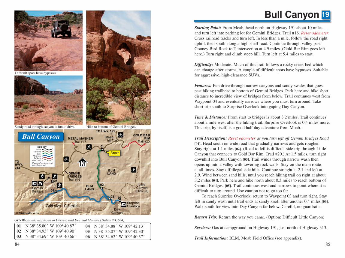
Starting Point: From Moab, head north on Highway 191 about 10 miles and turn left into parking lot for Gemini Bridges, Trail #16. Reset odometer. Cross railroad tracks and turn left. In less than a mile, follow the road right uphill, then south along a high shelf road. Continue through valley past Gooney Bird Rock to T intersection at 4.9 miles. (Gold Bar Rim goes left here.) Turn right and climb steep hill. Turn left at 5.4 miles to start.
Difficulty: Moderate. Much of this trail follows a rocky creek bed which can change after storms. A couple of difficult spots have bypasses. Suitable for aggressive, high-clearance SUVs.
Features: Fun drive through narrow canyons and sandy swales that goes past hiking trailhead to bottom of Gemini Bridges. Park here and hike short distance to incredible view of bridges from below. Trail continues west from Waypoint 04 and eventually narrows where you must turn around. Take short trip south to Surprise Overlook into gaping Day Canyon.
Time & Distance: From start to bridges is about 3.2 miles. Trail continues about a mile west after the hiking trail. Surprise Overlook is 0.4 miles more. This trip, by itself, is a good half day adventure from Moab.
Trail Description: Reset odometer as you turn left off Gemini Bridges Road [01]. Head south on wide road that gradually narrows and gets rougher. Stay right at 1.1 miles [02]. (Road to left is difficult side trip through Little Canyon that connects to Gold Bar Rim, Trail #20.) At 1.5 miles, turn right downhill into Bull Canyon [03]. Trail winds through narrow wash then opens up into a valley with towering rock walls. Stay on the main route at all times. Stay off illegal side hills. Continue straight at 2.1 and left at 2.9. Wind between sand hills, until you reach hiking trail on right at about 3.2 miles [04]. Park here and hike north about 0.3 miles to reach bottom of Gemini Bridges. [05]. Trail continues west and narrows to point where it is difficult to turn around. Use caution not to go too far. To reach Surprise Overlook, return to Waypoint 03 and turn right. Stay left in sandy wash until trail ends at sandy knoll after another 0.4 miles [06]. Walk south for view into Day Canyon far below. Careful, no guardrails.
Return Trip: Return the way you came. (Option: Difficult Little Canyon)
Services: Gas at campground on Highway 191, just north of Highway 313.
Trail Information: BLM, Moab Field Office (see appendix).
Bull Canyon 19
01
02
03
04
06
05
Bull Canyon
Easy ModerateDif�cult
PavedMINI KEY
More TrailsShadowed portion of traildescribed in text.
Unpaved
TOHWY.313
BLMLAND
TO HWY. 191
METAL MASHERTrail #17
© 2008 FunTreks, Inc.
LittleCanyon(Difficult)
Grid size - 0.5 miles
Start
GOLD BARRIM
Trail #20
GeminiBridges
DayCanyon
Steephill
BLMLAND
N
SurpriseOverlook
GEMINI BRIDGESTrail #16
01 N 38º 35.80´ W 109º 40.87´02 N 38º 34.93´ W 109º 40.90´03 N 38º 34.69´ W 109º 40.66´
04 N 38º 34.88´ W 109º 42.13´05 N 38º 35.07´ W 109º 42.30´06 N 38º 34.62´ W 109º 40.37´
GPS Waypoints displayed in Degrees and Decimal Minutes (Datum WGS84)
Difficult spots have bypasses.
Sandy road through canyon is fun to drive. Hike to bottom of Gemini Bridges.

9998
Starting Point: From the McDonald's Restaurant on Highway 191 on the south side of Moab, head west on Kane Creek Road. Bear left at the first major fork and follow Kane Creek Road south along the river. Continue on a wide gravel road after pavement ends. After a parking lot for bikers, continue a bit further to Amasa Back Bike Trail on the right. Total distance from McDonalds is 5.9 miles.
Difficulty: Difficult. This trail was filled in with dirt for maintenance recently, but the dirt is quickly washing away. Make no mistake, this trail is strictly hardcore with many big ledges and challenging obstacles. Although the big step on the ledge road is tamed somewhat, a new tippy spot has developed farther down the trail. Trail not suitable for most stock vehicles.
Features: Real challenges with incredible scenery, especially at the end. Heavy bike traffic. Be courteous. Pull over and let bikers pass.
Time & Distance: Main route is 4.3 miles one way. Add 1.4 miles for side trip to overlook. Allow 3 to 4 hours for everything.
Trail Description: Reset odometer as you turn right off Kane Creek Road [01]. Air drive down immediately and drop down steep ledges. At bottom of hill, cross creek, follow trail to left up difficult ledge. Stay right at 0.4 miles. Driver's choice at 1.1 miles; circle around to right or cut across slickrock. Bear right at 1.7 where a lesser road goes left before reaching the Z-Turn at 1.8 miles. Zigzag right then left uphill. Stay left at 2.2 miles [02]. Road on right goes to great overlook of Poison Spider Mesa and Colorado River. As you proceed north on the main trail, it narrows and drops down along the cliff edge with a big step down at 2.5. Continue straight at 3.1 where a lesser road goes right to another overlook. Be very careful at 3.3 miles [03]. You must straddle a narrow ledge that tips you to the right. It's easy to roll over if your right tire slips into the soft dirt. The trail appears to end at 3.5. Make a hard right here up some big ledges. Once on top, swing right then back to the left. At 3.6, climb to opening at top of barren slick-rock. At 4.0, stay left up bank. Turn around at scenic viewpoint at 4.3 miles [04]. Great spot for lunch. Caution: dangerous cliffs have no guardrails.
Return Trip: Return the way you came. Option: Add side trip to overlook.
Services: None. Return to Moab.
Trail Information: BLM, Moab Field Office (see appendix).
Cliff Hanger
01
02
0304
Start
Z-Turn
Dangeroustippy spot
PPStart of
Trail #21
279
279
Cliff Hanger
BLMLAND
BLMLAND
TO MOAB
Kane CreekRoad
KaneCreek Road
TO TRAILS#24, #27
Easy ModerateDif�cult
PavedMINI KEY
More TrailsShadowed portion of traildescribed in text.
Unpaved
JacksonHole
Jackson Ladderbike carry
Big stepon ledgeroad.
Grid size - 0.5 miles© 2008 FunTreks, Inc.
COLORADO RIVER
NTO TRAIL #45
01 N 38º 31.45´ W 109º 36.10´02 N 38º 31.15´ W 109º 37.12´
03 N 38º 31.80´ W 109º 38.01´04 N 38º 31.63´ W 109º 38.54´
GPS Waypoints displayed in Degrees and Decimal Minutes (Datum WGS84)
Steep ledges at start of trail.
Pick your level of difficulty at the Z-Turn.
Vehicle slips dangerously off ledge at Waypoint 03.
Narrow shelf road along cliff edge.
Turn around at final overlook.
23