Franklin County Judicial Green Streets Demonstration ...
33
Clean Water Act 319(h) Project Final Report Franklin County Judicial Green Streets Demonstration Project Memorandum of Agreement #PON2 129 1200000715 Cooperative Agreement C9994861-11 Work Plan #11-05 Project Start Date: December, 2011 Project End Date: February 8, 2016 Submitted by: Mr. Robert Hewitt Franklin Co. Planning and Building Codes 321 West Main Street Frankfort, Kentucky 40601
Transcript of Franklin County Judicial Green Streets Demonstration ...

Clean Water Act 319(h)
Project Final Report
Franklin County Judicial Green Streets Demonstration Project
Memorandum of Agreement #PON2 129 1200000715
Cooperative Agreement C9994861-11
Work Plan #11-05
Project Start Date: December, 2011
Project End Date: February 8, 2016
Submitted by:
Mr. Robert Hewitt Franklin Co. Planning and Building Codes
321 West Main Street Frankfort, Kentucky 40601

2
The Energy and Environment Cabinet (EEC) and the Franklin County Fiscal Court, Kentucky do not discriminate on the basis of race, color, national origin, sex, age, religion, or disability. The EEC and Franklin County Fiscal Court will provide, on request, reasonable accommodations including auxiliary aids and services necessary to afford an individual with a disability an equal opportunity to participate in all services, programs and activities. To request materials in an alternative format, contact the Kentucky Division of Water, 200 Fair Oaks Lane, Frankfort, KY 40601 or call (502) 564-3410, or contact Franklin County Fiscal Court at 321 West Main Street, Frankfort, Kentucky 40601 or call (502) 875-8706. Funding for this project was provided in part by a grant from the U.S. Environmental Protection Agency (USEPA) through the Kentucky Division of Water, Nonpoint Source Section, to Franklin County Fiscal Court as authorized by the Clean Water Act Amendments of 1987, §319(h) Nonpoint Source Implementation Grant #C9994861-05. Mention of trade names or commercial products, if any, does not constitute endorsement. This document was printed on recycled paper.

3
Acknowledgements
The Franklin County Fiscal Court would like to thank the United States Environmental Protection Agency 319(h) program and the Kentucky Environmental and Public Protection Cabinet, Department for Environmental Protection, Division of Water (KDOW) for providing funding, administrative support, and technical assistance for the Franklin County Judicial Green Streets Demonstration Project. CDP Engineers, Inc. assumed the leadership role in the design, development and administration of the project, and played a major role in the education component. Special thanks to Scott Southall, Project Manager, Vice President for Sustainability, Lisa Shuster, Graduate Landscape Architect and Jonathan Nieman, Project Engineer. The Franklin County Fiscal Court provided matching funding and in-kind hours through management and education. Special thanks to the Franklin County Fiscal Court Maintenance Department, which provided physical support and equipment, City of Frankfort Public Works Department and Sewer Department support with programming, design concept and construction project synergies.
Completion of the Franklin County Judicial Green Streets Demonstration Project, including all of the tasks and activities defined in the work program and summarized in this Final Project Report were made possible through the participation of all of the following individuals:
Franklin County Fiscal Court Judge Executive Ted Collins Judge Executive Huston Wells Deputy Judge Executive Jennifer Wilson Franklin County Planning & Zoning Robert Hewitt, Director Eric Cockley, Planning Supervisor Franklin County Ann Northcutt, Community Development Susan Laurenson, Treasurer City of Frankfort Mayor William May

4
City of Frankfort Public Works Department Tom Bradley PE, City Engineer Derek Gray, PE Jeff Hackbart, PE, City Engineer (retired) City of Frankfort Sewer Department Bill Scalf PE, Director Bob Peterson PE Robert Barker CDP Engineers Scott Southall, PLA, LEED AP BD+C, AICP Project Manager, Vice President for Sustainability Lisa Shuster, LEED GA Graduate Landscape Architect Krista Citron, PE Project Engineer Steve Green, PLS Survey Manager Jonathan Nieman, PE, LEED AP (Former Employee) Katie Pentecost, PLA, LEED AP (Former Employee) Sandy Camargo, PE, CFM (Former Employee) State of Kentucky Daniel Bishop Kentucky Division of Water Alyson Jinks Kentucky Division of Water Tammy West Kentucky Division of Water Brooke Shireman Kentucky Division of Water (Former Employee) Angie Wingfield Kentucky Division of Conservation Project Partners Brett Ruffing Kentucky Ready Mix Concrete Association (KRMCA) Finley Messick KRMCA Greg Smith KRMCA Brittain Skinner Downtown Frankfort Inc Joy Jeffries Frankfort / Franklin County Tourism Elizabeth Schmitz KY Environmental Education Council Michelle Shane KY Environmental Education Council Bill Bridges Codell Construction Lewis Owenby Codell Construction Alex Johns Codell Construction Scott Hudson Frankfort Plant Board Shane Holt Frankfort Plant Board - Cable Jack Phillips Frankfort Plant Board - Cable

5
Jim Carter Frankfort Plant Board - Electric Jack McNear Kentucky State University Joe Gronefeld Kentucky State University Greg Cooper Reading Rock Michael Baker Reading Rock Shon Lay Reading Rock Jonathan Otis Otis Engineering Donald Napier Rising Sun Brett Alfray Rising Sun Amy Sohner Bluegrass Greensource

6
Table of Contents
Acknowledgements ............................................................................... 3
Executive Summary ............................................................................... 7
1.0 Introduction and Background ......................................................... 9
2.0 Materials and Methods ................................................................. 10
3.0 Results and Discussion .................................................................. 22
4.0 Conclusions ................................................................................... 27
5.0 Literature Cited ............................................................................. 30
6.0 Appendices .................................................................................... 31
List of Figures:
Figure 1 – Aerial Map of Site
Figure 2 – Catfish Alley – Existing Conitions
Figure 3 – Franklin County Courthouse
Figure 4 – Aerial Map of Site
Figure 5 – Conceptual Site Plan
Figure 6 – Catfish Alley
Figure 7 – Aerial image of project site
Figure 8 – Grading & Drainage Plan
Figure 9 – St. Clair Street Rain Garden
Figure 10 – Permeable Concrete
Figure 11 – Permeable Concrete Pavers
Figure 12 – Stone Backfill for underground detention
Figure 13 – Downspout Disconnection

7
Appendix A: Financial & Administrative Closeout
1. Workplan Outputs
2. Budget Summary
Appendix B: QAPP – N/A
Appendix C: BMP Implementation Plan
Appendix D: Geotechnical Report
Appendix E: Design and Construction Documents
Appendix F: Field Days Workshop/Presentations
Appendix G: Local, State & National Presentations
Appendix H: Maintenance Manual
Appendix I: Facebook Website
Appendix J: Newspaper Articles

8
Executive Summary The Franklin County Judicial Green Streets Demonstration Project was approved by the Commonwealth of Kentucky—Division of Water, the U.S. EPA, and the Franklin County Fiscal Court (FCFC) in fiscal year 2011-2012 and annually reauthorized as a multi-year effort to be completed in 2016. The grant for the Franklin County Judicial Green Streets Demonstration Project, in part, is funded by resources made available under the Clean Water Act (CWA) Section 319(h), and by the Franklin County Fiscal Court, which is the local agency administering the grant. The goals and objectives for the Franklin County Judicial Green Streets Demonstration Project were:
1. Reduce runoff volume and discharge of pollutants through on-site green infrastructure Best Management Practices (BMPs). The objectives associated with this goal was to implement green infrastructure BMPs in the context of a new Judicial Center (Franklin County Courthouse) by incorporating the design concepts often utilized in green streets. To accomplish the objectives, a series of activities were established that identified the pollutants of concern, the BMPs most effective at removing the pollutants, and the locations most appropriate within the site. The selected BMPs were designed and implemented as part of the overall Courthouse site construction.
2. Educate a broad spectrum of target audiences, including government entities (both local and state), educational institutions, private sector organizations, and citizen groups, on green infrastructure BMPs and Non-Point Source (NPS) pollution control. The objectives to satisfy this goal are targeted toward a diverse group of stakeholders and audiences. To address the technical community; the developers, engineers, planners, landscape architects, architects, inspectors, and maintenance operators, a series of field days were held to demonstrate the form, function, and installation/construction of green infrastructure BMPs, and also demonstrate the performance after they have been completed. To raise awareness and educate the non-technical community such as the elected officials, educators, private entities, and civic organizations, education and outreach program were developed and launched after construction was completed. This program may provide both passive and active elements to educate. Local community organizations including environmental, commerce, tourism, downtown development, local government, and academia have been identified to promote the benefits of green infrastructure for not only water quality, but for the overall environmental benefits.
The implemented design incorporated three types of green infrastructure practices (permeable concrete pavement, permeable concrete interlocking pavers and a series of rain gardens. The final design also separated a combined sanitary/storm sewer connection and downspouts disconnection. Education and outreach included creation of Facebook page, three field days during construction, and numerous presentations at local, regional, and state conferences.

9
1.0 Introduction and Background Downtown Frankfort, Kentucky during the past 10 years has experienced somewhat of a renaissance. The City of Frankfort, the Franklin County Fiscal Court, Downtown Frankfort, Inc. and numerous other entities contributed to revitalize and refresh the downtown area. In 2008, Franklin County Fiscal Court begun the process of a significant renovation and expansion to create a new Judicial Center that will incorporate the 1837 historic Courthouse facing on St. Clair Street (see figure 1). The nearly 100,000 square foot expansion of the Judicial Center project encompasses nearly the entire block bound by St. Clair Street, Wapping Street, Catfish Alley and West Main. The judicial center project was, also, sensitive in preserving the historic church (Good Shepherd Church) at the corner of Wapping Street and Catfish Alley. While this urban area is highly impervious, at nearly 90%, it was probable the new Courthouse increased the impervious surface of this city block.
While redevelopment/infill is desirable activity and sustainable practice for many communities, it is widely accepted that urbanization can negatively affect the water quality of a stream/river due to nonpoint source pollution. Increased imperviousness can increase both peak runoff rate and runoff volume, which can alter the geometry and stability of stream channels by causing bank and bed erosion.
Figure 1- Aerial Map – Project Area (Bing Maps)

10
In established urban settings, aging infrastructure and space constraints in the downtown areas such as Frankfort have limited the use and effectiveness of conventional stormwater management techniques. In the process of upgrading urban infrastructure, consideration must be given to alternative tools and methodologies that will address water quality and quantity issues while restoring full or improved functionality of the development sites. Designing retrofit solutions (replacing existing structures with improved technologies), is a practice seen in very few locations throughout KY. Retrofitting can be much more difficult and costly due to space, access, and infrastructure constraints, but the potential benefits to water quality and capability to provide real solutions to the existing problems make it an advantageous alternative that should receive consideration in established urban situations. Several Green Infrastructure (GI) design alternatives may be used in retrofitting existing facilities to create environmentally sound designs and provide some offsets of the effects of increased development. Examples of these alternatives include permeable pavement, vegetated swales, rain gardens, and other rain harvesting techniques.
The initial discussion of a green street focused on Catfish Alley (see figure 2), but the County Judge Executive envisioned a project incorporating all the roads fronting the new Courthouse,
Figure 2 - Catfish Alley - (CDP)

11
creating a ‘green block’, which is the basis of this grant application. Conversations with members of the City staff and Commission were also very favorable. This project provides benefits for the new County Judicial Center and the existing City infrastructure and shares strong support from both the City and County. This highly visible, public project will build on the momentum that has developed with the partnering relationship and see it to fruition. The Franklin County Courthouse represented over a $29 million dollar investment by the county within downtown Frankfort. The new facility preserved the existing courthouse, maintained the integrity of the City’s mass while keeping in scale and portion to the surrounding structures. This green street aspired to compliment the effort of Judicial Center though the section of appropriate materials and design details. With the magnitude and visibility of this site, there were many potential advantages including demonstration, education, collaboration, and exposure to a water quality project (see figure 3). Since this was a county project and located within the City limits, there was great opportunities for shared interest, technology transfers and cost sharing between the City of Frankfort and Franklin County municipals. The project location is in a high visibility, high traffic area for individuals passing in and out of the Courthouse, and provided an occasion for outreach to state legislators and other elected stakeholders about the applications of green infrastructure throughout the Commonwealth. The BMPs implemented with the 319(h) funds were a part of a KDOW approved BMP Implementation Plan (BMP IP). Another aging infrastructure concern in the area associated with the project identified by the partners related to the Combined Sewer System (CSS) and Combined Sewer Overflows (CSO). While the project will not eliminate the issues associate with CSOs in the area, it had the potential to reduce the stress on the system by rerouting stormwater runoff to green infrastructure BMPs and delay the time of concentration for storm event in the project area. The Frankfort Sewer Department assisted the project team by identifying the trouble spots with CSOs in vicinity and financially supporting downstream project to connect into the “Green Block” infrastructure. In order to reduce the stormwater runoff, the project integrated green infrastructure components/BMPs such as; pervious pavements with subsurface detention, street or median rain gardens with other water quality and infiltration devices within the context of new and historic architecture producing a venue for education outreach. The green infrastructure improvements and BMPs will provide water quality and quantity benefits while enhancing the
Figure 3 – Existing Courthouse (FCFC)

12
site aesthetics. Traffic calming was also accomplished by the use of bump out rain gardens. The BMPs, especially along Catfish Alley were constructed and installed with an integration of other planned improvements such as sanitary sewer improvements and underground utilities. This multiple usage approach drove down the installation cost since the excavation can be a shared expense. The Green Infrastructure project was incorporated into the construction process of the judicial center (Courthouse) completed in the Spring, 2014 as an add-on change order so that non-related construction can proceed on its current schedule.
It was understood that, while the City and County are NPDES regulated Phase II Stormwater permittees, no aspect of this grant would count toward compliance with their stormwater program or meeting the requirements of the consent decree.

13
2.0 Materials and Methods The following Materials and Methods for The Franklin County Judicial Green Streets Demonstration Project were established in the grant application.
2.1. Project Area: The project location is in a high visibility, high traffic area for individuals passing in and out of the new/renovated Courthouse surrounded by the streets of St. Clair, Main, Wapping and Catfish Alley. Figure 4 is a map of downtown Frankfort with red dot indicating the project site. This site also provided an occasion for outreach to state legislators and other elected stakeholders about the applications of green infrastructure throughout the Commonwealth. The implemented BMPs utilizing the 319(h) funding where a part of the KDOW approval process for BMP Implementation Plan (BMP IP). The location also provided an excellent opportunity for effective technology transfer and education efforts, both active (field days) and passive (through future environmental graphics and interpretive signage). Being located in Frankfort, the State Capital, added one additional profile benefit related to a national program the “Green Capitols Program - Green Infrastructure at All 50 State Capitols” This initiative
sponsored in part by the EPA to demonstrate GI practices in every state capital. This
Figure 4- Aerial Map of Site – Downtown Frankfort, KY – Project Site Indicated by Red Dot (Bing Maps)

14
project, at the time of the grant award, was scheduled to be the first capital green street in the Midwest region of the US. Another related infrastructure issue in the project area identified during the grant-writing phase by the project partners related to the Combined Sewer System (CSS) and Combined Sewer Overflows (CSO) within the project area. While the project did not eliminate the issues associate with CSOs in the area, it did reduce the stress on the system by rerouting stormwater runoff to green infrastructure BMPs and delay the time of concentration for storm event in the project area. The Frankfort Sewer Department assisted by identifying the trouble spots with CSOs in vicinity of the project.
In order to reduce this stormwater runoff, the project integrated green infrastructure components/BMPs employing pervious pavements (concrete and interlocking pavers) with subsurface detention, street / median rain gardens with other water quality and infiltration devices within the context of new and historic architecture producing a venue for education outreach. The green infrastructure improvements and BMPs provided water quality and quantity benefits while enhancing the site aesthetics. The BMPs, along Catfish Alley were constructed with an integration of other planned improvements such as sanitary sewer improvements and taking utilities underground. This collective installation drove down the overall cost since the excavation was a shared expense.
2.2. Site Characterization: 2.2.1. Contributing Watershed area – approximately 2.3 acres consisting of portions of
the existing buildings along Main Street, the new Franklin County Courthouse, a portion of the surrounding existing buildings on Wapping Street and a portion of Catfish Alley and St. Clair Street, the Courthouse plaza and public sidewalks.
2.2.2. Site footprint – approximately 0.3 of acre, the site primarily consist of the stormwater runoff from the Courthouse and the surrounding hardscape (see figure 5).

15
Figure 6 – Catfish Alley partial excavated, yellow sandy clay soil (CDP)
2.2.3. Soil permeability – A geotechnical firm was retained by the Fiscal Court for the Courthouse Project and was utilized for the Green Streets Demonstration Project due to the proximity of the two intertwined projects. The general results found clay to sandy clay soils (see figure 6), which was expected considering the proximity to Kentucky River about 200 yards away. The report resulting from the fieldwork is included in Appendix D.
Figure 5 – Conceptual Site Plan – Courthouse Footprint in gray (CDP)

16
2.3. Design Development: The design was developed in consideration of both the goals of the project, and the desire complement the architecture language of the new/renovated Courthouse. The project goals were focused on developing a LID demonstration area that could provide immediate and long-term water quality performance and educational benefits. The combined final product would be a useable and aesthetically pleasing space for pedestrians to enter the Courthouse from St. Clair Street. This “Front Door to the Courthouse” also provides water quality control, and offers a sustainable educational venue for Franklin County and City of Frankfort. The Catfish Alley location provides opportunity to capture and treat surface runoff as well as discharge from disconnected downspouts from the Courthouse and an adjacent existing building. An iterative approach was utilized to evaluate multiple design concepts with respect to vehicular and pedestrian traffic flow, eliminating combined sewer system connections, suitability for various BMPs, site constraints, topography, and overall look. Figure 7 is an aerial image of the site prior to construction beginning on the Courthouse and Figure 8 is an AutoCAD drawing of the site grading & drainage plan.
Figure 7 – Aerial image of project site (Bing 2012)

17
2.4. Best Management Practices: LID BMPs fall into a number of categories. All are meant
to capture and treat runoff in some manner; reducing the runoff volume and providing water quality benefits. Surface infiltration practices, permeable pavements, downspout disconnection, and subsurface detention/infiltration were all incorporated into the design. Each method will be described in more detail in the following subsections.
2.4.1. Rain Gardens (surface infiltration): Rain gardens (St. Clair Street) are the most well known, although to a less degree in urban conditions, and economically feasible alternative for demonstrating surface infiltration practices. The plantings associated with rain gardens also add significantly to the aesthetic quality of
Figure 9 – St. Clair St. Rain Garden – under construction (CDP)
Figure 8 – Grading & Drainage Plan (CDP)

18
Figure 10 – Permeable Concrete – Design Concept & Installation
the BMP. Designs accounted for in-situ soils, applicability of using soil amendments, connectivity to the underdrain connection, and plant selection based on moisture tolerance, aesthetics and the urban context. Design guidance was taken from how-to guides developed by CDP for the Lexington-Fayette Urban County Government (citation) and the Mill Creek Watershed Council of Communities (citation), and past design experience of CDP.
2.4.2. Pervious Concrete (permeable pavements): Pervious concrete in Catfish Alley (figure 10) is a proven material for use in parking and drive lanes associated with
parking lots, and sidewalks. “When pervious pavement is in place, water resources are conserved. The resulting percolation recharges groundwater & runoff to the environment is cooler and cleaner” (http://krmca.org/pervious.htm ). Pervious concrete, due to its lighter color, also garners LEED credits for reducing the surface reflectivity index (SRI). The design methodology for the pervious concrete followed the recommendations of the Kentucky Ready Mix Concrete Association; another project partner.
Figure 11 – Permeable Concrete Pavers – Detail Design and Photo
19
2.4.3. Permeable Pavers (permeable pavements): The second form of permeable pavement utilized on this grant (see figure 11), consisting of solid paver blocks that come in many shapes and sizes that, when installed, create gaps between the units that allows rainwater to migrate through the pavement and into the detention area below. Pavers provide a great deal of flexibility in design and appearance so these would contribute significantly to the look and aesthetic appeal of the completed project. The installation methodology followed the recommendations of Reading Rock, project partner (www.readingrock.com).
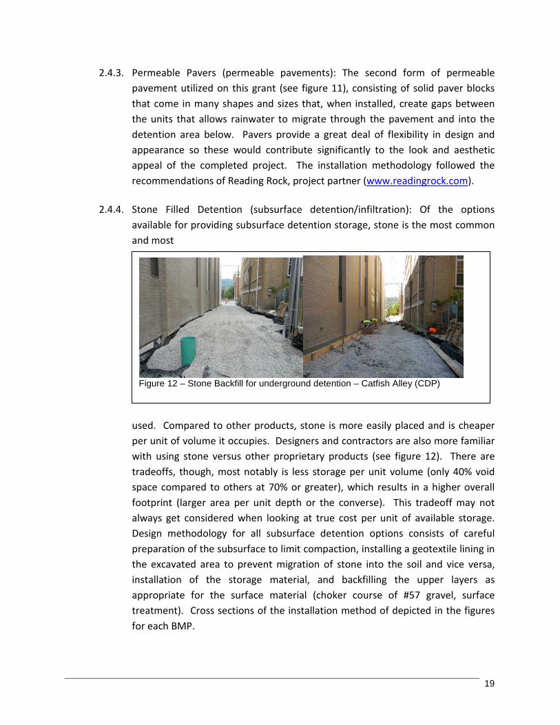
2.4.4. Stone Filled Detention (subsurface detention/infiltration): Of the options available for providing subsurface detention storage, stone is the most common and most frequently used. Compared to other products, stone is more easily placed and is cheaper per unit of volume it occupies. Designers and contractors are also more familiar with using stone versus other proprietary products (see figure 12). There are tradeoffs, though, most notably is less storage per unit volume (only 40% void space compared to others at 70% or greater), which results in a higher overall footprint (larger area per unit depth or the converse). This tradeoff may not always get considered when looking at true cost per unit of available storage. Design methodology for all subsurface detention options consists of careful preparation of the subsurface to limit compaction, installing a geotextile lining in the excavated area to prevent migration of stone into the soil and vice versa, installation of the storage material, and backfilling the upper layers as appropriate for the surface material (choker course of #57 gravel, surface treatment). Cross sections of the installation method of depicted in the figures for each BMP.
Figure 12 – Stone Backfill for underground detention – Catfish Alley (CDP)
20
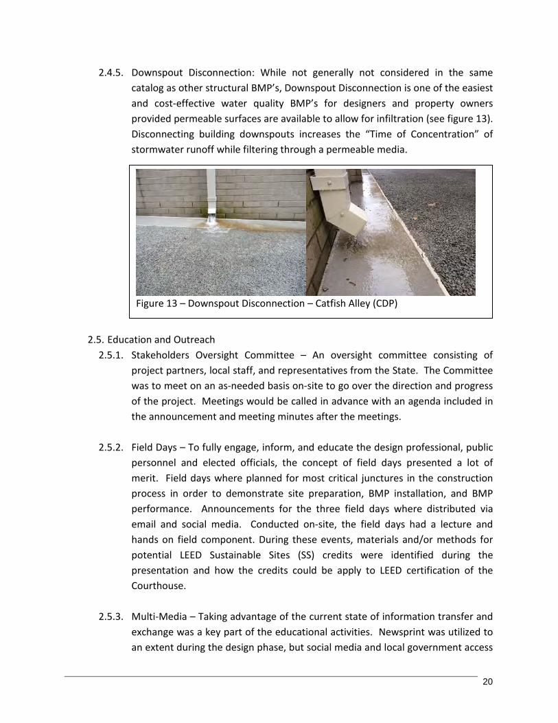
2.4.5. Downspout Disconnection: While not generally not considered in the same catalog as other structural BMP’s, Downspout Disconnection is one of the easiest and cost-effective water quality BMP’s for designers and property owners provided permeable surfaces are available to allow for infiltration (see figure 13). Disconnecting building downspouts increases the “Time of Concentration” of stormwater runoff while filtering through a permeable media.
2.5. Education and Outreach
2.5.1. Stakeholders Oversight Committee – An oversight committee consisting of project partners, local staff, and representatives from the State. The Committee was to meet on an as-needed basis on-site to go over the direction and progress of the project. Meetings would be called in advance with an agenda included in the announcement and meeting minutes after the meetings.
2.5.2. Field Days – To fully engage, inform, and educate the design professional, public personnel and elected officials, the concept of field days presented a lot of merit. Field days where planned for most critical junctures in the construction process in order to demonstrate site preparation, BMP installation, and BMP performance. Announcements for the three field days where distributed via email and social media. Conducted on-site, the field days had a lecture and hands on field component. During these events, materials and/or methods for potential LEED Sustainable Sites (SS) credits were identified during the presentation and how the credits could be apply to LEED certification of the Courthouse.
2.5.3. Multi-Media – Taking advantage of the current state of information transfer and exchange was a key part of the educational activities. Newsprint was utilized to an extent during the design phase, but social media and local government access
Figure 13 – Downspout Disconnection – Catfish Alley (CDP)

21
channel became the main modes to communicate information about project progress and upcoming events were through email and a Facebook site.
2.5.4. Printed Materials – trade publication and presentations would serve as the
printed products for the project. Presentations would target designers and decision makers across the state and nationally to tell the tale of the project. Reports would allow for future review of activities and sustained maintenance and management of the site.

22
editing
3.0 Results and Discussion
3.1 Site Characterization: The urban site constraints and results of the geotechnical investigation showed a less than ideal soil structure for infiltration practices but sufficient depth before rock was encountered. From the geotechnical report, the boring locations in the south area, which is the area developed for the project, the soils were classified as sandy clays and clays. Higher clay content soils are less permeable. Therefore, the design for the project took into account the low permeability soils and site constraints. Many design guides suggest that a permeability of 0.25 to 0.5 in/day is the target range for infiltration BMPs, so this site was one order of magnitude from ideal. However, one common argument against LID BMPs is that the clayey soils in Kentucky will not allow them to work. Since this was an urban demonstration project, it was decided to proceed with implementing the BMPs with an underdrain system and geomembrane liner to filter and increase time of concentration of the runoff. For the rain gardens, soil amendments including sand and organic matter would be incorporated to create a more permeable soil matrix.
The site was assessed for potential pollutant loading with regard to Nitrogen (N), Phosphorus (P), and Sediment (S). Based on typical urban pollutant concentrations of 2.3, 0.25, and 99 mg/l for N, P, and S, respectively, annual pollutant loadings of 42.08 lb, 4.57 lb, and 1,811 lb per year are predicted for N, P, and S based upon the simple method calculation. Expected load reductions exhibited by infiltration practices are 85% for N, 65% for P, and 95% for S. So with all drainage being routed to and through the site BMPs, the site is removing 35.77 lbs of N, 2.97 lbs of P, and 1,720 lbs of S annually from this 2.3 acre site. This is not a lot considering the big picture of the number of tons of sediment, for example, lost daily and annually, but if applied more broadly across a community the numbers will add up considerably and make a real difference.
3.2 Design Development: With the site selected and soils characterized, the project shifted into design. Evaluation of design alternatives resulted in one main conceptual designs with minor alternatives for the outfall location. The design consisted of the following BMP’s: In Catfish Alley, pervious concrete was placed in a portion of the alley . A more linear drive through design with access off the alley and Sam Pollock
Drive. This was rejected because it was preferable to not have access off the alley.

23
A dual access design with both entrances on Sam Pollack Drive. This was rejected due to the excessive amount of pavement for the amount of parking in return as well as an overall unappealing look.
The final design included both conventional and permeable pavements for comparative purposes, rain gardens and conventional planting beds and lawn areas, access to the fire station by way of a pervious concrete sidewalk crossing over the alley, and a central rain garden focal point to be used as an educational feature utilizing passive interpretive signage. The design consisted of a conventional asphalt access drive for entry and exit, alternating sections of porous asphalt and pervious concrete separated by concrete bands making up the remaining drive lane area with the concrete on the bends and asphalt in the straight sections. Permeable pavers made up the parking spaces, and the sidewalk areas were pervious concrete. Rain gardens were placed at each point of the triangle and in the center. On addition rain garden was placed on the opposite side of the alley to capture runoff discharging down slope from the upper flatter area. A rain barrel was connected to a corner downspout on the southeast corner of the fire station.
In order to use both federal funds and match, the construction was broken up between demolition and rough grading to be completed by the City crews, BMP installation and finish work by a contractor selected through competitive bid, construction management by the City, and maintenance by the City public works and fire department staff. The construction was complex because of the number of BMPs integrated into a small site, the coordination between the contractor and many product vendors, and the timing of construction activities with regard to weather and scheduled field days. Construction began in October of 2008 and was completed in April of 2009. Design plans are included in the Appendix E.
3.3 BMPs: The overall site plan shown in Figure 3.1 is a colorized rendering of the
AutoCAD final design. The image has been coded to identify the various surface BMPs implemented. Figure 3.2 is an overlay of the site plan identifying the location and extents of the underground storage BMPs. Details associated with the BMPs implemented follow:

24
Five rain gardens were designed and installed on site. The total area of coverage
was approximately 1,100 square feet. Over 170 wildflower plants and over 30 grasses were incorporated into the designs. Each rain garden had a different planting plan that would result in different color palettes and blooming seasons. Additional flowers, shrubs, and trees were incorporated into the overall landscaping plan. Rain garden planting was completed through a volunteer effort. Plant materials were discounted by a local nursery. The additional landscape shrubs and trees were installed by City staff. First year growth was excellent for the rain garden plants. A maintenance and management guidance document was also prepared for use by the City to help identify the desirable and undesirable species and describe the basics of rain garden maintenance.
There was approximately 1800 square feet of pervious concrete installed in addition to conventional concrete banding to separate and form the areas for the permeable pavement materials. Pervious concrete sidewalks incorporated into the parking areas and leading to the fire station were designed to be ADA compliant. They also added aesthetic detail to the site and provide access to the central rain garden and interpretive signage. The base soil under the pervious concrete was sloped slightly toward the center of the site so that captured rainfall would flow through the pavement and be directed to the subsurface storage area. It was not necessary to extend the detention area to the full extents of the paved surfaces. KRMCA provided a $10,000 in-kind contribution to the project as match and they were also present for the installation and field day.
Porous asphalt coverage was approximately 1900 square feet with an additional 2000 square feet of conventional asphalt in the entrance area (all sloping to the porous asphalt sections and upper rain garden). The timing of the installation was less than desirable with temperatures well below optimal for laying asphalt, and a site that was not conducive to installation with typical paving equipment. The contractors made the best of it, however, and the final product was mostly a success. There were locations adjacent to the rain gardens where some issues came up with regard to a lack of supporting edging to separate the asphalt from the planting bed. The interface between the loose and uncompacted rain garden
Figure 3.2

25
soil could not provide the structural support for the gravel base and pavement and as a result some edge slumping occurred. As with the concrete, the soil surface below the pavement and gravel sloped toward the detention area. PAIKY provided pro-bono technical support for the design and installation and put on a field day.
2200 square feet of permeable pavers were installed, making up the parking space areas. Two colors of pavers were used, with one color used for striping instead of paint. Striping using paver blocks will reduce maintenance costs, eliminate the risk of blockage associated with painting, and it created a unique and creative feature. Wheel stops installed were composed of recycled rubber. 12 parking spaces were created on site including a handicap space. The pavers were within the footprint of the detention area so runoff flowing through the pavers went directly into the storage area. Reading Rock provided a discount on materials and assisted with the installation and field day
The remaining detention area volume was filled with stone, providing a third alternative for providing underground storage capacity though void space. Stone is very flexible in installation, relatively abundant and inexpensive, and is a material designers and contractors are comfortable using so bid prices are typically competitive. The downside of stone backfill is that the storage volume realized per unit volume occupied is relatively low at only 40% on average.
3.4 Education and Outreach: Over the course of this grant, there were many very successful and unique education and outreach activities. The creation of a Facebook page to reach out to interested parties, provide progress updates (narrative and photographs), and announce upcoming events was a first for KY 319(h) grants and it created a lot of interest. The site had over 70 ‘friends’ and recorded 100’s hits over the duration of the project. Facebook was an excellent mechanism for communication and distribution of flyers. Coupled with email, the project made full use of digital technology, saving time and expense of reproduction and mailing and reaching out to an audience greater than would be expected due to the ability to so easily spread the word to second and third tier contacts.
There were seven field days conducted corresponding with construction milestones. The concept implemented was to time the field days at points where attendees could not only learn in a classroom setting about the selected topic or BMP, but to also see on-site the BMP location, site preparation, installation, and finished product. Basically they covered the technology, design, construction and constructability, and performance. Covering all these components assured that the project was reaching the intended audiences of designers, developers, and decision makers. Field days were held on-site with a classroom presentation put on by the BMP vendor or professional association, or the project consultant, followed by a field demonstration to give attendees a first hand look at the BMPs. Topics included of the following: 1. Erosion Control put on by D2 Land and Water Resource 2. Subsurface detention put on by CDP Engineers (on behalf of Brentwood Industries)
and ADS Pipe

26
3. Pervious Concrete put on by the Kentucky Ready-Mix Concrete Association (KRMCA)
4. Porous Asphalt put on by the Plant Asphalt Industry of Kentucky (PAIKY) 5. Permeable Pavers put on by Reading Rock 6. Rain Gardens put on by CDP Engineers 7. Putting it all Together – completed project put on by CDP Engineers and the City of
Georgetown. News media also covered the project. 12 newspaper articles were written in both the Georgetown News Graphic and the Lexington Herald Leader. One Lexington television station also WTVQ, Channel 36, showcased the project in a “Green Begins with Me” segment. Numerous presentations were conducted by the City Engineer, CDP Engineers, and product vendors (D2, Brentwood, ADS) and professional associations (PAIKY, KRMCA) who were project partners. Venues for the presentations ranged from lunch and learns put on by the vendors and professional associations, to local professional society meetings, regional and state conferences, and also national conferences in Minneapolis, Nashville, Atlanta, and Boston. Overall, there were 15 presentations at local, regional, state, and national venues, and likely dozens of presentations by vendors and associations that included discussion and demonstration of the BMPs implemented in this project. One of the last outreach activities completed will likely leave the longest lasting impression. Three interpretive signage boards (24x36 inch) were developed and installed at the center of the site that describes the project intent, timeline, features, partners, funding agencies etc through words and graphics. These boards create a sustainable educational element for anyone that uses the site.

27
4.0 Conclusions
4.1 Meeting Goals 4.1.1 Educate on Water Quality and NPS Pollution Reduction: The targeted
numbers for the measures of success associated with this goal were likely not met within the identified venues of outreach. However, the Facebook site was not part of the original measures of success and it proved to be highly successful and generated a significant amount of participation. We feel that the ultimate outcome of the educational objective was highly successful and clearly met the objective. The target measure of success of 4 presentations at annual conferences and meetings and an estimated audience of 800 persons was exceeded in numbers of presentations, but perhaps fell slightly short in total attendees. The project partners (namely Eric Larson with the City and CDP Engineers) presented at 4 conferences and workshops in Kentucky and in 4 other states. Individual presentations by project partners, estimated at 220, proved to be very difficult to track as the vendors and associations were not very reliable at providing updated activities. It is likely though, that the projected number was not met. Printed media was largely abandoned in lieu of digital media, although 13 newspaper and periodical articles were published related to the project and the passive education interpretive signage was developed and installed. Through the field days and conversations at presentations and other phone contacts, we believe that well over the estimated 100 persons were reached and informed about implementation of similar BMPs. Several communities across Kentucky are now attempting to develop their own LID demonstration sites. For example, Owensboro is doing so at this time as part of another 319(h) grant. Momentum like this is a testament to the potential influence the project has made on DDDs in the state.
4.1.2 Reduce Water Quality Impacts through Demonstration and Installation of Water Quality BMPs: All objectives and measures of success for this goal were far exceeded. Post construction permeability and any other monitoring was never completed but this was never part of the project budget. One parking lot was developed but it incorporated a host of BMPs including 3 porous pavements AND conventional pavement for comparative demonstration, 5 different vegetated bioretention facilities (swales and rain gardens function in the same manner), a significant recharge chamber with 3 different technologies, and a harvesting system using a rain barrel. Total loading was shown to be reduced by 85%, 65%, and 95% for N, P, and S, respectively. The actual numbers are even better to date since captured runoff has yet to be discharged offsite; it is all infiltrating. Given that the wettest year on record was just experienced it is safe to say that the BMPs are performing quite well.

28
Demonstrating the installation and effectiveness of Water Quality BMPs was clearly met through the presentation of 7 field days encompassing all stages of construction and BMP installation and performance. Average attendance at the field days was 30+ so it is estimated that over 200 persons were reached through this process. Additional local officials and citizens were on hand to witness the BMP demonstrations and, through the interpretive signage, individuals will continue to observe the BMPs in action and learn more about them.
4.1.3 Introduce LEED as it relates to LID: All objectives for this goal were met through inclusion of slides and discussion of LEED at conferences and field days. The materials presented introduced the LEED rating system, identified the categories and potential points the project would receive, described the significance of the LEED system, especially pertaining to KY House Bill 2 (2008) and new high performance building standards, and lastly through cost assessments of the LID BMPs versus conventional practices.
4.2 Pros: The project was highly successful; receiving statewide recognition, numerous
awards, and placing the City of Georgetown on the progressive forefront with regard to innovation and implementation of LID. Individual items to note as Pros include: APWA Bluegrass Environmental project of the year ACEC-KY Engineering Excellence Award Kentucky Chapter of ASLA Honorable Mention Award First NPS 319(h) grant to utilize Facebook for outreach Sustainable design practices through a maintenance manual and interpretive
signage Very successful field days program capturing snapshot of construction, installation,
and performance in one setting TV and newspaper articles highlighting the green technology and environmental
benefits Invitations to present at multiple national conferences Statewide name recognition; mention ‘The Georgetown Fire Station Parking Lot
Project’ to DDDs and a significant percentage will be familiar with it.
4.3 Cons: With all the positives, there were certainly some negatives, most of which were associated with the complexities of construction in a tight area utilizing a wide range of products, and using both hired contractors and City staff to divide responsibilities. Some specific items to note include: Incorporation of 5 different paving surfaces within a 0.6 acre footprint. Forming,
supporting and placing all these materials and coordinating the delivery schedules for the material providers was stressful.
The combination of the City Engineer being the general contractor (while also wearing many other hats with the city), city staff providing construction services at the onset and closeout, and coordinating a hired contractor proved to be a daunting task.

29
4.4 Lessons Learned: Upon reflection, there are some lessons learned that can be passed on to future grantees. (1) Projects of this complexity would be best served to have one contractor on board through the whole process. Match funds in the form of cash match would be more preferable than in-kind time for General Contracting and staff and equipment time. (2) Have at least monthly contact with project partners that agree to provide in-kind services to make sure they are documenting and submitting appropriate evidence of activity. It was very hit and miss with regard to collecting that information. (3) Document, organize, and keep duplicate copies of everything. Have a central location as the master location of complete project information sets. Create and utilize checklist or standard reporting forms so critical information is not overlooked. Grants that go on for multiple years invariably encounter transitions in staff from many directions and this was no exception. Well organized and clearly labeled files and folders allow new team members to get up to speed much quicker. (4) Provide adequate edge and subsurface support for pavement applications. Locations where pavement abutted rain gardens presented a weak edge support. (5) It may be better to choose 2 sites and distribute BMPs among them as opposed to incorporating all into one site. The resulting projects may be simpler and cheaper to construct and it provides a chance to get LID introduced at multiple locations. (6) Keep the duration of the project down to a minimal time frame without sacrificing the intent and success. Longer duration results in more administrative time, more chances for personnel turnover, and more chances for project partners to get lost or lose interest.
4.5 Final Comments: The overall project was a very positive and successful experience.
It is clear that there is a great deal of interest right now in LID and green practices. Through this project, we feel that more DDDs will be interested and willing to incorporate these practices into their future site developments. Familiarity with products and construction methods also drives down cost, so this project may result in more competitive pricing of LID as compared to conventional practices. LID is gaining momentum and acceptance. We’d like to think that this grant served to help build that momentum. On behalf of our primary project partner, CDP, it has been a pleasure to (1) be part of this project, (2) to work closely with the KDOW-NPS staff throughout, and (3) to build relationships with so many quality project partners and interested individuals over the past few years. Even with all the positives and good will, though, we are tired and ready to close this out…

30
5.0 Literature Cited
U.S. EPA, 1997. Urbanization and Streams: Studies of Hydrologic Impacts. Office of Water,
Washington, D.C., 841-R-97-009. U.S. Green Building Council, 2009, LEED Reference Guide for Green Building Design and
Construction, U.S. Green Building Council 2101 L Street, NW, Suite 500, Washington, DC 20036
Bluegrass Greensource, http://www.bgpride.org, 3120 Pimilico Parkway, Suite 126, Lexington,
KY 40517 Lexington Fayette Urban County Government, Department of Environmental Quality, Rain
Garden Manual, 200 East Main Street, Lexington, KY 40507 Mill Creek Watershed Council of Committees, http://www.millcreekwatershed.org, 720 East Pete
Rose Way, Suite 420, Cincinnati, OH 45202 KY Ready Mix Concrete Association, http://krmca.org, 1 HMB Circle, Frankfort, KY 40601 Plantmix Asphalt Industry of Kentucky, http://www.paiky.org, 119 W. Broadway, Frankfort, KY
40601 Reading Rock, http://www.readingrock.com, 4600 Devitt Drive, Cincinnati, OH 45246 ADS Pipe, http://www.ads-pipe.com, 4640 Trueman Boulevard, Hilliard, OH 43026 Brentwood Industries, http://www.brentwoodindustries.com, 610 Morgantown Road, Reading,
PA 19611 D-2 Land & Water Resource, http://d2lwr.com, 2600 Boyd Avenue, Indianapolis, IN 46218

31
6.0 Appendices
Appendix A: Financial & Administrative Closeout 1. Workplan Outputs 2. Budget Summary
Appendix B: QAPP - NA
Appendix C: BMP Implemention Plan
Appendix D: Geotechnical Report
Appendix E: Design and Construction Documents 1. Conceptual Site Plans 2. Final Rendering and Section 3. Construction Plans
Appendix F: Field Days Workshop/Presentations 1. Field Day #1 – Erosion Prevention & Sediment Control – October 25, 2008
a. Attendance Sheet b. Site Photos
2. Field Day #2 – Subsurface Retention – November 11, 2008 a. Attendance Sheet b. Site Photos
3. Field Day #3 – Porous Asphalt – November 21, 2008 a. Attendance Sheet b. Site Photos
4. Field Day #4 – Permeable Concrete Pavers – December 9, 2008 a. Attendance Sheet b. Site Photos
5. Field Day #5 – Permeable Concrete – January 9, 2009 a. Attendance Sheet b. Site Photos
6. Field Day #6 – It All Comes Together – March 23, 2009 a. PowerPoint Presentation b. Attendance Sheet c. Site Photos
7. Field Day #7 – Rain Gardens & Rain Barrels – April 3, 2009 a. PowerPoint Presentation b. Attendance Sheet c. Site Photos

32
Appendix G: Local, State & National Presentations
1. ASCE Presentation – May, 25, 2006
2. Kiwanis Club Presentation, Georgetown, KY – October 30, 2008 a. PowerPoint Presentation b. Attendance Sheet
3. Georgetown – Scott County Parks & Recreation, North Elkhorn Urban Water Quality BMP Education and Demonstration Project – September, 9, 2008 a. PowerPoint Presentation
4. Kentucky Chapter – American Planning Association (KAPA), Fall Conference, Bowling Green, Ky – September 24, 2009 a. PowerPoint Presentation
5. OKI – APA Regional Planning Conference, A Plethora of Low Impact Development Practices Packed into a Small Parcel - Louisville, KY October 10, 2008
6. Georgetown’s North Elkhorn Urban Water Quality BMP Education and Demonstration Project, KY Ms4 Workshop by KEEC – March 26, 2009
7. Georgetown’s Stormwater Management Plan, KY Public Retirees Bluegrass East Chapter – April 8, 2009
8. Kentucky ASCE Conference - October 1, 2009 9. KY / TN Water Professionals Conference, Lexington, KY - 2009 10. KSPE Bluegrass Meeting 2009 11. SESWA Annual Conference 2009 12. Governor’s Conference on the Environment, Lexington, KY - 2009 13. “Creek Crew” Presentation – May 19, 2010 14. APWA Sustainability in Public Works Conference, Minneapolis, MN – June 9, 2010 15. Ohio SWA 2010 Conference - Sandusky, OH - June 10, 2010 16. APWA 2010 Congress - Boston, MA – August, 2010 17. KSPE Annual Conference 2010 18. APWA, State Conference, Owensboro, KY – October 19, 2011
Appendix H: Maintenance Manual
Appendix I: Facebook Website
Appendix J: Newspaper Articles 1. “Educational stormwater project in development”, Georgetown News-Graphic,
Sunday, May 11, 2008 2. “City Council talks green during meeting”, Georgetown News-Graphic, Tuesday,
July 29, 2008 3. “Donation made to Georgetown project”, Georgetown News-Graphic, Friday,
October 10, 2008 4. “Calendar of Events”, Georgetown News-Graphic, Sunday, October 19, 2008 5. “Come to water improvement field day”, Georgetown News-Graphic, Tuesday,
January 6, 2009 6. “Georgetown goes green with its fire station” Paving the Way, March 2009 7. “City calling all green thumbs”, Georgetown News-Graphic, Thursday, March 26,
2009 8. “Georgetown Engineering Department Case Study Showcases “Green
Infrastructure”; Lane’s Run Business Park Update; Saving New Buildings a Good Deal in Scott County” Kentucky.com, April 2009

33
9. “Stormwater Can’t Run, But It Can Hide”, Lexington Herald – Leader, May 6, 2009 10. “Award-winning stormwater project is more than meets the eye”, Georgetown News-
Graphic, Sunday, December 19, 2009 11. “Georgetown fire station is rain garden showplace”, Lexington Herald-Leader,
February 27, 2010 12. “Rain gardens”, Land Air & Water, Spring 2010 13. Rain gardens’ benefits going on display, Georgetown News-Graphic, Thursday, June
9, 2011 Appendix K: Interpretive/Educational Signage
1. 3 Panel Interpretive Signage 2. Site picture of installed signage 3. Tri-Fold Handout