FR Final Remarks - link.springer.com
49
FR In hindsight, recalling the present state of the art of acoustic ocean imaging in general, one may say: yes, all that is needed technically to meet the various needs of research, industry and governmental surveillance appears available in prin- ciple. This may even include the greatest challenge of ocean imaging: to complete the inventory of our own planet’s hidden side. Since it deals with the living condi- tions of man and nature of today and the future, one could even argue that this knowledge has a higher priority by far for mankind than an expedition to an- other planet. However, it requires more than money and priority setting. Above all, there are the more than 200 ship years (Sect. 5.1) that it would take to com- plete the coverage by multibeam imaging standard in view of the small fraction of work done as yet. Even if the ships of the necessary size and equipment were available with professional crews, the costs would amount to 1–3 billion dollars minimum, depending on the costs per day at sea. One could think of a coordi- nated share between perhaps ten nations for 5 years but even then it would cause national research budgets to go out of balance. Moreover, ocean research requires much more, and costs more than mere high quality imaging. Further, a kind of crash program dealing exclusively with the detailed sea floor relief inventory would neglect other options which would bring in more than coping with this challenge. One option which has shown its future potential already should be recalled. The autonomous, unmanned underwater vehicle (AUV) is by orders of magnitude less expensive in production and operation than a full size, conventional ocean going ship, and in principle ideally suited to conduct routine, pre-programmed area cov- erage work but also special tasks where deep diving robotic capability is decisive. Of course, large area mapping by AUV requires a power supply technology other than batteries, forcing the host ship to stay nearby. Advanced non-nuclear submarine power-plant technology with fuel cells has shown that continuous, uninterrupted un- derwater operations are possible for weeks. There is certainly further development needed to downsize this technology, to standardize refueling, and further require- ments to enable a wide reaching application, but there is apparently a wider inter- national market than that of ocean research. This research application, setting the tone in long term missions would derive its priorities for area coverage from the already existing global relief maps of large scale features (Sect. 5.1). Just a few hints on further applications may suffice: automatic underwater sur- veillance of harbors and fairways is a cost reduction and safety requirement, as well as for military reconnaissance of combat or other hazardous areas, in par- ticular for search and destruction of sea mines. A growing market of underwater Final Remarks
Transcript of FR Final Remarks - link.springer.com
FR
In hindsight, recalling the present state of the art of acoustic ocean imaging ingeneral, one may say: yes, all that is needed technically to meet the various needsof research, industry and governmental surveillance appears available in prin-ciple. This may even include the greatest challenge of ocean imaging: to completethe inventory of our own planet’s hidden side. Since it deals with the living condi-tions of man and nature of today and the future, one could even argue that thisknowledge has a higher priority by far for mankind than an expedition to an-other planet. However, it requires more than money and priority setting. Aboveall, there are the more than 200 ship years (Sect. 5.1) that it would take to com-plete the coverage by multibeam imaging standard in view of the small fractionof work done as yet. Even if the ships of the necessary size and equipment wereavailable with professional crews, the costs would amount to 1–3 billion dollarsminimum, depending on the costs per day at sea. One could think of a coordi-nated share between perhaps ten nations for 5 years but even then it would causenational research budgets to go out of balance. Moreover, ocean research requiresmuch more, and costs more than mere high quality imaging. Further, a kind ofcrash program dealing exclusively with the detailed sea floor relief inventory wouldneglect other options which would bring in more than coping with this challenge.
One option which has shown its future potential already should be recalled. Theautonomous, unmanned underwater vehicle (AUV) is by orders of magnitude lessexpensive in production and operation than a full size, conventional ocean goingship, and in principle ideally suited to conduct routine, pre-programmed area cov-erage work but also special tasks where deep diving robotic capability is decisive.Of course, large area mapping by AUV requires a power supply technology otherthan batteries, forcing the host ship to stay nearby. Advanced non-nuclear submarinepower-plant technology with fuel cells has shown that continuous, uninterrupted un-derwater operations are possible for weeks. There is certainly further developmentneeded to downsize this technology, to standardize refueling, and further require-ments to enable a wide reaching application, but there is apparently a wider inter-national market than that of ocean research. This research application, setting thetone in long term missions would derive its priorities for area coverage from thealready existing global relief maps of large scale features (Sect. 5.1).
Just a few hints on further applications may suffice: automatic underwater sur-veillance of harbors and fairways is a cost reduction and safety requirement, aswell as for military reconnaissance of combat or other hazardous areas, in par-ticular for search and destruction of sea mines. A growing market of underwater
Final Remarks

422 Final Remarks
robotics is that for the offshore industry which needscost effective optimizing of safe pipeline and cablerouting and routine surveillance after installation. And,not to forget: AUVs are essentially the only solutionfor searching for casualty relics in the deep sea. Thetechnological challenge to develop genuine long dutycycle AUVs, including automatic updating of the on-board inertial- and sonar-Doppler navigation by briefemersions for GPS access and mission control may be
comparable to unmanned space vehicle technology.But the market is undoubtedly wider and the second-ary effects like further applications of robotics are cer-tainly rewarding. There is another welcome advantagein addition: AUVs don’t emit combustion gases andare essentially free of propulsion noise emission: amodern and real underwater version of the FlyingDutchman, the famous, unmanned ghost ship of thefairy tale.
LI
L.1–4
Beranek LL (1993) Acoustics. American Institute of Physics, Inc., ISBN 0-88318-494-XBlondel P, Murton BJ (1997) Handbook of seafloor sonar imagery. John Wiley & Sons, Inc.,
ISBN 0-471-96217-1Brekhovskikh L, Lysanov Y (1982) Fundamentals of ocean acoustics. Springer-Verlag,
ISBN 3-540-11305-3Camp L (1970) Underwater acoustics. Wiley-Interscience, ISBN 0-471-13150-4Coates RFW (1989) Underwater acoustic systems. John Wiley & Sons, Inc., ISBN 0-470-21544-5Crocker MJ (ed) (1998) Handbook of acoustics. John Wiley & Sons, Inc., ISBN 0-471-25293-XEdgerton HE (1986) Sonar images. Prentice Hall, ISBN 0-13-822651-2Enflo BO, Hedberg CM (2002) Theory of nonlinear acoustics in fluids. Kluwer Academic pub-
lishers, ISBN 1-4020-0572-5Etter PC (1991) Underwater acoustic modeling: principles, techniques and applications. Elsevier
Applied Science, ISBN 1-85166-528-5Frisk GV (1994) Ocean and seabed acoustics: a theory of wave propagation. Prentice Hall,
ISBN 0-13-630112-6Hubbell JH (1982) Photon mass attenuation and energy-absorption coefficients from 1 keV
to 20 MeV. Int J Appl Radiat Isot 33:1269–1290Jensen FB, Kuperman WA, Porter MB, Schmidt H (1994) Computational ocean acoustics. AIP
Press, ISBN 1-56396-209-8Kinsler LE (2000) Fundamentals of acoustics, 4th ed. John Wiley & Sons, Inc., ISBN 0-471-84789-5Landolt-Börnstein (1986) Numerical data and functional relationships in science and technology;
New Series, Group V: Geophysics and space research, Vol. 3: Oceanography; Subvolume a (Gier-loff-Emden HG, Høgerslev NK, Krause G, Peters H, Siedler G, Weichart G, Wille P, Ed.: Sünder-mann J. Springer-Verlag, Berlin Heidelberg New York, ISBN 3-540-15092-7 and 0-387-15092-7
Leighton TG (1994) The acoustic bubble. Academic Press, ISBN 0-12-441920-8Lurton X (2003) An introduction to underwater acoustics: principles and applications. Springer-
Verlag, Praxis Publ., ISBN 3-540-42967-0Maurer H, Stocks T (1933) Die Echolotungen der “Meteor”. Deutsche Atlantische Exped. Me-
teor, 1925–1927. Wiss. Ergeb. 2:1–309Maury MF (1855) The physical geography of the sea. Harper, New YorkMechel FP (ed) (2002) Formulas of acoustics. Springer-Verlag, ISBN 3-540-42548-9Medwin H, Clay CS (1998) Fundamentals of acoustical oceanography. Academic Press,
ISBN 0-12-487570-XMienert J, Weaver P (eds) (2003) European margin sediment dynamics: side-scan sonar and
seismic images. Springer-Verlag, ISBN 3-540-42393-1Ross D (1976) Mechanics of underwater noise. Pergamon Press, ISBN 0-08-021182-8Schmincke H-U (2004) Volcanism. Springer-Verlag, ISBN 3-540-43650-2
Literature Index

424 Literature Index
Stocks T, Wüst G (1935) Die Tiefenverhältnisse des offenenAtlantischen Ozeans. Deutsche Atlantische Exped. Meteor,1925–1927. Wiss. Ergeb. 3:1–31
Tolstoy I, Clay CS (1987) Ocean acoustics: theory and experi-ment in underwater sound. American Inst. of Physics,ISBN 0-88318-527-X
Urban HG (2002) Handbook of underwater acoustic engineer-ing. STN-ATLAS-Elektronik, ISBN 3-936799-04-0
Urick RJ (1982) Sound propagation in the sea. Peninsula Pub-lishing, ISBN 0-932146-08-2
Urick RJ (1983) Principles of underwater sound. McGraw-Hill,ISBN 0-07-066087-5
Urick RJ (1986) Ambient noise in the sea. Peninsula Publish-ing, ISBN 0-932146-13-9
Ziehm GH (1999) The city of Kiel – an early center of under-water acoustics. FWG, ISBN 3-980-62814-0
L.5.1
Sandwell DT, Smith WHF (1995) Marine gravity from satel-lite altimetry (poster). The Geological Data Center, ScrippsInst. of Oceanography, La Jolla, CA 92093, (digital file, Ver-sion 7.2), anonymous ftp to baltica.ucsd.edu
Sandwell DT, Smith WHF (1997) Marine gravity anomaly fromGeosat and ERS-1 altimetry. J Geophys Res 102: 10039–10054
Smith WHF, Sandwell DT (1994) Bathymetric prediction fromdense altimetry and sparse shipboard bathymetry. J GeophysRes 99:21803–21824
Smith WHF, Sandwell DT (1997) Global seafloor topographyfrom satellite altimetry and ship depth soundings. Science277:1957–1962
L.5.1.2
Bacon CR, Gardner JV, Mayer LA, Buktenica M (2002) Mor-phology, volcanism, and mass wasting in Crater Lake, Or-egon. Geol Soc Am Bull 114:675–692
Gardner JV, Mayer LA, Hughes-Clarke JE (1998) North Maui andPailolo, Auau, and Kealaikahiku Channels (Maui, Molokai,Lanai, and Kohoolawe, Hawaii): a high-resolution multibeamsurvey. Abs. American Geophysical Union Fall Mtg, p F827
Gardner JV, Mayer LA, Hughes-Clarke JE, Kleiner A (1999)High-resolution multibeam bathymetry of East and WestFlower Gardens and Stetson Banks, Gulf of Mexico. Gulfof Mexico Science 16:131–143
Gardner JV, Mayer LA, Hughes-Clarke JE (2000) Morphol-ogy and processes in Lake Tahoe (California-Nevada). GeolSoc Amer Bull 112:736–746
Gardner JV, Dartnell P, Sulak KJ, Calder B, Hellequin L (2001a)Physiography and Late Quaternary-Holocene processes ofnortheastern Gulf of Mexico outer continental shelf off Mis-sissippi and Alabama. Gulf Of Mexico Science 19:132–157
Gardner JV, van den Ameele EJ, Gelfenbaum G, Barnhardt W,Lee H, Palmer S (2001b) Mapping southern Puget Sounddelta fronts after the 2001 Nisqually earthquake. EOS82(42):485–489
Marlow MS, Gardner JV, Normark WR (2000) Using high-resolution multibeam bathymetry to identify seafloor sur-face rupture along the Palos Verdes fault complex in off-shore southern California. Geology 28:587–590
L.5.2.1
Caress DW, Chase DN (1996) Improved processing of Hydro-sweep DS multibeam data on the RV Maurice Ewing. MarGeophys Res 18:631–650
Flueh ER, Vidal N, Ranero CR, Hojka A, von Huene R, BialasJ, Hinz K, Cordoba D, Dañobeitia JJ, Zelt C (1998) Seismicinvestigation of the continental margin off and onshoreValparaiso, Chile. Tectonophysics 288:251–263
Fruehn J, von Huene R, Fisher M (1999) Accretion in the wakeof terrane collision: the Neogene accretionary wedge offKenai Peninsula, Alaska. Tectonics 18:263–277
Gung Y, Panning M, Romanowicz B (2003) Global anisotropyand the thickness of continents. Nature 422:707–711
Howell DG (1989) Tectonics of suspect terranes, mountainbuilding and continental growth. Chapman and Hall, Lon-don, 232 pp
Le Pichon X, Henry P, Lallemant S (1993) Accretion and ero-sion in subduction zones: the role of fluids. Annu Rev EarthPl Sc 21:307–331
Moore JC, Vrolijk (1992) Fluids in accretionary prisms. RevGeophys 30:113–135
Parsons B (1981) The rates of plates creations and com-sumption. Geophys J R Astron Soc 67:437–448
Ranero CR, Von Huene R (2000) Subduction erosion alongthe Middle America convergent margin. Nature 404:748–752
Reymer A, Schubert G (1984) Phanerozoic addition rates tothe continental crust and crustal growth. Tectonics 3:63–77
von Huene R, Ranero CR (2003) Subduction erosion andbasal friction along the sediment starved convergentmargin off Antofagasta Chile. J Geophys Res 108:2079,doi10.1029/2001JB001569
von Huene R, Scholl D (1991) Observations at convergentmargins concerning sediment subduction, subduction ero-sion, and the growth of continental crust. Rev Geophys29:279–316
von Huene R, Corvalan J, Flueh ER, Hinz K, Korstgard J,Ranero CR, Weinrebe W, CONDOR Scientists (1997) Tec-tonic control of the subducting Juan Fernández Ridgeon the Andean margin near Valparaiso, Chile. Tectonics16:474–488

425Literature Index
von Huene R, Klaeschen D, Gutscher M, Fruehn J (1998) Massand fluid flux during accretion at the Alaskan margin. GeolSoc Am Bull 110:468–482
Werner R, HoernleK, van den Bogaard P, Ranero CR, vonHuene R, Korich D (1999) Drowned 14 m.y. old Galapagosarchipelago off the coast of Costa Rica: implications fortectonic and evolutionary models. Geology 27:499–502
Wessel P, Smith WHF (1998) New improved version of ge-neric mapping tools released. EOS Trans Am GeophysUnion U 79(47):579
Yáñez GA, Ranero CR, von Huene R, Díaz J (2001) A tectonicinterpretation of magnetic anomalies across a segment ofthe convergent margin of the Southern Central Andes(32°–34° S). J Geophys Res 106:6325–6345
L.5.2.2
Baker N, Fryer P, Martinez F, Yamazaki T (1996) Rifting historyof the northern Mariana Trough: SeaMARC II and seismicreflection surveys. J Geophys Res-Solid 101(5): 11427–11455
Coffin MF, Karner GD, Falvey DA (1994) Research cruiseyields new details of Macquarie Ridge Complex. EOS TransAm Geophys Union 75:561–564
Delteil J, Collot J-Y, Wood R, Herzer R, Calmant S, ChristoffelD, Coffin M, Ferriere J, Lamarche G, Lebrun J-F, MauffretA, Pontoise B, Popoff M, Ruellan E, Sosson M, SutherlandR (1996) From strike-slip faulting to oblique subduction:a survey of the Alpine Fault-Puysegur Trench Transition,New Zealand. Results of Cruise Geodynz-sud Leg 2, MarGeophys Res 18:383–399
Garcia MO, Liu NWK, Muenow DW (1979) Volatiles in sub-marine volcanic rocks from the Mariana Island arc andtrough. Geochim Cosmochim Ac 43:305–312
Horibe Y, et al. (1987) PAPATUA Expedition III; Hydrother-mal vents in the Mariana Trough and Kagoshima Bay(Sakurajima Volcano). EOS Trans Am Geophys Union68(7):100
Howard AH, Stolper E (1981) Experimental crystallizationof boninites from the Mariana Trench. Abstract AGU FallMeeting. EOS Trans Am Geophys Union 62(45):1091
Kato C, Li L, Tamaoka J, Horikoshi K (1997) Molecular analy-ses of the sediment of the 11 000-m deep Mariana Trench.Extremophiles 1:117–123
Massell C, Coffin MF, Mann P, Mosher S, Frohlich C, SchuurCL, Karner G, Ramsay D, Lebrun J-F (2000) Neotectonicsof the Macquarie Ridge complex, Pacific-Australia Plateboundary. J Geophys Res 105(B6):13457–13480
Schuur CL, Coffin MF, Frohlich C, Massell CG, Karner GD,Ramsay D, Caress DW (1998) Sedimentary regimes at theMacquarie Ridge complex: interaction of Southern Oceancirculation and plate boundary bathymetry. Paleoceano-graphy 13:646–670
L.5.2.3
Bideau D, Hekinian R, Sichler B, Gracia E, Bollinger C,Constantin M, Guivel C (1998) Contrasting volcanic-tec-tonic processes during the past 2 Ma on the Mid-AtlanticRidge: submersible mapping, petrological and magneticresults at lat. 34 degrees 52' N and 33 degrees 55' N. MarGeophys Res 20(5):425–458
Bonatti B, Harrison CGA (1988) Eruption styles of basalts inoceanic spreading ridges and seamounts: effect of magmatemperature and viscosity. J Geophys Res 93: 2967–2980
Detrick RS, Needham HD, Renard V (1995) Gravity anoma-lies and crustal thickness variations along the Mid-Atlan-tic Ridge between 33° N and 40° N. J Geophys Res 100:3767–3787
Gràcia E, Parson LM, Bideau D (1998) Volcano-tectonic vari-ability along segments of the Mid-Atlantic Ridge betweenAzores platform and Hayes fracture zone: evidence fromsubmersible and high-resolution sidescan sonar data. In:Mills RA, Harrison K (eds) Modern ocean floor processesand the geological record. Geol Soc London Spec Publ148:1–15
Gràcia E, Bideau D, Hékinian R, Lagabrielle Y (1999) De-tailed geological mapping of two contrasting second-order segments of the Mid-Atlantic Ridge betweenOceanographer and Hayes fracture zones (33 degrees 30'N–35 degrees N). J Geophys Res Solid Earth 104(B10):22903–22921
Lin J, Purdy GM, Schouten H, Sempere J-C, Zervas C (1990)Evidence for focused magmatic accretion along the Mid-Atlantic Ridge. Nature 344:627–632
Macdonald KC (1986) The crest of the Mid-Atlantic Ridge:models for crustal generation processes and tectonics. In:Vogt QR, Tucholke BE (eds) The geology of North America;The western North Atlantic region. DNAG Ser M, Geol SocAmer, Boulder, CO, pp 51–58
Magde LS, Sparks DW, Detrick RS (1998) The relationshipbetween mantle flow, melt migration, and gravity bull’eyesat the Mid-Atlantic Ridge between 33° N and 35° N. EarthPlanet Sc Lett 148:59–67
Needham HD, SIGMA Scientific Team (1991) The crest of theMid-Atlantic Ridge between 40° and 15° N: very broadswath mapping with the EM 12 Echo Sounding System.AGU Fall Meeting 470
Sempere J-C, Purdy GM, Schouten H (1990) The segmenta-tion of the Mid-Atlantic Ridge. Nature 344:427–431
Smith DK, Cann JR (1992) The role of seamount volcanism incrustal construction of the Mid-Atlantic Ridge (24°–30° N).J Geophys Res 97:1645–1658
Smith DK, Humphris SE, Tivey MA, Cann JR (1997) Viewingthe morphology of the Mid-Atlantic Ridge from a new per-spective. EOS Trans Am Geophys Union 78:26

426 Literature Index
Tolstoy MA, Harding AJ, Orcutt JA (1993) Crustal thicknesson the Mid-Atlantic Ridge: bull’s eye gravity anomaliesand focused accretion. Science 262:726–729
Udintsev GB (ed) (1994) International geological-geophysi-cal atlas of the Atlantic Ocean. Intergovernmental Oceano-graphic Commission of UNESCO, Ministry of Geology ofthe USSR, Academy of Sciences of the USSR
L.5.2.4.1
Alexander RT, Macdonald KC (1996a) Sea Beam, SeaMARC IIand ALVIN-based studies of faulting on the East Pacific Rise9 degrees 20'N–9 degrees 50'N. Mar Geophys Res 18:557–587
Alexander RT, Macdonald KC (1996b) Small off-axis volcanoeson the East Pacific Rise. Earth Planet Sc Lett 139: 387–394
Carbotte SM, Macdonald KC (1994) Comparison of seafloortectonic fabric at intermediate, fast and super fast spread-ing ridges: influence of spreading rate, plate motions, andridge segmentation on fault patterns. J Geophys Res99:13609–13632
Cochran JR, Goff JA, Malinverno A, Fornari DJ, Keeley C, WangX (1993) Morphology of a “superfast” mid-ocean ridgecrest and flanks: the East Pacific Rise, 7–9° S. Mar GeophysRes 15:65–75
Edwards MH, Smith M, Fornari DJ (1992) CCD digital cam-era maps the East Pacific Rise. EOS Trans Am GeophysUnion 73
Edwards MH, Fornari DJ, Scheirer DS, Haymon RM, ShanksWC III (1994) High-resolution bathymetric maps andphotomosaics of vent fields on the East Pacific Rise, 9°–10° N. EOS Trans Am Geophys Union 75:601
Fornari DJ, Perfit MR, Batiza R, Edwards MH (1992) Submers-ible transects across the East Pacific Rise crest and upperflanks, 9°31'–32' N: 1. Observations of seafloor morphol-ogy and evidence for young volcanism off-axis. EOS TransAm Geophys Union 73:525
Gallo DG, Fox PJ, Macdonald KC (1986) A Sea Beam investi-gation of the Clipperton transform fault: the morpho-tectonic expression of a fast slipping transform bound-ary. J Geophys Res 91:3455–3467
Haymon RM, Fornari DJ, Von Damm KL, Lilley MD, PerfitMR, Edmond JM, et al. (1993) Volcanic eruption of themid-ocean ridge along the East Pacific Rise crest at 9 de-gree 45–52' N: direct submersible observations of seafloorphenomena associated with an eruption event in April,1991. Earth Planet Sc Lett 119: 85–101
Kurras GJ, Edwards MH, Fornari DJ (1997) High-resolu-tion bathymetry and imagery of the East Pacific Riseaxial summit trough [9°49'–51' N]: fine-scale volcanicand hydrothermal morphology and processes in a sub-marine rift zone. EOS Trans Am Geophys Union 78:F647
Macdonald KC (1991) Mid-ocean ridges: the quest for order.Oceanus 34:9–10
Macdonald KC (1992) Mid-oceanic ridge. In: Parker SP (ed)McGraw-Hill Yearbook of Science & Technology.McGraw-Hill Inc., New York, pp 259–262
Macdonald KC (1997) Sea Beam/SeaMARC II Studies of theEast Pacific Rise and its flanks in preparation for a geo-logic/acoustic natural laboratory
Macdonald KC, Fox PJ (1990) The mid-ocean ridge. Sci Am262:72–79
Macdonald KC, Fox PJ, Perram LJ, Eisen MF, Haymon RM,Miller SP, Carbotte SM, Cormier M-H, Shor AN (1988) Anew view of the mid-ocean ridge from the behaviour ofridge axis discontinuities. Nature 335:217–225
Macdonald KC, Scheirer DS, Carbotte S, Fox PJ (1992) Recentadvances in the understanding of mid-ocean ridge tec-tonics and volcanism using swath-mapping tools. ActaGeol Hispanica 27:13–32
Macdonald KC, Fox PJ, Alexander RT, Pockalny R, Gente P(1996) Volcanic growth faults and the origin of Pacificabyssal hills. Nature 380:125–129
Shen Y, Scheirer DS, Forsyth DW, Macdonald KC (1995) Trade-off in production between adjacent seamount chains nearthe East Pacific Rise. Nature 373:140–143
Toomey DR, Solomon SC, Purdy GM (1994) Tomographic im-aging of the shallow crustal structure of the East PacificRise at 9°30' N. J Geophys Res 99:24135–24157
Tucholke BE, Macdonald KC, Fox PJ (1991) ONR seafloornatural laboratories on slow- and fast-spreading mid-ocean ridges. EOS Trans Am Geophys Union 72:268–270
van Avendonk HJA, Harding AJ, Orcutt JA, McClain J (1998)A two-dimensional tomographic study of the Clippertontransform fault. J Geophys Res 103:17885–17899
Von Damm KL, Buttermore LG, Oosting SE, Bray AM, FornariDJ, Lilley MD, et al. (1997) Direct observation of the evo-lution of a seafloor ‘black smoker’ from vapor to brine.Earth Planet Sci Lett 149: 101–111
Von Damm KL, Oosting SE, Koslowski R, Buttermore LG,Colodner DC, Edmonds HN, Edmond JM, Grebmeier JM(1995) Evolution of East Pacific Rise hydrothermal ventfluids following a volcanic eruption. Nature 375:47–50
Wright DJ (1998) Formation and development of fissures atthe East Pacific Rise: implications for faulting and magma-tism at mid-ocean ridges. In: Buck WR, Delaney PT, KarsonJA, Lagabrielle Y (eds) Faulting and magmatism at mid-ocean ridges. American Geophysical Union, Washington,D.C., Geophysical Monograph 106, pp 137–152
L.5.2.4.3
Jordahl K, Caress D, McNutt M, Bonneville A (2003) Seafloortopography and morphology of the Superswell region. In:Hékinian R, Stoffers P, Cheminée J-L (eds) Oceanic hot-spots: intraplate submarine magmatism and tectonism.Springer-Verlag, pp 9–28

427Literature Index
Norton IO (1995) Plate motions in the North Pacific; the43 Ma nonevent. Tectonics 14(5):1080–1094
Sandwell DT (1986) Thermal stress and the spacings of trans-form faults. J Geophys Res B 91(6):6405–6417
Smith WHF, Sandwell DT (1997) Global sea floor topogra-phy from satellite altimetry and ship depth soundings.Science 277:1956–1962
L.5.2.5
Gardner JV, van den Ameele EJ, Gelfenbaum G, Barnhardt W,Lee H, Palmer S (2001) Mapping southern Puget Sounddelta fronts after the 2001 Nisqually earthquake. EOS TransAm Geophys Union 82(42):485–489
Marlow MS, Gardner JV, Normark WR (2000) Using high-resolution multibeam bathymetry to identify seafloor sur-face rupture along the Palos Verdes fault complex in off-shore southern California. Geology 28:587–590
L.5.2.6
Naveh Z (1990) Fire in the mediterranean – a landscape eco-logical perspective. In: Goldammer JG, Jenkins MJ (ed) Firein ecosystem dynamics – mediterranean and northern per-spectives. SPB Academic Publishing, The Hague, pp 1–20
Simkin T, Siebert L, McClelland L, Bridge D, Newhall C, Lat-ter JJ (1981) Volcanoes of the world. Smithsonian Inst.Hutchinson Ross Publ, Stroudsberg, pp 1–232
L.5.2.6.1
Kuhn T, Halbach P, Maggiulli M (1995) Formation of ferro-manganese microencrustations in relation to glacial/in-terglacial stages in Pleistocene sediments from AmpereSeamount (subtropical NE Atlantic). 85. Jahrestagung derGeologischen Vereinigung e. V.; summary: Terra Nostra(Bonn). Glob Change Mar Geol 1-95:28
Litvin VM, Matveyenkov EL, Onishchenko EL, Rudenko MV,Sagalevich AM (1982) New data on the structure of Am-pere Seamount. Oceanology+ 22(1):62–64
Marova NA, Yevsyukov YuD (1988) The geomorphology ofthe Ampere submarine seamount (in the Atlantic). Ocean-ology+ 27(4):452–455
Matveyenkov VV, Poyarkov SG, Dmitriyenko OV, Al’mukha-medov AI, Gamsakhurdia GR, Kuznetsov OL (1993) Geo-logical particularities of the seamount structure in theAzoro-Gibraltar Zone. Oceanology+ 33(5):664–673
L.5.2.6.2
Chadwick WW Jr, Embley RW, Fox CG (1991) Evidence forvolcanic eruption on the southern Juan de Fuca Ridgebetween 1981 and 1987. Nature 350:416–418
Ginster U, Mottl MJ, Von Herzen RP. (1994) Heat flux fromblack smokers on the Endeavour and Cleft segments, Juande Fuca Ridge. J Geophys Res 99:4937–4950
Johnson HP, Embley RW (1990) Axial Seamount: an activeridge axis volcano on the centra Juan de Fuca Ridge.J Geophys Res 95:12689–12696
Johnson HP, Holmes ML (1989) Evolution in plate tecton-ics: the Juan de Fuca Ridge. In: Winterer EL, Hussong DM,Decker RW (eds) The geology of North America: the East-ern Pacific Ocean and Hawaii. Geological Society ofAmerica, Boulder, Colorado, pp 73–91
L.5.2.7
ANZECC (1999) Strategic plan of action for the nationalrepresentative system of marine protected areas – aguide for action by Australian governments. Austra-lian and New Zealand Environment and Conser-vation Council, Taskforce on Marine Protected Areas,Canberra
Collie JS, Escanero GA, Valentine PC (1997) Effects of bot-tom fishing on the benthic megafauna of Georges Bank.Mar Ecol-Prog Ser 155:159–172
Commonwealth of Australia (2000) Commonwealth policy onfisheries by-catch. Commonwealth of Australia, Can-berra
Koslow JA (1997) Seamounts and the ecology of deep-seafisheries. Am Sci 85:168–176
Koslow JA, Bulman CM, Lyle JM (1994) The mid-slope dem-ersal fish community off southeastern Australia. Deep-Sea Res 41:113–141
Richer de Forges B, Koslow JA, Poore G (2000) Diversity andendemism of the benthic seamount fauna in the south-west Pacific. Nature 405:944–947
Rintoul SR, Bullister JL (1999) A late winter hydrographicsection from Tasmania to Antarctica. Deep-Sea Res Pt I(46)8:1417–1454
Rintoul SR, Donguy JR, Roemmich DH (1997) Seasonal evolu-tion of upper ocean thermal structure between Antarcticaand Tasmania. Deep-Sea Res 44:1185–1202
L.5.2.8
Gardner JV, Mayer LA, Hughes-Clarke JE (1998) North Mauiand Pailolo, Auau, and Kealaikahiku Channels (Maui,Molokai, Lanai and Kohoolawe, Hawaii): a high-resolutionmultibeam survey. American Geophysical Union Fall Mtg,p F827
L.5.2.9
Lallemand S, Liu CS, ACT cruise scientific team (1997) Swathbathymetry reveals active arc-continent collision near Tai-wan. EOS Trans Am Geophys Union 78(17):173–175

428 Literature Index
Lallemand S, Liu C-S, Dominguez S, Schnurle P, MalavieilleJ, ACT scientific crew (1999) Trench-parallel stretchingand folding of forearc basins and lateral migration of theaccretionary wedge in the southern Ryukyus: a case ofstrain partition caused by oblique convergence. Tecton-ics 18:231–247
Liu C-S, Liu SY, Lallemand SE, Lundberg N, Reed D (1998)Digital elevation model offshore Taiwan and its tectonicimplications. TAO 9(4):705–738
Liu C-S, Deffontaines B, Lu C-Y, Lallemand S (n.Y.) Defor-mation patterns of an accretionary wedge in the transi-tion zone from subduction to collision offshore south-western Taiwan. Submitted to Marine Geophysical Re-search
Malavieille J, Lallemand SE, Dominguez S, Deschamps A, LuC-Y, Liu C-S, Schnurle P, ACT scientific crew (2002) Arc-continent collision in Taiwan: new marine observationsand geodynamic model. In: Byrne T, Liu C-S (eds) Geol-ogy and geophysics of an arc-continent collision, Taiwan.Geol Soc Am Special Paper 358, 344:103–134
Schnurle P, Liu C-S, Lallemand S, Reed D (1998) Structuralcontrols of the Taitung Canyon in the Huatung Basin eastof Taiwan. TAO 9(3):453–472
Smith WHF, Sandwell D (1997) Measured and estimated sea-floor topography. World Data Center-A for Marine Geol-ogy and Geophysics Research Publication RP-1, Annou
L.5.3.1.1
Dokken TM, Jansen E (1999) Rapid changes in the mecha-nism of ocean convection during the last glacial period.Nature 401:458–461
Evans D, King EL, Kenyon NH, Brett C, Wallis D (1996) Evi-dence for long-term instability in the Storegga slide re-gion off western Norway. Mar Geol 130:281–292
Haflidason H, Gravdal A, Sejrup HP (2003) Northern Storeggaslide escarpment morphology and features. In: Mienert J,Weaver P (eds) European margin sediment dynamics:side-scan sonar and seismic images. Springer-Verlag
L.5.3.1.2
Laberg JS, Vorren TO (2003) The Traenadjupet slide: sedi-ment disintegration and flow. In: Mienert J, Weaver P (eds)European margin sediment dynamics: side-scan sonar andseismic images. Springer-Verlag, pp 67–70
L.5.3.1.3
Gee MJR, Watts AB, Masson DG, Mitchell NC (2001) Land-slides and the evolution of El Hierro in the Canary Islands.Mar Geol 177:271–293
Masson DG (1996) Catastrophic collapse of the flank of ElHierro about 15000 years ago, and the history of large flankcollapses in the Canary Islands. Geology 24: 231–234
Masson DG, Canals M, Alonso B, Urgeles R, Hühnerbach V(1998) The Canary debris flow: source area morphologyand failure mechanisms. Sedimentology 45:411–432
Urgeles R, Canals M, Baraza J, Alonso B, Masson DG (1997)The most recent megaslides on the Canary Islands: the ElGolfo Debris Avalanche and the Canary debris flow, westEl Hierro Island. J Geophys Res 102:20305–20323
Urgeles R, Masson DG, Canals M, Watts AB, Le Bas T (1999)Recurrent large-scale landsliding on the west flank of LaPalma, Canary Islands. J Geophys Res 104:25331–25348
Watts AB, Masson DG (1995) A giant landslide on the northflank of Tenerife, Canary Islands. J Geophys Res 100:24487–24498
L.5.3.2.1
Auffret GA, Zaragosi S, Voisset M, Droz L, Loubrieu B, PelleauP, Savoye B, Bourillet JF, Baltzer A, Bourquin S, DennielouB, Coutelle A, Weber N, Floch G (2000) Premières obser-vations sur la morphologie et les processus sédimentairesrécents de l’Eventail celtique. Oceanol Acta 23(1):109–116
Droz L, Auffret GA, Savoye B, Bourillet JF (1999) L’éventailprofond de la marge Celtique: stratigraphie et évolutionsédimentaire. CR Acad Sci Paris 328:173–180
Sibuet JC, Monti S, Pautot G (1994) Carte bathymétrique duGolfe de Gascogne. CR Acad Sci Paris 318(2):615–625
Zaragosi S, Auffret GA, Faugères JC, Garlan T, Pujol C, CortijoE (2000) Physiography and recent sediment distributionof the Celtic Deep-sea Fan, Bay of Biscay. Mar Geol 169:207–237
L.5.3.2.2
Nygård A, Haflidason H, Sejrup HP (2003a) Morphology of anon-glacigenic debris flow lobe in the Helland Hansen areainvestigated with 3D-seismic data. In: Mienert J, Weaver P(eds) European margin sediment dynamics: side-scan so-nar and seismic images. Springer-Verlag, pp 63–65
Nygård A, Sejrup HP, Haflidason H (2003b) Morphology ofglacigenic debris flows on the upper North Sea Fan. In:Mienert J, Weaver P (eds) European margin sediment dy-namics: side-scan sonar and seismic images. Springer-Verlag
L.5.3.2.3
Laberg JS, Vorren TO (1995) Late Weichselian submarine de-bris flow deposits on the Bear Island Trough Mouth Fan.Mar Geol 127:45–72
429Literature Index
Laberg JS, Vorren TO (2000) Flow behaviour of the subma-rine glacigenic debris flows on the Bear Island TroughMouth Fan, western Barents Sea. Sedimentology 47:1105–1117
Mohrig D, Elverhøi A, Parker G (1999) Experiments on therelative mobility of muddy subaqueous and subaerial de-bris flows, and their capacity to remobilize antecedentdeposits. Mar Geol 154:117–129
Vogt PR, Crane K, Sundvor E (1993) Glacigenic mudflows onthe Bear Island submarine fan. EOS Trans Am GeophysUnion 74:449, 452–453
L.5.3.2.4
Hübscher C, Spieß V, Breitzke M, Weber M (1997) The young-est channel-levee systems of the Bengal Fan: resultsfrom digital sediment echosounder data. Mar Geol 141:125–145
Hübscher C, Breitzke M, Michels K, Kudraß H, Spieß V,Wiedicke M (1998) Late Quaternary seismic stratigraphyof the eastern Bengal Shelf. Mar Geophys Res 20(1):57–71
Michels K, Kudraß HR, Hübscher C, Suckow A, Wiedicke M(1998) The submarine delta of the Ganges-Brahmaputra:cyclone-dominated sedimentation patterns. Mar Geol149:133–154
Schwenk T, Spieß V, Hübscher C, Breitzke M (2003) Frequentchannel avulsion within the active channel-levee systemof the middle Bengal Fan – an exceptional channel-leveedevelopment derived from parasound and hydrosweepdata. Deep-Sea Res Pt II 50:1023–1045
Weber ME, Wiedicke M, Kudraß H-R, Hübscher C, Erlen-keuser H (1997) Active growth of the Bengal Fan duringsea-level rise and highstand. Geology 25(4):315–318
L.5.3.2.5
Reinhardt L, Kudrass HR, Lückge A, Wiedicke M, WunderlichJ, Wendt G (2003) High-resolution sediment echosound-ing off Peru. Late Quaternary depositional sequences andsedimentary structures of a current-dominated shelf. MarGeophys Res 23:335–351
Wendt G, Müller S (2003) High resolutions with parametricacoustical systems. Prodelta Technology Forum DELTECHInternational Workshop, Venice, Italy, May 2003
Wunderlich J, Müller S (2003) High-resolution subbottomprofiling using parametric acoustics. Int Ocean Sys7(4):6–11
Wunderlich J, Wendt G (2001) Advantages of parametricacoustics for the detection of the dredging level in areaswith siltation. 7th Workshop on Dredging and Surveying,Scheveningen (Den Haag), 07.–08. Juni 2001. Tagungs-band, Scheveningen 2001, pp 67–75
Wunderlich J, Wendt G (2003) Detection of embedded ar-chaeological objects with parametric sub-bottom profilers.Prodelta Technology Forum DELTECH InternationalWorkshop, Venedig (Italien), Mai 2003
Wunderlich J, Wendt G (2004) High-resolution echo-soundingand estimation of sediment properties using nonlinearacoustics. Near Surface 2004, Conference of the EuropeanAssociation of Geoscientists and Engineers (EAGE), 06.–09. September 2004, Utrecht (NL); In: Near Surface 2004Extended Abstracts Book, ISBN 90-73781-37-X
Wunderlich J, Wendt G, Müller S (2003) Non-linear Acoustics inEchosounding and Sediments. Hydro International 7(9):44–47
L.5.3.3
Ashley GM (1990) Classification of large-scale subaqueousbedforms: a new look at an old problem. J Sediment Petrol60:160–172
Belderson RH, Johnson MA, Kenyon HH (1982) Bedforms. In:Stride AH (ed) Offshore tidal sands. Chapman and Hall,London, pp 27–57
Dalrymple RW, Rhodes RN (1995) Estuarine dunes and Bars.In: Perillo GME (ed) Geomorphology and sedimentologyof estuaries. Elsevier, Amsterdam, pp 359–422
Langhorne DN (1982) Consideration of meteorological con-ditions when determining the navigational water depthover a sand wave field. In: Stride AH (ed.): Offshore tidalsands. 15th Annual Canadian Hydrographic Conference,Ottawa. Chapman and Hall, London
McCave IN (1971) Sand waves in the North Sea off the coast ofHolland. Mar Geol 10:199–225
Salsman GG, Tolbert WH, Villars RG (1966) Sand-ridge mi-gration in St. Andrew Bay, Florida. Mar Geol 4:11–19
Terwindt JMJ (1971) Sand waves in the southern bight of theNorth Sea. Mar Geol 10:51–67
Wever ThF, Stender IH (2000) Strategies for and results fromthe investigation of migrating bedforms in the GermanBight. In: Trentesaux A, Garlan TE (eds) Marine sandwavedynamics. International Workshop, March 23.–24. 2000,University of Lille 1, Proceedings, pp 221–226
Yalin MS (1964) Geometrical properties of sandwaves. J HydrEng Div-Asce 90(HY5):105–119
L.5.3.4.1
Beyer A, Schenke HW, Klenke M, Niederjasper F (2003) Highresolution bathymetry of the eastern slope of the Porcu-pine Seabight. Mar Geol 198:27–54
De Mol B, Van Rensbergen P, Pillen S, Van Herreweghe K, VanRooij D, McDonnell A, Huvenne V, Ivanov M, Swennen R,Henriet JP (2002) Large deep-water coral banks in the Por-cupine Basin, southwest of Ireland. Mar Geol 188:193–231
430 Literature Index
Henriet JP, De Mol B, Vanneste M, Huvenne V, Van Rooij D,Porcupine-Belgica 97, 98 and 99 shipboard parties(2001) Carbonate mounds and slope failures in thePorcupine Basin: a development model involvingfluid venting. In: Shannon PM, Haughton PDW, Corco-ran DV (eds) The petroleum exploration of Ireland’s off-shore basins
Henriet JP, Guidard S, ODP Proposal 573 Team (2002) Car-bonate mounds as a possible example for microbial activ-ity in geological processes. In: Wefer G, Billett D, HebbelnD, Joergensen BB, Schluetter M, van Weering TJ (eds)Ocean margin systems. pp 439–455
Huvenne VAI, De Mol B, Henriet JP (2003) A 3D seismic studyof the morphology and spatial distribution of buried coralbanks in the Porcupine Basin, SW of Ireland. Mar Geol198:5–25
Van Rooij D, De Mol B, Huvenne V, Ivanov M, Henriet JP (2003)Seismic evidence of current-controlled sedimentation inthe Belgica mound province, upper Porcupine slope,southwest of Ireland. Mar Geol 195:31–53
Van Weering TJ, Dullo C, Henriet JP (2003) An introductionto geosphere-biosphere coupling; cold seep related car-bonate and mound formation and ecology. Mar Geol198:1–3
L.5.3.4.2
Freiwald A, Fosså JH, Grehan A, Koslow T, Roberts JM (2004)Cold-water coral reefs. UNEP-WCMC-Report, BiodiversitySeries 22:1–84
L.5.3.5.1
Dowdeswell JA, Kenyon NH, Elverhøi A, Laberg JS, HollenderFJ, Mienert J, Siegert MJ (1996) Large-scale sedimentationon the glacier-influenced Polar North Atlantic margins:long-range side-scan sonar evidence. Geophys Res Lett23:3535–3538
Hjelstuen BO, Eldholm O, Faleide JI, Vogt PR (1999) Regionalsetting of Håkon Mosby Mud Volcano, SW Barents SeaMargin. Geo-Mar Lett 19:22–28
Mienert J, Posewang J, Lukas D (2001) Changes in thehydrate stability zone on the Norwegian Margin andtheir consequence for methane and carbon releasesinto the oceanosphere. In: Schäfer P, Ritzrau W, Schlü-ter M, Thiede J (eds) The northern North Atlantic:a changing environment. Springer-Verlag, New York,pp 281–290
Van Rensbergen P, Depreiter D, Pannemans B, Henriet JP(2005) Sea floor expression of sediment extrusion andintrusion at the El Arraiche mud volcano field, Gulf ofCadiz. J Geophys Res-Sol Ea, in press
Vogt PR, Crane K, Pfirman S, Sundvor E, Cherkis N, FlemingH, Nishimura C, Shor A (1991) SeaMARC II sidescan so-nar imagery and swath bathymetry in the Nordic Basin.EOS Trans Am Geophys Union 72:486
Vogt PR, Gardner J, Crane K (1999) The Norwegian-Barents-Svalbard (NBS) continental margin: introducing a naturallaboratory of mass wasting, hydrates, and ascent of sedi-ment, pore water, and methane. Geo-Mar Lett 19:2–21
L.5.3.5.2
Acosta J, Palomo C, Uchupi E, Muñoz A, Escartin J, Herranz P,Sanz JL (1998) Morphology and seismic character northslope Tenerife, Canary Island. Evidence episod. MassiveLandslides. In: The European Laboratory Volcanoes, Vol-canic Risk. E S F (EVOP), pp 579–588
Palomo C, Acosta J, Sanz JL, Herranz P, Muñoz A, Uchupi E, yEscartin J (1997) Morphometric interpretation of thenorthwest and southeast slopes of Tenerife, Canary Islands.J Geophys Res 102(B9):20325–20342
L.5.3.6
Augustin M, Le Suave R, Lurton X, Voisset M, Dugelay S, SatraC (1996) Contribution of the multibeam acoustic imag-ery to the exploration of the sea-bottom. Mar GeophysRes 18:459–486
Beyer A, Chakraborty B, Schenke HW (2005) Seafloor char-acterization of the mound and channel provinces of thePorcupine Seabight – an application of the multi-beamangular backscatter data. Springer-Verlag, submitted
Hill PJ, De Deckker P (2004) AUSCAN seafloor mapping andgeological sampling survey on the Australian southernmargin by RV Marion Dufresne in 2003. Geoscience Aus-tralia Record 2004/04, 136 pp and CD-ROM
Hill PJ, De Deckker P, Exon NF (2005) Geomorphology andevolution of the gigantic Murray Canyons on the Austra-lian southern margin. Aust J Earth Sci (submitted)
Hugh Clarke JE (1993) The potential for seabed classi-ficationusing backscatter from shallow water multibeam sonars.Proceedings of the Institute of Acoustics 15(2)
Sprigg RC (1947) Submarine canyons of the New Guinea andSouth Australian coasts. T Roy Soc South Aust 71(2):296–310
Von der Borch CC (1968) Southern Australian submarine can-yons: their distribution and ages. Mar Geol 6:267–279
L.5.3.7
Davies TA, Bell T, Cooper AK, Josenhans H, Polyak L, SolheimA, Stoker MS, Stravers JA (1997) Glaciated continentalmargins. An atlas of acoustic images. Chapman and Hall,London

431Literature Index
Plassen L, Vorren TO (2003) Fluid flow features in fjord-filldeposits, Ullsfjorden, North Norway. Norwegian JournalOf Geology 83:37–42
Plassen L, Vorren TO, Forwick M (2004) Integrated acousticand coring investigation of glacigenic deposits in Spits-bergen fjords. Polar Res 23:89–110
Syvitski JPM, Shaw J (1995) Sedimentology and geomorphol-ogy of fjords. In: Perillo GME (ed) Geomorphology andsedimentology of estuaries. Developments in Sedimentol-ogy, pp 113–178
Syvitski JPM, Burell DC, Skei JM (1987) Fjords – processesand products. Springer-Verlag, New York, 379 pp
L.5.3.8
Loncarevic BD, Courtney RC, Fader GBJ, Giles PS, Piper DJW,Costello G, Hughes Clarke JE, Stea RR (1994) Sonographyof a glaciated continental shelf. Geology 22:747–750
L.5.3.9.1
Fader GBJ, Miller RO, Craft A (2001) Bedford Basin, NovaScotia: an interpretation of seabed materials, features andprocesses on multibeam bathymetry. Geological Surveyof Canada Open File No. 3941
Hooker SK, Whitehead H, Gowans S (1999) Marine protectedarea design and the spatial and temporal distributionof cetaceans in a submarine canyon. Conserv Biol 13(3):592–602
Li MZ, King E, Smyth C (2003a) Morphology and stability ofsand ridges on Sable Island Bank, Scotian Shelf. GSCAOpen File 1836, 52 pp
Li MZ, Parrott DR, Yang Z (2003b) Stability and dispersion ofdredged material at the black point ocean disposal site,Saint John Harbour, New Brunswick. Proceedings of 2003Canadian Coastal Conference, 15–17 October 2003,Kingston, Ontario
Preston JM, Parrott DR, Collins WT (2003) Sediment classi-fication based on repetitive multibeam bathymetry sur-veys of an offshore disposal site., Proceedings IEEE Oceans2003 San Diego, California, 22–26 Sept, MTS document0–933957–31–9, pp 69–75
L.5.3.9.2
Dalrymple RW, Rhodes RN (1995) Estuarine dunes and bars.In: Perillo GME (ed) Geomorphology and sedimentologyof estuaries. Developments in sedimentology. Vol., 53,Elsevier Science, pp 359–422
Miller MC, McCave IN, Komar PD (1977) Threshold of sedi-ment motion under unidirectional currents. Sedimentol-ogy 24:507–527
Mosher DC, Moran K (2001) Post-glacial evolution ofSaanich Inlet, British Columbia: results of physicalproperty and seismic reflection stratigraphic analysis.Mar Geol
Rubin DM, McCulloch DS (1980) Single and superimposedbedfroms: a synthesis of San Francisco Bay and flume ob-servations. Sediment Geol 26:207–231
Southard JB, Boguchwal LA (1990) Bed configurations insteady uni-directional water flows, part 2. Synthesis offlume data. J Sediment Petrol 60:658–679
Yalin MS (1977) Mechanics of sediment transport, 2nd edition.Pergamon Press, Toronto, 298 pp
L.5.3.9.3
Fedje DW, Josenhans H (2000) Drowned forests and archae-ology on the continental shelf of British Columbia, Canada.Geology 28:99–102
Josenhans H, Fedje DW, Pienitz R, Southon JR (1997) Earlyhumans and rapidly changing Holocene sea levels in theQueen Charlotte Islands, Hecate Strait, British Columbia,Canada. Science 277:71–74
L.5.4.1
Canadian Ya Ya (1962) The exploration and development ofpolar lands. In: Harris CD (ed) Soviet geography; accom-plishments and tasks. American Geographical SocietyOccasional Publication 1, New York, pp 265–274
Heezen BC, Ewing M (1961) The mid-oceanic ridge andits extension through the Arctic Basin. In: Raasch GO(ed) Geology of the Arctic. University of Toronto Press,pp 622–642
Hunkins K (1968) Geomorphic provinces if the Arctic Ocean.In: Sater JE (ed) Arctic drifting stations. Arctic Instituteof North America, pp 365–376
Hydrographic Service (1979) General bathymetric chart ofthe oceans (GEBCO) sheet 5.17. Canadian HydrographicService, Ottawa, scale 1 : 6 000 000. 1 sheet
Jakobsson M (2002) Hypsometry of the Arctic Ocean and itsconstituent seas. Geochem Geophys Geosyst 3(5)
Jakobsson M, Cherkis N, Woodward J, Coakley B, Macnab R(2000) A new grid of Arctic bathymetry: a significant re-source for scientists and mapmakers. EOS Trans AmGeophys Union 81(9):89, 93, 96
Jokat W, Weigelt E, Kristoffersen Y, Rasmussen TM (1995) Newinsights into the evolution of Lomonosov Ridge and theEurasia Basin. Geophys J Int 122:378–392
Karasik AM (1968) Magnetic anomalies of Hakkel Ridgeand origin of the Eurasia subbasin of the Arctic Ocean.Geophysical Methods Of Prospecting In The Arctic5:8–19

432 Literature Index
Karasik AM (1974) The Euro-Asian Basin of the North PolarOcean from the standpoint of plate tectonics. In: NIDRA(ed) Problems of the geology of the polar regions of theEarth. Leningrad, pp 24–31 (in Russian)
Menard HW, Smith SM (1966) Hypsometry of ocean basinprovinces. J Geophys Res 71:4305–4325
Nansen F (1902) The Norwegian North Polar Expedition1893–1896: scientific results. London Longmans, Green,v. III
Perry RK, Flemming HS, Weber HR, Kristoffersen Y, Hall JK,Grantz A, Johnson GL (1985) Bathymetry of the ArcticOcean. Naval Research Laboratory, Washington, Scale1:4704075, 1 Sheet
Vink GE, Jason Morgan W, Zhao WL (1984) Preferential rift-ing of continents: a source of displaced terranes. J GeophysRes 89:10072–10076
VNIIOkeangeologia (All Russia Research Institute for Geol-ogy and Mineral Resources of the World Ocean) (1999)Bottom relief of the Arctic Ocean. Department of Naviga-tion and Oceanography, St. Petersburg, Russian Federa-tion, scale 1 : 5 000 000, 1 Sheet
Vogt PR, Taylor PT, Kovacs LC, Johnson GL (1979) Detailedaeromagnetic investigation of the Arctic Basin. J GeophysRes 84:1071–1089
Weber JR (1983) Maps of the Arctic Basin sea floor: a his-tory of bathymetry and its interpretation. Arctic 36(2):121–142
Wilson JT (1963) Hypothesis of Earth’s behavior. Nature198:925–929
L.5.4.2
Klenke M, Schenke HW (2003) A new bathymetric modelfor the central Fram Strait. Mar Geophys Res 23(4)367–378(12)
L.5.4.3
Bauch HA, Mueller-Lupp T, Taldenkova E, Spielhagen RF,Kassens H, Grootes PM, Thiede J, Heinemeier J, Petrya-shov VV (2001) Chronology of the Holocene transgres-sion at the North Siberian margin. Global Planet Change31:125–141
Dittmers K, Niessen F, Stein R (2003) Holocene sedimentbudget and sedimentary history for the Ob and YeniseiEstuaries. In: Stein R, Fahl K, Fütterer DK, Galimov EM,Stepanets OV (eds) Siberian river run-off in the Kara Sea:characterisation, quantification, variability, and environ-mental significance. P Mar Sci 6:457–484
Fairbanks RG (1989) A 17 000-year glacio eustatic sealevel record: incfluence of glacial melting rates on theYounger Dryas event and deep-ocean circulation. Nature342:637–642
Kleiber HP, Niessen F (1999) Late Pleistocene paleoriver chan-nels on the Laptev Sea shelf – implications from sub-bot-tom profiling. In: Kassens H, Bauch HA, Dmitrenko I,Eicken H, Hubberten HW, Melles M, Thiede J, Timikhov L(eds) Land-ocean systems in the Siberian Arctic: dynam-ics and history. Springer-Verlag, Berlin, pp 657–665
Merklin LR, Kuznetzov VP, Timoshenko VI, Tarasov SP (1991)Parametric sonars in ocean studies. Proceedings ofOSATES-91 (Ocean Space Advanced Technology Show)International Congress, Brest, France (in English)
Merklin LR, Dunaev NN, Levchenko OV, Pavlidis YuA (1994)The Quaternary deposits of the Barents Sea and ValdaiGlaciation of the Eurasian Arctic Shelf. In: DK Thurston,K Fujita(eds) 1992 Proceedings of Int. Conf. on ArcticMargins. Anchorage, 1994, pp 327–332
Polyak L, Gataullin V, Okuneva O, Stelle V (2000) New con-straints on the limit of the Barents-Kara ice sheet duringthe Last Glacial Maximum based on borehole stratigra-phy from the Pechora Sea. Geology 28:611–614
Polyak L, Levitan M, Khusid T, Merklin L, Mukhina V (2002)Variations in the influence of riverine discharge on theKara Sea during the last deglaciation and the Holocene.Global Planet Change 32:291–309
Stein R, Fahl K (2000) Holocene accumulation of organic car-bon at the Laptev Sea continental margin (Arctic Ocean):sources, pathways, and sinks. Geo-Mar Lett 20:27–36
Stein R, Niessen F, Dittmers K, Levitan M, Schoster F, SimstichJ, Steinke T, Stepanets OV (2002) Siberian river run-offand Late Quaternary glaciation in the southern Kara Sea:preliminary results. Polar Res 21:315–322
Stein R, Fahl K, Dittmers K, Niessen F, Stepanets OV (2003)Holocene siliciclastic and organic carbon fluxes in the Oband Yenisei Estuaries and the adjacent inner Kara Sea:quantification, variability, and paleoenvironmental impli-cations. In: Stein R, Fahl K, Fütterer DK, Galimov EM,Stepanets OV (eds) Siberian river run-off in the Kara Sea:characterisation, quantification, variability, and environ-mental significance. P Mar Sci 6:401–434
Stuiver M, Reimer PJ, Bard E, Beck JW, Burr GS, Hughen KA,Kromer B, McCormic G, van der Plicht J, Spurk M (1998)INTCAL 98 radiocarbon age calibration, 24 000–0 cal BP.Radiocarbon 40:1041–1083
Svendsen JI, Astakhov VI, Bolshiyanov DY, Demidov I,Dowdeswell JA, Gautallin V, Hjort Ch, Hubberten HW,Larsen E, Mangerud J, Melles M, Möller P, Saarnisto M,Siegert MJ (1999) Maximum extent of the Eurasian icesheets in the Barents and Kara Sea region during theWeichselian. Boreas 28:234–242
L.5.4.4
Rothrock DA, Yu Y, Maykut GA (1999) Thinning of the Arcticsea-ice cover. Geophys Res Lett 26(23):3469–3472

433Literature Index
Schramm JL, Flato GM, Curry JC (2000) Toward the model-ing of enhanced basal melting in ridge keels. J GeophysRes 105(C6):14081–14092
Wadhams P (1988) The underside of Arctic sea ice imagedby sidescan sonar. Nature 333(6169):161–164
Wadhams P (1992) Sea ice thickness distribution in theGreenland Sea and Eurasian Basin, May 1987. J GeophysRes 102(C4):5331–5348
Wadhams P (1997) Variability of Arctic sea ice thickness – sta-tistical significance and its relationship to heat flux. In: StelJH, Behrens HWA, Borst JC, Droppert LJ, Van der Meulen JP(eds) Operational oceanography. The challenge for Euro-pean co-operation. Elsevier Oceanogr Srs 62:368–384
Wadhams P (2000) Ice in the ocean. Taylor and Francis, 351 ppWadhams P, Davis NR (2000) Further evidence for ice thinning
in the Arctic Ocean. Geophys Res Lett 27(24):3973–3975
L.5.5.1
Hinz K (1981) A hypothesis on terrestrial catastrophes,wedges of very thick oceanward dipping layers beneathpassive margins. Geologisches Jahrbuch E22:3–28
Hinz K, Krause W (1982) The continental margin of QueenMaud Land/Antarctica: seismic sequences, structural el-ements and geological development. GeologischesJahrbuch E23:17–41
Hinz K, Kristoffersen Y (1987) Antarctica, recent advances inthe understanding of the continental shelf. GeologischesJahrbuch E37:3
Jacobs SS, Weiss RF (1998) Ocean, ice and atmosphere: interac-tions at the Antarctic continental margin. Published underthe aegis of the Board of Associate Editors, Antarctic Re-search Series 75, American Geophysical Union
Jokat W, Hübscher C, Meyer U, Oszko L, Schöne T, Versteeg W,Miller H (1996) The continental margin off East Antarc-tica between 10° W and 30° W. In: Storey BC, King EC,Livermore RA (eds) Weddell Sea tectonics and Gondwanabreak-up. Geol Soc Spec Publ 108:129–141
Jokat W, et al. (2003) Timing and geometry of early Gondwanabreak-up. J Geophys Res 108(B9) 2428, doi: 10.1029/2002JB001802
Miller H, et al. (1990) A fine-scale stratigraphy of the east-ern margin of the Weddell Sea. In: Bleil U, Thiede J (eds)Geological history of the Polar Oceans: Arctic versus Ant-arctica. 131
L.5.5.2
Bohrmann G, Chin C, Petersen S, Sahling H, Schwarz-Schampera U, Greinert J, Lammers S, Rehder G, Daehl-mann A, Wallmann K, Dijkstra S, Schenke HW (1999)Hydrothermal activity at Hook Ridge in the CentralBransfield Basin, Antarctica. Geo-Mar Lett 18: 277–284
Gonzáles-Ferrán O (1991) The Bransfield rift and its activevolcanism. In: Thomson MRA, et al. (eds) Geological evo-lution of Antarctica. Cambridge University Press, Cam-bridge, UK, pp 505–509
Lawver LA, Ghidella M, von Herzen RP, Keller RA, Klinkham-mer GP, Chin CS (1996) Distributed, active extension inBransfield Basin, Antarctic Peninsula: evidence frommultibeam bathymetry. GSA Today 6(11):1–4
L.5.5.3
Vogt PR, Crane K, Sundvor E (1994) Deep Pleistoceneiceberg plowmarks on Yermak Plateau: sidescan and3.5 kHz evidence for thick calving ice fronts and a pos-sible marine ice sheet in the Arctic Ocean. Geology 22:403–406
Woodworth-Lynas CMT, Josenhans HW, Barrie JV, LewisCFM, Parrott DR (1991) The physical process of seabeddisturbance during iceberg grounding and scouring. ContShelf Res 11:939–961
L.5.5.4
Land Information New Zealand (2003) Cape Adare andCape Hallett, Possession Islands, Cape Adare toCape Daniel. Available for downloading at http://www.hydro.linz.govt.nz/charts/catalogue/index.asp
L.5.6
Krasheninnikov VA, Hall JK, Hirsch F, Benjamini C, FlexerA (2003) Geological framework of the Levant, Vol. I:Cyprus and Syria. Historical Productions-Hall Ltd.,Jerusalem
Krasheninnikov VA, Hall JK, Hirsch F, Benjamini C, Flexer A(2005) Geological framework of the Levant, Vol. II: TheLevantine Basin and Israel. Historical Productions-HallLtd., Jerusalem, in press
L.5.6.1
Rodríguez-Fernandez J, Martín-Penela AJ (1993) Neogeneevolution of the Campo de Dalias and the surroundingoffshore areas (northeastern Alboran Sea). Geodin Acta6:255–270
L.5.6.2
Acosta J, Muñoz A, Herranz P, Palomo P, Ballesteros CM,Vaquero M, Uchupi E (2001a) Geodynamics of theEmile Baudot Escarpment & the Balearic Promon-tory, Western Mediterranean. Mar Petrol Geol 18/3:349–369

434 Literature Index
Acosta J, Muñoz A, Herranz P, Palomo C, Ballesteros M, Va-quero M, Uchupi E (2001b) Pockmarks in the Ibiza Chan-nel and western end of the of the Balearic promontory(western Mediterranean) revealed by multibeam mapping.Geo-Mar Lett 21:123–130
Acosta J, Canals M, López-Martínez J, Muñoz A, Herranz P,Urgeles R, Palomo C, Casamor JL (2002) The Balearic prom-ontory geomorphology (western Mediterranean): morpho-structure and active processes. Geomorphology 49:177–204
Acosta J, Ancochea E, Canals M, Huertas MJ, Uchupi E (2004)Early Pleistocene volcanism in the Emile Baudot Sea-mount, Balearic promontory (western Mediterranean Sea).Mar Geol 207(1–4):247–257
Fornos JJ, Rodriguez-Perea A, Massuti C, Pomar L, Acosta J,Herranz P, y Sanz JL (1989) Recent carbonate sedimenta-tion on the Balearic platform: model for temperate-cli-mate shelves. AAPG Bull 73:315–429
Maldonado A, Swift DJP, Young RA, Han G, Nittrouer CA,DeMaster DJ, Rey J, Palomo C, Acosta AJ, Ballester A,Castellvi J (1983) Sedimentation on the Valencia conti-nental shelf: preliminary results. Cont Shelf Res 2(2–3):195–211
L.5.6.3
Bovio E (2003) The autonomous underwater vehicle pro-gramme at the NATO Undersea Research Centre. UUVS03,September 2003, Southampton
Bovio E, Schmidt H, Tyce R (2000) Autonomous underwatervehicle and ocean modelling networks. GOATS 2000 con-ference proceedings, August 2000, SACLANT-CEN CP-46
Bovio E, Baralli F, Cecchi D (2004) Autonomous underwatervehicles for scientific and naval operations. IFAC Confer-ence on Control Applications in Marine Systems, July 7–92004, Ancona
Tyce R, Coelho E, Bovio E, MREP (2003) Maritime reconnais-sance for NATO recognized environmental picture.SACLANTCEN CD-70, December 2003
L.5.6.4
Lykousis V, Rousakis G, Alexandri M, Pavlakis P, Papoulia I (2002)Sliding and regional slope stability in active margins: NorthAegean Trough (Mediterranean). Mar Geol 186:281–298
Papanikolaou D, Alexandri M, Nomikou P, Ballas D (2002) Mor-photectonic structure of the western part of the North AegeanBasin, based on swath bathymetry. Mar Geol 190:465–492
L.5.6.5
Gazioglu C, Yücel ZY, Dogan E (2004) Morphological featuresof major submarine landslides of Marmara Sea using bymulti beam data. J Coastal Res 20(4)
Gazioglu C, Gokasan E, Algan O, Yucel Z, Tok B, Dogan E (2002)Morphologic features of the Marmara Sea from multi-beam data. Mar Geol 190(1–2):397–420
Gokasan E, Ustaömer T, Gazioglu C, Yucel ZY, Öztürk K, TurH, Ecevitoglu B, Tok B (2003) Morpho-tectonic evolutionof the Marmara Sea inferred from multi-beam bathymet-ric and seismic data. Geo-Mar Lett 23(1):19–33
L.5.6.6
Huguen C (2001) Tectonique active et volcanisme boueuxassocié au sein de la Ride Méditerranéenne. Thése deDoctorat de l’ Université P. M. Curie de Paris, 260 pp
Loncke L (2002) Structure et évolution du delta profond du Nil.Thése de Doctorat de l’ Université P.M. Curie de Paris, 180 pp
Loubrieu B, Satra C, Cagna R (2000) Cartographie par sondeurmultifaisceaux de la Ride Méditerranéenne et des domainesvoisins, éditions Ifremer/CIESM 2001, échelle 1/1500000ème.Deux cartes (Morphobathymétrie et mosaiques d’imagesacoustiques)
Nielsen C (2003) Etude de zones de subduction en conver-gence hyper-oblique: Ride Méditerranéenne et MargeIndo-Birmane. Thése Université Paris XI-Orsay,172 pp
Sardou O, Mascle J (2003) Cartographie par sondeur multi-faisceaux du delta sous marin profond du Nil et desdomaines voisins. Deux cartes (Morphobathymétrie etmosaiques d’images acoustiques), special publicationCIESM/Géosciences-Azur
Zitter T (2004) Mud volcanism and fluid emissions in East-ern Mediterranean neotectonic zones. Phd academic the-sis, Vrije Universiteit Amsterdam, 99 pp
L.5.6.7
Almagor G, Hall JK (1984) Morphology of the Mediterrane-an continental margin of Israel (a compilative summaryand bathymetric chart). Geol Surv Israel Bulletin 77
Ben-Avraham Z, Hall JK (1977) Geophysical survey of MountCarmel structure and its extension into the eastern Med-iterranean. J Geophys Res 82(5):793–801
Hall JK (1996) Historical bathymetric surveys of the inner con-tinental shelf of the southeastern Levant. In Bogoch R, Weiss-brod T (eds) Geological survey of Israel. Curr Res 10:40–46
Neev D, Almagor G, Arad A, Ginzburg A, Hall JK (1976) Thegeology of southeastern Mediterranean Sea. GSI Bull 68
L.5.7.1
Gelumbauskaite L-Z, Grigelis A, Cato I, Repecka M, Kjellin B(1999) Bottom topography and sediment maps of the Cen-tral Baltic Sea. LGT series of marine geological maps No. 1,SGU series of geological maps Ba No. 54, Scale 1 : 500 000,Vilnius, Uppsala, Lithuanian-Swedish project GEOBALT

435Literature Index
Seifert T, Tauber F, Kayser B (2001) A high resolution spheri-cal grid topography of the Baltic Sea – revised edition.Proceedings of the Baltic Sea Science Congress, Stockholm25–29, November 2001
L.5.7.2
Lambert DN, Carnaggio FS, Young DC (1994) Sediment clas-sification system, patent application and award. Navy CaseNo. 75520. Patent Issued September 24, 1996, Patent Num-ber 5559754
Slowey NC, Bryant WR, Lambert DN (1996) Comparison ofhigh-resolution seismic profiles and the geoacoustic prop-erties of Eckernfoerder Bay sediments. Geo-Mar Lett16:240–248
Tegowski J (2003) Acoustical classification of the bottom sedi-ments in the southern Baltic Sea. Quatern Int (after posi-tive revisions)
Tegowski J, Klusek Z (1999) Acoustic properties of the Pome-ranian Bay bottom sediments. Oceanologia 41(3): 475–487
Tegowski J, L///// ubniewski Z (2002) Seabed characterisation us-ing spectral moments of the echo signal. Acta AcustAcustica 88(6):623–626
Tegowski J, Gorska N, Klusek Z (2003) Statistical analysis ofacoustic echoes from underwater meadows in theeutrophic Puck Bay (southern Baltic Sea). Aquat LivingResour 16:215–221
Walter DJ, Lambert DN, Young DC, Stephens KP (1997) Map-ping sediment acoustic impedance using remote sensingacoustic techniques in a shallow-water carbonate environ-ment. Geo-Mar Lett 17(4):260–267
L.5.7.3
Erbguth W, Jenish U, Streufert U (2003) Maritime safety inthe Baltic Sea area. Final Report of the Baltic Sea Institutefor Maritime and Environmental Law, Faculty of Law,Rostock University
L.5.7.4
Gajewski L, Gajewski L⁄ , Rudowski S, Stachowiak A (2004) Therelief of the offshore sea bottom at Karwia-Chal⁄upy, Pol-ish Baltic coast. Proc. Conf. “Rapid transgressions intosemi-enclosed basins”, Polish Geological Institute SpecialPapers vol. 11, pp 91–94
Klusek Z, Gorska N, Tegowski J, Groza K, Faghani D, GajewskiL, Nowak J, Kruk-Dowgial⁄l⁄o L, Opiol⁄a R (2003) Acousticaltechniques of underwater meadow monitoring in the PuckBay (southern Baltic Sea). Hydroacoustics 6:79–80
Rudowski S, Gajewski L (1998) Classification of sea floor ge-ology by complex acoustic methods, at Chl⁄apowo, Poland.Baltica 11:41–44
L.5.7.5
Flodén T; Söderberg P (1994) Shallow gas structures and gasmigration models in crystalline bedrock areas offshoreSweden. Baltica 8:50–56
Kulhanek O, Wahlström R (1981) Macroseismic observa-tions in Sweden 1977–1979. Geological Survey Of Swe-den C776:1–26
Pihl J, Ivansson I, Karlsson P, Lennartsson R, Levonen M,More’n P, Nilsson B, Olsson M, Staaf Ö, Sundin G, Söder-berg P (2003) Low frequency active sonar – reverberationand performance in the Baltic. Report FOI-0887-SE,pp 1–29, ISSN 1650–1942
Söderberg P; Flodén T (1992) Gas seepages, gas eruptionsand degassing structures in the seafloor along theStrömma tectonic lineament in the crystalline StockholmArchipelago, east Sweden. Cont Shelf Res 12:1157–1171
L.5.7.6
Lemke W (1998) Sedimentation und paläogeographischeEntwicklung im westlichen Ostseeraum (Mecklenbur-ger Bucht bis Arkonabecken) vom Ende der Weichsel-vereisung bis zur Litorinatransgression. Meereswissen-schaftliche Berichte, Institut für Ostseeforschung Warne-münde, 31, 156 S
Wunderlich J, Müller S (2003) High-resolution subbottom pro-filing using parametric acoustics. Int Ocean Sys 7(4):6–11
Wunderlich J, Müller S (2003) Nonlinear echosounders forhigh-res sub-bottom profiling. Sea Technol 44(9):23–26
Wunderlich J, Wendt G, Müller S (2003) Non-linear acousticsin echosounding and sediments. Hydro International7(9):44–47
L.5.7.7
Merklin LR, Levchenko OV (2002) Seismoacoustic investi-gations of IO RAS by parametric profilers (1988–2001).In: Kuznetzov VP, Mordvinov BG, Timoshenko VI (eds)Acoustical oceanological investigations and expeditions.Rostov-Don, Rostizdat, pp 396–413
L.6.1.1
Bower AS, et al. (2000) Warm-water pathways in the Subpo-lar North Atlantic: an overview of the ACCE RAFOS floatprogramme. WOCE International Newsletter 38:14–16
Bower A, Zenk W, et al. (2002) Directly measured mid-depthcirculation in the northeastern North Atlantic Ocean. Na-ture 419:604
Heywood KJ, McDonagh EL, White MA (1994) Eddy kineticenergy of the North Atlantic subpolar gyre from satellitealtimetry. J Geophys Res 99:22525–22539

436 Literature Index
Lavender KL, Davis RE, Owens WB (2000) Direct velocitymeasurements describe a new circulation regime in theLabrador and Irminger Seas. Nature 407:66–69
McCartney MS, Mauritzen C (2001) On the origin of the warminflow to the Nordic Seas. Prog Oceanogr 51:125–214
McCartney MS, Talley LD (1984) Warm-to-cold conversionin the northern North Atlantic Ocean. J Phys Oceanogr14:922–935
Paillet J, Arhan M, McCartney MS (1998) Spreading of La-brador Sea water in the eastern North Atlantic. J GeophysRes 103:10223–10239
Speer K, Gould J, LaCasce J (1999) Year-long float trajecto-ries in the Labrador Sea water of the eastern North Atlan-tic Ocean. Deep-Sea Res Pt II 46:165–179
Sy A, Schauer U, Meincke J (1992) The North Atlantic Currentand its associated hydrographic structure above and east-wards of the Mid-Atlantic Ridge. Deep-Sea Res 39:825–853
Zenk W (2000) Labrador Sea water in the Iceland Basin: anoverview of the present Kiel RAFOS float program. WOCEInternational Newsletter 39:3–6
Zenk W, Pinck A, Becker S, Tillier P (2000) The float park: a newtool for a cost-effective collection of Lagrangian time series withdual release RAFOS floats. J Atmos Ocean Tech 17:1439–1443
L.6.1.2
Bersch M (1995) On the circulation of the northeastern NorthAtlantic. Deep-Sea Res I 42:1583–1607
Bersch M (2002) North Atlantic Oscillation-induced changes ofthe upper layer circulation in the northern North AtlanticOcean. J Geophys Res 107(C10):3156, doi:10.1029/2001JC000901
Bersch M, Meincke J, Sy A (1999) Interannual thermoclinechanges in the northern North Atlantic. Deep-Sea Res Pt II46:55–75
Fischer J, Visbeck M (1993) Deep velocity profiling with self-contained ADCPs. J Atmos Ocean Tech 10:764–773
Fischer J, Brandt P, Dengler M, Mueller M, Symonds D (2003)Surveying the upper ocean with the ocean surveyor: a newphased array doppler current profiler. J Atmos Ocean Tech20:742–751
L.6.1.3
Dushaw B, Bold G, Chiu C-S, Colosi J, Cornuelle B, Desaubies Y,Dzieciuch M, Forbes A, Gaillard F, Gavrilov A, Gould J, HoweB, Lawrence M, Lynch J, Menemenlis D, Mercer J, Mikhalev-sky P, Munk W, Nakano I, Schott F, Send U, Spindel R, TerreT, Worcester P, Wunsch C (2001) Observing the ocean in the2000s: a strategy for the role of acoustic tomography inocean climate observation. In: Koblinsky CJ, Smith NR(eds) Observing the oceans in the 21st Century. GodaeProject Office, Bureau of Meteorology, Melbourne, Aus-tralia, pp 391–418, ISBN0642-70618-2
Gaillard F, Desaubies Y, Send U, Schott F (1997) A 4-D analysisof the thermal structure in the Gulf of Lions. J Geophys Res102(C6):12515–12537
Kindler D, Send U, Skarsoulis E (2001) Relative-time inver-sions in the Labrador Sea acoustic tomography experi-ment. Acta Acust Acustica 87:738–747
Menemenlis D, Webb T, Wunsch C, Send U, Hill C (1997)Basin-scale ocean circulation from combined altimetric,tomographic and model data. Nature 385:618–621
Send U, Krahmann G, Mauuary D, Desaubies Y, Gaillard F,Terre T, Papadakis J, Taroudakis M, Skarsoulis E, MillotC (1997) Acoustic observations of heat content across theMediterranean Sea. Nature 385:615–617
Send U, Worcester PF, Cornuelle BD, Tiemann CO, BaschekB (2002) Integral measurements of mass transport andheat content in straits from acoustic transmissions. Deep-Sea Res 49(19):4069–4096
L.6.2.1
Gerdom M, Tréhu AM, Flueh ER, Klaeschen D (2000) Thecontinental margin off Oregon from seismic Investiga-tions. Tectonophysics 329:79–97
Heeschen KU, Tréhu AM, Collier RW, Suess E, Rehder G(2003) Distribution and height of methane bubbleplumes on the Cascadia Margin characterized by acous-tic imaging. Geophys Res Lett 30(12):1643, doi:10.1029/2003GL016974
Johnson JE, Goldfinger C, Suess E (2003) Geophysical con-straints on the surface distribution of authigenic carbon-ates across the Hydrate Ridge region, Cascadia margin.Mar Geol 202:79–120
Paull CK, Dillon WP (eds) (2002) Natural gas hydrates:occurrence, distribution, and dynamics. AmericanGeophysical Union, Washington, Special Publication 124,315 pp
Suess E, Torres ME, Bohrmann G, Collier RW, Greinert J,Linke P, Rehder G, Tréhu A, Wallmann K, Winckler G,Zuleger E (1999) Gas hydrate destabilization: enhanceddewatering, benthic material turnover and large meth-ane plumes at the Cascadia convergent margin. EarthPlanet Sc Lett 170:1–15
Tréhu AM, Bangs NL, Arsenault MA, Bohrmann G, Gold-finger C, Johnson JE, Nakamura Y, Torres ME (2002) Com-plex subsurface plumbing beneath southern HydrateRidge, Oregon continental margin, from high-resolution3-D seismic reflection and OBS Data. Fourth Int. Conf.Gas Hydrates, Yokohama, Japan, 19023, pp 90–96
Tréhu AM, Long PE, Torres ME, Bohrmann G, Rack RR,Collett TS, et al. (2004) Three-dimensional distribu-tion of gas hydrate beneath southern Hydrate Ridge.Constraints from ODP Leg 204./Earth Planet Sc Lett222:845–862
437Literature Index
L.6.2.2
Anderson AL, Abegg F, Hawkins JA, Duncan ME, Lyons AP(1998) Bubble populations and acoustic interaction withthe gassy seafloor of Eckernfoerder Bay. Cont Shelf Res18:1807–1838
Davis KS, Bryant WR, Slowey NC, Lambert DN (1995) Re-flections on the geoacoustic and geotechnical character-istics of Eckernfoerder Bay sediments. In: Wever TF (ed)Proceedings of modeling methane-rich sediments ofEckernfoerder Bay. Eckernfoerder, Germany, 26–30 June,1995, FWG Report 22, pp 39–43
Lyons AP, Duncan ME, Anderson AL, Hawkins JA (1996)Predic-tions of the acoustic scattering response of free-methane bubbles in muddy sediments. J Acoust Soc Am95:163–172
L.6.2.3
Crawford GB, Farmer DM (1987) On the spatial distribu-tion of ocean bubbles. J Geophys Res 92:8231–8243
Dahl P, Plant W, Nützel B, Schmidt A, Herwig H, Terray E(1997) Simultaneous acoustic and microwave backscat-tering from the sea surface. J Acoust Soc Am 101
Detsch RM (1991) Small air bubbles in reagent grade waterand sea water 1. rise velocities of 20- to 1 000-µm-diam-eter bubbles. J Geophys Res 96
Farmer DM, Lemon DD (1984) The influence of bubbles onambient noise in the ocean at high wind speeds. J PhysOceanogr 14:1762–1778
Farmer DM, Vagle S (1989) Waveguide propagation of am-bient sound in the ocean-surface bubble layer. J AcoustSoc Am 86(5):1897–1908
Farmer DM, Vagle S, Ding L (1991) Acoustical studies ofbreaking waves and bubble clouds. Air/Sea AcousticsConference, Sidney, B.C., Canada
Farmer DM, McNeill CL, Johnson BD (1993) Evidence forthe importance of bubbles in increasing air-sea gas flux.Nature 361:620–623
Farmer DM, Deane GB, Vagle S (2001) The influence ofbubble clouds on acoustic propagation in the surf zone.IEEE J Oceanic Eng 26(1):113–124
Garrett CC, Li M, Farmer D (2000) The connection betweenbubble size spectra and energy dissipation rates in theupper ocean. J Phys Oceanogr 30:2163–2171
Herwig H, Nützel B (1994) Attenuation and scatteringby bubbles and their influence on surface backscat-tering strength. In: Bjørnø L (ed) Proceedings of the2nd European Conference on Underwater Acoustics, Lux-embourg
Hühnerfuss H, Garrett WD (1981) Experimental sea slicks:their practical applications and utilization for basic stud-ies of air-sea interactions. J Geophys Res 86:439–447
Nützel B, Herwig H (1991) Measurements of acoustic back-scattering of the near-surface layer during SAXON-FPN1990, IGARSS 1991 Remote Sensing: Global Monitoringfor Earth Management, Vol. IV, Helsinki
Nützel B, Herwig H (1994) A two-frequency scatterometerfor bubble scattering investigations. IEEE J OceanicEng 19(1)
Nützel B, Herwig H (1995) Wind speed dependence of acous-tic backscattering. J Geophys Res 100
Vagle S, Farmer DM (1992) The measurement of bubble-size distributions by acoustical backscatter. J AtmosOcean Tech 9(5):630–644
Vagle S, Farmer DM (1998) A comparison of four methodsfor bubble size and void fraction measurements. IEEE JOceanic Eng 23(3):211–221
Zedel L, Farmer DM (1991) Organised structures in subsur-face bubble clouds: Langmuir circulation in the openocean. J Geophys Res 96:8889–8900
L.6.3.1
Böttcher U, Götze E, Gröhsler T (2003) Survey report forRV “Walther Herwig III” 03.05.–21.05.2002. ICES BalticInternational Fish Survey Working Group 2003, ICES CM2003/G:05 (Annex 2), pp 140–152
Gröhsler T, Götze E (2002) Survey report for RV “SOLEA”28.09–18.10.2001. ICES Planning Group for HerringSurveys 2002, ICES CM 2002/G:02 (Appendix III),pp 134–150
MacLennan DN, Fernandes PG, Dalen J (2002) A consistentapproach to definitions and symbols in fisheries acous-tics. ICES J Mar Sci 59:365–369
Ona E (1987) The equivalent beam angle and its effectivevalue when applying an integrator threshold. ICES C.M:1987/B35, 13 pp
Reynisson P (1992) Target strength measurements ofoceanic redfish in the Irminger Sea. ICES C.M: 1992/B:8,13 pp
Reynisson P (1996) Evaluation of threshold-induced bias inthe integration of single-fish echoes. ICES J Mar Sci 53:345–350
Sigurdsson T, Pedchenko A, Stransky C, Mamylov V, BethkeE, Reynisson P, Bakay Y, Malmberg SA, Nedreaas K,Dalen J (2001) Draft report on the joint German/Ice-landic/Norwegian/Russian trawl-acoustic survey onpelagic redfish in the Irminger Sea and adjacent watersin June/July 2001. NAFO SCR Doc. 01/161, Ser. No. N4555,43 pp
Zimmermann C, Jansen S, Bethke E, Götze E (2003) Surveyreport for FRV “Walther Herwig III” cruise 240. Interna-tional Herring Acoustic Survey in the North Sea, ICESPlanning Group for Herring Surveys 2003, ICES CM 2003/G:03 (Appendix IIF), pp 129–143

438 Literature Index
L.6.3.2
Busdosh M, Robilliard GA, Tarbox K, Beehler CL (1982)Chemoreception in an Arctic amphipod crustacean: afield study. J Exp Mar Biol Ecol 62:261–269
Klages M, Vopel K, Bluhm H, Brey T, Soltwedel T, Arntz WE(2001) Deep-sea food falls: first observation of a naturalevent in the Arctic Ocean. Polar Biol 24:292–295
Klages M, Muyakshin S, Soltwedel T, Arntz WE (2002) Mecha-noreception, a possible mechanism for food fall detectionin deep-sea scavengers. Deep-Sea Res 49:143–155
Premke K, Muyakshin S, Klages M, Wegner J (2003) Evidencefor long-range chemoreceptive tracking of food odour indeep-sea scavengers by scanning sonar data. J Exp MarBiol Ecol 285/286:283–294
Sainte-Marie B (1992) Foraging of scavenging deep-sealysianassid amphipods. In: Rowe GT, Pariente V (eds)Deep-sea food chains and the global carbon cycle. KluwerAcademic Publishers, pp 105–124
Smith KL, Baldwin RJ (1982) Scavenging deep-sea amphi-pods: effects of food odor on oxygen consumption and aproposed metabolic strategy. Mar Biol 68:287–298
Weissburg MJ (1997) Chemo- and mechanosensory orienta-tion by crustaceans in laminar and turbulent flows: fromodor trails to vortex streets. In: Lehrer M (ed) Orientationand communication in arthropods. Birkhäuser Verlag,Basel, pp 215–246
L.6.3.3
American Cetacean Society Fact Sheet (n.y.) Pilot whale, http://www.acsonline.org/factpack/PilotWhale.htm
Cetacean Research & Rescue Unit (2004) Striped dolphin,Scottish Charity No. SC 035473, Scotland, UK, http://www.crru.org.uk/homemain.htm
Col J (1996) Bottlenose dolphin.http://www.enchantedlearning.com/subjects/whales/activities/whaletemplates/Bottledolphintemplate.shtml
Cornish J (2000) Sperm whale. Gander Academy, Newfound-land, Canada
Folkens P, Reeves RR, Stewart BS, Clapham PJ, Powell JA(2002) National Audubon Society guide to the marinemammals of the world. Alfred A. Knopf, New York
Leatherwood SL, Reeves RR (1983) The Sierra Club handbookof whales and dolphins. Sierra Club Books, San Francisco
Maptia A (1990) Whales and dolphins. Salamander Books,London
Perrin WF, Wursig B, Thewissen JGM (2002) Encyclopedia ofmarine mammals. Academic Press, New York
Richardson WJ, Greene Jr. CR, Malme CI, Thomson DH (1995)Marine mammals and noise. Academic Press, San Diego
Ridgeway SH, Harrison R (1981) Handbook of marine mam-mals. Vol. 6, Academic Press, London, pp 245–279
Whitehead H (2003) Sperm whales: social evolution in theocean. University of Chicago Press, Chicago
L.6.3.4
Acunto S, Lyons AP, Pouliquen E (2000) Characteristics ofthe Mediterranean seagrass Posidonia oceanica contrib-uting to high frequency acoustic scattering. Nato Under-sea Research Centre, Saclantcen Memorandum SM-372
L.7.1.1
Ellmer W (1997) The integrated survey system of the Ger-man survey and wreck search vessel DENEB. In: XVth In-ternational Hydrographic Conference. Hydrographic Sym-posium 21–22 April 1997, S. VII.2.1–VII.2.11, Monaco, In-ternational Hydrographic Organization
Ellmer W, Vahrenkamp B (2002) Surveying the Jade-busen as an example of hydrographic surveys for mul-tiple uses. Hydro 2002, Papers of the 17th HydrographicDays 2002, The Hydrographic Society Special Publica-tion No. 46
Zeiler M, Schulz-Ohlberg J, Figge K (2000) Mobile sand de-posits and shoreface sediment dynamics in the inner Ger-man Bight, North Sea. Marine Geology 170:363–380
L.7.1.2
Zielke W, Gross G, Hoyme H, Mayerle R, Ricklefs K, WinterC (2003) Promorph – Prognosis of medium-term coastalmorphology. Final Report, Institut für Strömungs-mechanik und ERiB, Universität Hannover
L.7.1.5
Brecht D, Peine H, Fedders B (2002) Detection and imagingof buried objects with a sediment sonar. Acta AcustAcustica 88:763–766
Müller S, Wunderlich J (2003) Detection of embedded ob-jects using parametric sub-bottom profilers. In: IntHydrogr Rev 4(3):76–82
Pinto MA, Belletini A, Hollet R, Tesei A (2002) Real- and syn-thetic-array processing of buried targets. IEEE J OceanicEng 27(3):484–494
Schock SG, Tellier A, Wulf J, Jason S, Ericksen M (2001) Bur-ied object scanning sonar. IEEE J Oceanic Eng 26(4):677–689
Wunderlich J, Wendt G, Müller S (2004) Detection of em-bedded archaeological objects using nonlinear sub-bot-tom profilers. In: Simons G (ed) Proceedings of the sev-enth European Conference on Underwater Acoustics.7th European Conference on Underwater Acoustics(ECUA), 05–08 Juli, Delft (NL)

439Literature Index
L.7.2.1
Evans GS (1999) Route planning for security – the essentialingredients. Proceedings Submarine CommunicationsAsia Pacific, Tokyo & Proceedings 3rd Annual SubmarineCommunications Conference, Cannes
Evans GS (2001) Identification & accurate mapping of smallscale obstructions & hazards to cable burial in deep wa-ter. Proceedings ICPC Plenary, Tokyo 2001, ProceedingsKMI 7th Annual Fibre Optics Symposium, Dublin 2001 &Proceedings 5th Annual Submarine Communications Con-ference, Rome
Evans GS, Byous JP (1999) Route planning for security – theshore end dilemma 2. Proceedings 5th Annual KMI Sub-marine Systems Symposium, Baltimore
L.7.2.2
Wendt G (2002) Detection of embedded objects with para-metric sub-bottom profilers. 8th Workshop on Dredgingand Surveying, Southampton (UK)
L.7.3
Akal T, Stoll RD (2004) Determination of physical/me-chanical characteristics of the seabed for archeo-logical applications. In: Akal T, Ballard RD, Bass G (eds)The application of recent advances in underwater de-tection and survey techniques to underwater arche-ology. Conference Bodrum, Turkey, May 2004, Insti-tute of Nautical Archaeology, Texas A&M University,p 263
Akal T, Ballard RD, Bass G (2004) The application of recentadvances in underwater detection and survey techniquesto underwater archeology. Conference Bodrum, Turkey,May 2004, Institute of Nautical Archaeology, Texas A&MUniversity
Basciano P (2004) Survey to establish comprehensivehigh-resolution data of the state of ancient urban ar-chitecture realised by application of a high-resolu-tion multibeam sonar system. In: Akal T, Ballard RD,Bass G (eds) The application of recent advances in un-derwater detection and survey techniques to under-water archeology. Conference Bodrum, Turkey, May2004, Institute of Nautical Archaeology, Texas A&M Uni-versity, p 67
Bass GF (2004) A brief history of underwater detection andsurvey techniques used in underwater archeology. In:Akal T, Ballard RD, Bass G (eds) The application of re-cent advances in underwater detection and survey tech-niques to underwater archeology. Conference Bodrum,Turkey, May 2004, Institute of Nautical Archaeology, TexasA&M University, p 9
Bikonis K, Moszynski M, Stepnowki A (2004) Submergedobject imaging using virtual reality modeling language.In: Akal T, Ballard RD, Bass G (eds) The application ofrecent advances in underwater detection and survey tech-niques to underwater archeology. Conference Bodrum,Turkey, May 2004, Institute of Nautical Archaeology, TexasA&M University, p 215
Blondel PH, Pouliquen E (2004) Acoustic textures anddetection of shipwreck cargo – Example of a romanship near Elba, Italy. In: Akal T, Ballard RD, Bass G (eds)The application of recent advances in underwaterdetection and survey techniques to underwater ar-cheology. Conference Bodrum, Turkey, May 2004,Institute of Nautical Archaeology, Texas A&M Univer-sity, p 135
Blondel Ph, Cosci M, Dobbins PF, Jayasundere N (2004)Bistatic sonars – theory, applications and potential forunderwater archaeology. In: Akal T, Ballard RD, Bass G(eds) The application of recent advances in underwaterdetection and survey techniques to underwater archeol-ogy. Conference Bodrum, Turkey, May 2004, Institute ofNautical Archaeology, Texas A&M University, p 161
Coleman DF, Ballard RD (2004) Archaeological oceanogra-phy of the Black Sea. In: Akal T, Ballard RD, Bass G (eds)The application of recent advances in underwater detec-tion and survey techniques to underwater archeology.Conference Bodrum, Turkey, May 2004, Institute of Nau-tical Archaeology, Texas A&M University, p 49
Dean M, Frazer J (2004) The application of high resolutionmultibeam sonar to the investigation of archaeological sites.In: Akal T, Ballard RD, Bass G (eds) The application of re-cent advances in underwater detection and survey tech-niques to underwater archeology. Conference Bodrum, Tur-key, May 2004, Institute of Nautical Archaeology, Texas A&MUniversity, p 59
Gunsenin N (2004) Underwater archeological research in theSea of Marmara. In: Akal T, Ballard RD, Bass G (eds) Theapplication of recent advances in underwater detectionand survey techniques to underwater archeology. Confer-ence Bodrum, Turkey, May 2004, Institute of Nautical Ar-chaeology, Texas A&M University, p 31
Javidan R, Jones ISF (2004) High resolution acoustic imagingof archaeological artifacts in fluid mud. In: Akal T, BallardRD, Bass G (eds) The application of recent advances in un-derwater detection and survey techniques to underwaterarcheology. Conference Bodrum, Turkey, May 2004, Insti-tute of Nautical Archaeology, Texas A&M University, p 177
Karovic G, Nenadovic M (2004) Multibeam sonar on the re-mains of Trajan’s bridge. In: Akal T, Ballard RD, Bass G(eds) The application of recent advances in underwaterdetection and survey techniques to underwater archeol-ogy. Conference Bodrum, Turkey, May 2004, Institute ofNautical Archaeology, Texas A&M University, p 91

440 Literature Index
Mayer L, Calder B, Schmidt JS, Malzone C (2004) Exploringthe third dimension: high-resolution multibeam sonaras a tool for archaeological investigations – an examplefrom the D-Day beaches of normandy. In: Akal T, BallardRD, Bass G (eds) The application of recent advancesin underwater detection and survey techniques to un-derwater archeology. Conference Bodrum, Turkey,May 2004, Institute of Nautical Archaeology, Texas A&MUniversity, p 71
Naoi J, Saito H, and Tsuchiya T (2004) Search for objects onthe deep-sea floor using sidescan sonar with a tiltedtransducer array arrangement. In: Akal T, Ballard RD,Bass G (eds) The application of recent advances inunderwater detection and survey techniques to un-derwater archeology. Conference Bodrum, Turkey,May 2004, Institute of Nautical Archaeology, Texas A&MUniversity, p 143
Prior MK (2004) The long-range detection of wrecks in shal-low water, using low-frequency active sonar. In: Akal T,Ballard RD, Bass G (eds) The application of recent ad-vances in underwater detection and survey techniques tounderwater archeology. Conference Bodrum, Turkey, May2004, Institute of Nautical Archaeology, Texas A&M Uni-versity, p 151
Sabra KG, Roux P, Kuperman WA (2004) Detection of buriedtargets with passive iterative time reversal processing. In:Akal T, Ballard RD, Bass G (eds) The application of recentadvances in underwater detection and survey techniquesto underwater archeology. Conference Bodrum, Turkey,May 2004, Institute of Nautical Archaeology, Texas A&MUniversity, p 199
Schmidt H, LeonardJ, Edwards JR, Liu T–C (2004) Sub-seabed mapping using AUV-based multi-static acous-tic sensing and adaptive control. In: Akal T, Ballard RD,Bass G (eds) The application of recent advances in un-derwater detection and survey techniques to under-water archeology. Conference Bodrum, Turkey, May2004, Institute of Nautical Archaeology, Texas A&M Uni-versity, p 111
Tripati S (2004) Exploration of Portuguese shipwreck in Goawaters of India: with special reference to Sunchi Reef. In:Akal T, Ballard RD, Bass G (eds) The application of recentadvances in underwater detection and survey techniquesto underwater archeology. Conference Bodrum, Turkey,May 2004, Institute of Nautical Archaeology, Texas A&MUniversity, p 19
Tsuchiya T, Naoi J, Kikuchi T (2004) Acoustic instruments indeep water search for sunken ship “Tsushimamaru” Dur-ing WW II. In: Akal T, Ballard RD, Bass G (eds) The appli-cation of recent advances in underwater detection andsurvey techniques to underwater archeology. ConferenceBodrum, Turkey, May 2004, Institute of Nautical Archae-ology, Texas A&M University, p. 81
Vestgard K, Espen Hagen P, Storkersen N (2004) Use of autono-mous underwater vehicles – AUVs in underwater archeol-ogy investigation and surveying. In: Akal T, Ballard RD, BassG (eds) The application of recent advances in underwaterdetection and survey techniques to underwater archeology.Conference Bodrum, Turkey, May 2004, Institute of Nauti-cal Archaeology, Texas A&M University, p 119
Vettori G, Gambogi P, Rizzerio A, Casalino G, Caiti A (2004) Re-cent experiences in underwater archaeological surveys withremotely operated vehicles in the North Tyrrhenian Sea. In:Akal T, Ballard RD, Bass G (eds) The application of recent ad-vances in underwater detection and survey techniques to un-derwater archeology. Conference Bodrum, Turkey, May 2004,Institute of Nautical Archaeology, Texas A&M University, pp 127
Woodworth-Lynas C, Guigne JY, Charron R, McDermott I(2004) DRUMS®: a shallow water sonar for detection andclassification of buried objects. In: Akal T, Ballard RD, BassG (eds) The application of recent advances in underwaterdetection and survey techniques to underwater archeol-ogy. Conference Bodrum, Turkey, May 2004, Institute ofNautical Archaeology, Texas A&M University, p 169
L.7.3.2
Bingeman JM, Mack AT (1997) The dating of military but-tons: second interim report basd on artifacts recoveredfrom the 18th-century wreck Invincible, between 1979 and1990. Int J Naut Archaeol 26:39–50
Englert A (1997) Conference report: the maritime archaeol-ogy of the eastern Baltic Sea, Vyborg, 10 and 11 June 1997.Int J Naut Archaeol 26:260–262
Frazer J (2002) RESON multibeam echosounders – explana-tion, clarification and truth. In: Multibeam echosounding– the total inshore solution? The Hydrographic Society ofthe United Kingdom – Southern Region
Hall RA, Hall AW, Arnold JB III (1997) Presenting archaeol-ogy on the web: the La Salle shipwreck project. Int J NautArchaeol 26:247–251
Keith DH, Carlin W, de Bry J (1997) A bronze cannon from LaBelle, 1686: its construction, conservation and display.Int J Naut Archaeol 26:144–158
Marsden P (2003) Sealed by time, the loss and recovery ofthe Mary Rose. Mary Rose Trust, Portsmouth
Okorokov AV (1997) Complex underwater and ground in-vestigations of 16th–18th century settlements in the Baltic.Int J Naut Archaeol 26:293–299
Owen N (1988) HMS hazardous wrecked 1706. Pre-dis-turbanceSurvey report 1987. Int J Naut Archaeol 17(4):285–293
Quinn R, Bull JM, Dix JK, Adams JR (1997) The Mary Rosesite – geophysical evidence for palaeo-scour marks. Int JNaut Archaeol 26:3–16
Rule M (1982) The Mary Rose, the excavation and raising ofHenry VIII’s flagship. Leicester. ISBN 0–7112–0323–7

441Literature Index
L.7.3.3
George SC (2003) Jutland to Junkyard. Birlinn, EdinburghHewson WS (2000) This Great Harbour Scapa Flow. KirkwallVan Der Vat D (2000) The Grand Scuttle. Birlinn General Edin-
burghWeb information: ScapaMap Historic Scotland.gov.uk/
Orkney-research agendaWood L (2000) The bull and the barrier: the wrecks of Scapa
Flow. Trafalgar Square, Letchworth
L.7.4.1
Browning RM Jr. (1996) U.S. merchant vessel war casualtiesof World War II. Naval Institute Press, Annapolis
Church RA, Warren DJ (2001) New technology rewrites his-tory: unraveling the mystery of the U-166. Gogulf Maga-zine July/August 2001:27–29
Church RA, Warren DJ (2002) Unraveling the mystery: thediscovery of the U-166. Proceedings of the Minerals Man-agement Services Twenty-first Annual Gulf of Mexico In-formation Transfer Meeting, pp 105–114
Church RA, Landry L, Warren DJ, Smith JS (2003a) TheSS Alcoa Puritan: deepwater discovery and investigation.Underwater Intervention Conference Proceedings
Church RA, Warren DJ, Hill AW, Smith JS (2003b) The discov-ery of U-166: rewriting history with new technology. No.OTC 14136, Offshore Technology Conference Proceedings
Garrison EG, Giammona CP, Kelly FJ, Tripp AR, Wolff GA(1989) Historic shipwrecks and magnetic anomalies of thenorthern Gulf of Mexico: reevaluation of archeologicalresource management zone 1, Vol. II: Technical narrative.OCS Study 89–0024. U.S. Department of the Interior, Min-erals Management Service, Gulf of Mexico OCS RegionalOffice. New Orleans, Louisiana
McNamara D (2000) Thunder in the Gulf: Nazi subs torpe-doed ships off the Louisiana coast, and at least one paidthe price. Louisiana Life, Summer 2000
Miller D (2000) U-boats: history, development and equipment,1914–1945. Conway Maritime Press, London
National Archives and Records Administration (1985) Recordsof the German Navy, 1850–1954: records relating to the U-boat warfare, 1939–1945. Compiled by Timothy Mulligan.Washington, D.C., United States National Archives
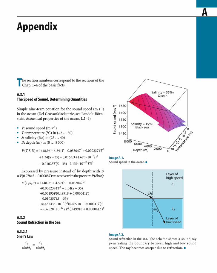
AAppendix
TA.3.1The Speed of Sound, Determining Quantities
Simple nine-term equation for the sound speed (m s–1)in the ocean (Del Grosso/Mackenzie, see Landolt-Börn-stein, Acoustical properties of the ocean, L.1–4)
� V: sound speed (m s–1)� T: temperature (°C) in (–2 … 30)� S: salinity (‰) in (25 … 40)� D: depth (m) in (0 … 8 000)
Expressed by pressure instead of by depth with D=P(0.97845+0.00008T) we receive with the pressure P (dbar):
A.3.2Sound Refraction in the Sea
A.3.2.1Snell’s Law
he section numbers correspond to the sections of theChap. 1–4 of the basic facts.
Image A.1.Sound speed in the ocean �
Image A.2.Sound refraction in the sea. The scheme shows a sound raypenetrating the boundary between high and low soundspeed. The ray becomes steeper due to refraction. �

444 Appendix
A.3.2.2Sound Refraction and Ducted Propagation
proportional to the square of the voltage. Expressedin sound pressure, which is the quantity measuredby a technical sound receiver, the 10 log sound in-tensity ratio becomes the corresponding 20 log soundpressure ratio. This dimensionless quantity is namedsound level.
Historically the dB definition is derived from thehuman hearing capability which senses an increase ofsound intensity fortunately only by its logarithm ratherthan by the enormous span of intensities between hear-ing threshold and pain threshold. This is a factor with13 digits, but ten times its logarithm is just 130 dB, anumber with merely 3 digits. The seemingly arbitraryfactor of 10 (deci-Bel!) of the logarithm is again cho-sen by human hearing experience. A sound level in-crease of 1 dB is about the minimum step, recognisableby man.
1 dB level increase corresponds to an increase of thesound intensity by roughly 10%. 10 dB increase in levelis exactly factor 10 in intensity; 20 dB amounts to afactor of a hundred and so forth. Factors which reducea sound intensity such as propagation loss or spatialfiltering by the receiver beam lead to negative num-bers. For instance: 1/10 means –10 dB. The advantageof the dimensionless sonar equation dealing with lev-els is the very practical compression of huge ratiosbetween the radiated sound signal and the tiny echoand the correspondingly simple treatment of sums anddifferences of the terms in the equation instead ofmultiplication and division.
Image A.4 compares the absorption of soundwaves and electromagnetic waves in the sea. The bluecurve of sound absorption in sea water is valid with-out reflection loss at the sea floor and the sea surfacewhich requires Sofar propagation in the low lossfrequency region. The variability below 100 Hz isdue to leakages of the Sofar-Channel. The two broaddeviations from the straight slope around 1–10 kHzand 100 kHz–1 MHz are caused by re-configurationof molecules and ions following varying pressurein the sound field with time delay. This mechanism
Image A.3.Sound refraction and ducted propagation. Snell’s law ap-plied to a layer of constant rate of change of sound speedc(z) = c0 + gz (s–1). The ray follows an arc of a circle withradius r. �
A.3.3Sound Attenuation
A.3.3.1Absorption
The Decibel Definition
The Decibel-scale in underwater acoustics, abbrevi-ated dB-scale, is used similarly to audio acoustics. It isdefined as 10 times the decimal logarithm of the ratioof two sound intensities. The denominator of the ratioin underwater acoustics is the reference intensity gen-erated by the sound pressure P0 of 1 µPa. (In audioacoustics the reference intensity is derived from thehuman hearing threshold in air and is standardized as20 µPa). The numerator of the ratio is the actual soundintensity generated by the sound pressure P1. Soundintensities are proportional to P2, the square of thesound pressure, similar to electric power which is
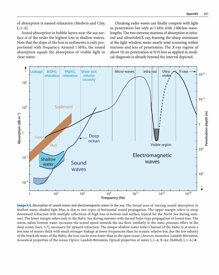
445Appendix
of absorption is named relaxation (Medwin and Clay,L.1–4).
Sound absorption in bubble layers near the sea sur-face is of the order the highest loss in shallow waters.Note that the slope of the loss in sediments is only pro-portional with frequency. Around 1 MHz, the soundabsorption equals the absorption of visible light inclear water.
Ultralong radio waves can finally compete with lightin penetration but only at 1 kHz with 1 000 km wave-lengths. The two extreme maxima of absorption at infra-red and ultraviolet/X-ray, framing the sharp minimumat the light window, mean nearly total screening withinmicrons and less of penetration. The X-ray regime ofabout 10 cm penetration at 9/10 loss as applied in medi-cal diagnosis is already beyond the interval depicted.
Image A.4. Absorption of sound waves and electromagnetic waves in the sea. The broad area of varying sound absorption inshallow water, shaded light blue, is due to two types of horizontal sound propagation. The upper margin refers to steepdownward refraction with multiple reflections of high loss at bottom and surface, typical for the North Sea during sum-mer. The lower margin refers only to the Baltic Sea during summer with ducted Sofar-type propagation of lowest loss. Thewarm, saline bottom water increases the sound speed towards the sea floor similarly to the static pressure effect in thedeep ocean (Sect. 5.7), necessary for upward refraction. The unique shallow water Sofar-Channel of the Baltic is at most afew tens of meters thick with much stronger leakage at lower frequencies than its oceanic relative but, due the low salinityof the brackish water of the Baltic, the loss can be even lower than in the open ocean. (Sources: Acoustics: Landolt-Börnstein,Acoustical properties of the ocean; Optics: Landolt-Börnstein, Optical properties of water, L.1–4; X-ray: Hubbell, L.1–4.) �
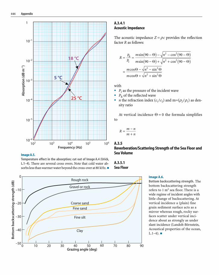
446 Appendix
Image A.5.Temperature effect in the absorption; cut out of Image A.4 (Urick,L.1–4). There are several cross overs. Note that cold water ab-sorbs less than warmer water beyond the cross-over at 80 kHz. �
A.3.4.1Acoustic Impedance
The acoustic impedance Z = ρc provides the reflectionfactor R as follows:
with� PI as the pressure of the incident wave� PR of the reflected wave� n the refraction index (c1/c2) and m=(ρ2/ρ1) as den-
sity ratio
At vertical incidence Θ = 0 the formula simplifiesto
A.3.5Reverberation/Scattering Strength of the Sea Floor andSea Volume
A.3.5.1Sea Floor
Image A.6.Bottom backscattering strength. Thebottom backscattering strengthrefers to 1 m2 sea floor. There is awide regime of incident angles withlittle change of backscattering. Atvertical incidence a (plain) finegrain sediment surface acts as amirror whereas rough, rocky sur-faces scatter under vertical inci-dence about as strongly as underslant incidence (Landolt-Börnstein,Acoustical properties of the ocean,L.1–4). �

447Appendix
A.3.5.2Sea Volume
A.3.6Noise
A.3.6.5The Spatial Filter
Image A.7. Volume backscattering strength. The volume backscattering strength refers to 1 m3 of sea water with distributed scatter-ers such as plankton (Landolt-Börnstein, Acoustical properties of the ocean, L.1–4). The eight figures show the measured vari-ability of volume backscattering in different deep ocean areas over a wide frequency regime. Such data are relevant for measuringthe ocean current by acoustic Doppler current profilers (ADCP) which are usually operated at higher frequencies. The variabilityis typical but unpredictable. �
Image A.8.The graphic scheme provides the beamwidthof a transducer of the indicated size and thefrequency by connecting the quantities by astraight line as indicated (Urick, L.1–4). �

448 Appendix
A.3.6.6The Frequency Filter
The bandwidth B (Hz) of a signal with a duration T (s) isconnected by the so called uncertainty relation of classi-cal physics
Table A.1.Parameters of the sonar equation.The target strength TS in the sonarequation is mainly used for singleobjects. In this context TS is used forbackscattering strengths of the seafloor or of the sea volume of distrib-uted objects in the water column, forinstance fish and plankton. �
A.3.7Sonar Equation
For an active remote sensing device or echosounder thesonar equation is
DT = SL – 2TL + TS – (NL – DI)
with the parameters shown in Table A.1.
Image A.9.Directivity index DI and beamwidth. The logarithmic depictionreveals the simple relation between directivity index and beam-width: narrowing the beamwidth to 1/10 gains 10 dB of the di-rectivity index of a linear array, and 20 dB of a planar array.Note, that the DI becomes zero at 180° beamwidth, which means:the so called “half space” in front of the ships hull is coveredwithout directional preference. This is the case of a so called“point source” or point receiver mounted in a sound tight wall. �

449Appendix
Image A.10.Source level and acoustic power. Typical source level values (SL)of echosounders are 210–220 dB relative to 1 µPa. �
Image A.11.Transmission loss with absorption and geometrical spreadingcombined. The dashed lower boundary of the transmissionloss curves assumes spherical spreading loss with 20 dB perevery 10 times the range. This is realistic only up to a rangeof transition between about 1 and 10 km beyond which thespread is merely cylindrical due to ducted Sofar-Channelpropagation. The real deep water transmission loss at theindividual frequencies is lower according to the red curvebelow as the cylindrical spreading reference. The differenceamounts to about 30 dB at 1 000 km. The range interval oftransition may vary somewhat however, depending on theregional and seasonal sound speed profile and the depthof the sound source (figure derived from Sect. A.3.3.1,Image A.4). �
Image A.12. Noise spectrum level of wind- and sea traffic noise (Landold-Börnstein, Acoustical properties of the ocean, L.1–4). The depictednoise spectrum level refers to a frequency bandwidth of 1 Hz. A bandwidth of 100 Hz for instance adds 20 dB and a bandwidth of1 kHz adds 30 dB to the spectrum level received by an omnidirectional receiver which then represents the noise level (NL) in thesonar equation. Most of the echosounders are directional by beamforming however which acts as a spatial filter of noise. Thisreduction of the received noise appears in the sonar equation as directivity index DI. If the beamwidth achieves a noise reduction of20 dB for instance, the DI is 20 dB. �
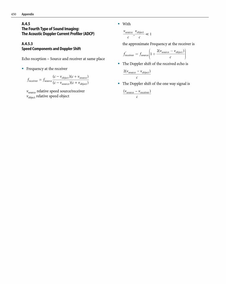
450 Appendix
A.4.5The Fourth Type of Sound Imaging:The Acoustic Doppler Current Profiler (ADCP)
A.4.5.3Speed Components and Doppler Shift
Echo reception – Source and receiver at same place
� Frequency at the receiver
vsource relative speed source/receivervobject relative speed object
� With
the approximate Frequency at the receiver is
� The Doppler shift of the received echo is
� The Doppler shift of the one way signal is

CD
Large Images, Fledermaus Files, Sound Tracks, and Animations
1 The first approach to sea floor imaging: North Atlantic, Maury, 18532.11 Atlantic sea floor imaging, 1940 with Meteor data 1925–1927; large image3.2.2 Acoustic “superconductivity”; sound tracks of earthquake, volcano erup-
tions, and nuclear explosion test5.1.1 GEBCO5 Globe of the sea floor relief; Fledermaus5.1.1.1 ETOPO2 Atlantic Ocean, large image5.1.1.2 ETOPO2 Pacific Central, large image5.1.1.3 ETOPO2 Pacific Australian, large image5.1.1.4 ETOPO2 Indian Ocean, large image5.1.1.5 ETOPO2 Arctic Ocean, large image5.1.1.6 ETOPO2 Antarctica, large image5.1.2 High resolution bathymetry versus Satellite altimetry, Eltanin; Fleder-
maus5.2.1 Subduction of tectonic plates; Alaska, large image5.2.1 Subduction of tectonic plates, Chile Type; Central America 1a, large image5.2.1 Subduction of tectonic plates, Chile Type; Central America 1b, large image5.2.1 Subduction of tectonic plates, Chile Type; Central America 4a large image5.2.9 East Asian formations, Taiwan, large image5.3.1 Submarine Escarpment Slides; Storegga Slide, large image5.3.3 Sediment bedforms, migrating dunes, animation5.3.5 Salt diapirs, animation5.3.6 Canyons, channels, Porcupine Bight; animation5.3.8 Canadian formations; Inner Scotian Shelf, large image5.4.1 Arctic Ocean and its constituent seas, IBCAO, large image5.5.1 Features of the Weddell Sea, Fledermaus5.5.4 Features of the Ross Sea, 2 large images5.6.1 Chella Bank, Mediterranean, animation6.2.1 Methane hydrate deposits, Hydrate Ridge, Fledermaus6.3.3 Marine mammal voices; sound tracks7.3.2 Historic ship wrecks and wreck sites; Blücher, Fledermaus
CD Attachment Index

SISubject Index
A
AABW (see Antarctic bottom water)absorption 7, 275, 449abyssal plain 145accretionary prism 87, 105Achziv Canyon 248acoustic
–, array axis 46–, bathymetry 64–, current measurement 56–, Doppler current profiler (ADCP) 19, 56, 57, 269
–, concept 56–, impedance 296, 297, 446–, Risk Mitigation Policies 322–, Sea-floor Classification System (ASCS) 255, 282, 292–, spectrometry 287, 300–, tomography 275, 281–, tracking 60
ADCP (see acoustic Doppler current profiler)Adelaide 187Aegean Sea 234, 238, 240, 247
–, features 238Aeolian Islands 234Africa 69, 183, 217African Plate 75, 131, 145, 234–236, 245air
–, bubble sound absorption 304–, intrusion 299
aircraft wreck 355airgun 55AKF (see Avalon Knoll Fault)Al Idrissi mud volcano 178Al Mansoura (wreck) 348Alaska 87, 139, 205
–, continental slope 103–, Peninsula 77–, subduction zone 102
albedo 202, 255Alboran 234
Alcoa Puritan 403, 405, 407, 409, 410Aleutian
–, Islands 77–, Trench 71, 77
Aleutians 127Alonnisos Island 238Alpha-Mendeljev Ridge 206Alps 236altimetry satellite 64, 65Amber Chamber 352Amerasian Basin 205America 69, 71, 405Ampère
–, Massif 131–, Seamount 131, 132
Amundsen Basin 77, 206Anaximander Mountains 245Andaman 114Andes 94angular (or cross) resolution 308anomaly
–, gravity 10–, magnetic 11
Antarctic–, Bottom Water (AABW) 132–, Circumpolar Current 116–, Continent 67, 79–, Cruise 217–, Peninsula 79, 216, 217, 222, 224–, Plate (tectonic) 75, 79, 83, 116, 125, 219
Antarctica 83, 187, 217, 219, 221, 222, 228, 230–, globe 79
aperture, synthetic 361Arabian Plate 75, 234archaeology 374
–, battleship a. 390architecture, ancient urban 374Arctic
–, Basin 206–, Fram Strait 315

454 Subject Index
–, Ocean 67, 77, 202, 206–, bathymetry 202–, depression 206–, globe 77–, physiography 202–, sediments 208
–, sea ice 212–, Shelf 202
Armutlu Peninsula 244array
–, axis 46–, beam, phased forming 46–, end-fire 54–, length 54–, phased 50–, two line 47
Arrow Lake 201Ascension Fracture Zone 121ASCS (see acoustic sea-floor classification system)Asker (wreck) 350asteroid impact 83astigmatism acoustic 50astronomical navigation 45Atlantic 75, 77, 86, 192
–, Islands 147–, landslide 153
–, Margin 178–, Ocean 69, 77, 186, 206, 251, 272, 281
–, globe 69ATLAS Werke AG, Bremen 16Austaasen Bank 226Australia 25, 79, 115Australian
–, Plate 111–, Shelf 187
autonomous–, lander 314–, underwater vehicle (AUV) 212, 355, 402, 421
AUV (see autonomous underwater vehicle)Avalon Knoll Fault (AKF) 130AWI Bathymetric Chart Weddell Sea (AWI BCWS) 218axial ridge 122Azores-Gibraltar 131
B
back-arc–, basin 73, 106–, chain 220
Bahamas 38Baia 374, 375Balearic Islands 236
Balleny Islands 228Balsfjord 188Baltic Sea 8, 15, 190, 234, 251, 252, 262, 310, 311, 328, 348,
351, 358, 396, 445–, fish stocks 310, 311–, formations 251–, Gulf of Gdansk 258–, Kadetrinne 256–, relief 252–, salinity 22–, sedimentation 261–, western 255–, wrecks 351
bandwidth 43Bangladesh 114, 161, 162barchan 170Barents Sea 159, 178, 205bathymetry
–, acoustic 12, 64–, high resolution 80
Battle–, of Normandy 383–, of the Doggerbank 382
battleship archaeology 390Bay of
–, Bengal 161, 162–, Biscay 146–, Eckernförde 255, 292, 293, 298–, Kiel 256–, Naples 378
beam, narrow 54beamwidth 54Bear Island
–, Fan 159–, Trough Mouth Fan (TMF) 159, 161
Beaufort Sea 206Bedford Basin 192bedrock structures 190Behm, Alexander 14, 16Belt Sea 252Bengal Fan 161–166, 234Bergen 189Berwick Castle 385Bight of
–, Lübeck 329–, Mecklenburg 261–, Meldorf 336
–, sea floor 339–, Scapa Flow 392, 396
Bismarck 390Bjørnsundet 188Black Sea 242

455Subject Index
Blücher (wreck) 381blue
–, whale 24–, whiting 313
BODC (see British Oceanographic Data Center)Boknafjorden 190Boris Petrov Expedition 208Boston
–, Centre 15–, USA 14
Bottlenose dolphin 316Bottom Simulating Reflector (BSR) 284–289boundary, pressure-release 289Brahmaputra River 161Bransfield Strait 222, 223Bremse class 394Britain 175British
–, Columbia 198, 200–, Oceanographic Data Center (BODC) 66
Bruce, William 218Brummer 394Brunt Ice Shelve 217Bryozoas 225BSR (see bottom simulating reflector)bubble oscillations 34Burma Trench 162buzz 298, 299, 319, 322
C
C.C.G.S. Matthew 192cable
–, submarine 362–, Trans-Atlantic 362–, Trans-Pacific 362
California margin 130Callao/Peru 166Campi Flegrei 374Canada 190, 200, 205
–, west coast 198–, Basin 206
Canadian–, Arctic Archipelago 206–, Gully 186
Canale Grande 343Canary
–, Channel 183–, Islands 147, 153
canyon, submarine 184Cape
–, Adare 228
–, Hallett 228, 230–, Horn 79
carbon dioxide 299carbonate mounds 171Carboniferous 236Caribean 69carpenter fish 317Carrara 237cavitation 43
–, bubble 43–, limit 43
CBBL (see coastal benthic boundary layer)CCGS John P. Tully 199, 200Celebes Basin (Sulawesi Basin) 111Celtic
–, Deep-sea Fan 156–, Fan 155–, Margin 155–, Shelf 146, 172, 186
Central–, America 71, 87
–, subduction zone 87–, American Trench 90, 234–, Basin 243, 244–, Chile 87, 97
–, subduction zone 94–, Costa Rica 91–, Fracture Zone 108–, Labrador Sea 279–, Pacific 127
Chagos-Laccadive Ridge 75Challenger Deep 107, 109
–, Trench 106channel 184
–, axis 25–, submarine 167–, levee
–, process 185–, complex 164–, effect 187–, system 218
Charybdis 13, 234Chella Bank 235Cherbourg 383Chi-Mei Canyon 143Chile 126
–, continental slope 101–, Trench 71–, -type margin 85
Chilean Margin 100Chinese Continental Margin 145Christelle Volcano 118

456 Subject Index
Chukchi Borderland 206Chukchi
–, Sea 206–, Spur-Chukchi Plateau 206
Ç1narc1k Basin 243–245, 456Cinque Terre 237
–, wrecks 349circulation, Langmuir 300City of Baia 374, 378Claire Volcano 118clathrates 289Cleona (wreck) 350climate history 4close-up deep water imagery 402Coastal Benthic Boundary Layer (CBBL) 292, 293, 295, 298Coats Land 217Cocos
–, Plate 70–, Ridge 87
cold water corals 176Colladon, J. Daniel 15Cöln II 393Comprehensive Test-Ban Treaty (CTBT) 27compressibility 22
–, non-linear 53–, of water 53
compressional wave 55computer capability and data storage 14concept
–, combined 59–, drifter 56–, tomographic 56
Condul (wreck) 328construction, submarine 362continental
–, margin 106–, rise 145–, shelf 8, 145–, slope 8, 145
convergence–, tectonic 245–, vector 93
conveyor belt 206, 279coral reef 139Cordilleras 236Coriolis force 189Corsica 298, 299, 320, 322Costa Rica 87, 90Crete 245, 247Crinoidea 225CTBT (see United Nations Comprehensive Test Ban Treaty)Curonian Lagoon 258current
–, bi-directional system 272–, circumpolar 26–, Doppler profiling 269–, measurement 56–, profile, vertical 56–, resolution, vertical 272–, sampling problem 59–, slow 58–, tracking 19–, turbidity c. 155–, unidirectional cold southward 269–, variability
–, spatial 58–, temporal 58
–, vector–, determination 57–, profile 56
–, velocity, horizontal 272–, volume 266
Cyprus 234, 245Cyrenaica 234
D
D-Day relics 341Daikakuji Seamount 80, 81Daito Ridge 108Danish Sounds 251Danzig 353Dardanelles 238Darss Peninsula 257data, climatological 25Dead Sea 234debris flow 156, 157, 159
–, non-glacigenic 158Decibel, definition 444deep
–, sea food 314–, Scattering Layer (DSL) 312–, towed 403
Denmark 252density 22depiction
–, bathymetric 44–, landscape 44
depression 206depth 35
–, chart 44–, profile 49–, resolution 54, 308
description–, Eulerian 60–, Lagrangian 60

457Subject Index
Dessau 334detection range limited 31DGPS navigation 364diapir 178, 183
–, evaporitic 183diffraction 30digital terrain model (DTM) 189dipole domain 42direction of radiation 46Dock of London 344dolphin, stranding 38Doppler
–, effect 56–, frequency-speed relation 58–, shift 56, 57, 450
Drake Passage 217dreadnoughts 391Dresden II 392, 393
–, class 392drifter concept 56drive fisheries 320DSL (see deep scattering layer)DTM (see digital terrain model)dune 170
–, underwater 198
E
Earth–, crust 4–, surface, deepest place 109
earthquake–, magnitude 112–, submarine, sonogram 36–, tsunami generating 113
East Antarctica 217East Asia 71, 362East Greenland Current 207, 215, 274East Mariana Basin 108East Mariana Ridge 107East Pacific Rise (EPR) 70, 71, 75, 79, 117, 123, 125, 130East Prussia 351, 354East Siberian Sea 206Eastern Ridge 243echo
–, formation 29–, imaging
–, radar 19–, sound 19
–, intensity 48–, strength 307–, sounding 275–, intensity 49
echosounder–, characteristics 41–, evolution 18–, fan (see multibeam)–, hardware 14–, high resolution 41–, information 35–, monobeam 308–, multibeam (or fan) 19, 31, 44, 46
–, angle 54–, parametric 358–, transducer 48
–, object discrimination 35–, optimization 44–, resolution 44–, sediment e. 162
–, conventional 55–, parametric 53, 54
–, sediment penetrating 19, 52–, sidescan 19, 28, 48, 49
–, transducers 50–, steering signal 46
echosounding 14–, direct, quantitative imagery 19–, high resolution 19–, sediment 52–, slant angles 31
effect–, Doppler 56–, hydrodynamic 12, 13–, piezoelectric 42
eigen-frequency 43eigen-rays 280El Golfo 153
–, -landslide 154El Hierro 153, 154El Niño 166Elba Island 359, 360Elbe
–, Estuary, floor features 336–, River 334, 335, 339
electromagnetic wave, penetration depth 9electrostrictive 42Ellsworth Land 217Eltanin
–, Impact Area 83–, Massif 10, 80, 82
–, relief 11Emperor Seamount Chain 71, 77, 80, 139
–, map 80encounter speed 57end-fire array 54, 359
–, synthetic 359

458 Subject Index
energy–, acoustical 42–, conversion 42–, electrical 42–, irradiation 7–, remaining 7
England 190English Channel 15, 155Eolian
–, Islands 134–, Volcanic Arc 134
EPR (see East Pacific Rise)Epsom Salts 22Equatorial Undercurrent 272equipotential surface 65Erathostene Seamount 245erosion 142
–, tectonic 87, 93, 94, 102eruption volcanic, sonogram 36escarpment slide 146Estonia 326estuary, surveillance 335Etna 133ETOPO2 64, 84
–, data 110, 112Eulalla Volcano 118Eulerian
–, description of flow 60–, method 266
Eurasian–, Basin 205–, Plate 73–77, 110, 112, 131, 140, 145, 161, 234–236, 240, 245
Europe 69European Continental Margin 145, 153Explora Escarpment 216, 217, 219explosion nuclear, sonogram 37exponential law 8
F
F. G. Creed 192, 194, 195facies 163Faeroe Islands 159fairway surveillance 326Falster Island 257fan echosounder (see multibeam echosounder)Fara Volcano 118Farallon Plate 70fauna, submarine 306ferry, sunken 326Fessenden
–, Oscillator 15, 16–, Reginald A. 14
FFK (see vessel/ship)FFS (see vessel/ship)field
–, Fraunhofer far 51–, Fresnel near 51–, magnetic 11
Fiji Islands 73Filchner Ice Shelve 217filter
–, frequency 35, 448–, spatial 34, 447–, tailoring 35
Fimbul Ice Shelve 217Finland 251, 252fish
–, stock, estimation 307–, towed 49
fishery, drive 320fjord 188Fledermaus visualization 110, 114, 206, 210, 220flora, marine
–, sound imaging 322Florence Rise 245Flores 75, 112Florida 296, 298flow
–, debris 157–, eddy 158–, Eulerian description 60–, Lagrangian description 60–, nearly horizontal 57–, tidal 168, 282–, turbidite 161–, type 167–, unidirectional 158
focus, gliding 50focusing 50
–, effect 51–, limits 51–, scheme of 50
formation–, Canadian 192–, natural 63–, volcanic 131
Fracture Zone 118Fram (vessel) 202Fram Strait 77, 202, 205, 206, 212Franpipe 367Fraser River 198Fraunhofer far field 51freeboard 213Freeden
–, Seamount 82, 83
459Subject Index
–, Wilhelm von 82frequency
–, difference 53–, filter 35–, low, generation 53–, resolution 58–, shift 57
Fresnel near field 51FRV (see vessel/ship)Fuerteventura 183Fyn 255
G
Gagua Ridge 140Gakkel Ridge 77, 206Galapagos 87Gale 302
–, Strong 302Galilee 248gamma radiation 10Ganges
–, Delta 75–, River 161
Ganos Mountain System 244gas 282
–, indicator 289–, plume 263
GDA (see GEBCO digital atlas)Gda´nsk 353GDF (see glacinogenic debris flows)GEBCO (see general bathymetric chart of the oceans)GEBCO Digital Atlas (GDA) 66General Bathymetric Chart of the Oceans (GEBCO) 66General von Steuben (wreck) 348, 351, 354geodynamics 85Geographic and Hydrographic Information System
HydroCAD (GIS/HIS) 343Geological Survey of Canada Atlantic (GSCA) 195Geosat 65German Federal Research Board for Fisheries 309Germany 252, 340giant
–, shelf canyon 161–, tsunami 114–, underwater dune 198
Gibraltar 119, 131Giesensand 338GIS/HIS (see geographic and hydrographic information
system HydroCAD)glacinogenic debris flows (GDF) 159gliding focus 50Global Ocean Ecosystem Dynamics program (GLOBEC) 310
global positioning satellite navigation (GPS) 14, 45, 46GLOBEC (see Global Ocean Ecosystem Dynamics Program)Gloria (sidescan echosounder) 52Gneisenau (wreck) 328Gogonarian 225Gondwana 187, 217Gorleben salt diapir 183Gorringe Bank 131Gotland 252
–, Basin 311Goya (wreck) 348, 351GPS (see global positioning satellite navigation)Grand Banks 272gravity
–, anomalies 10–, field 65
–, unipolar 11–, relief 10–, wave, internal 14
Great Ice Barrier 228Greece 145Greenland 205, 206Grosse Atlantische Expedition 16ground truth 270GSCA (see Geological Survey of Canada Atlantic)Gulf of
–, Aden 75–, Bengal 75–, Biscay 155–, Bothnia 252–, California 71, 128, 130–, Finland 263–, Gdansk 251, 255, 258–, Mexico 281, 403, 407, 409
Gulf Stream 5, 207Gustloff (wreck) 354guyot 81, 87, 135, 235, 249gyro 46
H
Haifa 248Haitabu 358, 396Håkon Mosby Mud Volcano (HMMV) 178, 181Halifax 190, 192
–, explosion 192–, Harbor 192
halocline 310Hamburg 335
–, Harbor 340, 341Hanseatic League 251harbor
–, protection 370

460 Subject Index
–, surveillance 340Hardangerfjord 188hardware transport 364Hawaii 84, 138Hawaiian
–, Archipelago 138, 362–, Chain 75, 77, 80
–, map 80–, Emperor Chain 80–, Islands 87, 138, 139
Hayes–, Fracture Zone 119–, Ridge Transform Intersection 120
heat–, content 278
–, large scale measurement 279–, measurements 277
–, energy, transport and distribution 59–, transport 266
Hecht, Heinrich 15Hela Peninsula 353Hellenic Trench 234, 240Hengchun Ridge 140, 142Herodotus
–, Abyssal Plain 245–, Trough 245
herring 313–, pole formation 313
Herringbone Relief 216, 219Himalayan 161, 162Himalayas 75, 138, 161Historic Wreck Site 388Hjort
–, Ridge 116–, Trench 115, 116
HMMV (see Håkon Mosby mud volcano)HMS
–, A1 (wreck) 385–, Hazardous (wreck) 387–, Mary Rose (wreck) 388–, Superb (submarine) 215
Hobart 137Holocene 261holography 44Hong Kong, seabed survey 346Hook of Holland 332Horlaland 188Horseshoe Seamounts 131hot spot
–, hypothesis 138–, islands 138–, temperature anomaly 23
house, Roman 377
Hr. Ms. Adder 386Hsiukuluan-chi River 143Hualien Canyon 143Huatung Basin 140, 145Hydrate Ridge 283–285, 287, 288Hydrodynamic effects 13hydrogen bond 287hydroplaning 161Hydrozoa 225Hylsfjorden 190
I
IBCAO (see international bathymetric chart of the Arctic Ocean)ice
–, coverage 213–, thickness 213
Iceberg Alley 224iceberg plough scars 224Iceland 77
–, Basin 268–, -Faroes Ridge 268
ICES (see International Council for the Exploration of theSea)
IHO (see International Hydrographic Organization)illumination 7image
–, processing 287–, radar 12–, visual 6
imaging–, acoustic 19
–, application 61–, by sound 6, 32–, limiting background 32
impedance–, acoustic 29, 287, 296, 297, 446
–, definition 29–, steps 30
Imperial Fleet 396India 162Indian Ocean 25, 75, 79, 86, 112, 162, 206
–, globe 75–, sound speed at Sofar-axis depth 26
Indo-Australian Plate 73, 75, 112, 116, 161Indonesia 110Indonesian
–, Island Arc 112–, passage 25
information, transport 364infrared 9inhomogeneity, backscattering 31intensity 8

461Subject Index
International–, Bathymetric Chart of the Arctic Ocean (IBCAO) 202–, Council for the Exploration of the Sea (ICES) 307–, Hydrographic Organization (IHO) 66–, Oceanographic Commission (IOC) 66
IOC (see International Oceanographic Commission)Ionian Basin 245Ireland 146, 172, 175Irish Sea 155Irminger
–, Basin 312–, fish stocks 312
–, Current 268irradiation 7
–, energy 7island arc 138Island of
–, Bornholm 255–, Sylt 299
Isle of–, Fehmarn 255–, Gotland 252–, Guam 107–, Wight 385
isobath 44, 67Israel shelf, formations 248Italy 145, 349, 374, 378Izu Ogasawara Trench 107
J
J6 Alpha platform 367Jan Hevelius (wreck) 326Japan 107, 113Japanese Sea 36Java 75, 112
–, Ridge 112–, Trench 75, 111, 112–, -Sunda Trench 112
Juan de Fuca–, Plate 70, 128, 133, 283–, Ridge 133–, Strait 198
Juan Fernández Ridge 94, 97Juan Perez Sound 201
K
K13 Alpha platform 367Kadetrinne 256, 257Kahoolawe 138, 139Kaiko (submersible) 107Kamchatka Trench 77
Kap1dag˘ Peninsula 244Kara Sea 205Kattegat 251Kauai 139
–, Island 80, 84Kent 383Kerguelen Plateau 79Kermadec Trench 71Key West 296Kiel 14
–, Canal 251, 255, 336–, Fjord 15, 255
København 255König (wreck) 391König class battleships 391, 392Königsberg II class 395Korfu 322Krautsand 338Kristiansund 188Kronprinz Wilhelm (wreck) 391kurkar 248Kyusyu 107
–, -Palau Ridge 107, 108
L
L3 submarine-minelayer 353Labrador Sea, heat content 279LADCP 270
–, method 274Lagrangian
–, description of flow 60–, method 266
Lake Lucrino 380Lake of
–, Geneva 15–, Tiberias 234
Lanai 138, 139landslide 159Landsort Trench 260Langmuir circulation 300Lanzarote 183Laptev Sea 205, 206Large Scale Drifter Field Experiment 266law, exponential 8Le Hazardeux (wreck) 387Lead-Zirconate-Titanate (LZT) 42, 43
–, as sound source 42–, polarization 42–, -transducer 43
lee wave 12length, apparent 54Levitus 25
462 Subject Index
–, Atlas of Oceanography 25Libya 245, 247Lichte, Hugo 15light
–, blue-green 9–, intensity 8–, visible 8
–, penetration depth 8Ligurian Sea 320, 322lithosphere 4Lomonosov Ridge 205Longitudinal Valley 143Lophelia pertusa 176, 177Loran 45Los Angeles
–, Area 130–, Basin 128
loudspeaker, electrodynamic 15Luzon
–, Island Arc 140–, Volcanic Arc 145
LZT (see lead-zirconate-titanate)
M
Ma Wan Island 347Maas Channel 332, 333Macquarie
–, Island 115–, Ridge 115
–, Complex (MRC) 115, 116Madagascar 75Madrepora oculata 177magnetic anomalies 11magnetostrictive 42magnitude 112Makarov Basin 206mammal, marine
–, noise 38–, voice sonogram 316
Manila Trench 140Manta mine 359map, global 67MAR (see Mid-Atlantic Ridge)Marciana Marina 359, 360margin
–, Chile type 85, 106–, continental 128, 247
–, active 178–, Marianas type 106–, passive 145, 178
–, convergent 106, 145–, Chile type 106, 107
–, Marianas type 106, 107–, passive 145, 178
Mariana–, Trench 107, 110, 112–, Trough 107
Marine Protected Area (MPA) 194marine reserve 137Maritime and Coastguard Agency 383Markgraf (wreck) 391Marmara Sea 238, 242
–, Trough 242Marquesas Fracture Zone 127Marsili 234Mary Rose Trust 388mass distribution 10matched
–, filter computer 277–, peak method 276
material–, electrostrictive 42–, hazardous 326–, magnetostrictive 42–, piezo-ceramic 42
Maui 138, 139Maury Map 117MB (see vessel/ship)meadow, inundated 255Mediterranean 145, 236, 238, 320, 322, 380
–, outflow 25–, water (MOW) 132
–, Ridge (MR) 245–, Sea 235, 242, 316, 322
–, formations 232–, heat content 277, 278–, salinity 22–, tectonic 245
–, sound speed at Sofar-axis depth 26Meghna River 161Melanesia 73melon 319Mentawai Ridge 112Merz, A. 16Meteor 17, 18methane
–, acoustic features 293–, biogenic 291–, hydrate 289, 292
–, deposits 282–, properties 284–, ressources 284
–, in shallow sediments 291method
–, Lagrangian 266
463Subject Index
–, matched peak 276MFZ (see Mocha Fracture Zone)microwaves 9Mid-Atlantic Ridge (MAR) 6, 17, 69, 75, 77, 79, 117–122,
127, 131, 145, 255mid-ocean ridge 75, 117, 119, 126, 127, 129, 138
–, fast spreading 123, 125, 127–, slow spreading 117, 119, 121, 122
Middle Marianas Ridge 107Mittelgrund 298mixing, non-linear 53Mobile Bay 405Moby Dick 316Mocha
–, Fracture Zone (MFZ) 100–, Island 100
Molde 188Molloy
–, Deep 206–, Hole 207
Molokai 138Mont Blanc
–, Massif 132–, vessel 192
Moresby Island 200Morocco 178morphology, small scale 48Morris Jessup Rise 206motion
–, compensation 46, 48–, of ship 46
Mount Carmel 248MOW (see Mediterranean outflow water)MPA (see marine protected area)MR (see Mediterranean Ridge)MRC (see Macquarie Ridge complex)MS (see vessel/ship)mud volcano 178multi-aspect sounding 52multibeam echosounder 19, 44, 46
–, transducer 48München (see General von Steuben)Munk, Walter 274Murray-Darling River 187MV (see vessel/ship)
N
NAC (see North Atlantic Current)NADW (see North Atlantic deep water)NAF (see North Anatolian Fault)Nanga Parbat 75Nansei Syoto Trench 107
Nansen Basin 77, 206Naples 133, 374Narrows 192navigation
–, astronomical 45–, DGPS 364–, GPS 45–, radio 45
Nazca Plate 70, 94, 97–, Margin 99
Neptunian water 22New Foundland 272
–, Basin 272New Guinea 73New Siberian Islands 202New Zealand 71, 79, 115Nicaragua 87, 90, 93
–, Trench 71Nicobar 114Nicoya Peninsula 93Nile 234
–, Deep-Sea Fan 247–, Delta 247
Ninety East Rise 75nitrogen 299noise
–, by bubble oscillations 34–, by rain 33, 34–, fighting 38–, fighting, technical 34, 35–, in the sea 32–, limited 31–, self n. 38–, signal to noise ratio 32–, sources 32, 36–, spectrum level 449–, wind-driven 33
–, intensity 33non-linearity parameter 54Norderelbe 340Nordic Seas 206Nordsee (research platform) 299, 300, 362, 373North Aegean
–, Basin 238, 240–, Trough 240, 242
North American–, continent 190–, Plate 77, 128, 145
North Anatolian Fault (NAF) 238, 240, 242North Atlantic 5, 146, 206, 207
–, bathygraphic map 5–, Circulation 266–, Current (NAC) 272, 274
464 Subject Index
–, Deep Water (NADW) 132, 207, 279–, fish stocks 312–, submarine cables 362
North Brazil Current 272North European Margin 255North Kaholmen 382North Luzon Trough 140North Pole 67, 77North San-Hsian Canyon 143North Sea 15, 168, 251, 313, 328, 372, 382, 445
–, Fan 158–, fish stocks 309–, TMF 159
Northern Greenland 206Northern Hemisphere 119, 122Northwind Ridge 206Norway 188, 350Norwegian
–, Channel 156–, Fjords 188
Nova Scotia 190–, Shelf 186
NRV (see vessel/ship)
O
Ob 208object
–, acoustic size 30–, buried 355–, minimum size 30
ocean–, acoustic
–, physics 15–, tomography 59, 274
–, Drilling Program (ODP) 139, 219–, floor, subduction 106–, remote sensing by sound 27–, salinity 22–, surface topography 64–, surveillance 19–, temperature 23–, volume 265
oceanic plate 106Oceanographer
–, Fracture Zone 119–, Transform Fault 118
Oceans Act 190, 193Odontocetes 38, 316, 319ODP (see Ocean Drilling Program)OFZ (see Owen fracture zone)Okeanos (vessel) 412Oki-Daito Ridge 108
Omega (navigation) 45Operation
–, Neptune 397–, Overlord 397
Ophiuridea 225optimization, sounding 35optimum compromise between range and resolution 29orange peel texture 111Orange Roughy 137Orca Seamount 222Ormen Lange 417
–, gas field 414ORP Arctowski 352, 353Oscillator 16
–, Fessenden 15, 16Oskarsborg 382Oslo Fjord 188, 382Owen Fracture Zone (OFZ) 75oxygen 299
P
Pacific 71, 75, 80, 86, 106, 112, 192, 245, 362–, Australia, globe 73–, Central, globe 71–, -Cocos Plate 126–, Fracture Zone 123–, -Nazca Plate 126–, Ocean 138, 206
–, sound speed at Sofar-axis depth 26–, Plate 70, 73, 83, 108, 116, 125, 128–, Ring of Fire 71, 73, 77, 106, 111–, submarine cables 362
Palau Trench 107Paleozoic Cambrian-Devonian period 190, 192Palos Verdes
–, Fault (PVF) 130–, Peninsula 130
Panarea Island 134–135parameter, non-linearity 54parametric echosounder 54Parasound 166Parece Vela Basin 108Patrol Craft 566 404Patton Escarpment 128Pelagia (survey vessel) 175Peloponnesus 247penetration depth 7, 304
–, visible light 8Penghu Canyon 142Persian Gulf, wreck 348Peru 166phase 46

465Subject Index
–, delay 46–, front 46, 50
–, axis 46–, propagation 23–, shift 47, 295
phased array beam-forming 46Philadelphia 383Philippine 110
–, Basin 108, 111–, Plate 73, 107, 110–112, 140
–, tectonic activities 140–, Trench 73, 107, 110, 111
Philippines 106phonic lips 319photography, underwater 19piezoceramic material 42piezoelectric effect 42piezoelectricity 42pilot whale 316pipe 368
–, state of free span 368pipeline
–, route planning 414–, submarine 366
pixel size 308, 327plain, abyssal 145plate
–, collision 234–, continental 106
–, margin 145–, converging 245–, margin 129
–, convergent 106–, motion 221–, oceanic 106
–, subduction 111–113–, subduction 106–, tectonic 86
–, convergent 85–, map 86
–, tectonics 85–, map 220
Pleistocene 156Pliny Trench 245pockmark 262, 292Polarstern (vessel) 172pole formation 313Porcupine Bight 171, 172Porto Giulio 378Portus Julius Baiae 378Posidonia 307
–, oceanica 322Possession Islands 228, 230, 231
pressure–, sound 53–, static 22, 53
prism, accretionary 87Prof. Albrecht Penck (ship) 261, 262project, EU C-Star 12Protection of Wrecks Act 388PVF (see Palos Verdes Fault)
Q
Qishon 248quartz 42Queen Charlotte Islands 200Queen Maud Land 217Quepos Plateau 87
R
radar–, image 12–, satellite 9
radiation–, absorption 7–, axis 46–, direction 46–, gamma 10–, ultraviolet 10
radiator, coherent 44radio
–, navigation 45–, waves 9
rain noise 33raindrop impact 34receiving mode 55Red Sea 75
–, sound speed at Sofar-axis depth 26redfish 312reflection 280
–, seismics 290–, specular 29, 30
refraction 280–, index 23, 24–, seismics 290
relief, gravity 10remote sensing 6, 274
–, of motion 59remotely operated vehicles (ROV) 192, 229–231, 359, 391, 396, 406research platform Nordsee 372resolution
–, angular (or cross) 50, 291, 292, 308–, cell 308–, depth 54, 308
466 Subject Index
–, dilemma 53–, frequency 58–, lateral 44, 50–, necessary 44–, possible 44–, radial 44, 50–, speed 58–, time r. 45
resonance 43reverberation 31, 446
–, limited 31Reykjanes Ridge 77, 268rheology 87Rhodes
–, Basin 245–, Island 245
Richard Montgomery–, vessel 328–, wreck 383
ridge–, erosional 142–, subduction-induced 142
ripples 168rise, continental 145Robert E. Lee (vessel) 404, 405, 409, 410, 412Rockall Trough 175
–, margin 171Rockan mine 359Rogaland 188Roman City, sunken 374Ronne Ice Shelf 217Ross
–, Ice Shelf 228–, James 228–, Sea 67, 79, 218, 228, 230
Rotterdam Harbor 332Route Position Lists (RPLs) 364ROV (see remotely operated vehicles)RPLs (see route position lists)Russia 205RV (see vessel/ship)Ryukyu
–, Island Arc 140–, Trench 140, 142
S
S/N (see signal to noise ratio)Sable Island 198Sable Offshore Energy Project (SOEP) 195Safe Shipping Clearance 327Salcombe 190
–, cannon site 389
–, wreck site 388salinity 22
–, sensor 59Salomon Islands 73Sambian Peninsula 252sampling 47
–, line by line 49–, problem 59–, simultaneous 47–, time parallel 47
San Andreas Fault 70, 128, 130San Antonio Canyon 97, 102San Francisco 130San-Hsian Canyon 143sand
–, ribbons 170–, dune 168, 169
Sandsfjord 188Sandwich Island Chain 219Saros Körfezi Bight 238satellite
–, altimetry 64, 65, 80–, navigation 45–, radar 9, 19
Scandinavia 251Scandinavian
–, Shield 252–, Star 326–, Vikings 397
scatterer 57scattering 29, 48, 446Schlei 396
–, Fjord 255, 358Schleswig-Holstein 339Sciara del Fuoco 135Scotia 69
–, Plate 116, 219Scotian Shelf 190, 192Scotland 188SCUFN (see Sub-Committee on Undersea Feature Names)Scylla 13, 234sea
–, features, acoustic 19, 21–, floor 63
–, acoustic classification 291, 296–, image 6–, maps 64–, random backscatter 32–, relief 48, 66–, sounding 15–, spreading 115–, surface 29, 174–, type 172

467Subject Index
–, volume 174–, ice, Arctic 212–, lane, surveillance 326–, mine 326, 355–, noise 32–, surface 32
–, image 4–, gravity deformed 64
–, traffic, noise spectrum 449–, water 22
–, density 22–, waves, air intrusion 287, 300
search–, acoustic 355–, line 358–, stripe 358
sediment–, bedform 167–, characteristics 297–, echosounder
–, conventional 55–, parametric 162
–, echosounding 52–, resolution 53
–, fan 155, 161–, gaseous 263–, identification 48–, layer, liquefied 161–, penetrating echosounder 19–, penetration 53–, pond 298–, shoal 326–, strata, bifurcation 166–, structure 53–, surface reflectivity 292
seismic–, sounding
–, receiver 55–, source 55
–, tomography 139seismics
–, reflection 290–, refraction 290
seismology 31self noise 38Selsey, Bill 385Serrata-Carboneras Fault 235shadow 49Shamrock Channel 155shear wave 31sheerness 383shelf 145
–, canyon 161
–, continental 8, 145–, formations 248
ship–, motion compensation 46–, traffic 32
–, noise 32–, vertical axis 46
shore protection 370Sicily-Malta Escarpment 234sidescan
–, echosounder 19, 48, 49–, long-range version 52–, sound irradiation 49–, transducers 50
–, sonar 367signal
–, bio-acoustic 38–, hydroacoustic 27–, length 43–, onset phase 287–, phase 46–, seismic 27–, to noise ratio (S/N) 32, 35, 39–, transmission 19
–, one way 19Signal-Gesellschaft, Kiel 16Simeulue Island 114size, acoustic 307Sjælland 255Skagerrak 252slide 159slip face 170slope, continental 8, 145SMS (see vessel/ship)Snell’s law 23, 443SOEP (see Sable Offshore Energy Project)Sofar
–, -axis 275–, depth 25
–, -channel 24, 26, 27, 234, 275, 281–, -location 24–, map 25
sonar–, sidescan, towed 403–, equation 35, 39, 448
–, target strength 307–, horizontal 304–, synthetic aperture 359
sonogram 316, 319–, voice s. 316
sound–, absorption 25, 27, 304
–, frequency dependence 30

468 Subject Index
–, attenuation 27, 444–, beam 28–, carpet 26–, channel 24–, ducted propagation 444–, fixing and ranging (Sofar) 24–, frequency 29–, generation by rain 34–, image 3
–, colorless 30–, minimum size of an object 30
–, imaging 6, 48–, optimization 35–, type 44, 56–, under ice 212
–, intensity 444–, negative pressure 44–, non-directional source 28–, one-way transmission 28–, pressure 31, 53–, propagation
–, computation 24–, ducted 23–, horizontal 23–, in air 33–, in sea 32–, saw-tooth-like 53
–, range limitation 26–, refraction 23, 26, 443, 444
–, in air 33–, resolution limit 29–, scatterer 31–, signal 289
–, length 35–, spectrum 35
–, speed 22, 443–, at Sofar-axis depth 26–, change 24–, dependence on pressure 22–, dependence on salinity 22–, dependence on temperature 23–, horizontal components 23–, in sea water 22–, profile 24–, regional variability 23
–, ultrasonic 43–, wave 31, 55
–, penetration depth 9sounding
–, multi aspect 52–, sea floor 15–, seismic 55
–, receiver 55
–, source 55sources, climatological 276South America 71, 405South American Plate 145, 219South Atlantic 25South China Sea 140, 142South Greenland 77South Kauai Debris Avalanche 84South Pacific 10, 80
–, Rise 71, 119, 120, 216South Pole 67, 79South San-Hsian Canyon 143South Sandwich Trench 79, 116Southern Chilean Margin 99Southern Hemisphere 121Southern Ocean 79, 116, 218, 228Southern Okinawa Trough 140Southern Tropic 228Soviet Union 202Spain 236spectrometry, acoustic 300speed
–, components 450–, measuring sensitivity 58–, sound 15–, resolution 58–, slow 58
sperm whale 316Spitsbergen 202
–, Deep 206–, Fracture Zone 206
sprat 313spreading
–, center 117–, geometrical 449–, loss 28–, ridge 86–, zone 221
Sri Lanka 114SS (see vessel/ship)state, gaseous 293Stavanger 190Stockholm Archipelago 260Storegga Slide 146–151, 159, 240, 414
–, secondary effects 150Strait of
–, Georgia 198–, Gibraltar 134, 145, 234, 235, 281
–, outflow monitoring 281–, Messina 13, 234
streamer 55strike slip fault 86, 114, 129, 238striped dolphin 316

469Subject Index
Stromboli 133, 134, 234Sturm, J.K.F. 15sub-bottom profiling 52Sub-Committee on Undersea Feature Names (SCUFN) 66subduction 142
–, Marianas-type 106–, zone 86, 129
–, tectonic processes 85submarine 399
–, HMS A1 (wreck) 385–, S13 352, 354–, U166 (wreck) 403, 404–, U507 403, 405
Suederelbe/Koehlbrand 340Sula Reef Complex 176Sulawesi Basin (see Celebes Basin)Sulu Basin 111Sumatra 75, 112. 114Sunda Trench 75, 114superconductivity, acoustic 23, 25surface, equipotential 65surveillance 326, 335, 340
–, program 326SV (see vessel/ship)Svalbard 205swatch of no ground 162swath width 49Sweden 190, 251, 252Sylt 372synthetic aperture 361
–, sonar 359, 360, 361
T
Taitung–, Canyon 143–, Trough 143
Taiwan 140Talamanca Cordillera 90target strength (TS) 448Tasmanian Seamounts 137TCG Cubuclu 242technology, multibeam 18tectonic
–, erosion 87, 92, 93, 97–, plate, geodynamics 85
–, theory 4Tekirdag Basin 243, 244Tel Aviv 249temperature 22
–, anomaly 23–, large scale measurement 279–, local 276
–, profile, remote sensing 59Tenerife 153, 154Thames Estuary 383The Gully 194theory of tectonic plate 4thermistor 59thermometry, acoustic 23Tibetan Plateau 161, 162tidal flow 168, 282time delay 46Timor 75, 112Titanic 15, 390TMF (see trough mouth fan)Tobi (sidescan echosounder) 52tomography
–, acoustic 19, 59, 274, 281–, seismic 139
Tonga 73–, Trench 73
towed fish 49tracking, acoustic 60trade winds 26Trænadjupet 152
–, Slide 147, 151traffic noise 32Transantarctic Mountains 228transceiver 277transducer 42
–, cavitation 44–, electromagnetic 15–, LZT- 43–, resonance 43
transect 307transform fault 86, 129transmitter, acoustic 42transport, mass 266trench
–, Chile-type 106, 109–, Marianas-type 109, 110–, roll-back 102
Trevelyan Escarpment 155Trinidad 405trough 236
–, Mouth Fan (TMF) 159, 161TS (see target strength)tsunami 113, 147
–, giant 114turbidite flow 161turbidity current 155Turkey 134, 242two line array 47Tyrrhenian Sea 134, 135, 234, 237
–, features 237
470 Subject Index
U
U166 (wreck) 403, 404, 407, 409–413U507 403, 405ultraviolet radiation 10, 448uncertainty relation 448underwater archaeology 374United Kingdom 146United Nations Comprehensive Test Ban Treaty (CTBT) 24unmanned underwater vehicle (AUV) 228Upper North Sea Fan 156USS (see vessel/ship)
V
Valencia Basin 236Vancouver Island 198Venice 343vessel/ship
–, Atalante (survey vessel) 156–, CP 875 (survey vessel) 134–, FFK Solea 311–, FFS
–, Victor Hensen 176–, Walther Herwig III 309, 313
–, MB Rosslau (vessel) 335–, MS
–, Deneb (vessel) 257–, Explora (vessel) 217
–, MV–, Genesis 398–, Geo Scanner 189, 190–, Geodetic Surveyor 406–, Line 382–, Revisor 199
–, NRV Alliance (vessel) 323–, RRS–, Charles Darwin 123, 148, 150, 153, 157–, James Clark Ross 181–, RV
–, Aegaeo 238, 240–, Akademik Boris Petrov 209–, Akademik Sergey Vavilov 210, 211–, Alkor 293–, Alliance 361–, Atalante 118–, Belgica 173, 178, 179, 180–, Cornide de Saavedra 236–, Deepenschriewer II 340–, Deepenschriewer III 340, 343–, DIGICON’s Geotide 287, 288–, Doktor Lubecki 258, 259–, Eltanin 82
–, Gauss 330–, Glomar Challenger 282–, Heinke 295–, Hesperides 236–, Hudson 279–, Jan Mayen 182–, Joides Resolution 282–, Kairei 107, 109, 110–, L’Atalante 115, 116, 137, 247–, Lance 212–, Le Suroit 278–, Meteor 272, 274, 279–, Nadir 118–, Ocean Alert 84, 130, 138–, Ocean Surveyor 260–, Oceania 255–, Planet 356–, Polarstern 83, 131, 172, 184, 185, 207, 216, 222, 225, 226–, Poseidon 278, 279–, Professor Shtokman 263–, Rig Supporter 408, 409, 411–, Seward Johnson 298–, Sonne 81, 90, 99, 121, 125, 133, 162, 163, 164, 165,
166, 283, 286, 288, 290, 291–, Tangaroa 228–, Thetis 237, 349–, Vizconde de Eza 183, 235–, Witjas 107–, Zirfaea 331, 332
–, SMS–, Baden (wreck) 396–, Bayern (wreck) 396–, Brummer (wreck) 394–, Cöln II (wreck) 392, 393–, Dresden II (wreck) 392, 393–, Karlsruhe (wreck) 395–, König (wreck) 391–, Kronprinz Wilhelm (wreck) 391–, Markgraf (wreck) 391, 392
–, SS–, Alcoa Puritan (wreck) 405–, Richard Montgomery (wreck) 383
–, SV–, Coastal Explorer 345–, Luen Hop IV 346, 347–, Red Fish 375, 378
–, Scimitar 383, 385, 387, 388, 391–, Zirfaea 367, 386–, USS
–, Glennon 400–, Meredith 400–, Partridge 400–, Rich 400
471Subject Index
–, Susan B. Anthony 399–, Tide 400
–, VWFS Atair 169–, WFS Planet 168, 256, 292, 293, 296, 298, 373
Vesuvius 378Victoria Land 228Vienna 15Viking
–, Dike 396–, settlement 358
visible light 8Vistula Lagoon 258voice, sonogram 316volcano 133
–, mud 178–, strombolian 133
volume, ocean 265Vøring Plateau 148, 150, 151VWFS (see vessel/ship)
W
Washington State 198water
–, anomaly 23–, coastal 145
–, wrecks 348–, compressibility 42–, depth 22–, heat content 266–, mass transport 59, 266, 276, 274–, neptunian 22–, non-linear compressibility 53–, sound absorption 25
wave–, breaking 299–, compressional 31, 55–, electromagnetic, penetration depth 9–, internal 12–, lee 12–, radio 9–, secondary 29–, shear w. 31–, sound 31
–, penetration depth 9wavelength
–, acoustic, handicap 306, 402
Weddell–, James 218–, Sea 67, 79, 83, 216, 217, 224, 228
Wegener Canyon 217, 218Werner Bay 201Weser River 169West Africa 171West European Continental Margin 184West European Margin 171, 176West Gamma (offshore shelter) 330West Mariana Ridge 107West Spitsbergen Current 207western Pacific 245Western Ridge 244WFS Planet (see vessel/ship)whistle 322Whittard
–, Channel 155–, Ridge 155
Wilhelm Gustloff (wreck) 348, 351Wilkes
–, Fracture Zone 124, 221–, Transform Fault 123
wind noise, spectrum 449wreck 326, 330, 351
–, aircraft 355–, deep-water sound imaging 403–, safety clearance 326–, sailing ship 350–, survey 348
WSA Dresden 335
X
X-rays 10
Y
Yaeyama Ridge 140, 142Yap Trench 107Yenisei 208Yermak Plateau 206
Z
zebra stripes, magnetic 11, 219Zeepipe 367