Foxtrap Access Road Quarry Environmental Assessment
23
Foxtrap Access Road Quarry Environmental Assessment Submitted By: Black Diamond Construction Ltd 1 Centennial Street, Suite 105 Mount Pearl, NL, A1N 0C9 Phone: (709) 745-0100 Fax (709) 745-0002 May 21, 2020 File Ref #’s: Department of Municipal Affairs and Environmental: 200.20.2940 Mineral Land’s: 71112707
Transcript of Foxtrap Access Road Quarry Environmental Assessment

Foxtrap Access Road Quarry
Environmental Assessment
Submitted By:
Black Diamond Construction Ltd
1 Centennial Street, Suite 105 Mount Pearl, NL, A1N 0C9
Phone: (709) 745-0100 Fax (709) 745-0002
May 21, 2020
File Ref #’s:
Department of Municipal Affairs and Environmental: 200.20.2940
Mineral Land’s: 71112707
1
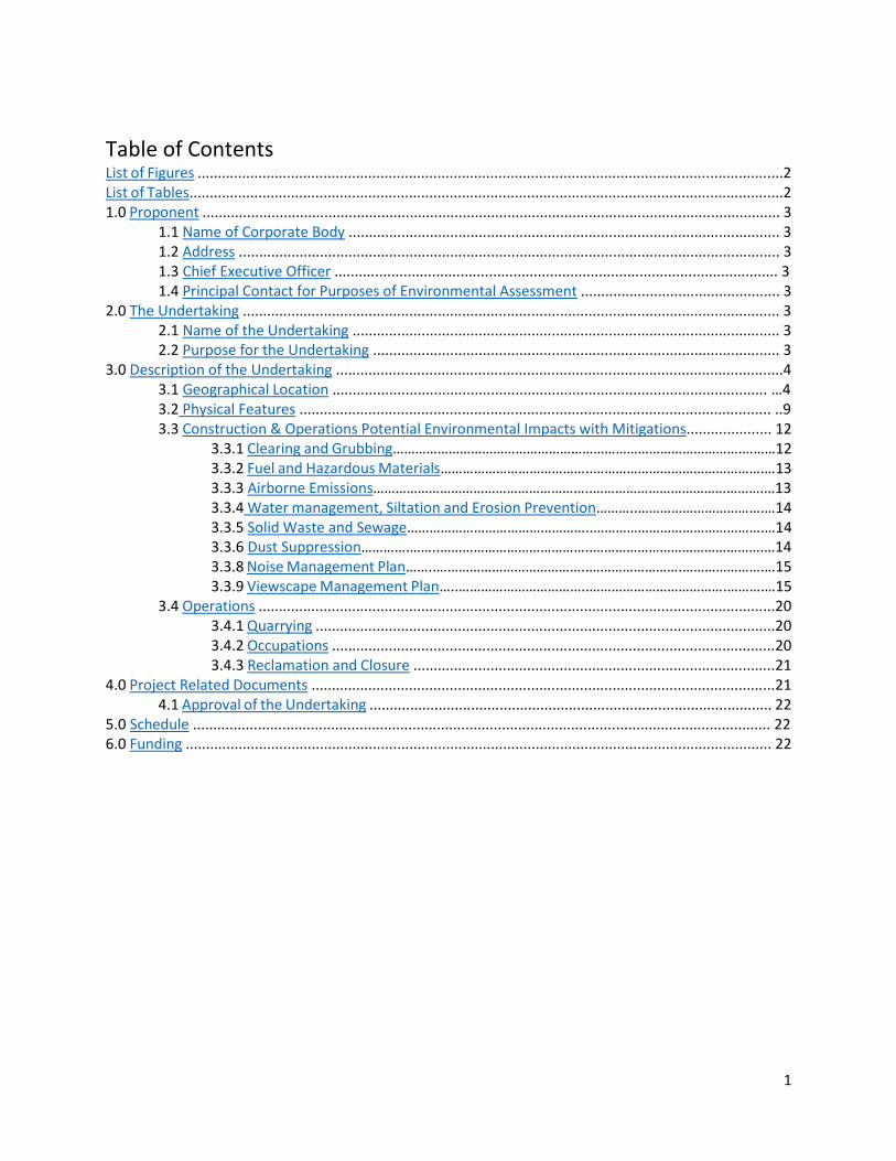
Table of Contents List of Figures ................................................................................................................................................2 List of Tables..................................................................................................................................................2 1.0 Proponent .............................................................................................................................................. 3
1.1 Name of Corporate Body .......................................................................................................... 3 1.2 Address ..................................................................................................................................... 3 1.3 Chief Executive Officer ............................................................................................................. 3 1.4 Principal Contact for Purposes of Environmental Assessment ................................................. 3
2.0 The Undertaking .................................................................................................................................... 3 2.1 Name of the Undertaking ......................................................................................................... 3 2.2 Purpose for the Undertaking .................................................................................................... 3
3.0 Description of the Undertaking ..............................................................................................................4 3.1 Geographical Location ........................................................................................................... …4 3.2 Physical Features .................................................................................................................... ..9 3.3 Construction & Operations Potential Environmental Impacts with Mitigations..................... 12 3.3.1 Clearing and Grubbing………………………………………………………………………………….………12 3.3.2 Fuel and Hazardous Materials…………………………………..……………………………………….…13
3.3.3 Airborne Emissions…………………………………………………..……………………………………….…13 3.3.4 Water management, Siltation and Erosion Prevention………..…………………………….…14 3.3.5 Solid Waste and Sewage…………………………………………..……………………………………….…14 3.3.6 Dust Suppression………….……..…………………………………..……………………………………….…14
3.3.8 Noise Management Plan……..…………………………………..…………………….………………….…15 3.3.9 Viewscape Management Plan…..……………………………..……………………………….……….…15
3.4 Operations ...............................................................................................................................20 3.4.1 Quarrying .................................................................................................................20 3.4.2 Occupations .............................................................................................................20 3.4.3 Reclamation and Closure .........................................................................................21
4.0 Project Related Documents ..................................................................................................................21 4.1 Approval of the Undertaking ................................................................................................... 22
5.0 Schedule .............................................................................................................................................. 22 6.0 Funding ................................................................................................................................................ 22
2
List of Figures Figure 1 : General Location Plan.................................................................................................................. 4
Figure 2 : Specific Location Plan...................................................................................................................5
Figure 3:. Topographic Map..........................................................................................................................6
Figure 4 : City St. John’s Land Zoning............................................................................................................7
Figure 5 : Coordinate Reference...................................................................................................................8
Figure 6: Phase Construction Plan..............................................................................................................10
Figure 7 : RLU 60 (MODIFIED) .................................................................................................................... 11
Figure 8 : Figure 8: Topographic Map for Viewscape Management..........................................................17
Figure 9: Viewscape Management............................................................................................................18
Figure 10 : Viewscape Management 2 .....................................................................................................19
List of Tables Table 1: Coordinates………………………………………………………………………………………………..……………………….……..8

3
1.0 Proponent 1.1 Name of Corporate Body Black Diamond Construction Ltd.
1.2 Address 1 Centennial Street, Suite 105 Mount Pearl, NL, A1N 0C9
1.3 Chief Executive Officer Jon Cutler 1 Centennial Street, Suite 105 Mount Pearl, NL, A1N 0C9 (709)745- 0100; [email protected]
1.4 Principal Contact for Purposes of Environmental Assessment Jon Cutler 1 Centennial Street, Suite 105 Mount Pearl, NL, A1N 0C9 (709)745-0100; [email protected]
2.0 The Undertaking 2.1 Name of the Undertaking The name of the undertaking is Black Diamond Construction
2.2 Purpose for the Undertaking
Black Diamond Construction is seeking a new rock and sand quarry located off Pasture Lands Road near the Foxtrap Access Road in Conception Bay South, NL. The purpose of this undertaking is to manufacture construction materials such as Class A, Class B, sand bedding, and structural rockfill for use in various municipal and government construction projects throughout the Avalon Peninsula. Black Diamond Construction is a new construction company, looking to acquire a quarry and become long term occupants of the proposed area.
4
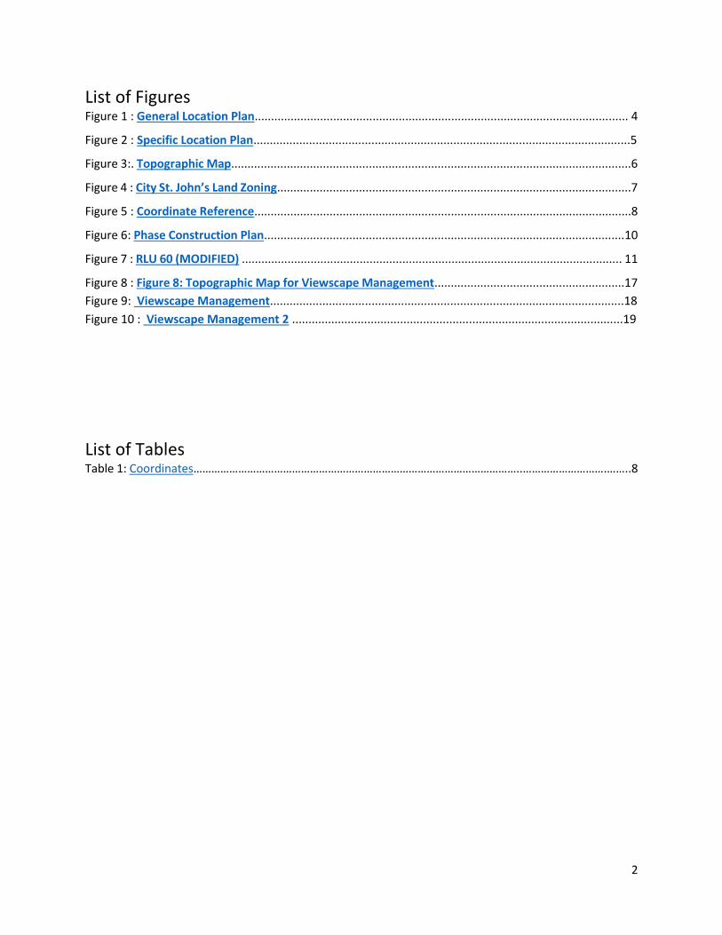
3.0 Description of the Undertaking 3.1 Geographical Location The proposed undertaking is located within the City of St. John’s municipal boundaries near the southwest limits. Furthermore, the site is located off Pasture Lands Road near the Foxtrap Access Road and TCH Interchange. It is situated on Crown Land with no active leases or grants. The parcel is located immediately before the westbound TCH off-ramp at the Foxtrap Interchange. The land is currently zoned for Forestry Use (F), however The City’s development regulations state that it can be applied for under Discretionary Usage if the Mineral Workings requirements are maintained, and the proper procedures followed. The proposed site is enclosed to the east by a large hill, west by another quarry permit, to s by the City of St. John’s Watershed Boundary and NL Hydro’s Transmission Line, the north boundary is offset 100m from the TCH. The site is accessible from Pasture Lands Road, off the eastbound on and off ramp of the highway. See the figures on the following pages to assist in the description.
Figure 1: General Location Plan

5
Figure 2: Specific Location Plan

6
Figure 3: Topographic Map

7
Figure 4: City St. John’s Land Zoning

8
POINT EASTING NORTHING
1 353639.26 5257078.41
2 353742.87 5256784.7
3 353598.62 5256600.34
4 353466.65 5256537.03
5 353314.89 5256523.75
6 353236.36 5256713.28
7 353289.65 5256778.04
8 353503.27 5256912.78
Figure 5: Coordinate Reference
Table 1: Coordinates WSG Datum (Google Earth Pro)

9
3.2 Physical Features
The proposed undertaking will encompass an area of 14.7 hectares and will be developed and
reclaimed in four individual phases, between 3 and 6 hectares each. The land being applied for is
in a valley and the base of the slope between two small hills. Within the boundaries of the
proposed undertaking the land slopes gradually upwards towards the east and west from the
access road. The western and eastern boundaries are the peaks of two different hills. The
Hills and contours will be utilized to obstruct view from the public to our quarry. (See Figure 3).
The vegetation present on site consists mostly of a heavy to medium density boreal coniferous
forest containing mainly spruce trees. The wildlife expected to be present in the area would
consist of small to medium sized animals that are native to the area.
There are two small wetlands within the undertaking’s boundaries combined for a total area of
1 hectare. These wetlands can be classified as a bog using the Canadian Wetland Classification
System (CWCS). Five classes are recognized under the CWCS; bog, fen, swamp, marsh and shallow
water. They are classified according to vegetation, amount of water present and source of the
water. Bogs are peat-covered wetlands, in which the vegetation shows the effects of a high-water
table and a general lack of nutrients. The bog surface is often raised relative to the surrounding
landscape and isolated from mineralized soil waters. The surface waters of bogs are strongly acid
and the upper peat layers are generally nutrient poor. At least 40 cm of peat is typically present.
The plant community consists of Sphagnum mosses (peat mosses), ericaceous shrubs and black
spruce trees. The St. John’s watershed area borders the south side (See Figure 4) and it is at a
higher elevation than the quarry, to prevent any waterflow towards these boundaries. This can
be seen from the topographic map (See Figure 3) in comparison as well.
Physical features that will be present on the undertaking will include portable weigh scales and
a temporary office trailer to serve as a scale house. An access road to the quarry from the existing
road to the CLB/Scouts Canada Campgrounds. There will be no excavation, quarrying or
restriction to the access road at anytime during the proposed development. The access road will
be upgraded to handle the influx of heavy equipment traffic (dump trucks, front-end loaders,
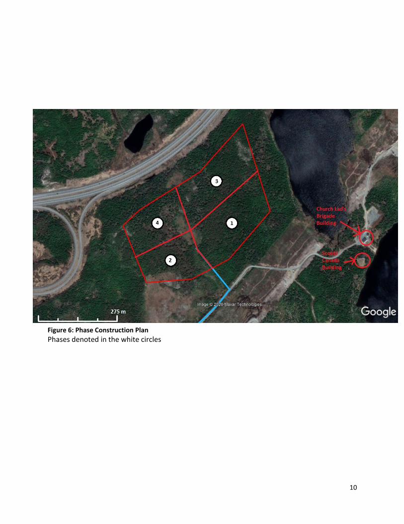
etc.) to a RLU 60 (MODIFIED) as per the Department of Transportation and Work’s Drawing 1111-
1, with exception to the asphalt. We will maintain a 20m right of way and restrict access to the
quarry by means of steel gate at the entrance of the quarry. Truck turning signs will also be
installed on the access road to warn the public. The near by buildings would include the Boy
Scouts Canada and the Church Lads Brigade’s cabins located 350m to the South East as shown in
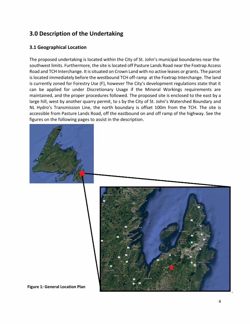
Figure 6.
10
Figure 6: Phase Construction Plan
Phases denoted in the white circles
11
Figure 7: RLU 60 (MODIFIED)

12
3.3 Construction & Operations Potential Environmental Impacts with Mitigations
3.3.1 Clearing and Grubbing Construction for this site would initially begin with clearing of the vegetation in phase 1 for
quarrying operations and depletion of the material in that phase before any construction in
future phases. Occupation and construction would be commencing in fall 2020, dependent on
approvals and permits. The clearing will be conducted via chainsaws and suitable timber stacked
neatly to be removed and utilized as firewood. Potential environmental concerns include the
loss of animal habitat.
To mitigation the environmental impacts we propose to adhere to the nesting, breeding window,
and brood rearing period running April 15 to August 15, in which all clearing will be conducted
outside these periods. Should a nest be found; the nest and neighboring vegetation should be
left undisturbed until nesting is completed and clearing activities will be minimized in the
immediate area until nesting is complete. An unnamed pond is located approximately 100m east
from the proposed quarry boundary, combined with the vegetation buffer of 30m inside our
boundary, there will be roughly 130m of undisturbed vegetation to ensure the fish habitats are
left undisturbed.
We intended to work with a local tree harvesting company so that all profitable timber can to
utilized. We have discussed operating together, so that they can harvest any trees that would be
of benefit to them before, we operate in that area. This relationship is beneficial to both parties
as they would save us the cost of clearing some of the land and we are proposing to upgrade the
access road.
The grubbing will be removed in phase 1 initially and windrowed will the topsoil near the quarry
boundary for future reclamation, and it will be conducted in other phases in a similar fashion.
Grubbing activities will adhere to buffer zone requirements and during grubbing, care will be
taken to ensure that grubbed material will not be pushed into areas that are to be left
undisturbed.

13
3.3.2 Fuel and Hazardous Material Risks
A variety of potentially hazardous fluids will be used during construction and operation such as
fuel hydraulic oil. The primary concern regarding the use and storage of fuel is accidental release
into the environment. We are aware of the potential negative impacts associated with this hazard
and are prepared to reduce or eliminate the sources of pollutants, utilizing our standard
operating procedures and practices.
To reduce the impacts on the environment from a potential fuel/oil spill during the construction
phase, Black Diamond will implement the following measures and practices; all employees
operating equipment are required to complete a daily pre-trip inspection prior to using the
equipment. These daily inspections will check fluid levels, condition of the lines and operational
features to ensure the equipment is functioning properly. Even though inspections are made
frequently, if a spill were to occur, spill control kits are readily available. Each kit includes oil
absorbent water-resistant pads, highly absorbent granular particles (speedy dry), and absorbent
oil booms/socks. Furthermore, Black Diamond Construction implements an inspection system
after every scheduled break (three per day) as a standard practice. Every 1000 hours each piece
of equipment is thoroughly inspected by qualified personnel for leaks, wear and tear on movable
parts, and routine maintenance to prevent unnecessary breakdowns.
Fuel Tanks will be stored in aboveground, self-dyked tanks, registered with Service NL, and
located in areas where spills, should they occur, are not likely to flow towaters watercourses or
our ditch system. Fueling and greasing of equipment will occur in designated locations, using a
drip pan beneath the equipment to contain any spill or drips during the process. Oily rags or
materials at risk of spontaneous combustion will be stored in a designated bin. These materials
will be removed from the quarry on a regularly to the appropriate waste disposal facility.
Any hazardous spill greater than 70 Litres shall be reported immediately through the Environmental Emergencies Telephone Line at (709) 772-2083 or 1- 800-563-9089. Additionally, each spill shall be reported to the company HSE Advisor and the manager in the area inspected and given clearance by a representative of Service NL by calling (709) 729-2550.
3.3.3 Airborne Emissions
Airborne emissions occur during heavy equipment operation coming from the exhaust systems
of various types of machinery. Airborne emissions are dealt within strict accordance to Heavy-
duty Vehicle and Engine Greenhouse Gas Emissions Regulations. These regulations are
implemented prior to a given manufacturer being able to sell their product in Canada. Black

14
Diamond’s standard inspections of the equipment check the operation of these features and
ensure they are still in working order. These inspections are performed on a 1000-hour basis as
well.
3.3.4 Water Management, Siltation and Erosion Prevention
Siltation of the waterway during the initially clearing process of each phase will follow proper
procedures and recommendations as per DFO regulations such as use of silt fence and hay bails
to mitigate the siltation of surface runoff. The silt fence and hay bails will be installed at 200m
intervals in the existing ditch system along the access road. The existing ditch system will also be
excavated to a 1m depth, with a side slope of 2:1 as shown in Figure 7 , stabilized with clean rock
(200-300 in diameter). This ensures that the silt from the newly stripped land will be contained
and not enter the watercourse. The silt fence will be inspected weekly by the manager on site to
ensure it is working as intended, and to be replaced or repaired as needed. The natural
topography of the area situates the quarry in a low-lying area, working with these features, the
surface runoff will be controlled by sloping the stripped ground towards the central ditch system
and reclaiming a quarried area with hydroseeding upon depletion. Phases one and two will be
sloped to the west and phases three through six will be graded towards the east. Before any
surface runoff enters the environment, it will be contained in a holding pond to allow any
particles to settle before entering, then directed towards a vegetative area to act as a natural
filter.
3.3.5 Solid Waste and Sewage
The solid waste or domestic refuse and sewage will be disposed of in an appropriate manner.
Solid waste or common trash will be disposed of using an industrial sized dumpster and hauled
away regularly. The quarry will be kept clear of waste and litter to reduce the potential for
attracting wildlife. Regular inspections of the area will be conducted by the manager or HSE
representative to ensure that no garbage is inadequately stored.
During the initial construction, sewage will be contained via portable toilets located in a central
area, away from the ditch system. Sewage waste will be trucked off site regular through a
licensed waste disposal subcontractor weekly.
3.3.6 Dust Suppression
Dust generation related to construction activities may result in human health effects, as well as
negative impacts on ecosystems and vegetation. To mitigation any dust concerns all equipment
15
will have the required dust and emission control filters. Dust created from travelling the access
road and Pasture Lands Road will be controlled by water and calcium chloride, applied frequently
via truck. Drilling subcontractors will be required to be fitted tested and wear half face respirators
as well as anyone operating the crushers.
3.3.7 Noise Management Plan
Quarrying activities have the potential to generate noise from the use of heavy equipment,
drilling and blasting, and the handling of construction materials. Noise generation has the
potential to cause negative effects on wildlife in the area. Noise and vibration will be reduced by
implementing best practice strategies from regulatory directives and guidelines. These mitigation
measures will require short- and long-term monitoring, with regular reporting to address noise
complaints or compliance issues. Equipment that emits noise and vibrations will be calibrated to
perform using manufacturer specifications, and all equipment will be fitted with standard and
noise suppression devices. Construction and operations will occur during daytime hours and
idling of equipment will be kept to a minimum. Also, as stated before blasting will only occur
during clear, optimal conditions. Considering the distance of the proposed site from residential
areas, it is highly unlikely that any negative noise effects will be caused as a result of quarrying
operations. During crushing operations, employees working in the vicinity will be required to
wear double ear protection.
3.3.8. Viewscape Management and Buffer Zones
Due to the increase in the tourism industry, sightlines from the TCH to existing quarries in the
general area (Harbour Arterial area and Incinerator Road), and the protection of animal habitats
it is vital to enclose our proposed quarry by a vegetative buffer to ensure the operation remains
concealed. Another potential impact is the erosion and siltation as a result of construction
activities resulting in damage to water quality, and fish habitat. Without adequate buffer zone
vegetation, streams, ponds and lakes can become laden with silt from run-off. Vegetative buffers
are also necessary to provide stream bank stability and intercept runoff to absorb and slow down
rainfall runoff before it enters a body of water.
The proposed quarry is offset approximately 100m from the TCH. The land between the highway
and the site contains a thick, mature forest which will serve as a broad buffer. However, we are
planning our development with the allowance of a 30m buffer zone along the entire perimeter
inside of our proposed area.
16
To obscure our quarry from the TCH, it is strategically situated in a natural valley, between to
hills. This will prevent us from being seen by approaching traffic both east and westbound. The
elevation of the North boundary of the quarry is 194m at its lowest point and 204 m at the peaks
on the East and West boundary. The neighbouring highway is situated at approximately 189m.
That provides us 5m of elevation buffer from the highway, plus the consideration the height of a
mature black spruce (15-20m), this will provide 20-25m of height protecting the visibility in span
of 100m, this will provide adequate coverage from the highway.
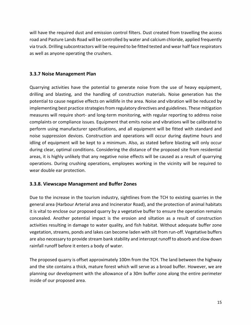
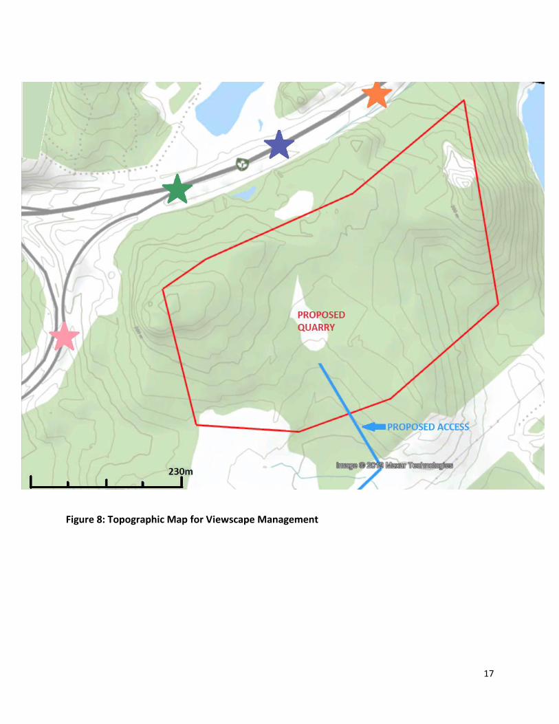
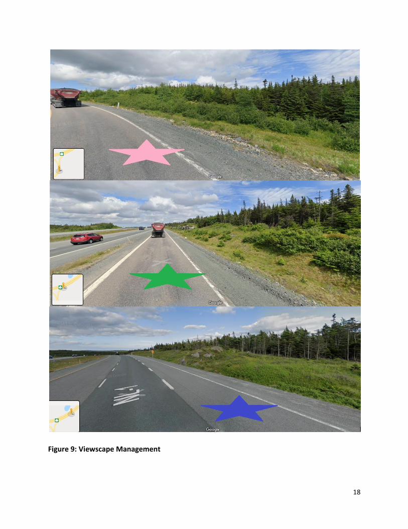
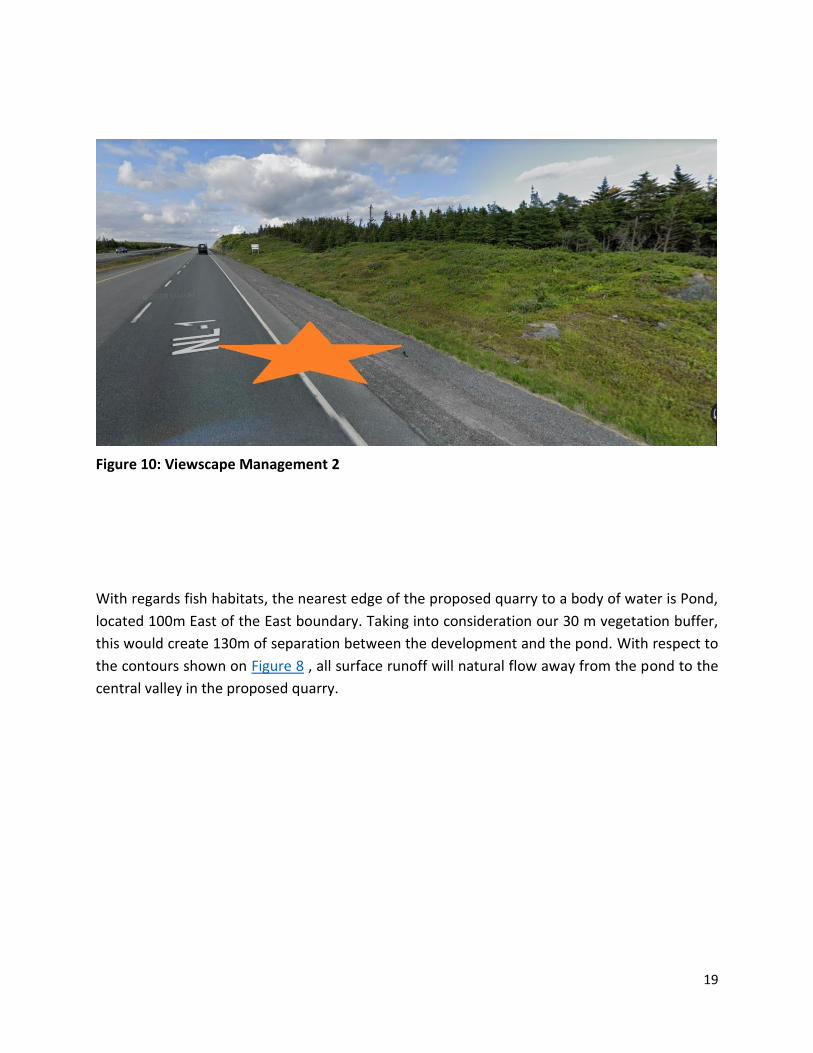
In Figures 8 through 10 the topographic map is used for referencing and the photos show the
approximately location of view. As approaching the proposed site from the east and west, the
large hills and significant 100 m mature treed vegetative buffer will block all view from will
obstruct the sightline of the proposed quarry.
17
Figure 8: Topographic Map for Viewscape Management
18
Figure 9: Viewscape Management
19
Figure 10: Viewscape Management 2
With regards fish habitats, the nearest edge of the proposed quarry to a body of water is Pond,
located 100m East of the East boundary. Taking into consideration our 30 m vegetation buffer,
this would create 130m of separation between the development and the pond. With respect to
the contours shown on Figure 8 , all surface runoff will natural flow away from the pond to the
central valley in the proposed quarry.

20
3.4 Operations
The primary intentions for this quarry will to be manufacture granular construction materials
such as Class A, Class B, structural rockfill and sand for use in various government and municipal
construction projects throughout the Avalon Peninsula. This operation will include stripping and
stockpiling of any topsoil and root mat for reuse in the reclamation process, excavation of the
native material and screening of sand. Once excavated and screened the material will be
separated and stockpiled. The operation would be phased and developed in areas of 3.25 to 7
hectares in size, as shown in shown in Figure 6. With no more than one phase active at a time,
once phase 1 is depleted, quarrying will begin in phase two and so fourth. The average production
be approximately 10,000 to 15,000 tonnes annually. Our intent is to follow up this permit with
an application to develop Crown Lands and apply for a long-term quarry lease.
3.4.1 Quarrying
The initial start-up phases of the quarry’s operation will be completed by utilizing portable
crushing equipment consisting of a jaw-crusher and a cone-crusher or a jaw-roll that will produce
aggregate from the excavated material. Throughout the development and the different phases
of the proposed quarry, the crusher will be positioned near the rock face in order to maximize
productivity and will be moved as necessary to keep up with production. The mobile jaw at the
rock face will crush the material to 150 mm minus material and the secondary crusher will
produce the smaller granulars. Other types of heavy equipment on site will include excavators,
front end loaders, dump trucks and a screening plant for sand extraction.
Typical quarrying methods will be used to save the overburden sand and gravel in the area. The
operation will include the excavation, crushing and loading of the sand and gravel materials at
the working face of the quarry, and transportation of these materials to processing equipment
Materials will be processed into aggregates of required specifications and stockpiled on site.
Waste and oversized rock will also be stockpiled for future use to restrict site access, or specific
armour stone and riparian projects.
3.4.2 Occupations
The proposed undertaking will employ various occupations during its lifecycle. During the initial
construction/development phase of the undertaking the operations will employ approximately
five personnel on a full-time seasonal basis (April to November) including:

21
2 - equipment operator (NOC: 7521) 2 - labourer (NOC: 7611), 1 - construction manager (NOC: 0711). All work for construction portion of the project with be direct hires. Black Diamond Construction is committed to employment equity and fair workplace hiring practices. During the operation of the proposed undertaking it will employ on average eight personnel on a full time seasonal basis (April to November) including: 2 - equipment operator (NOC: 7521), 2 - labourer (NOC: 7611), 1 - mechanic (NOC: 7312) 2 - truckdriver (NOC: 7511) 1- construction managers (NOC: 0711). The duration of operations is dependent on the demand for materials produced but should last
between 25 to 30 years. All work for the operations will be direct hire.
3.4.3 Reclamation and Closure
Reclamation will be conducted in phases progressively as the standard conditions of any quarry
of substantial size. Our intentions are to quarry in phase one and reclaim that phase, then strip-
clear and quarry phase two, then reclaim phase two, etc. This will cause preserve a healthier
looking quarry, prevent a large amount of surface run-off pollution and create less of an
environmental impact. Within each phase we intend to slope depleted areas and spread the
original topsoil and organics from the site. Sloping around the perimeter of the site will be
achieved by leaving a buffer of material in place along the boundary so that when re-contoured,
the rock-face of the quarried area can be sloped to a 30-degree angle, not leaving a large sudden
drop off the rock face. Following this final sloping and the contouring of quarry, the preserved
organic material and soil is spread, hydro-seeded with grass seed, and planted with tree seedlings
native to the area. Each phase will take three to five years to fully develop and reclaim depending
on demand for materials. (Refer to Figure 6 Phase Development Plan)

22
4.0 Project Related Documents 4.1 Approval of the Undertaking Permits, licences and approvals that will/could be required for this development are:
Governing Body Type Approval/Permit/License
City of St. John's Discretionary Use Application Development Application
Mines and Energy Division, Department of Natural Resources
Quarry Permit
Department of Environment and Conservation Release from the EA process
Forestry Division, Department of Natural Resources Commercial Cutting Permit
Service NL, Government Services Centre Fuel Storage and Handling
Water Resources Division, Department of Environment and Conservation
Permit to extract water from a water body
Government Services Centre Preliminary Application to Develop Land and Permit to Develop
5.0 Schedule We would like to start ground work on this site in the fall of 2020, pending all permits and approvals.
Access to this site this fall, will benefit us for upcoming St. John’s, Municipal Affairs, and Transportation &
Works tenders in 2021, as we can price the project with supplying our own aggregate and rock, opposed
to purchasing them from another supplier.
6.0 Funding The proponent will provide all funds necessary to develop this site and production of material. The funds
will be recovered through the sale of granular materials, rockfill and sand along with the cost savings of
using owned material opposed to purchasing.
--------------------- ----------------------------------------- Date Signature
March 21, 2020