Fort McHenry Alternative Transportation Study · Analysis 36 Element 2: ... engineering services of...
121
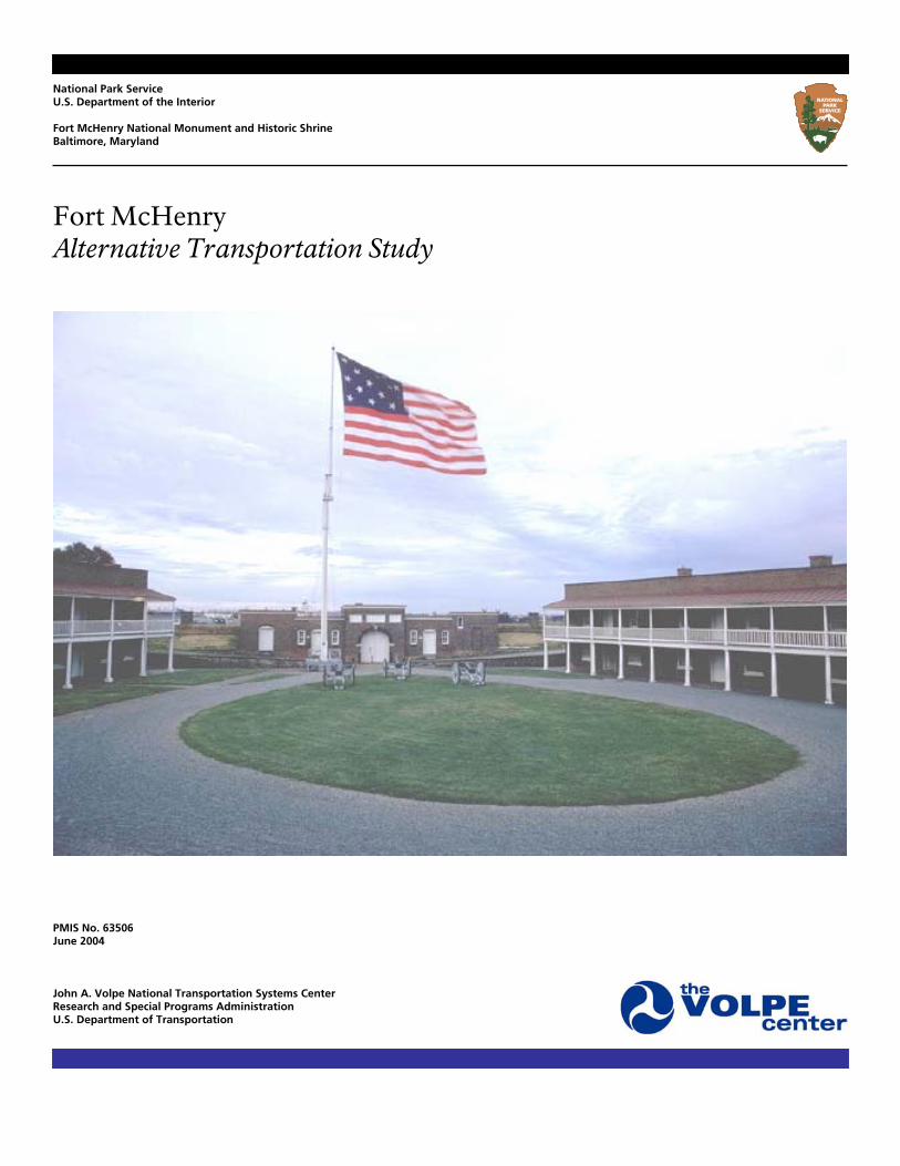
National Park Service U.S. Department of the Interior Fort McHenry National Monument and Historic Shrine Baltimore, Maryland Fort McHenry Alternative Transportation Study PMIS No. 63506 June 2004 John A. Volpe National Transportation Systems Center Research and Special Programs Administration U.S. Department of Transportation
Transcript of Fort McHenry Alternative Transportation Study · Analysis 36 Element 2: ... engineering services of...
National Park Service U.S. Department of the Interior Fort McHenry National Monument and Historic Shrine Baltimore, Maryland
Fort McHenry Alternative Transportation Study
PMIS No. 63506 June 2004 John A. Volpe National Transportation Systems Center Research and Special Programs Administration U.S. Department of Transportation

Contents Report Notes v Executive Summary viii
Important Findings ix Chapter 1: Introduction 1
Fort McHenry overview 1 Other studies: CLR, DCP/EA 3 ATP study and goals 4 AT study approach 5 Assumptions 6 Report structure 7
Chapter 2: Current Conditions 8
Modes available to Fort McHenry visitors 9 Private automobiles and tour buses: modes requiring parking 9 Public bus and pedestrian access 10 Water transport 10 Current and historical visitation trends 11 Seasonal notes 12 Data limitations 15 Correlation with regional trends 16
Chapter 3: Predicted Future Conditions; Demand for Alternative Transportation 17
Baseline predictions 20 Demand implications 21 Potential responses indicated 23
Chapter 4: Stakeholder Partnership Opportunities 25 Partnership opportunities by stakeholder 26
Patriots of Fort McHenry/Baltimore Maritime Museum 26 Baltimore City Planning Department (BPD) 26 Baltimore Department of Transportation (Baltimore DOT) 26 Maryland Department of Transportation (MDOT) 26 Baltimore Area Convention and Visitors’ Association (BACVA) 27 U.S. Naval Reserve Center (USNR) 27 Greater Baltimore History Alliance (GBHA) 27 C. Steinweg BV (“Steinweg”) 27 Ed Kane’s Water Taxi (“Water Taxi”) 28 National Historic Seaport (NHS) 28 Baltimore Metropolitan Council (BMC) 28 Maryland Port Administration (MPA) 28 Maryland Transit Administration (MTA) 29 Maryland Heritage Tourism (MHT) 29 Baltimore Downtown Partnership (BDP) 29 Locust Point Civic Association (LPCA) 29 Struever Bros., Eccles, and Rouse, Inc. (“Struever”) 29 Baltimore Development Corporation (BDC) 30 Baltimore Office of Promotion (BOP) 30 Museum of Industry (MI) 30 U.S.S. Constellation 30
Volpe Center Fort McHenry Alternative Transportation Study, June 2004 i
Partnership opportunities by mode 31
Surface (bus) transit 31 Water transport 31 Congestion management 31 Bicycle/pedestrian access 32 Reservations/parking management 32 Traveler information 32
Chapter 5: Transportation Elements 33
Note on costs 34 Element Category 1: Surface Transit 35
Category overview 35 Element 1: Creation of bus drop-off point within Fort McHenry 35
Stakeholders 35 Transportation benefits and impacts 36 Analysis 36
Element 2: Schedule integration with water transport service 36 Stakeholders 36 Transportation benefits and impacts 37
Element 3: Transfers and fare/pass reciprocity with water transport service 37 Stakeholders 37 Transportation benefits and impacts 37
Element 4: Bus shuttle from Inner Harbor operated by the park 37 Element 5: Collaboration on shuttle with interested institution(s) 37
Stakeholders 38 Transportation benefits and impacts 38 Analysis 38
Element 6: MTA No. 1 bus dropoff inside Fort McHenry 38 Stakeholders 38 Transportation benefits and impacts 39 Analysis 39
Element Category 2: Water Transport 39
Category overview 39 Element 1: Single water transportation operator with improved service to Fort McHenry; Element 5: Express/high-speed service from Inner Harbor to Fort McHenry 40
Stakeholders 40 Transportation benefits and impacts 41 Analysis 41 Service descriptions 41 Finances 42 Costs 42 Demand 43
Element 4: Improved ADA dock access at Fort McHenry 44 Stakeholders 44 Transportation benefits and impacts 45 Existing conditions 45 New dock configurations 45
Element 6: Higher-speed craft in service 46 Element 7: Higher frequency outer loop service 46
Element Category 3: Congestion Management 47
Category overview 47 Element 1: Rerouting of Steinweg trucks 47
Stakeholders 48 Transportation benefits and impacts 48 Analysis 48
Volpe Center Fort McHenry Alternative Transportation Study, June 2004 ii

Element 2: Improved bus parking at Fort McHenry 48 Stakeholders 49 Transportation benefits and impacts 49 Analysis 49
Element 3: Bus overflow parking off-site 50 Stakeholders 50 Transportation benefits and impacts 50 Analysis 50
Element 4: Reconfiguration of main gate and traffic controls/staffing; Element 7: Reconfiguration of Wallace Street 51
Stakeholders 51 Transportation benefits and impacts 51 Analysis 52
Element 5: Construction of separate exit road along north boundary (abutting USNR property) 54 Element 6: Reduce on-site car parking and enhance off-site overflow arrangements 55
Stakeholders 56 Transportation benefits and impacts 56 Analysis 56
Element Category 4: Pedestrian and Bicycle Access 58
Category overview 58 Element 1: Marked bicycle route from Inner Harbor through Locust Point to Fort McHenry 58
Stakeholders 58 Transportation benefits and impacts 59 Analysis 59
Element 2: Connection to other planned or existing bicycle and pedestrian trails 63 Stakeholders 63 Transportation benefits and impacts 63 Analysis 64
Element 3: Marked path inside Fort McHenry from main gate to new education/administration center 64
Stakeholders 64 Transportation benefits and impacts 64 Analysis 64
Element 4: Bicycle accommodations at visitor center (or at new education/administration center) 65
Stakeholders 65 Transportation benefits and impacts 65 Analysis 65
Element 5: Bicycle stowage onboard buses and passenger boats 65 Element Category 5: Reservations/Parking Management 66
Category overview 66 Element 1: Improved reservation system for bus/tour groups 66
Stakeholders 67 Transportation benefits and impacts 67 Analysis 67
Element 2: Require reservations for bus/tour groups in order to enable bus access 67 Element 3: Allow cars to park at Fort McHenry for trips originating on water transport 67
Element Category 6: Travel Information 68
Category overview 68 Element 1: Improved Fort McHenry signage/wayfinding in/around Baltimore 68
Stakeholders 68 Transportation benefits and impacts 68 Analysis 69
Element 2: Increased park outreach and communications 69 Stakeholders 69 Transportation benefits and impacts 69
Volpe Center Fort McHenry Alternative Transportation Study, June 2004 iii

Analysis 69 Element 3: Increased partner outreach and communications 70
Stakeholders 70 Transportation benefits and impacts 70 Analysis 70
Element 4: Provision of real-time traveler information 70 Stakeholders 71 Transportation benefits and impacts 71 Analysis 72
Screened roster of elements 72 Chapter 6: Transportation Alternatives 73 Alternative 1: No park action; no stakeholder action 80
Description 80 Analysis 80
Alternative 2: No park action; maximum stakeholder action 82 Description 82 Analysis 83
Alternative 3: Low-cost actions by park; low stakeholder action 84 Description 84 Analysis 85
Alternative 4: Low-cost actions by park; high stakeholder action 87 Description 87 Analysis 87
Alternative 5: Moderate-cost actions by park; low stakeholder action 89 Description 89 Analysis 90
Alternative 6: Moderate-cost actions by park; high stakeholder action 92 Description 92 Analysis 92
Alternative 7: Maximum action by park; low stakeholder action 94 Description 94 Analysis 94
Alternative 8: Maximum action by both park and stakeholders 96 Description 96 Analysis 97
Chapter 7: Action Items for Implementation 99
1. Pursue additional ATP funding and determine AT implementation requirements. 99 2. Discuss demonstration transit service with MTA. 100 3. Explore implementation of real-time traveler-information systems. 101 4. Begin talks with GBHA and MI about visitor transit system. 101 5. Begin talks with MPA about overflow parking area. 102 6. Facilitate discussions between MPA and Steinweg regarding trucks on Fort Avenue. 103 7. Reconcile data collection methods and collect additional data. 104 8. Discuss improvements to area outside main gate. 105 9. Continue discussions regarding dock accessibility improvements and consolidation of water transportation services. 106
(Appendices A, B, and C are presented in a separate document; Appendices D, E, and F are individually presented in additional documents.)
Volpe Center Fort McHenry Alternative Transportation Study, June 2004 iv

Report Notes This report was prepared by the U.S. Department of Transportation John A. Volpe National Transportation Systems Center, in Cambridge, Massachusetts. The project team was led by Michael G. Dyer, of the Technology Applications and Deployment Division, and included Eric J. Plosky, of the Service and Operations Assessment Division, and Carson D. Poe, of the Planning and Policy Analysis Division. The Volpe Center project team was supported by the architectural and engineering services of Kyle Zick, of Carol R. Johnson Associates, and David Porter, of Childs Engineering. (These services were contracted separately by the National Park Service Northeast Region Office in Boston, Massachusetts.) This effort was undertaken in fulfillment of PMIS 63506, Alternative Transportation Study for Fort McHenry National Monument and Historic Shrine.
Volpe Center Fort McHenry Alternative Transportation Study, June 2004 v
Acknowledgments The authors wish to thank the numerous organizations and individuals who graciously provided their time, knowledge and guidance in the development of this report. Those of particular note are listed below. National Park Service, Fort McHenry National Monument and Historic Shrine Laura Joss, Superintendent Charles Strickfaden, Chief Ranger Anna von Lunz Hugh Manar Greg McGuire Paul Plamann Susan Wright National Park Service, Northeast Region Office Bob Holzheimer National Park Service, Denver Service Center Hugh Duffy Butch Street Stakeholders Laurie Feinburg, Beth Strommen, and Bill Pencek, Baltimore City Planning Department John Kellet, Baltimore Maritime Museum/Patriots of Fort McHenry Judy London, Maryland Department of Transportation Andrew Murray, National Historic Seaport of Baltimore Cameron Kane, Ed Kane’s Water Taxi/Harbor Boating, Inc. Lisa Hansen, Baltimore Area Convention and Visitor Association Bill Gilmore, Baltimore Office of Promotion Joyce Bauerle, Locust Point Civic Association Mike Gibbons, Greater Baltimore History Alliance Paul Cypher, Museum of Industry Rupert Denney, C. Steinweg Handelsveem BV Commander James McGovern and Lieutenant Commander Phil Reed,
U.S. Naval Reserve Center, Baltimore Richard Chen, Baltimore Department of Transportation Larry White, Struever Bros., Eccles, Rouse Inc. Beth Robinson and Larry Dougherty, Maryland Transit Administration Eldon Miller and Mike Miller, Maryland Port Administration Marci Ross, Maryland Heritage Tourism Marshall Snively, Baltimore Downtown Partnership Larisa Salamacha, Baltimore Development Corporation Frances Knauss, Dock Master, City of Baltimore Vanasse Hangen Brustlin Carlton Abbott Partners Olmsted Center for Landscape Preservation
Volpe Center Fort McHenry Alternative Transportation Study, June 2004 vi
Definitions The following terms are used in this report: ADA Americans With Disabilities Act AT Alternative transportation ATP Alternative Transportation Program ATS Alternative transportation system Balto. Baltimore CAP Carlton Abbott and Partners, P.C. CLR Cultural Landscape Report DCP/EA Development Concept Report/Environmental Assessment DOT Department of Transportation DSC Denver Service Center (National Park Service) FOMC Fort McHenry National Monument and Historic Shrine MPA Maryland Port Administration MTA Maryland Transit Administration NEPA National Environmental Policy Act NLPMT North Locust Point Marine Terminal NPS National Park Service OCLP Olmsted Center for Landscape Preservation
(National Park Service) (lead on CLR) VHB Vanasse Hangen Brustlin, Inc. (lead on DCP/EA)
Volpe Center Fort McHenry Alternative Transportation Study, June 2004 vii
Executive Summary Fort McHenry National Monument and Historic Shrine is a 43-acre historic site located in the Locust Point neighborhood of Baltimore, Maryland. This alternative transportation (AT) study is one of three components of the park’s assessment and planning of its physical infrastructure and management. The other two components are the and Cultural and Historic Landscape (CLR) report and the Development Concept Report/Environmental Assessment (DCP/EA) report, which addresses several alternatives for replacing or modernizing the existing visitor center. The DCP alternatives address future visitor services and historic preservation needs, as major events, such as the 200th anniversary of the Battle of Baltimore, approach.
Identifying strategies to boost visitor arrivals by surface transit, water transport, bicycles, and pedestrians, and to enhance intermodal access.
Forming partnerships with
external organizations to coordinate area transportation planning, information, and marketing efforts.
Linking alternative
transportation planning to visitor-center expansion/replacement efforts (as presented in the DCP/EA).
Improving the overall visitor
experience. The approach of the study included the following main points:
This study informs the overall planning process, but is also a standalone document that addresses the park’s future transportation needs whether or not the visitor center is replaced or enlarged. The AT study’s goals, including the recommendations of the NPS Transportation Assistance Group (TAG), are:
Acquisition and analysis of all
relevant transportation and visitation data, from the park itself and from Baltimore area public agencies and private organizations concerned with commerce and tourism. The results were historical transportation trends by mode, with seasonal and hourly patterns discerned as well, and a detailed picture discussion of future transportation trends and needs at Fort McHenry.
Planning for mitigation of traffic
congestion and safety problems, especially with regard to peak use by school and tour buses and multiple mode conflicts at the main gate.
Extensive input from and review
by Fort McHenry staff, as well as the other members of the CLR
Volpe Center Fort McHenry Alternative Transportation Study, June 2004 viii
and DCP/EA project teams through meetings, public workshop sessions.
Extensive stakeholder interviews
with transportation providers and agencies, other historical and cultural institutions, and commerce and tourism groups, to find opportunities for new or strengthened partnerships in transportation planning and travel information for park visitors.
A comprehensive bibliography
assembled by collecting information from the park, from stakeholders, and from additional research conducted by project staff.
Development of a list of
transportation elements categorized both by transportation mode and by other strategies such as congestion reduction and improved traveler information. The report describes and analyzes these elements in detail, using Fort McHenry data, stakeholder interview results, feasibility assessments, cost estimates, architectural diagrams, and engineering schematics.
Creation of several transportation alternatives by selecting different combinations of the transportation elements. The alternatives are based upon varying levels of commitment by the park, and by outside
stakeholders and partners. This is because the key factor for success will be cooperation led by the park to encourage AT improvements, most of which the park cannot control. Since this study is not compliance oriented, it does not identify a “preferred” transportation alternative. Rather, the alternatives should be viewed as a spectrum of escalating opportunity that can serve as a model for incremental planning and implementation. While the most ambitious alternative could be viewed as the best outcome, this approach can lead to the optimum operational and fiscal management result.
Suggested preliminary action
items for implementation, which highlight near-term actions that the park can take to maximize prospects for future success. These include new and enhanced stakeholder partnerships, data collection methods, project funding opportunities, and implementation of selected AT enhancements.
Important Findings Current transportation trends. Visitors to Fort McHenry arrive in private automobiles, in transit, tour, and school buses, on foot, on bicycles, and via water transport. AT services to the park are presently limited, although a popular choice for park visitors when available.
Volpe Center Fort McHenry Alternative Transportation Study, June 2004 ix

Baseline visitation data were from 1993–2002. In 2002, there were 674,543 visitors to the park, and the transportation mode split was: private automobile, 69.6%; bus, 11.1%; boat, 10.5%; pedestrians and bicyclists, 8.8%.
Total park visitation will rise
slowly, to 739,500 in 2010, 755,000 in 2015, and 777,000 by 2025.
Following an earlier growth
period, annual car at the park have fallen by nearly 44,000 (17%) since 1998, while visitor use of transportation alternatives has risen. Numbers of visitors arriving by car in the future are expected to rise very slowly as the mode share stays nearly constant.
Peaks in seasonal and hourly car
arrivals cause main parking lot overflow situations (aside from special events) approximately 24 days per year, mostly on summer weekends.
Visitors arriving by tour and
school bus have dropped from 87,000 (1993) to 75,000 (2002) and are projected to continue falling slowly. Peak season continues to be late spring weekdays, coinciding with school field trip activity.
Pedestrian and bicycle visitors
have risen sharply in recent years from 47,000 (1993) to 59,000 (2002). Pedestrian and bicycle visitation in absolute and modal share terms is expected to rise in
the future. These visitors will number 61,000 in 2015 and 65,000 by 2025. At the main gate, mixed traffic, the abrupt transition to the one-way passage, and insufficient traffic control signage make the gate area potentially unsafe for all users.
Water transport is currently via
two water taxi services operating in Baltimore Harbor. Ridership to Fort McHenry has grown quickly, from 21,000 in 1993 to over 70,000 in 2002. Projected arrivals by boat are 78,000 in 2005, 85,000 in 2015, and 90,000 by 2025.
Stakeholder partnership opportunities. Many government agencies, non-profit organizations, and cultural institutions have regional transportation interests, with existing and prospective partnerships with Fort McHenry. The diffuse responsibility for transportation in Baltimore emphasizes the importance of pro-active efforts by Fort McHenry to develop new and enhanced partnerships, in particular the following opportunities:
Bus transit. Demonstration of a
Route 1 bus service directly into Fort McHenry in cooperation with the Maryland Transportation Administration, and a cooperative Baltimore visitor shuttle with other cultural and historical destinations.
Volpe Center Fort McHenry Alternative Transportation Study, June 2004 x

Water transport. Stronger partnerships with the city and with the operators, to improve service, increase public awareness, explore construction of accessible dock facilities at the park and elsewhere, and provide a better visitor experience.
The project team analyzed and screened AT elements, combining those deemed feasible and potentially beneficial into the transportation alternatives. The AT elements are summarized as follows:
Well-designed accommodations
for bus travelers in the park and improved bus transit partnerships.
Congestion management. A new
cooperative effort between Steinweg and the Maryland Port Administration to allow Steinweg trucks to use MPA’s access roads and avoid Fort Avenue and the Fort McHenry gate.
Enhanced water transportation
service to Fort McHenry and improved dock infrastructure with ADA-compliant design.
Bicycle/pedestrian access.
Partnerships with Baltimore DOT and MPA to improve bicycle and pedestrian access and the streetscape outside the Fort McHenry gate.
Congestion reduction and safety improvements through infrastructure improvements at the main gate, traffic management measures, and improved on-site and off-site parking management and infrastructure.
Reservations/parking management. Opportunity with MPA for joint or cooperative use of the MPA parking facility immediately outside the Fort McHenry gate.
Improved pedestrian
infrastructure and amenities, and bicycle access including connectivity to area bicycle routes, management of bicycle access within the park, and amenities in the park.
Traveler information. Partner
with transportation agencies, cultural-institutions, and tourism organizations to improve advance travel planning and publicize of AT services to the park. Explore collaboration with public transportation agencies on real-time traveler information, especially for peak season and special events use.
High-quality transportation
information for travelers. The proposed transportation alternatives are assessed by the criteria of visitor experience, protection of natural and cultural resources and of public health, safety, and welfare, program and policy benefits for NPS, and the cost and difficulty of implementation.
Volpe Center Fort McHenry Alternative Transportation Study, June 2004 xi
They are also evaluated against the DCP education/ administration center concepts. The key points are:
Several near-term action items are recommended with the intent of laying the groundwork for eventual selection and implementation of one (or more) of the transportation alternatives. They require time and commitment from park staff, but no funding or specific milestones. They are:
Stakeholder participation
through formation of partnerships is a key aspect of all of the “active” alternatives, because most of the high-expense AT elements are outside the park boundary.
Pursue additional ATP funding
and determine AT implementation requirements.
The benefits to NPS generally rise
with the scope and expense of the alternatives.
Discuss demonstration transit
service with MTA. The “no action” and “low action”
transportation alternatives (nos. 1 and 2) correspond to the DCP “no action” Concept A. Transportation alternatives 3–8 all fit to varying degrees with the DCP Concepts B, C, and D. Alternatives 7 and 8 provide for off-site car and bus parking at the MPA lot on Fort Avenue and would eliminate the need to construct extensive new parking accommodations within the park, as proposed in DCP Concepts C and D.
Explore implementation of real-
time traveler-information systems.
Begin talks with GBHA and MI
about visitor transit system. Begin talks with MPA about
overflow parking area. Facilitate discussions between
MPA and Steinweg regarding trucks on Fort Avenue.
Reconcile data collection
methods. The transportation alternatives may be pursued independent of any particular choice of DCP Concepts for the education/administration center, and could be planned and implemented incrementally as determined by need and the development of successful partnerships.
Discuss improvements to area
outside main gate. Continue discussions regarding
dock accessibility improvements and consolidation of water transportation services.
Volpe Center Fort McHenry Alternative Transportation Study, June 2004 xii

Chapter 1: Introduction The only National Monument and Historic Shrine in America, Fort McHenry is an important part of our national heritage. Growing annual visitation—from less than 300,000 before the Second World War to nearly 700,000 in 2002—has put pressure on Fort McHenry’s transportation infrastructure, and has prompted a comprehensive planning effort to ensure that the necessary facilities are in place to enable both the preservation of the fort’s natural and cultural resources and the continued enjoyment of its visitors. Fort McHenry overview Fort McHenry National Monument and Historic Shrine is a 43-acre historic site located in Baltimore, Maryland. The fort played an important role during the War of 1812, when the British unsuccessfully attempted to take Baltimore during September 13–14, 1814; their 24-hour bombardment was witnessed and memorialized by Francis Scott Key in a poem, “The Star-Spangled Banner,” which subsequently became the National Anthem. Fort McHenry came under the jurisdiction of the National Park Service (NPS) in the 1930s.
Fort McHenry is located at the end of the Locust Point peninsula; it is accessible by car, public transit, school bus, private tour operator, and water transportation service. Surrounding parcels are owned by the city of Baltimore (“Baltimore City”), the U.S. Naval Reserve, the U.S. Army Corps of Engineers, and private industry. There is a significant flow of tractor-trailers immediately in front of the fort’s entrance, presenting a potential safety hazard to automobiles, bicyclists, and pedestrians.
Volpe Center Fort McHenry Alternative Transportation Study, June 2004 1
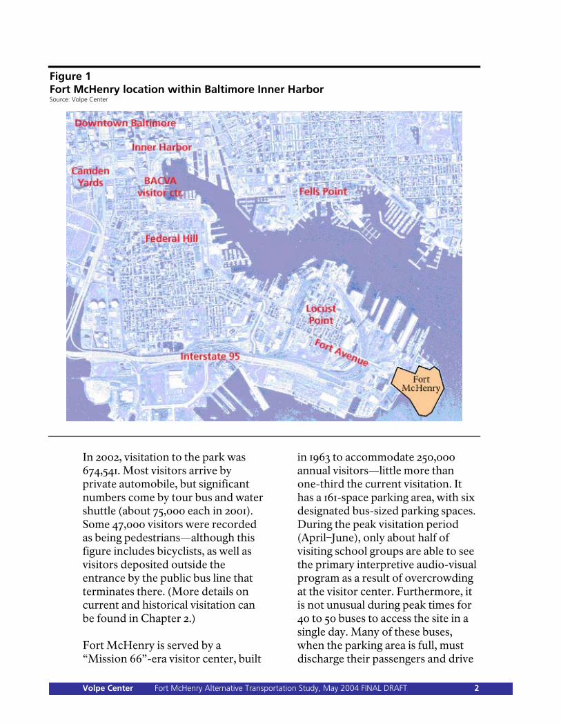
Figure 1 Fort McHenry location within Baltimore Inner Harbor Source: Volpe Center
In 2002, visitation to the park was 674,541. Most visitors arrive by private automobile, but significant numbers come by tour bus and water shuttle (about 75,000 each in 2001). Some 47,000 visitors were recorded as being pedestrians—although this figure includes bicyclists, as well as visitors deposited outside the entrance by the public bus line that terminates there. (More details on current and historical visitation can be found in Chapter 2.) Fort McHenry is served by a “Mission 66”-era visitor center, built
in 1963 to accommodate 250,000 annual visitors—little more than one-third the current visitation. It has a 161-space parking area, with six designated bus-sized parking spaces. During the peak visitation period (April–June), only about half of visiting school groups are able to see the primary interpretive audio-visual program as a result of overcrowding at the visitor center. Furthermore, it is not unusual during peak times for 40 to 50 buses to access the site in a single day. Many of these buses, when the parking area is full, must discharge their passengers and drive
Volpe Center Fort McHenry Alternative Transportation Study, May 2004 FINAL DRAFT 2
away in search of an alternate parking location elsewhere in the city. Several upcoming special events are likely to increase visitation in the future: the 300th anniversary of the
Port Authority and a Tall Ships event, both planned for 2006, and the Bicentennial of the War of 1812 (2012–2014).
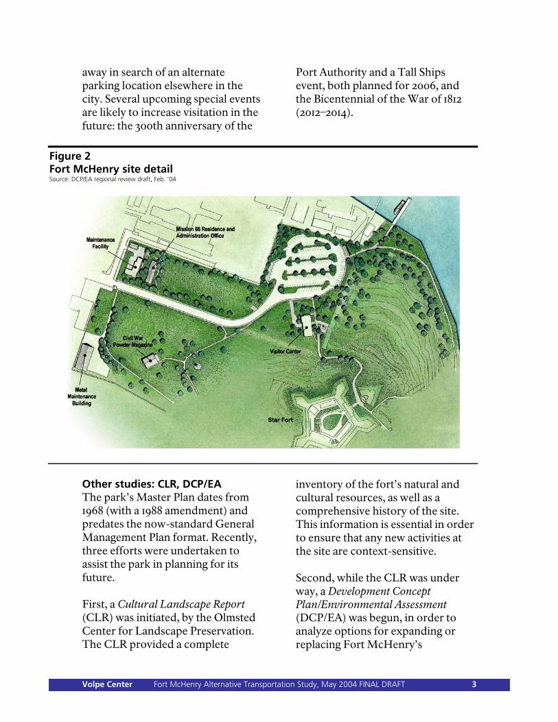
Figure 2 Fort McHenry site detail Source: DCP/EA regional review draft, Feb. ’04
Other studies: CLR, DCP/EA The park’s Master Plan dates from 1968 (with a 1988 amendment) and predates the now-standard General Management Plan format. Recently, three efforts were undertaken to assist the park in planning for its future. First, a Cultural Landscape Report (CLR) was initiated, by the Olmsted Center for Landscape Preservation. The CLR provided a complete
inventory of the fort’s natural and cultural resources, as well as a comprehensive history of the site. This information is essential in order to ensure that any new activities at the site are context-sensitive. Second, while the CLR was under way, a Development Concept Plan/Environmental Assessment (DCP/EA) was begun, in order to analyze options for expanding or replacing Fort McHenry’s
Volpe Center Fort McHenry Alternative Transportation Study, May 2004 FINAL DRAFT 3
overburdened visitor center. (This effort is discussed in more detail later in this report.) ATP study and goals This report represents the third effort—an Alternative Transportation Study (AT study). The AT study was done both in conjunction with and separately from the DCP/EA—whether or not the visitor center is replaced or enlarged, an AT study is necessary to update the park’s planning, in order that future visitation is properly accommodated. The AT study’s goals include: Creating a plan to mitigate
current and projected overcrowding and congestion problems, especially with regard to school and tour buses.
Identifying strategies to boost
visitor arrivals by surface and water transit (enhancing intermodal access).
Forming partnerships with
external organizations to coordinate area planning and marketing efforts.
Linking alternative
transportation planning to visitor-center expansion/replacement efforts (as presented in the DCP/EA).
Improving the overall visitor
experience.
Generally, the goals of this AT study follow the recommendations of the NPS Transportation Assistance Group (TAG), which completed a site visit to Fort McHenry in February 2002. This study also builds on the August 2001 Federal Lands Alternative Transportation Systems Study, prepared by Cambridge Systematics (the “Section 3039 study”), which highlighted four AT needs at Fort McHenry: improved signage, promotion of water transportation services, promotion and possible expansion of transit services, and partnership with the city of Baltimore to develop a tour-bus management plan. The Section 3039 study also suggested linking plans for a new visitor center to expanded AT service. The AT study goals draw upon the choosing-by-advantages factors used by NPS to evaluate AT planning and implementation projects: Addressing a clearly defined
need/problem, tied to existing planning documents and park purpose. (Planning factor only.)
Protection of natural and cultural
resources. Protection of public health,
safety, and welfare. Improvement of visitor
enjoyment through better services and educational and recreational opportunities.
Volpe Center Fort McHenry Alternative Transportation Study, May 2004 FINAL DRAFT 4
Improvement of park operational efficiency, reliability, and sustainability.
Provision of other advantages
(e.g., partnerships) to the national park system.
AT study approach The approach used in this study is as follows: First, all relevant Fort McHenry visitation data were compiled. Source data were obtained from the park itself and confirmed with the NPS Denver Service Center (DSC). The counting methods, technologies, and processes were documented. Analysis of these data permitted discussion of what the future transportation burdens upon Fort McHenry are likely to be. Extensive stakeholder interviews were conducted, in order to determine what opportunities existed to form or strengthen partnerships for the coordination of transportation planning and the provision of better travel information to park visitors. Stakeholders included the two current water transportation providers in Baltimore Harbor, various transportation-related agencies, other historical and cultural institutions, and related groups. A comprehensive bibliography was assembled by collecting information from the park, from stakeholders, and from additional research
conducted by project staff. The bibliography includes area planning studies, transportation system maps and schedules, and other relevant documentation. A list of transportation elements was generated. The elements, analogous to the items on a restaurant menu, refer to specific actions that the park could take relative to transportation. In describing and analyzing the transportation elements, technical staff and project contractors (including a civil engineer and a landscape architect, under separate contract to NPS but de facto members of the AT study team) produced feasibility assessments, cost estimates, architectural diagrams, and engineering schematics. The Fort McHenry data and the stakeholder-interview results were also used in developing the transportation elements. A number of transportation alternatives were then created by selecting one or more transportation elements to form different combinations. While the DCP/EA effort, informed in part by the AT study, included an environmental compliance activity, the scope of the AT study itself does not include compliance work, and so this report does not identify a “preferred” transportation alternative. This report does suggest preliminary action items for implementation, which, though not a recommended implementation of a preferred transportation alternative, highlight
Volpe Center Fort McHenry Alternative Transportation Study, May 2004 FINAL DRAFT 5
broader actions the park can take with respect to areas such as stakeholder partnerships, data collection, project funding opportunities, and implementation of selected AT enhancements. Throughout the course of the study, Fort McHenry staff, as well as the other members of the CLR and DCP/EA project teams, provided extensive input and review. The AT study proceeded in line with the DCP/EA effort; project deadlines and deliverables were synchronized wherever possible to take advantage of meetings, public workshop sessions, external NPS deadlines, staff availability, and review opportunities. Assumptions The study team assumed several conditions, including: Development in Locust Point,
including new residential and commercial projects, continues at or above the same pace as the last decade, with the Locust Point population continuing to increase.
There is no significant,
unplanned inducement to visitor demand in the near term, aside from the possible expansion or replacement of the visitor center. (Chapter 3 discusses this in more detail.)
Transportation in the Baltimore
area remains generally the same, with no major improvements or
impediments introduced to the highway, roadway, or transit systems.
Economic conditions do not
drastically improve or worsen. (Generally, this assumption is broadly taken to include matters such as the price of fuel and economic-related traveler behavior.)
There are no major, sudden
changes to park visitor demographics.
Current visitation trends
continue, including that part due to the gradual, continuing residential development of Locust Point.
NPS policy supports partnerships
with external stakeholders and other appropriate organizations. At the same time, however, in the absence of formal commitments from external partners, cooperation (including the provision of transportation or other services) cannot be guaranteed.
NPS policy supports the
expansion of alternative transportation systems, where appropriate.
NPS policy, at least in the
Northeast Region, discourages or prohibits the expansion of automobile facilities, including roadways and parking areas.
Volpe Center Fort McHenry Alternative Transportation Study, May 2004 FINAL DRAFT 6
ATP policy disallows the direct NPS funding of alternative transportation operations.
Chapter 7 outlines action items for implementation that Fort McHenry can consider as it moves forward, either separately from or in line with the expansion or replacement of the visitor center.
Other relevant NPS policies,
practices, funding eligibility criteria, etc., remain essentially unchanged.
Three appendices are presented in a companion document. Appendix A documents the stakeholder interviews conducted. Appendix B is a list of the sources (maps, plans, and other data) provided to the AT study team. Appendix C is a tabular listing of the transportation elements.
These assumptions are further explained in the relevant sections of this report. Report structure The structure of this report reflects the study approach taken: Chapter 2 discusses current and
historical visitation to Fort McHenry, and analyzes the data compiled by the study team.
Appendix D, in a separate,
additional document, is information produced by Kyle Zick, of Carol R. Johnson Associates, detailing options and cost estimates for improvements to the park gate area, including pedestrian and bicycle enhancements.
Chapter 3, based on the data in
Chapter 2, discusses projected visitor demand, as well as the predicted transportation needs associated with that demand. The exact calculations and numerical methods are explained.
Appendix E, in a separate, additional document, is information produced by David Porter, of Childs Engineering, detailing options and cost estimates for improvements to the park dock.
Chapter 4 presents the results of the stakeholder interviews and identifies numerous stakeholder opportunities the park can pursue.
Chapter 5 is devoted to an
explanation of the transportation elements.
Appendix F, in a separate,
additional document, is the TAG report from the February 2002 visit.
Chapter 6 presents the
transportation alternatives assembled from the transportation elements.
Volpe Center Fort McHenry Alternative Transportation Study, May 2004 FINAL DRAFT 7
Chapter 2: Current Conditions Visitation data for Fort McHenry has been collected since 1934. In that first year of recording visitation, roughly 274,000 people visited the park. Since then, visitation has more than doubled. However, a majority of this growth occurred during the first 20 years of data collection. Since 1949, Fort McHenry visitation has dropped below a level of 500,000 visitors per year only four times. Chart 1, below, summarizes historical visitation to the park.
Chart 1 Fort McHenry total recreation visits, 1934–2003 Source: NPS Public Use Statistics Office
0
100000
200000
300000
400000
500000
600000
700000
800000
900000
1934
1938
1942
1946
1950
1954
1958
1962
1966
1970
1974
1978
1982
1986
1990
1994
1998
2002
Currently, an automatic beam counter within the park’s main entrance records the number of automobiles visiting the park; the number of pedestrians is similarly recorded using counters on both park entrance sidewalks. (Bicyclists and visitors arriving via Route 1 public bus are counted as pedestrians.) After the initial 20-year period of quick and extensive growth, overall Fort McHenry visitation appears to have moderated. As illustrated in Chart 1, during 42 of the last 50 years, total visitation has fluctuated between 500,000 and 700,000 people annually. Figures also indicate that since 1949, the average (mean) number of visitors per year has been 601,650 (with a median of 597,400); data for recent years indicate visitation levels at or above this average. Visitation between 1993 and 2002 was 635,555, on average. In 2003, approximately 607,000 people visited, down from over 670,000 the previous year.
Volpe Center Fort McHenry Alternative Transportation Study, May 2004 FINAL DRAFT 8
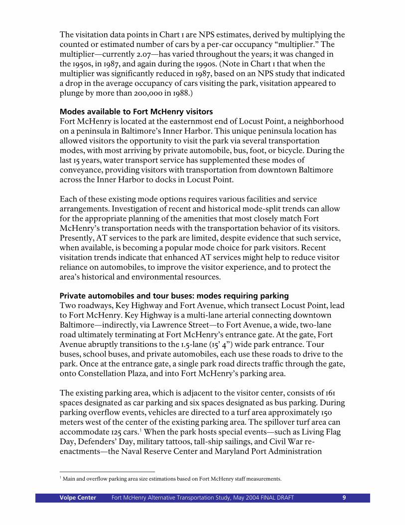
The visitation data points in Chart 1 are NPS estimates, derived by multiplying the counted or estimated number of cars by a per-car occupancy “multiplier.” The multiplier—currently 2.07—has varied throughout the years; it was changed in the 1950s, in 1987, and again during the 1990s. (Note in Chart 1 that when the multiplier was significantly reduced in 1987, based on an NPS study that indicated a drop in the average occupancy of cars visiting the park, visitation appeared to plunge by more than 200,000 in 1988.) Modes available to Fort McHenry visitors Fort McHenry is located at the easternmost end of Locust Point, a neighborhood on a peninsula in Baltimore’s Inner Harbor. This unique peninsula location has allowed visitors the opportunity to visit the park via several transportation modes, with most arriving by private automobile, bus, foot, or bicycle. During the last 15 years, water transport service has supplemented these modes of conveyance, providing visitors with transportation from downtown Baltimore across the Inner Harbor to docks in Locust Point. Each of these existing mode options requires various facilities and service arrangements. Investigation of recent and historical mode-split trends can allow for the appropriate planning of the amenities that most closely match Fort McHenry’s transportation needs with the transportation behavior of its visitors. Presently, AT services to the park are limited, despite evidence that such service, when available, is becoming a popular mode choice for park visitors. Recent visitation trends indicate that enhanced AT services might help to reduce visitor reliance on automobiles, to improve the visitor experience, and to protect the area’s historical and environmental resources. Private automobiles and tour buses: modes requiring parking Two roadways, Key Highway and Fort Avenue, which transect Locust Point, lead to Fort McHenry. Key Highway is a multi-lane arterial connecting downtown Baltimore—indirectly, via Lawrence Street—to Fort Avenue, a wide, two-lane road ultimately terminating at Fort McHenry’s entrance gate. At the gate, Fort Avenue abruptly transitions to the 1.5-lane (15’ 4”) wide park entrance. Tour buses, school buses, and private automobiles, each use these roads to drive to the park. Once at the entrance gate, a single park road directs traffic through the gate, onto Constellation Plaza, and into Fort McHenry’s parking area. The existing parking area, which is adjacent to the visitor center, consists of 161 spaces designated as car parking and six spaces designated as bus parking. During parking overflow events, vehicles are directed to a turf area approximately 150 meters west of the center of the existing parking area. The spillover turf area can accommodate 125 cars.1 When the park hosts special events—such as Living Flag Day, Defenders’ Day, military tattoos, tall-ship sailings, and Civil War re-enactments—the Naval Reserve Center and Maryland Port Administration
1 Main and overflow parking area size estimations based on Fort McHenry staff measurements.
Volpe Center Fort McHenry Alternative Transportation Study, May 2004 FINAL DRAFT 9
provide event participants with limited overflow parking at their adjacent properties. Public bus and pedestrian access Visitors choosing to attend Fort McHenry by public bus can ride the Maryland Transit Administration’s (MTA) Route 1 bus. The bus leaves from downtown Baltimore’s Mondawmin Metro station every 35 minutes, heading towards the Fort McHenry terminal stop, approximately 100 meters northwest of the park main entrance. The trip from the Mondawmin Metro station to Fort McHenry takes approximately 45 minutes. MTA ridership data indicate that very few people ride the Route 1 bus to the Fort McHenry stop. In any case, the park counts visitors who do arrive via public bus not as bus riders but as pedestrians, because riders must walk from the bus stop down Fort Avenue and through the front gate to enter. The existing pedestrian gates are two 4’ 5½” walkways, one each located on either side of the 1.5-lane vehicle entrance. Sidewalks extend from each pedestrian gate down both sides of the road leading to the parking area and visitor center. No crosswalks are present at the entrance gate. Bicyclists traveling into Fort McHenry2 also must use this entrance point to the park. Bike lanes do not exist on Key Highway, Fort Avenue, at the park entrance, or down the road leading to the visitor center. Cyclists are forced to share the road with vehicles. This bike-automobile arrangement, along with the abrupt transition from a two-lane road to the 1.5-lane entrance gate and insufficient traffic control signage, make the gate area potentially unsafe for pedestrians, bicyclists, and vehicles. Water transport For 10 years, one operator provided water transport for Fort McHenry visitors. In 1999, a second operator began offering service. This doubling in service correlated to a near doubling in ridership. Kane’s Water Taxi (or, simply, Water Taxi) runs every day from April 16 through September 1 and weekends from September 6 through September 28. The Water Taxi serves 12 landings and includes a route that originates at Fells Point (with connecting service to the Inner Harbor) and takes park visitors to a landing at Tide Point. From Tide Point, a free “jitney” shuttle bus takes visitors to the park every 15 to 18 minutes. An all-day pass on this service costs $6 for adults and $3 for children. Total trip time varies due to the inter-modal transfer at Tide Point, but is generally about 20 minutes from Fells Point. In 1999, the National Historic Seaport Water Taxi (“Seaport Taxi”) began service. They operate a fleet of boats ranging in capacity from 25 to 100 passengers3 and
2 36 CFR Section 4.30 prohibits bicycles “except on park roads, in parking areas, and on routes designated for bicycle use.” 3 Data from interviews with Seaport Taxi staff.
Volpe Center Fort McHenry Alternative Transportation Study, May 2004 FINAL DRAFT 10
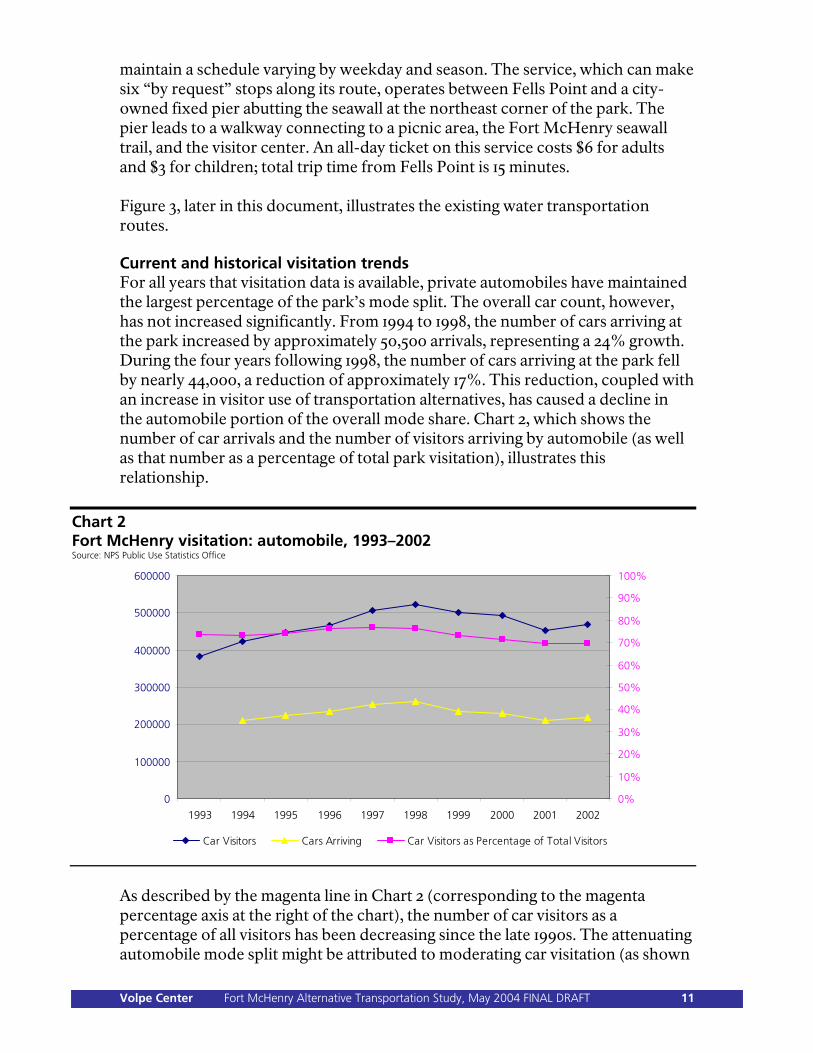
maintain a schedule varying by weekday and season. The service, which can make six “by request” stops along its route, operates between Fells Point and a city-owned fixed pier abutting the seawall at the northeast corner of the park. The pier leads to a walkway connecting to a picnic area, the Fort McHenry seawall trail, and the visitor center. An all-day ticket on this service costs $6 for adults and $3 for children; total trip time from Fells Point is 15 minutes. Figure 3, later in this document, illustrates the existing water transportation routes. Current and historical visitation trends For all years that visitation data is available, private automobiles have maintained the largest percentage of the park’s mode split. The overall car count, however, has not increased significantly. From 1994 to 1998, the number of cars arriving at the park increased by approximately 50,500 arrivals, representing a 24% growth. During the four years following 1998, the number of cars arriving at the park fell by nearly 44,000, a reduction of approximately 17%. This reduction, coupled with an increase in visitor use of transportation alternatives, has caused a decline in the automobile portion of the overall mode share. Chart 2, which shows the number of car arrivals and the number of visitors arriving by automobile (as well as that number as a percentage of total park visitation), illustrates this relationship.
Chart 2 Fort McHenry visitation: automobile, 1993–2002 Source: NPS Public Use Statistics Office
0
100000
200000
300000
400000
500000
600000
1993 1994 1995 1996 1997 1998 1999 2000 2001 2002
0%
10%
20%
30%
40%
50%
60%
70%
80%
90%
100%
Car Visitors Cars Arriving Car Visitors as Percentage of Total Visitors
As described by the magenta line in Chart 2 (corresponding to the magenta percentage axis at the right of the chart), the number of car visitors as a percentage of all visitors has been decreasing since the late 1990s. The attenuating automobile mode split might be attributed to moderating car visitation (as shown
Volpe Center Fort McHenry Alternative Transportation Study, May 2004 FINAL DRAFT 11
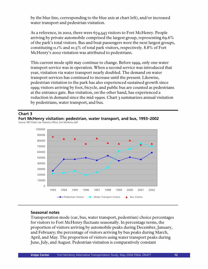
by the blue line, corresponding to the blue axis at chart left), and/or increased water transport and pedestrian visitation. As a reference, in 2002, there were 674,543 visitors to Fort McHenry. People arriving by private automobile comprised the largest group, representing 69.6% of the park’s total visitors. Bus and boat passengers were the next largest groups, constituting 11.1% and 10.5% of total park visitors, respectively. 8.8% of Fort McHenry’s 2002 visitation was attributed to pedestrians. This current mode split may continue to change. Before 1999, only one water transport service was in operation. When a second service was introduced that year, visitation via water transport nearly doubled. The demand on water transport services has continued to increase until the present. Likewise, pedestrian visitation to the park has also experienced sustained growth since 1999; visitors arriving by foot, bicycle, and public bus are counted as pedestrians at the entrance gate. Bus visitation, on the other hand, has experienced a reduction in demand since the mid-1990s. Chart 3 summarizes annual visitation by pedestrians, water transport, and bus.
Chart 3 Fort McHenry visitation: pedestrian, water transport, and bus, 1993–2002 Source: NPS Public Use Statistics Office; Fort McHenry staff
0
10000
20000
30000
40000
50000
60000
70000
80000
90000
100000
1993 1994 1995 1996 1997 1998 1999 2000 2001 2002
Pedestrian Visitors Water Transport Visitors Bus Visitors
Seasonal notes Transportation mode (car, bus, water transport, pedestrian) choice percentages for visitors to Fort McHenry fluctuate seasonally. In percentage terms, the proportion of visitors arriving by automobile peaks during December, January, and February; the percentage of visitors arriving by bus peaks during March, April, and May. The proportion of visitors using water transport peaks during June, July, and August. Pedestrian visitation is comparatively constant
Volpe Center Fort McHenry Alternative Transportation Study, May 2004 FINAL DRAFT 12
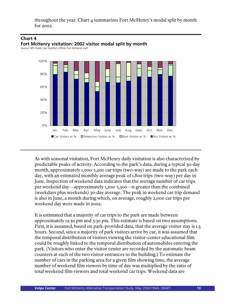
throughout the year. Chart 4 summarizes Fort McHenry’s modal split by month for 2002.
Chart 4 Fort McHenry visitation: 2002 visitor modal split by month Source: NPS Public Use Statistics Office; Fort McHenry staff
0%
20%
40%
60%
80%
100%
Jan. Feb. Mar. Apr. May June July Aug. Sept. Oct. Nov. Dec.
Car Visitors as % Pedestrian Visitors as % Boat Visitors as % Bus Visitors as %
As with seasonal visitation, Fort McHenry daily visitation is also characterized by predictable peaks of activity. According to the park’s data, during a typical 30-day month, approximately 1,000–1,200 car trips (two-way) are made to the park each day, with an estimated monthly average peak of 1,800 trips (two-way) per day in June. Inspection of weekend data indicates that the average number of car trips per weekend day—approximately 1,200–1,300—is greater than the combined (weekdays plus weekends) 30-day average. The peak in weekend car trip demand is also in June, a month during which, on average, roughly 2,000 car trips per weekend day were made in 2002. It is estimated that a majority of car trips to the park are made between approximately 12:30 pm and 3:30 pm. This estimate is based on two assumptions. First, it is assumed, based on park-provided data, that the average visitor stay is 1.5 hours. Second, since a majority of park visitors arrive by car, it was assumed that the temporal distribution of visitors viewing the visitor-center educational film could be roughly linked to the temporal distribution of automobiles entering the park. (Visitors who enter the visitor center are recorded by the automatic beam counters at each of the two visitor entrances to the building.) To estimate the number of cars in the parking area for a given film showing time, the average number of weekend film viewers by time of day was multiplied by the ratio of total weekend film viewers and total weekend car trips. Weekend data are
Volpe Center Fort McHenry Alternative Transportation Study, May 2004 FINAL DRAFT 13
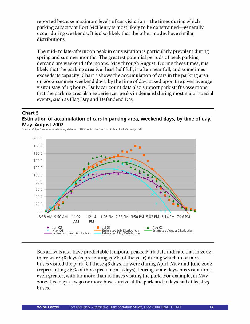
reported because maximum levels of car visitation—the times during which parking capacity at Fort McHenry is most likely to be constrained—generally occur during weekends. It is also likely that the other modes have similar distributions. The mid- to late-afternoon peak in car visitation is particularly prevalent during spring and summer months. The greatest potential periods of peak parking demand are weekend afternoons, May through August. During these times, it is likely that the parking area is at least half full, is often near full, and sometimes exceeds its capacity. Chart 5 shows the accumulation of cars in the parking area on 2002-summer weekend days, by the time of day, based upon the given average visitor stay of 1.5 hours. Daily car count data also support park staff’s assertions that the parking area also experiences peaks in demand during most major special events, such as Flag Day and Defenders’ Day.
Chart 5 Estimation of accumulation of cars in parking area, weekend days, by time of day, May–August 2002 Source: Volpe Center estimate using data from NPS Public Use Statistics Office, Fort McHenry staff
0.0
20.0
40.0
60.0
80.0
100.0
120.0
140.0
160.0
180.0
200.0
8:38 AM 9:50 AM 11:02AM
12:14PM
1:26 PM 2:38 PM 3:50 PM 5:02 PM 6:14 PM 7:26 PM
Jun-02 Jul-02 Aug-02May-02 Estimated July Distribution Estimated August DistributionEstimated June Distribution Estimated May Distribution
Bus arrivals also have predictable temporal peaks. Park data indicate that in 2002, there were 48 days (representing 13.2% of the year) during which 10 or more buses visited the park. Of these 48 days, 42 were during April, May and June 2002 (representing 46% of those peak month days). During some days, bus visitation is even greater, with far more than 10 buses visiting the park. For example, in May 2002, five days saw 30 or more buses arrive at the park and 11 days had at least 25 buses.
Volpe Center Fort McHenry Alternative Transportation Study, May 2004 FINAL DRAFT 14
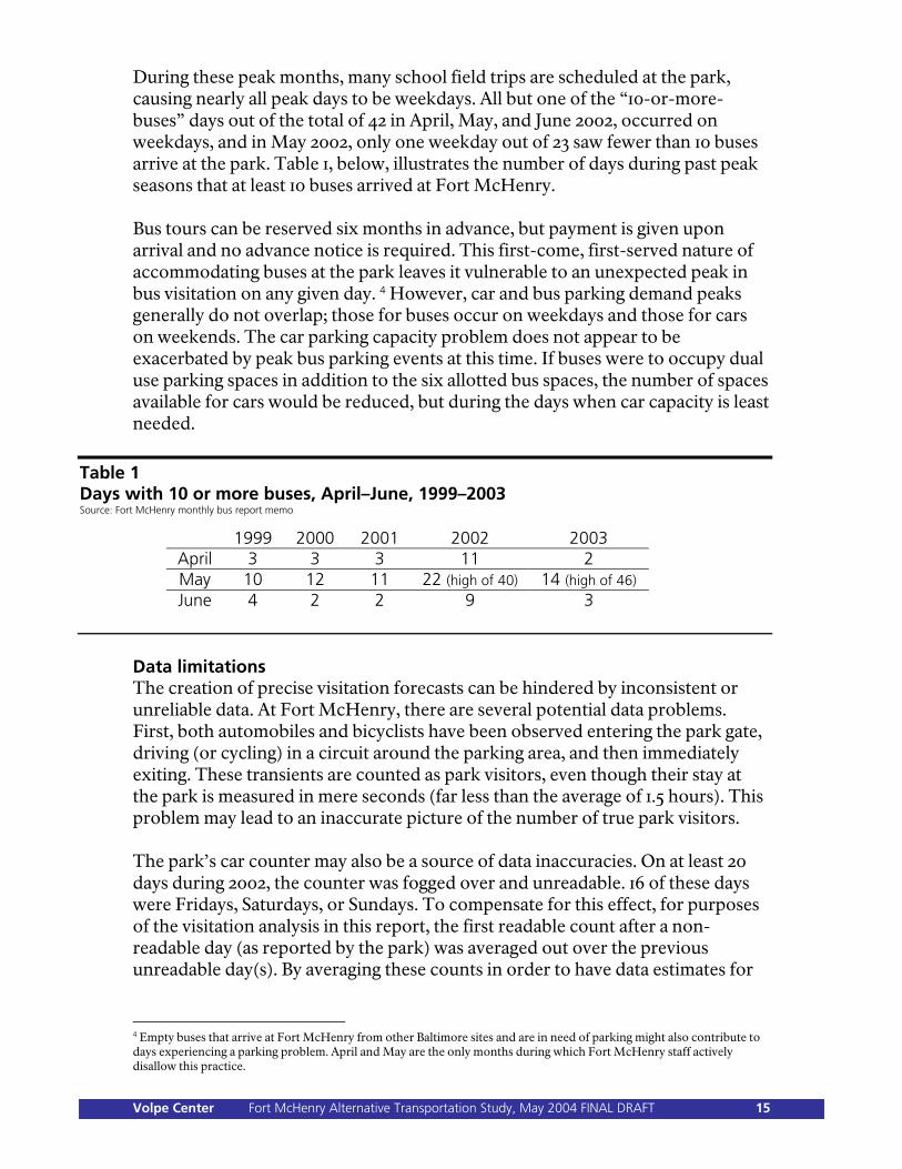
During these peak months, many school field trips are scheduled at the park, causing nearly all peak days to be weekdays. All but one of the “10-or-more-buses” days out of the total of 42 in April, May, and June 2002, occurred on weekdays, and in May 2002, only one weekday out of 23 saw fewer than 10 buses arrive at the park. Table 1, below, illustrates the number of days during past peak seasons that at least 10 buses arrived at Fort McHenry. Bus tours can be reserved six months in advance, but payment is given upon arrival and no advance notice is required. This first-come, first-served nature of accommodating buses at the park leaves it vulnerable to an unexpected peak in bus visitation on any given day. 4 However, car and bus parking demand peaks generally do not overlap; those for buses occur on weekdays and those for cars on weekends. The car parking capacity problem does not appear to be exacerbated by peak bus parking events at this time. If buses were to occupy dual use parking spaces in addition to the six allotted bus spaces, the number of spaces available for cars would be reduced, but during the days when car capacity is least needed.
Table 1 Days with 10 or more buses, April–June, 1999–2003 Source: Fort McHenry monthly bus report memo
1999 2000 2001 2002 2003 April 3 3 3 11 2 May 10 12 11 22 (high of 40) 14 (high of 46) June 4 2 2 9 3
Data limitations The creation of precise visitation forecasts can be hindered by inconsistent or unreliable data. At Fort McHenry, there are several potential data problems. First, both automobiles and bicyclists have been observed entering the park gate, driving (or cycling) in a circuit around the parking area, and then immediately exiting. These transients are counted as park visitors, even though their stay at the park is measured in mere seconds (far less than the average of 1.5 hours). This problem may lead to an inaccurate picture of the number of true park visitors. The park’s car counter may also be a source of data inaccuracies. On at least 20 days during 2002, the counter was fogged over and unreadable. 16 of these days were Fridays, Saturdays, or Sundays. To compensate for this effect, for purposes of the visitation analysis in this report, the first readable count after a non-readable day (as reported by the park) was averaged out over the previous unreadable day(s). By averaging these counts in order to have data estimates for
4 Empty buses that arrive at Fort McHenry from other Baltimore sites and are in need of parking might also contribute to days experiencing a parking problem. April and May are the only months during which Fort McHenry staff actively disallow this practice.
Volpe Center Fort McHenry Alternative Transportation Study, May 2004 FINAL DRAFT 15
each day in 2002, calculations regarding weekend versus weekday parking demand may be slightly skewed. Other limitations to visitation data include: Currently, there are no counting methods to keep track of the frequency of
overflow parking area use, other than anecdotal information obtained from park staff.
There is no differentiation between school buses and tour buses, nor is there a comprehensive record of the frequency of a particular school or tour company’s visits (unless reservations were made in advance). Obtaining better information along these lines might alter the way partnerships, facilities, and interpretive programs are designed.
Different visitation count sources sometimes report slightly different numbers for the same data set. More consistent counting could allow for more rigorous analysis.
Correlation with regional trends Travel patterns to Fort McHenry broadly mirror trends in the Baltimore Central Business District (CBD), as reported by the Baltimore Metropolitan Council. During the weekday morning rush hour, transit represents about 22% of trips (and this number has been steady since 1997); the remainder are automobile trips. Total person-trips into the CBD during the weekday morning rush have declined slightly, from 94,208 in 1997 to 88,258 in 2003—in line with the slight decline in visitation to Fort McHenry.
Volpe Center Fort McHenry Alternative Transportation Study, May 2004 FINAL DRAFT 16
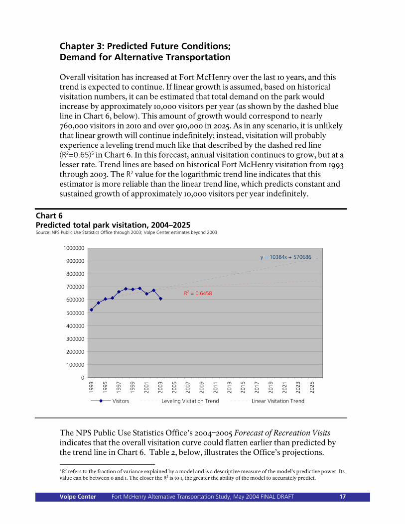
Chapter 3: Predicted Future Conditions; Demand for Alternative Transportation Overall visitation has increased at Fort McHenry over the last 10 years, and this trend is expected to continue. If linear growth is assumed, based on historical visitation numbers, it can be estimated that total demand on the park would increase by approximately 10,000 visitors per year (as shown by the dashed blue line in Chart 6, below). This amount of growth would correspond to nearly 760,000 visitors in 2010 and over 910,000 in 2025. As in any scenario, it is unlikely that linear growth will continue indefinitely; instead, visitation will probably experience a leveling trend much like that described by the dashed red line (R2=0.65)5 in Chart 6. In this forecast, annual visitation continues to grow, but at a lesser rate. Trend lines are based on historical Fort McHenry visitation from 1993 through 2003. The R2 value for the logarithmic trend line indicates that this estimator is more reliable than the linear trend line, which predicts constant and sustained growth of approximately 10,000 visitors per year indefinitely.
Chart 6 Predicted total park visitation, 2004–2025 Source: NPS Public Use Statistics Office through 2003; Volpe Center estimates beyond 2003
y = 10384x + 570686
0
100000
200000
300000
400000
500000
600000
700000
800000
900000
1000000
1993
1995
1997
1999
2001
2003
2005
2007
2009
2011
2013
2015
2017
2019
2021
2023
2025
Visitors Leveling Visitation Trend Linear Visitation Trend
R2 = 0.6458
The NPS Public Use Statistics Office’s 2004–2005 Forecast of Recreation Visits indicates that the overall visitation curve could flatten earlier than predicted by the trend line in Chart 6. Table 2, below, illustrates the Office’s projections. 5 R2 refers to the fraction of variance explained by a model and is a descriptive measure of the model’s predictive power. Its value can be between 0 and 1. The closer the R2 is to 1, the greater the ability of the model to accurately predict.
Volpe Center Fort McHenry Alternative Transportation Study, May 2004 FINAL DRAFT 17
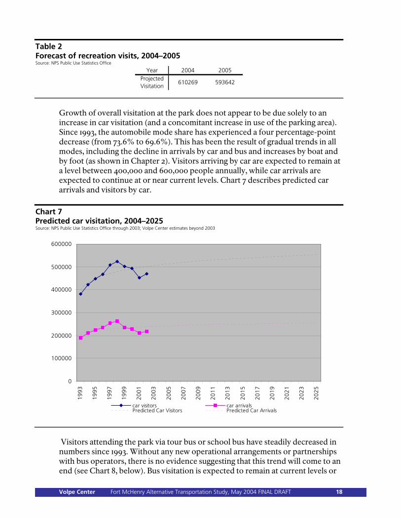
Table 2 Forecast of recreation visits, 2004–2005 Source: NPS Public Use Statistics Office
Year 2004 2005Projected Visitation
610269 593642
Growth of overall visitation at the park does not appear to be due solely to an increase in car visitation (and a concomitant increase in use of the parking area). Since 1993, the automobile mode share has experienced a four percentage-point decrease (from 73.6% to 69.6%). This has been the result of gradual trends in all modes, including the decline in arrivals by car and bus and increases by boat and by foot (as shown in Chapter 2). Visitors arriving by car are expected to remain at a level between 400,000 and 600,000 people annually, while car arrivals are expected to continue at or near current levels. Chart 7 describes predicted car arrivals and visitors by car.
Chart 7 Predicted car visitation, 2004–2025 Source: NPS Public Use Statistics Office through 2003; Volpe Center estimates beyond 2003
0
100000
200000
300000
400000
500000
600000
19
93
19
95
19
97
19
99
20
01
20
03
20
05
20
07
20
09
20
11
20
13
20
15
20
17
20
19
20
21
20
23
20
25
car visitors car arrivalsPredicted Car Visitors Predicted Car Arrivals
Visitors attending the park via tour bus or school bus have steadily decreased in numbers since 1993. Without any new operational arrangements or partnerships with bus operators, there is no evidence suggesting that this trend will come to an end (see Chart 8, below). Bus visitation is expected to remain at current levels or
Volpe Center Fort McHenry Alternative Transportation Study, May 2004 FINAL DRAFT 18
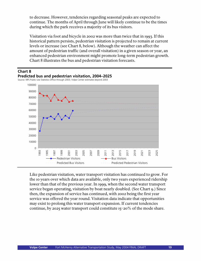
to decrease. However, tendencies regarding seasonal peaks are expected to continue. The months of April through June will likely continue to be the times during which the park receives a majority of its bus visitors. Visitation via foot and bicycle in 2002 was more than twice that in 1993. If this historical pattern persists, pedestrian visitation is projected to remain at current levels or increase (see Chart 8, below). Although the weather can affect the amount of pedestrian traffic (and overall visitation) in a given season or year, an enhanced pedestrian environment might promote long-term pedestrian growth. Chart 8 illustrates the bus and pedestrian visitation forecasts.
Chart 8 Predicted bus and pedestrian visitation, 2004–2025 Source: NPS Public Use Statistics Office through 2003; Volpe Center estimates beyond 2003
0
10000
20000
30000
40000
50000
60000
70000
80000
90000
100000
1993
1995
1997
1999
2001
2003
2005
2007
2009
2011
2013
2015
2017
2019
2021
2023
2025
Pedestrian Visitors Bus Visitors
Predicted Bus Visitors Predicted Pedestrian Visitors
Like pedestrian visitation, water transport visitation has continued to grow. For the 10 years over which data are available, only two years experienced ridership lower than that of the previous year. In 1999, when the second water transport service began operating, visitation by boat nearly doubled. (See Chart 9.) Since then, the expansion of service has continued, with 2002 being the first year service was offered the year round. Visitation data indicate that opportunities may exist to prolong this water transport expansion. If current tendencies continue, by 2025 water transport could constitute 15–20% of the mode share.
Volpe Center Fort McHenry Alternative Transportation Study, May 2004 FINAL DRAFT 19
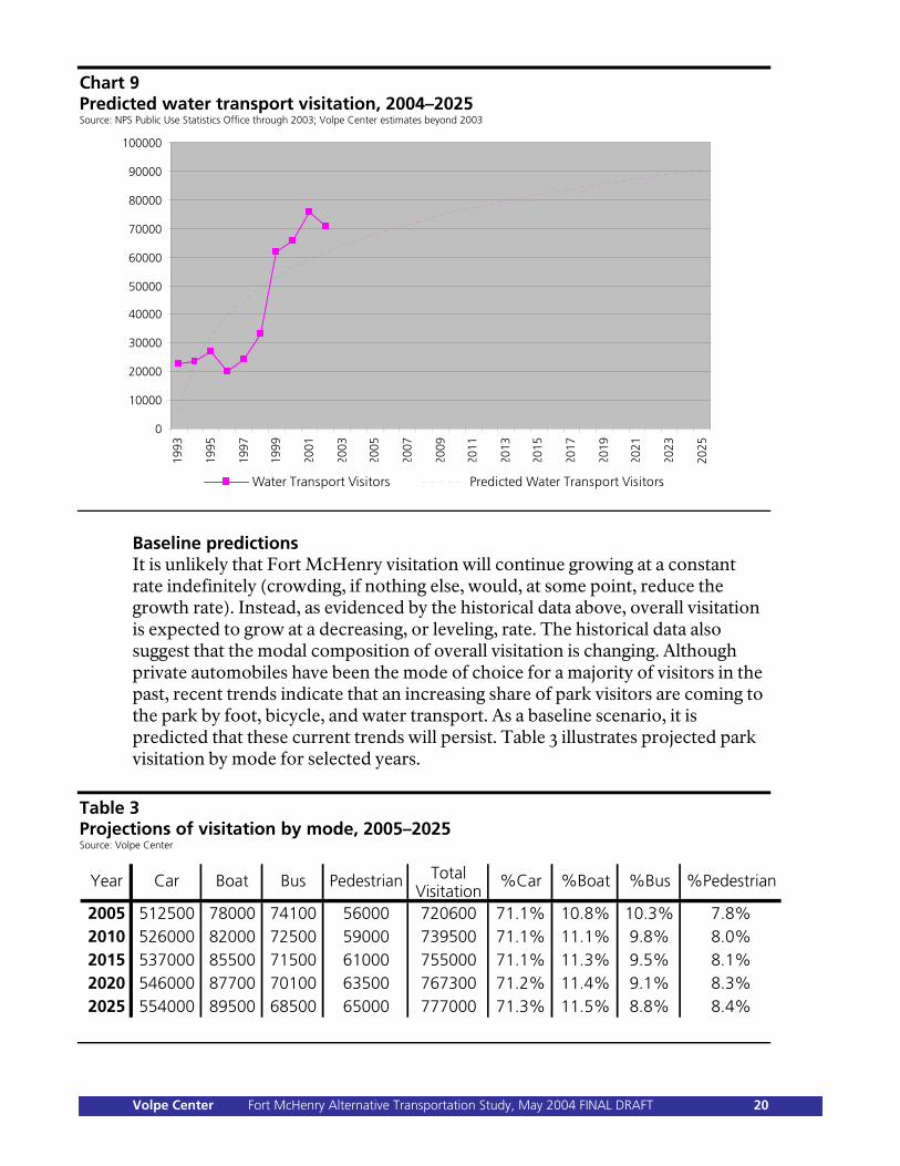
Chart 9 Predicted water transport visitation, 2004–2025 Source: NPS Public Use Statistics Office through 2003; Volpe Center estimates beyond 2003
0
10000
20000
30000
40000
50000
60000
70000
80000
90000
100000
1993
1995
1997
1999
2001
2003
2005
2007
2009
2011
2013
2015
2017
2019
2021
2023
2025
Water Transport Visitors Predicted Water Transport Visitors
Baseline predictions It is unlikely that Fort McHenry visitation will continue growing at a constant rate indefinitely (crowding, if nothing else, would, at some point, reduce the growth rate). Instead, as evidenced by the historical data above, overall visitation is expected to grow at a decreasing, or leveling, rate. The historical data also suggest that the modal composition of overall visitation is changing. Although private automobiles have been the mode of choice for a majority of visitors in the past, recent trends indicate that an increasing share of park visitors are coming to the park by foot, bicycle, and water transport. As a baseline scenario, it is predicted that these current trends will persist. Table 3 illustrates projected park visitation by mode for selected years.
Table 3 Projections of visitation by mode, 2005–2025 Source: Volpe Center
TotalVisitation
2005 512500 78000 74100 56000 720600 71.1% 10.8% 10.3% 7.8%2010 526000 82000 72500 59000 739500 71.1% 11.1% 9.8% 8.0%2015 537000 85500 71500 61000 755000 71.1% 11.3% 9.5% 8.1%2020 546000 87700 70100 63500 767300 71.2% 11.4% 9.1% 8.3%2025 554000 89500 68500 65000 777000 71.3% 11.5% 8.8% 8.4%
%Bus %PedestrianCar Boat Bus PedestrianYear %Car %Boat
Volpe Center Fort McHenry Alternative Transportation Study, May 2004 FINAL DRAFT 20
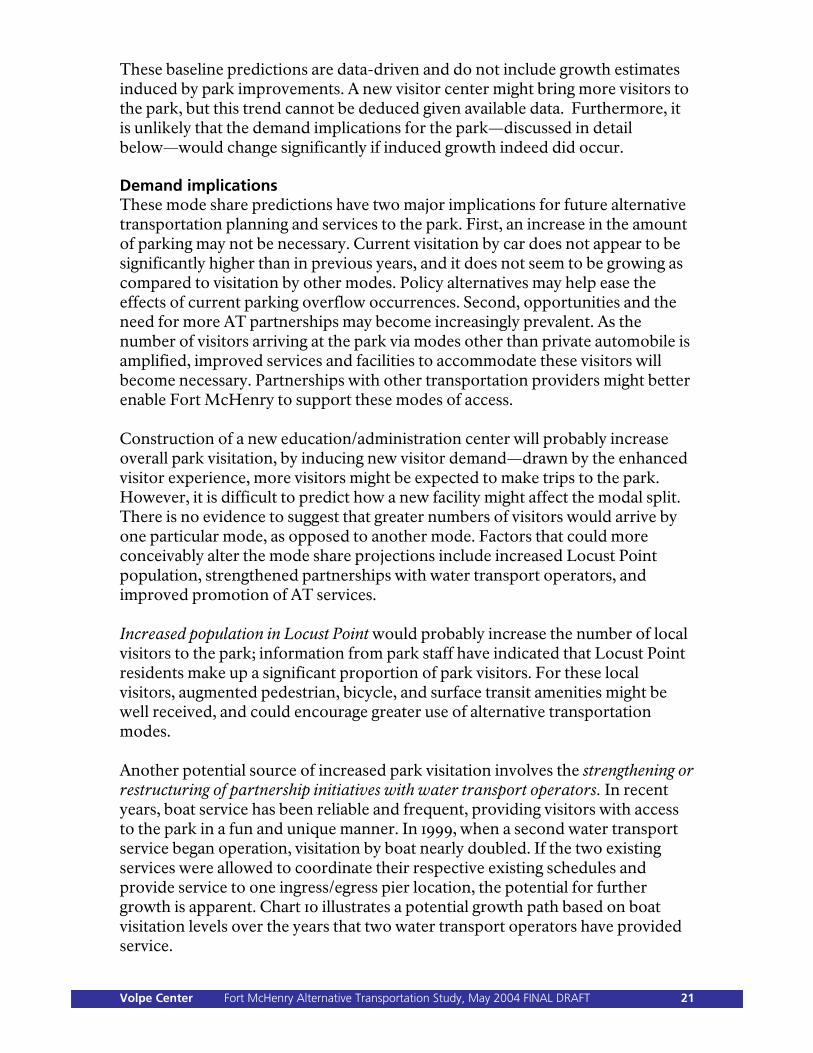
These baseline predictions are data-driven and do not include growth estimates induced by park improvements. A new visitor center might bring more visitors to the park, but this trend cannot be deduced given available data. Furthermore, it is unlikely that the demand implications for the park—discussed in detail below—would change significantly if induced growth indeed did occur. Demand implications These mode share predictions have two major implications for future alternative transportation planning and services to the park. First, an increase in the amount of parking may not be necessary. Current visitation by car does not appear to be significantly higher than in previous years, and it does not seem to be growing as compared to visitation by other modes. Policy alternatives may help ease the effects of current parking overflow occurrences. Second, opportunities and the need for more AT partnerships may become increasingly prevalent. As the number of visitors arriving at the park via modes other than private automobile is amplified, improved services and facilities to accommodate these visitors will become necessary. Partnerships with other transportation providers might better enable Fort McHenry to support these modes of access. Construction of a new education/administration center will probably increase overall park visitation, by inducing new visitor demand—drawn by the enhanced visitor experience, more visitors might be expected to make trips to the park. However, it is difficult to predict how a new facility might affect the modal split. There is no evidence to suggest that greater numbers of visitors would arrive by one particular mode, as opposed to another mode. Factors that could more conceivably alter the mode share projections include increased Locust Point population, strengthened partnerships with water transport operators, and improved promotion of AT services. Increased population in Locust Point would probably increase the number of local visitors to the park; information from park staff have indicated that Locust Point residents make up a significant proportion of park visitors. For these local visitors, augmented pedestrian, bicycle, and surface transit amenities might be well received, and could encourage greater use of alternative transportation modes. Another potential source of increased park visitation involves the strengthening or restructuring of partnership initiatives with water transport operators. In recent years, boat service has been reliable and frequent, providing visitors with access to the park in a fun and unique manner. In 1999, when a second water transport service began operation, visitation by boat nearly doubled. If the two existing services were allowed to coordinate their respective existing schedules and provide service to one ingress/egress pier location, the potential for further growth is apparent. Chart 10 illustrates a potential growth path based on boat visitation levels over the years that two water transport operators have provided service.
Volpe Center Fort McHenry Alternative Transportation Study, May 2004 FINAL DRAFT 21
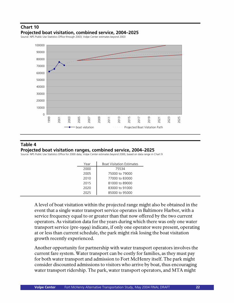
Chart 10 Projected boat visitation, combined service, 2004–2025 Source: NPS Public Use Statistics Office through 2003; Volpe Center estimates beyond 2003
0
10000
20000
30000
40000
50000
60000
70000
80000
90000
10000019
99
2001
2003
2005
2007
2009
2011
2013
2015
2017
2019
2021
2023
2025
boat visitation Projected Boat Visitation Path
Table 4 Projected boat visitation ranges, combined service, 2004–2025 Source: NPS Public Use Statistics Office for 2000 data; Volpe Center estimates beyond 2000, based on data range in Chart 9
Year Boat Visitation Estimates2000 755342005 75000 to 790002010 77000 to 830002015 81000 to 890002020 83000 to 910002025 85000 to 95000
A level of boat visitation within the projected range might also be obtained in the event that a single water transport service operates in Baltimore Harbor, with a service frequency equal to or greater than that now offered by the two current operators. As visitation data for the years during which there was only one water transport service (pre-1999) indicate, if only one operator were present, operating at or less than current schedule, the park might risk losing the boat visitation growth recently experienced.
Another opportunity for partnership with water transport operators involves the current fare system. Water transport can be costly for families, as they must pay for both water transport and admission to Fort McHenry itself. The park might consider discounted admissions to visitors who arrive by boat, thus encouraging water transport ridership. The park, water transport operators, and MTA might
Volpe Center Fort McHenry Alternative Transportation Study, May 2004 FINAL DRAFT 22
also better advertise to local visitors that MTA monthly passes grant free access to both water services. This promotion of AT services might also be extended to the Fort McHenry web site, which presently lists only car and MTA bus service as ways of “Getting There.”
Potential responses indicated Pedestrian facility improvements. Continuing to make AT improvements, such as the development of bicycle paths, better crosswalks, and an enhanced park entrance, might help to sustain the current expansion of travel to the park by foot. The exploration of smaller public shuttle bus routes, which are perhaps more “tourist-friendly” than the MTA’s Route 1 service, may also be an option to encourage pedestrian visitation. Parking policy alternatives. National Park Service Northeast Region policy generally, and Alternative Transportation Program policy more specifically, does not encourage the addition of roads or car parking facilities. Adding parking, rather than accommodating existing demand, might actually have the effect of increasing demand, as drivers realize that increased capacity offers increased opportunities for car parking. Therefore, even bearing in mind demand during special event days and the peak season, when parking constraints are most evident, policy alternatives may be appropriate in lieu of providing increased parking. Parking reduction. Park staff has anecdotally noted (in the absence of systematically collected overflow parking data) that the main parking area and overflow area are both full during virtually every special event held at Fort McHenry—approximately seven days per year. The staff has also pointed out that the parking area is probably full 30–40% of weekend days in the summer and about 25% of weekend days in the spring and fall—roughly 30 days per year. On these days, the overflow area (125 spaces) is rarely filled over 50% of capacity. In 2002, every special event day was characterized by at least 2,000 cars arriving at the park. Inferring that a 2,000-car-day is linked to an occurrence of a full parking area, and based on the actual data available, in 2002 the parking area was likely full 33 days—a number similar to the park staff’s supposition. With this information, it can be predicted that a reduction in parking area size would also lower the predicted 2,000-car threshold for a full-parking-area day. In line with DCP/EA Concept D, if the current parking area of 161 spaces were reduced to 108 spaces (a 33% reduction), it might be assumed that the threshold for full parking also be lowered by 33%, resulting in 1,340 cars as a predictor for full parking capacity. With this scenario, it could be estimated, based on the available data, that at some point during the day, the parking area would have reached capacity during approximately 137 days in 2002. While a 1,340-car-per-day threshold may or may not be exactly precise, these car visitation data suggest a parking area of 108 spaces would lead to a significant increase in the frequency of overflow area use.
Volpe Center Fort McHenry Alternative Transportation Study, May 2004 FINAL DRAFT 23
Better promotion of AT services. Continuing to develop, endorse, and advertise AT partnerships may allow the park to better manage its predicted growth, to enhance park operations, and to ensure that consistency with NPS policy goals is maintained. The NPS system-wide transportation objective is to offer a variety of safe, enjoyable transportation options, including alternative transportation services, where appropriate. An increase in AT through improved services and strengthened partnerships could help increase visitation, enhance the visitor experience, improve park aesthetics, and protect natural and cultural resources.
Volpe Center Fort McHenry Alternative Transportation Study, May 2004 FINAL DRAFT 24
Chapter 4: Stakeholder Partnership Opportunities Productive stakeholder partnerships are essential to Fort McHenry’s success in planning and implementing transportation initiatives as effectively and efficiently as possible. In and around Baltimore, a variety of government agencies, non-profit organizations, and cultural institutions are pursuing projects that can affect regional transportation. Working with a list of these external stakeholders, provided by the Fort McHenry superintendent, the AT study team conducted an extensive series of stakeholder interviews, aimed at determining what opportunities existed to establish or strengthen partnerships geared toward transportation. Only with this knowledge can the park plan and implement its own transportation efforts in concert with external activities to realize the maximum possible benefit. Generally, most of the stakeholders were supportive of mutually beneficial partnerships with Fort McHenry—many already have such partnerships in place. When it comes to transportation, however, it appears that there is no one “prime mover” in Baltimore. Many of the interviewees expressed frustration that visitor transportation is not better coordinated, and although many different ideas and plans (at varying stages of development) were expressed by individual stakeholders, most agreed that in the absence of some overarching plan, proposed visitor transportation services are likely to continue in the same somewhat haphazard manner. Previous efforts at consolidated visitor transportation services seem to have failed in Baltimore for this reason. Unless specifically noted below, each stakeholder was interviewed in Baltimore, in person, by the AT study team, with one or more Fort McHenry staff present. This section presents an overview of the stakeholder partnership opportunities identified by the AT study team. More extensive stakeholder information is available in Appendix A (detailed interview notes) and in Appendix B (a comprehensive bibliography of materials and documentation furnished by stakeholders).
Volpe Center Fort McHenry Alternative Transportation Study, May 2004 FINAL DRAFT 25
Partnership opportunities by stakeholder Patriots of Fort McHenry/Baltimore Maritime Museum There is considerable overlap between these organizations—the park’s “friends” group and an interpretive non-profit organization, respectively, though represented to the AT study team by the same person. Both groups are interested in expanded surface and water transportation among Baltimore cultural institutions, and can facilitate partnerships and cross-institutional promotion. The Maritime Museum, along with its affiliate, the National Historic Seaport (see below), proposed a $50 million Baltimore ferry system to Congress. Baltimore City Planning Department (BPD) BPD is involved in a variety of initiatives with the potential to affect Fort McHenry: regional bicycle and heritage trails, waterside and landside master plans for Baltimore Harbor, “enterprise” zoning for Locust Point. BPD representatives explained that Baltimore City owns most of the Inner Harbor boat docks (including the one at Fort McHenry), and controls water operators’ access to those docks via contract agreements. Although several times delayed, the city’s eventual intention is to permit dock access only to a single operator, in order to reduce confusion among visitors to Baltimore who do not understand the two-operator system.
The single-operator situation implies either that the two current operators would need to merge, or that one would be denied access to the municipally-owned docks. BPD also expressed interest in a closer partnership with Fort McHenry. (Such a partnership might take a form similar to that between Lowell National Historical Park in Massachusetts and the city of Lowell.) Baltimore Department of Transportation (Baltimore DOT) The municipal transportation agency, Baltimore DOT, is a major provider of information useful to the park—traffic data, Geographic Information Systems (GIS) data, bicycle-path plans, engineering specifications, and the like. Currently, Baltimore DOT is involved with the Key Highway Extension project to connect the Tide Point commercial development directly with a major artery, bypassing the need for commuter traffic to travel on Locust Point local roads. Baltimore DOT is also involved in other potential road projects, such as the installation of a bicycle lane on Fort Avenue and the improvement of Andre Street, which could create another major park access point to Interstate 95. Maryland Department of Transportation (MDOT) The state transportation agency; the Maryland Transit Administration and Maryland Port Administration (see below) are both actually part of MDOT. Locust Point was one focus area of MDOT’s Master Plan for the
Volpe Center Fort McHenry Alternative Transportation Study, May 2004 FINAL DRAFT 26

Port of Baltimore, which aimed at retaining industrial activities. Although resource-constrained, MDOT could be involved in transportation improvements, and administers the Planning, Land Use, and Transportation Advisory Council (PLUTAC), to which Fort McHenry can provide input. Baltimore Area Convention and Visitors’ Association (BACVA) BACVA’s mission is to promote Baltimore as a destination for both visitors and business conventions. They provide information to visitors and conventioneers, including information on local attractions and on transportation options, and recently opened a new visitor center in the Inner Harbor, the use of which as a transportation hub may be possible. BACVA also provides information to bus drivers on Baltimore’s bus parking/management system—empty buses are directed to the Ravens Stadium lot. U.S. Naval Reserve Center (USNR) Located immediately adjacent to Fort McHenry, USNR is an active military facility that requires secure access and parking for its personnel, especially during heightened security or during military operations. Nonetheless, USNR does currently allow for Fort McHenry overflow parking on a case-by-case basis, for fort personnel (support staff or re-enactors, not the general public). This kind of arrangement can usually be worked out, even if Fort McHenry’s requests become more frequent, although USNR is unable to make a formal commitment or
enter into a contractual arrangement due to its unpredictable military/security requirements. USNR holds ceremonies (such as its change of command) at Fort McHenry; Fort McHenry staff give USNR personnel tours of the park. Greater Baltimore History Alliance (GBHA) GBHA, in part an organization of Baltimore historical and cultural institutions, noted that visitor transportation in Baltimore (including visitor orientation signage) is lacking, especially beyond the immediate Inner Harbor vicinity. However, the Babe Ruth Museum, in coordination with several other attractions on the city’s west side—including the B&O Railroad Museum, the Hippodrome, and the Mount Vernon cultural area—may be interested in funding and running its own visitor shuttle beginning with the 2005 season, to serve the new BACVA visitor center in the Inner Harbor and the new Babe Ruth and sports museum to be located at Camden Station. C. Steinweg BV (“Steinweg”) A private corporation located adjacent to Fort McHenry (with parcels on both sides of Fort Avenue), Steinweg is a major shipper and, hence, involved in industrial maritime activities. (The Steinweg representative also spoke on behalf of the Baltimore Maritime Association.) Fully-loaded tractor-trailers use Fort Avenue to access Steinweg property, and must pass directly in front of the Fort McHenry entrance gate to do so, presenting a potential safety hazard.
Volpe Center Fort McHenry Alternative Transportation Study, May 2004 FINAL DRAFT 27
Baltimore Metropolitan Council (BMC)
Steinweg is willing to reroute its trucks off of Fort Avenue, to use a separate access road owned by the Maryland Port Administration (see below), if that solution can be worked out to the satisfaction of all parties concerned. Steinweg may also be interested in Andre Street access to I-95.
The Baltimore metropolitan planning organization (MPO), BMC is involved with promoting transit in an around Baltimore, and provided useful information regarding the implementation of “shuttle bug” transit services in three Baltimore neighborhoods. Partnership opportunities with BMC seem limited, but BMC expressed a desire to maintain a strong relationship with Fort McHenry and to be involved with any proposed expansion of transit services.
Ed Kane’s Water Taxi (“Water Taxi”) One of the two water operators in Baltimore Harbor, the Water Taxi currently brings Fort McHenry-bound passengers to a dock at Tide Point, where they transfer to a jitney bus for the final leg of their journey. Water Taxi is interested in expanding the Baltimore water transportation network, in doing more effective visitor promotions, and (if the economics work) in providing more frequent, faster, year-round service, including service directly to Fort McHenry.
Maryland Port Administration (MPA) MPA administers Baltimore’s extensive port facilities and related lands, and is involved with the concomitant industrial and shipping activities. Maintaining the long-term industrial capacity of the North Locust Point Marine Terminal (where trade is forecast to increase) is one of MPA’s major interests; the aim is to keep industrial waterfront parcels from being developed as residential/commercial projects, as has happened several times in Baltimore.
National Historic Seaport (NHS) Part of the Living Classrooms Foundation, NHS operates the second water service in Baltimore Harbor, the “Seaport Taxi,” which serves the municipally-owned dock at Fort McHenry. Overall, NHS has a broad, multifaceted mission, providing educational, cultural, and historical information and opportunities to Baltimore visitors and students. With the affiliated Maritime Museum, as noted above, NHS proposed a $50 million Baltimore ferry system to Congress.
MPA also owns a parking lot outside Fort McHenry’s main gate that, on occasion, is made available to the public during specific overflow parking situations at the park; depending on the circumstances, MPA may be amenable to a more formal, longer-term agreement regarding use of the lot, possibly including more frequent use for weekend car overflow parking. (The December 2003 North Locust Point
Volpe Center Fort McHenry Alternative Transportation Study, May 2004 FINAL DRAFT 28
Marine Terminal Facility Master Plan prepared for MPA states that that parking lot will be retained; however, MPA representatives indicated their willingness to discuss a creative solution that could accommodate Fort McHenry overflow parking.) MPA also controls a truck access road that could, potentially, be used to reroute Steinweg trucks away from the Fort McHenry gate; MPA also owns or has interest in land parcels immediately outside the gate. Maryland Transit Administration (MTA) MTA provides surface transit services in Maryland, including the Route 1 bus that connects Fort McHenry, via Fort Avenue, with downtown Baltimore. Because Fort McHenry is the end of the Route 1 line, MTA has been receptive to the idea of extending the line to the Fort McHenry visitor center; the cost to MTA of doing so would be negligible. MTA is also the provider of two “shuttle bug” neighborhood transit services in Baltimore; a third service, for Locust Point, was never implemented due to funding concerns. In the past, MTA has worked with the Baltimore Museum of Art and the Baltimore City Zoo to run new transit services championed by those institutions; this set a precedent for co-funded transit partnerships. Maryland Heritage Tourism (MHT) The state office of tourism and development, MHT’s goal is to bring visitors to Maryland; Fort McHenry is recognized as a major draw. MHT operates 13 welcome centers throughout the state and works to
get Fort McHenry information not only to travelers, but to tour guides, for whom MHT runs familiarization/orientation programs. “Historic” and “cultural” visitors seem especially receptive to MHT’s efforts. Baltimore Downtown Partnership (BDP) Promotion of the safety, navigability, and beautification of the Charles Street downtown area is BDP’s goal. BDP is involved in a pioneering visitor/pedestrian signage/wayfinding program downtown that, if successful, is set to be expanded. BDP also oversees the DASH commuter shuttle (a local transit service, even if not geared to Baltimore visitors). Locust Point Civic Association (LPCA) LPCA is a neighborhood group that represents Locust Point residents’ interests; it has a close relationship with its elected representatives. Generally, LPCA would like to see Locust Point’s industrial character retained; LPCA does not favor new residential/commercial developments and is concerned about traffic congestion in the area. LPCA is a strong supporter of Fort McHenry and is in favor of expanded surface and water transportation options that can connect not only visitors but Locust Point residents to other parts of Baltimore. Struever Bros., Eccles, and Rouse, Inc. (“Struever”) A residential/commercial developer, creator of the Tide Point complex on
Volpe Center Fort McHenry Alternative Transportation Study, May 2004 FINAL DRAFT 29
Baltimore Office of Promotion (BOP)
Locust Point, Struever is interested in expanded transportation services that will serve its tenants. Struever actually operates a shuttle in Fells Point; this service would have been operated by the city, if a proposed municipal shuttle system had been implemented. The Water Taxi services to Tide Point—serving Fort McHenry visitors as well as business travelers across the harbor to Fells Point—has been highly successful, and Struever may be interested in expanding them. Struever would also support extension of the Baltimore Harbor pedestrian promenade from the Inner Harbor to Tide Point. The current Key Highway extension project will ease access to Tide Point. Struever continues development along the waterfront, especially in the Fells Point area.
Mostly a coordinator of arts/cultural events, BOP works with Baltimore DOT on special-events transportation planning when there are specific concerns related to congestion, crowding, or security. Museum of Industry (MI) Near Fort McHenry, located off of Key Highway, MI is working on plans for a visitor shuttle in cooperation with the Visionary Arts Museum and the Science Center, in order to transport visitors from the Inner Harbor (the new BACVA visitor center); Fort McHenry could potentially participate in this effort. MI is currently served by the Seaport Taxi, but not on a scheduled basis, and is interested in more frequent, scheduled service. Baltimore Development
Corporation (BDC) U.S.S. Constellation A tourist attraction in the Inner Harbor, Constellation is affiliated with the National Historic Seaport and is interested in coordinating transportation, wayfinding signage, and promotional efforts.
BDC’s mission is the promotion of industrial and commercial development in Baltimore. Their partnership potential is limited, although BDC does push for transportation investments by other agencies. BDC also coordinates agencies involved in land-use development, and helped to initiate the Key Highway extension project. BDC is also a source of knowledge regarding potential residential/commercial developments in Locust Point. BDC participates in Baltimore Harbor planning; the BDC representative is Baltimore City’s representative on the MDOT-administered PLUTAC advisory committee.
Volpe Center Fort McHenry Alternative Transportation Study, May 2004 FINAL DRAFT 30
Partnership opportunities by mode This study considers six transportation “modes”—surface transit, water transport, congestion management, bicycle/pedestrian access, reservations/parking management, and traveler information. Although a detailed explanation of these modes appears in the next section, it is useful here to summarize stakeholder partnership opportunities according to those modes. Surface (bus) transit There are two major surface transit partnership opportunities: MTA has indicated its willingness
to pursue demonstration Route 1 bus service directly into Fort McHenry, in front of the visitor center. To take best advantage of this opportunity, the extended transit service would need to be effectively promoted to park visitors and potential visitors. If ridership does not materialize, MTA will probably want to end the demonstration—and will be unwilling to try again.
A cooperative Baltimore visitor
shuttle, operated with the Babe Ruth Museum, the Museum of Industry, and other cultural institutions (possibly including the Hippodrome, the Visionary Arts Museum, the B&O Railroad Museum, and the Science Center). These institutions have already expressed interest in the idea and a willingness to explore financial partnership
arrangements with Fort McHenry, which is ideally placed—both in terms of visitation and geographically—to be an effective participant in such a service.
Water transport Whether or not Baltimore City consolidates its dock access contracts to enable only one water transportation operator, Fort McHenry has an opportunity to establish stronger partnerships in this area, at the least by better informing visitors and potential visitors of the availability of water transport to the park. A strong partnership with Baltimore City might also lead to cooperative construction of accessible dock facilities, enabling expanded visitation by the mobility-impaired, accommodations for more and different kinds of boats (enabling new, more frequent, and more flexible services), and a superior experience for all visitors arriving by boat. Congestion management Steinweg and MPA have not been able to agree on terms by which Steinweg trucks could avoid Fort Avenue—including the Fort McHenry gate—by using the MPA’s access roads. Given the nature of the Steinweg/MPA relationship, it may be inappropriate for Fort McHenry to become deeply involved, but the opportunity may exist for Fort McHenry to attempt to facilitate a solution, based on park visitor safety and aesthetics. Baltimore City may also play a role here, as they are typically involved in road projects.
Volpe Center Fort McHenry Alternative Transportation Study, May 2004 FINAL DRAFT 31
Traveler information Potential improvements to Andre Street, including its transformation into a gateway to I-95, would involve MPA, Steinweg, and Baltimore DOT.
Essentially, there are two types of traveler information: In terms of advance travel
planning, Fort McHenry can better publicize the availability of AT services serving the park, using its own materials (brochure and web site), surface and water transit providers, cultural-institution partners, BACVA, and MHT to do so. Many of the interviewees indicated that Fort McHenry is considered a major tourist draw and that additional advance-planning information would be helpful.
Bicycle/pedestrian access Baltimore DOT would be involved with bicycle, pedestrian, and streetscape improvements outside the Fort McHenry gate (as would MPA, for the parcels owned or controlled by that agency). Fort McHenry can use the diagrams and proposals presented later in this report as a basis for discussing with Baltimore DOT the possibility of funding and implementing such improvements. Reservations/parking management
It may also be possible to collaborate with transportation agencies—such as MDOT and Baltimore DOT—to provide visitors with real-time traveler information, via variable-message signs, radio, telephone, or Internet. This kind of information would be most useful on days of extremely heavy visitation during the peak season and during special events, when there is a particularly urgent need to communicate to visitors the availability of AT services to the park.
Fort McHenry staff can work to ensure that all buses entering the park are familiar with BACVA’s guidelines for bus parking within Baltimore City. In addition, the opportunity exists to discuss with MPA the possibility of some joint or cooperative use of the MPA parking facility immediately outside the Fort McHenry gate. While MPA has stated that they foresee a significant future need for that facility, there is an apparent willingness to consider compatible ideas that might also accommodate some of Fort McHenry’s overflow parking needs.
Volpe Center Fort McHenry Alternative Transportation Study, May 2004 FINAL DRAFT 32
Chapter 5: Transportation Elements The AT study team used an “elements” approach to the Fort McHenry transportation analysis—a method that describes transportation options as if they were items on a menu. As described in Chapter 1, creating a list of categorized transportation elements, analogous to the items on a restaurant menu, enabled the description and technical analysis of specific actions relative to transportation. The AT study team worked systematically to describe and analyze these elements. By using the Fort McHenry data obtained at the beginning of the project, and by drawing on the stakeholder-interview results, the AT study team created the following element categories:
1. Surface transit. 2. Water transport. 3. Congestion management. 4. Pedestrian/bicycle. 5. Reservations/parking management. 6. Travel information.
The following table shows the category names across the top, and the individual elements below. For instance, there are 7 congestion-management elements, but only 3 reservations/parking management elements. Read down only; there is no horizontal correlation (except for the second and third surface and water elements, which stretch across both categories).
Volpe Center Fort McHenry Alternative Transportation Study, May 2004 FINAL DRAFT 33
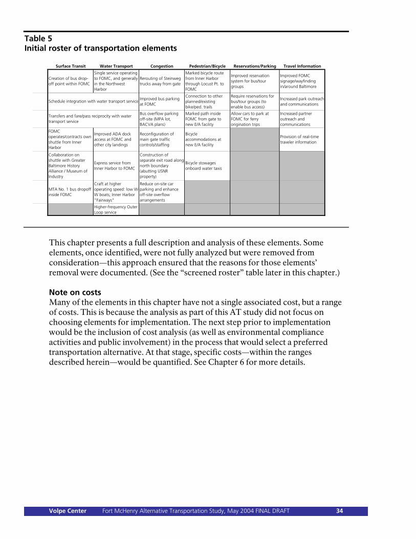
Table 5 Initial roster of transportation elements
Surface Transit Water Transport Congestion Pedestrian/Bicycle Reservations/Parking Travel Information
Creation of bus drop-off point within FOMC
Single service operating to FOMC, and generally in the Northwest Harbor
Rerouting of Steinweg trucks away from gate
Marked bicycle route from Inner Harbor through Locust Pt. to FOMC
Improved reservation system for bus/tour groups
Improved FOMC signage/wayfinding in/around Baltimore
Improved bus parking at FOMC
Connection to other planned/existing bike/ped. trails
Require reservations for bus/tour groups (to enable bus access)
Increased park outreach and communications
Bus overflow parking off-site (MPA lot, BACVA plans)
Marked path inside FOMC from gate to new E/A facility
Allow cars to park at FOMC for ferry origination trips
Increased partner outreach and communications
FOMC operates/contracts own shuttle from Inner Harbor
Improved ADA dock access at FOMC and other city landings
Reconfiguration of main gate traffic controls/staffing
Bicycle accommodations at new E/A facility
Provision of real-time traveler information
Collaboration on shuttle with Greater Baltimore History Alliance / Museum of Industry
Express service from Inner Harbor to FOMC
Construction of separate exit road along north boundary (abutting USNR property)
Bicycle stowages onboard water taxis
MTA No. 1 bus dropoff inside FOMC
Craft at higher operating speed: low W-W boats; Inner Harbor "Fairways"
Reduce on-site car parking and enhance off-site overflow arrangements
Higher-frequency Outer Loop service
Schedule integration with water transport service
Transfers and fare/pass reciprocity with water transport service
This chapter presents a full description and analysis of these elements. Some elements, once identified, were not fully analyzed but were removed from consideration—this approach ensured that the reasons for those elements’ removal were documented. (See the “screened roster” table later in this chapter.) Note on costs Many of the elements in this chapter have not a single associated cost, but a range of costs. This is because the analysis as part of this AT study did not focus on choosing elements for implementation. The next step prior to implementation would be the inclusion of cost analysis (as well as environmental compliance activities and public involvement) in the process that would select a preferred transportation alternative. At that stage, specific costs—within the ranges described herein—would be quantified. See Chapter 6 for more details.
Volpe Center Fort McHenry Alternative Transportation Study, May 2004 FINAL DRAFT 34
Element Category 1: Surface Transit Category overview National Park Service Alternative Transportation Program policy encourages the use of surface transit—including publicly and privately operated buses and other vehicles—for access into the national parks. Fort McHenry is served by a mix of bus operators, including tour operators, school districts, and MTA. There are also opportunities for bus shuttle partnerships with other tourist attractions and cultural and historic sites, as described in Chapter 4. Virtually all visitors arriving by bus do so as part of touring operations or school field trips. MTA reports very few alightings from their No. 1 bus at the Fort McHenry stop, and park staff report that they very seldom see No. 1 bus passengers entering the park. The number of visitors arriving in tour and school buses has declined slightly since 1993, and the trend is expected to continue in the absence of new arrangements and partnerships. The seasonal peak (April through June) reported in Chapter 3 is also expected to continue. Fort McHenry will need to provide well-designed accommodations for bus travelers in the future, since large numbers will continue to arrive even if the recent moderating visitation trend continues. Improving on the current minimal bus drop-off facility could also boost arrivals by the No. 1 bus. The development of new and improved partnerships and bus operations is, moreover, an important component of alternative transportation and could yield significant visitor modal choice gains if successfully implemented. Element 1: Creation of bus drop-off point within Fort McHenry This element specifies the “construction” of a dedicated bus stop. Such a stop could be as simple as a designated area on the pavement (marked with paint at essentially no cost), but could also feature a sheltered visitor waiting area, contrasting pavement materials, introductory interpretive information about the park, and bus schedules. The bus stop would be used by all buses, including tour buses, school buses, partner transit buses, and, potentially, the MTA No. 1 transit bus. As a result of the Value Analysis Workshop held at Fort McHenry in December, 2003, all DCP/EA action alternatives include a bus drop-off area that can accommodate two buses at once (see Figure 18, in Chapter 6). The DCP/EA concepts could also include a shelter with provision of park interpretative materials and maps, as well as information on all transportation alternatives at the park. Stakeholders Fort McHenry specifically, and NPS generally, has recognized the importance of bus transportation in the future and has ensured that the park’s future reconfiguration will include the space necessary for a bus drop-off, whichever
Volpe Center Fort McHenry Alternative Transportation Study, May 2004 FINAL DRAFT 35
education/administration facility alternative is ultimately chosen. Bus transit providers will have an improved reception area for their vehicles, including tour bus operators, school groups, potential bus shuttle partners (e.g., Greater Baltimore Historical Alliance), existing bus shuttle operators like Kane’s Water Taxi, and MTA. Transportation benefits and impacts There would be a mobility and access benefit, as the new facility would improve both access by bus and the visitor experience for those arriving by bus. Land planning, and development and environmental benefits and impacts, are negligible. Analysis As part of the DCP/EA process, design of a dedicated bus drop-off has reached the conceptual stage, to be followed by detailed architectural design, and then eventual fabrication and construction as part of the education/administration facility project. The bus drop-off as it appears in the conceptual design is sufficient to accommodate all anticipated vehicle types, including those that are fully accessible to visitors with mobility impairments. Park operations should require minimal adjustments to respond to the resulting visitor circulation patterns within the park (which should differ little or not at all from present patterns). Element 2: Schedule integration with water transport service The surface transportation providers at major water transport embarkation points (Inner Harbor, Fells Point) would coordinate arrivals there with regularly scheduled passenger boat departures and would also have telephone/radio contact with the boat operator(s) to address schedule disruptions and passenger pickups at “on call” landings. The emphasis here would be on privately operated buses and prospective cultural and historic shuttles. Small-scale local services operated by MTA, along the lines of the two current “Shuttle Bugs,” would also be good candidates for this coordination. Stakeholders The water transportation operator(s) would be major partners, as would any future tourist bus shuttle service. The latter is under consideration by the Greater Baltimore History Alliance, which seeks to link several important sites west and north of the Inner Harbor with shuttle buses. MTA is a potential partner as well, particularly if they seek to improve service to the Inner Harbor (currently served to some extent by the No. 1 bus, in addition to other MTA bus and light-rail services) as well as to stops on north shore of the Inner Harbor, e.g., Fells Point. Fort McHenry would be a supporting partner. Tourism/visitation organizations and other attractions/cultural institutions would publicize the linked schedules and services. BACVA would be a potential transit hub and ticket sales venue.
Volpe Center Fort McHenry Alternative Transportation Study, May 2004 FINAL DRAFT 36
Transportation benefits and impacts This element addresses mobility and access by providing new, linked transportation options in and around Baltimore and improved, more predictable access to Fort McHenry for park visitors. City residents could also likewise benefit depending on how actively MTA engages in the partnership. Environmental quality would be improved as the prospective service attracts new riders and reduces roadway congestion and pollution. Element 3: Transfers and fare/pass reciprocity with water transport service Surface transport providers, as identified above, would offer tickets with Inner Harbor boat service included, in the form of either single, round-trip, or all-day fares. This element would require a memorandum of understanding, or a similar instrument of agreement, between the surface transport providers and the passenger boat service(s). Stakeholders The bus and water transportation operators would have to develop a program with an integrated fare structure and ticketing, building on the fare reciprocity measures now in place. Fort McHenry and BACVA would be supporting partners: potential transit hubs and ticket sales venues. Transportation benefits and impacts The mobility and access benefit is the same as for Element 2, that is, improving transit options for visitors and residents and enhancing the feasibility of visitors’ leaving their car at home or at their hotel. Element 4: Bus shuttle from Inner Harbor operated by the park Fort McHenry would operate a bus shuttle exclusively for park visitors from the Inner Harbor, with the point of origin at the BACVA visitor center or another central location. While such a service could greatly improve visitor access and provide a good interpretative opportunity during the approach to the park, the financial and administrative burdens would be considerable. ATP funds, at least under current eligibility criteria, cannot be used for transit operations, so the service would have to be self-sustaining or subsidized through the park’s existing overhead budget. This concept service was discussed with Fort McHenry staff and eliminated from further consideration because of its remote feasibility. (It remains in the roster table, but with an X through it.) Element 5: Collaboration on shuttle with interested institution(s) Both the Greater Baltimore History Alliance (GBHA) and the Museum of Industry (MI) have proposed to operate, with partners, their own transit shuttle services to and from the Inner Harbor. Fort McHenry could participate, as a partner, in one or both of these operations. Transit service would then be provided to Fort McHenry, the Inner Harbor, and participating institutions.
Volpe Center Fort McHenry Alternative Transportation Study, May 2004 FINAL DRAFT 37

Stakeholders Fort McHenry, GBHA, MI, and other shuttle partners in this service would have to work closely together in order to agree on logistics, financing, operational details (type of vehicle, schedule), contingency plans, etc. The Patriots of Fort McHenry could be an additional partner in this endeavor, especially as regards fundraising. Transportation benefits and impacts This service could greatly improve visitor mobility and access for those coming from the Inner Harbor and other cultural attractions. It could be appealing to those who would like a “one-stop shopping” Baltimore experience but aren’t interested in planning a detailed itinerary for themselves, that is, through package deals. The latter could include cooperative integration with water transportation services as suggested in Elements 2 and 3. Analysis Fort McHenry would be a supporting partner and would in the best case avoid direct involvement in day-to-day operational issues. The service’s finances would be a significant challenge, particularly at start-up. Fort McHenry’s financial participation would be limited both by funding availability and funding-source restrictions. Although ATP funds cannot be used to subsidize transit operations, a vehicle purchase may be permissible. Fee revenue is another potential funding source. In any case, unless the other partners are willing to subsidize service operations and to provide for costs that Fort McHenry is unable or unwilling to meet, the service must be profitable, or at least self-sustaining. It may be important to note that previous attempts at visitor transportation in Baltimore have not succeeded—although a multi-organization partnership of the type this element describes has not previously been attempted. There is great possibility, as GBHA and MI, during stakeholder interviews, described an unmet need for visitor transportation within Baltimore. There would be negligible infrastructure impact, but this service could use, if it were made available, a dedicated bus drop-off facility at the park. Element 6: MTA No. 1 bus dropoff inside Fort McHenry The No. 1 bus would drop off passengers inside the park at the current or a future drop-off point (ideally, in front of or close to the visitor center), either on a scheduled or on an on-demand basis. The existing route terminus and turnaround outside the park gate on Fort Avenue would remain and would continue to provide for the scheduled layover times. As an additional service enhancement, a new on-demand stop could be provided for Locust Point residents, for example, at Fort Avenue and Cooksie Street. Stakeholders MTA owns the equipment and operates the service, and would be required to modify the No. 1 bus operation and the schedule. The Fort Avenue turnaround would not require physical reconfiguration to accommodate buses returning from
Volpe Center Fort McHenry Alternative Transportation Study, May 2004 FINAL DRAFT 38
the Fort McHenry drop point. It is likely that a memorandum of understanding or other formal agreement between Fort McHenry and MTA would be required to add the stop, in order to address any logistical, legal, security, or liability issues that may arise. Transportation benefits and impacts The added No. 1 stop within the park would provide improved mobility and access to Fort McHenry for Baltimore residents living in areas along the No. 1 bus route, including Federal Hill, downtown, the University of Maryland, and the northwest neighborhoods. In addition, accessible buses would improve Fort McHenry transit options for those requiring accessibility accommodations. Analysis MTA’s No. 1 route would provide service into FOMC, adding perhaps ¼ mile to the route. MTA, during stakeholder interviews, indicated that this would be considered minor route modification, as it appears that the extra distance and time would be well within the available layover times, according to the current schedule. There would be a new stop, but headways should not be affected. This is a modest step that would require negligible expense by either Fort McHenry or MTA and could be tried on a demonstration basis, if properly publicized and promoted. Element Category 2: Water Transport Category overview Future alternative transportation planning for Fort McHenry must include strong consideration of enhancing water transport services for passengers. Baltimore is a maritime city, built around the water, and the Northwest Harbor and Inner Harbor (see Figure 1) offer a natural transit highway. Fort McHenry occupies the eastern extremis of Locust Point and is the southern shoulder of the Northwest Harbor’s mouth. From there, the harbor juts westward with Canton, Fells Point, and Little Italy to the north, Locust Point, South Baltimore, and Federal Hill to the south, and the downtown embracing its western terminus. Many destination points surround the water on all three sides. Northwest Harbor and the Inner Harbor are a busy waterway, with merchant cargo vessels visiting the North Locust Point and Clinton Street Marine Terminals, tugboats operating from Broadway Pier at Fells Point, recreational craft from a number of marinas, and two active harbor taxi services. Kane’s Water Taxi and the National Historic Seaport Taxi each offer services connecting the Inner Harbor to points on the north and south sides of the water, as far east as Fort McHenry. Each operates approximately a dozen boats in a mix of on-call and scheduled service. Baltimore City owns numerous passenger boat landings, each used by one or both harbor taxi operators, including the fixed pier at Fort McHenry (which is currently
Volpe Center Fort McHenry Alternative Transportation Study, May 2004 FINAL DRAFT 39
served by Seaport Taxi). The City Planning Department sees considerable benefit in terms of both service and efficiency in a situation where a single operator serves this market, and is moving toward developing a new contract that will enable only that single operator to use the city-owned landings. The study of water transportation includes several operational elements and one infrastructure element. The likelihood of a single passenger service operating at the city’s docks opens consideration of several operational improvements that could benefit visitors to Fort McHenry. The AT study team has also developed a concept design for an improved, ADA-compliant dock at the park. Detailed descriptions and technical analyses follow. Element 1: Single water transportation operator with improved service to Fort McHenry; Element 5: Express/high-speed service from Inner Harbor to Fort McHenry Baltimore City has clearly stated its intent to re-compete the landing rights at city-owned landings, awarding sole access to a single operator. The likely result, in operational terms, is a unified, larger fleet offering more frequent service, particularly at high volume landings such as the Inner Harbor, Fells Point, and Fort McHenry. The prospect for visitors to Fort McHenry is direct service to the city’s dock at the northeast corner of the park seawall and the potential for quicker runs via express service. Stakeholders The prospective landing rights award by Baltimore City to one operator would likely result in the use of a numerically smaller group of landings, in a more intensive way than at present. The winning water transportation operator would have to develop operating schedules, management procedures, and a fleet to meet the city’s specifications and the needs of particular users. The new operating environment should allow considerably improved efficiency relative to the two-operator scenario. Fleet expansion by a single operator would better serve the various landings with the right number of boats offering a spectrum of service types and schedules matched to passenger volumes and needs. These changes would affect every aspect of the operation, including personnel, maintenance and repair, insurance, publicity and advertising, and administration. Based on past water-transportation ridership trends, as documented in Chapters 2 and 3, visitor arrivals at the city-owned dock at Fort McHenry could double immediately (to 70,000 plus per year) and grow thereafter due to several factors: overall visitation growth in Baltimore City and Fort McHenry; induced demand for the improved service; and improved facilities and programs at the park. Designs for visitor access to and circulation within the park must address the dock as a terminus bringing in a substantial and growing fraction of visitors.
Volpe Center Fort McHenry Alternative Transportation Study, May 2004 FINAL DRAFT 40
Transportation benefits and impacts This service would improve mobility and access by reducing automobile traffic to Fort McHenry, particularly from downtown areas, and providing opportunities for better linkage to landside transit services, especially those serving tourists. There would also be environmental benefit due to potential reduction of overall energy consumption and engine emissions. Wake and wash impacts would be negligible as there would be no impact on sensitive areas. This service would have little or no planning and development or infrastructure impact, since existing city landings would be used. A single operator would have to address the home berthing issue for a larger fleet. Analysis The operator of a single larger fleet would likely engage in some combination of regular scheduled services among busy landings and harbor taxi service elsewhere. The Inner Harbor and Fells Point appear to be likely origins for enhanced service to the park; analysis herein is restricted to the Fort McHenry service. The assumption is that the operator would dedicate boats to the service. The results are a rough-order-of-magnitude estimation of operating costs and revenues. Three “strawman” services are specified, including capital and operating expenses associated with the boat type, route and schedule, and crew, as well as miscellaneous expenses such as insurance, dock fees, administration, and publicity. The specification of technical requirements for boats to serve Fort McHenry must include consideration of the tragic capsizing of a pontoon boat harbor taxi with loss of life that occurred near the Fort McHenry dock in March, 2004. The assumption is that small boats, particularly pontoon boats, will be unacceptable for future service. The boat selected for the analysis is a monohull, 64 feet long, 15 feet in breadth, 49 passenger capacity, 200 horsepower, and service speed of 8 knots. This boat is typical for this kind of service and would have a master and one deck hand onboard. The operating speed would be 6 knots in the Inner Harbor (assuming that the speed limit does not change), and slightly higher east of Fells Point. Service descriptions The three service variations examined are the following: Express service from Inner Harbor to Fort McHenry; 4.5 nautical miles
round trip; 25/50 minute headways for peak and off-peak services. “Circle” service from Inner Harbor to Fort McHenry with outbound stop at
Fells Point; 4.7 nautical miles round trip; 30/60 minute headways for peak and off-peak services.
Volpe Center Fort McHenry Alternative Transportation Study, May 2004 FINAL DRAFT 41
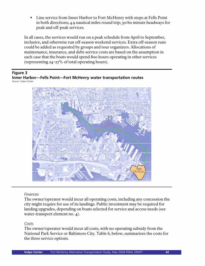
Line service from Inner Harbor to Fort McHenry with stops at Fells Point in both directions; 4.9 nautical miles round trip; 30/60 minute headways for peak and off-peak services.
In all cases, the services would run on a peak schedule from April to September, inclusive, and otherwise run off-season weekend services. Extra off-season runs could be added as requested by groups and tour organizers. Allocations of maintenance, insurance, and debt-service costs are based on the assumption in each case that the boats would spend 800 hours operating in other services (representing 24–27% of total operating hours).
Figure 3 Inner Harbor—Fells Point—Fort McHenry water transportation routes Source: Volpe Center
Finances The owner/operator would incur all operating costs, including any concession the city might require for use of its landings. Public investment may be required for landing upgrades, depending on boats selected for service and access needs (see water-transport element no. 4). Costs The owner/operator would incur all costs, with no operating subsidy from the National Park Service or Baltimore City. Table 6, below, summarizes the costs for the three service options.
Volpe Center Fort McHenry Alternative Transportation Study, May 2004 FINAL DRAFT 42
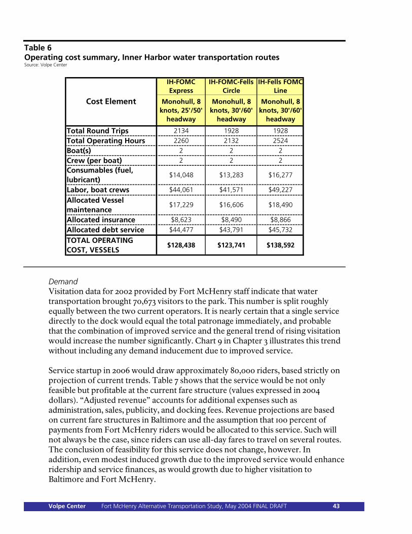
Table 6 Operating cost summary, Inner Harbor water transportation routes Source: Volpe Center
IH-FOMC Express
IH-FOMC-Fells Circle
IH-Fells FOMC Line
Monohull, 8 knots, 25'/50'
headway
Monohull, 8 knots, 30'/60'
headway
Monohull, 8 knots, 30'/60'
headway
Total Round Trips 2134 1928 1928
Total Operating Hours 2260 2132 2524
Boat(s) 2 2 2
Crew (per boat) 2 2 2
Consumables (fuel, lubricant)
$14,048 $13,283 $16,277
Labor, boat crews $44,061 $41,571 $49,227
Allocated Vessel maintenance
$17,229 $16,606 $18,490
Allocated insurance $8,623 $8,490 $8,866
Allocated debt service $44,477 $43,791 $45,732
TOTAL OPERATING COST, VESSELS
$128,438 $123,741 $138,592
Cost Element
Demand Visitation data for 2002 provided by Fort McHenry staff indicate that water transportation brought 70,673 visitors to the park. This number is split roughly equally between the two current operators. It is nearly certain that a single service directly to the dock would equal the total patronage immediately, and probable that the combination of improved service and the general trend of rising visitation would increase the number significantly. Chart 9 in Chapter 3 illustrates this trend without including any demand inducement due to improved service. Service startup in 2006 would draw approximately 80,000 riders, based strictly on projection of current trends. Table 7 shows that the service would be not only feasible but profitable at the current fare structure (values expressed in 2004 dollars). “Adjusted revenue” accounts for additional expenses such as administration, sales, publicity, and docking fees. Revenue projections are based on current fare structures in Baltimore and the assumption that 100 percent of payments from Fort McHenry riders would be allocated to this service. Such will not always be the case, since riders can use all-day fares to travel on several routes. The conclusion of feasibility for this service does not change, however. In addition, even modest induced growth due to the improved service would enhance ridership and service finances, as would growth due to higher visitation to Baltimore and Fort McHenry.
Volpe Center Fort McHenry Alternative Transportation Study, May 2004 FINAL DRAFT 43
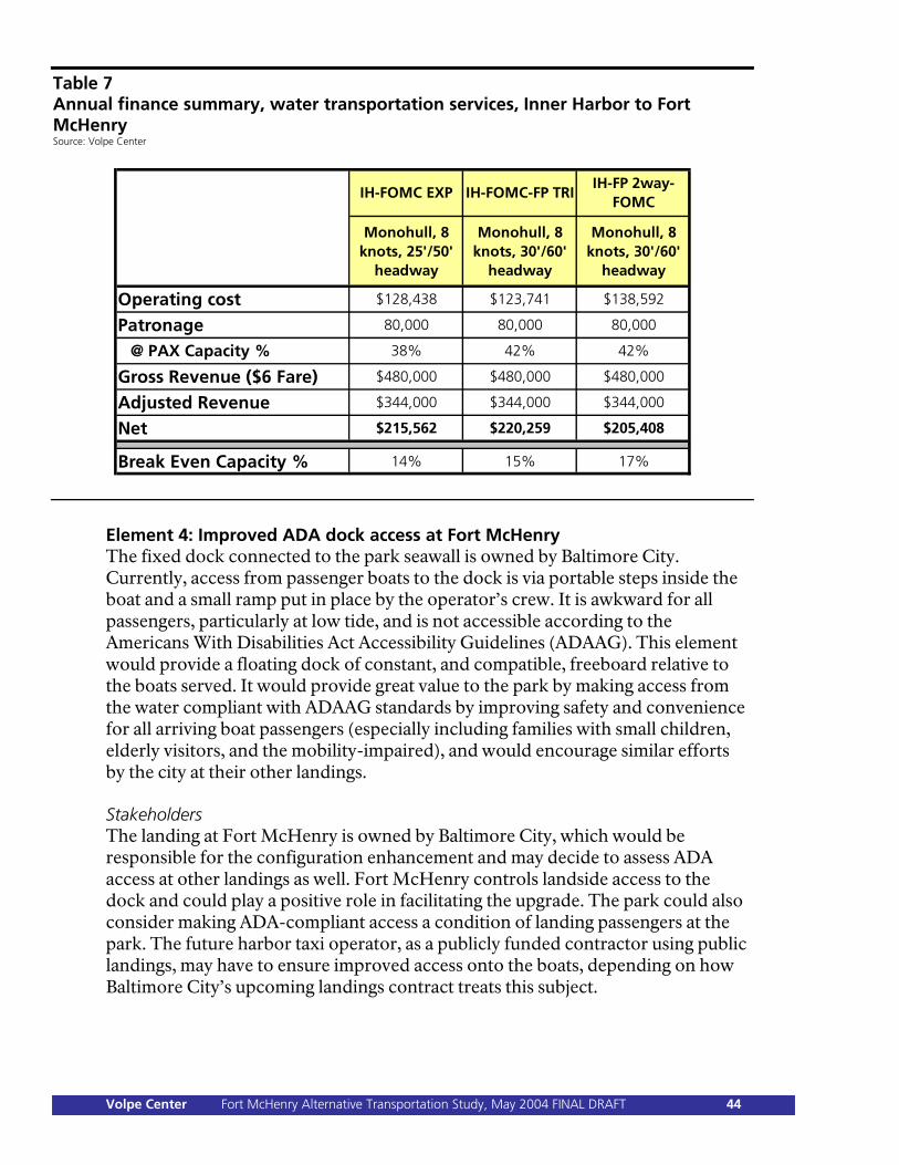
Table 7 Annual finance summary, water transportation services, Inner Harbor to Fort McHenry Source: Volpe Center
IH-FOMC EXP IH-FOMC-FP TRIIH-FP 2way-
FOMC
Monohull, 8 knots, 25'/50'
headway
Monohull, 8 knots, 30'/60'
headway
Monohull, 8 knots, 30'/60'
headway
Operating cost $128,438 $123,741 $138,592
Patronage 80,000 80,000 80,000
@ PAX Capacity % 38% 42% 42%
Gross Revenue ($6 Fare) $480,000 $480,000 $480,000
Adjusted Revenue $344,000 $344,000 $344,000
Net $215,562 $220,259 $205,408
Break Even Capacity % 14% 15% 17%
Element 4: Improved ADA dock access at Fort McHenry The fixed dock connected to the park seawall is owned by Baltimore City. Currently, access from passenger boats to the dock is via portable steps inside the boat and a small ramp put in place by the operator’s crew. It is awkward for all passengers, particularly at low tide, and is not accessible according to the Americans With Disabilities Act Accessibility Guidelines (ADAAG). This element would provide a floating dock of constant, and compatible, freeboard relative to the boats served. It would provide great value to the park by making access from the water compliant with ADAAG standards by improving safety and convenience for all arriving boat passengers (especially including families with small children, elderly visitors, and the mobility-impaired), and would encourage similar efforts by the city at their other landings. Stakeholders The landing at Fort McHenry is owned by Baltimore City, which would be responsible for the configuration enhancement and may decide to assess ADA access at other landings as well. Fort McHenry controls landside access to the dock and could play a positive role in facilitating the upgrade. The park could also consider making ADA-compliant access a condition of landing passengers at the park. The future harbor taxi operator, as a publicly funded contractor using public landings, may have to ensure improved access onto the boats, depending on how Baltimore City’s upcoming landings contract treats this subject.
Volpe Center Fort McHenry Alternative Transportation Study, May 2004 FINAL DRAFT 44
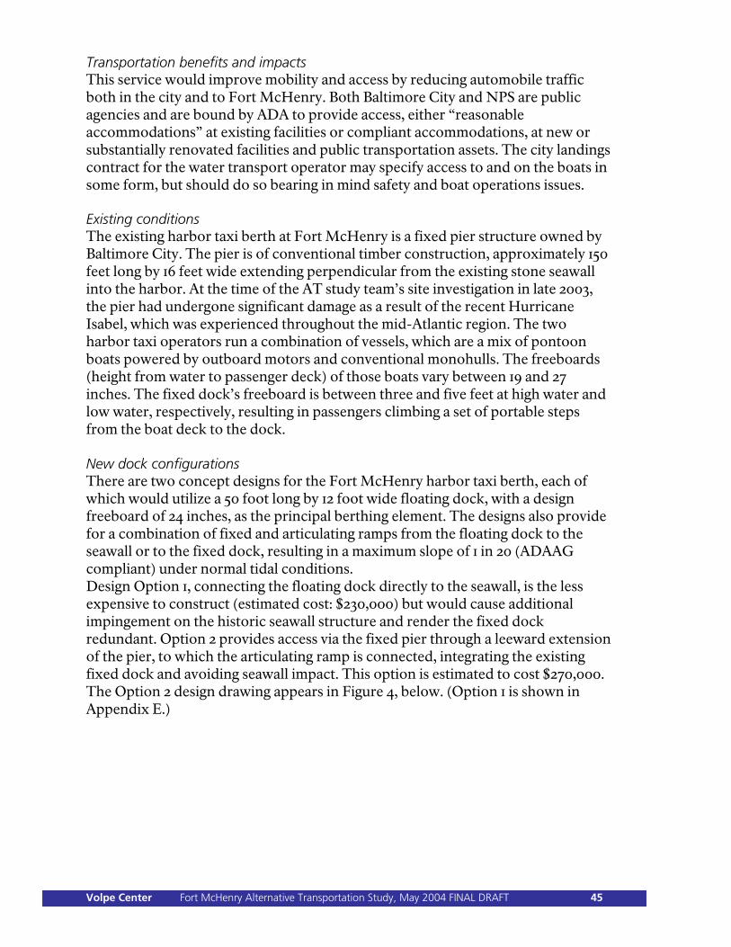
Transportation benefits and impacts This service would improve mobility and access by reducing automobile traffic both in the city and to Fort McHenry. Both Baltimore City and NPS are public agencies and are bound by ADA to provide access, either “reasonable accommodations” at existing facilities or compliant accommodations, at new or substantially renovated facilities and public transportation assets. The city landings contract for the water transport operator may specify access to and on the boats in some form, but should do so bearing in mind safety and boat operations issues. Existing conditions The existing harbor taxi berth at Fort McHenry is a fixed pier structure owned by Baltimore City. The pier is of conventional timber construction, approximately 150 feet long by 16 feet wide extending perpendicular from the existing stone seawall into the harbor. At the time of the AT study team’s site investigation in late 2003, the pier had undergone significant damage as a result of the recent Hurricane Isabel, which was experienced throughout the mid-Atlantic region. The two harbor taxi operators run a combination of vessels, which are a mix of pontoon boats powered by outboard motors and conventional monohulls. The freeboards (height from water to passenger deck) of those boats vary between 19 and 27 inches. The fixed dock’s freeboard is between three and five feet at high water and low water, respectively, resulting in passengers climbing a set of portable steps from the boat deck to the dock. New dock configurations There are two concept designs for the Fort McHenry harbor taxi berth, each of which would utilize a 50 foot long by 12 foot wide floating dock, with a design freeboard of 24 inches, as the principal berthing element. The designs also provide for a combination of fixed and articulating ramps from the floating dock to the seawall or to the fixed dock, resulting in a maximum slope of 1 in 20 (ADAAG compliant) under normal tidal conditions. Design Option 1, connecting the floating dock directly to the seawall, is the less expensive to construct (estimated cost: $230,000) but would cause additional impingement on the historic seawall structure and render the fixed dock redundant. Option 2 provides access via the fixed pier through a leeward extension of the pier, to which the articulating ramp is connected, integrating the existing fixed dock and avoiding seawall impact. This option is estimated to cost $270,000. The Option 2 design drawing appears in Figure 4, below. (Option 1 is shown in Appendix E.)
Volpe Center Fort McHenry Alternative Transportation Study, May 2004 FINAL DRAFT 45
Figure 4 Accessible floating dock and ramp design, Option 2 Source: Childs Engineering
Element 6: Higher-speed craft in service The AT study team explored the prospect of improving transit times and lowering headways by using higher speed craft, for example, low-wake, high-efficiency catamarans. A relaxed speed limit and a “fairway” in the Northwest Harbor would allow higher speeds east of Fells Point; however, indications from enforcement agencies are that this is highly unlikely. Furthermore, capital and maintenance costs for this type of boat are considerably higher, and the transit time savings over this route would be quite small. This element was eliminated from further consideration as an enhancement to water transport. (It remains in the roster table, but with an X through it.) Element 7: Higher frequency outer loop service This service and schedule element pertains to the “two-loop” service, as one of the harbor taxi operators currently runs. Passengers from the Inner Harbor using this service must change boats to get to the park, and the transits and transfers make for a time-consuming trip. Higher frequency outer loop service (Fells Point and eastward to Fort McHenry) was eliminated from further consideration because it offers marginal improvement to a relatively low-quality transportation option. (It remains in the roster table, but with an X through it.)
Volpe Center Fort McHenry Alternative Transportation Study, May 2004 FINAL DRAFT 46
Element Category 3: Congestion Management Category overview The majority of visitors now (and will in the foreseeable future) travel to and arrive at Fort McHenry in automobiles and buses along the west-east axis comprising Fort Avenue, the park main gate, the Constellation Plaza road, and the parking area located near the park’s north wall. The volume of traffic and visitors frequently results in several congestion and safety problems: Conflict of automobile and trucking traffic just outside the main gate, where
Wallace Street meets Fort Avenue. Constriction of traffic passing through the park main gate, whose width allows
only one-way passage. Insufficient traffic controls at the main gate, resulting in a traffic hazard,
particularly inside the gate. Poorly configured multi-modal passages through the main gate, resulting in less
than optimal—and potentially unsafe—access for pedestrians and bicyclists. Insufficient parking for buses in the Fort McHenry parking area during times
of peak activity. Insufficient parking for cars in the Fort McHenry parking area during times of
peak activity. The elements in this category are meant to reduce congestion and improve safety at the park through infrastructure improvements in the vicinity of the main gate, traffic management measures, and improved on-site and off-site parking management and infrastructure. Element 1: Rerouting of Steinweg trucks The C. Steinweg Handelsveem BV company (“Steinweg”) operates a bulk shipping terminal at Pier 3 and the adjacent land north of the park bounded by the Naval Reserve Center, Fort McHenry and the Maryland Port Administration (MPA) North Locust Point Marine Terminal (NLPMT). Steinweg also owns land and warehouse and storage facilities south of Fort Avenue. Semi-tractor trailers load at Pier 3 and transit via Wallace Street, either onto Fort Avenue or across it to the Steinweg property on the avenue’s south side. These movements from Wallace Street all occur directly in front of the park’s main gate at the intersection with Fort Avenue, creating additional congestion there, and pose a potential safety hazard with crossing traffic to and from the park. The potential alternative is to route the truck traffic over NLPMT property onto the MPA road, which crosses beneath the CSX-owned Fort Avenue bridge about 1/5 mile west of the gate and connects to McComas Street. The trucks would thus have access to Steinweg’s south property, to Key Highway, and to I-95, and would be removed from the park gate area. On August 2, 2002, in a letter to MPA, the Fort McHenry superintendent expressed the park’s support for such an arrangement.
Volpe Center Fort McHenry Alternative Transportation Study, May 2004 FINAL DRAFT 47
MPA responded on September 18, 2002, noting that it would carefully consider a formal proposal from Steinweg along those lines. Stakeholders Steinweg favors the proposed rerouting, since trucks would enter and exit on roads with no car traffic and possibly with easier maneuvering requirements. MPA and Steinweg would have to negotiate legal and infrastructure aspects for the new route, the latter including modification of the security and access arrangements at the east end of NLPMT and planning for added trucking traffic on MPA property. Fort McHenry would be the clear beneficiary of this change, and could play the role of “honest broker” between Steinweg and MPA. Baltimore DOT manages road maintenance and traffic on Fort Avenue, where truck traffic would be greatly reduced, providing significant benefit to the Locust Point neighborhood. Transportation benefits and impacts There would be a beneficial effect on mobility and access through congestion reduction and safety improvement at the front gate. Land planning and development and infrastructure impacts would be significant for the MPA. The new truck route from Steinweg would use NLPMT land and necessitate modified physical security arrangements and operations. MPA’s overriding concern for the NLPMT is future projected trade growth and the need to retain as much port land as possible in the face of development pressures on Locust Point. Analysis This element would entail serious negotiations between Steinweg and MPA to agree upon legal, operational and infrastructure matters and may require third party mediation and facilitation. MPA has developed a long-range plan for the future use and management of NLPMT, the December 2003 North Locust Point Marine Terminal Facility Master Plan, which details plans for increased dry-bulk and break-bulk throughput. Planned use of the land in the southeast corner of NLPMT will greatly influence any negotiations and decision in the matter of access for Steinweg’s trucks. Element 2: Improved bus parking at Fort McHenry Expansion of bus parking capacity from the six spaces currently available in the Fort McHenry parking area could accommodate the large numbers of school and tour buses arriving during peak times, particularly the spring season (see Chapter 2). Bus drivers now sometimes seek parking on nearby city streets when the designated spaces are full, causing extra traffic flow in and out of the main gate and noise, pollution, and congestion in the Locust Point neighborhood. The reconfigured parking area would retain six angled, single-purpose bus spaces and include ten additional dual-purpose, drive-through spaces, which would be used to accommodate two cars each at other times. This approach makes sense because the peak car parking demand is at different times than peak bus demand—summer weekends, rather than spring weekdays. This enhancement will be most
Volpe Center Fort McHenry Alternative Transportation Study, May 2004 FINAL DRAFT 48
effective if the park provides some accommodation—such as a seating area—for bus drivers while their passengers are touring. The park could also consider managing the expanded parking spaces using an improved bus reservation system. Stakeholders Fort McHenry is the prime stakeholder, and would fund the provision of the new angled bus parking spaces and dual use spaces. Group and tour bus operators would benefit from improved opportunities to park on-site, saving wear on their vehicles and reducing gasoline consumption. Baltimore City would benefit from reduced street congestion and pollution in the Locust Point neighborhood. Transportation benefits and impacts The primary benefit is the improvement of environmental quality in the Locust Point neighborhood, as previously described. Analysis The first-come, first-served nature of accommodating buses at Fort McHenry can leave the park vulnerable to an unexpected peak in bus visitation on a given day. However, it is unlikely that unexpected bus visitation peak days overlap with car visitation peak days, since the latter events generally occur on weekends. In 2002, ten or more buses visited the park on 48 days. Most of these occurrences (42) were during April, May and June, and nearly all (41) were on weekdays. In May 2002, out of 23 weekdays, only one day saw fewer than 10 buses arrive at the park. In the same month, at least 30 buses arrived at the park on five days, and two days saw at least 25 buses. Visitors attending the park via tour bus or school bus have steadily decreased in numbers since 1993, and there is no evidence suggesting that this trend will end. Tendencies regarding seasonal peaks are expected, however, to continue. The months of April through June will likely be the times during which the park receives a majority of its bus visitors. The designation of ten additional dual-purpose, drive-through bus spaces would likely allow the park to better accommodate arriving buses on peak bus visitation days. These spaces would give the park a total of 16 for bus use (including the six existing spaces within the main Fort McHenry parking area). In 2002, there were 25 days with more than 16 buses; except for Memorial Day, which had 40 buses, the maximum was 34. Assuming that each bus parking space turns over at least once during the day, the provision of 16 spaces would allow for peak bus visitation to be accommodated on all but the most congested days, perhaps once or twice per year on current trends. With 16 bus parking spaces, traffic, noise, pollution, and Locust Point congestion would all likely be reduced, both now and in the future.
Volpe Center Fort McHenry Alternative Transportation Study, May 2004 FINAL DRAFT 49
Element 3: Bus overflow parking off-site With or without added bus parking capacity in Fort McHenry, bus overflow parking situations will occur, although less frequently with the expanded capacity described in Element 2. The park would address excess bus parking demand in one of two ways. The first would be to provide extra spaces just outside the park through a partnership establishing such use in the MPA parking lot which abuts the west side of Wallace Street and the north side of Fort Avenue. Some improvement of the MPA lot—resurfacing and restriping—would probably be required if the lot is also intended to be used for car overflow parking, and could be included in a partnership agreement. Element 6, below, includes a conceptual layout of the MPA lot showing car parking spaces, pairs of which could combine to be used for bus parking. Occasional use of the lot for bus overflow only would require more modest investment, limited to restriping, since park visitors would not be using the area. The second approach is simply to ensure that all bus drivers entering the park have the bus parking plan prepared by the Baltimore Area Convention and Visitors Association (BACVA). The park would provide the BACVA brochure to all bus drivers. The brochure identifies appropriate sites in the city (e.g., the Ravens stadium parking lot) for tour bus parking, in order that empty buses are kept away from unauthorized parking areas. Stakeholders MPA would become a fully engaged partner through a formalized agreement for the use of its existing and currently underutilized parking lot. The poorly maintained lot would be refurbished and striped for new parking spaces. Fort McHenry would benefit from added adjacent bus parking, and the ability to plan/reserve parking spaces for more buses. The park would need to take the lead in developing the new partnership, particularly by engaging Baltimore City and other government bodies. Group and tour bus operators would benefit from improved opportunity to park on-site. Baltimore City, and the Locust Point neighborhood in particular, would benefit from reduced street congestion and pollution. Steinweg and the USNR Center would contend with extra traffic on Wallace Street getting access to the MPA lot entrance. Transportation benefits and impacts The primary benefit is the improvement of environmental quality in the Locust Point neighborhood, as described for Element 2, above. Analysis Technical details for the rehabilitation of the parking lot appear in Element 6, below.
Volpe Center Fort McHenry Alternative Transportation Study, May 2004 FINAL DRAFT 50
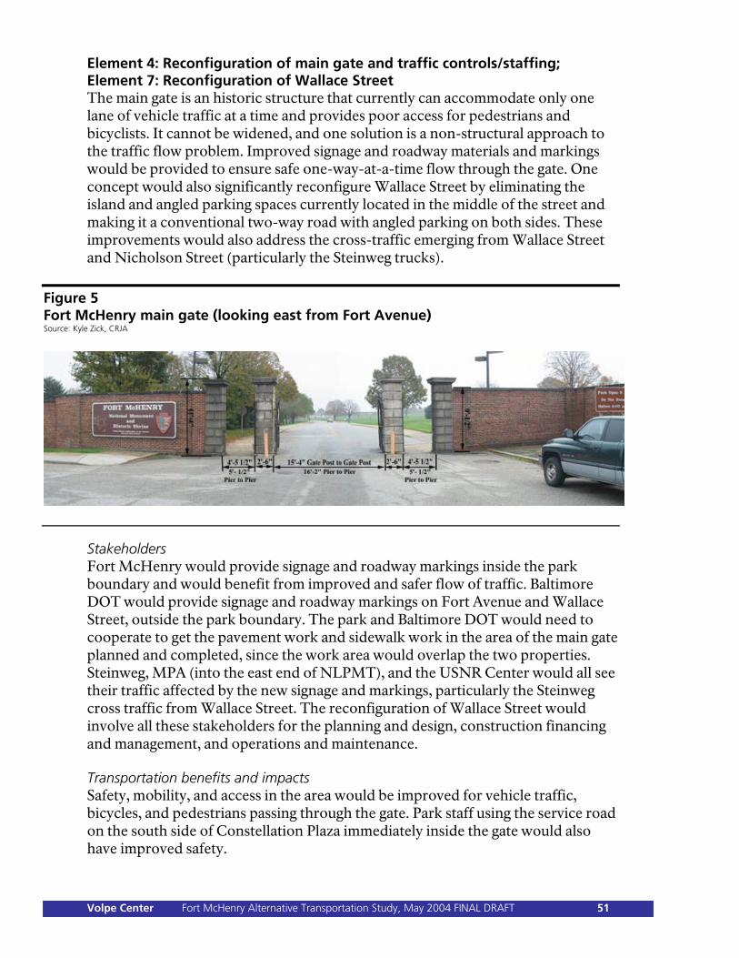
Element 4: Reconfiguration of main gate and traffic controls/staffing; Element 7: Reconfiguration of Wallace Street The main gate is an historic structure that currently can accommodate only one lane of vehicle traffic at a time and provides poor access for pedestrians and bicyclists. It cannot be widened, and one solution is a non-structural approach to the traffic flow problem. Improved signage and roadway materials and markings would be provided to ensure safe one-way-at-a-time flow through the gate. One concept would also significantly reconfigure Wallace Street by eliminating the island and angled parking spaces currently located in the middle of the street and making it a conventional two-way road with angled parking on both sides. These improvements would also address the cross-traffic emerging from Wallace Street and Nicholson Street (particularly the Steinweg trucks).
Figure 5 Fort McHenry main gate (looking east from Fort Avenue) Source: Kyle Zick, CRJA
Stakeholders Fort McHenry would provide signage and roadway markings inside the park boundary and would benefit from improved and safer flow of traffic. Baltimore DOT would provide signage and roadway markings on Fort Avenue and Wallace Street, outside the park boundary. The park and Baltimore DOT would need to cooperate to get the pavement work and sidewalk work in the area of the main gate planned and completed, since the work area would overlap the two properties. Steinweg, MPA (into the east end of NLPMT), and the USNR Center would all see their traffic affected by the new signage and markings, particularly the Steinweg cross traffic from Wallace Street. The reconfiguration of Wallace Street would involve all these stakeholders for the planning and design, construction financing and management, and operations and maintenance. Transportation benefits and impacts Safety, mobility, and access in the area would be improved for vehicle traffic, bicycles, and pedestrians passing through the gate. Park staff using the service road on the south side of Constellation Plaza immediately inside the gate would also have improved safety.
Volpe Center Fort McHenry Alternative Transportation Study, May 2004 FINAL DRAFT 51
There is a modest operational impact for Fort McHenry. The modified traffic flow at the main gate may require park staff there for some time after its installation to acclimatize to the new configuration people who use the park on a regular basis, that is, local residents and tour company bus drivers. The park and the Baltimore DOT would need to agree on the traffic management approach to be taken, and develop a detailed set of plans to implement it. Analysis Park staff have reported hazardous conditions and a safety problem at the front gate. Neither the park nor the city have accident data confirming this contention. However, the AT study team, from its own observations, confirmed park staff reports. Several infrastructure improvement concepts were developed for the main gate area, including the gate itself, Fort Avenue, and Wallace Street, with the aim of improving traffic safety. Some concepts included significant modifications of Wallace Street in conjunction with rerouting internal park traffic to effect a one-way exit through the auxiliary gate onto Wallace Street. The idea of using separate park gates for entry and exit was eliminated from consideration (see Element 5, below); its associated concept designs appear in Appendix D. Two concepts were developed for the retention of two-way traffic on Constellation Plaza within the park. They include new traffic control signage, which stops vehicles on both sides of the gate, and areas of textured pavement, such as cobblestones or patterned brick, as “traffic-calming” measures. The latter can be constructed as a “table” slightly above the asphalt’s level with graded transitions. The first concept focuses strictly on the main gate area, with the traffic calming surface extending west on Fort Avenue across the Wallace Street intersection, all-way stop signs, and a continuous sidewalk through the right hand pedestrian opening. This could be accomplished in the short term and would cost approximately $93,000 (details in Appendix D). Figure 6 (below) illustrates, showing two-way striping and stop signage on Constellation Plaza (top of the sketch), the new pavement surface (cross-hatched), continuous sidewalk access into the park (along the right side of the road), and a stop sign for traffic entering from Fort Avenue.
Volpe Center Fort McHenry Alternative Transportation Study, May 2004 FINAL DRAFT 52

Figure 6 Detail of front gate proposed modifications (Wallace Street unchanged) Source: Kyle Zick, CRJA
The second concept adds similar control features around the main gate, with a smaller pavement “calming” area, and includes a significant redesign of Wallace Street. The design would first eliminate the center parking strip which currently divides two separate two-way roads, creating driver confusion. Wallace Street would become a single regraded two-way road with angled parking (a net gain of 11 spaces) on both sides and landscaping features introduced to improve the outside appearance of the park. The estimated cost is approximately $330,000 (details in Appendix D). This would be a long term planning, development, and finance process involving a partnership with of all the stakeholders identified above. Figure 7, below, illustrates.
Volpe Center Fort McHenry Alternative Transportation Study, May 2004 FINAL DRAFT 53
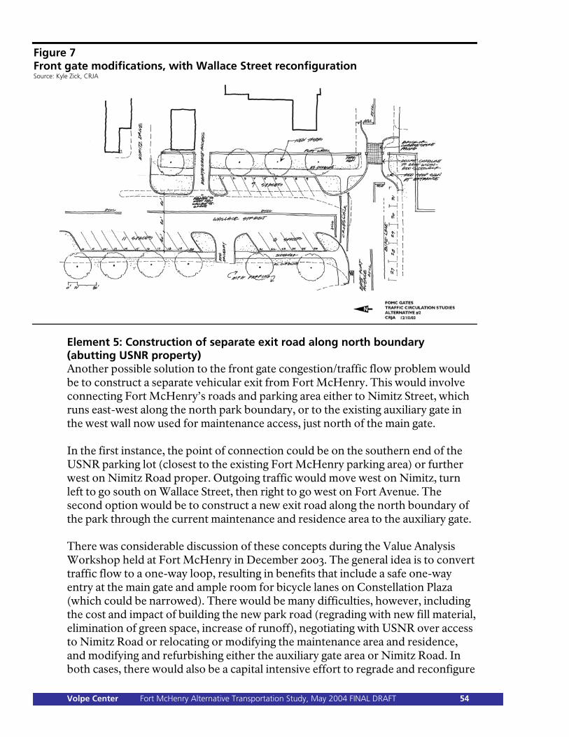
Figure 7 Front gate modifications, with Wallace Street reconfiguration Source: Kyle Zick, CRJA
Element 5: Construction of separate exit road along north boundary (abutting USNR property) Another possible solution to the front gate congestion/traffic flow problem would be to construct a separate vehicular exit from Fort McHenry. This would involve connecting Fort McHenry’s roads and parking area either to Nimitz Street, which runs east-west along the north park boundary, or to the existing auxiliary gate in the west wall now used for maintenance access, just north of the main gate. In the first instance, the point of connection could be on the southern end of the USNR parking lot (closest to the existing Fort McHenry parking area) or further west on Nimitz Road proper. Outgoing traffic would move west on Nimitz, turn left to go south on Wallace Street, then right to go west on Fort Avenue. The second option would be to construct a new exit road along the north boundary of the park through the current maintenance and residence area to the auxiliary gate. There was considerable discussion of these concepts during the Value Analysis Workshop held at Fort McHenry in December 2003. The general idea is to convert traffic flow to a one-way loop, resulting in benefits that include a safe one-way entry at the main gate and ample room for bicycle lanes on Constellation Plaza (which could be narrowed). There would be many difficulties, however, including the cost and impact of building the new park road (regrading with new fill material, elimination of green space, increase of runoff), negotiating with USNR over access to Nimitz Road or relocating or modifying the maintenance area and residence, and modifying and refurbishing either the auxiliary gate area or Nimitz Road. In both cases, there would also be a capital intensive effort to regrade and reconfigure
Volpe Center Fort McHenry Alternative Transportation Study, May 2004 FINAL DRAFT 54
Wallace Street. Because of these difficulties, this park access approach was eliminated from further consideration during the workshop. (It remains in the roster table, but with an X through it.) Though eliminated from consideration, concept drawings showing the park’s gates and the Wallace Street area in the one-way loop road options appear in Appendix D. Element 6: Reduce on-site car parking and enhance off-site overflow arrangements Element 6 would provide for car parking at a nearby offsite location and is a companion to the bus overflow parking concept advanced in Element 3. Park statistics and anecdotal evidence from park staff indicate that car demand often exceeds the main parking area’s capacity on peak season (late spring and early summer) weekends, necessitating the use of the park’s overflow parking area, the grassed area north of Constellation Plaza. In addition, special events like fireworks and Tall Ships parades sometimes require use of the MPA lot on Wallace Street. The park has an informal agreement with MPA and obtains their permission for use of the lot for each event. The DCP/EA concepts under consideration by Fort McHenry call for maintaining the current capacity of the main parking area or reducing it, depending on the placement and design of the education/administration center. The demand analysis in Chapter 3 indicates that car arrivals will grow slowly in the future. Therefore, the incidence of excessive car parking demand can be expected to grow slowly, given a constant supply of parking spaces, or to take a stepwise increase in the case of reduced parking capacity. The excess demand events would continue to occur on peak season weekends and for special events. Element 6 offers the solution of off-site parking in the existing and greatly underused MPA parking lot north of Fort Avenue, an area that is already paved, fenced, and lighted, and is in close proximity to the park. The MPA lot’s capacity is approximately 230 cars. Visitors using the MPA lot could park there after dropping off passengers inside the park and would be about ¼ mile from the existing park visitor center. This arrangement would necessitate provisions for getting visitors safely into the park, whether by a marked footpath (with interpretive opportunities) or a shuttle vehicle. It should be noted that a similar arrangement with USNR for use of their parking lot for overflow was also investigated. This option is not feasible due to USNR’s security concerns and their heavy use of the available land for parking on alternate weekends. (Although Fort McHenry has an informal agreement for the occasional use of this space by park volunteers during special events, USNR, for security and other reasons, is unable to commit to any kind of formal or permanent agreement.)
Volpe Center Fort McHenry Alternative Transportation Study, May 2004 FINAL DRAFT 55
Offsite overflow parking would retain more of the park’s land for restoration and visitor use. The grassed surface overflow area now used could be reserved for special event parking only, incurring much decreased use and impact, while the MPA lot would serve for more routine weekend peak demand overflows. Visitor car parking in the main parking area could be prioritized for disabled persons and older visitors during peak use periods. Stakeholders If Fort McHenry reconfigures its main parking area for a new education/administration facility, that would reduce car capacity, in which case the park may need to partner with MPA to negotiate an agreement for use of some part of their lot for overflow car parking. (DCP/EA Concepts C and D, as an in-park option, also call for the construction of a paved surface or underground parking “terrace” on the site of the park’s current grass overflow parking area—however, Alternative Transportation Program policy, and NPS policy generally, at least in the Northeast Region, does not encourage the expansion of car-parking facilities within national parks.) Financing for improvements to the MPA lot would be critical and may require a third partner, such as Baltimore City, whose interests would be waterfront district uses and zoning. (The Baltimore Planning Department has expressed such interests.) Steinweg, MPA, and USNR would all be affected by additional traffic on Wallace Street due to use of the off-site parking facility. Transportation benefits and impacts The effect on mobility and access would be roughly neutral in terms of transportation assets; it is important that the park prioritize on-site parking for disabled visitors. Off-site overflow parking should not discourage visitors, as long as good arrangements for a walking route or a shuttle from the lot are in place. The park’s environment would benefit from additional green space, or improved conditions in the park’s existing, grassed overflow parking area. The MPA overflow site is paved already and its use would not represent the loss of any green space. There would be negligible impact or benefits in terms of traffic, noise, and emissions. Vehicles visiting Fort McHenry will not change as a result of this element. Analysis The demand projection analysis shown in Chapter 3 also provides data showing the overflow frequency, given certain parking capacities at Fort McHenry (161 spaces, as at present, and the reduced capacities of DCP/EA Concepts C and D). Two design options were prepared, one each using the eastern and western portions of the MPA lot for overflow parking. In each case, approximately one-third of the lot would be retained by MPA for its purposes, which could include use of the parking by a future expanded NLPMT work force. Fort McHenry overflow parking in the east end of the lot is preferable because that arrangement
Volpe Center Fort McHenry Alternative Transportation Study, May 2004 FINAL DRAFT 56
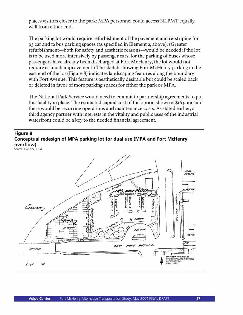
places visitors closer to the park; MPA personnel could access NLPMT equally well from either end. The parking lot would require refurbishment of the pavement and re-striping for 93 car and 12 bus parking spaces (as specified in Element 2, above). (Greater refurbishment—both for safety and aesthetic reasons—would be needed if the lot is to be used more intensively by passenger cars; for the parking of buses whose passengers have already been discharged at Fort McHenry, the lot would not require as much improvement.) The sketch showing Fort McHenry parking in the east end of the lot (Figure 8) indicates landscaping features along the boundary with Fort Avenue. This feature is aesthetically desirable but could be scaled back or deleted in favor of more parking spaces for either the park or MPA. The National Park Service would need to commit to partnership agreements to put this facility in place. The estimated capital cost of the option shown is $163,000 and there would be recurring operations and maintenance costs. As stated earlier, a third agency partner with interests in the vitality and public uses of the industrial waterfront could be a key to the needed financial agreement.
Figure 8 Conceptual redesign of MPA parking lot for dual use (MPA and Fort McHenry overflow) Source: Kyle Zick, CRJA
Volpe Center Fort McHenry Alternative Transportation Study, May 2004 FINAL DRAFT 57
Element Category 4: Pedestrian and Bicycle Access Category overview The National Park Service’s Alternative Transportation Program encourages walking and bicycling both to the parks and within the parks, to remove vehicles from the roadways, thereby reducing congestion, pollution, noise, and visitor frustration. This trend is in full motion at Fort McHenry without the assistance of formal program initiatives or public-education efforts. Visitation on foot and bicycle has been rising rapidly in recent years as the Locust Point and South Baltimore population changes and grows. Fort McHenry’s status as an urban park manifests itself strongly in this aspect of its character, as walkers, joggers, and bicyclists take advantage of its green space and harbor views. The park faces important visitor circulation and management issues as it looks to a future with a new education/administration center and reconfigured roads and pathways. Visitation growth overall, improved connectivity to other planned bicycle routes, and continued growth in local use will challenge park staff, who must manage the park as an historic site of solemn importance. They need to welcome visitors arriving on foot and on bicycles while managing their activities inside the park and preserving the nature of the park itself. In particular, bicycle riding activity will need to be directed to designated areas for access to the park and bicycle storage. The elements following will enhance the opportunities for people to arrive on bicycles and foot, be welcomed into the park, and guided to a meaningful experience of its history. Element 1: Marked bicycle route from Inner Harbor through Locust Point to Fort McHenry The aim is to provide a safe, marked route for bicyclists between the Inner Harbor attractions and Fort McHenry. The route would maximize safety while including as many recreational, cultural, and historical landmarks as possible. The route would attract riders from the downtown tourist market and would also include more serious bicyclists visiting the park as part of longer distance trips over connecting bicycle routes. Stakeholders Fort McHenry would be the east anchor of the route and an important destination. The park would also have an important role as a supporting organization in the negotiation, planning, design, and implementation to be jointly carried out by Baltimore DOT and the Baltimore Planning Department. Baltimore DOT is responsible for city roads, and would have to approve the route’s designation, design, and markings. The Baltimore Planning Department would be an important partner in developing a network and linkages with other proposed bike routes in the city and the region. The new BACVA visitor center on Light Street would be the origin of the route and its west anchor. As such, it could also serve as an
Volpe Center Fort McHenry Alternative Transportation Study, May 2004 FINAL DRAFT 58
intermodal transportation hub transfer point (for passengers using a cultural loop bus service or an MTA bus and ride program) and could include a bicycle rental operation. Other destinations along the way would benefit from proximity to the route and would be supporting partners in the publicity and operations of the route; these include the Visionary Art Museum and the Museum of Industry. Transportation benefits and impacts There would be a mobility and access benefit through the provision of a more attractive means for people to get to the park via bicycle. The route would result in some land planning and development impacts—reconfiguration of affected city streets and a portion of the Harbor Promenade. The environment would benefit from a reduction in the number of car trips from downtown and other points of origin in the region, with reduced congestion, noise, and emissions for the city as a whole and for Fort McHenry. Analysis The distance from the Inner Harbor to Fort McHenry is about 2.4 miles—a short bicycle route, potentially attractive to many visitors. Any route could include a variety of city streets, in terms of traffic and terrain, as well as the southern half of the Harbor Promenade. It is not possible in this densely developed urban area to dedicate a standalone bicycle path. However, two potential routes were developed, based on the American Association of State Highway and Transportation Officials’ 1999 Guidelines for “signed shared roadway,” “shared roadway,” “bicycle lane,” and “shared use path” (details appear in Appendix D). The origin for both routes would be proximate to the new BACVA visitor center, where Light Street brushes the west end of the Inner Harbor. The first option would follow the Promenade along the south shore of the Inner Harbor as far as the Museum of Industry (approximately half the distance to Fort McHenry), once the Promenade’s unfinished portions have been completed. The route would then run south on Lawrence Street and east on Fort Avenue. Lawrence Street is two-way and is wide enough to accommodate marked bicycle lanes. Fort Avenue is from 36 feet (on the bridges) to 48 feet wide—the avenue was built originally to accommodate trolleys—and is amply wide for the addition of striped and marked bike lanes between the parking spaces and the travel lanes in both directions. The long-term route appears in Figure 9, as the blue and purple lines. The dotted blue lines indicate incomplete sections of the Promenade. Figures 10, 11, and 12 are graphic representations of the route on the Promenade, on Lawrence Street, and on Fort Avenue. In the short term, the Promenade will only take bicyclists as far as the Visionary Art Museum. The route would then follow Key Highway to Lawrence Street and continue as above, where restriping travel lanes and shoulders would be necessary. The speed and volume of traffic on Key Highway are safety concerns and could restrict its appeal to more capable and experienced riders. The short-term route
Volpe Center Fort McHenry Alternative Transportation Study, May 2004 FINAL DRAFT 59
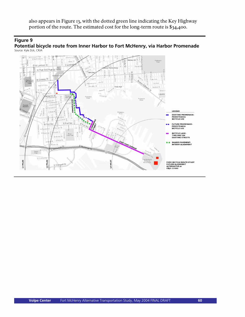
also appears in Figure 13, with the dotted green line indicating the Key Highway portion of the route. The estimated cost for the long-term route is $34,400.
Figure 9 Potential bicycle route from Inner Harbor to Fort McHenry, via Harbor Promenade Source: Kyle Zick, CRJA
Volpe Center Fort McHenry Alternative Transportation Study, May 2004 FINAL DRAFT 60
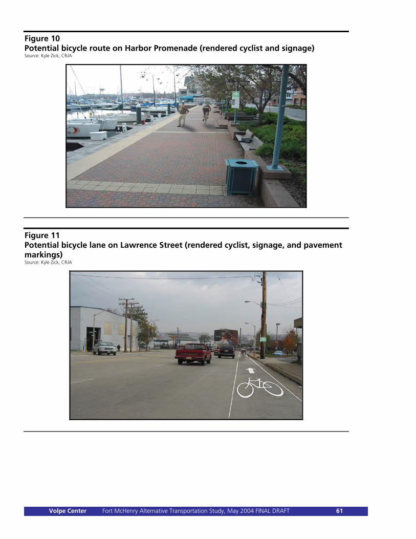
Figure 10 Potential bicycle route on Harbor Promenade (rendered cyclist and signage) Source: Kyle Zick, CRJA
Figure 11 Potential bicycle lane on Lawrence Street (rendered cyclist, signage, and pavement markings) Source: Kyle Zick, CRJA
Volpe Center Fort McHenry Alternative Transportation Study, May 2004 FINAL DRAFT 61
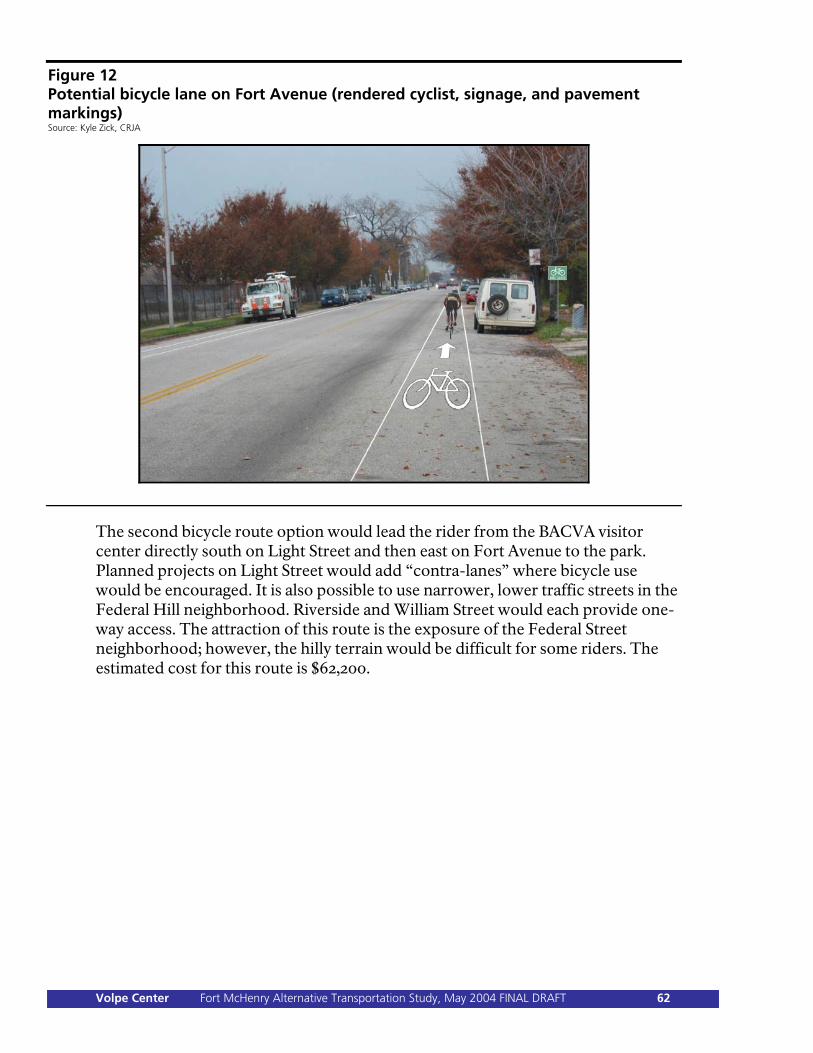
Figure 12 Potential bicycle lane on Fort Avenue (rendered cyclist, signage, and pavement markings) Source: Kyle Zick, CRJA
The second bicycle route option would lead the rider from the BACVA visitor center directly south on Light Street and then east on Fort Avenue to the park. Planned projects on Light Street would add “contra-lanes” where bicycle use would be encouraged. It is also possible to use narrower, lower traffic streets in the Federal Hill neighborhood. Riverside and William Street would each provide one-way access. The attraction of this route is the exposure of the Federal Street neighborhood; however, the hilly terrain would be difficult for some riders. The estimated cost for this route is $62,200.
Volpe Center Fort McHenry Alternative Transportation Study, May 2004 FINAL DRAFT 62
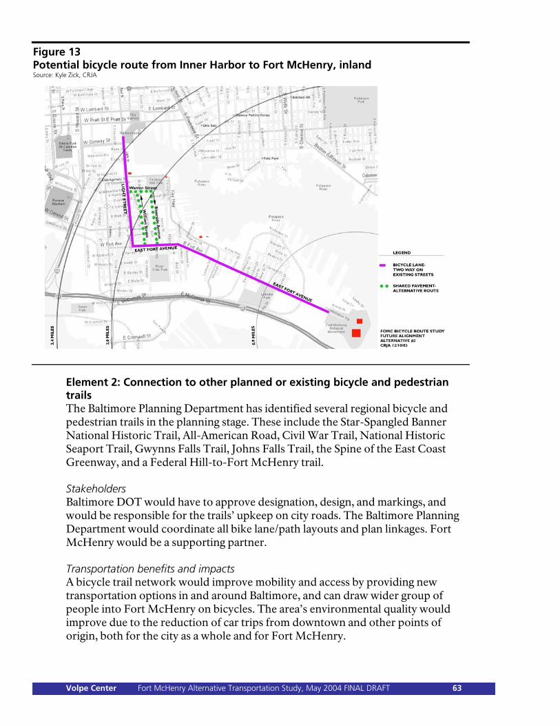
Figure 13 Potential bicycle route from Inner Harbor to Fort McHenry, inland Source: Kyle Zick, CRJA
Element 2: Connection to other planned or existing bicycle and pedestrian trails The Baltimore Planning Department has identified several regional bicycle and pedestrian trails in the planning stage. These include the Star-Spangled Banner National Historic Trail, All-American Road, Civil War Trail, National Historic Seaport Trail, Gwynns Falls Trail, Johns Falls Trail, the Spine of the East Coast Greenway, and a Federal Hill-to-Fort McHenry trail. Stakeholders Baltimore DOT would have to approve designation, design, and markings, and would be responsible for the trails’ upkeep on city roads. The Baltimore Planning Department would coordinate all bike lane/path layouts and plan linkages. Fort McHenry would be a supporting partner. Transportation benefits and impacts A bicycle trail network would improve mobility and access by providing new transportation options in and around Baltimore, and can draw wider group of people into Fort McHenry on bicycles. The area’s environmental quality would improve due to the reduction of car trips from downtown and other points of origin, both for the city as a whole and for Fort McHenry.
Volpe Center Fort McHenry Alternative Transportation Study, May 2004 FINAL DRAFT 63

Analysis Planning for the other routes is now in a very early stage, so analysis of the connectivity is not possible except in the general sense. The park should continue to work closely with the Baltimore Planning Department regarding not only the design of a bike route from the Inner Harbor to Fort McHenry, but also the physical and historic connections to other planned routes. To fully realize the benefits of connecting to regional trails, Fort McHenry would also need to undertake Element 1 (a bicycle route into the park), Element 3 (a bicycle route within the park), and Element 4 (bicycle accommodations at the visitor center). Element 3: Marked path inside Fort McHenry from main gate to new education/administration center The park would complete the connection of the city or regional bicycle trail network by providing marked bicycle lanes within its boundaries, from the main gate to the visitor center. This work can provide value with or without marked lanes approaching the park from Fort Avenue, since the safety and control of bicycles will be a concern regardless. Constellation Plaza is 36 feet wide and can accommodate one-way bike lanes on both shoulders with ease. The bike lanes would be marked on Fort Avenue leading up to the park gate, where cars and bicycles would share the entrance road (this area would be marked with dashed lines and “share the pavement” signs as specified by the Manual of Uniform Traffic Control Devices). On the other side of the gate, the marked bicycle lane would resume. The inbound lanes would terminate at the visitor center, where bicycle racks could be provided. Signage would clearly spell out park policy on bicycle access, that is, pathways and areas in the park where biking is prohibited, whether for safety reasons or to maintain the fort’s historic shrine atmosphere. Stakeholders All of the new lanes would be within the park’s boundaries. Therefore, Fort McHenry would have all responsibility for design, installation and maintenance of the bicycle lanes. Transportation benefits and impacts The mobility and access, safety, and environmental benefits are as described for Elements 1 and 2. This element has an added benefit for park operations—the management of bicycle access. Analysis Park visitation statistics do not identify bicycle riders, who are counted as pedestrians by the beam counters at the main gate. Anecdotal evidence from park staff indicates that numbers of bicyclists are rising, in line with the general upward trend of pedestrian visitors. Bicycle lanes will enhance the safety of bicyclists, particularly in conjunction with proposed access configuration changes around the main gate.
Volpe Center Fort McHenry Alternative Transportation Study, May 2004 FINAL DRAFT 64
The capital expense of installing the bicycle lanes is calculated as follows. The total length of the two lanes would be approximately 2,500 feet ($2,500); there would be six bike lane pavement markings required (beginning, middle, and end on each side = $1,800); and preparatory street cleaning would be needed ($500). The total cost would be $4,800. Maintenance consists of repainting the striping and signage on the pavement approximately every 5 years, at the same price (2004 dollars) as the original painting. Element 4: Bicycle accommodations at visitor center (or at new education/administration center) The park would provide bicycle racks with a capacity dictated by park need and visitor demand. (Capacity is flexible and can be incrementally installed.) Stakeholders Fort McHenry would be the lone stakeholder, responsible for construction and maintenance of the bicycle accommodations. Transportation benefits and impacts The mobility and access, safety, and environmental benefits are as described for Elements 1, 2, and 3. Analysis This element would best be undertaken in conjunction with Element 3. Bicycle racks are an accommodation and courtesy for bicyclists, but serve a more important purpose as part of the management of bicycling activity in the park. The racks will reinforce the cues telling the rider that access ends at the visitor center and that the bikes belong in the racks rather than elsewhere in the park. Because capacity can be installed incrementally (even down to one bicycle at a time), the cost of this element is minimal. An initial installation could cost less than $1,000. Higher expenditures would be associated with higher capacities, as well as with any custom installations—shapes, materials, colors, sculptures—in which the park might be interested, for aesthetic reasons. Space need not be an issue. 11 bicycles can be accommodated in a width of as little as 111 inches (9 ¼ feet). Any of the DCP/EA “action” concepts would have ample space for such accommodations. Element 5: Bicycle stowage onboard buses and passenger boats Many city and park transportation systems—such as the Island Explorer buses of Acadia National Park—now provide means for carrying bicycles. Passengers can thus get relatively long-distance transport to a destination area, alight, and use the bicycle for local touring. Some passenger boats also have on-board stowage of bicycles; an example is the Blue and Gold Line in San Francisco Bay.
Volpe Center Fort McHenry Alternative Transportation Study, May 2004 FINAL DRAFT 65
In the case of water transport, the applicability of such racks to the Baltimore Inner Harbor situation is questionable. The Blue and Gold Line example is a large ferry operating over a relatively long distance (Marin County to downtown San Francisco), carrying large numbers of commuters and tourists. There are large areas and long distances for bicyclists to travel at both ends. The Baltimore case is quite contrary. Even the largest of the passenger boats in service is very small by comparison to the Blue and Gold Line example; there is very little space available and bike stowage would almost certainly reduce seating and revenue. The boats carry mostly recreational passengers and do so for short distances only. The visitor desiring to cycle in the Locust Point/Federal Hill area can do so more easily by going there directly from the Inner Harbor by bicycle. Installing bicycle stowage aboard these boats is, therefore, not logical at this time. Bicycle racks mounted externally on buses are, on the other hand, inexpensive and unobtrusive with regard to passenger seating. The racks could be installed on the MTA No. 1 bus (when it is making stops inside Fort McHenry) and on a future shuttle bus connecting cultural and historical sites to the park, for example, a service for the Babe Ruth Museum, Edgar Allen Poe birthplace, and Mount Vernon area. Such measures could be tried experimentally at minimal expense. The estimated cost of purchasing and installing two bicycle racks on a bus, with a combined capacity of 20 bicycles, is approximately $2,500. Element Category 5: Reservations/Parking Management Category overview Elements in this category do not seek physical changes to Fort McHenry’s infrastructure; rather, they suggest operational or logistical measures to improve the way parking is managed, in order to better control conditions so that congestion does not occur. Element 1: Improved reservation system for bus/tour groups Fort McHenry now makes use of a basic bus and tour-group reservation system that enables ranger tours and services to be scheduled ahead of time. However, this system is almost entirely dependent on a single staff person, and all information is processed manually. The system allows some electronic storage and location of data, but it is not possible to do detailed data searching or processing—for instance, bus origins, and tour-group demographics, cannot easily be tracked. This element would—along the lines currently being planned by the park—implement an improved reservation system, one enabling automatic (e-mail or Web-based) scheduling, better data collection and processing. reduced reliance on a single individual, and more efficient programming of staff resources.
Volpe Center Fort McHenry Alternative Transportation Study, May 2004 FINAL DRAFT 66
Stakeholders Although Fort McHenry would be collecting data from bus and tour operators, as well as schools, no stakeholder involvement is necessary in order to pursue this element. Transportation benefits and impacts By better tracking bus and group arrivals, Fort McHenry staff will be better able to anticipate—and to prevent—congested conditions at the park. Also, by collecting superior data, the park will be able to better predict trends in visitation, which will inform future planning efforts. Analysis Fort McHenry is currently planning to implement a new reservation system, so no additional resources need be devoted to this task, unless, due to changed circumstances, the park is unable to complete work. (All of the eight alternatives presented in Chapter 6 assume that a new reservation system will be implemented.) Element 2: Require reservations for bus/tour groups in order to enable bus access Another way to improve bus traffic flow at Fort McHenry would be to require reservations for all bus groups. During peak times when all available bus parking spaces are full, buses without reservations would be denied permission to enter the park, and would be directed to discharge their passengers at the front gate. Although this system would be unusual as a way of handling bus traffic, reservations systems are commonly used by water transportation services, such as that providing access to Alcatraz Island as part of Golden Gate National Recreation Area of California—if a visitor does not make a reservation for the boat in advance, it may fill up, thus denying access. Nevertheless, due to staff and logistical concerns, this element was eliminated from further consideration. (It remains in the roster table, but with an X through it.) Element 3: Allow cars to park at Fort McHenry for trips originating on water transport In order to encourage transportation by water, would-be patrons often require convenient or inexpensive car parking. Currently, visitors are not allowed to park their cars at Fort McHenry and then originate a boat trip, due in part to the perception that such visitors would misuse the Fort McHenry parking area, treating it simply as a place to store their cars. Although during much of the year the parking area is uncrowded, allowing visitors to leave their cars at Fort McHenry would exacerbate the parking situation during days of peak demand, when the parking area fills up. There are also security considerations: the park is obligated to close the main gate at the end of its operating hours, and Fort McHenry staff do not want visitors’ cars to inadvertently be locked in if they do not return in time to pick them up.
Volpe Center Fort McHenry Alternative Transportation Study, May 2004 FINAL DRAFT 67
Due to such security and logistical concerns, this element was eliminated from further consideration at this time. (It remains in the roster table, but with an X through it.) In the future, due to significant outside interest on the part of water operators, the Locust Point community, and other stakeholders, it may be appropriate to re-examine this element. Element Category 6: Travel Information Category overview One way to reduce traffic congestion, and to promote the use of alternative transportation methods, is to ensure that travelers receive high-quality information that allows them to make informed transportation choices. Travel-information strategies have the advantage of being far less expensive than infrastructure improvements. The elements in this category discuss ways in which that information can be provided to visitors. Element 1: Improved Fort McHenry signage/wayfinding in/around Baltimore Brown signage on Interstate 95, and on the Baltimore-Washington Parkway, directs travelers to Fort McHenry. Also, Baltimore City has a standardized signage program—the “Trailblazer” system—involving white posts and blue-and-green signs directing travelers to points of interest, including Fort McHenry. One way to mitigate traffic congestion, and to reduce traveler confusion, is to increase both the number and quality of signs. Stakeholders On June 27, 2003, Fort McHenry made a request to Baltimore City to increase the number of signs within the city pointing to the park; Baltimore City runs the Trailblazer program and is responsible for the installation, and maintenance of vehicle-oriented city signs. On July 29, 2003, in a letter to the park, Baltimore DOT stated that it would authorize the installation of 11 additional signs within the city. Also, the Baltimore Downtown Partnership has recently begun a pilot program aimed at producing signs aimed at orienting pedestrians in downtown Baltimore; if successful, the program may be expanded. The Maryland Department of Transportation is responsible for installing and maintaining signs on area highways, such as I-95. MTA, private bus operators, BACVA (at its new visitor center), and water transportation providers also have signage responsibilities relating to their own facilities, services, and operations. Transportation benefits and impacts Many visitors, especially out-of-towners unfamiliar with Baltimore City’s unique signage, can lose their way, thereby causing frustration, and congestion in local neighborhoods such as Locust Point, if signs do not do their job correctly. (The Fort McHenry superintendent, in a June 27, 2003 letter to the mayor of Baltimore, noted that in 2002, the park received nearly 100 written complaints regarding the Trailblazer signs.) Good signage is also a critical ingredient in directing visitors to
Volpe Center Fort McHenry Alternative Transportation Study, May 2004 FINAL DRAFT 68
bus and water transportation options, as well as to pedestrian and bicycle routes to Fort McHenry. Analysis This element, to be most effective, should be undertaken on an incremental, continuous basis, working with relevant stakeholders and cooperating as necessary. If Fort McHenry staff can maintain a record of visitor feedback on signage, perhaps asking about signage as part of its next visitor survey, it may be possible to correlate improvements in signage with reduced visitor complaints. Maintaining an inventory of sign type and locations would also increase the effectiveness of this element. Element 2: Increased park outreach and communications Additional park outreach and communications can aid visitors in pre-trip planning, ensuring that travelers can make the best choice of transportation mode, and can be informed as to alternative transportation services (such as schedules and fares). The park brochure could be modified to include additional transportation information, especially regarding alternative transportation services. (Other park publications—maps, newsletters, special events notices, public-meeting notices, educational materials—could also have such information included.) For all materials, the park could review its distribution strategy, to ensure that printed information is distributed consistently and broadly—to hotels, visitor and tourism centers, highway rest areas, cultural and historic institutions, tourist attractions in Baltimore, and other appropriate locations. Also, the park web site, which currently has no information on water transportation service to Fort McHenry, could have that material added. Stakeholders Distributing park materials can be a cooperative effort, executed with the assistance of stakeholders, particularly Maryland Heritage Tourism and BACVA. Surface transit and water transportation providers can ensure that Fort McHenry is kept up to date on the latest route, schedule, and fare information. Transportation benefits and impacts Visitors who have all transportation information at their fingertips when planning a trip to Fort McHenry can make the most informed choice possible, and can have every opportunity to utilize the various alternative transportation services available. Park outreach and communications can help ensure that visitors have all available information, and can actually influence the mode share—as travelers gain greater knowledge of and confidence in alternative transportation services, they can patronize such services. Analysis Additional park outreach and communications, though an inexpensive activity, can meaningfully influence park visitors’ transportation choices. To make this element most effective, Fort McHenry staff should constantly monitor park
Volpe Center Fort McHenry Alternative Transportation Study, May 2004 FINAL DRAFT 69
outreach materials to verify that they are providing up-to-date and accurate information. The park can also solicit feedback from visitors—formally, as part of a visitor survey, or even informally, based on staff conversations with visitors—to determine whether park outreach materials are accomplishing their purpose. Element 3: Increased partner outreach and communications In addition to Fort McHenry increasing its own outreach and communications, stakeholder partners can do likewise—also ensuring that their materials contain accurate information regarding transportation in Baltimore, and how their institutions can be linked to Fort McHenry via alternative transportation services. Stakeholders Surface and water transportation providers can include in their outreach materials information about services to Fort McHenry. Stakeholders such as BACVA and Maryland Heritage Tourism, in their own materials, can emphasize Fort McHenry’s connections to the rest of the Baltimore area. Other cultural and historic institutions, whether linked geographically or by theme to Fort McHenry, can emphasize their own connections to the park, perhaps as part of an integrated experience for visitors to Baltimore. The Patriots of Fort McHenry could increase their outreach and communications efforts in cooperation with the park. Transportation benefits and impacts As with Element 2, additional outreach and communications by stakeholder partners can result in greater patronage of alternative transportation services. Analysis As with Element 2, this represents an inexpensive, but potentially effective, activity. Although, since stakeholders would take the lead, Fort McHenry would exercise less control over the materials themselves as well as their distribution, the costs of this element would be largely if not entirely paid for by stakeholder partners. Element 4: Provision of real-time traveler information Fort McHenry would work with stakeholders to provide real-time traveler information—that is, current, up-to-the-minute information, available on demand—to park visitors. Such information can include:
Volpe Center Fort McHenry Alternative Transportation Study, May 2004 FINAL DRAFT 70

Method of communications
Message to be communicated
Variable-message signs
Current conditions at park; roadway congestion; special-events information
Park web site Current conditions at park; special-events information; changes to alternative transportation service (e.g., due to weather)
Advisory radio Current conditions at park; roadway congestion; special-events information
Telephone message Current conditions at park; special-events information
Regional traveler-information system
Current conditions at park; roadway congestion; special-events information; changes to alternative transportation service
Many national parks currently use these methods. Variable-message signs, placed on highway or local-street roadways, are typically owned and operated by agencies such as Baltimore DOT or MDOT; their placement, and operational agreements, are significant issues. AM advisory radio systems generally provide drivers with more general information, although the recorded message broadcast can be updated on a daily basis or even more frequently, as circumstances warrant. The park can make available a call-in number with a recorded telephone message, so that visitors can use their hotel or cell phones to get an update as to conditions. Finally, Fort McHenry could participate in a regional traveler-information consortium, in partnership with Baltimore DOT, MDOT, MTA, and other agencies. Information from such a system could be made available by telephone and on Web sites. Stakeholders As described above, stakeholder partnerships would be essential if variable-message signs or a regional traveler-information are to be implemented. Fort McHenry could upgrade its own web site and telephone message without stakeholder cooperation. An advisory radio system would require numerous stakeholder partnerships, as well as the fulfillment of regulatory requirements regarding radio communications. Transportation benefits and impacts Real-time traveler information, especially when used in conjunction with pre-trip planning information such as that described in Element 2, enables visitors en route (or about to set off for the park) to adjust their transportation choices, depending on current conditions (bad weather, traffic congestion, unscheduled facility closure, etc.).
Volpe Center Fort McHenry Alternative Transportation Study, May 2004 FINAL DRAFT 71
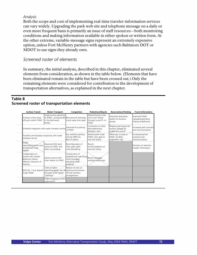
Analysis Both the scope and cost of implementing real-time traveler-information services can vary widely. Upgrading the park web site and telephone message on a daily or even more frequent basis is primarily an issue of staff resources—both monitoring conditions and making information available in either spoken or written form. At the other extreme, variable-message signs represent an extremely expensive option, unless Fort McHenry partners with agencies such Baltimore DOT or MDOT to use signs they already own. Screened roster of elements In summary, the initial analysis, described in this chapter, eliminated several elements from consideration, as shown in the table below. (Elements that have been eliminated remain in the table but have been crossed out.) Only the remaining elements were considered for contribution to the development of transportation alternatives, as explained in the next chapter.
Table 8 Screened roster of transportation elements
Surface Transit Water Transport Congestion Pedestrian/Bicycle Reservations/Parking Travel Information
Creation of bus drop-off point within FOMC
Single service operating to FOMC, and generally in the Northwest Harbor
Rerouting of Steinweg trucks away from gate
Marked bicycle route from Inner Harbor through Locust Pt. to FOMC
Improved reservation system for bus/tour groups
Improved FOMC signage/wayfinding in/around Baltimore
Improved bus parking at FOMC
Connection to other planned/existing bike/ped. trails
Require reservations for bus/tour groups (to enable bus access)
Increased park outreach and communications
Bus overflow parking off-site (MPA lot, BACVA plans)
Marked path inside FOMC from gate to new E/A facility
Allow cars to park at FOMC for ferry origination trips
Increased partner outreach and communications
FOMC operates/contracts own shuttle from Inner Harbor
Improved ADA dock access at FOMC and other city landings
Reconfiguration of main gate traffic controls/staffing
Bicycle accommodations at new E/A facility
Provision of real-time traveler information
Collaboration on shuttle with Greater Baltimore History Alliance / Museum of Industry
Express service from Inner Harbor to FOMC
Construction of separate exit road along north boundary (abutting USNR property)
Bicycle stowages onboard water taxis
MTA No. 1 bus dropoff inside FOMC
Craft at higher operating speed: low W-W boats; Inner Harbor "Fairways"
Reduce on-site car parking and enhance off-site overflow arrangements
Higher-frequency Outer Loop service
Schedule integration with water transport service
Transfers and fare/pass reciprocity with water transport service
Volpe Center Fort McHenry Alternative Transportation Study, May 2004 FINAL DRAFT 72
Chapter 6: Transportation Alternatives Once defined, transportation elements can be combined into several transportation alternatives—complete scenarios that can be considered for implementation. The transportation elements described in Chapter 5 form the basis for the creation of various “transportation alternatives”; each alternative is a complete transportation scenario that Fort McHenry could choose to pursue. Stakeholder participation, including the development and formation of partnerships, is a key aspect of all of the “active” alternatives. The park must pursue these partnerships vigorously, particularly for those alternatives which include higher levels of AT development. The alternatives represent levels of investment and involvement, ranging from minimal to maximal. Each includes investment and actions by both the park and other stakeholders. Most AT improvements and activities within the park are eligible for NPS ATP funding, although such funding, under current eligibility restrictions, cannot be used to pay for transportation operations. Alternative transportation activities outside the park should be the subject of park leadership and participation in partnered programs and initiatives; generally, such external activities are probably not eligible for ATP funding, although other federal funding opportunities—for transportation programs as well as broader programs—may be feasible to pursue. Each of the alternatives was evaluated in line with the following criteria, which are based on standard NPS “choosing by advantages” evaluation criteria and the factors used to evaluate ATP implementation projects. (These criteria were also specified in the Volpe Center AT study task plan.)
Improving the visitor experience. o Does the alternative offer better visitor services, or improved
educational or recreational opportunities? o What is the likely visitor demand? What types of visitors
(demographics, market segments) will be affected? Are there particular areas of applicability (e.g., seasonal service, school-group accommodations)?
o What is the likely visitor acceptance? o What is the potential reduction of congestion/overcrowding?
Protecting natural and cultural resources. What effects does the alternative have on Fort McHenry’s cultural, historical, and natural resources and landscape? Are there environmental effects (e.g., reduced air/noise pollution)?
Volpe Center Fort McHenry Alternative Transportation Study, May 2004 FINAL DRAFT 73

Protecting public health, safety, and welfare. How does the alternative protect or improve visitor safety?
Providing other advantages to NPS. Does the alternative advance any of
NPS service-wide goals, such as expanding stakeholder partnerships? What is the potential for this alternative to facilitate transportation linkages between Fort McHenry and the Baltimore area?
Cost, time, difficulty of implementation. What is the cost to NPS, and what
NPS actions are required; what is the cost to stakeholders, and what stakeholder actions are required? Are there particular sensitivities or obstacles that might prevent full implementation?
Evaluation against new education/administration center concepts. At the
beginning of the AT study, the originally proposed approach was to fully evaluate the AT alternatives against the DCP/EA concepts for expanding or replacing the education/administration center, based on the assumption that those concepts—perhaps by differing greatly in the placement of visitor facilities, administrative operations, roadways, or parking areas—would have significantly different implications for transportation. However, with one exception, the DCP/EA process actually produced education/administration center concepts that, from a transportation perspective, have no significant differences from one another. (This point was well illustrated during a December 2003 DCP/EA alternatives workshop at Fort McHenry, during which a “mini-choosing by advantages” transportation analysis was conducted.) The exception is that the DCP/EA concepts have different treatments for car and bus parking at Fort McHenry; each of the AT alternatives is, therefore, compared against the different parking concepts:
o DCP/EA Concept A—“no action”—would not change the
current parking arrangement. Concept A preserves the existing park layout.
o DCP/EA Concept B—“rehabilitated visitor center”—would
slightly expand the current parking arrangement to provide 179 car spaces.
o DCP/EA Concept C—“campus plan”—would shrink the
current parking area to 131 car spaces, but calls for the future development of the current overflow parking area, if needed, as a paved parking terrace, providing 135 additional car spaces.
o DCP/EA Concept D—“education/administration building”—
would shrink the current parking area to 108 car spaces but would provide eight bus spaces (as well as allowing for five
Volpe Center Fort McHenry Alternative Transportation Study, May 2004 FINAL DRAFT 74
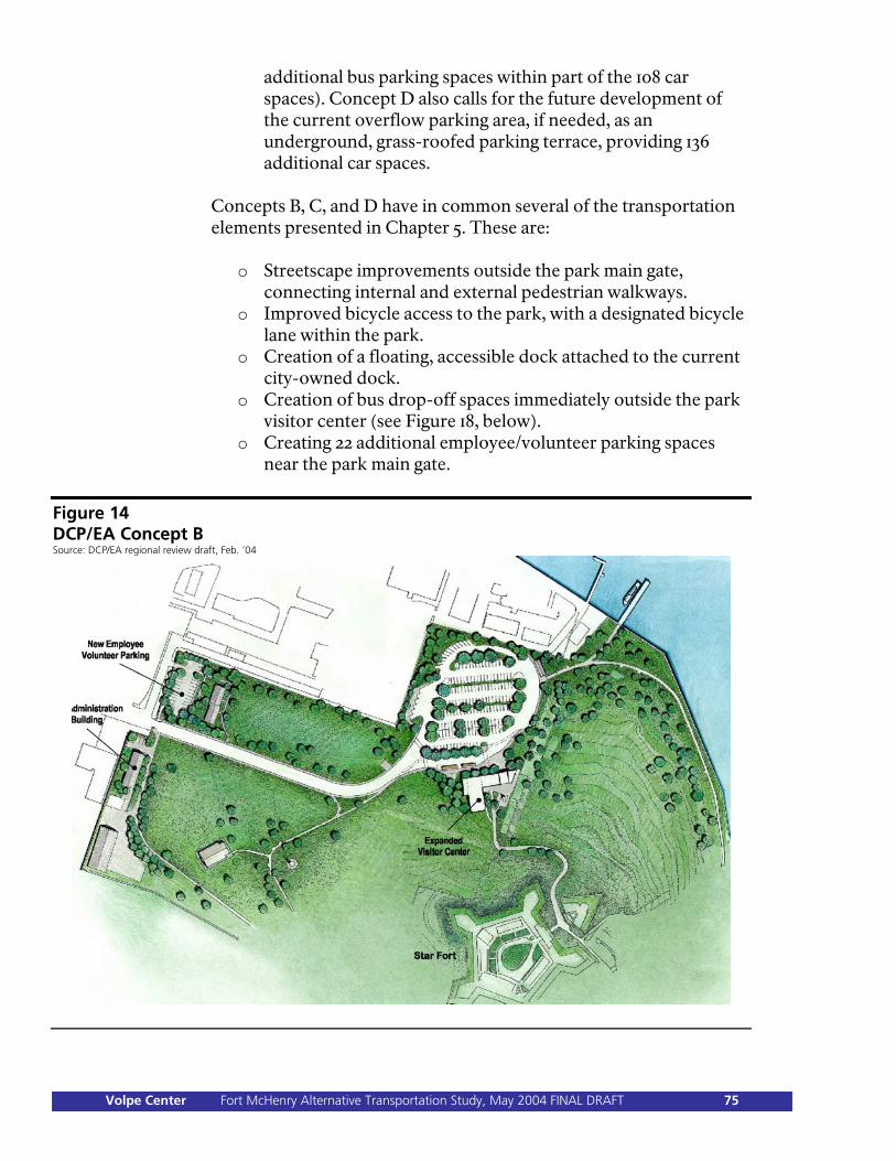
additional bus parking spaces within part of the 108 car spaces). Concept D also calls for the future development of the current overflow parking area, if needed, as an underground, grass-roofed parking terrace, providing 136 additional car spaces.
Concepts B, C, and D have in common several of the transportation elements presented in Chapter 5. These are:
o Streetscape improvements outside the park main gate, connecting internal and external pedestrian walkways.
o Improved bicycle access to the park, with a designated bicycle lane within the park.
o Creation of a floating, accessible dock attached to the current city-owned dock.
o Creation of bus drop-off spaces immediately outside the park visitor center (see Figure 18, below).
o Creating 22 additional employee/volunteer parking spaces near the park main gate.
Figure 14 DCP/EA Concept B Source: DCP/EA regional review draft, Feb. ’04
Volpe Center Fort McHenry Alternative Transportation Study, May 2004 FINAL DRAFT 75
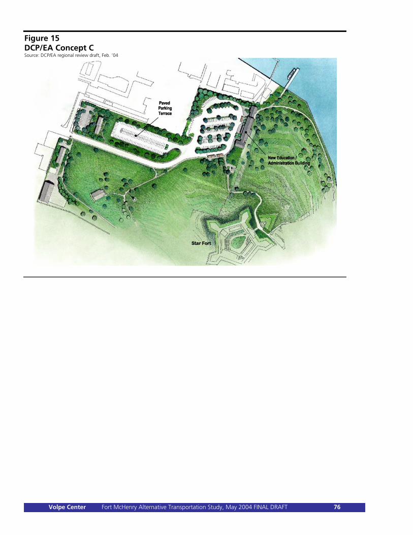
Figure 15 DCP/EA Concept C Source: DCP/EA regional review draft, Feb. ’04
Volpe Center Fort McHenry Alternative Transportation Study, May 2004 FINAL DRAFT 76
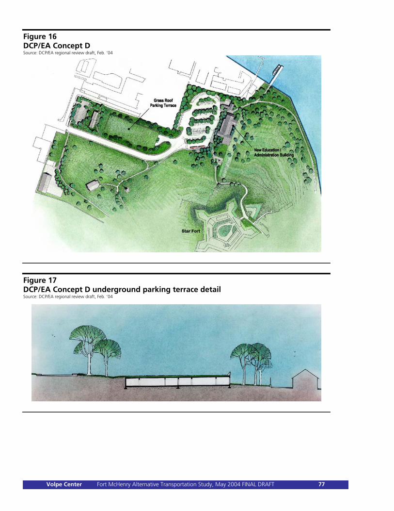
Figure 16 DCP/EA Concept D Source: DCP/EA regional review draft, Feb. ’04
Figure 17 DCP/EA Concept D underground parking terrace detail Source: DCP/EA regional review draft, Feb. ’04
Volpe Center Fort McHenry Alternative Transportation Study, May 2004 FINAL DRAFT 77
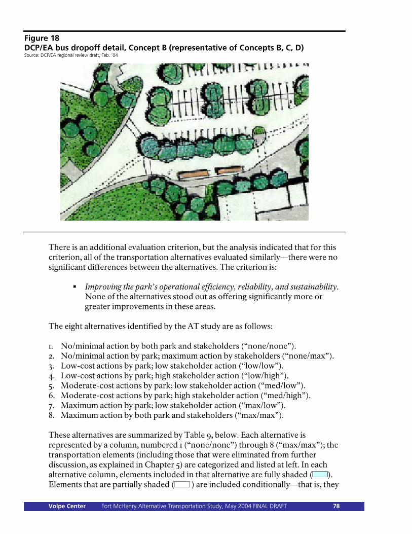
Figure 18 DCP/EA bus dropoff detail, Concept B (representative of Concepts B, C, D) Source: DCP/EA regional review draft, Feb. ’04
There is an additional evaluation criterion, but the analysis indicated that for this criterion, all of the transportation alternatives evaluated similarly—there were no significant differences between the alternatives. The criterion is:
Improving the park’s operational efficiency, reliability, and sustainability. None of the alternatives stood out as offering significantly more or greater improvements in these areas.
The eight alternatives identified by the AT study are as follows: 1. No/minimal action by both park and stakeholders (“none/none”). 2. No/minimal action by park; maximum action by stakeholders (“none/max”). 3. Low-cost actions by park; low stakeholder action (“low/low”). 4. Low-cost actions by park; high stakeholder action (“low/high”). 5. Moderate-cost actions by park; low stakeholder action (“med/low”). 6. Moderate-cost actions by park; high stakeholder action (“med/high”). 7. Maximum action by park; low stakeholder action (“max/low”). 8. Maximum action by both park and stakeholders (“max/max”). These alternatives are summarized by Table 9, below. Each alternative is represented by a column, numbered 1 (“none/none”) through 8 (“max/max”); the transportation elements (including those that were eliminated from further discussion, as explained in Chapter 5) are categorized and listed at left. In each alternative column, elements included in that alternative are fully shaded ( ). Elements that are partially shaded ( ) are included conditionally—that is, they
Volpe Center Fort McHenry Alternative Transportation Study, May 2004 FINAL DRAFT 78
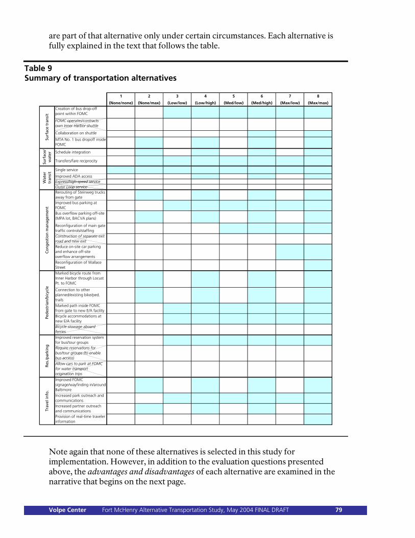
are part of that alternative only under certain circumstances. Each alternative is fully explained in the text that follows the table.
Table 9 Summary of transportation alternatives
1 2 3 4 5 6 7 8
(None/none) (None/max) (Low/low) (Low/high) (Med/low) (Med/high) (Max/low) (Max/max)Creation of bus drop-off point within FOMC
FOMC operates/contracts own Inner Harbor shuttle
Collaboration on shuttle
MTA No. 1 bus dropoff inside FOMC
Schedule integration
Transfers/fare reciprocity
Single service
Improved ADA accessExpress/high-speed serviceOuter Loop serviceRerouting of Steinweg trucks away from gateImproved bus parking at FOMCBus overflow parking off-site (MPA lot, BACVA plans)
Reconfiguration of main gate traffic controls/staffingConstruction of separate exit road and new exitReduce on-site car parking and enhance off-site overflow arrangementsReconfiguration of Wallace StreetMarked bicycle route from Inner Harbor through Locust Pt. to FOMC
Connection to other planned/existing bike/ped. trailsMarked path inside FOMC from gate to new E/A facilityBicycle accommodations at new E/A facilityBicycle stowage aboard ferriesImproved reservation system for bus/tour groupsRequire reservations for bus/tour groups (to enable bus access)Allow cars to park at FOMC for water transport origination trips
Improved FOMC signage/wayfinding in/around BaltimoreIncreased park outreach and communicationsIncreased partner outreach and communicationsProvision of real-time traveler information
Co
ng
esti
on
man
agem
ent
Ped
estr
ian
/bic
ycle
Res
./par
kin
gTr
avel
info
.Su
rfac
e tr
ansi
tSu
rfac
e/
wat
erW
ater
tr
ansi
t
Note again that none of these alternatives is selected in this study for implementation. However, in addition to the evaluation questions presented above, the advantages and disadvantages of each alternative are examined in the narrative that begins on the next page.
Volpe Center Fort McHenry Alternative Transportation Study, May 2004 FINAL DRAFT 79
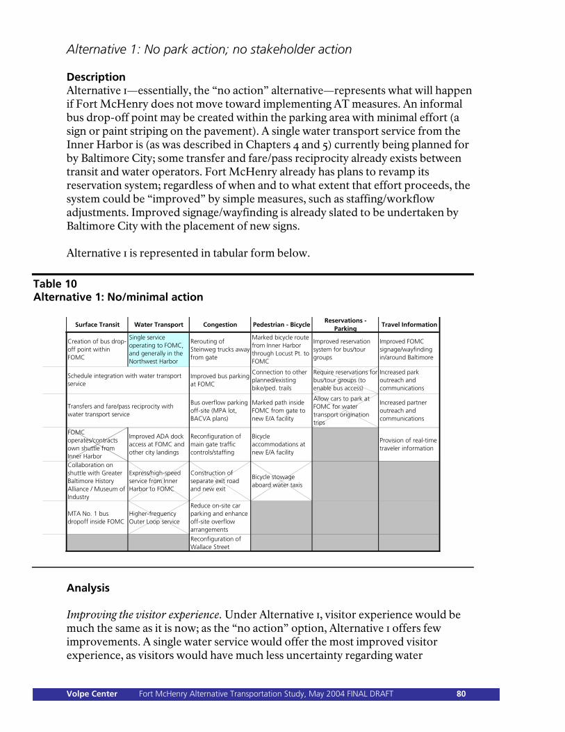
Alternative 1: No park action; no stakeholder action Description Alternative 1—essentially, the “no action” alternative—represents what will happen if Fort McHenry does not move toward implementing AT measures. An informal bus drop-off point may be created within the parking area with minimal effort (a sign or paint striping on the pavement). A single water transport service from the Inner Harbor is (as was described in Chapters 4 and 5) currently being planned for by Baltimore City; some transfer and fare/pass reciprocity already exists between transit and water operators. Fort McHenry already has plans to revamp its reservation system; regardless of when and to what extent that effort proceeds, the system could be “improved” by simple measures, such as staffing/workflow adjustments. Improved signage/wayfinding is already slated to be undertaken by Baltimore City with the placement of new signs. Alternative 1 is represented in tabular form below.
Table 10 Alternative 1: No/minimal action
Surface Transit Water Transport Congestion Pedestrian - BicycleReservations -
ParkingTravel Information
Creation of bus drop-off point within FOMC
Single service operating to FOMC, and generally in the Northwest Harbor
Rerouting of Steinweg trucks away from gate
Marked bicycle route from Inner Harbor through Locust Pt. to FOMC
Improved reservation system for bus/tour groups
Improved FOMC signage/wayfinding in/around Baltimore
Improved bus parking at FOMC
Connection to other planned/existing bike/ped. trails
Require reservations for bus/tour groups (to enable bus access)
Increased park outreach and communications
Bus overflow parking off-site (MPA lot, BACVA plans)
Marked path inside FOMC from gate to new E/A facility
Allow cars to park at FOMC for water transport origination trips
Increased partner outreach and communications
FOMC operates/contracts own shuttle from Inner Harbor
Improved ADA dock access at FOMC and other city landings
Reconfiguration of main gate traffic controls/staffing
Bicycle accommodations at new E/A facility
Provision of real-time traveler information
Collaboration on shuttle with Greater Baltimore History Alliance / Museum of Industry
Express/high-speed service from Inner Harbor to FOMC
Construction of separate exit road and new exit
Bicycle stowage aboard water taxis
MTA No. 1 bus dropoff inside FOMC
Higher-frequency Outer Loop service
Reduce on-site car parking and enhance off-site overflow arrangements
Reconfiguration of Wallace Street
Schedule integration with water transport service
Transfers and fare/pass reciprocity with water transport service
Analysis Improving the visitor experience. Under Alternative 1, visitor experience would be much the same as it is now; as the “no action” option, Alternative 1 offers few improvements. A single water service would offer the most improved visitor experience, as visitors would have much less uncertainty regarding water
Volpe Center Fort McHenry Alternative Transportation Study, May 2004 FINAL DRAFT 80
transportation in Baltimore and could rely upon more frequent service. Also, better signage in Baltimore would be of benefit to drivers. If any of the other activities listed in the description were undertaken, modest improvements to the visitor experience might be expected, but only for the few visitors (such as those arriving by public bus, or using fare/pass reciprocity) to whom those activities apply. To the extent that Alternative 1 could increase visitation by water transportation, resulting in decreased automobile arrivals at the park, there could be some reduction of congestion/overcrowding within the parking area. Protecting natural and cultural resources. Alternative 1 represents essentially no change from current conditions. To the extent that Alternative 1 could increase visitation by water transportation, resulting in decreased automobile arrivals at the park, a modest environmental benefit would be realized. Protecting public safety, health, and welfare. As with resource protection, Alternative 1 would result in essentially no change from current conditions. The major park safety hazard—conditions at and around the park main gate—is not addressed by this alternative. Providing other advantages to NPS. Stakeholder partnerships are not strengthened by this alternative, except that it may be possible to forge a closer relationship with a single water transportation operator than with two competing operators, as at present. A single water service would facilitate better transportation linkages between Fort McHenry and the Baltimore area, as would improved signage. Cost, time, difficulty of implementation. As the “no build” option, Alternative 1’s costs are minimal. Creating a bus drop-off point can be done merely by placing a sign or paint stripe; the improved reservations system is already underway and in any case has relied upon summer student assistance. Stakeholder costs are also minimal, with the exception of improved signage, the cost of which would be borne by the relevant agency. There are no sensitivities or obstacles preventing full implementation of this alternative. Stakeholders are not likely to object to implementation—unless they advocate for greater action to be taken by Fort McHenry. Evaluation against education/administration center concepts. Alternative 1 correlates with DCP/EA Concept A, which is also a “no action” alternative. Concepts B, C, and D all call for the implementation of transportation measures that go beyond Alternative 1. Advantages/disadvantages of this alternative. As essentially a “no action” option, Alternative 1 is the least expensive, least intensive alternative, and would take the least time and effort to implement. However, its benefits are similarly minimal. The major component—establishment of a single water transportation service in Baltimore Harbor—is beyond the control of Fort McHenry and is likely to happen regardless of which transportation alternative, if any, is ultimately selected for
Volpe Center Fort McHenry Alternative Transportation Study, May 2004 FINAL DRAFT 81
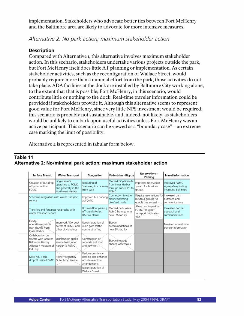
implementation. Stakeholders who advocate better ties between Fort McHenry and the Baltimore area are likely to advocate for more intensive measures. Alternative 2: No park action; maximum stakeholder action Description Compared with Alternative 1, this alternative involves maximum stakeholder action. In this scenario, stakeholders undertake various projects outside the park, but Fort McHenry itself does little AT planning or implementation. As certain stakeholder activities, such as the reconfiguration of Wallace Street, would probably require more than a minimal effort from the park, those activities do not take place. ADA facilities at the dock are installed by Baltimore City working alone, to the extent that that is possible; Fort McHenry, in this scenario, would contribute little or nothing to the dock. Real-time traveler information could be provided if stakeholders provide it. Although this alternative seems to represent good value for Fort McHenry, since very little NPS investment would be required, this scenario is probably not sustainable, and, indeed, not likely, as stakeholders would be unlikely to embark upon useful activities unless Fort McHenry was an active participant. This scenario can be viewed as a “boundary case”—an extreme case marking the limit of possibility. Alternative 2 is represented in tabular form below.
Table 11 Alternative 2: No/minimal park action; maximum stakeholder action
Surface Transit Water Transport Congestion Pedestrian - BicycleReservations -
ParkingTravel Information
Creation of bus drop-off point within FOMC
Single service operating to FOMC, and generally in the Northwest Harbor
Rerouting of Steinweg trucks away from gate
Marked bicycle route from Inner Harbor through Locust Pt. to FOMC
Improved reservation system for bus/tour groups
Improved FOMC signage/wayfinding in/around Baltimore
Improved bus parking at FOMC
Connection to other planned/existing bike/ped. trails
Require reservations for bus/tour groups (to enable bus access)
Increased park outreach and communications
Bus overflow parking off-site (MPA lot, BACVA plans)
Marked path inside FOMC from gate to new E/A facility
Allow cars to park at FOMC for water transport origination trips
Increased partner outreach and communications
FOMC operates/contracts own shuttle from Inner Harbor
Improved ADA dock access at FOMC and other city landings
Reconfiguration of main gate traffic controls/staffing
Bicycle accommodations at new E/A facility
Provision of real-time traveler information
Collaboration on shuttle with Greater Baltimore History Alliance / Museum of Industry
Express/high-speed service from Inner Harbor to FOMC
Construction of separate exit road and new exit
Bicycle stowage aboard water taxis
MTA No. 1 bus dropoff inside FOMC
Higher-frequency Outer Loop service
Reduce on-site car parking and enhance off-site overflow arrangements
Reconfiguration of Wallace Street
Schedule integration with water transport service
Transfers and fare/pass reciprocity with water transport service
Volpe Center Fort McHenry Alternative Transportation Study, May 2004 FINAL DRAFT 82
Analysis Improving the visitor experience. Alternative 2 would result in significantly improved transportation options for those visitors choosing to travel to the park by means other than private cars. The alternative transportation enhancements offered by outside stakeholders would not be matched by corresponding efforts inside the park, so the safety (at the park gate) and accommodations would suffer by comparison. This alternative would offer several improvements relative to Alternative 1. There would be improved transit service coordination between water and surface transit operators and MTA No. 1 bus service into the park. Congestion management would improve outside the park’s main gate, with the rerouting of Steinweg trucks and provision of bus overflow parking. A single water transport service—as in Alternative 1—would offer the most improved visitor experience, as visitors would have much less uncertainty regarding water transportation in Baltimore and could rely upon more frequent, and possibly regularly scheduled, service. There would be marked bicycle routes leading to the park and linkages to other planned thematic routes in the Baltimore area. Again, better signage in Baltimore would be of benefit to drivers. Alternative 2 could significantly increase visitation by water transportation, bicycles, and, to a lesser extent, buses, resulting in decreased automobile arrivals at the park and concomitant reduction of congestion within the parking area. Protecting natural and cultural resources. Similar to Alternative 1, there would be no change from current conditions, other than decreased automobile arrivals at the park and the resulting modest environmental benefit. Protecting public safety, health, and welfare. The major park safety hazard—conditions at and around the park main gate—is partially addressed by this alternative; Steinweg trucks would be rerouted away from Fort Avenue, leading to an improvement in visitor safety. Providing other advantages to NPS. Stakeholder partnerships are not strengthened by this alternative, except that it may be possible to forge a closer relationship with a single water transportation operator than with two competing operators, as at present. A single water service would facilitate better transportation linkages between Fort McHenry and the Baltimore area, as would improved signage. If anything, Alternative 2 could lead to a weakening of stakeholder partnerships, as the park does not respond to external initiatives with its own activities or funding. Cost, time, difficulty of implementation. Alternative 2’s costs to Fort McHenry are minimal, as for Alternative 1. Stakeholder costs would be significant only for the Steinweg truck rerouting, the provision of bicycle lanes to the park, and the improved signage (as before). Improved stakeholder outreach and communications could be at a scale and cost desired by stakeholders. A major obstacle to implementation of this alternative is the reluctance of stakeholders to move toward implementation without any actions being taken by Fort McHenry.
Volpe Center Fort McHenry Alternative Transportation Study, May 2004 FINAL DRAFT 83
Evaluation against education/administration center concepts. Alternative 2 correlates with DCP/EA Concept A, which is also a “no action” alternative for the park. Concepts B, C, and D all call for the implementation of transportation measures within Fort McHenry that go beyond Alternative 2. Advantages/disadvantages of this alternative. The likelihood of this alternative occurring is very low, because it is essentially a “no action” option for the park that nonetheless requires intensive commitment and activity by outside stakeholders. This is its major disadvantage. Alternative 2 would entail great expense for others and take considerable time and effort to implement. Its transportation benefits outside the park would be significant, particularly the establishment of improved water transport service and better bicycle access to the park. Even if pursued in the short term, however, Alternative 2 would probably not be sustainable for very long. Alternative 3: Low-cost actions by park; low stakeholder action Description Compared with Alternative 1, this scenario describes more activity by both the park and by stakeholders—but still at relatively low investment levels. As in Alternative 1, an MTA bus drop-off inside the park could be arranged, although with no improved infrastructure. ADA access could be possible at the Fort McHenry dock, paid for jointly by NPS and Baltimore City, but will not be provided by Baltimore City at other city-owned docks, limiting its usefulness at the park. Bus parking within Fort McHenry could be improved by restriping or slightly reconfiguring the existing parking area (e.g., to allow dual car/bus use of some spaces). Providing a marked bicycle path within the park, as well as bicycle accommodations, is also possible in Alternative 3, as those activities are inexpensive. A new reservation system would be implemented. The park can improve its own outreach; partners can also improve their outreach, depending on their investment level. Minimal real-time information can be provided at this level of investment, as a joint effort by Fort McHenry and stakeholders. Alternative 3 is represented in tabular form below.
Volpe Center Fort McHenry Alternative Transportation Study, May 2004 FINAL DRAFT 84
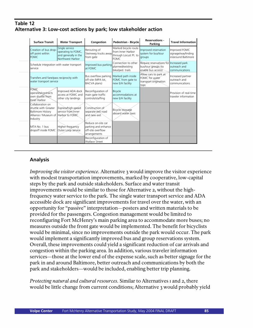
Table 12 Alternative 3: Low-cost actions by park; low stakeholder action
Surface Transit Water Transport Congestion Pedestrian - BicycleReservations -
ParkingTravel Information
Creation of bus drop-off point within FOMC
Single service operating to FOMC, and generally in the Northwest Harbor
Rerouting of Steinweg trucks away from gate
Marked bicycle route from Inner Harbor through Locust Pt. to FOMC
Improved reservation system for bus/tour groups
Improved FOMC signage/wayfinding in/around Baltimore
Improved bus parking at FOMC
Connection to other planned/existing bike/ped. trails
Require reservations for bus/tour groups (to enable bus access)
Increased park outreach and communications
Bus overflow parking off-site (MPA lot, BACVA plans)
Marked path inside FOMC from gate to new E/A facility
Allow cars to park at FOMC for water transport origination trips
Increased partner outreach and communications
FOMC operates/contracts own shuttle from Inner Harbor
Improved ADA dock access at FOMC and other city landings
Reconfiguration of main gate traffic controls/staffing
Bicycle accommodations at new E/A facility
Provision of real-time traveler information
Collaboration on shuttle with Greater Baltimore History Alliance / Museum of Industry
Express/high-speed service from Inner Harbor to FOMC
Construction of separate exit road and new exit
Bicycle stowage aboard water taxis
MTA No. 1 bus dropoff inside FOMC
Higher-frequency Outer Loop service
Reduce on-site car parking and enhance off-site overflow arrangements
Reconfiguration of Wallace Street
Schedule integration with water transport service
Transfers and fare/pass reciprocity with water transport service
Analysis Improving the visitor experience. Alternative 3 would improve the visitor experience with modest transportation improvements, marked by cooperative, low-capital steps by the park and outside stakeholders. Surface and water transit improvements would be similar to those for Alternative 2, without the high-frequency water service to the park. The single water transport service and ADA accessible dock are significant improvements for travel over the water, with an opportunity for “passive” interpretation—posters and written materials to be provided for the passengers. Congestion management would be limited to reconfiguring Fort McHenry’s main parking area to accommodate more buses; no measures outside the front gate would be implemented. The benefit for bicyclists would be minimal, since no improvements outside the park would occur. The park would implement a significantly improved bus and group reservations system. Overall, these improvements could yield a significant reduction of car arrivals and congestion within the parking area. In addition, various traveler information services—those at the lower end of the expense scale, such as better signage for the park in and around Baltimore, better outreach and communications by both the park and stakeholders—would be included, enabling better trip planning. Protecting natural and cultural resources. Similar to Alternatives 1 and 2, there would be little change from current conditions; Alternative 3 would probably yield
Volpe Center Fort McHenry Alternative Transportation Study, May 2004 FINAL DRAFT 85
modestly decreased automobile arrivals at the park and, consequently, a modest environmental benefit. Protecting public safety, health, and welfare. There would be essentially no change from current conditions. The major park safety hazard—conditions at and around the park main gate—is not addressed by this alternative. Providing other advantages to NPS. Stakeholder partnerships would be strengthened in small measure by the modest steps included in this alternative, particularly with the surface and water transportation operators. ADA access at the dock is a mobility feature of potentially great importance to a significant number of visitors. The traveler information elements taken altogether strengthen ties with many cultural and visitor organizations. Compared with Alternative 2, this alternative calls for roughly similar order-of-magnitude investments by both Fort McHenry and external stakeholders, enabling the perception that the park and its partners are, broadly speaking, collaborating as equals. Cost, time, difficulty of implementation. Except for the accessible dock, Alternative 3’s costs to both Fort McHenry and stakeholders are quite low, as are the time and difficulty of implementation. The estimated dock costs would be $270,000, negotiated between NPS and Baltimore City (depending on NPS funding eligibility requirements, as the dock is city property, not NPS property). The only other significant costs are for the striped bike lanes and accommodations within the park, which could be accomplished for as little as $7,500. Additional funding would make possible superior accommodations—for instance, a better bus drop-off area, perhaps with a sign or different paving materials (though probably not a shelter at the “low” funding level of Alternative 3). Increased park outreach and communications could be undertaken at a level commensurate with available funding. Evaluation against education/administration center concepts. Alternative 3 correlates with DCP/EA Concepts B, C, and D, which all call for the same transportation infrastructure measures—the accessible dock, the bus drop-off facility, and internal bicycle lanes and accommodations. If Concepts B, C, or D are implemented, therefore, all of the internal improvements specified in Alternative 3 will be implemented. If DCP/EA Concept A is implemented—that is to say, if no action is taken regarding a new education/administration center—Alternative 3 could still be implemented separately, following the completion of final compliance activities and documentation. Advantages/disadvantages of this alternative. The major advantage of Alternative 3 is that it allows the park and other stakeholders to work together and make progress on easily achievable measures. Its benefits are modest, but they could build confidence and momentum for future improvements. There is no disadvantage to Alternative 3 as such, except for the possibility that it would not be followed by a more ambitious program that would have larger associated benefits.
Volpe Center Fort McHenry Alternative Transportation Study, May 2004 FINAL DRAFT 86

Alternative 4: Low-cost actions by park; high stakeholder action Description Alternative 4 is similar to Alternative 3, but with a higher level of stakeholder activity, as in Alternative 2. The park would work with the MTA for a No. 1 bus dropoff and service to the park, and with Baltimore City to upgrade the Fort McHenry dock; Baltimore City would also upgrade other city-owned docks. More frequent, scheduled water transport service to Fort McHenry would be initiated. An integrated bicycle and pedestrian network between Fort McHenry (with internal bicycle/pedestrian improvements), Baltimore City, and the region forms at this stage. Signage and outreach (by both the park and partners) takes place; real-time traveler information is possible, to a greater extent than in Alternative 3. Alternative 4 is represented in tabular form below.
Table 13 Alternative 4: Low-cost actions by park; high stakeholder action
Surface Transit Water Transport Congestion Pedestrian - BicycleReservations -
ParkingTravel Information
Creation of bus drop-off point within FOMC
Single service operating to FOMC, and generally in the Northwest Harbor
Rerouting of Steinweg trucks away from gate
Marked bicycle route from Inner Harbor through Locust Pt. to FOMC
Improved reservation system for bus/tour groups
Improved FOMC signage/wayfinding in/around Baltimore
Improved bus parking at FOMC
Connection to other planned/existing bike/ped. trails
Require reservations for bus/tour groups (to enable bus access)
Increased park outreach and communications
Bus overflow parking off-site (MPA lot, BACVA plans)
Marked path inside FOMC from gate to new E/A facility
Allow cars to park at FOMC for water transport origination trips
Increased partner outreach and communications
FOMC operates/contracts own shuttle from Inner Harbor
Improved ADA dock access at FOMC and other city landings
Reconfiguration of main gate traffic controls/staffing
Bicycle accommodations at new E/A facility
Provision of real-time traveler information
Collaboration on shuttle with Greater Baltimore History Alliance / Museum of Industry
Express/high-speed service from Inner Harbor to FOMC
Construction of separate exit road and new exit
Bicycle stowage aboard water taxis
MTA No. 1 bus dropoff inside FOMC
Higher-frequency Outer Loop service
Reduce on-site car parking and enhance off-site overflow arrangements
Reconfiguration of Wallace Street
Schedule integration with water transport service
Transfers and fare/pass reciprocity with water transport service
Analysis Improving the visitor experience. Alternative 4 would improve the visitor experience with modest enhancements inside the park, and more ambitious cooperative elements outside the park. Surface and water transit improvements would be similar to those for Alternative 2, including high-frequency water service to the park and water/surface transit service integration. Congestion management
Volpe Center Fort McHenry Alternative Transportation Study, May 2004 FINAL DRAFT 87
would include reconfiguring the park’s main parking lot to accommodate more buses, rerouting of Steinweg’s trucks away from the main gate, and provision of bus (but not car) overflow parking in the MPA lot. The full suite of bicycle mobility elements inside and outside the park would occur. Bus and group reservations and traveler information services would be implemented. These improvements could yield significant reduction of car arrivals and congestion within the parking area, and improve safety to some degree outside the front gate. Protecting natural and cultural resources. Similar to Alternatives 1 through 3, there would be little change from current conditions, only modestly decreased automobile arrivals at the park and the resulting modest environmental benefit. Protecting public safety, health, and welfare. There would be essentially no change from current conditions. The major park safety hazard—conditions at and around the park main gate—is not addressed by this alternative. Providing other advantages to NPS. Stakeholder partnerships would be strengthened significantly by the elements included in this alternative, which is an improvement particularly with bicycling groups. ADA access at the dock is a mobility feature of potentially great importance to a significant number of visitors. However, as in Alternative 2, the perception could exist—if less so—that Alternative 4 overly relies on stakeholder partnerships; although the park is cooperating with external activities and has committed its own funding resources (unlike in Alternative 2), there remains some disparity between the park’s level of expenditure and that of stakeholders. Cost, time, difficulty of implementation. Alternative 4’s costs for both Fort McHenry and stakeholders would be significant, as would the time and difficulty involved for some elements, although in both cases more so for stakeholders. As in Alternatives 2 and 3, the estimated dock costs would be $270,000, although it is assumed that Baltimore City would bear the entire cost (or at least a greater share of the cost than in Alternative 3). The costs for the striped bike lanes and accommodations within the park would, as in Alternative 3, have a lower boundary of $7,500, and the lanes between the Inner Harbor and the park would cost $34,000 or $62,000 (borne by the city), depending on the option chosen. Again, higher funding levels would result in superior improvements. The park, and stakeholders, could undertake improved outreach and communications commensurate with available funding. As in Alternative 2, rerouting the Steinweg trucks off of Fort Avenue could involve significant stakeholder expense. Evaluation against education/administration center concepts. Alternative 4 correlates with DCP/EA Concepts B, C, and D, which all call for the same transportation infrastructure measures—the accessible dock, the bus drop-off facility, and internal bicycle lanes and accommodations. If Concepts B, C, or D are implemented, therefore, all of the internal improvements specified in Alternative 4 will be implemented. If DCP/EA Concept A is implemented—that is to say, if no
Volpe Center Fort McHenry Alternative Transportation Study, May 2004 FINAL DRAFT 88

action is taken regarding a new education/administration center—Alternative 4 could still be implemented separately, following the completion of final compliance activities and documentation. Advantages/disadvantages of this alternative. Alternative 4 includes the easily achievable cooperative measures of Alternative 3, but also implies that stakeholders will lead the way, pursuing more ambitious activities. This is advantageous to Fort McHenry compared with Alternative 3, but implies an unequal partnership, to an extent leaving leadership, and the facilitation of some of the more difficult and complex initiatives, to stakeholders. Alternative 5: Moderate-cost actions by park; low stakeholder action Description Alternative 5 is similar to Alternative 3, but with additional actions by the park. At this investment level, Fort McHenry could create a more elaborate bus dropoff facility than in Alternative 3, perhaps with better lighting, seating, or a shelter. At this investment level, some safety enhancements at the main gate are now possible—landscaping, restriping, and new stop signage. The other improvements described in Alternative 3 are also implemented, perhaps at a greater level, or with Fort McHenry assuming a greater share of the cost of cooperative improvements (such as ADA access at the dock). Alternative 5 is represented in tabular form below.
Volpe Center Fort McHenry Alternative Transportation Study, May 2004 FINAL DRAFT 89
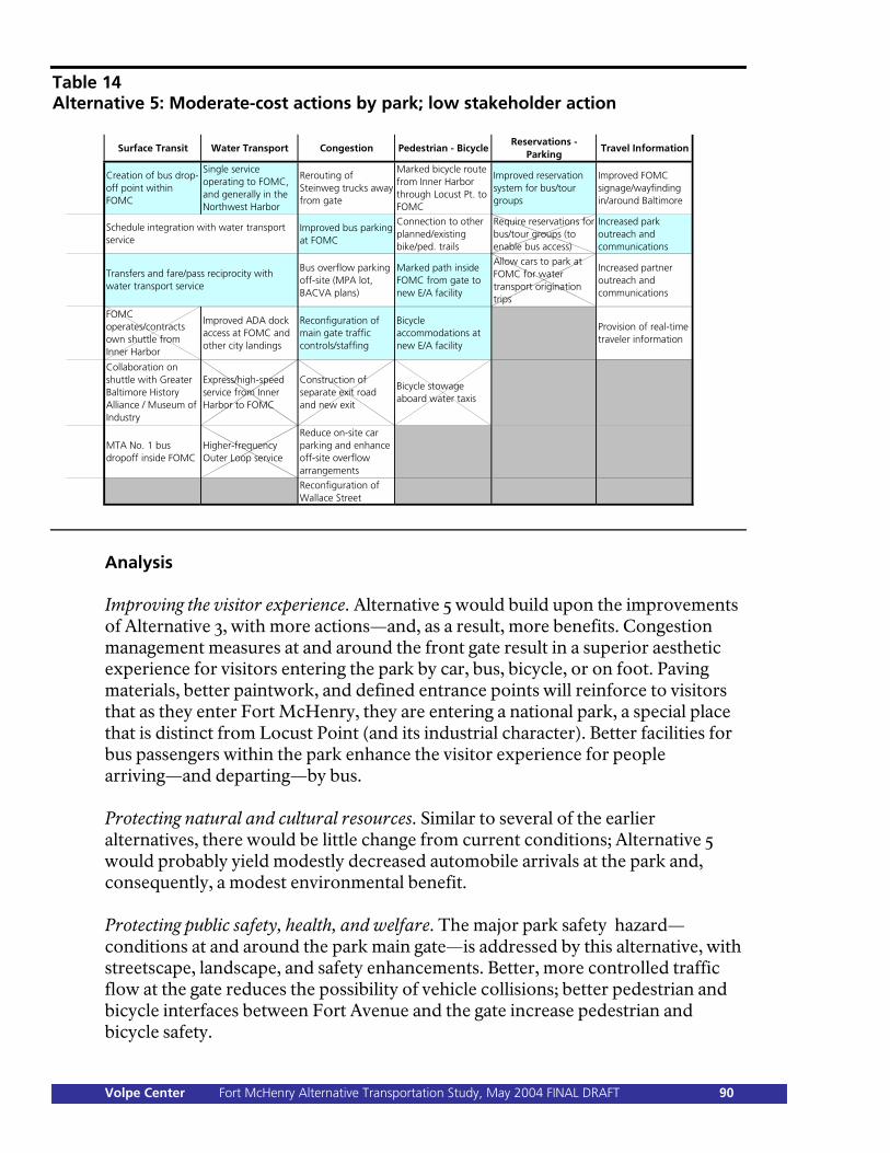
Table 14 Alternative 5: Moderate-cost actions by park; low stakeholder action
Surface Transit Water Transport Congestion Pedestrian - BicycleReservations -
ParkingTravel Information
Creation of bus drop-off point within FOMC
Single service operating to FOMC, and generally in the Northwest Harbor
Rerouting of Steinweg trucks away from gate
Marked bicycle route from Inner Harbor through Locust Pt. to FOMC
Improved reservation system for bus/tour groups
Improved FOMC signage/wayfinding in/around Baltimore
Improved bus parking at FOMC
Connection to other planned/existing bike/ped. trails
Require reservations for bus/tour groups (to enable bus access)
Increased park outreach and communications
Bus overflow parking off-site (MPA lot, BACVA plans)
Marked path inside FOMC from gate to new E/A facility
Allow cars to park at FOMC for water transport origination trips
Increased partner outreach and communications
FOMC operates/contracts own shuttle from Inner Harbor
Improved ADA dock access at FOMC and other city landings
Reconfiguration of main gate traffic controls/staffing
Bicycle accommodations at new E/A facility
Provision of real-time traveler information
Collaboration on shuttle with Greater Baltimore History Alliance / Museum of Industry
Express/high-speed service from Inner Harbor to FOMC
Construction of separate exit road and new exit
Bicycle stowage aboard water taxis
MTA No. 1 bus dropoff inside FOMC
Higher-frequency Outer Loop service
Reduce on-site car parking and enhance off-site overflow arrangements
Reconfiguration of Wallace Street
Schedule integration with water transport service
Transfers and fare/pass reciprocity with water transport service
Analysis Improving the visitor experience. Alternative 5 would build upon the improvements of Alternative 3, with more actions—and, as a result, more benefits. Congestion management measures at and around the front gate result in a superior aesthetic experience for visitors entering the park by car, bus, bicycle, or on foot. Paving materials, better paintwork, and defined entrance points will reinforce to visitors that as they enter Fort McHenry, they are entering a national park, a special place that is distinct from Locust Point (and its industrial character). Better facilities for bus passengers within the park enhance the visitor experience for people arriving—and departing—by bus. Protecting natural and cultural resources. Similar to several of the earlier alternatives, there would be little change from current conditions; Alternative 5 would probably yield modestly decreased automobile arrivals at the park and, consequently, a modest environmental benefit. Protecting public safety, health, and welfare. The major park safety hazard—conditions at and around the park main gate—is addressed by this alternative, with streetscape, landscape, and safety enhancements. Better, more controlled traffic flow at the gate reduces the possibility of vehicle collisions; better pedestrian and bicycle interfaces between Fort Avenue and the gate increase pedestrian and bicycle safety.
Volpe Center Fort McHenry Alternative Transportation Study, May 2004 FINAL DRAFT 90
Providing other advantages to NPS. Stakeholder partnerships would be strengthened by the modest steps included in this alternative, as in Alternative 3. A closer partnership with MPA, Baltimore DOT, Steinweg, and USNR would be one component of improvements to the gate area, as the needs of those agencies would have to be accommodated. If Fort McHenry constructs an enhanced bus drop-off area tailored to MTA’s needs, as part of a demonstration No. 1 service extension, a closer partnership with MTA would be effected. Cost, time, difficulty of implementation. Alternative 5 includes the costs of Alternative 3, as well as the additional costs of enhancements to the gate and the added cost of superior bus drop-off facilities. As described in Chapter 5, gate enhancements could cost between $93,000 and $330,000 (details in Appendix D)—although as part of Alternative 5, it is assumed that the park expenditure would be toward the lower end of that scale. (Alternatives 7 and 8, described below, assume the higher expenditure.) The total cost of Alternative 5, including the additional enhancements described as compared with Alternative 3, could range from $400,000–500,000, with external stakeholders assuming about one-third of that amount—not including the variable costs of additional signage outside the park, traveler information systems, or improved park or stakeholder outreach (all of which can be undertaken at a level commensurate with available funding). No significant obstacles to implementation of Alternative 5 have been identified. Evaluation against education/administration center concepts. Alternative 5 correlates with DCP/EA Concepts B, C, and D, which all call for the same transportation infrastructure measures—the accessible dock, the bus drop-off facility, and internal bicycle lanes and accommodations. If Concepts B, C, or D are implemented, therefore, all of the internal improvements specified in Alternative 5 will be implemented. If DCP/EA Concept A is implemented—that is to say, if no action is taken regarding a new education/administration center—Alternative 5 could still be implemented separately, following the completion of final compliance activities and documentation. Advantages/disadvantages of this alternative. Compared with Alternative 3, Alternative 5 builds on stakeholder partnerships and implies that the park will lead the way on transportation improvements. As with Alternative 3, there is no disadvantage to Alternative 5 as such, except for the possibility that it would not be followed by a more ambitious program that would have larger associated benefits (although Alternative 5, again compared with Alternative 3, does itself create more benefits). Alternative 5 represents a sort of middle ground, one that underscores the importance of stakeholder partnerships but reinforces the park’s leadership role, at moderate cost to the National Park Service.
Volpe Center Fort McHenry Alternative Transportation Study, May 2004 FINAL DRAFT 91
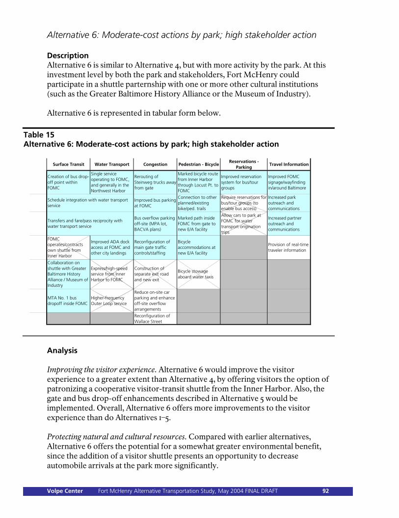
Alternative 6: Moderate-cost actions by park; high stakeholder action Description Alternative 6 is similar to Alternative 4, but with more activity by the park. At this investment level by both the park and stakeholders, Fort McHenry could participate in a shuttle parternship with one or more other cultural institutions (such as the Greater Baltimore History Alliance or the Museum of Industry). Alternative 6 is represented in tabular form below.
Table 15 Alternative 6: Moderate-cost actions by park; high stakeholder action
Surface Transit Water Transport Congestion Pedestrian - BicycleReservations -
ParkingTravel Information
Creation of bus drop-off point within FOMC
Single service operating to FOMC, and generally in the Northwest Harbor
Rerouting of Steinweg trucks away from gate
Marked bicycle route from Inner Harbor through Locust Pt. to FOMC
Improved reservation system for bus/tour groups
Improved FOMC signage/wayfinding in/around Baltimore
Improved bus parking at FOMC
Connection to other planned/existing bike/ped. trails
Require reservations for bus/tour groups (to enable bus access)
Increased park outreach and communications
Bus overflow parking off-site (MPA lot, BACVA plans)
Marked path inside FOMC from gate to new E/A facility
Allow cars to park at FOMC for water transport origination trips
Increased partner outreach and communications
FOMC operates/contracts own shuttle from Inner Harbor
Improved ADA dock access at FOMC and other city landings
Reconfiguration of main gate traffic controls/staffing
Bicycle accommodations at new E/A facility
Provision of real-time traveler information
Collaboration on shuttle with Greater Baltimore History Alliance / Museum of Industry
Express/high-speed service from Inner Harbor to FOMC
Construction of separate exit road and new exit
Bicycle stowage aboard water taxis
MTA No. 1 bus dropoff inside FOMC
Higher-frequency Outer Loop service
Reduce on-site car parking and enhance off-site overflow arrangements
Reconfiguration of Wallace Street
Schedule integration with water transport service
Transfers and fare/pass reciprocity with water transport service
Analysis Improving the visitor experience. Alternative 6 would improve the visitor experience to a greater extent than Alternative 4, by offering visitors the option of patronizing a cooperative visitor-transit shuttle from the Inner Harbor. Also, the gate and bus drop-off enhancements described in Alternative 5 would be implemented. Overall, Alternative 6 offers more improvements to the visitor experience than do Alternatives 1–5. Protecting natural and cultural resources. Compared with earlier alternatives, Alternative 6 offers the potential for a somewhat greater environmental benefit, since the addition of a visitor shuttle presents an opportunity to decrease automobile arrivals at the park more significantly.
Volpe Center Fort McHenry Alternative Transportation Study, May 2004 FINAL DRAFT 92
Protecting public safety, health, and welfare. The major park safety hazard—conditions at and around the park main gate—is addressed by this alternative, with streetscape, landscape, and safety enhancements. Better, more controlled traffic flow at the gate reduces the possibility of vehicle collisions; better pedestrian and bicycle interfaces between Fort Avenue and the gate increase pedestrian and bicycle safety. Steinweg trucks would also be rerouted away from Fort Avenue, leading to an improvement in visitor safety. Providing other advantages to NPS. As in Alternative 5, stakeholder partnerships would be strengthened significantly, as both the National Park Service and stakeholders embark—cooperatively—on significant transportation enhancements. As in Alternatives 2 and 4, Alternative 6 could lead to the perception that external stakeholders are taking the lead, but the park’s higher level of commitment as part of Alternative 6 should mitigate that possibility. Cost, time, difficulty of implementation. Alternative 6 has a higher cost associated than Alternative 5 for two reasons. First, the stakeholder cost is higher, since stakeholder involvement is more intense. Second, because stakeholder involvement is, in this alternative, high enough to support a cooperative visitor shuttle between the Inner Harbor and Fort McHenry, and such a shuttle would require the park’s financial participation. Based on current ATP eligibility criteria, one way the park could participate would be to purchase a vehicle for use by the service (as described in Chapter 5). The vehicle cost would likely be significant; additionally, route and service planning, and the generation of vehicle specifications, would be required. (Even if pre-implementation planning is done cooperatively with stakeholders, a significant cost would still accrue to Fort McHenry as a partner.) Evaluation against education/administration center concepts. Alternative 6 correlates with DCP/EA Concepts B, C, and D, which all call for the same transportation infrastructure measures—the accessible dock, the bus drop-off facility, and internal bicycle lanes and accommodations. If Concepts B, C, or D are implemented, therefore, all of the internal improvements specified in Alternative 6 will be implemented. If DCP/EA Concept A is implemented—that is to say, if no action is taken regarding a new education/administration center—Alternative 6 could still be implemented separately, following the completion of final compliance activities and documentation. Advantages/disadvantages of this alternative. Compared with Alternatives 4 and 5, Alternative 6 results in superior improvements, but requires higher park expenditures than Alternative 4 and higher stakeholder expenditures than Alternative 5. As with Alternative 5, Alternative 6 ,represents a sort of middle ground, but in a slightly different manner—Alternative 6 underscores the importance of stakeholder partnerships but cedes leadership to those
Volpe Center Fort McHenry Alternative Transportation Study, May 2004 FINAL DRAFT 93

stakeholders, since their involvement would be greater than the park’s. In that regard, Alternative 6 is similar to Alternative 4. Alternative 7: Maximum action by park; low stakeholder action Description Fort McHenry embarks upon internal transportation improvements that do not require a great deal of stakeholder involvement, and attempts to accomplish all that it can without relying on stakeholders for significant funding, leadership, or cooperation. In this regard, Alternative 7 is similar to Alternative 5, but with even more park activity. At this investment level, more elaborate facilities (bus/MTA dropoff, ADA dock access, bicycle amenities, gate improvements) can be provided. Also, Fort McHenry can invest in improvements to the MPA parking lot for overflow use by park visitors, subject to agreement with MPA. Alternative 7 is represented in tabular form below.
Figure 16 Alternative 7: Maximum action by park; low stakeholder action
Surface Transit Water Transport Congestion Pedestrian - BicycleReservations -
ParkingTravel Information
Creation of bus drop-off point within FOMC
Single service operating to FOMC, and generally in the Northwest Harbor
Rerouting of Steinweg trucks away from gate
Marked bicycle route from Inner Harbor through Locust Pt. to FOMC
Improved reservation system for bus/tour groups
Improved FOMC signage/wayfinding in/around Baltimore
Improved bus parking at FOMC
Connection to other planned/existing bike/ped. trails
Require reservations for bus/tour groups (to enable bus access)
Increased park outreach and communications
Bus overflow parking off-site (MPA lot, BACVA plans)
Marked path inside FOMC from gate to new E/A facility
Allow cars to park at FOMC for water transport origination trips
Increased partner outreach and communications
FOMC operates/contracts own shuttle from Inner Harbor
Improved ADA dock access at FOMC and other city landings
Reconfiguration of main gate traffic controls/staffing
Bicycle accommodations at new E/A facility
Provision of real-time traveler information
Collaboration on shuttle with Greater Baltimore History Alliance / Museum of Industry
Express/high-speed service from Inner Harbor to FOMC
Construction of separate exit road and new exit
Bicycle stowage aboard water taxis
MTA No. 1 bus dropoff inside FOMC
Higher-frequency Outer Loop service
Reduce on-site car parking and enhance off-site overflow arrangements
Reconfiguration of Wallace Street
Schedule integration with water transport service
Transfers and fare/pass reciprocity with water transport service
Analysis Improving the visitor experience. Alternative 7 would build upon the improvements of Alternative 5, with more (and more intensive) actions taken by the park. New visitor-experience benefits are gained from the provision of additional overflow
Volpe Center Fort McHenry Alternative Transportation Study, May 2004 FINAL DRAFT 94
parking in the MPA lot; this arrangement enables disabled visitors to receive priority in the existing main parking area. Protecting natural and cultural resources. Similar to several of the earlier alternatives, there would be little change from current conditions. Although additional and superior alternative transportation options are provided, since Alternative 7 also enables additional car parking, environmental degradation would be a concern—except that additional parking would not take place within the park, but within an area that is already paved. To the extent that overflow parking no longer need occur within the park’s green space, there is a modest environmental benefit. Protecting public safety, health, and welfare. The major park safety hazard—conditions at and around the park main gate—is addressed by this alternative, with streetscape, landscape, and safety enhancements. Better, more controlled traffic flow at the gate reduces the possibility of vehicle collisions; better pedestrian and bicycle interfaces between Fort Avenue and the gate increase pedestrian and bicycle safety. Providing other advantages to NPS. Stakeholder partnerships would be somewhat strengthened, as in Alternative 5. However, a great disparity would exist between the park’s intensive activities and the lower-level activities undertaken by stakeholders. The park would play an important leadership role, forging ahead with its own projects and not depending on major financial commitments from stakeholders. Partnership agreements in many cases—such as that required in order to improve the MPA lot—would be needed, but the National Park Service would provide the bulk of the funding. Cost, time, difficulty of implementation. Alternative 7 includes the costs of Alternative 5 (at the higher range, as described above), as well as the additional costs of improvements to the MPA lot (subject both to agreement with MPA and to NPS funding eligibility restrictions). Summing the high-end cost of Alternative 5, additional NPS investments in improving the quality of Alternative 5 transportation enhancements, and the cost (approximately $163,000, as described in Chapter 5) of improving the MPA lot yields a total cost range of $700,000–800,000—not including the variable costs of additional signage outside the park, traveler information systems, or improved park or stakeholder outreach (all of which can be undertaken at a level commensurate with available funding). External stakeholders, under this alternative, would assume about one-sixth of that amount. No significant obstacles to implementation of Alternative 7 have been identified, although stakeholder agreements would need to be put into place. Evaluation against education/administration center concepts. Alternative 7 correlates with DCP/EA Concepts B, C, and D, which all call for the same transportation infrastructure measures—the accessible dock, the bus drop-off facility, and internal bicycle lanes and accommodations. If Concepts B, C, or D are
Volpe Center Fort McHenry Alternative Transportation Study, May 2004 FINAL DRAFT 95
implemented, therefore, all of the internal improvements specified in Alternative 7 will be implemented. If DCP/EA Concept A is implemented—that is to say, if no action is taken regarding a new education/administration center—Alternative 7 could still be implemented separately, following the completion of final compliance activities and documentation. Advantages/disadvantages of this alternative. Compared with Alternative 5, Alternative 7 represents a higher level of park investment, and, hence, a wider disparity between the activities undertaken by the park and external stakeholders. The park would assume a significant and critical leadership role, and would bear the bulk of both the costs and the responsibilities of transportation enhancements. builds on stakeholder partnerships and implies that the park will lead the way on transportation improvements. In one sense, this is an advantage, as the park would have much greater influence than stakeholders over which enhancements are to be carried out. However, the role of stakeholders is somewhat minimized in this alternative, as they are not participating nearly at the same level as Fort McHenry. Nonetheless, Fort McHenry’s leadership role might expedite the process of getting projects underway. Alternative 8: Maximum action by both park and stakeholders Description All feasible transportation elements—including the reconfiguration of Wallace Street—are undertaken. Fort McHenry and stakeholders work in concert to begin, fund, and carry out the activities necessary to fully implement all of the transportation improvements described in Alternatives 1-7. The park and stakeholders both play leadership roles as appropriate. Alternative 8 is represented in tabular form below.
Volpe Center Fort McHenry Alternative Transportation Study, May 2004 FINAL DRAFT 96
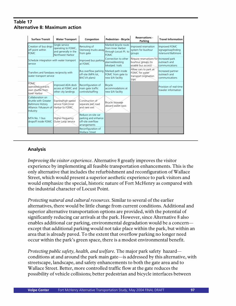
Table 17 Alternative 8: Maximum action
Surface Transit Water Transport Congestion Pedestrian - BicycleReservations -
ParkingTravel Information
Creation of bus drop-off point within FOMC
Single service operating to FOMC, and generally in the Northwest Harbor
Rerouting of Steinweg trucks away from gate
Marked bicycle route from Inner Harbor through Locust Pt. to FOMC
Improved reservation system for bus/tour groups
Improved FOMC signage/wayfinding in/around Baltimore
Improved bus parking at FOMC
Connection to other planned/existing bike/ped. trails
Require reservations for bus/tour groups (to enable bus access)
Increased park outreach and communications
Bus overflow parking off-site (MPA lot, BACVA plans)
Marked path inside FOMC from gate to new E/A facility
Allow cars to park at FOMC for water transport origination trips
Increased partner outreach and communications
FOMC operates/contracts own shuttle from Inner Harbor
Improved ADA dock access at FOMC and other city landings
Reconfiguration of main gate traffic controls/staffing
Bicycle accommodations at new E/A facility
Provision of real-time traveler information
Collaboration on shuttle with Greater Baltimore History Alliance / Museum of Industry
Express/high-speed service from Inner Harbor to FOMC
Construction of separate exit road and new exit
Bicycle stowage aboard water taxis
MTA No. 1 bus dropoff inside FOMC
Higher-frequency Outer Loop service
Reduce on-site car parking and enhance off-site overflow arrangements
Reconfiguration of Wallace Street
Schedule integration with water transport service
Transfers and fare/pass reciprocity with water transport service
Analysis Improving the visitor experience. Alternative 8 greatly improves the visitor experience by implementing all feasible transportation enhancements. This is the only alternative that includes the refurbishment and reconfiguration of Wallace Street, which would present a superior aesthetic experience to park visitors and would emphasize the special, historic nature of Fort McHenry as compared with the industrial character of Locust Point. Protecting natural and cultural resources. Similar to several of the earlier alternatives, there would be little change from current conditions. Additional and superior alternative transportation options are provided, with the potential of significantly reducing car arrivals at the park. However, since Alternative 8 also enables additional car parking, environmental degradation would be a concern—except that additional parking would not take place within the park, but within an area that is already paved. To the extent that overflow parking no longer need occur within the park’s green space, there is a modest environmental benefit. Protecting public safety, health, and welfare. The major park safety hazard—conditions at and around the park main gate—is addressed by this alternative, with streetscape, landscape, and safety enhancements to both the gate area and to Wallace Street. Better, more controlled traffic flow at the gate reduces the possibility of vehicle collisions; better pedestrian and bicycle interfaces between
Volpe Center Fort McHenry Alternative Transportation Study, May 2004 FINAL DRAFT 97
Fort Avenue and the gate increase pedestrian and bicycle safety. The reconfiguration of Wallace Street is an additional safety benefit. Steinweg trucks are also rerouted to other MPA access routes, removing them as a safety hazard. Providing other advantages to NPS. This alternative relies on strong stakeholder partnerships, as both the park and its stakeholders would commit to an ambitious, high-cost program of transportation improvements. Managing the stakeholder relationships—and ensuring that leadership is allocated appropriately during various tasks to both the park and to stakeholders—is likely to be a bigger challenge than in any of the other alternatives, but the potential reward (completion of all transportation enhancements) is the largest. Stakeholders themselves would derive major benefits from this alternative, as many of the transportation elements could be implemented to their full potential, given available investment. Cost, time, difficulty of implementation. Alternative 8 is the most expensive of the transportation alternatives. Depending on the quality desired for many of the improvements, the costs could vary considerably, but, given the cost of Alternative 7, and the cost (described in Chapter 5 and in more detail in Appendix D) of reconfiguring Wallace Street, a feasible minimum, excluding the cost of a cooperative visitor shuttle, is $1 million—divided between the park and external stakeholders. This cost also excludes the variable costs of additional signage outside the park, traveler information systems, and improved park and stakeholder outreach (all of which can be undertaken at a level commensurate with available funding). As explained under Alternative 6, the costs associated with a cooperative visitor shuttle could be considerable; vehicle purchase costs, which could be borne by Fort McHenry as a valid way for the park to participate, would not be known until the conclusion of the necessary pre-implementation planning. Evaluation against education/administration center concepts. Alternative 8 correlates with DCP/EA Concepts B, C, and D, which all call for the same transportation infrastructure measures—the accessible dock, the bus drop-off facility, and internal bicycle lanes and accommodations. If Concepts B, C, or D are implemented, therefore, all of the internal improvements specified in Alternative 8 will be implemented. If DCP/EA Concept A is implemented—that is to say, if no action is taken regarding a new education/administration center—Alternative 8 could still be implemented separately, following the completion of final compliance activities and documentation. Advantages/disadvantages of this alternative. Alternative 8 represents the maximum level of both park and stakeholder investment. Both the park and stakeholders would assume significant leadership roles and would be responsible for closely coordinating all activities. Stakeholder partnerships are essential to this alternative’s success. Alternative 8 is the most difficult and ambitious of the alternatives—but enables the greatest possible improvements.
Volpe Center Fort McHenry Alternative Transportation Study, May 2004 FINAL DRAFT 98
Chapter 7: Action Items for Implementation Although this study does not identify a preferred AT alternative for implementation, the study team has identified a number of related and supporting items suitable for immediate action by Fort McHenry. The action items presented in this chapter are intended to lay the groundwork for eventual selection and implementation of one (or more) of the transportation alternatives presented in Chapter 6. None of the activities require specific funding, and most do not have associated milestones—but all require time and commitment from Fort McHenry staff. Almost all of the items identified in this chapter encourage partnerships with the external stakeholders discussed in Chapter 4. Of course, Fort McHenry should continue all of its ongoing stakeholder partnerships and stakeholder conversations, so that the park is kept apprised of all relevant transportation development activities in the Baltimore area. The following are the important near-term action items for the park:
1. Pursue additional ATP funding and determine AT implementation requirements.
2. Discuss demonstration transit service with MTA. 3. Explore implementation of real-time traveler-information systems. 4. Begin talks with GBHA and MI about visitor transit system. 5. Begin talks with MPA about overflow parking area. 6. Facilitate discussions between MPA and Steinweg regarding trucks on Fort
Avenue. 7. Reconcile data collection methods and collect additional data. 8. Discuss improvements to area outside main gate. 9. Continue discussions regarding dock accessibility improvements and
consolidation of water transportation services. Importantly, these items have been formulated such that they can be pursued either together with the new education/administration center, or separate from it. That is, Fort McHenry may wish to move separately on AT if appropriate funding becomes available more quickly than for the education/administration center project. 1. Pursue additional ATP funding and determine AT implementation requirements. Fort McHenry should maintain the option of pursuing AT implementation either together with or separate from the related DCP effort to expand or replace the park’s education/administration center. If the two activities are executed simultaneously, AT implementation will be covered by the DCP compliance and documentation requirements, as the two projects would be considered as a single
Volpe Center Fort McHenry Alternative Transportation Study, May 2004 FINAL DRAFT 99
project. However, if AT implementation is to occur separately (for any number of reasons—for example, if follow-on DCP funding is delayed), the park needs to be sure of what compliance actions and documentation would be required in order to proceed. Either way, Fort McHenry should pursue additional ATP funding, in the event that AT implementation will be done independently. Such funding requests should be coordinated with the Northeast Region Office—several PMIS funding proposals for FY05 and FY06 have already been submitted. Roles and responsibilities. Fort McHenry staff should remain in close communication with the Northeast Region Office regarding the status and eligibility of ATP funding requests. DCP project team members should provide input on remaining documentation/compliance requirements related to AT implementation as part of the education/administration center project. Timeline. This item should be pursued immediately; conversations should be ongoing. ATP funding availability depends on a variety of factors and the funding timeline cannot be guaranteed at this time. Implications. If AT is to be implemented along with the education/administration center project, none of the alternatives presented in Chapter 6, in exactly that form, may be implemented, since elements may need to be somewhat modified depending on how the project design and compliance evolve. Contrariwise, if AT is to be implemented independently, allowance should be made for the ultimate execution of the education/administration center expansion or replacement. 2. Discuss demonstration transit service with MTA. As discussed earlier in this report, MTA has indicated its willingness to begin a demonstration transit service to Fort McHenry, extending its No. 1 bus line within the park. Fort McHenry staff should discuss this opportunity in more detail with MTA and should obtain specific terms under which demonstration service is to be provided—route frequency, daily and weekly schedule, weekend service, buses laying over within park grounds, exact pick-up and drop-off locations, promotions, and possible bus fare/park fee discount packages. Other logistical, administrative, liability, and legal concerns should be discussed. Most importantly, the park should clarify how long MTA is willing to continue the service, what conditions (low ridership, safety incident, etc.) would force its termination, and what conditions (high ridership, visitor satisfaction, etc.) could lay the groundwork for discussions to make the demonstration service permanent. Fort McHenry and MTA should also discuss how to better collect data on how many No. 1 passengers visit the park. Roles and responsibilities. Fort McHenry should initiate discussions with the MTA contacts identified by the AT study team. Timeline. This item should be pursued immediately. Demonstration transit service, if agreement can be reached with the MTA, could begin in the near future. In order
Volpe Center Fort McHenry Alternative Transportation Study, May 2004 FINAL DRAFT 100
to maximize the service’s potential, though, Fort McHenry will want to spend some time promoting the service, and will want to launch it during the warmer peak months—the 2005 season, perhaps. Implications. No major implications. Fort McHenry may need to make some minor accommodations (pavement alterations, striping or painting, signage) to get the demonstration service started. 3. Explore implementation of real-time traveler-information systems. Fort McHenry should begin discussions with relevant agencies, including Baltimore DOT and MDOT, regarding implementation of real-time traveler information systems. The following important coordination questions need to be addressed:
Who would purchase necessary hardware? Who would operate and maintain it?
Where would it be located (city streets? I-95?), and how would it be powered?
How would messages be transmitted, and what messages (decided upon by whom?) would be transmitted?
To what extent could Fort McHenry use equipment and communications protocols already in place and overseen by Baltimore DOT, MDOT, or other agencies?
The Sandy Hook unit of Gateway National Recreation Area, or the Volpe Center team that designed and implemented a traveler-information system at Sandy Hook, might be useful to contact regarding what questions need to be asked and how the discussion needs to be structured in order to lay the path to implementation. Roles and responsibilities. Fort McHenry should initiate discussions with Baltimore DOT and MDOT, and should follow up with Sandy Hook contacts. Timeline. This item should be pursued immediately. Traveler-information systems equipment can be purchased as soon as there is a confluence of a willingness to pay and funds available. The first components of a system could be in place by the 2005 season. Implications. No major implications. ATP funding, or other funding, may need to be available if Fort McHenry is to purchase or install hardware. 4. Begin talks with GBHA and MI about visitor transit system. The Greater Baltimore History Alliance and the Museum of Industry have both expressed interest in running their own visitor transit systems, and in partnering with Fort McHenry to do so. The park should lead and facilitate a three-way discussion—including other institutions that may be interested in participating—to
Volpe Center Fort McHenry Alternative Transportation Study, May 2004 FINAL DRAFT 101
determine how all parties can work together most effectively, and how a coordinated visitor transit system could be efficiently funded. (Chapter 5 explains how a comprehensive system could operate.) Roles and responsibilities. Fort McHenry should contact GBHA and MI and propose formal three-way discussions to coordinate a new visitor transportation system. Simultaneously, the park should determine precisely what financial resources it has available to commit to such a project, or whether additional ATP funds would be required to do so (keeping in mind ATP funding eligibility requirements—especially the possible exclusion of AT operations, as at the time this report was written—in force at the time any funding requests are submitted). If Fort McHenry is unable to commit financial resources to such a service, perhaps some other role can be identified, such as that of continuing facilitator, or lead partnership coordinator. Timeline. This item should be pursued immediately; GBHA and MI indicated their short-term interest in starting such a service. The first components of a system could be in place by the 2005 season, or even earlier—whether park funds are available to contribute or not. Either way, Fort McHenry should lay out what its involvement will be in the short, medium, and long terms. Implications. Funding is a major issue with regard to this item, and will determine exactly how and to what extent Fort McHenry can participate in a cooperative agreement. Whether the park pursues AT implementation together with the education/administration center project or not, this item would need to be funded separately, as it is in either case probably ineligible for the funds that would be made available for education/administration center expansion or replacement. 5. Begin talks with MPA about overflow parking area. Although MPA’s formal position is that its parking lot outside Fort McHenry will be retained for use by longshoremen, the possibility does exist to discuss a creative solution that could accommodate the needs of both MPA and Fort McHenry. Roles and responsibilities. Fort McHenry should continue discussions with MPA begun during this study, and should remain updated as to the North Locust Point Marine Terminal master planning process. In addition, Fort McHenry staff should review eligibility criteria for various park funding programs, to determine how and under what circumstances it would be possible to pursue NPS money for improvements to the MPA lot. It is possible that the cost of any improvements or construction would need to be borne by MPA, another agency, or by a private contractor under agreement with MPA, and that any use by Fort McHenry visitors of the lot would be through contract or written agreement. For instance, if MPA decided to permit development of part or all of its lot as a privately operated parking facility, it might be available to Fort McHenry visitors—and to the public—at a market rate; MPA could ensure permanent reduced-rate or free access to its longshoremen as part of its development contract. Fort McHenry staff
Volpe Center Fort McHenry Alternative Transportation Study, May 2004 FINAL DRAFT 102
should stimulate conversation with MPA along these and other creative lines, because both an innovative site plan and an innovative management arrangement might be necessary if anything is to happen. Timeline. Discussions should be ongoing. It is unlikely that any resolution would take place in the short term, but medium-term prospects are promising, depending on MPA parking and security needs, on the funding available to pursue any improvements, and on the interest displayed by other agencies and/or private developers that might serve as critical stakeholders. Implications. As mentioned above, funding—who will be able to pay for improvements to the MPA lot—is critical. A crucial first step is to discuss the cost and scope of any potential improvements; from that discussion can be drawn possible management/contractual arrangements, based on funding eligibility (at this point, for instance, an additional stakeholder—perhaps a private parking operator—may need to be involved). If Fort McHenry can assure additional overflow parking for park visitors, the size of its own parking area becomes less important, and there would be greater flexibility to, for instance, pursue an education/administration center alternative that significantly shrinks the existing parking area. Along with parking in the MPA lot, however, Fort McHenry may need to consider a shuttle service to transport visitors from that lot to the park visitor center. 6. Facilitate discussions between MPA and Steinweg regarding trucks on Fort Avenue. As discussed in Chapters 4 and 5, Steinweg truck traffic poses both a safety hazard and an interpretive/aesthetic obstacle to park visitors. Steinweg is amenable to rerouting its trucks along the alternate MPA access way, if a mutually acceptable agreement can be negotiated. Roles and responsibilities. Again, Fort McHenry can serve to facilitate discussions between MPA and Steinweg. There is a history of discussion on this topic that has not produced a solution—nonetheless, because the issue can now be discussed in terms of overall transportation improvements to Fort Avenue, the streetscape outside the park main gate, and Fort McHenry generally, perhaps attitudes may shift, especially if Fort McHenry takes a leadership role in pursuing discussions and demonstrates that it is committed to some or many of the other transportation improvements presented in this report. Due to the sensitive nature of this topic, however, Fort McHenry’s role, even in facilitating discussions, may be limited, and resolution of this issue may not yet be possible. Timeline. Discussions should be ongoing. It is unlikely that any resolution would take place in the short term; indeed, discussions would seem to have the greatest chance at being productive in the absence of external deadline pressures. As noted above, however, if Fort McHenry can facilitate these discussions in the context of
Volpe Center Fort McHenry Alternative Transportation Study, May 2004 FINAL DRAFT 103

implementing its own transportation improvements, that may also contribute to such discussions’ utility. Implications. Alteration of the traffic flow outside the park main gate would have significant implications on any streetscape enhancements in that area (see no. 9, below), as well as on the creation of bicycle and pedestrian linkages to Federal Hill and the Inner Harbor. Also, there are major implications for both MPA and Steinweg, including logistics, security, finances, and legal matters. 7. Reconcile data collection methods and collect additional data. The transportation and visitor data presented in Chapters 2 and 3 are drawn from several sources—the park’s own Monthly Use Report, data from the Denver Service Center, handwritten data sheets provided by park staff, and anecdotal information. These data, in many cases, are inconsistent. The automobile, pedestrian, and visitor-center door counters in use at the park seem also to produce inconsistent or unreliable data—it is not unusual, as mentioned earlier, for the automobile counter to be “fogged over” and unreadable. In order that a single, consistent, reliable flow of data can be provided for tracking and analysis, it is important that Fort McHenry formalize and reconcile its data collection methods. Without reliable data, it will be a difficult and possibly subjective undertaking to measure the success of any transportation measures implemented. Also, new data—such as a study of visitor origins, which would enable the more precise prediction of demand for AT services—could be collected, in accordance with future plans for visitor surveys as per NPS procedures. Roles and responsibilities. Fort McHenry should conduct an internal review—assisted by the data staff at the Denver Service Center—of its data-collection procedures to ensure that they are consistent, reliable, and non-duplicative. The goal is to itemize what data are to be collected and to match those data with collection methods. The AT analysis indicates the following:
Data to be collected Collection method Number of automobiles New vehicle counter that can
distinguish between cars and buses Number of automobile passengers
Revise vehicle multiplier; conduct new study
Number of buses New vehicle counter that can distinguish between cars and buses No. 1 buses (if entering park)—monitor schedule Tour/school buses—track via reservation system; for unscheduled buses, subtract all buses accounted for from total bus figure Visitor shuttles (e.g., GBHA/MI)—monitor schedule
Volpe Center Fort McHenry Alternative Transportation Study, May 2004 FINAL DRAFT 104
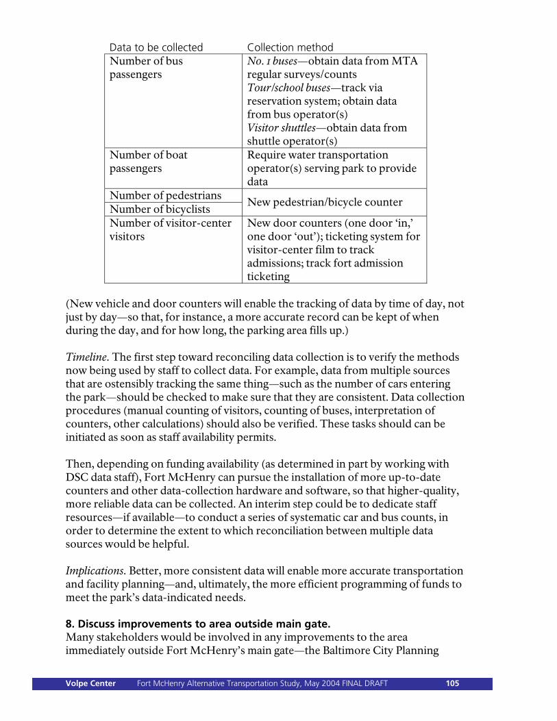
Data to be collected Collection method Number of bus passengers
No. 1 buses—obtain data from MTA regular surveys/counts Tour/school buses—track via reservation system; obtain data from bus operator(s) Visitor shuttles—obtain data from shuttle operator(s)
Number of boat passengers
Require water transportation operator(s) serving park to provide data
Number of pedestrians Number of bicyclists
New pedestrian/bicycle counter
Number of visitor-center visitors
New door counters (one door ‘in,’ one door ‘out’); ticketing system for visitor-center film to track admissions; track fort admission ticketing
(New vehicle and door counters will enable the tracking of data by time of day, not just by day—so that, for instance, a more accurate record can be kept of when during the day, and for how long, the parking area fills up.) Timeline. The first step toward reconciling data collection is to verify the methods now being used by staff to collect data. For example, data from multiple sources that are ostensibly tracking the same thing—such as the number of cars entering the park—should be checked to make sure that they are consistent. Data collection procedures (manual counting of visitors, counting of buses, interpretation of counters, other calculations) should also be verified. These tasks should can be initiated as soon as staff availability permits. Then, depending on funding availability (as determined in part by working with DSC data staff), Fort McHenry can pursue the installation of more up-to-date counters and other data-collection hardware and software, so that higher-quality, more reliable data can be collected. An interim step could be to dedicate staff resources—if available—to conduct a series of systematic car and bus counts, in order to determine the extent to which reconciliation between multiple data sources would be helpful. Implications. Better, more consistent data will enable more accurate transportation and facility planning—and, ultimately, the more efficient programming of funds to meet the park’s data-indicated needs. 8. Discuss improvements to area outside main gate. Many stakeholders would be involved in any improvements to the area immediately outside Fort McHenry’s main gate—the Baltimore City Planning
Volpe Center Fort McHenry Alternative Transportation Study, May 2004 FINAL DRAFT 105
Department, Baltimore DOT, MPA, USNR, and Steinweg. The AT study team could not definitively ascertain ownership of the various parcels in that immediate area; doing so would perhaps be the first step in any discussion regarding streetscape enhancements or reconfiguration. Fort McHenry may be able to serve as an honest broker and facilitator in the multi-agency discussions that would be necessary if improvements are to be made. Roles and responsibilities. Clarifying the roles and responsibilities of the various agencies involved would be a critical first step; Fort McHenry, by facilitating the discussion, could initiate this process of identification. Timeline. Discussions can begin when convenient. Actual improvements to the area would probably be at least in the medium term and would depend on stakeholder responsibility and funding availability. The conceptual renderings provided in this study—which appear in Chapter 5, as well as the report appendices, can be a useful starting point for reference. Implications. The immediate benefit of streetscape improvements outside Fort McHenry would be an enhanced aesthetic experience for park visitors. A safety benefit would also result, but this benefit would be difficult to quantify, given the absence of accident data (mostly, an anecdotal reference to many “near misses”). Fort McHenry may need to secure the participation of other stakeholders by underlying how improving the park visitor experience would result in improved perception of Baltimore generally. More broadly, streetscape improvements could result in increased visitation by pedestrians and bicyclists, particularly if the Locust Point residential population continues to increase, and if Fort McHenry is linked to the Inner Harbor and to regional trails by a marked bicycle route. Also, streetscape improvements tie in with the possibility of removing Steinweg truck traffic from the park gate area (see no. 6, above). 9. Continue discussions regarding dock accessibility improvements and consolidation of water transportation services. Fort McHenry should continue discussions with Baltimore City regarding accessibility improvements to the city-owned dock attached to the park seawall, as well as on the topic of consolidated harbor transportation. As regards the dock, funding eligibility and availability are major concerns. Harbor water transport operator(s) should also be part of these discussions, as demand for their services, and the boat types they use, will determine what accessibility accommodations are required. (New Coast Guard regulations or certifications required after the March 2004 Seaport Taxi capsizing may force a change in what kinds of boats are permitted to travel to Fort McHenry.) The proposed consolidation of harbor-taxi contracts could also have an effect on how the dock is used, and on the potential number of visitors to the park arriving by water. Roles and responsibilities. Fort McHenry and Baltimore City both have responsibility for the dock—the city, as its owner and operator, for keeping it up;
Volpe Center Fort McHenry Alternative Transportation Study, May 2004 FINAL DRAFT 106
the park for monitoring the flow of visitors arriving there. Harbor taxi operators serving the dock also have responsibilities, dictated both by their operating contract with the city and by their security and other obligations relating to the park’s requirements. It is appropriate, however, that Fort McHenry take the lead in facilitating discussions on accessibility improvements, on the long-term future of the dock, and on short-term contractual changes pertaining to harbor taxi service. Depending on how Baltimore City structures its harbor taxi contract(s), harbor taxi operators may be given additional responsibilities relating to the Fort McHenry dock and other city docks. Timeline. Discussions should be ongoing. Depending on funding responsibility, project eligibility, and funding availability, dock improvements can be constructed in a relatively short time frame. Implications. Any improvements to the dock, and any improvements to harbor taxi service, have the potential to increase—perhaps significantly—the number of park visitors arriving at Fort McHenry by water (as discussed in Chapter 3). To the extent that such visitation increases, Fort McHenry may want to ensure that any education/administration center improvement or replacement project (or any other projects) fully take account of this fact, perhaps by orienting facilities or signage equally toward the dock as toward the parking area. Also, if the visitation mode share changes, Fort McHenry may be relieved of the need to provide additional car parking.
Volpe Center Fort McHenry Alternative Transportation Study, May 2004 FINAL DRAFT 107

Volpe Center Fort McHenry Alternative Transportation Study, May 2004 FINAL DRAFT 108
As the nation’s principal conservation agency, the Department of the Interior has the responsibility for most of our nationally owned public lands and natural resources. This includes fostering sound use of our land and water resources; protecting our fish, wildlife, and biological diversity; preserving the environmental and cultural values of our parks and historic places; and providing for the enjoyment of life through outdoor recreation. The department assesses our energy and mineral resources and works to ensure that their development is in the best interests of all our people by encouraging stewardship and citizen participation in their care. The department also has a major responsibility for American Indian reservation communities and for people who live in island territories under U.S. administration. NPS D-60 / June 2004