Formation of Hrad Vallis (Mars) by low viscosity lava … of Hrad Vallis (Mars) by low viscosity...
18
Formation of Hrad Vallis (Mars) by low viscosity lava flows Joshua P. Hopper, David W. Leverington ⁎ Department of Geosciences, Texas Tech University, Lubbock, TX 79409, USA abstract article info Article history: Received 6 July 2013 Received in revised form 26 October 2013 Accepted 28 October 2013 Available online xxxx Keywords: Mars Outflow channels Volcanism Lava Hrad Vallis is a Martian outflow channel previously interpreted as a product of aqueous outbursts from the sub- surface, possibly involving mudflows associated with lahar-like events. However, an alternative volcanic hypoth- esis for the development of the system is worthy of consideration on the basis of (1) the nature of landforms preserved along component channels and adjacent uplands and (2) similarities between the basic properties of this system and large volcanic channels of the inner solar system. Hrad Vallis commences on the distal flanks of the Elysium Mons shield volcano, terminates within extensive volcanic plains, is associated with landforms typical of large volcanic channels, and shows evidence for having been a conduit for large volumes of lava. The properties of this system are consistent with incision by low viscosity lava. Crude thermal estimates suggest that this system could have formed through effusion of as little as ~10,900 km 3 of magma to the surface, or ~6% of the volume of the terrestrial Columbia River Basalt Group. Incision rates of up to several meters per day are estimated for mechanical and thermal processes involving lava flows with depths of 5–20 m and dynam- ic viscosities of ~1 Pa s. Flow of lava within the Hrad Vallis system is predicted to have been fully turbulent and characterized by discharges as great as ~865,000 m 3 /s. Predicted flow conditions are consistent with those pre- viously determined for Athabasca Valles, which also formed as a result of the expulsion of flows from structures associated with Elysium Mons. © 2013 Elsevier B.V. All rights reserved. 1. Introduction The outflow channels of Mars predominantly originate at discrete sources marking the sites of voluminous effusion of fluids from the sub- surface (McCauley et al., 1972; Masursky, 1973; Milton, 1973; Carr, 1974). The presence of anastamosing reaches, streamlined erosional re- siduals, and other scabland-like landforms along these systems has contributed to their widespread interpretation as the products of cata- strophic aqueous floods (Milton, 1973; Baker and Milton, 1974; Carr, 1974; Masursky et al., 1977; Mars Channel Working Group, 1983). These floods are widely believed to have been generated by outbursts to the surface from enormous aquifers (e.g., Carr, 1979, 1996; Baker et al., 1991; Clifford and Parker, 2001; Andrews-Hanna and Phillips, 2007; Wilson et al., 2009; Rodriguez et al., 2012; Morgan et al., 2013), possibly augmented or even dominated by the flow of associated mud- flows or glaciers (e.g., Wilson and Mouginis-Mark, 2003; Tanaka et al., 2005; Chapman et al., 2010). Outflow channel origins are relevant to our understanding of past surface conditions and near-surface volatile contents on Mars (e.g., Carr, 1996; Head et al., 2001; Carr and Head, 2010). Outflow ori- gins are correspondingly also relevant to basic questions regarding past prospects for development of life on Mars (e.g., Masursky et al., 1979; McKay and Stoker, 1989; Komatsu and Ori, 2000; Levy and Head, 2005) and the potential for future colonization of the planet (e.g., Risner, 1989; Graham, 2004). Importantly, recent investigations of Martian outflow systems have suggested that associated lava flows may have had substantial capacity for channel incision (e.g., Hurwitz et al., 2010; Jaeger et al., 2010; Hurwitz and Head, 2012). As a result, a need exists to revisit previous aqueous interpretations of the outflow channels of Mars and to consider alternative channel origins involving predominantly volcanic processes. Indeed, geomorphological, mineral- ogical, and geochemical considerations collectively suggest the past de- velopment of some or all Martian outflow channels through incision by voluminous low-viscosity lava flows (Leverington, 2004, 2007, 2009, 2011, 2012), a mechanism believed to have been responsible for devel- opment of similar but generally smaller outflow systems on the Moon, Venus, and Mercury (e.g., Greeley, 1971; Wilhelms, 1987; Baker et al., 1992; Komatsu et al., 1993; Head et al., 2011; Hurwitz et al., 2012, 2013; Byrne et al., 2013). In order to further explore the viability of volcanic hypotheses for development of the outflow channels of Mars, this study considered the consistency of Hrad Vallis landforms with hypothesized volcanic or- igins and used the morphological attributes of this system as a basis for quantitative determination of the flow conditions that might have driv- en channel incision by lava. Elevation data used in this study were col- lected by the Mars Orbiter Laser Altimeter (MOLA) instrument on board Mars Global Surveyor (Smith et al., 2003a,b). Mars image data were collected by the Thermal Emission Imaging System (THEMIS) in- strument on board Mars Odyssey (Christensen et al., 2004), the High Resolution Imaging Science Experiment (HiRISE) instrument on board the Mars Reconnaissance Orbiter (McEwen et al., 2007a,b), and the Geomorphology xxx (2013) xxx–xxx ⁎ Corresponding author. Tel.: +1 806 834 5310. E-mail address: [email protected] (D.W. Leverington). GEOMOR-04548; No of Pages 18 0169-555X/$ – see front matter © 2013 Elsevier B.V. All rights reserved. http://dx.doi.org/10.1016/j.geomorph.2013.10.029 Contents lists available at ScienceDirect Geomorphology journal homepage: www.elsevier.com/locate/geomorph Please cite this article as: Hopper, J.P., Leverington, D.W., Formation of Hrad Vallis (Mars) by low viscosity lava flows, Geomorphology (2013), http://dx.doi.org/10.1016/j.geomorph.2013.10.029
Transcript of Formation of Hrad Vallis (Mars) by low viscosity lava … of Hrad Vallis (Mars) by low viscosity...
Geomorphology xxx (2013) xxx–xxx
GEOMOR-04548; No of Pages 18
Contents lists available at ScienceDirect
Geomorphology
j ourna l homepage: www.e lsev ie r .com/ locate /geomorph
Formation of Hrad Vallis (Mars) by low viscosity lava flows
Joshua P. Hopper, David W. Leverington ⁎Department of Geosciences, Texas Tech University, Lubbock, TX 79409, USA
⁎ Corresponding author. Tel.: +1 806 834 5310.E-mail address: [email protected] (D.W. Leve
0169-555X/$ – see front matter © 2013 Elsevier B.V. All rhttp://dx.doi.org/10.1016/j.geomorph.2013.10.029
Please cite this article as: Hopper, J.P., Leverhttp://dx.doi.org/10.1016/j.geomorph.2013.1
a b s t r a c t
a r t i c l e i n f oArticle history:Received 6 July 2013Received in revised form 26 October 2013Accepted 28 October 2013Available online xxxx
Keywords:MarsOutflow channelsVolcanismLava
Hrad Vallis is a Martian outflow channel previously interpreted as a product of aqueous outbursts from the sub-surface, possibly involvingmudflows associatedwith lahar-like events. However, an alternative volcanic hypoth-esis for the development of the system is worthy of consideration on the basis of (1) the nature of landformspreserved along component channels and adjacent uplands and (2) similarities between the basic propertiesof this system and large volcanic channels of the inner solar system. Hrad Vallis commences on the distal flanksof the Elysium Mons shield volcano, terminates within extensive volcanic plains, is associated with landformstypical of large volcanic channels, and shows evidence for having been a conduit for large volumes of lava. Theproperties of this system are consistent with incision by low viscosity lava. Crude thermal estimates suggestthat this system could have formed through effusion of as little as ~10,900 km3 of magma to the surface,or ~6% of the volume of the terrestrial Columbia River Basalt Group. Incision rates of up to several meters perday are estimated formechanical and thermal processes involving lavaflowswith depths of 5–20 m and dynam-ic viscosities of ~1 Pa s. Flow of lava within the Hrad Vallis system is predicted to have been fully turbulent andcharacterized by discharges as great as ~865,000 m3/s. Predicted flow conditions are consistent with those pre-viously determined for Athabasca Valles, which also formed as a result of the expulsion of flows from structuresassociated with Elysium Mons.
© 2013 Elsevier B.V. All rights reserved.
1. Introduction
The outflow channels of Mars predominantly originate at discretesources marking the sites of voluminous effusion of fluids from the sub-surface (McCauley et al., 1972; Masursky, 1973; Milton, 1973; Carr,1974). The presence of anastamosing reaches, streamlined erosional re-siduals, and other scabland-like landforms along these systems hascontributed to their widespread interpretation as the products of cata-strophic aqueous floods (Milton, 1973; Baker and Milton, 1974; Carr,1974; Masursky et al., 1977; Mars Channel Working Group, 1983).These floods are widely believed to have been generated by outburststo the surface from enormous aquifers (e.g., Carr, 1979, 1996; Bakeret al., 1991; Clifford and Parker, 2001; Andrews-Hanna and Phillips,2007; Wilson et al., 2009; Rodriguez et al., 2012; Morgan et al., 2013),possibly augmented or even dominated by the flow of associated mud-flows or glaciers (e.g., Wilson and Mouginis-Mark, 2003; Tanaka et al.,2005; Chapman et al., 2010).
Outflow channel origins are relevant to our understanding ofpast surface conditions and near-surface volatile contents on Mars(e.g., Carr, 1996; Head et al., 2001; Carr and Head, 2010). Outflow ori-gins are correspondingly also relevant to basic questions regardingpast prospects for development of life on Mars (e.g., Masursky et al.,1979; McKay and Stoker, 1989; Komatsu and Ori, 2000; Levy andHead, 2005) and the potential for future colonization of the planet
rington).
ights reserved.
ington, D.W., Formation of Hr0.029
(e.g., Risner, 1989; Graham, 2004). Importantly, recent investigationsof Martian outflow systems have suggested that associated lava flowsmay have had substantial capacity for channel incision (e.g., Hurwitzet al., 2010; Jaeger et al., 2010; Hurwitz and Head, 2012). As a result, aneed exists to revisit previous aqueous interpretations of the outflowchannels of Mars and to consider alternative channel origins involvingpredominantly volcanic processes. Indeed, geomorphological, mineral-ogical, and geochemical considerations collectively suggest the past de-velopment of some or all Martian outflow channels through incision byvoluminous low-viscosity lava flows (Leverington, 2004, 2007, 2009,2011, 2012), a mechanism believed to have been responsible for devel-opment of similar but generally smaller outflow systems on the Moon,Venus, and Mercury (e.g., Greeley, 1971; Wilhelms, 1987; Baker et al.,1992; Komatsu et al., 1993; Head et al., 2011; Hurwitz et al., 2012,2013; Byrne et al., 2013).
In order to further explore the viability of volcanic hypotheses fordevelopment of the outflow channels of Mars, this study consideredthe consistency of Hrad Vallis landformswith hypothesized volcanic or-igins and used the morphological attributes of this system as a basis forquantitative determination of the flow conditions that might have driv-en channel incision by lava. Elevation data used in this study were col-lected by the Mars Orbiter Laser Altimeter (MOLA) instrument onboard Mars Global Surveyor (Smith et al., 2003a,b). Mars image datawere collected by the Thermal Emission Imaging System (THEMIS) in-strument on board Mars Odyssey (Christensen et al., 2004), the HighResolution Imaging Science Experiment (HiRISE) instrument on boardthe Mars Reconnaissance Orbiter (McEwen et al., 2007a,b), and the
ad Vallis (Mars) by low viscosity lava flows, Geomorphology (2013),

Fig. 1. (A) Map of shaded topography for the Hrad Vallis region. The channel system commences on the distal flanks of Elysium Mons, in the vicinity of several elongate depressions(themain channel commences at d) that are oriented approximately radially to the central caldera of this shield volcano. The Hrad Vallis system fades westward into the plains of UtopiaPlanitia. Thewhite curvemarking the path of Hrad Vallis is dashed for distal reaches less clearly associatedwith themain channel system. The Viking 2 landing site is ~32 km north of thenorthern limit of thismap. Shaded relief data derived fromMars Orbiter Laser Altimeter (MOLA) gridded data (Smith et al., 2003a). (B) Geologic map of the region depicted in A, extractedand reprojected from Tanaka et al. (2005). As in (A), themain channel of Hrad Vallis commences at d. Map units are described in Table 1. Unit contacts are dashed where approximate orinferred. Troughs and ridges are marked by black arcs with dots and barbs, respectively; arcs are dotted where features are subdued. Lobate margins are indicated by red arcs, withhachures pointing downslope. Channels are marked by blue dashed arcs. Both maps are presented in simple cylindrical projection. (For interpretation of the references to color in thisfigure legend, the reader is referred to the web version of this article.)
2 J.P. Hopper, D.W. Leverington / Geomorphology xxx (2013) xxx–xxx
Please cite this article as: Hopper, J.P., Leverington, D.W., Formation of Hrad Vallis (Mars) by low viscosity lava flows, Geomorphology (2013),http://dx.doi.org/10.1016/j.geomorph.2013.10.029

3J.P. Hopper, D.W. Leverington / Geomorphology xxx (2013) xxx–xxx
Context Camera (CTX) instrument on board the Mars ReconnaissanceOrbiter (Malin et al., 2007).
2. Geomorphology of Hrad Vallis
Though most Martian outflow channels originate in the southernhighlands, a minority of systems originate in the northern plains. Themost prominent of these northern systems are associated with theElysium volcanic province (e.g., Masursky et al., 1977; Greeley andGuest, 1987; Carr, 1996) and include Hrad Vallis, a relatively narrowoutflow system that extends northwestward from depressions locatedon the distal flanks of Elysium Mons (Figs. 1–3). The major Elysiumunits into which the Hrad Vallis system was incised are generally ofAmazonian age (e.g., Greeley and Guest, 1987; Tanaka et al., 1992;DeHon et al., 1999) and appear to have been emplaced as lava flows as-sociated with ElysiumMons volcanism and as clastic deposits accumu-lated through sedimentary or volcanic processes (e.g., Mouginis-Market al., 1984; De Hon and Mouginis-Mark, 1990; Tanaka et al., 1992,2005; Keszthelyi et al., 2010) (Fig. 1; Table 1). Mapped near-surfaceElysiumunits located in the immediate Hrad Vallis region have general-ly been interpreted as massive volcaniclastic flows of Early Amazonianage that may have been produced as a result of the interaction betweenmagma and volatiles (e.g., Christiansen and Greeley, 1981; Christiansenand Hopler, 1986; Christiansen, 1989; Tanaka et al., 1992, 2005; Russelland Head, 2003; Wilson and Mouginis-Mark, 2003).
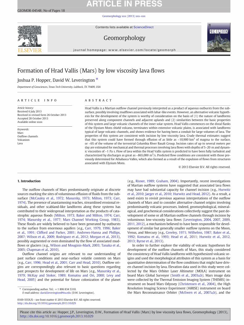
The Hrad Vallis system descends more than 800 m in elevation overthe ~1450-km longitudinal distance between its origin at topographicdepressions in Elysium and its distal reaches in Utopia Planitia (Fig. 4).Morphologically, the system is most clearly defined along its upperand middle reaches, whereas the low relief of the channel system be-yond a longitudinal distance of ~1000 km make the terminal reachesof this system more difficult to confidently identify. As is typical ofeven the largest Martian outflow channels (e.g., Leverington, 2013),the kilometer-scale longitudinal slopes of the Hrad Vallis channel are
Fig. 2.MOLA elevation data overlain on THEMIS daytime infraredmosaic of the upper reaches otopographic cross sections 1–6 are indicated by thenumbered black bars (see Fig. 6). An examplby the letter G. Selected reaches with anastamosing character and streamlined erosional resiDatabases are presented in simple cylindrical projection.
Please cite this article as: Hopper, J.P., Leverington, D.W., Formation of Hrhttp://dx.doi.org/10.1016/j.geomorph.2013.10.029
generally very low and are well below 0.5° over much of the length ofthe system (Fig. 5). The cross-sectional character of the Hrad Vallischannel varies along its length, with floor depths beneath adjacent up-lands as great as ~400 m near the start of the system, and typical floordepths of nomore than tens ofmeters in the distal parts of themain sys-tem (Fig. 6). The Hrad Vallis channel gradually fades into the plains ofUtopia Planitia, a 3300-km-wide circular basin located west and northof Elysium.
The three main depressions in the vicinity of the origin of the HradVallis system are elongate, morphologically complex, and orientednorthwest–southeast, with long axes parallel to local slopes (Fig. 7).These depressions are local components of a much larger system oflinear and arcuate depressions oriented radially and concentrically tothe peak of Elysium Mons (Fig. 1) and which appear to be the sur-face expressions of structural features formed by crustal extension(Mouginis-Mark et al., 1984; Hall et al., 1986; De Hon and Mouginis-Mark, 1990; De Hon, 1991; Tanaka et al., 1991; Carr, 1996). The threemain depressions in the vicinity of the origin of Hrad Vallis have overalldimensions as great as ~18 km inwidth and ~50 km in length. Lownar-row ridges and associated shallowdepressions are abundant in theHradVallis region (Pedersen et al., 2010); one of these features extendsacross the long axis of the small rise Galaxias Mons, running approxi-mately parallel to the nearby depressions that mark the origin of HradVallis (Fig. 7) (Chapman, 1994).
The main Hrad Vallis channel emerges with a width of ~3 km at theorigin of the system (Fig. 7, depression 3) and approximately maintainsthis width over much of the system's length. Much wider and morecomplex anastamosing channel segments are present along somereaches (selected examples are marked with an s in Figs. 2 and 3) andin most cases define prominent streamlined erosional residuals(Mouginis-Mark et al., 1984) (Figs. 8 and 9). Many such anastamosingreaches show evidence for abandonment of early channel segments infavor of trunk conduits that ultimately became more deeply incised(Mouginis-Mark et al., 1984). Some parts of the Hrad Vallis channel
f Hrad Vallis (see Fig. 1 for location). MOLA data after Smith et al. (2003a). The locations ofe of a valley thatmayhave been formed by flows expelled fromGalaxias Fossae is identifiedduals are identified by the letter s. THEMIS mosaic courtesy of Arizona State University.
ad Vallis (Mars) by low viscosity lava flows, Geomorphology (2013),
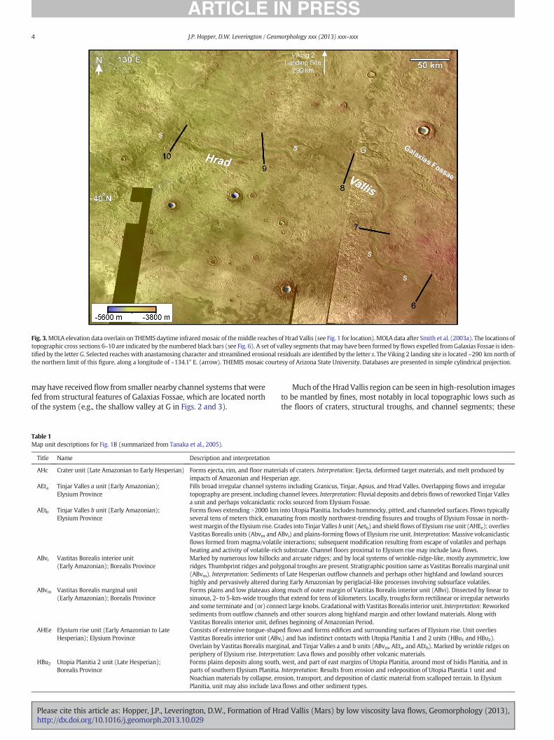
Fig. 3.MOLA elevation data overlain on THEMIS daytime infraredmosaic of themiddle reaches of Hrad Vallis (see Fig. 1 for location). MOLA data after Smith et al. (2003a). The locations oftopographic cross sections 6–10 are indicated by the numbered black bars (see Fig. 6). A set of valley segments thatmay have been formed by flows expelled fromGalaxias Fossae is iden-tified by the letter G. Selected reaches with anastamosing character and streamlined erosional residuals are identified by the letter s. The Viking 2 landing site is located ~290 km north ofthe northern limit of this figure, along a longitude of ~134.1° E. (arrow). THEMIS mosaic courtesy of Arizona State University. Databases are presented in simple cylindrical projection.
4 J.P. Hopper, D.W. Leverington / Geomorphology xxx (2013) xxx–xxx
may have received flow from smaller nearby channel systems that werefed from structural features of Galaxias Fossae, which are located northof the system (e.g., the shallow valley at G in Figs. 2 and 3).
Table 1Map unit descriptions for Fig. 1B (summarized from Tanaka et al., 2005).
Title Name Description and interpretation
AHc Crater unit (Late Amazonian to Early Hesperian) Forms ejecta, rim, and floor materimpacts of Amazonian and Hesper
AEta Tinjar Valles a unit (Early Amazonian);Elysium Province
Fills broad irregular channel systemtopography are present, includinga unit and perhaps volcaniclastic r
AEtb Tinjar Valles b unit (Early Amazonian);Elysium Province
Forms flows extending N2000 kmseveral tens of meters thick, emanwestmargin of the Elysium rise. GrVastitas Borealis units (Abvm and Aflows formed from magma/volatilheating and activity of volatile-rich
ABvi Vastitas Borealis interior unit(Early Amazonian); Borealis Province
Marked by numerous low hillocksridges. Thumbprint ridges and poly(ABvm). Interpretation: Sedimentshighly and pervasively altered dur
ABvm Vastitas Borealis marginal unit(Early Amazonian); Borealis Province
Forms plains and low plateaus alosinuous, 2- to 5-km-wide troughsand some terminate and (or) connsediments from outflow channelsVastitas Borealis interior unit, defi
AHEe Elysium rise unit (Early Amazonian to LateHesperian); Elysium Province
Consists of extensive tongue-shapVastitas Borealis interior unit (ABvOverlain by Vastitas Borealis margperiphery of Elysium rise. Interpre
HBu2 Utopia Planitia 2 unit (Late Hesperian);Borealis Province
Forms plains deposits along southparts of southern Elysium PlanitiaNoachian materials by collapse, erPlanitia, unit may also include lava
Please cite this article as: Hopper, J.P., Leverington, D.W., Formation of Hrhttp://dx.doi.org/10.1016/j.geomorph.2013.10.029
Muchof theHradVallis region can be seen in high-resolution imagesto be mantled by fines, most notably in local topographic lows such asthe floors of craters, structural troughs, and channel segments; these
ials of craters. Interpretation: Ejecta, deformed target materials, and melt produced byian age.s including Granicus, Tinjar, Apsus, and Hrad Valles. Overlapping flows and irregular
channel levees. Interpretation: Fluvial deposits and debrisflows of reworked Tinjar Vallesocks sourced from Elysium Fossae.into Utopia Planitia. Includes hummocky, pitted, and channeled surfaces. Flows typicallyating from mostly northwest-trending fissures and troughs of Elysium Fossae in north-ades into Tinjar Valles b unit (Aetb) and shield flows of Elysium rise unit (AHEe); overliesBvi) and plains-forming flows of Elysium rise unit. Interpretation: Massive volcaniclastice interactions; subsequent modification resulting from escape of volatiles and perhapssubstrate. Channel floors proximal to Elysium rise may include lava flows.and arcuate ridges; and by local systems of wrinkle-ridge-like, mostly asymmetric, lowgonal troughs are present. Stratigraphic position same as Vastitas Borealismarginal unitof Late Hesperian outflow channels and perhaps other highland and lowland sourcesing Early Amazonian by periglacial-like processes involving subsurface volatiles.ng much of outer margin of Vastitas Borealis interior unit (ABvi). Dissected by linear tothat extend for tens of kilometers. Locally, troughs form rectilinear or irregular networksect large knobs. Gradational with Vastitas Borealis interior unit. Interpretation: Reworkedand other sources along highland margin and other lowland materials. Along withnes beginning of Amazonian Period.ed flows and forms edifices and surrounding surfaces of Elysium rise. Unit overliesi) and has indistinct contacts with Utopia Planitia 1 and 2 units (HBu1 and HBu2).inal, and Tinjar Valles a and b units (ABvm, AEta, and AEtb). Marked by wrinkle ridges ontation: Lava flows and possibly other volcanic materials., west, and part of east margins of Utopia Planitia, around most of Isidis Planitia, and in. Interpretation: Results from erosion and redeposition of Utopia Planitia 1 unit andosion, transport, and deposition of clastic material from scalloped terrain. In Elysiumflows and other sediment types.
ad Vallis (Mars) by low viscosity lava flows, Geomorphology (2013),
Fig. 4. Longitudinal profile of the Hrad Vallis outflow system. Topographic data consist ofindividual MOLA shot point values available for the Hrad Vallis channel (Smith et al.,2003b); point data are not available for some channel reaches. Abrupt deviations fromthe general trend of this profile are mainly related to the presence of impact featuresincluding crater rims and ejecta blankets.
5J.P. Hopper, D.W. Leverington / Geomorphology xxx (2013) xxx–xxx
fines substantially take the form of aeolian landforms such asmegaripples (Fig. 10). In addition, the high and mid-latitudes of Mars,including the Hrad Vallis region, are discontinuously mantled bymeters-thick layered units that may be rich in dust and volatiles(e.g., Head et al., 2003a; Pedersen andHead, 2010).Measures of thermalinertia for the region (derived from the Thermal Emission Spectrometeron board the Mars Global Surveyor spacecraft) mainly fall with-in the range of ~100 to 300 J/m2 K s1/2 at a sampling resolution of1/20° × 1/20° (Putzig and Mellon, 2007) and confirm the widespreadmantling by fines here.
Despite the extensivemantling of the Hrad Vallis region by fines, thesurfaces of some channel reaches are sufficiently well exposed to revealfloor features. For example, as is typical for outflow channels on Mars(e.g., Carr, 1996), some reaches of Hrad Vallis can be seen to have floorscharacterized by the presence of longitudinal ridges (Fig. 9). Also, somechannel reaches show evidence for having acted as conduits for flowswith a ridged (festooned) and platy character (Fig. 11). The platycharacter is suggestive of the disruption of crusts that developed onthe surfaces of flows, whereas ridges suggest compression of crusts.
Uplands adjacent to themainHrad Vallis channel arewidely coveredby lobate-margined flow deposits with thicknesses of tens of meters(e.g., Morris and Mouginis-Mark, 2006). Some of these deposits are
Fig. 5. Semi-log plot of absolute kilometer-scale topographic slopes for the Hrad Vallisoutflow channel. The Hrad Vallis channel is characterized by the widespread presence ofslopes of b0.5°. Average and median slopes of the system at this scale are 0.32° and0.13°, respectively. Utilized MOLA data consist of the point data available along the HradVallis channel (after Smith et al., 2003b); point data are not available for some channelreaches.
Please cite this article as: Hopper, J.P., Leverington, D.W., Formation of Hrhttp://dx.doi.org/10.1016/j.geomorph.2013.10.029
Elysium Mons volcanic flows that are unrelated to Hrad Vallis itself(e.g., Wilson and Mouginis-Mark, 2003) (Fig. 12), but other examples(e.g., Figs. 7, 13, and 14) appear to have been emplaced as overflowunits from theHradVallis channel and from the depressions at its origin.Flows emplaced on uplands adjacent to the depressions that mark thestart of Hrad Vallis (e.g., units marked f in Fig. 7) have typical thick-nesses of ~40 m (e.g., Christiansen, 1989; Wilson and Mouginis-Mark,2003;Morris andMouginis-Mark, 2006); in places, these units are char-acterized by local pit-like features (Fig. 13) (e.g., Wilson and Mouginis-Mark, 2003; Morris and Mouginis-Mark, 2006). Downslope from thesource region of Hrad Vallis, some upland flow surfaces are character-ized by complex networks of sinuous and narrow ridges, with typicalridge widths of no more than ~40 m (Figs. 9 and 15A).
Hrad Vallis terminates in Utopia Planitia, a broad topographic de-pression that has properties consistent with formation as an impactbasin in the Noachian Period (McGill, 1989; Frey and Schultz, 1990).Aswithmuch of the northern lowlands, the topographic relief of this re-gion is subdued, reflecting the extensive weathering and burial thattook place in the Hesperian and Amazonian (Head et al., 2002). Thepast widespread occurrence of volcanism is suggested here by the cor-respondence between landformsofUtopia Planitia and those of volcanicprovinces of the inner solar system; for example, Utopia Planitia ischaracterized by the widespread presence of flow units, dike swarms,eruptive features, and mare-style wrinkle ridges (Head et al., 2002;Lanz et al., 2010). The Viking 2 landing site is located in Utopia Planitia,~200 km to the southwest of craterMie and ~400 kmnorth of the clos-est reach of Hrad Vallis. This site consists of a broad plain that is largelymantled by angular and subangular blocks of basalt, some of whichmaybe ejecta fromMie (Mutch et al., 1976).
3. Past interpretations of channel origins
The Hrad Vallis system has been interpreted in past research asan outflow system incised by water expelled from the subsurface(e.g., Masursky et al., 1977), possibly involving wet mudflows inlahar-like events (Christiansen and Greeley, 1981; Christiansen andHopler, 1986; Squyres et al., 1987; Christiansen, 1989; Head andWilson, 2002; Russell and Head, 2003; Wilson and Mouginis-Mark,2003; Tanaka et al., 2005; Morris and Mouginis-Mark, 2006). Channelfeatures considered in past work to be suggestive of aqueous origins in-clude streamlined landforms, anastamosing reaches, and channel ter-races (Mouginis-Mark et al., 1984; Mouginis-Mark, 1985; Tanakaet al., 1992; De Hon et al., 1999). These landforms, as well as the longi-tudinal ridges that exist along some channel reaches (Fig. 9), are typicalof other outflow systems onMars that have previously been interpretedas the products of aqueous processes and share properties with terres-trial scabland features known to have formed during large aqueousflood events (e.g., Baker and Milton, 1974; Mars Channel WorkingGroup, 1983; Carr, 1996; Baker, 2009).
Upland flows near the main Hrad Vallis channel (e.g., units marked fin Fig. 7) have been previously interpreted as possible lahar de-posits on the basis of their lobate margins and steep peripheralscarps (e.g., Christiansen, 1989; Wilson and Mouginis-Mark, 2003;Morris and Mouginis-Mark, 2006). Some workers have noted that thepresence of apparent subsidence pits (Fig. 13) is consistent with thepast release of volatiles from these flows, suggesting the possiblepresence of substantial amounts of water in these flows duringemplacement (e.g., Wilson and Mouginis-Mark, 2003; Morris andMouginis-Mark, 2006). The hypothesized emplacement of wet lahardeposits at Hrad Vallis has implied the past occurrence of localphreatomagmatic events involving violent interactions between shal-low igneous intrusions and volatile-rich layers (Head and Wilson,2002; Russell and Head, 2003; Wilson and Mouginis-Mark, 2003;Morris and Mouginis-Mark, 2006; Pedersen et al., 2010). Consistentwith this hypothesis, the systems of ridges and troughs in the region re-spectively have the morphological properties expected of exhumed
ad Vallis (Mars) by low viscosity lava flows, Geomorphology (2013),
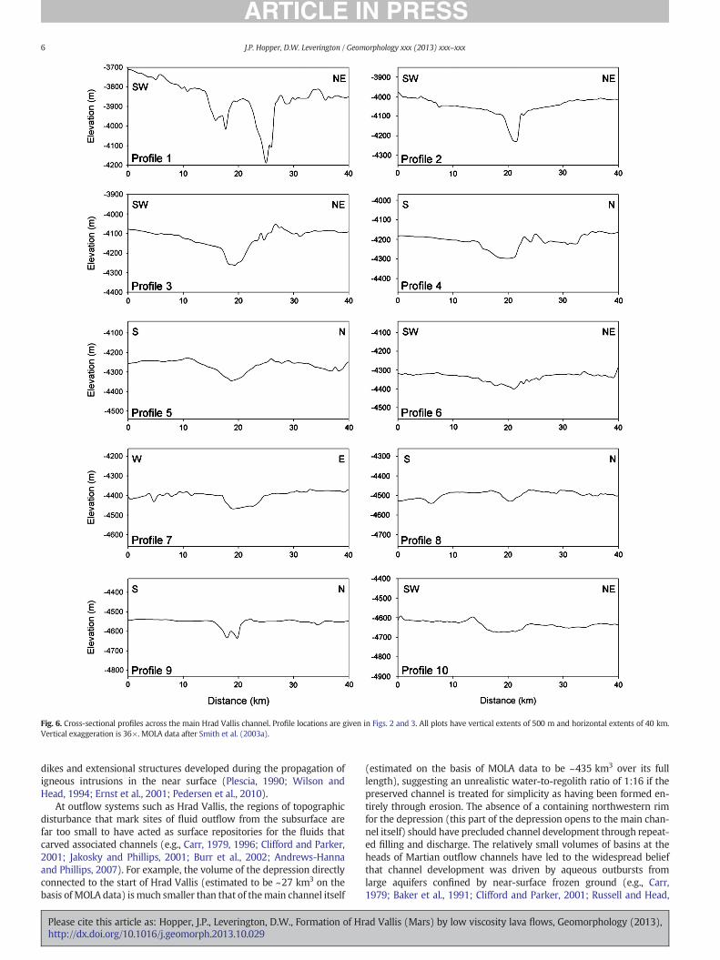
Fig. 6. Cross-sectional profiles across the main Hrad Vallis channel. Profile locations are given in Figs. 2 and 3. All plots have vertical extents of 500 m and horizontal extents of 40 km.Vertical exaggeration is 36×. MOLA data after Smith et al. (2003a).
6 J.P. Hopper, D.W. Leverington / Geomorphology xxx (2013) xxx–xxx
dikes and extensional structures developed during the propagation ofigneous intrusions in the near surface (Plescia, 1990; Wilson andHead, 1994; Ernst et al., 2001; Pedersen et al., 2010).
At outflow systems such as Hrad Vallis, the regions of topographicdisturbance that mark sites of fluid outflow from the subsurface arefar too small to have acted as surface repositories for the fluids thatcarved associated channels (e.g., Carr, 1979, 1996; Clifford and Parker,2001; Jakosky and Phillips, 2001; Burr et al., 2002; Andrews-Hannaand Phillips, 2007). For example, the volume of the depression directlyconnected to the start of Hrad Vallis (estimated to be ~27 km3 on thebasis of MOLA data) ismuch smaller than that of themain channel itself
Please cite this article as: Hopper, J.P., Leverington, D.W., Formation of Hrhttp://dx.doi.org/10.1016/j.geomorph.2013.10.029
(estimated on the basis of MOLA data to be ~435 km3 over its fulllength), suggesting an unrealistic water-to-regolith ratio of 1:16 if thepreserved channel is treated for simplicity as having been formed en-tirely through erosion. The absence of a containing northwestern rimfor the depression (this part of the depression opens to the main chan-nel itself) should have precluded channel development through repeat-ed filling and discharge. The relatively small volumes of basins at theheads of Martian outflow channels have led to the widespread beliefthat channel development was driven by aqueous outbursts fromlarge aquifers confined by near-surface frozen ground (e.g., Carr,1979; Baker et al., 1991; Clifford and Parker, 2001; Russell and Head,
ad Vallis (Mars) by low viscosity lava flows, Geomorphology (2013),
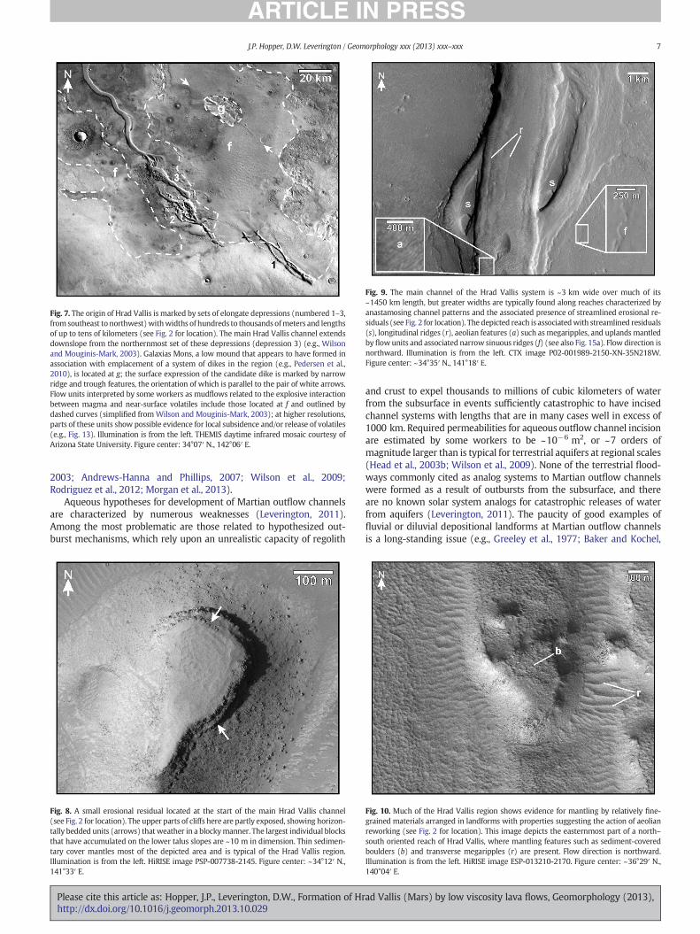
Fig. 7. The origin of Hrad Vallis is marked by sets of elongate depressions (numbered 1–3,from southeast to northwest)withwidths of hundreds to thousands ofmeters and lengthsof up to tens of kilometers (see Fig. 2 for location). The main Hrad Vallis channel extendsdownslope from the northernmost set of these depressions (depression 3) (e.g., Wilsonand Mouginis-Mark, 2003). Galaxias Mons, a low mound that appears to have formed inassociation with emplacement of a system of dikes in the region (e.g., Pedersen et al.,2010), is located at g; the surface expression of the candidate dike is marked by narrowridge and trough features, the orientation of which is parallel to the pair of white arrows.Flow units interpreted by some workers as mudflows related to the explosive interactionbetween magma and near-surface volatiles include those located at f and outlined bydashed curves (simplified fromWilson and Mouginis-Mark, 2003); at higher resolutions,parts of these units show possible evidence for local subsidence and/or release of volatiles(e.g., Fig. 13). Illumination is from the left. THEMIS daytime infrared mosaic courtesy ofArizona State University. Figure center: 34°07′ N., 142°06′ E.
Fig. 9. The main channel of the Hrad Vallis system is ~3 km wide over much of its~1450 km length, but greater widths are typically found along reaches characterized byanastamosing channel patterns and the associated presence of streamlined erosional re-siduals (see Fig. 2 for location). The depicted reach is associatedwith streamlined residuals(s), longitudinal ridges (r), aeolian features (a) such asmegaripples, and uplands mantledby flowunits and associated narrow sinuous ridges (f) (see also Fig. 15a). Flow direction isnorthward. Illumination is from the left. CTX image P02-001989-2150-XN-35N218W.Figure center: ~34°35′ N., 141°18′ E.
7J.P. Hopper, D.W. Leverington / Geomorphology xxx (2013) xxx–xxx
2003; Andrews-Hanna and Phillips, 2007; Wilson et al., 2009;Rodriguez et al., 2012; Morgan et al., 2013).
Aqueous hypotheses for development of Martian outflow channelsare characterized by numerous weaknesses (Leverington, 2011).Among the most problematic are those related to hypothesized out-burst mechanisms, which rely upon an unrealistic capacity of regolith
Fig. 8. A small erosional residual located at the start of the main Hrad Vallis channel(see Fig. 2 for location). The upper parts of cliffs here are partly exposed, showing horizon-tally bedded units (arrows) that weather in a blockymanner. The largest individual blocksthat have accumulated on the lower talus slopes are ~10 m in dimension. Thin sedimen-tary cover mantles most of the depicted area and is typical of the Hrad Vallis region.Illumination is from the left. HiRISE image PSP-007738-2145. Figure center: ~34°12′ N.,141°33′ E.
Please cite this article as: Hopper, J.P., Leverington, D.W., Formation of Hrhttp://dx.doi.org/10.1016/j.geomorph.2013.10.029
and crust to expel thousands to millions of cubic kilometers of waterfrom the subsurface in events sufficiently catastrophic to have incisedchannel systems with lengths that are in many cases well in excess of1000 km. Required permeabilities for aqueous outflow channel incisionare estimated by some workers to be ~10−6 m2, or ~7 orders ofmagnitude larger than is typical for terrestrial aquifers at regional scales(Head et al., 2003b; Wilson et al., 2009). None of the terrestrial flood-ways commonly cited as analog systems to Martian outflow channelswere formed as a result of outbursts from the subsurface, and thereare no known solar system analogs for catastrophic releases of waterfrom aquifers (Leverington, 2011). The paucity of good examples offluvial or diluvial depositional landforms at Martian outflow channelsis a long-standing issue (e.g., Greeley et al., 1977; Baker and Kochel,
Fig. 10. Much of the Hrad Vallis region shows evidence for mantling by relatively fine-grained materials arranged in landforms with properties suggesting the action of aeolianreworking (see Fig. 2 for location). This image depicts the easternmost part of a north–south oriented reach of Hrad Vallis, where mantling features such as sediment-coveredboulders (b) and transverse megaripples (r) are present. Flow direction is northward.Illumination is from the left. HiRISE image ESP-013210-2170. Figure center: ~36°29′ N.,140°04′ E.
ad Vallis (Mars) by low viscosity lava flows, Geomorphology (2013),
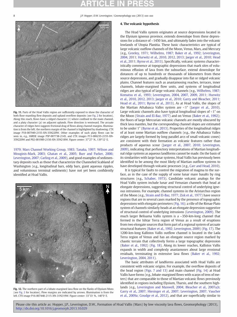
Fig. 11. Parts of the Hrad Vallis region are sufficiently exposed to show the character ofboth floor-mantling flow deposits and upland overflow deposits (see Fig. 2 for location).Along this reach, flows have a ridged character (r) where confined to the main channel,and a platy character (p) on adjacent uplands. Flow direction is westward. The arcuatecharacter of ridges here suggests frictional drag of flows along channel margins. Illumina-tion is from the left; the northernmargin of the channel is highlighted by shadowing. CTXimage P18-007949-2155-XN-35N220W. Other examples of such platy flows can beseen in, e.g., HiRISE image PSP-007738-2145, and CTX images P13-006235-2155-XN-35N220W and P02-001989-2150-XN-35N218W. Figure center: 37°27′ N., 139°12′ E.
8 J.P. Hopper, D.W. Leverington / Geomorphology xxx (2013) xxx–xxx
1979; Mars Channel Working Group, 1983; Tanaka, 1997; Wilson andMouginis-Mark, 2003; Ghatan et al., 2005; Burr and Parker, 2006;Leverington, 2007; Carling et al., 2009), and good examples of sedimen-tary deposits such as those that characterize the Channeled Scabland ofWashington (e.g., longitudinal bars, eddy bars, giant aqueous ripples,and voluminous terminal sediments) have not yet been confidentlyidentified at Hrad Vallis.
Fig. 12. The northern part of a lobate-margined lava flow on the flanks of Elysium Mons(see Fig. 2 for location). Flow margins are indicated by arrows. Illumination is from theleft. CTX image P16-007448-2115-XN-31N219W. Figure center: 33°33′ N., 140°0′ E.
Please cite this article as: Hopper, J.P., Leverington, D.W., Formation of Hrhttp://dx.doi.org/10.1016/j.geomorph.2013.10.029
4. The volcanic hypothesis
The Hrad Vallis system originates at source depressions located inthe Elysium igneous province, extends downslope from these depres-sions for a distance of ~1450 km, and ultimately fades into the volcaniclowlands of Utopia Planitia. These basic characteristics are typical oflarge volcanic outflow channels of theMoon, Venus, Mars, andMercury(e.g., Greeley, 1971; Wilhelms, 1987; Baker et al., 1992; Leverington,2004, 2011; Hurwitz et al., 2010, 2012, 2013; Jaeger et al., 2010; Headet al., 2011; Byrne et al., 2013). Specifically, volcanic systems character-istically commence at topographic depressions that mark sites of volu-minous effusion of lava from the subsurface, extend downslope fordistances of up to hundreds or thousands of kilometers from thesesource depressions, and gradually disappear into flat or ridged volcanicplains. Channel features such as anastamosing reaches, terraces, innerchannels, lobate-margined flow units, and systems of longitudinalridges are also typical of large volcanic channels (e.g., Wilhelms, 1987;Komatsu et al., 1993; Leverington, 2004, 2007, 2009, 2011; Hurwitzet al., 2010, 2012, 2013; Jaeger et al., 2010; Garry and Bleacher, 2011;Head et al., 2011; Byrne et al., 2013). As at Hrad Vallis, the slopes ofthe Martian Athabasca Valles system are b1° (Jaeger et al., 2010).Large volcanic channels also have typical longitudinal slopes of b1° onthe Moon (Strain and El-Baz, 1977) and on Venus (Baker et al., 1992);the floors of large Mercurian volcanic channels are mostly obscured bythick lava mantles, but the corresponding channel slopes are estimatedto be under 1° (Byrne et al., 2013). Properties of the longitudinal ridgesof at least some Martian outflow channels (e.g., the Athabasca Vallesridges are largely formed by long parallel arcs of small volcanic cones)are consistent with their formation as volcanic features rather thanproducts of aqueous scour (Jaeger et al., 2007, 2010; Leverington,2009), indicating that perfunctory interpretations of Martian longitudi-nal ridge systems as aqueous landforms cannot bemade. On the basis ofits similarities with large lunar systems, Hrad Vallis has previously beenidentified to be among the most likely of Martian outflow systems tohave developed through volcanic processes (e.g., Carr and Head, 2010).
It is typical for faults to control the migration of magma to the sur-face, as in the case of the supply of some lunar mare basalts by ringstructures (e.g., Schaber, 1973). Candidate volcanic analogs for theHrad Vallis system include lunar and Venusian channels that head atelongate depressions, suggesting structural control of underlying igne-ous intrusions. For example, channel systems in the Aristarchus regionof theMoon (e.g., Strain and El-Baz, 1977; Zisk et al., 1977) have sourceregions that are in several cases marked by the presence of topographicdepressionswith elongate perimeters (Fig. 16); a rille of the Rimae Platosystem of channels similarly heads at an elongate depression suggestiveof structural control of underlying intrusions (Leverington, 2009). Themuch larger Belisama Vallis system is a ~350-km-long channel thatformed in the Ishtar Terra region of Venus as a result of eruptionsfrom two elongate sources that form part of a regional systemof arcuatestructural features (Baker et al., 1992; Leverington, 2009) (Fig. 17). The1200-km-long Kallistos Vallis outflow channel is located in the LadaTerra region of Venus and has an elongate source region marked bychaotic terrain that collectively forms a large topographic depression(Baker et al., 1992) (Fig. 18). Along its lower reaches, Kallistos Vallisexpands in width and complexly anastamoses about large erosionalresiduals, terminating in extensive lava flows (Baker et al., 1992;Leverington, 2004, 2011).
The basic attributes of landforms associated with Hrad Vallis areconsistent with volcanic origins. For example, the overflow deposits ofthe head region (Figs. 7 and 13) and main channel (Fig. 14) at HradVallis have forms (e.g., lobate-margined flowswith scarps of tens ofme-ters) that are comparable to those of Martian volcanic flows previouslyidentified in regions including Elysium, Tharsis, and the southern high-lands (e.g., Leverington and Maxwell, 2004; Bleacher et al., 2007a,b;Garry et al., 2007; Hiesinger et al., 2007; Leverington, 2007; Vaucheret al., 2009a; Goudge et al., 2012), and that are superficially similar to
ad Vallis (Mars) by low viscosity lava flows, Geomorphology (2013),

Fig. 13. An elongate and lobate-margined flow is depicted for a region located west of the large depressions located near the start of Hrad Vallis (see Fig. 2 for location) (Wilson andMouginis-Mark, 2003). The margins of this flow are indicated by arrows, and selected pits are identified (P). Illumination is from the left. CTX image P16-007237-2122-XN-32N218W.Figure center: 33°52′ N., 140°48′ E.
9J.P. Hopper, D.W. Leverington / Geomorphology xxx (2013) xxx–xxx
ElysiumMons lava flows located in the immediate vicinity of HradVallis(e.g., Fig. 12). The pitted character of at least some lobate-marginedflows at Hrad Vallis can potentially be attributed to lava inflation,
Fig. 14.Uplands adjacent to themain Hrad Vallis channel aremantled in places by lobate-margined overflow deposits (see Fig. 2 for locations). (A) This flow has a platy character(p) and moved eastward away from the main channel. (B) This flow moved southwardaway from the main channel. Flow fronts are indicated by arrows, and illumination wasfrom the left. Image numbers: (A) CTX P02-001989-2150-XN-35N218W; (B) CTX P18-007949-2155-XN-35N220W. Image centers: (A) 35°03′30″ N., 141°11′ E; (B) 36°57′50″N., 139°14′ E.
Please cite this article as: Hopper, J.P., Leverington, D.W., Formation of Hrhttp://dx.doi.org/10.1016/j.geomorph.2013.10.029
subsidence, or volatile release (e.g., lunar examples of pitted lavaflows are described by Garry et al., 2012) without the need to invokethe past presence of large volumes of water. Pitted lava flows are pres-ent on the flanks of Martian shields including the Tharsis volcanoes, andsimilarly pitted flows are present on the floors of outflow systems suchas Mangala Valles; although the pitted deposits at Mangala Valles havebeen interpreted by some workers as ice-rich lag deposits that weresubjected to sublimation processes (Levy and Head, 2005), theMangalaValles flows are considered by some workers to be analogous to thepitted Tharsis lava flows (Leverington, 2007). The Hrad Vallis uplandflows characterized by networks of sinuous narrow ridges (Fig. 15A)have at least a superficial resemblance to those associated with lavaflows emplaced at Martian volcanic systems including Athabasca Valles(Fig. 15B); these features may be pressure ridges developed in lavacrusts.
The platy and ridged character of someflows exposed along thefloorand adjacent uplands of Hrad Vallis (Fig. 11) has been widely recog-nized at volcanic flows on Earth (e.g., in Iceland and Hawaii; Theiligand Greeley, 1986; Keszthelyi et al., 2004) and is also recognized else-where on Mars (e.g., at Daedalia Planum, Elysium Planitia, the Tharsisvolcanoes, and numerous Martian outflow channels including KaseiVallis, Athabasca Valles, and Mangala Valles; Theilig and Greeley,1986; Jaeger et al., 2007, 2010; Leverington, 2007; Keszthelyi et al.,2008; Caprarelli and Leitch, 2009; Chapman et al., 2010; Mangoldet al., 2010; Crown and Berman, 2012). Though Martian deposits withthese attributes have been previously interpreted by some workers asthe surface expressions of frozen bodies of water (e.g., Murray et al.,2005; Page and Murray, 2006; Page, 2008; Thomson et al., 2012), theyare interpreted by most workers as features related to the disruptedcrusts of lava flows emplaced during flood-style and inflation-styleeruptions (e.g., Theilig and Greeley, 1986; Jaeger et al., 2007, 2010;Keszthelyi et al., 2008; Giacomini et al., 2009, 2012). The spiral coilfeatures of platy and ridged flows at Athabasca Valles are stronglysupportive of volcanic origins and are inconsistent with aqueous orperiglacial origins (Ryan and Christensen, 2012).
If volcanic processes were responsible for emplacement of relativelyhigh-viscosity lava flows on the flanks of Elysium Mons (e.g., formingflowswith relatively steep fronts such as those of Fig. 12), could volcanicprocesses have also been responsible for eruption of low-viscosity,
ad Vallis (Mars) by low viscosity lava flows, Geomorphology (2013),

Fig. 15. (A) Some overflow deposits at Hrad Vallis are characterized by the presence of ir-regular networks of low ridges, as depicted here (see Fig. 2 for location). Ridges typicallyhave widths of b~40 m. Also depicted in this figure is a channel terrace (t) and an aeolianmantle (a) on the channel floor. (B) The features described above may be analogs to sim-ilar types of ridge networks associated with well-preserved Martian lava flows such asthose of the Elysium Planitia region, which could conceivably have formed through thecompression of rigid flow crusts. Illumination is from the left. Image numbers: (A) CTXP02-001989-2150-XN-35N218W; (B) HiRISE PSP-007777-1790. Figure centers: (A)34°54′ N., 141°02′E; (B) 1°03′20″ S., 160°30′20″ E.
Fig. 16. Oblique view of volcanic channels located in the Aristarchus region of the Moon(e.g., Strain and El-Baz, 1977; Zisk et al., 1977). Aristarchus crater (A) has a diameterof ~40 km, and Prinz crater (P) has a diameter of ~46 km. Lava sources (S) are markedhere by the presence of topographic depressions with elongate or ovoid perimeters.Illumination is from the left. Apollo 15 Metric camera photo 2606. Figure center: 26°20′N., 44°25′ W.
10 J.P. Hopper, D.W. Leverington / Geomorphology xxx (2013) xxx–xxx
channel-carving flows at Hrad Vallis? Lava viscosity generally variesinversely with temperature (e.g., Murase and McBirney, 1973), andtherefore factors that affect lava temperature over time (e.g., rate andtotal volume of effusion) can cause flows of a given composition tohave different viscosities under different eruptive conditions and at dif-ferent eruption stages (e.g., Walker, 1973; Guest and Murray, 1976).Variation in composition and in eruptive conditions can give maficlava flows very different flow characteristics, potentially endowingthem with a capacity for emplacement as thick domes, as prominenttongue-like units characterized by steepflow fronts, as nearly indiscern-ible sheet-like units deposited over broad areas, or as channel-carvingflows (e.g., Schaber, 1973; Hulme and Fielder, 1977; Wilhelms, 1987;Griffiths, 2000; Wilson and Head, 2003; Leverington and Maxwell,2004; Williams et al., 2005; Leverington, 2006, 2009, 2011; Bleacheret al., 2007a,b; Jaeger et al., 2007, 2010; Keszthelyi et al., 2008; Hauberet al., 2009; Hurwitz et al., 2012; Byrne et al., 2013). For example, lavaflows that form prominent features on the flanks of Martian shieldsand in regions such as Elysium Planitia likely had estimated viscositiesof ~1 × 10⁴ to more than 1 × 10⁶ Pa s (e.g., Baloga et al., 2003;Hiesinger et al., 2007; Vaucher et al., 2009a; Pasckert et al., 2012). Incontrast, the plains-mantling and channel-forming lava flows of regionsincluding Elysium Planitia and Gusev crater had estimated viscosities ofonly ~1 to 10 Pa s (Greeley et al., 2005; Jaeger et al., 2010). The broadcapacity of lava to construct or erode landscapes is not unique to
Please cite this article as: Hopper, J.P., Leverington, D.W., Formation of Hrhttp://dx.doi.org/10.1016/j.geomorph.2013.10.029
Mars. Some lunar basalt flows in Mare Imbrium had estimated viscosi-ties close to 1 Pa s and extended in some cases for distances in excessof 1000 km over slopes of only ~0.06°, forming units with heights ofonly ~20 to 40 m (Schaber, 1973). In contrast, the lunar lavas thatform theGruithuisen andMairandomes in Oceanus Procellarumflowedwith estimated viscosities of ~109 Pa s, suggesting that they may havehad relatively high silica contents (Wilson and Head, 2003). Clearly,factors such as lava chemistry, temperature, volume of eruption, rateof eruption, and rate of cooling will control the capacity of flows to con-struct or erode landscapes (e.g., Murase and McBirney, 1973; Walker,1973; Guest and Murray, 1976; Stasiuk et al., 1993; Stasiuk andJaupart, 1997).
Channel development is a recognized and realistic outcome of volu-minous effusive volcanic eruptions fed by large and deep subcrustalsources on Mars and on other solar system bodies (McGetchin andSmith, 1978; Wilson and Head, 1981; Head and Wilson, 1991, 1992;Jaeger et al., 2010; Wilson and Head, 2010; Leverington, 2011;Hurwitz et al., 2012, 2013; Byrne et al., 2013). If lithostatic pressures in-deed had the capacity to drive large volumes of magma through deeplyrooted igneous plumbing systems to the heads ofMartian outflow chan-nels, what lava flow conditions are most likely to have existed at thesurface during hypothesized incision of the Hrad Vallis channel system?In the following section, the basic geometry of Hrad Vallis is used tohelp constrain flow parameters of interest such as flow discharge,turbulence, and rates of incision.
5. Estimates of flow parameters for volcanic incision of Hrad Vallis
The approximate volume of the Hrad Vallis channel is estimated onthe basis of MOLA topographic data to be ~435 km3. Though channelfloors near the origin of the system are hundreds of meters below adja-cent uplands (suggesting channel development predominantly througherosion here), it is possible that the most shallow and distal channelreaches of Hrad Vallis were formed instead through constructive
ad Vallis (Mars) by low viscosity lava flows, Geomorphology (2013),

Fig. 17. The Belisama Vallis outflow channel has a length of ~350 km and is located in theIshtar Terra region of Venus (Baker et al., 1992; Leverington, 2009). The lava flows thatformed this system appear to have been erupted from two major source depressions (S)that form part of the surface expression of a system of arcuate structures (arrows). It islikely that associated faults acted as conduits for voluminous effusion of magma to thesurface here. Downslope from the source region, the incision of anastamosing channelsresulted in development of streamlined erosional residuals (R), some with lengths ofN10 km. Magellan full-resolution radar map (FMAP) left-look Synthetic Aperture Radar(SAR) mosaic. SAR illumination is from the left. Figure center: 50°5′ N., 22°30′ E.
11J.P. Hopper, D.W. Leverington / Geomorphology xxx (2013) xxx–xxx
deposition of volcanic materials. We take the estimated 435-km3
volume of the Hrad Vallis channel as a crude measure of the amountof material removed during channel formation. Making the simplifyingassumption that the densities and specific heat capacities of the liquidand solid phases of basalt are equal, the ratio of themass of cold regolithto the lava mass that would allow the temperature of overriding lava tobe maintained at N1400 K (a temperature above which flow propertiesare expected to allow for incision) is determined to be ~1:25(Leverington, 2007). This suggests a minimum erupted lava volume atHrad Vallis of ~10,900 km3. If deposited as a single unit with a thicknessof 30 m, this volume would cover a surface area of ~363,000 km2; athickness of 100 m would cover an area of ~109,000 km2. A volume of10,900 km3 represents only ~6% of the 1.7 × 10⁵ km3 volume of theterrestrial Columbia River Basalt Group (Tolan et al., 1989) and ~20%of the ~5 × 10⁴ km3 volume that may be typical of large Martiandikes (e.g., Wilson and Head, 2002). This value is comparable to the~7500-km3 volume estimated for the main lava flow at the Martianoutflow system Athabasca Vallis (Jaeger et al., 2010). The Hrad Vallisestimate is problematic, however, in that it does not take into accountthe basic nature of associated flow dynamics and ignores the effects ofmechanical erosion. A more effective characterization of the potentialfor volcanic development of the Hrad Vallis system can be madethrough the use of channel geometry to constrain equations of flowand incision.
Factors that control the capacity of a lava flow tomechanically erodeinto an underlying substrate are substantially related to the rates andtotal volumes of surface flow (e.g., Sklar and Dietrich, 1998; Williams
Please cite this article as: Hopper, J.P., Leverington, D.W., Formation of Hrhttp://dx.doi.org/10.1016/j.geomorph.2013.10.029
et al., 1998; Siewert and Ferlito, 2008). The rate of mechanical incisionassociated with a flow (Sklar and Dietrich, 1998; Hurwitz et al., 2010,2012) is given for low slopes by
d dchannelð Þdt
� �¼ KρgQw sina ð1Þ
where K is a proportionality constant that represents the erodibility ofthe underlying substrate (in Pa−1), ρ is lava density, g is gravitationalacceleration (3.7 m/s2 for Mars), Qw is the average lava flux throughthe channel per unit width (in m2/s), and α is the slope in degrees.Higher values of K (10−7) represent less consolidated materials(e.g., regolith or impact ejecta materials) and lower values (10−9)represent more consolidated materials (e.g., bedrock) (Hurwitz et al.,2012). An intermediate value of 1 × 10⁻⁸ Pa−1 (Table 2) was usedhere to reflect the possible presence of volcaniclastic units betweenmore consolidated lava flow units in the study region; the use of alower value or higher value will respectively make it harder or easierfor a given modeled substrate to be incised.
Flow velocity (Hurwitz et al., 2010, 2012) is given for low slopes(b10°) by
Vlavað Þ2 ¼ gdlava sinaC f
ð2Þ
where g is gravitational acceleration, dlava is the depth of lava, α is chan-nel slope in degrees, and Cf is the friction factor (Keszthelyi and Self,1998), which is given by
C f ¼132
� �log10 6:15
2Reþ 80041
� �0:92� �� �� �−2
ð3Þ
The associated Reynolds number is given by
Re ¼ ρvdlavaμ
ð4Þ
where ρ is lava density, v is lava velocity, dlava is the depth of the lava,and μ is the dynamic viscosity of the lava (in Pa s). Eqs. (2)–(4) arefunctions of each other and must therefore be solved iteratively. Lavadensity was assumed in the calculations made here to be 2800 kg/m3
(e.g., Murase and McBirney, 1973; Sparks and Huppert, 1984;Williams et al., 2005) (Table 2). The dynamic viscosity of lava wasassumed to be 1 Pa s, a viscosity typical of lunar mare basalts(e.g.,Mason andMelson, 1970; Schaber, 1973), and believed to have ap-proximately characterizedMartian basalts such as those of Gusev crater(Greeley et al., 2005). In general, lower viscosities should have a greaterpotential for mechanical incision than higher viscosities.
The rate of channel incision resulting from thermal erosion(e.g., Hulme, 1973; Huppert and Sparks, 1985a; Williams et al.,1998, 2000; Hurwitz et al., 2012) is given by
d dchannelð Þdt
� �¼
ht T−Tmg
� �Emg
ð5Þ
where ht is the heat transfer coefficient, T is the temperature of the lava,and Tmg is the melting temperature of the substrate; Emg is the amountof energy needed to melt the substrate (Hulme, 1973; Huppert andSparks, 1985a; Williams et al., 1998, 2000), which is given by
Emg ¼ ρg cg Tmg−Tg
� �þ f mgLg
h ið6Þ
where ρg is the density of the solid substrate, cg is the specific heat of thesubstrate (in J/kg/K), Tmg is the melting temperature of the substrate in°C, Tg is the initial temperature of the ground in °C, fmg is the fraction ofthe substrate that must be melted before it can be mobilized, and Lg is
ad Vallis (Mars) by low viscosity lava flows, Geomorphology (2013),

Fig. 18. The Kallistos Vallis outflow channel (arrows) is associated with the Ammavaru volcanic province of Venus and has a length of ~1200 km (Baker et al., 1992; Leverington, 2009).The system is located in the Lada Terra region, northeast of Eithinoha Corona and northwest of Otygen Corona. The source (S) of the system is marked by a zone of chaotic terrain thatcollectively forms a large topographic depression, from which the channel system extends toward the south. Along lower reaches, the channel system expands in width and complexlyanastamoses about numerous erosional residuals (R) (Baker et al., 1992; Leverington, 2011), terminating in extensive lava flows, some of which are radar-rough (F). Magellan FMAPleft-look SAR mosaic. SAR illumination is from the left. Figure center: 49°14′ S., 22°20′ E.
12 J.P. Hopper, D.W. Leverington / Geomorphology xxx (2013) xxx–xxx
the latent heat of fusion of the substrate (in J/kg). The heat transfercoefficient in Eq. (5) (Hulme, 1973) is given by
ht ¼0:017kRe
45Pr
25
dlavað7Þ
where k is the thermal conductivity of the lava [in W/(m K)], Re is theReynolds number, Pr is the Prandtl number [(cgμ)/k], and dlava is thedepth of lava in meters (an alternative but similar formulation for theheat transfer coefficient is given by Williams et al., 1998, 2000).Estimates of the magnitudes of flow parameters relevant to thermal
Table 2List of constants (see text for discussion).
Symbol Name Value
g Gravitational acceleration 3.7 m/s2
K Proportionality constant 1 × 10⁻⁸/Paρ Density of lava 2800 kg/m3
μ Dynamic viscosity of lava 1 Pa·sT Temperature of lava 1340 °Ccg Specific heat of substrate 1500 J/kg °CLg Latent heat of fusion of substrate 587,000 J/kgfmg Fraction of substrate melted before movement 0.4 (40%)Tg Initial temperature of substrate −23 °Cρg Density of solid substrate 2900 kg/m3
Please cite this article as: Hopper, J.P., Leverington, D.W., Formation of Hrhttp://dx.doi.org/10.1016/j.geomorph.2013.10.029
erosion, as noted above for mechanical erosion, must be madeiteratively.
In the thermal erosion calculationsmade here, key parameters weredefined as follows (broadly based on Hurwitz et al. (2010, 2012) andother sources as cited below) (Table 2): lava temperature = 1340 °C;specific heat of the substrate = 1500 J/kgC; latent heat of fusion ofthe substrate = 587,000 J/kg; fraction of substrate melted beforemovement = 0.4 (e.g., Hulme, 1973); melting temperature of thesubstrate = 1150 °C (see alsoWilliams et al., 2005); initial temperatureof the ground = −23 °C; density of solid substrate = 2900 kg/m3
(e.g., Salisbury and Christensen, 1973; Moore, 2001; McSween, 2002).Martian lava flows thatmantle Gusev crater have compositions compa-rable to those of basaltic shergottites and terrestrial basaltic komatiites(Gellert et al., 2004), suggesting higher temperatures of eruption andlower viscosities relative to those of modern terrestrial lava flows ofmafic composition (e.g., Green and Schulz, 1977; Huppert and Sparks,1985b). The effects of heat loss are most significant for poorly insulatedflows that are erupted under relatively low effusion rates, but arelow enough for voluminous flows with insulating cover that suchflows can extend for distances of hundreds of kilometers on Earth(e.g., Walker, 1973; Guest and Murray, 1976; Harris and Rowland,2009). In general, the lengths of lava flows will be greater if eruptionrates are higher (Walker, 1973). The expected amount of cooling in alarge insulated volcanic channel is ~0.1 K/km (Keszthelyi et al., 2006),resulting in a predicted ~150 K cooling for a system that is 1500 kmlong. Thus, the capacity for both mechanical and thermal incision is
ad Vallis (Mars) by low viscosity lava flows, Geomorphology (2013),

13J.P. Hopper, D.W. Leverington / Geomorphology xxx (2013) xxx–xxx
expected to decrease with distance from the source region, as magmatemperatures gradually decrease and viscosities increase.
Flow conditions were estimated for Hrad Vallis using a software im-plementation of Eqs. (1)–(7) written by the second author (D.W.L.),using the constants summarized in Table 2. Execution of this code isinitiated through assignment of an initial seed value for the Reynoldsnumber and the subsequent iterative calculation of parameter values(equations typically converged upon stable solutions within 3–7 itera-tions). Results are summarized in Fig. 19 for a channel width of3000 m, for flow depths of 5 to 20 m, and for slopes of 0.01 to 0.2°.Slopes of b0.1° are typical of the Hrad Vallis system at regional scales(as is the case at other Elysium systems such as Athabasca Valles;Jaeger et al., 2010), and the overall slope of the system is only ~0.03°.Though flow conditionswere conservatively determined by considering
Fig. 19. Volcanic flow conditions inferred for reaches located near the head of Hr
Please cite this article as: Hopper, J.P., Leverington, D.W., Formation of Hrhttp://dx.doi.org/10.1016/j.geomorph.2013.10.029
flow depths of 5–20 m, greater lava depths cannot be ruled out at HradVallis and indeed may be suggested by the existence of overflow de-posits. Flow velocities for lava depths of 5 to 20 m and slopes of 0.01to 0.2° are estimated to range between ~1 and 14 m/s (Fig. 19), valuesthat are comparable to the 4–9 m/s previously estimated for lavaflows at the Athabasca Valles system (Jaeger et al., 2010). The magni-tudes of Reynolds numbers estimated for Hrad Vallis flows over thedepths and slopes of interest range from ~15,000 to 807,000, indicatingfully turbulent flow. Discharge estimates for theHrad Vallis system overthe depths and slopes of interest range from ~16,000 to 865,000 m3/s.These estimates are well within the ranges previously predicted forother large volcanic channels and for broad unconfined flows on Mars,the Moon, Venus, and the Earth (e.g., Schaber, 1973; Schaber et al.,1976; Hulme and Fielder, 1977; Baker et al., 1997; Leverington, 2007;
ad Vallis for lava depths of 5 to 20 m and for channel slopes of 0.01 to 0.2°.
ad Vallis (Mars) by low viscosity lava flows, Geomorphology (2013),

14 J.P. Hopper, D.W. Leverington / Geomorphology xxx (2013) xxx–xxx
Jaeger et al., 2010;Williams et al., 2011) and in particular are compara-ble to theminimumpeak lava discharge rate of 500,000 m3/s previouslyestimated for Athabasca Valles (Jaeger et al., 2010). The pressures onmagma chambers stranded in the uppermost mantle (on the orderof ~1.4 to 2.4 GPa) should be sufficient to drive highly voluminousand effusive eruptions on Mars where routes to the surface exist orcan develop (Leverington, 2011).
Mechanical incision rates estimated for HradVallis forflowdepths of5 to 20 m and slopes of 0.01 to 0.2° range from ~8 cm/d to 9 m/d(Fig. 19). Thermal incision rates over the same depths and slopes of in-terest are predicted to range from ~25 cm/d to 1.4 m/d. As expected,the greatest rates of incision are predicted to have been associatedwith the deepest lava flows and the steepest channel slopes.Mechanicalerosion rates are predicted to have dominated at larger slopes but,consistent with the results of Hurwitz et al. (2012), should havebeen exceeded by thermal incision rates at the lowest channel slopes(e.g., at slopes of b~0.09° for flows with depths of 10 m). The mechan-ical and thermal incision rates predicted for Hrad Vallis are comparableto those previously estimated forMartian, lunar, and terrestrial systems(e.g., Hurwitz et al., 2010, 2012; Williams et al., 2011). With typicalchannel floor depths of ~50 to 200 m below adjacent uplands, incisionrates of ~1 m/d might be expected to have allowed for developmentof the Hrad Vallis system in as little as ~3–9 months, and such an esti-mate is broadly consistent with the above estimates of total eruptedlava volume of 10,900 km3 and peak channel discharges of upto ~865,000 m3/s. However, the system may instead have developedas a result of intermittent volcanic events distributed over a muchlonger time period.
The above estimates are sensitive to the assumedmagnitudes of keyvariables, including the dynamic viscosity of lava. For example, predict-ed relations between incision rates and viscosity are depicted in Fig. 20for flows with a depth of 10 m on a slope of 0.03°. These data suggestthat incision rateswill generally be notably higher for flowswith viscos-ities that are orders of magnitude lower than those typical of modernterrestrial flows. Though the viscosities typical of modern terrestrialflows of mafic composition are ~100–1000 Pa s (e.g., Gregg and Fink,1995; Self et al., 1997; Stasiuk and Jaupart, 1997; Harris and Rowland,2001) and the viscosities of some Martian flows are likely to havereached as high as 104 to 109 Pa s (e.g., Baloga et al., 2003; Hiesingeret al., 2007; Vaucher et al., 2009a; Pasckert et al., 2012; Chevrel et al.,in press), the low topographic relief and extreme volumes and lengthsof some flow units emplaced on the Moon, Mercury, Venus, and Marssuggest viscosities approaching only ~1 to 10 Pa s (e.g., Mason andMelson, 1970; Williams et al., 2000; Greeley et al., 2005; Jaeger et al.,2010; Head et al., 2011). This contrast in viscosities can help to accountfor the greater rates of incision expected to have been associated withchannelized lava flows beyond those of modern Earth, although other
Fig. 20. Viscosity effects on (A) mechanical and (B) thermal incisi
Please cite this article as: Hopper, J.P., Leverington, D.W., Formation of Hrhttp://dx.doi.org/10.1016/j.geomorph.2013.10.029
factors such as high volumes and rates of eruption are also consideredimportant in this regard. Relatively voluminous and thick lava flowswill take longer to cool and are expected to have a greater capacity fordevelopment of long flows (e.g., Walker, 1973), potentially endowingsuch flows with a greater capacity for incision of long channels. Highertemperature lavas will have a greater capacity for thermal incisionand, if a reduction in viscosity accompanies these temperatures(e.g., Murase and McBirney, 1973), for mechanical incision. However,the occurrence of meaningful thermal incision rates does not relyupon an assumed eruption temperature of 1340 °C; for example,thermal incision rates are predicted to range from ~0.15 to 0.8 m/dfor voluminous low-viscosity flows that are 5–20 m thick and thathave a temperature of only 1250 °C (Leverington, 2013).
6. Discussion
The Hrad Vallis outflow channel commences at elongate topograph-ic depressions located on the distal flanks of the Elysium Mons shieldvolcano (Mouginis-Mark et al., 1984; De Hon and Mouginis-Mark,1990; De Hon, 1991; Tanaka et al., 1991; Carr, 1996) (Figs. 1, 2, and 7).These depressions form part of a larger system of linear and arcuatestructures oriented radially and concentrically to the peak of ElysiumMons. As with many Martian outflow systems, the main channel ofHrad Vallis is characterized in places by anastamosing reaches and bychannel floors with longitudinal ridges (Figs. 1, 2, and 9). Some channelfloors are mantled by flows with a ridged and platy character (Fig. 11).Uplands adjacent to themainHrad Vallis channel arewidely covered bylobate-margined flow deposits; some of these deposits are ElysiumMons lava flows (Fig. 12), but others appear to be overflow unitsfrom the Hrad Vallis channel or from the depressions near its origin(e.g., Figs. 7, 13, and 14). Some upland flows have a pitted character(e.g., Wilson and Mouginis-Mark, 2003) (Fig. 13), a platy character(Fig. 14A), or are crossed by complex networks of narrow and lowridges (Fig. 15A). The Hrad Vallis channel ultimately fades into thesubdued terrain of Utopia Planitia.
The Hrad Vallis system is widely interpreted as the product of aque-ous floods and mudflows produced from subsurface reservoirs duringthe interaction between igneous intrusions and volatile-rich units(e.g., Squyres et al., 1987; Christiansen, 1989; Head and Wilson, 2002;Russell and Head, 2003; Wilson and Mouginis-Mark, 2003; Tanakaet al., 2005; Morris and Mouginis-Mark, 2006) (Section 3). Among thechannel characteristics considered consistent with aqueous origins are(i) the existence and streamlined character of erosional residual land-forms, which are known to exist on the Earth in regions subjected tocatastrophic flooding (e.g., Bretz, 1923; Baker, 2009); (ii) the existenceof longitudinal ridges along channel floors, which are also known toexist along some terrestrial floodways (e.g., Baker, 2009); and (iii) the
on rates for a lava depth of 10 m and channel slope of 0.03°.
ad Vallis (Mars) by low viscosity lava flows, Geomorphology (2013),

15J.P. Hopper, D.W. Leverington / Geomorphology xxx (2013) xxx–xxx
pitted character of some upland flows near the Hrad Vallis channel,which are interpreted by some workers as having developed throughthe release of substantial amounts of water from lahar deposits(e.g., Wilson andMouginis-Mark, 2003). Channel characteristics poten-tially incongruous with aqueous origins include the absence of solarsystem analogs for catastrophic development of large aqueous chan-nels from subsurface reservoirs (and the corresponding absence oflarge topographic depressions at the start of terrestrial floodways)(Leverington, 2011) and the apparent absence of clear examples ofdiluvial or fluvial deposits along the main Hrad Vallis channel.
The basic properties typical of large igneous channels of the Moon,Venus, and Mercury (e.g., Greeley, 1971; Wilhelms, 1987; Baker et al.,1992; Leverington, 2004, 2011; Hurwitz et al., 2010, 2012, 2013;Jaeger et al., 2010; Head et al., 2011; Byrne et al., 2013) mirror thoseof Hrad Vallis (Section 4). As with volcanic channels of the inner solarsystem, the Hrad Vallis channel was carved by voluminous fluidsreleased from large subsurface reservoirs. As is typical of volcanic chan-nels (e.g., Leverington, 2004, 2011), the zones of effusion from the sub-surface are marked by topographic depressions; and the main channelsystem extends downslope from one or more of these depressions.The anastamosing character of theHrad Vallis channel, and the associat-ed streamlined character of erosional residuals, is typical of large volca-nic channels (e.g., Figs. 17 and 18). Hrad Vallis terminates at volcanicplains, which is a property required of all large volcanic channels(Leverington, 2004, 2011). Though many uncertainties remain, thelobate-margined, platy-ridged, and pitted properties of Hrad Vallisflows are collectively consistent with those expected of lava flows(e.g., see Keszthelyi et al., 2004, 2008; Leverington and Maxwell,2004; Leverington, 2006, 2007, 2009; Jaeger et al., 2007, 2010).Although a volcanic origin for these flows would not conclusively dem-onstrate development of Hrad Vallis through incision by lava, as theflows could have been emplaced as volcanic mantles after initial devel-opment of Hrad Vallis through other processes (e.g., Plescia, 1990;Jaeger et al., 2007; Morgan et al., 2013), it would usefully confirm thepast downslope movement of lava flows within the main channel ofthis system and along adjacent uplands. The exact nature of thelongitudinal ridges of Hrad Vallis remains uncertain (partly as a resultof the extensive mantling here by sediments and the scarcity of HiRISEcoverage), but the longitudinal ridges of well-preserved Martianoutflow systems such as Athabasca Valles show abundant evidence fordevelopment as volcanic landforms (Jaeger et al., 2007, 2010;Leverington, 2009) that were developed in volcanic flows (e.g., Ryanand Christensen, 2012); might the longitudinal ridges of Hrad Vallishave also formed during volcanic channel development?
Large volcanic channels of the inner solar systemwere likely formedby voluminous eruptions of magma from large and deep reservoirs, amechanism that is consistent with the basic nature of planetary inte-riors and igneous plumbing systems (e.g., McGetchin and Smith, 1978;Wilson and Head, 1981; Stasiuk and Jaupart, 1997; Jaeger et al., 2010;Head et al., 2011; Leverington, 2011; Byrne et al., 2013). The depres-sions located near the start of Hrad Vallis are therefore hypothesizedhere to be the surface expressions of a deeply rootedmagmatic system.In order to further investigate the possibility that the Hrad Vallis out-flow channel is the product of incision by lava expelled from thesedepressions, estimates of flow conditions were generated in this study(Section 5, Fig. 19). Flow velocities at Hrad Vallis for lava depths of5 to 20 m and slopes of 0.01 to 0.2° are estimated to range between~1 and 14 m/s, and discharge estimates range from ~ 16,000 to865,000 m3/s. Mechanical incision rates estimated for Hrad Vallisfor flow depths of 5 to 20 m and slopes of 0.01 to 0.2° range from~8 cm/d to 9 m/d. Thermal incision rates over the same depths andslopes of interest are predicted to range from ~25 cm/d to 1.4 m/d. Atthese rates of incision, development of the Hrad Vallis system is consid-ered possible in as little as ~3–9 months, although incision as a result ofintermittent volcanic activity over geological time scales is also possible.As outlined in Section 5, the flow conditions estimated here for
Please cite this article as: Hopper, J.P., Leverington, D.W., Formation of Hrhttp://dx.doi.org/10.1016/j.geomorph.2013.10.029
hypothesized channel-forming lava flows suggest a realistic capacityfor lava to have formed Hrad Vallis. Estimates are also consistentwith those previously determined for volcanic outflow systems locatedon several bodies of the inner solar system, including the MartianAthabasca Valles system (Jaeger et al., 2010). This system, as withHrad Vallis, originates at structural features oriented radially to theElysium Mons shield volcano (e.g., Plescia, 1990).
Lava temperatures are expected to decreasewith increasingdistancefrom sources (e.g., Keszthelyi et al., 2006), reducing the capacity of lavato thermally incise and also reducing the capacity for mechanical inci-sion by increasing viscosity. Thus, if the Hrad Vallis system formed asa result of the effusion of large volumes of lava, the channel reaches lo-cated closer to the source depressions aremost likely to have developederosively and the distal channel reaches are most likely to have devel-oped constructively. The deepest floors of the Hrad Vallis system,which are located along reaches near the start of the main channel(Fig. 6), are consistent with channel development here through pre-dominantly erosive processes; whereas shallower floors of only severaltens ofmeters suggest reaches of possible constructive development. Alllarge volcanic channels must contribute lava to the terminal basins intowhich they flow (Leverington, 2004, 2011), and a volcanic origin forHrad Vallis would imply that the extensive volcanic plains of UtopiaPlanitia are partly composed of thousands of cubic kilometers of lavacontributed from this system.
Athabasca Valles is an Elysium channel system that shows evidencefor having developed partly or completely as a result of the rapid andturbulent expulsion of lava flows from the Cerberus Fossae system offissures (Jaeger et al., 2010; Leverington, 2011). A volcanic origin forthe Hrad Vallis system would suggest that other nearby channel sys-tems of Elysium (e.g., those associatedwith Galaxias Fossae and ElysiumFossae) might have also formed in this manner. A common volcanic or-igin for all large channel systems in Elysiumwould suggest thatmany ofthe structural features centered on Elysium Mons were exploited asconduits by magmas that rose from deep and large reservoirs. If thesespeculations are valid, numerous questions arise: Were the magmaticplumbing systems that drovewidespread flood volcanism in this regiondirectly related to those that drove formation of the large Elysiumshields? What physical and chemical conditions within the crust andupper mantle might have variously favored or hindered the occurrenceof channel-forming eruptions in this region over its history? Given theyoung age of southern Elysium systems such as those of the Cerberusplains (Vaucher et al., 2009b; Thomas, 2013), might there remain amodern capacity for voluminous effusions of lava in this region, andwhat might this tell us about the interior of Mars (Grott et al., 2012)?Does the past widespread development of large volcanic channels inElysium have a broader significance for the hypothesized volcanic ori-gins of Martian outflow systems located in other regions (Leverington,2004, 2007, 2009, 2011; Jaeger et al., 2010; Byrne et al., 2013)?Althoughour current understanding of the Hrad Vallis system is characterized bynumerous unknowns and ambiguities, future improvements in under-standing are expected to have important implications for the study ofthe Elysium region and the interior of Mars.
7. Conclusions
The characteristics of Hrad Vallis are consistent with origins involv-ing channel incision by low-viscosity lavas. This system originates atdepressions located on the flanks of a large shield volcano, terminatesat extensive ridged volcanic plains, shows evidence for having been aconduit for lava flows and possesses properties analogous to those oflarge volcanic channels of the inner solar system. The depressions locat-ed near the start of Hrad Vallis are hypothesized here to be the surfaceexpressions of a deeply rooted magmatic system. Crude thermalestimates suggest that Hrad Vallis could have been formed through ef-fusion of ~10,900 km3 of magma. Despite the widespread presence atHrad Vallis of channel slopes of b0.1°, daily incision rates of tens of
ad Vallis (Mars) by low viscosity lava flows, Geomorphology (2013),

16 J.P. Hopper, D.W. Leverington / Geomorphology xxx (2013) xxx–xxx
centimeters to severalmeters are estimated formechanical and thermalerosion processes involvingflowswith depths of 5 to 20 manddynamicviscosities of ~1 Pa s. These rates of incision are estimated to have beenassociated with turbulent lava flow and with discharges as great as~865,000 m3/s. The flow conditions estimated here for hypothesizedchannel-forming lava flows suggest a realistic capacity for lava to haveformed Hrad Vallis. Predicted flow conditions are consistent withthose previously determined for other large volcanic outflow systemsof the inner solar system, including the channels of the Cerberus plains,which similarly formed as a result of the expulsion of flows from struc-tures associatedwith ElysiumMons. A volcanic origin for theHradVallissystem would suggest that nearby channel systems associated withGalaxias Fossae and Elysium Fossae may have formed by analogousprocesses. A common volcanic origin for all Elysium channels wouldbe relevant to ongoing efforts to understand the basic nature of pastvolcanic processes in the Elysium region and to understand the originsof other Martian outflow channels.
Acknowledgments
The authors thankNick Lang and Guido Ventura for their helpful andsupportive comments. The editorial recommendations made by journalstaff are appreciated. The comments of Virginia Gulick and JarmoKorteniemi on an earlier draft are also appreciated. The authorsacknowledge the use of High Resolution Imaging Science Experimentimages processed by the University of Arizona, Thermal EmissionImaging System images processed by Arizona State University, andMars Reconnaissance Orbiter Context Camera images archived byArizona State University.
References
Andrews-Hanna, J.C., Phillips, R.J., 2007. Hydrological modeling of outflow channels andchaos regions on Mars. J. Geophys. Res. 112, E08001. http://dx.doi.org/10.1029/2006JE002881.
Baker, V.R., 2009. The Channeled Scabland: a retrospective. Annu. Rev. Earth Planet. Sci.37, 393–411.
Baker, V.R., Kochel, R.C., 1979. Martian channel morphology: Maja and Kasei Valles.J. Geophys. Res. 84, 7961–7983.
Baker, V.R., Milton, D.J., 1974. Erosion by catastrophic floods onMars and Earth. Icarus 23,27–41.
Baker, V.R., Strom, R.G., Gulick, V.C., Kargel, J.S., Komatsu, G., Kale, V.S., 1991. Ancientoceans, ice sheets and the hydrological cycle on Mars. Nature 352, 589–594.
Baker, V.R., Komatsu, G., Parker, T.J., Gulick, V.C., Kargel, J.S., Lewis, J.S., 1992. Channels andvalleys on Venus: preliminary analysis of Magellan data. J. Geophys. Res. 97,13,421–13,444.
Baker, V.R., Komatsu, G., Gulick, V.C., Parker, T.J., 1997. Channels and valleys. In: Bougher,S.W., Hunten, D.M., Phillips, R.J. (Eds.), Venus II. Univ. of Ariz. Press, Tucson, AZ,pp. 757–793.
Baloga, S.M., Mouginis-Mark, P.J., Glaze, L.S., 2003. Rheology of a long lava flow atPavonis Mons, Mars. J. Geophys. Res. 108 (E7), 5066. http://dx.doi.org/10.1029/2002JE001981.
Bleacher, J.E., Greeley, R., Williams, D.A., Werner, S.C., Hauber, E., Neukum, G., 2007a.Olympus Mons, Mars: inferred changes in Late Amazonian aged effusive activityfrom lava flow mapping of Mars Express High Resolution Stereo Camera data.J. Geophys. Res. 112, E04003. http://dx.doi.org/10.1029/2006JE002826.
Bleacher, J.E., Greeley, R., Williams, D.A., Cave, S.R., Neukum, G., 2007b. Trends in effusivestyle at the TharsisMontes, Mars, and implications for the development of the Tharsisprovince. J. Geophys. Res. 112, E09005. http://dx.doi.org/10.1029/2006JE002873.
Bretz, J.H., 1923. The Channeled Scablands of the Columbia Plateau. Geology 31, 617–649.Burr, D.M., Parker, A.H., 2006. Gjotá Valles and implications for flood sediment deposition
on Mars. Geophys. Res. Lett. L22201. http://dx.doi.org/10.1029/2006GL028011.Burr, D.M., McEwen, A.S., Sakimoto, S.E.H., 2002. Recent aqueous floods from the Cerberus
Fossae. Mars Geophys. Res. Lett. 29. http://dx.doi.org/10.1029/2001GL013345.Byrne, P.K., Klimczak, C., Williams, D., Hurwitz, D.M., Solomon, S.C., Head, J.W., Preusker,
F., Oberst, J., 2013. An assemblage of lava flow features on Mercury. J. Geophys. Res.118, 1303–1322. http://dx.doi.org/10.1002/jgre.20052.
Caprarelli, G., Leitch, E.C., 2009. Volcanic and structural history of the rocks exposed atPickering Crater (Daedalia Planum, Mars). Icarus 202, 453–461.
Carling, P.A., Burr, D.M., Johnsen, T.F., Brennand, T.A., 2009. A review of open-channelmegaflood depositional landforms on Earth and Mars. In: Burr, D.M., Carling, P.A.,Baker, V.R. (Eds.), Megaflooding on Earth and Mars. Cambridge Univ. Press,Cambridge, UK, pp. 33–49.
Carr, M.H., 1974. The role of lava erosion in the formation of lunar rilles and Martianchannels. Icarus 22, 1–23.
Please cite this article as: Hopper, J.P., Leverington, D.W., Formation of Hrhttp://dx.doi.org/10.1016/j.geomorph.2013.10.029
Carr, M.H., 1979. Formation of Martian flood features by release of water from confinedaquifers. J. Geophys. Res. 84, 2995–3007.
Carr, M.H., 1996. Water on Mars. Oxford Univ. Press, New York.Carr, M.H., Head, J., 2010. Geologic history of Mars. Earth Planet. Sci. Lett. 294, 185–203.Chapman, M.G., 1994. Evidence, age, and thickness of a frozen paleolake in Utopia
Planitia, Mars. Icarus 109, 393–406.Chapman, M.G., Neukum, G., Dumke, A., Michael, G., van Gasselt, S., Kneissl, T., Zuschneid,
W., Hauber, E., Mangold, N., 2010. Amazonian geologic history of the Echus Chasmaand Kasei Valles system on Mars: new data and interpretations. Earth Planet. Sci.Lett. 294. http://dx.doi.org/10.1016/j.espl.2009.11.034.
Chevrel, M.O., Baratoux, D., Hess, K.-U., Dingwell, D.B., 2013. Viscous flow behavior oftholeiitic and alkaline Fe-rich Martian basalts. Geochim. Cosmochim. Acta. http://dx.doi.org/10.1016/j.gca.2013.08.026 (in press).
Christensen, P.R., Jakosky, B.M., Kieffer, H.H., Malin, M.C., McSween, H.Y., Nealson, K.,Mehall, G.L., Silverman, S.H., Ferry, S., Caplinger, M., Ravine, M., 2004. The ThermalEmission Imaging System (THEMIS) for the Mars 2001 Odyssey Mission. Space Sci.Rev. 110, 85–130.
Christiansen, E.H., 1989. Lahars in the Elysium region of Mars. Geology 17, 203–206.Christiansen, E.H., Greeley, R., 1981.Mega-lahars (?) in the Elysium Region, Mars. In: Proc.
Lunar Planet. Sci. Conf., 12th, Houston. Lunar and Planetary Institute, Houston, TX138–140.
Christiansen, E.H., Hopler, J.A., 1986. Geomorphic evidence for subsurface volatilereservoirs in the Elysium region of Mars. Proc. Lunar Planet. Sci. Conf., 17th, Houston.Lunar and Planetary Institute, Houston, TX, pp. 125–126.
Clifford, S.M., Parker, T.J., 2001. The evolution of the Martian hydrosphere: implicationsfor the fate of a primordial ocean and the current state of the northern plains. Icarus154, 40–79.
Crown, D.A., Berman, D.C., 2012. Geologic mapping of MTM 35137 Quadrangle: DaedaliaPlanum region of Mars. Proc. Lunar Planet. Sci. Conf., 43rd, Houston. Lunar andPlanetary Institute, Houston (abstract 2055).
De Hon, R.A., 1991. Polygenetic origin of Hrad Vallis, Mars. Proc. Lunar Planet. Sci. Conf.,22nd, Houston. Lunar and Planetary Institute, Houston, TX, p. 295 (abstract).
De Hon, R.A., Mouginis-Mark, P.J., 1990. Geologic map of the Galaxias region (MTM35217) northwest Elysium region, Mars. Proc. Lunar Planet. Sci. Conf., 21st, Houston.Lunar and Planetary Institute, Houston, TX, pp. 268–269 (abstract).
De Hon, R.A., Mouginis-Mark, P.J., Brick, E.E., 1999. GeologicMap of the Galaxias Quadrangle(MTM35217) of Mars. U.S. Geological Survey map, scale 1:500,000, 1 sheet.
Ernst, R.E., Grosfils, E.B., Mège, D., 2001. Giant dike swarms: Earth, Venus, andMars. Annu.Rev. Earth Planet. Sci. 29, 489–534.
Frey, H.V., Schultz, R.A., 1990. Speculations on the origin and evolution of the Utopia–Elysium lowlands of Mars. J. Geophys. Res. 95 (B9), 14,203–14,213.
Garry, W.B., Bleacher, J.E., 2011. Emplacement scenarios for Vallis Schröteri, AristarchusPlateau, the Moon. In: Ambrose, W.A., Williams, D.A. (Eds.), Recent Advances andCurrent Research Issues in Lunar Stratigraphy. Geol. Soc. Am. Special Paper, 477.Geological Society of America, Boulder CO, USA, pp. 77–93.
Garry, W.B., Zimbelman, J.R., Gregg, T.K.P., 2007. Morphology and emplacement of a longchannelized lava flow near Ascraeus Mons volcano. Mars J. Geophys. Res. 112,E08007. http://dx.doi.org/10.1029/2006JE002803.
Garry, W.B., Robinson, M.S., Zimbelman, J.R., Bleacher, J.E., Hawke, B.R., Crumpler, L.S.,Braden, S.E., Sato, H., 2012. The origin of Ina: evidence for inflated lava flows on theMoon. J. Geophys. Res. 117, E00H31. http://dx.doi.org/10.1029/2011JE003981.
Gellert, R., Rieder, R., Anderson, R.C., Brückner, Clark, B.C., Dreibus, G., Economou, T.,Kingelhöfer, Lugmair, G.W., Ming, D.W., Squyres, S.W., d'Uston, C., Wänke, H., Yen,A., Zipfel, J., 2004. Chemistry of rocks and soils in Gusev Crater from the Alpha ParticleX-ray Spectrometer. Science 305, 829–832.
Ghatan, G.J., Head III, J.W., Wilson, L., 2005. Mangala Valles, Mars: assessment of earlystages of flooding and downstream flood evolution. Earth Moon Planets 96, 1–57.http://dx.doi.org/10.1007/s11038-005-9009-y.
Giacomini, L., Massironi, M., Martellato, E., Pasquarè, G., Frigeri, A., Cremonese, G., 2009.Inflated flows on Daedalia Planum (Mars)? Clues from a comparative analysis withthe Payen volcanic complex (Argentina). Planet. Space Sci. 57, 556–570.
Giacomini, L., Carli, C., Sgavetti, M., Massironi, M., 2012. Spectral analysis and geologicalmapping of the Daedalia Planum lava field (Mars) using OMEGA data. Icarus 220,679–693.
Goudge, T.A., Mustard, J.F., Head, J.W., Fassett, C.I., 2012. Constraints on the history ofopen-basin lakes on Mars from the composition and timing of volcanic resurfacing.J. Geophys. Res. 117, E00J21. http://dx.doi.org/10.1029/2012JE004115.
Graham, J.M., 2004. The biological terraforming of Mars: planetary ecosynthesis asecological succession on a global scale. Astrobiology 4, 168–195.
Greeley, R., 1971. Lunar Hadley Rille: considerations of its origin. Science 172, 722–725.Greeley, R., Guest, J.E., 1987. Geologic Map of the Eastern Equatorial Region of Mars. scale
1: 15,000,000. U.S. Geol. Survey Misc. Inv. Ser. Map I-1802-B.Greeley, R., Theilig, E., Guest, J.E., Carr, M.H., Masursky, H., Cutts, J.A., 1977. Geology of
Chryse Planitia. J. Geophys. Res. 82, 4093–4109.Greeley, R., Foing, B.H., McSween, H.Y., Neukum, G., Pinet, P., van Kan, M., Werner, S.C.,
Williams, D.A., Zegers, T.E., 2005. Fluid lava flows in Gusev crater. Mars J. Geophys.Res. 110. http://dx.doi.org/10.1029/2005JE02401.
Green, J.C., Schulz, K.J., 1977. Iron-rich basaltic komatiites in the early PrecambrianVermilion District. Minnesota. Can. J. Earth Sci. 14, 2181–2192.
Gregg, T.K.P., Fink, J.H., 1995. Quantification of submarine lava-flowmorphology throughanalog experiments. Geology 23, 73–76.
Griffiths, R.W., 2000. The dynamics of lava flows. Annu. Rev. Fluid Mech. 32, 477–518.Grott, M., Spohn, T., Smrekar, S.E., Banerdt, W.B., Hudson, T.L., Morgan, P., Zoest, T.V.,
Kargl, G., Wieczorek, M.A., HP3 Team, 2012. InSight: constraining the Martian heatflow from a single measurement. Proc. Lunar Planet. Sci. Conf., 43rd, Houston.Lunar and Planetary Institute, Houston, TX (abstract 1382).
ad Vallis (Mars) by low viscosity lava flows, Geomorphology (2013),

17J.P. Hopper, D.W. Leverington / Geomorphology xxx (2013) xxx–xxx
Guest, J.E., Murray, J.B., 1976. Volcanic features of the nearside equatorial lunar maria.J. Geol. Soc. London 132, 251–258.
Hall, J.L., Solomon, S.C., Head, J.W., 1986. Elysium region, Mars: tests of lithosphericloading models for the formation of tectonic features. J. Geophys. Res. 91 (B11),11,377–11,392.
Harris, A.J.L., Rowland, S.K., 2001. FLOWGO: a kinematic thermo-rheological model forlava flowing in a channel. Bull. Volcanol. 63, 20–44.
Harris, A.J.L., Rowland, S.K., 2009. Effusion rate controls on lava flow length and the role ofheat loss: a review. In: Thordarson, T., Self, S., Larsen, G., Rowland, S.K., Hoskuldsson,A. (Eds.), Studies in Volcanology: The Legacy of George Walker. Special Publicationsof IAVCEI 2, Geol. Soc. London, pp. 33–51.
Hauber, E., Bleacher, J., Gwinner, K., Williams, D., Greeley, R., 2009. The topography andmorphology of low shields and associated landforms of plains volcanism in theTharsis region of Mars. J. Volcanol. Geotherm. Res. 185, 69–95.
Head III, J.W., Wilson, L., 1991. Absence of large shield volcanoes and calderas on theMoon: consequence of magma transport phenomena? Geophys. Res. Lett. 18,2121–2124.
Head III, J.W., Wilson, L., 1992. Lunar mare volcanism: stratigraphy, eruption conditions,and the evolution of secondary crusts. Geochim. Cosmochim. Acta 56, 2155–2175.
Head III, J.W., Wilson, L., 2002. Mars: a review and synthesis of general environments andgeological settings of magma–H2O interactions. Geol. Soc. London Spec. Publ. 202,27–57.
Head, J.W., Greeley, R., Golombek, M.P., Hartmann, W.K., Hauber, E., Jaumann, R., Masson,P., Neukum, G., Nyquist, L.E., Carr, M.H., 2001. Geological processes and evolution.Space Sci. Rev. 96, 263–292.
Head, J.W., Kreslavsky, M.A., Pratt, S., 2002. Northern lowlands of Mars: evidence forwidespread volcanic flooding and tectonic deformation in the Hesperian Period.J. Geophys. Res. 107, 5004. http://dx.doi.org/10.1029/2000JE001445.
Head, J.W., Mustard, J.F., Kreslavsky, M.A., Milliken, R.E., Marchant, D.R., 2003a. Recent iceages on Mars. Nature 426, 797–802.
Head, J.W., Wilson, L., Mitchell, K.L., 2003b. Generation of recent massive water floodsat Cerberus Fossae, Mars by dike emplacement, cryospheric cracking, and confinedaquifer groundwater release. Geophys. Res. Lett. 30, 1577. http://dx.doi.org/10.1029/2003 GL017135.
Head, J.W., Chapman, C.R., Strom, R.G., Fassett, C.I., Denevi, B.W., Blewett, D.T., Ernst, C.M.,Watters, T.R., Solomon, S.C., Murchie, S.L., Prockter, L.M., Chabot, N.L., Gillis-Davis, J.J.,Whitten, J.L., Goudge, T.A., Baker, D.M.H., Hurwitz, D.M., Ostrach, L.R., Xiao, Z.,Merline, W.J., Kerber, L., Dickson, J.L., Oberst, J., Byrne, P.K., Klimczak, C., Nittler, L.R.,2011. Flood volcanism in the northern high latitudes of Mercury revealed byMESSENGER. Science 333, 1853. http://dx.doi.org/10.1126/science.1211997.
Hiesinger, H., Head III, J.W., Neukum, G., 2007. Young lava flows on the eastern flank ofAscraeus Mons: rheological properties derived from High Resolution Stereo Camera(HRSC) images and Mars Orbiter Laser Altimeter (MOLA) data. J. Geophys. Res. 112,E05011. http://dx.doi.org/10.1029/2006JE002717.
Hulme, G., 1973. Turbulent lava flow and the formation of lunar sinuous rilles. Mod. Geol.4, 107–117.
Hulme, G., Fielder, G., 1977. Effusion rates and rheology of lunar lavas. Phil. Trans. RoyalSoc. London, Series A. Math. Phys. Sci. 285, 227–234.
Huppert, H.E., Sparks, R.S.J., 1985a. Komatiites, I, Eruption and flow. J. Petrol. 26, 694–725.Huppert, H.E., Sparks, R.S.J., 1985b. Cooling and contamination of mafic and ultramafic
magmas during ascent through continental crust. Earth Planet. Sci. Lett. 74, 371–386.Hurwitz, D.M., Head, J.W., 2012. Testing the late-stage outflow channel origin hypothesis:
investigating both water erosion and lava erosion origins for Athabasca Valles, Mars.Proc. Lunar Planet. Sci. Conf., 43rd, Houston. Lunar and Planetary Institute, Houston,TX (abstract 1056).
Hurwitz, D.M., Fassett, C.I., Head, J.W., Wilson, L., 2010. Formation of an eroded lavachannel within an Elysium Planitia impact crater: distinguishing between amechanical and thermal origin. Icarus 210, 626–634.
Hurwitz, D.M., Head, J.W., Wilson, L., Hiesinger, H., 2012. Origin of lunar sinuous rilles:modeling effects of gravity, surface slope, and lava composition on erosion ratesduring the formation of Rima Prinz. J. Geophys. Res. 117, E00H14. http://dx.doi.org/10.1029/2011JE004000.
Hurwitz, D.M., Head, J.W., Byrne, P.K., Xiao, Z., Solomon, S.C., Zuber, M.T., Smith, D.E.,Neumann, G., 2013. Investigating the origin of candidate lava channels on Mercurywith MESSENGER data: theory and observations. J. Geophys. Res. 118, 471–486.http://dx.doi.org/10.1029/2012JE004103.
Jaeger, W.L., Keszthelyi, L.P., McEwen, A.S., Dundas, C.M., Russell, P.S., 2007. AthabascaValles, Mars: a lava-draped channel system. Science 317, 1709–1711. http://dx.doi.org/10.1126/science.1143315.
Jaeger, W.L., Keszthelyi, L.P., Skinner Jr., J.A., Milazzo, M.P., McEwen, A.S., Titus, T.N.,Rosiek, M.R., Galuszka, D.M., Howington-Kraus, E., Kirk, R.L., The HiRISE Team,2010. Emplacement of the youngest flood lava on Mars: a short, turbulent story.Icarus 205, 230–243.
Jakosky, B.M., Phillips, R.J., 2001. Mars' volatile and climate history. Nature 412, 237–244.Keszthelyi, L., Self, S., 1998. Some physical requirements for the emplacement of long
basaltic lava flows. J. Geophys. Res. 103, 27,447–27,464. http://dx.doi.org/10.1029/98JB00606.
Keszthelyi, L., Thordarson, T., McEwen, A., Haack, H., Guibaud, M.-N., Self, S., Rossi, M.J.,2004. Icelandic analogs to Martian flood lavas. Geochem. Geophys. Geosyst. 5 (11),Q11014. http://dx.doi.org/10.1029/2004GC000758.
Keszthelyi, L., Self, S., Thordarson, T., 2006. Flood lavas on Earth, Io and Mars. J. Geol. Soc.London 163, 253–264.
Keszthelyi, L., Jaeger, W., McEwen, A., Tornabene, L., Beyer, R.A., Dundas, C., Milazzo, M.,2008. High Resolution Imaging Science Experiment (HiRISE) images of volcanicterrains from the first 6 months of the Mars Reconnaissance Orbiter Primary SciencePhase. J. Geophys. Res. 113, E04005. http://dx.doi.org/10.1029/2007JE002968.
Please cite this article as: Hopper, J.P., Leverington, D.W., Formation of Hrhttp://dx.doi.org/10.1016/j.geomorph.2013.10.029
Keszthelyi, L.P., Jaeger, W.L., Dundas, C.M., Martínez-Alonso, S., McEwen, A.S., Milazzo,M.P., 2010. Hydrovolcanic features on Mars: preliminary observations from the firstMars year of HiRISE imaging. Icarus 205, 211–229.
Komatsu, G., Ori, G.G., 2000. Exobiological implications of potential sedimentary depositson Mars. Planet. Space Sci. 48, 1043–1052.
Komatsu, G., Baker, V.R., Gulick, V.C., Parker, T.J., 1993. Venusian channels and valleys:distribution and volcanological implications. Icarus 102, 1–25.
Lanz, J.K., Wagner, R., Wolf, U., Kröchert, J., Neukum, G., 2010. Rift zone volcanism andassociated cinder cone field in Utopia Planitia. Mars J. Geophys. Res. 115, E12019.http://dx.doi.org/10.1029/2010JE003578.
Leverington, D.W., 2004. Volcanic rilles, streamlined islands, and the origin ofoutflow channels on Mars. J. Geophys. Res. 109, E10011. http://dx.doi.org/10.1029/2004JE002311.
Leverington, D.W., 2006. Volcanic processes as alternative mechanisms of landformdevelopment at a candidate crater-lake site near Tyrrhena Patera. Mars J. Geophys.Res. 111, E11002. http://dx.doi.org/10.1029/2004JE002382.
Leverington, D.W., 2007. Was the Mangala Valles system incised by volcanic flows?J. Geophys. Res. 112, E11005. http://dx.doi.org/10.1029/2007JE002896.
Leverington, D.W., 2009. Reconciling channel formation mechanisms with the nature ofelevated outflow systems at Ophir and Aurorae Plana. Mars J. Geophys. Res. 114,E10005. http://dx.doi.org/10.1029/2009JE003398.
Leverington, D.W., 2011. A volcanic origin for the outflow channels of Mars: key evidenceand major implications. Geomorphology 132, 51–75.
Leverington, D.W., 2012. Do all rocky planets undergo early development of large volcanicoutflow channels? Proc. American Geophysical Union Annual Meeting, San Francisco,abstract, In (p 11B–1805).
Leverington, D.W., 2013. Development of Kasei Valles through mechanical andthermal erosion by voluminous low-viscosity lava flows. Proc. Lunar Planet.Sci. Conf., 44th, Houston. Lunar and Planetary Institute, Houston, TX (abstract1355).
Leverington, D.W., Maxwell, T.A., 2004. An igneous origin for features of a candidatecrater–lake system in western Memnonia. Mars J. Geophys. Res. 109, E06006.http://dx.doi.org/10.1029/2004JE002237.
Levy, J.S., Head, J.W., 2005. Evidence for remnants of ancient ice-rich deposits: MangalaValles outflow channel, Mars. Terra Nova 17, 503–509.
Malin, M.C., Bell, J.F., Cantor, B.A., Caplinger, M.A., Calvin, W.M., Clancy, R.T., Edgett, K.S.,Edwards, L., Haberle, R.M., James, P.B., Lee, S.W., Ravine, M.A., Thomas, P.C., Wolff,M.J., 2007. Context Camera Investigation on board the Mars Reconnaissance Orbiter.J. Geophys. Res. 112. http://dx.doi.org/10.1029/2006JE002808.
Mangold, N., Loizeau, D., Poulet, F., Ansan, V., Baratoux, D., LeMouelic, S., Bardintzeff, J.M.,Platevoet, B., Toplis, M., Pinet, P., Masson, Ph., Bibring, J.P., Gondet, B., Langevin, Y.,Neukum, G., 2010. Mineralogy of recent volcanic plains in the Tharsis region, Mars,and implications for platy-ridged flow composition. Earth Planet. Sci. Lett. 294.http://dx.doi.org/10.1016/j.epsl.2009.07.036.
Mars Channel Working Group, 1983. Channels and valleys on Mars. Geol. Soc. Am. Bull.94, 1035–1054.
Mason, B., Melson, W.G., 1970. The Lunar Rocks. John Wiley & Sons, New York.Masurksy, H., 1973. An overview of geological results fromMariner 9. J. Geophys. Res. 78,
4009–4030.Masursky, H., Boyce, J.M., Dial, A.L., Schaber, G.G., Strobell, M.E., 1977. Classification and
time of formation of Martian channels based on Viking data. J. Geophys. Res. 82,4016–4038.
Masursky, H., Strobell, M.E., Dial, A.L., 1979. Martian channels and the search forextraterrestrial life. J. Mol. Evol. 14, 39–55.
McCauley, J.F., Carr, M.H., Cutts, J.A., Hartmann,W.K., Masursky, H., Milton, D.J., Sharp, R.P.,Wilhelms, D.E., 1972. Preliminary Mariner 9 report on the geology of Mars. Icarus 17,289–327.
McEwen, A.S., Hansen, C.J., Delamere, W.A., Eliason, E.M., Herkenhoff, K.E., Keszthelyi, L.,Gulick, V.C., Kirk, R.L., Mellon, M.T., Grant, J.A., Thomas, N., Weitz, C.M., Squyres,S.W., Bridges, N.T., Murchie, S.L., Seelos, F., Seelos, K., Okubo, C.H., Milazzo, M.P.,Tornabene, L.L., Jaeger, W.L., Byrne, S., Russell, P.S., Griffes, J.L., Martínez-Alonso, S.,Davatzes, A., Chuang, F.C., Thomson, B.J., Fishbaugh, K.E., Dundas, C.M., Kolb, K.J.,Banks, M.E., Wray, J.J., 2007a. A closer look at water-related geologic activity onMars. Science 317, 1706. http://dx.doi.org/10.1126/science.1143987.
McEwen, A.S., Eliason, E.M., Bergstrom, J.W., Bridges, N.T., Hansen, C.J., Delamere, W.A.,Grant, J.A., Gulick, V.C., Herkenhoff, K.E., Keszthelyi, L., Kirk, R.L., Mellon, M.T.,Squyres, S.W., Thomas, N., Weitz, C.M., 2007b. Mars Reconnaissance Orbiter's HighResolution Imaging Science Experiment (HiRISE). J. Geophys. Res. 112, E05S02.http://dx.doi.org/10.1029/2005JE002605.
McGetchin, T.R., Smith, J.R., 1978. The mantle of Mars: some possible geological implica-tions of its high density. Icarus 34, 512–536.
McGill, G.E., 1989. Buried topography of Utopia, Mars: persistence of a giant impact basin.J. Geophys. Res. 94 (B3), 2753–2759.
McKay, C.P., Stoker, C.R., 1989. The early environment and its evolution on Mars:implication for life. Rev. Geophys. 27, 189–214.
McSween, H.Y., 2002. The rocks of Mars, from far and near. Meteorit. Planet. Sci. 37,7–25.
Milton, D.J., 1973. Water and processes of degradation in the Martian landscape.J. Geophys. Res. 78, 4037–4047.
Moore, J.G., 2001. Density of basalt core from Hilo drill hole. Hawaii. J. Volcanol.Geotherm. Res. 112, 221–230.
Morgan, G.A., Campbell, B.A., Carter, L.M., Plaut, J.J., Phillips, R.J., 2013. 3D reconstructionsof the source and scale of buried young flood channels on Mars. Science 340,607–610. http://dx.doi.org/10.1126/science.1234787.
Morris, A.R., Mouginis-Mark, P.J., 2006. Thermally distinct craters near Hrad Vallis,Elysium Planitia, Mars. Icarus 180, 335–347.
ad Vallis (Mars) by low viscosity lava flows, Geomorphology (2013),

18 J.P. Hopper, D.W. Leverington / Geomorphology xxx (2013) xxx–xxx
Mouginis-Mark, P.J., 1985. Volcano/ground ice interactions in Elysium Planitia, Mars.Icarus 64, 265–284.
Mouginis-Mark, P.J., Wilson, L., Head, J.W., Brown, S.H., Hall, J.L., Sullivan, K.D., 1984.Elysium Planitia, Mars: regional geology, volcanology, and evidence for volcano–ground ice interactions. Earth Moon Planets 30, 149–173.
Murase, T., McBirney, A.R., 1973. Properties of some common igneous rocks and theirmelts at high temperatures. Bull. Geol. Soc. Am. 84, 3563–3592.
Murray, J.B., Muller, J.-P., Neukum, G., Werner, S.C., van Gasselt, S., Hauber, E., Markiewicz,W.J., Head, J.W., Foing, B.H., Page, D., Mitchell, K.L., Portyankina, G., Co-InvestigatorTeam, H.R.S.C., 2005. Evidence from the Mars Express High Resolution Stereo Camerafor a frozen sea close to Mars' equator. Nature 434, 352–356.
Mutch, T.A., Grenander, U., Jones, K.L., Patterson, W., Arvidson, R.E., Guinness, E.A., Avrin,P., Carlston, C.E., Binder, A.B., Sagan, C., Dunham, E.W., Fox, P.L., Pieri, D.C., Huck, F.O.,Rowland, C.W., Taylor, G.R., Wall, S.D., Kahn, R., Levinthal, E.C., Liebes, S., Tucker, R.B.,Morris, E.C., Pollack, J.B., Saunders, R.S., Wolf, M.R., 1976. The surface of Mars: theview from the Viking 2 lander. Science 194, 1277–1283.
Page, D.P., 2008. Comment on ‘Athabasca Valles, Mars: a lava\-draped channel system’.Science 320, 1588.
Page, D.P., Murray, J.B., 2006. Stratigraphical and morphological evidence for pingogenesis in the Cerberus plains. Icarus 183, 46–54.
Pasckert, J.H., Hiesinger, H., Reiss, D., 2012. Rheologies and ages of lava flows on ElysiumMons, Mars. Icarus 219, 443–457.
Pedersen, G.B.M., Head, J.W., 2010. Evidence of widespread degraded Amazonian-aged ice-rich deposits in the transition between ElysiumRise andUtopia PlanitiaMars: guidelinesfor the recognition of degraded ice-rich materials. Planet. Space Sci. 58, 1953–1970.
Pedersen, G.B.M., Head III, J.W., Wilson, L., 2010. Formation, erosion and exposure ofEarly Amazonian dikes, dike swarms and possible subglacial eruptions in the ElysiumRise/Utopia basin region. Mars Earth Planet. Sci. Lett. 294, 424–439.
Plescia, J.B., 1990. Recent flood lavas in the Elysium region of Mars. Icarus 88, 465–490.Putzig, N.E., Mellon, M.T., 2007. Apparent thermal inertia and the surface heterogeneity of
Mars. Icarus 191, 68–94.Risner, J.K., 1989. The geohydrology of Mars. Ground Water 27, 184–192.Rodriguez, J.A.P., Bourke, M., Tanaka, K.L., Miyamoto, H., Kargel, J., Baker, V., Fairén, A.G.,
Davies, R.J., Bridget, L., Santiago, R.L., Hernández, M.Z., Berman, D.C., 2012. Infiltrationof Martian outflow channel floodwaters into lowland cavernous systems. Geophys.Res. Lett. 39, L22201. http://dx.doi.org/10.1029/2012GL053225.
Russell, P.S., Head, J.W., 2003. Elysium–Utopia flows as mega-lahars: a model of dikeintrusion, cryosphere cracking, and water–sediment release. J. Geophys. Res. 108,5064. http://dx.doi.org/10.1029/2002JE001995.
Ryan, A.J., Christensen, P.R., 2012. Coils and polygonal crust in the Athabasca Valles region,Mars, as evidence for a volcanic history. Science 336, 449–452.
Salisbury, M.H., Christensen, N.I., 1973. Progressive weathering of submarine basalt withage: further evidence of sea-floor spreading. Geology 1, 63–64.
Schaber, G.G., 1973. Lava flows in Mare Imbrium: geologic evaluation from Apollo orbitalphotography. Proc. Lunar Sci. Conf., 4th, Houston. Lunar and Planetary Institute,Houston, TX, pp. 73–92.
Schaber, G.G., Boyce, J.M., Moore, H.J., 1976. The scarcity of mappable flow lobes on thelunar maria: unique morphology of the Imbrium flows. Proc. Lunar Sci. Conf., 7th,Houston. Lunar and Planetary Institute, Houston, TX, pp. 2783–2800.
Self, S., Thordarson, T., Keszthelyi, L., 1997. Emplacement of continental flood basalt lavaflows. In: Mahoney, J., Coffin, F. (Eds.), Large Igneous Provinces: Continental, Oceanic,and Planetary Flood Volcanism. Geophys. Monogr. Ser., 100. American GeophysicalUnion, Washington DC, pp. 381–410. http://dx.doi.org/10.1029/GM100p0381.
Siewert, J., Ferlito, C., 2008.Mechanical erosion by flowing lava. Contemp. Phys. 49, 43–54.Sklar, L., Dietrich, W.E., 1998. River longitudinal profiles and bedrock incision models:
stream power and the influence of sediment supply. In: Tinkler, K.J., Wohl, E.E.(Eds.), Rivers Over Rock: Fluvial Processes in Bedrock Channels. American GeophysicalUnion, Washington, DC, pp. 237–260. http://dx.doi.org/10.1029/GM107p0237.
Smith, D., Neumann, G., Arvidson, R.E., Guinness, E.A., Slavney, S., 2003a. Mars GlobalSurveyor Laser Altimeter Mission Experiment Gridded Data Record. NASA Planet.Data Syst, Greenbelt, MD (MGS-M-MOLA-MEGDR-L3-V1.0).
Smith, D., Neumann, G., Ford, P., Arvidson, R.E., Guinness, E.A., Slavney, S., 2003b. MarsGlobal Surveyor Laser Altimeter Precision Experiment Data Record. NASA Planet.Data Syst, Greenbelt, MD (MGS-M-MOLA-3-PEDR-L1A-V1.0).
Sparks, R.S.J., Huppert, H.E., 1984. Density changes during the fractional crystallization ofbasaltic magmas: fluid dynamic implications. Contrib. Mineral. Petrol. 85, 300–309.
Squyres, S.W., Wilhelms, D.E., Moosman, A.C., 1987. Large-scale volcano–ground iceinteractions on Mars. Icarus 70, 385–408.
Stasiuk, M.V., Jaupart, C., 1997. Lava flow shapes and dimensions as reflections of magmasystem conditions. J. Volcanol. Geotherm. Res. 78, 31–50.
Please cite this article as: Hopper, J.P., Leverington, D.W., Formation of Hrhttp://dx.doi.org/10.1016/j.geomorph.2013.10.029
Stasiuk, M.V., Jaupart, C., Sparks, R.S.J., 1993. Influence of cooling on lava-flow dynamics.Geology 21, 335–338.
Strain, P.I., El-Baz, F., 1977. Topography of sinuous rilles in the Harbinger Mountainsregion of the Moon. Moon 16, 221–229.
Tanaka, K.L., 1997. Sedimentary history and mass flow structures of Chryse and AcidaliaPlanitiae. Mars J. Geophys. Res. 102, 4131–4149.
Tanaka, K.L., Scott, D.H., Greeley, R., 1991. Global stratigraphy. In: Kieffer, H.H., Jakosky,B.M., Snyder, C.W., Matthews, M.S. (Eds.), Mars. Univ. of Ariz. Press, Tucson, AZ,pp. 345–382.
Tanaka, K., Chapman, M., Scott, D., 1992. Geologic Map of the Elysium Region on Mars.scale 1: 5,000,000. Scientific InvestigationsMap 2147, Atlas of Mars, U.S. Geol. Survey,Denver, CO.
Tanaka, K.L., Skinner, J.A., Jr., Hare, T.M., 2005. Geologic Map of the Northern Plains ofMars. scale 1:15,000,000. Scientific Investigations Map 2888, Atlas of Mars: NorthernPlains Region, U.S. Geol. Survey, Denver, CO.
Theilig, E., Greeley, R., 1986. Lava flows on Mars: analysis of small surface features andcomparisons with terrestrial analogs. J. Geophys. Res. 91 (B13), E193–E206.
Thomas, R.J., 2013. Identification of possible recent water/lava source vents in theCerberus plains: stratigraphic and crater count age constraints. J. Geophys. Res. 118,789–802. http://dx.doi.org/10.1002/jgre.20071.
Thomson, L.I., Osinski, G.R., Pollard, W.H., 2012. The dielectric permittivity ofterrestrial ground ice formations: considerations for planetary exploration usingground-penetrating radar. J. Geophys. Res. 117, E09003. http://dx.doi.org/10.1029/2012JE004053.
Tolan, T.L., Reidel, S.P., Beeson, M.H., Anderson, J.L., Fecht, K.R., Swanson, D.A., 1989.Revisions to the estimates of the areal extent and volume of the Columbia RiverBasalt Group. In: Reidel, S.P., Hooper, P.R. (Eds.), Volcanism and Tectonism in theColumbia River Flood Basalt Province. Spec. Pap., 239. Geol. Soc. Am, Boulder, CO,pp. 1–20.
Vaucher, J., Baratoux,D., Toplis,M.J., Pinet, P.,Mangold,N., Kurita, K., 2009a. Themorphologiesof volcanic landforms at central Elysium Planitia: evidence for recent and fluid lavas onMars. Icarus 200, 39–51.
Vaucher, J., Baratoux, D., Mangold, N., Pinet, P., Kurita, K., Grégoire, M., 2009b. The volcanichistory of central Elysium Planitia: implications for martian magmatism. Icarus 204,418–442.
Walker, G.P.L., 1973. Lengths of lava flows. Phil Trans. Royal Soc. London 274, 107–118.Wilhelms, D., 1987. The Geologic History of the Moon. U.S. Geol. Surv. Prof. Pap., 1348
(Washington, DC).Williams, D.A., Kerr, R.C., Lesher, C.M., 1998. Emplacement and erosion by Archean
komatiite lava flows at Kambalda: revisited. J. Geophys. Res. 103, 27,533–27,549.Williams, D.A., Fagents, S.A., Greeley, R., 2000. A reassessment of the emplacement and
erosional potential of turbulent, low-viscosity lavas on the Moon. J. Geophys. Res.105, 20,189–20,205.
Williams, D.A., Greeley, R., Hauber, E., Gwinner, K., Neukum, G., 2005. Erosion by flowingmartian lava: new insights for Hecates Tholus from Mars Express and MER data.J. Geophys. Res. 110, E05006. http://dx.doi.org/10.1029/2004JE002377.
Williams, D.A., Kerr, R.C., Lesher, C.M., 2011. Mathematical modeling of thermomechanicalerosion beneath Proterozoic komatiitic basaltic sinuous rilles in the Cape Smith Belt,New Quebec, Canada. Miner. Deposita 46. http://dx.doi.org/10.1007/s00126-011-0364-5.
Wilson, L., Head III, J.W., 1981. Ascent and eruption of basaltic magma on the Earth andMoon. J. Geophys. Res. 86, 2971–3001.
Wilson, L., Head III, J.W., 1994. Mars: review and analysis of volcanic eruption theory andrelationships to observed landforms. Rev. Geophys. 32, 221–263.
Wilson, L., Head, J.W., 2002. Tharsis-radial graben systems as the surface manifestation ofplume-related dike intrusion complexes: models and implications. J. Geophys. Res.107, 5057. http://dx.doi.org/10.1029/2001JE001593.
Wilson, L., Head, J.W., 2003. Lunar Guithuisen and Mairan domes: rheology and mode ofemplacement. J. Geophys. Res. 108 (E2), 5012. http://dx.doi.org/10.1029/2002JE001909.
Wilson, L., Head, J.W.I.I.I., 2010. Lunar magmatism and volcanism: theory of magmageneration, ascent, intrusion and eruption. Proc. Lunar Planet. Sci. Conf., 41st,Houston. Lunar and Planetary Institute, Houston, TX (abstract 1100).
Wilson, L., Mouginis-Mark, P.J., 2003. Phreatomagmatic explosive origin of Hrad Vallis.Mars J. Geophys. Res. 108, 5082. http://dx.doi.org/10.1029/2002JE001927.
Wilson, L., Bargery, A.S., Burr, D.M., 2009. Dynamics of fluid flow in Martian outflowchannels. In: Burr, D.M., Carling, C.A., Baker, V.R. (Eds.), Megaflooding on Earth andMars. Cambridge Univ. Press, Cambridge, UK, pp. 290–311.
Zisk, S.H., Hodges, C.A., Moore, H.J., Shorthill, R.W., Thompson, T.W., Whitaker, E.A.,Wilhelms, D.E., 1977. The Aristarchus–Harbinger region of the Moon: surface geologyand history from recent remote sensing observations. Moon 17, 59–99.
ad Vallis (Mars) by low viscosity lava flows, Geomorphology (2013),