FOREST MANAGEMENT DISTRICT 19 › mae › files › env-assessment... · Forest Management District...
101
FOREST ECOSYSTEM STRATEGY PLAN FOR FOREST MANAGEMENT DISTRICT 19 LABRADOR/NITASSINAN 2003-2023 MARCH 10, 2003
Transcript of FOREST MANAGEMENT DISTRICT 19 › mae › files › env-assessment... · Forest Management District...

FOREST ECOSYSTEM STRATEGY PLAN
FOR
FOREST MANAGEMENT DISTRICT 19
LABRADOR/NITASSINAN
2003-2023
MARCH 10, 2003

ii
Acknowledgments
The Planning Team would like to acknowledge the many people that have provided time,support and expertise in the preparation of this Strategy Plan for District 19. Inparticular, we would like to thank Dr. Mohammad Nazir and Ben Michel for theirforesight and leadership throughout the planning process; John Thomas and HerbHammond for providing the technical foundation upon which this plan was built;Dwayne Goulding, Scott Higgins and Lacina Coulibaly for providing GIS and mappingsupport; Guy Playfair, Kirk Greening, Patrick Ashini, Hollis Yetman, Bruce Hope, RayRich, Bruce Hewlett, Jimmy Nuna, and Frank Phillips for providing field support on theground; Richard Nuna for leading the Innu Community consultations; Neal Simon, PeterArmitage, Janet Skinner, Betty Ann Fequet, Paul Aylward, Mike Hickey, Dan Myles,Robert Otto, Herb Brown, Chris Myrden, Gary Forward and members of the ThirdSignatory for presenting at public meetings; DFRA and Innu Nation support staff; SeanMurray for copy-editing the plans; and the many people who participated in the publicprocess which will ultimately make this Plan a reality.
The Planning Team:
Jay Forsyth Keith DeeringLarry Innes Len Moores
Innu Nation Dept. of Forest Resources& AgrifoodsBox 119 P.O. Box 429Sheshatshiu, Labrador Northwest River, NLA0P 1MO A0P 1MO(709) 497-8155 (709) 497-8479

iii
Executive Summary
Introduction
On January 30, 2001, the Province of Newfoundland & Labrador and the Innu Nationsigned a Forest Process Agreement. That Agreement was designed to enable and facilitateeffective communication, information sharing, and the resolution of issues between theProvince and the Innu Nation concerning interim planning and management, thedevelopment of sustainable forestry practices, and ecosystem-based management plans.This Forest Ecosystem Strategy Plan for District 19 is an important result of thatagreement.
From the onset, the Planning Team recognized that both stakeholder participants andlocal communities would be required to be involved in the development of this StrategyPlan. Accordingly, public participation was sought in general sessions which were opento all members of the public, as well as through specific consultations in the Innucommunities. Public participation was integral to the completion of the Plan. Thisdocument is therefore a reflection of the dedication and contribution of the many peoplewho participated in the numerous meetings, workshops, and field trips which were anessential part of the planning process.
This Strategy Plan follows an Ecosystem-Based Planning approach, which requires acareful representation of ecological, cultural and economic values. Ecosystem-BasedPlanning is a relatively new approach to forest management in Canada. It is based onprotecting, maintaining, or where necessary, restoring fully functioning ecosystems atdifferent spatial scales over long time frames. Following this approach, the Strategy Planis organized into three main chapters, reflecting Ecological, Cultural, and EconomicLandscapes. An additional chapter was also added to include research and monitoringrequirements.
The Ecological Landscape
Forest Management District 19 is 7.1 million hectares in size, an area which is just overtwice the size of Vancouver Island. District 19 has been further subdivided into Sub-Districts 19A, 19B, and 19C for management planning purposes. The focus of thisStrategy Plan will be on District 19A, an area of 2.1 million hectares located in UpperLake Melville.
Considering that most of Labrador is only sparsely forested or not forested at all, District19A contains a majority of Labrador’s closed canopy forest. This heavy to moderatelystocked spruce-fir forest is mixed within a diverse mosaic of vegetation types, such asopen sphagnum forest, lichen woodlands, mixed hardwoods (birch, aspen and poplar),black spruce bogs, and a variety of other wetland types. Although frozen most of the

iv
year, a significant portion of the landscape (11.6%) is composed of water. The District’snumerous lakes, rivers, and streams play a critical role in shaping its ecological character.The result is a unique ecological landscape, highlighting an important relationship betweenclimate, topography, hydrology, and vegetation.
District 19 ecosystems possess several important natural characteristics, such as coldclimates, extensive riparian ecosystems, and slow nutrient cycling. These characteristicsindicate some of the ecological limits which serve as the foundation for the developmentof ecosystem-based forest management and help to provide a general picture of the uniqueecological character of District 19.
The District has experienced relatively little ecological impact from human industrialactivities. The main impacts on terrestrial landscape are concentrated on the Northside ofthe Churchill River, including road developments, past timber harvesting activities, andhuman-caused forest fires. There have also been significant impacts associated withchanging water levels and flow patterns resulting from the Upper Churchill hydroelectricdevelopment.
One of the key principles of Ecosystem-Based Planning is the identification of anecological Protected Area Network at different levels of planning. For this Plan, theProtected Area Network was designed to protect ecological functioning at three distinctlevels or spatial scales: Landscape, Watershed, and Stand. Each level functions as a“filter” to identify and protect the ecosystem structures and functions which are bestreflected at these different map scales.
For example, woodland caribou are wide-ranging, migratory animals which require avariety of habitat types over the course of a year. Protection of caribou requiresparticular consideration of “coarse” landscape patterns at small map scales (1:250,000-1:500,000). Caribou are best protected at the Landscape level. Other species (forexample, Marten) have much smaller ranges, and depend on finer-scale features.Accordingly, their habitat needs are considered at the Watershed level (usually mapped at1:50,000). At the finest level of detail, consideration is given at the Stand level toprotecting site-specific features, such as rare plant communities and fish-bearing streams(1:12,500 map scale). Although each level focuses on protecting different features, alllevels test for rare, threatened, and endangered species and ecosystem types.
The following specific ecological objectives have been identified and addressed in theStrategy Plan:
1) Identification of Species at Risk2) Wildlife & Habitat Management3) Ecosystem Health & Water Quality4) Global Implications

v
Cultural Landscape
The cultural character of District 19 is a diverse blend of Aboriginal and non-aboriginalpeoples. These groups have historically interacted with the land, plants, animals, andwith each other. The District’s unique climate, vegetation, wildlife, and other ecologicalcharacteristics have shaped the people who call this land home. For over two thousandyears the people of Labrador have been “living off the land,” and thus a fundamentalrequirement of protecting cultural heritage values means protecting the land itself.
The Strategy Plan recognizes the critical importance of protecting and respectingAboriginal and non-aboriginal cultural heritage and land-use priorities across the District.A Cultural Protected Areas Strategy was developed to ensure that sensitive cultural areasand values are protected under this Plan. Subsequently, a cultural Protected AreasNetwork was mapped and removed from the commercial timber harvesting landbase.
The following specific cultural objectives have been identified and addressed in theStrategy Plan:
1) Cultural Heritage Values2) Landscape Aesthetics3) Hunting and Trapping4) Non-Timber Forest Products (NTFP)5) Socio-Economic Factors6) Domestic Forest Products
Economic Landscape
The Planning Team recognizes that domestic harvesting, including hunting, trapping,berry gathering, and similar activities are a large and important part of the Labradoreconomy, as well as a vital and highly valued part of both Aboriginal and non-Aboriginalways of life in the District. However, for the purposes of analysis and description underthe Plan, most of these activities are considered to be part of the Cultural Landscape. TheEconomic Landscape presented here is intended to describe forest-based activities whichhave a direct market value either as products or as services. Such activities include timberharvesting, sawmilling, value-added wood production, outfitting, and guided or self-directed adventure or eco-tourism, etc.
Forestry and tourism are among the primary forest-based industries in this region. Thetimber harvesting and sawmilling industry currently employs approximately 60 people.None of the current forest industry workforce are members of the Innu Nation, and only2% are women. Considering that currently over 85% of harvested timber is exported asround logs, there is significant potential for future employment in the saw milling andvalue-added sectors. With approximately 46 Labrador outfitter businesses offering

vi
fishing, hunting, and wilderness adventure trips, tourism and related spin-off industriesare showing signs of significant growth.
The commercial forest of District 19 is dominated by black spruce, which encompassesapproximately 91% of productive forest area. Balsam fir constitutes 5% of the area,while other softwoods and hardwoods make up the balance. The general characteristics offorest stands in District 19A can be summarized as stands greater than 140 years,between 10 - 15 meters in height, having 51-75% crown density and occupyingpredominately medium and poor quality sites.
The commercial use of the timber resource within District 19 has been relatively cyclic,with varying degrees of economic success. After Labrador Linerboard ceased large-scale(over 300,000m3/year) operations in 1977, harvesting continued at much lower levels upto 1992 to supply the export market. There has been a gradual increase in commercialharvesting activity from about 5000 m3 in 1993 up to about 40,000 m3 in 2000. This hasbeen undertaken mainly by local operators to supply both local and island mills.
Outside of the total Protected Areas Network, ecosystem-based management areas areidentified for timber harvesting and other extractive resource-based activities. The forestlandbase available for timber harvesting has been divided into five different managementclassifications: Domestic, Selective-Commercial, Commercial, Visual Management, andConservation Emphasis. Tourism and related activities are permitted within theProtected Area Network.
The rate of annual harvest or Annual Allowable Cut (AAC) is an important calculationthat defines the scale at which harvesting occurs over time. The District AAC is dividedinto two distinct management areas: north and south of the Churchill River (“Northside”and “Southside” respectively). The majority of management activities and all commercialharvesting allocations are proposed to take place on the Northside. A Southsideallocation will also be implemented when access issues are resolved, the final alignment ofPhase III of the Trans-Labrador Highway is determined and appropriate provisions forsecondary processing within the District are met. Southside allocations will require anamendment to this Operating Plan and be contingent on the following conditions:
1) Approval of Phase III of the Trans-Labrador Highway (Goose Bay to CartwrightJunction) following Environmental Assessment;
2) Bridge access across the Churchill River being constructed within the life of thisOperating Plan.
3) Construction of required roads to provide access to proposed SouthsideManagement Units
4) Investment in local capacity to harvest and process the majority of Southsidetimber allocations.

vii
The calculations for the AAC incorporated a 28.6% area net-down to account for moredetailed air-photo analysis, and the designation of watershed and stand level ecologicalprotected area networks created during operational planning. A further 20% reductionwas also applied to account for stand level volume reduction due to tree retention, culland waste. Through this analysis the Northside AAC was estimated at 56,700m3/yearand for the Southside at 141, 900 m3/year.
The total AAC for District 19A of 198,600 m3 represents a significant reduction from theprevious (2000) analysis, which set the AAC at 400,000 m3. The primary reason for this50% reduction in the AAC was due to the major shift in planning emphasis under theForest Process Agreement and through the incorporation of public values and concernsraised during the consultation process. This resulted in a significant change to how thetimber management landbase was determined. The incorporation of ecological and culturalpriorities in conjunction with changes in stand level harvesting practices resulted in asignificantly reduced commercial harvesting area, thus allowing for a far greater level ofecological and cultural protection.
The following specific economic objectives have been identified and addressed in theStrategy Plan:
1) Forest Product Processing & Value Added2) Timber Harvesting & Sustainability3) Timber Resource Utilization4) Forest Access Roads5) Forest Resource Protection6) Silviculture & Restoration7) Tourism and Recreation8) Future Economic Developments
Summary
ÿ Jointly prepared Plan by the Innu Nation and Department of Forest Resources &Agrifoods;
ÿ Plan follows an innovative Ecosystem-Based Planning approach, which requires acareful representation of ecological, cultural, and economic values;
ÿ Planning process includes an ongoing public participation component representingstakeholders and local community participants;
ÿ Plan identifies ecological Protected Area Networks at three different levels ofplanning, as well as a cultural Protected Area Network that ensures sensitive culturalareas and values are considered; Combined Protected Area Network encompasses over50% of the District;
ÿ Annual Allowable Cut (AAC) for the District is estimated at 198,600m3. Thisrepresents a 50% reduction from previous planning efforts.

viii
Executive Summary (Innu-Aimun)
Minashkuat tsheishi pempantakant Katapuetatunanut Mishinaikan
Ushkat etshitshepannanut
Stshe-pishum 30, 2001, Akamissisit mak Labrador stsheutshimau mak Innu Nationutiteimupant Katapuetatunanunit Mishinaikannu kie shash tshi mishinatautishupant nenumishinaikannu. Eukun ume Katapuetatunanut Mishinaikan tshenashatakau ntshentAkamississit stsheutshimau mak ne Innu Nation neme tsheishi pempantakant mishkuatkatshimikaishkanut, tsheishpish tshimikauakannit mishtukut ute shtassinat, kie kassinutsheishi takuaimatet ne katshimikauakanit mishtukut kie tan tsheishpish utinakannitmishtukut. Ume Katapuetatunanut mishinaikan eishi nishtutatunanut ne tsheioshinakatuentakant minashkuat (District 19) ishinikateu nta tshetakueimatet minashkuat.
Ume tsheishi takueimatet minashkuat tshika ui apitshiakanut ntshent auentshent ntepessis etakuannitshi utenamuaua nta tshetshimikaissanunit tshetshi uauitshiaushit nenuuieuetishutakannitshi nenu minashkuat. Kassinu auen muk shiapentak tshetshi itutet nteuetshimau iminanuntshi uishamakanu tshetshi issishuet tan etentak nenu tshipa eishipenmpantakanu ne minashkuat etakueimatet. Mamukakanipan ume mishinaikan tshetshitutakant Nete etutakant uiauitakant ume tsheishi pempantakant mishkuat kassinuauentshent kaishpish eissishueht mamushtakannipan.
Tshetshi tutakant ume mishinaikan ne tsheishi pempantakant minashkuat kassinutshekuan pitima tshitatakanu nte minashkuat etakuak miam ntshent aueshishet kie kassinutshekuan netautshik nte minashkuat kie tante tshipa utshi tutakanu ne shuniau nta utminashkuat. Ne anutshish meshkakant tsheishi takueimatet anutshish en mishkakanutshipa eishi takueimatet ne minashkuat ute Canada, ne apashtakanu tshetshinakatuentakant minashkuat, kie tshetshi kau ntautshiakannit ntshent mishtukut katshitshimikauakantaui, nete nikan aishkat tshitapatakanu tan tsheishi nakuak ne minashkuattshetshi kau nitautshit ntshent mishtukut ne ishpish tshi mitshetuppuaki. Nishtuiekan netshekuan tsheishi nakatuapatakant,ne eishi nakuak minashkuau eshk eka tshemikeisanut,shashish kaitapishtakant ne assi kie tshetshi ut shuniatshanut nta ut minashkuat. Kie netshika tshitapatakanu tshetshi nantutshissentakant nte minashkuat eishi takuak aueshishetkie ne kassinu eishi nitautshik nta assit mak tshetshi nantam nakatuapatakant neminashkuau.
Minashkuat etashkamikat
Ne tiakueimatet mishkuau atshitashun etishtet 19, ume ishpishau ne eminashkuat (7.1million hectares) peik mak nishuass tatunnu estshemitashumitunnu maktshishkestshemitashumitunnu, nishuau tatuau ishpishau ne eshpishat Vancouver

ix
minishtuk . Ne minashkua atshitashun etishtet 19 nishtuau tipeikanu ne kutak atshitashun19A ishinikateu, mak ne kutak 19B ishinikateu,mak ne 19C ishinikateu muk ne tshetshi uttshissentakuak ne minashkuau eishi takueimatet. Ume tshitshue tshetshitapatakantminashkuau 19A etishtet, ume ishpishau ne eminashkuat 2.1 million hectares kie ntatakuan Euikuekimat ume Atatshuinipek (Upper Lake Melville).
Kassinu nte etshitapatakant ute Labrador eminashkuat muk eiapishish nte minashkuau kienete itetshe nasht katak ninemeu apu nasht minashkuat, ekuta uta muk tshitshuemenashkuat ume etishtet 19A ute Labrador itetshe. Ume tshitshue eshinakushitmishtukut sheshekatukut mak innashtet mak kutakat eishinakushit mishtukut miamshikaua, kie kutakat (ushkuei, mitush, uatshinakan,) kie mineik, mak ntshent missekutkenitautshutshi mishtukut. Mishkutinna kassinu shakaikana nte nutshimit pepuaki, mukmishte mishau nte nutshimit ne nipi 11.6% eshpish takuak ne nipi nte assit, miam nemissekua, shipissa , kie shakeikanna, mak shipua.Shipissa, shipua, mak shakeikanaeukuannua tshitshue nukuaki nte nutshimit.Eukuan mak ne uet tshji minu ntautshikkassinu tshekuan nta assit neme eshpish mishat ne nipi etakuak nta assit.
Ume minashkuau etishtet 19A mamitshetuiet nta ishinakuan ne tshekuan miam nekemishte takaua pepuaki, kie nte usham nete naneu shipit mak nete naneu tshishutipetekut6e nte tshitshue menuminashkuat, kie usham ekute nte etat aueshish nte uet mistshuteussintautshinnit tshekuannu. Eukuan mak ne minashkuau uet minuat tshetshi utnakatuentakant kie tshetshi minu takueimatet mamu ne minashkuau etishtet 19.
Ume eshinakuak minashkau mishte apishish muk nimetaut auentshent nenu minashkuanune eshpish tshimikaissanut. Ume muk miatentakuak nta minashkuat ute nenim itetshekammishta shipit: neme katutakant mishte utapan meshkanau, mak nene katshimikaissanut,mak ne eishkuashakant nte minashkuat. Mak neme uet meshte mishkutshipant tshekuannene katshi tshipeikant neme mishta paushtuk uashtenimakana uet pempantakantshikatutakant.
Ume tshitshue tsheapashtakant eshinakatuentakant ne assit menashkuat, eukuan netshetshissinuashtakant nta tshenakatuentakant ne minashkuau Nishten nta tshekuantshitshue tshenakatuentakant eukaun ne: Ne eshinakuak ne assi, kie nenua shipissa, kientshent mishtukut ntsehnt miamitshashkushit mishtukut eukuan en eshinakushit tshetshitshimikauakanit. Kassinu nta mishinateikanu nta assiu mishinaikant ntatshenakatuentakant ne minashkuau miam itentakuan, “shikuashkupantakant” eukuantsheut tshi minu nakatuentakant ne minashkuat.
Mak ne eishitakuak nte minashkuat, miam ne minashkuau-atik kassinu nte eituteuminashkuta, Kie ntshent aueshishet ketshiuepanutshi tekuatshinnitshi piapintaui utenapinnitshi kassinu nte nutshimit et eitaut. Ne atik enakatuenimakant apu tshikutanimitshentakuannit tshetshi mishinateikannit nta assiu mishinaikant(1:250,000 1:500,000etishtent asiu mishinakannu. Tshikanakuan ne atik eshpish apishtat nenu assi nte eitutet

x
mishinateikannu nta assiu mishinaikant. Eku ntshent kutakat aueshishet eiapishissishitmiamne itatau, (Uapishtan) apu katak eshpis apashtat assinu apu katak eishpatat mishteapishish nta tshika mishinateikannu nta assiu mishinaikant nenu eshpish apashtat nenuaassinu. Ne aushish nte usham etat emishte minashkuant miam nte pessish shipissit kienete naneu minashkuat shipit mishinateikannu nta asssiu mishinaikant (1:50,000)etishtent assiu mishinaikannu. Kie ne kutak tshekuan ne natautshik nte minashkuat , kienimeshet nenua etat shipissa nta mishinateikannu assiu mishinaikan etishtet (1: 12,500).Kassinu eishinakusht aueshish tshika nakatuenimakanu, pisse en aueshishet shash apushuk mitshetit shash tshekat metshiniput kie mak metshiakannut.
Eukuan ume tsheitatussanut mak tsheishi nakatuentakant ne assit etakuak tshekuan umenashuk keuauitakanua:
ÿ Tshika uauinakanut ntshent aueshishet shash tshekat miessiakannitÿ Aueshishet & mak nte eitaht tsheishi takueimatentÿ Eshinakuak anutshish nte minashkuat mak ne nipi etakamitÿ Nutam nte eshpitashkamikat eishi matentakuak kassinu tshekuan
Auentshent etapishtaht nenu assinu
Ne kamishinateikant assi atshitashun etishtet 19 innut mak akaneshaut nenuapashtashipant. Shash nete pet shash apashtashipant umenu assinu kie nenua aueshishakie mamu eshpish apashtashipant umenu assinu.Kassinu eishinakushintshi nenuaaueshisha kie nenu tshekuannu natautshjinni9t nta assit eiapishtauakue kie umenu asssinueukuannu umenu eshinikatakau ntassinan ekute ute uetshiat. Shashnishustshemitashumitunnu epunnishapant eshpish apashtaht innut umenu assinuLabrador keishinikatummua akaneshau. Kie ekute ute uet pikassiuakue ntshent innut ntenutshimit kie eukuannnu nenu uet minashtat umenu assinu.
Ume tsheishinakatuentakant ne assi mishinaikan nishtuapatakanu kie ishpentakannunenua innut mak akaneshaut kaitapishtakuent shashish nenu assinu. Kassinu nenukaishpish apashtauakue innut mak akaneshaut nenu assinu tshika tshissinuashtakannu ntaassiu mishinaikant.Kassinu shashish kaiapashtauakue innut nenu assinu miam ntekauitshinanukue nantam tshika tshissinuashtakannu nta kie shash nta tshitshissinuashtakanu nta assiu mishinaikant kie apu tshika tapuetakant nta tshetshitshimikaissanut nta pessish.
Nenu shashish kaitapishtauakue innut nenu assinu nishtuapatakanu kie uauitakanu uta netshekuan tshenakatuapatakant:
ÿ Shashish nenu innut eitapishtauakue tshekuannuÿ ne assi kaispish minunakuakÿ entuiunanut mak eshtakantshi tishunakana

xi
ÿ nitamuk mishtukut eshpish tshimikauakanitÿ eshuniatshanut nte ut mishtukutÿ mishtukut eshpish tshimikauakanit tshetshi kutuatshanuit
Eshuniatshanut nta ut assit
Ntshent etushkatakau nenu tsheishi takueimatent nenu minashkuanu nishtuapatamut nenuetapishtantshi innu nenu assinu nte uet puikassitishuntshi miam ne Kantuiunanut, tishunakana kaishtakantshi, kie mina emaushunanut kie kutakanutshekuannu nta assit uetinakau innut tshetshi ut pikassitishut eukuan ume tshitshueeshinniunanukue nete pet shashish ute Labrador tshetshi ut pikassitishut innut makakaneshaut eukuan ume eshinniunanukue uta assit. Eku ume anutshish eshi tshitapatakanunene shashish kaishinniuit innut miam ne minashkuau kau nitautshin tshekuan nta assit.Eku ne nta assit tshetshi ut shuniatshanut eukuan ne uiauitakant shuniau nta uetshipantmishtukut miam, etrutakant tshekuan nta ut mishtukut. Kie ne shuniau nta tutakanutshemikauakantaui mishtukut tshetshi tassiputatshanut pepishtukut tshetshi atauatshanit,kie kutak tshekuan nta assit uet shuniatshanut eukuan ne peik kakusseutshuapa tutakanutshetshi shuniau tutakant, kie mak muk kapipanmuteiakanit akeneshaut muk tshetshiuauapatakau nte nutshimit assinu, mak kutaka tshekuanna.
Ne tshitshue atusseun meshat ute eukuan ne minashkuta atusseun mak ntshentakaneshaut kemishekautshi muk tshetshi uauapatakau assinu. Ne mishtukutkatshimikauakanit mak ne katassipunakanit mishtukut eukuan ne atusseun anutshish 60tatunnu eshut kaitusseht nenu.Eshk muk nasht apu taht nte innut tshetshi atusseht nte minashkuat atusseunnu kie 2%nishut muk ishkueut etussht nte minashkuat atusseunnu.Kassinu ntshent eshpishtshimikauakanit mishtukut 85% tshekat en kassinu tshitaunakanut nete kataketauatshanit, muk eshk eiat mishte minunakun kie tshipa ishpannu mitshet tshetshitutakantshi atusseunna nte katassipunakannit mishtukut. Ute Labrador nutshimit neunnuemikana ashu kutuass (46) kakusseutshuapa, kantuiunanut mak kapapamaunakanit katakakaneshaut, eukuan ne atusseun etitu uet tshishipant enitautshik. Ne minashkuau etishtet19 sheshekatukut eukuan tshitshue matshetit eshinakushit mishtukut miamishpitentakushut 91% tshekat kassinu sheshekatukut. Minuat ne innasht mishtuk eukuankutak eshinakusht mishtuk matshetit miam ishpitentakushut 5% eku patush ntshentkutakat eshinakushit mishtukut etshimakannit. Ne kassinu eshpish minashkuat etishtet19A minashkuau peikumitashumitunnu epunnemikanutshi ashu neunnu (140 years) neeshpish minashkuat, kie kutunnu (10 - 15 ) mak kutunnu ashu pitetat tatumishiteshuteshpish tshinuashkushit mishtukut, apum kassinu etashit mishtukut minushit pisse muk(15 - 75%) apu kassinu ishinakushit tshetshi tassipunakannit.
Emishte tshimikauakannit mishtukut ute ut minashkuau 19 katshissinuashtakant enuetkau nitautshut kie apishish shuniatshenanu. Katshi tshipeikant nene Labrador Linerboardkamishte tshimikaissanut ume ishpish minakanipant tshetshi tshimikauat mishtukua

xii
peikuppunna (300,000m3/year) nene pupunnu etishtent 1977, eku nene pupun etishtet1992 muk apiss tshimikauakanipant mishtukut tshetshi atauatshanit nete katak. Ekuminuat ishkupannipan eshpish tshimikauakanit mishtukut nenepupun etishtet 1993 nta ut5000 m3 nuash mak neta 40,000 m3 eshpish tshimikauakanipant mishtukut neme pupunetishtet 2000, kie ntshent auentshent tshemikeissaht muk natikam akaneshauttshimikaissepant tshetshi atauatshet nenua mishtukua ute mak nete akamissisitkatassiputatshanunit.
Eku nta unuitamit ne eshpish takueimatet ne minashkuau, assi mamu aueshishet tsheishitakueimatet ne minashkau nte tshetshimikaissanut mak nenua kakusseutshiuapatshetikuaki tshetshi ut shuiniatshanut nta ut assit. Ne minashkuau eshitipeikant tshetshiut tshimikauakanit mushtukut pitetat tatuiet ne tshika ishinakutakanu tsheishitakueimatet ne assit tshekuan etakuak;ne peik auen uetshit tshetshi ut apashtat nenua mishtukua, tshetshi mishtetshimikaissanut, tshetshi takueimatet ne minashkuau, mak nenua kutaka tshekuannatshetshi tutakantshi nte assit tshetshi ut shuniatshanut.
Ne eshpish tshimikauakannit peikuppunna mishtukut, kie mak ne eshpish tapuetakanttshetshi ishpish tshimikauakannit mishtukut (AAC) eukuan ne menuat eshitipeitshannut.Ne minashkuat etishtet (AAC ) nishuiet nte tipeikanu nete akamit itetshe Mishta shipumak ute itetshekam Mishta shipu. Ume tshika ishinikateu “Southside” mak Northside”mishta shipu. Eku anutshish keuauitakanua ne tsheishi takueimatet ne katshimikauakanitmishtukut ute itetshekam mishta shipu tshika tshimikaissanut. Eku nete akamit itetshepatush ne ashukan tshi tshutakantshi eku patush tshetshi tapuetakant tshetshitshimikaissanut nte akamit itetshe mishta shipit. Tapuetakantshi tshetshi tshimikaissanut(AAC) nete akamit itetshe mishta shipit ne pitima tshika ashuapatakanu pisse tshekuantshetshi takuak:
1. Tshikaui pitima tapuetakanu neme Utapan meshkanau kaui tutakant netaNutapineuant tsheut tshitamutakant nuash mak ute a[pipani-Kushpe tshepetitamutakant kie patush tshi tshishtakantshi ne kanantutshissentakant tshekuanassit etakuak.
2. Patush tshi tshishtakantshi ne ashukan tshetshi tishkamishamut neta Mishtashipit
3. Tshetshi tutakantshi utapan meskananua nete itetshent akamit mishtashipittshetshi ut autshitapanuit ntshent mishtukut.
4. Tshetshi tshishkutamuakannit auentshent tshimikaisseht nete akamittapuetakantshi tshetshi tshimikauakanit mishtukut.
Ume ititshitakanu tsheishpish tshimikauakanit mishtukut 28.6% ne eshpish tat mishtukutnte ut ishpimit eakunikant ne minashkuat. Eku mamu tsheishpish tshimikauakannitmishtukut ute itetshekam mishta shipu 20% tshika ishpish nashikupinut ne etatishitetenimakannit mishtukut ntshent tsheka tshi apatshiakannit miam ntshent

xiii
eiapishashkushishit, kie uassitekuit. Ume eshpish tipeitshanut tshetshi ishpishtshimikauakannit mishtukut ute itetshekam mishta shipit (56, 700 m3/peikupunna ekunete akamit itetshe mishta shipit 141, 900 m 3/ peikupunna tsheishpish tshimiakuakannitmishtukut.Eku mamu tsheishpish tshimikauakant mishtuk nta 19A , 198,600m3/ (2000pupun etishtet kantutshissenimakannit mishtukut etashit, eukun ne kue tapuetakanttshetshi ishpish tshimikauakannit mishtukut 400,000 m3/. Ume ne uet nashikupantakanteshpish 50% ne AAC kaishinikatet , ne uet tutakanipan katshi uauitamuakanit ntshentkatshimiakisseshit eukuannu umenu ishintuentamupant tshetshi ishpish minuanunitmishtukua tshetshi tshimikauakannitshi.Katshi uauitamuakanit ntshent katshimikaisseshitkue mishkutinikanipan pisse tshekuan ne tsheishi takueimatet minashkuau.
Uauitakanu ne tshetshi ut shuniatshanut nta ut minashkuat tshekuan etakuak ume nashukkuauitakanui nenua tshekuanna tsheut tshi shuniatshanut nta minashkuat:
ÿ meshtuk eitapitshiakant mak eshpish shuniautÿ Mishtukut etshimikauakanit & mak minekash tshetshi pempant ne atusseunÿ tshimikauakanut katassipunakanit mishtukutÿ utapan meshkanaua itamutakanua tshetshi tshimikaissanutÿ Eishi nakatuentakant nte minashkuatÿ Kau tshetshi nitautshiakanit mishtukussit & kau tshetshi ishinakuakÿ Kappepamaunakanit akaneshaut mak kametuanutÿ Nete nikan aishkat tsheishi nakuaki atusseunna
Kakuapitshenikanshu kau ne kauauitakant
ÿ Ume mishinaikan eishi uauitakant nishukamupant umenu ntshent Innu Nation makne Stsheutshimau ukakusseshima Minashkuat & Pisinauna Kanakatuentakau.
ÿ Ume mishinaikan etutakant nashatakanu neme tsheishi nakatuentakant nteminashkuat, kie tante tshetshi ut shuniatshanut nte minashkuat eiua mak tshetshiut minashtakant ne minashkuau.
ÿ Ume mishinaikan uet tshi tuitakant nantam pet uauitamuakanipantkatshimikeisseshit mak ntshent auentshent etat nte utenat ie utinikannipan nenueissishuet.
ÿ Ume mishinaikan uauitakanu nta tsheishi nakatuentakant ne assi kie nishtuiet netshika ishinakuan tsheishi nakatuentakant assi, tshika nakatuentakanu nteeiatpashtat assinu innut tshetshi eka tshimikaissanunit nte eiapashtat nenu assinuinnut.Ume tsheishi nakatuentakant ne assi nast tetaut 50% ishpitentakuan eshpishnakatuentakant ne assi.
ÿ Ne peikuppunna eshpish tapuetakant tshetshi ishpish tshimikauakanit mishtukut(AAC), ume tsheishpish tshimikauakannit mishtukut 198,600m3. Tetaut neeshpish nashukupentakanu neme ueshkat kaishpish itastakant nta mishinakant.

xiv
Table Of Contents
ACKNOWLEDGEMENTS i i
EXECUTIVE SUMMARY iii
EXECUTIVE SUMMARY (INNU-AIMUN) viii
TABLE OF CONTENTS xiv
CHAPTER 1: PLAN INTRODUCTION 1
Introduction 2Vision Statement, Goals, & Objectives 3Ecosystem-Based Plan Framework & Guiding Principles 5Public Participation Process 7
CHAPTER 2: THE ECOLOGICAL LANDSCAPE 9
Geographic Setting of Forest Management District 19A 10Ecological Classification Systems & Relevant Inventories 12Ecological Character & Condition 18Ecological Protected Area Strategy 25Ecological Objectives & Actions 28
Objective 1: Identification of Species At Risk 28Objective 2: Wildlife & Habitat Management 30Objective 3: Ecosystem Health & Water Quality 31Objective 4: Global Implications 33
CHAPTER 3: THE CULTURAL LANDSCAPE 37
Cultural Character & Condition 38Cultural Protected Areas Strategy 41Cultural Objectives & Actions 42
Objective 5: Cultural Heritage Values 42Objective 6: Landscape Aesthetics 44Objective 7: Hunting & Trapping 46Objective 8: Non-Timber Forest Products 47Objective 9: Socio-Economic Factors 48Objective 10: Domestic Forest Products 50

xv
CHAPTER 4: THE ECONOMIC LANDSCAPE 52
Timber Resources Character & Condition 53Identification of Forest-Based Activities & Management Zones 55Forest Management Classifications 57Rationale for the Annual Rate Of Harvest 58Forest Product Processing & Marketing 60
Economic Objectives & Actions 62Objective 11: Forest Product Processing & Value Added 62Objective 12: Timber Harvesting & Sustainability 64Objective 13: Timber Resource Utilization 66Objective 14: Forest Access Roads 67Objective 15: Forest Resource Protection 69Objective 16: Silviculture & Restoration 71Objective 17: Tourism & Recreation 72Objective 18: Future Economic Developments 74
CHAPTER 5: RESEARCH AND MONITORING 75
Ecological Research & Monitoring 76Cultural Research & Monitoring 78Economic Research & Monitoring 79
REFERENCES 80
MAPS
xvi
List of Tables
1.1 Plan Objectives 41.2 EBP Common Themes & Guiding Principles 62.1 Canadian Ecological Land Classification System: Seven
Levels Of Organization 122.2 Vegetation Cover Types of District 19A 152.4 Detailed Descriptions Of Biophysical Land Cover Types 162.5 Ecological Protected Areas Strategy 252.6 Labrador Species At Risk 293.1 District 19 Communities & Populations 464.1 Commercial AAC Breakdown 57
List of Figures
1. District Boundaries 102. Ecoregions Of Labrador 133. District 19 Protected Area Networks 254. Domestic Harvest Allocation & Permit History 485. District 19A Commercial Forest Land Classes 516. District 19A Commercial Tree Species Distribution 517. Commercial Forest Age Class Distribution 528. Commercial Forest Height Class Distribution 539. Commercial Forest Crown Closure Distribution 5310. Commercial Forest Site Quality Distribution 5411. Commercial Harvest Allocation & Permit History 5412. District 19A Sawmilling Production History 60

xvii
List of Maps
1. District 19 Vegetation Cover Types2. District 19A Vegetation Cover Types3. District 19A Ecodistricts4. District 19A Biophysical Land Cover Types5. District 19A Watershed & Topography6. District 19A Disturbances7. District 19 Ecological Protected Area Network8. District 19A Ecological Protected Area Network9. District 19A Cultural Protected Area Network10. District 19A Total Protected Area Network11. District 19A Forest Management Classifications12. Labrador Fire Suppression Priority Zones
List of Appendices
A Public Participation Process Summaries & Plan Reviews.B Landscape Level Ecological Protected Areas Network DescriptionsC District 19 Environmental Protection GuidelinesD Timber Harvesting Permit ConditionsE Annual Allowable Cut: Details, Assumptions and MethodologyF Forest Access Road StandardsG Silviculture Program InformationH Criteria & Indicator ProgramsI Legal Description of Forest Management District 19A


1
CHAPTER 1: PLAN INTRODUCTION

2
Introduction
When Forest Management Districts were declared in 1974, it was required throughlegislation that each District would prepare its own management plans. Initially,management planning was completed by each District Manager in consultation with otherresource agencies. Throughout the 1980’s this concept was expanded to include inputinto plans through public meetings. In the 1990’s, planning expanded into the use ofquestionnaires and a series of public meetings throughout the District to gauge publicopinion. By 1994, the Newfoundland Forest Service began to move toward managementon an ecosystem basis. In 1997, Forest Ecosystem Management District 19 entered intoForest Ecosystem Planning.
The two key planning documents in the Districts are this document, (the ForestEcosystem Strategy Document) and the Five-Year Operating Plan. The ForestEcosystem Strategy Document deals with the broad concepts or overall thrust ofmanagement. The Five Year Operating Plan shows specific areas for operations and otherdetail. An Annual Work Schedule and Past Report are also prepared as part of theplanning process.
On January 30, 2001, the province of Newfoundland & Labrador and the Innu Nationsigned a historic agreement. The Province of Newfoundland and Labrador recognized thesignificance of the unsettled Innu Nation land claim in this District, and how decisionsmade under this plan could affect those interests. Accordingly, the Forest ProcessAgreement was designed to enable and facilitate effective communication, informationsharing, and the resolution of issues between the Province and the Innu Nation concerninginterim planning and management, the development of sustainable forestry practices, andecosystem-based management plans.
Under the terms of the Forest Process Agreement, several committees were established,with equal representation from both parties, to oversee current forestry operations and todevelop both long-term operational and strategic forest management plans for these areas.This Plan is an important result of that process.
This Plan also reflects the dedication and contributions of the general public whoparticipated in the meetings, workshops and field trips that were an essential part of theplanning process.

3
Vision Statement, Goals, & Objectives
The Planning Team adopted the following vision statement:
To create an ecosystem-based forest management plan forDistrict 19 that protects ecological and cultural integrity,productive capacity, resiliency and biodiversity whileadvancing economic opportunities for the sustainabledevelopment of forest-based industries.
This vision will be achieved through an adaptive management strategy that works towardfour goals. The Plan also identifies specific objectives and associated actions, which aredescribed in detail throughout this Plan and summarized in Table 1.1
Plan Goals
ÿ Follow an Ecosystem-Based Planning approach that requires careful andsystematic consideration of ecological, cultural and economic values;
ÿ Make use of all applicable ecological and cultural information and databases,
recognize and identify gaps in this information, and make provisions throughoutthe life of the plan to fill those gaps;
ÿ Ensure that ecological and cultural values are adequately protected within a
District Protected Area Network, which incorporates ecologically and culturallysensitive areas and representative ecotypes, and through environmentallyappropriate forest management activities;
ÿ Give full consideration to the values of the local citizens of the District who
demonstrate a sense of stewardship and responsibility for the management andmaintenance of forest ecosystems and ensure that they are given adequateopportunity participate in both in the development and implementation of theplan.

4
Table 1: Plan Objectives and Page Reference.
Objective Statement Page1. Identification Of
Species At RiskTo recognize the critical importance of identifying species at risk withinthe District and ensuring their habitats are protected from disturbance.
30
2. Wildlife & HabitatManagement
Ensure all species of wildlife and their associated habitats are maintainedthroughout the District; to coordinate with other Aboriginal andGovernment wildlife management initiatives.
32
3. Ecosystem Health &Water Quality
Ensure the health and integrity of the District’s ecosystems and waterquality is maintained during management activities.
33
4. Global Implications Recognize and respect the global importance of the District’s intact borealforest; to assist in the implementation of Canada’s obligations underinternational agreements (biodiversity, climate change, etc.) .
35
5. Cultural HeritageValues
To identify, respect and protect the diverse range of Aboriginal and non-aboriginal cultural heritage values across the District.
42
6. Landscape Aesthetics To recognize the cultural and economic importance of landscape aestheticsin the District and strive to protect, maintain, or enhance landscapeaesthetics where possible.
44
7. Hunting andTrapping
To identify, respect, and protect both Aboriginal and non-aboriginalhunting and trapping activities within the District.
46
8. Non-Timber ForestProducts (NTFP)
To recognize and identify the economic potential and cultural importanceof NTFP in the District. Ensure appropriate areas are reserved for NTFPharvesting activities.
47
9. Socio-EconomicFactors
To identify critical socio-economic factors in the District and worktowards enhancing local employment from forest-based industries.
48
10. Domestic ForestProducts
To ensure that the sustainability of resources that provide for domesticforest products are not to be compromised under any circumstances.Acknowledge the cultural significance of domestic forest products andrelated activities to both Aboriginal and non-aboriginal people.
50
11. Forest ProductProcessing & ValueAdded
To acknowledge the importance of developing a viable forest productprocessing and value added industry within the District and highlightoptions that will support, promote, and facilitate forest productprocessing and value added industries within the District.
62
12. Timber Harvesting &Sustainability
Ensure that all timber harvesting activities are ecologically responsibleand sustainable over the rotation period.
64
13. Timber ResourceUtilization
To minimize merchantable wood wastage during timber harvestingoperations, while providing for adequate retention of forest structure fornatural habitat and ecosystem function requirements.
66
14. Forest Access Roads To develop a forest access road strategy for the district that balances theshort and long-term access needs with other ecological and culturalobjectives.
67
15. Forest ResourceProtection
To develop mechanisms for forest resource protection against disturbancessuch as fire and insect outbreaks which considers the risks to human life,property, commercial timber, and ecological health.
69
16. Silviculture &Restoration
To develop a silviculture & restoration strategy that fits the uniqueecological characteristics of the District and that strives to re-establishpre-disturbance species distributions to disturbed or degraded sites.
71
17. Tourism andRecreation
To acknowledge the economic and cultural importance of tourism andrecreation in the District. All forest-based activities will consider mutualimpacts and aim to coordinate economic and cultural benefits.
72
18. Future EconomicDevelopments
To recognize the importance of potential economic developments in theregion and consider how all developments will interact with the goals,objectives, and principles of this plan.
74

5
Ecosystem-Based Plan Framework1
Ecosystem-Based Planning (EBP) is a relatively new approach to forest management inCanada. EBP is seen by many different sectors, including First Nations, Government,industry, and environmental non-governmental organizations as a balanced, “go forward”approach to forest management. The EBP framework has been endorsed internationallyby the Parties to the Convention for the Protection of Biodiversity.
An EBP approach requires a careful representation of ecological, cultural, and economicvalues. With respect to forest management, this balance provides adequate landbases forsustainable human uses while ensuring that ecological processes and values are protected.It also helps create a balance between timber and non-timber values.
An EBP approach to forest management is founded upon protecting, maintaining, orwhere necessary restoring, fully functioning ecosystems at different spatial scales2 overlong timeframes. Disturbance and change are accepted as natural and important ecologicalprocesses, but disturbance and change need to occur within the range of naturaldisturbance characteristics.
An EBP approach recognizes an important hierarchy in priority decision-making that isbased on the acknowledgement that the maintenance of ecosystem health is the basis forsustaining cultures, which in turn is the basis for sustaining economies. In other words, ifplanning protects ecosystem functioning, then planning will ensure that human culturesare protected; and with healthy human cultures there will be healthy economies.Therefore, the first priority of an EBP approach is to protect the ecological functioning ofthe land and water of District 19, because these are the basis for human cultures andeconomies.
An EBP approach relies upon the following priority of decision-making:
First Priority: Ecological Responsibility – All activities will protect, maintain, and wherenecessary, restore fully functioning ecosystems at all levels of planning over long timeframes. Anadequate protected landbase will be provided in order to sustain biological richness and services.
Second Priority: Cultural Responsibility – All activities will respect and protect Aboriginal andnon-aboriginal cultural values. An adequate protected landbase will be provided to meet culturalneeds.
Third Priority: Economic Responsibility – All activities will strive for economically soundpractices and products. Local communities and organizations will assist in decision-making andprovide key direction in realizing economic opportunities.
1 Adapted from H. Hammond 2001.2 The three distinct scales of planning utilized in this plan are the Landscape (from satellite images),Watershed (from air photos) and Stand (from field data).

6
The EBP approach of “priority decision-making” ensures that ecological and culturalvalues are considered first, forming a protected landbase framework. Outside of theprotected landbase, areas are identified for sustainable economic development andmanagement decisions.
This Plan incorporates an EBP approach. The Plan is structured into three chaptersEcological, Cultural, and Economic Landscapes. As expressed in the Management Visionsand Goals, this plan will strive to represent all values, and undertake a priority decision-making approach that is in line with the definition and principles of EBP outlined below.
Ecosystem-Based Planning Guiding Principles
Although there has been significant debate over the objectives and methods of EBP, a setof common themes and guiding principles were accepted within this Plan. In Grumbine’s(1994) “What is Ecosystem Management?” the author reviewed more than 30 articlespertaining to EBP and identified 10 common themes. (Table 1.2)
Table 1.2. EBP Common Themes and Guiding Principles.
Common Theme FMD 19A Ecosystem-Based Planning Guiding Principles
Ecological Integrity 1. Respect the ecological limits of various ecosystems to human disturbance. Natural biological diversityand natural disturbance regimes will be protected and maintained through historic range and variabilityin order to maintain natural forest functioning.
Hierarchical Context 2. Ensure that all plans and activities protect, maintain and where necessary restore forest functioning at theLandscape, Watershed, and Stand level scales.
Ecological Boundaries 3. Focus on the ecological features to retain and utilize ecological boundaries at all levels of planning.
Values 4. Aboriginal and non-aboriginal cultural values will be respected and protected.
Humans Embedded inNature
5. Plan and carry out diverse, balanced activities to encourage ecological, social, and economic well-beingand stability. The maintenance of ecosystem health is recognized as the basis for sustaining cultures andeconomies.
Adaptive Management 6. Apply the precautionary principle to all plans and activities utilizing monitoring, assessment, andadaptive management.
Data Collection 7. Research on ecosystem structure and function, sensitive habitats, disturbance regime dynamics, andimpacts of timber harvesting will be carried out.
InteragencyCooperation
8. Ensure effective communication and cooperation channels are created between managementorganizations. Ensure all management organizations accept and support the listed guiding principles.
Organizational Change 9. Management organizations will strive to adapt past practices and operating structures in order tofacilitate an EBP approach and build trust between other management organizations.
Monitoring 10. Review and evaluate the success of all forest activities in meeting the previous nine principles.

7
Public Participation Process
Innu Nation and the DFRA recognize the value of ongoing stakeholder and publicinvolvement in the planning process. There is an important role for groups andindividuals to play in identifying issues, contributing information, and evaluating interimresults of the analyses that will be developed in the planning process. The Planning Teamrecognized that both stakeholder participants and Innu communities were required to beinvolved in the development of this Strategy Plan. Accordingly, the public participationprocess for District 19 was composed of two components: Innu CommunityConsultations and General Public Sessions.
Innu Community Consultations
The Innu Community consultations began in October 2001 and were held primarily inInnu Aimun by the Innu Nation Forest Guardians and planning staff. Theseconsultations took the form of presentations, field trips, and workshops within thecommunities of Sheshatshiu and Utshimassits. These consultations served to:
ÿ Describe the Innu Nation programs developed under the Forest ProcessAgreement;
ÿ Provide an opportunity to ask questions and identify concerns or issues Innucommunities may have with respect to forest management planning and forest-based activities;
ÿ Explain and receive feedback on the work completed by the Forest Guardians,Technician and Planner;
ÿ Highlight issues, concerns and potential solutions of past, present and futurelogging operations;
ÿ Consult communities on ecological and cultural areas for protection;ÿ Translate presentations and progress of the General Public Sessions.ÿ Review Draft Strategy Plan Results.
Ten community consultations have been completed to date. A summary of the InnuCommunity Consultations is provided in Appendix A.
General Public Sessions
The General Public Sessions began in November 2001 and were held in the communitiesof Happy-Valley Goose Bay and North West River on a bi-weekly basis. These sessionswere open to the public and were advertised via local newspapers, TV classifieds andradio. Once the agenda and schedule were established for these sessions, a website wasmade available to post information such as plan drafts, session minutes, and other relatedmaterials. These sessions were held in English with some limited Innu Aimun translation.

8
The Sessions topic agenda was structured from a “workshop approach” facilitationtechnique, which allowed participants go through a series of brainstorming exercises. Theresult of these brainstorming exercises was a condensed list of topics which could becovered during future public sessions. This technique allows for the process to be drivenby what the participants want to discuss, not on an agenda predetermined by managersand planners. The identified topics were organized in three broad categories: Ecological,Cultural, and Economic, thereby helping to form the structure of this Strategy Plan.
Seventeen Public sessions have been held to date. Minutes from these meetings can beaccessed at http://www.gov.nf.ca/forestry/management/district19a/ A summary of theGeneral Public Sessions and reviews of earlier drafts of this Plan are provided inAppendix A.

9
CHAPTER 2: THE ECOLOGICAL LANDSCAPE

10
Geographic Setting of Forest Management District 19A
Figure 1: Forest Management District 19
Although currently described by the Forest Management Districts Proclamation underthe Forestry Act (1996), Forest Management Districts were initially declared in thisProvince in 1974. Currently the province is divided into 24 Forest Management Districts(FMD’s), with 6 of those being in Labrador.

11
Forest Management District 19 is 7.1 million hectares in size. The District generallybounded to the north by Seal Lake and Mulligan River, to the east by the MealyMountains and Eagle Plateau, to the south by the Quebec border, and to the west by theborder of the upper Churchill River Plateau. Figure 1 and Map 1 highlight the size andextent of District 19 and describe the associated vegetation classes with the District.
District 19 has been further subdivided into Sub-Districts 19A, 19B and 19C formanagement planning purposes. The focus of this Strategy Plan will be on District 19A-Goose Bay (Figure 1).
Forest Management District (FMD) 19A is generally bounded to the north by Mulliganand Red Wine Rivers, to the east by the height of land that separates the Kenamu Riverwatershed from those flowing into the Labrador Sea, to the south by the height of landthat separates the Gulf Watershed from those flowing into the Labrador Sea, and to thewest by a line at longitude 61°45’.
FMD 19A covers an area of approximately 2,270,000 hectares. Four ecoregions arerepresented in the District as well as 27 primary watersheds including that of theChurchill River, which flows more or less diagonally through the middle of the District.Historically, the land and adjacent marine areas of the District have supplied variousresources and benefits to Aboriginal, settled, and transient residents. The District iscurrently considered a Crown Management District as most land is classified as Crownland, although portions may be allocated to various jurisdictions. It is important to notethat the entire area of FMD 19 is currently subject to land claims negotiations with theInnu Nation, which have not yet been resolved.

12
Ecological Classification Systems and Relevant Inventories
In order to facilitate more effective decision making on potential land use activities,resource managers utilize ecological land classification systems. Not unlike classificationsystems used for other purposes, the intent of ecological land classification is to identifyareas based on similar characteristics (vegetation type, climatic gradients, etc).
Ecological land classification assists managers to identify ecosystem patterns, assesspotential resources, conduct environmental analyses, forecast future conditions, andmanage and monitor resources. The ecological classification systems and relevantinventories utilized in this plan are listed below.
Canadian Ecological Land Classification System
The Canadian Ecological Land Classification System provides for seven levels oforganization (scales) based on ecological principles (Table 2.1). The Canada LandInventory and the Forest Regions of Canada (Rowe, 1972) are both examples of largescale ecological land classification systems that are widely used for Canada.
Table 2.1. The Canadian Ecological Land Classification System
Level Description Common MapScale
ECOZONE areas of large land masses representing very generalized ecologicalunits, based on the consideration that the earth’s surface isinteractive and continuously adjusting to the mix of biotic andabiotic factors that may be present at any given time (e.g. BorealShield)
1:50,000,000
ECOPROVINCE areas of the earth’s surface characterized by major structural orsurface forms, faunal realms, vegetation, hydrology, soil andclimatic zones (e.g. Island of Newfoundland)
1:10,000,0001:5,000,000
ECOREGION a part of the ecoprovince characterized by distinctive ecologicalresponses to climate as expressed by vegetation, soil, water, andfauna (e.g. High Subarctic Tundra Ecoregion)
1:3,000,0001:1,000,000
ECODISTRICT a part of the ecoregion characterized by a distinctive pattern ofrelief, geology, geomorphology, vegetation, water, and fauna
1:500,0001:250,000
ECOSECTION a part of the ecodistrict throughout which there is a recurringpattern of terrain, soil, vegetation, water bodies, and fauna
1:125,0001:50,000
ECOSITE a part of the ecosection having a relatively uniform parentmaterial, soil, hydrology, and chronosequence of vegetation
1:50,0001:10,000
ECOELEMENT a part of the ecosite displaying uniform soil, topographical,vegetative, and hydrological characteristics
1:10,0001:2,500
Ecoregions have been mapped for Newfoundland and Labrador based on distinctiveregional climates as expressed primarily by vegetation. Figure 2 shows the extent of theseEcoregions in Labrador as well as the Forest Management District boundaries. There arefour Ecoregions represented in District 19A:

13
Figure 2: Ecoregions of Labrador

14
Mid Subarctic Forest – Michikamau
This ecoregion encompasses the upland plateaus of central and western Labrador. Eskersand drumlin ridges are characteristic. This region has a very continental, subarctic climatewith short, cool summers and long, severe, cold winters. The growing season is 100 to120 days. Black spruce is the dominant trees species, except in the most northern areas,where white spruce dominates. Trembling aspen reaches its northern limit here and theonly native population of jack pine occurs in this ecoregion. Open lichen woodlands arecharacteristic of this ecoregion. Extensive ribbed fen-string bog complexes, bordered byblack spruce-sphagnum forest stands, dominate areas with little relief.
High Boreal Forest – Lake Melville
This ecoregion encompasses the Churchill River Valley and the coastal plain surroundingLake Melville. River terraces are composed of coarse-textured, alluvial soils, and uplandshave shallow, well-drained soils. This region has the most favourable climate in Labrador.Summers are cool and winters cold. The growing season is 120 to 140 days. The forestsare closed-canopied and highly productive. Richer slopes are dominated by balsam fir,white birch, and trembling aspen. Black spruce is present in most stands, but onlydominates in upland areas and lichen woodlands, which occupy river terraces. Ribbedfens occur in upland depressions; plateau bogs occur on coastal plains.
Low Subarctic Forest – Mecatina River
The main portion of this ecoregion is located in southern Labrador, with two separateareas to the north of Lake Melville and the Red Wine Mountains. Broad river valleys androlling hills covered by shallow till, drumlins, and eskers are characteristic of the region.Summers are cool and winters are long. The growing season is 120 to 140 days.Somewhat open black spruce forests are the dominant vegetation, with crown densitiesgreater than 75% on better sites. String bog-ribbed fen complexes cover extensive areasthroughout the region.
String Bog – Eagle River Plateau
The Eagle River Plateau comprises most of this ecoregion. This upland plateau iscomposed of extensive string bogs with numerous open pools surrounded by fenvegetation. Bog hummocks are dominated by scrub spruce, Labrador tea, andfeathermoss. The peatland expanses are occasionally interrupted by only a fewconspicuous eskers, which support open, lichen woodland. Alder thickets are commonalong river banks.
More detail on climate, flora, and fauna is available in Meades (1990).
At the next scale down, Ecodistricts have also been mapped for Labrador (Lopoukhineet.al, 1979) based on patterns of relief, geology, geomorphology, and associated regional

15
vegetation. Map 3: District 19A Ecodistricts depicts the location and extent of theseEcodistrics within District 19A.
Labrador Multi-Resource Inventory (Drieman Curtis Inc.)
This inventory highlights vegetation cover types for District 19 based on satelliteimagery. The primary data source for the compilation of this database was from1:1,000,000 scale Landsat Thematic Mapper colour composite transparencies. A total of20 images were used to map the forested region of Labrador (North to 560). Vegetationcover was delineated into several forest, disturbance, and wetland types. This informationwas digitized and is available for use in the GIS. Table 2.2, Map 1 and 2 (VegetationCover Types For District 19 and 19A) highlights the results of this inventory.
Table 2.2. Vegetation Cover Types of District 19A.
Vegetation Cover Type Percentage Of Type
Heavy Spruce/Fir Forest 12.8%Moderate Spruce/Fir Forest 29.3%Sparse Spruce/Sphagnum Forests 7.8%Sparse Spruce/Lichen Woodlands 9.8%Regenerating Forests 1.0%Mixed Hardwood Forests 1.6%Soil/Rock Barrens 2.3%Recent Burns 3.3%Lichen Scrub/Bog 9.2%Bog/Wetlands 8.7%Water Bodies 11.6%Unclassified 2.6%
Total 100.0%
Biophysical Land Cover Types With Initial Forestry Potential Classification
This classification, developed by Silva Ecosystem Consultants, presents an initialinterpretation of land cover types in FMD 19A, with an emphasis on forestry potential.It represents an attempt to delineate substantive forestry-oriented cover types in a verycomplex and variable landscape. This classification provides an initial analysis of thoseareas that may be suitable for timber production and is an important interpretation in theprocess of identifying protected, isolated, and forest management areas. Table 2.3 andMap 4: Biophysical Land Cover Types With Initial Forestry Potential highlights the resultof this inventory.

16
Table 2.3. Detailed descriptions of initial biophysical land cover types cross-referencing Drieman, Site Class, and topography.
Land Cover Type MapCode
Dominant DriemanVegetation Classifications
DominantDFRA Site
Class
DominantTopography/Landform3
Barren Uplands BAR Bog, sparse spruce(sphagnum), sparse spruce
(lichen), barren
None, Poor Bedrock plateau
Lichen woodland withvery few trees
L Lichen scrub None, Poor River terraces
Mixed scrub and bogwith poor forest
SCR Lichen scrub, bog, sparsespruce (lichen), sparse
spruce (sphagnum)
None, Poor Variable, typically withlittle relief
Wetlands WL Bog None LevelWetlands with poor
forestWL/P Bog, sparse spruce
(sphagnum), moderatespruce/fir
None, Poor Level with localized lowrelief
Wetlands with moderateforest
WL/M
Bog, sparse spruce(sphagnum), moderate
spruce/fir
None,Medium
Level with localized lowrelief
Poor forest on allterrain types
P Moderate spruce/fir, sparsespruce (sphagnum), sparse
spruce (lichen)
Poor, None,Medium
Variable
Moderate forest onEagle plateau
M-PL Moderate spruce/fir, bog,sparse spruce
Medium,Poor
Plateau
Moderate forest on veryrugged terrain
M-R Moderate spruce/fir, heavyspruce/fir, bog
Medium,Poor, Good
Rugged bedrock-controlled uplands
Moderate forest onundulating terrain
M-U Moderate spruce/fir, heavyspruce/fir, bog
Medium,Poor, Good
Gentle, undulatinguplands
Moderate forest withlarge lakes
M-LL Moderate spruce/fir, heavyspruce/fir, bog
Medium,Poor, Good
Rolling uplands
Other Moderate forest M Moderate spruce/fir, heavyspruce/fir
Medium,Poor, Good
Variable, but generallyuplands with significant
reliefFull Forest F Heavy spruce/fir Good,
MediumModerate valley slopes
3 General description only, based upon topographic maps and interpretation of 1:50 000 aerial photographs.

17
DFRA Forest Cover Type Inventory
The Province began its first complete inventory program thirty-five years ago. Itencompassed all of the Island portion of Newfoundland and all of Labrador as far north asthe 56th parallel. The program evolved over the years from a timber inventory to a broaderecosystem inventory, but the underlying focus of providing sound statistical information toensure sustainable management has remained.
The current Forest Inventory Program in the Province is funded through a cost sharingarrangement between the two pulp and paper companies and the Crown. The program iscarried out on a continuous cycle with 10 % of the Province being inventoried in each year.The inventory process is as follows:
ÿ Colour aerial photographs are flown by fixed wing aircraft each year in selectedlocations throughout the Province. Each photograph partially overlaps the coverageof the previous photo so that interpreters can view ground features in 3-dimensions(3-D). To facilitate this 3-D viewing, an interpreter uses a stereoscope whichallows him/her to define the height, species, age, and productivity of the forests.The information derived from photographs is verified and supplemented bymeasuring a series of ground plots. These ground plots also supply information onwildlife habitat and abundance, timber volumes, soils, ground vegetation, etc.
ÿ The next step in the inventory process is converting the boundaries and informationcreated by the interpreter on the photographs into digital format. This is done bycartographic technicians who trace the boundaries with an electronic mouse andstore the information in a Geographic Information System (GIS).
ÿ After the information has been digitized, planners use it to produce theme maps of
forest landscapes for planning and other information needs. The information is alsoused with computer models to determine the Annual Allowable Cuts (AACs) andimpacts of fibre management practices on other resource values.
The most current cover-type inventory database for district 19A was digitized between1990 and 1991 from aerial photos that were taken between 1987 and 1989. Map 4 andMap 5 highlight some of the applications from this inventory.
Other Classifications
Several other classifications have also been developed at various times, scales, locationsand for various purposes in Labrador (Hustich, 1949; Allington, 1958; Hare, 1959;Wilton, 1959, 1965; Bajzak, 1973; and Bajzak & Roberts, 1984).

18
Ecological Character & Condition
Describing the character and condition of District 19 ecosystems is the first task inpreparing an ecosystem-based forest management plan. The District ecosystems formthe basis on which all other activities will depend, therefore understanding the past(character) and present (condition) of these ecosystems is vital in planning for the future.
The ecological character refers to how the natural ecosystem functioned prior to, or in theabsence of human industrial activities. Ecological condition describes the impacts toecosystem functioning, as a result of human industrial activities.
Character
As described in the various ecological classifications and inventories outlined in thesection above, District 19 has a unique ecological character. Central to this character arethe vast, diverse, and relatively undisturbed tracts of boreal forest.
Considering that most of Labrador is only sparsely forested or not forested at all, District19A contains a majority of Labrador’s closed canopy forest. This heavy to moderatelystocked spruce-fir forest is mixed within a diverse mosaic of vegetation types such asopen sphagnum forest, lichen woodlands, mixed hardwoods (birch, aspen, and poplar),black spruce bogs and a variety of other wetland types (see Map 2 and Table 2.2).
Although frozen most of the year, a significant portion of the landscape (11.6%) iscomposed of water. The District’s numerous lakes, rivers, and streams play a critical rolein shaping its ecological character. The result is a unique landscape that highlights animportant relationship between climate, topography, hydrology, and vegetation.
Ecosystem diversity is the variety and pattern of animal and vegetation species,communities, and ecosystems across the District. Maintenance and protection of thevariety and quality of ecosystems is therefore necessary for the preservation of allspecies. At the Ecoregion level, diversity is reflected in Damman’s classification asdetermined by soil parent material, topography, and climate. The identified Ecoregionshave a variety of different plant and animal communities as well as many differences indominant ecological features.
There are 4 Ecoregions represented within District 19A. Within each ecoregion, thedominant ecological features and typical associated wildlife (Meades 1990) are:
ECOREGION 5: MID-SUBARCTIC FOREST – MICHIKAMAU
• Frequent fire contributes to dominance of open lichen woodlands• Sphagnum – black spruce forests common

19
• Northern limit of trembling aspen• Ribbed fens cover extensive areas
Land Mammals
Barren Habitats:Caribou, Arctic Fox
Forest and Shrub Habitats:Moose, Caribou, Lynx, Porcupine, Woodchuck, Marten, Mink, Fisher, Red Squirrel, FlyingSquirrel, Snowshoe Hare, Heather Vole, Red-backed Vole, Pygmy Shrew, Masked Shrew, Star-nosed Mole, Little Brown Bat, Woodland Jumping Mouse
Wetland Habitats:Meadow Vole, Meadow Jumping Mouse, Northern Bog Lemming
Ubiquitous:Black Bear, Red Fox, Wolf, Least Weasel, Ermine
Aquatic Habitats:Beaver, Muskrat, River Otter, Water Shrew
AmphibiansAmerican Toad, Wood Frog, Blue-spotted Salamander (2 sightings), Two-lined Salamander (1sighting)
Characteristic Birds
Barren Habitats:Water Pipit
Forest Habitats:Bald Eagle, Osprey, Red-tailed Hawk, Northern Flicker, Merlin, Great Horned Owl, SpruceGrouse, Blackpoll Warbler, Tree Swallow, Swainson’s Thrush, Hermit Thrush, Dark-eyed Junco,Northern Hawk-Owl, Three-toed Woodpecker, Black-backed Woodpecker
Shrubby or Thicket Habitats:Tree Sparrow, White-throated Sparrow
Wetland Habitats – marshes, peatlands:Common Snipe, Short-eared Owl, Lincoln’s Sparrow, Rusty Blackbird, Greater Yellowlegs
Aquatic Habitats – freshwater:Canada Goose, Common Merganser, Spotter Sandpiper, Solitary Sandpiper, Green – WingedTeal, Belted Kingfisher, Least Sandpiper

20
ECOREGION 6: HIGH BOREAL FOREST – LAKE MELVILLE
• Very productive closed-crown forest dominates• Balsam fir, black spruce, white birch, and trembling aspen all common• Lichen Woodlands dominated in lower river terraces• Ribbed Fens occupy upland depressions
Land Mammals
Barren Habitats:Caribou, Bog Lemming, Arctic Fox
Forest and Shrub Habitats:Moose, Caribou, Lynx, Porcupine, Woodchuck, Marten, Mink, Red Squirrel, Flying Squirrel,Snowshoe Hare, Heather Vole, Black-backed Vole, Pygmy Shrew, Masked Shrew, Star-nosedMole, Little Brown Bat, Woodland Jumping Mouse
Wetland Habitats:Meadow Vole, Meadow Jumping Mouse
Ubiquitous:Black Bear, Red Fox, Wolf, Least Weasel, Ermine
Aquatic Habitats:Beaver, Muskrat, River Otter, Water Shrew
AmphibiansAmerican Toad, Wood Frog, Northern Leopard Frog, Mink Frog, Blue-spotted Salamander (2sightings), Two-lined Salamander (1 sighting)
Characteristic Birds
Forest Habitats:Bald Eagle, Osprey, Red-tailed Hawk, Goshawk, Merlin, Great Horned Owl, Spruce Grouse,Ruffed Grouse, Boreal Flicker, Tree Swallow, Swainson’s Thrush, Hermit Thrush, Dark-eyedJunco, Tennessee Warbler, Blackpoll Warbler, Pine Siskin, Yellow-bellied Sapsucker, Three-toedWoodpecker, Black-backed Woodpecker, Yellow-bellied Flycatcher
Shrubby or Thicket Habitats:Yellow Warbler, Tree Sparrow, White-throated Sparrow
Wetland Habitats – marshes, peatlands:Common Snipe
Aquatic Habitats – freshwater:Canada Goose, Belted Kingfisher, Spotter Sandpiper, Solitary Sandpiper, Semipalmated Plover,Semipalmated Sandpiper

21
Aquatic Habitats – saltwater:Gulls, Common Tern, Harlequin Duck
ECOREGION 8: LOW SUBARCTIC FOREST – MECATINA RIVER
• Fairly open black spruce forest dominates• Balsam fir only occurs on moist slopes• Lichen woodland confined to sandy terraces and other dry sites• Sphagnum – black spruce forests occupy wet, low areas• Ribbed fens and string bogs cover extensive areas
Land Mammals
Barren Habitats:Caribou, Bog Lemming, Arctic Fox
Forest and Shrub Habitats:Moose, Caribou, Lynx, Porcupine, Woodchuck, Marten, Mink, Red Squirrel, Flying Squirrel,Snowshoe Hare, Heather Vole, Red-backed Vole, Rock Vole, Pygmy Shrew, Masked Shrew, Star-nosed Mole, Woodland Jumping Mouse
Wetland Habitats:Meadow Vole, Meadow Jumping Mouse
Ubiquitous:Black Bear, Red Fox, Wolf, Least Weasel, Ermine
Aquatic Habitats:Beaver, Muskrat, River Otter, Water Shrew
Amphibians: None observed in this ecoregion
Characteristic Birds
Forest Habitats:Great Horned Owl, Northern Hawk-Owl, Spruce Grouse, Ruffed Grouse, Tree Swallow,Swainson’s Thrush, Dark-eyed Junco, Boreal Owl, Northern Flicker
Shrubby or Thicket Habitats:Alder Flycatcher, White-throated Sparrow
Wetland Habitats – marshes, peatlands:Common Snipe, Lincoln’s Sparrow, Greater Yellowlegs, Rusty Blackbird
Aquatic Habitats – freshwater:Green Winged Teal, Belted Kingfisher, Spotter Sandpiper, Least Sandpiper

22
ECOREGION 9: STRING BOG – EAGLE RIVER PLATEAU
• Extensive string bogs dominate• Open pools are surrounded by fen lawn vegetation dominated by sedges (Carex
limosa and Carex oligosperma) and peatmoss (Sphagnum lindbergii)• strands of scrubby Black Spruce forest containing Labrador Tea, and Pleurozium
schreberi feathermoss, occur on hummocks in bog• Lichen Woodland occurs on eskers and areas of coarse till• Alder Swamps common along rivers
Land Mammals
Barren Habitats:Caribou, Bog Lemming, Arctic Fox
Forest and Shrub Habitats:Moose, Caribou, Lynx, Porcupine, Woodchuck, Marten, Mink, Red Squirrel, Flying Squirrel,Snowshoe Hare, Heather Vole, Red-backed Vole, Star-nosed Mole, Masked Shrew, PygmyShrew, Little Brown Bat, Woodland Jumping Mouse
Wetland Habitats:Meadow Jumping Mouse
Ubiquitous:Black Bear, Red Fox, Wolf, Least Weasel, Ermine
Aquatic Habitats:Beaver, Muskrat, River Otter, Water Shrew
Characteristic Birds
Forest Habitats:Bald Eagle, Osprey, Merlin, Spruce Grouse, Hermit Thrush, Swainson’s Thrush, Hermit Thrush,Dark-eyed Junco, Tree Swallow, Northern Flicker, Black-backed Woodpecker, Three-toedWoodpecker, Yellow-bellied Flycatcher
Shrubby or Thicket Habitats:Yellow Warbler, Tree Sparrow
Wetland Habitats – marshes, peatlands:Northern Harrier, Short-eared Owl, Common Snipe, Greater Yellowlegs, Rusty Blackbird,Lincoln’s Sparrow
Aquatic Habitats – freshwater:Belted Kingfisher, Spotted Sandpiper, Least Sandpiper, White-rumped Sandpiper

23
Some important natural characteristics of District 19 ecosystems are listed below4. Thesecharacteristics indicate some of the ecological limits that serve as the foundation for thedevelopment of ecosystem-based forest management and provide a general picture of theunique ecological character of District 19:
1. Climate: District 19 forests are limited by cold climate. The growing season inDistrict 19 lasts about 100 days. The cold climate and short growing season lead to aslowing of biological processes, reduced water uptake, and very slow tree growth.
2. Disturbances: Disturbance regimes commonly operate at a vast range of spatialscales, from single trees to large-landscapes. The death of individual trees, or smallgroups of trees, is the most common disturbance type. This continual low-leveldisturbance maintains the old, uneven-aged, semi-closed, and multi-layered canopyforests in District 19. Fire disturbances vary greatly, burning some areas at relativelylow intensity, while occasionally burning some areas at high intensity. Fire isrelatively infrequent and patchy, with fire return intervals in the order of 200 to 500years. Fire, however, plays key roles in nutrient cycling, and in diversifying habitattypes and landscape patterns.
3. Riparian ecosystems: Extensive networks of riparian ecosystems, often dominatedby wetland complexes, are present throughout the landscape. Riparian ecosystemsare very sensitive to disturbance, are biological “hot spots,” and are key landscapelinkages. Riparian ecosystems concentrate and retain nutrients; they also controlwater, sediment, and nutrient flows into streams – important factors for fish andother aquatic organisms. Riparian ecosystems support unique ecosystem types thatprovide important plant communities and wildlife habitats.
4. Soil Drainage: Outside of riparian ecosystems, there are many areas, characterizedby poor drainage or with a high water table. “Micro-bogs” not mapped at higherscales, exist throughout forest stands. These wet forested areas are sensitive todisturbance as there is a risk of paludification in many wet forested areas when treesare removed and the soil impacted. Conversely, there are large areas in District 19with coarse-textured soils that have rapid drainage and moisture deficit problems.
5. Soil Nutrients: District 19 has many areas with nutrient-poor soils that are coarsetextured or shallow. Lichen woodlands composed of sparse black spruce are commonon these sites, although dense tree cover may eventually develop on these sites overtime.
6. Nutrient Cycling: District 19 forests have slow nutrient cycling and low nutrientavailability because of the young, acidic, poorly developed, and cold soils. Many soilanimals, like earthworms and millipedes, that are decomposers in warmer soils cannotsurvive in the cold, acidic soils that are characteristic of Labrador. In the absence ofsoil animals to perform the initial breakdown of organic matter, slower-workingmicroorganisms, primarily fungi, are largely responsible for decay. As a result,organic matter tends to accumulate more quickly than it decomposes.
4 Hammond, H. 1993.

24
7. Soil Fungi Relationships: Mychorrhizae are a symbiotic relationship between soilfungi and tree roots, where the fungi provides water, nutrients, and other benefits tothe tree, while the tree provides sugars and carbohydrates from photosynthesis to thefungi. This relationship is very important for nutrient cycling, water uptake, and treegrowth. Mychorrhizae are diverse and site-specific, and seem to require thecontinuous presence of residual host trees. Due to the cold climate and slow nutrientcycling of District 19 forests, mychorrhizal fungi are the main mechanism fordecomposition of organic matter, and transfer of nutrients to trees and other plants.Different species of mychorrhizal fungi appear to be associated with different speciesof trees at various ages.
8. Successional Stages: The early successional shrub or deciduous phase following adisturbance in District 19 is important. The initial return of alder, birch, poplar andwillow species play an important role in providing for biodiversity, soil nutrients,wildlife and may allow mychorrhizae to survive after disturbances.
9. Patchy Landscape Patterns: Due to the difficult growing conditions, complexmoisture gradients, and diverse disturbance regimes, District 19ís landscape isheterogeneous and patchy. There are extensive areas of non-forest and open-canopied forest interspersed with patchy semi-closed canopy (commercial) forest.
10. Wildlife Habitat: The patchy and diverse landscape of District 19 provides for avariety of wildlife habitats and species (see wildlife section). The semi-closed canopyforests of District 19 are key wildlife habitats for many species such as woodlandcaribou, marten, etc., which depend on semi-closed canopy forests for part of theirlife cycles.
11. Genetic Variability: District 19 has few tree species, but significant geneticvariability within tree species. Due to the difficult growing conditions on many sites,naturally adapted local genotypes are a natural adaptation for successful regeneration.
12. Forest Regeneration: In District 19 natural tree regeneration following disturbancesis generally robust on good quality sites, but can be sparse on moisture extreme (toowet or too dry), nutrient poor or intensely burned sites. Layering of residual trees ofblack spruce and balsam fir is common, and an important evolutionary tool indifficult regeneration conditions.
Condition
Ecologically, the District has experienced relatively little impact from human industrialactivities. The main impacts on terrestrial landscape are concentrated on the north sideof the Churchill River, and include: road developments, past timber harvestingactivities, and human caused forest fires. There have also been significant impactsassociated with changing water levels and flow patterns resulting from the UpperChurchill hydroelectric development. Map 6: District 19A Disturbances, describes theterrestrial disturbance history.

25
Ecological Protected Areas Strategy
“I applaud the general approach of planning at three spatial scales. Iindependently have suggested planning at essentially the same three spatialscales. This is the first plan I’ve seen to implement this multi-scale planningeffectively.”
Reed F. Noss, Ph.D.
“I feel the approach used in this design is very well supported by scientificliterature from several relevant areas including a) ecosystem structure andfunction, b) reserve design and conservation, as well as c) the interplay ofecological and economic factors in planning processes.”
Robert Otto, Senior Wildlife Biologist (Labrador)
One of the key principles of Ecosystem-Based Planning is the identification of anEcological Protected Area Network (EPAN) at different levels of planning. For this Planthe ecological protected areas strategy focused on three distinct levels: Landscape,Watershed, and Stand.
Each level functions as a “filter” to identify and protect ecosystem structure and functionat different map scales. Although each level focuses on protecting different features, alllevels test for rare, threatened, and endangered species as well as ecosystem types. Table2.4 describes each level and gives examples of protected features. Figure 3 depicts theProtected Area Networks for District 19 and how they fit within each other.
Table 2.4: Ecological Protected Area Strategy Levels.
Level Map Scale Plan Terms Sources Examples ofProtection
Landscape(Coarse filter)
1:500,000To
1:250,000
District andSub-District
Satelliteinformation
Caribou telemetry
Large Core Reserves forspecies such caribou.Linkages to ensurelandscape connectivity
Watershed(Regular
filter)
1:50,000 Management Unit AerialPhotography andhigh resolution
satellite imagery.
Riparian buffers andmajor slopes, corehabitats, areas withunique ecologicalfeatures.
Stand(Fine filter)
1: 20,000To
1: 5,000
Block and HarvestUnit
Ground Surveys Wildlife dwellings,small streams, bog,isolated slopes, andimportant micro-habitats

26
Landscape Level EPAN
The landscape level EPAN was initially designed by Silva Ecosystem Consultants and isbased upon the principles of landscape ecology and conservation biology. The objectivefor the development of the EPAN at the landscape scale was to designate both unique andrepresentative core reserve areas in order to ensure broad connectivity linkages in thelandscape. This “coarse filter” is intended to allow for the representation of majorecosystem types and habitats.
The EPAN’s were designed at the 1:500,000 map scale for all of District 19 and the1:250,000 map scale for District 19A. As shown on Maps 7 & 8, the District 19AEPAN is designed to “nest” within the District 19 EPAN, with several of the 19 PANcomponents forming the framework of the 19A PAN. A similar exercise is anticipated forDistricts 19B and 19C in future planning efforts.
The Drieman vegetation inventory (Map 2), Ecodistrict mapping (Map 3), Landsatsatellite imagery, and Caribou telemetry location information were used as the primarydata sources for the EPAN design. The detailed design methodology and descriptions ofCore Reserves and Linkages for District 19 and 19A is found in Appendix B.
Watershed Level EPAN
At the watershed level a more detailed analysis can take place utilizing aerialphotography, Geographic Information System (GIS)-based forest resource inventories,and wildlife information. The watershed level EPAN will primarily result from thefollowing features being “filtered” from the harvest planning landbase:
• Scrub and other non-commercial forest areas• Ecologically sensitive areas• Isolated commercial forests stands• Riparian buffers• Areas dominated by steep slopes
To ensure the EPAN is based on design, and not default, a conceptual EPAN will becreated for each watershed. Additional areas that require protection will be assessed on acase-by-case basis and be defined in the stand level EPAN’s prior to harvestingoperations. Watershed level EPAN’s will be described on maps accompanying the Five-year Plan.

27
Stand Level EPAN
Stand level EPAN’s will be established following on-the-ground forest surveys andapplication of the District 19 Environmental Protection Guidelines (Appendix C). Standlevel EPAN’s function as the “fine filter” in the protected area strategy. Features such aswildlife dwellings and habitat, isolated slopes, small stream and bog buffers, and priorityprotection areas form the framework for the stand level EPAN. Areas outside of a standlevel EPAN may become Harvest Units. It is estimated that approximately 30% of thetimber management landbase will be reserved within stand level EPAN’s. Stand levelEPAN’s will be described on maps accompanying the Annual Work Schedule.

28
Figure 3: District 19 Protected Area Networks
29
Ecological Landscape: Objectives & Actions
Objective 1: Identification Of Species At Risk
To recognize the critical importance of identifying species at risk within the District and toensure that their habitats are protected from disturbance.
In December 2001 the Province of Newfoundland and Labrador passed an EndangeredSpecies Act that gives special protection to species at risk. Similarly, the Government ofCanada has been working for some time to complete a Species At Risk Act for Federaljurisdictions. In Labrador a total of ten species have been listed, with four considered “atrisk” and thus requiring the creation of a recovery team. The species, status, and habitatinformation for species at risk in Labrador is displayed below in Table 2.5
Species that are particularly important for District 19 are the Woodland Caribou and theHarlequin Duck. The core habitat areas of the Redwine Woodland Caribou herd occurswithin the District and there has been a sharp population decline since the late 1980’s.Currently a Woodland Caribou Recovery Team is working to stabilize the population andassist this herd in recovery. Although the Harlequin Duck has been recently down-listedfrom endangered to special concern status, it remains an important species because of thehabitat requirement on many of the District’s rivers.
Actions
The following actions will be taken to meet this objective and ensure plan activities do notadversely affect species at risk and help to build support for habitat protection:
q Sensitive habitats of species at risk will be included, where identified, within theDistrict’s Ecological Protected Areas Networks;
q Creation of the Red Wine Caribou Core Reserve as part of the District EcologicalProtected Area Network;
q The parties responsible for the implementation of the Plan will communicate regularlywith the Woodland Caribou Recovery Team. All Annual Work Schedules or harvestblock allocations prepared under this plan will be provided to the Woodland CaribouRecovery Team for review;
q The parties responsible for the implementation of the Plan will communicate andcollaborate with Federal and Provincial Endangered Species Programs;
q The parties responsible for the implementation of the Plan will monitor, review, andsupport research activities on species at risk that occur within the District.

30
Table 2.5: Labrador Species At Risk
Species Status Habitat & Traditional Knowledge
WolverineEndangered
Wolverines most frequently inhabit the tundra, especially where thereare large herds of ungulates, such as Caribou. Innu hunters reportonce hunting Wolverine in the Grand Lake Area.
EskimoCurlew Endangered
A small upland shore bird that utilizes coastal habitat generally notfound in this District. Traditionally the curlew was hunted on thecoast for meat.
Wood LandCaribou Threatened
Woodland caribou prefer mature forests which contain large quantitiesof lichen and are associated with marshes, bogs, lakes and rivers. Inmountainous environments, they are found in alpine prairies andvalleys. Woodland caribou have traditionally been extremely importantto the Innu.
PeregrineFalcon Threatened
Nests are usually scrapes made on steep cliffs, usually near wetlands.The home range in which the peregrines hunt for food can extend to 27km from the nest; peregrines prefer open habitats such as tundra,seacoasts and high mountains, but will also hunt over open forest.Traditionally, peregrines were acknowledged for their small game-birdhunting abilities. Sightings in this District include the RedwineMountains.
HarlequinDuck
SpecialConcern
Harlequin Ducks spend most of the year in coastal marineenvironments, but they move inland each spring to breed along fast-flowing turbulent rivers. During the winter, the Harlequin Duck occursalong headlands where the surf breaks against rocks and ice build-upis minimal. These ducks feed close to rocky shorelines or rock skerries.The ducks were traditionally an important food source for the Innu,due to their presence in the region’s rivers, and their close proximity toInnu camps..
BarrowsGolden-eye
SpecialConcern
Nests in Quebec, only a small part of the population actually molts inLabrador.
Ivory Gull SpecialConcern
Nests in the artic and winters off the Atlantic coast. Do not seem to beany concerns in this region.
Short EaredOwl
SpecialConcern
Nests mostly along coastal areas, but have been sighted inland. Itnests in high grass or on the edge of a forest or boggy areas.
Polar Bear SpecialConcern
The main habitat used by Polar Bears consists of landfast ice andcoastal pack ice. Appropriate denning areas and spring feeding areasare crucial components of the habitat. The animal’s movements areinfluenced by climate and ice conditions, and by the presence of prey,especially Ringed Seals.
Fernald’sMilk Vetch
SpecialConcern
Known to occur only in southern Labrador. The species grows strictlyin calcium-rich soils where vegetation is sparse or has been removed bynatural disturbance, and a calcareous substrate is available.

31
Objective 2: Wildlife & Habitat Management
To ensure all species of wildlife and their associated habitats are maintained throughoutthe District; to coordinate with other Aboriginal and Government wildlife management
initiatives.
District 19 has a robust and diverse range of wildlife species. Various land mammals,amphibians and bird species flourish in the wide range of habitats this District provides.For a detailed breakdown of the District’s wildlife species and associated habitats, refer tothe ecological character and condition section.
Management of big game species (moose, caribou and black bear) in the province isaccomplished by a planning process in which a Big Game Management Plan is preparedannually by the Inland Fish and Wildlife Division of the Department of Tourism Cultureand Recreation. Through this process, concerns of the public, as well as Departmentalfield staff, are taken into consideration. Each year the IFWD reviews all relevant data,such as recent census work, information provided on licence returns, and jawbone or skulldata, and makes decisions on types and numbers of licences of each species in eachmanagement area. Similar processes are undertaken for management of small game andfurbearers. Management of these species in District 19 will continue to be addressedthrough this process.
While management of habitat for migratory birds is the responsibility of the provincialgovernment, the management of the species themselves is a federal responsibility and isdone within the framework of the Convention for the Protection of Migratory Birds. TheConvention recognizes that migratory birds, and particularly waterfowl, can only beconserved and managed by the cooperative efforts of all provincial, state, and federalgovernments through which the birds move.
Actions:
q Protection of key Landscape level wildlife habitats in the District Ecological ProtectedArea Network;
q Protection of stand level wildlife habitats through the Stand Level Ecological ProtectedArea Networks;
q Protection of identified wildlife dwellings and nests through the application of theDistrict 19 Environmental Protection Guidelines;
q Coordinate with Government agencies such as Inland Fish and Wildlife Division toassess wildlife conditions and concerns;
q Coordinate with Aboriginal elders and hunters to assess wildlife conditions andconcerns.

32
Objective 3: Ecosystem Health & Water Quality
To ensure the health and integrity of the District’s ecosystems and water quality ismaintained during management activities
Ecosystem can be defined as a complex interacting system that includes all plants, animalsand their environment within a particular area. Health can be described as the overallcondition of an organism at a given time. A healthy organism is often characterized by itsfreedom from disease or abnormality. Because of the difficulties in establishingboundaries for ecosystems, defining Ecosystem Health has been subject to widespreaddebate both within and among various disciplines.
Ecosystem Distress Syndrome is characterized by reduction in vigor, resilience,organization, ecosystem services, and management options. An ecological system ishealthy and free from distress syndrome if it is stable and sustainable, if it is active andmaintains its organization and autonomy over time, and if it is resilient to stress.Ecosystem Health is thus closely linked to the idea of sustainability, which is seen to be acomprehensive, multiscale, dynamic measure of system resilience, organization, and vigor(Costanza et.al. 1992). A healthy ecosystem has the capacity across the landscape forrenewal, for recovery from a wide range of disturbances and retention of its resiliency,while meeting current and future needs of people for desired levels of values, uses,products, and services (USFS, 1997).
Incidence of disturbance and stress refers to the frequency/severity of major bioticstresses. Depending on the particulars of the disturbance, stress negatively or positivelyaffects forest conditions over time.
Extant biomass is an integrating measure of forest ecosystem condition. Biomassrepresents the mass of living organisms inherent in an ecosystem, and the ecosystemserves as a repository for animal, plant, and microbial biomass. Accordingly, biomass is ameasure of forest ecosystem condition and productivity. It refers to the condition of theforest in terms of organic matter production of all species and types.
Aquatic ecosystems within forest ecosystems integrate the overall watershed conditionand thus provide an important measure of forest ecosystem condition and productivity.Elevated nutrient levels and flow rates in forest streams sustained over a long periodclearly indicate a major forest ecosystem malfunction. In these situations, water andnutrients that should be utilized in forest growth are moving rapidly into drainagesystems. This threatens the sustainability of the forest as well as the aquatic systemsthrough eutrophication and flooding of downstream areas.

33
Actions:
q During the management planning period, the following indicators will bemeasured for assessment of disturbance and stress on forest condition andproductivity:
o area and severity of fire disturbances;o area and severity of small-scale disturbances such as blow-down;o area and severity of timber harvesting.
q Indicators to measure forest ecosystem extant biomass during the planning periodinclude:
o mean annual increment (m3/ha/yr) by forest type and age class;o frequency and occurrence within selected indicator species;o coarse woody debris surveys.
q Indicators to measure changes in water quality and quantity during the planningperiod are:
o water quality as measured by water chemistry, turbidity, contaminates, andother parameters for selected waterways;
o trends and timing of events in stream flows from forest catchments forselected waterway.
Information collected on all indicators will be used to assess forest ecosystem conditionand productivity change (if any) during the planning period based on the managementactions of the plan as well as natural disturbances that will occur.

34
Objective 4: Global Implications
To recognize and respect the global importance of the District’s intact boreal forest; toassist in the implementation of Canada’s obligations under international agreements
(biodiversity, climate change, etc.)
From the creation of regional employment, to the development of national parks, to theinternational marketing of forest products, it is clear that this plan will have impacts thatreach beyond the local communities. The Planning Team recognizes that this plan will notexist in isolation, and that activities proposed in the plan need to be evaluated in terms oftheir interaction with national and global interests.
“Frontier forests” are defined as the world’s remaining large intact natural forestecosystems – undisturbed industrially and large enough to maintain all of theirbiodiversity. The Planning Team recognizes that Labrador’s forests represent some thelast frontier forests left in the world. This situation creates unique opportunities, as wellas imposing unique obligations for planning. The value of Labrador’s forests are alsorecognized as an important part of the Labradorian identity and heritage. Planningparticipants from Aboriginal and non-aboriginal communities alike highlighted the need forprotection of intact forests as an important objective in the plan.
The Government of Canada has been a key participant in several important internationalagreements such as:
ß Kyoto Protocolß Convention On Biodiversityß Migratory Bird Actß North American Free Trade Agreement
These agreements spell out and set guidelines for how the international community canwork together on environmental and economic issues.
Actions:
q The Core Reserves developed under the District Ecological Protected AreaNetwork will reflect the value of intact frontier forests by protecting representativeecosystems at the District scale.
q Over the coarse of this Plan, attention will be paid to newly ratified internationalagreements as well as Canada’s obligations under existing agreements.

35
q The Innu Nation and the Department of Forestry and Agrifoods will engage otherpartners in research on the role of FMD 19 forests in global carbon storage andcycling.
q The Innu Nation and the Department of Forestry and Agrifoods will support effortsto protect endangered species and their habitats under federal and provincialendangered species legislation.

36
CHAPTER 3: THE CULTURAL LANDSCAPE

37
Cultural Character & Condition Of The District
Character
The cultural character of District 19 is a diverse blend of Aboriginal and non-aboriginalpeoples. These groups have historically interacted with the land, plants, animals, andwith each other. The District’s unique climate, vegetation, wildlife, and other ecologicalcharacteristics (described in Section 1) have shaped the people who call this land home.Like ecosystems, cultural processes are also dynamic and continuously changing, but havemeaningful patterns which emerge over time.
Much of the District was still covered with glaciers 7000 years ago, when thearchaeological record begins to provide evidence of human occupation in Labrador.Excavations of these “Maritime Archaic” Indian sites show tools and other materialswhich suggest that the people of that time were adapted to a life which relied on both theforests and the sea. Several tool types from this period were crafted from Ramah chert, astone unique to Labrador. The distribution patterns of these tools have providedevidence that a complex network of trade and communications existed as far south as NewEngland and as far west as James Bay5. The later pre-historic Indian groups, notably theIntermediate Indian and Point Revenge peoples, maintained a seasonal adaptation to bothforest and coastal regions which continues to typify the traditional uses of these areas bythe Innu people today: nomadic hunting in small family groups in the interior during thefall through the spring, and gathering in larger groups on the coast for fishing and othercoastal harvesting activities during the summer months.6
Inuit have also had a long history in the region. Early Dorset Inuit occupation ofHamilton Inlet and Groswater Bay has been established and dated to approximately 2200years before present. Inuit culture was highly reliant on maritime resources, harvestingseal, walrus, and seabirds extensively. Later migrations of Thule Inuit from the northsupplanted the Dorset culture approximately 800 years ago. The Thule Inuit, theancestors of the Labrador Inuit of today, moved into the Hamilton Inlet area by 1500 AD,and by 1600 AD, had established permanent settlements.7
The European history in the District begins with the arrival of the Vikings, 1000 yearsbefore present. Approximately 600 years later, English explorer John Davis met Innu andInuit peoples on his travels along the Labrador coast in 1586 and 1587. These were briefincursions. Significant interaction with Europeans did not begin until the 1700ís, whenEuropean whalers and merchants established a presence in Hamilton Inlet, but as
5 Mailhot, J. p. 6.6 Fitzhugh, William. 1972. Environmental Archaeology and Cultural Systems in Hamilton Inlet,Labrador. Smithsonian Contributions to Anthrolopology.v. 16 Washington DC7 Brice-Bennett, Carol (ed). 1977. Our Footprints are Everwhere: Inuit Land Use and Occupany inLabrador. Nain: LIA

38
historical evidence shows, Innu and Inuit trade with Europeans started in the early1500’s. In fact, when French merchant Louis Fornel set out to established the very firstfur trading post at North West River in 1743, the Innu he met already had axes, knivesand even French caps8.
Travel and trade has been a fundamental cultural characteristic of all the District’s culturalgroups. The numerous lakes, rivers, and the rich forest ecosystems that surround themformed the foundation for a vibrant traditional economy. Trapping became the economicmainstay, and trade goods from around the world soon became an important part of Innuand Inuit life. Upper Lake Melville became an important crossroads, and North WestRiver and Sheshatshiu became the hub of a complex social and trading network thatcontinues to exist today.
The establishment of the fur trade in the district was also the birth of Labrador’s settlerpeoples. These descendents of European and mixed race peoples established permanentresidence in Labrador in order to carry on the fur trade, and fishing enterprises were at theheart of the settler way of life. Like neighbouring Innu and Inuit peoples, the newcomershad to quickly learn how to adapt to the land to ensure their survival. Unlike the nomadicInnu peoples, settlers tended to be more stationary. They developed trap-lines andgardens, and established small but permanent communities.
However, the European presence had a marked and negative effect on the Innu and Inuitcultures. The introduction of trade goods and the inculcation of the Innu and Inuit intothe fur trade created new dependencies, such as alcohol and tobacco, and occasionallyresulted in starvation when supplies failed to last a hard winter season. Contagiousdiseases, including the Spanish Flu epidemic of 1919, decimated the Innu and Inuitpopulations. By the mid 1900’s Aboriginal cultures in Labrador were struggling tosurvive.
While there were early attempts at a modern industrial economy in the region, mostnotably an early logging enterprise established at Mud Lake in 1901, the harsh climate andremoteness of the region destined most such efforts to fail. However, the Districtchanged forever with the establishment of the air base at Goose Bay in 1941. The furtrade economy was replaced by modern waged labour associated with the base.Subsequently, the construction of iron ore mines in Labrador City and Wabush in the1950s and the Churchill Falls hydroelectric mega-project in the 1960s and 70s broughtincredible change, not only to the people of Labrador, but to the land itself. These large-scale industrial developments sharply increased the region’s population and facilitated theinfrastructure to open the land to further development. In a short period of time, HappyValley-Goose Bay replaced North West River as the regional administrative and servicecentre.
8 Mailhot, J. p 11.

39
In response to these new challenges, the Innu and Inuit began to organize themselvespolitically in the mid-1970s. Both groups filed land claims with the governments ofCanada and Newfoundland, and began their long struggle for self-determination. Further,in the mid-1980s, the Labrador Metis Nation organized and has subsequently filed itsown comprehensive land claim.
Condition
The current cultural condition of District 19 remains as complex and dynamic as ever.Local communities maintain strong ties to their cultural heritages and to the traditionalLabrador ways of life, while looking to the future for new opportunities anddevelopments. Labradorian culture continues to be vibrant and distinct, and Labradoriansmaintain a fierce pride in their self-reliant history.
The Innu and Inuit have made significant progress in resolving land claims and assertingtraditional rights over lands and resources. The conclusion of final land claims agreementsbetween the governments of Canada and Newfoundland and Labrador, the Innu Nationand the Labrador Inuit Association is expected to occur over the life of this Plan.However, at a community level, many Innu and Inuit are still struggling to find their placein the changing cultural and economic landscapes of Labrador.

40
Cultural Protected Areas Strategy
District 19 has a diverse blend of Aboriginal and non-aboriginal communities, all of whichhold a strong importance to cultural heritage. For over two thousand years the people ofLabrador have been “living off the land” and thus a fundamental requirement of protectingcultural heritage values means protecting the land itself.
The Innu believe the foundations of Innu culture and the natural economy are theecosystems of Nitassinan, “our land.” The Innu believe that “everything depends oneverything,” an insight that inter-related forest ecosystems support wildlife, fish, plants,fresh water, and air. From an Innu perspective, protecting the natural composition,structure, and function of forest ecosystems is the highest priority.
DFRA acknowledges the impact that cultural and community values can have on forestmanagement decisions (and vice versa) and further recognizes that these values are vital toboth Aboriginal and non-aboriginal communities alike. While sound environmentalpractices are paramount, both protection (for ecological and cultural values) and economicdevelopment are required to sustain the communities in the District.
Cultural Heritage and Land-Use Priorities
This Plan recognizes the critical importance of protecting and respecting Aboriginal andnon-aboriginal cultural heritage and land-use priorities across the District. A culturalprotected areas strategy was developed to ensure that sensitive cultural areas and valuesare protected under this Plan. The Planning Team identified these areas and valuesthrough:
ÿ Public participation and consultation processes with local communities;ÿ Discussions with heritage, community, and recreational organizations;ÿ Analysis of Innu land use and occupancy data and maps;ÿ Discussions with Innu land use experts.
The identified sensitive cultural areas and values were mapped at 1:250,000 and analyzedin order to derive a District 19A Cultural Protected Area Network (Map 9). The primarythemes considered in the development of the Cultural Use Network included:
ÿ Cultural Heritage Valuesÿ Landscape Aestheticsÿ Domestic Forest Harvesting Activitiesÿ Hunting, Trapping, and Gatheringÿ Tourism & Recreation

41
ÿ Traditional Travel Routesÿ Camp Locationsÿ Small-Scale Selective Harvesting Activitiesÿ Crown Land Reserves

42
Cultural Landscape: Objectives & Actions
Objective 5: Cultural Heritage Values
To identify, respect, and protect the diverse range of Aboriginal and non-aboriginalcultural heritage values across the District.
Participants in the public planning sessions agreed that the future of all Labradorians isinextricably linked to the future of Labrador’s forests, which are both home and thefoundation of the natural economy.
Traditionally and today, Labrador people use many parts of the forest, including treesand other plants, fish, wildlife, and water. Fir and spruce branches are used for shelterand flooring, and spruce and fir are cut for firewood and sawlogs. The forest alsoprovides materials for traditional tools and equipment: canoes and paddles, toboggans,sleds, snowshoes, fishing poles and floats, and frames for tanning. The traditionalLabrador diet of meat and fish, supplemented by edible forest plants, requires natural,healthy forests. Many traditional medicines such as Labrador tea, balsam resin, andbeaver castor also come directly from the forest. Participants also recognize thatcommercial harvesting is also culturally significant to the communities in this district,with a history dating back nearly 100 years.
The following cultural heritage values were identified and mapped by planningparticipants as high priorities for protection:
ÿ Archaeological sitesÿ Homesteads and gravesitesÿ Edible and medicinal plant picking areas (berries, mushrooms, etc.)ÿ Traditional and active trap linesÿ Hunting areasÿ Wildlife habitats (eg moose yards) and game trailsÿ Fishing areasÿ Traditional and active tenting areasÿ Cabin areasÿ Boating and canoeing routesÿ Travel routes and their associated view shedsÿ Major river valleys and shorelinesÿ Areas adjacent to Grand Lakeÿ Traditional domestic timber and firewood harvest areas (to preclude commercial
harvesting)ÿ Recreational activity areasÿ Scenic values along the Trans-Labrador Highway.

43
Actions:
q The District Protected Area Network (Maps 7-10) will ensure protection for anumber of identified cultural heritage values, such as major river valleys andshorelines, at the large landscape scale;
q All forestry-related activities (eg access roads and timber harvesting activities) willcomply with the District 19 Environmental Protection Guidelines (Appendix C);
q The Planning Team will continue to solicit input from individuals and interestgroups and will continue to build a database on culturally significant areas forinput into future management plans.

44
Objective 6: Landscape Aesthetics
To recognize the cultural and economic importance of landscape aesthetics in the Districtand strive to protect, maintain, or enhance landscape aesthetics where possible.
Landscape aesthetics refers to the visual quality and appreciation of the land. Duringpublic sessions, significant concern was expressed concerning the impacts of timberharvesting on landscape aesthetics, particularly in tourism and recreation areas, as well astraditional travel routes and scenic viewscapes.
Through the public and community consultation process the following locations werehighlighted as priority areas for maintenance of aesthetic qualities.
ÿ Grand Lakeÿ Churchill Riverÿ Shores of Lake Melvilleÿ Trans Labrador Highwayÿ Sunday Hillÿ Labrador Winter Trailsÿ Birch Brook Nordic Ski Areaÿ Muskrat Fallsÿ Outfitter Lodges and Cabinsÿ Traditional travel and tenting areas
Other areas may be identified as priorities for maintaining or protecting landscapeaesthetics through further public consultations or in response to requests from tourismoperators or other interests in the District.
Actions:
q Utilizing GIS software, derive and map viewshed9 boundaries of the followingidentified priority areas:
o Grand Lake: The identified core viewshed is protected from all harvestingactivities. Fringes of the viewshed will permit timber harvesting with apriority consideration given to visual quality objectives.
o Mulligan Bay Trail: The majority of this viewshed will be protected fromcommercial harvest and designated as a Domestic Reserve Area10. Otherportions of the viewshed will permit timber harvesting. Harvestingactivities will consider visual quality objectives and modify accordingly.
9 Viewshed is the total area visible from a specific location, such as a lake, lookout or road.10 Domestic Reserve Area is an area that is limited to domestic only harvesting activites.

45
o Trans Labrador Highway: Significant portions of this viewshed areprotected under a Crown Lands Reserve. Other portions of the viewshedwill permit timber harvesting. Harvesting activities will consider visualquality objectives and will be conducted accordingly.
q Provide a No Harvest Buffer of 30m along all roads (with the exception of forestaccess roads) and recreational trails;
q A minimum 50-metre, no-cut buffer is to be left between operations and approvedcabins. Planners will consult with cabin owners and make best efforts to modifyoperations in order to achieve an outcome acceptable to the parties involved.;
q The parties responsible for the implementation of the Plan will establish a processto respond to future requests for visual management or protection of landscapeaesthetics in areas within the District which are subject to timber harvesting.

46
Objective 7: Hunting and Trapping
To identify, respect, and protect both Aboriginal and non-aboriginal hunting and trappingactivities within the District.
Hunting and trapping for subsistence purposes is an important part of the lives of manyresidents of the communities in this district. For the Innu, hunting barren ground caribou,partridge, porcupine, geese, and duck remains an integral part of their lifestyle and animportant food source.
While trapping of furbearers as a sole source livelihood is no longer very common, huntingof both big game and small game, as well as upland and migratory birds still remains avery common subsistence activity for all cultures.
Actions:
q To ensure protection of wildlife habitat, Environmental Protection Guidelines willbe strictly adhered to;
q Annual work schedules will be provided to the Inland Fish and Wildlife Division toensure compliance with their management activities;
q The Planning Team will continue to receive and implement information from localtrappers pertaining to the locations of their activities.

47
Objective 8: Non-Timber Forest Products (NTFP)
To recognize and identify the economic potential and cultural importance of NTFP in theDistrict, and to ensure appropriate areas are reserved for NTFP harvesting activities.
Non-Timber Forest Products refer to all non-timber products and services that arecollected in natural forests and from indigenous plant and tree species. NTFP have beengiven a special designation because of the recognized emphasis placed on timber resourcesduring forest management.
Derived from various trees, plants, and animals, NTFP are used in medicines, extracts,foods, crafts, and art. They often include uses of barks, saps, foliage, roots, berries, andshrubs. These products tend to be harvested from a wide range of site types includingboth undisturbed and disturbed (harvested and/or burned) areas and in many areas of thedistrict. Permitting is generally not required for harvesting of these products.
NTFP are both an integral part of the regional culture and a future opportunity forappropriate economic developments. They also represent significant cultural and spiritualvalues for Aboriginal people. NTFP represent an interesting juncture where the localcultures utilize the forest and interact with other management values, especially issues oftimber management, road access and recreational activities. Further, the availability of andaccess to NTFP are good indicators of the subsistence activities of Aboriginal and non-aboriginal people.
Actions:
q Create Ecological and Cultural Protected Areas Networks (Map 6) in whichNTFP harvesting will continue to be permitted while commercial timber harvestingis excluded;
q Create Domestic Reserves (Map 9), in which only domestic timber and non-timberharvesting is permitted;
q Develop a database of potential NTFP, processing ideas and market informationfor the District.

48
Objective 9: Socio-Economic Factors
To identify critical socio-economic factors in the District and work towards enhancinglocal employment from forest-based industries.
In considering the implications that potential forest management developments mighthave on the cultural landscape of District 19a it is important to understand some of thesocio-economic projections of the region.
There are currently four communities within the region that have a collective populationof approximately 10,000 as described on Table 3.1.
Table 3.1: Communities in District 19A with respective populations.
Community Population
Happy Valley – Goose Bay 8000Sheshatshiu 1700Northwest River 450Mud Lake 150
Although some of these communities have seen population decline over the past censusperiod, the population is generally young and vibrant. The communities of HappyValley-Goose Bay and Sheshatshiu have significantly younger populations than thenational average, with 42% of HV-GB under 25 years and over 50% of Sheshatshiu under18 years. This represents an urgent need for future training and youth employmentopportunities within the region.
The major sources of employment in the region include military base services, governmentservices, education services, and the retail/wholesale trade. The majority of employmentopportunities and industries are based in the town of Happy Valley-Goose Bay.
The main forest-based industries in this region include forestry and tourism. The forestharvesting and saw milling industry currently employs approximately 60 people. None ofthe current forest industry workforce are members of the Innu Nation, and only 2% arewomen. Considering that currently over 85% of harvested timber is exported as roundlogs, there is significant potential for future employment in the sawmilling and value-added sectors.

49
With approximately 46 Labrador outfitter businesses offering fishing, hunting, andwilderness adventure trips, the tourism and related spin-off industries are showing signsof significant growth.
Actions:
q Identify specific initiatives and targets to increase the number of local jobs percubic meter of timber harvested within the District;
q Give priority to proposals for new forest-based activities which contribute toincreased employment and/or skills-development and diversification within theforest sector. This priority will be considered in any new harvesting permitallocations;
q Identify specific initiatives and targets to increase the participation by Innu Nationmembers within the forest sector;
q Develop specific initiatives and targets to increase the level of participation ofwomen within the forest sector;
q Incorporate socio-economic factors and targets into research and monitoring forboth the cultural and economic landscapes;
q Report on the results of any socio-economic research and monitoring on an annualbasis.

50
Objective 10: Domestic Forest Products
To ensure that the sustainability of resources which provide for domestic forest productsare not to be compromised under any circumstances. Acknowledge the cultural
significance of domestic forest products and related activities to both Aboriginal and non-aboriginal people.
Many residents of the district are highly dependent on both timber and non-timber forestproducts to sustain themselves. Locally harvested wood has been used to construct andheat homes, to make boats, snowshoes, komatics, and many other things made from woodthat people use on a daily basis. Traditionally, domestic wood requirements in thedistrict have not exceeded 7,000 m3. The conditions for domestic wood harvesters areoutlined in Appendix D.
Figure 3 illustrates the history of domestic forest use since 1976 (note that domesticpermits and returns were not regulated prior to 1975). The increasing trend up to 1985 isdue in part to an increase in compliance activities. Although consumption decreased aselectricity became more economical in the area, the decline in permit issuance after 1985 isalso partly attributable to people harvesting domestic fuelwood from the Grand Lakeburn site (where permits for dry wood were not enforced). Since 1991, the averagenumber of domestic permits issued was about 300 per year (with a correspondingallocation of about 6800 m3). It is expected that this level of harvesting will continuethroughout this Plan.
0
100
200
300
400
500
600
1977
1979
1981
1983
1985
1987
1989
1991
1993
1995
1997
1999
Year
Do
mes
tic
Per
mit
s Is
sued
Figure 4. Domestic permit issuance in District 19A from 1976 – 2000.

51
Actions:
q Domestic fibre requirements will be met and will be monitored and evaluated at theend of each permit season;
q Domestic timber harvesting reserves (Traditional domestic harvesting areas) willbe excluded from commercial harvesting activities (see map 9);
q Domestic timber harvesting will be permitted in identified commercial harvestingareas but not on active harvest blocks.

52
CHAPTER 4: THE ECONOMIC LANDSCAPE

53
Timber Resources Character & Condition
The boreal forests of Labrador are characterized by old, semi-closed canopy forests.Among the factors that limit stand density and thus crown cover are severe climaticconditions, soils with restricted or excessive drainage, and a relatively short growingseason.
Closed canopy forests occur only on rich, moist, mid to lower slopes. They contain amixture of spruce, fir, and hardwood tree species, and a well developed ground layer offeather mosses. On coarse-textured soils (typical of river terraces and eskers), thedominant forest type is lichen woodland, which is characterized by an open canopy ofblack spruce and a well developed lichen layer.
Black spruce is the most common tree species in the management district (approximately91% of productive forest area). Balsam fir constitutes 5% of the area, while othersoftwoods and hardwoods make up the balance. The general characteristics of foreststands in District 19a (land class and working group from the DFRA forest inventory) areillustrated in Figures 4 & 5. These characteristics define the limits within whichcommercial forest development must occur. Stands greater than 140 years form thedominant age class structure in this forest. Silvicultural intervention may enhance futureproductivity on some sites, but how such treatments will affect the long rotation period(tentatively 120 years) of forest stands in this district has yet to be quantified.
41%
21%
27%
9%
2%Commercial
Other Productive
Scrub
Non-Forested
Disturbed
91%
5%
1%
3%
black spruce
balsam fir
white birch
mixedwood
Figures 5 & 6: Land classes and productive species distribution in ForestManagement District 19A.
Continual low-level disturbances have maintained the old, semi-closed, multi-layeredcanopy forests in District 19. Fires have been a significant ecological disturbance in this

54
district, but vary greatly, burning some areas at relatively low intensity, whileoccasionally burning some areas at high intensity. Fire is relatively infrequent andpatchy, with fire return intervals in the order of 200 to 500 years.
A varied history of commercial timber harvesting has had a lesser impact, accounting forapproximately 18,000 ha (9%) of the productive landbase for the North side of theDistrict. Map 5 describes the total disturbance history. This disturbance history,coupled with harsh environmental factors, has led to a skewed age class (the age classdistribution for productive forests is illustrated in Figure 6). Approximately 4 % of theDistrict’s commercial forested landbase is in immature age classes with 77% inovermature age classes.
Figures 7 to 9 outline the height class distribution, crown closure and site quality forproductive forest stands in District 19A. As the figures show, a majority of theproductive stands are between 10 – 15 meters in height, have 51-75% crown density andoccupy medium and poor quality sites. These characters, combined with those outlinedin the section on ecological character and condition (p.18), as well as the limits of existingharvesting and processing technologies will define the limits within which commercialforest development must function. Map 8 shows the location of this commercial forest.
0
100000
200000
300000
400000
500000
600000
1-20 21-40 41-60 61-80 81-100 101-120 121-140 141-160
Age Class (years)
Pro
du
cti
ve
Fo
res
t A
rea
(h
ec
tare
s)
Figure 7: Age class distribution on productive sites in District 19A.

55
0
100000
200000
300000
400000
500000
600000
700000
0-3.5 3.6-6.5 6.6-9.5 9.6-12.5 12.6-15.5 15.6-18.5 18.6-21.5 21.6 +
Height (meters)
Pro
du
ctiv
e A
rea
(ha)
Figure 8. Height class distribution on productive sites in District 19A.
0
100000
200000
300000
400000
500000
600000
700000
800000
>75% 51-75% 26-50%
Crown Closure (percent)
Pro
du
cti
ve
Are
a (
ha
)
Figure 9. Crown closure distribution on productive sites in District 19A.

56
0
100000
200000
300000
400000
500000
600000
Poor Medium Good High
Site Quality
Pro
du
cti
ve
Are
a (
ha
)
Figure 10. Site quality distribution on productive sites in District 19A.
Figure 11. Volume of commercially harvested timber (m3) in District 19A from1969-2000.
Figure 10 illustrates the volume of timber harvested commercially in the district since1969. As the graph illustrates, the commercial use of the forest resource has beenrelatively cyclic, with varying degrees of economic success. After Labrador Linerboardceased operations in 1977, harvesting continued at much lower levels up to 1992 tosupply the export market. There has been a gradual increase in commercial harvestingactivity from about 5000 m3 in 1993 up to about 40,000 m3 in 2000. This has beenundertaken mainly by local operators to supply both local and island mills.
0
50000
100000
150000
200000
250000
300000
350000
400000
19
69
19
71
19
73
19
75
19
77
19
79
19
81
19
83
19
85
19
87
19
89
19
91
19
93
19
95
19
97
19
99
Year
Vo
lum
e H
arve
sted
(m
3)

57
Forest Management Classifications
An ecosystem-based planning approach requires careful consideration and appropriatebalance of ecological, cultural, and economic values. This balance not only provides forthe designation of ecosystem-based management areas and protected areas for human andnon-human uses of the forest, but also provides balance between timber and non-timbervalues. In addition, the planning approach of priority decision-making ensures thatecological and cultural values are considered first, forming a protected areas framework.Outside of the protected areas framework, ecosystem-based management areas areidentified for commercial timber harvesting and other extractive resource-based activities.
The resulting landbase framework is described on Maps 7-11. These maps highlight thetotal landbase within the planning area that will be designated as “alienated or protected,”and the forested landbase that is available for timber harvesting. The landbase analysiswas generated through a priority decision-making approach and several technicalexercises. Appendix E explains the detailed methodology and process involved to derivethis landbase analysis and calculate the rate of annual harvest.
Classifications
The forest landbase available for timber harvesting has been divided into five differentmanagement classifications and is depicted on Map 11: District 19A Forest ManagementClassifications:
1. Domestic Reserves: Areas provided for domestic harvest permits only.
2. Selective-Commercial Reserve: Area provided for small-scalecommercial operations that utilize a selective harvest approach (see theexample of Selective Commercial Harvest Permit conditions in AppendixD).
3. Commercial: Areas provided for commercial harvesting permits. Domestic andSelective-commercial harvesting will also be permitted in these areas. Allcommercial harvesting activities will comply with the District 19 EnvironmentalProtection Guidelines defined in Appendix C.
4. Visual Management: Areas provided for all harvesting activities, but subject tovisual management objectives (to be developed).
5. Conservation Emphasis: Area provided to apply a conservation emphasismanagement regime, using a Landscape Design approach. Protection for Innucultural values will be an important part of the Landscape Design approach.

58
Rationale For The Rate Of Annual Harvest
The rate of annual harvest, or Annual Allowable Cut (AAC), is an important calculationthat defines the scale at which harvesting occurs over time. In Ecosystem-BasedPlanning, this calculation must follow the ecological and cultural priorities described in theprevious chapters. Since the necessary growth and yield data required for running linearwood supply models (such as FORMAN +1) does not exist for this District, the AACwas calculated using a basic Area/Volume formula. This approach will provide a ‘go-forward’ AAC estimation that will be revised, as appropriate data is available. The areaformula utilized is as follows:
[Net Operable Area (ha) x Net Volume (m3/ha)] = AAC (m3/year)Rotation Age (years)
Therefore, the estimate of the potential AAC for management areas in District 19Arequires primarily three key inputs:
ÿ Quantification of the timber management landbase. (Net Operable Area)
ÿ Estimate of the timber volumes on that landbase with expected losses for naturaldisturbance, waste and retention. (Net Volume)
ÿ Length of time allowed for a forest ecosystem to recover to a mature conditionfollowing a harvesting disturbance. (Rotation Age)
The details, assumptions and general methodology for how these inputs were determinedare provided in Appendix E. The AAC !ummary results are provided in Table 4.1.
The District AAC is divided into two distinct management areas: north and south of theChurchill River (“Northside” and “Southside,” respectively). The majority ofmanagement activities and all commercial harvesting allocations are proposed to take placeon the Northside. A Southside allocation will also be implemented when access issues areresolved, the final alignment of Phase III of the Trans-Labrador Highway is determinedand appropriate provisions for secondary processing within the District are met.Southside allocations will require an amendment to this Operating Plan and be contingenton the following conditions:
1. Approval of Phase III of the Trans-Labrador Highway (Goose Bay to CartwrightJunction) following Environmental Assessment;
2. Bridge access across the Churchill River being constructed within the life of thisOperating Plan.
3. Construction of required roads to provide access to proposed SouthsideManagement Units
4. Investment in local capacity to harvest and process the majority of Southsidetimber allocations.
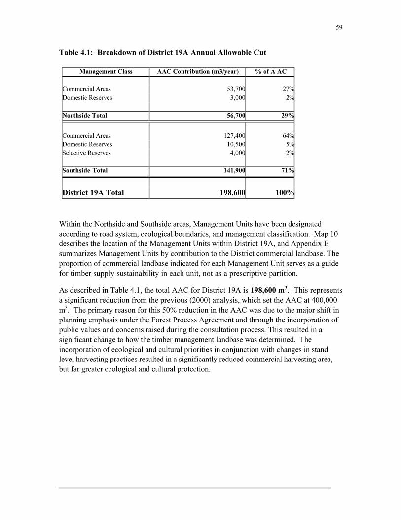
59
Table 4.1: Breakdown of District 19A Annual Allowable Cut
Management Class AAC Contribution (m3/year) % of A AC
Commercial Areas 53,700 27%Domestic Reserves 3,000 2%
Northside Total 56,700 29%
Commercial Areas 127,400 64%Domestic Reserves 10,500 5%Selective Reserves 4,000 2%
Southside Total 141,900 71%
District 19A Total 198,600 100%
Within the Northside and Southside areas, Management Units have been designatedaccording to road system, ecological boundaries, and management classification. Map 10describes the location of the Management Units within District 19A, and Appendix Esummarizes Management Units by contribution to the District commercial landbase. Theproportion of commercial landbase indicated for each Management Unit serves as a guidefor timber supply sustainability in each unit, not as a prescriptive partition.
As described in Table 4.1, the total AAC for District 19A is 198,600 m3. This representsa significant reduction from the previous (2000) analysis, which set the AAC at 400,000m3. The primary reason for this 50% reduction in the AAC was due to the major shift inplanning emphasis under the Forest Process Agreement and through the incorporation ofpublic values and concerns raised during the consultation process. This resulted in asignificant change to how the timber management landbase was determined. Theincorporation of ecological and cultural priorities in conjunction with changes in standlevel harvesting practices resulted in a significantly reduced commercial harvesting area,but far greater ecological and cultural protection.

60
Forest Product Processing and Marketing
The Province’s forest products sector consists of the newsprint industry, the lumberindustry, and a small number of value-added industries. These industries utilizeapproximately 2.5 million m3 of timber, and provide more than 3500 person years ofdirect employment resulting in 10,000 or more direct and indirect part-time and full-timejobs. These industries also produce newsprint and solid wood products valued at $600-$700 million.†
The sawmill industry in District 19A currently consists of 10 commercially licensedsawmills ranging in output size from a few thousand board feet per year to the largest oneat over 1 million board feet (fbm). Sawmill production since 1990 in this District isillustrated in Figure 11. As the graph illustrates, production has fluctuated between 1million and 2.6 million fbm (average production has been approximately 1.7 million fbm).Two of the 10 commercially licensed mills are considered class 6 mills (producing inexcess of 500,000 fbm per year) and their combined capacity has the potential to reach inexcess 10,000,000 fbm per year.
0
500000
1000000
1500000
2000000
2500000
3000000
1990 1991 1992 1993 1994 1995 1996 1997 1998 1999 2000
Year
Saw
mill
Pro
du
ctio
n (
fbm
)
Figure 12. Commercial sawmill production in District 19A (1990-2000)

61
Transporting forest products to outside markets has always been challenging forcommercial operators in this district. There is no rail link to the area, marine shipmentsare only possible for six months of the year and the current road link is consideredexpensive to operate on. While the completion of the Trans-Labrador Highway fromCartwright to Goose Bay would eliminate some of these problems, improvements in theabilities of local processors to carry inventories and increase production (and ultimatelyadd more value to the resource) would also help to overcome these marketing issues. It isclearly understood that local stakeholders wish to see local benefits from the forestresource maximized.

62
Economic Landscape: Objectives & Actions
Objective 11: Forest Product Processing & Value Added Industry
To acknowledge the importance of developing a viable forest product processing andvalue added industry within the District and highlight options that will support, promote,
and facilitate forest product processing and value added industries within the District.
The process of describing where and how timber harvesting will take place in the Districthas been an important consideration in this Plan. Effectively, after trees are harvested,de-limbed and cut to appropriate dimensions, the tree has become a forest product. Thenext critical issue is to then decide what to do with these forest products. Currently andhistorically the vast majority of forest products (over 85% of the harvested volume) isshipped out of the region in raw log form for processing elsewhere. The 15% thatremains is divided up among the local competing sawmills, all of which consistently run atunder-capacity. This situation is an issue that public participants feel extremelypassionate about, and they have made strong demands for change.
Local forest product processing and the development of value added industries areconsidered a viable solution to this dilemma. Forest product processing refers to primarymanufacturing of raw logs into traditional lumber products. Value added refers to any useof timber that generates more economic value than dimension lumber alone. Value added isa secondary manufacturing process that leads to a higher value product such as; flooring,paneling, musical instruments, furniture and cabinets, log homes, gardening products,mouldings, solid doors, pre-engineered wood products etc. Value added industries mayinclude several manufacturing processes, such as kiln drying, shaping, wood treatments,packaging and storage.
Considering the available wood supply for this District, forest product processing andvalue added represents a significant economic opportunity to this region. However,several challenges need to be overcome in developing this industry. A number ofquestions remain to be answered, and there is an urgent need for the following:
ÿ Timber quality assessmentsÿ Potential products assessmentsÿ Marketing assessmentsÿ Current financial capacityÿ Skills developmentÿ Detailed cost analysis

63
Actions:
Although the details of manufacturing forest products are outside of the scope of thisPlan, the following options will be evaluated in order to develop an action plan which willsupport, promote, and facilitate forest product processing and value added industrieswithin the District:
q Creating a processing and value added committee to research, monitor, andprovide recommendations to the Planning Team on how to maximize timberresources locally;
q Participate in and provide support to feasibility studies on local processing andvalue-added facilities;
q Study the feasibility of providing support in the form of rotating loans in order toenable local saw-milling facilities to purchase wood in advance of harvesting (thiswould ensure adequate cash-flow for both harvesting operations and sawmillfacilities);
q Establishing a wood purchasing agency or cooperative to operate a sort yard, inorder to create a viable market for local harvesting and value-added operations;
q Ensure any new harvesting allocations are tied to investment in local capacitybuilding for harvesting and processing.

64
Objective 12: Timber Harvesting & Sustainability
Ensure that all timber harvesting activities are ecologically responsible and sustainableover the rotation period.
Timber harvesting represents one of the key components of this forest management plan.Timber harvesting occurs at a variety of scales in this District, from small-scale domesticharvesters with chainsaws and pickup trucks, to commercial operators using mechanicalharvesters. Regardless of the scale, harvesting activities will follow specific standards toensure ecological responsibility and sustainability.
As discussed in several other sections of this Plan, timber harvesting can have an impacton other forest values if not properly managed. Past harvesting activities in this Districthave resulted in a variety of lessons learned, some of which include:
ÿ Pre-operational planning is required in order to identify sensitive features beforeharvesting commences.
ÿ Moist or wet timber management areas require harvesting activities to take placein the winter season.
ÿ Reduction of harvest block size is required to provide for stand level protectedarea networks.
ÿ Watershed level planning is required to avoid concentration of harvest blocks andto design conceptual protected area networks.
ÿ The quality of forest sites harvested must reflect the proportion in which theyoccur in the management areas to avoid high-grading the best timber sites.
ÿ Harvest-blocks need to be driven by area available, not expected volume yields.
Actions:
q Timber harvesting operations will be subject to the District 19 EnvironmentalProtection Standards (Appendix C);
q Pre-operational planning is required to identify sensitive features beforeharvesting commences;
q Moist or wet timber management areas require harvesting activities to take placein the winter season;
q Type of timber harvesting operation will be constrained to specific managementzones, as defined in Chapter 3 and Map11;
q Forest site quality proportions will be determined for each management area andharvesting activities will reflect these proportions;

65
q Proposed harvest areas will be driven by area available for harvest, not expectedvolume yields;
q Harvest blocks will be designed using natural features as boundaries. Thesefeatures will limit the size and shape of harvest blocks.

66
Objective 13: Timber Resource Utilization
To minimize merchantable wood wastage during timber harvesting operations, whileproviding for adequate retention of forest structure for natural habitat and ecosystem
function requirements
Good utilization is about minimizing wood wastage in the forest. Surveys of tops,stumps, cull, felled trees, pieces left, or standing trees are measured to find the net volumeleft in a cutting area after harvest. Although this coarse woody debris and other materialleft on site after harvest provides for natural habitat and ecosystem functionrequirements, it is very important to reduce the amount of merchantable timber left on theground following harvest.
With reference to standing trees, it is important to leave snags and other trees on the sitefor nesting and perching sites and to maintain forest structure. Seed trees and other leavetrees should not be left haphazardly in a cutting area but rather within a planneddistribution or in patches which would give the greatest benefit for current wildlife use, aswell as for regeneration and future development of the site. Standing trees retained afterharvesting should not be considered in utilization surveys. Proper design of harvest unitson the landscape and identification of trees to be left within harvest units will help guideutilization of areas.
Utilization surveys will continue in the District in order to quantify timber volumes leftafter harvest, but surveys will be expanded to take into account other attributes,particularly as they relate to habitat and other conditions following harvest. Publicinformation and education (regarding wood species, gains in heating value from seasoningof wood, burning techniques, as well as the condition of the resource and desiredcondition of blocks following harvest) need to be expanded to improve utilization of theresource now and into the future.
Actions:
q A general harvest strategy of harvesting the oldest forest stands first will befollowed;
q Immature stands will not be harvested;q In an effort to refine the wood supply analysis, regular utilization surveys will be
conducted and closely monitored;q Operators will be expected to utilize all merchantable portions of trees;q Sawlogs must be utilized as sawlogs and cut to the maximum length possible. A
minimum of 20% of all commercially harvested timber will be made available tolocal sawmills.
67
Objective 14: Forest Access Roads
To develop a forest access road strategy for the district that balances the short and long-term access needs with other ecological and cultural objectives.
Forest access roads are required for timber harvesting operations, silviculture, researchprojects, domestic harvesting, and general public use. The Department of ForestResources and Agrifoods constructs four classes of access roads (see Appendix F forstandards) and the Environmental Protection Plan of 1994 provides explicit guidelines forforest road construction. Further, the FMD 19 Environmental Protection Guidelines(Appendix C) outline specifications for forest access road construction and maintenance.
Forest harvesting by commercial operators (and subsequent silviculture work) hasgenerally been concentrated in areas accessed by the existing network of forest accessroads. Operational roads have been constructed from existing access roads. The existingnetwork of forest access roads is shown on Map 9.
It is recognized that new road networks will have to be constructed to accommodateharvesting operations and other forest management activities. It is also expected thatpublic highways and roads for agriculture and cottage development, as well as privateroads, will continue to be planned and built through areas of productive forest in thedistrict.
Actions:
q All roads will be constructed to approved environmental standards (as stated inAppendix F and Appendix C);
q In areas where there are no ecological protection issues or public objection toroad construction, and where desirable from a timber supply management point ofview, (i.e. silviculture) roads will be maintained;
q Where there are sensitivities, access from a main road would be restricted whileforest operations in the areas are ongoing. After forest operations in the area arecompleted (either temporarily or permanently), access to the road would be deniedto vehicular traffic by decommissioning (i.e., the removal of bridges and culvertsor by the addition of barriers);
q No main forest resource road would run on a continuous course parallel to themain channel of a scheduled salmon river within two kilometers of the salmonriver;

68
q Temporary extraction routes less than 2 km in length will be constructed bycommercial operators to a standard that is environmentally acceptable and,provided they have no further utility (i.e. for harvesting or silviculture), they will bedecommissioned immediately after satisfactory inspection of the harvesting areas;
q In order to minimize ground disturbance, extraction routes will be pre-planned ineach operating block, and will target stable terrain. Where this disturbanceexceeds 10%, reclamation of the trail has to be undertaken by the operator;
q Permanent road construction should be conducted during the summer months orgenerally dry periods. Road use should be similarly restricted. In particular, roaduse and construction should be restricted during periods of road weakness, firehazard or wildlife vulnerability.

69
Objective 15: Forest Resource Protection
To develop mechanisms for forest resource protection against disturbance, such as fireand insect outbreaks, which consider the risks to human life, property, commercial timber,
and ecological health.
On a large scale, ecosystems require protection to ensure their representation and toensure that land use activities do not negatively impact on them. On a smaller scale,mechanisms for resource protection must also be considered in order to safeguard humanlife, property, commercial timber supplies, and other factors. In this context, the term“resource protection” is usually used to describe fire control and pest control activities.
Over the years, the DFRA has greatly improved its ability to suppress wildfires in theprovince. The provincial government took the lead role in forest fire management andsuppression in 1975, making significant purchases of new equipment, technology, andaircraft. The Forest Service operates six CL-215 Air Tankers along with a Cessnaspotter. Four long ranger helicopters are on full time standby and others are hired asneeded. This equipment is used for initial attack along with ground crews who arescattered throughout the province in twenty-six depots (seven in Labrador). Fire co-ordination is handled by a Duty Officer for each region who oversees the initial attacksand deploys equipment as required. There is a modern new Provincial Forest FireEquipment and Maintenance Facility in Gander and in 1996 a state-of-the art hose drying,testing, and repair facility was opened adjacent to the Forest Protection Centre.
Healthy forests have an increased resistance to insects and disease. Forest managementtechniques will be used as far as possible to maintain healthy forests and thus reduce therisk and severity of insect epidemics.
Actions:
q Fire protection activities in District 19 will be coordinated from the District Officein Northwest River;
q All reported fires will be evaluated according to their risk to human life, property,ecological value, and commercial resources. Map 12 outlines the fire suppressionpriority map for this district;
q The timber harvesting strategy (to harvest the oldest stands first) reduces theproportion of senescent or weakened trees in the forest;
q A fire protection strategy will be developed for the four communities in the Districtwhich will include provisions for physical fire breaks where necessary;
q Where planting is conducted, use of native species which are less susceptible tomajor defoliators will offer the forest a greater degree of protection;

70
q Protection of fish, wildlife, water, and other forest resource values in forestryoperations will be accomplished through adherence to the Ecological ProtectedAreas Strategy, the Environmental Protection Plan, and any revisions made to it;
q Protection of the forest landbase will also be ensured through refusal of CrownLands applications for non-compatible use and through delineation orrecommendation of areas for reserve status;
q A community forest fire protection plan will be created for the towns of North WestRiver and Sheshatshiu.

71
Objective 16: Silviculture & Restoration
To develop a silviculture & restoration strategy which fits the unique ecologicalcharacteristics of the District and strives to re-establish pre-disturbance species
distributions to disturbed or degraded sites.
The study of silvics deals with the principles underlying the growth and development ofsingle trees and of the forest as a biological unit. The practice of silviculture applies theknowledge of silvics to maintain and enhance the utility of forest stands for any givenpurpose (Smith, 1986). It is defined by Forestry Canada as “the theory and practice ofcontrolling the establishment, composition, growth and quality of forest stands to achievethe biological and economic objectives of forest management.” Further, silviculturemethods can also be utilized for restoration of degraded sites such as borrows pits, streambanks, roadways, or skid trails.
However, a recent Senate subcommittee report on the boreal forest found that adequatesilvicultural methods have not been developed for the northern boreal forest, and thatcurrent research suggests intensive silviculture, such as planting, has had little success dueto the ecological limits of the boreal forest (L. Bouthillier, 1999).
The Province of Newfoundland and Labrador has a silviculture program consisting of tworelated components: Operational Treatments and Research and Development. Under thisPlan these activities will be monitored and adapted as new information on effectivesilviculture methods for this District and the boreal forest become available.
Actions
q Regeneration surveys will be conducted at various intervals on harvested anddisturbed areas to assess silvicultural requirements, ecosystem productivity, andsite disturbance. Natural regeneration is preferred and will be promotedthroughout the harvesting and silviculture strategies;
q Planted species will attempt to re-establish pre-disturbance species distributionq Seedlings will be grown from local seed sources;q Thinnings will attempt to re-establish pre-disturbance species distribution;q Research will focus on growth and yield in both treated and non-treated stands so
that a more refined wood supply analysis can be produced.
72
Objective 17: Tourism and Recreation
To acknowledge the economic and cultural importance of tourism and recreation in theDistrict. All forest-based activities will consider mutual impacts and aim to coordinate
economic and cultural benefits.
The tourism industry in Newfoundland and Labrador makes a significant contribution tothe provincial economy. The industry employs 25,000 people, both directly andindirectly, and generates revenue in excess of $600 million annually (based on the mostcurrent data available including both resident and non-resident visitation statistics). Thenon-resident tourism market has grown significantly in recent years (37% between 1996and 2000) and this trend is expected to continue. The Lake Melville area is considered tobe an emerging destination within this market and has the potential to realize significantdevelopment in the tourism industry.
As is the case in other parts of the province (Labrador in particular), the appeal of thetourism industry in this district is based on our natural resources. Non-resident visitorsto the area have generally been drawn by world-class opportunities in fishing, hunting,wilderness adventure, and winter sports. Potential increases to these markets will likelyemerge as a result of increased access (i.e. completion of the Trans Labrador Highway), anincrease in tourism-related opportunities (i.e. Mealy Mountains National Park), and anincrease in development of other non-related industries. Operational activities in this planwill aim to minimize the impact on the resources on which these tourism opportunitiesare dependent.
Outdoor recreational activities for local residents also often take the form of the tourismopportunities outlined above. While snowmobiling, skiing (Nordic and alpine), andsnowshoing are common pastimes in the winter, boating, camping, and hiking are commonin the spring and summer. It should be noted that domestic hunting and fishing, whileproperly classified as a subsistence harvesting activity, rather than a recreational activity,is a significant outdoor activity for a majority of local residents in this district. Manylocal residents also maintain and spend a considerable amount of time throughout the yearat private cabins in the area.
Actions:
q The Planning Team will continue to work with local stakeholders and operators todelineate areas which have high tourism and recreational use or potential use;

73
q Critical viewsheds will be delineated for high potential areas (i.e. Grand Lake,Trans-Labrador Highway, Snowmobile Trail), and commercial forestry activitieswithin these areas will be limited or designed to minimize the impact to visualsensitivity;
q Where commercial forestry activities are planned in areas adjacent to recreationalareas, efforts will be made to execute those operations during “low season” (i.e.summer operations in close proximity to winter activities and vice versa);
q Firm establishment of Mealy Mountain National Park boundaries (and options forconnectivity with this Plan’s Protected Area Network) will continue to be supportedby the Planning Team;
q Visual sensitivity will be evaluated around cabin development areas andharvesting activities will be planned to minimize this impact. A minimum 50 meter“no harvest” buffer will also be maintained around registered cabins.

74
Objective 18: Future Economic Developments
To recognize the importance of potential economic developments in the region andconsider how all developments will interact with the goals, objectives, and principles of
this plan.
Several significant economic developments are proposed for the central Labrador region.Proposed developments which may influence forest activities in District 19 include:
ÿ Lower Churchill Hydroelectric Projectÿ Trans Labrador Highway Phase IIIÿ An aluminium production facilityÿ Mealy Mountains/Akamiupishku National Parkÿ Voisey’s Bay Nickel Project11
These proposed economic developments are independent of this Plan. However, due tothe fact that economic developments within a region are interlinked, developments inother sectors will have an influence on the forest-based economic developments describedin this Plan. Therefore, future developments need to be considered in relation to the goalsand objectives outlined in this Plan.
Actions:
q Organizations responsible for the implementation of this Plan will provide input asrequested at regional economic forums or seminars, and to boards or agenciesregarding the goals and objectives of the Plan;
q Organizations responsible for this Plan will provide comments and information toany environmental assessments as required;
q Impacts of potential economic developments will be assessed within the ecological,cultural, and economic frameworks of this Plan;
q The Plan will be adapted, where necessary, to accommodate other approvedeconomic developments.
11 Although this project is located out of the District, it is anticipated the central Labrador region wouldrealize significant economic spin-offs.

75
CHAPTER 5: RESEARCH & MONITORING

76
Ecological Research & Monitoring
As discussed in Chapter 1, an Ecosystem-Based Planning approach to forest managementis founded upon protecting, maintaining, or where necessary, restoring fully functioningecosystems over a range of spatial scales over long timeframes. In order to realize thisgoal, specific ecological criteria and indicators need to be developed, and an active researchand monitoring program must be in place.
From 1996 to 1998 several public stakeholder meetings in this District focused on thisissue. As a result of this work, there was general consensus to adopt a criteria andindicators system as outlined by the Canadian Council of Forest Ministers (CCFM).This system has evolved from several international efforts that were initiated to developcriteria and indicators for sustainable forest management following the 1992 UnitedNations Conference on Environment and Development.
These criteria and indicators move beyond a narrowly defined focus on the productivityof timber and other commercial forest products to incorporate ecological and socialdimensions of sustainability. For example, the broad forest values developed as criteriaunder the Montreal Process for the conservation and sustainable management of borealand temperate forests includes the following priorities (see Appendix I for detaileddescriptions):
1. Conservation of biological diversity;2. Maintenance of the productive capacity of forest ecosystems;3. Maintenance of forest ecosystem health and vitality;4. Conservation and maintenance of soil and water resources;5. Maintenance of forest contribution to global carbon cycles;6. Maintenance and enhancement of long-term multiple socio-economic benefits to
meet societal needs;7. Effective legal, institutional, and economic frameworks for forest conservation and
sustainable management.
Further, the developments of national and international standards in the form of forestcertification systems are also an important indicator for this Plan.
Actions:
The parties responsible for the implementation of this Plan will undertake an ecologicalresearch and monitoring program through collaboration and consultation with localstakeholders, research organizations, and other institutions. The parties responsible forcreating this plan have identified several “go forward” planning issues that require furtherresearch, monitoring and action to resolve.

77
Work undertaken by the Parties responsible for implementing the ecological research andmonitoring program will accomplish the following priorities:
q Complete the landscape level EPAN for the remainder of FMD 19, with anemphasis on areas south of the Churchill River;
q Consult and collaborate with Parks Canada and the MealyMountains/Akamiuapishku National Park Steering Committee on the feasibilitystudy for the proposed Mealy Mountains/Akamiuapishku National Park;
q Research and monitor ecological components of the criteria and indicators set outby the CCFM (Appendix I);
q Research, monitor and participate in new criteria and indicator programs;q Design and implement a monitoring strategy to ensure that the District protected
area strategy maintains viable populations of key indicator species for each of thethree scales;
q Research and monitor stream, river, and lake water quality, and aquatic indicatorspecies such as fish;
q Work to refine and develop at the landscape and watershed level an ecosystemclassification system based on high-resolution satellite imagery and changedetection;
q Work to develop a site level ecosystem classification system based on indicatorplants, soil nutrients, and moisture regimes;
q Research and monitor natural disturbance regimes at multiple spatial scales;q Research and monitor the effectiveness of the Ecological Protected Area Networks
at all spatial scales to protect and maintain ecological structure and function;q Research and monitor specific ecological impacts of timber harvesting as identified
in Annual Work Schedules such as forest regeneration, site disturbance, andalternative logging methods;
q Research and monitor forest stand dynamics over time. Particular attention willbe given to ecosystem productivity, composition, structure, and function;
q Report annually on the status of “go-forward” planning issues, research, andmonitoring results.

78
Cultural Research & Monitoring
As discussed in the section above, an active research and monitoring program must be putin place, and specific criteria and indicators need to be developed in order to achieve theecological objectives and goals of this Plan. A similar framework must also be developedand implemented for research and monitoring with respect to cultural objectives and goals.
Although the Canadian Council of Forest Ministers criteria and indicators programaddresses some cultural values, additional indicators are required to address the culturalvalues encompassed in this plan. The Centre For International Forestry Research(CIFOR) has developed a set of criteria and indicators for sustainable forest managementspecifically focusing on Aboriginal and rural communities which place a high culturalvalue on forests. Similarly, several of the FSC principles and criteria encompass a broadsocial spectrum with particular attention paid to the rights of indigenous peoples. Asummary of the CIFOR criteria and indicators for human well-being and the FSCPrinciples & Criteria are provided in Appendix I.
Actions:
The Parties responsible for the implementation of this Plan will undertake a culturalresearch and monitoring program through collaboration and consultation with localstakeholders, research organizations, and other institutions. The research and monitoringprogram will strive to address the following priorities:
q Research and monitor cultural components of the criteria and indicators programsset out by FSC and CIFOR (Appendix I);
q Research, monitor and participate in cultural criteria and indicator developmentssuch as those outlined in the various certification standards;
q Research on non-Innu land use and occupancy information and mapping;q Assess cultural protection measures of the Plan with Aboriginal and non-
aboriginal communities;q Aboriginal and non-aboriginal assessments of stand level timber harvesting
practices;q Impacts of timber management activities on Aboriginal and non-aboriginal
cultural values;q The results of the cultural research and monitoring program will be reported
annually.

79
Economic Research & Monitoring
Specific criteria and indicators and an active research and monitoring framework must beapplied for the economic objectives and goals identified in this Plan. There are severaloverlaps between ecological, cultural, and economic research and monitoring components.For the purpose of this Plan, components which have a direct link to economic activities,such as timber harvesting, management zoning, and annual rate of harvest are addressed inthis section.
Actions:
The Parties responsible for the implementation of this Plan will undertake an economicresearch and monitoring program through collaboration and consultation with localstakeholders, research organizations and other institutions. Further, it is recognized thatthe Parties responsible for creating this plan have identified several “go forward” planningissues that require further research and monitoring to resolve. In doing so, this researchand monitoring program will strive to address the following priorities:
q Research, monitor and review the following “go forward” issues:
o Ecological and operational implications of harvesting in proximity to thelower Goose River linkage;
o Ecological and operational implications and patterns associated withharvesting poor sites;
o Review isolation analysis with air-photo interpretation on a managementunit basis;
o Buffer size and function for riparian features;o Percentage of area required for stand level EPAN’s;.o Percentage of volume required for block retention;o Utilization, cull, and waste levels;o Derived ecosystem productivity and growth and yield information for
regenerating stands. q Research and monitor economic components of the criteria and indicators programs
set out by CCFM (Appendix I);q Participate and provide input into economic criteria and indicator development for
boreal certification;q Research and monitor economic productivity of all forest-based industries;q Research and monitor training and employment opportunities / developments in all
forest-based industries;q Monitor timber harvest block volumes and areas against estimations;

80
q Create a processing and value added committee to research, monitor, and providerecommendations to the Planning Team on how to maximize local utilization of timberresources;
q Create a database of potential forest product developments and market information;q Report annually on the status of research and monitoring programs and results.

81
References
Allington, K.R. 1958. “Bogs of Central Labrador” McGill Subarctic Research Paper No.7: Montreal: McGill University.
Anderson, T.C. 1985. The Rivers Of Labrador. Ottawa: Department Of Fisheries &Oceans.
Bajzak, D. 1973. Bio-Physical Land Classification of the Lake Melville Area, Labrador.Information Report N-X-88, Newfoundland Forest Research Centre. 115 pp.
Bajzak & Roberts, 1984. Mapping landtypes for forest evaluation in the Lake MelvilleArea, Labrador. Paper presented at the Joint Meeting of the Working Parties # 1.02-6and #102-10 of IUFRO on Qualitative and Quantitative Assessment of Forest Sites withSpecial Reference to Soil. Sept 10 - 15, 1984, Birmensdorf, Switzerland. 12pp.
Brice-Bennett, Carol (ed). 1977. Our Footprints are Everwhere: Inuit Land Use andOccupany in Labrador. Nain: LIA.
Canadian Council of Forest Ministers, 2000. Criteria and Indicators of SustainableForest Management in Canada. Natural Resources Canada. 122 pp.
Clark, J.R. 1999. The Ecosystem Approach from a Practical Point of View. ConservationEcology, Volume 13 No.3.
Constanza, R., B.G. Norton & B.D. Haskell (Eds) 1992 Ecosystem Health: NewGoals for Environmental Managers. San Francisco: Island Press
Fitzhugh, William. 1972. Environmental Archaeology and Cultural Systems in HamiltonInlet, Labrador. Smithsonian Contributions to Anthrolopology.v. 16 Washington DC
Grumbine, R.E. 1994. What is Ecosystem Management? Conservation Biology v. 8.
Hammond, H ., and Hawe, A. 1993. Initial Study Of Ecological & Economic Viability OfCommerical Timber Management In Labrador. Winlaw: Silva Ecosystem Consultants.
Hammond, H ., and Hawe, A. 1994. Innu Peer Review Summary. Winlaw: SilvaEcosystem Consultants.
Hammond, H. 1995. Review Of “Environmental Preview Report Proposed AdaptiveManagement Process Newfoundland Forest Service.” Winlaw. Silva EcosystemConsultants.

82
Hammond, H. 2000. Initial Landscape Analysis & Ecosystem-Based Plan For FMD 20,Labrador (Nitassinan). Winlaw: Silva Ecosystem Consultants.
Hammond H. 2001. Ecosystem-Based Planning: A Practical Tool. Winlaw: SilvaEcosystem Consultants.
Hammond H., and Leslie, E. 2001. Review Of Draft Plans For FMD 20. Winlaw. SilvaEcosystem Consultants.
Hammond H., and Leslie, E. 2001. Draft Interpretive Maps For FMD 19 Ecosystem-Based Plan. Winlaw: Silva Ecosystem Consultants.
Hammond H., and Leslie, E. 2001. Addendum to Draft Interpretive Maps For FMD 19Ecosystem-Based Plan. Winlaw: Silva Ecosystem Consultants.
Hammond H., and Leslie, E. 2002. Peer Review Summary Innu Nation - Silva EcosystemConsultants Multiple Spatial Scale Reserve Designs for FMD 19, Labrador. Winlaw: SilvaEcosystem Consultants.
Hare, F.K. 1959. A Photo-Reconnaissance Survey of Labrador - Ungava; Geog. Br.,Dept. Mines and Tech. Surv.,Mem.6.
Hunter, M.J., Jr. 1990. Wildlife, Forests, and Forestry: Principles of Managing Forestsfor Biological Diversity. New Jersey: Prentice Hall.
Hustich, 1949. “On the Forest Geography of the Labrador Peninsula”. Acta Geographica,Vol. 10, pp. 67-87.
Lealock, E., and Rothschild, N. 1994. Labrador Winter. Washington D.C: SmithsonianInstitution.
Leslie, E., Bradley, T. and Hammond H. 2002. Growth & Yield Predictions For TheGrand Lake Area. Winlaw: Silva Ecosystem Consultants.
Lopoukhine, N., Prout, N.A., and Hirvonen, H.E. 1976. The Ecological LandClassification of Labrador: A Reconnaissance. Ecological Land Classification Series, No.4. 85 pp.
Mailhot, J. 1997. The People Of Sheshatshit: In The Land Of The Innu. St. John’s: ISERMemorial University.
Meades 1990. Natural Regions of Newfoundland and Labrador. Report preparedfor the Protected Areas Association, St. John's. 374pp. + appendix 103 pp.

83
Newfoundland & Labrador Forest Service. 1995. Guidelines for The Preparation ofForest Ecosystem Management Plans. Corner Brook: DFRA
Rigg, C.M. 2001. Orchestrating Ecosystem Management: Challenges and Lessons fromSequoia National Forest. Conservation Biology, Volume 15 No. 1 p78-90.
Rowe, J.S. 1972. Forest Regions of Canada. Can For Serv Bull. No. 1300.
Smith, D.M. 1986. The Practice of Silviculture. John Wiley and Sons, New York.
Thomas, J. 1995. Protected Areas Status In The Labrador Region: A draft discussion.North West River: Department Of Forest Resources & Agrifoods.
Thomas, J. 2000. Five-Year Operating Plan For FMD 19: Draft. North West River:Department Of Forest Resources & Agrifoods.
USFS 1997. An Assessment of Ecosystem Health in the Southwest. RM-GTR-295.
Wadden, Marie. 1991. Nitassinan: The Innu Struggle To Reclaim Their Homeland.Vancouver: Douglas & McIntyre.
Wilton, W.C. 1965. The Forests of Labrador, Dept. of Forestry, Canadian ForestResearch Branch Contribution No. 610.