For public purposes: The Government Farm and Belair ... · For public purposes: The Government Farm...
23
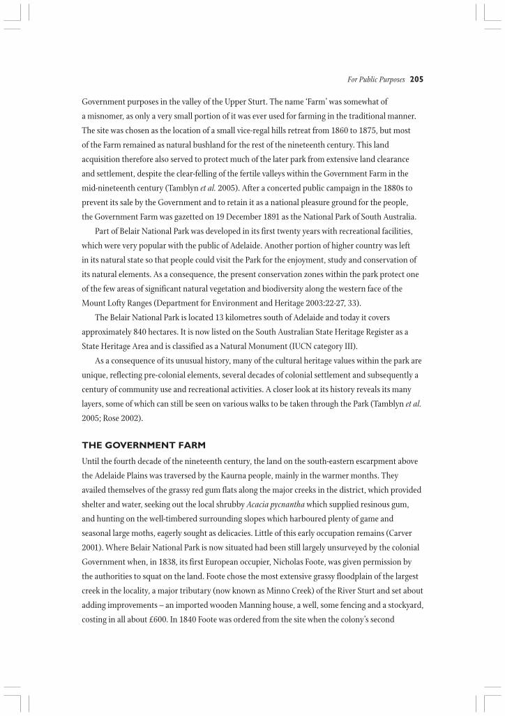
204 Valleys of Stone CHAPTER 12 For public purposes: The Government Farm and Belair National Park, 1840-1920 Pam Tamblyn HE BELAIR NATIONAL PARK is a significant park, both nationally and internationally. Declared in T December 1891, it was the first national park in South Australia, the second in Australia and the tenth in the world. A public campaign at that time had demanded that the area be set aside for recreation and to conserve the natural environment, although the 1891 Act focused on recreational activities rather than conservation (Department of Environment and Planning 1989:13-20). The Park owes its existence to the establishment, four years after the proclamation of South Australia as a British province in 1836, of a Government farm on the land on which the Park now stands. A tract of approximately 2,000 acres (820 hectares) was set aside in 1840 for a farm for
Transcript of For public purposes: The Government Farm and Belair ... · For public purposes: The Government Farm...
204 Valleys of Stone
CHAPTER 12
For public purposes:The Government Farm and
Belair National Park, 1840-1920Pam Tamblyn
HE BELAIR NATIONAL PARK is a significant park, both nationally and internationally. Declared inTDecember 1891, it was the first national park in South Australia, the second in Australia and
the tenth in the world. A public campaign at that time had demanded that the area be set aside for
recreation and to conserve the natural environment, although the 1891 Act focused on recreational
activities rather than conservation (Department of Environment and Planning 1989:13-20).
The Park owes its existence to the establishment, four years after the proclamation of South
Australia as a British province in 1836, of a Government farm on the land on which the Park now
stands. A tract of approximately 2,000 acres (820 hectares) was set aside in 1840 for a farm for
For Public Purposes 205
Government purposes in the valley of the Upper Sturt. The name ‘Farm’ was somewhat of
a misnomer, as only a very small portion of it was ever used for farming in the traditional manner.
The site was chosen as the location of a small vice-regal hills retreat from 1860 to 1875, but most
of the Farm remained as natural bushland for the rest of the nineteenth century. This land
acquisition therefore also served to protect much of the later park from extensive land clearance
and settlement, despite the clear-felling of the fertile valleys within the Government Farm in the
mid-nineteenth century (Tamblyn et al. 2005). After a concerted public campaign in the 1880s to
prevent its sale by the Government and to retain it as a national pleasure ground for the people,
the Government Farm was gazetted on 19 December 1891 as the National Park of South Australia.
Part of Belair National Park was developed in its first twenty years with recreational facilities,
which were very popular with the public of Adelaide. Another portion of higher country was left
in its natural state so that people could visit the Park for the enjoyment, study and conservation of
its natural elements. As a consequence, the present conservation zones within the park protect one
of the few areas of significant natural vegetation and biodiversity along the western face of the
Mount Lofty Ranges (Department for Environment and Heritage 2003:22-27, 33).
The Belair National Park is located 13 kilometres south of Adelaide and today it covers
approximately 840 hectares. It is now listed on the South Australian State Heritage Register as a
State Heritage Area and is classified as a Natural Monument (IUCN category III).
As a consequence of its unusual history, many of the cultural heritage values within the park are
unique, reflecting pre-colonial elements, several decades of colonial settlement and subsequently a
century of community use and recreational activities. A closer look at its history reveals its many
layers, some of which can still be seen on various walks to be taken through the Park (Tamblyn et al.
2005; Rose 2002).
THE GOVERNMENT FARM
Until the fourth decade of the nineteenth century, the land on the south-eastern escarpment above
the Adelaide Plains was traversed by the Kaurna people, mainly in the warmer months. They
availed themselves of the grassy red gum flats along the major creeks in the district, which provided
shelter and water, seeking out the local shrubby Acacia pycnantha which supplied resinous gum,
and hunting on the well-timbered surrounding slopes which harboured plenty of game and
seasonal large moths, eagerly sought as delicacies. Little of this early occupation remains (Carver
2001). Where Belair National Park is now situated had been still largely unsurveyed by the colonial
Government when, in 1838, its first European occupier, Nicholas Foote, was given permission by
the authorities to squat on the land. Foote chose the most extensive grassy floodplain of the largest
creek in the locality, a major tributary (now known as Minno Creek) of the River Sturt and set about
adding improvements – an imported wooden Manning house, a well, some fencing and a stockyard,
costing in all about £600. In 1840 Foote was ordered from the site when the colony’s second

206 Valleys of Stone
Governor, Colonel George Gawler, deemed it suitable for a farm owned by the Government for
agisting horses and bullocks from the Survey, Emigration and Stores Departments and for
supplying the large amounts of hay needed to feed Government stock. Foote, under protest, was
evicted with recompense of £300 for his improvements. The location would also be good for a vice-
regal hills retreat, ‘a place of retirement’ from the summer heat of the capital, in the tradition of
many parts of the British Empire. Its climate was amenably cooler in summer and the site was
sheltered, with timbered slopes and an adequate natural water supply.
In July 1840, the acting Colonial Treasurer, George Hall, tendered on behalf of the Government
for ten surveyed sections of land near Upper Sturt, each containing eighty acres, including Nicholas
Foote’s improvements. Another three sections were also reserved and a parcel of over 1,000 acres of
unsurveyed country was added. The offering of the acting Colonial Treasurer’s private promissory
note for only the first 800 acres, a highly questionable procedure, contravened the statutory
requirements for the sale of land in the colony and the Government’s claim of ownership of the
Government Farm was to be tested shortly.
The colony had fallen on straitened financial circumstances during Gawler’s time in office and
the next Governor, Captain George Grey, arrived in May 1841 to find just £713 in Government
coffers, with debts amounting to about £16,000. Grey ascertained that the disposal of Government
assets such as stock, property and the Government Farm, ‘by no means a necessary appendage to
Figure 12.2Map showing location of Belair National Park and its proximity to Adelaide.
SOURCE Department for Environment and Heritage 2003:7
For Public Purposes 207
the province’ (Grey in the Observer 21 May 1841), would temporarily alleviate the situation and so a
public auction of the Farm was immediately set in train (South Australian Government Gazette, 12
July 1841). It was ‘an opportunity not likely to occur again’ ((South Australian Government Gazette,
30 June 1841) for settlers to purchase ‘this splendid farm containing about 1500 acres of the richest
land in the Province’ (ibid.) and the auction was scheduled for 19 July. However the Government,
wary of public reaction to its doubtful legal ownership of the land, cancelled the auction in haste.
The Government Farm remained, and despite some further public discussion on the validity of its
title, the status quo was accepted. The survey of the Farm was completed in the early 1840s under
Corporal Dixon of the Sappers and Miners, who had been brought from England by the South
Australia Company to work under Colonel Edward Frome and assist with the survey of the colony
after the death of Colonel William Light. The five westernmost sections of the Farm (874, 875, 878,
879 and 882) were sold in 1844, on which were subsequently grown vines and fruit and which more
recently became parts of the suburbs of Belair and Glenalta.
In 1840, John McLaren, from the Survey Department, was installed as the first Supervisor
(or Keeper) of the Government Farm, residing in Nicholas Foote’s prefabricated cottage. McLaren
was followed briefly by Corporals John Coles then Robert Moulton, both from the Sappers and
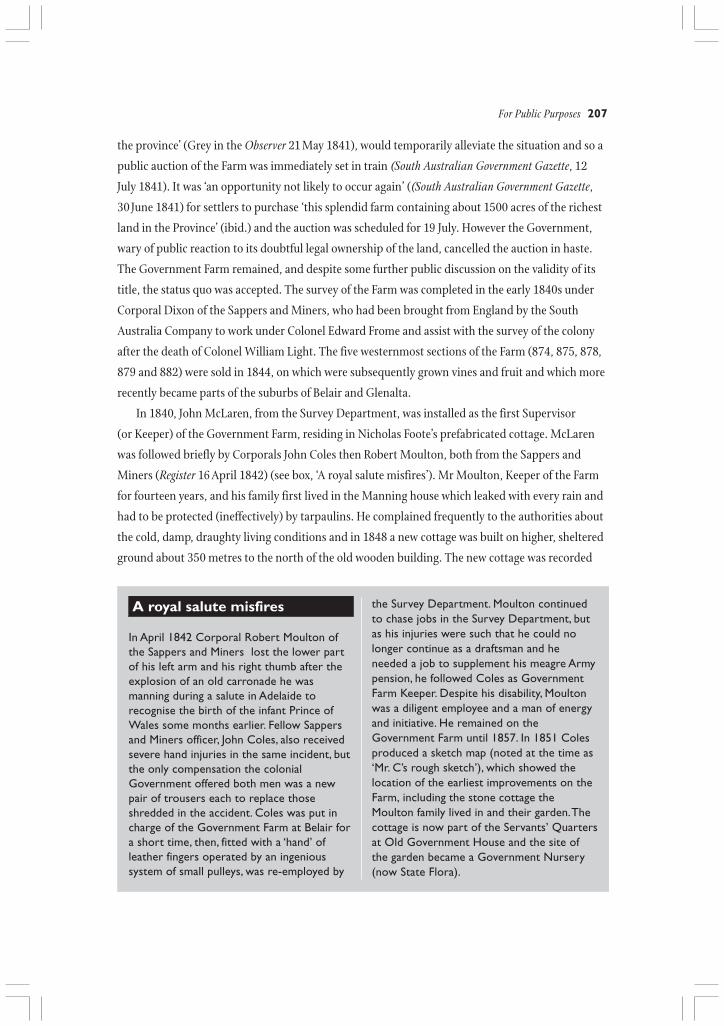
Miners (Register 16 April 1842) (see box, ‘A royal salute misfires’). Mr Moulton, Keeper of the Farm
for fourteen years, and his family first lived in the Manning house which leaked with every rain and
had to be protected (ineffectively) by tarpaulins. He complained frequently to the authorities about
the cold, damp, draughty living conditions and in 1848 a new cottage was built on higher, sheltered
ground about 350 metres to the north of the old wooden building. The new cottage was recorded
A royal salute misfires
In April 1842 Corporal Robert Moulton ofthe Sappers and Miners lost the lower partof his left arm and his right thumb after theexplosion of an old carronade he wasmanning during a salute in Adelaide torecognise the birth of the infant Prince ofWales some months earlier. Fellow Sappersand Miners officer, John Coles, also receivedsevere hand injuries in the same incident, butthe only compensation the colonialGovernment offered both men was a newpair of trousers each to replace thoseshredded in the accident. Coles was put incharge of the Government Farm at Belair fora short time, then, fitted with a ‘hand’ ofleather fingers operated by an ingenioussystem of small pulleys, was re-employed by
the Survey Department. Moulton continuedto chase jobs in the Survey Department, butas his injuries were such that he could nolonger continue as a draftsman and heneeded a job to supplement his meagre Armypension, he followed Coles as GovernmentFarm Keeper. Despite his disability, Moultonwas a diligent employee and a man of energyand initiative. He remained on theGovernment Farm until 1857. In 1851 Colesproduced a sketch map (noted at the time as‘Mr. C’s rough sketch’), which showed thelocation of the earliest improvements on theFarm, including the stone cottage theMoulton family lived in and their garden. Thecottage is now part of the Servants’ Quartersat Old Government House and the site ofthe garden became a Government Nursery(now State Flora).
208 Valleys of Stone
as being of local stone, had two solid rooms, two lean-to structures and a shingle roof (GRG 24/4
and 24/6 Colonial Secretary’s Office Correspondence 1840-1848). In 1849 on the gentle slopes to
the north which contained very good loamy soil and through which ran a small creek, Moulton
planted an enclosed vegetable garden in which he grew peas, beans, cabbages, cauliflowers, carrots
and potatoes, with shade from species of English trees which he also planted (ibid). This was the
first step in the cultivation of this site, a practice which was to continue, in one form or another,
for the next 150 years. Most notably the site developed from the late nineteenth century as the
Belair Woods and Forests Department Nursery, continuing to function still today as the Belair State
Flora Nursery.
In the late 1840s the Government was unsuccessful in finding suitable candidates for longer
term leases of the Farm. At this time a large centrally located paddock of about 85 acres (35 ha.) in
extent was the only cleared land on the Farm and was known for many years as the House Paddock
(see Figure 12.3). The Gold Escort was set up in 1852 to bring gold from the recently discovered
Victorian diggings to be assayed in Adelaide and the Government Farm was placed in the hands of
the Police Department. Horses from the Gold Escorts were rested on the Farm. Police records (GRG
5/5 Stewart Correspondence (Police Records) 1852-1856) show that Moulton, now employed as
officer in charge of mounted police on the Government Farm, lived in the upper stone cottage,
while the lower part of the House Paddock was given over to Gold Escort mounted police. The old
Manning house was made available as the men’s quarters, described as containing not much more
than four chairs, two tables, two iron stretchers (with blankets) and a well-provisioned tack room
(Blake1971:17-18). Three stone rooms had been added to the timber structure. The stockyards and a
stable were nearby. Moulton and his eldest son, George, were also included in at least two of the
escorts in 1852. Although the Gold Escorts finished in 1853, police horses were agisted on the Farm
for several years, police presence remaining officially until savage cuts in numbers occurred in 1856.
Moulton, now forced to leave the Government Farm, secured a position as Crown Lands Ranger at
Mount Barker in 1857. There are no signs today of police activity in the 1850s on this site as it was
subjected to many changes over the next fifty years and then became the hub of works activities
after the National Park was declared in 1891. The era of the 1850s is recalled in the current naming
of this part of the old House Paddock as the Gold Escort Picnic Ground.
In 1856 repairs were ordered by the Colonial Secretary for the old ‘wooden house on the
Government Farm’ (GRG 24/4 and 24/6 Colonial Secretary’s Office Correspondence 1840-1848).
The Manning house and its stone additions were consolidated, so that by 1877 it was reported that
the dwelling formed a comfortable home ‘substantially built of stone and roofed with galvanised
iron’ (Advertiser 6 February 1877). In 1942, Harriet Cook, whose youth had been spent on the Farm
in the 1870s, recalled that the dwelling also included a ‘big living room with its fireplace quite six
feet across’ and a dairy (Cook 1942). Its garden was enclosed by a picket fence and the homestead
served the Farm Keepers for the rest of the nineteenth century as well as the first Curator of the
For Public Purposes 209
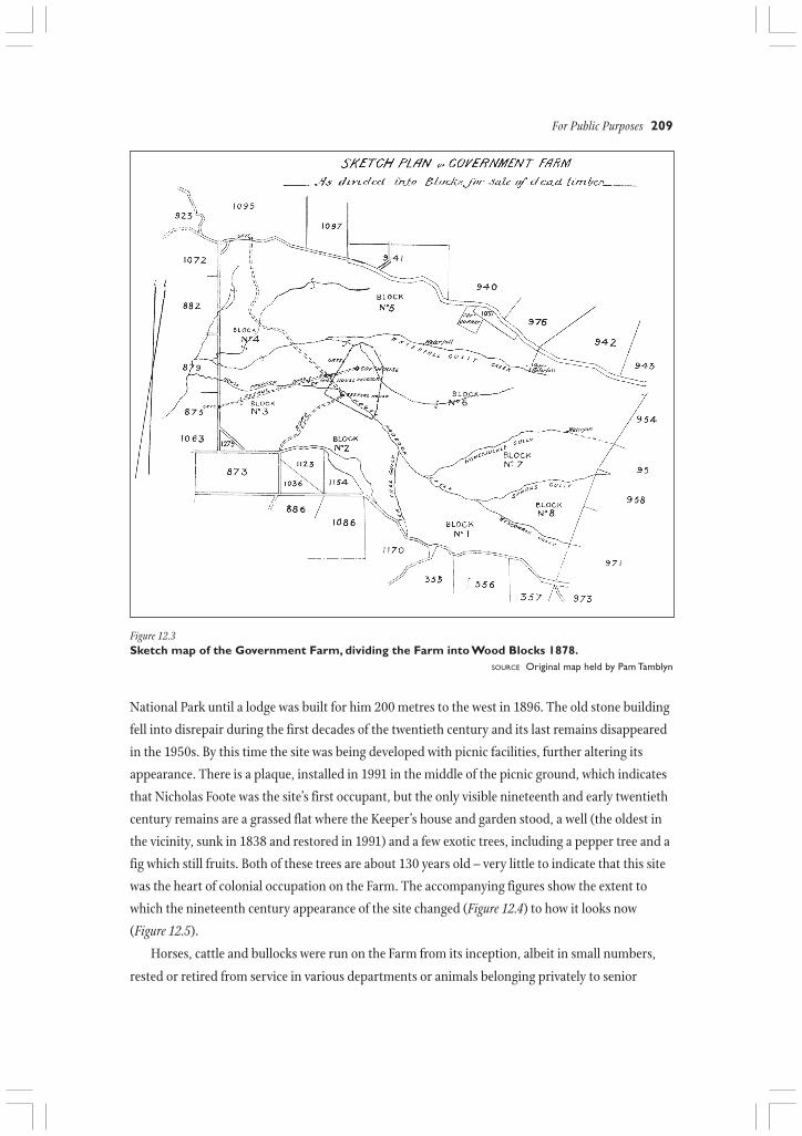
National Park until a lodge was built for him 200 metres to the west in 1896. The old stone building
fell into disrepair during the first decades of the twentieth century and its last remains disappeared
in the 1950s. By this time the site was being developed with picnic facilities, further altering its
appearance. There is a plaque, installed in 1991 in the middle of the picnic ground, which indicates
that Nicholas Foote was the site’s first occupant, but the only visible nineteenth and early twentieth
century remains are a grassed flat where the Keeper’s house and garden stood, a well (the oldest in
the vicinity, sunk in 1838 and restored in 1991) and a few exotic trees, including a pepper tree and a
fig which still fruits. Both of these trees are about 130 years old – very little to indicate that this site
was the heart of colonial occupation on the Farm. The accompanying figures show the extent to
which the nineteenth century appearance of the site changed (Figure 12.4) to how it looks now
(Figure 12.5).
Horses, cattle and bullocks were run on the Farm from its inception, albeit in small numbers,
rested or retired from service in various departments or animals belonging privately to senior
Figure 12.3Sketch map of the Government Farm, dividing the Farm into Wood Blocks 1878.
SOURCE Original map held by Pam Tamblyn
210 Valleys of Stone
Figure 12.4Gold Escort Ground/Keeper’s Cottage, lookingnorth, 1908
SOURCE Commissioners of the National Park 1908
Figure 12.5Gold Escort Picnic Ground, same aspect,looking north, 2003. The flattened area atcentre is all there is to show where thehomestead was.
SOURCE Jenny Skinner 2003
public servants, and some perfunctory attempts were made to use the flatter valleys of the Farm for
agriculture. An 1840 report indicated that the flats of central House Paddock Creek were used by
John McLaren for small crops of wheat, oats, barley, maize and potatoes (British Parliamentary
Papers 1840). A suggestion was made in 1858 to use strong young men from the Destitute Asylum
as labour to develop the Farm as a model farm, along the lines of those beginning to appear in
Europe, but this idea was discarded because of lack of confidence in the ability of these labourers to
‘be trained to become a most useful class’ (Farm and Garden 12 August 1858). The only major effort
at cropping was to happen later in the century when the ‘Old Cultivation Paddock’, the rich flat on
the upper valley of the House Paddock Creek (now Long Gully), was leased for two seasons in the
early 1870s to a gardener from Upper Sturt. This was the only clearing done beyond the House
Paddock, a factor which was to be instrumental in retaining the native vegetation on the rest of the
Farm, so that when the land became a public park later in the nineteenth century, its natural assets
had been kept largely intact.
A hills retreat
Old Government House, with a classification on the Commonwealth Register of the National
Estate as a Registered Place and with a State Heritage Register listing, is the premier heritage
feature in Belair National Park. The 1850s had seen South Australia’s economy grow, the result
of the lucrative trade in gold from Victoria, a situation of which the colony’s sixth Governor,
Sir Richard MacDonnell (1855-1862), took advantage to commission the doubling in size of
Government House in Adelaide (in 1856) and the building of a small summer residence in the
Adelaide Hills (1858-1860). In 1857, under the auspices of the Colonial Architect, Edward
Hamilton (GRG 38/1 and 38/7 Colonial Architect’s Office Correspondence 1857-1874), a site
on the Government Farm was chosen for the new vice-regal house, its location described by a
British visitor to the colony as having ‘an English park-like character to the place… beautifully
For Public Purposes 211
situated in a hollow, surrounded by high ground and forest’ (Milner and Brierly 1869:168).
The new building was known for the rest of the century as Government Farm Cottage. Designed
in 1858 by the Colonial Architect and built near Corporal Moulton’s stone cottage by reputable
colonial builder, Charles Farr, Government Farm Cottage was small, containing only two main
rooms – a large dining room-drawing room and a large bedroom with adjacent dressing room.
It also had a small library-office for the Governor. Its most noteworthy architectural and historical
feature was its large interior bathroom, complete with plunge pool, an exceptional feature for its
time, and still advertised today as a popular attraction for visitors (National Parks and Wildlife
Service 1978). The pool was fed by water piped from adjacent springs, one mineralised, in the
manner of nineteenth century European spa baths, and it is reputed to be the first indoor pool
of its kind in South Australia. A large five-sided bay window, topped with a turret and flagpole,
extended from the dining room, giving access to a wide tiled and balustraded terrace around the
building, with views over the Farm. Stone from a quarry on the Farm was used in the construction
of the cottage, with its roof made from shingles of local stringybark. Slate from the Willunga
district, some 40 kilometres south, was used in the building’s fireplaces, doorsteps, bathroom floor
and for shelving in the underground cellar. It was completed in 1860, the final cost in excess of
£1,600, a sum large enough to flabbergast most members of Parliament at the time (Register
1 September 1860). Minor improvements were made to the older, smaller stone cottage, vacated by
Figure 12.6Government Farm Cottage (Old Government House) 1885
SOURCE Photograph courtesy of the State Library of South Australia B4140; also Old Government House Collection

212 Valleys of Stone
the Moultons in 1857, to be used as a kitchen annex by the Governor’s attendants. There are no
detailed records of how the interiors of the Governor’s cottage were furnished, but it appears that
furniture and furnishings were sparse. Fortuitously, a complete set of the original 1859 architectural
plans of the building was kept and faithfully followed for structural restoration of the building in
the 1970s (GRS 8501 Old Government House Architectural Plans 1858-1869. Reproductions of
plans also held in the Old Government House Collection). The re-interpretation of the older cottage
in 1982 as Servants’ Quarters was based on the plan of an extension done in 1869. Re-
interpretations of the interior decor in 1978 and 2001 were as a more lavish vice-regal residence
than was actually the case.
The largest equestrian party seen on theGovernment Farm (now Belair NationalPark) was that which entertained the Dukeof Edinburgh, Queen Victoria’s second son,who visited Adelaide in November 1867near the end of the term of office of theGovernor, Sir Dominick Daly. The Duke,who had had Australian kangaroo rats aspets in his childhood, requested to be takenon a native animal hunt, so, at short notice,Governor Daly arranged one. A party ofabout sixty good riders, including the Duke,rode up to the Farm late in the afternoon of7 November, dined al fresco on the terraceof the Governor’s Cottage by moonlight,went into the bush to shoot several dozenpossums as they were silhouetted onbranches against the moon, enjoyed “asplendid night” and returned to Adelaide atmidnight. The press declared the event agreat success and the Duke “a goodsportsman”. In 1871 Parliament named anew approach to the Government Cottage(across the Farm from the west) as theDuke of Edinburgh’s Avenue, marked onearly maps as Avenue Road (see Sketch Mapof Government Farm 1878). Remnants ofthis very early avenue of Kurrajong treesstill exist, although it fell into disrepair afterSir Edwin’s Avenue became the mainthoroughfare entering the National Parkfrom the north later in the nineteenthcentury. Remaining trees in the Duke’sAvenue are on the Belair National ParkSignificant Tree Register
Belair National ParkSignificant Tree Field Team
In reality in the 1860s, the situation and
size of the Government Farm Cottage meant
that it was suited only as a small lodge for
riding and hunting, pursuits followed by
MacDonnell and his successor, Sir Dominick
Daly, both keen horsemen (Register 9 November
1867).
The former fruit and vegetable garden
adjacent to the Government Farm Cottage was
also planted in the 1860s with several species of
English and European trees, aimed to form a
pleasant, wooded area to the north of the vice-
regal cottage and known then as the
Government Garden and Experimental
Orchard. The plantings resulted from the
acclimatisation movement of the time which
Daly supported, but the experiment failed on
this location, mainly because of the effects of
severe bushfires in the 1860s and 1870s. Two
cork oaks, however, planted as part of the
scheme did survive (Observer 19 May and 1
October 1864), eventually being cut down in
1988. To acknowledge their historical
importance, a small portion of the butt of one
of them was retained at Old Government
House. In the early 1870s the Government
Farm Cottage was occupied by Major John
Adam Fergusson, younger brother and private
A royal foray on the Farm

For Public Purposes 213
secretary of Governor Sir James Fergusson. It was too small for the Governor, his wife and children
and barely passable for his newly-wedded brother. The Major and the Farm Keeper of the time,
Ebenezer Jarvis, often complained about the building – the cellar was frequently filled with ground
water, emitting, as Jarvis had commented to the authorities some time earlier, ‘a dank and foetid
odour’ and effluent from the water closet pooled about two metres away from the entrance to the
house, ‘most unsightly and dangerous, … into which anybody might fall’ (GRG 38/1 and 38/7
Colonial Architect’s Office Correspondence 1857-1874). Repeated requests were made for these
problems to be rectified, ‘but not during a North wind’ (ibid.). Before their departure from the
colony in 1874, both Fergusson brothers indicated that accommodation at the cottage needed much
improvement to be suitable for the next Governor, but their advice was not acted on and a new,
larger vice-regal summer residence was subsequently built at Marble Hill, some thirty kilometres
away. The Belair cottage was then used by various Government Departments as staff living
quarters, including 70 years’ occupation by the curator of the adjacent Woods and Forests Nursery,
a separate entity from the National Park after 1891. In 1958 the building and its grounds were
transferred to the Commissioners of the National Park, to be restored as a national monument and
re-interpreted in its original function, that of a mid-Victorian vice-regal residence.
Railways and rabbits
The Government Farm, still running Government stock and also producing hay, milk, eggs and
butter for Government institutions, was handed over to the Survey Department in 1875. A
devastating bushfire swept across the Farm on 5 February 1877, the worst experienced in the area
for almost a century. The scene on the evening of the inferno was reported as:
Figure 12.7The Railway Dam, looking west
SOURCE Commissioners of the National Park 1908
indescribably grand, … with lordly gums, allablaze (and) smoke and glowing embers. …Ever and anon the roaring and crackling of theflames would be accompanied by the crash offalling timber, the lowing of the cattle, thesnorting of the horses, the squeals of theopossums, the melancholy wail of the curflew[sic] and the shouting of the men.
Advertiser 6 February 1877
Burning vegetation on the
Government Farm was only finally
extinguished by a huge thunderstorm
which hit nine days after the fire – ‘a
dreadful affair’ according to Farm
resident at the time, Harriet Cook, ‘but’,
she added, ‘it put out the fire’ (Cook
1942). All stone structures on the Farm
survived the fire, but widespread

214 Valleys of Stone
Railway construction camps on the sectionof the Nairne railway running through theGovernment Farm (later the National Park)were in designated sites close to the railwayline and primarily located near the tunnelsbeing constructed on the line. In June 1880Crown Lands Ranger, Barton Hack, was sentby the Surveyor-General to the GovernmentFarm to “mark out camping gds pegs” withthe brand GC#, with instructions that “allpersons camping outside on grd on farm(were) to be prosecuted”, a move designedto keep the navvies away from the dayto day activities on the Farm (GRG 35/2and 35/20 Surveyor-General’s OfficeCorrespondence 1878-1884).
There are references to three camps onthe Farm, but little evidence now remains oftheir sites. One, known as the 15 mile camp,was most likely on the southern side of theHouse Paddock (see Figure 12.3), a secondwas closer to the line at 16.5 miles fromAdelaide (on the line) and a third smallcampsite was uphill from the tunnel at the 17mile mark.
The actual position of the 15 mile camphas been difficult to locate. The terrain rightat the 15 mile mark would have beenunsuitable for a campsite and any camp nearthat mark would have been close to theGovernment rabbit poison factory, inoperation at the time.
However, further to the south there is atrack which zig-zags up the steep hill to therailway line from a point in the valley ofMinno Creek where the Railway Dam is now.The track, cut from the House PaddockCreek (now Minno Creek) to the southernside of the sixth tunnel, would have beenconstructed to give access to the railwaywork sites and included a macadamisedsection, part of which can still be seen.
There is also what appears to be alevelled turning circle for drays on this track.The Railway Dam site was also a more viableposition for a railway construction camp as itwas close to water from the creek and
nearby springs. A description of the 15 milecamp in 1882 showed it to be:
for the greater part on the side of thecreek, and for the rest scrambles up thesteep hills on the left, covered evenly withgreen grass, native cyclamen, andquandongs and ferns sprung up since thelast fire. … The camp is like pretty allothers inhabited by navvies – dirty canvasor bag tents, and a wooden storeroom inthe centre, all with wonderful effects inchimney architecture.
Register 11 January 1882
Evidence that a campsite was on thiscentral part of Minno Creek disappearedwhen the Railway Dam, now an attractivewater feature in Belair National Park, wasconstructed in 1884 to pipe water to theCoromandel Valley (now Blackwood) RailwayStation for the steam trains.
The other two camps, of which someevidence remains, were largely used duringthe construction of the tunnels and were onthe eastern boundary of the GovernmentFarm at either end of the seventh railwaytunnel. The 16.5 mile camp was near the sitewhich later became Minno Siding, then LongGully Station, and the 17 mile camp, holdingfour or five tents, was in thick natural scrubeast of the tunnel.
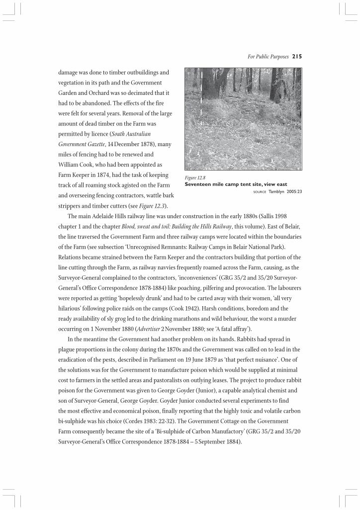
These sites are now covered by denseundergrowth but access tracks cut into thehillside remain. Two recessed and levelled tentsites, with dry stone walling at the rear, areevident at the 17 mile camp, and a water soaknearby, which had been dug out to increase itscapacity. Water would have been a problem,particularly in this location during the driermonths. Contemporary newspaper reportsand a sketch from Frearson’s Weekly of themurder which took place there wereinvaluable in determining what was at thiscamp. In the sketch four tents, an open fire-pitand the general layout of the campsite can beseen (see ‘A fatal affray’).
Ron TamblynSee the Hills Face Heritage GIS Database
Unrecognised remnants: railway camps in Belair National Park
For Public Purposes 215
Figure 12.8Seventeen mile camp tent site, view east
SOURCE Tamblyn 2005:23
damage was done to timber outbuildings and
vegetation in its path and the Government
Garden and Orchard was so decimated that it
had to be abandoned. The effects of the fire
were felt for several years. Removal of the large
amount of dead timber on the Farm was
permitted by licence (South Australian
Government Gazette, 14 December 1878), many
miles of fencing had to be renewed and
William Cook, who had been appointed as
Farm Keeper in 1874, had the task of keeping
track of all roaming stock agisted on the Farm
and overseeing fencing contractors, wattle bark
strippers and timber cutters (see Figure 12.3).
The main Adelaide Hills railway line was under construction in the early 1880s (Sallis 1998
chapter 1 and the chapter Blood, sweat and toil: Building the Hills Railway, this volume). East of Belair,
the line traversed the Government Farm and three railway camps were located within the boundaries
of the Farm (see subsection ‘Unrecognised Remnants: Railway Camps in Belair National Park).
Relations became strained between the Farm Keeper and the contractors building that portion of the
line cutting through the Farm, as railway navvies frequently roamed across the Farm, causing, as the
Surveyor-General complained to the contractors, ‘inconveniences’ (GRG 35/2 and 35/20 Surveyor-
General’s Office Correspondence 1878-1884) like poaching, pilfering and provocation. The labourers
were reported as getting ‘hopelessly drunk’ and had to be carted away with their women, ‘all very
hilarious’ following police raids on the camps (Cook 1942). Harsh conditions, boredom and the
ready availability of sly grog led to the drinking marathons and wild behaviour, the worst a murder
occurring on 1 November 1880 (Advertiser 2 November 1880; see ‘A fatal affray’).
In the meantime the Government had another problem on its hands. Rabbits had spread in
plague proportions in the colony during the 1870s and the Government was called on to lead in the
eradication of the pests, described in Parliament on 19 June 1879 as ‘that perfect nuisance’. One of
the solutions was for the Government to manufacture poison which would be supplied at minimal
cost to farmers in the settled areas and pastoralists on outlying leases. The project to produce rabbit
poison for the Government was given to George Goyder (Junior), a capable analytical chemist and
son of Surveyor-General, George Goyder. Goyder Junior conducted several experiments to find
the most effective and economical poison, finally reporting that the highly toxic and volatile carbon
bi-sulphide was his choice (Cordes 1983: 22-32). The Government Cottage on the Government
Farm consequently became the site of a ‘Bi-sulphide of Carbon Manufactory’ (GRG 35/2 and 35/20
Surveyor-General’s Office Correspondence 1878-1884 – 5 September 1884).
216 Valleys of Stone
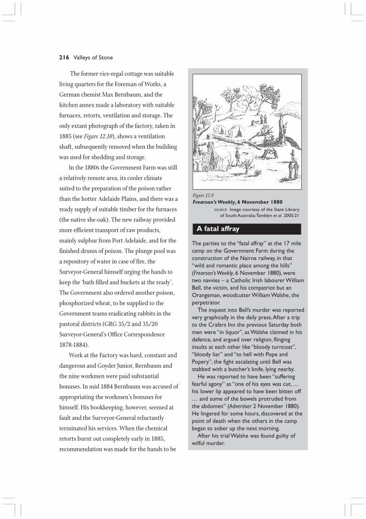
Figure 12.9Frearson’s Weekly, 6 November 1880
SOURCE Image courtesy of the State Libraryof South Australia; Tamblyn et al. 2005:21
The former vice-regal cottage was suitable
living quarters for the Foreman of Works, a
German chemist Max Bernbaum, and the
kitchen annex made a laboratory with suitable
furnaces, retorts, ventilation and storage. The
only extant photograph of the factory, taken in
1885 (see Figure 12.10), shows a ventilation
shaft, subsequently removed when the building
was used for shedding and storage.
In the 1880s the Government Farm was still
a relatively remote area, its cooler climate
suited to the preparation of the poison rather
than the hotter Adelaide Plains, and there was a
ready supply of suitable timber for the furnaces
(the native she-oak). The new railway provided
more efficient transport of raw products,
mainly sulphur from Port Adelaide, and for the
finished drums of poison. The plunge pool was
a repository of water in case of fire, the
Surveyor-General himself urging the hands to
keep the ‘bath filled and buckets at the ready’.
The Government also ordered another poison,
phosphorized wheat, to be supplied to the
Government teams eradicating rabbits in the
pastoral districts (GRG 35/2 and 35/20
Surveyor-General’s Office Correspondence
1878-1884).
Work at the Factory was hard, constant and
dangerous and Goyder Junior, Bernbaum and
the nine workmen were paid substantial
bonuses. In mid 1884 Bernbaum was accused of
appropriating the workmen’s bonuses for
himself. His bookkeeping, however, seemed at
fault and the Surveyor-General reluctantly
terminated his services. When the chemical
retorts burnt out completely early in 1885,
recommendation was made for the hands to be
The parties to the “fatal affray” at the 17 milecamp on the Government Farm during theconstruction of the Nairne railway, in that“wild and romantic place among the hills”(Frearson’s Weekly, 6 November 1880), weretwo navvies – a Catholic Irish labourer WilliamBell, the victim, and his compatriot but anOrangeman, woodcutter William Walshe, theperpetrator.
The inquest into Bell’s murder was reportedvery graphically in the daily press. After a tripto the Crafers Inn the previous Saturday bothmen were “in liquor”, as Walshe claimed in hisdefence, and argued over religion, flinginginsults at each other like “bloody turncoat”,“bloody liar” and “to hell with Pope andPopery”, the fight escalating until Bell wasstabbed with a butcher’s knife, lying nearby.
He was reported to have been “sufferingfearful agony” as “one of his eyes was cut, …his lower lip appeared to have been bitten off… and some of the bowels protruded fromthe abdomen” (Advertiser 2 November 1880).He lingered for some hours, discovered at thepoint of death when the others in the campbegan to sober up the next morning.
After his trial Walshe was found guilty ofwilful murder.
A fatal affray

For Public Purposes 217
Figure 12.10The Bi-sulphide of Carbon Manufactory 1885
SOURCE Photograph courtesy of the State Library of South Australia B4140 (part); also Old Government House Collection
re-deployed and much of the machinery disposed of. Soot stains from the old equipment, an oven-
like furnace and a large cast-iron boiler were to remain on the premises for many years, the last
vestiges being removed from the site in the mid 1990s.
A place for public pleasure
By the early 1880s a major change in the status of the Government Farm was underway. The land
outside the boundaries of the Government Farm had been developed as small holdings, berry
gardens and orchards, and with the completion of the railway bringing easier transport to the area,
pressure was put on the Government to sub-divide the Farm itself into affordable allotments for the
increasing number of settlers in the colony with small amounts of capital. However, other notions
for the Farm were being mooted, including that of use as a public park. In the late nineteenth
century the concept of a national pleasure ground for the masses was gaining favour among the
more public-spirited and several of Adelaide’s leading citizens spearheaded a well-publicised
campaign to keep the Government Farm in public hands. Walter Gooch, a local Belair resident, was
one of the strongest advocates (Cordes 1983:22-32). On 10 January 1882 a Memorial, signed by 312
gentlemen, was presented to Alfred Catt, the Commissioner of Crown Lands. It expressed regret at
the Government’s decision to put the land up for sale and proposed that the Government Farm
could, and should, be put to better use as any of the following – a water reserve, an experimental

218 Valleys of Stone
farm, a forest reserve, an acclimatisation station, or zoological gardens. Most desirable of all would
be its formation as ‘a park that cannot be surpassed as a public pleasure ground’, an estate to be
kept for the benefit of the whole colony. Parliament was divided over the issue. Public opinion and
eventually that of the Government was swayed by the precedent set elsewhere in the world where
‘the experience of older countries pointed that immense amounts of money were spent in acquiring
parks for the masses’ (C. Peacock, Memorial deputation: 10 January 1882), a course not favoured by
any government and, in this particular instance, unnecessary. The press also did not let up,
exhorting the public to ‘never be satisfied till their grand estate near Belair is secured to them in its
integrity’ (Advertiser 19 December 1881). Catt’s persistence, aided by sympathetic city newspapers,
saw an Act of Parliament passed in October 1883 preventing the Government from selling the
Government Farm.
Some Government officials, in particular Goyder, the influential Surveyor-General, felt that the
Farm could raise revenue for the Government at the same time as providing a venue for public
recreation. In July 1886, Parliament set aside 500 acres (208 ha.) in the north-western part of the
Farm as the Belair Forest Reserve under the Woods and Forests Department (Woods and Forests
Department 1886, 1887). The local blue and red gums were thinned in anticipation of the natural
forest becoming a viable commercial enterprise and in 1887 plantations of South Australian Sugar
gums and exotic Aleppo and Radiata pines were planted close to the newly completed Belair
Railway Station. The idea was for the Woods and Forests Department to acquire more of the Farm
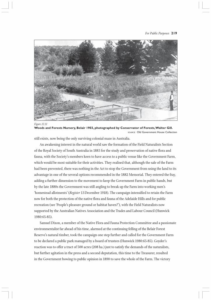
in increments and extend forest culture at Belair. In 1886 a Government Nursery was set up on the
old Government Garden initially to raise trees for southern Forest Reserves and the Nurseryman in
charge was housed in the former vice-regal cottage. The Nursery raised forest and plantation trees,
date palms and vines for Government schemes, also supplying Government bodies, local councils
and private landowners with exotic and indigenous trees under the long-running Free Tree Scheme
(to 1925) (Brown 1881:1-16; Lewis 1975:11-21, 53-56).
Five years after gazetting, the Belair Forest Reserve, except for the Nursery and residence, was
incorporated into the National Park. The Woods and Forests Department continued to operate the
Nursery, which has successfully conducted business on the site for 120 years. However, its only
visible remains from the nineteenth century are a few large, mature exotic conifers and hardwoods
on the site and a mixed stand of Sugar gums, just to the west of the Nursery itself.
In 1887 a small part of the Belair Forest Reserve by the Belair Railway Station was cleared for
picnic parties and walkers arriving at Belair by rail. A maze of six large concentric circles of
Hawthorn, separated by gravel paths, was planted on the site as an added attraction. Such mazes
were popular landscape and recreational features in Victorian England, the one at Belair modelled
on the Hawthorn (Quick) Maze in the Forest of Dean in Gloucestershire, initially reported to
Parliament as thriving (Woods and Forest Department 1886, 1887). The Belair Maze, although
beset over the years by problems of poor soil, insufficient moisture and difficulties in maintenance
For Public Purposes 219
still exists, now being the only surviving colonial maze in Australia.
An awakening interest in the natural world saw the formation of the Field Naturalists Section
of the Royal Society of South Australia in 1883 for the study and preservation of native flora and
fauna, with the Society’s members keen to have access to a public venue like the Government Farm,
which would be most suitable for their activities. They realised that, although the sale of the Farm
had been prevented, there was nothing in the Act to stop the Government from using the land to its
advantage in one of the several options recommended in the 1882 Memorial. They entered the fray,
adding a further dimension to the movement to keep the Government Farm in public hands, but
by the late 1880s the Government was still angling to break up the Farm into working men’s
‘homestead allotments’ (Register 13 December 1918). The campaign intensified to retain the Farm
now for both the protection of the native flora and fauna of the Adelaide Hills and for public
recreation (see ‘People’s pleasure ground or habitat haven?’), with the Field Naturalists now
supported by the Australian Natives Association and the Trades and Labour Council (Hunwick
1980:65-85).
Samuel Dixon, a member of the Native Flora and Fauna Protection Committee and a passionate
environmentalist far ahead of his time, alarmed at the continuing felling of the Belair Forest
Reserve’s natural timber, took the campaign one step further and called for the Government Farm
to be declared a public park managed by a board of trustees (Hunwick 1980:65-85). Goyder’s
reaction was to offer a tract of 500 acres (208 ha.) just to satisfy the demands of the naturalists,
but further agitation in the press and a second deputation, this time to the Treasurer, resulted
in the Government bowing to public opinion in 1890 to save the whole of the Farm. The victory
Figure 12.11Woods and Forests Nursery, Belair 1903, photographed by Conservator of Forests, Walter Gill.
SOURCE Old Government House Collection

220 Valleys of Stone
was short-lived, however, as that Government lost office. Over the next twelve months the issue was
keenly debated in both Parliament and the public arena (Advertiser 25 November 1890, 5 November
1891) before the National Park Act was passed, creating South Australia’s first national park. The
Act was gazetted on 19 December 1891 and the Government Farm was vested to a Board of twelve
Commissioners in perpetuity as the National Park of South Australia (Hunwick 1980:65-85).
The National Park of South Australia
From the inception of the National Park in 1891, its Board of Commissioners, led by Sir Edwin
Smith, immediately pursued the policy of developing the Park with venues for active, rather than
passive, recreation in that ‘natural arena’ lauded as ‘sufficient for amusements of all kinds – for
cricket, archery, football, races, rifle shooting and every other land sport’ (Register 21 September
The idea of national parks arose in NorthAmerica in the 1870s where it wasadvocated that tracts of land in its naturalstate could be set aside for the public toenjoy a pristine environment which wouldhave the intrinsic power to “elevate the soulto things noble and cultivated” (J.E. Brown1881), and further, to be a place for thosewith an interest in the study of the naturalworld – “the school of nature” (Advertiser 19December 1881).
The concept of such a national pleasureground for the masses was embraced inSouth Australia, and from the point of viewof the Parliamentarians who voted on theNational Park Act of 1891, the National Parkat Belair was seen as a people’s park. Duringthe debate on the bill the very use of theword ‘national’ in the title was defended andretained, as the Park’s creation, after all, wasdue to the sympathetic support of thegeneral public.
The preamble of the Act described theNational Park as “a pleasure ground for theamusement, recreation and convenience ofthe inhabitants of the Province of SouthAustralia”.
However, certain clauses in the NationalPark Act showed that the Park’s Board ofCommissioners was expected to developthe land for public recreation, rather thanleave it in its natural state, and so the Boardwas given the power to:
set apart portions for the conservationof water, for the purposes of sports andgames, for landscape gardening, … tomake roads, ways and paths, and erectpavilions, rotundas, lodges andsummerhouses, … to sell and removestone and bark and sell and exchangeplants and animals.
National Park Act 1891
The Field Naturalists Society had, inAugust 1886, made clear its feelings on whya national park should exist, as wasindicated in a paper to its members at thattime, in part as follows:
The chief merit of these reserves is thatthey serve the protection of wildlife inthe most natural way by retaining to agreat extent the primeval beauty of thecountry. With the vanishing of our nativefauna and flora will pass types differing,not but little from those of other partsof the world, but essentially distinct.
The Government, however, thought that,just by its existence, the National Parkwould fulfil the role of preservation of thenatural environment.
That the Park was expected to achievea dual role resulted directly from the lack ofunderstanding of the concept of a nationalpark and the requirements associated withthe preservation of native flora and fauna.Such attitudes left a challenging legacy in themanagement of the National Park at Belair.
D. John Hunwick
People’s pleasure ground or habitat haven?
For Public Purposes 221
1901). Taking office from 19 January 1892 and proceeding to appoint W.H. Sanders as Secretary to
the Board and Curator of the National Park, the Board requested that the Survey Department
prepare a topographical plan of the Park, upon which all improvements on the Farm were to be
shown. Intended as a guide to future development, this map was the basis of works for the next fifty
years and the Board was given the brief to implement all necessary improvements. Hiring of sports
facilities was considered the most viable financial option, as the Government expected the
Commissioners to find funds to supplement the small annual Government grant, initially just £150
(GRG 60/1 Minutes of the Commissioners of the National Park 1892-1912; GRG 60/43 Annual
Reports of the Commissioners of the National Park 1892-1912). Further finance was generated by
the sale of cleared timber, the stripping of wattle bark and depasturing stock.
A grand entrance to the Park was proposed from the north, named Sir Edwin’s Avenue after the
first Chairman of the Board. Work commenced on the avenue in 1892 and planting began on 1
October 1893, with double rows of the South Australian Sugar gum, Eucalyptus cladocalyx (see Figure
12.1 above the chapter title). The National Park Planting Record of the time shows that other tall,
impressive landscape trees like the Bunya Bunya pine from Queensland (Araucaria bidwillii), the
cream-flowered Yate from Western Australia (Eucalyptus cornuta) and the exotic Canary Island pine
(Pinus canariensis) were also grown along the Avenue (GRG 60/2 National Park Planting Record
1892-1920). Sweeping downhill for nearly two kilometres then across a couple of creeks on to the
flat on which the Park’s main attractions were situated, this feature became within a few years ‘a
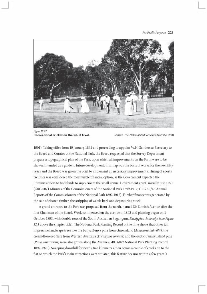
Figure 12.12Recreational cricket on the Chief Oval. SOURCE The National Park of South Australia 1908

222 Valleys of Stone
visually and spatially unique and stunning avenue’ (Ed McAlister, Assistant Director Adelaide
Botanic Gardens: 28 March 1985).
Aboriginal names (not necessarily relevant locally) were chosen by the Board for the main
valleys – the old House Paddock Creek became Minno Creek and other name changes included
Honeysuckle Gully to Tarnma, Waterfall Creek to Workanda and the adoption of Karka, Tapurro,
Tilti and Peroomba for other valleys (Commissioners of the National Park 1908). Roads linked the
main picnic and sports venues, and walking paths fanned out from the Belair Railway Station to
bush picnic sites. Two staff lodges of similar design were built in local stone in 1893: one at the
northern entrance over the railway line, the Upper Lodge; the other at the western approach, the
Lower Lodge. A third lodge was built in 1896 to replace the old Curator’s cottage (formerly the
Government Farm Keeper’s house), and located several hundred metres to the south of the old
building.
At play in the park
In the first fifteen years, four ovals, two refreshment rooms and two large pavilions, 21 clay tennis
courts, several cricket pitches and running tracks and 20 rustic picnic arbours were built, setting
the pattern for the 1920s and 1930s, one still evident today in the Park’s recreational facilities. On
weekends and holidays thousands of Adelaide residents flocked to the Park’s main picnic areas,
initially focusing on the Chief (now Main) Oval.
Tennis courts, with their adjacent arbours and fireplaces, were scattered throughout the flats in
the Park, catering for smaller parties indulging in the most popular pastime, tennis. Over many
decades South Australians have enjoyed this form of relaxation in the Park, and for many, tennis is
still synonymous with the National Park. An attractive gully on the southern side of central Minno
Creek was planted with Sequoias in 1897 and a slab arbour, Sequoia Arbor, built between them. In
1904 a small pavilion of timber with a terracotta tile roof, costing £100 and funded by Joseph Fisher,
Figure 12.13Picnic athletics on the Chief (Main) Oval, withthe Pavilion in background, 1908
SOURCE Commissioners of the National Park 1908
a noted Adelaide businessman, was added. It
fell into disrepair in the late 1950s and was
rebuilt in 1964 in stone, with a pressed steel
roof. Although Sequoia Arbor has disappeared,
the Joseph Fisher Pavilion and the towering
redwoods still provide picnickers with shelter.
The wide valley at the junction of Minno
and Tarnma Creeks was always a popular
destination for visitors to the park, accessible
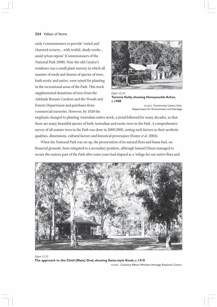
for many years by rail. In 1904 an oval was
constructed in Long Gully proper, with a kiosk
and a large pavilion nearby. The present
pavilion replaced the original building in 1928
For Public Purposes 223
On the western side of the Main Ovalprecinct was a running track enjoyed bythousands of people and a shelter shed,built in the early 1900s, with an adjacentwell. This shed was known as theShadehouse, from which picnic and sportsprovisions could be purchased. In 1912 itbecame the park workshop and is still inuse today as a shelter shed. Close by were,as the Commissioners put it quaintly, the“ladies’ and gents’ accommodation”, (toilets,tastefully disguised by lattice, climbers andshrubs) and a final feature, a gaol, servicedby the local policeman, Albert Huxleyof Belair. Because sports could not beplayed before noon on Sundays, theconsumption of alcohol was a popularpastime before midday. As patrons’behaviour deteriorated, it became necessaryto erect a small lock-up to hold revellingholiday-makers who had got out of hand.
To the north, opposite the Main Ovalwere wood and iron Refreshment Rooms,first erected in 1901. By 1909 a Swiss-styleKiosk had replaced the old structure.Burned down in 1955, it was replaced bythe brick Redgums Kiosk, now in use as anadministrative centre.
Dene Cordes
and was able to seat 550 people. An arbour, retaining the nineteenth century name for the gully,
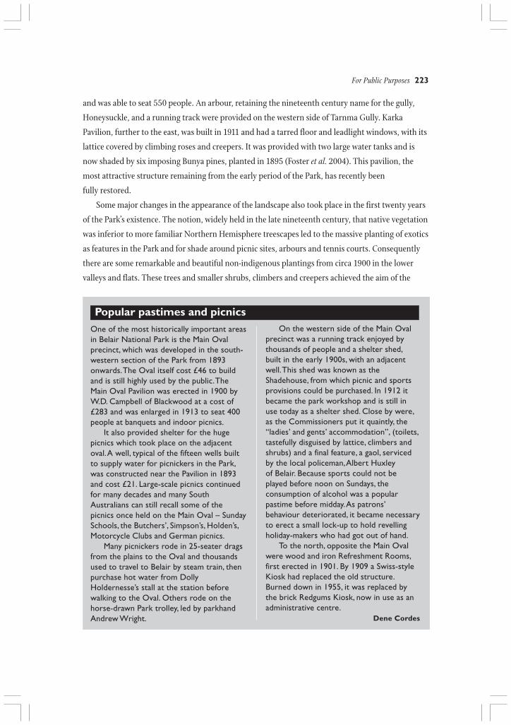
Honeysuckle, and a running track were provided on the western side of Tarnma Gully. Karka
Pavilion, further to the east, was built in 1911 and had a tarred floor and leadlight windows, with its
lattice covered by climbing roses and creepers. It was provided with two large water tanks and is
now shaded by six imposing Bunya pines, planted in 1895 (Foster et al. 2004). This pavilion, the
most attractive structure remaining from the early period of the Park, has recently been
fully restored.
Some major changes in the appearance of the landscape also took place in the first twenty years
of the Park’s existence. The notion, widely held in the late nineteenth century, that native vegetation
was inferior to more familiar Northern Hemisphere treescapes led to the massive planting of exotics
as features in the Park and for shade around picnic sites, arbours and tennis courts. Consequently
there are some remarkable and beautiful non-indigenous plantings from circa 1900 in the lower
valleys and flats. These trees and smaller shrubs, climbers and creepers achieved the aim of the
One of the most historically important areasin Belair National Park is the Main Ovalprecinct, which was developed in the south-western section of the Park from 1893onwards. The Oval itself cost £46 to buildand is still highly used by the public. TheMain Oval Pavilion was erected in 1900 byW.D. Campbell of Blackwood at a cost of£283 and was enlarged in 1913 to seat 400people at banquets and indoor picnics.
It also provided shelter for the hugepicnics which took place on the adjacentoval. A well, typical of the fifteen wells builtto supply water for picnickers in the Park,was constructed near the Pavilion in 1893and cost £21. Large-scale picnics continuedfor many decades and many SouthAustralians can still recall some of thepicnics once held on the Main Oval – SundaySchools, the Butchers’, Simpson’s, Holden’s,Motorcycle Clubs and German picnics.
Many picnickers rode in 25-seater dragsfrom the plains to the Oval and thousandsused to travel to Belair by steam train, thenpurchase hot water from DollyHoldernesse’s stall at the station beforewalking to the Oval. Others rode on thehorse-drawn Park trolley, led by parkhandAndrew Wright.
Popular pastimes and picnics
224 Valleys of Stone
Figure 12.15The approach to the Chief (Main) Oval, showing Swiss-style Kiosk, c.1910
SOURCE Coventry Album Mitcham Heritage Research Centre
early Commissioners to provide ‘varied and
charmed scenery… with restful, shady nooks…
amid sylvan repose’ (Commissioners of the
National Park 1908). Near the old Curator’s
residence was a small plant nursery in which all
manner of seeds and dozens of species of trees,
both exotic and native, were raised for planting
in the recreational areas of the Park. This stock
supplemented donations of trees from the
Adelaide Botanic Gardens and the Woods and
Forests Department and purchases from
commercial nurseries. However, by 1920 the
Figure 12.14Tarnma Gully, showing Honeysuckle Arbor,c.1908
SOURCE Community Liaison Unit,Department for Environment and Heritage
emphasis changed to planting Australian native stock, a trend followed for many decades, so that
there are many beautiful species of both Australian and exotic trees in the Park. A comprehensive
survey of all mature trees in the Park was done in 2000-2005, noting such factors as their aesthetic
qualities, dimensions, cultural factors and historical provenance (Foster et al. 2004).
When the National Park was set up, the preservation of its natural flora and fauna had, on
financial grounds, been relegated to a secondary position, although Samuel Dixon managed to
secure the eastern part of the Park after some years had elapsed as a ‘refuge for our native flora and
For Public Purposes 225
fauna’ (Commissioners of the National Park 1908). Such policy subsequently remained in place east
of the railway line and so fortunately that section of the Park has been preserved in much the same
natural state as it was 150 years ago. Today the fabric of Belair National Park reflects natural,
historical and cultural elements and the need to maintain the delicate balance between its built and
cultural heritage on the one hand, and its natural environment on the other, is still as much a
challenge today as it was in the days of the early Commissioners.
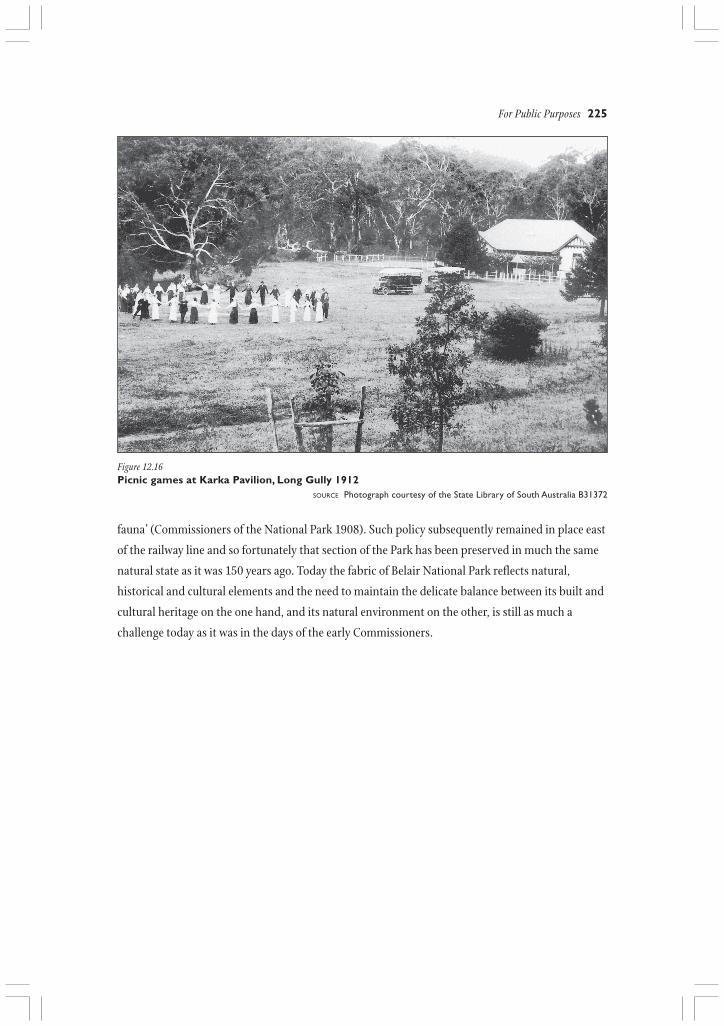
Figure 12.16Picnic games at Karka Pavilion, Long Gully 1912
SOURCE Photograph courtesy of the State Library of South Australia B31372
226 Valleys of Stone
REFERENCES
Advertiser 6 February 1877; 2 November 1880; 19December 1881; 25 November 1890; 5 November 1891.
Blake, L.J. 1971 The Gold Escort. Hawthorn Press,Melbourne.
British Parliamentary Papers 1840 Papers Relative to theAffairs of South Australia 1840. London.
Brown, J.E. 1881 Tree Culture in South Australia. ForestBoard of South Australia, Adelaide.
Carver, G. 2001 An examination of Indigenous Australianculturally modified trees in South Australia.Unpublished Honours thesis, Department ofArchaeology, Flinders University, Bedford Park,South Australia.
Commissioners of the National Park 1908 The NationalPark of South Australia, Commissioners of the NationalPark, Adelaide.
Cook, H. 1942 Reminiscences of Life on the GovernmentFarm 1874-1884. (Donated to South AustralianArchives Department in 1943, copy held at OldGovernment House, Belair National Park).
Cordes, D. D. 1983 The Park at Belair. Volume 1. The IslandPress, Kangaroo Island, South Australia.
Department for Environment and Heritage 2003 BelairNational Park Management Plan. Department forEnvironment and Heritage, Adelaide, South Australia.
Department of Environment and Planning 1989 BelairNational Park Management Plan. Department ofEnvironment and Planning, Adelaide, South Australia.
Farm and Garden 12 August 1858
Foster, R.C., Skinner, J., Tamblyn, P. and Tamblyn, R.N.2004 Belair National Park Significant Tree Register.Belair National Park, South Australia.
Hunwick, D. John 1980 Belair National Park and SouthAustralia’s National Parks System. MasterEnvironmental Studies thesis, Department ofEnvironmental Studies. University of Adelaide,Adelaide.
Lewis, N.B. 1975 A Hundred Years of State Forestry 1875-1975. Woods and Forests Department, Adelaide.
Milner, J. and Brierly, O. 1869 Cruise of HMS Galatea.Allen, London.
National Parks and Wildlife Service 1978 Old GovernmentHouse Belair (booklet), Department of Environment,Adelaide.
Observer 21 May 1841; 19 May 1864; 1 October 1864;16 April 1842.
Register 1 September 1860; 9 November 1867; 11 January1882; 21 September 1901; 13 December 1918.
Rose, M. 2002 The Belair Park story. Undergraduateresearch project, Historical Archaeology, Departmentof Archaeology, Flinders University, Bedford Park,South Australia.
Sallis, R. 1998 Railways in the Hills. Self published,Adelaide.
South Australian Government Gazette 12 July 1841
South Australian Government Gazette 14 December 1878
Tamblyn, P., Smith, P., Chisholm, S. and Rose, M. 2005The Government Farm and Belair National Park, 1840-1910. In Smith, P.A., Piddock, S. and Pate, F.D. (eds)Historic Sites and Landscapes: The Mitcham Hills. HillsFace Zone Cultural Heritage Project Reports, volume II.Department of Archaeology, Flinders University. KopiBooks, Belair, South Australia.
Woods and Forests Department Annual Reports in SouthAustralian Parliamentary Papers 1886, no.63.
Woods and Forests Department Annual Reports in SouthAustralian Parliamentary Papers 1887, no.31.
ARCHIVES
State Records of South Australia. Government RecordsGroups and Series:
GRG 5/5 Stewart Correspondence (Police Records)1852-1856
GRG 24/4 and 24/6 Colonial Secretary’s OfficeCorrespondence 1840-1848
GRG 35/2 and 35/20 Surveyor-General’s OfficeCorrespondence 1878-1884
GRG 38/1 and 38/7 Colonial Architect’s OfficeCorrespondence 1857-1874
GRG 60/1 Minutes of the Commissioners of theNational Park 1892-1912
GRG 60/2 National Park Planting Record 1892-1920
GRG 60/43 Annual Reports of the Commissioners ofthe National Park 1892-1912
GRS 8501 Old Government House Architectural Plans1858-1869. Reproductions of plans also held in theOld Government House Collection.