for Proposed Cluddaun Wind Farm Co. Mayo VOLUME 3...
12
Environmental Impact Statement for Proposed Cluddaun Wind Farm Co. Mayo VOLUME 3 APPENDICES Appendix 12 A Viewshed Reference Point Selection Report
Transcript of for Proposed Cluddaun Wind Farm Co. Mayo VOLUME 3...

Environmental Impact Statement
for
Proposed Cluddaun Wind Farm
Co. Mayo
VOLUME 3 APPENDICES
Appendix 12 A
Viewshed Reference Point Selection Report
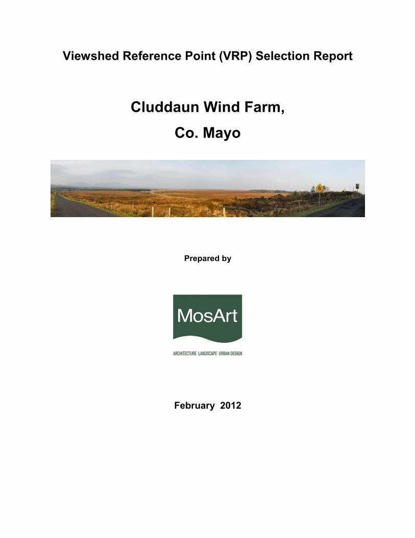
Viewshed Reference Point (VRP) Selection Report
Cluddaun Wind Farm,
Co. Mayo
Prepared by
February 2012
Viewshed Reference Point (VRP) Selection
Introduction
This report provides a rationale for the selection of viewshed reference points (VRP’s) for the proposed Cluddaun
Wind Farm, which is located in County Mayo some 10km to the north east of the settlement of Bellacorrick and 10km
southwest of Ballycastle. This project comprises fifty one turbines that are arranged in a fairly loose, organic layout.
The proposed turbines will have a blade tip height in the order of 150m.
The VRP selection is based on computer generated visibility modeling, a desk survey and subsequent field work and
uses a set of pre-established criteria to determine the likely relevance of each view.
Methodology
Generation of a Zone of Theoretical Visibility
Malachy Walsh and Partners Ltd. carried out a computer automated study of the zone of theoretical visibility (ZTV).
The purpose of this exercise is to identify the ‘theoretical’ extent and degree of visibility of turbines. This is a
theoretical exercise because it is based on topography only at 10m contour intervals and does not allow for
intermittent screening provided by, for example, hedgerows, forests or buildings and does not involve the actual
height of crests (but using the nearest 10m contour below). Thus the ZTV map, assuming no screening, represents a
‘worst-case-scenario’ with respect to viewing exposure. For the purposes of this project a radius of 20km from the
edge of the site was used for the ZTV to ensure reasonable coverage of the area. This is in line with the Wind
Energy Development Guidelines, which suggest a radius of 20km for turbines in excess of 100m in height.
Identification of Viewshed Reference Points as a Basis for Assessment
The results of the ZTV analysis provide the basis for selection of key viewpoints from which to study the visual
impacts of the proposed wind farm in detail. It is not warranted to include each and every single location that provides
a view of the development as this would result in an unwieldy report and make it extremely difficult to draw out the
key impacts arising from the project. Instead, the assessors endeavoured to select a variety of receptor types that
would also provide views of the proposed wind farm from different distances, different angles and different contexts.
These locations are significant because they represent, for example, centres of population and major transport
routes. An initial broad set of potential views is generated from a desk study using the ZTV map. Each potential VRP
is abbreviated to identify which of the following receptor types it represents;
Receptor Type Abbreviation
Key Views - from features of international or national importance; KV
Designated Scenic Routes and Views; DR
Local Community views; LC
Centres of Population CP
Major Routes; and MR
Amenity and heritage features. AV
Some VRP’s may be applicable to several receptor categories, in which case, they will be assessed under the group
that best reflects that location’s particular sensitivities. Such VRP’s are of particular relevance to the proposal due to
their multiple sensitivities.
Fieldwork is then undertaken using the broad set of potential VRP’s in order to systematically identify those that will
actually provide a view of the proposed wind farm and those from which potential views are screened by vegetation
or structures. This process involves the use of wireframe images to depict the proposed turbines within the terrain
context seen from each potential VRP location. It is also an opportunity to experience the character and features of
each location and make initial value judgements in relation to the sensitivity of each VRP. Where two or more VRP’s
with similar sensitivities are located within close proximity to each other, one may be selected in lieu of the others to
represent the visual impact from that general viewing distance and angle.
VRP selection by other Agencies
It is a common occurrence that VRP locations are suggested or required by Statutory or non-Statutory bodies with
stakeholder interest in the site. The most likely source of VRP selection input is from the Local Authority that will
assess the planning application or surrounding Local Authorities that may be impacted by the proposal. VRP
locations may also be requested by An Taisce or other tourism, heritage or conservation groups with an interest in
the area. If a third-party proposes a VRP, it can be evaluated for inclusion.
Final VRP selection and use
The VRP’s selected at this stage of the project are those from which MosArt intend to assess the landscape and
visual impacts of the proposal within the context of the project EIS. Notwithstanding, this VRP selection report is
intended as a discussion document and VRP locations may be added to or removed from this set in consultation with
the Planning Authority.
Table 1 provides the grid coordinate location of the selected VRP’s for the Cluddaun Wind Farm. The panoramic
photographs included thereafter represent each of the selected VRP locations and can be used in conjunction with
the grid reference coordinates by the Visualization Specialist to find the precise location of the VRP and to capture
their own images required for photomontages. In this instance, the design of the scheme has not yet been finalized
as it is the intention to minimize the visual impact at a number of the more sensitive receptor locations. The VRP’s
that currently represent these locations may not, therefore, be required depending on the extent of ZTV coverage for
the final scheme. VRP’s that may not ultimately be required for the visual impact assessment are marked with an
asterisk.
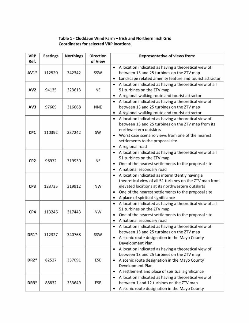
Table 1 - Cluddaun Wind Farm – Irish and Northern Irish Grid
Coordinates for selected VRP locations
VRP
Ref.
Eastings Northings Direction
of View
Representative of views from:
AV1* 112520 342342 SSW
• A location indicated as having a theoretical view of
between 13 and 25 turbines on the ZTV map
• Landscape related amenity feature and tourist attractor
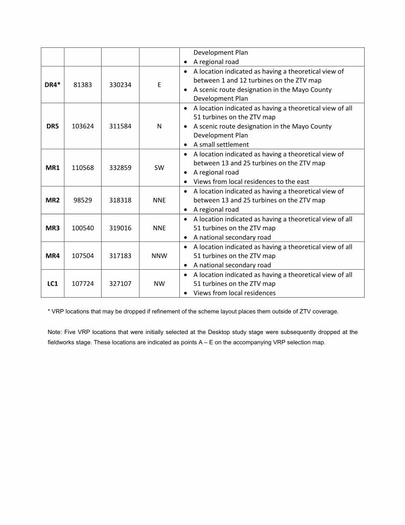
AV2 94135 323613 NE
• A location indicated as having a theoretical view of all
51 turbines on the ZTV map
• A regional walking route and tourist attractor
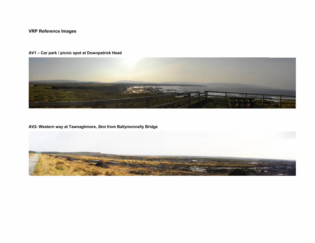
AV3 97609 316668 NNE
• A location indicated as having a theoretical view of
between 13 and 25 turbines on the ZTV map
• A regional walking route and tourist attractor
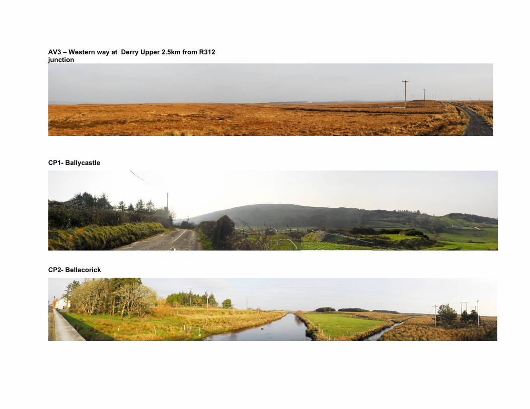
CP1 110392 337242 SW
• A location indicated as having a theoretical view of
between 13 and 25 turbines on the ZTV map from its
northwestern outskirts
• Worst case scenario views from one of the nearest
settlements to the proposal site
• A regional road
CP2 96972 319930 NE
• A location indicated as having a theoretical view of all
51 turbines on the ZTV map
• One of the nearest settlements to the proposal site
• A national secondary road
CP3 123735 319912 NW
• A location indicated as intermittently having a
theoretical view of all 51 turbines on the ZTV map from
elevated locations at its northwestern outskirts
• One of the nearest settlements to the proposal site
• A place of spiritual significance
CP4 113246 317443 NW
• A location indicated as having a theoretical view of all
51 turbines on the ZTV map
• One of the nearest settlements to the proposal site
• A national secondary road
DR1* 112327 340768 SSW
• A location indicated as having a theoretical view of
between 13 and 25 turbines on the ZTV map
• A scenic route designation in the Mayo County
Development Plan
DR2* 82527 337091 ESE
• A location indicated as having a theoretical view of
between 13 and 25 turbines on the ZTV map
• A scenic route designation in the Mayo County
Development Plan
• A settlement and place of spiritual significance
DR3* 88832 333649 ESE
• A location indicated as having a theoretical view of
between 1 and 12 turbines on the ZTV map
• A scenic route designation in the Mayo County
Development Plan
• A regional road
DR4* 81383 330234 E
• A location indicated as having a theoretical view of
between 1 and 12 turbines on the ZTV map
• A scenic route designation in the Mayo County
Development Plan
DR5 103624 311584 N
• A location indicated as having a theoretical view of all
51 turbines on the ZTV map
• A scenic route designation in the Mayo County
Development Plan
• A small settlement
MR1 110568 332859 SW
• A location indicated as having a theoretical view of
between 13 and 25 turbines on the ZTV map
• A regional road
• Views from local residences to the east
MR2 98529 318318 NNE
• A location indicated as having a theoretical view of
between 13 and 25 turbines on the ZTV map
• A regional road
MR3 100540 319016 NNE
• A location indicated as having a theoretical view of all
51 turbines on the ZTV map
• A national secondary road
MR4 107504 317183 NNW
• A location indicated as having a theoretical view of all
51 turbines on the ZTV map
• A national secondary road
LC1 107724 327107 NW
• A location indicated as having a theoretical view of all
51 turbines on the ZTV map
• Views from local residences
* VRP locations that may be dropped if refinement of the scheme layout places them outside of ZTV coverage.
Note: Five VRP locations that were initially selected at the Desktop study stage were subsequently dropped at the
fieldworks stage. These locations are indicated as points A – E on the accompanying VRP selection map.
VRP Reference Images
AV1 – Car park / picnic spot at Downpatrick Head
AV2- Western way at Tawnaghmore, 2km from Ballymonnelly Bridge
AV3 – Western way at Derry Upper 2.5km from R312 junction
CP1- Ballycastle
CP2- Bellacorick
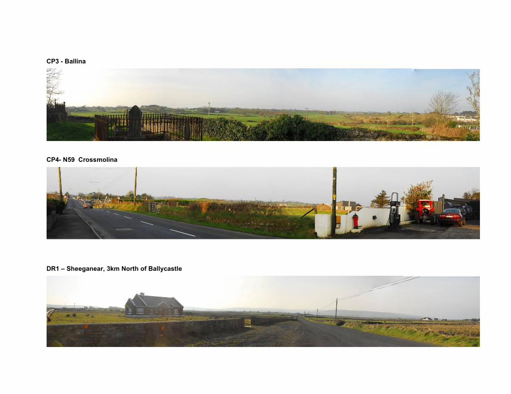
CP3 - Ballina
CP4- N59 Crossmolina
DR1 – Sheeganear, 3km North of Ballycastle
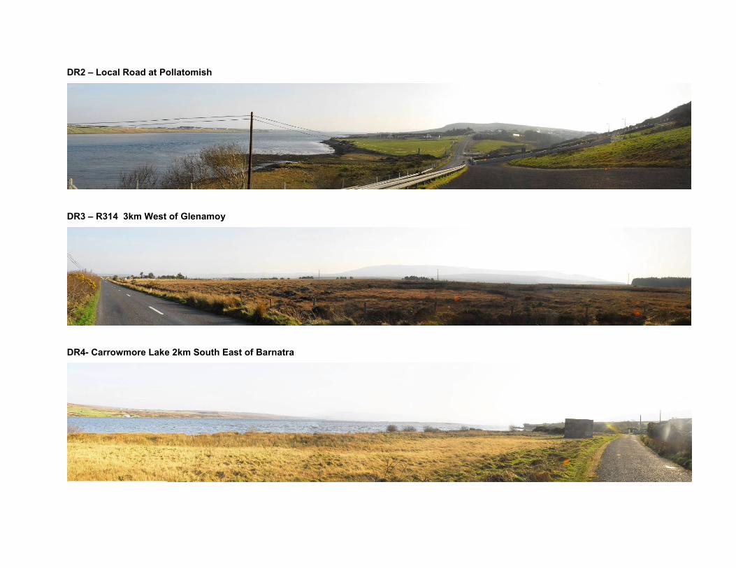
DR2 – Local Road at Pollatomish
DR3 – R314 3km West of Glenamoy
DR4- Carrowmore Lake 2km South East of Barnatra
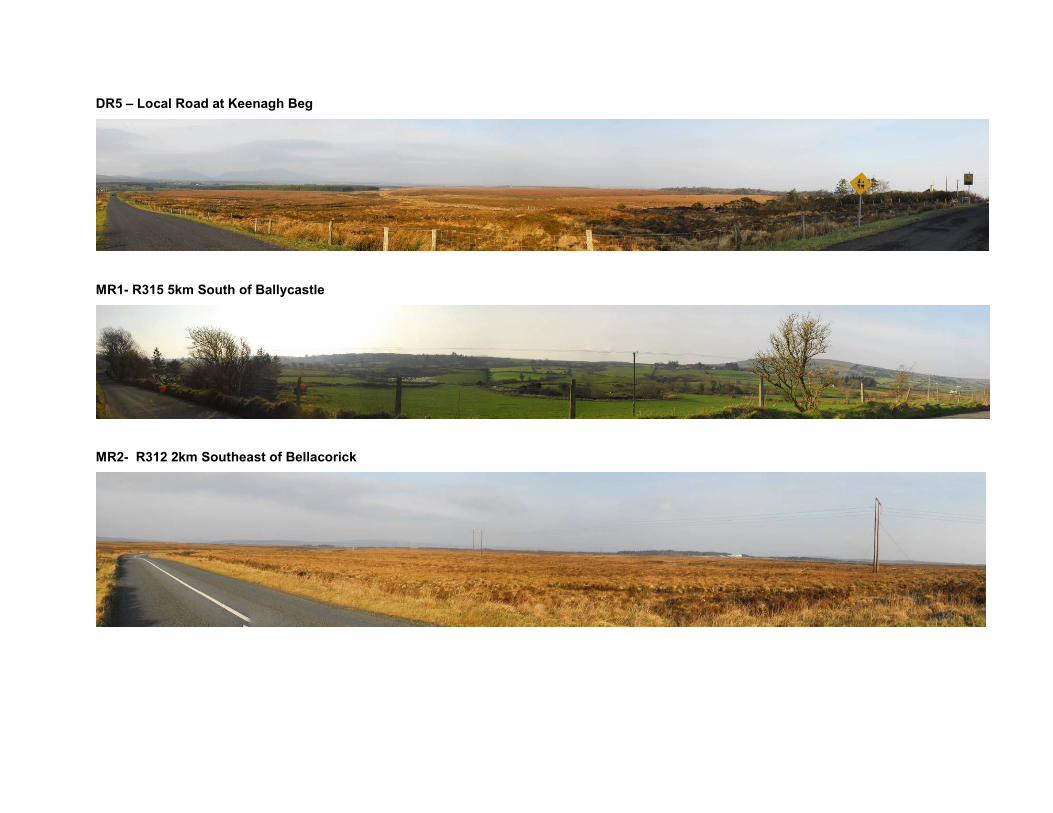
DR5 – Local Road at Keenagh Beg
MR1- R315 5km South of Ballycastle
MR2- R312 2km Southeast of Bellacorick
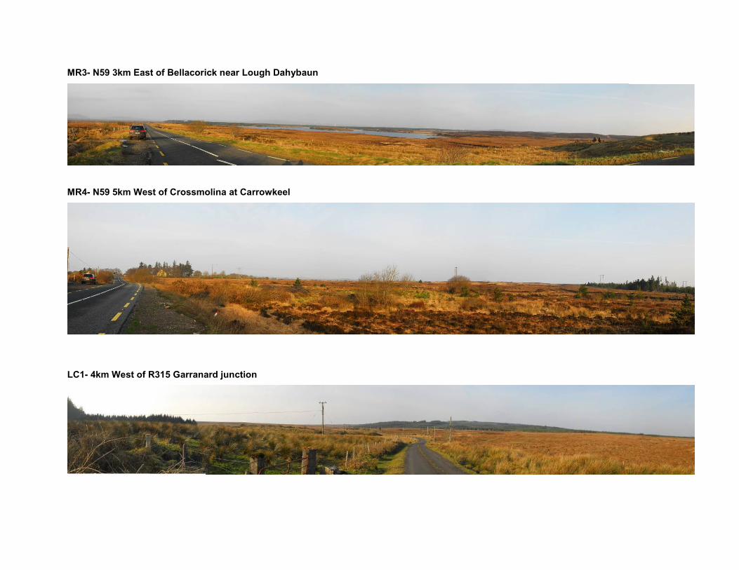
MR3- N59 3km East of Bellacorick near Lough Dahybaun
MR4- N59 5km West of Crossmolina at Carrowkeel
LC1- 4km West of R315 Garranard junction