For consideration by tenderers, specialists undertaking...
29
Community Liaison Group summary of input For consideration by tenderers, specialists undertaking EES studies and the project team 7 October 2016
Transcript of For consideration by tenderers, specialists undertaking...

Community Liaison Group summary of input
For consideration by tenderers, specialists undertaking EES studies and the project team
7 October 2016

Community Liaison Group summary of input Page 1
Foreword from the CLG independent chair
Dear colleague,
The Western Distributor Community Liaison Group (CLG) has been established to involve the wider community, local government and industry more directly with those responsible for the planning the Western Distributor.
After recruiting members during March 2016, the group was appointed and an initial meeting held in April 2016. Since then the group has met monthly to seek information and provide advice.
The group contributes by providing a local perspective, particularly in relation to identifying and escalating issues, minimising impacts on local communities and assisting to resolve community concerns where possible.
Members act in an advisory capacity by bringing local insights and a community perspective to discussions. They help facilitate a two-way flow of information between communities and the project team and provide the Project Team with important local knowledge.
I am honoured to be the Independent Chair for this group, and excited to be able to contribute in some way to this project. I, along with all the community representatives on the CLG, live in and love Melbourne’s west and want to see the best possible outcome achieved. I believe that the best way to ensure this is to get communities and key stakeholders involved at every stage of the project’s development and delivery.
Members of the CLG have exhibited commitment and passion in seeing that this project not only fulfils its objectives but achieves a strong and positive legacy for people of Melbourne’s west and have identified many opportunities to make this aspiration a reality.
I urge everyone involved in planning for the Western Distributor project to use the following document as a key resource to better understand community perspectives along the project corridor, and consider the information contained as you continue work your work on the project.
Jim Williamson
Independent Chair, Western Distributor Community Liaison Group

Community Liaison Group summary of input Page 2
Purpose of this document
This document has been created as an information resource for tenderers and technical specialists working on the Western Distributor project design and EES impact assessments and the project team.
It is intended to provide a consolidated overview of information and advice provided by the CLG members through monthly meetings and direct correspondence – particularly in relation to opportunities that the project presents and key concerns raised by communities.
Opportunities and concerns identified are presented in this document in categories, breaking information into key areas of interest so that the intended audience can easily find, consider and utilise the information.
It is important to note that the contents of this document are not intended to reflect the views of every CLG or community member. It represents the broad feedback that members have brought to the group from their local communities, members and organisations. To better understand differences in perception on location specific issues and depth of concerns about issues, please refer to the attached Community Summaries which have been prepared by CLG members and provided verbatim.

Community Liaison Group summary of input Page 3
Membership of the CLG
The Western Distributor CLG has been formed to seek ongoing community feedback as planning for the project progresses. The group is a forum for the exchange of views and information about topics that are of interest to the community.
Membership is from a cross section of the community, including local government, regional business groups, community groups and local residents. Members were selected through a formal recruitment process based on their location, community networks and linkages, knowledge of local issues and their capacity to communicate what’s important to their community.
The following groups, organisations or suburbs are represented on the CLG:
Altona / Altona North
Brooklyn
Footscray
Kensington, North and West Melbourne
Spotswood
Seddon
Yarraville
Brooklyn Residents Action Group (BRAG)
Concerned Locals of Yarraville
Friends of Stony Creek
Friends of Moonee Ponds Creek
Friends of Lower Kororoit Creek
Maribynong Truck Action Group (MTAG)
LeadWest
Royal Automobile Club of Victoria (RACV)
Spotswood and South Kingsville Residents Group
Victorian Transport Association (VTA)
Maribyrnong City Council*
Hobsons Bay City Council*
City of Melbourne*
Brimbank City Council*
*It should be noted that activities in relation to the Western Distributor by the members that comprise
the CLG are not limited to participation in this group. As councils were in election caretaker period
when this document was produced, they were unable to provide a Community Summary and this
document has no formal status for any of the councils on the CLG.

Community Liaison Group summary of input Page 4
Summary from CLG group members
Members of the CLG identified five key themes that captured the areas of most interest and concern. While specific detailed feedback varied amongst members, these themes encompass the major topics of interest collectively for the CLG.
Key themes:
Design impacts and loss of amenity to the local community
Transport - including traffic, public transport, cycling and walking
Project construction, and subsequent amenity and safety
Environment and heritage, especially noise and air quality impacts
Adjacent land, community spaces and connections
Health and well-being**
Please note that this is not an exhaustive list of all themes raised by the CLG.
Specific detail including level of concern as well as location-specific information is captured in this report as well as the community summaries prepared by CLG members attached. In some cases location-specific information may reflect a project-wide theme.
**The concerns and opportunities in relation to health and well-being, for example, are not listed below as a separate theme. They appear under most of the other five themes below, especially under Project design and construction and environment and heritage.

Community Liaison Group summary of input Page 5
Key opportunities and concerns identified by the CLG
Urban design
Opportunities
Members of the CLG have identified the below
opportunities for the project to deliver
improvements in areas on and around the project
corridor, and to maximise project benefits.
Concerns
Members of the CLG have identified the below
concerns as being of importance to the
community or group/organisation they represent.
Public and open spaces
Considering the off-road, community experience of the new infrastructure
Enhancing open space – not just offsetting any losses but improving it to a high standard
Creating parks along the project corridor, including along the West Gate Freeway
Considering open space and public realm improvements as a series of separate projects each with challenges and opportunities to be considered and addressed
Incorporating community consultation to open space improvements so that spaces meet unique local needs, which may differ across the corridor
Revitalising laydown or construction areas after project completion and returning to community
Addressing existing urban design problems between Arden Street and Dynon Road
The successful applicant is to work with
local community groups on urban design
features of new infrastructure
Turn industrial land next to Simcock
Avenue into parkland to create additional
open space in Spotswood
Address urban design considerations along Simcock Ave and Booker St, Hudsons Rd and The Avenue
Undertaking thorough and extensive investigation to develop a rigorous understanding of the existing site conditions, connections to its broader context and opportunities for expansion for not only Hyde Street Reserve and Stony Creek Reserve but all affected open space
Good urban design is important, with
requirements that are not too high level and with each area considered individually to ensure that spaces are not generic and impersonal
Any loss of open / green spaces is of concern to communities across the corridor and there is a desire to see any space lost replaced or increased in other areas
Lack of green space available in Spotswood and impact on existing green spaces including Don McLean Reserve
Concern that widening the West Gate Freeway removes green space pocket parks
Project impacts on Hyde Street Reserve,
community want to see a commitment to
protect the integrity of the reserve and
minimise the impact of the ramps
There is concern that the local
communities will be left with undesirable
and unusable open space similar to other
road projects that have occurred in
Melbourne e.g. City Link

Community Liaison Group summary of input Page 6
Urban design
Undertaking appropriate community and stakeholder engagement to collect relevant and informative feedback to appropriately develop open space
Demonstrating and discussing how the site analysis and consultation have been considered in the development of proposals for open space
Allocating suitable budget to both the rectification, reinstatement and establishment of quality open space and environmental assets
Undertaking construction, establishment and maintenance for all open space and environmental asset work
Visual
Minimising the visual impact of the bridge over the Maribyrnong River – avoiding large screening above the bridge or urban design art that could increase the visual impact
Improving visual amenity with new and well considered vegetation / landscaping
Minimising the visual impact of the entire
length of the West Gate Freeway through
use of unobtrusive but effective sound
barriers and landscaping. Preference for
tree planting of species shown through
research to be efficient in screening and
mitigating air pollution
Employing considered and quality urban
design to minimise the visual impact of
the ventilation stacks and noise
attenuation walls (on all facades) to be as
visually appealing and unobtrusive as
possible and demonstrate how
maintenance requirements have been
considered so that their intended and
proposed appearance can be maintained
Undertaking a thorough visual impact
assessment of the proposed locations of
ventilation stacks and noise attenuation
walls to be able to appropriately consider
mitigating their bearing prior to
construction commencing
That elevated structures could result in
loss of views / amenity and create visual impacts
Strong desire for the ramp be made visually appealing whilst meeting required standards
There is concern that the surrounding context and adjacent spaces to the proposed ventilation stacks and noise attenuation walls will not be appropriately or holistically considered, resulting in negatively impacting the value of the surrounding residential properties, creating anti-social spaces and/or attracting vandalism

Community Liaison Group summary of input Page 7
Transport
Opportunities
Concerns
Traffic
Considering and planning to avoid displacement of traffic
Ensuring EES traffic impact assessment considers truck bans
Ensuring tolling structure is not a disincentive for trucks to use the new infrastructure
Data of volume and patterns of traffic in the inner west should be shared with the community so that they may assess and understand how the road changes would actually achieve the claimed benefits of the project
Project to address small part in the broad solution, potential for other projects to be fast tracked
Providing clear and simple direction signs with meaningful names to help drivers navigate complex ramps and roadways
There is a strong desire to understand
changes to traffic on the road network with the project
That traffic in North and West Melbourne and on Footscray Road could increase with the project and a need to understand any impacts and plans to manage them
Concern about trucks avoiding tolls and how that could affect traffic and safety on surrounding local roads
Concern about the redistribution of placarded trucks if bans are applied only to Francis Street and Somerville Road, for example: to Buckley Street, Moore Street, Millers Road, Hyde Street, Simcock Ave, Hudsons Rd and The Avenue, Douglas Parade
A desire to understand what truck curfews will be applied with the project and what else is being done to resolve the issue of heavy truck traffic on residential streets
Preference for freight to use Grieve Parade rather than Millers Road
Concern about drivers ‘rat running’ during construction to avoid lowered speed limits or disruption – and a desire to understand how traffic will be managed during construction
Concern about traffic increase on Simcock Ave. Safety concerns regarding placarded loads in local suburbs. Issues with tolling of cars travelling locally being tolled on ramps
Concern around how the impact on emergency services will be managed particularly in an emergency
Public transport
Allowing for future tram route to west
Consideration of other transport modes – tram, punt, train line duplications, rail services for freight, port rail freight
Want assurances that the project won’t prevent future grade separation at Spotswood Station
Bike improvements to utilise existing assets where possible
Effect on current and future service of the bus route into/out of the city which currently exists at the off ramps on Melb/Williamstown Rd, Impact during and after construction including safety issues for commuters

Community Liaison Group summary of input Page 8
Transport
Walking and cycling
Making the most of proposed cycling improvements by making them user friendly and safe - with the right lighting, signage, path width and distance markers and facilities such as toilets and water
Separating walking and cycling facilities on Footscray Road to create a more user friendly and safer route that caters for increasing number of users
Providing barriers between Federation Bike Path and the West Gate Freeway to improve amenity for cyclists and pedestrians
Providing a cycling bridge over Whitehall Street to avoid crossing road / vehicle conflicts
Connecting and upgrading the arts precinct along Maribyrnong River waterfront, using a utility tunnel as a cycle route (i.e. London tunnels)
Improving bike crossings for areas that are subject to flooding – reference to paths around Moonee Ponds Creek
Removing crossings over roads for cyclists to improve travel times and safety
Ensuring that pedestrian and cycle connections from Docklands to E-gate and North Melbourne station are provided for
Reasonable gradients for cyclists to ensure an easier commute into the city
Enhance cycling paths and cyclist safety on Buckley Street - a designated cycling route
Consider registration of bicycles or tolling providing incentives for certain routes
Enhance cycling facilities on Spotswood streets
Assessing the impact the proposed works have on the existing walking and cycling network and ensuring that the needs of vehicles, pedestrians and cyclists are considered and addressed to create a continuous and well-connected walking and cycling network across the west
Would like project to achieve conversion
to cycling
Concern around changes to air quality along Footscray Road

Community Liaison Group summary of input Page 9
Project design and construction
Opportunities
Concerns
Road design
Minimising gradient of ramps for large trucks
Minimising crossings of the Moonee Ponds Creek to minimise impacts to creek health and environment
There are different points of view
regarding the location of the Hyde Street ramps, with the group generally recognising that any design will have impacts
Concern that the design includes new crossings of the Moonee Ponds Creek and the impact this would have on the remaining quality of open space and amenity
Concern that impacts are fair and proportionate to the problem being solved and to the relative sizes of communities availability for offset within the community
This needs to be assessed with needs of communities in mind not a holistic view of the corridor
Concern about safe access to West Gate Bridge from The Avenue (north) crossing Melbourne Rd to West Gate Bridge on ramp
Concern around potential changes at local intersections
Concern of the number of crossings over waterways, specifically Maribyrnong River and Moonee Ponds Creek and the impact this will have on amenity
Construction
Implementing a robust process for managing complaints during construction
Actively communicating to ensure community well informed about project activity
Developing and thoroughly documenting a construction and stakeholder engagement process that identifies the stages of construction, identifies impacted stakeholders and provides the opportunity for stakeholder input into the methodology for delivery so that needs can be understood, addressed and managed prior to construction commencing
Developing construction staging plans of various levels for community and stakeholder communication purposes that clearly articulates the following but not
Desire to understand how impacts will be
managed during construction – particularly traffic, noise, dust, air and safety
Careful management of traffic impacts is important, with the busy Williamstown Road interchange being highlighted as a key existing congestion point which could be affected
Consideration to be given to how construction activities are communicated to residents, including ensuring that a robust complaints management process is established and followed
A keen desire to understand construction impacts both along the project alignment and in neighbouring areas and how impacts are being avoided or managed
Removal of spoil and haulage routes are

Community Liaison Group summary of input Page 10
Project design and construction
limited to: o Construction extent and type o Temporary storage and site office
facilities o Site access o Road closures and detours o Associated timing of both road
closures, construction and operation of associated facilities
o Construction equipment and processes that may produce a variety of difference impacts including but not limited to; noise, light and odour
o Having a clear and transparent process for dispute resolution and incorporating community input on the structure of such a process
of concern, with a desire to see this kept to freeways / away from residential areas
Importance of dilapidation surveys for properties potentially affected by construction work
Avoid use of public open space including Don McClean Reserve as laydown areas
Concern around impacts on community and open space during construction and how this will be managed
Consideration of night works and how
lighting will be mitigated
Make Donald McLean Reserve a no go
area as a lay down area during
construction
Desire to understand how power supply
will be managed during undergrounding
of wires.
Environment and heritage
Opportunities
Concerns
Air quality
To improve air quality in and around the
project area, and by extension to alleviate
the impact of vehicle pollution on
residents' health, by shifting the current
large volume of truck traffic from local
streets onto a dedicated roadway
Setting air quality standards to new
national and international levels by
testing for ultrafine particulate matter in
addition to PM2.5 and PM10
Establishing robust testing regime to
capture data on health impacts of air
contamination in sensitive locations –
recreational open space and social
amenities reviewed independently and
regularly to accommodate scientific
advances
The location of tunnel ventilation
structures and their design is important, including the proximity of portal locations and ventilation structures to parks and other sensitive land uses
Consideration given to filtering the tunnel ventilation structures using international best practice solutions Concern about air quality changes for local residents and users of adjacent land (i.e. parks, sporting grounds)
Concern that air quality monitoring does not capture data on PM1
Concern regarding the monitoring of air
quality for sensitive areas in close
proximity to recreational and social
amenities such as schools, aged care
and early childhood services.

Community Liaison Group summary of input Page 11
Environment and heritage
Waterways, vegetation and landscaping
Replacing vegetation along the West Gate Freeway
Rejuvenating urban forest – reference to Footscray Road / city connections precinct
Going further than previous projects to protect and enhance waterways
Avoiding replicating poor amenity under CityLink at Moonee Ponds Creek
Making improvements to Moonee Ponds Creek, such as the reinstatement of Batman’s Lagoon
Upgrading the Maribyrnong River waterfront
Improving the environmental quality of Stony Creek as a waterway (thinking about the local ecology/biodiversity) and rehabilitating area by removing rubbish, exterminating pests and revegetating to attract appropriate wild life
Planting indigenous species appropriate to the local environment
Ensuring all proposed landscaping is consulted and approved by the relevant responsible authority or land owner so that it can be handed over for continual management once suitable and sufficient establishment and maintenance has been carried out
Concern about the potential loss of existing vegetation and green pockets, particularly along West Gate Freeway corridor and Footscray Road, and desire to understand how vegetation will be replaced / offset
Consideration of impact on waterways due to construction and location of structures
Maintenance of plantings delivered by the project over time is important, with a desire to see environmentally appropriate plants deliver a positive environmental outcome
Consideration for parks and rest facilities along the West Gate Freeway
Noise
Providing sound barriers not just along West Gate Freeway but on new sections of road to project nearby businesses and residents – i.e. at Maribyrnong River and Wurundjeri Way extension
Designing noise walls to reduce visual impact and bulk
Setting noise levels standards higher than existing and includes open space
Setting higher standards than current EPA and adopt robust independent testing practices
Testing carried out on second storeys where people sleep and impact most felt
Demonstrating how noise levels are reduced and maintained through various fluctuations of traffic measuring both peak and off peak times as well as an overall average
Demonstrating the consideration
Concern that traffic noise could worsen
and an expectation that no one should be worse off
Desire for noise standards to go above and beyond the minimum requirements including for open space
Concern that noise would travel from elevated structures, with the need to ensure those further away from the structures are protected from noise.

Community Liaison Group summary of input Page 12
Environment and heritage
and impact assessment of the proposed locations of noise attenuation barriers on their proposed surrounding context and adjacent spaces to ensure they do not negatively impact on the value of surrounding residential properties, create anti-social spaces or attract vandalism
Demonstrating how maintenance requirements have been considered to foremost reduce maintenance, be easily maintained and preserve the longevity in both function and appearance of noise attenuation walls
Heritage
Protecting and upgrading historical areas and features
Concern that the protected historical sites
and surrounds of Simcock Avenue –
bunkers, tennis courts, entrance to
Scienceworks and Power Station precinct
as industrial heritage will be further
isolated from public access by
construction of truck ramps
Desire for the preservation and
recognition of river frontage wharf
heritage for public access along Douglas
Parade
Health Impacts
Removing trucks off local streets
Providing more public open spaces
Safety concern with regards to road safety, Buckley Street is a vital crossing for Seddon residents to access Middle Footscray rail station more trucks increases the potential for harm
Concern regarding changes to truck
traffic movement and potential health
impacts
Concern around increased noise impacts,
and flow on effect of sleep disturbances
which can potentially increase the chance
of hypertension, myocardial infarction &
stroke in the resident population

Community Liaison Group summary of input Page 13
Land and property
Opportunities
Concerns
Establishing zones for potential voluntary acquisition in residential areas impacted by construction and new infrastructure
A desire to understand what the impact on E-Gate will be, with concern that reduction in viable land and amenity could devalue future developments
Concern that elevated structures could affect future land use, such as at E-Gate
Commitment to no compulsory residential property acquisition along West Gate Freeway is positive, and residents are seeking reassurances that acquisition would not extend beyond small pockets of industrial and crown land
A desire to see businesses that must be relocated provided assistance and support
A need to understand how business relocations and acquisition will work – including whether there will be temporary or permanent relocations and if they be able to return
Concern that residents along the freeway corridor impacted by tunnelling and freeway widening will require flexible options for staying or leaving in an environment in which values and amenity will be adversely affected
Noise, light and air pollution mitigation solutions be offered prior to construction
A need to minimise commercial acquisition and recognise the difficulty of business to relocate to appropriate locations close to the port.
Other
Opportunities
Concerns
Thorough consideration of future-proofing issues, including potential future infrastructure projects and developments that would interact with, intersect and/or otherwise is impacted by the project

Community Liaison Group summary of input Page 14
Other
Optimisation of local supply of goods, services and labour to the project (where local means from within the Western Melbourne region)
Communication
There is an expectation and overall want from community members that communication continues throughout the construction period. There is opportunity to gain further community support if a consultation and Engagement Strategy can be developed that provides:
o The opportunity to ask questions and gain information on the project throughout the construction period
o Enquiries to be responded to within a timely manner
o Identifies milestones where the community has opportunity to have meaningful input
o Consolidates all consultation feedback, proposes a review on actions, outcomes and recommendations ensuring this is also issued the public
o Demonstrating the exploration undertaken and the rationale for the proposed outcome

Community Liaison Group summary of input Page 15
Attachments: Community Summaries
The following community summaries have been prepared by CLG members to communicate the unique views of the community, group or organisation that they represent, based on feedback received from their local networks.
The following members have provided a summary for consideration:
Concerned Locals of Yarraville (CLOY)
Seddon community
Spotswood and South Kingsville Residents Group (SSKRG)
Brooklyn Residents Action Group (BRAG) and Friends of Lower Kororoit Creek
Altona and Altona North community
Friends of Stony Creek
Kensington Association, North & West Melbourne Association, Friends of the Moonee Ponds Creek, Melbourne City Western Connection Inc. and Flemington Association

1
01 October 2016
www.facebook.com/ConcernedLocals
Twitter: @ConcernedLocals
SUMMARY OF COMMUNITY CONCERNS AND OPPORTUNITIES
We provide this document as part of the Community Liaison Group (CLG) communiqué for tenderers and technical specialists to highlight key areas of concern and opportunities associated with the Western Distributor Project.
Community concerns and aspirations
Residents of suburban inner-west streets live with up to 22,000 non-local trucks
driving past our schools1, community centres, homes, childcare centres and parks on a daily basis. The health risks of diesel pollution are well-documented, and young Maribyrnong residents aged 3-19 years experience hospitalisation rates for
respiratory problems that are 70% higher than the state average 2 . This is unacceptable. Local residents note the potential for this project to deliver the removal of trucks off residential streets. We ask that the Victorian Government ensure that this opportunity for real and meaningful change to the lives and health of all inner-west residents not be lost.
In order to deliver these potential benefits 24/7 truck bans on all residential streets are required, with effective policing of bans to ensure that “rat-running” to avoid tolls does not occur. Building $5.5 billion of infrastructure to better connect the port but not requiring trucks to use this infrastructure would be a waste of public monies, and without these comprehensive truck bans on residential streets we are not supportive of the wider Project.
In addition, Maribyrnong City Council has one of the lowest ratios of public open space to municipality in Melbourne. As such, loss of public open space imposed by this project is not acceptable. This is relevant to the Yarraville Gardens (northern portal) and Hyde Street Reserve areas. We request that the impact to Yarraville Gardens be minimised to all extents possible, with international best-practice pollution mitigation (noise, air, visual intrusion). The current reference design impinges on the Hyde Street reserve, through ramp access to Hyde Street. Our community requests that:
• only the northern ramp be placed within the footprint of the Hyde Street Reserve, with the southern ramp to be placed within the industrial land
1
Maribyrnong Truck Action Group, January 27 2016, Health Minister responds to high asthma rates, Available: http://mtag.org.au/2016/01/health-minister-responds-to-asthma-rates/ [Accessed 24 September 2016] 2
The Age, December 20 2015, Yarraville trucks linked to high asthma rate, Available: 2
The Age, December 20 2015, Yarraville trucks linked to high asthma rate, Available: http://www.theage.com.au/victoria/yarraville-trucks-linked-to-high-asthma-rate-20151219-glrp19.html [Accessed 24 September 2016]

2
located on the southern side of the freeway. We feel that this would result in the least overall impact to Stony Creek;
• both ramps to be as closely aligned to the current footprint of the West Gate Bridge as possible; and
• the final design be respectful of the valuable ecosystem of Stony Creek, and the hard work of the many volunteers from The Friends of Stony Creek who have worked tirelessly to improve what has now become a much used and valued community asset.
Given that the Reference Design results in a loss of open space at Hyde Street Reserve, we request that the SP Ausnet site (adjacent to Beverley Street) be acquired, repatriated and returned to the community as compensation for loss of space at Hyde Street Reserve.
Opportunities to deliver improvements and mitigate potential impacts
The following local issues remain as areas of concern:
Ventilation stacks: The location of ventilation stacks is an ongoing concern and we are seeking international best practice filtration principles to be applied and visual impacts mitigated through quality urban design. This would substantially facilitate the alleviation of community concerns regarding the concentration of pollution near residential and community asset sites.
Noise barriers: Noise attenuation barrier standards and their visual representation on both frontages is an ongoing issue along the West Gate Freeway and Bridge, but is also applicable to the Hyde Street north-south ramps and tunnel portal locations. The noise attenuation barriers need to be built to international best practice standards with a long term view to ensure that noise levels are maintained at adequately reduced levels, whilst also being as visually appealing and unobtrusive as possible.
Construction: During the construction phase, we have particular concerns associated with the staging location and impacts to nearby residents from noise, pollution and light impacts to support 24/7 operations. There is also concern within the community regarding negative impacts to nearby homes from tunneling. To address these issues, we request that a clear and transparent process for dispute resolution is developed and implemented prior to the commencement of construction, taking into account community concerns in relation to this phase of the project and incorporating community input on the structure of such a process.
Conclusion
We generally support the alignment as detailed in the Reference Design, but request 24/7 truck bans on all resident streets to ensure that this project delivers the significant potential benefits promised by the Victorian Government and its partners. We support the concept of the north-south ramps as detailed in the Reference Design. We believe that low gradient ramps that profile the existing structure or exceed the height of the West Gate Freeway have the least overall impact to all nearby residents; however, ramps need to be as close to the existing structure as possible to minimise impacts to nearby open space.
We request ongoing community consultation to mitigate any potential negative effects of the Project (for example, during construction, pollution concerns etc).

03/10/2016 Seddon community
SUMMARY OF COMMUNITY CONCERNS AND OPPORTUNITIES
1. Re-distribution of trucks from Yarraville to Seddon.
Truck bans / curfew if applied need to apply across the network, not just on
Sommerville Rd & Francis Street. A view supported by MTAG & MCC.
Further strain on increasing truck traffic has an overall negative impact on human health (diesel class 1 carcinogen as classified by WHO). This includes noise impacts, it has been well-documented excess noise particularly if it disturbs sleep can potentially increase the chance of hypertension, myocardial infarction & stroke in the resident population.
Amenity loss, this isn't just a frustration for the residents. Buckley Street & Williamstown Rd are the gateway to Seddon Village's cafe & shopping area, if we have an increase in truck traffic there's a huge potential for patronage to drop, to be frank no-one wants to have a coffee & brunch hearing trucks, whilst smelling and tasting diesel.
There is a very real safety concern with regards to road safety, Buckley Street is a vital crossing for Seddon residents to access Middle Footscray rail station more trucks increases the potential for harm.
Buckley Street has the only route to have a significant high restriction, the Napier Street railway bridge, this is frequently hit by container trucks as drivers ignore the numerous safety signs, this bridge has the title of most hit bridge by freight in Victoria. Strict enforcement of height limits needs to occur, more trucks on this street will mean more potential for harm on road, rail and pedestrians users.
2. Air & Noise Monitoring
We believe that there's a gap in monitoring for the Northern activity corridor
(Kingsville, Seddon & Footscray). Given the potential impact of the above, we should be monitoring air quality now in this area so we have data and therefore we can estimate what an increase of freight movement would mean for the local population.
3. Cycle Routes
There should be a concerted effort to improve cycle routes through Seddon, again
particularly for Williamstown Road & Buckley Street the latter been designated as a major cycle route.
4. Loss of Investment
If we continue to see more and more freight shunted through Seddon the area
becomes less attractive to commercial & residential investment.
Fundamentally the Seddon community should not be placed in a negative impact situation, currently, we'd be better off without this 5.5 billion project, based on the evidence presented to us.

1
SSKRG Western Distributor Project Requirements 1. External noise levels in residential areas and Donald McLean Reserve are to be maintained at the
current level, unless they exceed 63 decibels, in which case levels are to be reduced to 63
decibels.
2. Noise monitoring to be undertaken at the second storey level of residential houses at the
prescribed distance from the Westgate, and should include periods with prevailing northerly
winds.
3. Child care centres and informal outdoor recreation areas are defined as sensitive land use areas
by the EPA Victoria (2013, p. 17). A recent review of buffer distances applied internationally to
sensitive land use areas, such as child care centres, recommended a separation distance from
the road edge of strategic routes (eg., motorways) of at least 150m (Wickham, 2012, p. 78).
The project requires that trucks not be permitted within 150 metres of the Donald McLean
Reserve or Emma McLean Kindergarten (3-5 yo children), measured either from the motorway
or from any local street in the vicinity of the two sensitive land use sites.
4. Monitoring of ultrafine particles (particle number) be undertaken in conjunction with monitoring
of PM2.5 and PM10. There be a commitment by the project to ultrafine particulate matter levels,
PM2.5 and PM10 not increasing after the project is completed, as compared to levels measured
pre-construction.
5. Monitoring stations for air quality, including for ultrafine particles, be set up at four locations in
Spotswood, West of Melbourne Road; Donald McLean Reserve; on Simcock Avenue near
Scienceworks and at the Emma McLean Kindergarten.
6. Annual particle number and particle mass inventories of motor vehicle particle emissions be
prepared for both the motorway and the on-ramp used by trucks for different vehicle types
covering the full size range of particles generated by motor vehicles (from ultrafine size (particle
number) to PM1, PM2.5 and PM10) using appropriate tailpipe emission factors and traffic data for
light duty vehicles, heavy duty vehicles and buses. (Refer method in Keogh et al. 2009, Keogh et
al.2010 & Kumar et al. 2014). This is a simple and cost effective method for quantifying and
monitoring pollution rates over time on individual road links.
7. As much tree planting of appropriate species as possible along the edges of the West Gate
Freeway and planting should use the latest scientific evidence to select species that have been
found to be effective for screening and mitigating air pollution. We recommend consideration
be given to funding a university research project in collaboration with Local Council to
investigate the ecological and scientific properties of local native and non-native tree species as
to their suitability for planting along motorways and relevant roads as buffer zones for
sequestering carbon and limiting human exposure to harmful air pollutants. This research would
likely be of great value to Council and national and state road authorities and would be a useful
future resource for tree selection for tree planting to mitigate against air pollution exposure.
8. Daily traffic counts for heavy duty vehicles (trucks), light duty vehicles and buses be collected,
published and made available to the public relevant to the motorway.
9. A 24 hour truck curfew on Melbourne Road, The Avenue and Hudsons Road and other
residential streets in Spotswood be enacted. This curfew to include the separation distance of
not less than 150 metres from the Donald McLean Reserve or Emma McLean Kindergarten.
10. Simcock Avenue is not to become an entry or exit point linking trucks to the Western Distributor
Project.
11. The design and aesthetics of the project are planned collaboratively with the community and
plans are developed that are satisfactory to the community.

2
12. A separate fund be set up for community enhancement projects in each suburb impacted by the
project, with a transparent mechanism for receiving and assessing applications and awarding
funds. Funds allocated should be dependent on the level of impact on that suburb. This will
stop the chance of projects being established on an ad hoc basis that may not be in line with the
wider community’s priorities.
13. If the on-ramp is built south of the West Gate then the industrial land owned by Mobil is to be acquired by the project, rehabilitated, turned into a park and handed over to the Hobsons Bay Council. This would be considered compensation for the construction of the southern ramp, which has no benefit to Spotswood and brings many negative impacts. Appropriate tree planting would be necessary and air quality monitoring to be undertaken on an ongoing basis.
NOTE: The health effects of exposure to particulate matter pollution, including to ultrafine particles,
are well-documented. Australia lags in terms of adoption of the Euro VI emission standard; as
Australia’s current emission standard for heavy vehicles, ADR 80/03, is based on Euro V (DIRD, 2012,
p. 15). Most developed nations have adopted Euro VI emission standards for heavy vehicles, which
prescribes a new test cycle and a particle number limit (standard) to reduce the concentration of
ultrafine particles generated by heavy duty vehicles (Australian Government, 2016, pp. 13-14).
References Australian Government. (2016).Vehicle Emissions Discussion Paper, Commonwealth of Australia.
ISBN 978-1-925401-12-7. Retrieved September 27, 2016 from
https://infrastructure.gov.au/roads/environment/forum/files/Vehicle_Emissions_Discussion_Paper.pdf
Department of Infrastucture and Regional Development (DIRD). (2012). Review of Emission
Standards (Euro VI) for Heavy Vehicles: Discussion Paper, October. Retrieved September 27, 2016
from https://infrastructure.gov.au/roads/environment/files/Review_of_Emission_Standards_for_Heavy_Vehi
cles_Discussion_Paper.pdf
EPA Victoria (2013). Recommended separation distances for industrial residual air emissions, (Publication No. 1518), March 2013. Retrieved September 27, 2016 from http://www.epa.vic.gov.au/~/media/Publications/1518.pdf
Keogh, D., Ferreira, L. & Morawska, L. (2009), Development of a particle number and particle mass vehicle emissions inventory for an urban fleet. Environmental Modelling & Software, 24(11), 1323- 1331. Retrieved September 27, 2016 from http://eprints.qut.edu.au/27534/1/27534.pdf
Keogh, D.U., Kelly, J., Mengersen, K. L., Jayaratne, Rohan, Ferreira, L. & Morawska, L. (2010). Derivation of motor vehicle tailpipe particle emission factors suitable for modelling urban fleet emissions and air quality assessments. Environmental Science and Pollution Research, 17(3), 724- 739. doi: 10.1007/s11356-009-0210-9. Retrieved September 27, 2016 from http://eprints.qut.edu.au/38672/1/38672.pdf.
Kumar, P., Morawska, L., Birmili, W., Paasonen, P, Hu, M., Kulmala, M, Harrison, R.M., Norford, L & Britter, R. (2014), Review: Ultrafine particles in cities. Environment International,66, 1-10. Retrieved September 27, 2016 from http://ac.els-cdn.com/S016041201400018X/1-s2.0-S016041201400018X-main.pdf?_tid=44c1ed1c-
84b5-11e6-9651-00000aacb35d&acdnat=1474982656_a2ab406c7e1eff1e69b7f91c861f97d5
Wickham, L (2012). Separation Distances for Roads, A discussion document prepared for Auckland Council, May 2012. Prepared by Emission Impossible Ltd. Retrieved September 27, 2016 from http://www.aucklandcouncil.govt.nz/EN/planspoliciesprojects/plansstrategies/unitaryplan/Documents/ Section32report/Appendices/Appendix%203.44.2.pdf

COMMUNITY RESPONSE
BROOKLYN RESIDENTS ACTION GROUP FRIENDS OF LOWER KOROROIT CREEK
Aspiration:
Green, clean, quiet and safe road corridor with no impact on the community.
NOISE:
Noise levels in Brooklyn and Altona North to be controlled to World’s Best Standard and noise levels not to exceed minimum European Freeway Standard at end of 30-year life of Western Distributor. Noise walls and acoustic treatment required as existing standards are nearly certainly being exceeded at present 24/7 in Brooklyn and Altona North
EMISSIONS:
Noise European emissions standards adopted for all traffic using Western Distributor.
Water emissions from the Western Distributor into Kororoit Creek must be treated through a wetland prior to discharge – Melbourne Water lead organization!
SAFETY:
Traffic:
a) Existing and possible future heavy truck traffic entering and exiting Western Distributor in Millers Road be eliminated from using Millers Road entries and exits.
b) Grieve Parade traffic diverted to M80 ring Road away from Millers Road
c) Heavy truck traffic from west of Chambers Road, Altona North, must use Grieve Parade to access Geelong Freeway and M80 Ring Road

Pedestrian:
Entry and exit at Millers Road to be upgraded to ensure absolute safety of pedestrians.
Pedestrian overpass access over Westgate Freeway from Richards Ct Brooklyn to Rosala and Misten Av Altona North, plus existing pedestrian access along the southern sound wall to Irwin & Chambers Roads leading to the Altona Gate Shopping Centre to be retained and improved.
ASPIRATION: Improve pedestrian access and safety between Brooklyn and Altona North.
GREENING:
Every effort MUST be made to retain some degree of greening within the Western Distributor. The greening off-sets planned by Western Distributor will do nothing to improve the aesthetics of the proposed road corridor!
ASPIRATION: Tunnel the entire Western Distributor from Williamstown Road to Grieve Parade and return area above tunnel to public open space.
SHARED TRAIL NETWORK:
As part of the Western Distributor Project, link the proposed 2017 shared trail between Barnes Road and Blackshaws Road, Altona North, along the Kororoit Creek corridor to Geelong Road, Brooklyn. This will connect Altona North community to the Federation Trail and link the Brooklyn community into Altona North via a shared trail.
NOTE: The works on Kororoit Creek bridge need to be a accessed from Blackshaws Road along the Kororoit Creek corridor rather than from dangerous Grieve Parade and will provide the basis for the future shared trail link to Federation Trail from Altona North.
Bert Boere Chairman, BRAG
Geoff Mitchelmore President, FOLKC
Thursday, September 29, 2016
Greater Altona feedback on the Western Distributor Project
Introduction
This submission is largely based on a personal submission I made to Hobsons Bay City Council in response to their consultation process and a handful of subsequent conversations with residents in what I call the Greater Altona area...basically the suburbs that were part of the former City of Altona. The focus is on Altona North & Brooklyn.
Community Interaction
I have a list of about 5 people that I keep updated about the Community Liaison Group happenings, but probably not as often as I should.
The two nearby Altona North residents I speak to are deeply concerned about the impacts, so the numbers of people are not important in my opinion…it is the nature of their concerns. Many of their concerns are reflected by other more mobilised communities, so in my limited time, I have not seen the need to mobilise more people or form an interest group as has occurred further east along the project corridor.
The fact I am writing this submission solo, but a whole lot of people have had input into Spotswood and South Kingsville Residents Group submission, is telling me something in terms of interacting with Altona North community which is closest to the project corridor.
I have read through the SSKRG submission and believe SSK and Altona North residents have near identical issues with the project in respect to noise, emission, loss of vegetation and traffic congestion on local roads.
Another reason for the relative lack of numbers is that I believe many people in Altona North and further south and west also see the project bringing tremendous benefits, noting they will not be living near the flyovers as is the case with localities further east.
Notwithstanding this, my feeling is Council / Transurban /State Government all need to have a better understanding about Altona North residents within 200m of freeway, and why they haven’t reacted to the project in large numbers.
Questions ticking around in my head include: Demographically, are these residents ageing / 1950s & 60s migrants / widowed/sole households moreso than broader suburb? Have new young families avoided locating there because of existing freeway noise & emissions, hence why the lack of reaction or are they interested but just too busy with work and young families?
Funding from Transurban or council or university research to better understand this pocket and why they haven't reacted in large numbers is something I urge the project team to explore further. Such research may be helpful to Transurban for other projects where communities are relatively passive to major infrastructure projects. I see it as worthwhile investment for Transurban.
Strategic Land Use Planning
Land use planning is my professional field.
I see some issues occurring for residents in respect to property valuation when the freeway is expanded and if the restrictive neighbourhood residential zone is introduced.
Review zoning area along freeway corridor
Investigate under growing of power lines Further West
I note Wyndham Council is a strong supporter of the project, which is largely a reflection of the horrendous commute many people in middle and outer suburbs are facing. The long tunnel option that has been chosen will be a substantially longer construction period is likely to increase the pain for middle and outer suburban users of the Freeway network and those affected by rat-running. Altona is already a rat run. Many Altona people use Spotswood & Newport as a rat-run getting back to Altona.
Noise & Air Emissions

Greater Altona feedback on the Western Distributor Project
Many of the properties either side of the Freeway will be redeveloped. Perhaps introduce noise overlay /air quality controls requiring measures be built into new development similar to airports. Important it is not retrospective or applicable to modest dwelling extensions.
Sound attenuation should be applied to the Millers Rd overpass and ramps as it will be rebuilt to widen that section of road. The reason for this is the high noise leves it and the ramp leading up to it produces. AECOM as Transurban’s acoustic consultant should carefully consider this.
Agree with the detailed submission of the Spotswood & South Kingsville Residents Association on noise and air quality issues.
If the project team is talking air emissions at CLG or consultation forums, it is critical that the existing air quality issues in Brooklyn and Altona North are recognised. Sure the tunnel portals and ventilation stacks further east are important and of concern, but people with views on air quality in Brooklyn/Altona North must be given the utmost respect and perhaps a tailored consultative is needed to their issues.
I’m not sure what the approach is, but I do know the project team will have a whole lot of people upset if a consultation session on air quality is focussed on the ventilation stacks as the primary air quality issue. The Brooklyn Community Representative Group should be consulted as a matter of urgency by the project team if not already underway. https://www.facebook.com/BrooklynCommunityRepresentativeGroup
Landscaping
There are lots of trees in the Freeway reserve either side of fence in Altona North/Brooklyn that will be lost. We should be looking for opportunity to have meaningful landscape pockets on the residential side of the fence.
The final freeway reservation does not need to be a continuous line.....it can be a zig-zag to create meaningful landscape nodes / open space on the residential side of the fence/wall. Motorists care less about trees/landscaping than residents on the other side of the freeway fence, but both aspects are obviously important and need to be carefully balanced.
Local road networks on residential side of fence should be looked at closely, particularly those alongside freeway. Traffic volumes are currently very low along these roads. Are fully functioning roads the best use of this space? Could Council realise some revenue or create some quality landscape pockets by rationalising roads (eg. reduce in half to create lanes, create more court bowls).
Landcaping plan should be shared with residents where large amounts of existing vegetation will be removed.
Employment Opportunities
The creation of this major infrastructure through established urban areas may present some opportunities to create quality commercial redevelopment opportunities that will attract business and create jobs. This is very important to people from Greater Altona and further out. Strategic planning for these opportunities (both in Hobsons Bay and Maribyrnong) needs to be looked at closely.
The western side of the section between the northern tunnel portal and the Maribyrnong River springs to mind. Though close to railway stations and activity centres, it is constrained by proximity to Coode Island. Could an elevated structure in that location change things up when it comes to buffer distances / blast zones from Coode Island? Will an appropriately design structure provide some benefit to established residential areas further west that may be in the Coode Island buffer area?
Dwayne Singleton, 0425 771 060 Western Distributor CLG Rep, Altona resident (former Yarraville & Altona North resident)
Friends of Stony Creek Submission.
Concerns and aspirations for the Western distributor project.
The friends group would like to express its concerns and hopes on
the effects of the western Distributor project.
Concerns
1 The preservation of the integrity of Hyde Street reserve.
2 Minimizing the footprint of the ramp on the Hyde street
reserve by hugging the north side of the Westgate as close as
possible.
3 Pylons for the ramp not interfering with the water flow of
Stony creek, minimizing the crossing of the creek.
4 Effects of the construction phase of the project. Keeping
disruption to the south side of the creek.
5 Impact on construction on remnant vegetation along the
creek, at crossing and exit at Hyde st. of ramp.
6 Noise, pollution and visual impact of the Ramp.
Positive outcomes
1 Implementation of Stony creek masterplan.
2 Connection along Stony creek for pedestrian and bicycle
traffic from Williamstown rd to Hyde Street.
3 Connections to Federation, Bay trails and path to
Cruickshank Park.

4 Improvement of indigenous plantings along and around
Stony creek and reserves.
5 Opening of access to the creek.
6 Improvement for recreational use of residents along and
around Stony Creek.
7 Creation of Native planting along the south side under the
ramp.
Extra possible outcomes.
1 Expansion of historical aspects of the Creek area. Industry,
Quarrying, historical slipway (1896). Signage, investigation or
restoration.
2 Removal of concrete channel, improving environment,
recreational activity around the Bena, Eirene st’s and Fogarty
Avenue area.
Steven Wilson
Friends of Stony Creek

WESTERN DISTRIBUTOR – CITY ACCESS & BYPASS
Community Groups
- Kensington Association, Nth & West Melbourne Association, Friends of the Moonee Ponds Creek, Melbourne City Western Connection Inc. & Flemington Association
Concerns to Date;
- The Moonee Ponds Creek between Arden St & Dynon Rd is already badly affected by poor quality urban design from the viaducts that were created by the City-Link project in our area;
As occurred with the impact assessments for the East West Link, we feel that a false standard has been created by which the WD Team and tenderers will justify their new work, eg – as the current visual amenity in the area is already poor, only low levels of urban design and landscaping are required in this area.
- No design information has been provided to show that any alternative evaluations have been conducted to
either eliminate or minimize the multiple new crossings of viaducts and on/off ramps over the Moonee Ponds Creek or the surrounding urban areas.
The impacts on the area could be removed to a large degree with an alternative design that moves the project into the rail yards to the west of the Moonee Ponds Creek & City Link
- The concern is that the destruction of the remaining Moonee Ponds Creek environs is the low cost solution
justified by placing 6 new ramps into what is seen as an already degraded area of poor amenity.
Our concern is that these on/off ramps are unnecessary, unwise and damaging to creek, CBD, docklands and ignore all of the various renewal plans (Arden Precinct, E-Gate & Moonee Ponds Creek Strategic Plan)
- Like the City-Link project we are concerned that no party will be contracted to permanently maintain whatever the urban design and landscaping that might occur along the creek and under viaducts/ramps.
- There has been no acknowledgement of any works to address the current unsafe Capital City Trail between
Arden St & Footscray Rd (flooding, insufficient sight line distances on corners). This area needs improvements to protect both pedestrian and bike user safety.
- There has been no solid information addressing the noise or the wider traffic impacts on our local road
networks, especially with increased traffic feeding from Dynon, Kensington and Macaulay Roads.
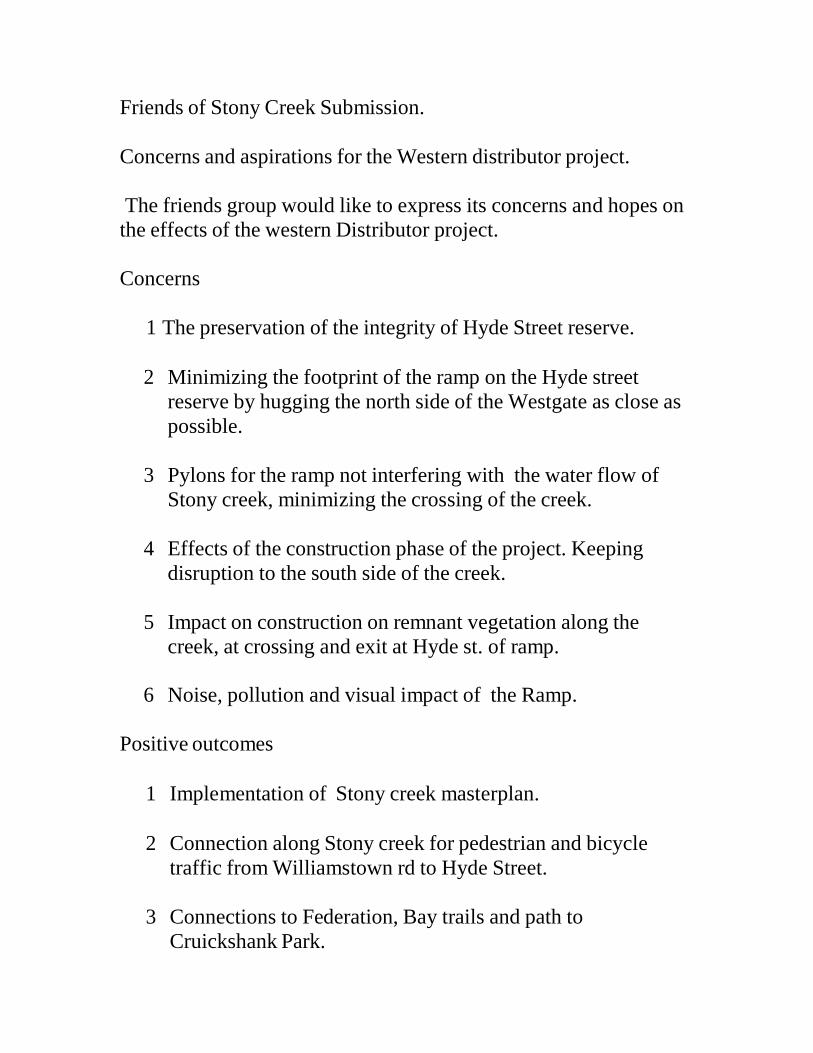
AREA - ISSUE / CONCERN
POTENTIAL SOLUTION
Current noise levels from CityLink in Kensington & Nth and West Melbourne is a major concern to residents.
With the CL expansion and now with the WD project, both noise and light spill are concerns.
Noise Walls to be added to protect the communities in Kensington and North & West Melbourne against the constant drone of traffic spilling out of CL & the new WD.
The contract must state a maximum noise limit and provide for ongoing monitoring.
Ensure designs are made to eliminate light spill.
Local Roads – Increased traffic No information has been provides on the likely increases in traffic.
WD Project should provide solutions to address the likely increases in
traffic on local roads & protect communities from increased rat-runs.
Rectification of the current poor urban design and visual amenity of CityLink between Arden Street & Dynon Road.
As new work is required for the WD in this area, we ask that the project include remediation work to repair the current lack of any visual amenity under CityLink in this section.
Ongoing maintenance of landscaping.
The contract must have a specific provision for who is financially responsible for maintaining the landscaping and urban design elements of the project
The Capital City Bike Path between Arden Street and Footscray Road is poorly designed.
The current path does not meet current design standards for safe sight lines & it regularly floods forcing riders into the rail yards.
The current bike & pedestrian trail in this area needs to be altered to reduce corner angles to increase safe sight line distances.
The bund height should also be increased, & /or provision of signposted safe alternative pathway during trail flooding.
Presence of 6 new viaducts over the Moonee Ponds Creek, will degrade the remaining quality of the open space and amenity for locals, users of the Capital City Trail and the MPCk environs.
Rather than destroy the remaining open section of the M.P.Ck, we would like to see the elimination of all extra Viaducts and ramps over the MPCk.
Reposition the CityLink to Western Distributor Southwest bound (blue) viaduct such that it hugs CL until south of Dynon Rd to reduce overshadowing of the M.P. Creek.
Redesign the city end of the project so that the linkages are moved into the rail yards west of City-Link.
Look to re-align Footscray road & the Dudley/W.Way/Dynon connection to allow for better utilization of the E-Gate Site & Docklands
Redesign the project so that the Dynon Road connectors do not impact the Moonee Ponds Creek.
As an offset to the ramps that cannot be eliminated over the M.P.Ck, provide for a local offset increase in habitat in this area (also to benefit the E-Gate site).