Folkestone Pomerania rMCZ Post-survey Site Report
58
Folkestone Pomerania rMCZ Post-survey Site Report Contract Reference: MB0120 Report Number: 8 Version 9 October 2015
Transcript of Folkestone Pomerania rMCZ Post-survey Site Report

Folkestone Pomerania rMCZ Post-survey Site Report
Contract Reference: MB0120
Report Number: 8 Version 9
October 2015

Project Title: Coordination of the Defra MCZ data collection programme 2011/12 Report No 8. Title: Folkestone Pomerania rMCZ Post-survey Site Report Defra Project Code: MB0120 Defra Contract Manager: Carole Kelly Funded by: Department for Environment, Food and Rural Affairs (Defra) Marine Science and Evidence Unit Marine Directorate Nobel House 17 Smith Square London SW1P 3JR Authorship Alex Callaway Centre for Environment, Fisheries and Aquaculture Science (Cefas) [email protected] Jacqueline Eggleton Centre for Environment, Fisheries and Aquaculture Science (Cefas) [email protected] Acknowledgements We thank Dr Sue Ware for reviewing earlier drafts of this report. We also thank Anna Downie for contributing to the object-based image analysis. Disclaimer: The content of this report does not necessarily reflect the views of Defra, nor is Defra liable for the accuracy of information provided, or responsible for any use of the reports content. Although the data provided in this report have been quality assured, the final products - e.g. habitat maps – may be subject to revision following any further data provision or once they have been used in SNCB advice or assessments.

Cefas Document Control Title: Folkestone Pomerania rMCZ Post-survey Site Report
Submitted to: Marine Protected Areas Survey Co-ordination & Evidence Delivery Group
Date submitted: October 2015
Project Manager: David Limpenny
Report compiled by: Alexander Callaway and Jacqueline D. Eggleton
Quality control by: Sue Ware
Approved by & date: Keith Weston (14/10/2015)
Version: V9
Version Control History
Author Date Comment Version
Alexander Callaway and Jacqueline Eggleton
27/02/2013 First draft 1
Alexander Callaway and Jacqueline Eggleton
28/02/2013 Edited draft following internal QA 2
Alexander Callaway and Jacqueline Eggleton
18/07/2013 Edited following receipt of reviewer comments
3
Alexander Callaway and Jacqueline Eggleton
09/10/2013 Edited following receipt of PSG and additional reviewer comments
4
Alexander Callaway and Jacqueline Eggleton
29/10/2013 Edited following internal review comments 5
Keith Weston 06/11/2013 Edited following internal review comments 6
Keith Weston 23/01/2014 Revised following additional Defra comments
7
Alexander Callaway 16/04/2014 Revised following reanalysis of video data 8
Alexander Callaway 13/10/2015 Revised following further comments from Defra
9

Folkestone Pomerania rMCZ Post-survey Site Reporti
Table of Contents
Table of Contents ........................................................................................................ i
List of Tables .............................................................................................................. iii
List of Figures ............................................................................................................. iv
1 Executive Summary: Report Card ................................................................. 1
1.1 Features proposed in the SAD for inclusion within the MCZ designation ...... 1
1.2 Features present but not proposed in the SAD for inclusion within the rMCZ designation .................................................................................................... 2
1.3 Evidence of human activities occurring within the rMCZ ............................... 2
2 Introduction ................................................................................................... 3
2.1 Location of the rMCZ ..................................................................................... 3
2.2 Rationale for site designation ........................................................................ 4
2.3 Rationale for prioritising this rMCZ for additional evidence collection ........... 5
2.4 Aims and objectives ...................................................................................... 5
3 Methods ........................................................................................................ 7
3.1 Acoustic data acquisition ............................................................................... 7
3.2 Ground truth sample acquisition .................................................................... 7
3.3 Production of the updated habitat map ......................................................... 9
3.4 Quality of the updated map ......................................................................... 12
4 Results ........................................................................................................ 13
4.1 Site Assessment Document (SAD) habitat map .......................................... 13
4.2 Updated habitat map based on new survey data ........................................ 13
4.3 Quality of the updated habitat map ............................................................. 15
4.4 Broadscale habitats identified ..................................................................... 15
4.5 Habitat FOCI identified ................................................................................ 16
4.6 Species FOCI identified .............................................................................. 17
4.7 Quality Assurance (QA) and Quality Control (QC) ...................................... 17
4.8 Data limitations and adequacy of the updated habitat map ......................... 18
4.9 Observations of human impacts on the seabed .......................................... 19
5 Conclusions ................................................................................................ 20
5.1 Presence and extent of broadscale habitats ............................................... 20
5.2 Presence and extent of habitat FOCI .......................................................... 20
5.3 Presence and distribution of species FOCI ................................................. 21
5.4 Evidence of human activities impacting the seabed .................................... 21
References ............................................................................................................... 22
Data sources ............................................................................................................ 24
Folkestone Pomerania rMCZ Post-survey Site Reportii
Annexes ................................................................................................................... 25
Annex 1. Broadscale habitat features listed in the ENG. ..................................... 25
Annex 2. Habitat FOCI listed in the ENG. ............................................................ 26
Annex 3. Low or limited mobility species FOCI listed in the ENG. ....................... 27
Annex 4. Highly mobile species FOCI listed in the ENG. ..................................... 28
Annex 5. Video and stills processing protocol. .................................................... 29
Appendices .............................................................................................................. 31
Appendix 1. Survey metadata (CEND 08c/12) .................................................... 31
Appendix 2. Outputs from acoustic surveys ......................................................... 33
Appendix 3. Evidence of human activities within the rMCZ ................................. 35
Appendix 4. Species list ....................................................................................... 36
Appendix 5. Analyses of sediment samples: classification and composition ....... 42
Appendix 6. BSH/EUNIS Level 3 descriptions derived from video and stills ........ 44
Appendix 7. Example images from survey for broadscale habitats ..................... 48
Appendix 8. Example images from survey for habitat FOCI ................................ 50

Folkestone Pomerania rMCZ Post-survey Site Reportiii
List of Tables
Table 1. Broadscale habitats for which this rMCZ was proposed for designation in the selection assessment document. ................................................................. 4
Table 2. Habitat FOCI for which this rMCZ was proposed for designation in the selection assessment document.* ..................................................................... 5
Table 3. Broadscale habitats identified in this rMCZ. .............................................. 16
Table 4. Habitat FOCI identified in this rMCZ. ......................................................... 17

Folkestone Pomerania rMCZ Post-survey Site Reportiv
List of Figures
Figure 1. Location of the Folkestone Pomerania rMCZ. Bathymetry is from the Defra Digital Elevation Model (Astrium, 2011). .................................................. 4
Figure 2. Location of ground truth sampling sites in the Folkestone Pomerania rMCZ. Bathymetry displayed is from Defra’s Digital Elevation Model (Astrium, 2011).................................................................................................................. 8
Figure 3. Flow chart outlining the process of producing the broadscale habitat map. ......................................................................................................................... 10
Figure 4. Habitat map from the Site Assessment Document. .................................. 13
Figure 5. Updated map of broadscale habitats based on newly acquired survey data. ................................................................................................................. 14
Figure 6. Overall MESH confidence score for the updated broadscale habitat map. ......................................................................................................................... 15
Figure 7. Habitat FOCI identified. ............................................................................ 17

Folkestone Pomerania rMCZ Post-survey Site Report 1
1 Executive Summary: Report Card
This report details the findings of a dedicated seabed survey at the Folkestone Pomerania recommended Marine Conservation Zone (rMCZ). The site is being considered for inclusion in a network of Marine Protected Areas (MPAs) in UK waters, designed to meet conservation objectives under the Marine and Coastal Access Act 2009. Prior to the dedicated survey, the site assessment had been made on the basis of ‘best available evidence’, drawn largely from historical data, modelled habitat maps and stakeholder knowledge of the area. The purpose of the survey was to provide direct evidence of the presence and extent of the broadscale habitats (BSH) and habitat FOCI (Features of Conservation Importance) that had been detailed in the original Site Assessment Document (SAD) (Final Recommendations Report: rMCZ no.11.4 Folkestone Pomerania (Balanced Seas 2011)).
This Executive Summary is presented in the form of a ‘Report Card’ comparing the characteristics predicted in the original SAD with the updated habitat map and new sample data that result from the survey of the site conducted by Emu Ltd and Cefas in February and June 2012. The comparison covers broadscale habitats and habitat FOCI.
1.1 Features proposed in the SAD for inclusion within the MCZ designation
Feature
Extent according to SAD (2011)
Extent according to updated habitat map
Accordance between SAD and updated habitat
map
Broadscale Habitats (BSH) Presence Extent
A4.1 High energy circalittoral rock 0.00 km2 1.64 km2 +1.64 km2
A4.2 Moderate energy circalittoral rock 1.60 km2 0.40 km2 -1.20 km2
A5.1 Subtidal coarse sediment 24.58 km2 25.12 km2 +0.54 km2
A5.2 Subtidal sand 7.12 km2 5.85 km2 -1.27 km2 Habitat FOCI
Blue Mussel Beds 0.31 km2 0.00 km2 -0.31 km2
Fragile Sponge and Anthozoan Communities on Subtidal Rocky Habitats 3 records 0 records N/A
Honeycomb Worm (Sabellaria alveolata) Reef 0.01 km2 0.00 km2 -0.01 km2
Ross Worm (Sabellaria spinulosa) Reef 0.07 km2
8 records 0.26 km2 +0.19 km2
Species FOCI
None proposed N/A N/A N/A N/A
x = presence not indicated in SAD; + = extent is greater in updated habitat map; - = extent is less in updated habitat map.

Folkestone Pomerania rMCZ Post-survey Site Report 2
1.2 Features present but not proposed in the SAD for inclusion within the rMCZ designation
Feature
Extent according to SAD (2011)
Extent according to updated habitat map
Accordance between SAD and updated habitat
map
Broadscale Habitats (BSH) Presence Extent
A3.2 Moderate energy infralittoral rock N/A N/A N/A N/A
A5.4 Subtidal mixed sediments 0.00 km2 0.44 km2 +0.44 km2
A5.6 Subtidal biogenic reefs 0.00 km2 0.26 km2 +0.26 km2
Species FOCI Low mobility
Native Oyster (Ostrea edulis) N/A N/A N/A N/A
Species FOCI High mobility
Smelt (Osmerus eperlanus) N/A N/A N/A N/A
Undulate Ray (Raja undulata) N/A N/A N/A N/A
1.3 Evidence of human activities occurring within the rMCZ
A series of 19 signatures observed in acoustic data correspond with registered wreck sites in the area.

Folkestone Pomerania rMCZ Post-survey Site Report 3
2 Introduction
In accordance with the Marine and Coastal Access Act 2009, the UK is committed to the development and implementation of a network of Marine Protected Areas (MPAs). The network will incorporate existing designated sites (e.g. Special Areas of Conservation and Special Protection Areas) along with a number of newly designated sites. Within English territorial waters and offshore waters of England, Wales and Northern Ireland, these newly designated sites will be termed Marine Conservation Zones (MCZs). In support of this initiative, four Regional MCZ Projects were set up to select sites that could contribute to this network because they contain one or more features specified in the Ecological Network Guidance (ENG; Natural England and the Joint Nature Conservation Committee (JNCC), 2010). The Regional MCZ Projects proposed a total of 127 recommended MCZs (rMCZs) and compiled a Site Assessment Document (SAD) for each site. The SAD summarises what evidence was available for the presence and extent of the various habitat, species and geological features specified in the ENG and for which the site was being recommended.
Due to the scarcity of survey-derived seabed habitat maps in UK waters, these assessments were necessarily made using ‘best available evidence’, which included historical data, modelled habitat maps and stakeholder knowledge of the areas concerned.
It became apparent that the ‘best available evidence’ on features for which some sites had been recommended as MCZs was of variable quality. Consequently, Defra initiated a number of measures aimed at improving the evidence base, one of which took the form of a dedicated survey programme, implemented and co-ordinated by Cefas, to collect and interpret new survey data at selected rMCZ sites. This report provides an interpretation of the survey data collected by EMU Ltd. and Cefas at the Folkestone Pomerania rMCZ site during February and June 2012.
2.1 Location of the rMCZ
The Folkestone Pomerania rMCZ is located in the eastern English Channel, approximately 6 km offshore from the Folkestone region of the Kent coast (Figure 1).

Folkestone Pomerania rMCZ Post-survey Site Report 4
Figure 1. Location of the Folkestone Pomerania rMCZ. Bathymetry is from the Defra Digital Elevation Model (Astrium, 2011).
2.2 Rationale for site designation
The Folkestone Pomerania rMCZ was included in the proposed network because it contained features that would contribute to an ecologically coherent network of broadscale habitats according to ENG criteria. For a detailed site description see Final Recommendations Report: rMCZ 11.4 Folkestone Pomerania (Balanced Seas, 2011) and ‘The Marine Conservation Zone Project: Ecological Network Guidance’ (Natural England and the JNCC, 2010).
2.2.1 Broadscale habitats proposed for designation
Three broadscale habitats were included in the recommendations for designation at this site (Table 1). See Annex 1 for full list of broadscale habitat features listed in the ENG.
Table 1. Broadscale habitats for which this rMCZ was proposed for designation in the selection assessment document.
EUNIS code & Broadscale Habitat Spatial extent according to the SAD
A4.2 Moderate energy circalittoral rock 1.60 km2
A5.1 Subtidal coarse sediment 24.58 km2
A5.2 Subtidal sand 7.12 km2

Folkestone Pomerania rMCZ Post-survey Site Report 5
2.2.2 Habitat FOCI proposed for designation
Annex 2 presents the habitat FOCI listed in the ENG. Five habitat FOCI were included in the SAD recommendations for designation for this site but only four are presented here (Table 2).
Table 2. Habitat FOCI for which this rMCZ was proposed for designation in the selection assessment document.
Habitat FOCI Spatial extent according to SAD
Blue Mussel Bed 0.31 km2
Fragile Sponge and Anthozoan Communities on Subtidal Rocky Habitats 3 records
Honeycomb Worm (Sabellaria alveolata)
Reefs 0.01 km2
Ross Worm (Sabellaria spinulosa) Reefs 0.07 km2
2.2.3 Species FOCI proposed for designation
Annexes 3 and 4 give the species FOCI listed in the ENG. No ‘Low or limited mobility species’ FOCI (Annex 3) or ‘Highly mobile species’ FOCI (Annex 4) were included in the recommendations for designation of this rMCZ.
2.3 Rationale for prioritising this rMCZ for additional evidence collection
Prioritisation of rMCZ sites for further evidence collection was informed by a gap analysis and evidence assessment. The prime objective was to elevate the confidence status for as many rMCZs as feasible to support designation in terms of the amount and quality of evidence for the presence and extent of broadscale habitat features and habitat FOCI and, where possible, species FOCI. The confidence status was originally assessed in the SADs according to Technical Protocol E (Natural England and the JNCC, 2012).
The confidence score for the presence and extent of broadscale habitats and habitat FOCI reported for the Folkestone Pomerania rMCZ ranged from Low to Moderate (JNCC and Natural England, 2012). This site was therefore prioritised for additional evidence collection.
2.4 Aims and objectives
Primary Objectives
To utilise newly acquired acoustic and groundtruthing data to allow the production of an updated map which could be used to inform the presence of broadscale habitats and habitat FOCI, and allow estimates to be made of their spatial extent within the rMCZ.
Secondary Objectives
To provide evidence, where possible, of the presence of Species FOCI listed within the ENG (Annexes 3 and 4) within the rMCZ.

Folkestone Pomerania rMCZ Post-survey Site Report 6
To report evidence of human activity within the rMCZ.
It should be emphasised that the surveys were not primarily designed to address the secondary objectives under the current programme of work.
The newly collected data have been used for the purpose of reporting against the primary objectives of the current programme of work (given above). However, it is also recognised that these data will be valuable for informing the assessment and monitoring of the condition of given habitat features in the future.

Folkestone Pomerania rMCZ Post-survey Site Report 7
3 Methods
3.1 Acoustic data acquisition
Multibeam echosounder (MBES) bathymetry and backscatter data were collected by EMU Ltd. (EMU Ltd., 2012) between 25th February and 27th February 2012 as part of the MCZ evidence collection process, using the vessel RV Discovery. The MBES data were acquired using a Reson SeaBat 7101 multibeam echosounder system, operated at 240 kHz, and QPS QINSy 8.00 software. Attitude and motion were measured by an Applanix POS MV motion reference unit to enable pitch, heave, roll and yaw artefacts to be removed from the MBES data during processing. Bathymetry data were processed using QPS Qloud 2.20 and gridded at 2 m bin sizes. Backscatter data were processed using QPS FM Geocoder Toolkit (FMGT) to produce a fully compensated and corrected backscatter mosaic which was exported as a Floating Point Geotiff at 0.5 m bin size (EMU Ltd., 2012).
The bathymetry and backscatter data were provided to Cefas cleaned and fully processed. The bathymetric data were collected and processed in accordance with the International Hydrographic Organisation (IHO) Standards for Hydrographic Surveys - Order 1 (Special Publication 44, Edition 4). Further details on the acquisition and processing of multibeam bathymetry data can be found in HI1153 Report of Survey Part 1 and HI1153 Report of Survey Part 2 (Civil Hydrographic Programme, 2008) (see Appendix 2 for images derived from acoustic data).
3.2 Ground truth sample acquisition
Ground truth samples were collected by Cefas between 1st June and 3rd June 2012 from 53 stations which were positioned within the sedimentary habitats using a triangular lattice grid overlaid on the Site Assessment Document (SAD) habitat map. Stations within the predicted ‘Coarse sediment’ (A5.1) and ‘Subtidal sand’ sediments (A5.2) were placed at a grid spacing of 1 km and 750 m respectively. Stations on rock substrata (A4.2) were sited to target specific seabed features noted on the bathymetry data layer. This resulted in an array of stations over the site, with station density varying according to the relative extent of the predicted habitat type (Figure 2). A benthic grab was used at 47 stations to collect sediments and infauna. An underwater camera system was deployed at 24 stations to collect video and still images of the seabed (Figure 2; Appendix 1).

Folkestone Pomerania rMCZ Post-survey Site Report 8
Figure 2. Location of ground truth sampling sites in the Folkestone Pomerania rMCZ. Bathymetry displayed is from Defra’s Digital Elevation Model (Astrium, 2011).
Sampling equipment comprised a 0.1 m2 mini Hamon grab fitted with a video camera, the combined gear being known as a HamCam. This allowed an image of the undisturbed seabed surface to be obtained immediately before each grab sample was taken. On recovery, the grab was emptied into a large plastic bin and a representative sub-sample of sediment (approx. 0.5 litres) taken for Particle Size Analysis (PSA). The remaining sample was photographed and sieved over a 1 mm mesh sieve to collect the benthic fauna. Fauna were preserved in buffered 4% formaldehyde for later processing ashore.
Within the broadscale habitat areas identified in the SAD, camera sledge or drop camera deployments were made at a subset of stations sampled by the grab. The frequency of use of the camera system was informed by the type of sediment obtained in the grab sample. Where this was consistent with the BSH predicted in the SAD, the camera was deployed at approximately every third station. Where the grab sample was not consistent with the predicted BSH, the camera was used at every station. The camera images helped to characterise the surficial sediments and associated epifaunal communities. The total number of camera deployments for each BSH varied depending on the uniformity of the habitat and its spatial extent.
The camera system was able to collect both video and still images. A 4-point laser scaling device was used to provide a reference scale in the video and still images. Set-up and operation followed the MESH ‘Recommended Operating Guidelines (ROG) for underwater video and photographic imaging techniques’ (Coggan et al., 2007). Video data were recorded simultaneously to a Sony GV-HD700 DV tape and

Folkestone Pomerania rMCZ Post-survey Site Report 9
a computer hard drive. A video overlay was used to provide station metadata, time and GPS position (of the vessel) in the recorded video image.
Camera tows lasted a minimum of 10 minutes, with the gear being towed at c. 0.5 knots (c. 0.25 m s-1) across a 100 m ‘bullring’ centred on the sampling station. Still images were captured at regular one minute intervals and opportunistically if specific features of interest were encountered. Video and still images were analysed following an established protocol developed and used by Cefas (Coggan and Howell, 2005; JNCC, in prep.; see Annex 5).
For further detail on ground truth sample collection see ‘The Folkestone Pomerania rMCZ Survey Report’ (Whomersley et al., 2012).
3.3 Production of the updated habitat map
All new maps and their derivatives have been based on a WGS84 datum. A new habitat map for the site was produced by analysing and interpreting the available acoustic data (as detailed above) and the ground truth data collected by the dedicated survey of this site. The process is a combination of two approaches, statistical modelling and image analysis, as described below.
The object-based image analysis (OBIA) is a two-step approach consisting of segmentation and classification (Blaschke, 2010), implemented in the software package eCognition® v8.7.2. The backscatter image (Appendix 2) is segmented into objects (sections of the image with homogeneous backscatter characteristics). For each of these objects, mean values of the primary acoustic data layers and their derivatives were calculated and used in a random forest decision tree (RFDT) model with ground truth data, to predict substrata type (Breiman, 2001). Each stage in the process is listed and described in detail below (Figure 3).

Folkestone Pomerania rMCZ Post-survey Site Report 10
Figure 3. Flow chart outlining the process of producing the broadscale habitat map.
Stage 1. Data Preparation
Prior to analysis, the bathymetry and backscatter data were re-sampled onto a common grid at 2 m resolution. This data preparation results in a spatial grid with a single value for bathymetry (depth) and a single value for backscatter (acoustic reflectance) in each 2 m x 2 m grid cell, and it is these data values that are used in the rest of the process.
Stage 2. Derivatives calculated
From the two primary acoustic datasets, bathymetry and backscatter, a range of derivatives were calculated, including the Bathymetric Position Index (BPI), which indicates where a point sits in relation to its neighbours, e.g. elevated, depressed or similar. The value of the BPI indicates the size of the search radius used for calculating the layer, i.e. BPI 10 had a search radius of 10 cells. Backscatter, bathymetry, slope, BPI 10 and BPI 25 were used in the initial segmentation. Mean backscatter, mean bathymetry, mean slope and mean BPI 10 were also included for the classification.
Stage 3. Segmentation
Segmentation divides the image into meaningful objects based on their spectral and spatial characteristics. The resulting objects can be characterised by their various features, such as layer values (mean, standard deviation, skewness, etc.), geometry (extent, shape, etc.), texture and many others.

Folkestone Pomerania rMCZ Post-survey Site Report 11
Segmentation was carried out using the multi-resolution segmentation algorithm in eCognition®. This is an optimisation procedure that starts with an individual pixel and consecutively merges it with neighbouring pixels to form an object. The process continues until a threshold value for a ‘scale’ parameter determining the variability allowed in the objects is reached. The threshold is determined by the operator.
The goal of the segmentation is to create meaningful objects that represent areas of homogeneous values in the map image. The size of the objects is influenced by the ‘scale’ parameter mentioned above and the heterogeneity of the image. For a fixed value of the scale parameter, a homogeneous area of seabed will have larger objects than a heterogeneous area. Likewise, for a fixed seabed heterogeneity, larger values of the scale parameter produce larger objects than smaller values. The final segmentation was carried out at pixel level on backscatter strength and BPI 25, backscatter being weighted higher than BPI, with the scale parameter set at 10.
For each of the objects created, mean values of the primary acoustic data layers and their derivatives were calculated (e.g., the mean backscatter value for the grid cells lying within the object) for further statistical analysis and modelling. Mean values of backscatter, slope and BPI 10 were used to fuse objects of similar characteristics using the multiple object difference, conditions based fusion algorithm (Weise, 2011). This algorithm works by fusing objects that have mean differences in their mean layer values below a user designated threshold. In this case the thresholds were: mean backscatter (10), mean slope (10), mean BPI 10 (0.5).
Stage 4. Random forest decision tree (RFDT) model trained to predict broadscale habitat type
The model was trained to predict five broadscale habitat types based upon the Marine Habitat Classification for Britain and Ireland Version 04.05 (Connor et al., 2004) that was used to inform UKSeaMap used by the site assessment document. These broadscale habitats were high energy circalittoral rock, subtidal coarse sediment, subtidal mixed sediment, subtidal sand, and subtidal biogenic reef.
The random forest decision tree algorithm within eCognition® was used to classify and predict the distribution of broadscale habitat types. The classifications of the broadscale habitat types were assigned from ground truth data. Both grab and video samples were considered to enable discrimination between sediments and rock present in acoustic facies. A training dataset was generated by assigning a sediment classification to those objects created in the segmentation process which contained a ground truth sample. Each training sample contained a label for sediment type and the mean values for each of the acoustic variables within the object. This training set is used by the RFDT algorithm to assign a sediment type to the rest of the objects based on their acoustic values.
The resulting broadscale habitat map appeared to have overestimated the amount of high energy circalittoral rock, subtidal biogenic reef and subtidal sand in the area with multiple small patches classified throughout other areas of sediment classes. Due to the absence of ground truth data in these patches, a final algorithm (assign class) was applied to reclassify all objects containing these over-predicted classes with an area less than 5000 pixels to either subtidal coarse sediment or Subtidal sand depending on which area of greater homogeneity the objects were present. Finally the broadscale habitat map was exported as a shapefile.

Folkestone Pomerania rMCZ Post-survey Site Report 12
3.4 Quality of the updated map
The technical quality of the updated habitat map was assessed using the MESH ‘Confidence Assessment’ Tool1, originally developed by an international consortium of marine scientists working on the MESH (Mapping European Seabed Habitats) project. This tool considers the provenance of the data used to make a biotope/habitat map, including the techniques and technology used to characterise the physical and biological environment and the expertise of the people who had made the map. In its original implementation it was used to make an auditable judgement of the confidence that could be placed in a range of existing, local biotope maps that had been developed using different techniques and data inputs, but were to be used in compiling a full coverage map for north-west Europe. Where two of the original maps overlapped, that with the highest MESH confidence score would take precedence in the compiled map.
Subsequent to the MESH project, the confidence assessment tool has been applied to provide a benchmark score that reflects the technical quality of newly developed habitat/biotope maps. Both physical and biological survey data are required to achieve the top mark of 100, but as the current rMCZ exercise requires the mapping of broadscale physical habitats, not biotopes, it excludes the need for biological data. In the absence of biological data, the maximum score attainable for a purely physical map is 88.
In applying the tool to the current work, none of the weighting options were altered; that is, the tool was applied in its standard form, as downloaded from the internet.
1 http://www.searchmesh.net/confidence/confidenceAssessment.html

Folkestone Pomerania rMCZ Post-survey Site Report 13
4 Results
4.1 Site Assessment Document (SAD) habitat map
The SAD habitat map was produced using a number of data sources including UKSeaMap v7 (McBreen, 2010) and outputs from the Mapping European Seabed Habitats (MESH) project. The predicted extent of the main broadscale habitats shown in the SAD habitat map are reproduced in Figure 4. For further detail see the original SAD; Folkestone Pomerania rMCZ no. 11.4 (Balanced Seas, 2011).
Figure 4. Habitat map from the Site Assessment Document.
4.2 Updated habitat map based on new survey data
The updated habitat map resulting from an integrated analysis of the 2012 dedicated survey data is presented in Figure 5. It shows the seabed at the site to be a heterogeneous mosaic of subtidal coarse sediment and subtidal sand, with smaller areas of high energy circalittoral rock, moderate energy circalittoral rock, subtidal mixed sediments and subtidal biogenic reef. The coarse sediments are most prevalent on raised plateaus in the north of the rMCZ whilst biogenic reef and mixed sediments appear to be restricted to topographic depressions
The list of benthic macrofaunal species found in the grab samples is presented in Appendix 4; a total of 221 taxa were recorded.

Folkestone Pomerania rMCZ Post-survey Site Report 14
Figure 5. Updated map of broadscale habitats based on newly acquired survey data.

Folkestone Pomerania rMCZ Post-survey Site Report 15
4.3 Quality of the updated habitat map
This map attained a score of 83 from the MESH Confidence Assessment Tool (Figure 6), which is good, given that the maximum possible score for a purely physical map is 88.
Figure 6. Overall MESH confidence score for the updated broadscale habitat map.
4.4 Broadscale habitats identified
The Folkestone Pomerania rMCZ seabed is a mosaic of coarse sediment and sand substrata with smaller areas of high energy circalittoral rock, moderate energy circalittoral rock, mixed sediment and biogenic reef. The definition of these substrata is not absolute as gradients exist between the sediments preventing certainty of boundaries between classifications. Also, the sediments appear to overlay rock. These veneers may be ubiquitous or the rock may outcrop at the seabed. The cobble aggregations classified as high energy and moderate energy circalittoral rock are found with coarse and sand sediment veneers. The high energy circalittoral rock classification was assigned to analysed images in which this BSH was observed. These results were then used in classification of the broadscale habitat map. Biological information, such as faunal distributions, abundance or biomass, was not used to inform BSH classification. Also, in the north of the site some ridge features are evident, and in the centre of the site some folding features are apparent (Appendix 2). The morphology of these features is characteristic of rock formations and the northern ridges are described as such in the site assessment document. The ground truth data available to create the updated broadscale habitat map do not

Folkestone Pomerania rMCZ Post-survey Site Report 16
support classification as rock. It is possible that the features observed in acoustic data are rock overlaid with sediments and the topographic expression still evident. However, it is acknowledged that exposed rock may be present in these areas. The extent of subtidal biogenic reefs is likely over-predicted. This is a result of the lack of a distinct acoustic signature for these biogenic structures which are created using sand from the vicinity of the structure and the inherent patchiness of the structures as reveled by video data. The extent of the subtidal biogenic reef class is therefore a result of the underlying objects in the OBIA and the samples used to inform the model. The spatial extent of each of the BSH classes shown in the updated habitat map is presented in Table 3.
Table 3. Broadscale habitats identified in this rMCZ.
Broadscale Habitat Type (EUNIS Level 3)
Spatial extent according to the SAD
Spatial extent according to the updated habitat map
A4.1 High energy circalittoral rock 0.00 km2 1.64 km2
A4.2 Moderate energy circalittoral rock 1.60 km2 0.40 km2
A5.1 Subtidal coarse sediment 24.58 km2 25.12 km2
A5.2 Subtidal sand 7.12 km2 5.85 km2
A5.4 Subtidal mixed sediments 0.00 km2 0.44 km2
A5.6 Subtidal biogenic reefs 0.00 km2 0.26 km2
4.5 Habitat FOCI identified
The extent of the habitat FOCI identified by the updated habitat map is shown in Figure 7 and detailed in Table 4. Habitat FOCI identified in this rMCZ.. Ross Worm (Sabellaria spinulosa) reefs cover around 0.8% of the rMCZ. Point occurrences are also included for ‘Ross Worm (Sabellaria spinulosa) Reefs’ as described from video data. Data from processed grab samples (abundance and biomass of taxa) are not used to illustrate the presence of these features.

Folkestone Pomerania rMCZ Post-survey Site Report 17
Figure 7. Habitat FOCI identified.
Table 4. Habitat FOCI identified in this rMCZ.
Habitat FOCI Spatial extent
according to the SAD
Spatial extent according to the updated habitat
map
Ross Worm (Sabellaria spinulosa) Reefs 0.07 km2
8 records
0.26 km2
Fragile Sponge and Anthozoan Communities on Subtidal Rocky Habitats 3 records 0 records
4.6 Species FOCI identified
No species FOCI were identified from the data collected.
4.7 Quality Assurance (QA) and Quality Control (QC)
4.7.1 Acoustic data
The acoustic data utilised for production of the updated habitat map were collected as part of Defra’s evidence gathering initiative coordinated by Cefas. Acquisition and processing of the acoustic data was carried out by EMU Ltd. Bathymetry data

Folkestone Pomerania rMCZ Post-survey Site Report 18
complied with the International Hydrographic Organisation (IHO) Standards for Hydrographic Surveys-Order 1 (Special Publication 44, Edition 4). The accompanying multibeam backscatter data were processed by hydrographic surveyors and reviewed by specialist Cefas staff to ensure these data were suitable for use in the subsequent interpretations and production of the updated habitat map.
4.7.2 Particle Size Analysis (PSA) of sediments
PSA was carried out by Kenneth Pye Associates Ltd following standard laboratory practice, and the results checked by specialist Cefas staff following the recommendations of the National Marine Biological Analytical Quality Control (NMBAQC) scheme (Mason, 2011). Results of the PSA are shown in Appendix 5.
4.7.3 Infaunal samples from grabs
Infaunal samples were processed by Seastar Survey Ltd. following standard laboratory practices, and results checked following the recommendations of the National Marine Biological Analytical Quality Control (NMBAQC) scheme (Worsfold et al., 2010).
4.7.4 Video and still images and analysis
Video and photographic stills were processed by Seastar Survey Ltd. in accordance with the guidance documents developed by Cefas and the JNCC for the acquisition and processing of video and stills data (Coggan and Howell, 2005; JNCC, in prep.; summarised in Appendix 6; examples of broadscale habitats are illustrated in Appendix 7).
4.8 Data limitations and adequacy of the updated habitat map
The quality of the derived habitat map is assessed to be High (MESH assessment tool). A source of potential misclassification of habitats arises from the location of groundtruthing samples in relation to habitat types.
The limited number of ground truth samples prevented a thorough external accuracy assessment of the mapping model, which would have been a more reliable indicator of the quality of the map.
The survey has provided substantial, robust evidence for the presence of the mapped habitats. However, as it is impractical (and undesirable) to sample the entire area of the site with grabs and video, there is a chance that a BSH or FOCI may exist within the site but has not been recorded, especially if it was limited in extent. Given the relatively heterogeneous nature of the site, the likelihood of this is moderate.
The precise location of the boundaries between the broadscale habitats depicted on the map should be regarded as indicative, not definitive. In nature, such boundaries are rarely abrupt. Instead it is typical for one BSH to grade into another across a transitional boundary. In contrast, the mapped boundaries are abrupt and have been placed using best professional judgment. This may have implications when calculating the overall extent of any of the mapped habitats or FOCI.

Folkestone Pomerania rMCZ Post-survey Site Report 19
4.8.1 Presence of Species FOCI
No species FOCI were observed.
4.9 Observations of human impacts on the seabed
A series of signatures interpreted to be wrecks were observed in the acoustic data (Appendix 3). These 19 records correspond with registered wreck sites in the area.

Folkestone Pomerania rMCZ Post-survey Site Report 20
5 Conclusions
5.1 Presence and extent of broadscale habitats
5.1.1 Presence
The 2012 dedicated survey has confirmed the presence of the BSHs ‘A4.2 Moderate energy circalittoral rock’, ‘A5.1 Subtidal coarse sediment’ and ‘A5.2 Subtidal sand’ that were included in the recommendations made by the SAD for designating this site as an MCZ.
The 2012 dedicated survey has confirmed the presence of the BSHs ‘A4.1 High energy circalittoral rock’, ‘A5.4 Subtidal mixed sediment’ and ‘A5.6 Subtidal biogenic reefs’. These BSHs were not included in the recommendations made by the SAD for designating this site as an MCZ.
5.1.2 Extent
The spatial extent of the BSH ‘A4.1 High energy circalittoral rock’ on the updated habitat map is 1.64 km2. This was not identified in the SAD habitat map.
The spatial extent of the BSH ‘A4.2 Moderate energy circalittoral rock’ on the updated habitat map is 0.40 km2. This 1.20 km2 less than in the SAD habitat map.
The spatial extent of the BSH ‘A5.1 Subtidal coarse sediment’ on the updated habitat map is 25.12 km2. This is 0.54 km2 more than its spatial extent in the SAD habitat map.
The spatial extent of the BSH ‘A5.2 Subtidal sand’ on the updated habitat map is 5.85 km2. This is 1.27 km2 less than its spatial extent in the SAD habitat map.
The spatial extent of the BSH ‘A5.4 Subtidal mixed sediments’ on the updated habitat map is 0.44 km2. This was not identified in the SAD habitat map.
The spatial extent of the BSH ‘A5.6 Subtidal biogenic reefs’ on the updated habitat map is 0.26 km2. This was not identified in the SAD habitat map.
5.2 Presence and extent of habitat FOCI
5.2.1 Presence
The 2012 dedicated survey has confirmed the presence of the habitat FOCI ‘Subtidal Sands and Gravels’, ‘Ross Worm (Sabellaria spinulosa) Reefs’ that were included in the recommendations made by the SAD for designating this site as an MCZ (see Appendix 8 for example images).
The 2012 dedicated survey has not confirmed the presence of either the habitat FOCI ‘Blue Mussel Beds’ or ‘Honeycomb Worm (Sabellaria alveolata)

Folkestone Pomerania rMCZ Post-survey Site Report 21
Reefs’ at this site. These habitat FOCI were included in the recommendations made by the SAD for designating this site as an MCZ.
5.2.2 Extent and distribution
The spatial extent of the habitat FOCI ‘Ross Worm (Sabellaria spinulosa) Reefs’ on the updated habitat map is 0.26 km2. This is 0.19 km2 more than predicted in the SAD document. The extent of this habitat FOCI is derived from the predicted broadscale habitat ‘A5.6 Subtidal biogenic reefs’ which was based upon grab samples containing S. spinulosa.
5.3 Presence and distribution of species FOCI
5.3.1 Low or limited mobility species
No ‘low or limited mobility species FOCI’ were recorded at this site by the 2012 dedicated survey. The species FOCI ‘Native Oyster (Ostrea edulis)’ was noted as present in the SAD but not proposed as a feature for designation.
5.3.2 Highly mobile species FOCI
No ‘highly mobile species FOCI’ were recorded at this site by the 2012 dedicated survey. Smelt (Osmerus eperlanus) and Undulate Ray (Raja undulata) were noted as present in the SAD but not proposed as a feature for designation.
5.4 Evidence of human activities impacting the seabed
A series of 19 signatures observed in acoustic data correspond with registered wreck sites in the area.

Folkestone Pomerania rMCZ Post-survey Site Report 22
References
Astrium (2011). Creation of a high resolution Digital Elevation Model (DEM) of the British Isles continental shelf: Final Report. Prepared for Defra, Contract Reference: 13820. 26 pp.
Balanced Seas. 2011. Final Recommendations Report: rMCZ 11.4 Folkestone Pomerania. Online resource: http://webarchive.nationalarchives.gov.uk/20120502155440/http:/www.balancedseas.org/ [Accessed 23/01/2014].
Blaschke, T. (2010). Object based image analysis for remote sensing. ISPRS Journal of Photogrammetry and Remote Sensing 65, 2-16.
Breiman, L. (2001). Random Forests. Machine Learning 45, 5-32.
Civil Hydrographic Programme (2008). 2006-2009 Medium Depth Civil Hydrographic Programme, HI1153 Report of Survey Part 1 and HI1153 Report of Survey Part 2.
Coggan, R., Mitchell, A., White, J. and Golding, N. (2007). Recommended operating guidelines (ROG) for underwater video and photographic imaging techniques (www.searchmesh.net/PDF/GMHM3_video_ROG.pdf) [Accessed 23/01/2014]
Coggan, R. and Howell, K. (2005). Draft SOP for the collection and analysis of video and still images for groundtruthing an acoustic basemap. Video survey SOP version 5, 10 pp.
Connor, D.W., Allen, J.H., Golding, N., Howell, K.L., Lieberknecht, L.M., Northern, K.O. and Reker, J.B. (2004) the Marine Habitat Classification for Britain and Ireland Version 04.05 JNCC, Peterborough. ISBN 1 861 07561 8 (internet version).
EMU Ltd. 2012. [Bayliss, D] Folkestone Pomerania MCZ Acoustic Survey: End of Cruise Report. EMU report 12/J/1/02/2038/1306. 56 pp. Cefas report FP/13/A/02-12.
JNCC (in prep.). Video/Stills Camera Standard Operating Procedure for Survey and Analysis: for groundtruthing and classifying an acoustic basemap, and development of new biotopes within the UK Marine Habitat Classification. JNCC Video and Stills Processing SOP v2. 6 pp.
JNCC and Natural England (2012). Marine Conservation Zone Project: JNCC and Natural England's advice to Defra on recommended Marine Conservation Zones. Peterborough and Sheffield. 1455 pp.
Mason, C. (2011). NMBAQC’s Best Practice Guidance Particle Size Analysis (PSA) for Supporting Biological Analysis.
McBreen, F. (2010). UKSeaMap 2010 EUNIS model Version 3.0. UKSeaMap 2010: Predictive seabed habitat map (v5). JNCC.

Folkestone Pomerania rMCZ Post-survey Site Report 23
Natural England and the Joint Nature Conservation Committee (2010). The Marine Conservation Zone Project: Ecological Network Guidance. Sheffield and Peterborough, UK.
Natural England and the Joint Nature Conservation Committee (2012). SNCB MCZ Advice Project-Assessing the scientific confidence in the presence and extent of features in recommended Marine Conservation Zones (Technical Protocol E)
Weise, C. 2011. Customized algorithm to generate meaningful objects. Online resource: http://community.ecognition.com/home/Customized%20Segmentation.zip. [Accessed 23/1/2014]
Whomersley, P., Rance, J., Vanstaen, K. and Callaway, A. 2012. Folkestone Pomerania rMCZ Survey report. 27 pp.
Worsfold, T.M., Hall., D.J. and O’Reilly, M. (2010). Guidelines for processing marine macrobenthic invertebrate samples: a processing requirements protocol version 1 (June 2010). Unicomarine Report NMBAQCMbPRP to the NMBAQC Committee. 33 pp. http://www.nmbaqcs.org/media/9732/nmbaqc%20-%20inv%20-%20prp%20-%20v1.0%20june2010.pdf

Folkestone Pomerania rMCZ Post-survey Site Report 24
Data sources
All enquiries in relation to this report should be addressed to following e-mail address: [email protected]

Folkestone Pomerania rMCZ Post-survey Site Report 25
Annexes
Annex 1. Broadscale habitat features listed in the ENG.
Broadscale Habitat Type EUNIS Level 3 Code
High energy intertidal rock A1.1
Moderate energy intertidal rock A1.2
Low energy intertidal rock A1.3
Intertidal coarse sediment A2.1
Intertidal sand and muddy sand A2.2
Intertidal mud A2.3
Intertidal mixed sediments A2.4
Coastal saltmarshes and saline reed beds A2.5
Intertidal sediments dominated by aquatic angiosperms A2.6
Intertidal biogenic reefs A2.7
High energy infralittoral rock* A3.1
Moderate energy infralittoral rock* A3.2
Low energy infralittoral rock* A3.3
High energy circalittoral rock** A4.1
Moderate energy circalittoral rock** A4.2
Low energy circalittoral rock** A4.3
Subtidal coarse sediment A5.1
Subtidal sand A5.2
Subtidal mud A5.3
Subtidal mixed sediments A5.4
Subtidal macrophyte-dominated sediment A5.5
Subtidal biogenic reef A5.6
Deep-sea bed*** A6
* Infralittoral rock includes habitats of bedrock, boulders and cobble which occur in the shallow subtidal zone and typically support seaweed communities ** Circalittoral rock is characterised by animal dominated communities, rather than seaweed dominated communities *** The deep seabed broadscale habitat encompasses several different habitat sub-types, all of which should be protected within the MPA network. The broadscale habitat deep seabed habitat is found only in the south-west of the MCZ project area and MCZs identified for this broadscale habitat should seek to protect the variety of sub-types known to occur in the region.

Folkestone Pomerania rMCZ Post-survey Site Report 26
Annex 2. Habitat FOCI listed in the ENG.
Habitat Features of Conservation Importance (FOCI)
Blue Mussel Beds (including Intertidal Beds on Mixed and Sandy Sediments)**
Cold-Water Coral Reefs ***
Coral Gardens***
Deep-Sea Sponge Aggregations***
Estuarine Rocky Habitats
File Shell Beds***
Fragile Sponge and Anthozoan Communities on Subtidal Rocky Habitats
Intertidal Underboulder Communities
Littoral Chalk Communities
Maerl Beds
Horse Mussel (Modiolus modiolus) Beds
Mud Habitats in Deep Water*****
Sea-Pen and Burrowing Megafauna Communities
Native Oyster (Ostrea edulis) Beds
Peat and Clay Exposures
Honeycomb Worm (Sabellaria alveolata) Reefs
Ross Worm (Sabellaria spinulosa) Reefs
Seagrass Beds
Sheltered Muddy Gravels
Subtidal Chalk
Subtidal Sands and Gravels
Tide-Swept Channels
* Habitat FOCI have been identified from the ‘OSPAR List of Threatened and/or Declining Species and Habitats’ and the ‘UK List of Priority Species and Habitats (UK BAP)’. ** Only includes ‘natural’ beds on a variety of sediment types. Excludes artificially created mussel beds and those which occur on rocks and boulders. *** Cold-Water Coral Reefs, Coral Gardens, Deep-Sea Sponge Aggregations and File Shell Beds currently do not have distributional data which demonstrate their presence within the MCZ project area. **** Subtidal Sands and Gravels are considered to be adequately protected by its component habitat features subtidal sand and/or subtidal coarse sediment, and is no longer included within MCZ designations. ***** ‘Mud Habitats in Deep Water’ is considered to be adequately protected by its component broadscale habitat feature ‘Subtidal mud’ and is no longer included within MCZ designation.

Folkestone Pomerania rMCZ Post-survey Site Report 27
Annex 3. Low or limited mobility species FOCI listed in the ENG.
Group Scientific name Common Name
Brown Algae Padina pavonica Peacock’s Tail
Red Algae Cruoria cruoriaeformis
Grateloupia montagnei
Lithothamnion corallioides
Phymatolithon calcareum
Burgundy Maerl Paint Weed
Grateloup’s Little-Lobed Weed
Coral Maerl
Common Maerl
Annelida Alkmaria romijni**
Armandia cirrhosa**
Tentacled Lagoon-Worm**
Lagoon Sandworm**
Teleostei Gobius cobitis
Gobius couchi
Hippocampus guttulatus
Hippocampus hippocampus
Giant Goby
Couch’s Goby
Long Snouted Seahorse
Short Snouted Seahorse
Bryozoa Victorella pavida Trembling Sea Mat
Cnidaria Amphianthus dohrnii
Eunicella verrucosa
Haliclystus auricula****
Leptosammia pruvoti
Lucernariopsis campanulata
Lucernariopsis cruxmelitensis
Nematostella vectensis
Sea-Fan Anemone
Pink Sea-Fan
Stalked Jellyfish****
Sunset Cup Coral
Stalked Jellyfish
Stalked Jellyfish
Starlet Sea Anemone
Crustacea Gammarus insensibilis**
Gitanopsis bispinosa
Pollicipes pollicipes
Palinurus elephas
Lagoon Sand Shrimp**
Amphipod Shrimp
Gooseneck Barnacle
Spiny Lobster
Mollusca Arctica islandica
Atrina pectinata***
Caecum armoricum**
Ostrea edulis
Paludinella littorina*****
Tenellia adspersa**
Ocean Quahog
Fan Mussel***
Defolin’s Lagoon Snail**
Native Oyster
Sea Snail*****
Lagoon Sea Slug**
* Species FOCI have been identified from the ‘OSPAR List of Threatened and/or Declining Species and Habitats’, the ‘UK List of Priority Species and Habitats (UK BAP)’ and Schedule 5 of the Wildlife and Countryside Act. ** Those lagoonal species FOCI may be afforded sufficient protection through coastal lagoons designated as SACs under the EC Habitats Directive. However, this needs to be assessed by individual Regional MCZ Projects. *** Fan mussel should be correctly described as Atrina fragilis. **** The stalked jellyfish Haliclystus auricula is now referred to as Haliclystus species for the purpose of MCZ protection to account for potential presence of Haliclystus octoradiatus that has not been consistently differentiated within scientific records. The species are therefore considered jointly as an MCZ feature. ***** The sea snail (Paludinella littorina) has been removed from Schedule 5 of the Wildlife and Countryside Act. This means that it is no longer a Feature of Conservation Importance (FOCI) so has been removed as a feature for MCZ designation.

Folkestone Pomerania rMCZ Post-survey Site Report 28
Annex 4. Highly mobile species FOCI listed in the ENG.
Group Scientific name Common Name
Teleostei Osmerus eperlanus
Anguilla anguilla**
Smelt
European Eel**
Elasmobranchii Raja undulata Undulate Ray
* Species FOCI have been identified from the ‘OSPAR List of Threatened and/or Declining Species and Habitats’, the ‘UK List of Priority Species and Habitats (UK BAP)’ and Schedule 5 of the Wildlife and Countryside Act. ** MCZs are no longer considered to be an appropriate tool for the protection of European eels. They have been identified as habitat generalists for which it is particularly difficult to identify unique nursery or foraging grounds due to their wide distribution across coastal and freshwater zones. Conservation and management of European eels is considered to be more effectively achieved through the Eel Regulations and Eel Management Plans.

Folkestone Pomerania rMCZ Post-survey Site Report 29
Annex 5. Video and stills processing protocol.
The purpose of the analysis of the video and still images is to identify what habitats exist in a video record, provide semi-quantitative data on their physical and biological characteristics and to note where one habitat changes to another. A minimum of 10% of the videos should be re-analysed for QA purposes.
Video Analysis
The video record is initially viewed rapidly (at approximately 4x normal speed) in order to segment it into sections representing different habitats. The start and end points of each segment are logged, and each segment subsequently subject to more detailed analysis. Brief changes in habitat type lasting less than one minute of the video record are considered as incidental patches and are not logged.
For each segment, note the start and end time and position from the information on the video overlay. View the segment at normal or slower than normal speed, noting the physical and biological characteristics, such as substrata type, seabed character, species and life forms present. For each taxon record an actual abundance (where feasible) or a semi quantitative abundance (e.g. SACFOR scale).
Record the analyses on the video pro-forma provided (paper and/or electronic), which is a modified version of the Sublittoral Habitat Recording Form used in the MNCR surveys.
When each segment has been analysed, review the information recorded and assign the segment to one of the broadscale habitat (BSH) types or Habitat FOCI listed in the Ecological Network Guidance (as reproduced in Annexes 1 and 2 above). Note also any species FOCI observed (as per Annex 3 above).
Stills analysis
Still images should be analysed separately, to supplement and validate the video analysis, and provide more detailed (i.e. higher resolution) information than can be extracted from a moving video image.
For each segment of video, select three still images that are representative of the BSH or FOCI to which the video segment has been assigned. For each image, note the time and position it was taken, using information from the associated video overlay.
View the image at normal or greater than normal magnification, noting the physical and biological characteristics, such as substrata type, seabed character, species and life forms present. For each taxon record an actual abundance (where feasible) or a semi quantitative abundance (e.g. SACFOR scale).
Record the analysis on the stills pro-forma provided (paper and/or electronic), which is a modified version of the Sublittoral Habitat Recording Form used in the MNCR surveys. Assign each still image to the same BSH or Habitat FOCI as its ‘parent’ segment in the video.

Folkestone Pomerania rMCZ Post-survey Site Report 30
Taxon identification
In all analyses, the identification of taxa should be limited to a level that can be confidently achieved from the available image. Hence, taxon identity could range from the ‘life form’ level (e.g. sponge, hydroid, anemone) to the species level (e.g. Asterias rubens, Alcyonium digitatum). Avoid the temptation to guess the species identity if it can not be determined positively from the image. For example, Spirobranchus sp. would be acceptable, but Spirobranchus triqueter would not, as the specific identification normally requires the specimen to be inspected under a microscope.

Folkestone Pomerania rMCZ Post-survey Site Report 31
Appendices
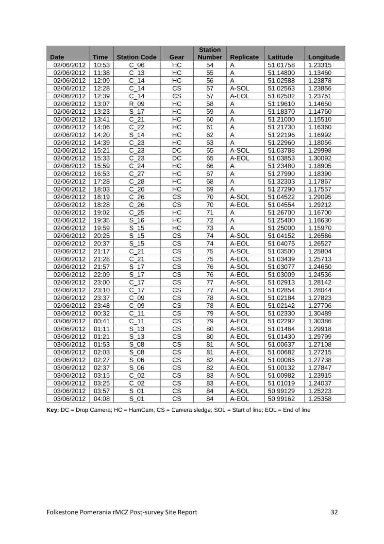
Appendix 1. Survey metadata (CEND 08c/12)
Date Time Station Code Gear Station Number Replicate Latitude Longitude
01/06/2012 13:52 R_04 DC 13 A-SOL 51.02654 1.32723
01/06/2012 14:06 R_04 DC 13 A-EOL 51.02767 1.32724
01/06/2012 14:33 R_08 DC 14 A-SOL 51.02330 1.32460
01/06/2012 14:44 R_08 DC 14 A-EOL 51.02397 1.32443
01/06/2012 15:39 R_03 DC 15 A_SOL 51.02187 1.32953
01/06/2012 15:44 R_03 DC 15 A-EOL 51.02203 1.32936
01/06/2012 16:28 R_06 DC 16 A-SOL 51.01733 1.33300
01/06/2012 16:38 R_06 DC 16 A-EOL 51.01787 1.33240
01/06/2012 17:07 R_07 DC 17 A-SOL 51.02003 1.32070
01/06/2012 17:19 R_07 DC 17 A-EOL 51.02069 1.32037
01/06/2012 17:41 R_05 DC 18 A-SOL 51.01509 1.32261
01/06/2012 17:54 R_05 DC 18 A-EOL 51.01578 1.32212
01/06/2012 18:18 C_05 DC 19 A-SOL 51.01566 1.31293
01/06/2012 18:28 C_05 DC 19 A-EOL 51.01649 1.31244
01/06/2012 18:50 R_02 DC 20 A-SOL 51.01347 1.30674
01/06/2012 19:03 R_02 DC 20 A-EOL 51.01445 1.30600
01/06/2012 19:20 R_01 DC 21 A-SOL 51.00913 1.30444
01/06/2012 19:30 R_01 DC 21 A-EOL 51.00884 1.30522
01/06/2012 20:03 C_05 HC 22 A 51.01580 1.31249
01/06/2012 20:33 R_02 HC 23 A 51.01350 1.30594
01/06/2012 20:55 R_01 HC 24 A 51.00890 1.30488
01/06/2012 21:21 S_13 HC 25 A 51.01482 1.29832
01/06/2012 21:39 S_10 HC 26 A 51.00858 1.29423
01/06/2012 21:57 S_07 HC 27 A 51.00234 1.28997
01/06/2012 22:16 S_06 HC 28 A 51.00162 1.27921
01/06/2012 22:47 S_09 HC 29 A 51.00779 1.28356
01/06/2012 23:05 S_12 HC 30 A 51.01392 1.28781
01/06/2012 00:04 S_11 HC 31 A 51.01310 1.27684
02/06/2012 00:21 S_08 HC 32 A 51.00685 1.27282
02/06/2012 00:41 S_05 HC 33 A 51.00065 1.26859
02/06/2012 00:56 S_02 HC 34 A 50.99440 1.26419
02/06/2012 01:13 S_01 HC 35 A 50.99367 1.25355
02/06/2012 01:31 S_04 HC 36 A 50.99977 1.25787
02/06/2012 01:53 S_03 HC 37 A 50.99884 1.24749
02/06/2012 02:14 C_01 HC 38 A 51.00305 1.25030
02/06/2012 02:46 C_02 HC 39 A 51.01028 1.24168
02/06/2012 03:37 C_03 HC 40 A 51.01145 1.25569
02/06/2012 04:14 C_04 HC 41 A 51.01241 1.27003
02/06/2012 04:37 C_09 HC 42 A 51.02044 1.27570
02/06/2012 04:56 C_10 HC 43 A 51.02176 1.28951
02/06/2012 05:26 C_11 HC 44 A 51.02269 1.30417
02/06/2012 05:51 C_12 HC 45 A 51.02383 1.31785
02/06/2012 06:15 C_20 HC 46 A 51.03220 1.32360
02/06/2012 07:05 C_19 HC 47 A 51.03116 1.30925
02/06/2012 07:37 C_18 HC 48 A 51.03030 1.29499
02/06/2012 08:04 C_17 HC 49 A 51.02929 1.28101
02/06/2012 08:24 C_16 HC 50 A 51.02810 1.26677
02/06/2012 08:46 C_08 HC 51 A 51.01989 1.26103
02/06/2012 09:48 C_07 HC 52 A 51.01868 1.24724
02/06/2012 10:21 C_07 CS 53 A-SOL 51.01992 1.24413
02/06/2012 10:31 C_07 CS 53 A-EOL 51.01923 1.24300
Folkestone Pomerania rMCZ Post-survey Site Report 32
Date Time Station Code Gear Station Number Replicate Latitude Longitude
02/06/2012 10:53 C_06 HC 54 A 51.01758 1.23315
02/06/2012 11:38 C_13 HC 55 A 51.14800 1.13460
02/06/2012 12:09 C_14 HC 56 A 51.02588 1.23878
02/06/2012 12:28 C_14 CS 57 A-SOL 51.02563 1.23856
02/06/2012 12:39 C_14 CS 57 A-EOL 51.02502 1.23751
02/06/2012 13:07 R_09 HC 58 A 51.19610 1.14650
02/06/2012 13:23 S_17 HC 59 A 51.18370 1.14760
02/06/2012 13:41 C_21 HC 60 A 51.21000 1.15510
02/06/2012 14:06 C_22 HC 61 A 51.21730 1.16360
02/06/2012 14:20 S_14 HC 62 A 51.22196 1.16992
02/06/2012 14:39 C_23 HC 63 A 51.22960 1.18056
02/06/2012 15:21 C_23 DC 65 A-SOL 51.03788 1.29998
02/06/2012 15:33 C_23 DC 65 A-EOL 51.03853 1.30092
02/06/2012 15:59 C_24 HC 66 A 51.23480 1.18905
02/06/2012 16:53 C_27 HC 67 A 51.27990 1.18390
02/06/2012 17:28 C_28 HC 68 A 51.32303 1.17867
02/06/2012 18:03 C_26 HC 69 A 51.27290 1.17557
02/06/2012 18:19 C_26 CS 70 A-SOL 51.04522 1.29095
02/06/2012 18:28 C_26 CS 70 A-EOL 51.04554 1.29212
02/06/2012 19:02 C_25 HC 71 A 51.26700 1.16700
02/06/2012 19:35 S_16 HC 72 A 51.25400 1.16630
02/06/2012 19:59 S_15 HC 73 A 51.25000 1.15970
02/06/2012 20:25 S_15 CS 74 A-SOL 51.04152 1.26586
02/06/2012 20:37 S_15 CS 74 A-EOL 51.04075 1.26527
02/06/2012 21:17 C_21 CS 75 A-SOL 51.03500 1.25804
02/06/2012 21:28 C_21 CS 75 A-EOL 51.03439 1.25713
02/06/2012 21:57 S_17 CS 76 A-SOL 51.03077 1.24650
02/06/2012 22:09 S_17 CS 76 A-EOL 51.03009 1.24536
02/06/2012 23:00 C_17 CS 77 A-SOL 51.02913 1.28142
02/06/2012 23:10 C_17 CS 77 A-EOL 51.02854 1.28044
02/06/2012 23:37 C_09 CS 78 A-SOL 51.02184 1.27823
02/06/2012 23:48 C_09 CS 78 A-EOL 51.02142 1.27706
03/06/2012 00:32 C_11 CS 79 A-SOL 51.02330 1.30489
03/06/2012 00:41 C_11 CS 79 A-EOL 51.02292 1.30386
03/06/2012 01:11 S_13 CS 80 A-SOL 51.01464 1.29918
03/06/2012 01:21 S_13 CS 80 A-EOL 51.01430 1.29799
03/06/2012 01:53 S_08 CS 81 A-SOL 51.00637 1.27108
03/06/2012 02:03 S_08 CS 81 A-EOL 51.00682 1.27215
03/06/2012 02:27 S_06 CS 82 A-SOL 51.00085 1.27738
03/06/2012 02:37 S_06 CS 82 A-EOL 51.00132 1.27847
03/06/2012 03:15 C_02 CS 83 A-SOL 51.00982 1.23915
03/06/2012 03:25 C_02 CS 83 A-EOL 51.01019 1.24037
03/06/2012 03:57 S_01 CS 84 A-SOL 50.99129 1.25223
03/06/2012 04:08 S_01 CS 84 A-EOL 50.99162 1.25358
Key: DC = Drop Camera; HC = HamCam; CS = Camera sledge; SOL = Start of line; EOL = End of line

Folkestone Pomerania rMCZ Post-survey Site Report 33
Appendix 2. Outputs from acoustic surveys

Folkestone Pomerania rMCZ Post-survey Site Report 34

Folkestone Pomerania rMCZ Post-survey Site Report 35
Appendix 3. Evidence of human activities within the rMCZ

Folkestone Pomerania rMCZ Post-survey Site Report 36
Appendix 4. Species list
Species list for grab samples (Species FOCI indicated by grey shading if present). Percentage occurrence was calculated as the ‘Number of samples where the species occurs/total number of samples x100’.
Taxa % Occurrence
SPONGES PORIFERA 2
HYDROIDS, CORALS, JELLYFISH, ANEMONES ACTINIARIA 38 Tubularia sp. 21 Alcyonium digitatum 13 Sertulariidae 6 Campanulariidae 6 Cerianthus lloydii 4 Halecium sp. 2
RIBBON WORMS NEMERTEA 66
NEMATODA NEMATODA 15
ARROW WORMS CHAETOGNATHA 4
PEANUT WORMS Golfingia vulgaris 40
SEGMENTED WORMS Spirobranchus lamarcki 70 Sabellaria spinulosa 64 Lumbrineris cf. cingulata 62 Ophelia borealis 62 Polycirrus sp. 53 Glycera lapidum agg. 49 Syllis armillaris 49 Aonides paucibranchiata 49 Caulleriella alata 38 Syllis cornuta 36 Notomastus sp. 34 Spirobranchus triqueter 34 Polynoidae juv 32 Nephtys cirrosa 32 Pholoe inornata 28 Syllis variegata 28 Mediomastus fragilis 26 Clymenura sp. 23 Spirobranchus sp. 23 Pholoe baltica 21 Autolytus sp. 21 Dipolydora coeca agg. 21 Eumida sanguinea 19 Nematonereis unicornis 19 Clymenura johnstoni 19 Petaloproctus sp. 19 Glycera oxycephala 17 Goniada maculata 17 Asclerocheilus intermedius 17 Jasmineira elegans 17 Lepidonatus squamatus 15 Eulalia ornata 15

Folkestone Pomerania rMCZ Post-survey Site Report 37
Taxa % Occurrence Syllidia armata 15 Poecilochaetus serpens 15 Dipolydora caulleryi 15 Malmgreniella marphysae 13 Caulleriella zetlandica 13 Scalibregma inflatum 13 Eunereis longissima 11 Owenia fusiformis 11 Gattyana cirrhosa 9 Harmothoe extenuata 9 Syllides 'A' 9 Paradoneis lyra 9 Prionospio sp. 9 Chaetozone gibber 9 Aphelochaeta 'A' 9 Lanice conchilega 9 Harmothoe sp. 6 Nephtys sp. juv 6 Marphysa sanguinea 6 Spio armata agg. 6 Clymenura tricirrata 6 Galathowenia oculata 6 Thelepus cincinnatus 6 Thelepus setosus 6 Pisione remota 4 Harmothoe imbricata 4 Polynoe scolopendrina 4 Phyllodocidae 4 Eteone longa 4 Mysta picta 4 Phyllodoce maculata 4 Glycera alba 4 Syllis sp. B 4 Nereididae juv. 4 Lumbrineridae 4 Schistomeringos rudolphi 4 Aonides oxycephala 4 Spio decorata 4 Praxillella affinis 4 Amphitritides gracilis 4 Pseudopotamilla reniformis 4 Adyte pellucida 2 Enipo elisabethae 2 Malmgreniella castanea 2 Harmothoe glabra 2 Sthenelais boa 2 Eulalia bilineata 2 Eulalia viridis 2 Eumida bahusiensis 2 Glycera sp. juv 2 Goniadidae 2 Sphaerodorum gracilis 2 Kefersteinia cirrata 2 Podarkeopsis capensis 2 Odontosyllis fulgurans 2 Exogone hebes 2 Exogone verrugera 2 Nephtys kersivalensis 2 Arabella iricolor 2

Folkestone Pomerania rMCZ Post-survey Site Report 38
Taxa % Occurrence Protodorvillea kefersteini 2 Aricidea minuta 2 Atherospio guillei 2 Pseudopolydora pulchra 2 Scolelepis tridentata 2 Spiophanes bombyx 2 Caulleriella bioculata 2 Chaetozone christei 2 Cirratulus caudatus juv. 2 Lumbriclymene minor 2 Euclymene sp. 2 Euclymene oerstedii 2 Opheliidae juv 2 Opheliidae 2 Sclerocheilus minutus 2 Polygordius sp. 2 TEREBELLIDA 2 Terebellides stroemi 2 Lysilla loveni 2 Sabellidae 2 Serpulidae 2
SEA SPIDERS Nymphon brevirostre 11 Achelia echinata 2
CRUSTACEANS Unciola crenatipalma 32 Urothoe pulchella 28 Urothoe elegans 26 Pisidia longicornis 26 Stenothoe marina 23 Abludomelita obtusata 23 Crassicorphium bonelli 21 Ampelisca diadema 19 Gammaropsis maculata 19 Anthura gracilis 13 Callianassa subterranea 13 Ampelisca spinipes 11 Socarnes erythrophthalmus 9 Pagurus bernhardus 9 Liocarcinus sp. juv. 9 Amphilochus neapolitanus 6 Bathyporeia pelagica 6 Ericthonius sp. 6 Dyopedos monacanthus 6 Pilumnus hirtellus 6 Gastrosaccus spinifer 4 Acidostoma obesum 4 Pseudoprotella phasma 4 Pseudoprotella phasma juv. 4 Janira maculosa 4 Astacilla longicornis 4 Decapoda indet. zoea 4 Upogebia deltaura 4 Paguridae sp. juv. 4 Anapagurus hyndmanni 4 Galathea intermedia 4 Corystes cassivelaunus juv. 4 COPEPODA 2 Bathyporeia sp. 2

Folkestone Pomerania rMCZ Post-survey Site Report 39
Taxa % Occurrence Gammaropsis nitida 2 Pariambus typicus 2 Phtisica marina 2 Gnathia oxyuraea 2 Eurydice pulchra 2 Ione thoracica 2 Processa canaliculata 2 Pestarella tyrrhena 2 Macropodia deflexa 2 Liocarcinus pusillus 2
MOLLUSCS Abra alba 19 Doto sp. 17 Epitonium clathratulum 11 Musculus subpictus 9 Diplodonta rotundata 9 Timoclea ovata 9 Sphenia binghami 9 Leptochiton asellus 6 Tritoniidae 6 Kellia suborbicularis 6 Spisula elliptica 6 Calliostoma zizyphinium 4 Euspira pulchella 4 Buccinum undatum 4 AEOLIDIACEA 4 Nucula nucleus 4 Goodalia triangularis 4 Acanthochitona crinita 2 Crepidula fornicata 2 Dendronotus frondosus 2 Gnathia oxyuraea 2 Mytilus edulis 2 Modiolus sp. 2 Pectinidae sp. juv 2 Diplodonta rotundata juv. 2 Kurtiella bidentata 2 Thracia papyracea 2
BRYOZOANS Vesiculaira spinosa 15 Bicellariella ciliata 9 Alcyonidium diaphanum 6 Electra pilosa 6 Eucratea loricata 2
HORSESHOE WORMS Phoronis sp. 6
SEA STARS, URCHINS, SEA CUCUMBERS Echinocyamus pusillus 66 Amphipholis squamata 43 Psammechinus miliaris 13 Asterias rubens 6 Ophiothrix fragilis 6 Amphiuridae juv. 6 Ophiura albida 6 Psammechinus miliaris juv. 6 Ophiura sp. juv. 4 Asteroidea juv. 2 Ophiothrix sp. juv 2

Folkestone Pomerania rMCZ Post-survey Site Report 40
Taxa % Occurrence Amphiura icana 2 Holothurioidea 2 Thyone fusus 2
SEA SQUIRTS Didemnidae 4 Molgula sp. 2
FISH Ammodytidae juv 2
Species list for video samples (Species FOCI indicated by grey shading if present). ‘Number of video samples where the species occurs/total number of video samples x100’.
Taxa % Occurrence
SPONGES PORIFERA (encrusting) 58 PORIFERA (massive) 17 Amphilectus fucorum 4
HYDROIDS, CORALS, JELLYFISH, ANEMONES HYDROZOA 100 Actiniaria 79 Alcyonium digitatum 67 Nemertesia 67 Urticina 58 Tubularia indivisa 50 Nemertesia antennina 33 HYDROZOA (turf) 29 Abietinaria abietina 25 Sagartia elegans 21 Kirchenpaueria pinnata 13 Nemertesia ramosa 13 Sagartiidae 13 Actinothoe sphyrodeta 8 Metridium senile 8
SEGMENTED WORMS Spirobranchus 100 Sabellaria spinulosa (crust) 46 POLYCHAETA burrow/tube 8 POLYCHAETA tube 8
CRUSTACEANS Paguridae 71 Decapoda 29 Majidae 21 Buccinum undatum 8 Cancer pagurus 8 Ebalia 8 Necora puber 8 Brachyura 4 Buccinidae 4 Cirripedia 4 Hyas araneus 4
MOLLUSCS Pectinidae 25 Calliostoma zizyphinum 13 Gastropoda 13 Janolus cristatus 8

Folkestone Pomerania rMCZ Post-survey Site Report 41
Taxa % Occurrence Pecten maximus 8 Pectinidae juv. 4
BRYOZOA BRYOZOA (foliaceous) 63 Alcyonidium diaphanum 50 Vesicularia spinosa 33 Flustridae 25 Flustra foliacea 21 Chartella papyracea 13 BRYOZOA (plumose) 13 BRYOZOA (dendroid) 8 Pentapora fascialis 4 Securiflustra securifrons 4
SEA STARS, URCHINS, SEA CUCUMBERS Asterias rubens 88 ASTEROIDEA 29 Ophiura albida 25 Ophiuroida 17 ECHINOIDEA 8 Ophiura 8 OPHIUROIDEA 8 Psammechinus miliaris 4
SEA SQUIRTS Ascidiacea (colonial) 8 Ascidiacea (solitary) 8 Botryllus schlosseri 4
FISH Pleuronectidae 33 TELEOSTEI 29 Solea solea 17 Scyliorhinus canicula 8 Callionymus lyra 4 Mermaid's purse 4 Pleuronectes platessa 4 Pleuronectidae juv 4 Pleuronectiformes 4 Rajidae 4 Trisopterus luscus 4
ALGAE RHODOPHYTA (encrusting) 8
Unidentified faunal turf 71

Folkestone Pomerania rMCZ Post-survey Site Report 42
Appendix 5. Analyses of sediment samples: classification and composition
Stn No. Stn Code Latitude Longitude Sediment Description EUNIS Level 3/BSH Gravel (%) Sand (%) Silt/clay (%)
FP_C_01 38 51.00305 1.25030 sand and muddy sand A5.2 Subtidal sand 0.76 99.24 0.00
FP_C_02 39 51.01028 1.24168 coarse sediment A5.1 Subtidal coarse sediment 11.29 87.61 1.11
FP_C_03 40 51.01145 1.25569 coarse sediment A5.1 Subtidal coarse sediment 20.70 79.30 0.00
FP_C_04 41 51.01241 1.27003 sand and muddy sand A5.2 Subtidal sand 0.19 99.81 0.00
FP_C_05 22 51.01580 1.31248 coarse sediment A5.1 Subtidal coarse sediment 49.19 48.42 2.39
FP_C_06 54 51.01758 1.23315 coarse sediment A5.1 Subtidal coarse sediment 15.83 82.25 1.93
FP_C_07 52 51.01869 1.24724 coarse sediment A5.1 Subtidal coarse sediment 39.08 56.72 4.20
FP_C_08 51 51.01989 1.26103 coarse sediment A5.1 Subtidal coarse sediment 40.31 57.24 2.45
FP_C_09 42 51.02044 1.27570 coarse sediment A5.1 Subtidal coarse sediment 45.72 53.49 0.79
FP_C_10 43 51.02176 1.28951 coarse sediment A5.1 Subtidal coarse sediment 12.16 82.31 5.53
FP_C_11 44 51.02269 1.30417 coarse sediment A5.1 Subtidal coarse sediment 11.32 88.68 0.00
FP_C_12 45 51.02383 1.31785 coarse sediment A5.1 Subtidal coarse sediment 5.02 93.86 1.13
FP_C_13 55 51.02467 1.22437 coarse sediment A5.1 Subtidal coarse sediment 60.73 38.24 1.03
FP_C_14 56 51.02588 1.23878 coarse sediment A5.1 Subtidal coarse sediment 83.57 14.74 1.68
FP_C_16 50 51.02810 1.26677 coarse sediment A5.1 Subtidal coarse sediment 42.44 56.37 1.19
FP_C_17 49 51.02928 1.28101 coarse sediment A5.1 Subtidal coarse sediment 25.70 73.32 0.98
FP_C_18 48 51.03030 1.29499 coarse sediment A5.1 Subtidal coarse sediment 66.43 32.37 1.20
FP_C_19 47 51.03116 1.30925 coarse sediment A5.1 Subtidal coarse sediment 50.69 48.21 1.10
FP_C_20 46 51.03220 1.32360 coarse sediment A5.1 Subtidal coarse sediment 27.92 70.71 1.38
FP_C_21 60 51.03506 1.25857 coarse sediment A5.1 Subtidal coarse sediment 30.88 69.11 0.00
FP_C_22 61 51.03623 1.27257 mixed sediments A5.1 Subtidal coarse sediment 39.18 53.55 7.27
FP_C_23 63 51.03827 1.30093 coarse sediment A5.1 Subtidal coarse sediment 10.42 88.47 1.10
FP_C_24 66 51.03914 1.31511 coarse sediment A5.1 Subtidal coarse sediment 45.97 52.14 1.89
FP_C_25 71 51.04464 1.27838 coarse sediment A5.1 Subtidal coarse sediment 24.89 73.68 1.43
FP_C_26 69 51.04547 1.29263 coarse sediment A5.1 Subtidal coarse sediment 19.25 79.60 1.15
FP_C_27 67 51.04666 1.30661 coarse sediment A5.1 Subtidal coarse sediment 47.90 52.10 0.00
FP_C_28 68 51.05384 1.29777 coarse sediment A5.1 Subtidal coarse sediment 32.36 61.73 5.91
FP_R_01 24 51.00890 1.30488 coarse sediment A5.1 Subtidal coarse sediment 65.99 31.22 2.79
FP_R_02 23 51.01350 1.30593 sand and muddy sand A5.2 Subtidal sand 1.33 98.67 0.00

Folkestone Pomerania rMCZ Post-survey Site Report 43
Stn No. Stn Code Latitude Longitude Sediment Description EUNIS Level 3/BSH Gravel (%) Sand (%) Silt/clay (%)
FP_R_09 58 51.03270 1.24417 coarse sediment A5.1 Subtidal coarse sediment 29.22 66.01 4.77
FP_S_01 35 50.99367 1.25355 coarse sediment A5.1 Subtidal coarse sediment 11.78 88.22 0.00
FP_S_02 34 50.99440 1.26419 sand and muddy sand A5.2 Subtidal sand 4.13 95.63 0.24
FP_S_03 37 50.99884 1.24749 coarse sediment A5.1 Subtidal coarse sediment 20.02 78.93 1.05
FP_S_04 36 50.99978 1.25787 coarse sediment A5.1 Subtidal coarse sediment 18.05 79.86 2.09
FP_S_05 33 51.00065 1.26859 coarse sediment A5.1 Subtidal coarse sediment 35.22 64.22 0.55
FP_S_06 28 51.00162 1.27921 sand and muddy sand A5.2 Subtidal sand 4.81 94.68 0.51
FP_S_07 27 51.00234 1.28997 sand and muddy sand A5.2 Subtidal sand 0.17 99.83 0.00
FP_S_08 32 51.00685 1.27282 coarse sediment A5.1 Subtidal coarse sediment 27.46 71.69 0.85
FP_S_09 29 51.00773 1.28343 coarse sediment A5.1 Subtidal coarse sediment 14.09 85.85 0.05
FP_S_10 26 51.00858 1.29423 sand and muddy sand A5.2 Subtidal sand 1.39 97.81 0.80
FP_S_11 31 51.01310 1.27684 sand and muddy sand A5.2 Subtidal sand 0.51 98.67 0.83
FP_S_12 30 51.01392 1.28781 coarse sediment A5.1 Subtidal coarse sediment 21.85 77.83 0.32
FP_S_13 25 51.01476 1.29820 sand and muddy sand A5.2 Subtidal sand 0.06 99.94 0.00
FP_S_14 62 51.03698 1.28324 coarse sediment A5.1 Subtidal coarse sediment 43.89 55.25 0.86
FP_S_15 73 51.04168 1.26617 sand and muddy sand A5.2 Subtidal sand 4.59 93.86 1.55
FP_S_16 72 51.04234 1.27728 coarse A5.1 Subtidal coarse sediment 81.18 16.72 2.11
FP_S_17 59 51.03062 1.24613 mixed sediments A5.4 Subtidal mixed sediments 21.81 59.36 18.83

Folkestone Pomerania rMCZ Post-survey Site Report 44
Appendix 6. BSH/EUNIS Level 3 descriptions derived from video and stills
Station code
Stn no.
Latitude (start)
Longitude (start)
Latitude (end)
Longitude (end)
Habitat No.
No. of stills Sediment description
Broadscale Habitat
MNCR code
FP_R_04 13 51.02658 1.32710 51.02720 1.32705 1 13 Sand, empty shells, shell fragments and pebbles.
A5.1 - Subtidal Coarse Sediment
SS.SCS
FP_R_04 13 51.02720 1.32705 51.02773 1.32711 2 13 Sand, empty shells, shell fragments, pebbles and cobbles
A4.1 - High Energy Circalittoral Rock
CR.HCR
FP_R_08 14 51.02335 1.32445 51.02340 1.32446 1 7 Sand with a small boulders possibly encrusted with Sabellaria spinulosa
A5.2 - Subtidal Sand
SS.SSA
FP_R_08 14 51.02340 1.32446 51.02354 1.32444 2 3 Sand and cobbles with patches of Sabellaria spinulosa
A5.6 - Subtidal Biogenic Reef
SS.SBR
FP_R_08 14 51.02354 1.32444 51.02378 1.32437 3 4 Sand, cobbles and boulders A4.1 - High Energy Circalittoral Rock
CR.HCR
FP_R_08 14 51.02378 1.32437 51.02440 1.32428 4 1 Sand, cobbles and pebbles A5.1 - Subtidal Coarse Sediment
SS.SCS
FP_R_08 14 51.02440 1.32428 51.02404 1.32429 5 no stills Sand, empty shells, shell fragments, pebbles, cobbles
A4.1 - High Energy Circalittoral Rock
CR.HCR
FP_R_03 15 51.02193 1.32941 51.02208 1.32923 1 7 Coarse sand with cobbles, pebbles and shell fragments. Possible Sabellaria observed
A5.1 - Subtidal Coarse Sediment
SS.SCS
FP_R_06 16 51.01738 1.33286 51.01755 1.33264 1 7 Sand, pebbles and cobbles A5.1 - Subtidal Coarse Sediment
SS.SCS
FP_R_06 16 51.01755 1.33264 51.01766 1.33256 2 4 Sand, cobbles, pebbles and boulders
A5.1 - Subtidal Coarse Sediment
SS.SCS
FP_R_06 16 51.01766 1.33256 51.01790 1.33230 3 1 Sand, pebbles and cobbles A5.1 - Subtidal Coarse Sediment
SS.SCS
FP_R_06 16 51.01790 1.33230 51.01796 1.33224 4 no stills Sand, cobbles, pebbles and boulders
A5.1 - Subtidal Coarse Sediment
SS.SCS
FP_R_07 17 51.02010 1.32057 51.02054 1.32037 1 12 Sand, cobbles, pebbles and boulders
A4.1 - High Energy Circalittoral Rock
CR.HCR
FP_R_07 17 51.02054 1.32037 51.02077 1.32024 2 8 Sand with aggregations of Sabellaria spinulosa
A5.1 - Subtidal Coarse Sediment
SS.SCS
FP_R_05 18 51.01519 1.32245 51.01545 1.32227 1 9 Sandy cobbles and boulders A4.1 - High Energy Circalittoral Rock
CR.HCR

Folkestone Pomerania rMCZ Post-survey Site Report 45
Station code
Stn no.
Latitude (start)
Longitude (start)
Latitude (end)
Longitude (end)
Habitat No.
No. of stills Sediment description
Broadscale Habitat
MNCR code
FP_R_05 18 51.01545 1.32227 51.01565 1.32214 2 7 Sand ripples with cobbles and pebbles
A4.1 - High Energy Circalittoral Rock
CR.HCR
FP_R_05 18 51.01565 1.32214 51.01584 1.32198 3 3 Sand with cobbles and pebbles
A4.1 - High Energy Circalittoral Rock
CR.HCR
FP_C_05 19 51.01570 1.31278 51.01581 1.31273 1 5 Mixed sediment with Sabellaria spinulosa
A5.1 - Subtidal Coarse Sediment
SS.SCS
FP_C_05 19 51.01581 1.31273 51.01634 1.31240 2 10 Sand, gravel and cobbles A5.1 - Subtidal Coarse Sediment
SS.SCS
FP_C_05 19 51.01634 1.31240 51.01654 1.31229 3 5 Mixed sediment with Sabellaria spinulosa
A5.1 - Subtidal Coarse Sediment
SS.SCS
FP_R_02 20 51.01352 1.30660 51.01391 1.30632 1 12 Mixed sediment with Sabellaria spinulosa
A5.1 - Subtidal Coarse Sediment
SS.SCS
FP_R_02 20 51.01391 1.30632 51.01427 1.30604 2 4 Sand with sparse fauna A5.2 - Subtidal Sand
SS.SSA
FP_R_02 20 51.01427 1.30604 51.01452 1.30586 3 6 Mixed sediment with Sabellaria spinulosa
A5.1 - Subtidal Coarse Sediment
SS.SCS
FP_R_01 21 51.00941 1.30459 51.00891 1.30511 1 7 Mixed sediment with Sabellaria spinulosa
A5.1 - Subtidal Coarse Sediment
SS.SCS
FP_R_01 21 51.00891 1.30511 51.00875 1.30553 2 3 Gravelly sand A5.1 - Subtidal Coarse Sediment
SS.SCS
FP_C_07 53 51.01970 1.24378 51.01902 1.24265 1 11 Sandy gravel with cobbles A5.1 - Subtidal Coarse Sediment
SS.SCS
FP_C_14 57 51.02543 1.23822 51.02477 1.23707 1 15 Sandy gravel with cobbles A5.1 - Subtidal Coarse Sediment
SS.SCS
FP_C_23 65 51.03794 1.29985 51.03814 1.30168 1 3 Gravelly sand A5.1 - Subtidal Coarse Sediment
SS.SCS
FP_C_23 65 51.03814 1.30168 51.03818 1.30021 2 3 Mixed sediment with Sabellaria spinulosa
A5.1 - Subtidal Coarse Sediment
SS.SCS
FP_C_23 65 51.03818 1.30021 51.03831 1.30038 3 3 Gravelly sand with sparse fauna
A5.1 - Subtidal Coarse Sediment
SS.SCS
FP_C_23 65 51.03831 1.30038 51.03838 1.30050 4 2 Mixed sediment with Sabellaria spinulosa
A5.1 - Subtidal Coarse Sediment
SS.SCS
FP_C_23 65 51.03838 1.30050 51.03860 1.30081 5 5 Gravelly sand with cobbles A5.1 - Subtidal Coarse Sediment
SS.SCS
FP_C_26 70 51.04543 1.29164 51.04556 1.29212 1 10 Sand, gravel and cobbles with Spirobranchus sp.
A5.1 - Subtidal Coarse Sediment
SS.SCS

Folkestone Pomerania rMCZ Post-survey Site Report 46
Station code
Stn no.
Latitude (start)
Longitude (start)
Latitude (end)
Longitude (end)
Habitat No.
No. of stills Sediment description
Broadscale Habitat
MNCR code
FP_C_26 70 51.04556 1.29212 51.04568 1.29259 2 7 Cobbles and boulders A4.1 - High Energy Circalittoral Rock
CR.HCR
FP_S_15 74 51.04126 1.26563 51.04054 1.26508 1 16 Sand with troughs containing pebbles and cobbles
A5.1 - Subtidal Coarse Sediment
SS.SCS
FP_S_15 74 51.04054 1.26508 51.04046 1.26503 2 3 Boulders surrounded by sand and occasional cobbles
A4.1 - High Energy Circalittoral Rock
CR.HCR
FP_C_21 75 51.03480 1.25775 51.03416 1.25679 1 19 Sand with occasional pebbles, cobbles and boulders
A5.2 - Subtidal Sand
SS.SSA
FP_S_17 76 51.03057 1.24614 51.02998 1.24498 1 15 Sand waves with occasional accumulations of pebbles and cobbles in troughs
A5.1 - Subtidal Coarse Sediment
SS.SCS
FP_C_17 77 51.02893 1.28107 51.02832 1.28005 1 12 Gravelly sand A5.1 - Subtidal Coarse Sediment
SS.SCS
FP_C_09 78 51.02168 1.27781 51.02156 1.27750 1 4 Sand with aggregations of Sabellaria spinulosa
A5.1 - Subtidal Coarse Sediment
SS.SCS
FP_C_09 78 51.02156 1.2775 51.0214 1.27717 2 2 Coarse sand with pebbles A5.1 - Subtidal Coarse Sediment
SS.SCS
FP_C_09 78 51.02144 1.27717 51.0214 1.27694 3 2 Sand with aggregations of Sabellaria spinulosa
A5.1 - Subtidal Coarse Sediment
SS.SCS
FP_C_09 78 51.02136 1.27694 51.0213 1.27664 4 4 Coarse sand with pebbles A5.1 - Subtidal Coarse Sediment
SS.SCS
FP_C_11 79 51.02314 1.30448 51.0228 1.30344 1 11 Coarse sand with accumulations of pebbles and cobbles in sand wave troughs
A5.1 - Subtidal Coarse Sediment
SS.SCS
FP_S_13 80 51.01452 1.29875 51.0142 1.29754 1 12 Coarse sand with patches of gravel and cobbles
A5.1 - Subtidal Coarse Sediment
SS.SCS
FP_S_08 81 51.00654 1.27148 51.0067 1.27182 1 5 Sand with aggregations of Sabellaria spinulosa
A5.1 - Subtidal Coarse Sediment
SS.SCS
FP_S_08 81 51.00667 1.27182 51.0069 1.27245 2 6 Sand and cobbles A4.1 - High Energy Circalittoral Rock
CR.HCR
FP_S_08 81 51.00692 1.27245 51.0069 1.27259 3 2 Coarse sand and gravel with occasional cobbles
A5.1 - Subtidal Coarse Sediment
SS.SCS
FP_S_06 82 51.00103 1.27778 51.0014 1.27865 1 11 Coarse sand, gravel, occasional cobbles and shell fragments
A5.1 - Subtidal Coarse Sediment
SS.SCS

Folkestone Pomerania rMCZ Post-survey Site Report 47
Station code
Stn no.
Latitude (start)
Longitude (start)
Latitude (end)
Longitude (end)
Habitat No.
No. of stills Sediment description
Broadscale Habitat
MNCR code
FP_S_06 82 51.00144 1.27865 51.0015 1.27886 2 2 Sand A5.2 - Subtidal Sand
SS.SSA
FP_C_02 83 51.00994 1.23959 51.0103 1.24083 1 15 Coarse sand with sparse aggregations of Sabellaria and cobbles
A5.1 - Subtidal Coarse Sediment
SS.SCS
FP_S_01 84 50.99143 1.25268 50.9918 1.25397 1 12 Coarse sand with areas of pebbles and cobbles
A5.1 - Subtidal Coarse Sediment
SS.SCS

Folkestone Pomerania rMCZ Post-survey Site Report 48
Appendix 7. Example images from survey for broadscale habitats
Broadscale Habitats MNCR Description Example Image taken during survey
A4.1 High energy circalittoral rock
Image from station code FP_R07_STN_170013
Extremely wave-exposed to exposed circalittoral bedrock and boulders subject to tidal streams ranging from strong to very strong.
A5.1: Sublittoral coarse sediment
Image from station code FP_S13_STN80_0008
Coarse sediments including coarse sand, gravel, pebbles, shingle and cobbles which are often unstable due to tidal currents and/or wave action.
A5.2: Sublittoral sand
Image from station code FP_C02_STN83_0015
Clean medium to fine sands or non-cohesive slightly muddy sands on open coasts, offshore or in estuaries and marine inlets.
A5.4: Sublittoral mixed sediments
Image from station code FP_S17_STN_76_0010
Sublittoral mixed (heterogeneous) sediments found from the extreme low water mark to deep offshore circalittoral habitats.

Folkestone Pomerania rMCZ Post-survey Site Report 49
A5.6 Subtidal biogenic reef
Image from station code FP_R02_STN_200010
Honeycomb worm (Sabellaria alveolata) reefs (subtidal), Ross worm (Sabellaria spinulosa) reefs, Modiolus modiolus beds, blue mussel beds and cold-water coral reefs.

Folkestone Pomerania rMCZ Post-survey Site Report 50
Appendix 8. Example images from survey for habitat FOCI
Habitat FOCI & Station Code
Description Example Image taken during survey
Subtidal sands and gravel
Image from station code FP_C02_STN83_0015
Sand and gravel seabeds widespread around the UK
Ross worm (Sabellaria spinulosa) reef
Image from station code FP_C23_STN_65_0012
Biogenic reef structures formed by Sabellaria spinulosa

© Crown Copyright 2015