National recovery plan for the spectacled flying fox Pteropus
F l y ing- fox Moni tor ing WC2NH
July 2013
Prepared for: SKM © GeoLINK, 2013
PO Box 119 Lennox Head NSW 2478
T 02 6687 7666
PO Box 1446 Coffs Harbour NSW 2450
T 02 6651 7666

UPR Description Date Issued Issued By 2182-1008 First issue 05/08/2013 RVI 2182-1013 Second issue 13/08/2013 RVI
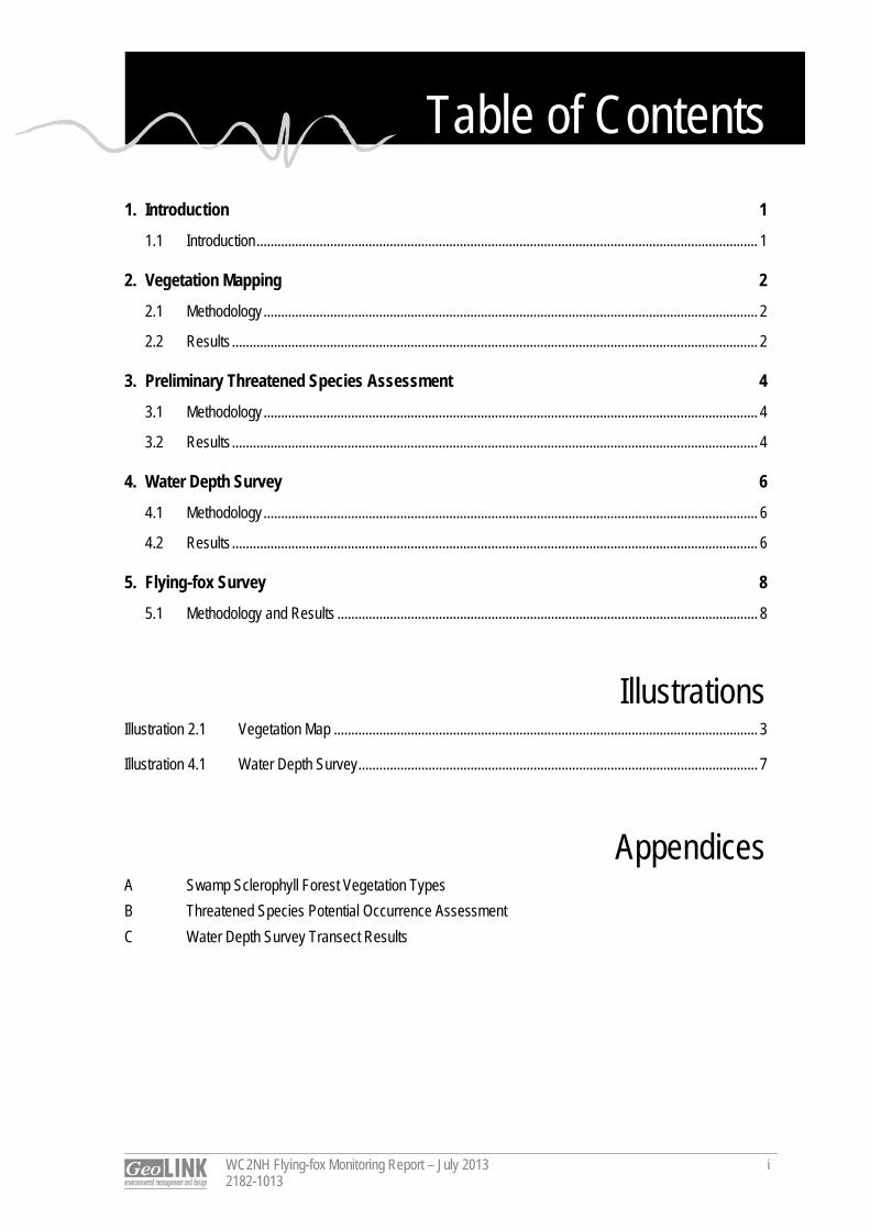
Table of Contents
WC2NH Flying-fox Monitoring Report – July 2013 2182-1013
i
1. Introduction 1
1.1 Introduction ............................................................................................................................................... 1
2. Vegetation Mapping 2
2.1 Methodology ............................................................................................................................................. 2
2.2 Results ...................................................................................................................................................... 2
3. Preliminary Threatened Species Assessment 4
3.1 Methodology ............................................................................................................................................. 4
3.2 Results ...................................................................................................................................................... 4
4. Water Depth Survey 6
4.1 Methodology ............................................................................................................................................. 6
4.2 Results ...................................................................................................................................................... 6
5. Flying-fox Survey 8
5.1 Methodology and Results ........................................................................................................................ 8
Illustrations Illustration 2.1 Vegetation Map ......................................................................................................................... 3
Illustration 4.1 Water Depth Survey .................................................................................................................. 7
Appendices A Swamp Sclerophyll Forest Vegetation Types
B Threatened Species Potential Occurrence Assessment C Water Depth Survey Transect Results
1
WC2NH Flying-fox Monitoring Report – July 2013 2182-1013
1
1. Introduction 1.1 Introduction Sinclair Knight Merz (SKM) and NSW Roads and Maritime Services (RMS) are working to resolve the Grey-headed Flying-fox (Pteropus poliocephalus) camp conflict on the Warrell Creek to Nambucca Heads (WC2NH) Pacific Highway upgrade project. GeoLINK was engaged to undertake flying-fox monitoring at the subject roost, which is located in a patch of Swamp Sclerophyll Forest vegetation north of Bald Hill Road, Macksville. Specifically GeoLINK was engaged to: Map the vegetation types within the subject Swamp Sclerophyll Forest, to gain clarity on the distribution
of the Melaleuca and Casuarina dominated vegetation types; Undertake preliminary field surveys and desktop assessment to identify other potentially occurring
threatened species within the subject Swamp Sclerophyll Forest; Survey the open water to identify its depth and distribution within the subject Swamp Sclerophyll Forest;
and Survey the presence and extent of the flying fox camp in late July 2013. The monitoring was undertaken 23 - 25 July 2013.
2
WC2NH Flying-fox Monitoring Report – July 2013 2182-1013
2
2. Vegetation Mapping 2.1 Methodology A field survey to map the vegetation types within the subject Swamp Sclerophyll Forest, with an emphasis on defining the boundary between the Broad-leaved Paperbark (Melaleuca quinquenervia) and Swamp Oak (Casuarina glauca) dominated vegetation types, was undertaken on 24 July 2013. The methodology included: Initial aerial photograph interpretation and review of existing vegetation mapping (SKM 2010 and
Ecological 2005); and Ground-truthing, using GPS, to map vegetation boundaries. Other relevant features of each vegetation
type were also noted, including dominant species, vegetation structure (cover and height of each strata layer), condition and presences of standing water.
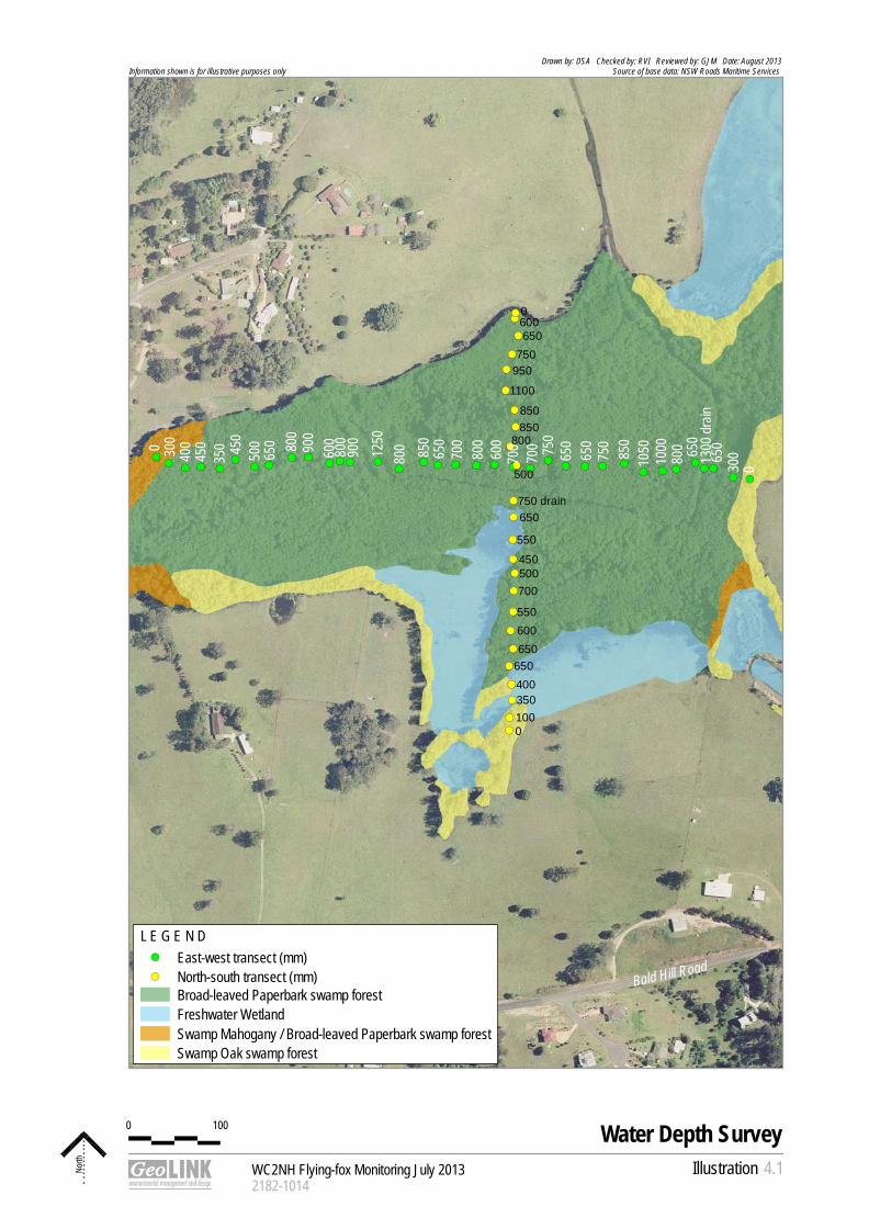
2.2 Results The subject Swamp Sclerophyll Forest occupies an area of 23.4 ha and was found to support three vegetation types, as detailed in Appendix A and mapped in Illustration 2.1. Broad-leaved Paperbark swamp forest occurs across the majority of the subject Swamp Sclerophyll Forest system (18 ha). Swamp Oak swamp forest (3.8 ha) and Swamp Mahogany/ Broad-leaved Paperbark swamp forest (approximately 1.6 ha) were restricted to the edges. The subject Swamp Sclerophyll Forest conforms to the Threatened Species Conservation Act 1995 (TSC Act) listed Endangered Ecological Community (EEC) Swamp sclerophyll forest on coastal floodplains of the NSW North Coast, Sydney Basin and South East Corner bioregions. Vegetation condition is predominantly good, though localised areas around the edges are in low or moderate condition due to edge effects, historic clearing and/ or livestock disturbances. Stands of mostly treeless Freshwater Wetland vegetation communities occur to the north-east and south-east. These areas constitute the TSC Act listed EEC Freshwater wetlands on coastal floodplains of the NSW North Coast, Sydney Basin and South East Corner bioregions. The majority of the subject Swamp Sclerophyll Forest supports surface water, predominantly between 0.4 and 0.8 m deep. Only the periphery of the subject Swamp sclerophyll Forest (typically 5 to 20 m wide), where it did not directly adjoin Freshwater Wetlands, was not inundated at the time of the survey. Substantial Salvina molesta infestation covers approximately 40% of the water in the subject Swamp Sclerophyll Forest. This species is listed as a noxious species and weed of national significance. Care should be taken by all personal visiting the site to avoid spread of this highly invasive species.
0 150
WC2NH Flying-fox Monitoring July 20132182-1009
Illustration
Vegetation Map
North 2.1
Drawn by: DSA Checked by: RVI Reviewed by: GJM Date: August 2013Source of base data: NSW Roads Maritime Services Information shown is for illustrative purposes only
L E G E N D Broad-leaved Paperbark swamp forestFreshwater WetlandSwamp Mahogany / Broad-leaved Paperbark swamp forestSwamp Oak swamp forest
Warrell Creek
Bald Hill Road
Pacif
ic Hi
ghwa
y
3
WC2NH Flying-fox Monitoring Report – July 2013 2182-1013
4
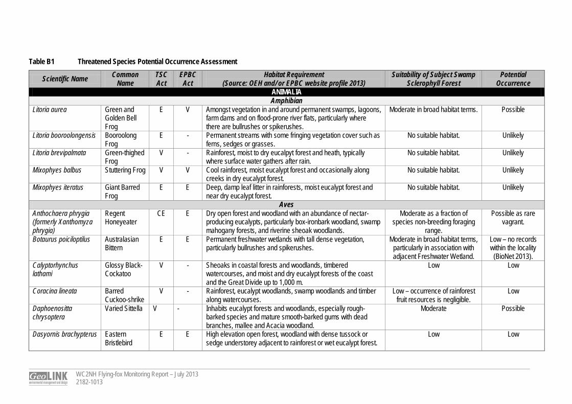
3. Preliminary Threatened Species Assessment 3.1 Methodology A preliminary threatened species assessment was undertaken to identify potentially occurring threatened species (additional to the Grey-headed Flying-fox Pteropus poliocephalus) within the subject Swamp Sclerophyll Forest. This included: Database searches (Environmental Protection and Biodiversity Conservation Act 1999 [EPBC Act]
Protected Matters Search Tool and Office of Environment and Heritage [OEH] BioNet – July 2013) and literature review of relevant Nambucca Heads to Urunga Pacific Highway Upgrade (NH2U) Project Approval documentation to identify threatened species recorded within a 10 km radius of the site; and
Habitat evaluation and opportunistic searches for threatened species during other survey activities (i.e. vegetation mapping, flying-fox searches and water depth surveys) on 24 and 25 July 2013 (total 28 person hours).
The literature review search included the following documents: Ecos Environmental (2013). Warrell Creek to Urunga upgrade: Threatened Plant Species Management
Plan. Report to Roads and Maritime Services; SKM (2010). Environmental Assessment – Upgrading the Pacific Highway Warrell Creek to Urunga.
Report to Roads and Maritime Services; and Project GIS mapping (provided by RMS). Marine species were excluded from the assessment due to the absence of marine environments on and adjacent to the subject Swamp Sclerophyll Forest. 3.2 Results The results of the preliminary threatened species assessment are provided in Appendix B. Fifty threatened fauna and 18 threatened flora were identified from the literature review as threatened species or species habitat (from the EPBC Act search only), known to occur within a 10 km radius of the site (excluding marine species). No additional threatened species were recorded during the survey. Two threatened species have previously been recorded within the subject Swamp Sclerophyll Forest, including: Maundia triglochinoides (TSC Act listed Vulnerable species): previously recorded in the Freshwater
Wetlands to the south of the subject Swamp Sclerophyll Forest. It is referred as ‘mt82’ in Ecos Environmental (2013), Warrell Creek to Urunga upgrade: Threatened Plant Species Management Plan. The site inspection was undertaken outside this species flowering period (i.e. period of best detectability November and January) and with the presence of other ribbon weed species (e.g. Triglochin spp.) it was difficult to detect. Targeted surveys during November and January would be required to adequately survey the distribution of this species within the subject Swamp Sclerophyll Forest and associated Freshwater Wetland.
Little Bent-wing Bat (Miniopterus australis – TSC Act listed Vulnerable species) was previously recorded during the Project EA assessment (SKM 2010). The subject Swamp Sclerophyll Forest does not constitute significant habitat for this species.
WC2NH Flying-fox Monitoring Report – July 2013 2182-1013
5
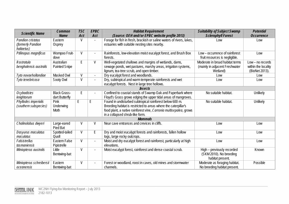
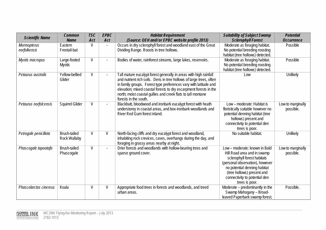
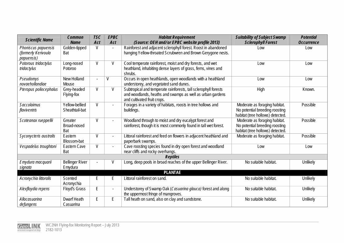
The habitat within the subject Swamp Sclerophyll Forest provides potential habitat (at least in broad habitat terms) for the following additional locally recorded threatened species: Green and Golden Bell Frog (Litoria aurea); Regent Honeyeater (Anthochaera phrygia); Varied Sittella (Daphoenositta chrysoptera); Black-necked Stork (Ephippiorhynchus asiaticus); Little Lorikeet (Glossopsitta pusilla); Brolga (Grus rubicunda); Little Eagle (Hieraaetus morphnoides); Black Bittern (Ixobrychus flavicollis); Swift Parrot (Lathamus discolor); Square-tailed Kite (Lophoictinia isura); Powerful Owl (Ninox strenua); Eastern Freetail-bat (Mormopterus norfolkensis); Large-footed Myotis (Myotis macropus); Squirrel Glider (Petaurus norfolcensis); Brush-tailed Phascogale (Phascogale tapoatafa); Koala (Phascolarctos cinereus); Yellow-bellied Sheathtail-bat (Saccolaimus flaviventris); Greater Broad-nosed Bat (Scoteanax rueppellii); Eastern Blossom-bat (Syconycteris australis); and Spider Orchid (Dendrobium melaleucaphilum). These species would require further consideration with regards to any Project alignment changes (including updates to their impact assessments where required). Of the additional relevant threatened species, the Koala, Spider Orchid and Maundia triglochinoides pose the main potential constraint with regards to changes to the highway alignment within the subject Swamp Sclerophyll Forest. Targeted surveys would be required to determine whether these species pose actual constraints.
4
WC2NH Flying-fox Monitoring Report – July 2013 2182-1013
6
4. Water Depth Survey 4.1 Methodology The water depth survey was undertaken by traversing the extent of standing water and undertaking two transects (one north-south and one east-west) across the standing water within the subject Swamp Sclerophyll Forest and measuring water depths (to the closest 0.05 m) at roughly 15 to 20 m intervals. A survey staff was used to provide approximate water depths and a GPS was used to record water depth measurement locations. The survey was undertaken on 24 and 25 July 2013. 4.2 Results The results of the water depth transect survey are shown in Appendix C and Illustration 4.1 (GPS data has also been provided). The majority of the subject Swamp Sclerophyll Forest supports surface water predominantly between 0.4 and 0.8 m (average 0.65 m) deep. Only the periphery of the subject Swamp sclerophyll Forest (typically 5 to 20 m wide), where it did not directly adjoin Freshwater Wetlands, was not inundated at the time of the survey. Attempts to map the extent of standing water via traversing with a hand held GPS were withdrawn as it was not possible to accurately represent the extent of water in relation to the Swamp Sclerophyll Forest boundary or vegetation type boundaries due to the GPS having a typical standard error of 5 m.
!(
!(
!(
!(
!(
!(
!(
!(
!(
!(
!(
!(
!(
!(
!(
!(!( !( !( !(
!(!( !( !(!(!(!(
!(!( !( !( !( !( !( !( !(!(
!( !( !( !(!( !( !(
!(!(!(
!( !(
!(
!(
!(
!(
!(
!(
!(
!(
!(!(
Bald Hill Road
0 300
400
450 45
035
0
500
650 80
090
0
900
600
800
1250
800 85
065
070
080
060
070
070
0 750
650
650
750
850
800
650
030013
00 dr
ain65
0
1000
1050
0100
6000
650750
950
850850
800
500
650
550
450500700
550600650
650400350
1100
750 drain
0 100
WC2NH Flying-fox Monitoring July 20132182-1014
Illustration
Water Depth Survey
North 4.1
Drawn by: DSA Checked by: RVI Reviewed by: GJM Date: August 2013Source of base data: NSW Roads Maritime Services Information shown is for illustrative purposes only
L E G E N D !( East-west transect (mm)!( North-south transect (mm)
Broad-leaved Paperbark swamp forestFreshwater WetlandSwamp Mahogany / Broad-leaved Paperbark swamp forestSwamp Oak swamp forest
5
WC2NH Flying-fox Monitoring Report – July 2013 2182-1013
8
5. Flying-fox Survey 5.1 Methodology and Results Meander surveys were undertaken across the site on the 24 and 25 July 2013, searching for flying-foxes. No flying-foxes were recorded. Evidence of recent flying-fox roosting was detected, including damaged tree canopy limbs and a ‘musty’ smell, typical of flying-foxes. A flying-out inspection was also undertaken on the 24 July 2013, commencing one hour before dark until dark, in case a small population was present and was not detected during traverse surveys. This also failed to record any flying-foxes. Three other known local roosts were inspected on the 25 July 2013, including Bowraville, Gordon Park (Nambucca Heads) and Wilson Road (Macksville). Only the Gordon Park site was occupied. No data regarding flying-fox numbers or species were recorded.
David Andrighetto Ecologist
Appendix A
WC2NH Flying-fox Monitoring Report – July 2013 2182-1013
A Swamp Sclerophyll Forest Vegetation Types
WC2NH Flying-fox Monitoring Report – July 2013 2182-1013
Table A1 Swamp Sclerophyll Forest Vegetation Types Vegetation Type
Location Area (ha)
Canopy Mid-Storey Groundcover Condition Approx Area Inundated
Comment Dominant Species
Structure Dominant Species
Structure Dominant Species
Structure
Broad-leaved Melaleuca Swamp Forest
Occupies the central portion of Swamp Sclerophyll Forest
18 Broad-leaved Paperbark. Other species such as Swamp Oak, Swamp Mahogany (Eucalyptus robusta) and Prickly-leaved Paperbark (Melaleuca styphelioides) comprise <5% of the canopy.
Cover: 10-75 % (typically 40-70%). Height: 8-15 m (typically 12 m). DBH Range: 0.08-0.6 m (typically 0.1-0.3 m).
As per canopy.
Cover: 0- 5%. Height: 2-7 m.
Gahnia clarkei, Triglochin procera, Blechnum indicum. Salvina molesta, Philydrum lanuginosum, Eleocharis sphacelata.
Cover: 0-100% (highly variable with location) Height: 0.1-2 m.
Good Over 90 % Swamp Oak is common in narrow bands (<5 m wide) along drains and fence lines within the Broad-leaved Melaleuca swamp forest, however occurrences are not significant enough to constitute a separate vegetation unit or influence flying-fox distribution.
Swamp Mahogany / Broad-leaved Paperbark Swamp Forest
Occupies the western edge and a small area in the south-east of the subject Swamp Sclerophyll Forest
1.6 Swamp Mahogany occurs in an emergent layer in the west and within the canopy layer with Broad-leaved Paperbark in the south-east. Other species such as Swamp Oak and Red Mahogany (Eucalyptus resinifera) comprise approximately 5% of the canopy.
Cover: Emergent – 15%. Canopy – 50-75%. Height: Emergent – 15-20 m. Canopy – 10-15 m. DBH Range: 0.2-0.7 m (typically 0.2-0.5 m).
Canopy saplings, Prickly-leaved Paperbark, Callistemon salignus,
Cover: 10-25%. Height: 2-8 m.
Gahnia clarkei, Broad-leaved Paspalum (Paspalum wettsteinii), Blechnum indicum, Carex appressa, Salvina molesta, Lantana (Lantana camara), Narrow-leaved Palm Lily (Cordyline stricta).
Cover: 50-90 % Height: 0.4-2 m.
Moderate to good (some edge effects and localised weed invasion).
40% -
WC2NH Flying-fox Monitoring Report – July 2013 2182-1013
Vegetation Type
Location Area (ha)
Canopy Mid-Storey Groundcover Condition Approx Area Inundated
Comment Dominant Species
Structure Dominant Species
Structure Dominant Species
Structure
Swamp Oak Swamp Forest
Occupies the southern and eastern fringes of the subject Swamp Sclerophyll Forest, as well as around the Freshwater Wetlands.
3.8 Swamp Oak. Other species such as Swamp Mahogany and Broad-leaved Melaleuca comprise between approximately 5-40% of the canopy.
Cover: 30-70%. Height: 15-25 m (variable). DBH Range: 0.2-0.5 m.
Canopy saplings, Prickly-leaved Paperbark, Callistemon salignus, Swamp Box (Lophostemon sauveolens), Creek Sandpaper Fig (Ficus coronata).
Cover: 10-25%. Height: 5-15 m.
Gahnia clarkei, Oplismenus imbecillis Broad-leaved Paspalum, Lantana, Salvina molesta, Narrow-leaved Palm Lilly.
Cover: 50-90 % Height: 0.4-2 m.
Moderate to good in areas associated with the core Swamp Sclerophyll Forest. Low in the outer margins of the Freshwater Wetland.
30% Interface with pastoral land is subject to edge effects. Stands in the far south and south-east associated with the Freshwater Wetland comprise regrowth.
Appendix B
WC2NH Flying-fox Monitoring Report – July 2013 2182-1013
B Threatened Species Potential Occurrence Assessment
WC2NH Flying-fox Monitoring Report – July 2013 2182-1013
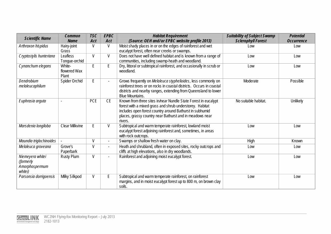
Table B1 Threatened Species Potential Occurrence Assessment
Scientific Name Common Name
TSC Act
EPBC Act
Habitat Requirement (Source: OEH and/ or EPBC website profile 2013)
Suitability of Subject Swamp Sclerophyll Forest
Potential Occurrence
ANIMALIA Amphibian
Litoria aurea Green and Golden Bell Frog
E V Amongst vegetation in and around permanent swamps, lagoons, farm dams and on flood-prone river flats, particularly where there are bullrushes or spikerushes.
Moderate in broad habitat terms. Possible
Litoria booroolongensis Booroolong Frog
E - Permanent streams with some fringing vegetation cover such as ferns, sedges or grasses.
No suitable habitat. Unlikely
Litoria brevipalmata Green-thighed Frog
V - Rainforest, moist to dry eucalpyt forest and heath, typically where surface water gathers after rain.
No suitable habitat. Unlikely
Mixophyes balbus Stuttering Frog V V Cool rainforest, moist eucalypt forest and occasionally along creeks in dry eucalypt forest.
No suitable habitat. Unlikely
Mixophyes iteratus Giant Barred Frog
E E Deep, damp leaf litter in rainforests, moist eucalypt forest and near dry eucalypt forest.
No suitable habitat. Unlikely
Aves Anthochaera phrygia (formerly Xanthomyza phrygia)
Regent Honeyeater
CE E Dry open forest and woodland with an abundance of nectar-producing eucalypts, particularly box-ironbark woodland, swamp mahogany forests, and riverine sheoak woodlands.
Moderate as a fraction of species non-breeding foraging
range.
Possible as rare vagrant.
Botaurus poiciloptilus Australasian Bittern
E E Permanent freshwater wetlands with tall dense vegetation, particularly bullrushes and spikerushes.
Moderate in broad habitat terms, particularly in association with adjacent Freshwater Wetland.
Low – no records within the locality
(BioNet 2013). Calyptorhynchus lathami
Glossy Black-Cockatoo
V - Sheoaks in coastal forests and woodlands, timbered watercourses, and moist and dry eucalypt forests of the coast and the Great Divide up to 1,000 m.
Low Low
Coracina lineata Barred Cuckoo-shrike
V - Rainforest, eucalypt woodlands, swamp woodlands and timber along watercourses.
Low – occurrence of rainforest fruit resources is negligible.
Low
Daphoenositta chrysoptera
Varied Sittella V - Inhabits eucalypt forests and woodlands, especially rough-barked species and mature smooth-barked gums with dead branches, mallee and Acacia woodland.
Moderate Possible
Dasyornis brachypterus Eastern Bristlebird
E E High elevation open forest, woodland with dense tussock or sedge understorey adjacent to rainforest or wet eucalypt forest.
Low Low

WC2NH Flying-fox Monitoring Report – July 2013 2182-1013
Scientific Name Common Name
TSC Act
EPBC Act
Habitat Requirement (Source: OEH and/ or EPBC website profile 2013)
Suitability of Subject Swamp Sclerophyll Forest
Potential Occurrence
Ephippiorhynchus asiaticus
Black-necked Stork
E - Swamps, mangroves, mudflats, dry floodplains. Moderate – primarily within adjacent Freshwater Wetland.
No nests detected.
Possible
Erythrotriorchis radiatus Red Goshawk CE V Along or near watercourses, swamp forest and woodlands on the coastal plain.
Moderate in broad habitat terms. Low – no records within the locality
(BioNet 2013). Esacus neglectus Beach Stone-
curlew CE - Tidal flats at the mouth of estuaries or on open beaches. No suitable habitat. Unlikely
Glossopsitta pusilla Little Lorikeet V - Distributed in forests and woodlands from the coast to the western slopes of the Great Dividing Range, extending westwards to the vicinity of Albury, Parkes, Dubbo and Narrabri.
Moderate – primarily as foraging habitat. No significant potential
tree hollows for nesting detected.
Possible
Grus rubicunda Brolga V - Shallow swamps, floodplains, grasslands and pastoral lands, usually in pairs or parties.
Moderate – primarily within adjacent Freshwater Wetland.
No nests detected.
Possible
Haematopus fuliginosus
Sooty Oystercatcher
V - Intertidal rocky and coral reefs, mostly ocean shores. No suitable habitat. Unlikely
Hieraaetus morphnoides
Little Eagle V - Open eucalypt forest, woodland or open woodland. Sheoak or acacia woodlands and riparian woodlands of interior NSW are also used.
Moderate – mainly as foraging habitat. No nests recorded.
Possible
Ixobrychus flavicollis Black Bittern V - Dense vegetation fringing and in streams, swamps, tidal creeks and mudflats, particularly amongst swamp sheoaks and mangroves.
Moderate Possible
Lathamus discolor Swift Parrot E E Forests, woodlands, plantations, and banksias. Moderate as a fraction of species non-breeding foraging
range.
Possible as rare vagrant.
Lophoictinia isura Square-tailed Kite
V - Dry woodland and open forest, particularly along major rivers and belts of trees in urban or semi-urban areas. Home range can extend over at least 100 km2.
Moderate – mainly as foraging habitat. No nests recorded.
Possible
Ninox strenua Powerful Owl V - Woodland and open forest to tall moist forest and rainforest, common along drainage lines.
Moderate – mainly as foraging habitat. No nests habitat
present.
Possible
WC2NH Flying-fox Monitoring Report – July 2013 2182-1013
Scientific Name Common Name
TSC Act
EPBC Act
Habitat Requirement (Source: OEH and/ or EPBC website profile 2013)
Suitability of Subject Swamp Sclerophyll Forest
Potential Occurrence
Pandion cristatus (formerly Pandion haliaetus)
Eastern Osprey
V - Forage for fish in fresh, brackish or saline waters of rivers, lakes, estuaries with suitable nesting sites nearby.
Low Low
Ptilinopus magnificus Wompoo Fruit-dove
V - Rainforests, low-elevation moist eucalypt forest, and Brush Box forests.
Low – occurrence of rainforest fruit resources is negligible.
Low
Rostratula benghalensis australis
Australian Painted Snipe
E V Well-vegetated shallows and margins of wetlands, dams, sewage ponds, wet pastures, marshy areas, irrigation systems, lignum, tea-tree scrub, and open timber.
Moderate in broad habitat terms (mainly in adjacent Freshwater
Wetland)
Low – no records within the locality
(BioNet 2013). Tyto novaehollandiae Masked Owl V - Dry eucalypt forest and woodlands. Low Low Tyto tenebricosa Sooty Owl V - Dry, subtropical and warm temperate rainforests and wet
eucalypt forests. Nest in large tree hollows. Low Low
Insects Ocybadistes knightorum
Black Grass-dart Butterfly
E - Confined to coastal stands of Swamp Oak and Paperbark where Floyd’s Grass grows edging the upper tidal areas of mangroves.
No suitable habitat. Unlikely
Phyllodes imperialis (southern subspecies)
Pink Underwing Moth
E E Found in undisturbed subtropical rainforest below 600 m. Breeding habitat is restricted to areas where the caterpillar's food plant, a native rainforest vine, Carronia multisepalea, grows in a collapsed shrub-like form.
No suitable habitat. Unlikely
Mammals Chalinolobus dwyeri Large-eared
Pied Bat V V Near cave entrances and crevices in cliffs. Low Low
Dasyurus maculatus maculatus
Spotted-tailed Quoll
V E Dry and moist eucalypt forests and rainforests, fallen hollow logs, large rocky outcrops.
Low Low
Falsistrellus tasmaniensis
Eastern False Pipistrelle
V - Moist and dry eucalypt forest and rainforest, particularly at high elevations.
Low Low
Miniopterus australis Little Bentwing-bat
V - Moist eucalypt forest, rainforest and dense coastal scrub. High – previously recorded (SKM 2010). No breeding
habitat present.
Known
Miniopterus schreibersii oceanensis
Eastern Bentwing-bat
V - Forest or woodland, roost in caves, old mines and stormwater channels.
Moderate as foraging habitat. No breeding habitat present.
Possible
WC2NH Flying-fox Monitoring Report – July 2013 2182-1013
Scientific Name Common Name
TSC Act
EPBC Act
Habitat Requirement (Source: OEH and/ or EPBC website profile 2013)
Suitability of Subject Swamp Sclerophyll Forest
Potential Occurrence
Mormopterus norfolkensis
Eastern Freetail-bat
V - Occurs in dry sclerophyll forest and woodland east of the Great Dividing Range. Roosts in tree hollows.
Moderate as foraging habitat. No potential breeding roosting habitat (tree hollows) detected.
Possible
Myotis macropus Large-footed Myotis
V - Bodies of water, rainforest streams, large lakes, reservoirs. Moderate as foraging habitat. No potential breeding roosting habitat (tree hollows) detected.
Possible
Petaurus australis Yellow-bellied Glider
V - Tall mature eucalypt forest generally in areas with high rainfall and nutrient rich soils. Dens in tree hollows of large trees, often in family groups. Forest type preferences vary with latitude and elevation; mixed coastal forests to dry escarpment forests in the north; moist coastal gullies and creek flats to tall montane forests in the south.
Low Unlikely
Petaurus norfolcensis Squirrel Glider V - Blackbutt, bloodwood and ironbark eucalypt forest with heath understorey in coastal areas, and box-ironbark woodlands and River Red Gum forest inland.
Low – moderate: Habitat is floristically suitable however no potential denning habitat (tree
hollows) present and connectivity to potential den
trees is poor.
Low to marginally possible.
Petrogale penicillata Brush-tailed Rock Wallaby
V V North-facing cliffs and dry eucalypt forest and woodland, inhabiting rock crevices, caves, overhangs during the day, and foraging in grassy areas nearby at night.
No suitable habitat. Unlikely
Phascogale tapoatafa Brush-tailed Phascogale
V - Drier forests and woodlands with hollow-bearing trees and sparse ground cover.
Low – moderate: known in Bald Hill Road area and in swamp
sclerophyll forest habitats (personal observation), however
no potential denning habitat (tree hollows) present and
connectivity to potential den trees is poor.
Low to marginally possible.
Phascolarctos cinereus Koala V V Appropriate food trees in forests and woodlands, and treed urban areas.
Moderate – predominantly in the Swamp Mahogany – Broad-
leaved Paperbark swamp forest.
Possible.
WC2NH Flying-fox Monitoring Report – July 2013 2182-1013
Scientific Name Common Name
TSC Act
EPBC Act
Habitat Requirement (Source: OEH and/ or EPBC website profile 2013)
Suitability of Subject Swamp Sclerophyll Forest
Potential Occurrence
Phoniscus papuensis (formerly Kerivoula papuensis)
Golden-tipped Bat
V - Rainforest and adjacent sclerophyll forest. Roost in abandoned hanging Yellow-throated Scrubwren and Brown Gerygone nests.
Low Low
Potorous tridactylus tridactylus
Long-nosed Potoroo
V V Cool temperate rainforest, moist and dry forests, and wet heathland, inhabiting dense layers of grass, ferns, vines and shrubs.
Low Low
Pseudomys novaehollandiae
New Holland Mouse
- V Occurs in open heathlands, open woodlands with a heathland understorey, and vegetated sand dunes.
Low Low
Pteropus poliocephalus Grey-headed Flying-fox
V V Subtropical and temperate rainforests, tall sclerophyll forests and woodlands, heaths and swamps as well as urban gardens and cultivated fruit crops.
High Known.
Saccolaimus flaviventris
Yellow-bellied Sheathtail-bat
V - Forages in a variety of habitats, roosts in tree hollows and buildings.
Moderate as foraging habitat. No potential breeding roosting habitat (tree hollows) detected.
Possible
Scoteanax rueppellii Greater Broad-nosed Bat
V - Woodland through to moist and dry eucalypt forest and rainforest, though it is most commonly found in tall wet forest.
Moderate as foraging habitat. No potential breeding roosting habitat (tree hollows) detected.
Possible
Syconycteris australis Eastern Blossom-bat
V - Littoral rainforest and feed on flowers in adjacent heathland and paperbark swamps.
Moderate as foraging habitat. Possible
Vespadelus troughtoni Eastern Cave Bat
V - Cave roosting species found in dry open forest and woodland near cliffs and rocky overhangs.
Low Low
Reptiles Emydura macquarii signata
Bellinger River Emydura
- V Long, deep pools in broad reaches of the upper Bellinger River. No suitable habitat. Unlikely
PLANTAE Acronychia littoralis Scented
Acronychia E E Littoral rainforest on sand. No suitable habitat. Unlikely
Alexfloydia repens Floyd’s Grass E - Understorey of Swamp Oak (Casuarina glauca) forest and along the uppermost fringe of mangroves.
No suitable habitat. Unlikely
Allocasuarina defungens
Dwarf Heath Casuarina
E E Tall heath on sand, also on clay and sandstone. No suitable habitat. Unlikely
WC2NH Flying-fox Monitoring Report – July 2013 2182-1013
Scientific Name Common Name
TSC Act
EPBC Act
Habitat Requirement (Source: OEH and/ or EPBC website profile 2013)
Suitability of Subject Swamp Sclerophyll Forest
Potential Occurrence
Arthraxon hispidus Hairy-joint Grass
V V Moist shady places in or on the edges of rainforest and wet eucalypt forest, often near creeks or swamps.
Low Low
Cryptostylis hunteriana Leafless Tongue-orchid
V V Does not have well defined habitat and is known from a range of communities, including swamp-heath and woodland.
Low Low
Cynanchum elegans White-flowered Wax Plant
E E Dry, littoral or subtropical rainforest, and occasionally in scrub or woodland.
Low Low
Dendrobium melaleucaphilum
Spider Orchid E - Grows frequently on Melaleuca styphelioides, less commonly on rainforest trees or on rocks in coastal districts. Occurs in coastal districts and nearby ranges, extending from Queensland to lower Blue Mountains.
Moderate Possible
Euphrasia arguta - PCE CE Known from three sites in/near Nundle State Forest in eucalypt forest with a mixed grass and shrub understorey. Habitat includes open forest country around Bathurst in subhumid places, grassy country near Bathurst and in meadows near rivers.
No suitable habitat. Unlikely
Marsdenia longiloba Clear Milkvine E V Subtropical and warm temperate rainforest, lowland moist eucalypt forest adjoining rainforest and, sometimes, in areas with rock outcrops.
Low Low
Maundia triglochinoides - V - Swamps or shallow fresh water on clay. High Known Melaleuca groveana Grove’s
Paperbark V - Heath and shrubland, often in exposed sites, rocky outcrops and
cliffs at high elevations, also in dry woodlands. Low Low
Niemeyera whitei (formerly Amorphospermum whitei)
Rusty Plum V - Rainforest and adjoining moist eucalypt forest. Low Low
Parsonsia dorrigoensis Milky Silkpod V E Subtropical and warm temperate rainforest, on rainforest margins, and in moist eucalypt forest up to 800 m, on brown clay soils.
Low Low
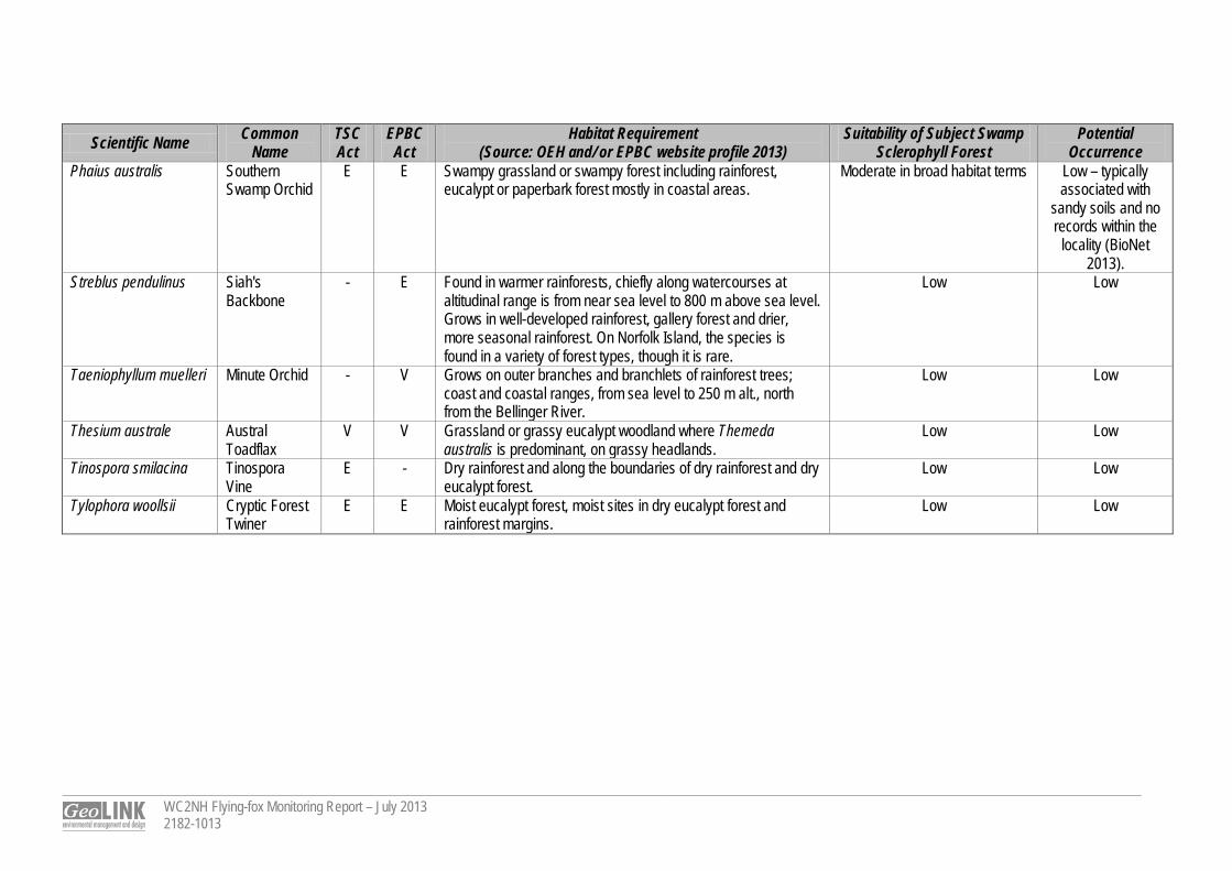
WC2NH Flying-fox Monitoring Report – July 2013 2182-1013
Scientific Name Common Name
TSC Act
EPBC Act
Habitat Requirement (Source: OEH and/ or EPBC website profile 2013)
Suitability of Subject Swamp Sclerophyll Forest
Potential Occurrence
Phaius australis Southern Swamp Orchid
E E Swampy grassland or swampy forest including rainforest, eucalypt or paperbark forest mostly in coastal areas.
Moderate in broad habitat terms Low – typically associated with
sandy soils and no records within the
locality (BioNet 2013).
Streblus pendulinus Siah's Backbone
- E Found in warmer rainforests, chiefly along watercourses at altitudinal range is from near sea level to 800 m above sea level. Grows in well-developed rainforest, gallery forest and drier, more seasonal rainforest. On Norfolk Island, the species is found in a variety of forest types, though it is rare.
Low Low
Taeniophyllum muelleri Minute Orchid - V Grows on outer branches and branchlets of rainforest trees; coast and coastal ranges, from sea level to 250 m alt., north from the Bellinger River.
Low Low
Thesium australe Austral Toadflax
V V Grassland or grassy eucalypt woodland where Themeda australis is predominant, on grassy headlands.
Low Low
Tinospora smilacina Tinospora Vine
E - Dry rainforest and along the boundaries of dry rainforest and dry eucalypt forest.
Low Low
Tylophora woollsii Cryptic Forest Twiner
E E Moist eucalypt forest, moist sites in dry eucalypt forest and rainforest margins.
Low Low
Appendix C
WC2NH Flying-fox Monitoring Report – July 2013 2182-1013
A Water Depth Survey Transect Results
WC2NH Flying-fox Monitoring Report – July 2013 2182-1013
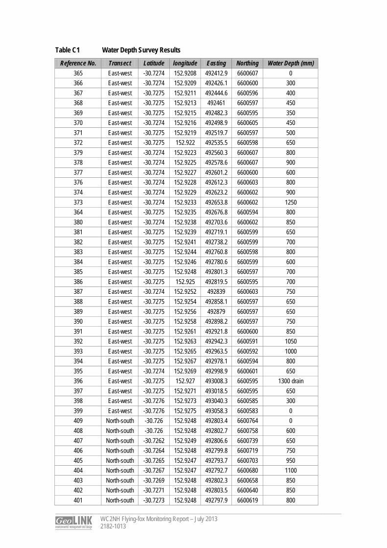
Table C1 Water Depth Survey Results
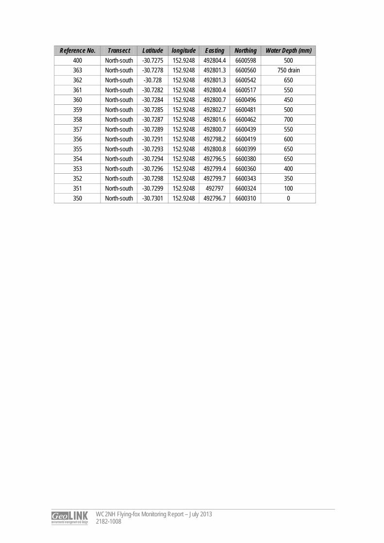
Reference No. Transect Latitude longitude Easting Northing Water Depth (mm) 365 East-west -30.7274 152.9208 492412.9 6600607 0 366 East-west -30.7274 152.9209 492426.1 6600600 300 367 East-west -30.7275 152.9211 492444.6 6600596 400 368 East-west -30.7275 152.9213 492461 6600597 450 369 East-west -30.7275 152.9215 492482.3 6600595 350 370 East-west -30.7274 152.9216 492498.9 6600605 450 371 East-west -30.7275 152.9219 492519.7 6600597 500 372 East-west -30.7275 152.922 492535.5 6600598 650 379 East-west -30.7274 152.9223 492560.3 6600607 800 378 East-west -30.7274 152.9225 492578.6 6600607 900 377 East-west -30.7274 152.9227 492601.2 6600600 600 376 East-west -30.7274 152.9228 492612.3 6600603 800 374 East-west -30.7274 152.9229 492623.2 6600602 900 373 East-west -30.7274 152.9233 492653.8 6600602 1250 364 East-west -30.7275 152.9235 492676.8 6600594 800 380 East-west -30.7274 152.9238 492703.6 6600602 850 381 East-west -30.7275 152.9239 492719.1 6600599 650 382 East-west -30.7275 152.9241 492738.2 6600599 700 383 East-west -30.7275 152.9244 492760.8 6600598 800 384 East-west -30.7275 152.9246 492780.6 6600599 600 385 East-west -30.7275 152.9248 492801.3 6600597 700 386 East-west -30.7275 152.925 492819.5 6600595 700 387 East-west -30.7274 152.9252 492839 6600603 750 388 East-west -30.7275 152.9254 492858.1 6600597 650 389 East-west -30.7275 152.9256 492879 6600597 650 390 East-west -30.7275 152.9258 492898.2 6600597 750 391 East-west -30.7275 152.9261 492921.8 6600600 850 392 East-west -30.7275 152.9263 492942.3 6600591 1050 393 East-west -30.7275 152.9265 492963.5 6600592 1000 394 East-west -30.7275 152.9267 492978.1 6600594 800 395 East-west -30.7274 152.9269 492998.9 6600601 650 396 East-west -30.7275 152.927 493008.3 6600595 1300 drain 397 East-west -30.7275 152.9271 493018.5 6600595 650 398 East-west -30.7276 152.9273 493040.3 6600585 300 399 East-west -30.7276 152.9275 493058.3 6600583 0 409 North-south -30.726 152.9248 492803.4 6600764 0 408 North-south -30.726 152.9248 492802.7 6600758 600 407 North-south -30.7262 152.9249 492806.6 6600739 650 406 North-south -30.7264 152.9248 492799.8 6600719 750 405 North-south -30.7265 152.9247 492793.7 6600703 950 404 North-south -30.7267 152.9247 492792.7 6600680 1100 403 North-south -30.7269 152.9248 492802.3 6600658 850 402 North-south -30.7271 152.9248 492803.5 6600640 850 401 North-south -30.7273 152.9248 492797.9 6600619 800
WC2NH Flying-fox Monitoring Report – July 2013 2182-1008
Reference No. Transect Latitude longitude Easting Northing Water Depth (mm) 400 North-south -30.7275 152.9248 492804.4 6600598 500 363 North-south -30.7278 152.9248 492801.3 6600560 750 drain 362 North-south -30.728 152.9248 492801.3 6600542 650 361 North-south -30.7282 152.9248 492800.4 6600517 550 360 North-south -30.7284 152.9248 492800.7 6600496 450 359 North-south -30.7285 152.9248 492802.7 6600481 500 358 North-south -30.7287 152.9248 492801.6 6600462 700 357 North-south -30.7289 152.9248 492800.7 6600439 550 356 North-south -30.7291 152.9248 492798.2 6600419 600 355 North-south -30.7293 152.9248 492800.8 6600399 650 354 North-south -30.7294 152.9248 492796.5 6600380 650 353 North-south -30.7296 152.9248 492799.4 6600360 400 352 North-south -30.7298 152.9248 492799.7 6600343 350 351 North-south -30.7299 152.9248 492797 6600324 100 350 North-south -30.7301 152.9248 492796.7 6600310 0

F ly ing- fox Moni tor ing WC2NH
August 2013
Prepared for: SKM © GeoLINK, 2013
PO Box 119 Lennox Head NSW 2478
T 02 6687 7666
PO Box 1446 Coffs Harbour NSW 2450
T 02 6651 7666
Table of Contents
WC2NH Flying-fox Monitoring Report – August 2013 2182-1024
i
1. Introduction 1
1.1 Introduction ........................................................................................................................................ 1
2. Flying-fox Survey 2
2.1 Methodology ...................................................................................................................................... 2
2.2 Results ............................................................................................................................................... 2
UPR Description Date Issued Issued By 2182-1019 First issue 02/09/2013 RVI 2182-1024 Final 02/09/2013 RVI
1
WC2NH Flying-fox Monitoring Report – August 2013 2182-1024
1
1. Introduction
1.1 Introduction Sinclair Knight Merz (SKM) and NSW Roads and Maritime Services (RMS) are working to resolve the Grey-headed Flying-fox (Pteropus poliocephalus) camp conflict on the approved alignment of the Warrell Creek to Nambucca Heads (WC2NH) Pacific Highway upgrade project. GeoLINK has been engaged to undertake monthly flying-fox monitoring at the Macksville roost (henceforth referred to as ‘the site’), which is located in a patch of Swamp Sclerophyll Forest vegetation north of Bald Hill Road, Macksville. This report details the August monitoring results. The monitoring was undertaken on 26 - 27 August 2013.
2
WC2NH Flying-fox Monitoring Report – August 2013 2182-1024
2
2. Flying-fox Survey
2.1 Methodology All fieldwork for the August survey was undertaken by Dr Tom Pollard (GeoLINK) and Dr Peggy Eby (flying-fox expert). On the evening of 26 August, a dusk fly-out survey was undertaken at the site. One person was located at the northern ridge (off Wedgewood Drive) and the other person was located on the southern ridge (off Bald Hill Road). The survey extended over approximately 1 hour from sunset until dark. On 27 August, a day-time meander survey of the site was undertaken on foot with waders to search for roosting flying-foxes. This survey was focused on the area in which a roost has previously been recorded by SKM & Dr Eby. In addition to the survey work at the site, three local flying-fox roosts were inspected over 26 – 27 August at Bellingen (Bellingen Island), Bowraville, and at the proposed control site at Nambucca Heads (Gordon Park). During these inspections Dr Eby provided one-on-one training to GeoLINK on methods for assessing flying-fox demographics, reproductive status and fly-out counts, which will be used in subsequent surveying at the Macksville roost. 2.2 Results No flying-foxes were recorded exiting the site during the dusk fly-out survey. No roosting flying-foxes were recorded at the site during the meander survey. In combination with the negative result of the dusk fly-out survey, this result indicates, with a high degree of certainty, that the site was not being utilised as a roost by flying-fox at the time of survey. Of the additionally inspected local flying-fox roosts, only Bellingen and Nambucca Heads are currently occupied. Grey-headed Flying-fox was present at both roosts, with Black Flying-fox being also present at Nambucca Heads. The proportion of these species in the overall roost at Nambucca Heads was estimated to be 70% Grey-headed Flying-fox and 30% Black Flying-fox. No young were recorded at either roost. As no data on demographics or reproductive status was collected at the site (Macksville roost) during this month’s survey, no specific comparative data was collected at the proposed Nambucca Heads control site.
Dr Tom Pollard Ecologist
F l y ing- fox Moni tor ing WC2NH
September 2013
Prepared for: Sinclair Knight Merz © GeoLINK, 2013
PO Box 119 Lennox Head NSW 2478
T 02 6687 7666
PO Box 1446 Coffs Harbour NSW 2450
T 02 6651 7666

Table of Contents
WC2NH Flying-fox Monitoring Report – September 2013 2182-1031
i
1. Introduction 1
1.1 Introduction ............................................................................................................................................... 1
2. Flying-fox Survey 2
2.1 Methodology ............................................................................................................................................. 2
2.2 Results ...................................................................................................................................................... 2
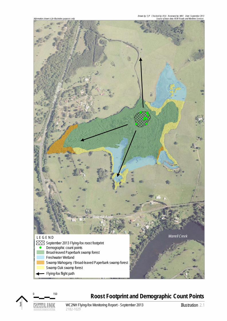
2.2.1 Population Estimate – Exit Count ................................................................................................ 2
2.2.2 Camp Footprint ............................................................................................................................. 2
2.2.3 Detailed Data ................................................................................................................................ 4
2.3 Discussion ................................................................................................................................................ 5
2.3.1 Population Estimate ..................................................................................................................... 5
2.3.2 Camp Footprint ............................................................................................................................. 6
2.3.3 Demographic Composition .......................................................................................................... 6
2.3.4 Phenology of Trees in Region ..................................................................................................... 6
2.3.5 Practicalities of Demographic Surveys ....................................................................................... 6
2.4 Conclusion ................................................................................................................................................ 7
Illustrations Illustration 2.1 Roost Footprint and Demographic Count Points ..................................................................... 3
Tables Table 2.1 Habitat Characteristics and Demographic Data – Macksville Camp ...................................... 4
Table 2.2 Demographic Data – Nambucca Heads Camp Control Site................................................... 5
Plates Plate 2.1 GHFF roosting in Broad-leaved Paperbark at Macksville ....................................................... 2
Plate 2.2 Aborted foetus beneath the flying-fox camp at Nambucca Heads ......................................... 7

WC2NH Flying-fox Monitoring Report – September 2013 2182-1031
ii
UPR Description Date Issued Issued By 2182-1028 First issue 27/09/2013 RVI 2182-1031 Final (following client review) 04/10/2013 RVI
1
WC2NH Flying-fox Monitoring Report – September 2013 2182-1031
1
1. Introduction 1.1 Introduction Sinclair Knight Merz (SKM) and NSW Roads and Maritime Services (RMS) are working to resolve the Grey-headed Flying-fox (Pteropus poliocephalus) (GHFF) camp conflict on the approved alignment of the Warrell Creek to Nambucca Heads (WC2NH) Pacific Highway upgrade project. GeoLINK has been engaged to undertake monthly flying-fox monitoring at the Macksville roost (henceforth referred to as ‘the site’), which is located in a patch of Swamp Sclerophyll Forest vegetation north of Bald Hill Road, Macksville. This report details the September monitoring results. The monitoring was undertaken on 23 - 24 September 2013.
2
WC2NH Flying-fox Monitoring Report – September 2013 2182-1031
2
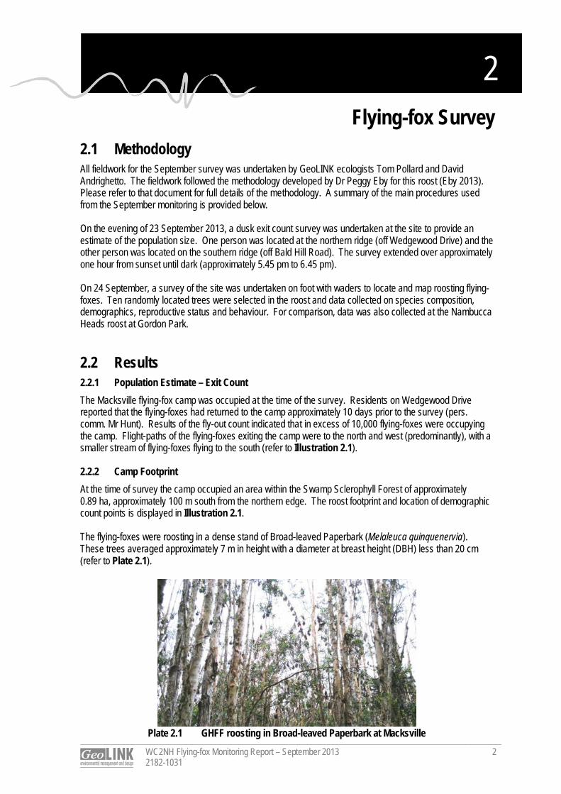
2. Flying-fox Survey 2.1 Methodology All fieldwork for the September survey was undertaken by GeoLINK ecologists Tom Pollard and David Andrighetto. The fieldwork followed the methodology developed by Dr Peggy Eby for this roost (Eby 2013). Please refer to that document for full details of the methodology. A summary of the main procedures used from the September monitoring is provided below. On the evening of 23 September 2013, a dusk exit count survey was undertaken at the site to provide an estimate of the population size. One person was located at the northern ridge (off Wedgewood Drive) and the other person was located on the southern ridge (off Bald Hill Road). The survey extended over approximately one hour from sunset until dark (approximately 5.45 pm to 6.45 pm). On 24 September, a survey of the site was undertaken on foot with waders to locate and map roosting flying-foxes. Ten randomly located trees were selected in the roost and data collected on species composition, demographics, reproductive status and behaviour. For comparison, data was also collected at the Nambucca Heads roost at Gordon Park. 2.2 Results 2.2.1 Population Estimate – Exit Count The Macksville flying-fox camp was occupied at the time of the survey. Residents on Wedgewood Drive reported that the flying-foxes had returned to the camp approximately 10 days prior to the survey (pers. comm. Mr Hunt). Results of the fly-out count indicated that in excess of 10,000 flying-foxes were occupying the camp. Flight-paths of the flying-foxes exiting the camp were to the north and west (predominantly), with a smaller stream of flying-foxes flying to the south (refer to Illustration 2.1). 2.2.2 Camp Footprint At the time of survey the camp occupied an area within the Swamp Sclerophyll Forest of approximately 0.89 ha, approximately 100 m south from the northern edge. The roost footprint and location of demographic count points is displayed in Illustration 2.1. The flying-foxes were roosting in a dense stand of Broad-leaved Paperbark (Melaleuca quinquenervia). These trees averaged approximately 7 m in height with a diameter at breast height (DBH) less than 20 cm (refer to Plate 2.1).
Plate 2.1 GHFF roosting in Broad-leaved Paperbark at Macksville
!(!(!(
!( !(
!(!(
!(!(!(
0 150
WC2NH Flying-fox Monitoring Report - September 20132182-1029
Illustration
Roost Footprint and Demographic Count Points
North 2.1
Drawn by: TJP Checked by: DSA Reviewed by: MVE Date: September 2013Source of base data: NSW Roads and Maritime Services Information shown is for illustrative purposes only
L E G E N D September 2013 Flying-fox roost footprint
!( Demographic count pointsBroad-leaved Paperbark swamp forestFreshwater WetlandSwamp Mahogany / Broad-leaved Paperbark swamp forestSwamp Oak swamp forest
Warrell Creek
Bald Hill Road
Pacif
ic Hi
ghwa
y
Flying-fox flight path
WC2NH Flying-fox Monitoring Report – September 2013 2182-1031
4
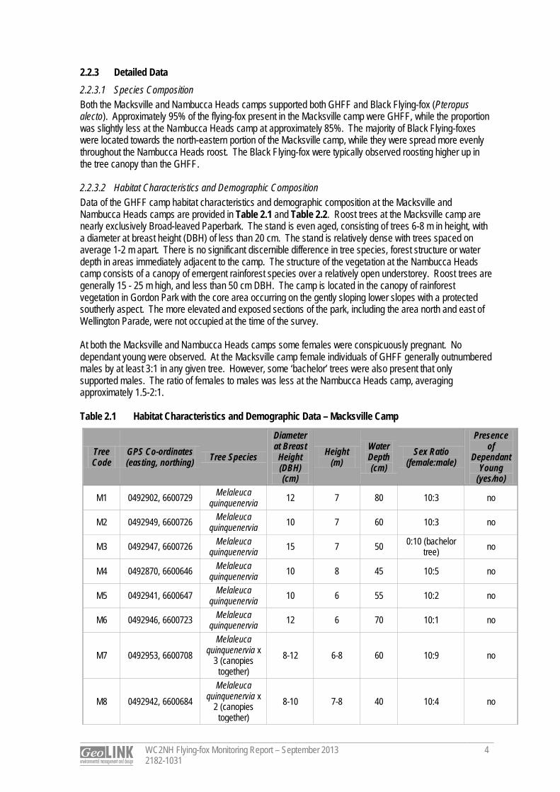
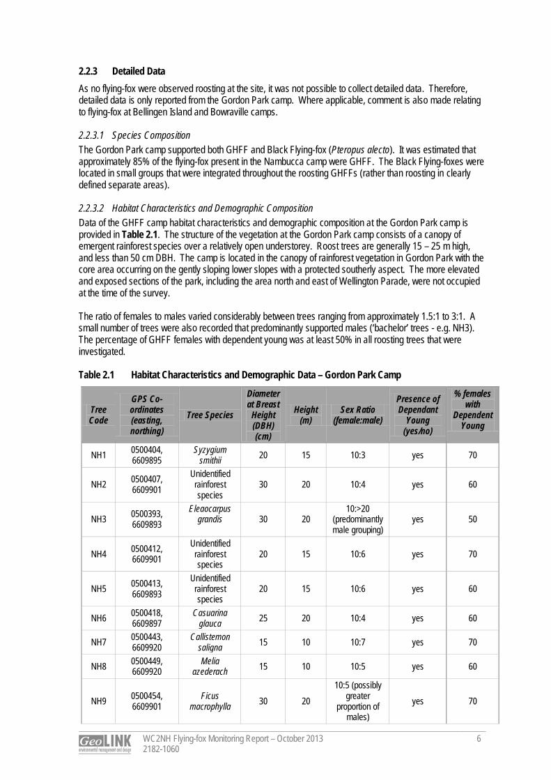
2.2.3 Detailed Data 2.2.3.1 Species Composition Both the Macksville and Nambucca Heads camps supported both GHFF and Black Flying-fox (Pteropus alecto). Approximately 95% of the flying-fox present in the Macksville camp were GHFF, while the proportion was slightly less at the Nambucca Heads camp at approximately 85%. The majority of Black Flying-foxes were located towards the north-eastern portion of the Macksville camp, while they were spread more evenly throughout the Nambucca Heads roost. The Black Flying-fox were typically observed roosting higher up in the tree canopy than the GHFF. 2.2.3.2 Habitat Characteristics and Demographic Composition Data of the GHFF camp habitat characteristics and demographic composition at the Macksville and Nambucca Heads camps are provided in Table 2.1 and Table 2.2. Roost trees at the Macksville camp are nearly exclusively Broad-leaved Paperbark. The stand is even aged, consisting of trees 6-8 m in height, with a diameter at breast height (DBH) of less than 20 cm. The stand is relatively dense with trees spaced on average 1-2 m apart. There is no significant discernible difference in tree species, forest structure or water depth in areas immediately adjacent to the camp. The structure of the vegetation at the Nambucca Heads camp consists of a canopy of emergent rainforest species over a relatively open understorey. Roost trees are generally 15 - 25 m high, and less than 50 cm DBH. The camp is located in the canopy of rainforest vegetation in Gordon Park with the core area occurring on the gently sloping lower slopes with a protected southerly aspect. The more elevated and exposed sections of the park, including the area north and east of Wellington Parade, were not occupied at the time of the survey. At both the Macksville and Nambucca Heads camps some females were conspicuously pregnant. No dependant young were observed. At the Macksville camp female individuals of GHFF generally outnumbered males by at least 3:1 in any given tree. However, some ‘bachelor’ trees were also present that only supported males. The ratio of females to males was less at the Nambucca Heads camp, averaging approximately 1.5-2:1. Table 2.1 Habitat Characteristics and Demographic Data – Macksville Camp
Tree Code
GPS Co-ordinates (easting, northing) Tree Species
Diameter at Breast Height (DBH) (cm)
Height (m)
Water Depth (cm)
Sex Ratio (female:male)
Presence of
Dependant Young
(yes/no)
M1 0492902, 6600729 Melaleuca quinquenervia 12 7 80 10:3 no
M2 0492949, 6600726 Melaleuca quinquenervia 10 7 60 10:3 no
M3 0492947, 6600726 Melaleuca quinquenervia 15 7 50 0:10 (bachelor
tree) no
M4 0492870, 6600646 Melaleuca quinquenervia 10 8 45 10:5 no
M5 0492941, 6600647 Melaleuca quinquenervia 10 6 55 10:2 no
M6 0492946, 6600723 Melaleuca quinquenervia 12 6 70 10:1 no
M7 0492953, 6600708 Melaleuca
quinquenervia x 3 (canopies
together) 8-12 6-8 60 10:9 no
M8 0492942, 6600684 Melaleuca
quinquenervia x 2 (canopies
together) 8-10 7-8 40 10:4 no
WC2NH Flying-fox Monitoring Report – September 2013 2182-1031
5
Tree Code
GPS Co-ordinates (easting, northing) Tree Species
Diameter at Breast Height (DBH) (cm)
Height (m)
Water Depth (cm)
Sex Ratio (female:male)
Presence of
Dependant Young
(yes/no)
M9 0492930, 6600690 Melaleuca
quinquenervia x 2 (canopies
together) 10 10 50 10:3 no
M10 0492925, 6600679 Melaleuca
quinquenervia x 2 (canopies
together) 12 7 50 10:4 no
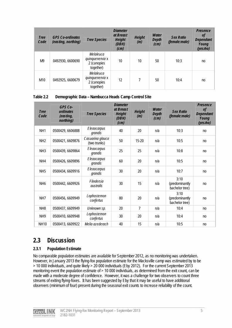
Table 2.2 Demographic Data – Nambucca Heads Camp Control Site
Tree Code
GPS Co-ordinates (easting, northing)
Tree Species
Diameter at Breast
Height (DBH) (cm)
Height (m)
Water Depth (cm)
Sex Ratio (female:male)
Presence of
Dependant Young
(yes/no)
NH1 0500429, 6606888 Eleaocarpus grandis 40 20 n/a 10:3 no
NH2 0500421, 6609876 Casuarina glauca (two trunks) 50 15-20 n/a 10:5 no
NH3 0500439, 6609864 Eleaocarpus grandis 25 25 n/a 10:8 no
NH4 0500426, 6609896 Eleaocarpus grandis 60 20 n/a 10:5 no
NH5 0500434, 6609916 Eleaocarpus grandis 30 20 n/a 10:7 no
NH6 0500442, 6609926 Flindersia australis 30 15 n/a
3:10 (predominantly bachelor tree)
no
NH7 0500456, 6609949 Lophostemon confertus 80 20 n/a
3:10 (predominantly bachelor tree)
no
NH8 0500437, 6609949 Unknown sp. 20 7 n/a 10:4 no
NH9 0500410, 6609948 Lophostemon confertus 30 20 n/a 10:4 no
NH10 0500413, 6609922 Melia azederach 40 15 n/a 10:5 no 2.3 Discussion 2.3.1 Population Estimate No comparable population estimates are available for September 2012, as no monitoring was undertaken. However, in January 2013 the flying-fox population estimate for the Macksville camp was estimated by to be > 10 000 individuals, and quite likely > 20 000 individuals (Eby 2012). For the current September 2013 monitoring event the population estimate of > 10 000 individuals, as determined from the exit count, can be made with a moderate degree of confidence. However, it was a challenge for two observers to count three streams of exiting flying-foxes. It has been suggested by Eby that it may be useful to have additional observers (minimum of four) present during the seasonal exit counts to increase reliability of the count.
WC2NH Flying-fox Monitoring Report – September 2013 2182-1031
6
2.3.2 Camp Footprint The footprint of the camp in September 2013 corresponds very closely with the camp footprint mapped by SKM in early 2013, with the camp occupying the core area of the subject Swamp Sclerophyll Forest. These 2013 camp footprints occupy a significantly smaller area of Swamp Sclerophyll Forest than the indicative area identified in Eby (2012). 2.3.3 Demographic Composition For GHFF, the percentage of adult females in the population increases in association with population size (Eby 2012). This is supported by the results of the September survey in which the female to male ratio at the Macksville camp was found to be higher than that at the Nambucca Heads camp, where a significantly smaller number of individuals were present. The September survey was undertaken during the later stages of pregnancy for GHFF and prior to the main birthing period of October-early November (Eby 2012). The presence of conspicuously pregnant females at the Macksville camp indicates that birthing will occur soon. As relatively large numbers of GHFF are currently occupying the Macksville camp immediately prior to the birthing period of October/ early November, there is a high likelihood that the roost will be used for birthing in 2013. This is supported by seasonal increases in foraging resources locally (Eby and Law 2008). The Macksville camp has previously supported dependent young, as evidenced by the sound of flightless young calling in the camp at night during January and February 2012 (Eby 2012). Young are not fully independent until approximately March. Subsequent monitoring will confirm whether the camp is used as a maternity camp over the 2013-2014 GHFF breeding season. 2.3.4 Phenology of Trees in Region Although the movement patterns of the GHFF are complex and difficult to assign to a single factor, the onset of flowering of Grey Ironbark (Eucalyptus siderophloia) and Forest Red Gum (Eucalyptus tereticornis) in September on the coastal lowlands of the upper North Coast may be a contributing factor to the return of the GHFF to the Macksville camp. These trees are recognised as highly productive species in this region and can be considered key diet species (Eby 2012; Eby and Law 2008). 2.3.5 Practicalities of Demographic Surveys A number of characteristics of the Nambucca Heads camp affect the ability to accurately determine the sex of animals. The animals are generally roosting higher (15-20 m) compared with the Macksville camp (animals are roosting at around 4-8 m at Macksville, but height difference is linked to the height of trees at the respective camps, rather than animals roosting lower in trees). The Nambucca camp is also located within an urban area above a wooden walkway through the park. These factors decrease the propensity for flying-foxes at Nambucca to be alarmed when approaching on foot, resulting in the opening of wings which facilitates the sexing of animals. A noise stimulus in the form of breaking of a branch or a soft clap was sometimes required to elicit an alarm response and wing opening at the Nambucca Heads camp. This noise stimulus was intentionally limited as two lost flying-fox foetuses were located beneath the roost during the survey (refer to Plate 2.2). Despite mass abortions of flying-fox foetuses previously being recorded at some roosts during periods of food shortage and inclement weather, isolated incidences of abortion can be expected, as young females (two year olds) often do not carry to term (Eby and Lunney 2002). However, it has also been recognised that additional noise stress, such as that undertaken to achieve relocation, has the potential to increase this risk of abortion (Australian Research Centre for Urban Ecology 2009). For the current survey, as a precaution, it was considered prudent that additional unnecessary stress from noise should be limited to reduce the risk of further abortion of foetuses occurring.
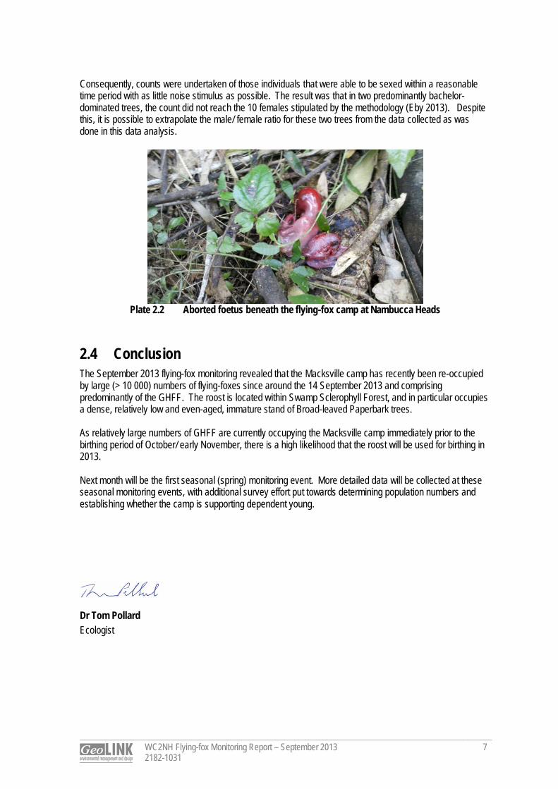
WC2NH Flying-fox Monitoring Report – September 2013 2182-1031
7
Consequently, counts were undertaken of those individuals that were able to be sexed within a reasonable time period with as little noise stimulus as possible. The result was that in two predominantly bachelor-dominated trees, the count did not reach the 10 females stipulated by the methodology (Eby 2013). Despite this, it is possible to extrapolate the male/ female ratio for these two trees from the data collected as was done in this data analysis.
Plate 2.2 Aborted foetus beneath the flying-fox camp at Nambucca Heads
2.4 Conclusion The September 2013 flying-fox monitoring revealed that the Macksville camp has recently been re-occupied by large (> 10 000) numbers of flying-foxes since around the 14 September 2013 and comprising predominantly of the GHFF. The roost is located within Swamp Sclerophyll Forest, and in particular occupies a dense, relatively low and even-aged, immature stand of Broad-leaved Paperbark trees. As relatively large numbers of GHFF are currently occupying the Macksville camp immediately prior to the birthing period of October/ early November, there is a high likelihood that the roost will be used for birthing in 2013. Next month will be the first seasonal (spring) monitoring event. More detailed data will be collected at these seasonal monitoring events, with additional survey effort put towards determining population numbers and establishing whether the camp is supporting dependent young.
Dr Tom Pollard Ecologist
References
WC2NH Flying-fox Monitoring Report – September 2013 2182-1031
8
Eby, P and Lunney, L (Ed.) (2002). Managing the Grey-headed Flying-fox as a Threatened Species in NSW, Royal Zoological Society of NSW. Eby, P. and Law, B. (2008). Ranking the feeding habitat of Grey‐headed flying foxes for conservation management. Department of Environment, Heritage, Water and the Arts, Canberra. Eby, P. (2012). An Assessment of the Flying-fox Camp at Macksville. Unpublished report to NSW Roads and Maritime Services. Eby, P. (2013). A Field Monitoring Program Proposed for the Macksville Flying-fox Roost. Unpublished report to Sinclair Knight Merz. Australian Research Centre for Urban Ecology (2009). Public Environment Report: Proposed Relocation of a Camp of Grey-headed Flying-foxes (Pteropus poliocephalus) from the Royal Botanic Gardens, Sydney. A report prepared for the Botanic Gardens Trust.
F l y ing- fox Moni tor ing Warrell Creek to Nambucca Heads
Pacific Highway Upgrade October 2013
Prepared for: Sinclair Knight Merz © GeoLINK, 2013
PO Box 119 Lennox Head NSW 2478
T 02 6687 7666
PO Box 1446 Coffs Harbour NSW 2450
T 02 6651 7666
UPR Description Date Issued Issued By 2182-1049 First issue 31/10/2013 Tom Pollard 2182-1057 Second issue 08/11/2013 Tom Pollard 2182-1060 Third issue 11/11/2013 Tom Pollard
Table of Contents
WC2NH Flying-fox Monitoring Report – October 2013 2182-1060
i
1. Introduction 1
1.1 Introduction ............................................................................................................................................... 1
2. Flying-fox Survey 2
2.1 Methodology ............................................................................................................................................. 2
2.2 Results ...................................................................................................................................................... 2
2.2.1 Population Estimate – Exit Count ................................................................................................ 2
2.2.2 Camp Footprint ............................................................................................................................. 2
2.2.3 Detailed Data ................................................................................................................................ 6
2.3 Discussion ................................................................................................................................................ 7
2.3.1 Population Estimate ..................................................................................................................... 7
2.3.2 Demographic Composition .......................................................................................................... 7
2.3.3 Phenology of Trees in Region ..................................................................................................... 8
2.3.4 Selection of Control Site .............................................................................................................. 8
2.3.5 Ongoing Water-level Measurements .......................................................................................... 8
2.4 Conclusion ................................................................................................................................................ 8
Illustrations Illustration 2.1 October 2013 Survey Traverse ................................................................................................ 4
Illustration 2.2 Location of Regional Flying-fox Camps ................................................................................... 5
Tables Table 2.1 Habitat Characteristics and Demographic Data – Gordon Park Camp .................................. 6
Plates Plate 2.1 Traversing through the Dense Broad-leaved Paperbark Swamp at the Site ......................... 3
1
WC2NH Flying-fox Monitoring Report – October 2013 2182-1060
1
1. Introduction 1.1 Introduction Sinclair Knight Merz (SKM) and NSW Roads and Maritime Services (RMS) are working to resolve the Grey-headed Flying-fox (Pteropus poliocephalus) (GHFF) camp conflict on the approved alignment of the Warrell Creek to Nambucca Heads (WC2NH) Pacific Highway upgrade project. GeoLINK has been engaged to undertake monthly flying-fox monitoring at the Macksville roost (henceforth referred to as ‘the site’), which is located in a patch of Swamp Sclerophyll Forest vegetation north of Bald Hill Road, Macksville. To date, monthly monitoring has been undertaken since July 2013. However, a significant amount of data from previous monitoring has also been collected irregularly on the camp since its establishment in December 2011 (Eby 2012). This report details the October 2013 monitoring results. The monitoring was undertaken on 28 - 29 October 2013.
2
WC2NH Flying-fox Monitoring Report – October 2013 2182-1060
2
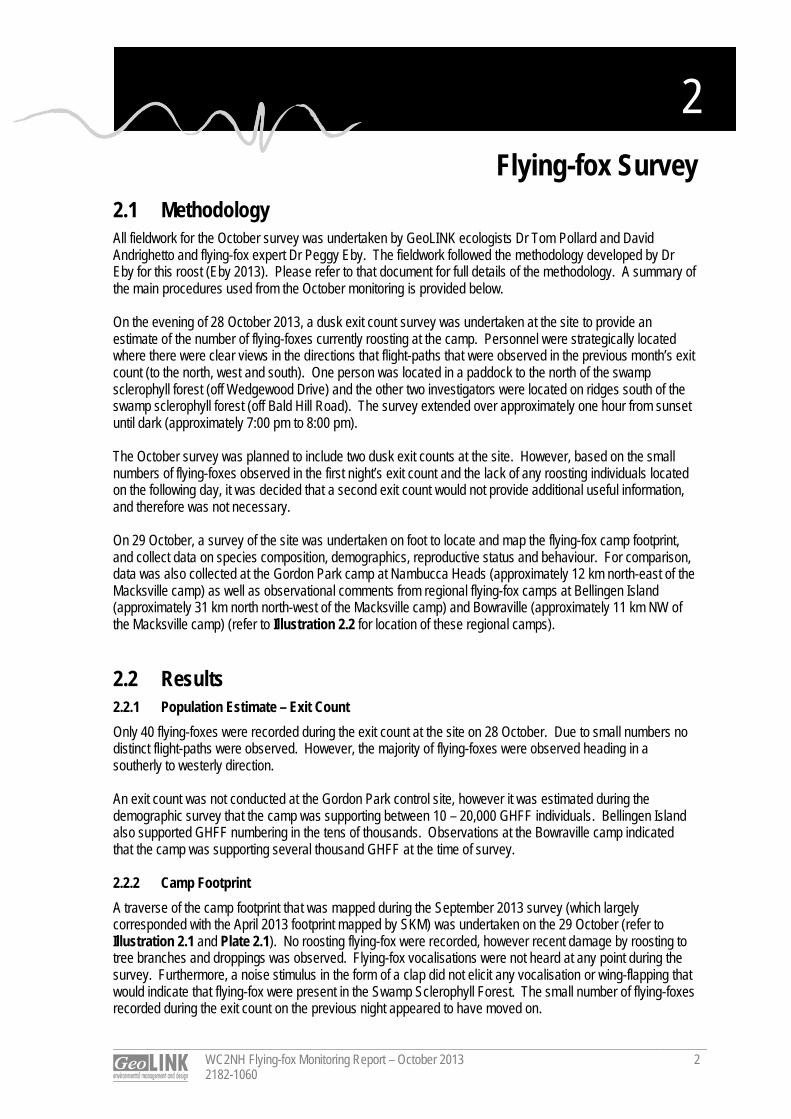
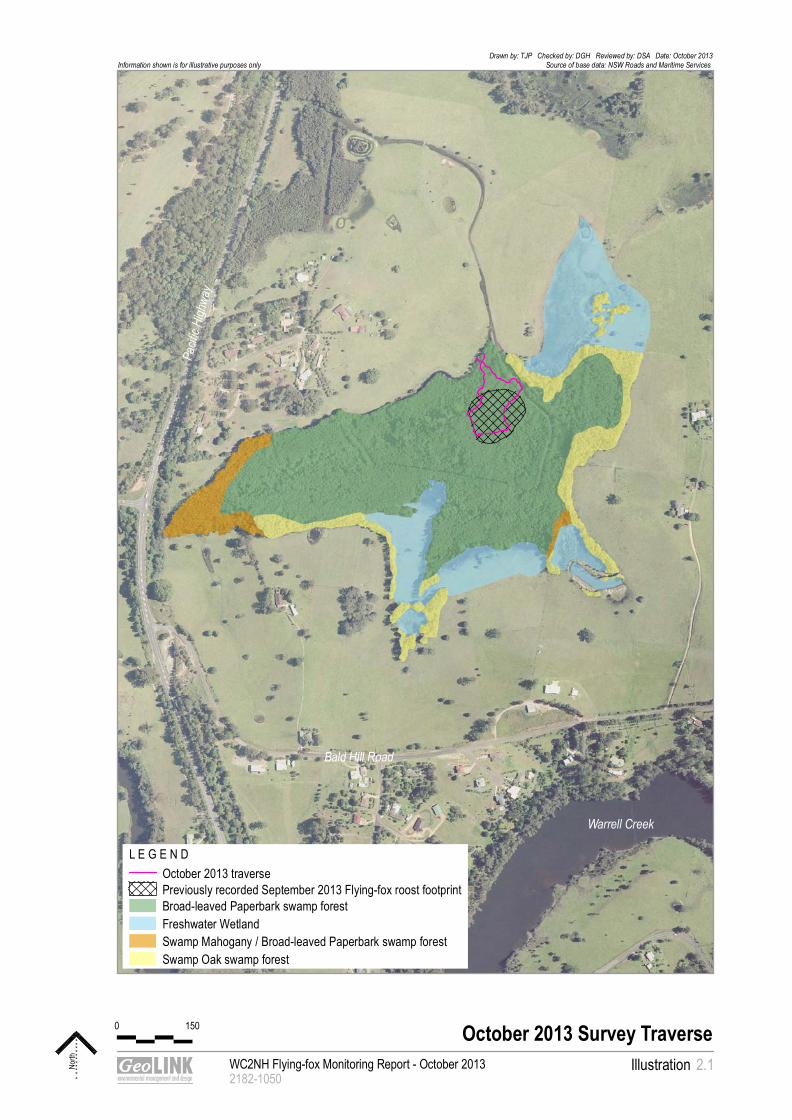
2. Flying-fox Survey 2.1 Methodology All fieldwork for the October survey was undertaken by GeoLINK ecologists Dr Tom Pollard and David Andrighetto and flying-fox expert Dr Peggy Eby. The fieldwork followed the methodology developed by Dr Eby for this roost (Eby 2013). Please refer to that document for full details of the methodology. A summary of the main procedures used from the October monitoring is provided below. On the evening of 28 October 2013, a dusk exit count survey was undertaken at the site to provide an estimate of the number of flying-foxes currently roosting at the camp. Personnel were strategically located where there were clear views in the directions that flight-paths that were observed in the previous month’s exit count (to the north, west and south). One person was located in a paddock to the north of the swamp sclerophyll forest (off Wedgewood Drive) and the other two investigators were located on ridges south of the swamp sclerophyll forest (off Bald Hill Road). The survey extended over approximately one hour from sunset until dark (approximately 7:00 pm to 8:00 pm). The October survey was planned to include two dusk exit counts at the site. However, based on the small numbers of flying-foxes observed in the first night’s exit count and the lack of any roosting individuals located on the following day, it was decided that a second exit count would not provide additional useful information, and therefore was not necessary. On 29 October, a survey of the site was undertaken on foot to locate and map the flying-fox camp footprint, and collect data on species composition, demographics, reproductive status and behaviour. For comparison, data was also collected at the Gordon Park camp at Nambucca Heads (approximately 12 km north-east of the Macksville camp) as well as observational comments from regional flying-fox camps at Bellingen Island (approximately 31 km north north-west of the Macksville camp) and Bowraville (approximately 11 km NW of the Macksville camp) (refer to Illustration 2.2 for location of these regional camps). 2.2 Results 2.2.1 Population Estimate – Exit Count Only 40 flying-foxes were recorded during the exit count at the site on 28 October. Due to small numbers no distinct flight-paths were observed. However, the majority of flying-foxes were observed heading in a southerly to westerly direction. An exit count was not conducted at the Gordon Park control site, however it was estimated during the demographic survey that the camp was supporting between 10 – 20,000 GHFF individuals. Bellingen Island also supported GHFF numbering in the tens of thousands. Observations at the Bowraville camp indicated that the camp was supporting several thousand GHFF at the time of survey. 2.2.2 Camp Footprint A traverse of the camp footprint that was mapped during the September 2013 survey (which largely corresponded with the April 2013 footprint mapped by SKM) was undertaken on the 29 October (refer to Illustration 2.1 and Plate 2.1). No roosting flying-fox were recorded, however recent damage by roosting to tree branches and droppings was observed. Flying-fox vocalisations were not heard at any point during the survey. Furthermore, a noise stimulus in the form of a clap did not elicit any vocalisation or wing-flapping that would indicate that flying-fox were present in the Swamp Sclerophyll Forest. The small number of flying-foxes recorded during the exit count on the previous night appeared to have moved on.
WC2NH Flying-fox Monitoring Report – October 2013 2182-1060
3
Prior to the survey discussions with residents on Wedgewood Drive indicated that flying-fox numbers appeared low recently at the site and that odour had ceased to be a significant issue (pers. comm. Mr Wilkes and Mr Ainsworth). When undertaking nearby ecological survey work approximately two weeks prior to the October survey on Thursday 17 October, GeoLINK ecologists reported hearing vocalisations of flying-fox that were roosting at the site (David Andrighetto, pers. obs.). No water measurements were made at the Macksville camp in October 2013 as the levels have previously been measured along with detailed data at each demographic count tree. As no flying-fox were present no demographic count trees were investigated. However, despite that, the following estimations relating to water level at the Macksville camp can be made: Comparison of photos taken in the swamp in September and October showing the exposed roots
growing from the base of Broad-leaved Paperbark trees indicate that a decrease in water levels of approximately 10-20 cm has occurred between September and October 2013; and
Although variable depending on exact location, the average water level in October beneath the flying-fox camp is estimated to be approximately 60 cm depth and the maximum water level in the drainage channels is in excess of 100 cm.
Plate 2.1 Traversing through the Dense Broad-leaved Paperbark Swamp at the Site
WC2NH Flying-fox Monitoring Report - October 20132182-1050
Illustration
October 2013 Survey Traverse
North 2.1
Drawn by: TJP Checked by: DGH Reviewed by: DSA Date: October 2013Source of base data: NSW Roads and Maritime Services Information shown is for illustrative purposes only
L E G E N D October 2013 traversePreviously recorded September 2013 Flying-fox roost footprintBroad-leaved Paperbark swamp forestFreshwater WetlandSwamp Mahogany / Broad-leaved Paperbark swamp forestSwamp Oak swamp forest
Warrell Creek
Bald Hill Road
Pacif
ic Hi
ghwa
y
0 150

0
100
200
300
400
500
600
700
800
900
1000
1100
120 0
130 0
140 0
150 0
160 0
170 0
180 0
190 0
200 0
210 0
220 0
230 0
2400
2500
2600
2700
2800
290 0
300 0
310 0
320 0
330 0
340 0
350 0
360 0
370 0
380 0
390 0
400 0
410 0
420 0
430 0
440 0
4500
4600
4700
4800
4900
5000
5100
520 0
530 0
540 0
550 0
560 0
570 0
580 0
590 0
600 0
610 0
620 0
630 0
640 0
650 0
660 0
670 0
680 0
690 0
700 0
710 0
720 0
730 0
740 0
750 0
760 0
770 0
780 0
790 0
800 0
810 0
820 0
830 0
840 0
850 0
860 0
870 0
880 0
890 0
205 00
206 00
207 00
208 00
209 00
32500
32600
32700
32800
32900
116 00
117 00
118 00
119 00
120 00
221 00
222 00
223 00
224 00
22500
22600
22700
22800
22900
23000
341 00
342 00
343 00
344 00
345 00
900 0
910 0
920 0
930 0
940 0
950 0
960 0
970 0
980 0
990 0
100 00
101 00
102 00
103 00
104 00
105 00
106 00
107 00
10800
10900
11000
11100
11200
113 00
114 00
115 00
121 00
122 00
123 00
124 00
125 00
126 00
127 00
128 00
129 00
130 00
131 00
132 00
133 00
134 00
135 00
136 00
137 00
138 00
139 00
140 00
141 00
142 00
143 00
144 00
145 00
146 00
147 00
148 00
149 00
150 00
151 00
152 00
153 00
154 00
155 00
156 00
157 00
158 00
159 00
160 00
161 00
162 00
163 00
16400
16500
16600
16700
16800
16900
170 00
171 00
172 00
173 00
174 00
175 00
176 00
177 00
178 00
179 00
180 00
181 00
182 00
18300
18400
18500
18600
18700
18800
18900
19000
191 00
192 00
193 00
194 00
195 00
196 00
197 00
198 00
199 00
200 00
201 00
202 00
203 00
204 00
210 00
211 00
212 00
213 00
214 00
215 00
216 00
217 00
218 00
219 00
220 00
23100
23200
23300
23400
23500
23600
237 00
238 00
239 00
240 00
241 00
242 00
243 00
244 00
245 00
246 00
247 00
24800
24900
25000
25100
25200
25300
25400
25500
25600
25700
258 00
259 00
260 00
261 00
262 00
263 00
264 00
265 00
266 00
267 00
268 00
269 00
270 00
271 00
272 00
273 00
274 00
275 00
276 00
277 00
278 00
279 00
280 00
281 00
282 00
283 00
284 00
285 00
286 00
287 00
288 00
289 00
290 00
291 00
292 00
293 00
294 00
295 00
296 00
297 00
298 00
299 00
300 00
301 00
302 00
303 00
304 00
305 00
306 00
307 00
308 00
309 00
310 00
311 00
312 00
313 00
314 00
315 00
316 00
317 00
318 00
319 00
320 00
32100
32200
32300
32400
33000
33100
33200
33300
33400
335 00
336 00
337 00
338 00
339 00
340 00
346 00
347 00
348 00
349 00
350 00
351 00
352 00
353 00
354 00
355 00
356 00
357 00
358 00
359 00
360 00
361 00
362 00
363 00
364 00
365 00
366 00
367 00
368 00
369 00
370 00
371 00
372 00
373 00
374 00
375 00
376 00
377 00
378 00
379 00
380 00
381 00
38200
38300
38400
38500
38600
38700
38800
38900
39000
39100
39200
39300
39400
39500
39600
39700
39800
39900
40000
40100
402 00
403 00
404 00
405 00
406 00
407 00
408 00
409 00
410 00
411 00
412 00
413 00
414 00
415 00
416 00
417 00
417 98
411 82
NAMBUCCA HEADS
Bellingen Island camp
Gordon Park camp
Bowraville camp
Macksville camp
BOWRAVILLE
BELLINGEN
MACKSVILLE
CH 0
CH19500
Pacif
ic Hi
ghwa
y
Location of Flyng-fox camps
The Site Note - the extent of the WC2NH project is highlighted in red
0 4 km
WC2NH Flying-fox Monitoring Report - October 2013 2182-1059
IllustrationLocation of Regional Flying-fox camps
North 2.2
Drawn by: TJP Checked by: MVE Reviewed by: DSA Date: November 2013Source of base data: Roads and Maritime ServicesInformation shown is for illustrative purposes only
L E G E N D WC2U Project boundary
WC2NH Flying-fox Monitoring Report – October 2013 2182-1060
6
2.2.3 Detailed Data As no flying-fox were observed roosting at the site, it was not possible to collect detailed data. Therefore, detailed data is only reported from the Gordon Park camp. Where applicable, comment is also made relating to flying-fox at Bellingen Island and Bowraville camps. 2.2.3.1 Species Composition The Gordon Park camp supported both GHFF and Black Flying-fox (Pteropus alecto). It was estimated that approximately 85% of the flying-fox present in the Nambucca camp were GHFF. The Black Flying-foxes were located in small groups that were integrated throughout the roosting GHFFs (rather than roosting in clearly defined separate areas). 2.2.3.2 Habitat Characteristics and Demographic Composition Data of the GHFF camp habitat characteristics and demographic composition at the Gordon Park camp is provided in Table 2.1. The structure of the vegetation at the Gordon Park camp consists of a canopy of emergent rainforest species over a relatively open understorey. Roost trees are generally 15 – 25 m high, and less than 50 cm DBH. The camp is located in the canopy of rainforest vegetation in Gordon Park with the core area occurring on the gently sloping lower slopes with a protected southerly aspect. The more elevated and exposed sections of the park, including the area north and east of Wellington Parade, were not occupied at the time of the survey. The ratio of females to males varied considerably between trees ranging from approximately 1.5:1 to 3:1. A small number of trees were also recorded that predominantly supported males (‘bachelor’ trees - e.g. NH3). The percentage of GHFF females with dependent young was at least 50% in all roosting trees that were investigated. Table 2.1 Habitat Characteristics and Demographic Data – Gordon Park Camp
Tree Code
GPS Co-ordinates (easting, northing)
Tree Species
Diameter at Breast
Height (DBH) (cm)
Height (m)
Sex Ratio (female:male)
Presence of Dependant
Young (yes/no)
% females with
Dependent Young
NH1 0500404, 6609895
Syzygium smithii 20 15 10:3 yes 70
NH2 0500407, 6609901
Unidentified rainforest species
30 20 10:4 yes 60
NH3 0500393, 6609893
Eleaocarpus grandis 30 20
10:>20 (predominantly male grouping)
yes 50
NH4 0500412, 6609901
Unidentified rainforest species
20 15 10:6 yes 70
NH5 0500413, 6609893
Unidentified rainforest species
20 15 10:6 yes 60
NH6 0500418, 6609897
Casuarina glauca 25 20 10:4 yes 60
NH7 0500443, 6609920
Callistemon saligna 15 10 10:7 yes 70
NH8 0500449, 6609920
Melia azederach 15 10 10:5 yes 60
NH9 0500454, 6609901
Ficus macrophylla 30 20
10:5 (possibly greater
proportion of males)
yes 70
WC2NH Flying-fox Monitoring Report – October 2013 2182-1060
7
Tree Code
GPS Co-ordinates (easting, northing)
Tree Species
Diameter at Breast
Height (DBH) (cm)
Height (m)
Sex Ratio (female:male)
Presence of Dependant
Young (yes/no)
% females with
Dependent Young
NH10 0500454, 6609911
Acacia melanoxylon 15 12 10:6 yes 80
Female GHFF with dependent young were also present at the Bellingen Island and Bowraville camps. 2.2.3.3 Presence of dead young flying-fox A single dead young bat was opportunistically observed at the Gordon Park camp and at the Bellingen Island camp. No aborted foetuses were observed. 2.3 Discussion 2.3.1 Population Estimate It is not unexpected for camps with highly consistent patterns of occupation to contain no animals for short periods nor is it uncommon for the number of animals in such a camp to fluctuate over short time-scales (P. Eby pers. comm.). For example, monthly population estimates of GHFF in the Gordon camp, Sydney (classified as a continuously occupied camp), recorded between 1995 and 2012 (Ku-ring-gai Bat Conservation Society), showed that population size can vary considerably month to month, from <50 to >10,000 animals between months. These fluctuations are believed to reflect both the quantity and quality of food in the local area and the quantity of highly preferred food sources at a regional scale (P. Eby pers. comm.). Periods of zero population have also been recorded at various other sites with long histories of consistent use such as Harriet Island, Bundaberg (mean population size 44,000); Currumbin Creek, Gold Coast (mean population size 6,700); and Regents Park, Logan (mean population size 8,000) (Queensland EPA). Partially eaten segments of citrus were observed floating on the water beneath the previously occupied roost area at Macksville. This observation may indicate that there is currently a local shortage of suitable food for flying-foxes within the vicinity of the camp as citrus are not a preferred food source (P. Eby pers. comm.). This may be a contributing factor explaining why few, then no flying-foxes were roosting at the site at the time of the October survey. No population estimate of GHFF is available for the site in October last year. However, radio-tracking undertaken by John Martin at the Royal Botanic Garden and Domain Trust (RBGDT), Sydney indicates that both adult male and female GHFF individuals were present at the site in October 2012. Radio-tracked individuals were also recorded at the site in each subsequent month through to May 2013 (data courtesy of John Martin, RBGDT, unpublished). For future exit counts it is recommended that an additional person be stationed east of the site to ensure that flying-fox exiting to the east are more easily counted. 2.3.2 Demographic Composition Locally, the first young of both GHFF and Black flying-foxes at Bellingen Island were observed on 5 October and were determined to be at least two days old at this time (P. Eby pers. comm., data collected by Tim Pearson, doctoral candidate at Macquarie University). As births typically commence at the same time in neighbouring camps it is reasonable to surmise that females at the site gave birth to young at approximately the same time (i.e. 3 October). Commencement of births on or around 3 October is also consistent with observations this year at several camps in Sydney including Gordon, Centennial Park, Parramatta Park and Kareela (P. Eby pers. comm.).

WC2NH Flying-fox Monitoring Report – October 2013 2182-1060
8
As roosting flying-foxes were present at the site on 17 October [GeoLINK observations] prior to departing sometime between 17 October and 28 October, it is reasonable to predict that females with young were also present in the site at that time. As females carry their dependent young with them on nightly foraging flights for a period of 4 to 5 weeks following birth, and the roost has shown some recent fluctuations in occupation, it is not possible to determine with certainty whether GHFF gave birth at the site in 2013. The site has previously supported dependent young, as evidenced by the sound of flightless young calling in the camp at night during January and February 2012 (Eby 2012). Young are not fully independent until approximately March. Subsequent monthly monitoring between now and March 2014 will confirm whether the site is re-occupied by GHFF and used as a maternity camp during the 2013/14 breeding season. 2.3.3 Phenology of Trees in Region Flowering of the flying-fox food trees Grey Ironbark (Eucalyptus siderophloia) and Forest Red Gum (Eucalyptus tereticornis) continues throughout October on the coastal lowlands and river valleys of the lower North Coast. These trees are recognised as highly productive species in this region and can be considered key diet species (Eby 2012; Eby and Law 2008). Although the movement patterns of the GHFF are complex and difficult to assign to a single factor, the local and regional availability of these and other food resources may be influencing monthly presence at the site at this time. 2.3.4 Selection of Control Site As identified in the previous September monitoring report the height of the tree canopy at the Gordon Park control site makes undertaking the demographic survey challenging. For this reason, it is proposed that the Bellingen Island camp be considered as an alternative as the canopy here is considerably lower. 2.3.5 Ongoing Water-level Measurements As suggested by RMS a more permanent relative water measurement method will be established during the next monitoring event and will consist of either a nail (non-copper) in a tree or a marker on a steel post. 2.4 Conclusion The October 2013 flying-fox monitoring revealed that only a small number of flying-foxes (approximately 40) were occupying the site on the 28 October, and the site was not occupied on the 29 October. This follows re-occupation of the camp by large (> 10,000) numbers of predominantly GHFF in mid-September 2013, after the camp was unoccupied during the July and August monitoring events. It is not unexpected for camps to experience large fluctuations in flying-fox numbers over short time scales or for camps with highly consistent patterns of occupation to contain no animals for short periods, (including during the breeding period) as the availability of foraging resources changes at a local and regional scale (P. Eby pers. comm.). Females with dependent young were likely to have been present at the site on 17 October 2013 before flying-foxes departed. Other local camps at Gordon Park, Bellingen Island and Bowraville were supporting females with dependent young at the time of the October 2013 survey. Future monthly monitoring will provide information on whether the current decrease in occupation at the site is temporary in response to local and regional food quality and availability, and further information regarding the camp’s overall usage over the 2013/14 breeding season.
Dr Tom Pollard Ecologist
References
WC2NH Flying-fox Monitoring Report – October 2013 2182-1060
9
Eby, P and Lunney, L (Ed.) (2002). Managing the Grey-headed Flying-fox as a Threatened Species in NSW, Royal Zoological Society of NSW. Eby, P. and Law, B. (2008). Ranking the feeding habitat of Grey‐headed flying foxes for conservation management. Department of Environment, Heritage, Water and the Arts, Canberra. Eby, P. (2012). An Assessment of the Flying-fox Camp at Macksville. Unpublished report to NSW Roads and Maritime Services. Eby, P. (2013). A Field Monitoring Program Proposed for the Macksville Flying-fox Roost. Unpublished report to Sinclair Knight Merz.

F l y ing- fox Moni tor ing Warrell Creek to Nambucca Heads
Pacific Highway Upgrade November 2013
Prepared for: Sinclair Knight Merz © GeoLINK, 2013
PO Box 119 Lennox Head NSW 2478
T 02 6687 7666
PO Box 1446 Coffs Harbour NSW 2450
T 02 6651 7666

UPR Description Date Issued Issued By 2182-1067 First issue 25/11/2013 Tom Pollard 2182-1069 Second issue 04/12/2013 Tom Pollard
Table of Contents
WC2NH Flying-fox Monitoring Report – November 2013 2182-1069
i
1. Introduction 1
1.1 Introduction ............................................................................................................................................... 1
2. Flying-fox Survey 2
2.1 Methodology ............................................................................................................................................. 2
2.2 Results ...................................................................................................................................................... 2
2.2.1 Population Estimate – Exit Count ................................................................................................ 2
2.2.2 Camp Footprint ............................................................................................................................. 3
2.2.3 Detailed Data ................................................................................................................................ 6
2.3 Discussion ................................................................................................................................................ 9
2.3.1 Population Estimate ..................................................................................................................... 9
2.3.2 Species Composition and Demographic Data ............................................................................ 9
2.3.3 Phenology of Trees in Region ..................................................................................................... 9
2.3.4 Selection of Control Site ............................................................................................................ 10
2.3.5 Ongoing Water-level Measurements ........................................................................................ 10
2.4 Conclusion .............................................................................................................................................. 10
Illustrations Illustration 2.1 November 2013 Roost Footprint and Demographic Count Points ......................................... 4
Illustration 2.2 Location of Regional Flying-fox Camps ................................................................................... 5
Tables Table 2.1 Demographic Data for The Site ................................................................................................ 7
Table 2.2 Demographic Data for Bellingen Island ................................................................................... 8
Plates Plate 2.1 Undertaking the Demographic Count at The Site ................................................................... 6
1
WC2NH Flying-fox Monitoring Report – November 2013 2182-1069
1
1. Introduction 1.1 Introduction Sinclair Knight Merz (SKM) and NSW Roads and Maritime Services (RMS) are working to resolve issues relating to the Grey-headed Flying-fox (Pteropus poliocephalus) (GHFF) camp within the approved alignment of the Warrell Creek to Nambucca Heads (WC2NH) Pacific Highway upgrade project. GeoLINK has been engaged to undertake monthly flying-fox monitoring at the Macksville roost (henceforth referred to as ‘the site’), which is located in a patch of Swamp Sclerophyll Forest vegetation north of Bald Hill Road, Macksville. To date, monthly monitoring has been undertaken by GeoLINK since July 2013. However, a significant amount of data from previous monitoring has also been collected irregularly on the camp since its establishment in December 2011 (Eby 2012). This report details the November 2013 monitoring results. The monitoring was undertaken on 20 November 2013.
2
WC2NH Flying-fox Monitoring Report – November 2013 2182-1069
2
2. Flying-fox Survey 2.1 Methodology All fieldwork for the November survey was undertaken by GeoLINK ecologists Dr Tom Pollard and David Andrighetto. The fieldwork followed the methodology developed by Dr Eby for this roost (Eby 2013). Refer to that document for full details of the methodology. A summary of the main procedures used from the November monitoring is provided below. On 20 November, a survey of the site was undertaken on foot to locate and map the flying-fox camp footprint and collect data on species composition, demographics, reproductive status and behaviour. For comparison, data was also collected at a control site located at Bellingen Island (approximately 31 km north north-west of the Macksville camp), along with observational comments from other regional flying-fox camps at Gordon Park camp, Nambucca Heads (approximately 12 km north-east of the Macksville camp) and Bowraville (approximately 11 km north-west of the Macksville camp) (refer to Illustration 2.2 for location of these regional camps). Previous control site data for the September and October monitoring events was collected at the Gordon Park camp. However, for logistical reasons this has been changed to the Bellingen Island camp. Please refer to Section 2.3.4 for further information. A permanently flagged marker on a tree was set up at the site to measure the water level at the roost. The water level at this location is representative of the average level across the camp. On the evening of 20 November 2013, a dusk exit count survey was undertaken at the site to provide an estimate of the number of flying-foxes currently roosting at the camp. Personnel were strategically located where there were clear views to the north, west and south, corresponding to the directions that flight-paths were observed during the exit count in September 2013, when the flying-fox population was at its greatest level since the July 2013 monitoring began. One person was located in a paddock to the north of the swamp sclerophyll forest (off Wedgewood Drive) and the other person was located on a ridge south of the swamp sclerophyll forest (off Bald Hill Road). The survey extended over approximately one hour from sunset until dark (approximately 7:30 pm to 8:30 pm). 2.2 Results 2.2.1 Population Estimate – Exit Count An estimated 1200 flying-foxes were recorded during the exit count at the site on 20 November. The vast majority of flying-foxes (approximately 1100 individuals) were observed heading in a westerly direction. The remaining small number of flying-foxes were observed heading in a northerly direction (refer to Illustration 2.1). No exit counts were conducted at any of the other regional camps. However, rough population estimates for these camps based on extrapolation of counts in individual trees and the size of the camps are as follows: Gordon Park: >10,000 individuals; Bowraville: 3000-5000 individuals; and Bellingen Island: >10,000 individuals.
WC2NH Flying-fox Monitoring Report – November 2013 2182-1069
3
2.2.2 Camp Footprint The camp occupied an area within the Swamp Sclerophyll Forest of approximately 0.08 ha, approximately 100 m south from the northern edge. The camp footprint at the site was considerably reduced in comparison with that mapped in September 2013, when it occupied an area of 0.89 ha. The roost footprint and location of demographic count points is displayed in Illustration 2.1. As has been previously recorded, the flying-fox are roosting in a dense stand of Broad-leaved Paperbark (Melaleuca quinquenervia). These trees averaged approximately 7 m in height with a diameter at breast height (DBH) less than 20 cm.

Flying-fox flight path
WC2NH Flying-fox Monitoring Report - November 20132182-1068
Illustration
Roost Footprint and Demographic Count Points
North 2.1
Drawn by: TJP Checked by: MVE Reviewed by: DSA Date: November 2013Source of base data: NSW Roads and Maritime Services Information shown is for illustrative purposes only
L E G E N D November 2013 Flying-fox roost footprint
!( Demographic count pointsPreviously recorded September 2013 Flying-fox roost footprintBroad-leaved Paperbark swamp forestFreshwater WetlandSwamp Mahogany / Broad-leaved Paperbark swamp forestSwamp Oak swamp forest
Warrell Creek
Bald Hill Road
Pacif
ic Hi
ghwa
y
0 150
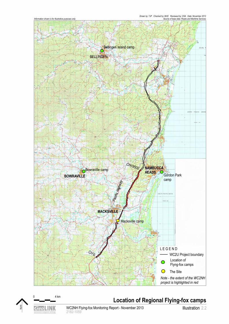
0
100
200
300
400
500
600
700
800
900
1000
1100
120 0
130 0
140 0
150 0
160 0
170 0
180 0
190 0
200 0
210 0
220 0
230 0
2400
2500
2600
2700
2800
290 0
300 0
310 0
320 0
330 0
340 0
350 0
360 0
370 0
380 0
390 0
400 0
410 0
420 0
430 0
440 0
4500
4600
4700
4800
4900
5000
5100
520 0
530 0
540 0
550 0
560 0
570 0
580 0
590 0
600 0
610 0
620 0
630 0
640 0
650 0
660 0
670 0
680 0
690 0
700 0
710 0
720 0
730 0
740 0
750 0
760 0
770 0
780 0
790 0
800 0
810 0
820 0
830 0
840 0
850 0
860 0
870 0
880 0
890 0
205 00
206 00
207 00
208 00
209 00
32500
32600
32700
32800
32900
116 00
117 00
118 00
119 00
120 00
221 00
222 00
223 00
224 00
22500
22600
22700
22800
22900
23000
341 00
342 00
343 00
344 00
345 00
900 0
910 0
920 0
930 0
940 0
950 0
960 0
970 0
980 0
990 0
100 00
101 00
102 00
103 00
104 00
105 00
106 00
107 00
10800
10900
11000
11100
11200
113 00
114 00
115 00
121 00
122 00
123 00
124 00
125 00
126 00
127 00
128 00
129 00
130 00
131 00
132 00
133 00
134 00
135 00
136 00
137 00
138 00
139 00
140 00
141 00
142 00
143 00
144 00
145 00
146 00
147 00
148 00
149 00
150 00
151 00
152 00
153 00
154 00
155 00
156 00
157 00
158 00
159 00
160 00
161 00
162 00
163 00
16400
16500
16600
16700
16800
16900
170 00
171 00
172 00
173 00
174 00
175 00
176 00
177 00
178 00
179 00
180 00
181 00
182 00
18300
18400
18500
18600
18700
18800
18900
19000
191 00
192 00
193 00
194 00
195 00
196 00
197 00
198 00
199 00
200 00
201 00
202 00
203 00
204 00
210 00
211 00
212 00
213 00
214 00
215 00
216 00
217 00
218 00
219 00
220 00
23100
23200
23300
23400
23500
23600
237 00
238 00
239 00
240 00
241 00
242 00
243 00
244 00
245 00
246 00
247 00
24800
24900
25000
25100
25200
25300
25400
25500
25600
25700
258 00
259 00
260 00
261 00
262 00
263 00
264 00
265 00
266 00
267 00
268 00
269 00
270 00
271 00
272 00
273 00
274 00
275 00
276 00
277 00
278 00
279 00
280 00
281 00
282 00
283 00
284 00
285 00
286 00
287 00
288 00
289 00
290 00
291 00
292 00
293 00
294 00
295 00
296 00
297 00
298 00
299 00
300 00
301 00
302 00
303 00
304 00
305 00
306 00
307 00
308 00
309 00
310 00
311 00
312 00
313 00
314 00
315 00
316 00
317 00
318 00
319 00
320 00
32100
32200
32300
32400
33000
33100
33200
33300
33400
335 00
336 00
337 00
338 00
339 00
340 00
346 00
347 00
348 00
349 00
350 00
351 00
352 00
353 00
354 00
355 00
356 00
357 00
358 00
359 00
360 00
361 00
362 00
363 00
364 00
365 00
366 00
367 00
368 00
369 00
370 00
371 00
372 00
373 00
374 00
375 00
376 00
377 00
378 00
379 00
380 00
381 00
38200
38300
38400
38500
38600
38700
38800
38900
39000
39100
39200
39300
39400
39500
39600
39700
39800
39900
40000
40100
402 00
403 00
404 00
405 00
406 00
407 00
408 00
409 00
410 00
411 00
412 00
413 00
414 00
415 00
416 00
417 00
417 98
411 82
NAMBUCCA HEADS
Bellingen Island camp
Gordon Park camp
Bowraville camp
Macksville camp
BOWRAVILLE
BELLINGEN
MACKSVILLE
CH 0
CH19500
Pacif
ic Hi
ghwa
y
Location of Flyng-fox camps
The Site Note - the extent of the WC2NH project is highlighted in red
0 4 km
WC2NH Flying-fox Monitoring Report - November 2013 2182-1059
IllustrationLocation of Regional Flying-fox camps
North 2.2
Drawn by: TJP Checked by: MVE Reviewed by: DSA Date: November 2013Source of base data: Roads and Maritime ServicesInformation shown is for illustrative purposes only
L E G E N D WC2U Project boundary
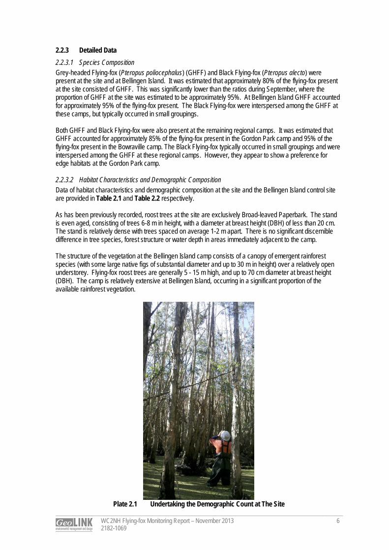
WC2NH Flying-fox Monitoring Report – November 2013 2182-1069
6
2.2.3 Detailed Data 2.2.3.1 Species Composition Grey-headed Flying-fox (Pteropus poliocephalus) (GHFF) and Black Flying-fox (Pteropus alecto) were present at the site and at Bellingen Island. It was estimated that approximately 80% of the flying-fox present at the site consisted of GHFF. This was significantly lower than the ratios during September, where the proportion of GHFF at the site was estimated to be approximately 95%. At Bellingen Island GHFF accounted for approximately 95% of the flying-fox present. The Black Flying-fox were interspersed among the GHFF at these camps, but typically occurred in small groupings. Both GHFF and Black Flying-fox were also present at the remaining regional camps. It was estimated that GHFF accounted for approximately 85% of the flying-fox present in the Gordon Park camp and 95% of the flying-fox present in the Bowraville camp. The Black Flying-fox typically occurred in small groupings and were interspersed among the GHFF at these regional camps. However, they appear to show a preference for edge habitats at the Gordon Park camp. 2.2.3.2 Habitat Characteristics and Demographic Composition Data of habitat characteristics and demographic composition at the site and the Bellingen Island control site are provided in Table 2.1 and Table 2.2 respectively. As has been previously recorded, roost trees at the site are exclusively Broad-leaved Paperbark. The stand is even aged, consisting of trees 6-8 m in height, with a diameter at breast height (DBH) of less than 20 cm. The stand is relatively dense with trees spaced on average 1-2 m apart. There is no significant discernible difference in tree species, forest structure or water depth in areas immediately adjacent to the camp. The structure of the vegetation at the Bellingen Island camp consists of a canopy of emergent rainforest species (with some large native figs of substantial diameter and up to 30 m in height) over a relatively open understorey. Flying-fox roost trees are generally 5 - 15 m high, and up to 70 cm diameter at breast height (DBH). The camp is relatively extensive at Bellingen Island, occurring in a significant proportion of the available rainforest vegetation.
Plate 2.1 Undertaking the Demographic Count at The Site
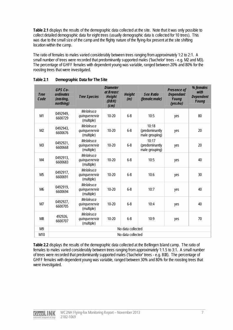
WC2NH Flying-fox Monitoring Report – November 2013 2182-1069
7
Table 2.1 displays the results of the demographic data collected at the site. Note that it was only possible to collect detailed demographic data for eight trees (usually demographic data is collected for 10 trees). This was due to the small size of the camp and the flighty nature of the flying-fox present at the site shifting location within the camp. The ratio of females to males varied considerably between trees ranging from approximately 1:2 to 2:1. A small number of trees were recorded that predominantly supported males (‘bachelor’ trees - e.g. M2 and M3). The percentage of GHFF females with dependent young was variable, ranged between 20% and 80% for the roosting trees that were investigated. Table 2.1 Demographic Data for The Site
Tree Code
GPS Co-ordinates (easting, northing)
Tree Species
Diameter at Breast
Height (DBH) (cm)
Height (m)
Sex Ratio (female:male)
Presence of Dependant
Young (yes/no)
% females with
Dependent Young
M1 0492949, 6600729
Melaleuca quinquenervia
(multiple) 10-20 6-8 10:5 yes 80
M2 0492943, 6600676
Melaleuca quinquenervia
(multiple) 10-20 6-8
10:18 (predominantly male grouping)
yes 20
M3 0492921, 6600668
Melaleuca quinquenervia
(multiple) 10-20 6-8
10:17 (predominantly male grouping)
yes 20
M4 0492913, 6600683
Melaleuca quinquenervia
(multiple) 10-20 6-8 10:5 yes 40
M5 0492917, 6600691
Melaleuca quinquenervia
(multiple) 10-20 6-8 10:6 yes 30
M6 0492919, 6600694
Melaleuca quinquenervia
(multiple) 10-20 6-8 10:7 yes 40
M7 0492927, 6600705
Melaleuca quinquenervia
(multiple) 10-20 6-8 10:4 yes 40
M8 492926, 6600707
Melaleuca quinquenervia
(multiple) 10-20 6-8 10:9 yes 70
M9 No data collected M10 No data collected
Table 2.2 displays the results of the demographic data collected at the Bellingen Island camp. The ratio of females to males varied considerably between trees ranging from approximately 1:1.5 to 3:1. A small number of trees were recorded that predominantly supported males (‘bachelor’ trees - e.g. BI8). The percentage of GHFF females with dependent young was variable, ranged between 30% and 80% for the roosting trees that were investigated.
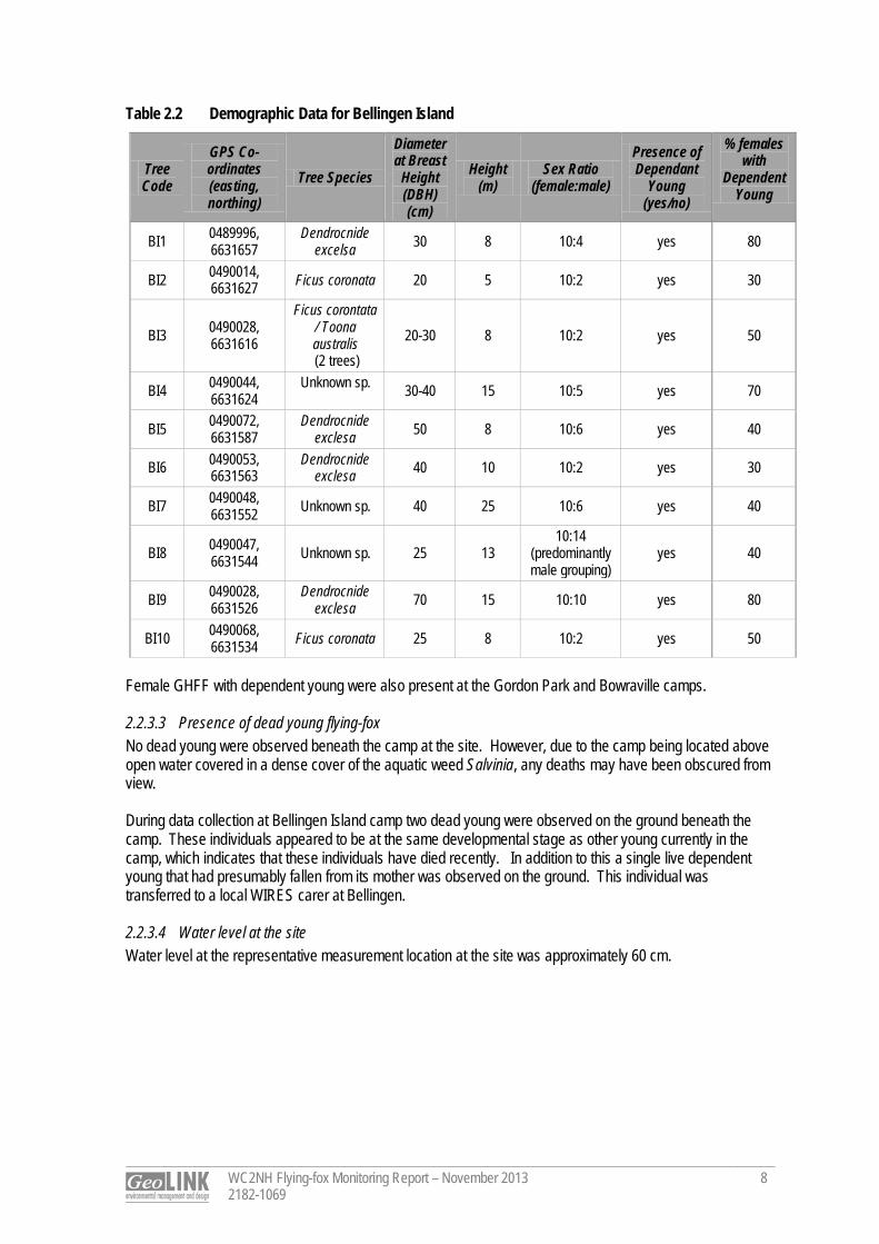
WC2NH Flying-fox Monitoring Report – November 2013 2182-1069
8
Table 2.2 Demographic Data for Bellingen Island
Tree Code
GPS Co-ordinates (easting, northing)
Tree Species
Diameter at Breast
Height (DBH) (cm)
Height (m)
Sex Ratio (female:male)
Presence of Dependant
Young (yes/no)
% females with
Dependent Young
BI1 0489996, 6631657
Dendrocnide excelsa 30 8 10:4 yes 80
BI2 0490014, 6631627 Ficus coronata 20 5 10:2 yes 30
BI3 0490028, 6631616
Ficus corontata / Toona australis (2 trees)
20-30 8 10:2 yes 50
BI4 0490044, 6631624
Unknown sp. 30-40 15 10:5 yes 70
BI5 0490072, 6631587
Dendrocnide exclesa 50 8 10:6 yes 40
BI6 0490053, 6631563
Dendrocnide exclesa 40 10 10:2 yes 30
BI7 0490048, 6631552 Unknown sp. 40 25 10:6 yes 40
BI8 0490047, 6631544 Unknown sp. 25 13
10:14 (predominantly male grouping)
yes 40
BI9 0490028, 6631526
Dendrocnide exclesa 70 15 10:10 yes 80
BI10 0490068, 6631534 Ficus coronata 25 8 10:2 yes 50
Female GHFF with dependent young were also present at the Gordon Park and Bowraville camps. 2.2.3.3 Presence of dead young flying-fox No dead young were observed beneath the camp at the site. However, due to the camp being located above open water covered in a dense cover of the aquatic weed Salvinia, any deaths may have been obscured from view. During data collection at Bellingen Island camp two dead young were observed on the ground beneath the camp. These individuals appeared to be at the same developmental stage as other young currently in the camp, which indicates that these individuals have died recently. In addition to this a single live dependent young that had presumably fallen from its mother was observed on the ground. This individual was transferred to a local WIRES carer at Bellingen. 2.2.3.4 Water level at the site Water level at the representative measurement location at the site was approximately 60 cm.
WC2NH Flying-fox Monitoring Report – November 2013 2182-1069
9
2.3 Discussion 2.3.1 Population Estimate The flying-fox population estimate at the site as recorded in the exit count this month shows that relatively small numbers of flying-fox have returned to the camp after a recent short period of non-occupation last month. This variability between months is not uncommon and is believed to reflect both the quantity and quality of food in the local area and the quantity of highly preferred food sources at a regional scale (P. Eby pers. comm.). Population levels are considerably lower than the levels recorded in September 2013 when >10,000 individuals were observed exiting the camp. Numbers at the Gordon Park and Bellingen camps appear to have remained relatively stable between October and November. At the Bowraville camp the population estimate this month seems to indicate a minor increase since last month, reflected in an increased camp footprint. It should be noted that no exit counts were conducted at these regional camps, and consequently the population estimates for these camps are less reliable than that made for the site. As was seen in October at the site, partially eaten citrus fruit was observed beneath the Bellingen Island camp. This observation may indicate that there is currently a local shortage of suitable food for flying-foxes within the foraging range of the camp as citrus are not a preferred food source (P. Eby pers. comm.). No population estimate of GHFF is available for the site in November last year. However, satellite-tracking undertaken by John Martin at the Royal Botanic Garden and Domain Trust (RBGDT), Sydney indicates that both adult male and female GHFF individuals were present at the site in November 2012. Satellite-tracked individuals were also recorded at the site in each subsequent month through to May 2013 (data courtesy of John Martin, RBGDT, unpublished). 2.3.2 Species Composition and Demographic Data Both GHFF and Black Flying-fox were present at all camps sampled in the current monitoring event. GHFF dominated the species composition, and varied from approximately 80% of individuals present at the site to >95% of individuals present at Bellingen Island and Bowraville. For GHFF, the percentage of adult females in the population increases in association with population size (Eby 2012). This is supported by the results of the November survey in which the average female to male ratio at the Bellingen Island camp was higher than at the site, where a significantly smaller number of individuals were present (refer to Table 2.1 and Table 2.2). For the 2013 breeding season, it was surmised that births of GHFF commenced on or around 3 October within the region (refer to October monthly monitoring report - GeoLINK 2013). The demographic data collected at the site, and at regional camps, indicates that the camp is currently supporting dependent young of GHFF. The site has previously supported dependent young, as evidenced by the sound of flightless young calling in the camp at night during January and February 2012 (Eby 2012) (young are not fully independent until approximately March). However, no calls of flightless young were heard during the exit count on 20 November. This is not unexpected, as flightless young are typically left at a camp while females forage in late November (Eby 2012) and this may not have occurred yet at the site. 2.3.3 Phenology of Trees in Region Flowering of Grey Ironbark (Eucalyptus siderophloia) and Forest Red Gum (Eucalyptus tereticornis) (in the inland coastal lowlands and at high altitude) continues throughout November in the upper North Coast region of NSW. These trees are recognised as highly productive species in this region and can be considered key diet species for GHFF (Eby 2012; Eby and Law 2008). Although the movement patterns of the GHFF are complex and difficult to assign to a single factor, the local and regional availability of these and other key food resources may be influencing monthly presence at the site at this time. As was observed at the Bowraville camp until it being abandoned in 2011, in most years it is typical that a summer maximum in GHFF population occurs coinciding with the flowering of a number of highly productive nectar producing trees, particularly Pink Bloodwood (Corymbia intermedia) or Grey Ironbark (Eby 2012).
WC2NH Flying-fox Monitoring Report – November 2013 2182-1069
10
2.3.4 Selection of Control Site As identified in the previous monitoring reports the height of the tree canopy at the Gordon Park control site makes undertaking the demographic survey challenging. As the trees in which flying-fox are roosting at the Bellingen Island camp considerably lower, it was decided (in consultation with Dr Eby) that the Bellingen Island camp is potentially more suitable as a comparison site. It is possible to collect more reliable data at the Bellingen Island camp as the lower height of the roosting flying-foxes makes sampling easier and a noise stimulus is not necessary to encourage the flying-fox to open their wings for accurate sexing. Therefore, control site demographic data for the current monitoring event, and subsequent monitoring events, will be collected at Bellingen Island camp. 2.3.5 Ongoing Water-level Measurements The establishment of a representative water level measurement location at the site allows for comparisons between months of water level changes beneath the camp. However, the accuracy and usefulness of this data should be acknowledged as detailed below: the water level varies considerably over short distances within the swamp sclerophyll vegetation due to
wind-thrown Broad-leaved Paperbark resulting in significant holes of greater depth (not uncommon to be up to 1 m depth; and
the ground substrate is soft in the swamp making it difficult to accurately establish the bottom of the water column.
Despite these inaccuracies in undertaking water level measurements, the location selected is considered to be representative of average water levels elsewhere beneath the camp. 2.4 Conclusion The results of the November 2013 flying-fox monitoring indicated that flying-foxes have re-established at the site, although in smaller numbers (approximately 1200) than was recorded in September 2013 when >10,000 individuals were present. GHFF dominates the site and other regional camps visited in the monitoring representing over 80% of all individuals. The return of flying-fox to the site after a short absence is likely to be in response to the availability of foraging resources changes at a local and regional scale (P. Eby pers. comm.). All of the regional camps visited during the monitoring, including the site, were supporting female flying-fox with dependent young at the time of the November 2013 survey. Future monthly monitoring will provide information on whether the current occupation of the site by GHFF continues and whether the camp is used as a refuge for flightless young during the upcoming period until full independence in March 2014.
Dr Tom Pollard Ecologist

References
WC2NH Flying-fox Monitoring Report – November 2013 2182-1069
11
Eby, P. and Law, B. (2008). Ranking the feeding habitat of Grey‐headed flying foxes for conservation management. Department of Environment, Heritage, Water and the Arts, Canberra. Eby, P. (2012). An Assessment of the Flying-fox Camp at Macksville. Unpublished report to NSW Roads and Maritime Services. Eby, P. (2013). A Field Monitoring Program Proposed for the Macksville Flying-fox Roost. Unpublished report to Sinclair Knight Merz. GeoLINK (2013). WC2NH Flying-fox Monitoring Report – October 2013. Unpublished report to Sinclair Knight Merz and the NSW Roads and Maritime Services. GeoLINK, Lennox Head.
q u a l i t y s o l u t i o n s s u s t a i n a b l e f u t u r e
ABN 79 896 839 729 ACN 101 084 557 Return address: PO Box 119 LENNOX HEAD NSW 2478 LENNOX HEAD T 02 6687 7666 F 02 6687 7782 COFFS HARBOUR T 02 6651 7666 F 02 6651 7733 www.geolink.net.au
Urba
n and
Reg
ional
Plan
ning |
Env
ironm
ental
Eng
ineer
ing | C
ivil D
esign
| Env
ironm
ental
Impa
ct As
sess
ment
| Eco
logica
l Surv
eys a
nd M
onito
ring |
Land
scap
e Arch
itectu
re | U
rban
Des
ign | C
oastl
ine an
d Wate
rway
s Man
agem
ent
5 December 2013 Ref No: 2182-1070 The Manager Sinclair Knight Merz PO Box 2147 DANGAR NSW 2309 Attention: Rachel Vazey Dear Rachel, December 2013 fortnightly Flying-fox monitoring report
This short report details the findings of the December 2013 fortnightly GHFF monitoring at the Macksville camp undertaken between standard monthly monitoring events. The purpose of collecting additional data more frequently is to form a clearer picture of short-term population fluctuations at the camp. For more detailed information on methodology used for this monitoring, refer to the monthly flying-fox monitoring reports. A traverse of the site was undertaken on 4 December 2013. No roosting flying-fox were located during this traverse. Additionally, no flying-fox vocalisations were heard, indicating that the camp is unlikely to have shifted elsewhere within the swamp sclerophyll forest from its previously recorded location. An exit count was conducted at two vantage points on either side of the site on the night of the 4 December 2013. The results of this exit count supported the findings of the traverse that the camp was essentially un-occupied. Less than 20 flying-fox were counted exiting the site. Due to the small numbers, no distinct flight-paths were observed. However, most individuals were generally heading in a westerly direction. The small numbers observed suggest that these individuals were using the vegetation as a temporary roost.
If you have any queries regarding this report, please feel free to call on 02 6687 7666.
Yours sincerely GeoLINK
Dr Tom Pollard Ecologist

Fly ing- fox Moni tor ing Warrell Creek to Nambucca Heads
Pacific Highway Upgrade December 2013
Prepared for: Sinclair Knight Merz © GeoLINK, 2014
PO Box 119 Lennox Head NSW 2478
T 02 6687 7666
PO Box 1446 Coffs Harbour NSW 2450
T 02 6651 7666

UPR Description Date Issued Issued By 2182-1072 First issue 09/01/2014 Tom Pollard
Table of Contents
WC2NH Flying-fox Monitoring Report – December 2013 2182-1072
i
1. Introduction 1
1.1 Introduction ............................................................................................................................................... 1
2. Flying-fox Survey 2
2.1 Methodology ............................................................................................................................................. 2
2.2 Results ...................................................................................................................................................... 3
2.2.1 Population Estimate – Exit Count ................................................................................................ 3
2.2.2 Roost Footprint ............................................................................................................................. 3
2.2.3 Detailed Data ................................................................................................................................ 6
2.3 Discussion ................................................................................................................................................ 9
2.3.1 Population Estimate ..................................................................................................................... 9
2.3.2 Species Composition and Demographic Data ............................................................................ 9
2.3.3 Phenology of Trees in Region ................................................................................................... 10
2.4 Conclusion .............................................................................................................................................. 10
Illustrations Illustration 2.1 December 2013 Roost Footprint and Demographic Count Points ......................................... 4
Illustration 2.2 Location of Regional Flying-fox Camps ................................................................................... 5
Tables Table 2.1 Demographic Data for The Site ................................................................................................ 7
Table 2.2 Demographic Data for Bellingen Island ................................................................................... 8
Plates Plate 2.1 Bellingen Island Camp .............................................................................................................. 2

1
WC2NH Flying-fox Monitoring Report – December 2013 2182-1072
1
1. Introduction 1.1 Introduction Sinclair Knight Merz (SKM) and NSW Roads and Maritime Services (RMS) are working to resolve issues relating to the Grey-headed Flying-fox (Pteropus poliocephalus) (GHFF) camp within the approved alignment of the Warrell Creek to Nambucca Heads (WC2NH) Pacific Highway upgrade project. GeoLINK has been engaged to undertake monthly flying-fox monitoring at the Macksville roost (henceforth referred to as ‘the site’), which is located in a patch of Swamp Sclerophyll Forest vegetation north of Bald Hill Road, Macksville. To date, monthly monitoring has been undertaken by GeoLINK since July 2013. However, a significant amount of data from previous monitoring has also been collected irregularly on the camp since its establishment in December 2011 (Eby 2012). This report details the December 2013 monitoring results. The monitoring was undertaken on 18 December 2013.
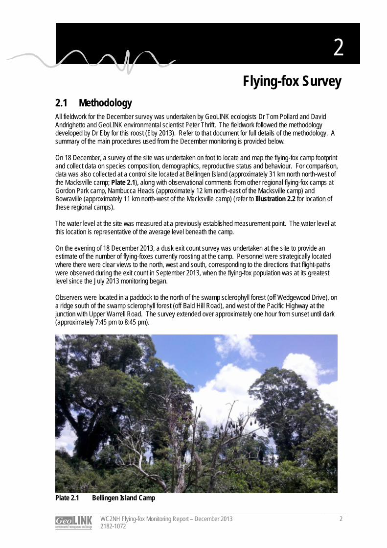
2
WC2NH Flying-fox Monitoring Report – December 2013 2182-1072
2
2. Flying-fox Survey 2.1 Methodology All fieldwork for the December survey was undertaken by GeoLINK ecologists Dr Tom Pollard and David Andrighetto and GeoLINK environmental scientist Peter Thrift. The fieldwork followed the methodology developed by Dr Eby for this roost (Eby 2013). Refer to that document for full details of the methodology. A summary of the main procedures used from the December monitoring is provided below. On 18 December, a survey of the site was undertaken on foot to locate and map the flying-fox camp footprint and collect data on species composition, demographics, reproductive status and behaviour. For comparison, data was also collected at a control site located at Bellingen Island (approximately 31 km north north-west of the Macksville camp; Plate 2.1), along with observational comments from other regional flying-fox camps at Gordon Park camp, Nambucca Heads (approximately 12 km north-east of the Macksville camp) and Bowraville (approximately 11 km north-west of the Macksville camp) (refer to Illustration 2.2 for location of these regional camps). The water level at the site was measured at a previously established measurement point. The water level at this location is representative of the average level beneath the camp. On the evening of 18 December 2013, a dusk exit count survey was undertaken at the site to provide an estimate of the number of flying-foxes currently roosting at the camp. Personnel were strategically located where there were clear views to the north, west and south, corresponding to the directions that flight-paths were observed during the exit count in September 2013, when the flying-fox population was at its greatest level since the July 2013 monitoring began. Observers were located in a paddock to the north of the swamp sclerophyll forest (off Wedgewood Drive), on a ridge south of the swamp sclerophyll forest (off Bald Hill Road), and west of the Pacific Highway at the junction with Upper Warrell Road. The survey extended over approximately one hour from sunset until dark (approximately 7:45 pm to 8:45 pm).
Plate 2.1 Bellingen Island Camp
WC2NH Flying-fox Monitoring Report – December 2013 2182-1072
3
2.2 Results 2.2.1 Population Estimate – Exit Count An estimated 2500 flying-foxes were recorded during the exit count at the site on 18 December. The vast majority of flying-foxes (approximately 2000 individuals) were observed heading in a westerly direction (refer to Illustration 2.1). No exit counts were conducted at any of the other regional camps. However, rough population estimates for these camps based on extrapolation of counts in individual trees and the size of the camps are as follows: Gordon Park: >10,000 individuals; Bowraville: >10,000 individuals; and Bellingen Island: >10,000 individuals. 2.2.2 Roost Footprint The roost occupied an area within the Swamp Sclerophyll Forest at the site of approximately 0.32 ha and was located within the same general area in which flying-fox have previously been mapped in September and November 2013. The size of the roost has increased since November, when it occupied an approximate area of 0.08 ha. A maximum roost footprint of approximately 0.89 ha was recorded in September 2013. The roost footprint and location of demographic count points is displayed in Illustration 2.1. As has been previously recorded, the flying-fox are roosting in a dense stand of Broad-leaved Paperbark (Melaleuca quinquenervia). These trees averaged approximately 7 m in height with a diameter at breast height (DBH) less than 20 cm.
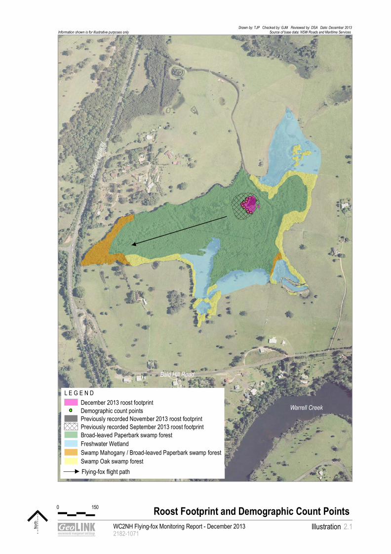
Flying-fox flight path
WC2NH Flying-fox Monitoring Report - December 20132182-1071
Illustration
Roost Footprint and Demographic Count Points
North 2.1
Drawn by: TJP Checked by: GJM Reviewed by: DSA Date: December 2013Source of base data: NSW Roads and Maritime Services Information shown is for illustrative purposes only
L E G E N D December 2013 roost footprintDemographic count pointsPreviously recorded November 2013 roost footprintPreviously recorded September 2013 roost footprintBroad-leaved Paperbark swamp forestFreshwater WetlandSwamp Mahogany / Broad-leaved Paperbark swamp forestSwamp Oak swamp forest
Warrell Creek
Bald Hill Road
Pacif
ic Hi
ghwa
y
0 150

0
100
200
300
400
500
600
700
800
900
1000
1100
120 0
130 0
140 0
150 0
160 0
170 0
180 0
190 0
200 0
210 0
220 0
230 0
2400
2500
2600
2700
2800
290 0
300 0
310 0
320 0
330 0
340 0
350 0
360 0
370 0
380 0
390 0
400 0
410 0
420 0
430 0
440 0
4500
4600
4700
4800
4900
5000
5100
520 0
530 0
540 0
550 0
560 0
570 0
580 0
590 0
600 0
610 0
620 0
630 0
640 0
650 0
660 0
670 0
680 0
690 0
700 0
710 0
720 0
730 0
740 0
750 0
760 0
770 0
780 0
790 0
800 0
810 0
820 0
830 0
840 0
850 0
860 0
870 0
880 0
890 0
205 00
206 00
207 00
208 00
209 00
32500
32600
32700
32800
32900
116 00
117 00
118 00
119 00
120 00
221 00
222 00
223 00
224 00
22500
22600
22700
22800
22900
23000
341 00
342 00
343 00
344 00
345 00
900 0
910 0
920 0
930 0
940 0
950 0
960 0
970 0
980 0
990 0
100 00
101 00
102 00
103 00
104 00
105 00
106 00
107 00
10800
10900
11000
11100
11200
113 00
114 00
115 00
121 00
122 00
123 00
124 00
125 00
126 00
127 00
128 00
129 00
130 00
131 00
132 00
133 00
134 00
135 00
136 00
137 00
138 00
139 00
140 00
141 00
142 00
143 00
144 00
145 00
146 00
147 00
148 00
149 00
150 00
151 00
152 00
153 00
154 00
155 00
156 00
157 00
158 00
159 00
160 00
161 00
162 00
163 00
16400
16500
16600
16700
16800
16900
170 00
171 00
172 00
173 00
174 00
175 00
176 00
177 00
178 00
179 00
180 00
181 00
182 00
18300
18400
18500
18600
18700
18800
18900
19000
191 00
192 00
193 00
194 00
195 00
196 00
197 00
198 00
199 00
200 00
201 00
202 00
203 00
204 00
210 00
211 00
212 00
213 00
214 00
215 00
216 00
217 00
218 00
219 00
220 00
23100
23200
23300
23400
23500
23600
237 00
238 00
239 00
240 00
241 00
242 00
243 00
244 00
245 00
246 00
247 00
24800
24900
25000
25100
25200
25300
25400
25500
25600
25700
258 00
259 00
260 00
261 00
262 00
263 00
264 00
265 00
266 00
267 00
268 00
269 00
270 00
271 00
272 00
273 00
274 00
275 00
276 00
277 00
278 00
279 00
280 00
281 00
282 00
283 00
284 00
285 00
286 00
287 00
288 00
289 00
290 00
291 00
292 00
293 00
294 00
295 00
296 00
297 00
298 00
299 00
300 00
301 00
302 00
303 00
304 00
305 00
306 00
307 00
308 00
309 00
310 00
311 00
312 00
313 00
314 00
315 00
316 00
317 00
318 00
319 00
320 00
32100
32200
32300
32400
33000
33100
33200
33300
33400
335 00
336 00
337 00
338 00
339 00
340 00
346 00
347 00
348 00
349 00
350 00
351 00
352 00
353 00
354 00
355 00
356 00
357 00
358 00
359 00
360 00
361 00
362 00
363 00
364 00
365 00
366 00
367 00
368 00
369 00
370 00
371 00
372 00
373 00
374 00
375 00
376 00
377 00
378 00
379 00
380 00
381 00
38200
38300
38400
38500
38600
38700
38800
38900
39000
39100
39200
39300
39400
39500
39600
39700
39800
39900
40000
40100
402 00
403 00
404 00
405 00
406 00
407 00
408 00
409 00
410 00
411 00
412 00
413 00
414 00
415 00
416 00
417 00
417 98
411 82
NAMBUCCA HEADS
Bellingen Island camp
Gordon Park camp
Bowraville camp
Macksville camp
BOWRAVILLE
BELLINGEN
MACKSVILLE
CH 0
CH19500
Pacif
ic Hi
ghwa
y
Location of Flyng-fox camps
The Site Note - the extent of the WC2NH project is highlighted in red
0 4 km
WC2NH Flying-fox Monitoring Report - December 2013 2182-1059
IllustrationLocation of Regional Flying-fox camps
North 2.2
Drawn by: TJP Checked by: MVE Reviewed by: DSA Date: November 2013Source of base data: Roads and Maritime ServicesInformation shown is for illustrative purposes only
L E G E N D WC2U Project boundary
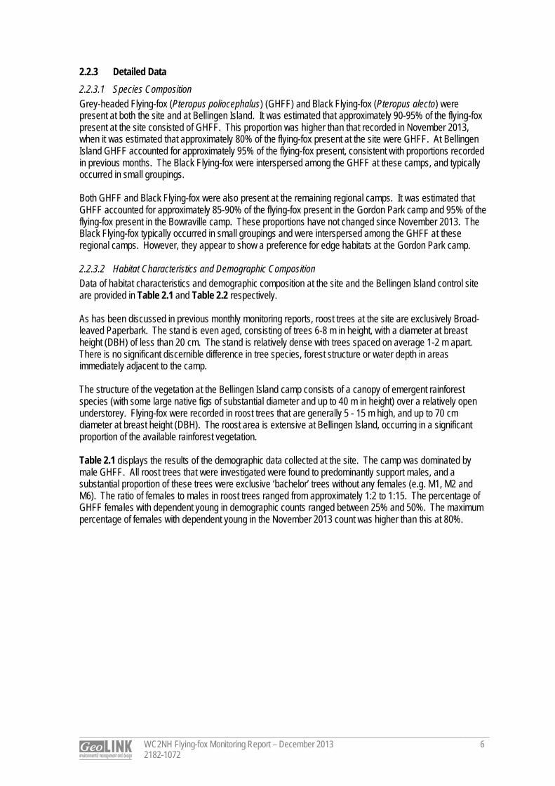
WC2NH Flying-fox Monitoring Report – December 2013 2182-1072
6
2.2.3 Detailed Data 2.2.3.1 Species Composition Grey-headed Flying-fox (Pteropus poliocephalus) (GHFF) and Black Flying-fox (Pteropus alecto) were present at both the site and at Bellingen Island. It was estimated that approximately 90-95% of the flying-fox present at the site consisted of GHFF. This proportion was higher than that recorded in November 2013, when it was estimated that approximately 80% of the flying-fox present at the site were GHFF. At Bellingen Island GHFF accounted for approximately 95% of the flying-fox present, consistent with proportions recorded in previous months. The Black Flying-fox were interspersed among the GHFF at these camps, and typically occurred in small groupings. Both GHFF and Black Flying-fox were also present at the remaining regional camps. It was estimated that GHFF accounted for approximately 85-90% of the flying-fox present in the Gordon Park camp and 95% of the flying-fox present in the Bowraville camp. These proportions have not changed since November 2013. The Black Flying-fox typically occurred in small groupings and were interspersed among the GHFF at these regional camps. However, they appear to show a preference for edge habitats at the Gordon Park camp. 2.2.3.2 Habitat Characteristics and Demographic Composition Data of habitat characteristics and demographic composition at the site and the Bellingen Island control site are provided in Table 2.1 and Table 2.2 respectively. As has been discussed in previous monthly monitoring reports, roost trees at the site are exclusively Broad-leaved Paperbark. The stand is even aged, consisting of trees 6-8 m in height, with a diameter at breast height (DBH) of less than 20 cm. The stand is relatively dense with trees spaced on average 1-2 m apart. There is no significant discernible difference in tree species, forest structure or water depth in areas immediately adjacent to the camp. The structure of the vegetation at the Bellingen Island camp consists of a canopy of emergent rainforest species (with some large native figs of substantial diameter and up to 40 m in height) over a relatively open understorey. Flying-fox were recorded in roost trees that are generally 5 - 15 m high, and up to 70 cm diameter at breast height (DBH). The roost area is extensive at Bellingen Island, occurring in a significant proportion of the available rainforest vegetation. Table 2.1 displays the results of the demographic data collected at the site. The camp was dominated by male GHFF. All roost trees that were investigated were found to predominantly support males, and a substantial proportion of these trees were exclusive ‘bachelor’ trees without any females (e.g. M1, M2 and M6). The ratio of females to males in roost trees ranged from approximately 1:2 to 1:15. The percentage of GHFF females with dependent young in demographic counts ranged between 25% and 50%. The maximum percentage of females with dependent young in the November 2013 count was higher than this at 80%.
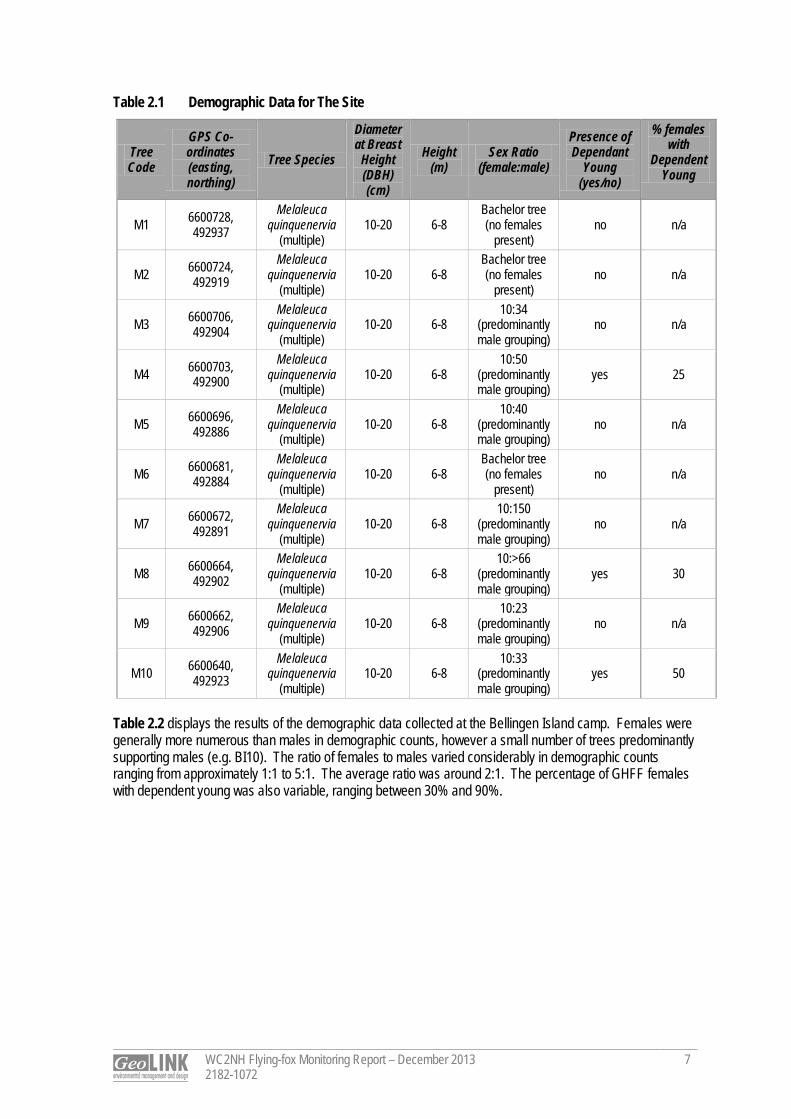
WC2NH Flying-fox Monitoring Report – December 2013 2182-1072
7
Table 2.1 Demographic Data for The Site
Tree Code
GPS Co-ordinates (easting, northing)
Tree Species
Diameter at Breast
Height (DBH) (cm)
Height (m)
Sex Ratio (female:male)
Presence of Dependant
Young (yes/no)
% females with
Dependent Young
M1 6600728, 492937
Melaleuca quinquenervia
(multiple) 10-20 6-8
Bachelor tree (no females
present) no n/a
M2 6600724, 492919
Melaleuca quinquenervia
(multiple) 10-20 6-8
Bachelor tree (no females
present) no n/a
M3 6600706, 492904
Melaleuca quinquenervia
(multiple) 10-20 6-8
10:34 (predominantly male grouping)
no n/a
M4 6600703, 492900
Melaleuca quinquenervia
(multiple) 10-20 6-8
10:50 (predominantly male grouping)
yes 25
M5 6600696, 492886
Melaleuca quinquenervia
(multiple) 10-20 6-8
10:40 (predominantly male grouping)
no n/a
M6 6600681, 492884
Melaleuca quinquenervia
(multiple) 10-20 6-8
Bachelor tree (no females
present) no n/a
M7 6600672, 492891
Melaleuca quinquenervia
(multiple) 10-20 6-8
10:150 (predominantly male grouping)
no n/a
M8 6600664, 492902
Melaleuca quinquenervia
(multiple) 10-20 6-8
10:>66 (predominantly male grouping)
yes 30
M9 6600662, 492906
Melaleuca quinquenervia
(multiple) 10-20 6-8
10:23 (predominantly male grouping)
no n/a
M10 6600640, 492923
Melaleuca quinquenervia
(multiple) 10-20 6-8
10:33 (predominantly male grouping)
yes 50
Table 2.2 displays the results of the demographic data collected at the Bellingen Island camp. Females were generally more numerous than males in demographic counts, however a small number of trees predominantly supporting males (e.g. BI10). The ratio of females to males varied considerably in demographic counts ranging from approximately 1:1 to 5:1. The average ratio was around 2:1. The percentage of GHFF females with dependent young was also variable, ranging between 30% and 90%.
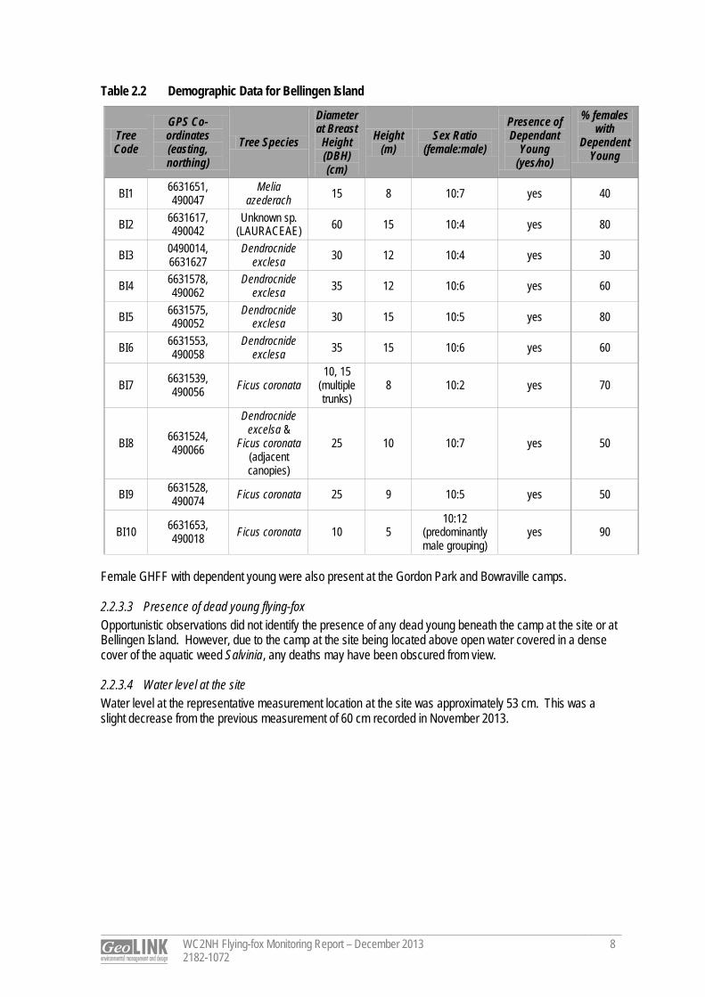
WC2NH Flying-fox Monitoring Report – December 2013 2182-1072
8
Table 2.2 Demographic Data for Bellingen Island
Tree Code
GPS Co-ordinates (easting, northing)
Tree Species
Diameter at Breast
Height (DBH) (cm)
Height (m)
Sex Ratio (female:male)
Presence of Dependant
Young (yes/no)
% females with
Dependent Young
BI1 6631651, 490047
Melia azederach 15 8 10:7 yes 40
BI2 6631617, 490042
Unknown sp. (LAURACEAE) 60 15 10:4 yes 80
BI3 0490014, 6631627
Dendrocnide exclesa 30 12 10:4 yes 30
BI4 6631578, 490062
Dendrocnide exclesa 35 12 10:6 yes 60
BI5 6631575, 490052
Dendrocnide exclesa 30 15 10:5 yes 80
BI6 6631553, 490058
Dendrocnide exclesa 35 15 10:6 yes 60
BI7 6631539, 490056 Ficus coronata
10, 15 (multiple trunks)
8 10:2 yes 70
BI8 6631524, 490066
Dendrocnide excelsa &
Ficus coronata (adjacent canopies)
25 10 10:7 yes 50
BI9 6631528, 490074 Ficus coronata 25 9 10:5 yes 50
BI10 6631653, 490018 Ficus coronata 10 5
10:12 (predominantly male grouping)
yes 90
Female GHFF with dependent young were also present at the Gordon Park and Bowraville camps. 2.2.3.3 Presence of dead young flying-fox Opportunistic observations did not identify the presence of any dead young beneath the camp at the site or at Bellingen Island. However, due to the camp at the site being located above open water covered in a dense cover of the aquatic weed Salvinia, any deaths may have been obscured from view. 2.2.3.4 Water level at the site Water level at the representative measurement location at the site was approximately 53 cm. This was a slight decrease from the previous measurement of 60 cm recorded in November 2013.
WC2NH Flying-fox Monitoring Report – December 2013 2182-1072
9
2.3 Discussion 2.3.1 Population Estimate The flying-fox population estimate at the site of 2500 as recorded in the exit count on 18 December indicates that there has been a minor increase in flying-fox numbers since the previous monthly count in November 2013 when 1200 flying fox were counted. This is also reflected in an increased camp footprint (refer to Illustration 2.1). However, the number of individuals is still relatively low when compared to the peak of >10,000 individuals recorded in September 2013. The number of individuals at the site is also relatively low compared with other regional camps that were visited in December, all of which were estimated to be supporting >10,000 flying-foxes. Numbers at the Gordon Park and Bellingen camps appear to have remained relatively stable between November and December. The trend of increasing numbers of flying-fox at the Bowraville camp between October and November has continued into December, with a substantial increase in numbers from around 5,000 to >10,000. The camp footprint has also expanded. It should be noted that no exit counts were conducted at these regional camps, and consequently the population estimates for these camps are less reliable than that made for the site. No population estimate of GHFF is available for the site in December of the previous year. However, flying-fox were present at the site during November/ early December 2011 when the presence of a flying-fox camp was first noted (Eby 2012). Satellite-tracking undertaken by John Martin at the Royal Botanic Garden and Domain Trust (RBGDT) indicates that adult female GHFF individuals were present at the site in December 2012. Satellite-tracked individuals were also recorded at the site in each subsequent month through to May 2013 (data courtesy of John Martin, RBGDT, unpublished). 2.3.2 Species Composition and Demographic Data Both GHFF and Black Flying-fox were present at all camps sampled in the current monitoring event. GHFF dominated the species composition at all camps, and varied from approximately 80% of individuals present at the site to >95% of individuals present at Bellingen Island and Bowraville. This is consistent with the results from previous monthly monitoring. For GHFF, the percentage of adult females in the population increases in association with population size (Eby 2012). This is supported by the results of the November survey in which the average female to male ratio at the Bellingen Island camp was higher than at the site, where a significantly smaller number of individuals were present (refer to Table 2.1 and Table 2.2). The proportion of female GHFF recorded at the site in December 2013 was considerably lower than that recorded in November 2013. Very small camps (< 500) are often dominated by adult males and sub‐adults and the percentage of adult females in the population generally increases in association with population size (Eby 2012). Although there was a minor increase in overall numbers of flying-fox at the site between November and December 2013, there was no corresponding increase in the overall proportion of females occupying the camp. The driving factor/s leading to lower female flying-fox numbers at the site during the current monitoring event remain unclear. Depending on the nature of the flowering of highly productive species (e.g. species of Corymbia) within the broad locality over the summer period, the GHFF population at the site is expected to reach a maximum over the next few months. If flowering of these key foraging tree species is strong, the results of the January 2014 monitoring may show an increase in the proportion of females and young occupying the camp as the overall number of individuals at the camp increases For the 2013 breeding season, it was surmised that births of GHFF commenced on or around 3 October within the region (refer to October monthly monitoring report - GeoLINK 2013). The demographic data collected at the site, and at regional camps, indicates that the camp is currently supporting dependent young GHFF that will not be fully independent until approximately March. Flightless young are typically left at a camp while females forage in late November (Eby 2012). No calls of flightless young were heard during the exit count on 18 December. This may reflect the low number of young that were recorded in the camp during this month’s monitoring.
WC2NH Flying-fox Monitoring Report – December 2013 2182-1072
10
2.3.3 Phenology of Trees in Region Flowering of Corymbia species such as Pink Bloodwood (C. intermedia), Red Bloodwood (C. gummifera) and Spotted gum (C. maculata / C. variegata) as well as Grey Ironbark (Eucalyptus siderophloia) (foothills and ranges) occurs in December in the upper North Coast region of NSW. These trees are recognised as highly productive species in this region and can be considered key diet species for GHFF (Eby 2012; Eby and Law 2008). In most years it is typical that a summer maximum in GHFF population occurs coinciding with the flowering of a number of highly productive nectar producing trees, particularly Pink Bloodwood or Grey Ironbark (Eby 2012). 2.4 Conclusion The results of the December 2013 flying-fox monitoring indicated that flying-foxes have increased in numbers at the site between November and December (from approximately 1200 individuals to 2500 individuals. This population size is substantially less than was recorded in September 2013 when >10,000 individuals were present. GHFF dominates the site and other regional camps visited in the monitoring representing over 80% of all individuals. All of the regional camps visited during the monitoring, including the site, were supporting female flying-fox with dependent young at the time of the December 2013 survey. A lower proportion of female GHFF were recorded occupying the site in December 2013 compared with the November monitoring results. This is despite an increase in the overall population size. Results of the next seasonal monitoring event in January 2014 may clarify whether this is an ongoing trend at the site or represents short-term variability in population characteristics in response to local resource availability.
Dr Tom Pollard Ecologist
References
WC2NH Flying-fox Monitoring Report – December 2013 2182-1072
11
Eby, P. and Law, B. (2008). Ranking the feeding habitat of Grey‐headed flying foxes for conservation management. Department of Environment, Heritage, Water and the Arts, Canberra. Eby, P. (2012). An Assessment of the Flying-fox Camp at Macksville. Unpublished report to NSW Roads and Maritime Services. Eby, P. (2013). A Field Monitoring Program Proposed for the Macksville Flying-fox Roost. Unpublished report to Sinclair Knight Merz. GeoLINK (2013). WC2NH Flying-fox Monitoring Report – October 2013. Unpublished report to Sinclair Knight Merz and the NSW Roads and Maritime Services. GeoLINK, Lennox Head.

WC2NH Flying-fox Monitoring Report – December 2013 2182-1072
12