Florida Bay Boating Routes and Zones - National Park Service · corridor On-Plane Safe Speed c orid...
13
9 4 7 6 1 2 3 8 5 11 12 10 Esri, DeLorme, GEBCO, NOAA NGDC, and other contributors 80°25'0"W 80°25'0"W 80°30'0"W 80°30'0"W 80°35'0"W 80°35'0"W 80°40'0"W 80°40'0"W 80°45'0"W 80°45'0"W 80°50'0"W 80°50'0"W 80°55'0"W 80°55'0"W 81°0'0"W 81°0'0"W 81°5'0"W 81°5'0"W 25°15'0"N 25°15'0"N 25°10'0"N 25°10'0"N 25°5'0"N 25°5'0"N 25°0'0"N 25°0'0"N 24°55'0"N 24°55'0"N National Park Service U.S. Department of the Interior Florida Bay Boating Routes and Zones Everglades National Park Florida
-
Upload
nguyenkhue -
Category
Documents
-
view
214 -
download
0
Transcript of Florida Bay Boating Routes and Zones - National Park Service · corridor On-Plane Safe Speed c orid...

9
4
76
1 2 3
85
11 1210
Esri, DeLorme, GEBCO, NOAA NGDC, and other contributors
80°25'0"W
80°25'0"W
80°30'0"W
80°30'0"W
80°35'0"W
80°35'0"W
80°40'0"W
80°40'0"W
80°45'0"W
80°45'0"W
80°50'0"W
80°50'0"W
80°55'0"W
80°55'0"W
81°0'0"W
81°0'0"W
81°5'0"W
81°5'0"W
25°1
5'0"N
25°1
5'0"N
25°1
0'0"N
25°1
0'0"N
25°5
'0"N
25°5
'0"N
25°0
'0"N
25°0
'0"N
24°5
5'0"N
24°5
5'0"N
National Park ServiceU.S. Department of the Interior
Florida Bay Boating Routes and Zones
Everglades National ParkFlorida

[t
[t
"n
£
!@¬
Tin Can Channel
Snak
e Big
ht
South Joe
River C hickee
Campsite
Clubhou se
Beach
Campsite Dave
Foy
Chan
nel
CoastalPrairie
Joe River
Little Fox Lake
Fox Lakes Coot Bay
Middle Fox Lake
Mud LakeEast Fox Lake
Homestead Canal Bear LakeTrail
Bear LakeGator Lake
Roberts Prairie
ChristianPoint TrailRaulerson PrairieEast Cape Canal Coastal Prairie Trail Flamingo
CampgroundSlagle DitchHouse Ditch
Curry Key Bradley Key
Joe KempChannelFra
nk
Key
Chan
nel
Butt
onw
ood
Can
al
East CapeCanal
Coot Bay Canal
T
arpon Cre
ek
Coot Bay
Bear Lake Canoe Trail
Mud
Lake
Canoe Trail
Whitew
ate rB
ay
Bear Lake Canoe Trail (currently impassable)
Bradley Key
The Flats
Fla
mi n
go
Ch
ann
el
Esri, DeLorme, GEBCO, NOAA NGDC, and other contributors
National Park ServiceU.S. Department of the Interior
Florida Bay
Everglades National Park Florida
Map Key¬ Visitor Center!@ Ranger Station£ Picnic Area"n Marina[t Campsite
Hiking trailGulf Coast
Wilderness Waterway -On Plane Safe SpeedId le Speed-No WakePaddling Tra il
Florida BayId le Speed-No WakecorridorOn-Plane Safe SpeedcorridorId le speed/No WakePole/Tro ll ZonePole/Tro ll/Id le ZoneFrontcountrySpecial protection zone
Page 1
Á0 1 20.5
Miles
Date: 3/6/2017

[t
[t
[t
[t
£Lard Can
Campsite
Shark Poin t
Chickee C amp site
Alligator
Creek
Campsite
TerrapinChannel
Chri s
tanPoi n t Tr a
il
Snak
eBig
htTra
l
East River
Noble HammockNoble Hammock Canoe Trail
Rookery KeyWest LakeCuthbert Lake
Saint Marys Cathedral Little Henry LakeLong Lake Henry Lake
SnakeBight Canal Crocodile Point TrailMrazek
Pond
Garfield Bight OysterCreekMonroe
LakeLungs, TheAlligator Creek
Gibby Point Snake BightPorpoise Point
Santini BightRankin Bight
Derelict KeyOtter Key
MosquitoPointUmbrella Key
Rankin Key
Buoy Key
Terra
pin
Ch a
nne
l
P a l mKey
C h an n el
Dave
Foy C
han
nel
Coot Bay Canal
H
ells BayCanoeTrail
Noble Hammock
West Lake Canoe Trail
Porpoise Pt .
Snak
eBight East
Te
rr
ap
i n
W e s t
San
t ini B
i gh
t Ea
st
Sa
nt
in
i
Bi
gh
t
We
st
Ra
nk
in
Bi
gh
t
Ga
rf
ie
ld
B
ig
ht
Ea
st
Pa
lm
K
ey
McC
orm
ick C
reek
The Flats
Sn
ak
eB
ig
ht
T i nC a n C h a n n e l
Esri, DeLorme, GEBCO, NOAA NGDC, and other contributors
National Park ServiceU.S. Department of the Interior
Florida Bay
Everglades National Park Florida
Map Key[t Campsite
Hiking trailGulf Coast
Id le Speed-No WakePaddling Tra il
Florida BayId le Speed-No WakecorridorOn-Plane Safe SpeedcorridorId le Speed/No WakecorridorId le speed/No WakePole/Tro ll ZoneSpecial protection zone
Page 2
Á0 1 20.5
Miles
Date: 3/6/2017

Eag
le K
ey
Pa
ss
Joe Bay
Bryan MemorialChurch
Davis Creek
Alligator BayMud Creek
East Creek
Taylor RiverLittle Madeira HammockFan Palm HammockLittle Madeira Bay
Middle LakeEagle Key Pass
Maderia HammockEagle Key
Madeira BayPass Key
Lake Key Pass
Terrapin Point Maderia PointLake Key
Big Key
Black Betsy Keys Park Key
Triplet Keys
Madeira Bay
Te
rr
ap
in
C h a
nn
el
Terrapin West
McC
orm
ick Cree
k
Ma
de
ira B
ay
Pass K
ey
Cr oc od i l e Dr ago ve r
C r oco d i le D r a g o v e r
Esri, DeLorme, GEBCO, NOAA NGDC, and other contributors
National Park ServiceU.S. Department of the Interior
Florida Bay
Everglades National Park Florida
Map KeyFlorida Bay
Id le Speed-No WakecorridorOn-Plane Safe SpeedcorridorId le Speed/No WakecorridorPole/Tro ll ZonePole/Tro ll/Id le ZoneBackcountrySpecial protection zone
Page 3
Á0 1 20.5
Miles
Date: 3/6/2017
[t
Stump
Pass
Tro
ut
Cre
e k
Lit tl e Buttonwood Sound
Joe Bay
No rth Nest
Key Camp site
Main KeyBay Point
Manatee Creek
Cormorant RookeriesJoe BayLong Sound
Long Sound PassDivision Point
Little Blackwater SoundTrout CoveDavis Cove
Shell KeyStump Pass
Cross KeyDeer Key
Duck Key
Snake PointBlackwater Sound
Stellrecht PointTern Keys
Boggy KeyNest Keys Bush Point
PortLargoPlazaLittle Buttonwood SoundPorjoe Key
Largo SoundWhaleback Key
Grouper Creek Tarpon Basin
Buttonwood Sound
North
Nest
Key
Trout C
reek
Little Bla
ckw
ater P
ass
Tarp
on Bas
in
Shel
l Cre
ek
The Boggies
Esri, DeLorme, GEBCO, NOAA NGDC, and other contributors
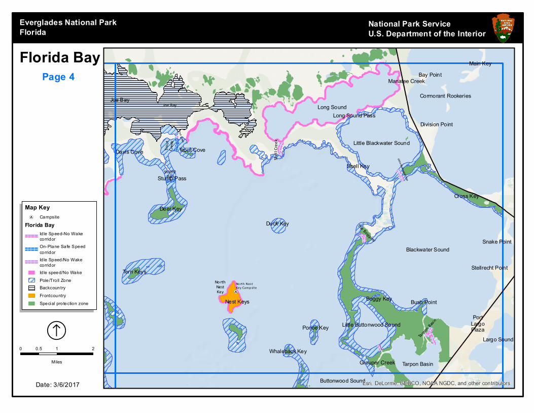
National Park ServiceU.S. Department of the Interior
Florida Bay
Everglades National Park Florida
Map Key[t Campsite
Florida BayId le Speed-No WakecorridorOn-Plane Safe SpeedcorridorId le Speed/No WakecorridorId le speed/No WakePole/Tro ll ZoneBackcountryFrontcountrySpecial protection zone
Page 4
Á0 1 20.5
Miles
Date: 3/6/2017

[t
[t
Tin Can Channel
Fla
min
go
Ch
ann
el
Joh nso n Key
Campsite
Dave
Foy
Channel
Joe Kemp Channel
Murray KeyOyster KeysMiddle Ground
Conchie Channel Catfish Key
Clive KeyFirst National Bank
Sandy Key Basin
Carl Ross Key Sandy Key Bank
Sandy KeyMan of War Key
Blue BankOxfoot Bank
Frank
Key
Ch
an
nel
Fr
an
k
Ke
y
I r o n P i p e
Ma
n o
f W
ar
Ro
ck
yC h a n n e l
C o n c h i e C ha n n
e l
Mu
rr
ay
Ke
ys
Esri, DeLorme, GEBCO, NOAA NGDC, and other contributors
National Park ServiceU.S. Department of the Interior
Florida Bay
Everglades National Park Florida
Map Key[t Campsite
On-Plane Safe SpeedcorridorId le Speed/No WakecorridorPole/Tro ll ZonePole/Tro ll/Id le ZoneFrontcountrySpecial protection zone
Page 5
Á0 1 20.5
Miles
Date: 3/6/2017

[t
Iron
Pipe
Joh nso n Key
Campsite
PalmKey
Channel Buoy KeyDump KeysPalm Key Camp Key
Cormorant Key
Conchie Basin Curlew Key
Roscoe Key
Whipray Basin
Pelican Keys Jim Foot Key
Dildo KeyCoon Key
Whipray Channel
Topsy KeyDead Terrapin KeyDildo Key Bank
Corinne KeyCluett Key
Sid Key
Spy Key
Florida Bay
Rabbit Key Basin
Rosc o e
Chan n el
D u m p Ke yC h a n n el
Co
on
K e y
Pa
s
s
Da
ve
Fo
y
Ch
an
ne
l
Sid K
ey
Tops y K
ey Chan
nel
Cl
ue
tt
Ke
y
Pa
lm
K
e
y
Sp
y K e y s
Tin Can Channel
3 S i s t e r s B a s i n
T i n C a n C h a n n e l
Esri, DeLorme, GEBCO, NOAA NGDC, and other contributors
National Park ServiceU.S. Department of the Interior
Florida Bay
Everglades National Park Florida
Map Key[t Campsite
On-Plane Safe SpeedcorridorId le Speed/No WakecorridorPole/Tro ll ZoneSpecial protection zone
Page 6
Á0 1 20.5
Miles
Date: 3/6/2017

3 S isters Basin
Spy Keys
Stak
e an
d Lo
we
Cap
tain
Ke
y
Ma
na
tee P
ass
East o
f
West K
ey
Triplet Keys
Samphire KeysBob Keys
Club KeyBrush KeysEnd Key
Russell KeyButtonwood Keys
Manatee KeysManatee Pass
Jimmie Channel Stake Key
Low KeyCalusa Keys
Bob Allen Keys
Captain Key
Pollock Keys
Cross Bank
Crane KeysEast KeyPanhandle Key
North
Jimm
yC o o n K e y
P a ss
Bob AllenPa
ss
Bru
sh K
ey
Samphire Creek
Tw
i
st y
Mi l e
Bu
tto
nw
oo
d K
eys
Ch
an
ne
l
South J immy
Crane Key
NW
of C
rab K
eys
Bottle Keys
Panhan
dle K
eys
Crab K
ey
Cro
ss B
ank
Calusa Keys
West o
f Calu
sa Ke
ysEsri, DeLorme, GEBCO, NOAA NGDC, and other contributors
National Park ServiceU.S. Department of the Interior
Florida Bay
Everglades National Park Florida
Map KeyOn-Plane Safe SpeedcorridorId le Speed/No WakecorridorPole/Tro ll ZonePole/Tro ll/Id le ZoneSpecial protection zone
Page 7
Á0 1 20.5
Miles
Date: 3/6/2017

!@
Bleach Bott le Pass
Grouper Creek Tarpon Basin
Buttonwood Sound
South CreekSwash KeysLower Sound PointSaint Margarets Church
Shell KeyKey Largo Baptist Temple
First BaptistChurchBaker Cut Saint James
the FishermanChurch
Sunset CoveButternut Key Key
Largo Christian AcademyRock HarborSaint James the
FishermanEpiscopal Church Tavernier Towne II Shopping Center
Bottle Key
Pigeon Key
Rodriguez KeyUpper Cross Bank Dove KeySunset Point
Thompson
DoveCreek
Long PointRamshorn Shoal Hammer Point DoveSound
Ramshorn CutBurton
MemorialUnited Church
Mariners HospitalTavernier
TrianglesTavernaeroPark Airport Tavernier Harbor
Cowpens Cut Lowe, PointImmanuel
Church Tavernier KeyKalteux Key
Bottle Keys
Esri, DeLorme, GEBCO, NOAA NGDC, and other contributors
National Park ServiceU.S. Department of the Interior
Florida Bay
Everglades National Park Florida
Map Key!@ Ranger Station
On-Plane Safe SpeedcorridorPole/Tro ll ZoneSpecial protection zone
Page 8
Á0 1 20.5
Miles
Date: 3/6/2017

Nin
eM
ilie Ban
kN
or
th
Blue BankOxfoot Bank
Schooner Bank
Sprigger Bank
Iron Pipe
Esri, DeLorme, GEBCO, NOAA NGDC, and other contributors
National Park ServiceU.S. Department of the Interior
Florida Bay
Everglades National Park Florida
Map KeyOn-Plane Safe SpeedcorridorSlow speed-Min WakecorridorPole/Tro ll ZonePole/Tro ll/Id le Zone
Page 9
Á0 1 20.5
Miles
Date: 3/6/2017

[tLittle Rabbit Key
Iron Pipe
Nine
Mil
ie
BankSo
uth
Little Rabbit
Key Camp site
Florida Bay
Rabbit Key BasinRabbit Keys
Gopher Keys
Twin Keys
Ninemile BankTwin Key Bank
Barnes Key
Upper Arsnicker Keys
Green Mangrove KeyLower Arsnicker Keys Buchanan Keys
Buchanan BankPeterson Keys
Pontoon BankArsenic Bank
Yacht Channel
Buchanan Keys Channel
Pete
rso
n K
eys
Ch
an
nel
Crab Lake
Gopher Keys
Barn
es Ke
yRabbit Keys
Esri, DeLorme, GEBCO, NOAA NGDC, and other contributors
National Park ServiceU.S. Department of the Interior
Florida Bay
Everglades National Park Florida
Map Key[t Campsite
On-Plane Safe SpeedcorridorSlow speed-Min WakecorridorPole/Tro ll ZoneFrontcountrySpecial protection zone
Page 10
Á0 1 20.5
Miles
Date: 3/6/2017

NW
of C
rab K
eys
Gopher Keys
East KeyPanhandle Key
Crab Keys
West Key
Cotton Key Basin
Plantation Key Seaplane Base
Ironwood ChannelCotton Key WCTH-FM
(PlantationKey)Snake Creek Treasure
HarborWindley Key
Wilson KeyShell Key Bank Whale HarborSteamboat Channel Whale Harbor Channel
Holiday Isle Seaplane BaseIsland Community Church
Lignumvitae Basin
IslamoradaShell Key ShellKey
ChannelIsland Christian
SchoolLignumvitae Key Aquatic Preserve Little
BasinHok, TheRace Channel
Peterson Key BankBowlegs Cut Lignumvitae Key
Islamorada Underwater Coral GardensTeatable KeyChannel
Teatable KeyLignumvitae Key BankLignumvitae ChannelIndian Key Channel
Indian KeyIndian Key AnchorageMatecumbe Bight
Matecumbe Keys
Ironwood
Panhan
dle K
eys
Crab K
ey
South of Crab Keys
East o
f We
st Ke
y
Esri, DeLorme, GEBCO, NOAA NGDC, and other contributors
National Park ServiceU.S. Department of the Interior
Florida Bay
Everglades National Park Florida
Map KeyOn-Plane Safe SpeedcorridorPole/Tro ll ZoneSpecial protection zone
Page 11
Á0 1 20.5
Miles
Date: 3/6/2017

ImmanuelChurch Tavernier Key
Kalteux KeyPickles ReefSan Pedro Church
Plantation
Conch Reef
Rocks, The Little Conch Reef
Hen and Chickens
Davis ReefDavis Reef Light 14
Crocker ReefBuoy 16
Esri, DeLorme, GEBCO, NOAA NGDC, and other contributors
National Park ServiceU.S. Department of the Interior
Florida Bay
Everglades National Park Florida
Map KeyPole/Tro ll Zone
Page 12
Á0 1 20.5
Miles
Date: 3/6/2017