Floods, Droughts, and Lawsuits: A Brief History of ... · PDF file1 19 Riverboats at the port...
52
1 19 Riverboats at the port of Sacramento, 1850. Floods, Droughts, and Lawsuits: A Brief History of California Water Policy The history of California in the twentieth century is the story of a state inventing itself with water. William L. Kahrl, Water and Power , 1982 California’s water system might have been invented by a Soviet bureaucrat on an LSD trip. Peter Passell, “Economic Scene: Greening California,” New York Times, 1991 California has always faced water management challenges and always will. e state’s arid and semiarid climate, its ambitious and evolving economy, and its continually growing population have combined to make shortages and conflicting demands the norm. Over the past two centuries, California has tried to adapt to these challenges through major changes in water manage- ment. Institutions, laws, and technologies are now radically different from those brought by early settlers coming to California from more humid parts of the United States. ese adaptations, and the political, economic, technologic, and social changes that spurred them on, have both alleviated and exacerbated the current conflicts in water management. is chapter summarizes the forces and events that shaped water man- agement in California, leading to today’s complex array of policies, laws, and infrastructure. ese legacies form the foundation of California’s contemporary water system and will both guide and constrain the state’s future water choices. 1 1. Much of the description in this chapter is derived from Norris Hundley Jr.’s outstanding book, e Great irst: Californians and Water: A History (Hundley 2001), Robert Kelley’s seminal history of floods in the Central Valley, Battling the Inland Sea (Kelley 1989), and Donald Pisani’s influential study of the rise of irrigated agriculture in California, From the Family Farm to Agribusiness: e Irrigation Crusade in California (Pisani 1984). MPI/GETTY IMAGES
Transcript of Floods, Droughts, and Lawsuits: A Brief History of ... · PDF file1 19 Riverboats at the port...

1
19Riverboats at the port of Sacramento, 1850.
Floods, Droughts, and Lawsuits: A Brief History of California Water Policy
The history of California in the twentieth century is the story of a state inventing itself with water.
William L. Kahrl, Water and Power, 1982
California’s water system might have been invented by a Soviet bureaucrat on an LSD trip.
Peter Passell, “Economic Scene: Greening California,” New York Times, 1991
California has always faced water management challenges and always will. The state’s arid and semiarid climate, its ambitious and evolving economy, and its continually growing population have combined to make shortages and conflicting demands the norm. Over the past two centuries, California has tried to adapt to these challenges through major changes in water manage-ment. Institutions, laws, and technologies are now radically different from those brought by early settlers coming to California from more humid parts of the United States. These adaptations, and the political, economic, technologic, and social changes that spurred them on, have both alleviated and exacerbated the current conflicts in water management.
This chapter summarizes the forces and events that shaped water man-agement in California, leading to today’s complex array of policies, laws, and infrastructure. These legacies form the foundation of California’s contemporary water system and will both guide and constrain the state’s future water choices.1
1. Much of the description in this chapter is derived from Norris Hundley Jr.’s outstanding book, The Great Thirst: Californians and Water: A History (Hundley 2001), Robert Kelley’s seminal history of floods in the Central Valley, Battling the Inland Sea (Kelley 1989), and Donald Pisani’s influential study of the rise of irrigated agriculture in California, From the Family Farm to Agribusiness: The Irrigation Crusade in California (Pisani 1984).
MPI/Getty IMaGeS

20 Part I California Water
California’s Native Waterscape
California’s rivers, streams, and estuaries reflect its dynamic landscape and climate. Straddling the divide between the temperate rainforests of the Pacific Northwest and the arid deserts of the Southwest, California hosts the most complex and diverse range of climates anywhere in the United States. This geo-graphic diversity in climate is matched by its variability. Every year, California has a drought of six to seven months, with precipitation ending in April or May and largely absent again until November. Significant precipitation occurs only during the winter, with more than half of the state’s annual precipitation delivered in a handful of large storms from December through March. Year-to-year variations in streamflow are also large, with annual totals ranging from less than 25 percent of average to more than 200 percent of average over the past century.
This variable climate is superimposed on a landscape that is equally diverse. California’s rugged terrain, with large mountain ranges and adjacent alluvial valleys, coastal plains, and the Great Central Valley, processes and partitions its precipitation into snowpack, surface runoff, groundwater, and water returned to the atmosphere by evaporation and plant transpiration (together known as evapotranspiration).
The hallmark of California’s native waterscape was its remarkable physical diversity, which supported extraordinary biological diversity and abundance. California’s rivers were ideal for colonization by anadromous salmon and steel-head (fish species that live in ocean water but that swim inland to spawn). Each year, millions of adult salmon and steelhead spawned in California’s rivers and streams, carrying with them enormous volumes of ocean nutrients that enriched the state’s inland ecosystems. The Great Central Valley, with its extensive low-land floodplains and forests, was home to vast herds of elk and antelope, as well as beavers, otters, cougars, grizzly bears, and other species. Seasonal wetlands supported massive bird migrations along the Pacific Flyway. San Francisco Bay, at twice its current size, was one of the most productive estuaries in the lower 48 states. Upstream, the Sacramento–San Joaquin Delta was a 700,000-acre mosaic of tidal freshwater marsh, tidal channels, floodplains, and natural levees. The lower estuary was rimmed with salt and brackish marshes, which pro-vided spawning and rearing habitat for dozens of fish species. California also had several freshwater lakes greater in surface area than Lake Tahoe. Located principally in the upper Klamath River watershed and the Tulare Basin, these
Floods, Droughts, and Lawsuits 21
vast lakes were surrounded by thousands of acres of wetlands and supported large populations of fish, amphibians, turtles, and birds.
The biological productivity of the inland waters of California, when linked to the productivity of the Pacific Ocean, supported a large population of Native Californians with diverse and complex cultures. Before the arrival of Europeans, California had more than 300,000 inhabitants who spoke between 80 and 100 languages, making it among the most densely populated regions of North America (Anderson 2005; Lightfoot and Parrish 2009). This diverse human landscape, as well as the natural waterscape of California itself, would change irrevocably—first with Spanish and Mexican settlements and later (more dramatically) with the discovery of gold and the economic transforma-tion that ensued.
Spanish and Mexican Influences
The Spanish settled Alta California in 1769, conscripting thousands of Native Californians into labor, dividing the lands into missions, pueblos, and ranchos and establishing California’s first system of water rights. The missions and pueblos were located along rivers or smaller coastal streams, and their inhab-itants usually dug wells or diverted water, using small dams for domestic use and irrigation. Spanish law granted the missions and pueblos a preferential right to an adequate water supply for their residents, including water for irriga-tion. Following the U.S.-Mexico War in 1848, the Treaty of Guadalupe Hidalgo recognized all property rights established under Spanish and Mexican law. In a series of cases decided during the late 19th and early 20th centuries, the California Supreme Court ruled that California water rights law incorporated the Spanish law of pueblo rights. The largest beneficiary of these decisions was the City of Los Angeles; its pueblo rights gave it first call on all of the native waters of the Los Angeles River, as well as all hydrologically connected ground-water in the upper Los Angeles River Basin.
In contrast, Spanish law generally did not confer water rights on the more than 800 ranchos created before the U.S. acquisition of California. Spanish and Mexican land grants, therefore, were usually large enough to support cattle grazing on arid land, with small ranchos in the range of 15,000 to 20,000 acres and the largest exceeding 300,000 acres (Hundley 2001). California’s pattern of large agricultural landholdings partly derives from these land grants. Although some of the ranchos subsequently obtained water rights for irrigation (either

22 Part I California Water
by purchase or by judicial confirmation of prescriptive use), neither the ran-chos nor the pueblos significantly changed California’s native waterscape. Most diversions were small and for use on lands adjacent to the river or stream from which the water was diverted. Substantial alteration of California’s hydrologic systems would await the American takeover.
The Laissez-Faire Era of Water Development
Early water management was largely undertaken by uncoordinated individ-ual, corporate, and local actions, with little federal or state intervention. John Marshall’s discovery of gold at Sutter’s Mill in 1848 and the ensuing Gold Rush brought irreversible changes to California. California’s population was then about 160,000, of which 10,000 were nonnative (the native populations had already been decimated by disease). In 1849, the nonnative population grew to 100,000, and the immigrants soon eclipsed their Native Californian and Californio predecessors. By 1900, the state’s population would swell to more than 1.5 million, supporting a rapidly growing and diversifying economy.
What began as simple panning for gold carried downstream by California’s rivers quickly evolved into industrial-scale extraction. As the easy gold was sluiced, sifted, and panned out, the gold miners found that they had to move water from the rivers to the gold itself. These “hydraulic miners” diverted water from streams high in the gold country, carrying it (sometimes for many miles) through wooden flumes, dropping it through penstocks to generate hydraulic pressure, and then using the pressurized water to blast away hill-sides containing valuable ore. The miners then washed the debris through sluices to separate the gold from its surrounding sediment. By 1880, the gold country had 20,000 miners and more than 6,000 miles of ditches, flumes, and canals. The industry generated more than $5.5 billion in wealth (in current dollars), roughly one-quarter of one year of California’s agricultural produc-tion today (Hundley 2001). The hydraulic mining of the Sierra Nevada was the first large-scale effort to industrialize California’s water resources, with profound consequences for the economy, the environment, and the laws that govern water use (Isenberg 2005).
From the Gold Rush came a new rule of law for allocating water among competing users. The miners had developed the practice of resolving disputes—over both water and conflicting claims to the gold itself—on the principle of “first-in-time, first-in-right.” In Irwin v. Phillips (1855), the California Supreme
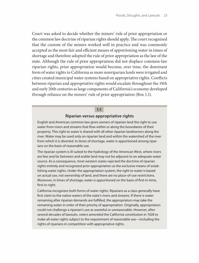
Floods, Droughts, and Lawsuits 23
Court was asked to decide whether the miners’ rule of prior appropriation or the common law doctrine of riparian rights should apply. The court recognized that the custom of the miners worked well in practice and was commonly accepted as the most fair and efficient means of apportioning water in times of shortage and therefore adopted the rule of prior appropriation as the law of the state. Although the rule of prior appropriation did not displace common-law riparian rights, prior appropriation would become, over time, the dominant form of water rights in California as more nonriparian lands were irrigated and cities created municipal water systems based on appropriative rights. Conflicts between riparian and appropriative rights would escalate throughout the 19th and early 20th centuries as large components of California’s economy developed through reliance on the miners’ rule of prior appropriation (Box 1.1).
Riparian versus appropriative rightsEnglish and American common law gives owners of riparian land the right to use water from rivers and streams that flow within or along the boundaries of their property. This right to water is shared with all other riparian landowners along the river. Water may be used only on riparian land and within the watershed of the river from which it is diverted. In times of shortage, water is apportioned among ripar-ians on the basis of reasonable use.
The riparian system is ill-suited to the hydrology of the American West, where rivers are few and far between and arable land may not be adjacent to an adequate water source. As a consequence, most western states rejected the doctrine of riparian rights entirely and recognized prior appropriation as the exclusive means of estab-lishing water rights. Under the appropriation system, the right to water is based on actual use, not ownership of land, and there are no place-of-use restrictions. Moreover, in times of shortage, water is apportioned on the basis of first-in-time, first-in-right.
California recognizes both forms of water rights. Riparians as a class generally have first claim to the native waters of the state’s rivers and streams. If there is water remaining after riparian demands are fulfilled, the appropriators may take the remaining water in order of their priority of appropriation. Originally, appropriators could not challenge a riparian’s use as wasteful or unreasonable. However, after several decades of lawsuits, voters amended the California constitution in 1928 to make all water rights subject to the requirement of reasonable use—including the rights of riparians in competition with appropriative rights.
1.1

24 Part I California Water
The Gold Rush also produced California’s first significant experiments with local and collective flood management. Hydraulic mining generated more than a million acre-feet of debris that washed downriver during winter and spring torrents, entering the Sacramento Valley and eventually moving as a wave through the Delta and into San Francisco Bay (Gilbert 1917). The debris choked the river channels, reducing their capacity to carry flows and forcing water and sediment onto the lowland floodplains. These floodplains, which included the newly established state capitol in Sacramento, were prone to seasonal inunda-tion even under normal conditions. Hydraulic mining amplified these inunda-tions until even modest flows caused flooding. In 1862, for example, successive storms flooded both Northern and Southern California, causing widespread death and destruction and turning the Central Valley into an “inland sea” more
Mining led to the first large-scale uses of water in California and the creation of appropriative water rights. Photo by Bettmann/Corbis.

Floods, Droughts, and Lawsuits 25
than 200 miles long and 60 miles wide (Kelley 1989). When the floodwaters subsided, mining debris covered the orchards and fields of the Sacramento Valley and provided vivid evidence that flooding would be a major problem for water management.
In response, landowners along the Sacramento River and its tributaries built small embankments between themselves and the river. These small levees failed regularly and flooded both fields and homes. Recognizing the need to form local governments to address flood problems, the California legislature, in 1868, authorized the creation of local reclamation districts, which allowed landowners to join together and levy property assessments to fund construc-tion of land reclamation and flood control projects. This legislation spurred the formation of hundreds of reclamation districts throughout the state, forming a key element in the growth of agriculture on the state’s floodplains.
Unfortunately, the taller and stronger levees made possible by this collective action reduced natural attenuation of flood waves and channeled floodwaters, which would overflow or breach smaller, weaker levees. Flooded landowners responded in kind, forcing the floodwaters onto their neighbors. In times of major floods, each district essentially relied on adjacent districts having levees weaker than their own. The resulting escalation of levees proved to be ineffec-tive for the Sacramento Valley, with some landowners finding demolition of a neighbor’s levees during a flood to be more economical than raising the height of their own levees (Kelley 1989).
The flood problems of this early era plague California to this day (Chap-ters 2, 6). Development in the rivers’ natural floodplains, combined with the construction of riverbank levees, denied the winter and spring floodwaters their natural outlets. The same development placed thousands of lives and millions of dollars of investment at annual risk of catastrophic loss. In addition, the channelization of rivers for flood control and mining debris removal destroyed seasonal and riparian wetlands and shallows that provided habitat for native fish and wildlife dependent on these wetlands.
By the 1880s, farmers, cities, and their state legislative representatives rec-ognized that local solutions were inadequate (and perhaps even dangerous) to address regional flooding problems. The Laissez-Faire Era of California water development and flood control policy was poised to give way to a new era of management, characterized by efforts to organize at the local level (Figure 1.1).

26 Part I California Water
Figure 1.1Water management in California has undergone several eras of change
Englishcommon
lawadopted
(1850)
Gold Rushbegins(1848)
SWPapproved
(1960)
Water policy legislation
(2009)
Right of priorappropriation
established(1855)
Reclamationdistricts
authorized(1868)
Widespread flooding(1906, 1909)
Reasonable use doctrine (1928)Federal Flood Control Act (1928)
NEPA (1969)Porter-Cologne Act (1969)
California Wild andScenic Rivers Act (1972)
Delta StewardshipCouncil (2010)
California Aqueduct (1966)
North Coast riversdeclared wild andscenic (1981)
Irrigation districtsauthorized
(1887)
Federaltakeoverof CVP (1935)
End ofhydraulic
mining(1884)
DeltaMendota
Canal(1951)
Central Valleyflood
legislation(2007)
Reclama-tion Act
(1902)
Raker ActauthorizesHetchHetchy (1913) Rejection of
peripheral canal (1982)
Riparian rightsheld as superior to
appropriative rights(1886)
Section 5937Fish and Game Code
(1933)
Bay-Delta Accord(CALFED) (1994)
CALFEDRecord ofDecision(2000)
CollapseofCALFED(2006)
O’ShaughnessyDam (1923)
Colorado RiverAqueduct (1940)
Hoover Damauthorized (1928) Trinity Dam (1962)
Oroville Dam (1968) Clean WaterAct (1972)
FederalESA(1973)
CEQA (1970) CVPIA (1992)
Owens RiverAqueduct
(1913)
ShastaDam(1944)
MonoLake
decision(1983)
Great Floodof 1862
1840 19001900 1950 2000
Laissez-Faire Era Hydraulic EraLocal Organization Era Era of Conflict
The Era of Local Organization
The end of the Laissez-Faire Era in California water management coincided with rapid population growth and a shift in the economy toward agricultural production, new demands for water supply and flood control, and a series of related court cases.
Two legal issues prevented significant legislative reform of California’s water management policies. The first was the status of gold mining—the industry that created California’s early economy but whose mine tailings and pollution had come to threaten growing economic sectors of agriculture, commerce, and shipping. The second issue was how to reconcile the two systems of water rights

Floods, Droughts, and Lawsuits 27
recognized by the California Supreme Court in the early years of statehood: the miners’ custom of prior appropriation—based on actual use prioritized by date of first use—and the common law doctrine of riparian rights—based on ownership of land on a river (Box 1.1).
By the early 1880s, the environmental and economic problems caused by gold mining were widely recognized, and two lawsuits were filed to declare continued hydraulic mining a public nuisance. In Woodruff v. North Bloomfield Mining Co. (1884), a group of farmers along the Yuba and Feather Rivers whose lands were flooded and spoiled by mining tailings sued in federal court to prohibit the discharge of mining debris. In People v. Gold Run Ditch & Mining Co. (1884), the California attorney general brought suit in state court to prevent hydraulic mining in the watershed of the North Fork of the American River. Both courts prohibited continued mining, declaring it a public nuisance and holding that it must give way to the paramount public interest in navigation and commerce and to the burgeoning commercial and agricultural development in the Sacramento Valley.
Two years after the gold mining decisions, the California Supreme Court confronted the second water rights issue that had come to dominate the state’s water policies—the relationship between the riparian and appropriative systems (Box 1.1).
In a series of early cases, the court concluded that the doctrine of riparian rights had been incorporated into California’s water rights system in 1850, when the legislature enacted a statute that recognized the common law of England as the law of the new state. This meant that landowners along California’s rivers and streams could claim the right to use water on their riparian lands simply by virtue of their ownership of such lands, whereas nonriparians could claim water only through its diversion and use under the law of prior appropriation.
As California agriculture expanded from lands adjacent to the principal rivers to upland areas, tensions grew between riparians and appropriators. Upstream appropriators diverted water for their own uses—sometimes trans-porting water to irrigate lands outside the watershed—and downstream ripar-ians claimed the right to the full, unimpeded flow of the river.
This conflict was especially pronounced in the Tulare Basin, where two of California’s largest water users (and three of its wealthiest individuals) squared off in a titanic battle over water rights. Lux v. Haggin (1886) was one of the great legal cases in California history, pitting powerful riparian landowners against an equally powerful appropriator who urged the California Supreme Court to abolish riparian rights. By a vote of 4 to 3, the court ruled in favor of the

28 Part I California Water
riparians. Appropriative rights would continue to exist alongside the riparian system, but in almost all cases, they would be inferior in priority to the rights of the riparians. In cases of conflict, riparians would be entitled to “the natural flow of the watercourse undiminished except by its reasonable consumption by upper [riparian] proprietors.”
The hydraulic mining cases and Lux v. Haggin have many legacies—some constructive, others (at least in retrospect) a hindrance to California’s evolv-ing water policies. In People v. Gold Run Ditch & Mining Co., for example, the court responded to new developments on the ground, both economic and environmental, and shaped the law to ensure that it kept pace with changing conditions and societal needs. The case also marked the court’s first significant application of the public trust doctrine to resolve a conflict over use of the state’s water resources (Box 1.2). These aspects of People v. Gold Run Ditch & Mining Co. would become essential features of the state’s efforts to promote efficient and sustainable use of water resources.
In contrast, Lux v. Haggin was more of a mixed bag. Millions of acres of arable land throughout the Central Valley could not qualify for riparian rights because they were not adjacent to reliable sources of surface water, and their water rights were now effectively subordinate to those of riparians. This meant that downstream riparians—including those farming the lower reaches of the Sacramento and San Joaquin Rivers and in the Delta itself—could claim the full, unencumbered flow of the rivers despite the burdens such claims would place on upstream appropriators. Moreover, riparian rights would become an obstacle to developing water sup-plies for California’s growing cities, which sought to acquire supplemental water sources. These conflicts would play out over the next four decades.
On the other hand, Lux v. Haggin also held that disputes between riparians would thereafter be decided on the basis of reasonable use. As developed by the court in a series of cases following Lux v. Haggin, the reasonable use doctrine would come to require that all riparians exercise their rights in a manner that did not result in waste, that was reasonably efficient under existing conditions, and that took into account the reasonable demands of competing riparian water users. The principle of reasonable use would later become a cornerstone of California water law.
Organizing Local Governments
As demands for irrigation grew beyond the scale of individual farmers, more governmental authority was sought to establish irrigation systems serving many

Floods, Droughts, and Lawsuits 29
The public trust doctrine Under the common law of England, the Crown held particular resources in trust for use by all of the people. These resources included navigable waters, as well as submerged lands beneath such waters up to the mean high tide or high-water mark. Although the King or Queen could grant these submerged lands as part of larger land grants, the private rights to both the navigable waters and the submerged lands were impressed with a “public trust.” The private landowners could not exclude members of the public from using navigable waters and submerged lands for navigation, commerce, and fishing, nor could the landowners develop or alter the lands to obstruct or diminish these public trust uses.
When the United States gained its independence from England, it carried the public trust doctrine into its own laws. California incorporated the public trust into state law in 1850, when the legislature enacted a statute that adopted the common law of England. Over the course of the late 19th and 20th centuries, the California Supreme Court applied the public trust doctrine to preserve public rights of navigation, fishing, and recreation along the state’s beaches, the San Francisco Bay waterfront, and inland waters including the American and Sacramento Rivers and Lake Tahoe. In Marks v. Whitney (1971), the court declared that the public trust protects not only the traditional uses recognized under English and American common law but also “the preservation of those lands [covered by the trust] in their natural state, so that they may serve as ecological units for scientific study, as open space, and as environments which provide food and habitat for birds and marine life, and which favorably affect the scenery and climate of the area.”
In 1983, in the famous case of National Audubon Society v. Superior Court, the Supreme Court held that the “public trust doctrine and the appropriative water rights system are parts of an integrated system of water law. The public trust doctrine serves the function in that integrated system of preserving the continuing sovereign power of the state to protect public trust uses, a power which precludes anyone from acquiring a vested right to harm the public trust, and imposes a continuing duty on the state to take such uses into account in allocating water resources.”
1.2
farmers in a local area. The decline of gold mining and the (temporary) legal resolution of the conflict between riparians and appropriators set the stage for California’s first period of organized water development. During this era, irrigated acreage increased exponentially around the state, cities expanded their local water supplies, and groups of water users organized themselves locally into irrigation districts and mutual water companies (Figure 1.1).
30 Part I California Water
Of course, farming in early California was hampered by the lack of summer rainfall. Farmers along the Sacramento River and its tributaries grew a variety of crops—including orchard fruit, wine grapes, peanuts, wheat, and barley—irrigated with water diverted from the rivers. In contrast, farmers in the San Joaquin Valley grew mostly wheat, alfalfa, and pasture, relying on scarce rain and spring flooding to water their crops. As the state’s population grew and local and global demands for food increased, California’s farmers sought to bring additional land into production. Expanding agriculture required irriga-tion methods able to bring water to arable land above the natural floodplains.
Expanding irrigation beyond a few riparian farms also required larger units of organization and finance. In a few areas, farmers pooled their resources to acquire water rights and to construct dams, canals, and irrigation ditches. But private water development lacked the investment capital needed to move water from Sierra Nevada streams to the lands that farmers hoped to irri-gate. To address this problem, the legislature enacted the Wright Act in 1887, which (combined with earlier legislation to establish local reclamation dis-tricts) launched an era of local governmental development and control of water resources. This period established today’s highly decentralized system of local water management. The Wright Act authorized the formation of irrigation districts with the power to acquire water rights, to construct water projects, and to sell bonds and impose property assessments to support water development and distribution (Pisani 1984).
Farmers throughout the Central Valley joined together to form local irri-gation districts. The most successful districts were created in the lower San Joaquin Valley and Tulare Basin—the Turlock, Modesto, and Tulare Irrigation Districts—which financed and built the first significant-scale dams and canal systems to store and distribute water on a regional basis. These districts, along with several important private companies, such as the Fresno Canal and Land Company, sparked a dramatic increase in agricultural production.
Many of the first irrigation districts failed (including six of the seven estab-lished in the Sacramento Valley), but by the early 20th century, irrigation districts were successfully established around the state, including the Glenn-Colusa and Anderson-Cottonwood Irrigation Districts in the Sacramento Valley, the El Dorado and Nevada Irrigation Districts in the Sierra Nevada foothills, the Merced and Fresno Irrigation Districts in the San Joaquin Valley, and the Imperial Irrigation District along the Mexican border (Pisani 1984). And businesses and real estate developers in Southern California and the Bay

Floods, Droughts, and Lawsuits 31
Area used water companies to develop and distribute domestic water supplies. The legislature subsequently authorized the creation of a panoply of new types of local water agencies to develop and distribute water for irrigation and domes-tic purposes.
Local development and control of California’s water resources would be lim-ited, however, by two factors. In some areas, local water availability was simply insufficient to support long-term growth. And local capital was inadequate to construct new projects on the scale needed to move water from where it was available to where growth (and ambition to grow) demanded it.
The Rise and Fall of Groundwater
As Central Valley agriculture continued to expand, farmers without access to surface irrigation turned to the aquifers beneath their lands as a more available source. Farmers and cities in Southern California also began to rely heavily on groundwater, initially tapping artesian springs and later pumping water from the dozens of basins that underlie the region. Conflicts between surface and groundwater users, and among groundwater users, inevitably followed. In the 1880s, Los Angeles sued neighboring cities and private groundwater users and persuaded the California Supreme Court that its pueblo rights in the upper Los Angeles River also gave it superior rights to all groundwater in the basin hydro-logically connected to the river. This was the first case to recognize surface and groundwater as an integrated resource. Litigation was also common in water management in the San Gabriel and Santa Ana River Basins (Blomquist 1992).
For most of the 19th century, access to groundwater was limited by technol-ogy—with windmills and steam engines providing power for irrigation pumps. Toward the end of the century, however, drilling technology and gasoline- and diesel-powered pumps became more widely available, allowing farmers to pump more water from greater depths. By the early 20th century, wells in some cases exceeded 300 feet. As with the levee wars in the Sacramento Valley, the new technology led to conflict. The new pumps lowered groundwater levels below the depth of neighboring pumps. Thus, neighbors were forced to drill deeper wells, which lowered the groundwater table below the depth of recent wells, and the race to the bottom was on.
Conflicts over well-lowering and groundwater depletion eventually made their way into the courts, and in 1903, the California Supreme Court handed down its opinion in Katz v. Walkinshaw. The court held that the common law rule of “absolute ownership” of groundwater, under which all landowners

32 Part I California Water
overlying an aquifer could pump as much water as they needed, was no longer compatible with California’s hydrologic and economic conditions. The rule of absolute ownership, the court noted, afforded groundwater users no protection against stronger pumps or deeper wells. Nor did it protect surface water users, whose rights were impaired when excessive groundwater extractions lowered the level of aquifers that fed and supported the state’s rivers.
In place of the old common law rule, the court borrowed from the surface water law of riparian rights and held that all overlying landowners had correla-tive rights to the “safe yield” of the aquifer—the quantity of water that could be extracted without sustained lowering of the groundwater table. Disputes among overlying owners would be resolved on the basis of reasonable use. As a group, overlying landowners would have first claim to the available groundwater. If additional groundwater could be extracted within the safe yield of the aquifer, other users could pump it in order of priority of appropriation.
Although it was an improvement on the rule of absolute ownership, the court’s decision in Katz v. Walkinshaw did not address two fundamental prob-lems with groundwater use in early 20th century California. First, as with sur-face water rights, no state regulatory system existed to supervise groundwater extraction and use. Although several districts were formed under the Wright Act in Southern California to manage ground and surface water supplies in the San Gabriel and Santa Ana River Basins, all had failed by the early years of the 20th century (Blomquist 1992), and the irrigation districts in the San Joaquin Valley focused only on surface water development. As a result, no local or regional entities existed to fill the void of state regulation.
Second, the two regions with the greatest use of groundwater—Southern California and the Tulare and western San Joaquin Basins—simply lacked enough surface water to replenish their aquifers under existing and projected future levels of extraction. Consistent with the times, water users and political leaders in both regions addressed groundwater overdraft by seeking ever-greater supplies of imported surface water, rather than by limiting groundwater use—a harbinger of the next era of water management.
Local Flood Management
As with their irrigation district counterparts, local flood control and recla-mation districts found themselves at the mercy of forces beyond their local jurisdictional boundaries. The “levee wars” had failed to provide effective flood protection in the Sacramento Valley, and the rapid urban growth in Sacramento,
Floods, Droughts, and Lawsuits 33
Southern California, and the Bay Area increased demand for flood management improvements on a larger geographic scale. This political pressure, coupled with the intractable problems of hydraulic mining sediment, brought the first federal foray into state water management.
The U.S. Army Corps of Engineers, with its mandate to protect and to facilitate navigation on the nation’s waterways, became involved in managing floods in California as early as the 1880s. The corps advocated two strategies for managing hydraulic mining sediment. The first was to construct brush dams upstream to trap sediments. Several dams were erected on the Yuba and Bear Rivers in 1880, but all failed within the first year. The second approach stemmed from the corps’ 30 years of experience in maintaining navigation channels on the Mississippi River. It urged reclamation districts to place levees as close as practicable to river channels to scour sediment. This strategy was pursued in a loosely coordinated fashion through the latter years of the 19th century, but these close riverbank levees also failed to provide sufficient flood protection.
Although flood management during the Era of Local Organization was not as sophisticated or successful as the local development of water supplies, it did produce three important legacies. First, placing levees close to the river created the footprint of flood control that remains in place today. Second, the repeated failures to address flood issues, both in Sacramento and in urban areas throughout the state, led to new efforts to cooperate. These efforts are reflected in the ambitious Manson-Grunsky Plan developed in the late 1890s to address flooding in the greater Sacramento Valley. Finally, this new flood plan was the first large-scale engagement of the federal government in water management—a role that would expand dramatically in the next century.
The Hydraulic Era
The Hydraulic Era is defined by large regional, interregional, and statewide water management schemes, driven by continued growth in agricultural and urban water demands. These large projects called for the involvement of state and federal agencies, as well as existing and new local authorities.
At the turn of the 20th century, California had the nation’s fastest-growing economy and population. This growth required a shift in water and flood policy from local to interregional projects that could manage water over much larger distances. Four intertwined forces would initiate California’s transition into what Norris Hundley, Jr., has called the “hydraulic society”: the decision of Los

34 Part I California Water
Angeles and San Francisco to secure water supplies that would enable them to grow and to prosper for the next 100 years; Congress’s creation and lavish support of a federal reclamation program; the state legislature’s decision to build a California water project; and the engagement of the federal govern-ment—with dollars, expertise, and land use controls—in the management of floods (Figure 1.1).
Los Angeles and the Conquest of Owens Valley
By 1900, Los Angeles had largely exhausted its local sources of water from the Los Angeles River and its tributary groundwater basin, and city leaders began the quest for supplemental supplies.2 They eschewed smaller local water sources in favor of a grander ambition—to secure a larger source of clean water that would meet the city’s needs for a century or more. For this, they looked 240 miles north to the Owens Valley, on the east side of the Sierra Nevada.
Mayor Fred Eaton appointed William Mulholland, superintendent of the Los Angeles Water Company, to be the chief engineer of the new Los Angeles Department of Water and Power. Eaton and Mulholland traveled numerous times to the Owens Valley, with Mulholland designing the water project and Eaton acquiring land and water rights under his own name. They teamed with J. B. Lippincott, the United States Reclamation Service’s supervising engineer for the Pacific Coast states, who was evaluating Owens Valley for inclusion in the new federal reclamation program, described below. Eaton and Mulholland persuaded Lippincott to give them access to the Reclamation Service’s land records, which enabled the men to secure options on land and water rights. By 1905, Eaton and Mulholland had acquired almost all riparian land and water rights in the valley, including the Reclamation Service’s planned reservoir site, and transferred them to the city. The following year, the United States granted the city a right-of-way across federal lands for the Owens Valley Aqueduct. Construction began in 1908, and five years later, on November 5, 1913, the first Owens River water poured into the San Fernando Valley, where it would be stored in the local aquifer for distribution to residents of Los Angeles.
By 1920, the city’s population had grown to 500,000. A decade later, it reached 1.2 million. As the city grew, so did its demand for water, and Los Angeles built new diversion works higher up in the Owens River Valley. As the valley dried out, its residents became increasingly hostile. Although protesters
2. Kahrl (1982) is an excellent reference on the history of Los Angeles’s water supplies.

Floods, Droughts, and Lawsuits 35
dynamited sections of the aqueduct several times during the 1920s, Los Angeles was undeterred in its search for additional water. By 1933, the city had acquired most of the remaining private land in the Owens Valley and began pumping groundwater. With few overlying landowners still possessing groundwater rights, valley residents could do little to limit exports.
In 1930, Los Angeles voters approved a bond to extend the aqueduct north into the Mono Basin. Diversion dams on four of the five tributaries that fed Mono Lake were completed in 1940. Over the next four decades, the city’s diversions would diminish the lake, imperil its wildlife, and ultimately set the stage for the California Supreme Court’s recognition of the public trust as a fundamental limit on the exercise of water rights.
San Francisco and the Battle for Hetch Hetchy Valley
San Francisco, Oakland, and other Bay Area cities also trained their sights on Sierra Nevada streams to support their growing populations and economies. James Phelan, San Francisco’s mayor from 1897 to 1902, wanted to ensure that his city remained the dominant commercial and industrial center of California and the West. He wanted to break the monopolistic grip of the privately owned Spring Valley Water Company, and he recognized that the meager local water sources of San Francisco would be inadequate for the city’s growth into the coming century.
San Francisco’s water system relied on building a reservoir in Yosemite’s Hetch Hetchy Valley. Photo by Sarah Null.
36 Part I California Water
San Francisco’s quest was led by the city’s chief engineer, Michael Maurice O’Shaughnessy, who settled on the Tuolumne River as the ideal source of water for the city. O’Shaughnessy proposed to construct a dam and divert water high in the watershed at the mouth of Hetch Hetchy Valley. This would protect the city’s water quality at its source, generate hydroelectric power, and deliver water to the city and other East Bay and peninsula locales by gravity. The main prob-lem with O’Shaughnessy’s plan was that Congress had included Hetch Hetchy Valley in the Yosemite National Park in 1890.
The opposition, led by John Muir and the newly formed Sierra Club, delayed the project for more than a decade. In the end, however, the city’s arguments pre-vailed, and in 1913, Congress passed the Raker Act, authorizing San Francisco’s use of Hetch Hetchy Valley as a reservoir. Plagued by construction and financial problems, Tuolumne River water finally arrived in San Francisco in 1934.3
The Owens Valley and Hetch Hetchy Projects began a long period in which both Congress and the California legislature authorized large interbasin water projects that would promote statewide urban and agricultural development, spurring the growth of California’s population and economy. Yet both proj-ects would also spawn a deep and enduring suspicion of interbasin water development.
In response to the Owens Valley Project, the legislature included in the Central Valley Project (CVP) Act of 1933 a law recognizing the superior rights of the areas of the state that are the sources of California’s developed water supplies. The County-of-Origin Act would influence the planning and admin-istration of the CVP and later the State Water Project (SWP). In addition, Los Angeles’s destruction of Owens Lake and the Owens River, and its plans to divert from streams feeding Mono Lake, would move the legislature to place in the new Fish and Game Code of 1933 an obscure requirement of the Penal Code that the owners of all dams release or bypass water to protect downstream fish-eries. Five decades later, this statute would be applied to restrict Los Angeles’s water rights in both Owens Valley and the Mono Basin and would become one of the state’s strongest fisheries protection laws (Box 1.3; Chapter 5). Perhaps most significantly, San Francisco’s damming of Hetch Hetchy planted the seeds of the environmental movement that would play a major role in California (and national) water policy during the latter decades of the 20th century.
3. Oakland and the East Bay area engaged in a similar period of water system acquisition and development, culminating in the East Bay Municipal Utility District bringing water from the Mokelumne River in 1929 (Elkind 1998).

Floods, Droughts, and Lawsuits 37
Fish and Game Code, § 5937“The owner of any dam shall allow sufficient water at all times to pass over, around, or through the dam, to keep in good condition any fish that may be planted or exist below the dam.”
California’s statutory protection of its fisheries dates back to 1872 when the legis-lature enacted § 637 of the California Penal Code, which required that dam owners build a fishway over or around the dam if requested to do so by the State Board of Fish Commissioners. In 1903, the legislature expanded the duties of the fish commissioners, requiring that they determine if dams throughout the state were hindering passage of migratory fish, especially salmon and shad. In 1915, it revised § 637 again to apply to all fish, not just migratory species.
In 1933, the legislature created the Fish and Game Code and transferred the Penal Code language to it with only minor modifications. Although § 5937 was rarely applied until modern times, it is nonetheless a powerful fisheries protection law. The lawsuits that ultimately led to the restoration of both Mono Lake and the San Joaquin River were both based in part on § 5937.
1.3
Modernization of California Water Laws
California’s transition to the Hydraulic Era was facilitated by the modernization of its water laws. In 1913, the legislature created the first regulatory system to administer new surface water rights. Fifteen years later, the electorate amended California’s Constitution to repair the breach between the riparian and appro-priative rights systems that the Supreme Court left open in Lux v. Haggin and to establish the doctrine of reasonable use as the foundation of California water resources law.
The modern water code
Although the legislature had addressed water rights in the Civil Code in 1872, that statute did little more than codify (with minor changes) the common law rules of prior appropriation developed by the gold miners and the courts. In the Water Commission Act of 1913, however, it endeavored to devise a com-prehensive system for regulating water rights. The act created a State Water Commission with the power to issue permits and licenses to govern the exercise of water rights.

38 Part I California Water
Unfortunately, because of political pressure from various vested interests, the legislature exempted more uses of water than it included in the new regula-tory scheme. Pueblo rights, riparian rights, and groundwater rights were com-pletely exempt. Only water appropriations beginning after the effective date of the statute were included. Because the Water Commission Act was put to refer-endum, it did not pass the vote of the electorate until December 19, 1914. To this day, surface water appropriations initiated after this date must be authorized by a water rights permit or license; appropriations existing before this date do not require a permit or license and are commonly known as “pre-1914 rights.” As a result of these statutory exemptions, the State Water Resources Control Board (SWRCB) or “the board”—the successor to the Water Commission—regulates through the permit and license system less than half of the water used by agri-cultural and urban interests in California today.
Despite these shortcomings, the Water Commission Act was an important development in California water policy because it laid the foundation for the modern regulation of water rights and use. Over time, the legislature would add to the authority of the commission (and its successors), granting the power not only to monitor a permittee’s or licensee’s uses but also to protect the rights of other legal water users, water quality, fish and wildlife, recreational uses, and the public interest generally. Today, the SWRCB also has the power to enforce the mandates of reasonable use and the public trust, and this authority applies to all water users regardless of the type or source of their water rights (Littleworth and Garner 2007).
The reasonable use doctrine
A more significant advance in state power over the water resources system, however, would come from the constitutional resolution of the long-standing conflict between the riparian and appropriative water rights systems. Following Lux v. Haggin, the California Supreme Court employed the doctrine of reason-able use as a fundamental limitation on the exercise of water rights. In disputes among riparians, the court applied the standard of reasonable use as the princi-pal means of allocating water in times of shortage. In disputes between appro-priators, the court held that water could be allocated to a junior appropriator out of priority if the senior appropriator was using water unreasonably under the circumstances. For example, in the important case of Town of Antioch v. Williams Irrigation District (1922), the court refused to protect the city’s senior downstream water right because it required that upstream junior appropriators
Floods, Droughts, and Lawsuits 39
forgo too much water to repel salinity intrusion at Antioch’s point of diversion in the western Delta.
In disputes between a riparian and an appropriator, however, the court held that the doctrine of reasonable use was inapplicable because riparian rights were categorically superior to appropriative rights (Gray 1989). Thus, in Herminghaus v. Southern California Edison (1926), the court held that down-stream riparians were entitled to the unimpaired flow of the San Joaquin River, even though that would require that the upstream public utility forgo its uses. The gross inefficiency mandated by the court would lead voters to amend the California Constitution to close the divide between the riparian and appro-priative systems.
The resulting 1928 amendment, which now appears as Article X, § 2, of the constitution (Box 1.4), changed California water law in three fundamental ways.
The reasonable use doctrine of California water lawCALIFORNIA CONSTITUTION, ARTICLE X, § 2 (1928)
“It is hereby declared that because of the conditions prevailing in this State the gen-eral welfare requires that the water resources of the State be put to beneficial use to the fullest extent of which they are capable, and that the waste or unreasonable use or unreasonable method of use of water be prevented, and that the conserva-tion of such waters is to be exercised with a view to the reasonable and beneficial use thereof in the interest of the people and for the public welfare. The right to water or to the use or flow of water in or from any natural stream or water course in this State is and shall be limited to such water as shall be reasonably required for the beneficial use to be served, and such right does not and shall not extend to the waste or unreasonable use or unreasonable method of use or unreasonable method of diversion of water. Riparian rights in a stream or water course attach to, but to no more than so much of the flow thereof as may be required or used consis-tently with this section, for the purposes for which such lands are, or may be made adaptable, in view of such reasonable and beneficial uses; provided, however, that nothing herein contained shall be construed as depriving any riparian owner of the reasonable use of water of the stream to which the owner’s land is riparian under reasonable methods of diversion and use, or as depriving any appropriator of water to which the appropriator is lawfully entitled.
“This section shall be self-executing, and the Legislature may also enact laws in the furtherance of the policy in this section contained.”
1.4

40 Part I California Water
First, it declared the doctrines of reasonable and beneficial use to be the founda-tion of all water rights in California. Second, it stipulated that the requirement of reasonable use could be asserted in all water rights disputes, including those where an appropriator challenges a riparian use. Third, it invested all branches of government with significant authority to implement the mandates of reason-able and beneficial use.
The enactment of the 1928 constitutional amendment would facilitate the dramatic expansion of the hydraulic society that would take place during the middle of the 20th century. By removing the obstacle of riparian claims to the full flow of the state’s rivers—and by declaring a state policy to prevent waste and to promote the reasonably efficient use and allocation of California’s water resources—the constitutional amendment laid the legal foundation for the statewide water projects that were on the drawing boards. Later, as the era of the great projects was nearing its end, Article X, § 2, would be employed to require that California’s water resources also be used so as not to cause unreasonable harm to water quality, fish, and the aquatic ecosystems that are the sources of the states developed water supplies.
Large Federal Water Projects
The next phase of the Hydraulic Era was led by the federal government; it resulted in the development of two of the state’s major water sources: the Boulder Canyon Project, which delivers Colorado River water to farms and cities in Southern California, and the Central Valley Project, which carries water from the state’s northern and eastern mountain watersheds to farms and cities in the Central Valley and the Bay Area.
Although these projects did not get under way until the 1920s and 1930s, the federal government had established its involvement earlier in the 20th century. Congress enacted the Reclamation Act of 1902 under pressure from western farm-ers who had suffered through two decades of almost constant drought and by west-ern politicians who had witnessed the failure of local and regional water projects because of insufficient capital. The legislation gained the support of the Progressives, who sought to promote public ownership of utilities and who insisted on statu-tory terms to guard against land speculation and to focus benefits on small family farms. The Reclamation Act authorized the construction of dams and irrigation projects throughout the West, created a new Reclamation Service (later the Bureau of Reclamation) within the Department of the Interior to administer the program, and made water available at subsidized rates to farms no larger than 160 acres.

Floods, Droughts, and Lawsuits 41
The first reclamation projects to develop California’s rivers were relatively small and designed to supplement water supplies for farmers in several areas that had experienced only limited success in developing local sources. Construction of the Newlands Project (named after the author of the act, Representative Francis Newlands) began in 1903. The project included dams on the Truckee and Carson Rivers and a six-foot-high addition to Lake Tahoe’s outlet to the Truckee River. These dams impounded the Truckee and Carson Rivers for distribution to farm-ers in the Lahontan Valley in Nevada. Another effort, the Klamath Project, which began in 1906, included the construction of dams on the Klamath River and its tributaries in southern Oregon and northeastern California, supplying irrigation water to farmers throughout the upper Klamath Basin in both states.
Meanwhile, Imperial Valley farmers continued to struggle with unpre-dictable water supplies from the Colorado River. With no significant dams upstream, river flows ranged from languid to violent. During a large flood in 1905, the Colorado River destroyed the Imperial diversion structures and flowed unimpeded onto the farm lands, converting the long-dry Salton Sink into the Salton Sea. It took years to rebuild the diversion structures and to restore flows in the Alamo Canal that irrigators shared with Mexico. The unreli-ability of flows affected agricultural development on both sides of the border.
The Imperial Valley irrigators sought to build an “All-American Canal” that would end their forced sharing of water with Mexico. But diverting Colorado River waters north of the international border would require larger dams—so large, in fact, that funding was well beyond the financial ability of either the Imperial farmers or the state. Federal involvement, on a scale unprecedented for the Reclamation Service, would be imperative.
The Boulder Canyon Project
Led by its new director and chief engineer, Arthur Russell Davis, the Reclamation Service proposed a massive concrete gravity-arch dam across the Colorado River at the mouth of Boulder Canyon, Nevada, 342 river miles upstream from the Mexican border. The dam would impound the river for flood control, hydro-electric power, and water supply for users in Arizona, Nevada, and California. The California users would include the Imperial farmers, who would receive water by diversion from a new Imperial Dam (49 miles north of the Mexican border) through their long-desired All-American Canal.
Davis’s plan was met initially with opposition from almost all quarters, including the U.S. Army Corps of Engineers, which planned to control lower
42 Part I California Water
Colorado River flooding through levee construction; the upper-basin states of the Colorado River Basin and Arizona, which feared a California water grab; and Mexico, which (correctly) anticipated that a large dam on the Colorado River would enable the United States to dominate the river.4
The upper-basin states’ opposition was relieved by the Colorado River Compact of 1922, which divided the waters of the Colorado River equally between the upper and lower basins. Each basin would be entitled to 7.5 million acre-feet (maf) annually, although the upper basin could not deprive the lower basin of water that the upper-basin states did not need. Without dams compa-rable to that proposed for Boulder Canyon, however, this caveat would allow the lower-basin states, especially California, to claim the lion’s share of Colorado River water for most of the 20th century without violating the compact.
Congress’s authorization of the Boulder Canyon Project in 1928 resolved some of the remaining opposition. It sided with the Reclamation Service and funded construction of a 726-foot-high dam at Boulder Canyon (subsequently named Hoover Dam after then–Secretary of Commerce Herbert Hoover), creat-ing a 28 million acre-foot reservoir (later named Lake Mead in honor of the new Bureau of Reclamation director, Elwood Mead). The statute garnered additional political support in California by also authorizing construction of the Imperial Dam and All-American Canal, as well as Parker Dam (143 river miles upstream of Imperial) and the Colorado River Aqueduct, which would deliver water to the newly formed Metropolitan Water District of Southern California. In addi-tion, Congress allowed the Secretary of the Interior to determine whether the hydroelectric power would be sold by the United States directly or through long-term leases to public and private utilities that would then profit from their resale of the electricity. This compromise secured support from both the Los Angeles Department of Water and Power and Southern California Edison, which would sign 50-year contracts with the Department of the Interior for power produced at Hoover Dam.
Although Congress attempted to accommodate Arizona by giving its advance approval to an interstate compact that would apportion the waters of the lower basin among Arizona, California, and Nevada, Arizona maintained its opposition. Indeed, in 1933, its governor sent National Guard troops to the river to block construction of the Arizona footings for Parker Dam. Arizona’s
4. The “upper-basin states” commonly refers to Colorado, New Mexico, Utah, and Wyoming. In addition to California and Arizona, Nevada is a “lower-basin” state. Technically, the upper basin also includes the northern part of Arizona and the lower basin includes portions of Utah and New Mexico.

Floods, Droughts, and Lawsuits 43
opposition to the project would last another 50 years and require a decision by the U.S. Supreme Court in Arizona v. California (1963), congressional enact-ment of the Colorado River Basin Project Act of 1968, and completion of the Central Arizona Project in 1982 (to pump Colorado River water into Arizona’s central plateau) to bring the state into the fold.
The water provided by the Boulder Canyon Project’s All-American Canal sustained farms in the Imperial Valley, enabling the development of agriculture as well as cities and resorts in the Coachella Valley north of the Salton Sea. In addition, the Colorado River Aqueduct fueled the rapid growth of cities within the Metropolitan Water District during and after World War II. The population of the Los Angeles –Orange County– San Diego metropolitan area grew from 4 million in 1940, the year before the first Colorado River water arrived, to more than 10 million in 1970. Southern California established itself as the West’s preeminent economic center, surpassing Chicago, with defense, aerospace, manufacturing, shipping, housing, and commercial services quickly crowding out dairies and agriculture as its principal industries.
This development did not come without costs. As Lake Mead filled, water supplies diminished for Mexicali farmers (although flooding was largely eliminated), and the combined U.S. and Mexican diversions dried up the lush Colorado River Delta, eliminating its abundant fish and wildlife and causing the tamed river to end in a puddle, miles upstream of its natural terminus at the Gulf of California. Excessive water use and lack of regulating reservoirs within the Imperial Irrigation District would cause the Salton Sea to rise and flood shoreline landowners. The Colorado River supplies to the Metropolitan Water District would soon prove insufficient for Southern California’s ever-growing demands. By the mid-1960s, California would exceed its 4.4 million acre-feet annual allocation under the Boulder Canyon Act. As the population and corresponding demands of Arizona and Nevada grew, California would face renewed conflicts over the fair apportionment of lower-basin Colorado River flows.
The Central Valley Project
Farmers in California’s Central Valley also sought a large water project to har-ness water from the North Coast and the Sierra Nevada. Irrigated acreage had increased from less than one million acres in 1900 to more than three million by 1930. With less surface water than arable land in the San Joaquin Valley and Tulare Basin, much of this new irrigation relied heavily on groundwater, leading

44 Part I California Water
to extensive overdraft of regional aquifers. The larger landowners were wary of federal development, however, because the acreage limits of the Reclamation Act would require that they break up their existing farms (some of which cov-ered tens of thousands of acres). In contrast to their Imperial brethren, these farmers supported U.S. Army Corps of Engineers’ dams on nearby streams (nominally for flood control) and lobbied the California legislature for a state-funded, state-operated project to import additional water from the Sacramento River Basin (Maass 1951).
For decades, state, federal, and local governments had engaged in sporadic efforts to conceptualize and plan a comprehensive interregional water proj-ect, taking water from wetter northern and mountainous regions to areas of growing agricultural and urban demands. A federally sponsored plan for the Central Valley released in 1873 envisioned a vast series of canals that would move water across the valley. The 1919 Marshall Plan (developed by Robert Marshall, a retired U.S. Geological Survey hydrologist working at the University of California) gained widespread support for a statewide scheme of reservoirs and aqueducts to bring water from the Sacramento River to the San Joaquin Valley and divert water from the Kern River to Southern California. The Marshall Plan became the basis for California’s preliminary comprehensive plan for water in 1924 and the first State Water Plan of 1930 under the direction of State Engineer Edward Hyatt.
Hyatt’s “Central Valley Project” had as its capstone a large dam on the Sacramento River (at the location of today’s Shasta Dam) to control the flow of the river and distribute the water to users in the Sacramento Valley, the Delta, and the northern San Joaquin Valley. A smaller dam on the San Joaquin River northeast of Fresno would divert most of that river to irrigate lands in Madera, Kings, Fresno, Tulare, and Kern Counties. Riparian water users on the San Joaquin River below the dam, as well as lands on the west side of the San Joaquin Valley that relied heavily on groundwater, would be supplied by water pumped from the Delta via a series of check dams on the San Joaquin River. The plan essentially required that the lower San Joaquin River run back-ward during the irrigation season (Division of Water Resources 1930). Releases from the Sacramento River Dam would not only supply water but also provide a freshwater barrier against salt water intruding into the Delta from San Francisco Bay. This would enhance summer water quality for Delta farmers using water pumped from the southern Delta. Water users on the Sacramento River would receive water to fulfill their pre-project water rights, as well as
Floods, Droughts, and Lawsuits 45
additional water made available by releases from the project. Because the dam on the San Joaquin River would dry up the river during most hydrologic con-ditions, the state would either “condemn” (or invalidate) existing downstream water rights impaired by the project or, in some cases, offer pre-project San Joaquin water rights holders Sacramento River water pumped from the Delta (Lund et al. 2010).
It was an audacious proposal. The legislature authorized the Central Valley Project in 1933, but opposition by Pacific Gas & Electric, Southern California Edison, Sacramento River Basin area-of-origin advocates, and some senior water rights holders forced a referendum on the act. Voters narrowly approved the CVP legislation in December 1933.
Although California was in the midst of a sustained drought, it was also in the midst of the Great Depression, and economic conditions prevented the state from selling the bonds needed to finance the project’s construction. The Roosevelt administration offered to take over the CVP as part of the federal reclamation program. Congress authorized the federal Central Valley Project in 1935 and again in 1937. The purposes of the CVP were navigation, flood control, water supply, and hydroelectric power. Construction of Shasta Dam began in 1937, with water and power deliveries beginning in 1944. Pumping from the Delta through the Delta Mendota Canal and diversions from the San Joaquin River began in 1951.
Over time, Congress added other units and facilities to the CVP. These included dams on the Trinity River (which divert water from the North Coast to the Sacramento River), the American River, and the Stanislaus River; San Luis Reservoir, an off-stream storage facility near the Pacheco Pass, which allows storage of Sacramento River water pumped south from the Delta; and canals that supply water to users in the Sacramento Valley, the Bay Area, and additional areas on the western side of the San Joaquin Valley. Today, the CVP manages roughly 7 million acre-feet of water annually, about 90 percent of which is for irrigation.
The Central Valley Project is by far the largest water purveyor in California and is probably the most controversial. The dams and reservoirs, in conjunction with those constructed for the State Water Project (described below), blocked access for salmon and steelhead to their native spawning grounds. Attempts to use fish hatcheries to offset these losses ultimately failed (Chapter 5). The impoundment and diversion of water and the conversion of new land for farming made possible by the new supplies of project water resulted in the loss of more than half of the Central Valley’s remaining freshwater wetlands (Figure 1.2). In

Figure 1.2California’s Central Valley has lost most of its native wetlands
SOURCeS: California State University, Chico (2003); Dahl and allord (1997); California Department of Forestry and Fire Protection (2002); California Department of Fish and Game (1997); U.S. Fish and Wildlife Service (undated).
NOteS: 1900 wetlands include the yellow, orange, and red areas, and 1960 wetlands include the orange and red areas. Sacramento Valley rice fields provide some seasonal wetlands functions for migrating birds and terrestrial and riparian species such as the giant garter snake.
Redding
Sacramento
Stockton
Fresno
Bakersfield
San Francisco
mi0 30 60 90
km0 60 120 180
2002 (4.9%)
1960 (27.6%)
1900 (100%)
Current rice field
Wetlands remaining (% of 1900)

Floods, Droughts, and Lawsuits 47
the Tulare Basin, dams constructed on the Kings, Kaweah, Tule, and Kern Rivers by the U.S. Army Corps of Engineers captured most of the water that historically flooded the low-lying lands, allowing these lands to be cultivated (Arax and Wartzman 2005). Tulare Lake, once with a surface area far larger than Lake Tahoe, has vanished in all but the wettest of years. The loss of the Central Valley’s natural wetlands—while necessary to expand farming—had the unintended consequence of reducing habitat for migratory birds, fish, and terrestrial species and eliminating most of the system’s natural flood control capability.
In the San Joaquin Valley, the availability of Sacramento River water pumped from the southern Delta enabled many thousands of acres of new land to be irrigated. The completion of San Luis Reservoir in 1963 allowed Sacramento River water to be stored south of the Delta, so more water could be exported through the Delta pumps. Extension of the CVP south of San Luis in the late 1960s brought more lands into production. These lands sit on an impermeable formation of Corcoran clay, which prevents surface water from percolating into the confined aquifer below. Without adequate drainage, irrigation water applied to the land would flood the crops’ root zone, and salts from the irrigation water would accumulate. The Bureau of Reclamation therefore agreed to construct an elaborate system of subterranean tile drains to collect and convey the drainage water to a larger San Luis Drain, which in turn would discharge the agricultural drainage into the Delta. However, when Congress failed to appropriate funds to complete the drain, the bureau decided simply to allow the drainage water to pool and evaporate at the Kesterson National Wildlife Refuge, the drain’s de facto terminus. The drainage water carried salts, selenium, and heavy metals that are natural components of the soil on the west side of the San Joaquin Valley. As the water evaporated from the ponds, the selenium and other solids were left in increasing concentrations at Kesterson. In the late 1970s, biologists noticed high rates of birth defects in birds hatched in the area. Increasing levels of selenium had turned the refuge into a killing field.
In addition, Shasta and Friant Dams and the other large “rim” dams subse-quently added to the system did not include fish ladders, thus eliminating all of the salmon and steelhead runs on the upper Sacramento and San Joaquin Rivers and their major tributaries. Friant Dam was especially harmful to anadromous fish because it diverted almost the entire river flow, leaving an intermittently dry riverbed for about 150 miles downstream. Salmon and steelhead runs of up to 100,000 adults migrating upriver to spawn—already representing only
48 Part I California Water
perhaps 5 to 10 percent of historical runs—dwindled rapidly during the 1940s and became extinct except in sparse habitat below the main stem and tributary dams (in such places as the Merced, Tuolumne, and Stanislaus Rivers). Indeed, for most of its 60-year history, the riverbed below Friant Dam has functioned primarily as a regional drain and flood channel.
The impoundment and diversion of water at northern installations of the CVP also exacerbated the decline of the salmon runs. Trinity Dam, completed in 1964, diverted 75–90 percent of the Trinity River to support Sacramento River diversions to the San Joaquin Valley. These diversions reduced Trinity River salmon and steelhead runs by more than 80 percent and created intense conflict between the United States and the Yurok and Hoopa Tribes, which have aboriginal and treaty-based fishing rights on the river. Moreover, as described below, the alteration of the quantity and timing of flows in California’s major river systems—combined with the pumping of the water from the southern Delta—has had disastrous consequences for anadromous fish that migrate through the Delta as well as for its other native fish species.
When Congress authorized the federal takeover of the Central Valley Project in the depths of the Great Depression, it foresaw some of these environmental consequences but chose to sacrifice facets of the environment for the greater economic good of creating a secure and abundant water supply for the people and farms in the Central Valley. Yet, in the end, the 7 million acre-feet of water produced annually by the project would not be enough for the farmers—espe-cially those south of the Delta. Nor was it enough for municipal and industrial users who had largely been excluded from the congressional largesse and whose rapidly growing demands for water eclipsed (in economic value) those of their agricultural neighbors.
The State Water Project
The idea of a State Water Project to complement (and perhaps to complete) the CVP formally began as early as 1945, when the legislature passed the State Water Resources Act. The statute created a Water Resources Board to investi-gate California’s water resources and formulate plans to address water issues throughout the state. In 1951, the board reported that 40 percent of the har-vestable water in California’s rivers was allowed to flow unused to the Pacific Ocean. California’s greatest challenge, the board concluded, would be to redis-tribute water from areas of surplus—the North Coast rivers and the tributaries of the Sacramento River—to the areas of deficiency in Central and Southern

Floods, Droughts, and Lawsuits 49
California. Later that year, State Engineer Arthur Edmonston published his own report, which called for constructing a large dam on the Feather River to help control Sacramento Valley floods and provide water for the Bay Area, the western San Joaquin Valley, and Southern California.
The State Water Project that emerged combined the central features of both reports to create an integrated system of dams and canals that would parallel (and rival) the CVP. The capstone of the SWP would be the 3.5 million acre-feet Oroville Reservoir on the Feather River. The project would release this stored water into the lower Feather River, where it would be joined by water from the Yuba and Bear and then flow into the Sacramento River and the Delta. Communities in the Sacramento Valley and North Bay Area would take some of the water, but most would be pumped from the southern Delta into the California Aqueduct. From there, the water would supply farms along the west side of the San Joaquin Valley and the Tulare Basin, as well as cities in the eastern and southern parts of the San Francisco Bay Area. The balance would be pumped 3,000 feet up and over the Tehachapi Mountains for distribution to the customers of the Metropolitan Water District of Southern California and other communities. Over time, additional installations could be added to the project, including dams on the North Coast rivers and a canal that would allow the waters of the Sacramento Basin to bypass the Delta and flow directly to the southern Delta pumps.
In 1956, the legislature took the first step to make the State Water Project a reality, creating a Department of Water Resources that consolidated the water planning and development responsibilities of 52 state agencies. The law establishing the new department passed shortly after the Christmas floods of 1955, which inundated large parts of California, took 64 lives, and caused more than $200 million in property damage. Three years later, the legislature approved the Water Resources Development Bond Act (commonly known as the Burns-Porter Act), which authorized the sale of $1.75 billion in general obligation bonds, plus the use of additional revenue from California’s offshore oil drilling revenues, to pay for the project. The bond measure was the largest in the nation’s history, almost equal to California’s entire state budget for 1959 (Hundley 2001). As required by the state constitution, the legislature submitted the Water Resources Development Bond Act to voters for their approval.
Governor Edmund G. (Pat) Brown believed that the SWP was essential for California’s future growth and economic prosperity and campaigned through-out the state for the Burns-Porter Act. The bond measure had strong support

50 Part I California Water
in the San Joaquin Valley. Sacramento Valley voters, fearing that their water would be contracted away to users in the south, generally opposed the measure. In the November 1960 election that sent John F. Kennedy to the White House, California voters approved the State Water Project by a margin of less than three-tenths of one percent of the 5.8 million ballots cast, the narrowest elec-tion in the state’s history. All northern counties except for the recently flooded Yuba and Butte Counties (the future site of the Oroville Dam) voted no, with strong Southern California support providing the margin of victory. The SWP vote highlighted the north-south divide that would dominate California water politics for the next quarter century.
Construction began on the project in 1961, and the initial facilities at Oroville Dam were completed by 1965. In 1966, the great pumps at Clifton Court in the southern Delta were installed and water began flowing south through the California Aqueduct to San Joaquin Valley farmers. Five years later, the Edmonston Pumping Plant began lifting SWP water over the Tehachapi Mountains to Southern California. The Department of Water Resources signed contracts with 30 agencies throughout the state for permanent water service. The contracts pledged deliveries of 4.2 million acre-feet annually, although the SWP facilities built during the first phase of development could provide, on average, only about half that amount.
Flood Management During the Hydraulic Era
Although the Hydraulic Era is best known for its extensive water supply devel-opments and interbasin transfers, a parallel expansion occurred in flood man-agement. The Central Valley’s unique geographic and hydrologic conditions and its legacy of failed attempts to manage hydraulic mining sediment, spurred the nation’s most comprehensive, and in some ways most innovative, flood manage-ment. At the same time, the explosive growth in urban areas, particularly in the South Coast region, was occurring in flood-prone areas, requiring major structural investments against future flooding.
The dramatic expansion of flood management shared a common charac-teristic with the expansion of water supply during the Hydraulic Era: By the 1930s, it turned to massive flood control projects dependent on federal lar-gesse and expertise, principally through the U.S. Army Corps of Engineers. This commonality between water supply and flood control created a complex, co-dependent relationship between the two that led to conflicts for both man-agement objectives to this day. When managing floods using levees and river

Floods, Droughts, and Lawsuits 51
diversions proved ineffectual for controlling large floods, flood management strategists joined with water supply strategists in focusing their attention on big, multipurpose reservoirs. This led to further conflicts. Although multiple objectives made these structures more economically viable, the objectives often diverge (Chapters 3, 6): Flood managers have an interest in keeping reservoirs empty, to capture large winter and spring flood flows, whereas water supply managers have an interest in keeping reservoirs full, to have more water avail-able for the dry summer months.
Central Valley flood control
At the end of the 19th century and the beginning of the 20th century, the legacy of hydraulic mining continued to plague efforts to manage floods in the Central Valley. Urban growth in the Sacramento and Marysville–Yuba City areas, along with rapid expansion of farms throughout the Central Valley created great pressures to resolve flood issues. Between 1902 and 1909, a series of devastating floods wracked the Central Valley, building pressure for, and focusing public attention on, more effective flood management.
The solutions put forward by the corps in the 19th century and carried out principally by local reclamation districts had failed to reduce large floods in Central Valley rivers. In 1911, the legislature chose a new direction by fol-lowing the advice of the first state engineer, William Hammond Hall, who, in the 1880s, proposed storing and conveying floodwaters on leveed portions of floodplains to bypass major floods outside the regular stream channels. Known as the Major Project, or the Jackson Plan, this effort involved establishing major bypass areas on the Sacramento River floodplain to receive floodwaters over weirs. The largest of these, the Yolo Bypass west of Sacramento, became an international model for flood management. The legislature also broke with the traditions of the Laissez-Faire and Local Organization Eras and took state control over reclamation policy by forming the State Reclamation Board.
Such an ambitious effort could not succeed without extensive federal involvement, given the exceptionally high costs of this project and its need for extensive technical expertise. Moreover, the federal government had author-ity over the navigable streams that would be affected by the project. Federal involvement began in the late 19th century and included the federally autho-rized California Debris Commission in 1893 to improve navigation in river channels and to reduce flooding. Congress dramatically expanded the federal role with two statutes enacted in the early 20th century. The Major Project

52 Part I California Water
Act of 1917 funded about half the costs of California’s flood control project and welded together the state and federal government in managing floods in California. Following a series of great floods on the Mississippi River, Congress authorized the Flood Control Act of 1928. This statute put the U.S. Army Corps of Engineers firmly in charge of flood control projects in California and throughout the nation.
The California flood control project was later expanded to include flood control works for the San Joaquin Valley and portions of the Sacramento–San Joaquin Delta. Today, the federal and state governments jointly manage flood control in the Central Valley.
The flood control projects of the Central Valley became integrated with water supply during the Hydraulic Era in two ways. The first was early recogni-tion that the initial designs for the project were insufficient to protect portions of the floodplain undergoing rapid urban expansion. The second involved the role of flood management in maintaining the ability of the CVP and the SWP to export water from the Delta. Together, these factors created additional demand and economic justification for the era’s primary tool in water management: the multipurpose dam. All major dams along the west slope of the Sierra Nevada and at the head of the Sacramento Valley allocate some of their winter and spring storage capacity to managing floods, which creates an inherent conflict between water supply and flood management. Water supply operations prefer full reservoirs; flood operations prefer empty reservoirs. This tangled relation-ship between water supply and flood control remains a thorny problem for water management (Lund et al. 2007, 2010).
Despite investments in more than 1,600 miles of levees for flood control, the levees have failed to live up to expectations. Water administrators and flood control managers have consistently underestimated the potential magnitude of floods and overestimated the reliability of levees in the system (Chapter 6). Moreover, floods are regional events that require federal, state, and local co-operation for management; yet land use decisions, which ultimately dictate risks from flooding, remain at the local level. Thus, urban development has frequently occurred behind inadequate levees.
Urban flood control in Southern California
Equally ambitious and costly exercises in flood management occurred simulta-neously in Southern California and the Bay Area. Dramatic increases in popula-tion during the Hydraulic Era created the urban footprint that defines much

Floods, Droughts, and Lawsuits 53
of California’s landscape.5 Flood problems were most pronounced in the Los Angeles region where a combination of factors led to chronic flood problems. First, intense winter rainfall occurs in the rugged mountains surrounding the Los Angeles Basin, causing the rapid rise and fall of local rivers. Second, the culture of indiscriminate sprawl that took root in Southern California early in the 20th century led to the development and paving over of lands in the floodplains of the region’s principal streams. Better land use planning might have prevented many of Southern California’s flood problems.
After multiple failed attempts by Los Angeles County to develop and fund a comprehensive flood control project for the Los Angeles River, the U.S. Army Corps of Engineers, with newfound powers from the Flood Control Act of 1928, took over the project’s design and construction. The unplanned urban sprawl left them few choices: They channelized the river, seeking to move floodwater from the urban area as fast as possible without encumbering floodplain develop-ment. This effort set the California standard for urban streams during the latter half of the Hydraulic Era. Throughout the Bay Area and Southern California, urban streams became concrete-lined canals, often underground, that channel-ized flows and minimized the footprint of the watercourse. Thousands of miles of rivers and streams underwent this type of “improvement” with profound implications for water supply and river ecosystems. In the end, most of these projects supported development but failed to eliminate flooding.
The End of the Hydraulic Era
The state, federal, and local projects of the Hydraulic Era—the heyday of California water development and flood control from the early 1900s through the 1970s—transformed the state. In less than a century, the state’s economy evolved from its early domination by mining, to a period of dramatic expansion of agriculture, followed by a sustained, explosive growth in manufacturing and service industries to become the world’s sixth or seventh largest economy (Figure 1.3). California’s water infrastructure had harnessed the rivers of the Coast Range, the Sierra Nevada, and the Rocky Mountains, making it possible for farms in Kern County to irrigate their crops with water from the Pit River in Modoc County, for businesses in the Silicon Valley to produce computer chips using runoff from Mount Lyell in the Yosemite back country, for Budweiser
5. The history of Southern California’s battles with floods and the tendency to ignore them is well captured by John McPhee in his book Control of Nature (1989) and in Blake Gumprecht’s extensive review entitled The Los Angeles River: Its Life, Death, and Possible Rebirth (1999).

54 Part I California Water
Figure 1.3Since statehood, California’s economy has undergone major structural changes
SOURCe: Hanak et al. (2010) using data from the U.S. Census (Integrated Public Use Microdata Series) (1950 industry basis).
NOteS: agriculture includes farm-related wholesale trade and manufacturing as well as forestry (which never exceeded 0.2 per-cent of employment and now accounts for less than 0.1 percent). Other goods includes nonfood manufacturing and construc-tion. Recreation includes fisheries (which never exceeded 0.5 percent of employment and now accounts for less than 0.1 percent).
to brew beer in the San Fernando Valley with groundwater from the eastern Sierra Nevada, and for the residents of San Diego to drink water that fell as snow outside Pinedale, Wyoming. The economic glories of California, its social and cultural achievements—indeed, much of what the state’s residents take for granted as quintessentially Californian—are attributable to its water projects.
The Hydraulic Era also left in its wake a set of less beneficent legacies. The economy of Owens Valley had been reduced to scattered agriculture, ranching, and tourism. Owens Lake was a dry lakebed, subject to toxic dust storms, and most of the Owens River and valley groundwater flowed into the Los Angeles Aqueduct. To the north, the ecosystem of Mono Lake was collapsing from the diminished freshwater inflows. To the west, Hetch Hetchy Valley in Yosemite National Park, was buried under 300 feet of water. The San Joaquin River below Friant Dam was dry for most of the year, and the lower river had become a drain for irrigation and wastewater rather than a natural waterway. Salmon and steelhead runs in the Sacramento River continued to decline as Oroville Reservoir filled and SWP exports from the Delta approached capacity. Delta farmers complained of increasing salinity in their water supplies as upstream diversions and combined CVP/SWP operations depleted more of the natu-ral flow. Biological surveys revealed precipitous declines in native fish species
Shar
e of
Cal
iforn
ia e
mp
loym
ent (
%)
200019901980197019601950194019301920191019001880187018601850 2007
90
80
70
60
50
40
30
20
10
100Recreation
Nonrecreation services
Other goods
Mining
Agriculture
0

Floods, Droughts, and Lawsuits 55
dependent on the channels, shallows, and quality of water within the Delta. As California’s population increased—from 20 million in 1970 to 24 million in 1980 to 30 million in 1990—it became clear that there still was not enough water to satisfy all water demands. And, despite large investments in flood management, the risk of catastrophic flooding remained unacceptably high.
After many decades of interregional and statewide development, California would enter the difficult modern period of water policy. The extensive develop-ment of water supply and flood control projects could not provide completely reliable water supplies or end flood risk for a growing economy and population. Furthermore, developing these water management systems had greatly harmed the native species and the natural environment. Changing societal values and a long history of degrading the state’s ecosystems created a new, unsettling reality for water management: Environmental demands held a new and prominent seat at the water management negotiating table. The water world was deviating from the 1930 and 1957 water plans in fundamental ways. But no new fundamental state plan existed for moving forward. With little consensus on how California should proceed, almost all water users (urban, agricultural, and environmental) had reason to fear for the future.
The Hydraulic Era ended for many reasons, accumulating over several decades (Figure 1.1). As the environmental movement took hold in the late 1960s, public interest in outdoor recreation and environmental protection increased and popular support for new dams and flood control projects waned. The best reservoir sites had already been taken, which meant that additional dams—which would have provided increasingly meager contributions to water supplies and flood control—would be increasingly expensive. The inflation of the late 1960s and 1970s exacerbated this problem. By the 1980s, the rising federal deficit reduced the willingness of the United States to pay for major new reclamation projects. Indeed, the federal government, which had been California’s essential partner throughout the Hydraulic Era, was transformed from principal funder and promoter of water development into its new, opposite role as chief regulator. The symbolic end of the Hydraulic Era though came in 1982 when California’s electorate rejected the peripheral canal, a large water project that would have routed Sacramento and Trinity River Basin water around the Delta to the CVP and SWP pumps (see below).
More positively, the Hydraulic Era left California with a broadly capable physical infrastructure, as well as a state economy in which prosperity was no longer closely tied to the availability of water as a direct input into production.
56 Part I California Water
The most water-dependent sectors of the economy, including agriculture and some manufacturing industries, had largely ceased to increase their water use and had become a small share of California’s employment and economic output, replaced by a service economy with much greater flexibility to reduce water use without reducing wealth (Figure 1.3; Chapter 2). The growth in recreational services, moreover, suggests a shift over time toward water demands more com-patible with environmental protection.
The Era of Conflict
The Hydraulic Era gave way to the current Era of Conflict, in which the domi-nant water policies have struggled to achieve contemporary management needs for water supply reliability and quality, environmental restoration and protec-tion, conservation and efficiency of use, and adaptation to new laws, new sci-ence, and ever-changing hydrologic, economic, and demographic conditions. These new conflicts and changes have challenged current institutions, users, managers, and scientists to adapt more quickly, and with greater uncertainty, than existed before. Many incremental changes, largely led by local agencies, have occurred during this Era of Conflict, but strategic changes needed to adapt to changing conditions have largely eluded California.
The Environment as a Stakeholder
During the late 1960s and early 1970s, Congress and the state legislature enacted a series of landmark environmental statutes. These laws transformed the envi-ronment into a major factor in water planning and administration.
New environmental statutes transform the water management landscape
The National Environmental Policy Act of 1969 and the California Environmental Quality Act of 1970 required that new water management and flood control projects be preceded by an analysis of their potential environmental effects and include a range of project alternatives and consideration of actions to mitigate or offset any unavoidable environmental damage. California’s Porter-Cologne Act of 1969 and the Federal Water Pollution Control Act Amendments of 1972, which constitute the modern Clean Water Act (CWA), gave power and impetus to the State Water Resources Control Board to set standards for water quality and other beneficial uses of California’s waters. The National Wild and Scenic Rivers Act of 1968 and the California Wild and Scenic Rivers Act of 1972

Floods, Droughts, and Lawsuits 57
protected numerous rivers that had been identified for dam projects to support the CVP and SWP. And the federal Endangered Species Act of 1973, together with the California Endangered Species Act of 1984, profoundly influenced the administration of California’s water resources systems as a variety of native fish species from suckerfish to salmon were listed for protection.
These environmental laws played out in diverse forums. In 1973, Governor Ronald Reagan signed a bill that included the Eel River in the California Wild and Scenic Rivers System. The legislation prevented construction of the Dos Rios Reservoir, which would have flooded ranch lands and the town of Covelo in Round Valley to augment water supplies for the SWP. In 1978, the State Water Resources Control Board acted to protect whitewater recreation and fisheries in the Stanislaus River by denying the U.S. Bureau of Reclamation permission to fill the newly constructed New Melones Reservoir. Although the board’s decision was only a temporary reprieve and the reservoir ultimately was filled, the intense public controversy would make New Melones the last unit added to the CVP. After New Melones, it could no longer be assumed that development of California’s rivers to supply agricultural and urban demands was necessar-ily the highest and best use of water. These same arguments later constrained several large water supply and flood control projects, including attempts to build a large dam on the American River near the city of Auburn (a project also beset with seismic problems) and East Bay Municipal Utility District’s proposal to divert water from Folsom Reservoir on the American River to augment its Mokelumne River supplies.
By the early 1980s, the long period of water development was reaching its end. On January 20, 1981, in one of the last acts of the Carter administration, Secretary of the Interior Cecil Andrus added the North Coast rivers and the lower American River to the National Wild and Scenic Rivers System, which meant that these rivers could not be dammed without an act of Congress. The prohibition of new water projects on these rivers was especially signifi-cant because the North Coast rivers carry an average of 26 million acre-feet of water annually, an amount exceeding the average flow of the Sacramento River (Chapter 2). Proponents of expanding the CVP and SWP had seen these rivers as the principal source of additional project water supplies.
Then, in the fall of 1982, the California electorate decisively rejected another key feature of the projects—a 43-mile, concrete-lined peripheral canal—which would have more efficiently linked the northern and southern units of the CVP and SWP.

58 Part I California Water
The conveyance of water from the Sacramento River through the channels of the Delta to the southern Delta pumping plants had emerged as a major inefficiency for both projects (Lund et al. 2007, 2010). From a water supply perspective, the transport of water through the Delta meant that additional “carriage water” had to be released to prevent salt water from San Francisco Bay from contaminating the fresh water that would be exported at the pumps. From a water quality and environmental perspective, the operation of the proj-ects reduced outflow and altered flows of water through the Delta, which both impaired agricultural uses within the Delta region and harmed the native fish that inhabited or migrated through the Delta. Peripheral canal proponents argued that the new infrastructure would reduce these conflicts and improve the reliability, quality, and quantity of Delta exports.
Legislation authorizing the construction of a canal was passed and signed into law in 1980. But opponents of the canal succeeded in putting an initiative on the ballot in June 1982. The voters sided with the canal opponents, rejecting the peripheral canal by a margin of 54 percent to 46 percent. All counties north of Ventura on the coast and Kern inland voted no—many with more than 90 per- cent of voters opposing the measure.6 The yes votes in Southern California were insufficient to overcome monolithic northern opposition.
The Hydraulic Era was over. In the wake of the peripheral canal defeat, the continuing debate over California water resource policy moved to the courts, which were struggling with two landmark cases that would begin to define how the state would redress the accumulated problems that massive water develop-ment had created—one concerning Los Angeles’s diversions from Mono Lake and the other involving CVP and SWP exports from the Delta.
The Mono Lake decision
The first decision came in litigation to limit Los Angeles’s export of water from the Mono Lake watershed and to restore the lake’s collapsing ecosystem. The plaintiffs, led by the National Audubon Society and the Committee to Save Mono Lake, asserted that Los Angeles’s diversions violated the public trust, the legal doctrine on which the California Supreme Court relied in enjoining mining in 1884 (Box 1.2). The traditional public trust doctrine protected naviga-tion, fishing, and recreational uses. But in 1971, the court significantly expanded
6. For a map of votes by county, see Lund et al. 2010 or www.ppic.org/main/mapdetail.asp?i=855.

Floods, Droughts, and Lawsuits 59
the doctrine’s scope to include protection of ecological services, habitat, and preservation (Marks v. Whitney 1971).
In its historic National Audubon Society v. Superior Court (1983) decision, the California Supreme Court held that, although the public trust does not trump other uses of water, the state has an obligation to protect public trust uses “whenever feasible” in planning and allocating water. Most significantly, it ruled that the state has a continuing responsibility to protect the public trust uses of Mono Lake and is not bound by past water allocation decisions that “may be incorrect in light of current knowledge or inconsistent with current needs.”
This ruling and subsequent litigation brought under Fish and Game Code § 5937 (Box 1.3) forced Los Angeles to release water from its dams on tributaries to Mono Lake to protect trout in the river. The cases ultimately were referred to the SWRCB, which amended Los Angeles’s water rights in 1991 requiring that the city bypass sufficient water to protect the public trust in Mono Lake and again in 1998 to establish minimum stream flows in the tributaries.
The Supreme Court’s incorporation of the public trust doctrine into the water rights system would have profound effects on California water policy. Following National Audubon Society v. Superior Court, neither water admin-istrators nor water users could continue to ignore the needs of the ecosystems that are the sources of the state’s developed water supplies. Moreover, the court’s recognition that protection of the public trust requires regulatory flexibility to respond to ecological changes significantly strengthened the legal authority of the SWRCB, the courts, and the legislature to continue their efforts to rebalance economic and environmental uses of the state’s rivers and estuaries, which had been overexploited and damaged during the Hydraulic Era.
The Bay-Delta controversy
California’s most complex and intractable water dispute is the four-decade-long struggle to manage the decline of the Bay-Delta ecosystem (Lund et al. 2007, 2010). Indeed, the Bay-Delta controversy is emblematic of the Era of Conflict.
After the SWP began operations in the late 1960s, the combined effects of CVP and SWP impoundments and diversions—along with those of hundreds of other water users—became clearly apparent. River flows and water quality declined, threatening both economic and environmental uses; and the eco-logical balance of the Delta became disastrous to native fish species (Moyle and Bennett 2008; Lund et al. 2007, 2010). The conversion of the 700,000-acre tidal freshwater marsh to a network of rock-lined channels had severely limited
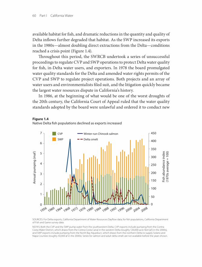
60 Part I California Water
available habitat for fish, and dramatic reductions in the quantity and quality of Delta inflows further degraded that habitat. As the SWP increased its exports in the 1980s—almost doubling direct extractions from the Delta—conditions reached a crisis point (Figure 1.4).
Throughout this period, the SWRCB undertook a series of unsuccessful proceedings to regulate CVP and SWP operations to protect Delta water quality for fish, in-Delta water users, and exporters. In 1978 the board promulgated water quality standards for the Delta and amended water rights permits of the CVP and SWP to regulate project operations. Both projects and an array of water users and environmentalists filed suit, and the litigation quickly became the largest water resources dispute in California’s history.
In 1986, at the beginning of what would be one of the worst droughts of the 20th century, the California Court of Appeal ruled that the water quality standards adopted by the board were unlawful and ordered it to conduct new
Figure 1.4Native Delta fish populations declined as exports increased
SOURCeS: For Delta exports, California Department of Water Resources Dayflow data; for fish populations, California Department of Fish and Game survey data.
NOteS: Both the CVP and the SWP pump water from the southwestern Delta. CVP exports include pumping from the Contra Costa Water District, which draws from the Contra Costa Canal in the western Delta (roughly 120,000 acre-feet [af] in the 2000s), and SWP exports include pumping from the North Bay aqueduct, which draws from the northern Delta to supply Solano and Napa Counties (roughly 50,000 af in the 2000s). Series for salmon and adult delta smelt are not available before the years shown.
Ann
ual p
ump
ing
(maf
)
7
6
5
4
3
2
1
0
19561960
19641968
19721976
19801984
19881992
19962000
20042008
CVP
SWP
Fish
ab
unda
nce
inde
x(1
970s
ave
rage
= 1
00)
450
400
350
300
250
200
150
100
50
0
Winter-run Chinook salmon
Delta smelt
Floods, Droughts, and Lawsuits 61
hearings. The court emphasized that the SWRCB had broad authority to amend the water rights of the CVP and SWP to ensure that project operations did not threaten water quality, aquatic species, and other beneficial uses, and it autho-rized the board to apply the new water quality standards to other water rights holders whose uses contribute to flow depletion and water quality degradation (United States v. State Water Resources Control Board 1986).
The SWRCB’s Bay-Delta water quality proceedings convened after the court’s decision included more than 100 water agencies, representing a variety of water users from all parts of the state. The board’s first draft water quality plan, announced in 1989, proposed to cap Delta exports at 1986 levels. It also contained a “California Conservation Ethic” that assigned most of the burden of conserving water on users in Southern California. The draft plan provoked a firestorm of political protest. The water quality plan that replaced it in 1991 deleted all refer-ences to the water ethic and imposed no limits on exports. It set water quality standards for salinity that were almost identical to the 1978 standards and failed to address one of the most important issues before the board—the quantity and timing of flows needed to protect endangered and threatened fish species.
Because of these failings, the U.S. Environmental Protection Agency (EPA) disapproved the water quality plan. EPA’s veto returned the matter to the board, which conducted new hearings. In March 1993, the SWRCB announced revised standards and a proposed water rights order. The board established water qual-ity and flow standards for salmon and steelhead and imposed water release requirements and water use fees on more than 100 appropriators in the Central Valley and Trinity River Basins. This proposal set off another political firestorm, and Governor Pete Wilson directed the board to rescind it. EPA responded by promulgating federal water quality and flow standards for the Bay-Delta Estuary in January 1994.
Meanwhile, additional federal regulatory agencies stepped to the forefront of California’s water policy debates. In 1989, the National Marine Fisheries Service listed the Sacramento River winter-run Chinook salmon as a threatened species (upgrading the listing to endangered status in 1994), and in 1993, the U.S. Fish and Wildlife Service listed the delta smelt as threatened. Returning winter-run Chinook salmon had declined from more than 100,000 in 1940 to fewer than 500 in 1989, and the delta smelt population had diminished by more than 90 percent. Federal biological opinions arising from these listings regulating the CVP and SWP called for significant changes in project operations—including reservoir releases to increase outflows and restrictions on exports through the southern

62 Part I California Water
Delta pumps—to protect the species from extinction. These actions cemented the central role of the federal fish protection agencies in California’s Era of Conflict.
In October 1992, Congress also interceded by enacting the Central Valley Project Improvement Act (CVPIA). Congress acknowledged in the statute that the CVP had been dedicated almost exclusively to providing water for agricultural and municipal uses and that project operations had diminished water quality, degraded the ecology of the Central Valley and the Delta, and threatened the extinction of native fish species. The CVPIA thus added fish and wildlife protection to the operational directives of the project, and ordered the Bureau of Reclamation to dedicate 800,000 acre-feet annually (about 20 per-cent of the face value of water delivery contracts) to a variety of environmental purposes.7 These included restoration of wetlands, protection of water quality in the Delta, provision of flows for fish, and assistance with state and federal efforts to protect these resources in other regulatory forums such as in the Bay-Delta proceedings and threatened and endangered species biological opin-ions. Although this new environmental water would be initially released and dedicated to environmental purposes, most of it would be reused for economic purposes, including significant expanded SWP exports from the Delta during the late 1990s and early 2000s (Figure 1.4).
The CVPIA also included provisions that brought the project into greater conformity with state law. Congress ordered the bureau to comply with all aspects of California law, ending the long-standing uncertainty whether the decisions of the SWRCB—as well as other vital state laws such as the reason-able use and public trust doctrines—could be applied to the CVP. The act also borrowed from California’s expanding policy of promoting water markets by authorizing the transfer of project water, both within the CVP and to users outside the project service area (see below).
CALFED and the failure of consensus politics
The EPA veto of California’s Bay-Delta water quality standards and the listings of winter-run salmon and delta smelt presented state water managers and their constituents with the threat of a federal regulatory takeover of California’s largest water projects and most important sources of water supply. In the spring of 1994, negotiations to resolve the crisis began. They included not just
7. The CVP delivers roughly 7 million acre-feet, but roughly 2.6 million acre-feet is “settlement” or “exchange” water to parties already diverting water before the project’s arrival, and another 0.4 million for wildlife refuges. The “project” deliveries are on the order of 4 million acre-feet, and only these were affected by the CVPIA.

Floods, Droughts, and Lawsuits 63
representatives of agricultural, urban, and environmental interests but also California’s business community and political leaders from Sacramento and Washington, D.C. The December 1994 Bay-Delta Accord incorporated the restrictions of the biological opinions, took advantage of the 800,000 acre-feet per year provided by the CVPIA, and laid the groundwork for revising SWRCB water quality standards, which were adopted the next year.
The Bay-Delta Accord and new water quality plan were followed by an even more ambitious proposal—to convene all state and federal agencies charged with administering or regulating the waters of the Delta system to devise a long-term management plan. This convening, which came to be known as “CALFED,” was “to develop a long-term comprehensive program that will restore ecological health and improve water management for beneficial uses of the Bay-Delta system.” To achieve these twin goals, the CALFED agencies stated that they would “concurrently and comprehensively address problems of the Bay-Delta system within four critical resource categories: ecosystem quality, water quality, water supply reliability, and levee system integrity.” The program examined a range of approaches to resolving the issues of the Delta, albeit with only modest technical analysis (CALFED 1996). In 2000, the agencies with authority over the Delta published the CALFED Record of Decision (ROD), which set forth a seven-year plan to achieve the goals defined by the Bay-Delta Accord. The CALFED ROD promoted continuing the current system of pull-ing water exports through the Delta to the southern Delta pumps until 2007, effectively putting off the difficult, strategic decisions.
The CALFED program was a well-funded (at least initially), grand experi-ment in consensus politics (Kallis, Kiparsky, and Norgaard 2009). The goal was to keep the warring parties at the table under the notion that “everyone would get better together.” In this regard, the program was successful. The amount of litigation declined significantly after the Bay-Delta Accord and through the early years of implementing the CALFED ROD. By the mid-2000s, however, consensus politics (which often serves to avoid difficult decisions) had run its course and the program began to fall apart. Under aggressive pressure from disaffected water users, federal and state support for the program disappeared.
The collapse of CALFED had many causes (Little Hoover Commission 2005; Hanneman and Dyckman 2009; Lund et al. 2007; Hanak et al. 2010; Madani and Lund 2011). These included the sharp increase in SWP exports from 2000 through 2007; a precipitous decline in open-water (or pelagic) species such as the delta smelt, followed by similar declines in salmon and steelhead at the end
64 Part I California Water
of the decade; and a failure to arrange funding from two of the three anticipated sources—the federal government and local agencies. (State general obligation bonds were the major initial source of funds.) CALFED also was not struc-tured to achieve its goals. It lacked mechanisms to craft decisions that might be unpopular with some stakeholders, it never implemented a “beneficiary pays” financing plan that could wean it from state bonds as a primary source of fund-ing, and it ultimately failed to develop a coherent vision for the future of the Delta where, by necessity, not everyone would necessarily get better together.
With the demise of CALFED, the Delta returned to its tradition of litigation and confrontation. In response to lawsuits filed by environmental groups, in May 2007 and April 2008 federal district Judge Oliver Wanger invalidated the biological opinions that governed CVP and SWP operations to protect delta smelt and salmon. Citing the insufficiency of federal efforts to protect declining species, Judge Wanger ordered severe restrictions on exports and a redrafting of the biological opinions. The new biological opinions, issued in 2008 and 2009, were adopted by the project operators. Then, in response to lawsuits filed by CVP and SWP contractors, the same judge invalidated the new biological opin-ions, concluding that the fish protection agencies did not adequately explain the linkage between project operations and the decline of the species and failed to consider effects of export restrictions on employment and production. At the time of this writing (late 2010), the judge has ordered a temporary increase in exports while all parties attempt to negotiate a solution. Clearly, California’s water management institutions have been unable to cope.
With CALFED moribund and the litigation wars back in full swing, the state embarked on a yet another new approach to the problems of the Delta ecosys-tem. Governor Arnold Schwarzenegger convened a Delta Vision Blue Ribbon Task Force in February 2007 to study the situation and to recommend insti-tutional changes to enable California to better manage the array of competing interests. In its Strategic Plan for the Delta published in October 2008, the task force called on the legislature to create a new governance structure that would manage the waters of the ecosystem to achieve two “co-equal” goals: “Restore the Delta ecosystem and create a more reliable water supply for California.” The task force emphasized that these “are co-equal goals because one objective can’t be achieved without the other” (Delta Vision Blue Ribbon Task Force 2008).
The legislature responded the following year with a broad package of reforms, as well as an $11.1 billion bond measure to fund new water projects around the state. The Delta Reform Act adopted the task force’s recommendation to
Floods, Droughts, and Lawsuits 65
create a Delta Stewardship Council to manage the Delta to achieve the goals of “restoring the Delta and providing for a clean, reliable, and sustainable water supply for all of the uses that depend on the waters of the ecosystem” (Water Code § 85001(c)). The legislature also declared that the “longstanding consti-tutional principle of reasonable use and the public trust doctrine shall be the foundation of state water management policy and are particularly important and applicable to the Delta” (Water Code § 85023). The package of reforms also included statewide measures to increase urban water conservation, better account for groundwater use, and increase water rights enforcement.
The Delta Reform Act is a promising beginning for the contemporary era of California water policy. So is the Bay Delta Conservation Plan, currently being negotiated by federal and state water managers, government regulators, water users, and environmental interests. These negotiations seek to create a compre-hensive habitat conservation and management plan to protect the endangered and threatened species of the Delta ecosystem while also permitting continued export of water by the SWP and CVP.
Flood Management in an Era of Conflict
During the Era of Conflict, traditional approaches to flood management also began to change. The massive flood control projects of the Hydraulic Era largely ended in the 1970s. Although environmental constraints restricted new flood control projects, a more significant factor was the general decline in federal support for water (and other infrastructure) projects, starting in the 1970s. Most large flood control projects in California depended on the federal government paying the bulk of the costs—occasionally reaching 80 percent—and providing much of the technical expertise. This decline in support is the cause of both the long backlog of repairs and maintenance on existing flood control projects (Chapter 2) and the relative dearth of proposals for additional projects.8
Ironically, the decline in federal investment coincided with dramatic increases in demand for flood management as urban development encroached into floodplains. This encroachment was particularly acute in the Central Valley, where cash-strapped communities increasingly depended on taxes from new development. Arguments that growth should be located in less hazardous areas fell on deaf ears.
8. In real terms, annual federal flood control spending in California fell to an average of only $70 million per year in the mid-1980s (2009 dollars); it has hovered in the range of $140 million per year over the past decade (Figure 2.16). The most sustained reduction occurred during the Reagan administration.
66 Part I California Water
A series of large floods highlighted the system’s weaknesses. In February 1986, floodwaters overwhelmed Folsom Dam on the American River and came perilously close to flooding Sacramento. In January 1997, floodwaters from levee failures throughout the Central Valley necessitated the largest flood evacuation in California’s history. These floods highlighted an unpleasant truth about the Central Valley flood control system: It can fail catastrophically.
Neither flood was enough to spur the federal and state governments back into the business of flood control, leaving local areas to prepare for floods largely on their own (Chapter 6). The state’s lethargy changed with the California Court of Appeal’s decision in Paterno v. State of California (2003), which held the state liable for failure of a levee along the Yuba River during the 1986 flood. This levee was within the federally authorized Sacramento Flood Control Project and maintained by a local reclamation district. The $500 million damages award paid by the state highlighted how a levee failure in a more populated area could, in the words of more than one legislator, “bankrupt the state.”
In 2004, on a warm day in June, a levee protecting Jones Tract in the Delta gave way, flooding the island whose lands were well below sea level. Repair costs for this levee failure reached almost $90 million, with the state paying the bulk of the cost. The levee failure also shut down the CVP and SWP pumps, signaling the close connection between flood control and water supply.
Then came Hurricane Katrina in August 2005. The images of the destruction and loss of life from failure of New Orleans’s levees galvanized the legislature and Governor Schwarzenegger to begin flood reform in the Central Valley. This urgency to act increased when the Department of Water Resources announced that failure to maintain Central Valley levees had led to more than 300 critical erosion sites, with many threatening large cities.
In the two years following Hurricane Katrina, the state legislature took several actions. It passed emergency legislation to address levee erosion, allocat-ing almost $500 million from the general fund, and placed a $4 billion general obligation bond on the November 2006 ballot for floods as part of a set of infrastructure measures. Voter approval for this bond and another placed on the ballot by initiative made almost $5 billion available for flood control works. The legislature also developed a package of flood policy bills. This legislation, signed by the governor in 2007, raised the required level of protection for urban areas above federal standards (200-year flood), reorganized the Reclamation Board, required shared liability on the part of communities building on the
Floods, Droughts, and Lawsuits 67
floodplain, and required that the Department of Water Resources develop a new State Plan of Flood Control.
The federal government, California’s flood control partner for over a cen-tury, was almost entirely absent during these developments. In a precedent that has rankled flood managers nationwide, California was forced to address flood management largely on its own, at a very high cost. Following the change of federal administrations in January 2009, federal flood control activity has increased in California. However, compared to federal involvement during the Hydraulic Era, it remains modest and focused principally on regulation rather than infrastructure.
Conflict as Impetus for Innovation
During the Era of Conflict, water managers were forced to adapt to reduced quantities of water and funding, increasing legal complexity, growing demands due to population growth, and diminished certainty about the future. As described in later chapters, these changes spawned a range of innovations in water management that could lay a foundation for the next era.
Several innovations, born out of necessity over the past 30 years, will be particularly crucial to creating adaptive capacity in the future. These include (1) agricultural and urban water conservation, driven by new metering and monitoring requirements, new plumbing codes, technological innovation, pricing incentives, and regulatory cutbacks; (2) more flexible operations and water allocations, reflecting more use of water markets; (3) conjunctive use of surface and groundwater, including better groundwater management; and reuse and recycling of wastewater and stormwater discharges. Of these, water marketing is perhaps the most promising means of creating incentives to change how California’s water management institutions function in the future (Hanak 2003; Israel and Lund 1995; Vaux and Howitt 1984).
The drought of 1976–1977 was one of the most severe in state history. Luckily, it was relatively short-lived. This drought spurred widespread urban water conservation programs, with unexpected success and acceptance. In the wake of this drought, both the governor and the legislature commissioned studies that suggested that water marketing—involving the voluntary transfer of water from those holding historical rights to others willing to pay for it—had great potential to reduce scarcity during times of drought and support longer-term shifts in demand (Governor’s Commission 1978; Phelps et al. 1978; Phelps, Moore, and Graubard 1978). Although there was considerable initial political
68 Part I California Water
resistance to water marketing, it became much more accepted in the early 1990s during yet another drought. The state created an emergency drought water bank in 1991 and acquired about 800,000 acre-feet of water for transfer. A year later, when Congress passed the CVPIA, it included provisions that facilitated water marketing and purchase of water for environmental purposes. The state followed suit in 1994, making it easier for SWP contractors to exchange water.
In 2000, the state created an Environmental Water Account (EWA) as part of the CALFED Record of Decision. The program was intended to provide water to protect listed fish species in the Delta while providing assurances to water users against additional water supply losses. Its goal was to reduce conflicts between ecosystem and water supply demands. Under the EWA, fish agency managers could store surplus water in reservoirs or aquifers and purchase water from willing sellers and then use the water to protect endangered species. The EWA also could be used to purchase water to replace water lost to agricultural and urban users from curtailment of export pumping. The federal and state governments funded the EWA, with the state shouldering most of the burden (Hollinshead and Lund 2006).
The benefits of the EWA remain unclear. Most state and federal officials tout it as a success principally because it reduced conflicts between water users and fish agencies. However, a comprehensive review of the EWA’s effects on fish from 2000 to 2006 found that the initial benefits were small: Survival of winter-run Chinook salmon increased by 0–6 percent, adult delta smelt by 0–1 percent, and juvenile delta smelt by 2–4 percent (Brown, Kimmerer, and Brown 2009). Despite these low returns on investment, the authors concluded that, with adequate financial and scientific support, the EWA had considerable potential. Although water is still available for the EWA under a new long-term transfer agreement with the Yuba County Water Agency, the ability to use it has virtually disappeared with the new biological opinions governing Delta operations.
An Era of Reconciliation?
Water management in California has evolved substantially over the past two centuries. This evolution is captured in a series of overlapping eras, defined by activities meant to meet growing and changing demands for water and flood control with a rapidly expanding economy and population. Natural and human events, involving floods, droughts, lawsuits, an evolving economy, and changing

Floods, Droughts, and Lawsuits 69
societal values, have shaped California’s water history. Each era has also left indelible marks on California’s landscape and ecosystems, both influencing and constraining future management.
Today’s Era of Conflict is characterized by the rise of environmental values that must now be integrated into all facets of water management and the hard realities of a water management system that may be extracting more than California’s climate and ecosystems can support. This era is also character-ized by financial constraints. The federal government—an essential source of financing, expertise, and leadership for more than a century—has become less able to support projects. Today, the federal government is focusing more on regulating solutions developed by others than on developing solutions to cur-rent and foreseen problems. Federal regulations are particularly important for achieving many public health and environmental objectives, but the lack of traditional federal funding, expertise, and initiative has made it more difficult for state and local water managers to adapt to change. At the same time, a state weary of borrowing money to patch over structural budget deficits may soon join the federal government in reducing its commitments to water projects.
The Era of Conflict has framed conditions for the next era in water man-agement in California. New environmental concerns and other changes will constrain and influence the shape of the next era, in which water management must balance and reconcile environmental and human water uses. Recent policy efforts, including the new Delta governance framework and the attempt to craft a comprehensive habitat conservation plan for the Delta, suggest paths for achieving this balance. And continued innovations and adaptations in water management, born of necessity during previous eras, could facilitate this shift by allowing agricultural and urban water users to live with less. Of course, current efforts may fail, and battles among water users may continue, prolong-ing the Era of Conflict. The remainder of this book explores the more hopeful path—and the challenges likely to be faced—in an Era of Reconciliation that may be emerging today.