Floodable exploring resilience remembrance in cedar rapids, iowa
62
RESILIENCE + REMEMBRANCE exploring in CEDAR RAPIDS, IOWA FLOODABLE
-
Upload
amber-hill -
Category
Documents
-
view
223 -
download
1
description
Â
Transcript of Floodable exploring resilience remembrance in cedar rapids, iowa

RESILIENCE + REMEMBRANCEexploring
in CEDAR RAPIDS, IOWA
FLOODABLE

RESILIENCE + REMEMBRANCEexploring
in CEDAR RAPIDS, IOWA
FLOODABLE

FORGETTABLE FLOODS
WATERMARKSproject introduction
PROJECT GROUNDINGsite location and approach
6
8
12
16
22
24
26
42
44
48
56
58
50
52
54
32
36
38
THE BUY-OUTcurrent plans to buy out property in the floodplain
TIME CHECK HOMES STANDINGTime Check neighborhood remaining homes
PARCEL PATCH PARKTime Check neighborhood shifting to open space
FLOOD OF 2008the damage done
FLOOD STAGES50 yr, 100 yr , 500 yr, 2008
WATERSHED CHARACTERISTICSlocation of city within the watershed and channel characteristics that influence flooding
SUPER-EFFICIENT LANDSCAPEimplications of a hyrdologicly efficient landscape on flooding
RIVER INTERSECTIONScurrent places where city meets river
CONSTRICTION POINTSregional effects of using levees and dams
CURRENT FLOOD RECOVERY PLANcurrent and historical paradigm regarding flood control
CITY + RIVER HISTORYsettlement of Cedar Rapids along the river
GIS DATA INVENTORY
REFERENCES
FLOODABILITYbuilding resiliency through floodability
WATERS INeach city is required to accept flood water
CONCEPTS FOR REMEMBRANCEconcepts for integrating rembrance into design in the Time Check neighborhood
FLOODPLAIN RETREATFLOOD ANATOMY
SOURCES
CEDAR (RAPIDS) RIVER
FLUX + PERSISTRIVER + CITY
page_2
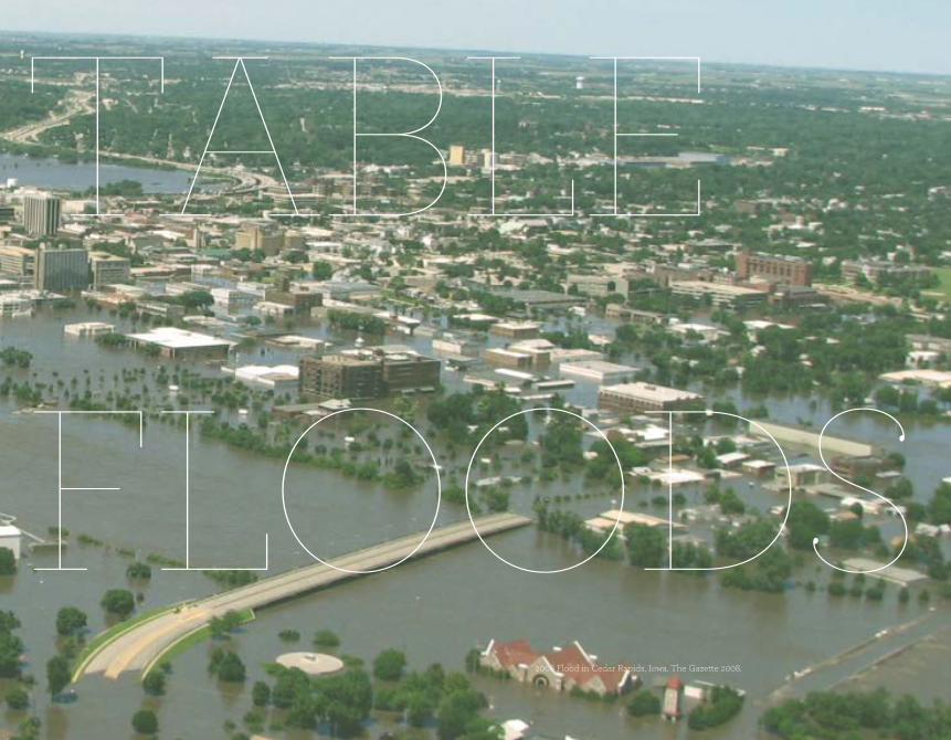
CONTENTS

page_3
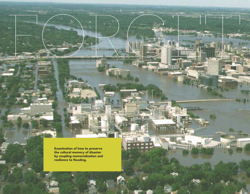
FORGET TABLE
Examination of how to preserve the cultural memory of disaster by coupling memorialization and resilience to flooding.
FORGET TABLE
FLOODS2008 Flood in Cedar Rapids, Iowa. The Gazette 2008.

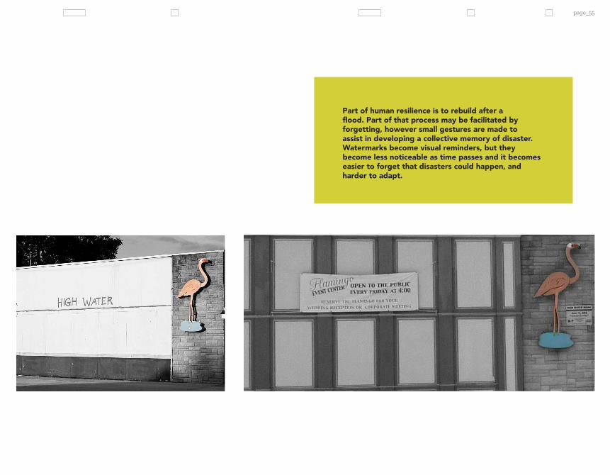
Flood level marked on Flamingo family restaurant on Ellis Blvd, Cedar Rapids. Photo by Amber Hill.
page_6
Some paint dark lines on buildings that show how far flood waters reached. People must paint those lines for many reasons, but primarily those lines and other similar gestures serve to develop a collective memory of disaster. Severe disasters must be remembered if people are to learn from them, to safeguard against their recurrence (Pfister 2011). In Cedar Rapids, the words “high water” were painted in red on a family restaurant affected by the flood. When you walk down that street you can re-imagine what that space must have been like, and how people had to deal with such a disaster. At another restaurant just along the river there’s a plaque marking the high water line inside the cafe. Patrons walk under a doorway to see it.
These gestures help people to remember, but forgetting can be useful too. When water rose in Cedar Rapids, it left it’s mark on people’s lives and on the physical infrastructure of the city. Yet, when compared to other types of disaster, such as wars, the memory of natural disasters is much shorter lived. The high water marks don’t only serve to remember the floods, but also become “expressions of institutional risk memory,” (Pfister 2011) an understanding of how risky a place is to live, and yet despite this type of remembering of a disaster such as that in 2008 in Cedar Rapids, people still feel determined to live in the flood zone. “Disaster gap” is a term to describe the long period of time between disasters in a region that can lead to a loss of a cultural memory of disaster (Pfister 2011).
I want to examine how to preserve the cultural memory of disaster by coupling memorialization and resilience to flooding, particularly in the neighborhood that I grew up in, which is currently in the process of being bought out to be transformed into a greenway as a flood protection measure.
WATERMARKSWHEN WATERS RISE, THEY LEAVE THEIR MARK

page_7
page_8
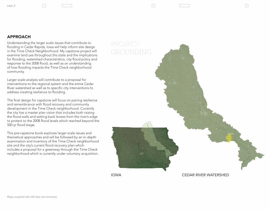
Understanding the larger scale issues that contribute to flooding in Cedar Rapids, Iowa will help inform site design in the Time Check Neighborhood. My capstone project will examine land use throughout the state and the implications for flooding, watershed characteristics, city flood policy and response to the 2008 flood, as well as an understanding of how flooding impacts the Time Check neighborhood community.
Larger scale analysis will contribute to a proposal for interventions to the regional system and the entire Cedar River watershed as well as to specific city interventions to address creating resilience to flooding.
The final design for capstone will focus on pairing resilience and remembrance with flood recovery and community development in the Time Check neighborhood. Currently the city has a master plan vision that includes both raising the flood walls and setting back levees from the river’s edge to protect to the 2008 flood levels which reached beyond the 500-yr flood stage.
This pre-capstone book explores larger scale issues and theoretical approaches and will be followed by an in-depth examination and inventory of the Time Check neighborhood site and the city’s current flood recovery plan which includes a proposal for a greenway through the Time Check neighborhood which is currently under voluntary acquisition.
APPROACH
Maps compiled with GIS data. See Inventory.
PROJECT GROUNDING
IOWA CEDAR RIVER WATERSHED
page_9
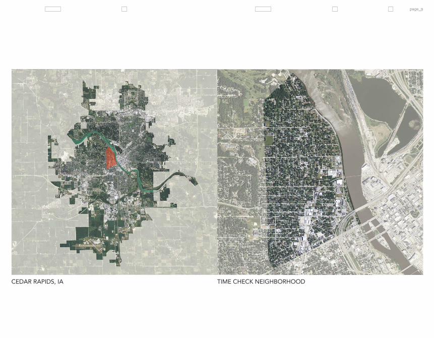
CEDAR RIVER WATERSHED CEDAR RAPIDS, IA TIME CHECK NEIGHBORHOOD

(CEDAR RAPIDS)

(CEDAR RAPIDS) RIVERPeople have always been drawn to rivers. They support life by supplying water and are economic
resources. The use of waterways for transportation and trade routes has spurred people to build homes along them where they could be close to food and supplies, but settlement along rivers is also a dangerous endeavor; rivers change. They move around in the landscape, carving out new locations for their flow. They rise and fall annually, swelling with the influx of snow melt and spring rains and subsiding as the dry summer landscape soaks up moisture. Sometimes that swelling floods where people have settled, which is what has continuously happened in Cedar Rapids since early development. The city needed the river to grow economically, however dealing with the consequences of such proximity to a dynamic river is a challenge of balancing ecological, economic, and cultural interests.
page_12
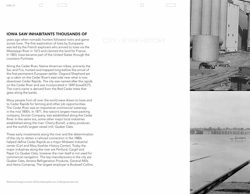
IOWA SAW INHABITANTS THOUSANDS OF years ago when nomadic hunters followed rivers and game across Iowa. The first exploration of Iowa by Europeans was led by the French explorers who arrived to Iowa via the Mississippi River in 1673 and claimed the land for France. In 1803, Iowa became part of the United States through the Louisiana Purchase.
Along the Cedar River, Native American tribes, primarily the Sac and Fox, hunted and trapped long before the arrival of the first permanent European settler. Osgood Shepherd set up a cabin on the Cedar River’s east side near what is now downtown Cedar Rapids. The city was named after the rapids on the Cedar River and was incorporated in 1849 (IowaDOT). The river’s name is derived from the Red Cedar trees that grew along the banks.
Many people from all over the world were drawn to Iowa and to Cedar Rapids for farming and other job opportunities. The Cedar River was an importanat commercial waterway in the mid 1800’s. In 1871, the nation’s largest meat-packing company, Sinclair Company, was established along the Cedar River. In the same era, some other major local industries established along the river: Cherry-Burrell, a dairy producer, and the world’s largest cereal mill, Quaker Oats.
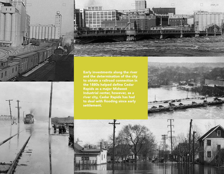
These early investments along the river and the determination of the city to obtain a railroad connection in the 1880s helped define Cedar Rapids as a major Midwest Industrial center (Carl and Mary Koehler History Center). Today the major industries along the river are Penford, Cargill and Pepsi Co Quaker Oats, however the river itself is not used for commercial navigation. The top manufacturers in the city are Quaker Oats, Amana Refrigeration Products, General Mills and Heinz Compnay. The largest employer is Rockwell Collins.
CITY + RIVER HISTORY
Historical image sources: Hellocedarrapids.com, lookinginatiowa.com
page_13
Early investments along the river and the determination of the city to obtain a railroad connection in the 1880s helped define Cedar Rapids as a major Midwest Industrial center, however, as a river city, Cedar Rapids has had to deal with flooding since early settlement.

The flood of 2008 in Cedar Rapids reached over 31 feet, surpassing the previous record of 20 feet in 1993. The flood of ‘93 did not rise over the city’s flood wall and levee system. 2008 was a surprise. The city flooded for reasons beyond city control, including climate change, land-use change, timing and location of precipitation, and the geographical location of the city in the watershed.

ANATOMYFLOOD

page_16

page_17
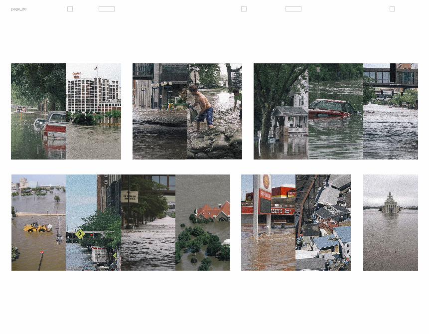
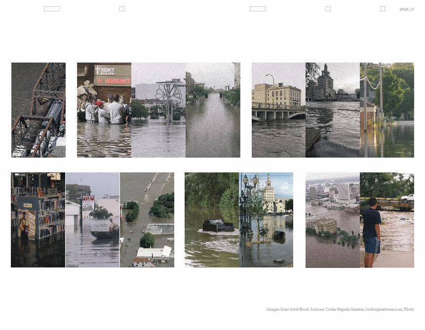
• Houses damaged: 5,238 (parcels: 5,390)• Businesses damaged: 940 (parcels: 1,049)• Non-profits/faith organizations damaged: 77• City blocks affected: 1,300 (10 square miles)• River levels: Crest 31.12 feet June 13, 2008
in Cedar Rapids. The 2008 flood was federally declared a national disaster, affecting most of the rivers in Eastern Iowa and continuing to the Upper Mississippi River. The cultural and economic losses of the flood were great and the recovery process is an expensive endeavor that requires federal assistance. A host of civically important buildings were damaged, including the County and federal courthouses. Many of the homes along the floodplain had to be demolished due to damage from water reaching the first floors of the houses and causing floor joists to fail with some floors sagging into basements. Time Check neighborhood, which was particularly hard hit, has had hundreds of homes since demolished. In addition to the loss of structures, the city endured tremendous disruption to water supplies and utilities.
Many jobs were lost due to the flood as well, estimated to be in the 6,000 – 7,000 range. Many small businesses were essentially wiped out, especially in Czech Village. Quaker Oats is a major employer in the area and they fortunately did not see much damage.
The waters finally receded greatly by June 18. Recovery efforts began immediately and are ongoing (Iowa Flood of 2008).
The city currently has a master plan for flood recovery that is anticipated to take up to ten years to implement if they receive funding from state sources, which they are currently applying for.
FLOOD OF 20082008 WAS KNOWN AS THE YEAR OF THE FLOOD
Iconic Cedar Rapids boat houses piled up at the 1st Avenue railroad bridge. Image source: MSNBCmedia

page_18
Quaker Oats in Cedar Rapids and fields flooded in 2008. Images from Marc Saegesser.

page_19
Homes and businesses both in the city proper and the surrounding area were affected by the 2008 flood.
page_20
page_21
Images from 2008 flood. Sources: Cedar Rapids Gazette, lookinginatiowa.com, Flickr
page_22
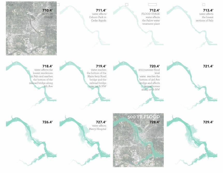
water affects the lowest
sections of Palo
713.4’
721.4’
729.4’
water affects Osborn Park in
Cedar Rapids
ACTION STAGE
water reaches the bottom of the Blairs ferry Road
bridge and the railroad bridge near 1st St NW
water affects Mercy Hospital
FLOOD STAGEwater affects
the Palow water treatment plant
2013 summer flood level
water reaches the bottom of 3rd Ave bridge and affects
several homes along 1st St NW
water affects the lowest residences
in Palo and reaches the bottom of the
railroad bridge along 8th Ave
711.4’
719.4’
727.4’
712.4’
720.4’
728.4’
710.4’
718.4’
726.4’
page_23
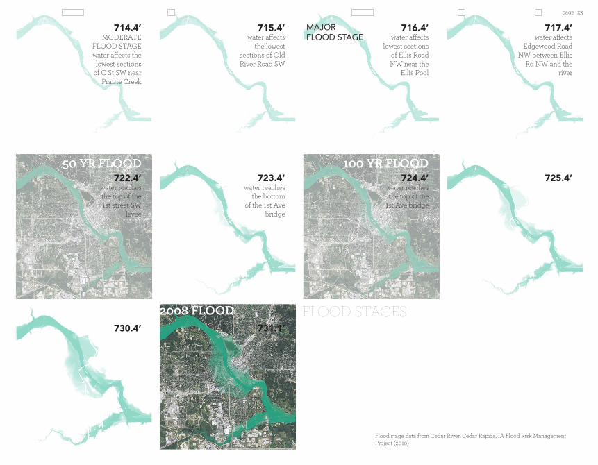
MAJORFLOOD STAGE
100 YR FLOOD
water affects the lowest
sections of Old River Road SW
water reaches the bottom
of the 1st Ave bridge
water affects lowest sections
of Ellis Road NW near the
Ellis Pool
water reaches the top of the
1st Ave bridge
water affects Edgewood Road
NW between Ellis Rd NW and the
river
MODERATE FLOOD STAGEwater affects the lowest sections
of C St SW near Prairie Creek
water reaches the top of the 1st street SW
levee
715.4’
723.4’
731.1’
2008 FLOOD
716.4’
724.4’
717.4’
725.4’
714.4’
722.4’
730.4’
Flood stage data from Cedar River, Cedar Rapids, IA Flood Risk Management Project (2010)
FLOOD STAGES
page_24
WATERSHED CHARACTERISTICS
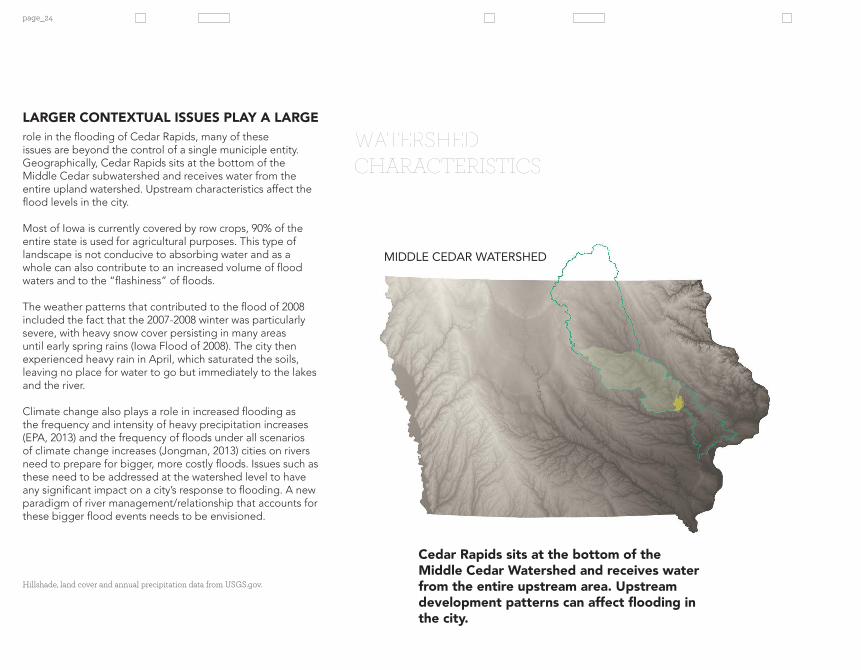
role in the flooding of Cedar Rapids, many of these issues are beyond the control of a single municiple entity. Geographically, Cedar Rapids sits at the bottom of the Middle Cedar subwatershed and receives water from the entire upland watershed. Upstream characteristics affect the flood levels in the city.
Most of Iowa is currently covered by row crops, 90% of the entire state is used for agricultural purposes. This type of landscape is not conducive to absorbing water and as a whole can also contribute to an increased volume of flood waters and to the “flashiness” of floods.
The weather patterns that contributed to the flood of 2008 included the fact that the 2007-2008 winter was particularly severe, with heavy snow cover persisting in many areas until early spring rains (Iowa Flood of 2008). The city then experienced heavy rain in April, which saturated the soils, leaving no place for water to go but immediately to the lakes and the river.
Climate change also plays a role in increased flooding as the frequency and intensity of heavy precipitation increases (EPA, 2013) and the frequency of floods under all scenarios of climate change increases (Jongman, 2013) cities on rivers need to prepare for bigger, more costly floods. Issues such as these need to be addressed at the watershed level to have any significant impact on a city’s response to flooding. A new paradigm of river management/relationship that accounts for these bigger flood events needs to be envisioned.
LARGER CONTEXTUAL ISSUES PLAY A LARGE
MIDDLE CEDAR WATERSHED
Hillshade, land cover and annual precipitation data from USGS.gov.
Cedar Rapids sits at the bottom of the Middle Cedar Watershed and receives water from the entire upstream area. Upstream development patterns can affect flooding in the city.
page_25
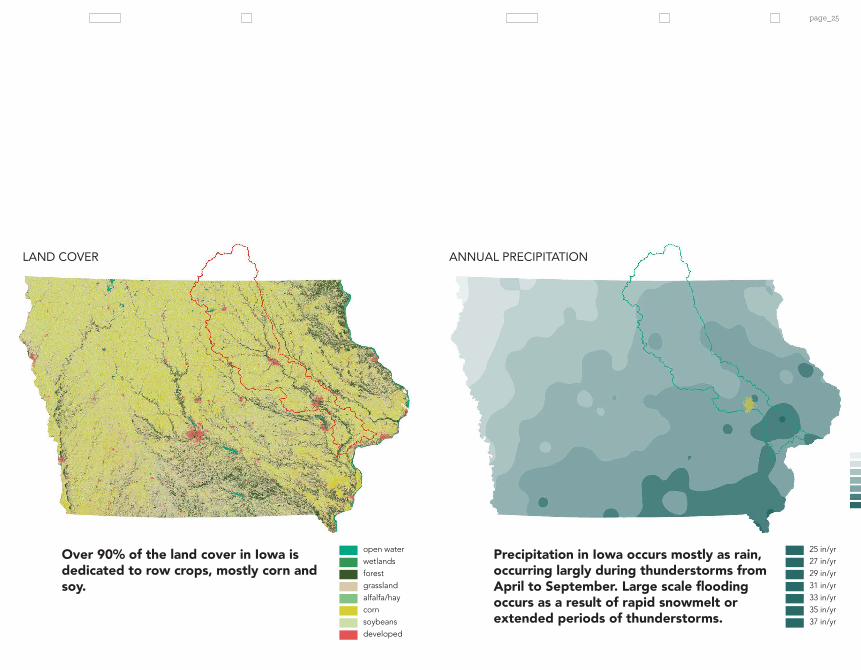
LAND COVER ANNUAL PRECIPITATION
25 in/yr27 in/yr29 in/yr31 in/yr33 in/yr35 in/yr37 in/yr
open waterwetlandsforestgrassland alfalfa/haycornsoybeansdeveloped
Over 90% of the land cover in Iowa is dedicated to row crops, mostly corn and soy.
Precipitation in Iowa occurs mostly as rain, occurring largly during thunderstorms from April to September. Large scale flooding occurs as a result of rapid snowmelt or extended periods of thunderstorms.

page_26
landscape that is incredibly efficient at moving water from the soil to a receiving body of water. Development patterns upland contribute to the increase of runoff, which impacts both the quantity and quality of the river’s waters within the city of Cedar Rapids. In Iowa, almost 40% of the agricultural fields are tiled which allows for water to flow more quickly from the fields and into the waterways (Iowa Flood of 2008) which contributes to extensive flooding. As can be observed in the map to the right, most of the tiled landscape is in the north central portion of the state, around Cedar Rapids, the primary way to drain soils is by drainage ditches, and the use of existing creeks.
Compared to how the tall grass prairies of Iowa’s heritage functioned, the agricultural landscape is super efficient at moving water through the landscape. The prairie system essentially acts as a sponge that retains water and slowly releases it at steady rates through the subsoil. The deep roots of the prairie plants direct water downward, countering the tendency to move laterally (Mutel 2008). Row crops, which are generally planted as monocultures, have shorter, less complex root systems and strip the soil of nutrients. Generally corn and soy only cover the ground during the growing season, leaving hard dry soil for water to flow off of the rest of the year.
Protection against future flooding requires integration of addressing larger scale issues that could help reintroduce hydrologic function to the state and make each city more resilient to flooding. Increasing programs like the Farm and Ranch Lands Protection Program (FRPP) to focus on acquiring space that could be used flexibly as both farmland and river floodplain could begin to address this issue.
SUPER EFFICIENT LANDSCAPE
INDUSTRIAL AGRICULTURE CREATES A
AGRICULTURAL TILE DRAINAGE
Tillage data map from NRGS. Aerial image from Google maps.

page_27
Existing river systems can be seen cutting through the street grid layout derived from the public land survey system (PLSS). Farmer’s use a series of ditches and pipes or drain tilage in cunjunction with these existing creeks and rivers to drain their land.
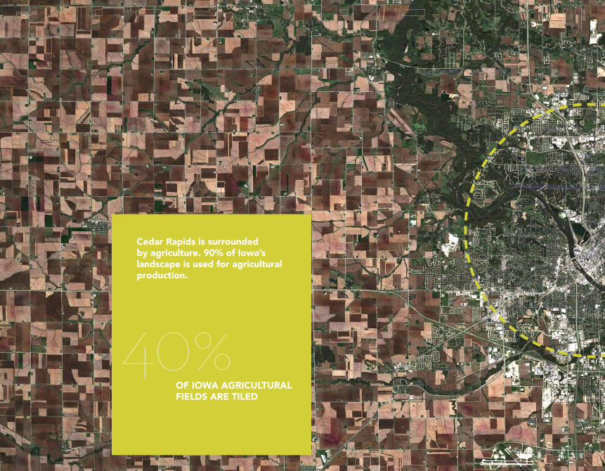
Cedar Rapids is surrounded by agriculture. 90% of Iowa’s landscape is used for agricultural production.
page_28
OF IOWA AGRICULTURAL FIELDS ARE TILED
40%

page_29
page_30
page_31
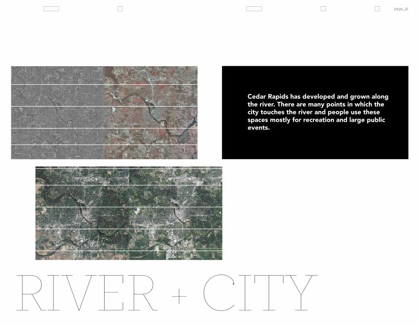
RIVER + CITY
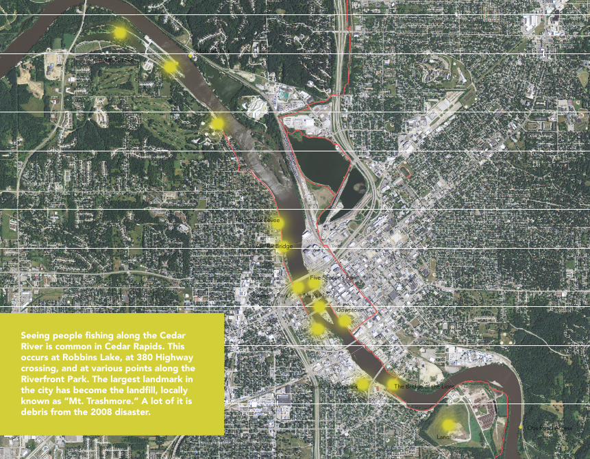
Cedar Rapids has developed and grown along the river. There are many points in which the city touches the river and people use these spaces mostly for recreation and large public events.
Sac & Fox Trail
Sac & Fox Trail
Cedar River Trail
Cedar River Trail
Cedar River Trail
Mohawk Park
Robbins Lake
Otis Road Access
Sac and Fox
Lou’s Area Access
River Road Access
Riverfront Park
Landfill
1st Ave RR Bridge
The Bridge of the LionsRiverfront Skatepark
Czech Village
Timecheck Levee
May’s Island
Downtown
Five Season’s Park
page_32
Dam, levees and flood walls in the Cedar River watershed and within Cedar Rapids. Data from xyz.
Seeing people fishing along the Cedar River is common in Cedar Rapids. This occurs at Robbins Lake, at 380 Highway crossing, and at various points along the Riverfront Park. The largest landmark in the city has become the landfill, locally known as “Mt. Trashmore.” A lot of it is debris from the 2008 disaster.

Sac & Fox Trail
Sac & Fox Trail
Cedar River Trail
Cedar River Trail
Cedar River Trail
Mohawk Park
Robbins Lake
Otis Road Access
Sac and Fox
Lou’s Area Access
River Road Access
Riverfront Park
Landfill
1st Ave RR Bridge
The Bridge of the LionsRiverfront Skatepark
Czech Village
Timecheck Levee
May’s Island
Downtown
Five Season’s Park
page_33
Places where river and city intesect in Cedar Rapids, IA. Photos by Amber Hill.
RIVER INTERSECTIONS
Robbins Lake
Landfill
Ellis boat houses Downtown

page_34

Time Check Levee to the Police Station 1st St (west side river road.)
page_35

Dam, levees and flood walls in the Cedar River watershed and within Cedar Rapids. Data varies, see Inventory..
page_36
CONSTRICTION POINTSmanagement includes the use of flood walls, levees, and dams to command and control the flow of the river in order to prevent damage to property along the river. The U.S. Army Corps of Engineers is the primary federal agency involved in flood control in the U.S. In 1936 the Flood Control Act was established by congress to address flooding at a national level. USACE has approached the problem of flooding from the paradigm of command and control of the river, building more and larger infrastructural elements along rivers (U.S. General Accounting Office 1995).
One of the main problems with this method is that the construction of higher and more abundant walls along the river creates channels that have less capacity for holding water and actually raises the levels of flood waters when they do occur. The maps to the right show the dams and levees that exist along the Cedar River. These create a series of constriction points that restrict the flow of water and create areas where flow builds up behind them. After the flood of 1993, the research branch of congress issued a report that addressed the role of levees in the ‘93 flood. The report acknowledged that levees and flood walls do not eliminate flooding, but in the case of 1993, prevented about $7.4 billion in flood damage (U.S. GAO 1995). However, putting up walls in one city may cause another city to flood. The GAO stated that during the 1993 flood, there were some places that received up to 7 feet more water than they would have had flood infrastructure in other locations not been in place (1995).
The dikes and levees along the banks of cities upstream create constriction points that require the river to find places to expand downstream. The cities of Waterloo and Cedar Falls did not receive significant flood damage due to their high levee systems, whereas the channels that were created along the river near downtown Cedar Rapids create a narrow pathway that doesn’t accommodate high volumes of water (Sasaki 2008).
THE STATUS QUO METHOD FOR FLOOD
WATERSHED FLOOD INFRASTRUCTURE
levees/floodwallsriver dams
Cedar Rapids
WaterlooCedar Falls

page_37
2008 FLOOD EXTENTS 31.12’
CITY FLOOD INFRASTRUCTURE AS OF 2013

10 cedar Rapids Framework Plan
typical section of riverfront with extended parkland
leveeRight-of-way
Riverfront Park
greenway levee Plaza/levee overlook new damcity park
0 500 1000 2000
N
O Avenue
TimeCheck
CzechVillage
Downtown
New Bohemia
I-38
0
F AvenueE Avenue
5TH Avenue
16TH Avenue
6TH S
tree
t
1ST Avenue
3RD Avenue
8TH Avenue
12TH A
venu
e16
TH A
venu
e
8 TH Street
C Street
Ellis Park
Edg
ewoo
d R
d
TaylorArea Oak Hill
Jackson
Cedar Valley/Rompot
Continuous Trail System
Great Lawn / Sports Recreation
Restored River Edge and River Recreation
Wetland Park
Riverfront Amphitheater
Plaza/Levee Overlook
Potential PLAY location
Restored River Edge
New Dam
Potential PLAY Location
May’s Island Plaza
City Terrace
Boat Dock
Greenway
Taylor
page_38
Sasaki drawing showing City Preferred Flood Recovery Plan, approved by city council 11/12/2008.
CITY PREFERRED FLOOD RECOVERY PLAN

page_39
City map explaining flood recover progress. 5-yr Flood Management Progress Report, 2013. Information from interview with Sandi Fowler, City Manager of Cedar Rapids, 2013.
Recovery Framework Plan provides protection for both sides of the river to the 2008 flood levels of 24’, with an additional 3’ for free-board. The framework plan combines two strategies explored during the recovery process, one was to build flood walls at the river’s edge all along the city, the other to have a more naturalized floodplain and have levees and walls considerably offset from the river’s edge. The approved plan as shown in the images to the left has levees offset slightly from the river’s edge as well as increased flood wall heights directly at the water’s edge.
The city has not yet made headway on permanent flood structures, however 3 private businesses have constructed their own flood infrastructure. Quaker Oats has built a small segment of flood wall directly surrounding the company which protects to the 100-yr flood level. Cargill and Penford have created temporary earthen levees that will remain until permanent flood walls are constructed. The city has reinforced the Time Check Levee.
Completion of implementation of the project depends on receiving state funding for both sides of the river. In city documentation there is also acknowledgment of a need for regional strategies that address upstream issues related to flooding.
CURRENT FLOOD RECOVERY PLAN
THE CITY’S CURRENT APPROVED FLOOD

page_40
FLOODPLAINRETREAT

Letting the river come into the floodplain, even slightly, as the current plan envisions, has social and political implications. People currently live in that neighborhood and there are a total of five homes that have decided to opt out of the voluntary acquisition process. In this case, the resilience of individuals and the community is at odds with the resilience of the city.
page_41

page_42
GIS data varies. See Inventory.
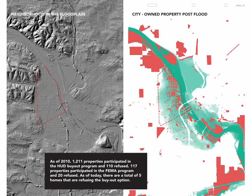
THE BUY OUTproperties in the floodplain. The city has implemented a voluntary property acquisition program funded by two Federal sources. The U.S. Department of Housing and Urban Development (HUD) provides funding through the Comunity Development Block Grant (CDBG) and the Federal Emergency Management Agency (FEMA) provides funding through the Hazard Mitigation Grant Program (HMGP). The FEMA HMGP funds will be used to create the Time Check Greenway and the HUD CDBG funds will be used to acquire properties in the construction zone that will be revitalized. In addition to federal funding, the city appoved a local-option sales tax to aid in acquision and rehabilitation of flood-damaged properties (USACE 2011).
Currently their are five homes that are refusing the buy-out option. When I met with a woman who lives in the last remaining home along the river road (1st St,) she stated that most of the people who were bought out struggled to make the move and did not receive adequate compensation for their homes. She stated that the city offered her $14,000 to move from the home that she currently owns. She stated that her home has been in that location for over a hundred years, before the levee was in place. She told a story of a neighbor who said he used to fish from his porch when flood waters would rise before the levee existed.
The five homes that remain have bonded through their experience and meet weekly to have cook-outs and sometimes imagine what their neighborhood could look like. They have ideas for a memorial, the re-use of a house to become a Dairy-Queen, a maze, and the homeowner even said she would rather see her house become a museum than be torn down.
CEDAR RAPIDS HAS INITIATED PURCHASING
TIME CHECK NEIGHBORHOOD + RIVER
page_43
TIME CHECK NEIGHBORHOOD + RIVER
As of 2010, 1,211 properties participated in the HUD buyout program and 110 refused. 117 properties participated in the FEMA program and 20 refused. As of today, there are a total of 5 homes that are refusing the buy-out option.
NEIGHBORHOOD IN THE FLOODPLAIN CITY - OWNED PROPERTY POST FLOOD
page_44page_44
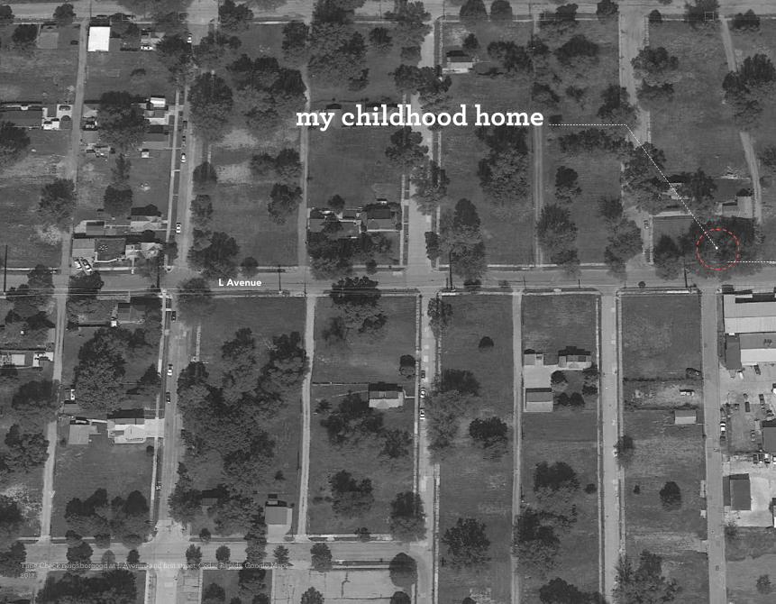
Time Check neighborhood at L Avenue and first street, Cedar Rapids. Google Maps 2012.
my childhood home
L Avenue

page_45page_45
TIME CHECK HOMES STANDING
TIME CHECK HOMES STANDING 2010
2012
L Avenue
L Avenue

page_46
PARCEL PATCH PARK
Time Check neighborhood 2013. PhotoS by Amber Hill.

page_47

FLUX + PERSIST
Flooding issues in one city have to be addressed at a larger scale considering the overall context of Cedar Rapids is a sea of agriculture. No one city intervention will flood-proof the city, especially if all the cities upstream decide to build levees and flood walls which will increase flood water levels elsewhere.

FLUX + PERSIST
page_50
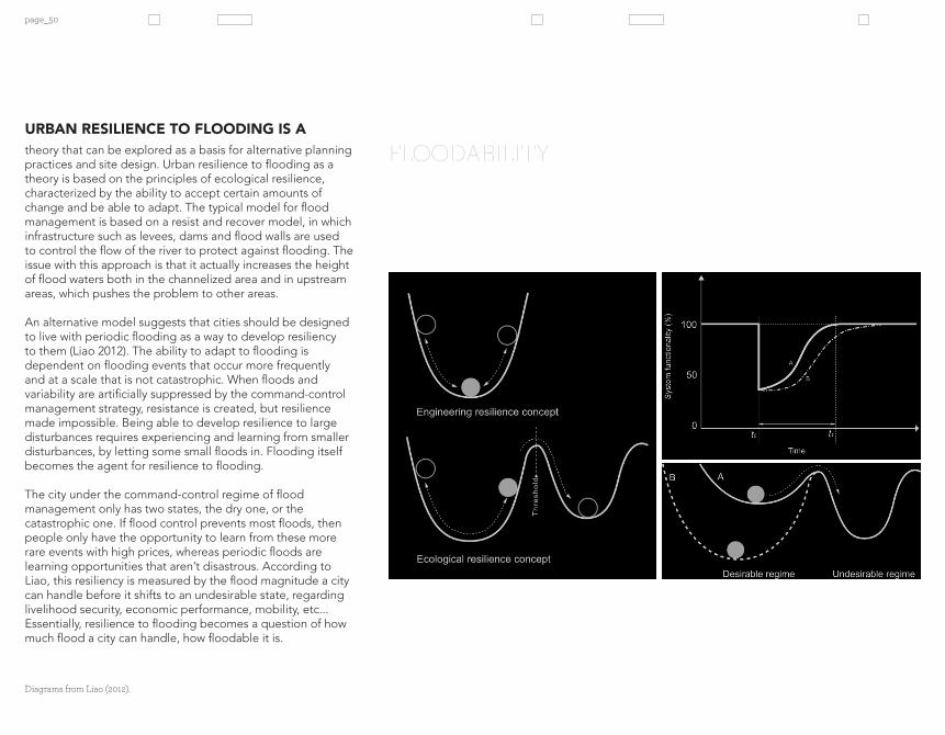
FLOODABILITYtheory that can be explored as a basis for alternative planning practices and site design. Urban resilience to flooding as a theory is based on the principles of ecological resilience, characterized by the ability to accept certain amounts of change and be able to adapt. The typical model for flood management is based on a resist and recover model, in which infrastructure such as levees, dams and flood walls are used to control the flow of the river to protect against flooding. The issue with this approach is that it actually increases the height of flood waters both in the channelized area and in upstream areas, which pushes the problem to other areas.
An alternative model suggests that cities should be designed to live with periodic flooding as a way to develop resiliency to them (Liao 2012). The ability to adapt to flooding is dependent on flooding events that occur more frequently and at a scale that is not catastrophic. When floods and variability are artificially suppressed by the command-control management strategy, resistance is created, but resilience made impossible. Being able to develop resilience to large disturbances requires experiencing and learning from smaller disturbances, by letting some small floods in. Flooding itself becomes the agent for resilience to flooding.
The city under the command-control regime of flood management only has two states, the dry one, or the catastrophic one. If flood control prevents most floods, then people only have the opportunity to learn from these more rare events with high prices, whereas periodic floods are learning opportunities that aren’t disastrous. According to Liao, this resiliency is measured by the flood magnitude a city can handle before it shifts to an undesirable state, regarding livelihood security, economic performance, mobility, etc... Essentially, resilience to flooding becomes a question of how much flood a city can handle, how floodable it is.
URBAN RESILIENCE TO FLOODING IS A
Diagrams from Liao (2012).

page_51
Urban resiliency to flooding can be conceptualized as the “capacity to remain in a desirable regime while experiencing a flood.”
levees/floodwallphased removal
river damsphased selective decomissioning
phased replacement of decommissioned structures with flood reservoirs/riparian habitat
Cedar Rapids
WaterlooCedar Falls
page_52
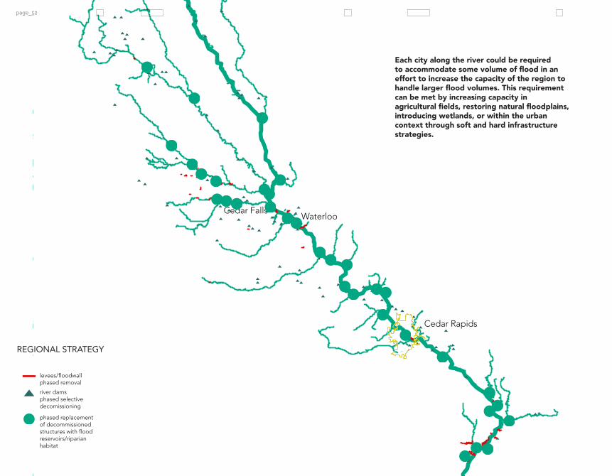
Each city along the river could be required to accommodate some volume of flood in an effort to increase the capacity of the region to handle larger flood volumes. This requirement can be met by increasing capacity in agricultural fields, restoring natural floodplains, introducing wetlands, or within the urban context through soft and hard infrastructure strategies.
REGIONAL STRATEGY
levees/floodwallphased removal
river damsphased selective decomissioning
phased replacement of decommissioned structures with flood reservoirs/riparian habitat
Cedar Rapids
WaterlooCedar Falls

page_53
along the Cedar River to accept some percentage of water into their own city boundaries or to purchase land from nearby areas for flood mitigation could be a way to create a resilient regional system for flood protection. This strategy could be implemented through identifying areas regionally that could be converted to floodplains and areas where levees could be taken down in conjunction with developing a strategy for how agricultural lands could hold more water throughout the year. A policy of compensation for flood mitigation could be paid to farmers who have land along the floodplain, or to cities that have land that could be used as reservoirs.
Precedents of international projects that currently use these strategies are the Netherlands’ “Room for the River” concept and Rotterdam’s “Waterplein.” Room for the River is a strategy in which the government has decided to shift focus from built structures that channelize rivers in the Rhine region, and instead focus all future funding on opportunities to expand the river channel to not only decrease flood levels, but to also create habitat, restore natural hydrologic function, and create opportunities for public space.
On a local level, resilience design can be explored in the areas where flood waters are let in. The Rotterdam “Waterplein” is a design strategy that uses public hardspace infrastructure such as underground parking lots, public plazas, and recreational space as temporary storage during flood events.
A REGIONAL STRATEGY TO REQUIRE CITIES
WATERS IN
Images: River Waal in Namjegen and Rotterdam Waterplein proposals.

Images of Flamingo restaurant adapted from Flickr.
necessary elements in the process of recovering and being able to prepare for disasters like flooding. The theory of urban resilience to flooding requires that people see flooding in order to learn from it. In the current situation, floods only enter into people’s lives in a meaningful way when they are disasters. Not allowing flooding to occur at small and manageable scales frequently prevents people from being able to develop resiliency mechanisms (Liao 2012). If flooding occurs more frequently, people are more likely to anticipate floods and develop adaptive strategies. Severe disasters need to be remembered collectively in order to prevent the impact when they reoccur (Pfister 2011).
Coupling the concepts of resilience and remembrance, I want to explore how the city proposed Time Check Greenway can become a place that is adaptive to flooding at multiple stages while serving as a memorial to the lives that were destroyed and a commemoration of the resilient community spirit to persist despite the fact that the river makes equal claim to their home.
RESILIENCE AND REMEMBRANCE ARE BOTH
page_54
CONCEPTS FOR REMEMBRANCE
page_55
Part of human resilience is to rebuild after a flood. Part of that process may be facilitated by forgetting, however small gestures are made to assist in developing a collective memory of disaster. Watermarks become visual reminders, but they become less noticeable as time passes and it becomes easier to forget that disasters could happen, and harder to adapt.

page_56

page_57
City of Cedar Rapids Data:
land use
storm sewer
sanitary sewer
zoning
building footprints
sidewalks
curb lines
paved parking lots
1’ Contours
streets
Linn County GIS Data:
parcels
geopolitical boundaries
bike trails
railroads
Natural Resources Geographic Information Systems Library Data:
stream gages
FEMA floodway
flood areas
base flood elevations
dams
land exemptions
(forest,prairie,wetland)
soil data
municipal water intake
watersheds
ecoregions
hillshade
levee centerlines
major rivers
annual precipitation
landform regions
bedrock faults
agricultural land cover
National Weather Service Data:
inundation maps
GIS DATA INVENTORY

page_58
Adger, W. N. 2000. Social and ecological resilience:are they related? Progress
in Human Geography 24(3):347-364.
Ahern, Jack. 2011. “From Fail-safe to Safe-to-fail: Sustainability andResilience
in the New Urban World.” Landscape Architecture & Regional
Planning Graduate Research and Creative Activity (April 1).
Alberti, M., and J. M. Marzluff. 2004. Ecological resilience in urban
ecosystems: linking urban patterns to human and ecological
functions. Urban Ecosystems 7 (3):241-265.
Bennett, E. M., G. S., Cumming, and G. D. Peterson. 2005. A system model
approach to determining resilience surrogates for case studies.
Ecosystems 8:945-957.
Berkes, F. 2007. Understanding uncertainty and reducing vulnerability:lessons
from resilience thinking. Natural Hazards 41(2):283-295.
Brierley, Gary J, Kirstie A Fryirs, and Society for Ecological Restoration
International. 2008. River Futures an Integrative Scientific Approach to River
Repair. Washington [D.C.]: Island Press.
Carl and Mary Koehler History Center. Cedar Rapids History. Web. 11 March
2013. http://www.city-data.com/us-cities/The-Midwest/Cedar-
Rapids-History.html
Carpenter, S. R., B. Walker, J. M. Anderies, and N. Abel. 2001. From metaphor
to measurement: resilience of what to what? Ecosystems 4 (8):765-
781.
City of Cedar Rapids. Cedar Rapids, IA Framework for Redevelopment and
Reinvestment. Web. 11 March 2013.
City of Cedar Rapids. Flood Protection: Both Sides of the River. Web. 11
March 2013. http://www.cedar-rapids.org/city-news/flood-recovery-
progress/ floodmanagementsystem/Pages/default.aspx
City of Cedar Rapids. 2013. Flood Response Manual. Cedar Rapids Public
Works Department. Revised February 2013.
Cronon, William. 1995. Uncommon Ground: Toward Reinventing Nature. New
York: W.W. Norton & Co.
REFERENCES

page_59
Mother Nature Network. Accessed October 5.
Mutel, Cornelia Fleischer. 2008. The Emerald Horizon the History of Nature in
Iowa. Iowa City: University of Iowa Press.
National Weather Service, NOAA’s National Weather. 2013. “NOAA’s
National Weather Service, Hydrologic Information Center.”
Accessed September 7.
Pfister, Christian. 2011. “The Monster Swallows You.” Disaster Memory and
Risk Cultrue in Western Europe, 1500 -2000. Rachel Carson Center.
Riessen, Jack P.E. Water Planning: Law and Government. Nov. 2008. Iowa
Department of Natural Resources.
Sasaki 2008. Planning and design documentation.
Spatial Planning Key Decision - Room for the River. 2006. Ministry of
Transport, Public Works and Water Management.
The Gazette. 2013. “Serious Thought Given to Whether Ag Tiling Helps or
Harms.” Accessed October 5.
US Army Corps of Engineers. 2011. Flood Risk Management Project:
Feasibility Study Report with Integrated Environmental
Assessment. Rock Island District.
US EPA, Climate Change Division. 2013. “Future Climate Change”.
Overviews & Factsheets,. Accessed September 7.
US General Accounting Office. 1995. “Midwest Flood: US General
Accounting Office_Information on the Performance, Effects, and
Control of LeveesInformation on the Performance, Effects, and
Control of Levees.”
U.S. Geological Survey. 2012. “Selected Water-Quality Data from the Cedar
River Well Fields, Cedar Rapids, Iowa, 2006-10.
Walker, B., and F. Westley. 2011. Perspectives on resilience to disasters across
sectors and cultures. Ecology and Society 16(2):4.
Waterworld. 2013. “ Rotterdam: The Water City of the Future.” Accessed
October 5.
ClimateWire. 2012. “How the Dutch Make ‘Room for the River’ by
Redesigning Cities.” Scientific American. January 20.
Folke, C. 2006. Resilience: the emergence of a perspective for social–
ecological systems analyses. Global Environmental Change 16:253-
267.
Geological Survey. 1991. USGS National Water Summary. U.S. Department of
the Interior. University of Minnesota.
Gross, Matthias. 2010. Ignorance and Surprise Science, Society, and
Ecological Design. Cambridge, Mass.: MIT Press.
Iowa Department of Transportation. Discovering historic Iowa transportation
milestones. Director’s Staff Division. The Dept., 1999
Iowa Flood of 2008. Web. 11 March 2013. http://en.wikipedia.org/wiki/
Iowa_flood_of_2008
Holling, C.S. 1996. Engineering resilience versus ecological resilience. 31-43.
Hollnagel, E., C. P. Memeth, and S. Dekker, editors. 2008. Resilience
engineering perspectives. volume 1: remaining sensitive to the
possibility of failure. Ashgate, Burlington, Vermont, USA.
Hulse, David, and Stan Gregory. 2004. “Integrating Resilience into Floodplain
Restoration.” Urban Ecosystems 7 (3) (September 1).
Kocian, M., Traughber, B., Batker, D. 2012. Valuing Nature’s Benefits: An
Ecological Economic Assessment of Iowa’s Middle Cedar
Watershed. Earth Economics. Tacoma, WA.
Liao, Kuei-Hsien. 2012. “A Theory on Urban Resilience to Floods--A Basis for
Alternative Planning Practices.” Ecology and Society 17 (4).
Legislative Services Agency. 2012. “2012 Iowa Factbook.” State Capitol. Des
Moines, IA.
Lehner, Peter. 2013. “New FEMA Study: Climate Change Will Greatly Increase
Flood Risk, Debt.” Switchboard, from NRDC. Accessed October 5.
McPhee, John. 1987. “The Control of Nature – ATCHAFALAYA.” The New
Yorker, February 23.
Moore, Rob. 2013. “The Changing Climate for Flood Insurance.” MNN –

Amber HillMaster of Landscape Architecture CandidateUniversity of MinnesotaCollege of Design
Nov. 2013