Flin Flon Gold Prospects -...
7
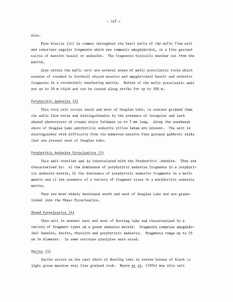
- 145 - Flin Flon Gold Pro spects by J .G. Pearson The Flin Flo n-Arni sk Lake area go ld occ u rr en ce s (Byers et a l., 19 65 ; Stockwe ll, 1960 ; a nd Beck, 1 959 ; Fig . 1, this report) are bei ng re - examin ed in d etail. In 1979 work was concent r ated in th e Dougl as Lake-W eka ch Lake ar ea (occ ur rences 9,10,12,1 3 ,14 and 15 on Fi gure 1), wh ich in c lud es t wo former go l d p rodu c in g mines and six pr ospec ts. Because of the c los e pr oximity of the se occ urrences the ar ea was ma pp e d at a sca le of 1: 4 ,800 (1 inch= 400 fee t) with aerial photographic e nlarge- me nts . Sampl es of r epresenta tiv e r ock types have been sent for major and tr ace element an a lys is . ,o, · ,, . I 101°00 ' f-c;.'\- .., .... ,.~-- MAP 0 AM/SK I 102 " 1 5' S C A l E MU U I t /1 0 1 J KILO M £TliPf~ i Fig . 1 - Gold Occurrences i n the Flir, Flon-Ami sk Lake area. For a desc ription of each oc currence refer to th e Saskatchewan Min era l Index. 1. Newcor Mine , 2. Henning-Malon ey Mine , 3. Rio , 4. Unity , 5. Co r, 6. Bomber Lake, 7. Wekach Lake, 8. Angelski, 9. Phantom La ke Mine, 10. MacMill an Mine, 11. North Pha ntom Lak e, 12.Yell ow Jacket Group, 13. Phantom-McRobbie Lake, 14 . Dee cla ims, 15. Boot Lak e, 16. Do do, 17. Mosher Lake, 18. Mitchel, 19. Sye, 20. Am i sk S yn dicate , 21. V.M. Gr oup, 22. Derby (Hoodo), 23. Lu cky S tri ke, 24. Royal, 25. K ent, 26 . Duplex, 27. Monarc h Mine, 28. Amisk Go ld Syndicate, 29. T. C. A. , 30. Laurel , 31. Bea ve r, 32 . Hannay Isla nd, 33. Waver ly Island, 34. Wing, 35. Bud , 36 . Gra ha m M i ne , 37 . Go lden Cros s, 38. Robinson C reek, 39. Ace. As teri s ked occurrences are me ntio ned in prese nt r epo rt. AREA
Transcript of Flin Flon Gold Prospects -...

- 145 -
Flin Flon Gold Prospects
by J .G. Pearson
The Flin Flon-Arnisk Lake area go ld occurrences (Byers et a l., 1965 ; Stockwell,
1960; and Beck, 1959 ; Fig . 1, this report) are being re- examined in detail.
In 1 979 work was concentr ated in the Dougl as Lake-Wekach Lake area (occurrences
9,10,12,13 ,14 and 15 on Fi gure 1), which includes t wo former gol d produc ing mine s
and six prospec ts. Because of the c lose proximity of these occurrences the area was
ma pped at a sca l e of 1: 4 ,800 (1 inch= 400 fee t) with aerial photographic enlarge
ments . Sampl es of r epresentative r ock types have been sent for major and trace
element ana lysis .
,o,· ,,. I 101°00 '
f-c;.'\-..,....,.~--MAP
0
AM/SK
I 102 " 15'
S C Al E MU U I t/1 0 1 J
KILO M £TliPf~ i
Fig . 1 - Gold Occurrences i n the Flir, Flon-Ami sk Lake area. For a description of each occurrence refer to the Saskatchewan Minera l Index. 1. Newcor Mine , 2. Henning-Maloney Mine , 3. Rio , 4. Unity , 5. Cor, 6. Bomber Lake, 7. Wekach Lake, 8. Angelski, 9. Phantom Lake Mine, 10. MacMill an Mine, 11. North Phantom Lake, 12.Yell ow Jacket Group, 13. Phantom-McRobbie Lake, 14 . Dee cla ims, 15. Boot Lake , 16. Dodo, 17. Mosher Lake, 18. Mitchel, 19. Sye, 20. Am i sk Syndicate , 21. V.M. Group, 22. Derby (Hoodo), 23. Lucky Stri ke, 24. Royal, 25. Kent, 26 . Duplex, 27. Monarch Mine, 28. Amisk Go l d Syndicate, 29. T. C. A. , 30. Laurel , 31. Beaver, 32 . Hannay Island, 33. Waverly Island, 34. Wing, 35. Bud , 36 . Gra ham Mine , 37 . Golden Cross, 38. Robinson Creek, 39. Ace. Asteri sked occurrences are mentioned in present report.
AREA

- 146 -
General Geology
The sequence of rocks belongs entirely to the Amisk Gr oup of volcanic r ocks of
Aphebian age (1865 Ma to 1800 Ma ; Mukherjee~ a l, 1971) . The sequence youngs to
the west, as det er mined from pillow shape , amygdule concentr a tions and sedimentary
structures. The sequenc e mapped l ies on the west flank of the Beaver Road anticline
(Stockwell, 1960), has a general north-northwesterly strike and a steep westerly dip.
It becomes more siliceous to the west, grading from mafic flow r ocks t o rhyolite and
tuf f.
Rock Descriptions
The lithol ogi c units are listed in Table 1 and their distribution i s shown in
the accompanying prel iminary geological map .
Table 1 . Lithological units i n t he a r ea
Diabase Porphyri tic Granite Granodiori t e Diorite Metagabbro
Intrusive Contact
Ar gillite, Cher t Quartz porphyry, Rhyolite Dacite Mixed Pyroclast i c ro cks Porphyritic Andes i te, Pyr oclastic rocks Porphyr i tic andesite Mafic flow, (basalt to andesite) pillow l avas Flow brecc i a , mafic pyroclast ic rocks
Mafic Fl ow Rocks (1)
Thi s rock unit occurs mostly east of Douglas Lake and comprises undifferent iated
basalt and andesite . The domi nant rock type is massive green to black, fine -
grained and commonly contains amygdules wi th quartz, carbonate and/or epidote , as
well as large pods (20-30 cm in d i ameter) of epidote. Pill ow lavas are also wide
spread east of Douglas Lake in thin unmappable zones and sequences up to 75 m t hick .
Pil lows vary from 8 cm to 1 m,in diameter and exhibit cores containing epidote and
quartz which are commonly amygdaloidal. In many areas the pillows a r e highl y defor
med,almost bedded in appearance.
West of Douglas Lake andesitic to dacitic lavas (J . Pickel l, pers. comm.)
s howing pillows of bedded appearance wi th massi ve co res and rims and diameters up
to 5 m form a dis tinctive unit by virtue of their composition a nd t he large pillow
- 147 -
size.
Flow breccia (le) is common throughout the basal parts of the mafic flow unit
and compr ises angular fragments whic h a re commonl y amygdaloidal, in a fine grained
matrix of massive basalt or andesite. The fragments t ypically weather out from the
matrix.
Also withi n the mafic unit are sever a l zones of mafic pyr oc l ast ic rocks whi ch
consist of rounded to football s haped massive and amygda loida l basalt and andesite
fra gments in a r ecessively weathering matrix. Bodies of the mafic pyroclastic unit
are up to 20 m thick and can be traced along strike for up t o 500 m.
Porphyritic Andesite (2)
This rock unit occur s south a nd west of Douglas Lake , is coarser gr a ined than
the mafic flow rocks and distinguishable by the presence of i rregular a nd l a th
shaped phenocrys ts of cr eamy white feldspar up to 5 mm long. Along the southwes t
shore of Douglas Lake porphyritic andesite pillow lavas ar e present. The unit i s
distinguished with difficulty from the numerous massive fine grained gabbroic sills
that are present west of Douglas Lake .
Porphyritic And esite Pyroclastics (3)
This unit overl i es and is i ntercalated with the Porphyritic :.ndesite. They are
characterized by: a) the dominance of porphyritic andesite f ragments in a porphyri
tic andesite matrix, b) the dominance o f porphyritic andesit e fragment s i n a mafic
matric and c) the presence of a varie ty of fragment types in a porphyritic andesi t e
matri x .
They are mo s t widely developed south and west of Douglas Lake and are grada
tional into the MixeJ Pyroc last ics .
Mixed Pyroclastics (4)
This unit is present east and west of Bootleg Lake and c harac terized by a
var iet y of fragment types in a gr een andes ite matrix. Fragments comprise amygdalo
idal basalts, dacite, rhyolite and porphyritic andesite. Fragments range up to 25
cm in diamet er . In some outcrops pisolites were noted .
Dacite ( 5)
Dacite occurs on the east s hore of Bootl eg Lake in narrow l enses of black t o
light gr een mass ive very fine gr ained rock . Byer s et al . (1954) map this unit

- 148 -
northward to include the pillow lavas (lb?) (with the very large pillow size) west
of Douglas Lake. These pillow lavas appear to be intermediate in composition be t
ween the mafic flow rocks east of Douglas Lake and the dacite of Bootleg Lake,
although they are on strike.
Rhyolite and Quartz Porphyry (6)
Rhyolite occurs as thin lenses on the shore of Bootleg Lake, west of Bootleg
Lake and in the Meridian Creek area. It is a massive, white to buff colored , fine
grained quartz rich rock which is bedded in places . Lenses of quartz porphyry
(similar in appearance to rhyolite but containing quartz phenocrysts up to 2 mm in
diameter) occur with the rhyolite and as s ills and dykes eas t of Douglas Lake .
Bedded Tuff (7)
It comprises a thick thinly bedded unit between Bootleg and Wekach Lakes.
Individua l beds vary from 0.5 cm to 10 cm in thickness. In the lower part of the
unit the tuff is mafic and is black to dark grey in colour; it grades into felsic
tuff near the west boundary of the map area. Where the tuff is i ntruded by gabbro
or diorite, small feldspar phenocrysts are present.
Metasedimen tary Rocks (8)
Thi n unmappable units of argilli te and cher t occur as thin lenses in the vici
nity of Meridian Creek and Bootleg Lake and are associated with gossans composed of
massive sulfides with angular inclusions of argillit e .
Meta- gabbro (9)
Three distinct units of gabbro were mapped. A number of thin dykes (up to 2 m
wide) of fine grained gabbro which have a distinctive rhythmic layering along their
margins occur east of Douglas Lake.
Between Douglas Lake and Meridian Creek the re are two medium to fine grained
sills, possibly altered diabase (R , MacQuarrie, pers. comm.), which closely r esemble
the porphyritic andesite. They may be distinguished from the latter by the small
size of the plagioclase phenocrysts, a reddish weathering on some outcrops and a
uniform grain size.
Several thick gabbroic to dioritic sills outcrop between Bootleg and Wekach
Lakes. They are typically black, coarse- grained and con tain amphibole pheno
crysts up to 2 cm long. Mafic minera ls constitute 50 to 75% of the rock with the
r emainder being plagioclase. The typical rock is gradational into a more felsic

- 149 -
member with up t o 90% plagioclase and 10% mafic minerals. I n some areas as many as
four phases of intrus ion can be ident i fied with the composition of each successive
phase becoming more depleted in mafics .
Diori te (10)
This rock unit occurs east and north of Bootleg Lake and i s a dis tinct buff t o
light gre en weathering ma ssive r ock.
Granodiorite-Diorite (11)
It comprises the Reyna rd Lake Pluton wes t of Wekach Lake and the Boot Lake
Complex (R. MacQuarrie, pe rs. comm. ) s outh of Bootleg Lake. The border zone of the
Reynard Lake pluton s hows a t l east two stages of diorite int rusion , some shearing
near the con tact and xenoliths of bedd ed tuff. The Boot Lake Complex has a wide
border zone of ma ss i ve to equigranular diorite . The interior of both plutons is
buff to pink ma s s ive granodiorite.
Porphyr i tic Granite (12)
Porphyr i tic granite dyke s occur south and west of Douglas La ke and are intrusive
into all r ocks in this area . They a re pink wea thering rocks with large euhedr al
phenocrysts (up to 1 cm in diameter) of K-feldspar . Byers et al. (1965 ) i ndica te
that the dykes ar e related t o the Phantom Lake Gr anite which outcrops 2 km south of
Douglas Lake .
Diabase (13)
This rock unit forms thin dykes (less than 3 m wide) south of Dougl as Lake .
They are commonly fine grained,dark col oured on fresh s urfaces and eas terly striking.
Structural Geology
The sequence described lies on the west f lank of the Beaver Road anticline
(Stockwell , 1960), strikes northweste rly and di ps moderatel y t o s t eeply t o the wes t.
The only significant fault in the area is the Rio Fault. Detailed mapping
s hows this as a zone comprising s everal local frac tures rather than as a s ingle
continuous brea k. Southeast of Douglas Lake its pr esence i s indica t ed by r ubbly
weathe ring outc rops , minor dis placements or fractures and veins of rus ty weathering
chert. In the south Bootleg Lake area a small amount ( less tha n 100 m) of s inis tra l
displacemen t and drag folding of the Mixed Pyroclas tic unit is observed. However,

- 150 -
between these two a r eas there i s no evidence of movement .
Two sets of minor faul ts are r ecognised. One of these strikes north-north
westerly, i s subvertical and in the Douglas Lake area is f i l l ed with massive wh ite
qu artz commonly containing sulfides.
The other set, best developed around Bootleg Lake and Wekach Lakes , shows
sma ll (less than 10 m) displac ement s which are both sinistral and dextral. These
fractures ,probably rela ted t o the Rio Fault,commonly con tain c herty quartz and
disseminated sulfides.
Mineralization
With one exception, the gold occurrences are associa ted with faulting. The
Rio and other nor t heasterly trending fault s are int ruded by cherty quartz wi t h dis
s eminated sulf ides and some go ld as at the Henning-Maloney Mine and t he Rio
Occurrence.
The Rio Occurrence forms a zone of dense, very fine grained, r usty weathering,
cherty quartz carry ing dissemina ted pyrite, cha lcopyrit e , and t r aces of galena and
sphalerite and lies entirely within altered mafic volcanic flow r ocks. Massive
white quartz veins cutting the cherty quartz contain no s ulf ides . A second nort h
eas terly frac tur e zone 75 m west of the Rio Occurrence wi t h similar cherty quartz
and characteristic rusty weathering lies entirely within t he Porphyri tic and es ite
pyroclas ti c unit.
The Henning-Maloney Mine occurs entire l y within mass ive , coarse grained , white
to light grey weathering diorite which i s a border phase of t he Boot Lake Intrus i ve
Complex (R. MacQuarrie , in prep .). Severa l northeaster ly t r ending fractures , t he
l argest of which was called the "shaft shear", are f illed with very fine grained,
grey, cherty quart z with disseminated chalcopyrite, pyri te and a r s enopyr ite . The
surface expressi on of t he mineralization is now covered by broken rock from the
underground workings .
The Newcor, Cor, Unity and Bomber Lake occurren c es have nearly identical f orms
of mineralization and quart z intrusion. The f our gold s howings l i e along north
westerl y trending fractures and lie entire l y within the maf i c flow rock uni t. The
mineralization occ urs in massive coar se-grained white quart z and massive grey qua rtz
which commonl y has a banded appearance . Ore minerals are chal copyrite , pyrite ,
a r senopyr i te and sphalerite .
The Bomber Lake occurrence is a massive quartz vein in a northwes t e rly trending
~ractur e . Both massive white coarse-grained quartz and f ine- grained, cherty quartz

- 151 -
are presen t. Sulfide mineralization occurs as massi ve coar se- grained pyrite and
chalcopyrite , as coarse-gra ined blebs of pyrite and c ha l copyrite fil l ing vugs in the
white quartz, and as sulf i des dissemi na t ed in bands and a l ong fractures in the cher t y
quartz . Significant copper , gol d and silver assays have been r eported from this
occurrence as well as t races of molybdenum and zinc .
The Cor Occurrence i s also a sulfide rich quartz vein in mafic volcanic flow
r ocks which comprises vuggy, massive white quartz in the centre gr ading into f i ne
grained grey quartz a t the margins . The wall rock altera tion comprises a zone of
black , fine grained roc k (silicified basalt?) and a zone of friable r ed and yellow
weat hering rock and i s less than 1 m wide. Pyrite and arsenopyrit e ar e disseminated
in bands and along frac t ur es i n the fine grained grey quartz .
The Unity Occurr ence is located 400 m sou t heast of the Cor Occurence and a
rus ty weathering fracture can be traced between the two . It is l ocat ed along a
fract ur e separating l enses of quartz porphyry and mafic f l ow r ocks. The mineraliza
tion consis t s of coar se- gr ained pyrite and c halcopyr ite filling vugs in massive
white quartz. The alte r ation zone i s s imilar to t hat at the Cor Occurrence.
The Newcor Mine miner al ization, a l so along a northwesterly t r ending fracture
within mafic flow rocks, i s in a gr ey , massive quartz vein up t o 1 m wide . It con
sist s of arsenopyrite and sphal erit e , disseminated in bands and along fractures in
the quartz vein and massive a rsenopyrite . Othe r sulfide minerals are pyr ite , chalco
pyrite and traces of gal ena . The alteration zone is similar to tha t descri bed for
t he Cor Occurrence.
Gold has also been reported from the Meridian Creek area (Saskat chewan Mineral
Index). I n this ar ea it occur s in a massi ve sulfide horizon associated with graphi
t ic argi llite. Sulphide minerals present are pyrite and chalcopyrite.
References
Byer s, A. R., Kirkland, S . J . T. and Pearson, W. J . (1962) : Geology and Mineral Deposits of the Flin Fl on Ar ea . Dept. of Mineral Resources, Report No . 62 .
Beck, L.S. (1959): Mineral Occurrences in the Precambrian of Northern Saskatchewan. Dept. of Mineral Resources , Report No . 36 .
Mukherjee , A.C ., Stauffer, M.R. , and Baadsgaard, H, (1971): The Hudsoni an Orogeny Near Flin Flon Manitoba; A Tentati ve Interpre tat i on of Rb/Sr and K/Ar Ages. Canadian Journal of Earth Sciences; V. 8; pp . 939- 946 .
St ockwell, C.H . (1960): Flin Flon-Mandy . Geological Survey of Canada Map 1078A.