FLATHEAD COUNTY PLANNING AND ZONING OFFICE · FLATHEAD COUNTY PLANNING AND ZONING OFFICE ......
27
FLATHEAD COUNTY PLANNING AND ZONING OFFICE SUBDIVISION REPORT FPP-16-05 ROUND STONE INDUSTRIAL PARK SEPTEMBER 28, 2016 A report to the Flathead County Planning Board and Board of County Commissioners regarding a request for preliminary plat approval of Round Stone Industrial Park subdivision, a major subdivision that would create 4 industrial lots. Located approximately 1/2 mile west of the U.S. Highway 93 and located on Cemetery Road. The Planning Board will hold a public hearing in the 2nd Floor Conference Room of the South Campus Building located at 40 11th Street West in Kalispell on October 12, 2016 to review the proposal and make a recommendation to the Flathead County Commission. Final action on this proposal by the governing body must be taken prior to the review deadline of November 18, 2016. Documents pertaining to this application are available for public inspection at the Flathead County Planning and Zoning Office, located in the South Campus Building at 40 11 th Street West, Kalispell, Montana. I. APPLICATION REVIEW UPDATES A. Land Use Advisory Committee/Council The proposal is not located within the advisory area of a Land Use Advisory Council. B. Planning Board The Flathead County Planning Board will hold a public hearing on the proposed subdivision on October 12, 2016 and make a recommendation to the Flathead County Board of Commissioners. This space is reserved for a summary of the Planning Board’s discussion and recommendation. C. Commission The Flathead County Board of Commissioners will review this proposal after the public hearing conducted by the Planning Board and prior to November 18, 2016 which is the end of the 60 working day statutory review period. This space will contain an update regarding the Flathead County Commission review of the proposal. II. GENERAL INFORMATION A. Project Personnel i. Owner/Applicant Mike and Sharon Tikka 294 Stillwater Road Kalispell, MT 59901 ii. Technical Assistance Bob Erickson, PLS Jackola Engineering & Architecture, PC 2550 Highway 93 South Kalispell, MT 59901 B. Project Description The request is for preliminary plat approval of a 4 lot subdivision located on Cemetery Road. The proposed subdivision would create 3 additional industrial lots and be served by on-site septic and wells. Primary access to the lots would be from a new interior
Transcript of FLATHEAD COUNTY PLANNING AND ZONING OFFICE · FLATHEAD COUNTY PLANNING AND ZONING OFFICE ......

FLATHEAD COUNTY PLANNING AND ZONING OFFICE
SUBDIVISION REPORT FPP-16-05
ROUND STONE INDUSTRIAL PARK
SEPTEMBER 28, 2016
A report to the Flathead County Planning Board and Board of County Commissioners regarding
a request for preliminary plat approval of Round Stone Industrial Park subdivision, a major
subdivision that would create 4 industrial lots. Located approximately 1/2 mile west of the U.S.
Highway 93 and located on Cemetery Road.
The Planning Board will hold a public hearing in the 2nd Floor Conference Room of the South
Campus Building located at 40 11th Street West in Kalispell on October 12, 2016 to review the
proposal and make a recommendation to the Flathead County Commission. Final action on this
proposal by the governing body must be taken prior to the review deadline of November 18,
2016. Documents pertaining to this application are available for public inspection at the
Flathead County Planning and Zoning Office, located in the South Campus Building at 40 11th
Street West, Kalispell, Montana.
I. APPLICATION REVIEW UPDATES
A. Land Use Advisory Committee/Council
The proposal is not located within the advisory area of a Land Use Advisory Council.
B. Planning Board
The Flathead County Planning Board will hold a public hearing on the proposed
subdivision on October 12, 2016 and make a recommendation to the Flathead County
Board of Commissioners. This space is reserved for a summary of the Planning Board’s
discussion and recommendation.
C. Commission
The Flathead County Board of Commissioners will review this proposal after the public
hearing conducted by the Planning Board and prior to November 18, 2016 which is the
end of the 60 working day statutory review period. This space will contain an update
regarding the Flathead County Commission review of the proposal.
II. GENERAL INFORMATION
A. Project Personnel
i. Owner/Applicant
Mike and Sharon Tikka
294 Stillwater Road
Kalispell, MT 59901
ii. Technical Assistance
Bob Erickson, PLS
Jackola Engineering & Architecture, PC
2550 Highway 93 South
Kalispell, MT 59901
B. Project Description
The request is for preliminary plat approval of a 4 lot subdivision located on Cemetery
Road. The proposed subdivision would create 3 additional industrial lots and be served
by on-site septic and wells. Primary access to the lots would be from a new interior

2
subdivision road. The property is currently zoned SAG-10 and is going through a zoning
map amendment which would rezone the property to I-1.
C. Legal Description of Subject Property
The property can be legally described as Parcel D of Certificate of Survey No. 19227,
located the Northwest Quarter of Section 29, Township 28 North, Range 21 West,
P.M.M., Flathead County, Montana.
D. Detailed Location
The property is approximately 1/2 mile west of Highway 93 and the Kalispell city limits
on Cemetery Road. The property is situated roughly equidistance from the Highway 93
By-pass and Highway 93.
Figure 1: Subject property (highlighted yellow) and vicinity
E. Subdivision Layout Detail
i. Total Subdivision Acreage: 21.02 acres
ii. Acreage in Lots: 18.25 acres
iii. Acreage in Roads: 2.79 acres
iv. Total Park/Common Area/Open Space Acreage: 0.00 net acres
v. Minimum Lot Size: 1.14 acres
vi. Maximum Lot Size: 12.94 acres
vii. Overall Gross Lot Density: 1 unit per
5.26 acres
F. Administrative Characteristics
i. Current Land Use
The east side of the property was formerly a part of a gravel pit. The current
owners have begun remediation of the gravel pit with DEQ. The gravel pit extends
onto the neighboring properties to the north and east. The middle of the lot has
historically been used for agriculture and the west side of the property is Ashley
Creek.

3
Figure 2: Current land use and land cover (subject property shown blue)
ii. Current Zoning
The subject property is located within the Westside Zoning District and is currently
zoned ‘SAG-10 Suburban Agricultural’ (see Figure 2 below). As depicted in
Figure 3 below, the applicant has requested a zoning map amendment for the
property to zone it ‘I-1 Light Industrial.’ Per Section 3.07 of the Flathead County
Zoning Regulations (FCZR), SAG-10 is ‘A district to provide and preserve
agricultural functions and to provide a buffer between urban and unlimited
agricultural uses, encouraging separation of such uses in areas where potential
conflict of uses will be minimized, and to provide areas of estate-type residential
development.’
The I-1 designation is defined in Section 3.27 FCZR as, ‘A district to provide areas
for light industrial uses and service uses that typically do not create objectionable
by-products (such as dirt, noise, glare, heat, odors, smoke, etc.), which extend
beyond the lot lines. It is also intended that the encroachment of non-industrial uses
within the district be prevented other than those listed herein.’

4
Figure 3: Current zoning applicable to subject property (outlined in red)
Figure 4: Proposed zoning on the subject property (outlined in red)
iii. Proposed Land Use
The proposed Round Stone Industrial Park Subdivision would create a 4 lot
industrial subdivision with lots ranging in size from 2 to 14 acres.
G. Area Characteristics
i. Description of Area Surrounding Proposed Subdivision
A portion of the property was formerly a part of a gravel pit. The gravel pit extends
onto the neighboring properties to the north and east. Also in the vicinity of the
subject property is agricultural, industrial and residential.
I-1

5
ii. Zoning
As mentioned above, the subject property is currently zoned SAG-10 but the
applicants have requested a zoning map amendment to rezone the property I-1 in
order to subdivide the property as proposed. Property to the northeast and southeast
are currently zoned I-1 and I-1H, respectively while adjoining properties are SAG-
10 (Figure 4).
iii. Land Uses
As previously stated, a portion of the property was formerly a part of a gravel pit.
The gravel pit extends onto the neighboring properties to the north and east. Also
in the vicinity of the subject property is agricultural, industrial and residential.
iv. Previously Considered Subdivisions in Area
As shown in Figure 4 above, the subject property is located within close proximity
to a variety of subdivisions. Several of the subdivisions in the vicinity of the
property were completed prior to the adoption of the subdivision regulations such as
Keith-Smith Tract Number One, Twin Road Acres or were divided though deed or
COS. Other subdivision in the area include The Amended Subdivision Plat of Lots
1, 2 and 3 of Block 2 of Twin Road Acres, the Amended Subdivision Plat of Lot 1,
Block 1, of Twin Road Acres, Willow Glen Tracts, Amended Plat of Lots 1 & 2 of
Ashley Business Park Subdivision, Amended Plat of Lot 1, Fisher Subdivision,
Amended Plat of Lot 2, Fisher Subdivision and the Mergenthaler Subdivision.
Some subdivisions are located within the City of Kalispell including; Amended Plat
of Lots 3 & 5 of Ashley Business Park & Amended Plat of the Amended Plat of Lot
4 of Ashley Business Park and Lots 1& 2 of the Mergenthaler Subdivision.
Figure 5: Area subdivisions (subject property highlighted in blue)
Keith-Smith Tract
Number One
Twin Road Acres Subdivision
Number 160
Amended Subdivision Plat of
Lots 1, 2 and 3 of Block 2 of
Twin Road Acres
Amended Subdivision Plat of Lot
1, Block 1, Twin Road Acres
Willow Glen
Tracts
Amended Plat of Lots 1 & 2 of
Ashley Business Park
Amended Plat of Lots 3 & 5 of Ashley Business Park & Amended
Plat of the Amended Plat of Lot 4 of Ashley Business Park
Subdivision
Mergenthaler Subdivision
Amended Plat of Lot 1
Fisher Subdivision
Amended Plat of Lot 2
Fisher Subdivision

6
H. Utilities and Services
Wastewater: Individual Wastewater Treatment systems
Water: Individual Wells
Solid Waste: Contract Haul- Evergreen Disposal
Schools: Elrod School District
Flathead High School District
Fire: South Kalispell Fire District
Police: Flathead County Sheriff
III. COMMENTS RECEIVED
A. Agency Comments
The subdivision file contains a copy of the agency referral document sent on August 22,
2016. As of the date of completion of this staff report, the following comments have
been received:
Flathead County Road and Bridge Department
o Comment: “At this point the Department does not have any comments on
this request.”
Bonneville Power Administration
o Comment: “In reviewing the proposed plan, it appears this request will
not affect any BPA facilities located within this area. BPA does not have
any objections to the approval of this request at this time.”
Montana Fish, Wildlife & Parks
o Comment: “The proposed subdivision abuts the riparian zone of Ashley
Creek. Riparian zones, such as the area surrounding Ashley Creek,
provide important habitat for numerous wildlife species, as well as
movement corridors for others. In order to protect water quality, stream
stability, aquatic habitat, and the associated riparian areas, while
minimizing fragmentation and degradation of these sites, we recommend
the following design standards:
a) Maintain a minimum of 150 feet of vegetated buffer from the creek
edge, plus an additional 50 feet building setback (total of 200-foot
buffer).
b) Within this setback, avoid the construction of buildings and other
subdivision improvements, including roads.
c) Avoid disturbing native vegetation, except as needed to control
noxious weeds.
In contrast, the developers propose a 20-foot vegetative buffer and a 50-
foot no-build zone from the top of the bank of Ashley Creek. This buffer
is deficient to allow for wildlife movement and provide habitat for
wildlife. We recommend increasing the vegetative buffer and the no-
build zone to 150 feet and 200 feet, respectively.”
Flathead County Environmental Health Department
o Comment received during the zoning map amendment for the subject
property: “Further division of the property requires review under the
Sanitation in Subdivisions Act (Title 76, Chapter 4, Part 1). This review

7
includes potable water, wastewater, storm water drainage, and solid waste
disposal. This parcel is located within the Kalispell Control District.
Development must be in accordance with the Flathead County Air
Pollution Control Regulations.”
Flathead County GIS
o Comment: As proposed, the road name “Round Stone Dr” is hereby
approved by the Flathead County GIS Department for use on the
Preliminary Plat of Round Stone Industrial Park. Road names are
reserved for a period of three years. In the event that the road name has
not been adopted prior to the reservation period expiration, the name shall
be voided.”
Flathead County Weed, Parks & Recreation
o Comment: “The Flathead County Weed District office assists
Landowners and developers when an application is made to the Planning
& Zoning Department that may result in soil disturbance. It is the
landowners’ responsibility to control noxious weeds on their land – MCA
Section 7-22-2116. A noxious weed is legally defined as “any exotic
plan species that may render land unfit for agriculture, forestry, livestock
wildlife or other beneficial uses, or that may harm native plant
communities.” Most noxious weeds thrive when soil is disturbed. Some
can grow from root parts, as well as seeds that become exposed.
“Please refer to the enclosed Weed Inspection Report that includes Weed
Control Suggestions for this subdivision. A Soil Disturbance & Weed
Management Plan is enclosed for you to complete and return to our office
within 10 days. This is required prior to final plat approval and/or before
construction and/or disturbance begins.
“If construction is involved, vehicles entering and exiting the site during
construction should be monitored for any weeds “hitchhiking” on tires or
attached to the vehicle. Weed management guidelines and a weed
prevention plan should be developed for the entire subdivision as
opposed to individual lots. Road maintenance plans should address weed
management along the subdivision roadsides to reduce the spread of
weeds throughout the subdivision, as well.”
B. Public Comments
In accordance with Section 4.0.14 Flathead County Subdivision Regulations (FCSR),
adjacent property notification was mailed to neighboring property owners within 150
feet of the proposed subdivision on September 23, 2016, legal notice was published in
the Daily Interlake on September 25, 2016, and notice of the proposal and public
hearing was physically posted onsite on September 27, 2016.
As of the date of the completion of this staff report, no public comments have been
received from the general public regarding the proposal.
Any written public comment received after September 28, 2016 will be summarized
during the Planning Board hearing on October 12, 2016. Anyone wishing to provide
public comment may do so at the October 12, 2016 Planning Board hearing.

8
IV. LOCAL GOVERNMENT REVIEW
A. Review Criteria
Findings in this portion of the report are applicable to the impacts of the proposed
subdivision on the review criteria listed.
i. Impact on Agriculture
According to the environmental assessment, approximately 60% of the area west of the
slopes along Ashley Creek had been used for agricultural production until 2014. The
remaining 40% had been used as open cut gravel pit and is currently in the DEQ
reclamation process with established vegetation covering the mined area. The application
also states, “Approximately 8 acres on the western half of the property had been farmed
primarily for wheat through 2014 with an average yield of 40 bushels per acre. Canola
was planted and harvested in 2013 with a yield of approximately 25 bushels per acres.”
The neighboring properties are currently being used for agriculture. While the proposal
would result in a reduction in agricultural production onsite, it does not appear the
proposal would impact the ability of neighboring properties to continue agricultural
production. The evaluation of the Preliminary Plat, Environmental Assessment, and
supporting documentation included with the application has identified no adverse impacts
to onsite or area agriculture which would necessitate special mitigation.
Finding #1 – There would be minimal impact on agriculture because discontinuation of
hay production on site would have minimal impact on hay production rates and adjacent
properties are not dependent upon the subject property for agricultural use.
ii. Impact on Agricultural Water User Facilities
As indicated in the submitted Environmental Assessment, there are no agricultural water
works, wells, canals, irrigation ditches or pump houses onsite or adjacent to the proposal.
The subject property is not developed with irrigation infrastructure, is not in an irrigation
district or party to any irrigation agreements, and serves no irrigation water to adjacent or
neighboring properties.
Finding #2- There would be no impact to agricultural water user facilities because the
subject property is not currently irrigated for agricultural purposes, has no irrigation
infrastructure on site, is not in an irrigation district, and is not party to any existing
irrigation agreements.
iii. Impact on Local Services
1. Water and Wastewater
The application indicates, “Water for domestic use and irrigation would be provided
by individual and shared wells. To determine the domestic demand a total 20 worker
per lot, comprised of 5 office workers and 15 construction workers is assumed.
Based on DNRC calculations, the total domestic demand for the subdivision would be
3,300 gallons per day, or 2.3 gallons per minute. If an average of 10,800 square feet
of lawn on each lot is assumed, the total irrigation demand would be 2.5acre/feet per
season. The well logs previously provided in Appendix E of the Environmental
Assessment indicate adequate water supply is available to serve the proposed
subdivision. The least productive well generates 25 gallons per minute, which would
meet the estimated demands of the subdivision.”

9
Comments from the Flathead County Environmental Health Department states,
“Further division of the property requires review under the Sanitation in Subdivisions
Act (Title 76, Chapter 4, Part 1). This review includes potable water, wastewater,
storm water drainage, and solid waste disposal.”
According to the additional information provided in the Environmental Assessment,
“As the type of business and number of employees is unknown for each lot, an
assumed light industrial building with an estimate of 20 employees per shift per lot
was used […]. Based on Montana DEQ Circular 4, the total estimated effluent for the
proposed subdivision at full occupancy is 1,040 gallons per day with each lot
generating 260 gallons per day. […]. The proposed on-site septic systems would be
sufficient to serve the proposed subdivision and would meet states standards.
Individual drainfields would be required to meet the Montana Department of
Environmental Quality and Flathead County Health Department design and
construction standards prior to permitting and installation.”
According to the City of Kalispell Growth Policy the subject property is located
within the Annexation Policy Boundary. The Kalispell annexation plan states, “The
annexation boundary map was intended to be a general policy statement not a fixed
regulatory document. The boundary was intended to address the impacts of logical
development patterns and growth within the city that would occur over the next 5 –
10 years.”
Water and wastewater services for the proposed subdivision would be required to be
reviewed and approved as applicable by the Flathead County Environmental Health
Department and the Montana Department of Environmental Quality and not required
to annex into the City of Kalispell. The impacts to existing private or public water
and wastewater services are anticipated to be minimal because the subdivision will
utilize individual wells and septic.
Finding #3 - The subdivision will have minimal impact on water and wastewater
appears to be acceptable with the imposition of conditions the subdivision will utilize
the wells and onsite septic, not be required to connect to City services and both the
water and wastewater system will be required to be reviewed and permitted by the
Montana Department of Environmental Quality as applicable.
2. Schools
Although the proposal is located within the Elrod Elementary and Flathead High
School Districts, no school age children are anticipated as a result of the subdivision
because the proposal specifies an industrial land use and is currently in the process of
a zone change to I-1. Because of this, no impacts to area schools are anticipated with
this subdivision.
3. Mail Delivery
The applicant is proposing to utilize centralized mailboxes. The location of the
centralized mail facility serving the proposed subdivision shall require review and
written approval from the local postmaster as a condition of final plat approval and
should meet the location requirements outlined in Section 4.7.28 FCSR.

10
4. Recreation
Since the proposal is for a four lot industrial subdivision, no parkland is required per
Section 4.7.24(a)(ii) FCSR as the lots are part of a non-residential subdivision.
According to the Flathead County Trails Plan and Section 4.7.19 FCSR, a 15 feet
wide easement for a pedestrian/bicycle path will be required along Cemetery Road
the length of the subject property as the property is designated as a future connector
on the Flathead County Trails Plan Map.
Finding #4 – Impacts on schools, recreation and mail delivery will be acceptable with
standard conditions because the proposed subdivision would have no impact on local
schools, mail delivery shall be approved by the postmaster, the final plat shall be
required to have a 15 feet wide easement for a pedestrian/bicycle path along
Cemetery Road and no other recreational facilities are required for commercial or
industrial subdivisions.
5. Roads
Primary access to the property is currently off Cemetery Road. Cemetery Road is a
two-lane paved County collector road within 60 foot easement. Cemetery Road
connects Highway 93 with the Highway 93 Bypass via Airport Road. Traffic counts
for Cemetery Road indicate 1,746 average daily trips east of Airport Road and 1,931
daily trips west of Highway 93. The lots will be accessed from the proposed Round
Stone Drive. Round Stone Drive is a proposed road approximately 623 feet long that
ends in a cul-de-sac. Round Stone Drive will be a paved road within a sixty foot
easement and shall comply with Flathead County Road and Bridge Department
Minimum Standards for Design and Construction.
Abelin Traffic Services conducted a Traffic Impact Study for the proposed Round
Stone Industrial Park in July 2016. According to the study the subdivision has the
potential to generate 850 daily trips. The Level of Service (LOS) for the intersection
of Cemetery Road and Highway 93 and Cemetery Road and Airport Road is B and
the LOS for the intersection of Airport Road and Highway 93 Bypass A is for both
AM and PM peak hours. At full build-out the intersections of Cemetery Road and
Highway 93 and Cemetery Road and Airport Road will continue to have a LOS B and
the intersection of Airport Road and Highway 93 Bypass will have LOS A. Round
Stone Drive and Cemetery Road will have LOS A for AM peak hour and B for PM
peak hour. According to the study, typically a LOS C or better is considered
acceptable for peak hour conditions. The study concludes, “As proposed, the Round
Stone Industrial Park will not create any roadway capacity problems on adjacent
roadways. All nearby intersections will continue to function at acceptable levels of
service. No additional turning lanes or traffic controls would be warranted with this
project.”
The subject property currently has a 60 foot private road and utility easement located
along the east boundary that will not be used as access to the proposed subdivision
but the preliminary plat shows the easement would be maintained for access to the
properties to the north, which would be in compliance with Section 4.7.15(d) FCSR.
The applicant is not proposing any improvements to the existing easement.

11
Finding #5 – The road system appears to be acceptable with the standard conditions
as the primary access would be from the proposed Round Stone Drive via Cemetery
Road, Cemetery Road is a paved County collector within an appropriate right of way,
each lot has legal and physical access via Round Stone Drive which shall be
constructed to comply with the Flathead County Road and Bridge Department
Minimum Standards for Design and Construction.
6. Fire/Emergency Medical Services
The proposed subdivision is located within the South Kalispell Fire District. The
nearest fire station is located on Willow Glen Drive approximately 1.0 road mile
northeast of the subject property. Because of the proximity to the proposed
subdivision the South Kalispell Fire Department anticipates a response time of
approximately 5 minutes. An email from the South Kalispell Fire Department stats,
“Firefighting and medical resources would not be unduly burdened by the addition of
this development, and adequate resources are currently in place to provide protection
to this area as planned.”
It is not anticipated the proposed subdivision would overburden the district as the site
is within an acceptable distance to the fire station and access to each site. Ambulance
service would be available to serve the proposed subdivision, as well as ALERT
service by the Kalispell Regional Medical Center.
7. Police Services
The property is located outside city limits and will be served by the Flathead County
Sheriff. The Sheriff’s Department did not respond to a request for comments. Given
existing staffing, the size of the County and the dispersed nature of the population,
police services to this subdivision are anticipated to be consistent with other areas of
Flathead County.
Finding #6 – Impacts on fire/medical and police services would be minimal with
standard conditions because the lots within the proposed subdivision would utilize
would be served within an acceptable response time by the Evergreen Fire District
and Flathead County Sheriff’s Department in the event of an emergency.
8. Solid Waste Disposal
The applicant has indicated the use of contract haul as the planned method of solid
waste disposal which is consistent with the Flathead County Solid Waste District’s
request that all new subdivisions in Flathead County use a contract hauler to bring
solid waste to the landfill. Evergreen Disposal is the (PSC) Public Service
Commission licensed hauler in this area. Pursuant to Section 4.7.22 FCSR the
applicant should be required to meet the requirements of the Flathead County Solid
Waste District.
9. Other Utilities
Overhead power line is located along the south side of Cemetery Road. Any new
utilities installed in the future shall be extended underground in compliance with
Section 4.7.23 FCSR.
Finding #7 – Impacts on solid waste disposal and other utilities would be acceptable
with standard conditions because the lots within the proposed subdivision would
12
utilize contract haul services for solid waste management, and future utilities would
be required to be underground in conformance with the applicable regulations.
iv. Impact on the Natural Environment
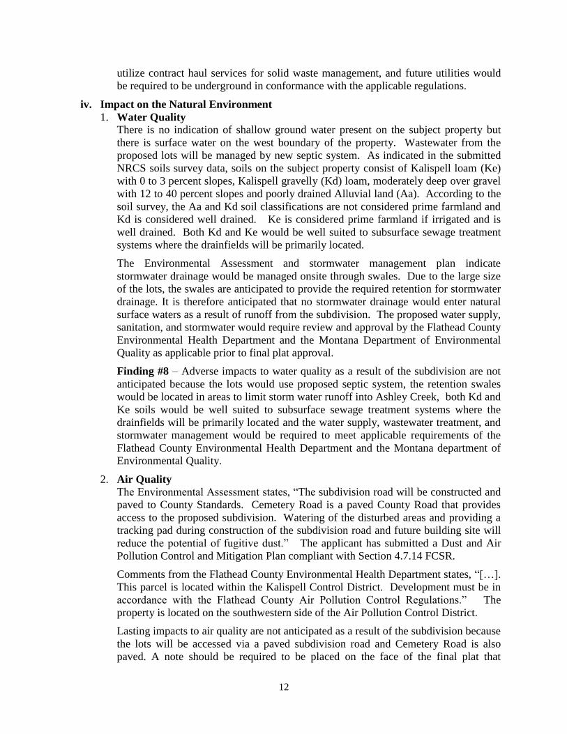
1. Water Quality
There is no indication of shallow ground water present on the subject property but
there is surface water on the west boundary of the property. Wastewater from the
proposed lots will be managed by new septic system. As indicated in the submitted
NRCS soils survey data, soils on the subject property consist of Kalispell loam (Ke)
with 0 to 3 percent slopes, Kalispell gravelly (Kd) loam, moderately deep over gravel
with 12 to 40 percent slopes and poorly drained Alluvial land (Aa). According to the
soil survey, the Aa and Kd soil classifications are not considered prime farmland and
Kd is considered well drained. Ke is considered prime farmland if irrigated and is
well drained. Both Kd and Ke would be well suited to subsurface sewage treatment
systems where the drainfields will be primarily located.
The Environmental Assessment and stormwater management plan indicate
stormwater drainage would be managed onsite through swales. Due to the large size
of the lots, the swales are anticipated to provide the required retention for stormwater
drainage. It is therefore anticipated that no stormwater drainage would enter natural
surface waters as a result of runoff from the subdivision. The proposed water supply,
sanitation, and stormwater would require review and approval by the Flathead County
Environmental Health Department and the Montana Department of Environmental
Quality as applicable prior to final plat approval.
Finding #8 – Adverse impacts to water quality as a result of the subdivision are not
anticipated because the lots would use proposed septic system, the retention swales
would be located in areas to limit storm water runoff into Ashley Creek, both Kd and
Ke soils would be well suited to subsurface sewage treatment systems where the
drainfields will be primarily located and the water supply, wastewater treatment, and
stormwater management would be required to meet applicable requirements of the
Flathead County Environmental Health Department and the Montana department of
Environmental Quality.
2. Air Quality
The Environmental Assessment states, “The subdivision road will be constructed and
paved to County Standards. Cemetery Road is a paved County Road that provides
access to the proposed subdivision. Watering of the disturbed areas and providing a
tracking pad during construction of the subdivision road and future building site will
reduce the potential of fugitive dust.” The applicant has submitted a Dust and Air
Pollution Control and Mitigation Plan compliant with Section 4.7.14 FCSR.
Comments from the Flathead County Environmental Health Department states, “[…].
This parcel is located within the Kalispell Control District. Development must be in
accordance with the Flathead County Air Pollution Control Regulations.” The
property is located on the southwestern side of the Air Pollution Control District.
Lasting impacts to air quality are not anticipated as a result of the subdivision because
the lots will be accessed via a paved subdivision road and Cemetery Road is also
paved. A note should be required to be placed on the face of the final plat that
13
requires the owners of all lots abide by the guidelines set forth in the plan during and
after site construction and development activities, if any.
3. Impact of Noise
It is estimated that the development of the subdivision would generate noise during
construction of the subdivision and minimal noise during development of the lots.
The proposed industrial uses are not anticipated to generate permanent continuous
impacting noise to area residents or wildlife because the definition of the currently
proposed I-1 zoning district states ‘An industrial district intended to provide areas for
light industrial, research and technology. The uses would typically not create
objectionable characteristics (such as dirt, noise, glare, heat, odor, smoke, etc.),
which extend beyond the lot lines. This zoning district would typically be restricted to
areas designated as industrial on the Kalispell Growth Policy Future Land Use
Map.’
Finding #9 – Adverse impacts to air quality and of noise are anticipated to be
acceptable with standard conditions as all roads accessing the subdivision are already
paved, a Dust Abatement Plan was provided to mitigate potential issues of dust
during construction and impacts of noise are not expected to extend beyond property
lines.
4. Impact to Flora
There is riparian vegetation on the lot. The preliminary plat indicates bushes and trees
exist along the west boundary line. This vegetation is expected to be maintained
within the riparian boundary. The Riparian Resources Management Map shows a 20
foot vegetative buffer and 50 foot no-build zone from the top of the slope. In addition
to the buffer and no-build zone at the top of the slope the applicant has designated all
of the SFHA as no-build at the base of the slopes. The SFHA ranges in width from
approximately 40 feet to 350 feet and the width of the no-build zone would be
between 90 feet and 400 feet. The no-build zone would be left in its current state.
Pursuant to Section 4.7.25 FCSR the subdivision will be required to develop and
implement a weed control plan approved by the Flathead County Weeds Department
prior to final plat approval. Comments from the Flathead County Weed District
states, “The Flathead County Weed District office assists Landowners and developers
when an application is made to the Planning & Zoning Department that may result in
soil disturbance. It is the landowners’ responsibility to control noxious weeds on
their land – MCA Section 7-22-2116. A noxious weed is legally defined as ‘any
exotic plan species that may render land unfit for agriculture, forestry, livestock
wildlife or other beneficial uses, or that may harm native plant communities.’ Most
noxious weeds thrive when soil is disturbed. Some can grow from root parts, as well
as seeds that become exposed.
“Please refer to the enclosed Weed Inspection Report that includes Weed Control
Suggestions for this subdivision. A Soil Disturbance & Weed Management Plan is
enclosed for you to complete and return to our office within 10 days. This is required
prior to final plat approval and/or before construction and/or disturbance begins.
“If construction is involved, vehicles entering and exiting the site during construction
should be monitored for any weeds “hitchhiking” on tires or attached to the vehicle.

14
Weed management guidelines and a weed prevention plan should be developed for
the entire subdivision as opposed to individual lots. Road maintenance plans should
address weed management along the subdivision roadsides to reduce the spread of
weeds throughout the subdivision, as well.”
5. Impact to Floodplain
The subject property is located on Ashley Creek and according to FEMA FIRM Panel
30029C 1820J, a portion of the property is located within a Zone AE, a Special Flood
Hazard Area with a base flood elevation and regulatory floodway. The majority of
the property is located within an unshaded Zone X an area determined to be outside
the 0.2% annual chance flood hazard. Lots 2 through 4 contain floodplain; however
the lots contain areas for building sites outside of the floodplain. Per Section 4.7.9
areas delineated as 100 year floodplain have been designated as “No Build Zones” on
the preliminary plat and can be conditioned for the final plat which will minimize the
impact of the subdivision on the floodplain.
6. Impact to Riparian/Wetland Areas
The western property line of the proposed subdivision is Ashley Creek therefore a
Riparian Resource Management Plan was provided with the preliminary plat
application. Most of the riparian area is designated as Zone AE, a Special Flood
Hazard Area (SFHA) with a base flood elevation and regulatory floodway.
According to the Plan and the topography illustrated on the preliminary plat, the
riparian/wetland area can be described as a steep creek bank with areas of sloughing.
The Riparian Resources Management Map shows a 20 foot vegetative buffer and 50
foot no-build zone from the top of the slope. In addition to the buffer and no-build
zone at the top of the slope the applicant has designated all of the SFHA as no-build.
The SFHA ranges in width from approximately 40 feet to 350 feet, so the width of the
no-build zone would be between 90 feet and 400 feet.
According to the Environmental Assessment and Riparian Resource Management
Plan, states “The riparian areas on Lots 2, 3 and 4 shall be kept in its natural state and
free of noxious weeds and debris. […]. Areas eroded by storm waters, winds, or other
natural events shall be repaired by the owner of the lot where erosion has occurred by
replacing topsoil and replanting with native plants as needed to establish a root
system to prevent further erosion.”
The Riparian Resources Management Plan also states, “Each lot owner shall be
responsible for monitoring the riparian area located on their own lot for presence of
noxious weeds and debris on an annual basis at a minimum.”
Because the applicant is proposing a no-build zone adjacent to the creek and within
the SFHA and monitoring will be done by each landowner, minimal impact to the
riparian and wetland areas are anticipated.
Finding #10 – No impacts to the flora, floodplain and riparian/ wetland area are
anticipated as the subject property as the applicant proposed and will be required to
have a no-build zone within the Special Flood Hazard Area between 90 and 400 feet,
monitoring will be done by each landowner within the riparian boundary and a weed

15
management plan shall be approved by the Flathead County Weed Board prior to
final plat approval.
7. Impact to Historical Features
The Environmental Assessment indicates there are no known historic, archeological,
or cultural sites on the subject property.
Finding #11 – Impacts to historical features are not anticipated as the subject
property contains no historical structures.
v. Impact on Wildlife
According to a search of the Montana Natural Heritage Program, 10 Species of Concern
exist within the boundaries of Township 29N, Range 21W. These include the Hoary Bat,
Little Brown Myotis, Fisher, Great Blue Heron, Veery, Westslope Cutthroat Trout,
Pygmy Whitefish, Bull Trout, Hooked Snowfly, and Alberta Snowfly. Hoary Bat, Veery,
and Great Blue Heron habitat is riparian forest which is present on-site. Alberta and
Hooked Snowfly, Westslope Cutthroat and Bull Trout are found in creeks can be found in
rivers and streams.
Comment was requested from the Montana Fish, Wildlife and Parks “The proposed
subdivision abuts the riparian zone of Ashley Creek. Riparian zones, such as the area
surrounding Ashley Creek, provide important habitat for numerous wildlife species, as
well as movement corridors for others. In order to protect water quality, stream stability,
aquatic habitat, and the associated riparian areas, while minimizing fragmentation and
degradation of these sites, we recommend the following design standards:
a) Maintain a minimum of 150 feet of vegetated buffer from the creek edge, plus an
additional 50 feet building setback (total of 200-foot buffer).
b) Within this setback, avoid the construction of buildings and other subdivision
improvements, including roads.
c) Avoid disturbing native vegetation, except as needed to control noxious weeds.
“In contrast, the developers propose a 20-foot vegetative buffer and a 50-foot no-build
zone from the top of the bank of Ashley Creek. This buffer is deficient to allow for
wildlife movement and provide habitat for wildlife. We recommend increasing the
vegetative buffer and the no-build zone to 150 feet and 200 feet, respectively.”
As previously stated, The Riparian Resources Management Map shows a 20 foot
vegetative buffer and 50 foot no-build zone from the top of the slope. In addition to the
buffer and no-build zone at the top of the slope the applicant has designated all of the
SFHA as no-build below the slope. The SFHA ranges in width from approximately 40
feet to 350 feet and the width of the no-build zone would be between 90 feet and 400 feet
with an average width over 100 feet.
vi. Impact on Wildlife Habitat
Comment was requested from the Montana Fish, Wildlife and Parks “The proposed
subdivision abuts the riparian zone of Ashley Creek. Riparian zones, such as the area
surrounding Ashley Creek, provide important habitat for numerous wildlife species, as
well as movement corridors for others. In order to protect water quality, stream stability,
aquatic habitat, and the associated riparian areas, while minimizing fragmentation and
degradation of these sites, we recommend the following design standards:

16
d) Maintain a minimum of 150 feet of vegetated buffer from the creek edge, plus an
additional 50 feet building setback (total of 200-foot buffer).
e) Within this setback, avoid the construction of buildings and other subdivision
improvements, including roads.
f) Avoid disturbing native vegetation, except as needed to control noxious weeds.
In contrast, the developers propose a 20-foot vegetative buffer and a 50-foot no-build
zone from the top of the bank of Ashley Creek. This buffer is deficient to allow for
wildlife movement and provide habitat for wildlife. We recommend increasing the
vegetative buffer and the no-build zone to 150 feet and 200 feet, respectively.”
As previously stated, the property is located along Ashley Creek and contains SFHA, as
such the applicant has submitted a Riparian Resource Management Plan with the
application. The Riparian Resources Management Plan Map shows a 20 foot vegetative
buffer and 50 foot no-build zone from the top of the slope. In addition to the buffer and
no-build zone at the top of the slope the applicant has designated all of the SFHA as no-
build which varies in width from approximately 40 feet to 350 feet. The width of the no-
build zone would be between 90 feet and 400 feet and an average width over 100 feet.
Because the property will contain a vegetative buffer, which does not permit structures
for human occupancy, sewage disposal systems, accessory structures or roads and the
vegetative buffer will be maintained and monitored, the impacts on wildlife habitat will
be minimal.
Finding #12 – Impacts to wildlife and wildlife habitat are anticipated to be minimal and
acceptable as the property will contain a vegetative buffer, which does not permit
structures for human occupancy, sewage disposal systems, accessory structures or roads
and the vegetative buffer will be maintained and monitored.
vii. Impact on Public Health and Safety
1. Flood Risk
The subject property is located on Ashley Creek and according to FEMA FIRM Panel
30029C 1820J, a portion of the property is located within a Zone AE, a SFHA with a
base flood elevation and regulatory floodway. The majority of the property is located
within an unshaded Zone X an area determined to be outside the 0.2% annual chance
flood hazard. Lots 2, 3 and 4 contain floodplain; however the lots contain areas for
building sites outside of the floodplain. Per Section 4.7.9 areas delineated as 100 year
floodplain have been designated as “No Build Zones” on the preliminary plat and can
be conditioned for the final plat which will minimize future impact on public health
and safety of the subdivision.
Finding #13 – The proposal would not introduce adverse impacts to public health and
safety in regard to flood risk because the areas delineated as 100 year floodplain have
been designated as “No Build Zones” on the preliminary plat and can be conditioned
for the final plat which will minimize future impact on public health and safety of the
subdivision.
2. Water and Wastewater Treatment
As previously mentioned the application states, “Water for domestic use and
irrigation would be provided by individual and shared wells. To determine the
domestic demand a total 20 worker per lot, comprised of 5 office workers and 15
17
construction workers is assumed. Based on DNRC calculations, the total domestic
demand for the subdivision would be 3,300 gallons per day, or 2.3 gallons per minute.
If an average of 10,800 square feet of lawn on each lot is assumed, the total irrigation
demand would be 2.5acre/feet per season. The well logs previously provided in
Appendix E of the Environmental Assessment indicate adequate water supply is
available to serve the proposed subdivision. The least productive well generates 25
gallons per minute, which would meet the estimated demands of the subdivision.”
Comments from the Flathead County Environmental Health Department states,
“Further division of the property requires review under the Sanitation in Subdivisions
Act (Title 76, Chapter 4, Part 1). This review includes potable water, wastewater,
storm water drainage, and solid waste disposal.”
According to the additional information provided in the Environmental Assessment,
“As the type of business and number of employees is unknown for each lot, an
assumed light industrial building with an estimate of 20 employees per shift per lot
was used […]. Based on Montana DEQ Circular 4, the total estimated effluent for the
proposed subdivision at full occupancy is 1,040 gallons per day with each lot
generating 260 gallons per day. […]. The proposed on-site septic systems would be
sufficient to serve the proposed subdivision and would meet states standards.
Individual drainfields would be required to meet the Montana Department of
Environmental Quality and Flathead County Health Department design and
construction standards prior to permitting and installation.”
The applicant has provided well logs and soil profiles which seem to demonstrate that
the quantity and quality of water supply is available to service the subdivision.
Impacts on water and wastewater treatment would be minimal because a water and
wastewater permit would be required before installation of any new systems. The
proposed water supply and wastewater treatment would be required to be reviewed
and approved by the Flathead County Environmental Health Department and the
Montana Department of Environmental Quality as applicable prior to final plat
approval.
3. Stormwater
The submitted application includes a conceptual plan for the management of
stormwater. The Environmental Assessment states, “Runoff […] from the paved
subdivision road will flow into roadside grass swales with gentle sloped sides […] to
provide adequate short term storage capacity. […]. No runoff from new impervious
areas and newly graded vegetated areas will be discharged offsite. Runoff from
driveways, parking areas, roofs and other impervious surfaces developed on each lot
will flow to landscape swales on each lot.”
The storm water drainage plan calls for swales at the top of the slope along the west
side of lots 2, 3 and 4 and along the proposed Round Stone Drive for lot 1. The
proposed drainage swales would allow stormwater from the proposed subdivision to
be collected and absorbed on-site, preventing direct discharge onto adjoining
properties or into Ashley Creek. The proposed stormwater management plan would
be required to be reviewed and approved by the Flathead County Environmental

18
Health Department and the Montana Department of Environmental Quality, as
applicable, prior to final plat approval.
Finding #14 – The effects of this proposed subdivision on public health and safety in
regard to the proposal for water, wastewater treatment, and stormwater management
is acceptable with conditions because the water, wastewater treatment systems and
stormwater management plan would be required to be reviewed and approved as
applicable by the Flathead County Environmental Health Department and the
Montana Department of Environmental Quality, the drainage swales would limit
runoff onto neighboring lots and Ashley Creek and well logs and soil profiles seem to
demonstrate that the quantity and quality of water supply is available to service the
subdivision.
4. Traffic Safety
Primary access to the proposed subdivision is via Cemetery Road a paved county
collector. Cemetery Road is a two-lane paved road within 60 foot easement.
Cemetery Road connects Highway 93 with the Highway 93 Bypass via Airport Road.
Access to the lots will be from the proposed Round Stone Drive. Round Stone Drive
will be a paved road within a sixty foot easement and comply with Flathead County
Road and Bridge Department Minimum Standards for Design and Construction.
Round Stone Drive will have a 50 foot cul-de-sac radius to provide sufficient room
for emergency vehicles to get to the proposed lots and turn around.
Because of the traffic speeds and cleared view sheds at proposed intersection of
Cemetery Road and Round Stone Drive, it appears that there is sufficient and safe
access for vehicles traveling along Cemetery Road. Comments from the Flathead
County Road and Bridge Department indicate no concerns with this proposal.
Finding #15 – Impacts of the proposed subdivision on the area road network appear
to be acceptable because adequate legal and physical access exists to the subdivision
via Cemetery Road a paved County collector, lots are accessed via the proposed
Round Stone Drive and sufficient roadways exist for emergency vehicles and general
traffic to access the subject property and turn around.
5. High Voltage Electric Lines/High Pressure Gas Lines
There appear to be no high voltage electric lines or high pressure gas lines traversing
the subject property or in the immediate vicinity of the proposed subdivision.
6. Fire and Emergency Services
The proposed subdivision is located within the South Kalispell Fire District with the
nearest fire station located on Willow Glen Drive approximately 1.0 road mile
northeast of the subject property. Because of the proximity to the proposed
subdivision the South Kalispell Fire Department anticipates a response time of
approximately 5 minutes. An email from the South Kalispell Fire Department stats,
“Firefighting and medical resources would not be unduly burdened by the addition of
this development, and adequate resources are currently in place to provide protection
to this area as planned.”
It is anticipated that the proposed subdivision would not overburden the district as the
site is within an acceptable distance to the fire station and all lots have access.
19
Ambulance service would be available to serve the proposed subdivision, as well as
ALERT service by the Kalispell Regional Medical Center.
7. Geologic Hazards
The subject property is located in a relatively flat area of Flathead County and the
Preliminary Plat indicates a slope located along the banks of Ashley Creek which is
designated as a no-build zone. According to the Environmental Assessment
submitted with the application materials, no evidence of unstable soils, rock
outcroppings, falls or slides indicating significant geologic hazards is present on the
subject property.
8. Avalanche Hazards
The subdivision is not located in an area of the county considered to be prone to
avalanche hazards.
Finding #16 – Minimal risks to public health and safety are anticipated because there
are no high voltage electric or high pressure gas lines on or around the subject
property and there are no apparent hazards associated with geology or avalanche.
9. Airport Influence Areas
The subject property is located less than a half mile south of the Kalispell Municipal
Airport. According to the City of Kalispell Airport Affected Area, the property is
located within the airport Horizontal Zone and located in the Airport Influence Zone.
Pursuant to MCA 67-7-202, Flathead County and the City of Kalispell entered into an
interlocal agreement that was approved by the Flathead County Commissioners on
January 30, 2006, to provide members to the Airport Affected Area Regulation Board
and defer to the zoning regulations proposed by that board and enacted by the City.
The horizontal zone is defined as, “the area within a perimeter established by
swinging 5000 foot arcs from 200 feet beyond the existing runways’ extended runway
centerlines and then connecting the arcs by line tangent to those arcs.” Kalispell
Ordinance No. 1745 the Horizontal Zone has a height restriction of 150 feet above the
airport elevation. The elevation of the runway is approximately 2985.7 feet and the
highest elevation on the subject property is approximately 2949 feet. The proposed
I-1 zoning allows for a maximum height of 40 feet. It appears that the subdivision
will not impact air traffic at the Kalispell City Airport.
Finding #17 – Minimal risks to public health and safety from the airport influence
area is anticipated because the property is located in the Airport Horizontal Zone
which has a height restriction of 150 feet above the airport elevation, the subject
property is located below the elevation of the runway and the future I-1 zoning has a
maximum building height if 40 feet.
10. Soils
As previously stated, soils on the subject property consist of Kalispell loam (Ke) with
0 to 3 percent slopes, Kalispell gravelly (Kd) loam, moderately deep over gravel with
12 to 40 percent slopes and poorly drained Alluvial land (Aa). According to the soil
survey, the Aa and Kd soil classifications are not considered prime farmland but Kd
is considered well drained. Ke is considered prime farmland if irrigated and is well
drained. According to the Soil Map the majority of the Aa soil is located in the
riparian area and floodplain and will be classified as a no-build zone.

20
Finding #18 – Minimal risks to public health and safety are anticipated with the
imposition of conditions because soils on the subject property appear to be
appropriate to support the future infrastructure.
B. Compliance with Survey Requirements of 76-3-401 through 76-3-406 M.C.A.
Finding #19 – The preliminary plat would conform to all provisions of the Montana
Subdivision and Platting Act if it contains all elements required to meet state survey
requirements, which would be determined when it is reviewed by the Flathead County
Examining Land Surveyor prior to final plat approval.
C. Compliance with the Flathead County Subdivision Regulations
Finding #20 – No variances are requested or required. The proposed subdivision is in
general compliance with the Flathead County Subdivision Regulations, effective
December 1, 2014 as compliant legal and physical access would be provided and
potential impacts to the primary review criteria appear able to be adequately addressed
by conditions.
D. Compliance with the Flathead County Subdivision Review Procedure
i. Pre-application Conference Date
April 27, 2016
ii. Application Deadline Date (6 months from pre-application)
October 27, 2016
iii. Application Submittal Date
July 11, 2016
iv. Completeness Date
July 15, 2016
v. Sufficiency Date
August 22, 2016
vi. Agency Referral Requests Mailing Date
August 22, 2016
vii. Adjacent Property Notification Mailing Date
September 23, 2016
viii. Legal Notice Publication Date
September 25, 2016
ix. On-site Posting of Public Hearing Date
September 27, 2016
Finding #21- The proposal has been reviewed as a major subdivision in accordance
with statutory criteria and standards outlined in Section 4.4 of the Flathead County
Subdivision Regulations effective December 1, 2014.
E. Provision of Easements for the Location and Installation of Planned Utilities
Finding #22 – The preliminary plat identifies adequate easements on-site for utilities to
serve the subdivision. All other easements associated with this subdivision shall be
clearly located on the Final Plat or documentation of the easement shall be provided to
satisfy applicable requirements of the Montana Subdivision and Platting Act and the
Flathead County Subdivision Regulations.
F. Provision of Legal and Physical Access to Each Parcel

21
Finding #23 – Cemetery Road will provide legal and physical access to the subdivision
and the proposed Round Stone Drive will provide legal and physical access to the
individual lots via individual driveways.
G. Review of Applicable Plans
76-1-605(2)(b) M.C.A states that “A governing body may not withhold, deny, or impose
conditions on any land use approval or other authority to act based solely on
compliance with a growth policy adopted pursuant to this chapter.” Furthermore, 76-
3-608(3) M.C.A. does not contain compliance with the growth policy as a primary criteria
by which an individual subdivision proposal must undergo local government review or on
which findings of fact are to be based. Review of general conformance with applicable
plans is provided as an acknowledgement and consideration of the guidance offered by the
information contained in the document(s).
i. Neighborhood Plan
The proposed subdivision is located within the Kalispell City-County Master Plan. The proposed zoning map amendment appears to comply with the text and map of the
Kalispell City-County Master Plan because the majority of the property is designated
as ‘Light Industrial’ and the property is located near other industrial zoning and it
would establish additional areas for light industrial near annexed areas of the city.
ii. Flathead County Growth Policy
The Flathead County Growth Policy is a general policy document that meets the
requirements of 76-1-601, MCA and was updated on October 12, 2012. The location
is in an area of the county that is designated as ‘Suburban Agricultural’ on the
Flathead County Designated Land Use Map which is a reflection of zoning at the time
the map was adopted. Regulations adopted by Flathead County used in the review of
subdivisions are an implementation of the goals and policies established in the
Growth Policy. This proposal conforms to the regulations used in the review of
subdivision in Flathead County and is therefore in general compliance with the
Flathead County Growth Policy.
H. Compliance with Local Zoning
The subject property is located within the Westside Zoning District and is currently
zoned ‘SAG-10 Suburban Agricultural.’ The applicant has requested a zoning map
amendment for the property to zone it ‘I-1 Light Industrial.’ Per Section 3.07 of the
Flathead County Zoning Regulations (FCZR), SAG-10 is ‘A district to provide and
preserve agricultural functions and to provide a buffer between urban and unlimited
agricultural uses, encouraging separation of such uses in areas where potential conflict
of uses will be minimized, and to provide areas of estate-type residential development.’
The I-1 designation is defined in Section 3.27 FCZR as, ‘A district to provide areas for
light industrial uses and service uses that typically do not create objectionable by-
products (such as dirt, noise, glare, heat, odors, smoke, etc.), which extend beyond the
lot lines. It is also intended that the encroachment of non-industrial uses within the
district be prevented other than those listed herein.’
Finding #24 – The proposed subdivision will be incompliance with local zoning
because the lot is currently zoned SAG-10 but is in the process of obtaining a zone
change on the lot to I-1 which will all for smaller industrial lots.

22
V. SUMMARY OF FINDINGS
1. There would be minimal impact on agriculture because discontinuation of hay
production on site would have minimal impact on hay production rates and adjacent
properties are not dependent upon the subject property for agricultural use.
2. There would be no impact to agricultural water user facilities because the subject
property is not currently irrigated for agricultural purposes, has no irrigation
infrastructure on site, is not in an irrigation district, and is not party to any existing
irrigation agreements.
3. The subdivision will have minimal impact on water and wastewater appears to be
acceptable with the imposition of conditions the subdivision will utilize the wells and
onsite septic, not be required to connect to City services and both the water and
wastewater system will be required to be reviewed and permitted by the Montana
Department of Environmental Quality as applicable.
4. Impacts on schools, recreation and mail delivery will be acceptable with standard
conditions because the proposed subdivision would have no impact on local schools,
mail delivery shall be approved by the postmaster, the final plat shall be required to
have a 15 feet wide easement for a pedestrian/bicycle path along Cemetery Road and
no other recreational facilities are required for commercial or industrial subdivisions.
5. The road system appears to be acceptable with the standard conditions as the primary
access would be from the proposed Round Stone Drive via Cemetery Road, Cemetery
Road is a paved County collector within an appropriate right of way, each lot has legal
and physical access via Round Stone Drive which shall be constructed to comply with
the Flathead County Road and Bridge Department Minimum Standards for Design and
Construction.
6. Impacts on fire/medical and police services would be minimal with standard conditions
because the lots within the proposed subdivision would utilize would be served within
an acceptable response time by the Evergreen Fire District and Flathead County
Sheriff’s Department in the event of an emergency.
7. Impacts on solid waste disposal and other utilities would be acceptable with standard
conditions because the lots within the proposed subdivision would utilize contract haul
services for solid waste management, and future utilities would be required to be
underground in conformance with the applicable regulations.
8. Adverse impacts to water quality as a result of the subdivision are not anticipated
because the lots would use proposed septic system, the retention swales would be
located in areas to limit storm water runoff into Ashley Creek, both Kd and Ke soils
would be well suited to subsurface sewage treatment systems where the drainfields will
be primarily located and the water supply, wastewater treatment, and stormwater
management would be required to meet applicable requirements of the Flathead County
Environmental Health Department and the Montana department of Environmental
Quality.
9. Adverse impacts to air quality and of noise are anticipated to be acceptable with
standard conditions as all roads accessing the subdivision are already paved, a Dust
23
Abatement Plan was provided to mitigate potential issues of dust during construction
and impacts of noise are not expected to extend beyond property lines.
10. No impacts to the flora, floodplain and riparian/ wetland area are anticipated as the
subject property as the applicant proposed and will be required to have a no-build zone
within the Special Flood Hazard Area between 90 and 400 feet, monitoring will be
done by each landowner within the riparian boundary and a weed management plan
shall be approved by the Flathead County Weed Board prior to final plat approval.
11. Impacts to historical features are not anticipated as the subject property contains no
historical structures.
12. Impacts to wildlife and wildlife habitat are anticipated to be minimal and acceptable as
the property will contain a vegetative buffer, which does not permit structures for
human occupancy, sewage disposal systems, accessory structures or roads and the
vegetative buffer will be maintained and monitored.
13. The proposal would not introduce adverse impacts to public health and safety in regard
to flood risk because the areas delineated as 100 year floodplain have been designated
as “No Build Zones” on the preliminary plat and can be conditioned for the final plat
which will minimize future impact on public health and safety of the subdivision.
14. The effects of this proposed subdivision on public health and safety in regard to the
proposal for water, wastewater treatment, and stormwater management is acceptable
with conditions because the water, wastewater treatment systems and stormwater
management plan would be required to be reviewed and approved as applicable by the
Flathead County Environmental Health Department and the Montana Department of
Environmental Quality, the drainage swales would limit runoff onto neighboring lots
and Ashley Creek and well logs and soil profiles seem to demonstrate that the quantity
and quality of water supply is available to service the subdivision.
15. Impacts of the proposed subdivision on the area road network appear to be acceptable
because adequate legal and physical access exists to the subdivision via Cemetery Road
a paved County collector, lots are accessed via the proposed Round Stone Drive and
sufficient roadways exist for emergency vehicles and general traffic to access the
subject property and turn around.
16. Minimal risks to public health and safety are anticipated because there are no high
voltage electric or high pressure gas lines on or around the subject property and there
are no apparent hazards associated with geology or avalanche.
17. Minimal risks to public health and safety from the airport influence area is anticipated
because the property is located in the Airport Horizontal Zone which has a height
restriction of 150 feet above the airport elevation, the subject property is located below
the elevation of the runway and the future I-1 zoning has a maximum building height if
40 feet.
18. Minimal risks to public health and safety are anticipated with the imposition of
conditions because soils on the subject property appear to be appropriate to support the
future infrastructure.

24
19. The preliminary plat would conform to all provisions of the Montana Subdivision and
Platting Act if it contains all elements required to meet state survey requirements,
which would be determined when it is reviewed by the Flathead County Examining
Land Surveyor prior to final plat approval.
20. No variances are requested or required. The proposed subdivision is in general
compliance with the Flathead County Subdivision Regulations, effective December 1,
2014 as compliant legal and physical access would be provided and potential impacts to
the primary review criteria appear able to be adequately addressed by conditions.
21. The proposal has been reviewed as a major subdivision in accordance with statutory
criteria and standards outlined in Section 4.4 of the Flathead County Subdivision
Regulations effective December 1, 2014.
22. The preliminary plat identifies adequate easements on-site for utilities to serve the
subdivision. All other easements associated with this subdivision shall be clearly
located on the Final Plat or documentation of the easement shall be provided to satisfy
applicable requirements of the Montana Subdivision and Platting Act and the Flathead
County Subdivision Regulations.
23. Cemetery Road will provide legal and physical access to the subdivision and the
proposed Round Stone Drive will provide legal and physical access to the individual
lots via individual driveways.
24. The proposed subdivision will be incompliance with local zoning because the lot is
currently zoned SAG-10 but is in the process of obtaining a zone change on the lot to I-
1 which will all for smaller industrial lots.
VI. CONCLUSION
In accordance with the provisions of Section 4.4 of the Flathead County Subdivision
Regulations, a review and evaluation of the major subdivision application has been
completed by the staff of the Planning Board. The proposed subdivision appears to generally
comply with the applicable design standards and subdivision review criteria found in Section
4.7 FCSR, pursuant to draft Findings of Fact prepared herein, or identified impacts can be
mitigated with conditions of approval. Should the Planning Board forward a recommendation
of approval of this subdivision to the Flathead County Commissioners, the following
conditions should be considered to supplement that recommendation.
VII. CONDITIONS
A. Standard Conditions
1. The developer shall receive physical addresses in accordance with Flathead County
Resolution #1626C. All road names shall appear on the final plat. Street addressing
shall be assigned by Flathead County. [Section 4.7.16(g)(iv) and 4.7.26(c) Flathead
County Subdivision Regulations (FCSR)]
2. The developer shall comply with reasonable fire suppression and access requirements
of the South Kalispell Fire District. A letter from the fire chief stating that the plat
meets the requirements of the Fire District (or Department) shall be submitted with
the application for Final Plat. [Section 4.7.26(b) FCSR]
25
3. All areas disturbed during development of the subdivision shall be re-vegetated in
accordance with an approved Weed Control Plan and a letter from the County Weed
Supervisor stating that the Weed Control Plan has been approved shall be submitted
with the final plat. [Section 4.7.25 FCSR]
4. Design and construction of all internal subdivision roads shall be certified by a
licensed engineer and constructed and paved as proposed in accordance with the
Flathead County Minimum Standards for Design and Construction, as applicable.
[Sections 4.7.16, 4.7.17 FCSR]
5. With the application for final plat, the developer shall provide a compliant Road
Users’ Agreement or CC&R document which requires each property owner to bear
his or her pro-rata share for maintenance of the roads within the subdivision and for
any integral access roads lying outside the subdivision. [Section 4.7.15(e) FCSR]
6. All utilities shall be extended underground to abut and be available to each lot, in
accordance with a plan approved by the applicable utility providers. [Section 4.7.23
FCSR]
7. The proposed water, wastewater treatment, and stormwater drainage systems for the
subdivision shall be reviewed, approved, and permitted as applicable by the Flathead
City-County Health Department, and approved by the Montana Department of
Environmental Quality. [Sections 4.7.20 and 4.7.21 FCSR]
8. The mail delivery site shall be provided with the design and location approved by the
local postmaster of USPS. A letter from the postmaster stating that the developer has
met their requirements shall be included with the application for final plat. [Section
4.7.28 FCSR]
9. In order to assure the provisions for collection and disposal of solid waste, the
developer shall submit a letter from the applicable solid waste contract hauler stating
that the hauler is able to provide service to the proposed subdivision. [Section 4.7.22
FCSR]
10. The owners shall abide by the guidelines set forth in the approved Dust and Air
Pollution Control and Mitigation Plan during and after site construction and
development activities. [Section 4.7.14 FCSR]
11. All road names shall be approved by Flathead County and clearly identified and
house numbers will be clearly visible from the road, either at the driveway entrance
or on the house. House numbers shall be at least four inches in length per number.
[Section 4.7.26(c) FCSR]
12. The following statements shall be placed on the face of the final plat applicable to all
lots:
a. All road names shall be assigned by the Flathead County Address Coordinator
and clearly identified and house numbers will be clearly visible from the road,
either at the driveway entrance or on the house. House numbers shall be at least
four inches in length per number. [Section 4.7.26(c) FCSR]
b. All utilities shall be placed underground. [Section 4.7.23 FCSR]

26
c. The owners shall abide by the guidelines set forth in the approved Dust and Air
Pollution Control and Mitigation Plan during and after site construction and
development activities. [Section 4.7.14 FCSR]
d. Solid Waste removal for all lots shall be provided by a contracted solid waste
hauler. [Section 4.7.22, FCSR]
e. Lot owners are bound by the Weed Control Plan to which the developer and the
Flathead County Weed Department agreed. [4.7.25 FCSR]
13. The final plat shall comply with state surveying requirements. [Section 76-3-608(b)(i)
M.C.A.]
14. Where the aggregate total disturbed area of any infrastructure construction in the
proposed subdivision as defined in A.R.M. 17.30.1102(28) is equal to, or greater than
one acre; or where when combined with subsequent construction of structures such
disturbed area will be equal to, or greater than one acre, a Montana State Department
of Environmental Quality (DEQ) General Permit for Stormwater Discharges
Associated with Construction Activity (General Permit) shall be obtained prior to any
site disturbance or construction and a copy of the DEQ confirmation letter shall be
provided to the Flathead County Planning & Zoning office prior to final plat
approval. [17.30.1115 Administrative Rules of Montana (A.R.M.)]
15. All required improvements shall be completed in place or a Subdivision Improvement
Agreement shall be provided by the subdivider prior to final approval by the County
Commissioners. [Section 4.0.16 FCSR]
16. The final plat shall be in substantial compliance with the plat and plans submitted for
preliminary plat review, except as modified by these conditions. [Section 4.1.13
FCSR]
17. Preliminary plat approval is valid for three years. The final plat shall be filed prior to
the expiration of the three years. Extension requests to the preliminary plat approval
shall be made in accordance with the applicable regulations and following associated
timeline(s). [Section 4.1.11 FCSR]
B. Project-Specific Conditions
18. The zoning map amendment from SAG-10 to I-1 must be approved for the subject
property prior to final plat approval.
19. The applicant shall show proof of a completed approach permit from the Flathead
County Road and Bridge Department for the approach of the internal subdivision road
indicating the approach has been built and received final inspection and final
approval. [Section 4.7.16, FCSR]
20. The delineated SFHA 100-year floodplain and Base Flood Elevation shall be shown
and labeled as a ‘No Build Zone’ on the face of the final plat. [Sections 4.7.5(a & d)
and 4.7.9 FCSR]
21. The Riparian Resource Management Plan shall comply with 4.7.11 FCSR and be
approved by the Commission. [Section 4.7.11 FCSR]

27
22. A bike/pedestrian path easement of compliant width shall be shown on the face of the
final plat. [Sections 4.7.19 FCSR]
EKM