
Fish the Coast!...discrimination on the basis of race, color, national origin, disability, age and...
36
The Official New Hampshire Digest of Regulations Fish the Coast! NEW HAMPSHIRE SALTWATER FISHING New Hampshire Fish and Game Department 2020 DIGEST fishnh.com
Transcript of Fish the Coast!...discrimination on the basis of race, color, national origin, disability, age and...

The Official New Hampshire Digest of Regulations
Fish theCoast!
NEW HAMPSHIRE
SALTWATER FISHINGNew Hampshire Fish and Game Department
2020 DIGEST
fishnh.com
Rte 1 Kittery, ME / Mon-Sat 9-9, Sun 10-6 / 888-587-6246 / ktp.com
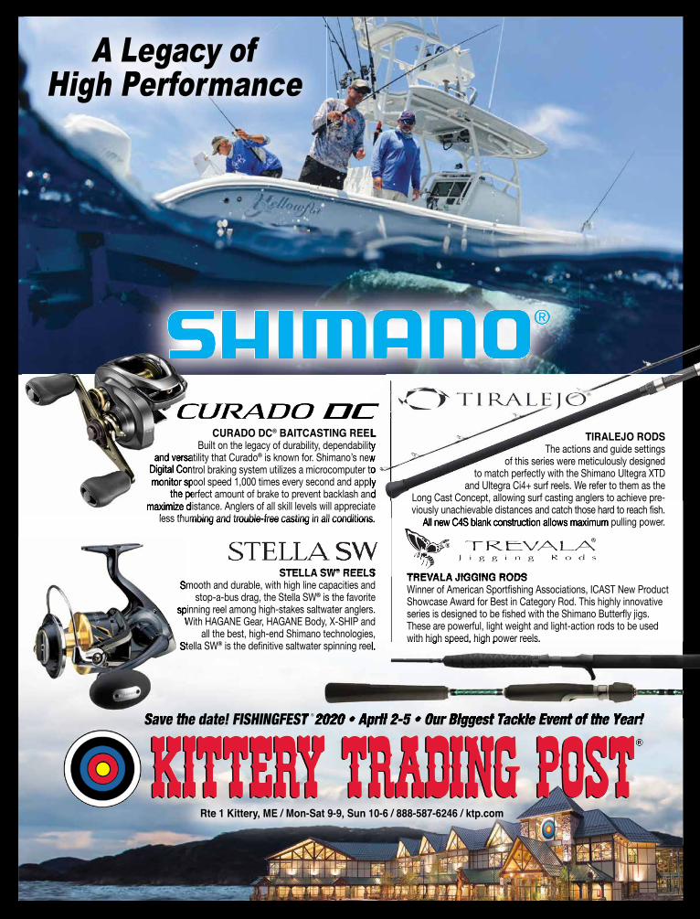
STELLA SW® REELSSmooth and durable, with high line capacities and
stop-a-bus drag, the Stella SW® is the favorite spinning reel among high-stakes saltwater anglers.
With HAGANE Gear, HAGANE Body, X-SHIP and all the best, high-end Shimano technologies,
Stella SW® is the definitive saltwater spinning reel.
CURADO DC® BAITCASTING REEL Built on the legacy of durability, dependability
and versatility that Curado® is known for. Shimano’s new Digital Control braking system utilizes a microcomputer to monitor spool speed 1,000 times every second and apply
the perfect amount of brake to prevent backlash and maximize distance. Anglers of all skill levels will appreciate
less thumbing and trouble-free casting in all conditions.
Save the date! FISHINGFEST 2020 • April 2-5 • Our Biggest Tackle Event of the Year!
A Legacy of High Performance
TREVALA JIGGING RODSWinner of American Sportfishing Associations, ICAST New ProductShowcase Award for Best in Category Rod. This highly innovative series is designed to be fished with the Shimano Butterfly jigs. These are powerful, light weight and light-action rods to be used with high speed, high power reels.
Smooth and durable, with high line capacities and
spinning reel among high-stakes saltwater anglers. With HAGANE Gear, HAGANE Body, X-SHIP and With HAGANE Gear, HAGANE Body, X-SHIP and
Stella SW
Save the date! FISHINGFEST 2020 • April 2-5 • Our Biggest Tackle Event of the Year!
BAITCASTING REEL Built on the legacy of durability, dependability
is known for. Shimano’s new Digital Control braking system utilizes a microcomputer to monitor spool speed 1,000 times every second and apply
the perfect amount of brake to prevent backlash and
is the definitive saltwater spinning reel. with high speed, high power reels.
STELLA SW® REELS
less thumbing and trouble-free casting in all conditions.
TIRALEJO RODSThe actions and guide settings
of this series were meticulously designed to match perfectly with the Shimano Ultegra XTD
and Ultegra Ci4+ surf reels. We refer to them as the Long Cast Concept, allowing surf casting anglers to achieve pre-viously unachievable distances and catch those hard to reach fish.
All new C4S blank construction allows maximum pulling power.
REELS
less thumbing and trouble-free casting in all conditions.
TREVALA JIGGING RODS REELS
less thumbing and trouble-free casting in all conditions. All new C4S blank construction allows maximum pulling power.
Save the date! FISHINGFEST 2020 • April 2-5 • Our Biggest Tackle Event of the Year!
and versatility that CuradoDigital Control braking system utilizes a microcomputer to monitor spool speed 1,000 times every second and apply
the perfect amount of brake to prevent backlash and maximize distance. Anglers of all skill levels will appreciate
less thumbing and trouble-free casting in all conditions.
NH_SW_Fish2018_2019.indd 1 10/25/18 12:44 PM
®

ON THE COVER: Girl holding mackerel
that she caught
Human Role/istockphoto.com
CONTENTS2 Agency and Resource
Contact Information
3 License Fees & Requirements
5 Recreational Licenses
5 Restrictions
6 Definitions
7 Recreational Saltwater Fishing—Finfish
8 Cod Spawning Protection Area
9 Sharks of New Hampshire
10 Flounder and Herring Identification
11 Finfish Identification
12 Saltwater Rigging Basics
14 Great Bay National Estuarine Research Reserve
■ Tide Table Pull-Out Section
15 Coastal Access Sites
18 Commercial Saltwater Fishing—Finfish
19 Coastal Harvest
19 Special River Restrictions
20 Shellfish
21 Shellfish Identification
22 Shellfish Areas
24 Lobster & Crab
26 Northern Shrimp, Other Invertebrates & Marine Plants
26 Jonah vs. Atlantic Rock Crabs
27 Fish Consumption Guidelines
28 Boating in N.H.
N.H. Fish and Game — Our MissionAs the guardian of the state’s fish, wildlife and marine resources, the New Hampshire Fish and Game Department works in partnership with the public to:• Conserve, manage and protect these resources and their habitats;• Inform and educate the public about these resources; and• Provide the public with opportunities to use and appreciate these resources.
The N.H. Fish and Game Department receives Federal Assistance from the US Fish & Wildlife Service, and thus prohibits discrimination on the basis of race, color, national origin, disability, age and sex, pursuant to Title VI of the Civil Rights Act of 1964, Section 504 of the Rehabilitation Act of 1973, Title II of the Americans with Disabilities Act of 1990, Title IX of the Education Amendments of 1972, and the Age Discrimination Act of 1975. If you believe you have been discriminated against in any program, activity or service, please contact or write the US Fish & Wildlife Service, Division of Wildlife and Sport Fish Restoration, 4001 N. Fairfax Drive, Mail Stop: WSFR – 4020, Arlington, Virginia 22203, Attention: Civil Rights Coordinator for Public Programs.
NEW HAMPSHIRE Fish and Game Department
SALTWATER FISHING2020 DIGEST
A Short Coast with Big Opportunities Though New Hampshire has the shortest coastline of any state
that borders an ocean, it offers great sport fishing opportunities: striped bass, mackerel, flounder, tuna, haddock, and more. Our recreational and commercial fisheries are a time-honored tradi-tion and a significant contributor to the state’s economy. I am a longtime seacoast resident, a former commercial fisherman, and I have held a lobster license for the past 20 years, so trust me when I say our seacoast has a lot to offer the saltwater angler.
New Hampshire’s estuarine and saltwater species, including fish, lobsters, clams, and oysters, are managed by Fish and Game’s Marine Fisheries Division, based in Durham. Biologists work closely with other state and federal agencies to protect and maintain marine resources and habitats for both recreational and commercial fisheries. These efforts are essential to rebuilding groundfish stocks, enhancing related habitat, and maintaining healthy populations of species such as Atlantic herring, striped bass, and lobsters in the New England region.
Recreational saltwater anglers can help Fish and Game monitor coastal species. If you encounter Fish and Game’s trained survey staff at one of the many saltwater fishing access sites along New Hampshire’s seacoast or on the ice this winter, I encourage you to take a few minutes to speak with them and participate in the Access Point Angler Intercept Survey or the Winter Smelt Survey. Fish and Game also invites striped bass anglers to report catch and effort online. Find out about these and other survey efforts involving the public at wildnh.com/marine.
So enjoy the beauty of New Hampshire’s seacoast and I’ll see you out there!
Glenn NormandeauExecutive DirectorN.H. Fish and Game Department

2
N.H. Fish & Game CommissionersThe numbers on this page are the home phone numbers of Fish and Game Commissioners. Please use discretion with the timing of your calls. For emergency calls after hours, call N.H. State Police or your local police. For questions about N.H. fishing laws, call (603) 271-3127.
NEW HAMPSHIRE Fish and Game Department
SALTWATER FISHING2020 DIGEST
This digest, with enlarged type, is available for the visually impaired. Call (603) 271-3211
or email [email protected]
Belknap County Marc Lachance (603) 722-0509
Carroll County David L. Patch Vice Chair (603) 387-3771
Cheshire County Robert Phillipson, Jr. Chair (603) 352-8336
Coastal Paul G. McInnis (603) 770-6677
Coos County Eric G. Stohl (603) 237-4206
Grafton County Paul W. DeBow (603) 481-2479
Hillsborough County Ray Green (603) 396-2493
Merrimack County Christopher Hodgdon (603) 746-1000
Rockingham County Christina Luppi (603) 957-8524
Strafford County Frederick T. Bird (603) 289-7745
Sullivan County Bruce Temple (603) 543-0519
State of New HampshireChristoper T. Sununu, Governor
Glenn Normandeau, Executive Director New Hampshire Fish and Game Department 11 Hazen Drive • Concord, New Hampshire 03301
Law Enforcement DistrictsDistrict 1Region 1, 629B Main St. Lancaster, NH 03584 (603) 788-3164 Lt. Mark W. Ober
District 2Region 2, Box 417 New Hampton, NH 03256 (603) 744-5470 Lt. Bradley R. Morse
District 3Region 2, Box 417 New Hampton, NH 03256 (603) 744-5470 Lt. James E. Kneeland
District 4Region 4, 15 Ash Brook Court Keene, NH 03431 (603) 352-9669 Lt. William J. Boudreau
District 5Fish and Game HQ 11 Hazen Drive Concord, NH 03301 (603) 271-3361 Lt. Adam P. Cheney
District 6Region 3, 225 Main St. Durham, NH 03824-4732 (603) 868-1095 Lt. Delayne Brown
N.H. Fish & Game Telephone NumbersLaw EnforcementQuestions about N.H. Fish and Game regulations .....(603) 271-3127Dispatch ....................................................................(603) 271-3361
Regular Hours: 8 a.m.–5 p.m., Mon.–Fri; 7 a.m. to 7 p.m., Sat. and Sun Sept. 1 to end of firearm season: Seven days a week, 7 a.m.–7 p.m.
To Report Violations 24 Hours a DayOperation Game Thief ..............................................1-800-344-4262or wildnh.com/ogtOff Highway Recreational Vehicle (laws/education) .....(603) 271-3129
N.H. Fish and GameHeadquarters/License Office ......................................(603) 271-3421Executive Director’s Office .........................................(603) 271-3511Inland Fisheries .........................................................(603) 271-2501License Agent Accounting/OHRV Registry .................(603) 271-2743License Information ...................................................(603) 271-3421Marine Fisheries ........................................................(603) 868-1095Nuisance Wildlife Questions .....................................(603) 223-6832Public Affairs .............................................................(603) 271-3211Wildlife Programs ......................................................(603) 271-2461
Regional OfficesRegion 1: Lancaster ...................................................(603) 788-3164Region 2: New Hampton ...........................................(603) 744-5470Region 3: Durham .....................................................(603) 868-1095Region 4: Keene ........................................................(603) 352-9669
Coastal Resource ContactsN.H. Fish and Game Marine Fisheries Division225 Main St., Durham, NH 03824 Hours: 8 a.m.–4 p.m., Mon.–Fri. ...............................(603) 868-1095
AquacultureContact N.H. Fish and Game Department for rules and statutes .................................................(603) 868-1095
Clam Flat HotlineCurrent open or closed condition of Hampton Harbor and other shellfishing areas......... 1-800-43-CLAMS
Maine Marine Resources (Maine Marine Patrol) ..... (207) 633-9595
Marine Mammals, Seals, Porpoises, WhalesFederal regulations prohibit harassment of marine mammals. Stranded or dead mammals should be reported to the Seacoast Science Center at .........................................(603) 997-9448
Massachusetts Marine Fisheries ....................... (617) 626-1520Massachusetts Environmental Police ..............1-800-632-8075
National Marine Fisheries Service (NMFS)(greateratlantic.fisheries.noaa.gov)For information on federal regulations and federal permits: Regulations ................................................................(978) 281-9315 Permits ......................................................................(978) 281-9370
New Hampshire Dept. of Environmental ServicesShellfish Program ......................................................(603) 559-1509
New Hampshire Dept. of Safety—Marine PatrolBoating regulations ....................................................(603) 293-2037 Boat registration ........................................................(603) 227-4000
Portsmouth Harbor Coast GuardFor U.S. Coast Guard information .............................(603) 436-4415
Wildlife ServicesAnimal Damage Control ............................................(603) 223-6832

fishnh.com 3
LICENSE INFORMATIONBuying a LicenseFishing (saltwater and freshwater) and hunting licenses, valid January 1 to December 31 of each year, may be purchased online via fishnh.com, from license agents, Fish and Game Depart-ment headquarters in Concord, Fish and Game Region 1, 2 and 4 Offices and some town or city clerks. Applicants must purchase their own licenses. A $2 transaction fee is charged for each license form ($2.75 for Internet purchases).
Lost LicensesRegular hunting and fishing licenses, including recreational saltwater, clam, and oyster, may be reprinted at the original issuing agent or at N.H. Fish and Game in Concord. If purchased at a license agent, and it is at least one week from the date of issue, the license can be reprinted from the online sales site. There is no charge for reprints, however, there is a limit on the number of reprints allowed. For all other miscellaneous and perma-nent licenses, duplicates are issued only at Fish and Game in Concord; there is a fee of $6.
Violation/RevocationConviction for violation of any fishing law or rule, littering, or criminal trespass (RSA 214:19; 207:36-b; 635:2) may result in the revocation of your fishing license or privilege.
Carry Your License The license must be carried on your per-son when fishing or hunting. For fishing licenses, a pdf or other fixed image of a valid license visible on a smart phone is sufficient to comply with the law, as long as a Conservation Officer can view the information contained on the license and a photo ID can be presented.
Residency RequirementsTo obtain a license at resident rates, the per-son must present to the issuing agent a valid New Hampshire driver's license or non-driv-er's picture identification card issued by the N.H. Department of Safety, Division of Motor Vehicles. Whenever the applicant is under 18 years of age, the parent or guardian of the appli-cant shall be a resident and present their valid N.H. driver's license or non-driver's picture identification.
Note: Any person who is no longer a legal resident of the state, but still retains a valid N.H. driver’s license, is guilty of a misdemeanor if he/she tries to obtain a resident fishing, hunting or trapping license based on this driver’s license. The following Permanent Disabled Licenses may be available to qualified N.H. residents: Disabled Veteran License, Paraplegic License, Blind Fishing License, Complimentary Fishing for Developmentally Disabled. Visit fishnh.com for information and application forms.
Residents Age 68 or OlderN.H. residents age 68 and over who would like a clam or oyster license must obtain a free, permanent Clam/Oyster License at Fish and Game Headquarters or Regional Offices in Keene, Lancaster, or New Hampton or by mail.
FISHING LICENSE TYPE CATEGORY FEE
STATE REPORTING REQUIRE-
MENTS
LICENSE (L) OR APPLICATION (A)AVAILABLE
ONLINE*Recreational Saltwater Fishing1,** Allows taking, possessing, or transporting finfish from N.H. coastal and estuarine waters.
Resident or nonresident ages 16 and older (including over age 68 and Lifetime licenses)
$11.002 L
Resident Softshell Clam** N.H. residents only. See page 20 for rules.
Age 6-67 $30.002 L68 years and older - see above Free No
Resident Oyster** N.H. residents only. See page 20 for rules.
Age 0-67 $30.002 L68 years and older - see above Free No
Saltwater Fishing Charter Boat1 Allows a for-hire vessel less than 100 gross tons and USCG licensed to carry 6 or fewer passengers to provide recreational saltwater fishing opportunity to take, possess, or transport finfish from N.H. coastal and estuarine waters.
Resident or nonresident $51.002 per vessel A***
Saltwater Fishing Party Boat1 Allows a vessel holding a valid USCG Certificate of Inspection to carry passengers for-hire to provide recreational saltwater fishing opportunity to take, possess, or transport finfish from N.H. coastal and estuarine waters.
Resident or nonresident $101.002 per vessel A***
Resident Commercial Sea Clam $300.00 Yes A***
Resident Lobster and Crab Required to take lobsters and crabs from state waters. All persons eligible for Commercial or Limited Commercial licenses must purchase a license or submit an affidavit by June 30 each year in order to maintain eligibility for the license.
Recreational: 5 pots maximum $40.00
Yes A***
Part-time Commercial:3 100 pots maximum $125.00Limited Commercial:4 600 pots maximum $200.00Commercial:4 1,200 pots maximum $350.00Helper’s License5 $20.00
Nonresident Lobster and Crab6
Prohibited if applicant’s state excludes nonresident harvest.
Part-time Commercial3 100 pots maximum $350.00Limited Commercial:4 600 pots maximum $400.00Commercial:4 1,200 pots maximum $600.00Helper’s License5 $20.00
Retail Trade of Lobster Meat and Crab Meat Separate license required for each market, store, vehicle or other facility where lobsters and crabs are sold.
Resident $50.00A***
Nonresident $75.00
Landing License for Lobster and Crab Required to transport lobsters and crabs from outside the state’s jurisdic-tion to land and/or sell in N.H., unless a N.H. Lobster and Crab license or either N.H. resident or non-resident Commercial Saltwater License is held.
Resident $50.00
A***Nonresident $500.00

4
LICENSES: FEES & REQUIREMENTS
* See fishnh.com/marine to download an application or buy a license.** A $2 transaction fee is charged for each recreational license form. ($2.75 online)
*** License obtained at Fish and Game in Concord only in person or by mail.
1. See page 6 for more on saltwater license types, including information on reciprocity between states.
2. Includes $1 agent fee.3. New license holders limited to 100 traps maximum.4. Limited entry licenses—for further information, contact Marine Fisheries Division at
(603) 868-1095.5. Helper’s license required for each helper (no residency requirement for helpers).6. Eligible only if applicant’s state provides reciprocal licensing privileges.7. Additional fees associated with license.8. Fee waiver only for educational and nonprofit institutions and government agencies.
FISHING LICENSE TYPE CATEGORY FEE
STATE REPORTING REQUIRE-
MENTS
LICENSE (L) OR APPLICATION (A)AVAILABLE
ONLINE*
Resident Commercial Saltwater Required to take, land, transport or possess marine species with the intent to sell, regardless of method. Does not allow taking lobsters or crabs from state waters or taking, possession, landing or transport of northern shrimp. Includes operator and unlimited helpers. License is not issued to a vessel, it is issued to an individual.
Resident $50.00
Yes, Menhaden
dealersA***Nonresident Commercial Saltwater
Required to take, land, transport or possess marine species with the intent to sell, regardless of method. Includes operator and unlimited helpers. Allows for the landing of lobsters taken from areas outside the jurisdiction of New Hamp-shire. License is not issued to a vessel; it is issued to an individual. Does not allow for the taking, possession, landing or transportation of northern shrimp.Taking of sea urchins, clam worms, river herring and scallops is prohibited if applicant’s state excludes nonresident harvest.
Nonresident $500.00
Commercial Shrimp License Required to take, possess, land or transport northern shrimp on the waters of the state for sale, regardless of where catch was taken.
Resident $100.00Yes A***
Nonresident $500.00
Wholesale Marine Species Required to buy, sell, process and transport marine species if wholesaling marine species. A separate extra facility license shall be required for each market, store, vehicle or facility where marine species are bought or sold at wholesale. Vehicles used solely for the transportation of marine species are not required to be licensed as an extra facility, as long as the wholesale marine dealer is licensed. Cannot transport lobster and crab taken outside of the state by boat with this license. Need to obtain either a Commercial Saltwater License or Landing License.
Resident $130.00
Yes—Lobster, Shrimp, Crab,
Menhaden and
Dogfish Dealers
A***
Nonresident $260.00
Resident Extra Facility $75.00
Nonresident Extra Facility $100.00
Harvest Permit Required to take finfish by seine, net, weir, pot or trap, horseshoe crab by any method, or American eel by any method but angling, from coastal and estuarine waters of N.H. Also required to take any species, except lobsters and crabs, for commercial purposes from state waters, unless reporting that catch via vessel trip reports to NOAA Fisheries. Available at Durham office.
Free Yes A
Shrimp Processing Permit Required to possess shrimp during closed season. Available at Durham office. Free A
Sea Herring Possession Permit Required to possess sea herring. Available at Durham office. Free A
Aquaculture License Marine-related aquaculture licenses are issued by N.H. Fish and Game, Marine Fisheries Division. Contact Marine Fisheries directly at (603) 868-1095.
$200.007 Yes No
Scientific Permit Marine-related scientific permits are issued by N.H. Fish and Game, Marine Fisheries Division. Contact Marine Fisheries directly at (603) 868-1095.
$25.008 Yes No
Limited Annual Saltwater License for Lifetime Licensees Allows for persons holding a lifetime fishing or combination license pur-chased before 2011 to take saltwater smelt, saltwater shad, or saltwater salmonids. Contact N.H. Fish and Game in Concord or download an application from fishnh.com/marine.
Resident Free A***

RECREATIONAL LICENSESN.H. Recreational Saltwater License In 2009, legislation was passed implementing a Rec-reational Saltwater License in New Hampshire, in addition to Charter Boat and Party Boat licenses. Passage of this law exempted licensed N.H. saltwater anglers from NOAA’s National Saltwater Angler Reg-istry (countmyfish.noaa.gov) and took effect in 2011.
Cost• $11 (N.H. resident and nonresident)Recreational fishing licenses are available forpurchase online or through any of 200+ N.H.license agents statewide.
Who Needs the License?All persons ages 16 and older participating in recreational saltwater fishing who wish to take, possess, or transport finfish from coastal and estuarine waters of New Hampshire. This includes anglers, spearfishers, and persons using other gear types to take marine finfish for personal use and which are not sold.
There is no exemption for persons over age 68 from the recreational saltwater license. This is because we need to collect the name, address, and phone number of all those fishing in salt-water each year in order to obtain an exemp-tion for N.H. license holders from the National Saltwater Angler Registry and the associated fee.
ExemptionsYou do not need the recreational fishing license to fish from a licensed charter or party boat.
Persons who purchased a Lifetime fishing or combination license prior to 2011 may obtain a Limited Annual Saltwater License for Lifetime Licensees to fish for saltwater smelt, American shad, trout and salmon in coastal and estuarine waters. This permit must be applied for each year
by mail or at Fish and Game in Concord and is good only for the fish listed above. If you wish to fish for other fish species such as striped bass, flounder, cod, etc. you must purchase a N.H. Recreational Saltwater License.
ReciprocityResident anglers possessing a valid N.H. Rec-reational Saltwater License can legally fish in all tidal and estuarine areas of Massachusetts and in Maine. Reciprocity will be granted in N.H. for those nonresident anglers possessing a valid Maine or Mass. saltwater license.
Charter and Party Boat License Cost• Charter boat: $51• Party boat: $101
Who Needs the License?A charter or party boat license is required for party boats, charter boats, dive boats, head boats, and other boats hired by persons to engage in rec-reational saltwater fishing opportunities which includes the taking of any marine finfish, by any means for personal use only and which are not sold.
Charter boat is a vessel less than 100 gross tons that meets the requirements of the U.S. Coast Guard to carry 6 or fewer passengers for hire.
Party boat or head boat is a vessel that holds a valid Certificate of Inspection issued by the U.S. Coast Guard to carry passengers for hire.
Passengers hiring a licensed party or charter boat do not need to have a Recreational Saltwater Fishing license while fishing from the vessel.
Sale ProhibitedSeaweed, rockweed or sea moss of N.H. origin may not be sold outside the state. Softshell clams and oysters of N.H. origin, striped bass regardless of origin, and quahogs, littlenecks and cherrystones (Mercenaria mercenaria) less than 1 inch in shell thickness cannot be sold.
It Is Unlawful to:• Import any living marine plant or animal
for release without a permit;• Set a net so it extends beyond the thread of
the stream. The thread of stream means the center of the main channel;
• Set a net within 1,000 feet of another net,measured along the thread of the stream;
• Molest, pull, tend, possess or disturb gearused or marine species raised in a marineaquaculture operation;
• Take lobsters by diving, angling, spearingor dipping;
• Dump dead or injured fish or fish parts within bays, rivers, harbors or upon the shores. Thisdoes not restrict the use of fish or fish partsfor chum or bait, nor the releasing of deador injured undersized fish taken by angling;
• Be on a fishway without permission;• Take salmon or striped bass by netting, except
when landing by use of hand-held dip nets;• Take finfish, horseshoe crabs, American eels
or other species for commercial purposes(excluding lobster/crab) without obtaining aharvest permit, as further specified on page 19.
• Take or possess oysters, clams, or mussels
from a licensed aquaculture site that is prop-erly marked with yellow buoys at each corner.
Law EnforcementProhibitionIt is unlawful to throw, dump, destroy or other-wise dispose of any fish, lobsters, crabs, or shell-fish when a Conservation Officer has informed a person his boat, motor vehicle, wharf, dock or landing, or contents thereof, are about to be inspected. The same applies to any pot, trap, car, or any other receptacle used to catch or store lobsters or crabs. Any person who refuses or attempts to refuse to stand by for such inspection is guilty of a misdemeanor. Any lobsters or crabs, thrown or dumped or caused to be thrown or dumped, are prima facie evidence they were illegally taken. A person is guilty of a violation for each lobster or crab thrown or dumped.
RESTRICTIONS
Charter & Party Boat Operators: Please NoteOperators of vessels with a N.H. party or charter boat license operating in coastal and estuarine waters of the state are exempt from the need to obtain a N.H. Guide license if:
1. They possess a U.S. Coast Guard-issued Master License or “6-pack” license, and
2. They or a crew member on board the ves-sel has current certification (with practi-cal exam) in basic first aid and CPR, and
3. They obtain a federal party/charter permit if fishing in federal waters (>3 miles fromshore). Call (978) 281-9370.
Visit fishnh.comBuy your N.H. fishing license online; download the Saltwater Fishing Digest; sign up for fishing reports; and much more!
ReciprocityNew Hampshire law provides reciprocity for Maine and Massachusetts licensed charter and party boats, but only if those states provide reciprocity for N.H. licensed vessels. At this time, only Massachusetts provides reciprocity for N.H. licensed charter and party boat ves-sels; licensed N.H. vessels may operate and fish in Mass. state waters, but may not pick up or drop off passengers or land fish in Mass.
Leave Lobster Pots AloneLobster pots, traps, warps (ropes), cars or buoys are private property, regardless of the location. This includes on the beach and in the rocks. No person except the owner or a Conservation Officer can possess, lift, molest or disturb them. To do so can result in a fine of $2,000 and up to 1 year in jail.
fishnh.com 5

DEFINITIONS
Angling: The taking of fish by line in hand or rod in hand to which is attached a cast of artifi-cial flies, or an artificial bait, or hooks, or other devices for the attachment of bait. A person may use up to two lines. Rod holders are permitted.
Coastal and estuarine waters: All water within the rise and fall of the tide, and water below any fishway or dam which normally divides tide water and freshwater, or below any legally established tidal bound in streams flowing into the sea.
Commercial fisherman: Any person who takes, possesses, lands or transports, on the waters of New Hampshire, any marine species by any method for the purpose of sale.
Curved fork length (CFL): The length of an intact fish measured from the tip of the upper jaw to the fork of the tail along the contour of the body in a line that runs along the top of the pectoral fin and the top of the caudal keel.
Finfish: Includes all species and subspecies of fish listed under the definition of fish.
Fish: A member of any of the following classes: cyclostomata, including, but not limited to, hag-fishes and lampreys; elasmobranchii, includ-ing, but not limited to, sharks, skates and rays; and pisces, including, but not limited to, trout, perch, bass, minnows and catfish; including any part, product, egg or offspring thereof, or the dead body or parts thereof, excluding fossils.
Fork Length: The straightline measurement of a fish from the midpoint of the anterior edge of the fish to the fork of the caudal fin (not along the curve of the body).
Groundfish: A group of fish which includes Atlantic cod (Gadus morhua), Atlantic wolffish (Anarhichas lupus), Atlantic halibut (Hippoglossus hippoglossus), ocean pout (Zoarces americanus), haddock (Melanogrammus aeglefinus), pollock (Pollachius virens), American plaice (Hippoglossoi-des platessoides), redfish (Sebastes marinus), white hake (Urophycis tenuis), summer flounder (Parali-chthys dentatus), yellowtail flounder (Pleuronectes
New Rules• Definition for fork length (see below).
• Groundfish - Recreational: new season and daily bag limit for Atlantic cod and haddock, and new minimum length limit for Atlantic cod (see page 7).
• Sharks - Recreational: new length limits for shortfin mako, and use of non-offset, corrodible circle hooks if angling with bait (see page 7).
• Atlantic Menhaden: small-scale purse seine allowed in state waters with restric-tions (see pages 18 and 19).
• Atlantic sea herring: increased spawning closed season (see page 18).
or placing, setting, drawing, or using any net or other device commonly used to take wild-life, whether they result in taking or not, and includes every attempt to take and every act of assistance to every other person in taking or attempting to take wildlife, provided that when-ever taking is allowed by law, reference is made to taking by lawful means and in lawful manner.
Total length (TL): The straight-line distance from the tip of the snout to the tip of the tail (caudal fin) while the fish is lying on its side, normally extended.
Transport and transportation: All carrying or moving, or causing to be carried or moved.
Weir: A fixed position fish trap consisting of a lead of net strung from poles, usually wooden, with a pocket of net within which the fish are contained.
Wildlife: Refers to all species of mammals, birds, fish, mollusks, crustaceans, amphib-ians, reptiles or their progeny or eggs which, whether raised in captivity or not, are normally found in a wild state.
6 2020 New Hampshire Saltwater Fishing Digest
ferruginea), winter flounder (Pleuronectes ameri-canus), windowpane flounder (Scophthalmus aquosus), and witch flounder (Glyptocephalus cynoglossus).
Inclusion dates: Whenever a period is named during which an act is permitted or prohibited, both the first and second dates named will be included within such period.
Marine species: Includes all fish which inhabit salt water, and all shellfish, lobsters, crabs, shrimps, clams, marine worms, other marine invertebrates and marine plants found in the coastal and estuarine waters.
Mobile gear: Includes, but is not limited to, otter trawls, mid-water trawls, beam trawls, pair trawls, drag seines in any form, purse seines and Scottish seines. Does not include cast nets, dip nets held in hand, hook and line, seines less than 50 sq. ft. and stationary gill nets anchored on each end.
Net: Any open fabric constructed of string, cord, thread, wire, etc., knotted or woven together in such a way as to be capable of entraining or entrapping finfish.
Nonresident: All persons not coming within the definition of resident.
Person: Includes co-partnership, association and corporation, and also principal, agent or employee.
Resident: A resident of the state, as defined in RSA 21:6, except that no person shall be deemed to be a resident who claims residence in any other state for any purpose.
Resident and nonresident corporations: The word “resident,” when applied to a cor-poration, is a corporation organized under the laws of this state. The word “nonresident,” when applied to a corporation, is a corporation organized under the laws of another state.
Possession: Actual or constructive possession, and any control of things referred to.
Salters: Any species of trout which spends part of its life cycle in brackish or saltwater.
Seaweed: Any marine algae in the classes Chlorophyceae, Xanthophyceae, Phaeophyceae and Rhodophyceae, including rockweeds and sea moss.
Seine: A net that is rectangular or square and is pulled through the water to entrap organisms.
Sell and Sale: Includes the barter, exchange, and offering or exposing for sale.
Single hook artificial lure: Lure with 1 single hook with not more than 3 hook points.
Waters under the jurisdiction of the state: Those waters within the 3-mile territorial sea.
Take or taking: Includes pursuing, shooting, hunting, killing, capturing, trapping, snaring and netting wildlife, and all lesser acts, such as disturbing, harrying, worrying, wounding

RECREATIONAL SALTWATER FISHING—FINFISHRecreational saltwater fishing in New Hamp-shire provides diverse opportunities. Saltwater anglers can cast a line from boats, bridges, jetties or the beach. Many saltwater fish species are avail-able along the coast and in our rivers and bays. Recreational saltwater fishing in N.H. requires a
recreational saltwater license. See page 5 for details.Below are species that have rules or laws that
apply to recreational anglers or spearfishers while fishing in state waters.
Additional regulations apply in federal waters for most of the below-listed species — contact NOAA
NEW HAMPSHIRE RECREATIONAL SALTWATER FISHING REGULATIONS***
SPECIES CLOSED SEASON MINIMUM LENGTH (TOTAL LENGTH) DAILY BAG LIMIT SPECIAL RULES
American Eel No closed season (except surrounding fishways) 9 inches 25 fish per day Fishway closures apply October 2 – June 14
(see Coastal Harvest Section, page 19)American Plaice* 14 inchesAmerican Shad All shad must be immediately released
Atlantic Cod*Jan. 1 - Sept. 14Oct. 1- Dec. 31
21 inches 1 fish per day • See Gulf of Maine Cod Spawning Protection Area map on page 8
Atlantic Halibut 41 inches 1 fish per trip/vessel Head and tail intact while on or leaving waters of the stateAtlantic Sea Herring Federal regulations apply in federal watersAtlantic Salmon (Sea-run )
All sea-run Atlantic salmon caught on coastal and estua-rine waters must be immediately released
Atlantic Wolffish Possession is prohibitedBlack Sea Bass 13 inches 10 fish per day Length does not include filament/tail extension
Bluefin Tuna 27 inches CFL** Variable; see website Federally managed — follow federal regulations (call 1-888-USA-TUNA) or visit hmspermits.noaa.gov
Bluefish 10 fish per dayDogfish, Spiny Finning prohibitedHaddock* Mar. 1 – April 14 17 inches 15 fish per day • Head and tail intact, unless fillet is 10 inches minimumMonkfish 17 inchesPollock* 19 inches, if taken in federal watersRainbow Smelt (Saltwater) 4 liquid quarts Head and tail must remain intactRedfish* 9 inchesRiver Herring (Alewife/ Blueback Herring)
Closed sunrise Wednes-day – sunrise Thursday
See Squamscott River in Special River Restric-
tions, page 19.
See Special River Restrictions and Coastal Harvest Sec-tion, page 19. Fishing prohibited around fishway closure areas Oyster and Taylor rivers closed
Salters (Sea-run Trout) see definition on page 6 No closed season 1 fish per day
• Recreational angling only• In Berry Brook****: Single-hook artificial lures and flies
only. Immediate release required. • In Winnicut River: The salter daily limit applies only
downstream of the B&M Railroad bridge
Sharks — Blue, Porbeagle, Shortfin Mako and Thresher
Shortfin mako: 71 inches FL*** - males
83 inches FL*** - females
• Porbeagle — recreational fishing in state waters only• All sharks — head, fins and tail must remain attached
through landing• Non-offset, corrodible circle hooks required if angling
with bait. • Additional federal regulations apply in federal waters
(call 1-978-281-9315).
Striped Bass 28 inches 1 fish per day
• Gaffing and culling, is prohibited; No sale allowed, regardless of origin.
• Head and tail must be intact while on or leaving the waters or shores of the state except may possess up to 2 fillets with skin intact if:1. Also possess fish rack > 28" TL with head/tail intact
that fillets came from, or2. Fillets measure > 28" TL.
Sturgeon Closed year round Possession is prohibitedSummer Flounder* 15 inches Recreational angling only; No sale allowedWhite Perch 25 fish per day Sale is prohibitedWinter Flounder* 12 inches 8 fish per dayYellowtail Flounder* 13 inches
* All groundfish species that are filleted and skinned must retain at least 2 square inches of contiguous skin intact for identification purposes.** Curved fork length - See definition on page 6.*** Fork length - See definition on page 6.**** Anglers fishing Berry Brook in Rye: All fish species caught must be immediately released.
fishnh.com 7
About This PublicationThis publication is a summary of fishing regulations. It is not the full laws or rules. It is intended only as a guide to seasons and other necessary marine information. For more detailed information concerning regulations, consult the New Hampshire Fish and Game Law Book, Fish and Game Administrative Rules, or contact your local Conservation Officer. Fish and Game laws and rules may be viewed at any Fish and Game office (see page 2 for phone numbers); Legislative Services, Administrative Rules, in the State House Annex, 25 Capitol St., Room 219, Concord, NH 03301; and at fishnh.com or nh.gov. A compendium of Fish and Game laws may also be purchased at Department headquarters in Concord for $41.
Fisheries at (978) 281-9315 or https://www.fisher-ies.noaa.gov/new-england-mid-atlantic/recre-ational-fishing/recreational-fishing-regulations-species directly if you have questions regarding fishing in federal waters.

8 2020 New Hampshire Saltwater Fishing Digest
COD SPAWNING PROTECTION AREAGulf of Maine Cod Spawning Protection AreaThe Gulf of Maine Cod Spawning Protection Area (CSPA) is located in both state and federal waters south of the Isles of Shoals and is closed to all fishing, as well as take and possession of groundfish, in April, May and June, with the following exceptions:
In state waters (area depicted with red lines):• All cod caught in New Hampshire waters must
be immediately released.• Fishing with either line or rod in hand with
gear that has no more than 1 ounce of artifi-cial weight or a single artificial lure weigh-ing one ounce or less. (Note: In the federalwaters portion of the CSPA, the use of anyweights or weighted lures is prohibited.)
• Commercial vessels using gear described in 50 CFR 648.2.
• Private recreational or charter/party vessels that are transiting the area with groundfish caught outside the CSPA must have all baitand hooks removed from fishing rods orhandlines and groundfish species on board must have been gutted.
• Commercial vessels that are transiting thearea with groundfish caught outside theCSPA must have gear stowed in accordance with the provisions of 50 CFR 648.23.
Additional federal rules may apply withinthe federal waters of the Gulf of Maine Cod Spawning Protection Area. Contact NOAA Fisheries at (978) 281-9315.
Catch & Release• Time is of the essence. Play and release the fish as quickly and carefully as possible. An overplayed fish may become too weak to recover.
• When landing fish, use a net with fine mesh to avoid injury. Keep the fish in the water as much as possible. A fish out of water is suffocating andcould be injured.
• When releasing a fish, try not to touch it when removing the hook and releasing it. When handling the fish, do not let it flop around or squeeze it. The fish can be gently held around the middle and upside down while removing the hook. This position calms the fish and deters it from moving around.
• Remove the hook with small pliers or by using the thumb and forefinger to loosen and back out the hook. If a hook cannot be easily removed, cutthe leader as close as possible to the hook. The hook will rust or fall out in a short time.
• To revive a tired fish, hold it in a swimming position with one hand under its bottom jaw and the other hand grasping the fish in front of the tail.Gently move the fish back and forth through the water until it is able to swim away.
N.H. Fish and Game recommends that anglers using live or cut bait use circle hooks to reduce mortality on fish that will be released. Studies comparing baited circle hooks to the standard J hooks used by most anglers show a substantial reduction in post-release hooking mortality when circle hooks are used. See page 13 for more information on circle hooks.
For more information, contact Fish and Game Marine Fisheries Division weekdays (8:00 a.m. – 4:00 p.m.) at (603) 868-1095.
Landowner ProtectionNew Hampshire State law provides cer-tain protections for landowners who open their land to those using it for outdoor recreation. For more information, visit wildnh.com/landshare.
Buy Your Hike Safe CardGet your annual voluntary Hike Safe Card! $25 for indi-vidual or $35 per family. Available at wildnh.com.

fishnh.com 9
SHARKS OF NEW HAMPSHIRESh
ark
illus
tratio
ns: ©
Vict
or Y
oung
: Sho
rtfin
mak
o, B
lue
shar
k; ©
Katie
Ste
el: P
orbe
agle
; ©
USFW
S/Du
ane
Rave
r Illu
stra
tions
: Spi
ny d
ogfis
h; ©
NO
AA: T
hres
her s
hark
A variety of sharks are found in coastal waters off New Hampshire. There are federal and state regulations around the harvest of sharks in both federal and state waters. Below are sharks species that have state regulations in New Hampshire (see pages 7 and 18).
Blue Shortfin mako
Porbeagle Thresher
Spiny dogfish
For advertising inquiries, please call(413)884-1001
Missed the printed edition?Ask about year-round digital opportunities.
Showcaseyour business!

10 2020 New Hampshire Saltwater Fishing Digest
FLOUNDER AND HERRING IDENTIFICATION
Herri
ng il
lust
ratio
ns: ©
Vict
or Y
oung
: Atla
ntic
her
ring,
Ale
wife
, Am
eric
an s
had;
©
USFW
S: B
lueb
ack
herri
ng; ©
NO
AA: A
tlant
ic m
enha
den
Herring of New Hampshire
A variety of herring frequent N.H. coastal and estuarine waters and can be confusing to identify. River herring (alewife and blueback her-ring) and American shad are generally seen during spring spawning runs. Menhaden and Atlantic herring may appear in our estuaries during coastal migration in the summer or early fall.
Alewife
Eye diameter greater than snout length
No teeth on roof of mouth
Dorsal fin forward of midlength
Deep body
American shad
Large mouth
Largest in the herring family
May have a line of spots
Upper jaw close to rear edge of eye
Atlantic sea herring
Teeth on roof of mouth
Dorsal fin at midlength
Narrow body
Atlantic menhaden
Series of random, smaller dark spots
Scaleless head = 1⁄3 of body length
Blueback herring
Eye diameter less than snout length
No teeth on roof of mouth
Dorsal fin forward of midlength
A few features help distinguish the flounder caught recreationally along New Hampshire’s coast that have size regulations: Orientation of the eyes (right- or left-eyed); mouth size; and shape of the lateral line or tail. Recreational saltwater anglers in N.H. most commonly catch winter flounder, followed by yellowtail, summer flounder and American plaice. While not often caught, Atlantic halibut are the largest flounder found in the Gulf of Maine.
Winter flounder
• Eyes on right side• Small mouth• Scales between eyes
American plaice
• Eyes on right side• Large mouth
Summer flounder
• Eyes on left side• Large mouth• Sharp teeth
Yellowtail flounder
Arched lateral line
• Eyes on right side• Small mouth
Atlantic halibut
Arched lateral line
• Largest flatfish• Eyes on right side• Tail concave

fishnh.com 11
Finfi
sh il
lust
ratio
ns: ©
Mas
s DF
G/V
icto
r You
ng Il
lust
ratio
ns: B
luefi
sh, B
luefi
n tu
na, S
tripe
d ba
ss, C
od, M
acke
rel,
Hadd
ock,
Pol
lock
, Wol
ffish
, Cus
k, B
lack
sea
bas
s; ©
Vict
or Y
oung
: Atla
ntic
sal
mon
, Ra
inbo
w s
mel
t, W
hite
hak
e, A
mer
ican
eel
; ©US
FWS/
Duan
e Ra
ver I
llust
ratio
ns: A
tlant
ic s
turg
eon,
Bro
wn
trout
; ©N
ew J
erse
y Di
visi
on o
f Fis
h an
d W
ildlif
e/Du
ane
Rave
r Illu
stra
tions
: Mon
kfish Bluefin tuna
Atlantic wolffish
Striped bass
Rainbow smelt
Pollock
Bluefish
Brown trout
Atlantic cod
Cusk
Haddock
Atlantic mackerel
Atlantic salmon
Atlantic sturgeon
American eel
Monkfish
FINFISH IDENTIFICATION
Black sea bass
Redfish
White hake
Silver hake
12 2020 New Hampshire Saltwater Fishing Digest
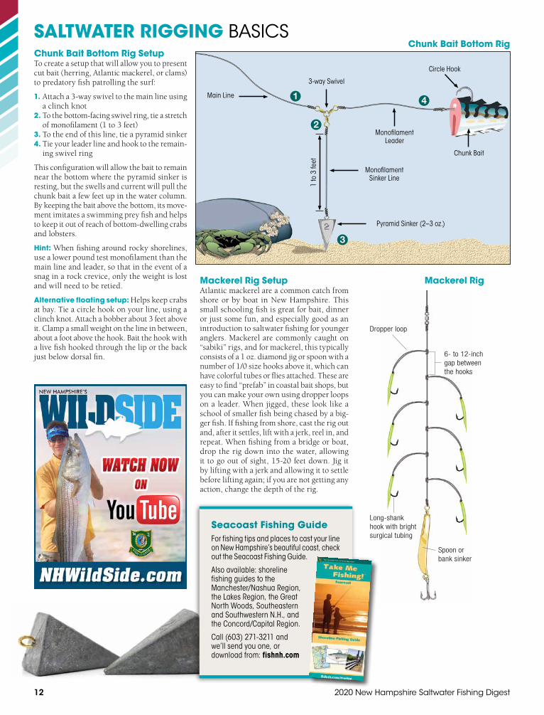
SALTWATER RIGGING BASICS
1
1 to
3 fe
et
Main Line
Monofilament Sinker Line
3-way Swivel
Pyramid Sinker (2–3 oz.)
Monofilament Leader
Chunk Bait
Circle Hook
2
3
4
Chunk Bait Bottom RigChunk Bait Bottom Rig SetupTo create a setup that will allow you to present cut bait (herring, Atlantic mackerel, or clams) to predatory fish patrolling the surf:
1. Attach a 3-way swivel to the main line using a clinch knot
2. To the bottom-facing swivel ring, tie a stretch of monofilament (1 to 3 feet)
3. To the end of this line, tie a pyramid sinker4. Tie your leader line and hook to the remain-
ing swivel ring
This configuration will allow the bait to remain near the bottom where the pyramid sinker is resting, but the swells and current will pull the chunk bait a few feet up in the water column. By keeping the bait above the bottom, its move-ment imitates a swimming prey fish and helps to keep it out of reach of bottom-dwelling crabs and lobsters.
Hint: When fishing around rocky shorelines, use a lower pound test monofilament than the main line and leader, so that in the event of a snag in a rock crevice, only the weight is lost and will need to be retied.
Alternative floating setup: Helps keep crabs at bay. Tie a circle hook on your line, using a clinch knot. Attach a bobber about 3 feet above it. Clamp a small weight on the line in between, about a foot above the hook. Bait the hook with a live fish hooked through the lip or the back just below dorsal fin.
Seacoast Fishing Guide For fishing tips and places to cast your line on New Hampshire’s beautiful coast, check out the Seacoast Fishing Guide.
Also available: shoreline fishing guides to the Manchester/Nashua Region, the Lakes Region, the Great North Woods, Southeastern and Southwestern N.H., and the Concord/Capital Region.
Call (603) 271-3211 and we’ll send you one, or download from: fishnh.com
Dropper loop
Long-shank hook with bright surgical tubing
Spoon or bank sinker
6- to 12-inch gap between the hooks
Mackerel Rig Setup Atlantic mackerel are a common catch from shore or by boat in New Hampshire. This small schooling fish is great for bait, dinner or just some fun, and especially good as an introduction to saltwater fishing for younger anglers. Mackerel are commonly caught on “sabiki” rigs, and for mackerel, this typically consists of a 1 oz. diamond jig or spoon with a number of 1/0 size hooks above it, which can have colorful tubes or flies attached. These are easy to find “prefab” in coastal bait shops, but you can make your own using dropper loops on a leader. When jigged, these look like a school of smaller fish being chased by a big-ger fish. If fishing from shore, cast the rig out and, after it settles, lift with a jerk, reel in, and repeat. When fishing from a bridge or boat, drop the rig down into the water, allowing it to go out of sight, 15-20 feet down. Jig it by lifting with a jerk and allowing it to settle before lifting again; if you are not getting any action, change the depth of the rig.
Mackerel Rig

fishnh.com 13
SALTWATER RIGGING BASICS
Please Use Circle HooksTo conserve fisheries, many sport anglers now release the fish they catch. Using circle hooks instead of standard J-hooks can significantly reduce mortality. Experienced striped bass anglers find that baited circle hooks, because the point is turned inward, almost always hook fish in the lip or jaw. Points on J-hooks, in contrast, are more exposed and can lodge in the gills, throat or stomach—internal organs where injuries can be fatal.
Because of its design, you don’t need to “set” a circle hook as you would a J-hook; simply let the fish “take” the bait and then start reeling to get a hook-up. Many longtime anglers believe they actu-ally catch more fish with circle hooks than J-hooks, once they’ve learned to use them properly.
circle hook standard “J” hook
Dropper Loop Knot (use to attach a second hook)
1
2
3
4
5
Use a match stick or similar object to assist with wrapping the loop.
Make 5 to 8 twists in the wrapping.
For more saltwater fishing tips and information, visit
fishnh.com/marine
Let’s Go Fishing! Classes with N.H. Fish and GameWant to learn how to fish, enhance your fishing skills, help turn a friend into a fishing buddy? Check out Let’s Go Fishing classes from N.H. Fish and Game’s Aquatic Resources Education team! Courses are offered throughout the state by trained volunteer instructors who bring a wealth of experience and knowledge to help anglers get started.
Courses for adults and children are free of charge and designed to teach basic ecological concepts, fishing skills and new ways to enjoy the outdoors together. Courses cover basic techniques for year-round fishing in ponds, lakes, streams and the ocean. A typical course offers hands-on instruction, plus a field trip to put your new skills to the test on the water. Let’s Go Fishing also offers specialty clinics and weekend workshops on fly fishing, saltwater fishing, fly tying, ice fishing and more. For a class schedule, visit fishnh.com.

14 2020 New Hampshire Saltwater Fishing Digest
rivers. In addition, there are 2,935 acres of upland that comprise the boundary of the Reserve. All Reserve lands are open to the public for hunting and fishing. Go to greatbaypartnership.org to view maps highlighting all conservation lands in the Great Bay area.
The efforts of the Reserve are focused at the Great Bay Discovery Center and the Hugh Gregg Coastal Conservation Center in Greenland off Route 33. The 50-acre site includes a 1,300-foot boardwalk, a high-tide-only boat access, and indoor and outdoor exhibits featuring the
The Great Bay National Estuarine Research Reserve (GBNERR) was designated in 1989 and is part of a network of 29 Reserves across the nation. The Great Bay Reserve is managed by the New Hampshire Fish and Game Depart-ment in cooperation with the National Oceanic and Atmospheric Administration (NOAA). The program sets aside important estuarine areas for long-term research, education and stewardship.
The Great Bay Reserve includes all of Great Bay, Little Bay and the tidal portions of the Bellamy, Oyster, Lamprey, Squamscott and Winnicut
GREAT BAY NATIONAL ESTUARINE RESEARCH RESERVE
Volunteer for Great Bay!Share your passion for the Great Bay and join the volunteer family at the Great Bay Discovery Center. Volunteers are needed to help implement the school and summer programs, staff the exhibit rooms, work on special events, help with research projects, and keep the grounds and gardens looking great.
Call the Great Bay Discovery Center at (603) 778-0015 or visit greatbay.org for more information.
Children enjoying an education program on Great Bay.
2020 Free Fishing Days — Saturday, January 18 and Saturday, June 6
• Recreational fishing by angling only
• All other regulations apply
• Saltwater or freshwater
• NO LICENSE REQUIRED*
* Participants in fishing tournaments must have a license, even onfree fishing days.
cultural and natural history of the Great Bay Estuary, as well as antique coastal hunting and fishing artifacts. The interpretive centers are open May to October and are free of charge.
Year round, the Reserve holds a number of special programs, including interpretive kayak tours and programs for children. The Reserve provides technical training for coastal decision makers through its Coastal Training Program, and conducts coastal research and monitoring. The facilities feature a number of innovative tech-nologies for managing stormwater and reducing energy consumption, including a porous pave-ment parking lot, composting toilets, solar roof-ing and a geothermal heating and cooling system.
The Reserve is also supported by a local friends group, the Great Bay Stewards. Learn more at greatbaystewards.org. For more infor-mation about all the Reserve's programs, visit greatbay.org.
Great Bay National Estuarine Research Reserve N.H. Fish and Game Department 225 Main Street, Durham, NH 03824 (603) 868-1095
Great Bay Discovery Center/ Hugh Gregg Coastal Conservation Center 89 Depot Road, Greenland, NH 03885 (603) 778-0015
Volunteers help GBNERR plant a wildlife garden.The Lowcountry Awaits
PROFESSIONAL FISHING GUIDEFLY AND CONVENTIONAL
INSHORE × NEARSHORE × OFFSHORE Charleston, SC
(843)860-4231 × john@� yrightcharters.comwww.� yrightcharters.com
fishnh.com 2020 Tide Table Pull-out Section — A
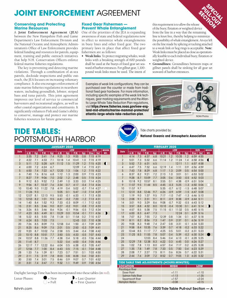
TIDE TABLES: PORTSMOUTH HARBOR
SPECIAL
PULL-OUT
SECTION
Daylight Savings Time has been incorporated into these tables (in red).
Lunar Phases: = New = Last Quarter = Full = First Quarter
TIDE TABLE TIME ADJUSTMENTS (HOURS:MINUTES)LOCATION HIGH LOWPiscataqua River
Dover Point +1:11 +1:10Salmon Falls River +1:13 +1:35Squamscott River +1:57 +2:24
Hampton Harbor –0:08 +0:15
Tide charts provided by:
National Oceanic and Atmospheric Association
JANUARY 2020
DateHIGH LOW SUN MOON
Qtr.A.M. Hgt. P.M. Hgt. A.M. Hgt. P.M. Hgt. Rise Set1 3:35 7.2 3:41 7.4 9:25 1.3 9:55 0.8 7:15 4:19 2 4:22 7.1 4:33 7.1 10:18 1.4 10:41 1.0 7:15 4:19 3 5:11 7.2 5:28 6.9 11:12 1.5 11:29 1.2 7:15 4:20 4 6:00 7.2 6:24 6.7 12:09 1.4 7:15 4:21 5 6:50 7.4 7:22 6.7 12:20 1.3 1:06 1.2 7:15 4:22 6 7:40 7.6 8:16 6.8 1:12 1.3 2:00 0.9 7:15 4:23 7 8:27 7.9 9:06 7.0 2:02 1.2 2:48 0.5 7:15 4:24 8 9:12 8.3 9:52 7.3 2:49 1.0 3:33 0.0 7:14 4:25 9 9:56 8.7 10:37 7.6 3:34 0.7 4:17 -0.4 7:14 4:26
10 10:40 9.0 11:22 7.8 4:19 0.4 5:02 -0.7 7:14 4:27 11 11:26 9.3 5:05 0.1 5:47 -1.0 7:14 4:29 12 12:07 8.1 12:13 9.5 5:53 -0.1 6:33 -1.1 7:13 4:30 13 12:53 8.2 1:01 9.5 6:41 -0.2 7:20 -1.2 7:13 4:31 14 1:40 8.4 1:52 9.3 7:33 -0.3 8:09 -1.1 7:12 4:32 15 2:31 8.5 2:46 9.0 8:27 -0.2 9:01 -0.8 7:12 4:33 16 3:26 8.5 3:46 8.6 9:26 -0.1 9:56 -0.5 7:12 4:34 17 4:23 8.5 4:49 8.1 10:29 0.0 10:54 -0.1 7:11 4:36 18 5:22 8.5 5:55 7.8 11:34 0.1 11:54 0.2 7:10 4:37 19 6:24 8.5 7:03 7.5 12:43 0.0 7:10 4:38 20 7:26 8.5 8:09 7.5 12:58 0.4 1:50 -0.1 7:09 4:39 21 8:25 8.6 9:09 7.5 2:01 0.5 2:50 -0.3 7:09 4:41 22 9:20 8.7 10:02 7.6 2:58 0.5 3:44 -0.4 7:08 4:42 23 10:10 8.8 10:51 7.7 3:50 0.5 4:33 -0.5 7:07 4:43 24 10:57 8.8 11:36 7.7 4:38 0.4 5:18 -0.5 7:06 4:44 25 11:41 8.7 5:22 0.4 6:00 -0.4 7:05 4:46 26 12:17 7.7 12:22 8.6 6:04 0.5 6:38 -0.3 7:05 4:47 27 12:56 7.7 1:00 8.4 6:43 0.5 7:15 -0.1 7:04 4:48 28 1:33 7.6 1:39 8.1 7:23 0.7 7:51 0.1 7:03 4:50 29 2:11 7.5 2:19 7.8 8:03 0.8 8:28 0.4 7:02 4:51 30 2:50 7.4 3:01 7.5 8:46 0.9 9:07 0.7 7:01 4:52 31 3:31 7.4 3:47 7.1 9:32 1.1 9:49 0.9 7:00 4:54
FEBRUARY 2020
DateHIGH LOW SUN MOON
Qtr.A.M. Hgt. P.M. Hgt. A.M. Hgt. P.M. Hgt. Rise Set1 4:14 7.3 4:37 6.8 10:21 1.2 10:35 1.2 6:59 4:55 2 5:01 7.3 5:32 6.6 11:14 1.2 11:24 1.4 6:58 4:56 3 5:52 7.3 6:31 6.5 12:11 1.1 6:57 4:58 4 6:47 7.5 7:32 6.6 12:19 1.4 1:11 0.9 6:56 4:59 5 7:43 7.8 8:29 6.8 1:17 1.3 2:09 0.5 6:54 5:00 6 8:37 8.2 9:21 7.2 2:13 1.0 3:01 0.1 6:53 5:02 7 9:28 8.7 10:09 7.7 3:05 0.6 3:50 -0.5 6:52 5:03 8 10:18 9.2 10:57 8.1 3:55 0.1 4:38 -0.9 6:51 5:04 9 11:07 9.5 11:44 8.5 4:45 -0.3 5:25 -1.3 6:50 5:06
10 11:57 9.7 5:35 -0.7 6:12 -1.5 6:48 5:07 11 12:31 8.8 12:46 9.7 6:26 -0.9 6:59 -1.5 6:47 5:08 12 1:19 9.0 1:37 9.5 7:17 -1.0 7:47 -1.3 6:46 5:10 13 2:08 9.1 2:31 9.1 8:11 -0.9 8:38 -0.9 6:44 5:11 14 3:01 9.0 3:29 8.6 9:08 -0.7 9:32 -0.5 6:43 5:12 15 3:57 8.8 4:32 8.0 10:10 -0.4 10:30 0.1 6:41 5:14 16 4:57 8.5 5:38 7.5 11:15 -0.1 11:32 0.5 6:40 5:15 17 6:00 8.3 6:47 7.3 12:24 0.1 6:39 5:16 18 7:07 8.2 7:55 7.2 12:39 0.8 1:34 0.1 6:37 5:18 19 8:11 8.2 8:56 7.3 1:47 0.9 2:37 0.1 6:36 5:19 20 9:08 8.3 9:48 7.4 2:47 0.8 3:31 -0.1 6:34 5:20 21 9:58 8.4 10:35 7.6 3:39 0.7 4:18 -0.2 6:33 5:22 22 10:44 8.5 11:17 7.7 4:25 0.5 5:01 -0.2 6:31 5:23 23 11:25 8.5 11:55 7.8 5:07 0.4 5:39 -0.2 6:30 5:24 24 12:03 8.4 5:46 0.4 6:13 -0.1 6:28 5:25 25 12:29 7.8 12:38 8.3 6:22 0.3 6:45 0.0 6:26 5:27 26 1:02 7.8 1:13 8.0 6:57 0.4 7:17 0.2 6:25 5:28 27 1:35 7.8 1:49 7.8 7:33 0.5 7:50 0.4 6:23 5:29 28 2:08 7.7 2:27 7.5 8:11 0.6 8:26 0.7 6:22 5:31 29 2:44 7.6 3:09 7.2 8:52 0.7 9:05 1.0 6:20 5:32
JOINT ENFORCEMENT AGREEMENTFixed Gear Fishermen — Prevent Whale EntanglementOne of the priorities of the JEA is expanding awareness of state and federal regulations now in effect to minimize whale entanglements in buoy lines and other fixed gear. The two primary laws in place that affect fixed gear fishermen are as follows:• Weak links: To protect migrating whales, weak
links with a breaking strength of 600 poundsshall be used at the buoys of fixed gear set sea-ward of harbor entrances. For gillnet gear, 1,100-pound weak links must be used. The intent of
Conserving and Protecting Marine ResourcesA Joint Enforcement Agreement (JEA) between the New Hampshire Fish and Game Department’s Law Enforcement Division and the National Oceanic and Atmospheric Admin-istration’s Office of Law Enforcement provides federal funding and resources for patrols, equip-ment, training and public outreach initiatives that help N.H. Conservation Officers enforce federal marine fisheries regulations.
The key is preventing and detecting marine violations. Through a combination of at-sea patrols, dockside inspections and public out-reach, the JEA focuses on increasing voluntary compliance. It also encourages enforcement of state marine fisheries regulations in nearshore waters, including groundfish, lobster, striped bass and tuna patrols. This joint agreement improves our level of service to commercial harvesters and recreational anglers, as well as other coastal organizations and constituents. It significantly enhances Fish and Game’s ability to conserve, manage and protect our marine fisheries resources for future generations.
this requirement is to allow the release of the buoy, flotation or weighted device from the line in a way that the remaining line is knot free, thereby helping to minimize the possibility of whale entanglement. An eye left on the line made by splicing or tucking attached to a weak link or hog rings is acceptable. Note: Weak links must be placed as close as operation-ally feasible to each individual buoy, flotation or weighted device.
• Groundlines: Groundlines between traps orgillnet panels shall be sinking for all gear setseaward of harbor entrances.
Examples of weak link configurations; they can be purchased over the counter or made from tradi-tional fixed gear hardware. For more information, including specific examples of the weak link tech-niques, gear marking requirements and the Atlan-tic Large Whale Take Reduction Plan regulations, visit https://www.fisheries.noaa.gov/new-eng-land-mid-atlantic/marine-mammal-protection/atlantic-large-whale-take-reduction-plan.
NOAA Photos

B — 2020 Tide Table Pull-out Section fishnh.com
TIDE TABLES: PORTSMOUTH HARBOR
Daylight Savings Time has been incorporated into these tables (in red).
Lunar Phases: = New = Last Quarter = Full = First Quarter
MAY 2020
DateHIGH LOW SUN MOON
Qtr.A.M. Hgt. P.M. Hgt. A.M. Hgt. P.M. Hgt. Rise Set1 6:01 8.1 6:52 7.4 12:25 0.4 4:36 6:45 2 7:06 8.1 7:54 7.8 12:45 1.1 1:26 0.2 4:35 6:46 3 8:12 8.4 8:53 8.3 1:52 0.7 2:27 -0.1 4:34 6:47 4 9:15 8.6 9:47 8.9 2:56 0.1 3:24 -0.4 4:32 6:48 5 10:13 8.9 10:38 9.5 3:55 -0.5 4:17 -0.6 4:31 6:50 6 11:09 9.1 11:28 9.9 4:50 -1.0 5:08 -0.8 4:30 6:51 7 12:03 9.2 5:43 -1.4 5:58 -0.8 4:28 6:52 8 12:18 10.1 12:56 9.1 6:35 -1.6 6:48 -0.6 4:27 6:53 9 1:07 10.0 1:49 8.9 7:26 -1.5 7:38 -0.3 4:26 6:54
10 1:57 9.8 2:41 8.5 8:18 -1.3 8:29 0.1 4:25 6:55 11 2:48 9.4 3:36 8.1 9:11 -0.8 9:23 0.6 4:24 6:56 12 3:42 8.9 4:34 7.8 10:07 -0.3 10:21 1.0 4:22 6:57 13 4:41 8.4 5:33 7.5 11:05 0.1 11:22 1.3 4:21 6:58 14 5:41 7.9 6:32 7.3 12:05 0.5 4:20 6:59 15 6:42 7.6 7:30 7.3 12:25 1.5 1:03 0.8 4:19 7:00 16 7:43 7.4 8:24 7.5 1:29 1.5 2:00 0.9 4:18 7:01 17 8:41 7.4 9:14 7.7 2:29 1.4 2:52 1.0 4:17 7:03 18 9:33 7.4 9:57 7.9 3:23 1.1 3:38 1.0 4:16 7:04 19 10:20 7.5 10:37 8.1 4:09 0.8 4:18 0.9 4:15 7:05 20 11:03 7.5 11:14 8.3 4:50 0.6 4:55 0.9 4:14 7:06 21 11:44 7.6 11:49 8.4 5:28 0.3 5:30 0.9 4:14 7:07 22 12:23 7.6 6:05 0.2 6:06 1.0 4:13 7:08 23 12:24 8.5 1:02 7.6 6:41 0.1 6:42 1.0 4:12 7:08 24 12:59 8.6 1:39 7.5 7:18 0.0 7:19 1.0 4:11 7:09 25 1:36 8.6 2:18 7.5 7:56 0.0 7:59 1.1 4:11 7:10 26 2:15 8.6 3:00 7.5 8:38 0.0 8:43 1.1 4:10 7:11 27 2:59 8.6 3:46 7.5 9:23 0.0 9:32 1.1 4:09 7:12 28 3:48 8.5 4:38 7.5 10:13 0.0 10:27 1.1 4:09 7:13 29 4:43 8.4 5:33 7.7 11:07 0.0 11:26 1.0 4:08 7:14 30 5:43 8.3 6:30 8.0 12:02 0.0 4:07 7:15 31 6:46 8.3 7:29 8.3 12:28 0.8 1:00 0.0 4:07 7:15
JUNE 2020
DateHIGH LOW SUN MOON
Qtr.A.M. Hgt. P.M. Hgt. A.M. Hgt. P.M. Hgt. Rise Set1 7:51 8.3 8:27 8.8 1:33 0.5 1:59 0.0 4:06 7:16 2 8:55 8.4 9:23 9.2 2:38 0.0 2:58 -0.1 4:06 7:17 3 9:56 8.5 10:16 9.6 3:38 -0.5 3:53 -0.2 4:05 7:18 4 10:53 8.6 11:07 9.8 4:34 -0.9 4:45 -0.2 4:05 7:18 5 11:48 8.6 11:58 9.9 5:28 -1.2 5:37 -0.2 4:05 7:19 6 12:41 8.6 6:20 -1.2 6:28 0.0 4:04 7:20 7 12:48 9.8 1:33 8.4 7:11 -1.2 7:19 0.2 4:04 7:20 8 1:38 9.5 2:24 8.2 8:01 -0.9 8:09 0.5 4:04 7:21 9 2:28 9.2 3:15 8.0 8:51 -0.6 9:01 0.8 4:04 7:22
10 3:19 8.8 4:08 7.7 9:42 -0.2 9:54 1.1 4:04 7:22 11 4:12 8.3 5:01 7.6 10:34 0.2 10:51 1.3 4:03 7:23 12 5:07 7.9 5:53 7.5 11:26 0.6 11:48 1.5 4:03 7:23 13 6:02 7.6 6:45 7.5 12:16 0.8 4:03 7:24 14 6:58 7.3 7:35 7.5 12:45 1.5 1:07 1.1 4:03 7:24 15 7:54 7.1 8:25 7.7 1:43 1.4 1:57 1.2 4:03 7:25 16 8:49 7.1 9:11 7.9 2:39 1.3 2:46 1.3 4:03 7:25 17 9:40 7.1 9:54 8.1 3:29 1.0 3:31 1.3 4:03 7:25 18 10:27 7.2 10:34 8.3 4:13 0.7 4:12 1.2 4:03 7:26 19 11:11 7.3 11:14 8.5 4:55 0.5 4:52 1.2 4:04 7:26 20 11:54 7.4 11:53 8.6 5:35 0.2 5:32 1.1 4:04 7:26 21 12:35 7.5 6:14 0.0 6:13 1.0 4:04 7:26 22 12:33 8.8 1:16 7.6 6:55 -0.2 6:55 0.9 4:04 7:26 23 1:14 8.9 1:58 7.7 7:36 -0.3 7:39 0.8 4:05 7:26 24 1:57 9.0 2:42 7.8 8:20 -0.4 8:26 0.7 4:05 7:27 25 2:44 9.0 3:29 7.9 9:06 -0.4 9:17 0.7 4:05 7:27 26 3:34 8.8 4:20 8.1 9:55 -0.4 10:12 0.6 4:06 7:27 27 4:29 8.7 5:13 8.3 10:47 -0.3 11:11 0.5 4:06 7:27 28 5:28 8.5 6:09 8.5 11:41 -0.2 4:06 7:27 29 6:30 8.2 7:06 8.7 12:13 0.4 12:37 0.0 4:07 7:26 30 7:34 8.1 8:04 8.9 1:17 0.2 1:35 0.1 4:07 7:26
MARCH 2020
DateHIGH LOW SUN MOON
Qtr.A.M. Hgt. P.M. Hgt. A.M. Hgt. P.M. Hgt. Rise Set1 3:24 7.5 3:56 6.9 9:38 0.8 9:50 1.2 6:18 5:33 2 4:10 7.5 4:48 6.6 10:28 0.9 10:40 1.4 6:17 5:34 3 5:02 7.4 5:46 6.5 11:25 1.0 11:36 1.5 6:15 5:36 4 6:00 7.5 6:50 6.6 12:27 0.8 6:13 5:37 5 7:03 7.8 7:53 6.9 12:37 1.3 1:31 0.5 6:12 5:38 6 8:05 8.2 8:50 7.4 1:41 1.0 2:29 0.0 6:10 5:39 7 9:02 8.8 9:42 8.0 2:39 0.5 3:22 -0.5 6:08 5:41 8 10:56 9.3 11:31 8.6 4:34 -0.1 5:12 -1.0 6:07 5:42 9 11:48 9.6 5:26 -0.7 6:00 -1.4 6:05 5:43
10 12:19 9.1 12:39 9.8 6:17 -1.2 6:48 -1.5 6:03 5:44 11 1:07 9.5 1:30 9.8 7:09 -1.4 7:35 -1.5 6:01 5:45 12 1:54 9.6 2:21 9.5 8:00 -1.5 8:24 -1.2 6:00 5:47 13 2:43 9.6 3:14 9.0 8:53 -1.3 9:14 -0.7 5:58 5:48 14 3:35 9.3 4:12 8.5 9:49 -1.0 10:08 -0.2 5:56 5:49 15 4:31 8.9 5:14 7.9 10:50 -0.5 11:07 0.4 5:54 5:50 16 5:32 8.5 6:20 7.4 11:54 -0.1 5:53 5:51 17 6:37 8.1 7:29 7.2 12:11 0.9 1:03 0.3 5:51 5:53 18 7:45 7.9 8:36 7.1 1:20 1.2 2:13 0.4 5:49 5:54 19 8:51 7.9 9:36 7.2 2:30 1.2 3:16 0.4 5:47 5:55 20 9:49 8.0 10:27 7.4 3:31 1.0 4:09 0.3 5:46 5:56 21 10:39 8.1 11:11 7.7 4:22 0.8 4:55 0.2 5:44 5:57 22 11:23 8.2 11:50 7.8 5:07 0.6 5:35 0.1 5:42 5:58 23 12:03 8.2 5:47 0.4 6:10 0.1 5:40 6:00 24 12:26 8.0 12:40 8.2 6:24 0.3 6:43 0.2 5:38 6:01 25 12:59 8.1 1:15 8.1 6:59 0.2 7:13 0.3 5:37 6:02 26 1:30 8.1 1:49 7.9 7:32 0.2 7:44 0.5 5:35 6:03 27 2:00 8.1 2:24 7.7 8:06 0.2 8:16 0.7 5:33 6:04 28 2:32 8.1 3:00 7.5 8:42 0.3 8:51 0.9 5:31 6:05 29 3:06 8.0 3:39 7.2 9:21 0.4 9:30 1.1 5:30 6:07 30 3:45 7.9 4:24 7.0 10:05 0.6 10:15 1.3 5:28 6:08 31 4:32 7.8 5:16 6.8 10:55 0.7 11:07 1.4 5:26 6:09
APRIL 2020
DateHIGH LOW SUN MOON
Qtr.A.M. Hgt. P.M. Hgt. A.M. Hgt. P.M. Hgt. Rise Set1 5:25 7.7 6:14 6.8 11:51 0.7 5:24 6:10 2 6:25 7.8 7:17 6.9 12:04 1.4 12:52 0.7 5:23 6:11 3 7:31 8.0 8:21 7.3 1:07 1.3 1:56 0.4 5:21 6:12 4 8:37 8.3 9:20 7.8 2:14 0.9 2:58 0.0 5:19 6:14 5 9:38 8.8 10:14 8.5 3:16 0.3 3:53 -0.5 5:17 6:15 6 10:34 9.2 11:04 9.1 4:13 -0.4 4:44 -0.9 5:16 6:16 7 11:28 9.5 11:53 9.6 5:07 -1.0 5:34 -1.2 5:14 6:17 8 12:21 9.6 6:00 -1.4 6:22 -1.3 5:12 6:18 9 12:42 9.9 1:13 9.5 6:51 -1.7 7:11 -1.1 5:10 6:19
10 1:30 10.0 2:04 9.3 7:43 -1.7 8:00 -0.8 5:09 6:21 11 2:19 9.8 2:58 8.8 8:35 -1.4 8:51 -0.3 5:07 6:22 12 3:10 9.5 3:54 8.3 9:30 -1.0 9:45 0.2 5:05 6:23 13 4:06 8.9 4:55 7.8 10:29 -0.5 10:45 0.8 5:04 6:24 14 5:07 8.4 5:59 7.4 11:32 0.0 11:49 1.2 5:02 6:25 15 6:11 8.0 7:04 7.2 12:37 0.4 5:00 6:26 16 7:17 7.7 8:07 7.2 12:56 1.4 1:43 0.7 4:59 6:28 17 8:22 7.6 9:05 7.3 2:04 1.4 2:44 0.7 4:57 6:29 18 9:20 7.7 9:55 7.6 3:05 1.2 3:37 0.7 4:56 6:30 19 10:11 7.8 10:38 7.8 3:57 1.0 4:21 0.6 4:54 6:31 20 10:55 7.8 11:16 8.0 4:42 0.7 5:00 0.5 4:52 6:32 21 11:36 7.9 11:52 8.2 5:22 0.5 5:35 0.5 4:51 6:33 22 12:14 7.9 5:59 0.3 6:08 0.6 4:49 6:35 23 12:25 8.3 12:51 7.8 6:33 0.2 6:40 0.7 4:48 6:36 24 12:57 8.4 1:26 7.7 7:07 0.1 7:12 0.8 4:46 6:37 25 1:28 8.4 2:01 7.6 7:41 0.1 7:46 0.9 4:45 6:38 26 2:01 8.3 2:37 7.5 8:17 0.1 8:23 1.0 4:43 6:39 27 2:37 8.3 3:17 7.3 8:57 0.2 9:04 1.2 4:42 6:40 28 3:18 8.2 4:03 7.2 9:41 0.3 9:50 1.3 4:40 6:42 29 4:05 8.1 4:55 7.1 10:31 0.4 10:43 1.3 4:39 6:43 30 5:00 8.0 5:52 7.2 11:26 0.4 11:42 1.3 4:38 6:44
Tide charts provided by:
National Oceanic and Atmospheric Association

fishnh.com 2020 Tide Table Pull-out Section — C
TIDE TABLES: PORTSMOUTH HARBOR
TIDE TABLE TIME ADJUSTMENTS (HOURS:MINUTES)LOCATION HIGH LOWPiscataqua River
Dover Point +1:11 +1:10Salmon Falls River +1:13 +1:35Squamscott River +1:57 +2:24
Hampton Harbor –0:08 +0:15
JULY 2020
DateHIGH LOW SUN MOON
Qtr.A.M. Hgt. P.M. Hgt. A.M. Hgt. P.M. Hgt. Rise Set1 8:40 8.0 9:02 9.2 2:22 0.0 2:36 0.2 4:08 7:26 2 9:42 8.0 9:58 9.4 3:24 -0.3 3:34 0.2 4:08 7:26 3 10:40 8.1 10:51 9.5 4:22 -0.6 4:29 0.2 4:09 7:26 4 11:35 8.1 11:43 9.5 5:16 -0.8 5:21 0.3 4:10 7:25 5 12:28 8.1 6:08 -0.8 6:13 0.3 4:10 7:25 6 12:34 9.4 1:17 8.1 6:57 -0.7 7:02 0.5 4:11 7:25 7 1:22 9.2 2:04 8.0 7:44 -0.6 7:50 0.6 4:12 7:24 8 2:08 9.0 2:50 7.9 8:29 -0.3 8:37 0.8 4:12 7:24 9 2:54 8.6 3:36 7.7 9:13 0.0 9:25 1.0 4:13 7:24
10 3:41 8.2 4:22 7.6 9:58 0.3 10:14 1.2 4:14 7:23 11 4:29 7.8 5:09 7.6 10:42 0.6 11:05 1.3 4:15 7:23 12 5:19 7.5 5:55 7.6 11:27 0.9 11:58 1.4 4:15 7:22 13 6:11 7.2 6:42 7.6 12:12 1.2 4:16 7:21 14 7:05 6.9 7:31 7.6 12:51 1.4 1:00 1.4 4:17 7:21 15 8:01 6.8 8:20 7.7 1:47 1.3 1:51 1.5 4:18 7:20 16 8:57 6.8 9:09 7.9 2:42 1.1 2:42 1.5 4:19 7:19 17 9:49 6.9 9:55 8.2 3:33 0.9 3:31 1.4 4:20 7:19 18 10:36 7.1 10:40 8.5 4:19 0.6 4:17 1.2 4:21 7:18 19 11:22 7.3 11:24 8.8 5:03 0.2 5:01 1.0 4:21 7:17 20 12:06 7.5 5:46 -0.1 5:47 0.7 4:22 7:16 21 12:09 9.0 12:50 7.8 6:30 -0.4 6:33 0.5 4:23 7:15 22 12:54 9.2 1:34 8.1 7:14 -0.6 7:20 0.3 4:24 7:14 23 1:40 9.3 2:19 8.3 7:59 -0.8 8:09 0.1 4:25 7:14 24 2:28 9.3 3:07 8.5 8:45 -0.8 9:01 0.0 4:26 7:13 25 3:19 9.1 3:57 8.7 9:33 -0.7 9:57 0.0 4:27 7:12 26 4:15 8.8 4:51 8.8 10:25 -0.5 10:55 0.0 4:28 7:11 27 5:14 8.5 5:47 8.8 11:19 -0.2 11:57 0.1 4:29 7:09 28 6:16 8.1 6:45 8.8 12:16 0.1 4:30 7:08 29 7:21 7.8 7:46 8.8 1:02 0.1 1:16 0.4 4:31 7:07 30 8:28 7.7 8:47 8.9 2:09 0.0 2:20 0.6 4:32 7:06 31 9:32 7.7 9:46 9.0 3:13 -0.1 3:21 0.6 4:33 7:05
AUGUST 2020
DateHIGH LOW SUN MOON
Qtr.A.M. Hgt. P.M. Hgt. A.M. Hgt. P.M. Hgt. Rise Set1 10:30 7.7 10:41 9.1 4:12 -0.3 4:18 0.6 4:34 7:04 2 11:24 7.8 11:32 9.1 5:05 -0.4 5:10 0.5 4:35 7:03 3 12:13 7.9 5:55 -0.4 5:59 0.5 4:37 7:01 4 12:20 9.0 12:59 7.9 6:40 -0.4 6:45 0.5 4:38 7:00 5 1:05 8.9 1:41 7.9 7:23 -0.3 7:29 0.6 4:39 6:59 6 1:47 8.7 2:21 7.9 8:02 -0.1 8:11 0.7 4:40 6:58 7 2:28 8.4 3:00 7.8 8:40 0.2 8:53 0.8 4:41 6:56 8 3:09 8.1 3:39 7.8 9:18 0.4 9:36 1.0 4:42 6:55 9 3:52 7.7 4:20 7.7 9:57 0.7 10:22 1.1 4:43 6:53
10 4:38 7.4 5:03 7.6 10:38 1.0 11:10 1.2 4:44 6:52 11 5:26 7.1 5:49 7.6 11:22 1.3 4:45 6:51 12 6:18 6.8 6:37 7.5 12:01 1.3 12:09 1.5 4:46 6:49 13 7:14 6.7 7:30 7.6 12:55 1.3 1:01 1.6 4:47 6:48 14 8:13 6.7 8:25 7.8 1:53 1.2 1:56 1.6 4:48 6:46 15 9:09 6.8 9:18 8.1 2:50 0.9 2:52 1.4 4:50 6:45 16 10:01 7.1 10:08 8.5 3:43 0.6 3:44 1.1 4:51 6:43 17 10:49 7.5 10:56 8.9 4:31 0.1 4:33 0.7 4:52 6:42 18 11:35 7.9 11:44 9.3 5:17 -0.3 5:22 0.3 4:53 6:40 19 12:21 8.3 6:02 -0.7 6:11 -0.1 4:54 6:39 20 12:33 9.5 1:07 8.7 6:48 -0.9 7:01 -0.4 4:55 6:37 21 1:21 9.6 1:54 9.0 7:34 -1.1 7:51 -0.6 4:56 6:35 22 2:11 9.5 2:41 9.2 8:21 -1.0 8:44 -0.7 4:57 6:34 23 3:03 9.2 3:32 9.2 9:10 -0.8 9:39 -0.6 4:58 6:32 24 3:59 8.8 4:26 9.1 10:02 -0.4 10:38 -0.4 4:59 6:31 25 4:59 8.4 5:24 9.0 10:58 0.0 11:41 -0.1 5:00 6:29 26 6:03 8.0 6:25 8.8 11:58 0.4 5:02 6:27 27 7:10 7.6 7:30 8.6 12:47 0.1 1:02 0.7 5:03 6:26 28 8:18 7.5 8:35 8.6 1:56 0.2 2:09 0.9 5:04 6:24 29 9:22 7.5 9:36 8.6 3:02 0.1 3:13 0.9 5:05 6:22 30 10:18 7.6 10:30 8.7 4:00 0.0 4:09 0.7 5:06 6:20 31 11:08 7.8 11:19 8.7 4:52 -0.1 4:59 0.6 5:07 6:19
SEPTEMBER 2020
DateHIGH LOW SUN MOON
Qtr.A.M. Hgt. P.M. Hgt. A.M. Hgt. P.M. Hgt. Rise Set1 11:54 7.9 5:37 -0.1 5:45 0.5 5:08 6:17 2 12:04 8.7 12:35 8.0 6:19 -0.1 6:27 0.5 5:09 6:15 3 12:45 8.6 1:12 8.0 6:56 0.0 7:07 0.5 5:10 6:14 4 1:24 8.4 1:48 8.0 7:31 0.2 7:44 0.5 5:11 6:12 5 2:01 8.2 2:22 8.0 8:04 0.4 8:22 0.6 5:12 6:10 6 2:38 7.9 2:56 7.9 8:38 0.6 9:00 0.7 5:14 6:08 7 3:17 7.6 3:33 7.8 9:14 0.9 9:42 0.9 5:15 6:07 8 3:59 7.3 4:14 7.7 9:54 1.2 10:27 1.0 5:16 6:05 9 4:46 7.0 4:59 7.6 10:38 1.4 11:16 1.2 5:17 6:03
10 5:37 6.8 5:49 7.5 11:26 1.6 5:18 6:01 11 6:32 6.6 6:44 7.6 12:10 1.2 12:19 1.7 5:19 5:59 12 7:32 6.7 7:44 7.8 1:09 1.1 1:17 1.6 5:20 5:58 13 8:32 6.9 8:43 8.1 2:09 0.9 2:18 1.3 5:21 5:56 14 9:27 7.3 9:39 8.6 3:07 0.5 3:15 0.9 5:22 5:54 15 10:17 7.8 10:30 9.1 3:58 0.0 4:08 0.3 5:23 5:52 16 11:04 8.4 11:21 9.4 4:46 -0.5 4:59 -0.2 5:24 5:50 17 11:52 8.9 5:33 -0.9 5:50 -0.7 5:26 5:49 18 12:11 9.7 12:39 9.4 6:20 -1.1 6:41 -1.1 5:27 5:47 19 1:02 9.7 1:26 9.6 7:07 -1.1 7:32 -1.2 5:28 5:45 20 1:53 9.5 2:15 9.7 7:55 -1.0 8:25 -1.2 5:29 5:43 21 2:46 9.2 3:06 9.6 8:45 -0.7 9:20 -0.9 5:30 5:41 22 3:42 8.7 4:01 9.3 9:39 -0.2 10:20 -0.6 5:31 5:40 23 4:44 8.2 5:02 8.9 10:38 0.3 11:24 -0.2 5:32 5:38 24 5:49 7.8 6:07 8.6 11:41 0.7 5:33 5:36 25 6:57 7.5 7:14 8.3 12:31 0.1 12:48 1.0 5:34 5:34 26 8:04 7.5 8:21 8.3 1:40 0.3 1:57 1.1 5:35 5:32 27 9:06 7.5 9:21 8.3 2:46 0.3 3:01 1.0 5:37 5:31 28 10:00 7.7 10:14 8.4 3:42 0.3 3:56 0.8 5:38 5:29 29 10:47 7.9 11:01 8.4 4:30 0.2 4:44 0.6 5:39 5:27 30 11:28 8.1 11:43 8.4 5:13 0.2 5:27 0.4 5:40 5:25
OCTOBER 2020
DateHIGH LOW SUN MOON
Qtr.A.M. Hgt. P.M. Hgt. A.M. Hgt. P.M. Hgt. Rise Set1 12:06 8.2 5:50 0.2 6:06 0.3 5:41 5:23 2 12:22 8.3 12:41 8.2 6:25 0.3 6:43 0.3 5:42 5:22 3 12:59 8.2 1:14 8.2 6:57 0.5 7:18 0.3 5:43 5:20 4 1:35 8.0 1:45 8.2 7:29 0.7 7:52 0.4 5:44 5:18 5 2:10 7.7 2:18 8.1 8:02 0.9 8:28 0.5 5:46 5:16 6 2:47 7.5 2:53 8.0 8:37 1.1 9:07 0.7 5:47 5:15 7 3:27 7.2 3:32 7.8 9:16 1.3 9:51 0.8 5:48 5:13 8 4:12 7.0 4:17 7.7 10:00 1.5 10:40 1.0 5:49 5:11 9 5:02 6.8 5:09 7.6 10:50 1.7 11:34 1.0 5:50 5:10
10 5:58 6.8 6:07 7.7 11:45 1.7 5:51 5:08 11 6:57 6.9 7:09 7.9 12:32 0.9 12:45 1.5 5:53 5:06 12 7:57 7.2 8:11 8.2 1:32 0.7 1:48 1.2 5:54 5:04 13 8:54 7.7 9:11 8.6 2:31 0.3 2:49 0.6 5:55 5:03 14 9:46 8.3 10:06 9.0 3:26 -0.1 3:45 0.0 5:56 5:01 15 10:35 9.0 10:58 9.4 4:16 -0.6 4:38 -0.7 5:57 5:00 16 11:23 9.5 11:50 9.5 5:04 -0.9 5:30 -1.2 5:59 4:58 17 12:11 9.9 5:52 -1.1 6:22 -1.5 6:00 4:56 18 12:42 9.5 1:00 10.1 6:41 -1.0 7:14 -1.6 6:01 4:55 19 1:35 9.4 1:50 10.0 7:31 -0.8 8:06 -1.5 6:02 4:53 20 2:29 9.0 2:42 9.7 8:22 -0.4 9:01 -1.1 6:03 4:52 21 3:25 8.6 3:38 9.3 9:17 0.1 10:01 -0.6 6:05 4:50 22 4:27 8.1 4:40 8.8 10:17 0.6 11:04 -0.2 6:06 4:49 23 5:32 7.7 5:45 8.4 11:22 0.9 6:07 4:47 24 6:37 7.5 6:52 8.1 12:10 0.2 12:29 1.2 6:08 4:46 25 7:41 7.5 7:58 7.9 1:16 0.4 1:38 1.2 6:10 4:44 26 8:41 7.6 8:58 7.9 2:19 0.5 2:41 1.1 6:11 4:43 27 9:33 7.8 9:50 8.0 3:14 0.5 3:35 0.8 6:12 4:41 28 10:18 8.0 10:36 8.0 4:01 0.5 4:22 0.6 6:13 4:40 29 10:57 8.2 11:18 8.0 4:41 0.5 5:04 0.4 6:15 4:38 30 11:34 8.3 11:57 7.9 5:18 0.5 5:42 0.2 6:16 4:37 31 12:08 8.4 5:52 0.6 6:18 0.2 6:17 4:36
Tide charts provided by:
National Oceanic and Atmospheric Association

D — 2020 Tide Table Pull-out Section fishnh.com
TIDE TABLES: PORTSMOUTH HARBOR
TIDE TABLE TIME ADJUSTMENTS (HOURS:MINUTES)LOCATION HIGH LOWPiscataqua River
Dover Point +1:11 +1:10Salmon Falls River +1:13 +1:35Squamscott River +1:57 +2:24
Hampton Harbor –0:08 +0:15
Daylight Savings Time has been incorporated into these tables (in red).
Lunar Phases: = New = Last Quarter = Full = First Quarter
NOVEMBER 2020
DateHIGH LOW SUN MOON
Qtr.A.M. Hgt. P.M. Hgt. A.M. Hgt. P.M. Hgt. Rise Set1 12:35 7.9 5:24 0.8 5:52 0.2 6:18 4:34 2 12:11 7.7 12:13 8.3 5:57 0.9 6:26 0.2 6:20 4:33 3 12:46 7.6 12:46 8.2 6:30 1.0 7:02 0.3 6:21 4:32 4 1:22 7.4 1:21 8.1 7:06 1.2 7:40 0.4 6:22 4:31 5 2:01 7.2 2:00 8.0 7:46 1.4 8:23 0.5 6:24 4:29 6 2:45 7.0 2:46 7.9 8:31 1.5 9:11 0.6 6:25 4:28 7 3:34 6.9 3:39 7.8 9:21 1.5 10:04 0.7 6:26 4:27 8 4:29 7.0 4:37 7.8 10:18 1.5 11:00 0.6 6:27 4:26 9 5:27 7.2 5:39 7.9 11:19 1.3 11:59 0.4 6:29 4:25
10 6:25 7.6 6:43 8.1 12:22 0.9 6:30 4:24 11 7:23 8.1 7:45 8.4 12:58 0.2 1:26 0.4 6:31 4:23 12 8:17 8.7 8:43 8.8 1:54 -0.2 2:25 -0.3 6:33 4:22 13 9:08 9.3 9:38 9.0 2:47 -0.5 3:20 -0.9 6:34 4:21 14 9:58 9.8 10:32 9.2 3:38 -0.7 4:12 -1.4 6:35 4:20 15 10:47 10.1 11:26 9.2 4:28 -0.8 5:05 -1.7 6:36 4:19 16 11:38 10.2 5:18 -0.7 5:57 -1.7 6:38 4:18 17 12:19 9.0 12:29 10.0 6:09 -0.5 6:50 -1.5 6:39 4:17 18 1:12 8.7 1:21 9.7 7:01 -0.2 7:43 -1.1 6:40 4:16 19 2:07 8.3 2:16 9.2 7:56 0.2 8:40 -0.6 6:41 4:16 20 3:06 8.0 3:16 8.7 8:54 0.7 9:40 -0.1 6:43 4:15 21 4:07 7.7 4:18 8.2 9:57 1.0 10:41 0.3 6:44 4:14 22 5:08 7.5 5:22 7.8 11:02 1.2 11:42 0.6 6:45 4:13 23 6:08 7.5 6:24 7.6 12:07 1.3 6:46 4:13 24 7:05 7.5 7:24 7.5 12:40 0.7 1:10 1.2 6:47 4:12 25 7:56 7.7 8:18 7.5 1:35 0.8 2:06 0.9 6:49 4:12 26 8:42 7.9 9:06 7.5 2:22 0.8 2:54 0.7 6:50 4:11 27 9:22 8.1 9:50 7.5 3:04 0.8 3:37 0.4 6:51 4:11 28 10:00 8.3 10:31 7.5 3:42 0.9 4:16 0.2 6:52 4:10 29 10:36 8.4 11:10 7.5 4:18 0.9 4:52 0.1 6:53 4:10 30 11:11 8.4 11:47 7.5 4:53 0.9 5:28 0.1 6:54 4:09
DECEMBER 2020
DateHIGH LOW SUN MOON
Qtr.A.M. Hgt. P.M. Hgt. A.M. Hgt. P.M. Hgt. Rise Set1 11:45 8.4 5:28 1.0 6:03 0.0 6:55 4:09 2 12:24 7.4 12:21 8.4 6:04 1.0 6:40 0.0 6:56 4:09 3 1:01 7.3 12:58 8.4 6:42 1.1 7:19 0.1 6:58 4:09 4 1:40 7.3 1:38 8.3 7:23 1.1 8:01 0.1 6:59 4:08 5 2:22 7.2 2:23 8.2 8:08 1.1 8:48 0.2 7:00 4:08 6 3:10 7.3 3:15 8.1 8:59 1.1 9:38 0.2 7:00 4:08 7 4:03 7.4 4:13 8.0 9:56 1.1 10:32 0.2 7:01 4:08 8 4:59 7.6 5:14 8.0 10:56 0.9 11:28 0.2 7:02 4:08 9 5:56 8.0 6:18 8.0 12:00 0.6 7:03 4:08
10 6:54 8.4 7:23 8.1 12:27 0.1 1:04 0.1 7:04 4:08 11 7:51 8.9 8:25 8.3 1:26 -0.1 2:06 -0.4 7:05 4:08 12 8:45 9.4 9:23 8.5 2:22 -0.2 3:04 -0.9 7:06 4:08 13 9:38 9.7 10:18 8.6 3:16 -0.4 3:58 -1.3 7:07 4:09 14 10:29 9.9 11:12 8.7 4:09 -0.5 4:51 -1.5 7:07 4:09 15 11:21 9.9 5:01 -0.4 5:43 -1.5 7:08 4:09 16 12:05 8.6 12:12 9.8 5:52 -0.3 6:34 -1.3 7:09 4:09 17 12:56 8.4 1:03 9.5 6:43 -0.1 7:25 -1.0 7:09 4:10 18 1:48 8.2 1:55 9.0 7:35 0.2 8:17 -0.6 7:10 4:10 19 2:41 7.9 2:49 8.5 8:29 0.6 9:10 -0.1 7:11 4:10 20 3:35 7.7 3:45 8.0 9:27 0.9 10:04 0.3 7:11 4:11 21 4:30 7.5 4:43 7.6 10:26 1.1 10:57 0.6 7:12 4:11 22 5:24 7.4 5:41 7.2 11:26 1.3 11:50 0.9 7:12 4:12 23 6:17 7.4 6:40 7.0 12:27 1.2 7:13 4:13 24 7:10 7.5 7:37 6.9 12:44 1.1 1:25 1.1 7:13 4:13 25 7:59 7.7 8:30 7.0 1:35 1.2 2:18 0.9 7:13 4:14 26 8:44 7.9 9:18 7.0 2:23 1.2 3:05 0.6 7:14 4:14 27 9:26 8.0 10:02 7.1 3:06 1.2 3:47 0.4 7:14 4:15 28 10:05 8.2 10:43 7.2 3:45 1.1 4:26 0.1 7:14 4:16 29 10:44 8.4 11:23 7.3 4:24 1.0 5:04 0.0 7:14 4:17 30 11:22 8.5 5:02 0.9 5:41 -0.2 7:15 4:18 31 12:02 7.4 12:00 8.6 5:41 0.8 6:19 -0.3 7:15 4:18
Tidal Region Mooring Regulations
The Pease Development Authority - Division of Ports and Harbors (“DPH”) regulates moorings in N.H. tidal waters. DPH is the only agency that can permit moorings for use in the state's tidal waters.
A person may apply for a mooring in the following classifications: general use mooring, shorefront property mooring, commercial use mooring, and commercial mooring for hire. State agencies may apply for a non-revenue mooring permit. Applicants should refer to the N.H. Administrative Rules Pda 500—Moorings and Anchorages to determine what type of mooring permits they qualify for. The rules can be found on the DPH website at portofnh.org.
The mooring permit holder’s last name (if an individual) or business name and mooring permit number must be on the mooring buoy in letters and numbers at least 2 inches high.
If no mooring is available, a mooring permit applicant may place his or her name on a wait list for the mooring area. A person may apply for more than one wait list area. Mooring permit applications and wait list applications may be obtained by contacting Pease Development Authority—Division of Ports and Harbors, 555 Market Street, Portsmouth, NH 03801. If you have questions, please call (603) 436-8500.
Tide charts provided by:
National Oceanic and Atmospheric Association
Source for 2020 Tide Tables: tidesandcurrents.noaa.gov

fishnh.com 15
COASTAL ACCESS SITES
Looking for Exciting Sportfishing? Surf fishing is great along New Hampshire’s sandy beaches and rocky coastline. Use the map on this page to find shore and boat access points for saltwater fishing in the Great Bay Estuary and its tidal river tributaries. For prime coastal access points, see pages 16–17.
SITE # ON MAP NAME FEE PARKING COMMENTS
27 Durham Town Landing N Ample
28 Scammel Bridge N Ample Parking at both ends of bridge
29 Fox Point N Limited Newington resident access only
30 Hilton Park N Ample Boat ramp not accessible at low tide
31 Bloody Point N Limited Bloody Point is a shore site at the end of Bloody Point Road
32 Little Bay Marina Y Ample Marina; private docks; fuel dock
33 Great Bay Marine Y Ample Marina; private docks; fuel dock and boat launch; restaurant.
34 Adams Point N Limited Boat ramp not accessible at low tide
35 Newmarket Town Landing N Limited Not accessible at all tides; also shore fish-ing access behind mill building
36 Great Bay Discovery Center/Depot Road Boat Launch N Limited Cartop only; not accessible at all tides
37 Great Bay Access N Limited No wheeled vehicles
38 Chapman’s Landing N Ample Accessible at all tides
39 Swazey Parkway/Exeter Downtown Boat Ramp N Ample In center of downtown Exeter; limited trailer
parking
Great Bay Access Sites
LegendBoat ramp/Marina
Shore fishing access
Town boundary
Conservation
Road/Street
Stream/Shoreline
Waterbody
Wetland
Saltwater Anglers & SpearfishersBuy your N.H. Recreational Saltwater Fishing License at fishnh.com or at your local license agent – just $11.
See pages 3 and 5 for details.
Also good in Maine and Massachusetts salt waters.
LIVE &
FROZEN
BAIT!
NH’s TOP SELECTIONSHIMANO
REELS, RODS & CLOTHING
17 New Rocherster Road, Dover, NH 603.742.5453
www.dovermarine.com • www.coveredbridgesports.com
TRAILERTires! • Parts! • Service!
TAX FREENH!
Friendly experienced service!
Family owned since 1948
Tracker Boats

16 2020 New Hampshire Saltwater Fishing Digest
SITE # ON MAP NAME FEE PARKING COMMENTS
1 Blackwater River N Limited Parking along Route 286; fish from bridge and shoreline
2 Seabrook Town Boat Launch N Limited Boat ramp use open to all, but parking for Seabrook residents only
3 Seabrook Beach/Village** N Limited Parking along Route 1A* (Ocean Blvd) on Seabrook side of bridge; Lot with limited spaces
4 Hampton-Seabrook Bridge N Limited Parking along Route 1A* (Ocean Blvd) or in state parks for a fee
5 Hampton Harbor State Park Y Ample Jetty and beach fishing** access
6 Hampton Harbor State Marina Y Ample Seasonal fees apply
7 Tide Mill Creek N Limited Cartop boat access and shore fishing
8 Hampton North Beach** N Ample Metered parking at state beach
9 North Hampton State Park** N Limited Metered parking at state beach; Parking along Route 1A
10 Bass Beach N Limited Parking along Route 1A
11 Jenness State Beach** N Limited Metered parking at state beach; Parking along Route 1A
12 Rye Harbor State Marina Y Ample Seasonal fees apply
13 Rye Harbor State Park Y Limited Jetty and beach fishing access; Seasonal fees apply
14 Wallis Sands State Park** Y Ample Seasonal fees apply
15 Berry's Brook N Limited Sea-run brown trout fishery
16 Odiorne State Park Boat Ramp N Ample Jetty and shore fishing access; Boat ramp not accessible at all tides
17 Odiorne State Park Jetty and Beach Access Y Ample Jetty and beach access along trail at edge of parking lot; shore fishing access at
other roadside parking; Seasonal fees apply18 Portsmouth Marina Y Ample Marina; private docks; Fuel dock and boat launch
19 Wentworth Marina Y Ample Marina; private docks; Fuel dock
20 Fort Stark N Limited Jetty and beach fishing access on both sides of fort
21 Great Island Common Y Ample Jetty and shore fishing access
22 Fort Constitution N Limited Shore fishing access behind fort (open limited hours); Follow US Coast Guard Station signs and rules
23 Goat Island N Limited Cartop launch area at state shore fishing access site; Bridge fishing
24 Peirce Island Y Ample Seasonal fees apply
25 Four Tree Island N Ample Jetty and shore fishing
26 Prescott Park N Limited Temporary boat slips by reservation; Piers for shore fishing access
* May be no or limited parking in immediate vicinity of bridge and beach.** The N.H. Division of Parks and Recreation may restrict fishing at swimming areas of State Park Beaches or municipalities may restrict fishing.
COASTAL ACCESS SITES
Managing Our Marine ResourcesThe Marine Fisheries Division of the N.H. Fish and Game Department is responsible for the regulation and promotion of recreational and commercial marine fishing in the salt waters of the state. State waters include all waters within 3 miles of the coastline; the area between 3 and 200 miles from shore is under the jurisdiction of the Federal government. The Marine Division conducts scientific investigations to monitor marine resources and habitat as well as the harvest of fishery resources within state waters. We also work with other states through the Atlantic States Marine Fisheries Commission, as well as the New England Fisheries Management Council, to manage marine species throughout their range.
The Atlantic States Marine Fisheries Commission (ASMFC.org) was formed by the 15 Atlantic coast states in 1942, in recognition that fish do not adhere to political boundaries. The Commission serves as a deliberative body, coordinating the conservation and manage-ment of the states’ shared near-shore fishery resources – marine, shell, and diadromous – for sustainable use. The Commission’s mission is to promote the better utilization of the fisheries of the Atlantic seaboard by the development of a joint program for the promotion and protection of such fisheries, and by the prevention of physical waste of the fisheries from any cause. It currently manages more than 27 species, including lobster, striped bass, bluefish, Atlantic sea herring, spiny dogfish, northern shrimp, and river herring. New Hampshire is represented on the ASMFC by three commissioners, including one representative from Fish and Game’s Marine Fisheries Division.
The New England Fishery Management Council (NEFMC.org) is one of eight regional fishery councils created in 1976. NEFMC manages the living marine resources in the Federal waters (between 3 and 200 miles offshore) off the New England coastline. The NEMFC includes three New Hampshire members – the head of the Marine Division, as well as two local fishermen. It has developed fishery management plans for groundfish (cod, haddock, flounders, etc.), scallops, Atlantic sea herring, monkfish, red crab, skates, Atlantic salmon, and habitat. The plans are approved by the U.S. Secretary of Commerce and implemented by the National Oceanic and Atmospheric Administration's Fisheries Service.

fishnh.com 17
COASTAL ACCESS SITESN.H. Coastal Access Sites
LegendBoat ramp/Marina
Shore fishing access
Town boundary
Conservation
Road/Street
Stream/Shoreline
Waterbody
Wetland
LegendBoat ramp/Marina
Shore fishing access
Town boundary
Conservation
Road/Street
Stream/Shoreline
Waterbody
Wetland
LegendBoat ramp/Marina
Shore fishing access
Town boundary
Conservation
Road/Street
Stream/Shoreline
Waterbody
Wetland
LegendBoat ramp/Marina
Shore fishing access
Town boundary
Conservation
Road/Street
Stream/Shoreline
Waterbody
Wetland

18 2020 New Hampshire Saltwater Fishing Digest
COMMERCIAL SALTWATER FISHING—FINFISHNew Hampshire has an active commercial marine fishing industry. Commercial finfish harvesting occurs almost exclusively in federal waters. State licenses may be required to har-vest, transport, sell, or possess.
Reporting Requirements: Any person hold-ing a permit to net or harvest from coastal waters must submit a monthly report of fishing
NEW HAMPSHIRE COMMERCIAL SALTWATER FISHING REGULATIONS
SPECIES
MIN. LENGTH (TOTAL
LENGTH)
LIMIT CLOSED SEASON/DAY SPECIAL RULES
American Eel 9 inches Fishway closures: October 2 – June 14
• See Coastal Harvest Section, page 19• Harvest Permit required if taken by any method other than angling
American Plaice* 12 inches April 1 – June 30
American Shad• All shad taken in State waters must be immediately released• Commercial landing cannot exceed 5% of the total landing by weight per trip
Atlantic Cod* 19 inches See Special Rules April 1 – June 30
• Non-federally permitted vessels fishing in state waters with a commercial saltwater license are restricted to current daily trip limits for common pool vessels pursuant to 50CFR648.86
• If federally permitted, current federal regulations and trip limits apply• See Gulf of Maine Cod Spawning Protection Area map on page 8
Atlantic Halibut* 41 inches 1 fish per trip/vessel April 1 – June 30 Head and tail intact
Atlantic Menhaden 6,000 lbs./day once state quota harvested
• Only non-directed or small scale gears permitted in state waters (call 868-1095 for list of allowable gears)
• See gill net/small-scale purse seine restrictions (page 19)• No transfer of catch at sea• Daily electronic reporting requirement for menhaden dealers
Atlantic Sea Herring
• September 23 - November 3
• Contact Marine Fisheries for prohibited landing days
• Fish and Game Director may revise closure dates• Max. incidental catch = 2,000 lbs./day during specific area closures• Permit required to possess herring (see page 4)• May be possessed without a permit for use as bait when tending lobster
and crab pots and recreational fishingAtlantic Wolffish Closed Taking and possession prohibitedBlack Sea Bass 11 inches Length does not include filament/tail extension
Bluefin Tuna 73 inches CFL** Variable; see website Under federal management; contact NMFS — 1-888-USA-TUNA or
hmspermits.noaa.gov; Commercial saltwater license required for sale
Bluefish October 1 – June 30 (by any method)
Dogfish, SpinyContact Marine Division
for current trip limits: (603) 868-1095
May 1 – June 30• Subject to additional closures• Finning prohibited
Haddock* 16 inches April 1 – June 30 Head and tail intact, unless fillet is 10 inches minimum
Monkfish 17 inches
• Tails: minimum 11 inches; measured from the anterior portion of the fourth cephalic dorsal spine to the end of the caudal fin
• Livers: shall not exceed 25% of the total weight of monkfish tails or 10% of the total weight of whole monkfish on any trip
Ocean Pout* April 1 – June 30Pollock* 19 inches Gill net: April 1 – June 30
Rainbow Smelt (saltwater) 4 liquid quarts/day
Net or Weirs: March 1 – December 15
Inland of Memorial Bridge (Portsmouth)
• Head and tail intact• Bow nets and dip nets held in hand may be used in:
Oyster, Squamscott, Bellamy, and Lamprey Rivers• Harvest Permit required for nets (see Coastal Harvest Section, page 19)• Commercial saltwater license required to sell
Redfish* 7 inches Gill net: April 1 – June 30River Herring (Alewife/ Blueback Herring)
Sunrise Wednesday – sunrise Thursday
• Harvest Permit required if taken by any form of netting (including chicken wire)• See page 19 for specific river regulations
Sharks — Blue, Porbeagle, Shortfin Mako and Thresher
• Porbeagle — no commercial take in state waters• All sharks — head, fins and tail must remain attached through landing• Additional federal regulations apply in federal waters (call 1-978-281-9315)
Striped Bass Closed Take by netting prohibited; sale prohibitedSturgeon Closed Possession prohibitedSummer Flounder* Closed Take prohibitedWhite Hake* April 1 – June 30White Perch Closed Sale is prohibitedWindowpane Flounder* April 1 – June 30Winter Flounder * 12 inches April 1 – June 30 If not federally permitted for groundfish, may possess up to 500 lbs./vesselWitch Flounder* 13 inches April 1 – June 30Yellowtail Flounder* 12 inches April 1 – June 30
*All groundfish species that are filleted and skinned must retain at least 2 square inches of contiguous skin intact for identification purposes.**Curved fork length - See definition on page 6.
activities. Forms are available from Fish and Game Marine Division. Fishermen must also participate in the National Marine Fisheries Service Vessel Trip Report program, if they have a federal permit for specific species.
Groundfish: See tables below for specific information and page 6 for a list of ground-fish species.
• No mobile gear may be used to take finfish or crustaceans in state waters.
• Minimum mesh size for gillnets and mobile gear is 6.5 inches to take, transport or pos-sess groundfish.
• All federally permitted vessels must abide by current federal trip limits for groundfish.

fishnh.com 19
COASTAL HARVEST
AREA RESTRICTION(S)
Cocheco River Closed from the upstream side of Central Avenue Bridge to downstream side of Washington Street Bridge in DoverExeter River (downtown) Closed from the upstream side of High Street (Great) Bridge to downstream side of Chestnut Street (String) Bridge (on Squamscott River) in Exeter
Lamprey River
• No person shall use any type of net or weir for the taking of finfish from the downstream side of the Macallen Dam to a line perpendicular with the two riverbanks from the north side of the Newmarket boat launch ramp
• Closed from upstream side of Rte 108 Bridge to 275 feet below the downstream side of Macallen Dam (tidal water) in Newmarket• In the Lamprey River, use of nets, except weirs, shall be restricted to the period of sunrise to sunset
Oyster River Closed from the upstream side of dam and fishway, including a 50-foot radius in front of the fishway; closed to the taking of river herring from Mill Pond Dam, Durham, downstream to the river mouth in Little Bay
Piscataqua River Including Great Bay estuary and tributaries inland of Memorial Bridge, closed to the use of gill nets with mesh larger than 3 inchesSalmon Falls River Closed from the upstream side of the Route 4 Bridge to 150 feet downstream of South Berwick Dam
Squamscott River
River herring: Squamscott River and its tributaries from the Route 108 bridge to the String Bridge in Exeter: • Open Mondays and Saturdays only from April 1 – June 30• Daily limit of 1 tote per person• Tote container measures 31.5 inches x 18 inches x 11.5 inches• Tote shall have the harvester’s permit number plainly visible on the outside of the tote
Taylor River• Closed from the railroad bridge to the head of tide dam in Hampton to the taking of river herring by netting of any method• Closed from the upstream side of fishway and dams, including a 50-foot radius in front of the fishway on the upstream side, to a line
perpendicular to south end of south overflow culvert at Route 95 to opposite side of river (east)
Winnicut River • Closed to all fishing within a 25-foot radius of the downstream portion of the fishway and a 6-foot radius of the upstream portion of the fishway.• Closed to the taking of all fish, except by angling, from the south side of the Boston and Maine Railroad bridge to the Route 33 bridge.
There are regulations relating to the harvest of many marine species from New Hamp-shire’s coastal and estuarine waters, gen-erally by means other than hook and line. Refer to the tables at right for general species regulations and gear restrictions for fish and invertebrates commonly harvested by coastal harvest permittees.
Harvest Permit: Required to take finfish by seine, net, weir, pot or trap, horseshoe crab by any method, or American eel by any method but angling, from coastal and estuarine waters of N.H. Also required to take any species, except lobsters and crabs, for commercial pur-poses from N.H. waters unless already report-ing the catch to NOAA Fisheries via vessel trip reports. Available at Fish and Game Region 3 Office in Durham. Netting of river herring by residents only and non-residents holding a non-resident Commercial Saltwater License.
NOTE: If you are harvesting finfish for personal use only, you need to purchase a recreational saltwater license (see page 5). If you plan to sell your catch, you need a commercial saltwater license.
Reporting: Any person holding a permit to net or harvest from coastal waters is required to submit a monthly report of fishing activi-ties. Forms are available from Fish and Game’s Region 3 Office, Durham. Commercial fisher-men are required to report catch information to the Department if fishing in state waters. Fisher-men are also required to participate in the NOAA Fisheries Service Vessel Trip Report program, if fishing federal waters for specific species.
Fishways: No person is allowed to take finfish in fishways nor allowed in or on a fishway without permission. The waters surrounding any dam containing a fishway are closed to all fishing, except eels may be taken by traps, pots or spears within the tidal portions from June 15 – October 1:
SPECIAL RIVER RESTRICTIONS
COASTAL HARVESTSPECIES
RESTRICTIONSLENGTH LIMIT SEASON
American Eel Minimum 9 inches 25 (recreational)
• No closed season• Except the downstream portion of a fishway is
closed from Oct. 2 – June 14Atlantic Sea Herring Refer to Commercial Fishing section (page 18)Dogfish, Spiny Refer to Commercial Fishing section (page 18)Horseshoe Crab Refer to Invertebrate section (page 26)Rainbow Smelt (see also Recreational Fishing section, page 7)
• 4 quarts liquid measure
• Head and tail intact
• Closed March 1 – December 15 to the taking by net or weir, in state waters which lie inland of the Memorial Bridge in Portsmouth
River Herring (Alewife/ Blueback Herring)
See Squamscott River in Special River Restrictions, below
• May not be taken on Wednesdays by any method• See Squamscott River and Taylor River in
Special River Restrictions
COASTAL HARVEST GEAR RESTRICTIONSGEAR SIZE OTHER
Gill Nets (to take, transport, or possess groundfish only)
• Minimum mesh 6.5 in.• Maximum length 300 ft.• Limit of 25 gill nets per permittee
Weak links with a breaking strength of 1,100 lbs. shall be used in gill net panels set seaward of the harbor entrances.
Gill Nets (used in waters inland of the Memorial Bridge in Portsmouth, Little Harbor and Rye Harbor and their tributaries inland of the most seaward jetty, and inland of the Hampton Harbor Bridge)
• Maximum mesh 3 in.• Maximum length 100 ft.;
Maximum width 7 ft.
• Permitted from April 16 – October 31 between 2hours before sunrise until 2 hours after sunset
• Netter must be within unaided eyesight of net• It is not permitted to set a net so it extends
beyond the thread of the stream• A net may not be set within 1,000 feet of
another net, measured along the thread of the stream
Gill Nets/ Small-Scale Purse Seines (Men-heden/coastal waters)
Call Marine Fisheries Division for current rules, (603) 868-1095, or see Fish and Game rule Fis 603.21 at www.fishnh.com.
Mobile Gear Not permitted for use in state waters to take finfish or crustaceans
Pots and Traps (used for taking finfish)
Tending must be done between sunrise and sunset
Pots and Traps (used for taking American eels)
Minimum mesh 1/2 in. throughout.
Tending must be done between sunrise and sunset
Seines • Not greater than 50 sq. ft.• Minimum mesh ½ in.
Shall only be drawn manually, pulled or dragged through water
Weir• Harvest of smelt prohibited• For more information, call
Marine Fisheries (603) 868-1095
SHELLFISHSPECIES SEASON/DAY/TIME
RESTRICTIONS SIZE LIMIT LICENSE NEEDED NOTES
RECREATIONAL SHELLFISH REGULATIONS*
Blue Mussels (Mytilus edulis)
No closed season except for Hampton/Seabrook Estuary and Little Bay/Oyster River/Bellamy River Open Areas
No limit No limit No
• Residents only• Personal use only, no sale allowed• Harvest by hand or handheld tools only• Other mussel species (e.g. horse and ribbed mussel) may also be taken• Hampton/Seabrook Estuary only: ½ hour before sunrise to sunset on Satur-
days only, open Nov. 1 – May 31• Lower Little Bay (Dover Point to Fox Point/Durham Point), Oyster River,
Bellamy River Open Areas: Open on Saturdays only from 9AM to sunset, April–September. New Closure (see map) — closed October through March.
• Upper Little Bay (Fox Point to Adams Point) Open Areas: Open on Satur-days only from 9AM to sunset.
Oysters
• Open Sept. – June• Sunrise to sunset only,
except Little Bay/Oyster River/Bellamy River Open Areas
No limit ½ bushel unshucked/day Yes
• Residents only• Personal use only, no sale allowed• May be taken by hand, hand rake or tongs only• No taking through ice• No shucked oysters may be possessed while on or leaving N.H. waters• Oyster license number must be permanently marked on outside of container• Must have oyster license on person• Lower Little Bay (Dover Point to Fox Point/Durham Point), Oyster River,
Bellamy River Open Areas: Open on Saturdays only from 9AM to sunset, April–September. New Closure (see map) — closed October through March.
• Upper Little Bay (Fox Point to Adams Point) Open Areas: Open on Satur-days only from 9AM to sunset.
Sea Scallops
Open November 1 – April 14 by diving; December 1 – April 14 by dredge
Min. 3½ inches shell
height
75 lbs. shucked meats or 625 lbs. unshucked (shell)/
day
No• Personal use only• May be taken by diving or dredge• Must be landed in shell if taken by hand
Softshell Clam (Mya arenaria)
• Open the first Saturday after Labor Day – May 31 except for Hampton/Seabrook Estuary
• Saturday only• ½ hr. before sunrise
to sunset, except Little Bay/Oyster River/Bel-lamy River Open Areas
No limit 10 liquid quarts unshucked/day Yes
• Residents only (6 years of age or older)• Personal use only, no sale allowed• License must be displayed in plain view while clamming• Clam license number must be permanently marked on outside of container• Handheld tools only, with handles not exceeding 18 inches• No shucked clams allowed on or while leaving N.H. waters• Hampton/Seabrook Estuary only: Open Nov. 1 – May 31**• Lower Little Bay (Dover Point to Fox Point/Durham Point), Oyster River,
Bellamy River Open Areas: Open April, May, and September on Saturdays only from 9AM to sunset. New Closure (see map) — closed October through March.
• Upper Little Bay (Fox Point to Adams Point) Open Areas: Open on Satur-days only from 9AM to sunset.
Quahog, little neck or cherrystone clam (Mer-cenaria mercenaria)
No open season
Other Bivalve Mollusks (surf & razor clams, mahogany quahog)
No closed season except Little Bay/Oyster River/Bellamy River Open Areas
No limit No limit No
• Residents only• Harvest by hand or handheld tools only• Harvest of surf clams and quahogs limited to approved water within 500 feet
of low tide line• Lower Little Bay (Dover Point to Fox Point/Durham Point), Oyster River,
Bellamy River Open Areas: Open on Saturdays only from 9AM to sunset, April–September. New Closure (see map) — closed October through March.
• Upper Little Bay (Fox Point to Adams Point) Open Areas: Open on Satur-days only from 9AM to sunset.
Whelks• No closed season• Harvest only from 1 hr.
before sunrise to sunset
Min. 2½ inches 5/day No
• Personal use only• Residents only
COMMERCIAL SHELLFISH REGULATIONS*
Sea Scallops
Open November 1 – April 14 by diving; December 1 – April 14 by dredge
Min. 3½ inches shell
height
75 lbs. shucked meats or 625
lbs. unshucked (shell)/day
Yes ***
• May be taken by diving or one dredge only• Must be landed in shell if taken by hand• Helpers working under the Commercial Saltwater License shall not take by diving• Dredge: width limit = maximum 4 feet., ring size = 4 inches, minimum mesh
size = 10 inches• No obstructions or liners attached in dredge• Call Marine Fisheries (603) 868-1095 for chafing gear restrictions• No possession of other marine species when dredging except surf clams and
mahogany quahogs and only in accordance with species regulationsOther Bivalve Mollusks (surf and razor clams, mahogany quahog)
No closed season No limit 500 unshucked bushels/day Yes
• Dredge blade/knife/manifold: maximum 48 inches.• Monthly reporting required: Contact Marine Division (603) 868-1095
Whelks• No closed season• Harvest only from 1 hr.
before sunrise to sunset
Min. 2½ inches No limit Yes
• Harvest by pot, trap or other contrivance• Each buoy and trap shall be marked with a “W” and the first initial and last
name of licensee when fishing solely for whelks * Temporary closures of shellfishing areas may occur due to high bacteria count or red tide or other pollution concerns. For updates, call the Clam Flat Hotline at 1-800-43-CLAMS. ** Due to unpredictable water quality in September and October, even in dry weather, the opening of the clam flats in Hampton-Seabrook Estuary is delayed until November 1. *** If fishing state waters, a harvest permit is required.

fishnh.com 21
Aquaculture in Little BayAquaculture of marine bivalves (mainly oysters) is a relatively new enterprise in New Hampshire. Currently, this activity is being pursued at a number of aquaculture operations in Upper and Lower Little Bay. Each area, ranging from 1 to 4.5 acres, is identified by yellow corner buoys. Recre-ational boaters and fishermen should use care in traversing these areas. Remember, it is unlawful to disturb, molest, tend, or possess any aquaculture gear or marine species raised in a licensed marine aquaculture operation without the writ-ten permission of the licensee.
fishnh.com 21
SHELLFISH IDENTIFICATIONNew Hampshire is fortunate to have a rich variety of molluscan shellfish. Some of the most frequently seen are easy to identify by their shell shape and color.
Sea Scallop Softshell Clam
Horse Mussel
Ribbed Mussel
Quahog (Mercenaria mercenaria)
American Oyster
Blue Mussel
Mahogany Quahog
Razor Clam
Surf Clam
Stimpsons WhelkWaved Whelk
Shel
lfish
illu
stra
tions
: ©Ha
ns H
illew
aert
CC 2
.5: M
ahog
any
Qua
hog,
Raz
or c
lam
; ©
Inve
rtzo
o G
NU
Free
Doc
umen
tatio
n Li
cens
e: S
urf C
lam
; ©Fi
sher
ies
and
Oce
ans
Cana
da: W
aved
Whe
lk;
©N
HFG
/Vic
tor Y
oung
: Rib
bed
Mus
sel;
©Pa
llbo:
Blu
e M
usse
l; ©
Pipa
100
| Dr
eam
stim
e.co
m: E
urop
ean
Oys
ter
European Oyster
New Hampshire has oysters, clams and mussels available for recreational harvest. License may be required.• Mollusks (clams, oysters, mussels, etc.)
may only be taken from approved areas.(See map on pages 22–23.)
• Motor vehicles are prohibited on clamflats (any tidal area, exposed at low tide,that is capable of growing clams).
• Call 1-800-43-CLAMS for current open/closed status of N.H. shellfish areas. Tem-porary closures during open seasons mayoccur due to high bacteria levels, red tideor other issues.
• Sale prohibited. Softshell clams and oystersof N.H. origin, and quahogs, littlenecks andcherrystones (Mercenaria mercenaria) lessthan 1 inch in shell thickness cannot be sold.
Note: Shellfish Closures May ChangeMost of New Hampshire’s coastal waters (up to 3 miles offshore) are open to shellfish har-vest, with the exception of surf clams and mahogany quahogs, which can be harvested for consumption from the shoreline to 500 feet seaward of the low tide line. In addition, several small areas along the coast are closed due to pollution concerns. These areas include the outlets of Parsons Creek and Eel Pond in Rye, an unnamed creek near Bass Beach in Rye, and Chapel Brook. All waters within 750 feet of each outlet are closed to shellfish harvest. Additionally, all waters within 1,500 feet of Little River (near North Hampton State
Services at (603) 559-1509, weekdays from 8 a.m. to 4 p.m., for updated information. Even when red tide closures are not in effect, some areas may be closed to the taking of shellfish (see Shellfish Closures May Change).
Beach), and waters 1,500 feet north of Great Boars Head in Hampton, are closed to shell-fish harvest. Also closed are areas around the wastewater treatment plant outfalls at Wallis Sands State Park, the Town of Seabrook, and Star Island (Isles of Shoals).
Other areas may close temporarily at any time. For up-to-date information, call Fish and Game’s Clam Flat Hotline at 1-800-43-CLAMS, check fishnh.com/marineand consult the information and maps atwww4.des.state.nh.us/CoastalAtlas/Atlas.html.
Red TideRed tide is caused by the accumulation of toxins from one-celled organisms. The toxins may be stored in the bodies of filter-feeding bivalves, such as clams, mussels and oysters, which ingest the organisms. Humans who eat the shellfish may become afflicted with paralytic shellfish poisoning (PSP), which can cause death through respiratory paraly-sis. Mussel samples are tested weekly from April to October. If PSP toxins exceed state standards for consumption, shellfish harvesting areas are closed and public notice given via news media and the Fish and Game website. Contact Fish and Game Marine Fisheries Division at (603) 868-1095 orthe Departmentof Environmental

22 2020 New Hampshire Saltwater Fishing Digest
SHELLFISH AREASGreat Bay Shellfish Open/Closed Areas
&-
(/
&-
&-&-
(/
&-
&-
§̈¦1
4
95
16
16
108
108
108
Eliot
Kittery
GreatBay
LittleBay
Squa
msc
ott R
iver
LampreyRiver
Oyster River
BellamyRiver
Piscataqua River
LittleHarbor
RyeHarborW
inni
cut
Riv
er
Cable CrossingCrommet
Creek
North Hampton
Stratham
GreenlandRye
NewCastlePortsmouth
Newington
DoverMadbury
Durham
Newmarket
Newfields
Exeter
MAINE
FabyanPoint
Vol'sIsland
Great BayDiscoveryCenter
Great Bay DriveWest Greenland
AtlanticOcean
ParsonsCreek
Wallis SandsState Park
Closed to head-of-tideCocheco River
Closed to head-of-tide
Salmon Falls RiverClosed to head-of-tide
PickeringBrook
CLOSED
NEW CLOSURE (Oct-Mar)
OPEN
OPEN (Sat. 9AM-sunset)
Recreational harvest of various types of shellfish is an activity enjoyed by many New Hampshire residents. State licenses are required to harvest softshell clam and oysters; other shellfish may have certain restrictions on taking, but require no license. Softshell clams are dug from flats at or near low tide. For advice on proper clam digging techniques, see page 23. Oysters are brought up from their shallow beds using tongs or simply picked up by hand. For season, limit and take require-ments for shellfish, see page 20.
Shellfish Maps OnlineShellfish harvesters have a great tool making it easier to find out what areas are open for har-vest. You can now get updates on the status of the clam flats and other coastal areas, including red tide alerts, on your mobile phone or com-puter via an interactive website hosted by the N.H. Department of Environmental Services. Interactive maps show areas open for harvest. Use a personal computer to sign up for free text or email alerts at www4.des.state.nh.us/ CoastalAtlas/Atlas.html. The information matches the weekly Clam Hotline message, but comes to you on the devices you use.
Clam Flat HotlineFor the latest information on closed and open shellfishing areas, call Fish and Game’s Clam Flat Hotline at 1-800-43-CLAMS. The hotline is updated weekly on Friday after-noons, but harvesters should check back frequently for unscheduled updates. For those harvesting in Little Bay and Bellamy River open areas check the hotline after 9 AM on Saturdays for any updates. Infor-mation is also posted at fishnh.com and on the NH Coastal Atlas at www4.des.state.nh.us/CoastalAtlas/Atlas.html.
Did You Know?Only New Hampshire residents are allowed to purchase licenses for the taking of clams and oysters.
WOODMAN POINTBED
NANNIE ISLAND BED
NANNIE ISLAND
Five-acre Oyster Restoration Project Area
Oyster Restoration AreaNatural Oyster Reef Beds (2012)
0 510 1,020 Feet
LEGEND
Great Bay, Newington,New Hampshire
1 2
43
Oyster Reef Restoration AreaA five-acre area to the west of Nannie Island in Great Bay, shown on the map above, is closed to harvesting of clam, oyster and other bivalve mollusk for a five-year period that extends through 2021. The closed area is marked with orange buoys labeled “Oyster Restoration Site” on the four corners of the site. The existing Woodman Point and Nannies Island natural oyster reef beds identified on the map remain open to shellfish harvesters. For more information, go to www.fishnh.com/marine.

fishnh.com 23
1
95
1A
27
111
286
101
MASSACHUSETTS
North Hampton
Greenland
Rye
Hampton
HamptonFalls
Seabrook
RyeHarbor
EelPond
ChapelBrook
LittleRiver
Tide MillCreek
HamptonHarbor
BlackwaterRiver
TaylorRiver
HamptonFalls River
ATLANTICOCEAN
Mill Creek
Hunts IslCreek
BrownsRiver
Hampton R. HamptonBeach
SeabrookBeach
CLOSEDOPEN
B&M
N.H. Coast Shellfish Open/Closed Areas
SHELLFISH AREAS
1. Select and cut a manageable section offlat on four sides.
2. Try to judge the location and depth of mostclams of suitable size. Work fork into theflat with gentle rocking motion, adjusting angle of fork to move between and under the clam burrows.
3. Turn the piece of flat completely over and place it in the resulting furrow. (Placing the piece to one side may needlessly cover anundug area with small clams vulnerableto smothering.)
4. Pick out the exposed clams that are ofsuitable size.
5. With fork tines straight downward, gentlybreak up the section of flat to expose theremaining clams.
6. When all harvestable clams have beentaken from the piece, simply leave it as itlies in the furrow. This protects the remain-ing clams from predators such as crabs and gulls. Clams not harvested will graduallyreturn to an upright feeding position.
Proper Clam Digging Techniques
phone 803.707.8540 email [email protected]
built to last a lifetime
Plantation®
Firekettles.com• Cast iron, commercial-grade fi re pits• Powder Coated stands• Lifetime guarantee!
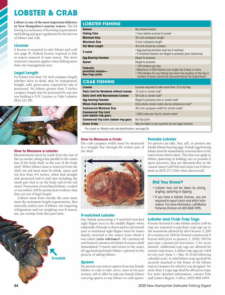
24 2020 New Hampshire Saltwater Fishing Digest
LOBSTER & CRABLobster is one of the most important fisheries in New Hampshire’s marine waters. The fol-lowing is a summary of licensing requirements and fishing and gear regulations for the harvest of lobster and crab.
LicenseA license is required to take lobster and crab (see page 4). Federal license required to fish in waters seaward of state waters. The more restrictive measure applies when fishing more than one management area.
Legal LengthNo lobster less than 3¼ inch carapace length, whether alive or dead, may be transported, bought, sold, given away, exposed for sale or possessed. No lobster greater than 5 inches carapace length may be possessed by any per-son holding a N.H. License to Take Lobsters (RSA 211:18).
How to Measure a LobsterMeasurements must be made from the rear of the eye socket, along a line parallel to the center line of the body shell, to the rear of the body shell. When lobster meat is removed from the shell, the tail meat must be whole, intact and not less than 4¼ inches, when laid straight and measured end to end (not including the small part that is on the body end of the tail meat). Possession of mutilated lobster, cooked or uncooked, will be prima facie evidence that they are not of legal length.
Lobster meat from outside the state must meet the minimum length requirements. Her-metically sealed cans of lobster, not requiring refrigeration and not weighing over 8 ounces net, are exempt from this provision.
LOBSTER FISHINGSeason No closed seasonFishing Time 1 hour before sunrise to sunsetMinimum Size 3¼ inch carapace lengthMaximum Size 5 inch carapace lengthTail Meat Length 4¼ inch (must be cooked)
V-notch • Egg bearing females must be V-notched• V-notched lobsters are illegal to possess (zero tolerance)
Egg Bearing Females Illegal to possessSpawn Illegal to possess
Federally permitted vessels— Non-Trap Limits
• 100 lobsters per day• Maximum of 500 lobsters per single trip 5 days or more• 100 lobsters for any fishing trip when the duration of the trip in
number of hours cannot be documented by the Department
CRAB FISHINGLicense License required to take more than 12 or by trapDaily Limit for Residents without License 12 rock or Jonah crab*Daily Limit with Recreational License 50 rock or Jonah crab*Egg-bearing Females Illegal to possess rock or Jonah crab*Whole Crab Restriction Only whole Jonah crabs can be retained or sold*Commercial Minimum Size 4¾ inch carapace width for Jonah crabs*Commercial Trip Limit (non-lobster trap gear) 1,000 crabs per trip for Jonah crabs*
Commercial Trip Limit (lobster trap gear) No Trip LimitGreen Crabs May be taken in any quantity by any legal method
*For Jonah vs. Atlantic rock crab identification, see page 26.
How to Measure a Crab:The crab carapace width must be measured in a straight line through the widest part of the shell.
V-notched LobsterAny female possessing a V-notched (notched right flipper next to the middle flipper when underside of female is down and its tail toward you) or mutilated right flipper must be imme-diately returned to the waters from which it was taken (zero tolerance). All commercial and limited commercial lobster licensees shall immediately V-notch and return to the water, all egg-bearing female lobster captured in the process of taking lobster.
SpawnNo person can remove spawn from any female lobster or crab or take, serve, have in his pos-session, sell or offer for sale any female lobster carrying spawn or any lobster or crab spawn.
V-notch
Female LobsterNo person can take, buy, sell, or possess any female lobster bearing eggs. Female egg-bearing lobster must be immediately returned alive to the waters from which taken. This does not apply to lobster spawning in holding cars or pounds if, upon discovery, they are liberated alive in the coastal waters (call Fish and Game Law Enforce-ment at (603) 271-3361 when discovered).
Lobster and Crab Trap TagsPersons licensed to take lobster and/or crab by trap are required to purchase trap tags up to the maximum allowed by their license (1,200 for commercial; 600 for limited commercial if license held prior to January 1, 2006; 100 for part-time commercial harvesters; 5 for recre-ational). Additional trap tags are allowed for routine trap losses. Lobster trap tags are valid for one year (June 1 – May 31 of the following calendar year). A valid lobster trap tag shall be securely attached to the frame of the lobster trap in a manner for which it was designed. No more than 2 traps tags shall be affixed to traps. For more detailed information, contact Fish and Game’s Region 3 office, (603) 868-1095.
Did You Know?• Lobster may not be taken by diving,
angling, spearing or dipping.
• If you have a lobster license, you are required to report catch and effort infor-mation. For more information, call Marine Fisheries Division at 603-868-1095.

25
LOBSTER & CRABLOBSTER AND CRAB GEAR REQUIREMENTSVolume No more than 22,950 cubic inchesEscape Vent Size (in parlor section)
At least 115⁄16 inches x 5¾ inches or two circular vents at least 27⁄16 inches in diameter; see other options below
Escape Panels (in parlor section)
• Hinged at the top of positively buoyant or bottom of negatively buoyant panels • Tied with an untreated natural fiber not to exceed 3⁄16 inches in diameter OR
nonstainless, uncoated, ferrous metal wire not exceeding 3⁄32 inches in diameter• Opening must be at least 3¾ inches by 3¾ inches when open or removed• See further details below
Runners or Sills Must have at least 2 running the length of the bottom of the trapWeak Links 600-pound breaking strength seaward of harbors (see Tide Table Pull-out Section–A)Groundlines Sinking if seaward of the harbors (see Tide Table Pull-out Section–A)
Vertical Lines• Must not have any portion floating on the surface• Must be marked with a red color at least three times (top, middle, bottom) along the
vertical line and each mark shall be 12 inches in length
Trap and Trap Tag Limits
• Depending on license type: recreational (5 traps), or commercial (100, 600, or 1200 traps)• Season runs June 1 – May 31• New tags must be affixed by June 1
GEAR MARKING REQUIREMENTS
All Fixed Gear • Permanently marked with the owner’s name• Flags and pennants affixed to buoys marking a string of gear must be of uniform color
Pot or Trap Trawls If 5 or more traps or pots, must be marked with buoys made of highly visible material set on both ends of the trawl
Lobster Buoy Last name and initials, permanently marked (carved or branded); 2 buoys per 5 or more trap trawls
Lobster Trap Last name and initials, permanently marked (carved or branded)Lobster Car Last name and initials; permanently marked (carved or branded)
Lobster and Crab GearLobster and crab may only be taken by traps in state waters, with the exception that up to 12 crab may be taken by angling, diving, or by hand without a license. All trap and pot gear must be hauled at least once every 30 days.
Escape Vents or GapsMust be in the parlor section of the trap and may be:1. A rectangular or oblong escape vent at least
115⁄16 inches by 5¾ inches, located next tothe bottom edge;
2. Two circular vents at least 27⁄16 inches indiameter;
3. A gap created by raising, modifying or sepa-rating the horizontal or vertical laths so that they create openings as described in 1) or2) above;
4. A gap caused by separating both ends of 2laths 1¾ inches on the top of the parlor sec-tion next to the middle bow or supportingframe and directly over the parlor head; or
5. Vents cut in the side or the end of a wire orplastic trap that comply with the dimensions in 1) and 2) above.
Biodegradable Escape Panels and RunnersEach trap must have escape panels and at least two runners or sills extending the entire length of the trap. Nothing may be placed in the parlor section of the trap that will obstruct the open-ing after disintegration of the fiber. The traps must be constructed in the following manner:
Rectangular Wire or Plastic Mesh Traps:1. Every trap must have at least 2 parallel run-
ners or sills attached to the bottom of the trap, running along the entire length of the exterior.
2. Every trap must have an unobstructedescape panel which must be:» Located in the parlor section on the sides
or end;» Hinged at the top of positively buoyant
panels or at the bottom of negativelybuoyant panels;
» Tied with an untreated natural fibersuch as cotton, sisal, hemp or jute notexceeding 3⁄16 inches in diameter beforeimmersion in sea water, or a piece of non-stainless, uncoated ferrous metal wire notexceeding 3⁄32 inches in diameter; and
» Of sufficient size to create an opening ofat least 3¾ inches x 3¾ inches when thepanel is removed or opened.
Non-Rectangular Wire or Plastic Mesh Traps: Must have at least two runners and an escape panel which will create an opening of 3¾ inches x 3¾ inches when open. These con-struction designs must be approved in writing by the Fish and Game Director.
Wood Lath Traps—Half Round, Round or Rectangular: Every trap must have at least two runners and an escape panel. An escape panel can be cre-ated by one untreated, softwood lath running the full length of the parlor section. The lath must have the same dimensions as the other laths on the trap. It must not be located where it will rest on the sea bottom. After disintegra-tion, it must leave a space of at least 3¾ inches x 3¾ inches between the adjacent laths. One can also be created by an opening of at least 3 inches between adjacent laths, running the length of the parlor section, which is laced with an untreated natural fiber such as cotton, sisal, hemp, or jute not exceeding 3⁄16 inches in diameter before immersion in sea-water.
Note: The Fish and Game Director may exempt specific trap designs from the escape vent and escape panel requirements if it can be conclusively proven that the specific trap design will only take crabs and is incapable of catching lobster. Approval will be granted in writing only after inspection.
Gear MarkingEach lobster or crab license holder has a color scheme or special markings indicated on their license. These must be used to mark all buoys. These colors must also be displayed on the boat, either by painting an area at least 1 square foot on the port and starboard side of the bow or by setting a painted buoy on the highest point of the boat (excluding the mast) visible for 360 degrees. The buoy or colors must be permanently attached at all times while the lobster or crab gear is being fished.
How to Order Trap Tags• Trap tags are not based on a calendar year. Trap tags are valid from June 1 – May 31.
• The new year tags must be affixed to traps by June 1.
• Trap tags can take up to 8 weeks to arrive after ordering.
• No more than 2 trap tags shall be affixed to traps.
• Recreational tags are ordered through N.H. Fish and Game Licensing Office — (603) 271-3422.
• All commercial and federal trap tags must be ordered through the Department’s selected vendor.
• Order forms are available on the N.H. Fish and Game website fishnh.com or from the Depart-ment’s Region 3 office after February 15.
• New order forms are sent out to previous licensees in February each year.
• Any questions relating to trap tag orders must go through the Region 3 office (603) 868-1095 – not the vendor.

26 2020 New Hampshire Saltwater Fishing Digest
NORTHERN SHRIMP, OTHER INVERTEBRATES & MARINE PLANTSFinfish and shellfish are not the only species that can be harvested from New Hampshire waters. The following are other species that can be harvested. Licenses may be required. See table below for details.
INVERTEBRATES/MARINE PLANTS
SPECIES LICENSE REQUIREMENT SEASON MINIMUM
LENGTHDAILY BAG
LIMIT GEAR REGULATIONS & SPECIAL RULES
Clamworms
Recreational: None No closed season None 1 quart/day
• Residents only• For personal use only• Only handheld tools with handles not to exceed 18 inches
Commercial: Commercial
Saltwater LicenseNo closed season None None • Only handheld tools with handles not to exceed 18 inches
Horseshoe Crab Harvest Permit No closed season None
10/day (either
taken or in possession)
• Refer to Coastal Harvest Section (page 19)• Reporting required
Sea Urchins
Personal use: None
By Hand or Pot: Oct. 1 – March 15
2 inches (longest
diameter)None • Sublegal sea urchins shall be culled immediately after capture and
returned immediately to the sea
Commercial: Commercial
Saltwater License
By Hand or Pot: Oct. 1 – March 15
Sled: Dec. 15 – March 15
2 inches (longest
diameter)None
• Sublegal sea urchins shall be culled immediately after capture and returned immediately to the sea
• Helpers working under the Commercial Saltwater License shall not takeby diving
• No possession of other marine species including lobsters, finfish or shellfish if taken by sled
• Gear: Call Marine Fisheries Division for specific gear regulations — (603) 868-1095
Seaweeds None No closed season None 3 bushels/day
• Residents or summer residents only• May be taken below the high water mark during daylight hours only• Do not detach or injure the holdfasts of the seaweed when cutting• Owner’s permission is required to take flats-weed or seaweed from
saltmarsh or flats• No seaweed may be piled below the high water mark to be hauled away• Sale is prohibited outside the state
Northern Shrimp Call Marine Fisheries Division for current rules — (603) 868-1095 or see Marine Fishing Rules Fis 607.01 at nh.gov
Striped Bass Volunteer Angler Survey — Join Us!Do you like to fish for striped bass in N.H.? Tell N.H. Fish and Game’s Marine Division about your striped bass fishing — and you could win a great prize!
For the Striped Bass Volunteer Angler Survey, anglers are asked to provide information such as amount of time fished and length of fish caught. Completed trip logs may be sent by mail, or an electronic logbook can be filled out online at fishnh.com/surveys/striped-bass.html. Marine fisheries biologists use the results to assess the status of striped bass populations each year.
How do I get started? Contact the Marine Division at [email protected] or (603) 868-1095 to get your logbookby mail or e-mail. Submit your logsby November 1, for a chance to win a framed print of “Shadow” by Vic-tor E. Young, donated by the Coastal Conservation Association of N.H.and a saltwater rod & reel donated by Kittery Trad-ing Post. Thanks foryour help!
Jonah vs. Atlantic Rock Crabs
Jonah crab (Cancer borealis)
• Front edge of carapace is jag-ged with undefined “teeth”(Jonah = jagged)
• Local name “Jonah crab”
• Less aggressive when handled
• Larger than rock crabs (cara-pace width up to 7 inches)
Atlantic rock crab (Cancer irroratus)
• Front edge of carapace hassmooth defined “teeth”
• Local names include “sand”crab or “peekytoe”
• More aggressive when handled
• Smaller than Jonah crabs(carapace width up to 5 inches)

fishnh.com 27
FISH CONSUMPTION GUIDELINESNORTHERN SHRIMP, OTHER INVERTEBRATES & MARINE PLANTSIs it Safe to Eat the Fish?Some ocean fish and shellfish contain varying levels of pollutants like mercury, PCBs and dioxins. Because of this, the N.H. Department of Environmental Services recommends the following guidelines:
Best Choices: Cod, flounder, haddock, herring, light tuna (canned), pollock, sole, salmon, tilapia, shellfish (oysters, shrimp, crab, clams, scallops, lobster) — Pregnant and nursing women, women who may become pregnant, and young children can safely eat TWO meals per week. For all others, no limit as part of a balanced diet.
Good Choices: Halibut, red snapper, tuna steak, white tuna (canned) — Pregnant and nursing women, women who may become pregnant, and young children can safely eat ONE meal per week. For all others, no limit as part of a balanced diet.
Cautions: Bluefish, Striped BassPregnant and nursing women, women who may become pregnant, and young children should avoid consumption. For all others, eat no more than ONE meal per month.
Marshmallows
Taste better
Whatever you like to do, there’s a NH campground for you!
Download or order your free copy of the New Hampshire Camping Guide
at www.nhlovescampers.com
King Mackerel, Swordfish, Shark, TilefishPregnant and nursing women, women who may become pregnant, and young children should avoid consumption. For all others, limit to TWO meals per month.
Lobster Tomalley (green substance in lobster) Everyone avoid consumption. All other parts of the lobster, no limits as part of a balanced diet.
Stick to the lowest weekly or monthly limits when combining freshwater fish, ocean fish and shellfish. Do not add limits. For more freshwater and saltwater guidelines, contact:
N.H. Department of Environmental Services, Environmental Health Program (603) 271-1370fishnh.com/fishing/consume-sw.html
Wildlife & Sport Fish Restoration: 75 Years of Restoring, Managing and Researching Fish and WildlifeOur thanks to hunters, shooters, anglers, boaters and our industry partners! With the purchase of firearms and ammunition, archery equipment, fishing equipment, and motorboat fuels, hunters, anglers and manufacturers pay excise taxes that are distributed to state fish and wildlife agencies for approved projects.
The U.S. Fish and Wildlife Service joins state fish and wildlife agen-cies, private industry and the public in a partnership to conserve fish and wildlife resources.
With help from over $150 million in federal aid funding over nearly three quarters of a century, N.H. Fish and Game has been able to:
• Gain knowledge through research
• Manage fish and wildlife populations
• Acquire Wildlife Management Areas
• Improve and protect aquatic habitat
• Restore fish and wildlife populations
• Conduct Hunter and Aquatic Education programs
• Construct, upgrade and maintain more than 140 public accesssites for boating and fishing.
Your purchase of hunting and fishing equipment and motorboat fuels supports wildlife and sport fish restoration and boating access facilities.

28 2020 New Hampshire Saltwater Fishing Digest
BOATING IN N.H.Ph
oto
© D
an H
ayw
ard
Ten Tips for Safe Boating1. Don’t Overload Carry only the specified
limit for your craft and don’t sit on the gun-wales or the transom.
2. Wear Life Jackets or Vests State law req-uires one wearable life preserver for eachperson in a boat. Kids 12 and under mustwear a life preserver.
3. Know the Water Always carry a chart (map)of the waters you are boating on.
4. In an Accident Your first obligation is tosave lives and help the injured. Call N.H.Marine Patrol: (603) 293-2037.
5. Water and Alcohol Don’t Mix Sixty per-cent of recent boating fatalities in N.H. are alcohol-related. Don’t drink and boat—the.08 law applies to boaters, too!
6. Use Your Lights All boats operating aftersunset must display lights to be visible toother boaters.
Wildlife Heritage Foundation of New HampshireThe official non-profit partner of the N.H. Fish and Game Department, the Wildlife Heritage Foundation raises money and works with wildlife profes-sionals and conservation education partners to fund Fish and Game’s conservation of wildlife and natural places. The foundation has supported a wide range of projects, including tracking and mapping of ovigerous female lobsters and monitoring river herring passage over the breached
Wadleigh Falls Dam on the Lamprey River. Funding for the foundation’s grants program comes from individual and corporate donors and from the annual auction of fish and game permits and licenses. The foundation accepts general and targeted cash donations, as well as planned gifts and tangible assets; in most cases, contributions are tax-deductible.
To learn more about the foundation or make an online donation, visit nhwildlifeheritage.org or contact (603) 496-2778 or [email protected]. Thanks for your support!
7. Use Caution When passing within 150feet of another boat, swimmers, rafts, shore, docks, or mooring fields, you must be atheadway speed.
8. Don’t Use the Water as a Dump It is ille-gal to litter or discharge sewage into thewater.
9. Don’t Harass Wildlife All wildlife are pro-tected on the state’s waters, subject to stricthunting and fishing regulations.
10. Take a Boating Safety Course For infocall Boating Education at (603) 267-7256.
General Boating InformationN.H. Department of Safety, Marine Patrol Headquarters (603) 293-2037
Motor Restrictions Division of Safety Services (603) 293-2037 orNH.gov/safety/divisions/nhsp/fob/marine-patrol/restricted.html
See “Restricted Bodies of Water”
Boating Safety Courses• Classes offered year-round by N.H.
Marine Patrol
• Many locations throughout the state.
• Open to any boater over 14 years of age.
• Online study materials: boat-ed.com/nh
• NASBLA approved.
• Satisfies requirements of mandatoryboating education law.
• For class schedule, call N.H. MarinePatrol at 1-888-254-2125.
• Be smart — boat safe!
Diver There, Please BewareN.H. State law requires boaters to stay at least 150 feet away from a red flag with a white stripe or other flags in the water. They signal that scuba divers are in the area.
Share your love of fishing— Become a Volunteer “Let’s Go Fishing” Instructor!For more information on the “Let’s Go Fishing” program, call (603) 271-3212.
Aquatic Resources Education N.H. Fish and Game Department
It’s the Law: Clean & DrainTo avoid the spread of aquatic invasives, N.H. State law requires boaters to drain their boat and other equipment that holds water, including live wells and bilges, when leaving a waterbody (including saltwater).
Every time you purchase a fi shing license or register your boat, a portion of the proceeds go toward preserving our nation’s coastlines, lakes, rivers and streams. Protecting our memories on the water for generations to come.
THE SIMPLE ACT OF FISHING, PRESERVES FISHING.
Learn more at TakeMeFishing.org/ConservationLearn more at TakeMeFishing.org/Conservation
46831_TMF_PSA_Pg_Ad.indd 1 2/4/11 9:53 AM

Some discounts, coverages, payment plans and features are not available in all states, in all GEICO companies, or in all situations. Boat and PWC coverages are underwritten by GEICO Marine Insurance Company. In the state of CA, program provided through Boat Association Insurance Services, license #0H87086. GEICO is a registered service mark of Government Employees Insurance Company, Washington, DC 20076; a Berkshire Hathaway Inc. subsidiary. © 2019 GEICO
geico.com | 1-800-865-4846 | Local Office
Feel-Good Savings.
Unforgettable Adventures.
Heed the call of adventure with great insurance coverage.Boat insurance serviced by the boating experts. Get a fast, free quote today.


