FIRST BIDDING ROUND FOR HYDROCARBONIFEROUS AREAS · FIRST BIDDING ROUND FOR HYDROCARBONIFEROUS...
15
FIRST BIDDING ROUND FOR HYDROCARBONIFEROUS AREAS MINISTRY OF PRODUCTION AND EMPLOYMENT SECRETARIAT OF MINING AND ENERGETIC RESOURCES SUB – SECRETARIAT OF ENERGY 1
Transcript of FIRST BIDDING ROUND FOR HYDROCARBONIFEROUS AREAS · FIRST BIDDING ROUND FOR HYDROCARBONIFEROUS...

FIRST BIDDING ROUND FOR
HYDROCARBONIFEROUS AREAS
MINISTRY OF PRODUCTION
AND EMPLOYMENT
SECRETARIAT OF MINING AND ENERGETIC RESOURCES
SUB – SECRETARIAT OF ENERGY
1

2 2
HISTORICAL REVIEW The oldest historical record about oil in our Province dates 1781, when the Franciscan priest Barba, while being in one of his trips around Salta discovered a spring of “oil” in the area of Aguarague. By the ends of 1868, engineer Francisco Host, in the name of the Government of Salta handed President Domingo F. Sarmiento, samples of raw and refined oil in two bottles that the latter sent to the organizers of an exposition in Córdoba. In 1882, Luis Brackebusch did some research in the provinces of Salta and Jujuy for four months, resulting in a positive report about the oil prospects in the area. By midst of 1882, the Algelt and Méndez society got some grants from the government of Salta to work in the deposits for a period of 17 years, it drilled a hole 92 metres deep and found no oil. During an expedition to Chaco, commanded by General Benjamín Victorica in 1884-85, the scientific commission accompanying them found several oil deposits in salteñan territory. Engineer Máximo Stutterhein reported the presence of hydrocarbons in the area known as Teuco and engineer Leopoldo Arnaud found other deposits in Las Lomitas, near Tartagal. After five years without activities, one of the pioneers in the oil industry of Argentina, don Francisco Tobar, found springs in 1906, in the Galarza creak, near the so called Campamento Vespucio. He immediately started exploitation under extreme conditions for he had to drag a drilling machine with buoys and mules along 200 km of dense forest. Once the works started, the oil spring reached 30 metres high. Tobar baptized the deposit under the name of “Mina República Argentina”. In 1908 he started what could be called the first organized exploitation of Mina República Argentina. Aided with two Keystone wire machines, with capacity for
250 and 500 metres each, five holes were drilled from which only three threw positive results in depths ranking 70 to 200 metres. Tobar ordered the construction of barrels of 50 lts in Buenos Aires, to carry the product on mules to Embarcación and, from there, along the Bermejo river up to Buenos Aires where one of those barrels was exhibited at the Centennial Exposition. At that time, geologist Guido Bonarelli discovered oil on the Bermejo right river bank; in Vado Hondo, on the Zenta left river bank and in the Colorado River. He also discovered some springs 20 km north Madrejones, in sierra Alto, and others in Aguarague sierra, in Galarza and Zanja Honda creaks. In 1924, YPF (Yacimientos Petrolíferos Fiscales) bought the rights for exploitation of Mina República Argentina. The new drillings ended in September 11th, 1928, in hole Vespucio #1, which registered a surging production of 30 m3 per hour. By that time, Standard Oil Co. discovered the deposits San Pedro, Ramos, Lomitas and Cerro Tartagal, located on the North of the Province. Some years later, YPF discovered the Tranquitas and Río Pescado deposits, all of which registered important hydrocarbon volumes of production. Some of them are still producing. There were no more important discoveries until 1951, when the first deposit of condensed oil and gas of the country, known as “Campo Durán”, is found. Its relevance lead way to the construction of the Campo Durán refinery and the first gaspipe of importance in our country, the so called “Campo Durán – Buenos Aires”. Later, north of Campo Durán, the Madrejones deposit is found, also of condensed oil and gas, productive at 3800 and 4300 metres, being the deepest of their kind in the country. The relation oil – gas of these deposits varied from 2500 m3/m3 in Campo Durán to 4500 m3/m3 in Madrejones, their oil having a API approximate density of 60°, which means that they are very light. By the ends of the 70s, YPF drilled in the area of Olmedo sierra, in the so called cretaceous basin, discovering the first deposit of commercial oil in our province in the Yacoraite formation, making possible a new level of

3 3
exploration. The aforementioned deposit is the so called Martínez del Tineo. On the grounds of the new oil area, there are later discoveries in Puesto Guardián, Bañada Grande, Vinalar Norte, Pozo Escondido, Puesto Climaco, Dos Puntitas, Divisadero Sur, Las Avispas, La Reina. The characteristic of those deposits is the production of raw oil with a high paraffin content, low associated gas and its density varies from 37° to 45° API. Since 1994 a new important and aggressive exploratory period is started, especially concerning the drilling of deep holes and the pursue of increasing the gas resources of the province. In fact, it was last semester that this kind of exploration started, after an exhaustive reprocessing and reinterpreting of seismic registers, aided by the most modern computerized technology internationally available. This exploratory era brought about the discovery in the new devonic basin, of the gasiferous deposits Porcelana, Chango Norte, San Pedrito and Tuyunti. In the cretaceous basin the Valle Morado deposit was discovered, constituting the most important deposit found in the aforementioned basin. In the carboniferous the Ñacatimbay deposit is discovered, whose most important characteristic is that of being the first in producing gas from the formations Las Peñas and San Telmo. This discovery was later confirmed with the works developed in the old holds of Campo Durán deposit, leading to the discovery of important gas resources. HYDROCARBONS The graph illustrates the annual production of oil and natural gas from 1928 to 2005, and at the same time, the production accumulated until last December, which reaches a volume of 31,900,000 m3 for liquid and 138,122,000,000 m3 for gas. In the story of hydrocarbons of our province, three major cycles with an increase in production can be distinguished. The first of them took place in the 40´s and coincides with the discovery and development of San Pedro and Tranquitas deposits by Standard Oil Co. and YPF. The second positive outburst was registered at the beginnings of the 60´s, a period when there was an expansive national policy and the aim was to become hydrocarbon self-sufficient. For that reason an intense exploratory campaign was started, resulting in the discovery of Campo Durán and Madrejones. The final leap took
place during the 70´s with the discovery of two big deposits as are Ramos and Aguarague.
OIL AND GAS PRODUCTIONPROVINCE OF SALTA 1928 - 2005
0
100.000
200.000
300.000
400.000
500.000
600.000
700.000
800.000
900.000
1928
1933
1938
1943
1948
1953
1958
1963
1968
1973
1978
1983
1988
1993
1998
2003
YEAR
m3
Gas*1000m3OiL*10m3
There is a fall in production during 1993 as a consequence of the impasse provoked by transferring the deposits to private hands. This drop reverts in 1994, especially in regards to gas production, showing a growing tendency and reaching a record mark of injection of 8,146 million of cubic metres. The deposits in production by April, 2006 are: Devonic Basin Ramos, Cuchara, Aguarague, Arroyo Lomitas, Tranquitas, Cango Norte, Porcelana y San Pedrito. Carbonic Basin Campo Durán, Madrejones, Lomitas Bloque Bajo, Acambuco, South and North Macueta and Ñacatimbay.
4 4
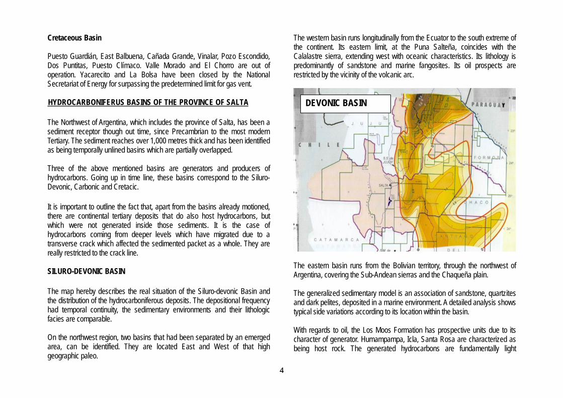
Cretaceous Basin Puesto Guardián, East Balbuena, Cañada Grande, Vinalar, Pozo Escondido, Dos Puntitas, Puesto Clímaco. Valle Morado and El Chorro are out of operation. Yacarecito and La Bolsa have been closed by the National Secretariat of Energy for surpassing the predetermined limit for gas vent. HYDROCARBONIFERUS BASINS OF THE PROVINCE OF SALTA The Northwest of Argentina, which includes the province of Salta, has been a sediment receptor though out time, since Precambrian to the most modern Tertiary. The sediment reaches over 1,000 metres thick and has been identified as being temporally unlined basins which are partially overlapped. Three of the above mentioned basins are generators and producers of hydrocarbons. Going up in time line, these basins correspond to the Siluro-Devonic, Carbonic and Cretacic. It is important to outline the fact that, apart from the basins already motioned, there are continental tertiary deposits that do also host hydrocarbons, but which were not generated inside those sediments. It is the case of hydrocarbons coming from deeper levels which have migrated due to a transverse crack which affected the sedimented packet as a whole. They are really restricted to the crack line. SILURO-DEVONIC BASIN The map hereby describes the real situation of the Siluro-devonic Basin and the distribution of the hydrocarboniferous deposits. The depositional frequency had temporal continuity, the sedimentary environments and their lithologic facies are comparable. On the northwest region, two basins that had been separated by an emerged area, can be identified. They are located East and West of that high geographic paleo.
The western basin runs longitudinally from the Ecuator to the south extreme of the continent. Its eastern limit, at the Puna Salteña, coincides with the Calalastre sierra, extending west with oceanic characteristics. Its lithology is predominantly of sandstone and marine fangosites. Its oil prospects are restricted by the vicinity of the volcanic arc.
DEVONIC BASIN
The eastern basin runs from the Bolivian territory, through the northwest of Argentina, covering the Sub-Andean sierras and the Chaqueña plain. The generalized sedimentary model is an association of sandstone, quartzites and dark pelites, deposited in a marine environment. A detailed analysis shows typical side variations according to its location within the basin. With regards to oil, the Los Moos Formation has prospective units due to its character of generator. Humampampa, Icla, Santa Rosa are characterized as being host rock. The generated hydrocarbons are fundamentally light

5 5
(condensed, 60° API or more), due to depth, pressure and temperature conditions of the mother rocks where they were generated. The deposits discovered within this basin are Ramos, Aguarague, Tranquitas, Arroyo Lomitas, San Pedrito, Chango Norte, Porcelana, Ramos Norte, Limón, Río Pescado, San Andrés and Río Colorado. CARBONIC BASIN Again, there are two basins separated by a high geographic paleo and both coincide with it. This can be seen in the map hereby.
The western basin, whose limits coincide with those of the Siluro-devonc basin, have sedimentary sequences formed by sandstones and limestones with vegetal rests of continental facies which lay discordantly upon Devonic. In regards to oil, it lacks of exploratory interest.
The East basin, a southern continuation of the Tarija Basin in Bolivia, has a restricted distribution towards the North of the province, which is no longer than 4,000 km2, covering both the northern Sub-Andean sierras and, partially, the Chaqueña plain. The sedimentary frequency shows a psamitc predominance, with marine characteristics. Towards the centre of the basin, there is participation of dark grey pelites. Towards the higher portions, the continentalization of the deposits is verified, with fluvial facies of reddish sandstones and fangolites. This is the basin which supplied the first volumes of raw in the 20´s, with the previously mentioned discoveries of Tobar in Mina República Argentina; of Lomitas, carried on by Standard Oil; and Tranquitas, operated by YPF. The exploration and exploitation stages to which Lomitas, Vespucio, San Pedro, Aguas Blancas, Tranquitas, Cerro Tartagal and Ramos deposits belong, are characterized by short targets, reached between 320 and 1,200 metres depth.
CARBONIC BASIN
A second exploratory stage, with deeper targets, lead to the discovery of the deposits of Campo Durán, Marejones, Ypaguazu, Jollín, Tonono, Acambuco and Macueta in the years 1951 and 1962. The formations Las Peñas, Tarija and Tupambi are identified as host rocks, while the formations Itacuami and some and some pelitic levels of Tupambi are considered to be potentially mother rocks, though definite geological research has not been done yet. It is important to underline tat at the Tonono deposit, a property belonging to the Government of the Province of Salta, interesting sandy levels were identified after detailed research was done on hole T-2, and the formations San Telmo and Las Peñas supplied raw and gas. These formations were considered as sterile, thus, the results open way to important exploratory perspectives. The exploratory holes Ñacatimbay x-1001 and South Campo Durán as web as the redrilling of Campo Durán, holes # 38, 15 and 45, confirmed the presence of abundant resources of gas and oil in the formation Las Peñas and San

6 6
Telmo, at about 1200 metres above present producer (Tupambi from the Carbonic, at about 4,000 m) CRETACIC BASIN This oil basin is the most modern of the Northwest of Argentina. It covers the provinces of Salta, Jujuy, Formosa and Tucumán, trespassing the limits of prospection over the neighbouring countries of Bolivia, Chile and Paraguay. The detailed research done on the surface and subsoil, made possible the division of the area into several sub basins, separated by dorsals and thresholds, with oil behaviour of Las Lomas, Olmedo and Metan basins.
Estatigraphically, it belongs to the Salta Group which is distinguished by three sedimentologic events. The first and oldest belongs to the continental deposit
of red layers in fluvial environments, characteristic of the Pirgua sub group. The intermediate, is represented by the Balbuena subgroup typified by a sedimentary duplex, fluvial first (Lecho formation) and lagoonar to slightly marine, later (Yacoraite formation). The last stage, superior, starts with a hypersalty lagoonar transition represented by evaporitic deposits of gypsum and halite (Olmedo formation), it continues with a fluvial activity with red layers (Mealla formation), then it is slightly lagoonar with green pelites (Maiz Gordo formation), ending with red fluvial deposits which were the reason for the final desiccation of the basin (Lumbrera formation. The main producer is the Yacoraite formation in reservoir of sandstones, oolitic limestone’s, limestone’s tectonically fractured. Limestone’s with secondary porosity from Olmedo and Maiz Gordo formations also supplied hydrocarbons. During 2000, the existence of important volumes of gas and condensed within the Mealla formation was verified. They were inside some sandstones inserted all along the formation. A particular example of host rocks is the case of andesites inserted in the Yacoraite formation, in the area of Palmar Largo (Formosa). The layer rocks vary in accordance with the different deposits. In some cases they are constituted by pelites of the Yacoraite, Olmedo or Maiz Gordo formations.
CRETACIC BASIN
It seems that the generative rocks make the organogenous levels of the Yacoraite formation. The productive deposits, within Lomas and Olmedo sub-basins are El Chorro, East Balbuena, Puesto Clímaco, Cañada Grande, Pozo Escondido, Las Avispas, South Divisadero, Martínez del Tineo, Dos Puntitas and Valle Morado. Within the sub-basin of Metán, Cuchuma and Lumbreras deposits supply paraphinic intermediate oil from shallow levels. TERTIARY DEPOSITS The presence of continental tertiary levels of hydrocarbons has already been mentioned.
7 7
Geological researches of this type of oil proved to be similar to that trapped inside the deepest levels, belonging to the Carbonic basin. The discovered deposits are Rio Pescado and Tranquitas, both located on the line of fracture with a direction SSW-NNE, which coincides with the south rim of the Carbonic basin. Oil was accumulated, in underlaying sandstones, in some areas of the Tranquitas formation and it is thought to come from the deposits of Tupambi and Tarija formations, after a secondary migration through the said regional fracture.
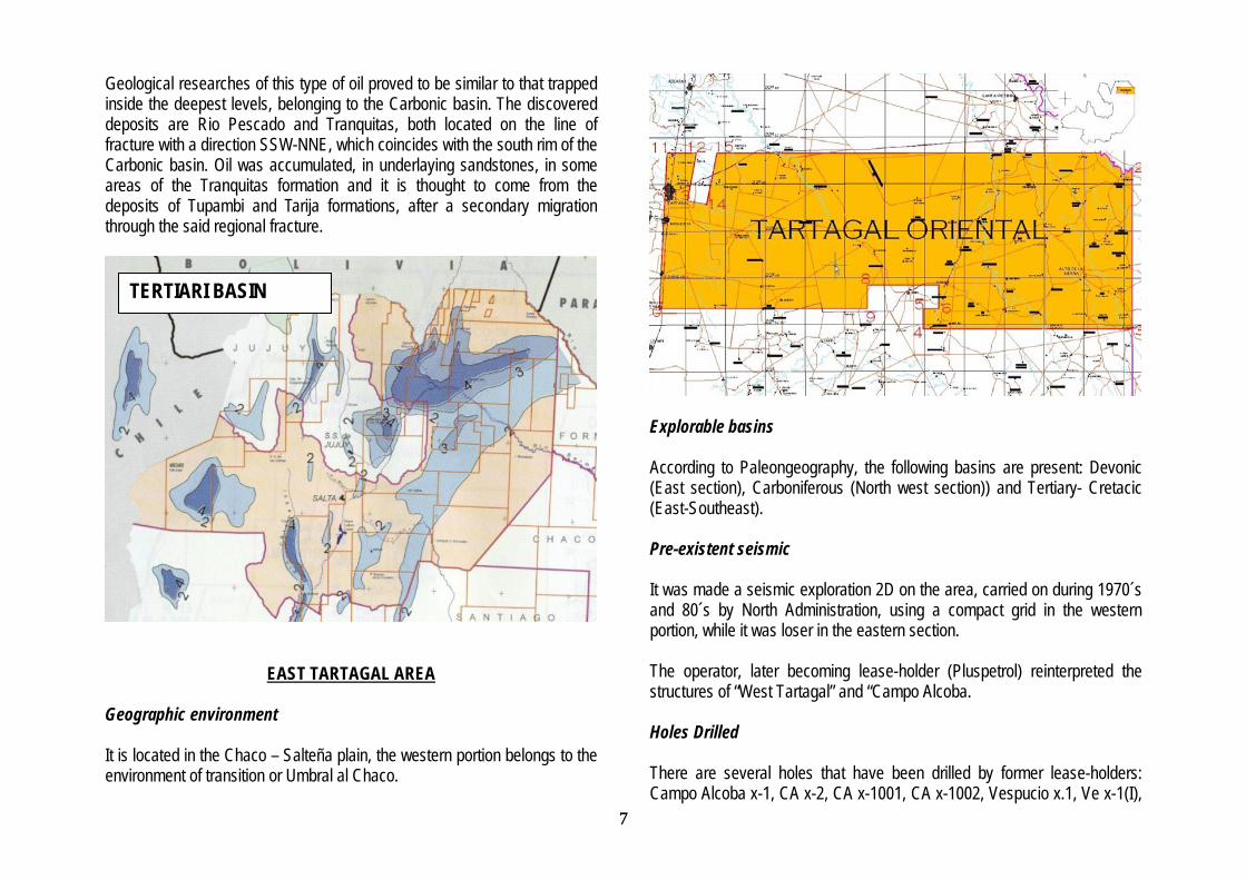
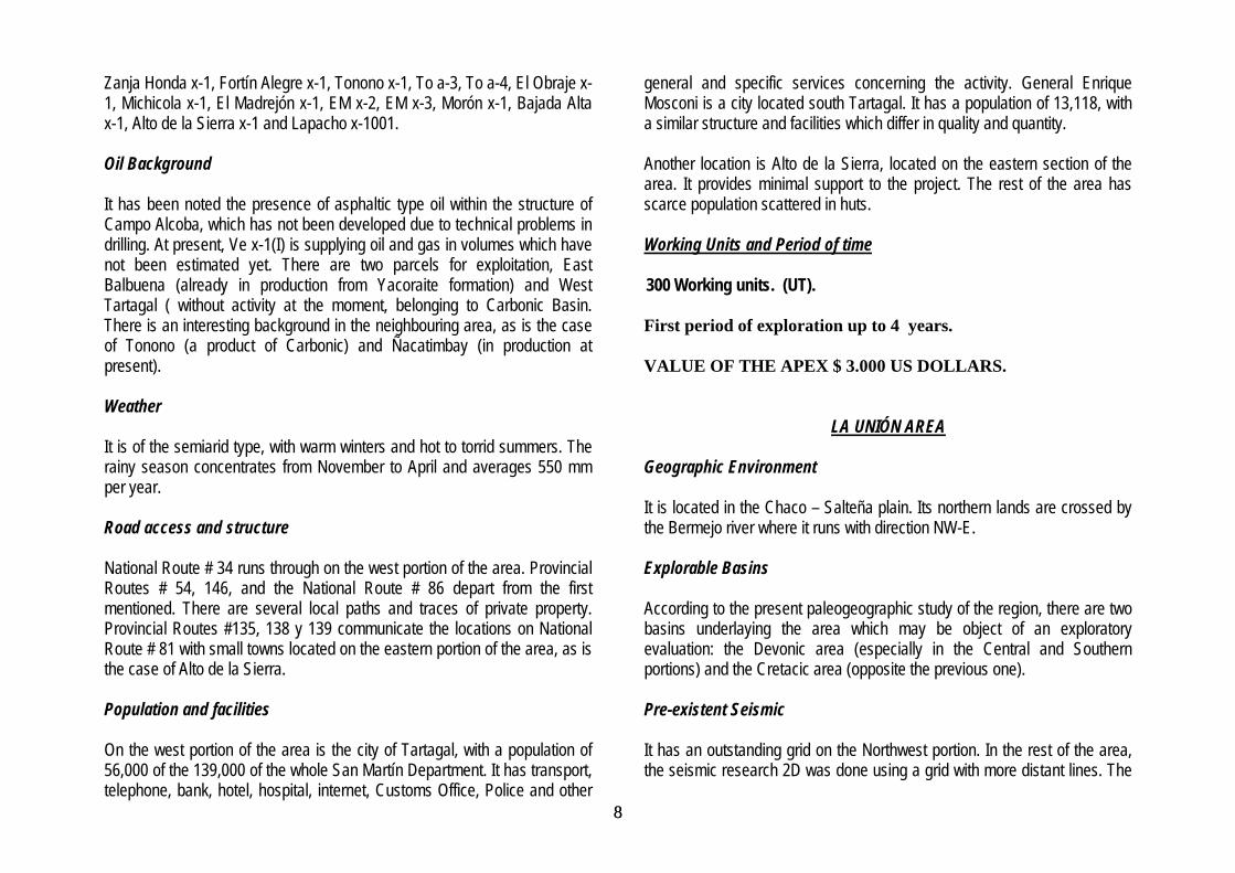
EAST TARTAGAL AREA Geographic environment It is located in the Chaco – Salteña plain, the western portion belongs to the environment of transition or Umbral al Chaco.
TERTIARI BASIN
Explorable basins
According to Paleongeography, the following basins are present: Devonic (East section), Carboniferous (North west section)) and Tertiary- Cretacic (East-Southeast).
Pre-existent seismic It was made a seismic exploration 2D on the area, carried on during 1970´s and 80´s by North Administration, using a compact grid in the western portion, while it was loser in the eastern section. The operator, later becoming lease-holder (Pluspetrol) reinterpreted the structures of “West Tartagal” and “Campo Alcoba. Holes Drilled There are several holes that have been drilled by former lease-holders: Campo Alcoba x-1, CA x-2, CA x-1001, CA x-1002, Vespucio x.1, Ve x-1(I),
8 8
Zanja Honda x-1, Fortín Alegre x-1, Tonono x-1, To a-3, To a-4, El Obraje x-1, Michicola x-1, El Madrejón x-1, EM x-2, EM x-3, Morón x-1, Bajada Alta x-1, Alto de la Sierra x-1 and Lapacho x-1001. Oil Background It has been noted the presence of asphaltic type oil within the structure of Campo Alcoba, which has not been developed due to technical problems in drilling. At present, Ve x-1(I) is supplying oil and gas in volumes which have not been estimated yet. There are two parcels for exploitation, East Balbuena (already in production from Yacoraite formation) and West Tartagal ( without activity at the moment, belonging to Carbonic Basin. There is an interesting background in the neighbouring area, as is the case of Tonono (a product of Carbonic) and Ñacatimbay (in production at present). Weather It is of the semiarid type, with warm winters and hot to torrid summers. The rainy season concentrates from November to April and averages 550 mm per year. Road access and structure National Route # 34 runs through on the west portion of the area. Provincial Routes # 54, 146, and the National Route # 86 depart from the first mentioned. There are several local paths and traces of private property. Provincial Routes #135, 138 y 139 communicate the locations on National Route # 81 with small towns located on the eastern portion of the area, as is the case of Alto de la Sierra. Population and facilities On the west portion of the area is the city of Tartagal, with a population of 56,000 of the 139,000 of the whole San Martín Department. It has transport, telephone, bank, hotel, hospital, internet, Customs Office, Police and other
general and specific services concerning the activity. General Enrique Mosconi is a city located south Tartagal. It has a population of 13,118, with a similar structure and facilities which differ in quality and quantity. Another location is Alto de la Sierra, located on the eastern section of the area. It provides minimal support to the project. The rest of the area has scarce population scattered in huts. Working Units and Period of time 300 Working units. (UT). First period of exploration up to 4 years. VALUE OF THE APEX $ 3.000 US DOLLARS.
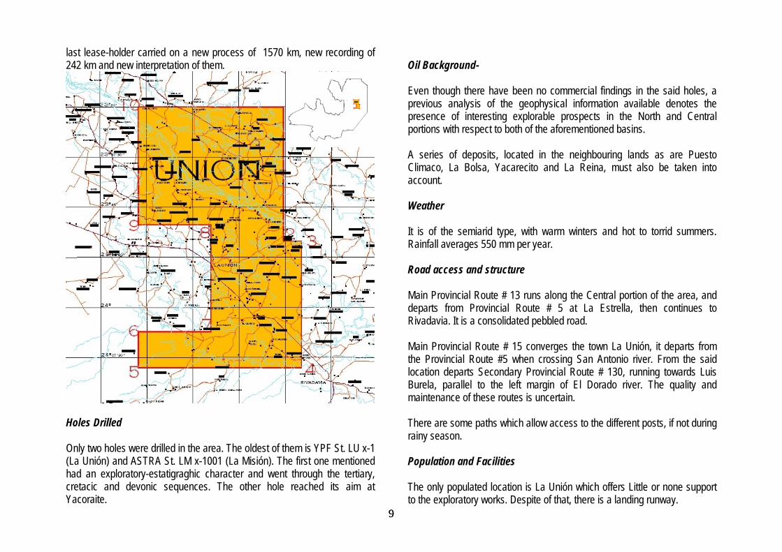
LA UNIÓN AREA Geographic Environment It is located in the Chaco – Salteña plain. Its northern lands are crossed by the Bermejo river where it runs with direction NW-E. Explorable Basins According to the present paleogeographic study of the region, there are two basins underlaying the area which may be object of an exploratory evaluation: the Devonic area (especially in the Central and Southern portions) and the Cretacic area (opposite the previous one). Pre-existent Seismic It has an outstanding grid on the Northwest portion. In the rest of the area, the seismic research 2D was done using a grid with more distant lines. The
9 9
last lease-holder carried on a new process of 1570 km, new recording of 242 km and new interpretation of them.
Holes Drilled Only two holes were drilled in the area. The oldest of them is YPF St. LU x-1 (La Unión) and ASTRA St. LM x-1001 (La Misión). The first one mentioned had an exploratory-estatigraghic character and went through the tertiary, cretacic and devonic sequences. The other hole reached its aim at Yacoraite.
Oil Background- Even though there have been no commercial findings in the said holes, a previous analysis of the geophysical information available denotes the presence of interesting explorable prospects in the North and Central portions with respect to both of the aforementioned basins. A series of deposits, located in the neighbouring lands as are Puesto Climaco, La Bolsa, Yacarecito and La Reina, must also be taken into account. Weather It is of the semiarid type, with warm winters and hot to torrid summers. Rainfall averages 550 mm per year. Road access and structure Main Provincial Route # 13 runs along the Central portion of the area, and departs from Provincial Route # 5 at La Estrella, then continues to Rivadavia. It is a consolidated pebbled road. Main Provincial Route # 15 converges the town La Unión, it departs from the Provincial Route #5 when crossing San Antonio river. From the said location departs Secondary Provincial Route # 130, running towards Luis Burela, parallel to the left margin of El Dorado river. The quality and maintenance of these routes is uncertain. There are some paths which allow access to the different posts, if not during rainy season. Population and Facilities The only populated location is La Unión which offers Little or none support to the exploratory works. Despite of that, there is a landing runway.
10 10
The closest location is Pichanal, 160 km distant, and from Pichanal to Orán (22 km) or to Tartagal (100km), both of the last mentioned offer varied facilities. Working units and period of time 150 Working units. (UT). Period of exploration up to 4 years. VALUE OF THE APEX $ 1500 US dollars.
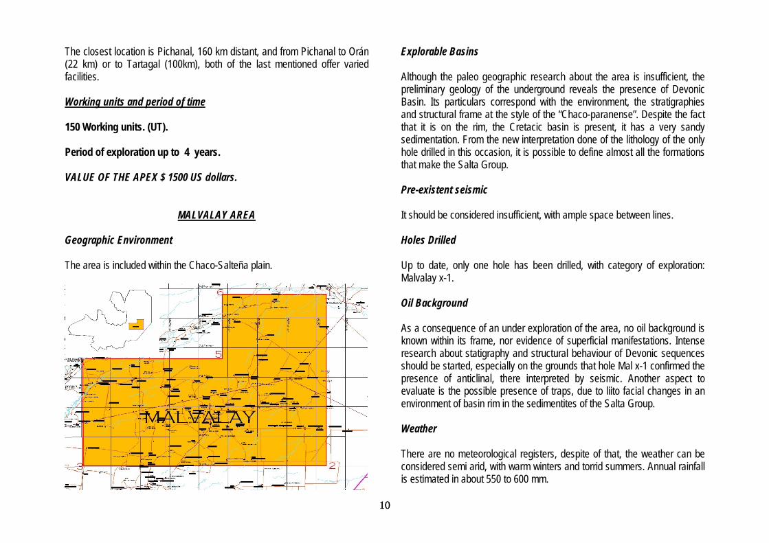
MALVALAY AREA Geographic Environment The area is included within the Chaco-Salteña plain.
Explorable Basins Although the paleo geographic research about the area is insufficient, the preliminary geology of the underground reveals the presence of Devonic Basin. Its particulars correspond with the environment, the stratigraphies and structural frame at the style of the “Chaco-paranense”. Despite the fact that it is on the rim, the Cretacic basin is present, it has a very sandy sedimentation. From the new interpretation done of the lithology of the only hole drilled in this occasion, it is possible to define almost all the formations that make the Salta Group. Pre-existent seismic It should be considered insufficient, with ample space between lines. Holes Drilled Up to date, only one hole has been drilled, with category of exploration: Malvalay x-1. Oil Background As a consequence of an under exploration of the area, no oil background is known within its frame, nor evidence of superficial manifestations. Intense research about statigraphy and structural behaviour of Devonic sequences should be started, especially on the grounds that hole Mal x-1 confirmed the presence of anticlinal, there interpreted by seismic. Another aspect to evaluate is the possible presence of traps, due to liito facial changes in an environment of basin rim in the sedimentites of the Salta Group. Weather There are no meteorological registers, despite of that, the weather can be considered semi arid, with warm winters and torrid summers. Annual rainfall is estimated in about 550 to 600 mm.

11 11
Road access and structure The only reads are Primary Provincial Route # 52 (Las Lajitas – Rivadavia), and # 41 (J. V. Gonzalez - Santo Domingo - Simbol Pozo). There are some private paths, but their condition and maintenance is uncertain. Population and Facilities There is no population in the area, except for some posts and huts. Outside the area are the towns of Apolinario Saravia, Rivadavia and Las Lajitas. Working Units and Period of Time 300 Working units. (UT). Period of exploration up to 4 years. VALUE OF THE APEX $ 1500 US dollars.
MORILLO Geographic Environment It is located within the Chaco-Salteña plain.
Explorable basins The Devonic Basin is found in the underground of the South of the Area whose deepest bottom is at about 2,500 and 3,000 m. The sub-basin Lomas de Olmedo (Cretacic-Tertiary) underlays most of the block, except for its South-East corner. Pre-existent Seismic
The area has seismic exploration 2D, with an interesting grid in the South portion . In the rest of the area, the space between lines is too wide to carry on a structural – estatifraphic interpretation, thus, information provided is considered insufficient to understand the underground geology.
12 12
Holes Drilled Only one hole has been drilled within the block in 1968. It is located in the South –East border and behaves as inductive. According to the original descriptions made on the Balbuena sub-group, it should not be included as part of it. Oil Background There is no oil background in the area due to insufficient seismic exploration, particularly in the Central and North areas where the Cretacic basin depocentre is located. It must be taken into consideration the analysis of the results of the Chirete holes, as well as the lining with an orientation East - North-East of the productive parcels El Chorro – Chivil – Cañada Rica – Palmar Largo. The under exploration of the area is evidenced in the existence of only one hole, Tordillo x-1. This was located in accordance to the hypothesis about the presence of a bay in the Cretacic sea. Although it did not show the presence of Yacoraite, a new interpretation of its lithologic profile(2005), reveals that it had been deposited during the interval 2587-2658 mbbp, underlaying the Lecho formation (2658 – 2691). Weather It is of the semi-arid type, with warm winters and hot to torrid summers. Rainfall reach about 550 mm a year, according to the registers of Coronel Juan Sola (Morillos) Road access and structure The area is crossed on its centre by National Route # 81, from which Secondary Provincial Route # 138 departs when reaching Cnel. Juan Solá. Primary Provincial Route # 53 crosses the South of the area, connecting Embarcación to Fortín Belgrano, on the Formosa Border. The conditions
and maintenance of the said Provincial routes is uncertain. Route # 81 is being paved at present time. Population and Facilities There is only one town which can offer little support to the project, it is Coronel Juan Solá where Estación Morillo is placed. Railroad is out of service at the moment. It has got a landing runway and basic health aid. The city of Tartagal has all the facilities and support, it is 160 km far. Working Units and Period of Time 300 Working units. (UT). Period of exploration up to 4 years. VALUE OF THE APEX S 1.500 US dollars.
CHIRETE Geographic Environment It is placed in the same natural environment as the Chaco-Salteña plain, with the same morphological – structural general characteristics. Explorable Basin In accordance to the regional paleo geographic research, there are sedimentites of Devonic Basin in its underground (South-West portion). The Cretacic Basin is displayed in the Centre and North of the area. Pre-existent Seismic It has an important geophysic research carried on by YPF, especially in the central portions of the Area. In the North border and South – East corner,

13 13
there is seismic, but with wide space between bars. The last lease-holder, PLUSPETROL-BHP PETROLEUM, carried on a new processing, a new interpretation and even a new recording in the lands surrounding the said Chirete holes.
Holes Drilled Five holes were drilled in the area, four of which were drilled in the Chirete structure, belonging to YPF-St. Chi x-1, YPF-St. Chi x-1(I), St.-Pp. Chi x-1001 and St.-Pp. Chi x-1002. The fifth is located in the South of the block and it refers to Los Blancos x-1 which had an exploratory- estatigraphic character (drilled in 1950). Oil Background It is an area with important background concerning oil possibilities. Holes Chi x-1001 and Chi x-1002 supplied oil and gas from the formations Olmedo and Yacoraite. Due to technical and operative reasons, the volumes were not measured and the holes were finally abandoned. Hole Chi x-1(I) stopped drilling in the Mealla formation due to technical problems and weather conditions, and it has never been restarted. Seismic exploitation revealed the presence of about four anticlinal structures East Chirete, which could have excellent possibilities of trapping, anticlinal of the Avellaneda type (placed 15 km East Chi x-1), Tacuruzal, Macho Colgado and Las Cañitas. Weather It is semi arid, with warm winters and hot to torrid summers. Average rainfall concentrates from November to March, reaching 550 mm a year. Road access and structure
The National Route # 81 crosses the southern extreme of the area. Secondary Provincial Routes # 138 (connecting Morillo to alto de la Sierra) and # 139 (connecting Los Blancos to El Chorro), both run South-West to North-East. Between Los Blancos and Fortín Belgrano is Secondary Provincial Route # 156, but its state is uncertain.
14 14
Population and Facilities There are two towns on Route # 81, they both have poor facilities. They are Los Blancos and Capitán Pagés. Outside the area, the locations of Coronel Juan Solá (Morillo) and El Chorro (Province of Formosa) can offer slightly better support than the towns previously mentioned. The remaining area is scarcely populated, except for some posts and huts . The city of Tartagal, populated place that offers good facilities, is 190 km far. Working Units and Period of Time. 300 Working Units. (UT). Period of exploration up to 4 years. VALUE OF THE APEX U$S 5.000 US dollars.
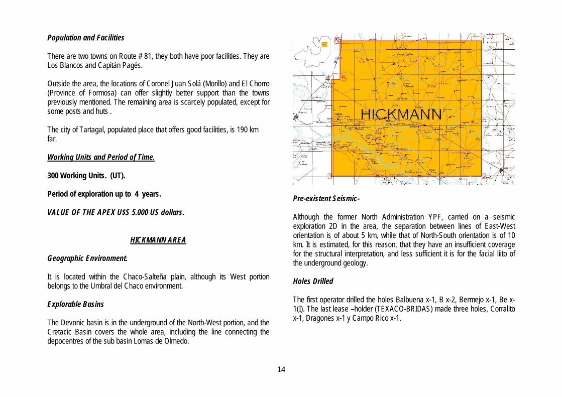
HICKMANN AREA Geographic Environment. It is located within the Chaco-Salteña plain, although its West portion belongs to the Umbral del Chaco environment. Explorable Basins The Devonic basin is in the underground of the North-West portion, and the Cretacic Basin covers the whole area, including the line connecting the depocentres of the sub basin Lomas de Olmedo.
Pre-existent Seismic- Although the former North Administration YPF, carried on a seismic exploration 2D in the area, the separation between lines of East-West orientation is of about 5 km, while that of North-South orientation is of 10 km. It is estimated, for this reason, that they have an insufficient coverage for the structural interpretation, and less sufficient it is for the facial liito of the underground geology. Holes Drilled The first operator drilled the holes Balbuena x-1, B x-2, Bermejo x-1, Be x-1(I). The last lease –holder (TEXACO-BRIDAS) made three holes, Corralito x-1, Dragones x-1 y Campo Rico x-1.

15 15
Oil Background The reports on the said holes indicate that there are vestiges of hydrocarbons, but it seems that the cromatographic records are unreliable due to the use of reverse injection. The geophyisic interpretation shows interesting perspectives at basal levels of the Yacoraite formation. An important fact to consider is the presence of the exploration parcel of East Balbuena, which is beside the North-East border and in active productive stage. Moreover, La Bolsa and Yacarecito deposits have thrown important volumes of gas and condensed and are also located behind the south border of this block Weather It is semi arid, with warm winters and hot to torrid summers, Rainfall period concentrates from November to April and reaches 550 mm per year. Road Access and Structure National Route # 81 crosses the block from East to West, running from National Route # 34. There is also Primary Provincial Route # 53, connecting Embarcación to Fortín Belgrano and it runs parallel to the North of Bermejo River. Its viability is uncertain. Other ways of communication are Secondary Provincial Routes # 135, 136 and 157 and several local and private paths which were originally seismic traces. South of Bermejo river and parallel to it, runs Primary Provincial Route # 15. Population and Facilities- There are several locations on National Route # 81, as is the case of Hickmann, Dragones, Pluma de Pato, all having poor facilities, especially the second of them. Hickmann and Dragones have landing runway, semi
public telephone service and cellular system, health aid centres. The rest of the area is scarcely populated. The city of Tartagal (50 km North of the crossroad between National Route #34 and 81), Embarcación (25 km from the same spot), Coronel Juan Solá, located 12 km from North border but offering very little support to the project. Working Units and Period of Time 300 Working units. (UT). Period of exploration up to 4 years. VALUE OF THE APEX U$S 3000 US dollars.