Fire Prevention and Response Plan
71
June 2015 Fire Prevention and Response Plan Sacramento Municipal Utility District Upper American River Project FERC Project No. 2101 i Fire Prevention and Response Plan Sacramento Municipal Utility District Hydro License Implementation • June 2015 Upper American River Project FERC Project No. 2101
Transcript of Fire Prevention and Response Plan

June 2015 Fire Prevention and Response Plan
Sacramento Municipal Utility District Upper American River Project FERC Project No. 2101 i
Fire Prevention and Response Plan Sacramento Municipal Utility District Hydro License Implementation • June 2015 Upper American River Project FERC Project No. 2101

June 2015 Fire Prevention and Response Plan
Sacramento Municipal Utility District Upper American River Project FERC Project No. 2101 i
TABLE OF CONTENTS
1.0 Introduction ................................................................................................................................................. 1 2.0 Project Area Description ............................................................................................................................... 1 3.0 Objective ...................................................................................................................................................... 1 4.0 Information Collection and Research ............................................................................................................ 2 5.0 Responsibilities ............................................................................................................................................. 3
5.1 SMUD .............................................................................................................................................................. 3 5.2 SMUD Contractors ........................................................................................................................................... 4 5.3 USFS ................................................................................................................................................................. 4 5.4 CAL FIRE ........................................................................................................................................................... 5 5.5 El Dorado County Fire District.......................................................................................................................... 5 5.6 Bureau of Land Management .......................................................................................................................... 5
6.0 Access ........................................................................................................................................................... 6 6.1 Vehicle Access .................................................................................................................................................. 6 6.2 Aerial Firefighting ............................................................................................................................................ 6 6.3 Water Drafting ................................................................................................................................................ 6
7.0 Hazard Assessment ....................................................................................................................................... 7 7.1 Fuel Types ........................................................................................................................................................ 7 7.2 Firefighting Conditions .................................................................................................................................... 7 7.3 Large Fire History ............................................................................................................................................ 7 7.4 Fire Danger Rating ........................................................................................................................................... 8 7.5 Ignition History .............................................................................................................................................. 13
8.0 Prevention and Preparedness ..................................................................................................................... 13 8.1 Training ......................................................................................................................................................... 13
SMUD and Contractors ........................................................................................................................ 13 8.1.1 Fire Responders ................................................................................................................................... 13 8.1.2
8.2 Recreation Management ............................................................................................................................... 14 8.3 Fuel Hazard Reduction ................................................................................................................................... 14 8.4 Precautionary Measures................................................................................................................................ 15
9.0 Response .................................................................................................................................................... 15 9.1 Reporting ....................................................................................................................................................... 16 9.2 Initial Attack .................................................................................................................................................. 16 9.3 Incident Command Support ........................................................................................................................... 17
10.0 Investigation .......................................................................................................................................... 17 11.0 Plan revisions ......................................................................................................................................... 18 12.0 References ............................................................................................................................................. 19

Fire Prevention and Response Plan June 2015
Sacramento Municipal Utility District Upper American River Project FERC Project No. 2101 ii
LIST OF TABLES, FIGURES, AND APPENDICES
Table 1. Large Wildfires near the Project from 1959 to Present…………………………..8 Table 2. Fire Danger Rating Color Code and Their Descriptors…………………………10 Table 3. ENF Fire Danger Ratings Levels, ERC Values and Percentile Conditions…..10 Figure 1. SMUD UARP Fire History………………………………………………………...11 Figure 2. SMUD UARP Ignition History…………………………………………………….12 Appendix A USFS 4(e) Condition 60 of Project License Appendix B Map Book for Upper American River Project Fire Prevention and
Response Plan Appendix C SMUD Hot Work Standard Appendix D Fire Plan for Special Use Permits, Eldorado National Forest Appendix E Procedures for Reporting a Wildfire in the UARP Appendix F Project Activity Level Frequently Asked Questions Appendix G Key Personnel Lists

Fire Prevention and Response Plan June 2015
Sacramento Municipal Utility District Upper American River Project FERC Project No. 2101 1
1.0 INTRODUCTION
The Federal Energy Regulatory Commission (FERC) issued the Sacramento Municipal Utility District (SMUD) a fifty-year license to operate the Upper American River Project (UARP or Project) on July 23, 2014 (License). U.S Forest Service (USFS) 4(e) Condition No. 60 in the License, and Article 1-34 in the FERC Relicensing Settlement Agreement for the UARP, require that within one year of license issuance, SMUD shall file with FERC a Fire Prevention and Response Plan (FPRP) developed in consultation with appropriate State and local fire agencies and approved by USFS. This FPRP has been developed in consultation with the USFS, Bureau of Land Management (BLM), and the California Department of Forestry and Fire Protection (CAL FIRE). While not explicitly required by the License, this FPRP will be sent to BLM for approval.
USFS Condition No. 60 is included as Appendix A.
2.0 PROJECT AREA DESCRIPTION
The UARP is a series of hydroelectric developments consisting of 11 reservoirs, eight powerhouses, and their associated electrical switchyards and distribution lines. Located on the western slope of the Sierra Nevada within El Dorado and Sacramento Counties, the Project is primarily within lands of the Eldorado National Forest (ENF). A map booklet identifying the Project Boundary which delineates the Project area, along with other location based features relevant to this FPRP, is included as Appendix B.
In addition to its generation-related facilities, the Project includes 47 developed recreation sites that include campgrounds, day use facilities, boat launches, trails, and a scenic overlook. Many of these developed recreation sites, as well as dispersed recreation areas within or immediately adjacent to the Project Boundary facilities, are accessed via one lane rural roads.
The SMUD electrical distribution network connects the UARP with a junction facility in the City of Folsom. This FPRP directly addresses the concerns developed by operating the UARP on public lands. The analysis terminates at the White Rock Powerhouse, just east of Highway 193 on the SFAR.
Some of the SMUD facilities contain high voltage switches and other features that may present unique challenges for fire suppression efforts. These features are summarized in the UARP Facilities Management Plan which will be distributed to the USFS and CAL Fire so that responders will be more informed when managing wildland fire suppression efforts in the vicinity of the UARP facilities.
3.0 OBJECTIVE
The objective of this FPRP is to outline the responsibility of SMUD and its contractor(s) for the prevention of, and response to, fires occurring in the vicinity of the Project and

Fire Prevention and Response Plan June 2015
Sacramento Municipal Utility District Upper American River Project FERC Project No. 2101 2
resulting from Project operations, or Project induced recreation within or immediately adjacent to the Project Boundary, in accordance with federal, state, and local regulations including, the Forest Service Manual (FSM) 5100 (USDA-FS 2014), FERC License Articles, and the California Public Resources Code (CPRC) (State of California 2009). Measures and procedures identified in this FPRP apply to Project operations conducted by SMUD and its contractors within, and in the immediate vicinity of, the Project Boundary.
As defined by the Interagency Standards for Fire and Fire Aviation Operations (United States Department of Interior et al. 2013), agency management goals for implementing fire prevention and response actions on USFS land within the Project Boundary include the following:
Protect human life, property, and natural/cultural resources both within and adjacent to agency-administered land;
Identify problem areas, causal factors, and increasing trends and implement measures aimed at reducing human-caused fires in these areas;
Apply maximum prevention efforts to minimize the ignition of human-caused fires in watersheds and high value areas identified as high hazard;
Minimize and, where necessary, mitigate human-induced impacts to resources, natural processes, or improvements attributable to wildland fire activities;
Prevent and investigate all unplanned human-caused fires; and
Focus cost effective prevention activities in the priority areas.
4.0 INFORMATION COLLECTION AND RESEARCH
A variety of documents were consulted for the development of this Plan. A complete listing of the documents is presented in Section 12 – References.
The information sources and data listed below relating to fire prevention, suppression, and fuel management were reviewed to provide appropriate background and technical reference for the development of this draft FPRP. In general, the documents consist of:
USFS, BLM, CAL FIRE, and other Agency Land Use and Resource Management Plans that may apply to the area
Fire Management, Fire Prevention, Fire Response, and Fuel Management Plans prepared for local agencies
Agency Management Goals for Implementation of Fire Prevention and Response Actions

Fire Prevention and Response Plan June 2015
Sacramento Municipal Utility District Upper American River Project FERC Project No. 2101 3
Fire Prevention and Response Plans prepared by other Utilities to satisfy their FERC License requirements
Fire behavior literature and scientific publications
5.0 RESPONSIBILITIES
Specific responsibilities under this FPRP are principally divided between SMUD, USFS, and CAL FIRE. Under the Cooperative Fire Protection Agreement, CAL FIRE and the USFS have divided the mostly undeveloped, public lands around the UARP into Direct Protection Areas (DPA). Fire suppression responsibility is assigned to one agency for each DPA. Having these agreements made ahead of time reduces confusion and redundant use of resources. The DPAs do not necessarily follow property lines. Consequently, both CAL FIRE and the USFS have fire suppression duties on lands where they are not the owners. CAL FIRE has the fire suppression responsibilities for BLM land in El Dorado County. The DPAs are displayed in a map in Appendix B.
SMUD 5.1
The following describes the responsibilities of SMUD regarding fire prevention, response, and investigation activities associated with fires in the vicinity of the Project and resulting from Project operations, or Project induced recreation within or immediately adjacent to the Project Boundary:
As a major stakeholder in the South Fork American River (SFAR) watershed, work with other stakeholders to prevent wildfires;
Identify and implement strategic Project related fire prevention and response enhancements that will provide mutual benefit among collaborating stakeholders such as sharing the cost of fuel reduction efforts, post fire restorations, response training, infrastructure, and facility improvements;
Conduct Project activities in a manner that will minimize potential fire dangers and that complies with this FPRP and all applicable rules, regulations, laws, and ordinances;
Take all reasonable and practicable actions to prevent and suppress fires resulting from UARP operations within the Project Boundary including compliance with SMUD’s Hot Work Standard contained in Appendix C for any Project operations involving open flames or producing heat and/or sparks;
Coordinate with federal, state, and local fire management personnel to ensure that appropriate preventive measures are in place, including Emergency Measures contained in Section 5 of Appendix D detailing Project Activity Level

Fire Prevention and Response Plan June 2015
Sacramento Municipal Utility District Upper American River Project FERC Project No. 2101 4
Requirements, during all Project operations that have the potential to ignite a wildfire;
Immediately report fires by calling 911 and initiate appropriate actions as specified in the Procedures for Reporting a Wildlfire in the UARP contained in Appendix E;
Take corrective action when observing or having been notified that fire protection measures have not been properly installed or maintained;
Ensure adequate operation and maintenance of Project recreational facilities, and administration of Project associated recreational activities within the Project Boundary (SMUD currently pays USFS to provide these services);
Notify the USFS and BLM through Camino Emergency Interagency Dispatch Center of any fire started on National Forest System of BLM lands, even if completely extinguished;
Cooperate fully with any fire investigations related to fires in the vicinity of the Project resulting from Project operations; and
Be diligent in supporting the USFS and BLM in restoring burned areas within, and in the immediate vicinity of, the Project Boundary or that resulted from SMUD operations.
SMUD Contractors 5.2
Contractors working on behalf of SMUD in the UARP will be required to, at minimum, conform to SMUD’s Hot Work Standard contained in Appendix C and Emergency Measures contained in Section 5 of Appendix D detailing Project Activity Level Requirements. In addition, SMUD contractors may be required by USFS and BLM to develop job specific fire plans with scope and terms consistent with those being used by USFS for Special Use Permits (see Appendix D).
USFS 5.3
The following describes the responsibilities of USFS regarding fire prevention and response activities associated with fires in the vicinity of the Project and resulting from Project operations:
Suppress, prevent, mitigate, and detect wildfires within their jurisdictional boundaries;
Respond to wildfires within its Direct Protection Area;
Designate an authorized representative to represent ENF on the portions of the UARP within USFS’s jurisdiction;

Fire Prevention and Response Plan June 2015
Sacramento Municipal Utility District Upper American River Project FERC Project No. 2101 5
Consult on the preparation of this FPRP and approve the FPRP in its final form; and
Review wildland fire prevention measures within the Project Boundary for compliance with applicable fire requirements and notify SMUD, through the authorized representative, in the event of non-compliance.
CAL FIRE 5.4
The following describes the responsibilities of CAL FIRE regarding fire prevention and response activities associated with fires in the vicinity of the Project and resulting from Project operations:
Suppress, prevent, mitigate, and detect wildfires within their jurisdictional boundaries;
Respond to wildfires within its Direct Protection Area;
Consult in the preparation of this FPRP;
Designate an authorized Unit representative to represent the Unit Chief on the portions of the UARP within CAL FIRE’s jurisdiction; and
Review wildland fire prevention measures within the Project Boundary for compliance with applicable fire requirements and notify SMUD, through the authorized representative, in the event of non-compliance.
El Dorado County Fire District 5.5
The El Dorado County Fire District does not have responsibility for responding to wildfires within, or in the immediate vicinity of, the Project Boundary. They may respond to a medical emergency or structural fire in the communities that are near the UARP. The El Dorado County Fire District has been invited to participate in the development of this FPRP and El Dorado County is a member of the Project License Implementation Consultation Group.
Bureau of Land Management 5.6
The Bureau of Land Management (BLM) owns parcels within and near the Project Boundary. While BLM has jurisdictional responsibility for these parcels, CAL FIRE has the fire suppression responsibilities for those lands. BLM is a member of the Project License Implementation Consultation Group.
The following describes the responsibilities of BLM regarding fire prevention and response activities associated with fires in the vicinity of the Project and resulting from Project operations:

Fire Prevention and Response Plan June 2015
Sacramento Municipal Utility District Upper American River Project FERC Project No. 2101 6
Suppress, prevent, mitigate, and detect wildfires within their jurisdictional boundaries;
Consult on the preparation of this FPRP;
Designate an authorized Field Office representative to represent the BLM on the portions of the UARP within BLM jurisdiction and to work with CAL FIRE in fire suppression activities; and
Review wildland fire prevention measures within the Project Boundary for compliance with applicable fire requirements and notify SMUD, through the authorized representative, in the event of non-compliance.
6.0 ACCESS
The UARP facilities are located in remote country. The surrounding lands are used primarily for timber production and outdoor recreation. Much of the local topography is steep with several important facilities situated at river level inside deep canyons.
Vehicle Access 6.1
Portions of the Project are accessible through state, county, and USFS roads, and by SMUD’s primary Project access roads. Access to some of SMUD’s roads is controlled by locked gates. This is to protect sensitive, hazardous, or valuable infrastructure. In addition to a SMUD lock, all of the gates have USFS padlocks installed in the locking mechanism to facilitate rapid response in a wildfire or other emergency. This transportation network is depicted in Appendix B.
Aerial Firefighting 6.2
Much of the Project lies within steep canyons and mountainous terrain. To aid in aerial firefighting and other suppression strategies, helicopter landing areas in the vicinity of the Project are depicted in Appendix B.
Water Drafting 6.3
Water drafting would likely draw from reservoirs, SFAR, and other water bodies located in or adjacent to the Project Boundary. As stated previously, most of the Project is accessible by USFS and other fire suppression vehicles. The locations of known water drafting sites are identified in Appendix B.

Fire Prevention and Response Plan June 2015
Sacramento Municipal Utility District Upper American River Project FERC Project No. 2101 7
7.0 HAZARD ASSESSMENT
Fuel Types 7.1
Under severe conditions (dry, hot, and windy), almost all of the vegetation types within the Project Boundary are susceptible to major fire events. The risk of larger fires increases as severe conditions persist. Historically, the most difficult fires to control occurred in the mixed conifer and the lower montane vegetation types. The chaparral and oak woodland types may produce fires with high rates of spread but historic fire sizes are relatively smaller. Similarly, very few large fires occurred in the upper montane forests due to the low fuel loading, cooler temperatures and shorter dry periods.
Firefighting Conditions 7.2
Availability of wildland fire suppression equipment is dependent on other fires throughout California, Oregon, and Nevada. The Project is accessible to helicopters within 15 minutes of a reported emergency during fire season from June through September, and is subject to change based on contracts for aerial equipment and the length of the fire season. There are two helicopters based out of Pacific Ranger Station. Fixed wing aircraft are based out of Grass Valley and Sonora with fight times of about 15 minutes. Ground resources travel time can vary substantially if fires are located deep in the forest. They are available from the Forest Service stations at Crystal Basin, Pacific, and Georgetown with arrival times generally within 20 minutes. Other Forest Service equipment is also available, but with longer arrival times. Cal Fire has ground equipment available in Camino and elsewhere in the county, with up to 30 minutes travel time.
Large Fire History 7.3
Large fires have been a part of the landscape history of El Dorado County for centuries. Table 1 lists the most significant fires that have occurred in the SFAR drainage or near the Project since 1959 and Figure 1 displays the locations of these, and other, wildfires.
It is know from 1900 and earlier that large fires occurred in this part of the Sierra Nevada Mountains, and frequent fire return intervals (2-20 years in lower montane zone areas around Camino, Placerville and Pollock Pines). Foothill regions of the Project burn frequently with mixed severity. Much of the chaparral covered areas are more productive than their southern California relatives and chamise can become extremely flammable within 16 years of a fire (Sugihara, 2006)
A recent large fire, the King Fire, burned through the area between Jaybird and Camino Powerhouses during September 2014. It was one of the largest most destructive fires in El Dorado County recorded history. Although it did not substantially damage hydroelectric infrastructure, it did do major damage to the forest and watersheds around the Project. According to ENF, it is unlikely for any treatments or post fire timber harvesting to be conducted in the steep canyons where much of the hydroelectric

Fire Prevention and Response Plan June 2015
Sacramento Municipal Utility District Upper American River Project FERC Project No. 2101 8
infrastructure is located. A recent study (Peterson, 2010) indicates that without post fire logging or surface fuel treatments, woody fuels accumulate at a rate that exceeds the decomposition rate. As fuel accumulates, so does the fire hazard in the Project area.
Table 1. Large Wildfires near the Project from 1959 to Present.
Fire Name Year Acres Burned
Ice House 1959 19,099
Camp 7 1960 11,212
Pillikin 1973 10,313
Chili Bar 1979 6,927
Eight Mile 1985 813
Cleveland 1992 22,518
Freds 2004 7,557
King Fire 2014 97,000
Fire Danger Rating 7.4
Most large fire growth on the ENF occurs due to a combination of steep slopes, fuel conditions and winds. Local thresholds or Watch Out concerns that can greatly increase fire behavior and growth include a combination of 20’ wind speed over 5 mph, RH (relative humidity)less than 22%, temperatures over 84 degrees, and 1000-hour fuel moistures less than 9%. Many large fires on the ENF occur late in the season when fuels have fully cured in conjunction with North wind events. Early season large fires occur in years where lack of precipitation results in early season drying and drought.
To determine seasonal trends, the ENF uses the Energy Release Component (ERC). The ERC is a National Fire Danger Rating System (NFDRS) index related to how hot a fire could burn. It is directly related to the 24-hour, potential worst case, total available energy (BTUs) per unit area (in square feet) within the flaming front at the head of a fire.
The ERC can serve as a good characterization of fire season as it tracks seasonal fire danger trends well. The ERC is a function of the fuel model and live and dead fuel moistures. Fuel loading, woody fuel moistures, and larger fuel moistures all have an influence on the ERC, while the lighter fuels have less influence and wind speed has none. ERC has low variability, and is the best fire danger component for indicating the effects of intermediate to long-term drying on fire behavior elevating fire danger.
Analysis of weather and fire occurrence data shows a correlation between fire growth and ERC. As ERC rises, fires resistance to control also rises. This also serves to inform cooperators and the public about fire danger. Fire Danger Ratings are broad scale assessments which describe conditions that reflect the potential, over a large area, for fire to ignite, spread, and require suppression action. Each Fire Danger Rating is defined in Table 2.

Fire Prevention and Response Plan June 2015
Sacramento Municipal Utility District Upper American River Project FERC Project No. 2101 9
An example of a familiar public notification system used by ENF and others to communicate Fire Danger Rating levels to the general public are signs with Smokey Bear pointing to the current Fire Danger Rating level.
The ERC indices are calculated daily May through November (peak fire season). Table 3 correlates the ERC value to the Fire Danger Rating levels and Percentile conditions. For example, a Percentile of 75 means that only 25% of days of peak fire season had an ERC of 79 or greater.

Fire Prevention and Response Plan June 2015
Sacramento Municipal Utility District Upper American River Project FERC Project No. 2101 10
Table 2. Fire Danger Rating color code and their descriptors.
Fire Danger Rating and Color Code
Description
Low (L) (Green)
Fuels do not ignite readily from small firebrands although a more intense heat source, such as lightning, may start fires in duff or punky wood. Fires in open cured grasslands may burn freely a few hours after rain, but woods fires spread slowly by creeping or smoldering, and burn in irregular fingers. There is little danger of spotting.
Moderate (M) (Blue)
Fires can start from most accidental causes, but with the exception of lightning fires in some areas, the number of starts is generally low. Fires in open cured grasslands will burn briskly and spread rapidly on windy days. Timber fire spread slowly to moderately fast. The average fire is of moderate intensity, although heavy concentrations of fuel, especially draped fuel, may burn hot. Short-distance spotting may occur, but is not persistent. Fires are not likely to become serious and control is relatively easy.
High (H) (Yellow)
All fine dead fuels ignite readily and fires start easily from most causes. Unattended brush and campfires are likely to escape. Fires spread rapidly and short-distance spotting is common. High-intensity burning may develop on slopes or in concentrations of fine fuels. Fires may become serious and their control difficult unless they are attacked successfully while small.
Very High (VH)
(Orange)
Fires start easily from all causes and, immediately after ignition, spread rapidly and increase quickly in intensity. Spot fires are a constant danger. Fires burning in light fuels may quickly develop high intensity characteristics such as long-distance spotting and fire whirlwinds when they burn into heavier fuels.
Extreme (E) (Red)
Fires start quickly, spread furiously, and burn intensely. All fires are potentially serious. Development into high intensity burning will usually be faster and occur from smaller fires than in the very high fire danger class. Direct attack is rarely possible and may be dangerous except immediately after ignition. Fires that develop headway in heavy slash or in conifer stands may be unmanageable while the extreme burning condition lasts. Under these conditions the only effective and safe control action is on the flanks until the weather changes or the fuel supply lessons.
Table 3. ENF Fire Danger Ratings levels, ERC values and percentile conditions.
ERC Percentile Fire Danger Rating
0 - 45 20% LOW
46-65 40% MODERATE
66-79 75% HIGH
80-86 89% VERY HIGH
87+ 90% EXTREME

CLEVELAND
CAMP 7
FREDS
PILLIKEN
ICE HOUSE(USFS #8)KELSEY MILL
VOLCANO
CHILI BAR
RALSTON
WRIGHTS
PLUM
DEADMAN'S FLAT
RUBICON
SAND MT
8 MILE
BRYANTS MILL
BIG
BOTTLE HILL
KELSEY
ROBBERS
SECTION 28
SNOWLINE
LONG
KYBURZ
PONDEROSA
PARK CREEK
SLATE MT
BADGER HILL
HUNTER
WILD CAT
LONG ESCAPE
B.O.B. CO-OP ESCAPE
DRIVERS
ST. PAULI
WHALER CK
SAM BABB
KAISER
PENSTOCK
WEBBER CREEK
GILLIS HILL
CEMENT HILL
SLATE MOUNTAINPINO GRANDE
AMERICAN RIVER
MILL
CAMP #11
POLLOCK PINES
MEEKS CK
PENNSYLVANIA
CHIPMUNK #2
BAYNE
HAZEL VALLEYHARTWICK
51
CLEASE
PILOT CK
MILLER DIGGINS FIRE
CIDER CK
MULE
BLACK
MARSHAL
PERRY MOUNTAIN
CUTTER
HOTCHKISS
MURPHY
BASSI FORK
BACCHI FIRE
BEACHES
CAMP 11#1
MUTTON
BACCHI
BLACKSMITH
TIMM
SIERRA
HAZEL
SOLDIER
PINES
FASHODA
GROOVY
PATTERSON
GRADE
POWER HOUSE
FORESTHILL
CARSON
SILVER
GIRARD
POVERTY CANYON
STONEY CK
GOLD CHANNEL
HARRISON HILLBUTCHER
FUNKY
TELLS 3
LOON 4
LONGJOHN
LOON 5
TEXAS CANYON
BEAR CK
ROBBS
BULTER
SILVER CK
ROADSIDE #51
SUGARLOAFONYX
BOTTLE
OLD PINO #1
TELLS 1
CABLE #2
CAMP #10
SPRING
SLICK ROCK
TELLS 2
NOODLESSIESNOP
HELLS DELIGHT
GREENWOOD
MOSQUITO
RUBICON CANYON
TELLS CK
HOTCHKISS HILL
BRADEN
MULE CANYON
RAMSEY CROSSING
NEVADA
WEST SHERMAN CK
UNCLE TOMS
SKY PILOT
YELLOW HOUND
SADDLE
TRESSEL #26
PILOT CK #2
DRISCOLL
LAWYER 2
WHALER OR SLATE CK
GREYHORSE
ROCKBOUND
LAKEVIEW
ZEPHRE COVE
IOWA CANYON
GRANLEES
STAR
KENTUCKY FLAT
MOSQUITO RS
CAMPER FLAT
ORELLI FIRE
BUTCHER CORRAL #2
BEAR
DANAHER PUMP
DARK CANYON
WHISKEY CANYON
NORTH BEAR CK #2
SLATE CK
NORTH WALLACE CANON
DARK CANYON #5
BERRY
PLACERVILLESources: Esri, HERE, DeLorme, TomTom, Intermap, increment P Corp., GEBCO, USGS, FAO, NPS, NRCAN, GeoBase, IGN, Kadaster NL, OrdnanceSurvey, Esri Japan, METI, Esri China (Hong Kong), swisstopo, MapmyIndia, © OpenStreetMap contributors, and the GIS User Community
FFigure 1. SMUD UARP Fire HistoryUpper American River Project - FERC No. 2101Fire Prevention and Response Plan
UPPER AMERICAN RIVER PROJECT
_Sacramento
1 in = 2.8 miles
Notes:Map Features
!
!
!
!
!
!
!
!
!
!
!
!!
!
!
!
!
!!
!
!
!
!
!
!
!
!
!
!
!!
UARP
EL DORADO
PLACER
AMADOR
ALPINE
NEVADA
SACRAMENTOCALAVERAS
Human Caused FireLightning Caused FireUARP FERC Boundary
0 2.51.25Miles
Fire history informationprovided by CAL FIRE.Title: firep13_2Published: June 2014King Fire Not Displayed

XY
XY
XY
XY
XY
XY
XY
XY
XY
XY
XY
XY
XY
XY
XY
XY
XY
XY
XY
XY
XY
XY
XY
XY
XYXY
XY
XY
XY
XY
XY
XY
XY
XY
XY
XY
XYXYXYXY
XY
XY
XY
XY
XY
XY
XY
XYXY
XY
XYXY
XY XYXY
XY
XY
XY
XY
XY
XY
XY
XY
XY
XY
XY
XY
XY
XY
XY
XY
XY
XY
XY
XY
XY
XY
XY
XY
XY
XY
XY
XYXY
XY
XY
XY
XY
XY
XY
XYXY
XY
XY
XY
XY
XY
XY
XY
XY
XY
XY
XY
XY
XY
XY
XY
XYXY
XY
XY
XY
XYXY
XY
XY
XYXY
XY
XYXYXY XY
XY
XY
XY
XYXY
XY
XW
XY
XYXYXY XYXY
XW
XY
XY
XY
XYXY
XY
XW
XY
XYXY
XY
XY
XY
XY
XY
XY XY
XY
XYXY
XYXY
XYXY
XY
XY
XY
XW
XY
XY
XY
Sources: Esri, HERE, DeLorme, TomTom, Intermap, increment P Corp., GEBCO, USGS, FAO, NPS, NRCAN, GeoBase, IGN, Kadaster NL, OrdnanceSurvey, Esri Japan, METI, Esri China (Hong Kong), swisstopo, MapmyIndia, © OpenStreetMap contributors, and the GIS User Community
FFigure 2. SMUD UARP Ignition HistoryUpper American River Project - FERC No. 2101Fire Prevention and Response Plan
UPPER AMERICAN RIVER PROJECT
_Sacramento
1 in = 2.5 miles
Notes:Map Features
!
!
!!
!
!
!
!
!
!
!
!!
!
!
!
!
!
!
!
!
!
!
!
!!
UARP
EL DORADO
PLACER
AMADOR
ALPINE
NEVADA
SACRAMENTOCALAVERAS
XY Human Caused IgnitionXW Lightning Caused Ignition
UARP FERC Boundary0 2.51.25
Miles
Ten year ignition historyprovided by CAL FIREand Eldorado NationalForest. Only ignitions withina half mile of the ProjectBoundary are shown.

Fire Prevention and Response Plan June 2015
Sacramento Municipal Utility District Upper American River Project FERC Project No. 2101 13
Ignition History 7.5
Both human and lightning caused wildfire occurred within the Project Boundary. Figure 2 displays the location and source of wildfire ignitions. This figure displays data from the USFS and CAL FIRE during the past 10 years within the vicinity of the Project. The majority of ignitions within the Project boundary were human caused. The proximity of recreational facilities and road access to the forest increases the chance of anthropogenic wildfire ignitions (Chuvieco & Congalton, 1989). Visitor use of UARP related recreation developments and dispersed sites within the Project Boundary has the potential to ignite wildfires.
8.0 PREVENTION AND PREPAREDNESS
SMUD shall independently make a good faith effort to prevent and suppress fire within, and adjacent to, the Project Boundary and shall require its employees, agents, contractors, subcontractors, and employees of contractors and subcontractors to do likewise. The following prevention measures shall be adhered to during Project operation, routine maintenance, and construction activities.
Training 8.1
Training received by SMUD staff and contractors with regards to hazard identification, fire prevention, and fire response procedures is described below.
SMUD and Contractors 8.1.1
Fire Familiarization Training- Employees and contractors who perform work involving open flame, or producing heat and/or sparks, or are responsible for performing fire watch duties while such work is occurring, will receive annual familiarization training on the proper use of available fire tools.
Incident Command Systems- Employees expected to participate in the Incident Command System as an Agency Representative will receive the necessary training to do so effectively. Such training may include ICS-100, ICS-200, and NIMS-700.
Prior to the commencement of work, SMUD contractors at a minimum, receive training in the hazards of working conditions in the UARP. This training includes wildfire prevention and response expectations.
Fire Responders 8.1.2
In order to facilitate an active awareness of SMUD facilities and operations, SMUD will provide orientation to fire responders who may encounter SMUD installations while responding to a fire. Such orientation will occur on an as requested basis. Topics

Fire Prevention and Response Plan June 2015
Sacramento Municipal Utility District Upper American River Project FERC Project No. 2101 14
covered during orientation will be tailored to specific requests, but may include proper communication to determine when power lines or switchyards have been, or need to be, de-energized, the locations of SMUD high value assets, Project personnel evacuation and accountability procedures, UARP feature specific hazards, and other activities that will assist fire fighters in safely performing their duties.
Recreation Management 8.2
SMUD and USFS have voluntarily entered into an agreement whereby SMUD will pay USFS to provide operation, maintenance, and administration of those developed recreation sites, facilities, or uses that are adjacent to or in the vicinity of Project reservoirs and facilities. This will include, but not be limited to, managing use within and immediately adjacent to the Project boundary, and performing both regular and annual maintenance. Work to be completed by USFS within these areas is to consist of conducting patrols, picking up litter, providing public information, enforcing rules and regulations, rehabilitating impacted areas, addressing sanitation, maintaining day use sites (such as concentrated use areas), maintaining trails, information signs, and regulatory signs, responding to fires and other emergencies, assisting in search and rescue, addressing resource impacts, and area condition monitoring.
The basis for this agreement is in USFS 4(e) Condition No. 47 of the License.
Fuel Hazard Reduction 8.3
SMUD recognizes that managing vegetation growth to control fuels buildup is an important component in preventing and controlling wildfires within the SFAR watershed. As a major stakeholder, SMUD will seek to collaborate with other SFAR watershed stakeholders to identify, implement, and maintain, strategic fuel hazard reduction measures.
Any prescribed fire associated with Project operations occurring on USFS managed lands will comply with USFS policy and plan approval requirements. Personnel implementing prescribed fires on USFS owned lands will meet all applicable USFS qualification standards.
For prescribed fire on BLM owned lands, SMUD staff and/or its contractors shall obtain prior written approval by the BLM Authorized Officer, necessary BLM burn permits, as well as any necessary burn permit from the appropriate CAL FIRE unit(s). Approval and permits from respective air quality management district(s) will be obtained as required, prior to burning on BLM lands. A Prescribed Burn Plan must be filed and approved by BLM before any burning can occur on BLM land.
Project associated prescribed fire occurring on lands not owned by the USFS or BLM will be coordinated with those agencies having jurisdiction (i.e., CAL FIRE and El Dorado County) and may be implemented by SMUD staff and/or its contractors.

Fire Prevention and Response Plan June 2015
Sacramento Municipal Utility District Upper American River Project FERC Project No. 2101 15
SMUD will regularly inspect for vegetation encroachment adjacent to Project buildings and will clear vegetation and maintain clearance according to practices identified in the UARP Vegetation Management Plan. At a minimum fuels will be controlled to meet the more restrictive criteria described in various federal and state requirements including FERC Engineering Guidelines, North American Electric Reliability Corporation Standards, California Public Resources Code Sections 4291 – 4299, and California Code of Regulations Title 14, Chapter 7, Article 4, Fire Prevention Standards for Electrical Utilities. Any fuels hazard reduction projects will incorporate applicable USFS best management practices for water quality management which, as of May 2015, can be found in the United States Department of Agriculture, Forest Service, Pacific Southwest Region Water Quality Management Handbook (2011) and the United States Department of Agriculture, Forest Service, National Best Management Practices for Water Quality Management on National Forest System Lands (2012). Further, preventative and post fire rehabilitative measures will be coordinated with other state and federal agencies as appropriate, and in accordance with Condition 27 of the UARP Water Quality Certification included in the License as Appendix A.
Precautionary Measures 8.4
Compliance with SMUD Hot Work Standard in Appendix C is required for all Project operations involving open flames or producing heat and/or sparks.
While SMUD does not maintain a ready supply of dedicated fire suppression equipment or personnel for Project operations, during Fire Precautionary periods determined by USFS, BLM, and/or CAL FIRE (based on jurisdiction), SMUD and its contractors will, at minimum, implement Emergency Measures contained in Section 5 of Appendix D detailing Project Activity Level Requirements. Alternatively and at the direction of USFS, BLM and/or CAL FIRE, SMUD staff and/or contractors will prepare job-specific Fire Plans and submit to the directing agency for approval. Frequently asked questions about the Project Activity Level decision support tool used by the ENF are contained in Appendix F.
During business hours (Mon-Thu, 6am-4:30pm) SMUD field staff file a planned route slip with Fresh Pond administrative staff. Outside of regular business hours, field staff are directed by the Fresh Pond On-Call Supervisor who is accountable for their location. Field, administrative, and supervisory staff are accessible by radio communications throughout the UARP. Key SMUD contacts for this FPRP are identified in Appendix G.
9.0 RESPONSE
While not trained wildland firefighters, SMUD staff and/or contractors may be in a position to report, extinguish, monitor and/or aid in the suppression of fires in the vicinity of the Project and resulting from Project operations. SMUD will take reasonable actions to extinguish any fires that are caused, directly or indirectly, as a result of Project-related operations, as training, equipment, and safety allows. For fires that occur on

Fire Prevention and Response Plan June 2015
Sacramento Municipal Utility District Upper American River Project FERC Project No. 2101 16
lands outside of Project facilities but adjacent to or in the vicinity of the Project Boundary, SMUD personnel will notify appropriate Agency responders and take all reasonable fire suppression actions safely within their limits of training.
The actions of SMUD staff and/or contractors to suppress fires will be limited to small, first attack operations.
Reporting 9.1
All Project-related fires and any fire detected in, or near, the Project Boundary will be immediately reported by SMUD or its contractor(s) by calling 911 and providing the following information to the best of their ability:
Incident type (wildland fire, vehicle accident, hazardous material spill, search and rescue, etc.);
Reporting party’s name; Radio number; office or cell phone call back number; Fire location using geographic coordinates, roads, or commonly known
geographic features as reference points; Possible access routes; Estimated size (in acres); Estimated rate of fire growth or spread; Weather conditions; Radio frequencies; Special hazards and concerns; and Additional resource needs.
Following the 911 call, the reporting party will immediately notify SMUD’s Power System Operations Dispatcher by the most expeditious means available. This notification can be made by telephone at (916) 732-6225, or by radio on the KMK637 UARP Channel.
Additional detail can be found in the Procedures for Reporting a Wildlfire in the UARP contained in Appendix E.
Initial Attack 9.2
In the event of a fire in the vicinity of the Project and resulting from Project operations, SMUD and/or its contractor(s) will attempt to contain the fire within their limits of training using onsite personnel, equipment, and fire tools until 1) the fire is controlled, 2) qualified fire suppression personnel arrives and assumes responsibility for fire suppression activities, or 3) a determination is made that it is unsafe to attempt to contain the fire.
Project personnel shall only attempt fire suppression based upon their knowledge, training, and ability to safely do so. When the scene becomes unsafe, personnel shall evacuate to a safe location.

Fire Prevention and Response Plan June 2015
Sacramento Municipal Utility District Upper American River Project FERC Project No. 2101 17
Incident Command Support 9.3
Within the Project Boundary, SMUD has a substantial workforce, assets that are valuable to the region including critical infrastructure, and control of high voltage power lines and facilities. These responsibilities make SMUD a vital resource for coordinating wildfire incident response. In order to provide for the safety of SMUD staff and contractors, as well as emergency responders, SMUD needs updated information of fire activity. In order to prevent the loss or disruption of a major regional power supply, SMUD can provide immediate insight about the location and disposition of high value facilities. In order to reduce the fire fighters’ potential exposure to harm, SMUD can de-energize transmission lines and switchyards as necessary.
Execution of these actions will require close coordination between SMUD and the Incident Command team. If a fire is reported in or near the Project Boundary, then SMUD must be notified immediately and will engage with the Incident Command Team as needed. Notification will be made to the appropriate key SMUD contacts identified in Appendix F, which will be on file with the Camino Emergency Command Center. Upon receiving notification of a fire reported in or near the Project Boundary, SMUD will select a Fire Liaison and an alternate Fire Liaison.
SMUD bears the responsibility of knowing how many staff and contractors are working in the Project Boundary. In the event of an evacuation, the SMUD Fire Liaison will contact department managers for a tally of how many workers were deployed and how many have safely evacuated. If it becomes necessary, the Fire Liaison will inform the Incident Command team that workers remain in the evacuation zone, identify, in consultation with the Incident Command team, their planned and alternative access routes (see Appendix B).
10.0 INVESTIGATION
SMUD agrees to fully cooperate with the proper authorities on all fire investigations related to the Project. SMUD shall produce, upon request, all materials and witnesses not subject to the attorney-client or attorney-work product privileges, over which SMUD has control, related to the fire and its investigation including:
All investigation reports; All witness statements; All photographs; All drawings; All analysis of cause and origin; and All other, similar materials and documents regardless of how collected or
maintained.
SMUD shall preserve all physical evidence and give custody to the proper authority of all physical evidence requested. SMUD shall have reasonable access to the physical

Fire Prevention and Response Plan June 2015
Sacramento Municipal Utility District Upper American River Project FERC Project No. 2101 18
evidence and documents SMUD requires in order to defend any and all claims, which may arise from a fire resulting from Project operations, to the extent such access is not precluded by ongoing criminal or civil litigation.
11.0 PLAN REVISIONS
If SMUD, USFS, BLM, CAL FIRE or El Dorado County Fire Control District collaboratively determine that revisions should be made to the plan, SMUD will make any revisions to the Plan in coordination and consultation with the listed resource agencies. Any revisions to the plan must be approved by USFS and BLM. Any revisions shall be filed with FERC for approval prior to implementing.

Fire Prevention and Response Plan June 2015
Sacramento Municipal Utility District Upper American River Project FERC Project No. 2101 19
12.0 REFERENCES
Chuvieco E, Congalton RG.1989. Application of Remote Sensing and Geographic Information Systems to Forest Fire Hazard Mapping. Remote Sensing of Environment 29, 147-159.
Federal Energy Regulatory Commission and United States Department of Agriculture, Forest Service. 2008 (March). Final Environmental Impact Statement for Hydropower License. Upper American River Hydroelectric Project – FERC Project No. 2101-084 – California, Chili Bar Hydroelectric Project – FERC Project No. 2101-024 – California. Washington, DC.
Pacific Gas and Electric Company. 2010 (March). Fire Management and Response Plan for Spring Gap-Stanislaus Project (FERC Project No. 2130).
Pacific Gas and Electric Company. 2008 (Revised December). Fire Management and Response Plan for Pit 3, 4, and 5 Hydrologic Project (FERC Project No. 233).
Pererson, David, Richy J. Harrod, 2010 (May) Fuel succession, Post-Fire Logging, and Future fire Behavior: Addressing the “Reburn Problem”, Final report to the Joint Fire Sciences Program, Project Number: 06-3-4-16
Placer County Water Agency. 2011 (Revised). Fire Prevention and Suppression Plan for Middle Fork American River Project (FERC Project No. 2079).
Sacramento Municipal Utility District. 2014 (December). Fire Prevention and Management Plan for Construction Fire Protection Plan. Iowa Hill Pumped-Storage Project. Prepared by Carlton Engineering/GHD Inc.
Sacramento Municipal Utility District. 2014 (December). Fire Prevention and Management Plan for Geotechnical Surveys. Iowa Hill Pumped-Storage Project. Prepared by Carlton Engineering/GHD Inc. and McMillen Jacobs Associates.
Southern California Edison. 2012 (Revised). Project Fire Prevention and Response Plan. Sierra National Forest. High Sierra and Bass Lake Ranger Districts.
Southern California Edison. 2007 (June). Fire Management and Response Plan for Borel Hydroelectric Project. Hydro Generation Division. Prepared by Psomas. Kern County, CA.
State of California, 2009. Public Resources Code, http://www.leginfo.ca.gov/.html/prc_table_of_contents.html
Sugihara, Neil G., 2006. Fire in California’s Ecosystems, University of California Press

Fire Prevention and Response Plan June 2015
Sacramento Municipal Utility District Upper American River Project FERC Project No. 2101 20
United States Department of Agriculture, Forest Service, 2012. National Best Management Practices for Water Quality Management on National Forest System Lands.
United States Department of Agriculture, Forest Service, 2014. Forest Service Manual 5100 – Wildland Fire Management, Washington Headquarters National Office
United States Department of Agriculture, Forest Service, Pacific Southwest Region, 2000. FS-990a-Water Quality Management for National Forest System Lands in California-Best Management Practices
United States Department of Agriculture, Forest Service, Pacific Southwest Region, 2011. R5 FSH 2509.22 – Water Quality Management Handbook.
United States Department of Interior, Bureau of Land Management, National Park Service, United States Department of Agriculture, Forest Service, 2013. Interagency Standards for Fire and Fire Aviation Operations
United States Department of Interior- Bureau of Land Management, National Park Service, Bureau of Indian Affairs, United States Fish and Wildlife Service, United States Department of Agriculture- United States Forest Service, State of California- California Department of Forestry and Fire Protection. 2013. California Master Cooperative Wildland Fire Management and Stafford Act Response Agreement.
Yuba County Water Agency. 2014 (April). Application for a New License Major Project – Existing Dam Fire Prevention and Response Plan (FERC No. 2246). Yuba River Development Project.

Fire Prevention and Response Plan June 2015
Sacramento Municipal Utility District Upper American River Project Appendix A-1 FERC Project No. 2101
APPENDIX A
USFS 4(E) CONDITION 60
Fire Prevention and Response Plan June 2015
Sacramento Municipal Utility District Upper American River Project Appendix A-2 FERC Project No. 2101
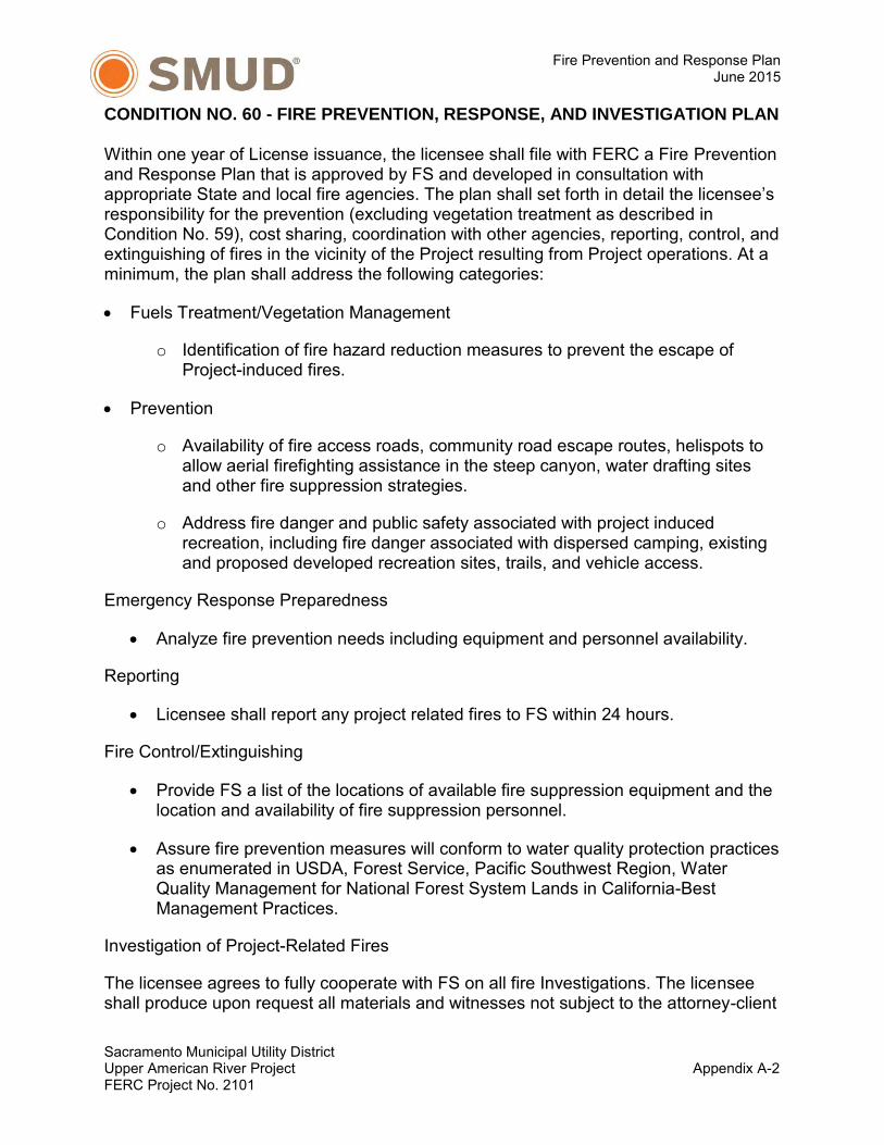
CONDITION NO. 60 - FIRE PREVENTION, RESPONSE, AND INVESTIGATION PLAN
Within one year of License issuance, the licensee shall file with FERC a Fire Prevention and Response Plan that is approved by FS and developed in consultation with appropriate State and local fire agencies. The plan shall set forth in detail the licensee’s responsibility for the prevention (excluding vegetation treatment as described in Condition No. 59), cost sharing, coordination with other agencies, reporting, control, and extinguishing of fires in the vicinity of the Project resulting from Project operations. At a minimum, the plan shall address the following categories:
Fuels Treatment/Vegetation Management
o Identification of fire hazard reduction measures to prevent the escape of Project-induced fires.
Prevention
o Availability of fire access roads, community road escape routes, helispots to allow aerial firefighting assistance in the steep canyon, water drafting sites and other fire suppression strategies.
o Address fire danger and public safety associated with project induced recreation, including fire danger associated with dispersed camping, existing and proposed developed recreation sites, trails, and vehicle access.
Emergency Response Preparedness
Analyze fire prevention needs including equipment and personnel availability.
Reporting
Licensee shall report any project related fires to FS within 24 hours.
Fire Control/Extinguishing
Provide FS a list of the locations of available fire suppression equipment and the location and availability of fire suppression personnel.
Assure fire prevention measures will conform to water quality protection practices as enumerated in USDA, Forest Service, Pacific Southwest Region, Water Quality Management for National Forest System Lands in California-Best Management Practices.
Investigation of Project-Related Fires
The licensee agrees to fully cooperate with FS on all fire Investigations. The licensee shall produce upon request all materials and witnesses not subject to the attorney-client

Fire Prevention and Response Plan June 2015
Sacramento Municipal Utility District Upper American River Project Appendix A-3 FERC Project No. 2101
or attorney work product privileges, over which the licensee has control, related to the fire and its investigation including:
All investigation reports.
All witness statements.
All photographs.
All drawings.
All analysis of cause and origin.
All other, similar materials and documents regardless of how collected or maintained.
The licensee shall preserve all physical evidence, and give custody to FS of all physical evidence requested. FS shall provide the licensee with reasonable access to the physical evidence and documents the licensee requires in order to defend any and all claims, which may arise from a fire resulting from Project operations, to the extent such access is not precluded by ongoing criminal or civil litigation.

Fire Prevention and Response Plan June 2015
Sacramento Municipal Utility District Upper American River Project Appendix B-1 FERC Project No. 2101
APPENDIX B
MAP BOOK
Map Book Total.pdf
apercy
Rectangle

!
!
!
!!
!!
!
!
! !
!
!
!!
!
!
!!
!
!
!
!
!
!
!
!
!
!!!
!!
!
!
!!!
!
!
!
!
!!
!
!
!
!
!
!
!
!!
!
! !
!!
!!
!!
!!
!!
!
!
!
!!
!
! ! !
!
!
!
! !
!
!
!
!
!
!
!
!
!
!
!
!
!!
!
!!
!
!
!
! ! !
!!
!
!
!
!!
!
!!
!
!
!
!
!
!
!
!
!
!
!
!
!
!!
! !
!
!
!
!!
!
!
!!
!!
!
!
!
!!!!
!
!
!
!
!
!
!
!!
!
!
!
!
!
!
!
!
!
!!
!!
!
!!
!
!
!
!
!
!
!
!!
!!
!
!
! !
!
!
!
!
!
!
!
!
!
ÑØÑØ
ÑØ
ÑØ
ÑØ
ÑØ
ÑØ
ÑØ
ÑØ
ÑØ
ÑØ
ÑØ
ÑØÑØÑØ
ÑØ
ÑØÑØ
ÑØ ÑØ
ÑØ
ÑØ
ÑØÑØ
ÑØ ÑØ
ÑØ
ÑØÑØÑØ
ÑØ ÑØÑØÑØ
ÑØÑØ
ÑØ
ÑØÑØ
ÑØ
ÑØ
ÑØ
ÑØ
ÑØ
ÑØ
ÑØ
ÑØ
ÑØÑØ
ÑØ
ÑØ
ÑØ
ÑØ
ÑØ
ÑØ
ÑØ
ÑØ ÑØ
ÑØ
ÑØ
ÑØ
ÑØ
ÑØÑØ
ÑØÑØ
ÑØ
ÑØ
ÑØÑØ ÑØ
ÑØ
ÑØ
ÑØ
ÑØÑØ
ÑØ
ÑØ
ÑØ
ÑØ
ÑØÑØ
ÑØ
ÑØ
ÑØ
ÑØ
ÑØ ÑØÑØ
ÑØ ÑØ
ÑØÑØ
ÑØÑØ
ÑØ
ÑØ
ÑØ
ÑØ
ÑØ
ÑØ
ÑØ
ÑØ
ÑØ
ÑØ
ÑØ
ÑØ
ÑØ
ÑØ
ÑØ
ÑØ
ÑØ
ÑØ
ÑØ
ÑØ
ÑØ
ÑØ
ÑØ
ÑØ
ÑØÑØ
ÑØ
ÑØÑØ
ÑØ
ÑØÑØ
ÑØ
¥i¤
¥i¤¥i¤
¥i¤¥i¤¥i¤
¥i¤¥i¤
¥i¤
¥i¤ ¥i¤
¥i¤
¥i¤
¥i¤
¥i¤¥i¤ ¥i¤
¥i¤
¥i¤¥i¤¥i¤
¥i¤¥i¤¥i¤
¥i¤
¥i¤
¥i¤
¥i¤
¥i¤
¥i¤
¥i¤
¥i¤
¥i¤
¥i¤
¥i¤
¥i¤
Slab Creek R eservoir
El Dorado Co.
Placer Co.
STATE DPA
FEDERAL DPA
Sources: Esri, HERE, DeLorme, USGS, Intermap, increment P Corp., NRCAN, Esri Japan, METI, Esri China (Hong Kong), Esri (Thailand), TomTom,MapmyIndia, © OpenStreetMap contributors, and the GIS User Community, National Geographic, Esri, DeLorme, HERE, UNEP-WCMC, USGS, NASA, ESA,METI, NRCAN, GEBCO, NOAA, increment P Corp.
F
UPPER AMERICAN RIVER PROJECT
_Sacramento
1 in = 2.4 miles
Map Features
1:150,000
!
! ! !
!
!
!
!
!
!
!
!!
!
!
!
!
!
!
!
!
!
!
!
!
!
!
!
!
!
!!
UARP
EL DORADO
PLACER
AMADOR
ALPINE
NEVADA
SACRAMENTOCALAVERAS
D e s o l a t i o n Wi l d e r n e s s
D e s o l a t i o n Wi l d e r n e s s
Brush Creek ReservoirCamino Reservoir
JunctionReservoir
Union ValleyReservoir
Ice House Reservoir
Gerle CreekReservoir
Robbs PeakForebay
Loon Lake
RubiconReservoir
Buck IslandReservoir
2250
Appendix B-0. Map BookUpper American River Project - FERC No. 2101Fire Prevention and Response Plan
UARP FERC BoundarySMUD Facilites
Land OwnershipNational Forest LandBureau of Land Management
TransportationUS Highway 50Primary Access RoadsGated Access RoadsOther Roads
FEDERAL DPAFire Response
¥i¤ Helispots
ÑØ Water Hole / Drafting Site
Transmission!d Transmission Structures
Transmission Lines
Water ConveyanceTunnel
Non-pressurized TunnelPressurized TunnelAdit / Spur
Penstock! Penstock
Penstock SubsurfaceOther
ChannelCanal

!d !d !d !d!d !d !d!d!d !d !d !d !d!d!d!d!d
!d!d!d!d
!d
!d
!d
!d!d
!d!d
!d!d
!d!d
!d
!d!d
!d!d!d
!d
!d
!d
!d!d!d !d!d!d!d !d!d!d!d!d
!d
!d
!d
!d!d
!d !d!d
!d
!d
!d!d !d!d !d!d !d!d!d !d !d !d!d !d !d !d!d!d !d!d !d !d !d!d!d !d !d!d !d !d !d!d!d
!d !d
!d
!d!d!d!d!d!d!d
!d!d!d!d
!d!d !d!d !d!d !d!d !d!d !d!d !d !d!d !d!d!d !d!d !d!d!d!d !d!d!d !d!d!d!d!d!d!d!d!d !d!d !d!d!d!d!d!d!d!d
!d!d
!d!d!d
!d!d !d!d !d !d !d!d !d !d !d !d !d!d !d !d !d !d !d !d !d!d
!d
!d!d
!d!d
!d!d
!d!d
!d!d!d!d!d!d!d
!d!d
!d!d
!d!d
!d!d
!d!d
!d!d
!d!d
!d!d
!d
!d
!d!d
!d!d
!d!d
!d!d!d
!d
!d
!d!d!d
!d!d
!d
!d!d
!d!d
!d
!d!d
!d!d
!d!d
!d
!d
!d
!d
!d
!d!d
!d!d
!d!d
!d!d
!d!d
!d!d
!d!d
!d
!d!d
!d!d
!d!d
!d!d
!d
!d!d
!d!d
!d
!d
!d!d
!d
!d!d
!d
!d!d
!d
!d!d
!d!d!d!d!d
!d!d!d
!d
!d!d
!d
!d!d!d
!d
!d!d
!d!d
!d!d
!d !d !d!d
!d !d !d !d!d!d!d !d !d!d!d !d!d!d!d !d!d !d
!d !d !d!d!d !d!d !d !d!d !d!d
!d!d !d!d !d !d !d
!d!d
!d!d
!d!d!d
!d!d !d!d !d !d !d !d !d !d!d !d!d !d !d !d!d!d !d!d!d !d !d!d!d !d !d!d!d !d !d
!d !d !d !d !d!d !d !d !d !d!d !d !d!d!d !d !d !d!d !d!d!d !d !d !d!d !d!d !d!d !d!d !d!d !d!d!d !d!d !d !d !d!d !d!d !d !d!d !d!d !d!d!d !d !d !d !d !d!d !d!d !d !d!d !d !d !d !d!d !d!d !d !d!d !d !d !d !d !d !d !d !d !d!d !d !d!d !d
!d!d!d!d
!d!d!d!d!d!d !d!d!d !d!d!d!d!d!d
!d!d
!d!d!d!d!d!d
!d!d
!d
!d!d
!d !d!d
!d!d
!d!d
!d!d
!d!d
!d
!d
!d!d
!d!d
!d!d!d
!d!d
!d!d
!d!d
!d!d
!d
!d
!d
!d
!d
!d
!d!d
!d!d
!d!d
!d
!d
!d!d
!d
!d!d!d!d
!d!d
!d!d!d
!d!d!d
!d!d!d
!d!d
!d
!d!d!d
!d!d !d!d!d!d !d !d!d !d !d!d!d !d
!d
!d !d!d!d!d
!d!d
!d
!d!d
!d!d!d!d!d!d
!d!d!d
!d
!d
!d!d
!d
!d
!d
!d
!d
!d!d
!d
!d
!d!d!d!d !d!d !d!d
!d
!d !d!d!d!d!d
!d!d
!d!d!d
!d!d!d!d
!d
!d
!d!d
!d!d!d!d!d!d
!d
!d!d!d!d !d!d!d!d
!d!d
!d
!d!d !d
!d!d!d!d
!d
!d!d!d !d!d
!d!d
!d
!d!d !d
!d!d !d
!d
!d!d!d!d
!d!d!d!d !d!d!d
!d
!d!d !d!d!d!d!d!d!d!d
!d
!d !d!d!d
!d!d!d
!d!d!d
!d!d
!d
!d!d!d
!d
!d
!d!d
!d!d
!d!d
!d!d
!d!d
!d
!d!d!d!d !d!d!d !d !d!d!d!d !d!d !d !d !d!d !d!d !d !d!d !d!d!d!d !d
!d
!d!d!d!d !d!d!d!d!d!d !d!d!d !d!d!d!d !d
!d
!d!d!d !d !d!d!d!d !d
!d
!d
!d!d!d !d!d!d !d!d!d !d !d!d!d !d!d
!d
!d !d!d!d !d!d !d!d !d!d
!d
!d !d!d!d!d!d !d
!d!d!d
!d !d
!d!d!d
!d
!d!d
!d
!d
!d!d
!d!d
!d
!d
!d!d
!d!d
!d
!d
!d
!d
!d!d
!d!d
!d
!d
!d
!d
!d!d
!d
!d
!d
!d!d
!d
!d!d!d
!d
!d!d
!d!d
!d
!d!d !d!d
!d
!d!d!d
!d!d
!d
!d!d!d
!d
!d!d
!d
!d
!d!d
!d
!d
!d!d!d
!d!d
!d!d
!d
!d
!d
!d!d
!d!d
!d!d
!d
!d!d!d!d!d!d
!d
!d!d !d!d!d!d!d!d!d!d
!d!d
!d
!d
!d!d!d
!d!d!d
!d!d!d
!d!d!d
!d!d!d
!d!d!d
!d!d!d
!d!d!d
!d!d!d!d !d !d!d !d!d !d !d!d !d !d
!d
!d!d!d!d
!d!d!d!d!d!d
!d
!d
!d !d!d
!d!d
!d
!d
!d!d !d
!d
!d
!d
!d!d!d
!d
!d
!d!d
!d !d
!d!d
!d !d!d!d!d
!d !d
!d
!d !d
!d!d
!d !d
!d!d
!d
!d
!d!d
!d
!d!d!d
!d!d!d
!d!d
!d
!d!d
!d!d !d
!d!d!d
!d !d!d
!d!d!d !d
!d
!d!d!d
!d!d!d!d !d
!d!d
!d
!d!d
!d
!d
!d
!d
!d!d !d
!d!d
!d
!d
!d!d
!d
!d
!d
!d
!d !d
!d!d
!d
!d
!d
!d
!d
!d
!d
!d
!d !d !d !d !d
!d
!d !d!d
!d !d!d!d
!d!d!d!d!d
!d
!d!d!d!d
!d
!d
!d
!d
!d
!d
!d!d
!d
!d
!d
!d !d
!d
!d !d
!d
!d
!d!d
!d
!d
!d
!d!d
!d
!d!d
!d
!d
!d
!d!d
!d
!d
!d
!d!d!d!d
!d
!d!d
!d!d
!d
!d!d!d !d!d !d!d!d !d!d!d
!d
!d
!d
!d!d !d!d !d!d
!d!d
!d
!d
!d
!d!d
!d!d
!d
!d
!d
!d!d
!d!d
!d
!d
!d
!d!d!d!d
!d!d !d
!d
!d !d!d !d !d!d !d!d!d!d
!d
!d !d!d !d!d !d !d!d!d !d
!d
!d!d
!d
!d!d!d
!d!d
!d!d
!d
!d
!d
!d
!d!d
!d
!d!d!d
!d
!d
!d
!d!d!d
!d!d
!d
!d
!d!d!d!d
!d!d
!d !d
!d
!d!d!d!d
!d
!d!d!d
!d!d!d
!d
!d
!d
!d!d
!d!d
!d
!d!d
!d!d
!d
!d!d
!d!d!d
!d
!d
!d
!d
!d!d!d
!d!d
!d!d!d
!d!d
!d
!d
!d
!d
!d!d
!d!d
!d!d
!d!d
!d!d
!d!d
!d
!d !d
!d
!d !d!d
!d!d
!d!d
!d
!d!d
!d
!d!d
!d !d!d !d!d!d !d
!d!d !d!d!d !d!d!d !d!d !d!d !d!d !d
!d !d!d
!d !d!d!d!d !d!d !d!d !d!d!d !d!d!d !d !d!d
!d
!d!d
!d
!d!d
!d!d
!d !d!d!d!d
!d
!d
!d!d
!d!d
!d
!d!d !d
!d!d!d
!d
!d
!d !d !d !d !d !d!d!d!d
!d !d !d
!d
!d
!d
!d!d !d!d
!d!d
!d!d
!d
!d
!d
!d !d !d!d!d!d!d !d !d !d
!d
!d !d !d !d !d !d !d !d
!d!d
!d!d!d
!d!d
!d!d
!d!d
!d!d
!d!d
!d!d
!d!d!d!d
!d!d!d!d
!d!d
!d
!d!d!d!d
!d
!d
!d
!d
!d
!d
!d
!d
!d
!d
!d
!d
!d
!d
!d
!d
!d
!d!d!d!d!d !d!d !d!d!d!d!d
!d!d !d!d!d
!d!d!d !d !d!d!d !d!d!d
!d!d
!d
!d!d
!d!d
!d
!d
!d!d
!d!d
!d!d!d
!d!d !d!d !d!d !d!d !d!d!d!d!d
!d!d!d!d!d
!d!d !d!d!d!d!d!d!d!d !d!d!d!d!d
!d!d!d
!d!d!d!d
!d!d
!d!d
!d!d!d
!d!d
!d!d!d!d!d
!d!d!d!d!d!d!d !d!d!d
!d
!d
!d
!d
!d
!d
!d
!d
!d
!d
!d
!d
!d
!d
!d!d!d
!d
!d!d
!d
!d!d
!d!d
!d!d!d
!d
!d!d!d
!d !d!d
!d
!d
!d
!d
!d
!d
!d
!d
!d
!d
!d
!d
!d
!d
!d
!d
!d
!d
!d
!d!d
!d
!d
!d
!d
!d
!d
!d
!d!d
!d !d!d
!d !d!d
!d
!d!d!d
!d
!d!d!d
!d
!d
!d!d!d
!d!d!d
!d!d !d !d
!d !d
!d!d!d!d!d
!d!d!d!d
!d
!d!d!d!d!d!d!d!d!d!d!d!d!d!d!d!d!d!d!d!d!d!d!d!d!d!d!d!d!d!d!d!d!d!d!d!d!d!d
!d!d!d!d!d!d!d!d
!d!d!d!d!d!d!d!d!d!d
!d!d!d!d!d!d!d!d!d!d!d!d!d!d!d!d!d!d!d!d!d!d!d!d!d!d!d!d!d!d!d!d!d!d!d!d!d!d!d!d!d!d!d!d!d!d!d!d!d!d!d!d!d!d!d!d!d!d!d!d
!d!d!d!d!d!d!d!d!d!d!d!d!d!d!d!d!d!d!d!d!d!d!d!d!d
!d
!d!d!d
!d!d
!d
!d
!d
!d!d
ÑØ
ÑØ
ÑØ
ÑØ
ÑØ
ÑØ
ÑØ
ÑØ
ÑØ
ÑØ
ÑØ
ÑØ
ÑØ
ÑØ
ÑØ
ÑØ
ÑØ
ÑØ
ÑØ
ÑØ
ÑØ
ÑØ
ÑØ
ÑØ
ÑØ
ÑØ
ÑØ
ÑØ ÑØ
ÑØ
ÑØ
ÑØÑØ
ÑØ
ÑØ
ÑØ
ÑØ
ÑØ
ÑØ
ÑØ
ÑØ
ÑØÑØ
ÑØ
ÑØ
ÑØ
ÑØ
ÑØ
ÑØ
ÑØ
ÑØÑØ
ÑØÑØ ÑØ
ÑØÑØ
ÑØ
ÑØ
ÑØ
ÑØ
ÑØ ÑØ
ÑØ
ÑØ
ÑØ
ÑØ
ÑØÑØ
ÑØ ÑØ
ÑØ
ÑØ
ÑØ
ÑØ
ÑØ
ÑØ
ÑØ
ÑØ
ÑØ
ÑØ
ÑØ
ÑØ
ÑØ
ÑØ ÑØ
ÑØ
ÑØ
ÑØ
ÑØ
ÑØ
ÑØ
ÑØ
ÑØ
ÑØ
ÑØ
ÑØÑØ
ÑØ
ÑØ
ÑØ
ÑØ
ÑØ
ÑØ
ÑØ
ÑØ
ÑØ
ÑØ
ÑØ
ÑØ
ÑØ
ÑØ
ÑØ
ÑØ
ÑØ
ÑØ
ÑØ
ÑØ ÑØ
ÑØ
ÑØ
ÑØ
ÑØ
ÑØÑØ
ÑØ
ÑØ
ÑØ
ÑØ
ÑØ
ÑØ
ÑØ
ÑØ
ÑØ
ÑØ
ÑØ
ÑØ
ÑØ
ÑØ
ÑØ
ÑØ
ÑØ
ÑØ
ÑØ
ÑØ
ÑØ
ÑØ
ÑØ
ÑØ
ÑØ
ÑØ
ÑØ
ÑØ
ÑØ
ÑØ
ÑØ
ÑØ
ÑØ
ÑØ
ÑØ
ÑØ
ÑØ
ÑØ
ÑØ
ÑØ
ÑØÑØ
ÑØ
ÑØ
ÑØ
ÑØ
ÑØ
ÑØ
ÑØ
ÑØ
ÑØ
ÑØ
ÑØ
ÑØ
ÑØ
ÑØ
ÑØ
ÑØ
ÑØ
ÑØ
ÑØ
ÑØ
ÑØ
ÑØ
ÑØ
ÑØ
ÑØ
ÑØ
ÑØ
ÑØ
ÑØ
ÑØ
ÑØ
ÑØÑØ
ÑØ
ÑØ
ÑØ
ÑØ
¥i¤
¥i¤¥i¤
¥i¤
¥i¤
Slab Creek Reservo ir
£¤50
Placerville
KONA DR White Rock (Kona)Adit and Spoils White Rock Tunnel
2000
1800
2400
1600
2600
2200
1400
2800
1200
1000
3000
2200
3000
1800
2800
2000
2200
2200
1800
1600
3000
2200
2200
2200
2000
2400
2000
2200
2600
1800
2200
2800
3000
2800
2200
2000
1800
1200
2600
2600
3000
3000
2000
2000
1600
2000 2400
2400
2600
1400
2600
2600
2800
1800
2400
2200
2600
2800
1800
2400
2200
2400
2600
2000
1400
3000
£¤50
CHUTE CAMP
MOSQUITO
RD
STATE HWY 193
ROCK CREEK RD
CARSON RD
BARKLEY RD
HOLLAND DR
NORT
H CA
NYON
RD
SLAB
CRE
EK R
D
LARSEN DRMEADOW LN
COLOMA CT
ROCK CREEK RD
NORTH CANYON RD
CARSON RD
FUARP FERC Boundary
Land OwnershipNational Forest LandBureau of Land Management
TransportationUS Highway 50Primary Access RoadsGated Access RoadsOther Roads
UPPER AMERICAN RIVER PROJECT
_Sacramento
1 in = 0.5 miles
Map Features
0 0.50.25Miles
Transmission LineT-line Segment
Loon Lake to RobbsRobbs to Union ValleyJones Fork to Union ValleyUnion Valley to JaybirdJaybird to CaminoCamino to White RockBrush CreekWhite Rock to FolsomFolsom
Appendix B-1. Map BookUpper American River Project - FERC No. 2101Fire Prevention and Response Plan
EL DORADO
PLACERNEVADA
AMADORALPINESACRAMENTO
AMADOR
Fire Response
¥i¤ Helispots
ÑØ Water Hole / Drafting Site
Transmission!d Transmission Structures
Transmission Lines
Water ConveyanceTunnel
Non-pressurized TunnelPressurized TunnelAdit / Spur
Penstock! Penstock
Penstock SubsurfaceOther
ChannelCanal

!d !d !d !d!d !d !d!d!d !d !d !d !d!d!d!d!d
!d!d!d!d
!d
!d
!d
!d!d
!d!d
!d!d
!d!d
!d
!d!d
!d!d!d
!d
!d
!d
!d!d!d !d!d!d!d !d!d!d!d!d
!d
!d
!d
!d!d
!d !d!d
!d
!d
!d!d !d!d !d!d !d!d!d !d !d !d!d !d !d !d!d!d !d!d !d !d !d!d!d !d !d!d !d !d !d!d!d
!d !d
!d
!d!d!d!d!d!d!d
!d!d!d!d
!d!d !d!d !d!d !d!d !d!d !d!d !d !d!d !d!d!d !d!d !d!d!d!d !d!d!d !d!d!d!d!d!d!d!d!d !d!d !d!d!d!d!d!d!d!d
!d!d
!d!d!d
!d!d !d!d !d !d !d!d !d !d !d !d !d!d !d !d !d !d !d !d !d!d
!d
!d!d
!d!d
!d!d
!d!d
!d!d!d!d!d!d!d
!d!d
!d!d
!d!d
!d!d
!d!d
!d!d
!d!d
!d!d
!d
!d
!d!d
!d!d
!d!d
!d!d!d
!d
!d
!d!d!d
!d!d
!d
!d!d
!d!d
!d
!d!d
!d!d
!d!d
!d
!d
!d
!d
!d
!d!d
!d!d
!d!d
!d!d
!d!d
!d!d
!d!d
!d
!d!d
!d!d
!d!d
!d!d
!d
!d!d
!d!d
!d
!d
!d!d
!d
!d!d
!d
!d!d
!d
!d!d
!d!d!d!d!d
!d!d!d
!d
!d!d
!d
!d!d!d
!d
!d!d
!d!d
!d!d
!d !d !d!d
!d !d !d !d!d!d!d !d !d!d!d !d!d!d!d !d!d !d
!d !d !d!d!d !d!d !d !d!d !d!d
!d!d !d!d !d !d !d
!d!d
!d!d
!d!d!d
!d!d !d!d !d !d !d !d !d !d!d !d!d !d !d !d!d!d !d!d!d !d !d!d!d !d !d!d!d !d !d
!d !d !d !d !d!d !d !d !d !d!d !d !d!d!d !d !d !d!d !d!d!d !d !d !d!d !d!d !d!d !d!d !d!d !d!d!d !d!d !d !d !d!d !d!d !d !d!d !d!d !d!d!d !d !d !d !d !d!d !d!d !d !d!d !d !d !d !d!d !d!d !d !d!d !d !d !d !d !d !d !d !d !d!d !d !d!d !d
!d!d!d!d
!d!d!d!d!d!d !d!d!d !d!d!d!d!d!d
!d!d
!d!d!d!d!d!d
!d!d
!d
!d!d
!d !d!d
!d!d
!d!d
!d!d
!d!d
!d
!d
!d!d
!d!d
!d!d!d
!d!d
!d!d
!d!d
!d!d
!d
!d
!d
!d
!d
!d
!d!d
!d!d
!d!d
!d
!d
!d!d
!d
!d!d!d!d
!d!d
!d!d!d
!d!d!d
!d!d!d
!d!d
!d
!d!d!d
!d!d !d!d!d!d !d !d!d !d !d!d!d !d
!d
!d !d!d!d!d
!d!d
!d
!d!d
!d!d!d!d!d!d
!d!d!d
!d
!d
!d!d
!d
!d
!d
!d
!d
!d!d
!d
!d
!d!d!d!d !d!d !d!d
!d
!d !d!d!d!d!d
!d!d
!d!d!d
!d!d!d!d
!d
!d
!d!d
!d!d!d!d!d!d
!d
!d!d!d!d !d!d!d!d
!d!d
!d
!d!d !d
!d!d!d!d
!d
!d!d!d !d!d
!d!d
!d
!d!d !d
!d!d !d
!d
!d!d!d!d
!d!d!d!d !d!d!d
!d
!d!d !d!d!d!d!d!d!d!d
!d
!d !d!d!d
!d!d!d
!d!d!d
!d!d
!d
!d!d!d
!d
!d
!d!d
!d!d
!d!d
!d!d
!d!d
!d
!d!d!d!d !d!d!d !d !d!d!d!d !d!d !d !d !d!d !d!d !d !d!d !d!d!d!d !d
!d
!d!d!d!d !d!d!d!d!d!d !d!d!d !d!d!d!d !d
!d
!d!d!d !d !d!d!d!d !d
!d
!d
!d!d!d !d!d!d !d!d!d !d !d!d!d !d!d
!d
!d !d!d!d !d!d !d!d !d!d
!d
!d !d!d!d!d!d !d
!d!d!d
!d !d
!d!d!d
!d
!d!d
!d
!d
!d!d
!d!d
!d
!d
!d!d
!d!d
!d
!d
!d
!d
!d!d
!d!d
!d
!d
!d
!d
!d!d
!d
!d
!d
!d!d
!d
!d!d!d
!d
!d!d
!d!d
!d
!d!d !d!d
!d
!d!d!d
!d!d
!d
!d!d!d
!d
!d!d
!d
!d
!d!d
!d
!d
!d!d!d
!d!d
!d!d
!d
!d
!d
!d!d
!d!d
!d!d
!d
!d!d!d!d!d!d
!d
!d!d !d!d!d!d!d!d!d!d
!d!d
!d
!d
!d!d!d
!d!d!d
!d!d!d
!d!d!d
!d!d!d
!d!d!d
!d!d!d
!d!d!d
!d!d!d!d !d !d!d !d!d !d !d!d !d !d
!d
!d!d!d!d
!d!d!d!d!d!d
!d
!d
!d !d!d
!d!d
!d
!d
!d!d !d
!d
!d
!d
!d!d!d
!d
!d
!d!d
!d !d
!d!d
!d !d!d!d!d
!d !d
!d
!d !d
!d!d
!d !d
!d!d
!d
!d
!d!d
!d
!d!d!d
!d!d!d
!d!d
!d
!d!d
!d!d !d
!d!d!d
!d !d!d
!d!d!d !d
!d
!d!d!d
!d!d!d!d !d
!d!d
!d
!d!d
!d
!d
!d
!d
!d!d !d
!d!d
!d
!d
!d!d
!d
!d
!d
!d
!d !d
!d!d
!d
!d
!d
!d
!d
!d
!d
!d
!d !d !d !d !d
!d
!d !d!d
!d !d!d!d
!d!d!d!d!d
!d
!d!d!d!d
!d
!d
!d
!d
!d
!d
!d!d
!d
!d
!d
!d !d
!d
!d !d
!d
!d
!d!d
!d
!d
!d
!d!d
!d
!d!d
!d
!d
!d
!d!d
!d
!d
!d
!d!d!d!d
!d
!d!d
!d!d
!d
!d!d!d !d!d !d!d!d !d!d!d
!d
!d
!d
!d!d !d!d !d!d
!d!d
!d
!d
!d
!d!d
!d!d
!d
!d
!d
!d!d
!d!d
!d
!d
!d
!d!d!d!d
!d!d !d
!d
!d !d!d !d !d!d !d!d!d!d
!d
!d !d!d !d!d !d !d!d!d !d
!d
!d!d
!d
!d!d!d
!d!d
!d!d
!d
!d
!d
!d
!d!d
!d
!d!d!d
!d
!d
!d
!d!d!d
!d!d
!d
!d
!d!d!d!d
!d!d
!d !d
!d
!d!d!d!d
!d
!d!d!d
!d!d!d
!d
!d
!d
!d!d
!d!d
!d
!d!d
!d!d
!d
!d!d
!d!d!d
!d
!d
!d
!d
!d!d!d
!d!d
!d!d!d
!d!d
!d
!d
!d
!d
!d!d
!d!d
!d!d
!d!d
!d!d
!d!d
!d
!d !d
!d
!d !d!d
!d!d
!d!d
!d
!d!d
!d
!d!d
!d !d!d !d!d!d !d
!d!d !d!d!d !d!d!d !d!d !d!d !d!d !d
!d !d!d
!d !d!d!d!d !d!d !d!d !d!d!d !d!d!d !d !d!d
!d
!d!d
!d
!d!d
!d!d
!d !d!d!d!d
!d
!d
!d!d
!d!d
!d
!d!d !d
!d!d!d
!d
!d
!d !d !d !d !d !d!d!d!d
!d !d !d
!d
!d
!d
!d!d !d!d
!d!d
!d!d
!d
!d
!d
!d !d !d!d!d!d!d !d !d !d
!d
!d !d !d !d !d !d !d !d
!d!d
!d!d!d
!d!d
!d!d
!d!d
!d!d
!d!d
!d!d
!d!d!d!d
!d!d!d!d
!d!d
!d
!d!d!d!d
!d
!d
!d
!d
!d
!d
!d
!d
!d
!d
!d
!d
!d
!d
!d
!d
!d
!d!d!d!d!d !d!d !d!d!d!d!d
!d!d !d!d!d
!d!d!d !d !d!d!d !d!d!d
!d!d
!d
!d!d
!d!d
!d
!d
!d!d
!d!d
!d!d!d
!d!d !d!d !d!d !d!d !d!d!d!d!d
!d!d!d!d!d
!d!d !d!d!d!d!d!d!d!d !d!d!d!d!d
!d!d!d
!d!d!d!d
!d!d
!d!d
!d!d!d
!d!d
!d!d!d!d!d
!d!d!d!d!d!d!d !d!d!d
!d
!d
!d
!d
!d
!d
!d
!d
!d
!d
!d
!d
!d
!d
!d!d!d
!d
!d!d
!d
!d!d
!d!d
!d!d!d
!d
!d!d!d
!d !d!d
!d
!d
!d
!d
!d
!d
!d
!d
!d
!d
!d
!d
!d
!d
!d
!d
!d
!d
!d
!d!d
!d
!d
!d
!d
!d
!d
!d
!d!d
!d !d!d
!d !d!d
!d
!d!d!d
!d
!d!d!d
!d
!d
!d!d!d
!d!d!d
!d!d !d !d
!d !d
!d!d!d!d!d
!d!d!d!d
!d!d!d!d!d!d!d!d!d!d!d!d!d!d!d!d!d!d!d!d!d!d!d!d!d!d!d!d!d!d!d!d!d!d!d!d!d!d!d
!d!d!d!d!d!d!d!d
!d!d!d!d!d!d!d!d!d!d
!d!d!d!d!d!d!d!d!d!d!d!d!d!d!d!d!d!d!d!d!d!d!d!d!d!d!d!d!d!d!d!d!d!d!d!d!d!d!d!d!d!d!d!d!d!d!d!d!d!d!d!d!d!d!d!d!d!d!d!d
!d!d!d!d!d!d!d!d!d!d!d!d!d!d!d!d!d!d!d!d!d!d!d!d!d
!d
!d!d!d
!d!d
!d
!d
!d
!d!d
ÑØ
ÑØ
ÑØ
ÑØ
ÑØ
ÑØ
ÑØ
ÑØ
ÑØ
ÑØ
ÑØ
ÑØ
ÑØ
ÑØ
ÑØ
ÑØ
ÑØ
ÑØ
ÑØ
ÑØ
ÑØ
ÑØ
ÑØ
ÑØ
ÑØ
ÑØ
ÑØ
ÑØ ÑØ
ÑØ
ÑØ
ÑØÑØ
ÑØ
ÑØ
ÑØ
ÑØ
ÑØ
ÑØ
ÑØ
ÑØ
ÑØÑØ
ÑØ
ÑØ
ÑØ
ÑØ
ÑØ
ÑØ
ÑØ
ÑØÑØ
ÑØÑØ ÑØ
ÑØÑØ
ÑØ
ÑØ
ÑØ
ÑØ
ÑØ ÑØ
ÑØ
ÑØ
ÑØ
ÑØ
ÑØÑØ
ÑØ ÑØ
ÑØ
ÑØ
ÑØ
ÑØ
ÑØ
ÑØ
ÑØ
ÑØ
ÑØ
ÑØ
ÑØ
ÑØ
ÑØ
ÑØ ÑØ
ÑØ
ÑØ
ÑØ
ÑØ
ÑØ
ÑØ
ÑØ
ÑØ
ÑØ
ÑØ
ÑØÑØ
ÑØ
ÑØ
ÑØ
ÑØ
ÑØ
ÑØ
ÑØ
ÑØ
ÑØ
ÑØ
ÑØ
ÑØ
ÑØ
ÑØ
ÑØ
ÑØ
ÑØ
ÑØ
ÑØ
ÑØ ÑØ
ÑØ
ÑØ
ÑØ
ÑØ
ÑØÑØ
ÑØ
ÑØ
ÑØ
ÑØ
ÑØ
ÑØ
ÑØ
ÑØ
ÑØ
ÑØ
ÑØ
ÑØ
ÑØ
ÑØ
ÑØ
ÑØ
ÑØ
ÑØ
ÑØ
ÑØ
ÑØ
ÑØ
ÑØ
ÑØ
ÑØ
ÑØ
ÑØ
ÑØ
ÑØ
ÑØ
ÑØ
ÑØ
ÑØ
ÑØ
ÑØ
ÑØ
ÑØ
ÑØ
ÑØ
ÑØ
ÑØÑØ
ÑØ
ÑØ
ÑØ
ÑØ
ÑØ
ÑØ
ÑØ
ÑØ
ÑØ
ÑØ
ÑØ
ÑØ
ÑØ
ÑØ
ÑØ
ÑØ
ÑØ
ÑØ
ÑØ
ÑØ
ÑØ
ÑØ
ÑØ
ÑØ
ÑØ
ÑØ
ÑØ
ÑØ
ÑØ
ÑØ
ÑØ
ÑØÑØ
ÑØ
ÑØ
ÑØ
ÑØ
¥i¤
¥i¤
¥i¤
¥i¤
¥i¤
¥i¤
¥i¤
¯Sf
Slab Creek Reservo ir
Brush Creek Reservoir
Camino AdditBrush Creek Dam
Jaybird Powerhouseand Switchyard
Camino Powerhouseand Switchyard
Camino Dam
Camino Surge Chamber
Slab Creek Gate House
Camino Gatehouse
Camino Penstock Valvehouse
CM-6CM-1
2800
2600
2400
22003000
2000
3200
3400
3600
1800
3800 4000
4200
44004600
2800
3400
3000
3600
3800
2800
2400
3200
3200
3600
3000
3600
3200
4200
2800
3800
3200
3400
3600
2800
3600
3200
3400
3000
3200
3000
3600
2800
3800
2800
4200
3800
3600
4400
4000
3000
3400
4000
4000
3200
4000
3200
3400
2800
3200
3000
2600
2800
3400
3400
3000
3000
3200
3400 3800
3200
3400
4000
R i d g e
P o h o
Iowa Hill
Independence Point
£¤50
FOREBAY
POHO RIDGE
FOREBAY RD
FOREBAY RD
FUARP FERC BoundarySMUD Facilites
Land OwnershipNational Forest LandBureau of Land Management
TransportationUS Highway 50Primary Access RoadsGated Access RoadsOther Roads
UPPER AMERICAN RIVER PROJECT
_Sacramento
1 in = 0.5 miles
Map Features
0 0.50.25Miles
Transmission LineT-line Segment
Loon Lake to RobbsRobbs to Union ValleyJones Fork to Union ValleyUnion Valley to JaybirdJaybird to CaminoCamino to White RockBrush CreekWhite Rock to FolsomFolsom
Appendix B-2. Map BookUpper American River Project - FERC No. 2101Fire Prevention and Response Plan
EL DORADO
PLACERNEVADA
AMADORALPINESACRAMENTO
AMADOR
Fire Response
¥i¤ Helispots
ÑØ Water Hole / Drafting Site
Transmission!d Transmission Structures
Transmission Lines
Water ConveyanceTunnel
Non-pressurized TunnelPressurized TunnelAdit / Spur
Penstock! Penstock
Penstock SubsurfaceOther
ChannelCanal

!d !d !d !d!d !d !d!d!d !d !d !d !d!d!d!d!d
!d!d!d!d
!d
!d
!d
!d!d
!d!d
!d!d
!d!d
!d
!d!d
!d!d!d
!d
!d
!d
!d!d!d !d!d!d!d !d!d!d!d!d
!d
!d
!d
!d!d
!d !d!d
!d
!d
!d!d !d!d !d!d !d!d!d !d !d !d!d !d !d !d!d!d !d!d !d !d !d!d!d !d !d!d !d !d !d!d!d
!d !d
!d
!d!d!d!d!d!d!d
!d!d!d!d
!d!d !d!d !d!d !d!d !d!d !d!d !d !d!d !d!d!d !d!d !d!d!d!d !d!d!d !d!d!d!d!d!d!d!d!d !d!d !d!d!d!d!d!d!d!d
!d!d
!d!d!d!d!d !d!d !d !d !d!d !d !d !d !d !d!d !d !d !d !d !d !d !d
!d!d
!d!d
!d!d
!d!d
!d!d
!d!d!d!d!d!d!d
!d!d
!d!d
!d!d
!d!d
!d!d
!d!d
!d!d
!d!d
!d
!d
!d!d
!d!d
!d!d
!d!d!d
!d
!d
!d!d!d
!d!d
!d
!d!d
!d!d
!d
!d!d
!d!d
!d!d
!d
!d
!d
!d
!d
!d!d
!d!d
!d!d
!d!d
!d!d
!d!d
!d!d
!d
!d!d
!d!d
!d!d
!d!d
!d
!d!d
!d!d
!d
!d
!d!d
!d
!d!d
!d
!d!d
!d
!d!d
!d!d!d!d!d
!d!d!d
!d
!d!d
!d
!d!d!d
!d
!d!d
!d!d
!d!d
!d !d !d!d
!d !d !d !d!d!d!d !d !d!d!d !d!d!d!d !d!d !d
!d !d !d!d!d !d!d !d !d!d !d!d
!d!d !d!d !d !d !d
!d!d
!d!d
!d!d!d
!d!d !d!d !d !d !d !d !d !d!d !d!d !d !d !d!d!d !d!d!d !d
!d!d!d !d !d!d!d !d !d!d !d !d !d !d!d !d !d !d !d
!d !d !d!d!d !d !d !d!d !d!d!d !d !d !d!d !d!d !d!d !d!d !d!d !d!d!d !d!d !d !d !d!d !d!d !d !d!d !d!d !d!d!d !d !d !d !d !d!d !d!d !d !d!d !d !d !d !d!d !d!d !d !d!d !d !d !d !d !d !d !d !d !d!d !d !d!d !d!d!d!d
!d!d
!d!d!d!d!d !d!d!d !d!d!d!d!d!d!d
!d!d
!d!d!d!d!d
!d!d
!d
!d!d
!d !d!d
!d!d
!d!d
!d!d
!d!d
!d
!d
!d!d
!d!d
!d!d!d
!d!d
!d!d
!d!d
!d!d
!d
!d
!d
!d
!d
!d
!d!d
!d!d
!d!d
!d
!d
!d!d
!d
!d!d!d!d
!d!d
!d!d!d
!d!d!d
!d!d!d
!d!d
!d
!d!d!d
!d!d !d!d!d!d !d !d!d !d !d!d!d !d
!d
!d !d!d!d!d
!d!d
!d
!d!d
!d!d!d!d!d!d
!d!d!d
!d
!d
!d!d
!d
!d
!d
!d
!d
!d!d
!d
!d
!d!d!d!d !d!d !d!d
!d
!d !d!d!d!d!d
!d!d
!d!d!d
!d!d!d!d
!d
!d
!d!d
!d!d!d!d!d!d
!d
!d!d!d!d !d!d!d!d
!d!d
!d
!d!d !d!d!d
!d!d
!d
!d!d!d !d!d
!d!d
!d
!d!d !d
!d!d !d
!d
!d!d!d!d
!d!d!d!d !d!d!d
!d
!d!d !d!d!d!d!d!d!d!d
!d
!d !d!d!d
!d!d!d
!d!d!d
!d!d
!d
!d!d!d
!d
!d
!d!d
!d!d
!d!d
!d!d
!d!d
!d
!d!d!d!d !d!d!d !d !d!d!d!d !d!d !d !d !d!d !d!d !d !d!d !d!d!d!d !d
!d
!d!d!d!d !d!d!d!d!d!d !d!d!d !d!d!d!d !d
!d
!d!d!d !d !d!d!d
!d !d!d
!d
!d!d!d !d!d!d !d!d!d !d !d!d!d !d!d
!d
!d !d!d!d !d!d !d!d !d!d
!d
!d !d!d!d!d!d !d
!d!d!d
!d !d
!d!d!d
!d
!d!d
!d
!d
!d!d
!d!d
!d
!d
!d!d
!d!d
!d
!d
!d
!d
!d!d
!d!d
!d
!d
!d
!d
!d!d
!d
!d
!d
!d!d
!d
!d!d!d
!d
!d!d
!d!d
!d
!d!d !d!d
!d
!d!d!d
!d!d
!d
!d!d!d
!d
!d!d
!d
!d
!d!d
!d
!d
!d!d!d
!d!d
!d!d
!d
!d
!d
!d!d
!d!d
!d!d
!d
!d!d!d!d!d!d
!d
!d!d !d!d!d!d!d!d!d!d
!d!d
!d
!d
!d!d!d
!d!d!d
!d!d!d
!d!d!d
!d!d!d
!d!d!d
!d!d!d
!d!d!d
!d!d!d!d !d !d!d !d!d !d !d!d !d !d
!d
!d!d!d!d
!d!d!d!d!d!d
!d
!d
!d !d!d
!d!d
!d
!d
!d!d !d
!d
!d
!d
!d!d!d
!d
!d
!d!d
!d !d
!d!d
!d !d!d!d!d
!d !d
!d
!d !d!d!d
!d !d
!d!d
!d
!d
!d!d
!d
!d!d!d
!d!d!d
!d!d
!d
!d!d
!d!d !d
!d!d!d
!d !d!d
!d!d!d !d
!d
!d!d!d
!d!d!d!d !d
!d!d
!d
!d!d
!d
!d
!d
!d
!d!d !d
!d!d
!d
!d
!d!d
!d
!d
!d
!d
!d !d
!d!d
!d
!d
!d
!d
!d
!d
!d
!d
!d !d !d !d !d
!d
!d !d!d
!d !d!d!d
!d!d!d!d!d
!d
!d!d!d!d
!d
!d
!d
!d
!d
!d
!d!d
!d
!d
!d
!d !d
!d
!d !d
!d
!d
!d!d
!d
!d
!d
!d!d
!d
!d!d
!d
!d
!d
!d!d
!d
!d
!d
!d!d!d!d
!d
!d!d
!d!d
!d
!d!d!d !d!d !d!d!d !d!d!d
!d
!d
!d
!d!d !d!d !d!d
!d!d
!d
!d
!d
!d!d
!d!d
!d
!d
!d
!d!d
!d!d
!d
!d
!d
!d!d!d!d
!d!d !d
!d
!d !d!d !d !d!d !d!d!d!d
!d
!d !d!d !d!d !d !d!d!d !d
!d
!d!d
!d
!d!d!d
!d!d
!d!d
!d
!d
!d
!d
!d!d
!d
!d!d!d
!d
!d
!d
!d!d!d
!d!d
!d
!d
!d!d!d!d
!d!d
!d !d
!d
!d!d!d!d
!d
!d!d!d
!d!d!d
!d
!d
!d
!d!d
!d!d
!d
!d!d
!d!d
!d
!d!d
!d!d!d
!d
!d
!d
!d
!d!d!d
!d!d
!d!d!d
!d!d
!d
!d
!d
!d
!d!d
!d!d
!d!d
!d!d
!d!d
!d!d
!d
!d !d
!d
!d !d!d
!d!d
!d!d
!d
!d!d
!d
!d!d
!d !d!d !d!d!d !d
!d!d !d!d!d !d!d!d !d!d !d!d !d!d !d
!d !d!d
!d !d!d!d!d !d!d !d!d !d!d!d !d!d!d !d !d
!d
!d
!d!d
!d
!d!d
!d!d
!d !d!d!d!d
!d
!d
!d!d
!d!d
!d
!d!d !d
!d!d!d
!d
!d
!d !d !d !d !d !d!d!d!d
!d !d !d
!d
!d
!d
!d!d !d!d
!d!d
!d!d
!d
!d
!d
!d !d !d!d!d!d!d !d !d !d
!d
!d !d !d !d !d !d !d !d
!d!d
!d!d!d
!d!d
!d!d
!d!d
!d!d
!d!d
!d!d
!d!d!d!d
!d!d!d!d
!d!d
!d
!d!d!d!d
!d
!d
!d
!d
!d
!d
!d
!d
!d
!d
!d
!d
!d
!d
!d
!d
!d
!d!d!d!d!d !d!d !d!d!d!d!d
!d!d !d!d!d!d!d!d !d !d!d!d !d!d
!d!d
!d
!d
!d!d
!d!d
!d
!d
!d!d
!d!d
!d!d!d
!d!d !d!d !d!d !d!d !d!d!d!d!d
!d!d!d!d!d
!d!d !d!d!d!d!d!d!d!d !d!d!d!d!d
!d!d!d
!d!d!d!d
!d!d
!d!d
!d!d!d
!d!d
!d!d!d!d!d
!d!d!d!d!d!d!d !d!d!d
!d
!d
!d
!d
!d
!d
!d
!d
!d
!d
!d
!d
!d
!d
!d!d!d
!d
!d!d
!d
!d!d
!d!d
!d!d!d
!d
!d!d!d
!d !d!d
!d
!d
!d
!d
!d
!d
!d
!d
!d
!d
!d
!d
!d
!d
!d
!d
!d
!d
!d
!d!d
!d
!d
!d
!d
!d
!d
!d
!d!d
!d !d!d
!d !d!d
!d
!d!d!d
!d
!d!d!d
!d
!d
!d!d!d
!d!d!d
!d!d !d !d
!d !d
!d!d!d!d!d
!d!d!d!d
!d!d!d!d!d!d!d!d!d!d!d!d!d!d!d!d!d!d!d!d!d!d!d!d!d!d!d!d!d!d!d!d!d!d!d!d!d!d!d
!d!d!d!d!d!d!d!d
!d!d!d!d!d!d!d!d!d!d
!d!d!d!d!d!d!d!d!d!d!d!d!d!d!d!d!d!d!d!d!d!d!d!d!d!d!d!d!d!d!d!d!d!d!d!d!d!d!d!d!d!d!d!d!d!d!d!d!d!d!d!d!d!d!d!d!d!d!d!d
!d!d!d!d!d!d!d!d!d!d!d!d!d!d!d!d!d!d!d!d!d!d!d!d!d
!d
!d!d!d!d!d
!d
!d
!d
!d!d
ÑØ
ÑØ
ÑØ
ÑØ
ÑØ
ÑØ
ÑØ
ÑØ
ÑØ
ÑØ
ÑØ
ÑØ
ÑØ
ÑØ
ÑØ
ÑØ
ÑØ
ÑØ
ÑØ
ÑØ
ÑØ
ÑØ
ÑØ
ÑØ
ÑØ
ÑØ
ÑØ
ÑØ ÑØ
ÑØ
ÑØ
ÑØÑØ
ÑØ
ÑØ
ÑØ
ÑØ
ÑØ
ÑØ
ÑØ
ÑØ
ÑØÑØ
ÑØ
ÑØ
ÑØ
ÑØ
ÑØ
ÑØ
ÑØ
ÑØÑØ
ÑØÑØ ÑØ
ÑØÑØ
ÑØ
ÑØ
ÑØ
ÑØ
ÑØ ÑØ
ÑØ
ÑØ
ÑØ
ÑØ
ÑØÑØ
ÑØ ÑØ
ÑØ
ÑØ
ÑØ
ÑØ
ÑØ
ÑØ
ÑØ
ÑØ
ÑØ
ÑØ
ÑØ
ÑØ
ÑØ
ÑØ ÑØ
ÑØ
ÑØ
ÑØ
ÑØ
ÑØ
ÑØ
ÑØ
ÑØ
ÑØ
ÑØ
ÑØÑØ
ÑØ
ÑØ
ÑØ
ÑØ
ÑØ
ÑØ
ÑØ
ÑØ
ÑØ
ÑØ
ÑØ
ÑØ
ÑØ
ÑØ
ÑØ
ÑØ
ÑØ
ÑØ
ÑØ
ÑØ ÑØ
ÑØ
ÑØ
ÑØ
ÑØ
ÑØÑØ
ÑØ
ÑØ
ÑØ
ÑØ
ÑØ
ÑØ
ÑØ
ÑØ
ÑØ
ÑØ
ÑØ
ÑØ
ÑØ
ÑØ
ÑØ
ÑØ
ÑØ
ÑØ
ÑØ
ÑØ
ÑØ
ÑØ
ÑØ
ÑØ
ÑØ
ÑØ
ÑØ
ÑØ
ÑØ
ÑØ
ÑØ
ÑØ
ÑØ
ÑØ
ÑØ
ÑØ
ÑØ
ÑØ
ÑØ
ÑØ
ÑØÑØ
ÑØ
ÑØ
ÑØ
ÑØ
ÑØ
ÑØ
ÑØ
ÑØ
ÑØ
ÑØ
ÑØ
ÑØ
ÑØ
ÑØ
ÑØ
ÑØ
ÑØ
ÑØ
ÑØ
ÑØ
ÑØ
ÑØ
ÑØ
ÑØ
ÑØ
ÑØ
ÑØ
ÑØ
ÑØ
ÑØ
ÑØ
ÑØÑØ
ÑØ
ÑØ
ÑØ
ÑØ
¥i¤
¥i¤
¥i¤
¥i¤
¥i¤
¥i¤
¥i¤
Union Valley Reservoir
Camino Addit
Union Valley Dam and Spillway
Union Valley Switchyard
Junction Dam
Jaybird Powerhouseand Switchyard
Camino Dam
Jaybird Penstock Surge Chamber
Union Valley Powerhouse
Junction Gatehouse
Union Valley Gatehouse
Camino Gatehouse
Jaybird Penstock Valvehouse
4600
4400
4200
3800
5000
5200
3600
3400
3200
4800
4000
3000
5400
2800
5600260
0 5800
4800
4800
5000
5000
4600
4600
5400
5600
5400
5000
5000
4800
4800
58004000
5000
4800
5400
5200
4800
4400
5600
4600
5200
4400
5600
4400
4800
5000
5000
4400
4400
4600
5200
5200
5400
4200
4800
5200 50
00
5000
4800
5000
4400
4800
JAYBIRD SPRING
FUARP FERC BoundarySMUD Facilites
Land OwnershipNational Forest LandBureau of Land Management
TransportationUS Highway 50Primary Access RoadsGated Access RoadsOther Roads
UPPER AMERICAN RIVER PROJECT
_Sacramento
1 in = 0.5 miles
Map Features
0 0.50.25Miles
Transmission LineT-line Segment
Loon Lake to RobbsRobbs to Union ValleyJones Fork to Union ValleyUnion Valley to JaybirdJaybird to CaminoCamino to White RockBrush CreekWhite Rock to FolsomFolsom
Appendix B-3. Map BookUpper American River Project - FERC No. 2101Fire Prevention and Response Plan
EL DORADO
PLACERNEVADA
AMADORALPINESACRAMENTO
AMADOR
Fire Response
¥i¤ Helispots
ÑØ Water Hole / Drafting Site
Transmission!d Transmission Structures
Transmission Lines
Water ConveyanceTunnel
Non-pressurized TunnelPressurized TunnelAdit / Spur
Penstock! Penstock
Penstock SubsurfaceOther
ChannelCanal

!d !d !d !d!d !d !d!d!d !d !d !d !d!d!d!d!d
!d!d!d!d
!d
!d
!d
!d!d
!d!d
!d!d
!d!d
!d
!d!d
!d!d!d
!d
!d
!d
!d!d!d !d!d!d!d !d!d!d!d!d
!d
!d
!d
!d!d
!d !d!d
!d
!d
!d!d !d!d !d!d !d!d!d !d !d !d!d !d !d !d!d!d!d!d !d !d !d!d!d !d !d!d !d !d !d!d
!d!d !d
!d
!d!d!d!d!d!d!d
!d!d!d!d
!d!d !d!d !d!d !d!d !d!d !d!d !d !d!d !d!d!d !d!d !d!d!d!d !d!d!d !d!d!d!d!d!d!d!d!d !d!d !d!d!d!d!d!d!d!d
!d!d
!d!d!d!d!d !d!d !d !d !d!d !d !d !d !d !d!d !d !d !d !d !d !d !d
!d!d
!d!d
!d!d
!d!d
!d!d
!d!d!d!d!d!d!d
!d!d
!d!d
!d!d
!d!d
!d!d
!d!d
!d!d
!d!d
!d
!d
!d!d
!d!d
!d!d
!d!d!d
!d
!d
!d!d!d
!d!d
!d
!d!d
!d!d
!d
!d!d
!d!d
!d!d
!d
!d
!d
!d!d
!d!d
!d!d
!d!d
!d!d
!d!d
!d!d
!d!d
!d
!d!d
!d!d
!d!d
!d!d
!d
!d!d
!d!d
!d
!d
!d!d
!d
!d!d
!d
!d!d
!d
!d!d
!d!d!d!d!d
!d!d!d
!d
!d!d
!d
!d!d!d
!d
!d!d
!d!d
!d!d
!d !d !d!d
!d !d !d !d!d!d!d !d !d!d!d !d!d!d!d !d!d !d
!d !d !d!d!d !d!d !d !d!d !d!d
!d!d !d!d !d !d !d
!d!d
!d!d
!d!d!d
!d!d !d!d !d !d !d !d !d !d!d !d!d !d !d !d!d!d !d!d!d !d !d!d!d !d !d!d!d !d !d
!d !d !d !d !d!d !d !d !d !d!d !d !d!d!d !d !d !d!d !d!d!d !d !d !d!d !d!d !d!d !d!d !d!d !d!d!d !d!d !d !d !d!d !d!d !d !d!d !d!d
!d!d!d !d !d !d !d !d!d !d!d !d !d!d !d !d !d !d!d !d!d !d !d!d !d !d !d !d !d !d !d !d !d!d !d !d!d !d!d!d!d
!d!d
!d!d!d!d!d !d!d!d !d!d!d!d!d!d!d
!d!d
!d!d!d!d!d
!d!d
!d
!d!d
!d !d!d
!d!d
!d!d
!d!d
!d!d
!d
!d
!d!d
!d!d
!d!d!d
!d!d
!d!d
!d!d
!d!d
!d
!d
!d
!d
!d
!d
!d!d
!d!d
!d!d
!d
!d
!d!d
!d
!d!d!d!d
!d!d
!d!d!d
!d!d!d
!d!d!d
!d!d
!d
!d!d!d
!d!d !d!d!d!d !d !d!d !d !d!d!d !d
!d
!d !d!d!d!d
!d!d
!d
!d!d
!d!d!d!d!d!d
!d!d!d
!d
!d
!d!d
!d
!d
!d
!d
!d
!d!d
!d
!d
!d!d!d!d !d!d !d!d
!d!d !d!d!d
!d!d!d!d
!d!d!d
!d!d!d!d
!d
!d
!d!d
!d!d!d!d!d!d
!d
!d!d!d!d !d!d!d!d
!d!d
!d
!d!d !d
!d!d!d!d
!d
!d!d!d !d!d
!d!d
!d
!d!d !d
!d!d !d
!d
!d!d!d!d
!d!d!d!d !d!d!d
!d
!d!d !d!d!d!d!d!d!d!d
!d
!d !d!d!d
!d!d!d
!d!d!d
!d!d
!d
!d!d!d
!d
!d
!d!d
!d!d
!d!d
!d!d
!d!d
!d
!d!d!d!d !d!d!d !d !d!d!d!d !d!d !d !d !d!d !d!d !d !d!d !d!d!d!d !d
!d
!d!d!d!d !d!d!d!d!d!d !d!d!d !d!d!d!d !d
!d
!d!d!d !d !d!d!d
!d !d!d
!d
!d!d!d !d!d!d !d!d!d !d !d!d!d !d!d
!d
!d !d!d!d !d!d !d!d !d!d
!d
!d !d!d!d!d!d !d
!d!d!d
!d !d
!d!d!d
!d
!d!d
!d
!d
!d!d
!d!d
!d
!d
!d!d
!d!d
!d
!d
!d
!d
!d!d
!d!d
!d
!d
!d
!d
!d!d
!d
!d
!d
!d!d
!d
!d!d!d
!d
!d!d
!d!d
!d
!d!d !d
!d
!d
!d!d!d
!d!d
!d
!d!d!d
!d
!d!d
!d
!d
!d!d
!d
!d
!d!d!d
!d!d
!d!d
!d
!d
!d
!d!d
!d!d
!d!d
!d
!d!d!d!d!d!d
!d
!d!d !d!d!d!d!d!d!d!d
!d!d
!d
!d
!d!d!d
!d!d!d
!d!d!d
!d!d!d
!d!d!d
!d!d!d
!d!d!d
!d!d!d
!d!d!d!d !d !d!d !d!d !d !d!d !d !d
!d
!d!d!d!d
!d!d!d!d!d!d
!d
!d
!d !d!d
!d!d
!d
!d
!d!d !d
!d
!d
!d
!d!d!d
!d
!d
!d!d
!d !d
!d!d
!d !d!d!d!d
!d !d
!d
!d !d!d!d
!d !d
!d!d
!d
!d
!d!d
!d
!d!d!d
!d!d!d
!d!d
!d
!d!d
!d!d !d
!d!d!d
!d !d!d
!d!d!d !d
!d
!d!d!d
!d!d!d!d !d
!d!d
!d
!d!d
!d
!d
!d
!d
!d!d !d
!d!d
!d
!d
!d!d
!d
!d
!d
!d
!d !d
!d!d
!d
!d
!d
!d
!d
!d
!d
!d
!d !d !d !d !d
!d
!d !d!d
!d !d!d!d
!d!d!d!d!d
!d
!d!d!d!d
!d
!d
!d
!d
!d
!d
!d!d
!d
!d
!d
!d !d
!d
!d !d
!d
!d
!d!d
!d
!d
!d
!d!d
!d
!d!d
!d
!d
!d
!d!d
!d
!d
!d
!d!d!d!d
!d
!d!d
!d!d
!d
!d!d!d !d!d !d!d!d !d!d!d
!d
!d
!d
!d!d !d!d !d!d
!d!d
!d
!d
!d
!d!d
!d!d
!d
!d
!d
!d!d
!d!d
!d
!d
!d
!d!d!d!d
!d!d !d
!d
!d !d!d !d !d!d !d!d!d!d
!d
!d !d!d !d!d !d !d!d!d !d
!d
!d!d
!d
!d!d!d
!d!d
!d!d
!d
!d
!d
!d
!d!d
!d
!d!d!d
!d
!d
!d
!d!d!d
!d!d
!d
!d
!d!d!d!d
!d!d
!d !d
!d
!d!d!d!d
!d
!d!d!d
!d!d!d
!d
!d
!d
!d!d
!d!d
!d
!d!d
!d!d
!d
!d!d
!d!d!d
!d
!d
!d
!d
!d!d!d
!d!d
!d!d!d
!d!d
!d
!d
!d
!d
!d!d
!d!d
!d!d
!d!d
!d!d
!d!d
!d
!d !d
!d
!d !d!d
!d!d
!d!d
!d
!d!d
!d
!d!d
!d !d!d !d!d!d !d
!d!d !d!d!d !d!d!d !d!d !d!d !d!d !d
!d !d!d
!d !d!d!d!d !d!d !d!d !d!d!d !d!d!d !d !d
!d
!d
!d!d
!d
!d!d
!d!d
!d !d!d!d!d
!d
!d
!d!d
!d!d
!d
!d!d !d
!d!d!d
!d
!d
!d !d !d !d !d !d!d!d!d
!d !d !d
!d
!d
!d
!d!d !d!d
!d!d
!d!d
!d
!d
!d
!d !d !d!d!d!d!d !d !d !d
!d
!d !d !d !d !d !d !d !d
!d!d
!d!d!d
!d!d
!d!d
!d!d
!d!d
!d!d
!d!d
!d!d!d!d
!d!d!d!d
!d!d
!d
!d!d!d!d
!d
!d
!d
!d
!d
!d
!d
!d
!d
!d
!d
!d
!d
!d
!d
!d
!d
!d!d!d!d!d !d!d !d!d!d!d!d
!d!d !d!d!d!d!d!d !d !d!d!d !d!d
!d!d
!d
!d
!d!d
!d!d
!d
!d
!d
!d!d
!d
!d!d!d
!d!d !d!d !d!d !d!d !d!d!d!d!d
!d!d!d!d!d
!d!d !d!d!d!d!d!d!d!d !d!d!d!d!d
!d!d!d
!d!d!d!d
!d!d
!d!d
!d!d!d
!d!d
!d!d!d!d!d
!d!d!d!d!d!d!d !d!d!d
!d
!d
!d
!d
!d
!d
!d
!d
!d
!d
!d
!d
!d
!d
!d!d!d
!d
!d!d
!d
!d!d
!d!d
!d!d!d
!d
!d!d!d
!d !d!d
!d
!d
!d
!d
!d
!d
!d
!d
!d
!d
!d
!d
!d
!d
!d
!d
!d
!d
!d
!d!d
!d
!d
!d
!d
!d
!d
!d
!d!d
!d !d!d
!d !d!d
!d
!d!d!d
!d
!d!d!d
!d
!d
!d!d!d
!d!d!d
!d!d !d !d
!d !d
!d!d!d!d!d
!d!d!d!d
!d!d!d!d!d!d!d!d!d!d!d!d!d!d!d!d!d!d!d!d!d!d!d!d!d!d!d!d!d!d!d!d!d!d!d!d!d!d!d
!d!d!d!d!d!d!d!d
!d!d!d!d!d!d!d!d!d!d
!d!d!d!d!d!d!d!d!d!d!d!d!d!d!d!d!d!d!d!d!d!d!d!d!d!d!d!d!d!d!d!d!d!d!d!d!d!d!d!d!d!d!d!d!d!d!d!d!d!d!d!d!d!d!d!d!d!d!d!d
!d!d!d!d!d!d!d!d!d!d!d!d!d!d!d!d!d!d!d!d!d!d!d!d!d
!d
!d!d!d!d!d
!d
!d
!d
!d!d
ÑØ
ÑØ
ÑØ
ÑØ
ÑØ
ÑØ
ÑØ
ÑØ
ÑØ
ÑØ
ÑØ
ÑØ
ÑØ
ÑØ
ÑØ
ÑØ
ÑØ
ÑØ
ÑØ
ÑØ
ÑØ
ÑØ
ÑØ
ÑØ
ÑØ
ÑØ
ÑØ
ÑØ ÑØ
ÑØ
ÑØ
ÑØÑØ
ÑØ
ÑØ
ÑØ
ÑØ
ÑØ
ÑØ
ÑØ
ÑØ
ÑØÑØ
ÑØ
ÑØ
ÑØ
ÑØ
ÑØ
ÑØ
ÑØ
ÑØÑØ
ÑØÑØ ÑØ
ÑØÑØ
ÑØ
ÑØ
ÑØ
ÑØ
ÑØ ÑØ
ÑØ
ÑØ
ÑØ
ÑØ
ÑØÑØ
ÑØ ÑØ
ÑØ
ÑØ
ÑØ
ÑØ
ÑØ
ÑØ
ÑØ
ÑØ
ÑØ
ÑØ
ÑØ
ÑØ
ÑØ
ÑØ ÑØ
ÑØ
ÑØ
ÑØ
ÑØ
ÑØ
ÑØ
ÑØ
ÑØ
ÑØ
ÑØ
ÑØÑØ
ÑØ
ÑØ
ÑØ
ÑØ
ÑØ
ÑØ
ÑØ
ÑØ
ÑØ
ÑØ
ÑØ
ÑØ
ÑØ
ÑØ
ÑØ
ÑØ
ÑØ
ÑØ
ÑØ
ÑØ ÑØ
ÑØ
ÑØ
ÑØ
ÑØ
ÑØÑØ
ÑØ
ÑØ
ÑØ
ÑØ
ÑØ
ÑØ
ÑØ
ÑØ
ÑØ
ÑØ
ÑØ
ÑØ
ÑØ
ÑØ
ÑØ
ÑØ
ÑØ
ÑØ
ÑØ
ÑØ
ÑØ
ÑØ
ÑØ
ÑØ
ÑØ
ÑØ
ÑØ
ÑØ
ÑØ
ÑØ
ÑØ
ÑØ
ÑØ
ÑØ
ÑØ
ÑØ
ÑØ
ÑØ
ÑØ
ÑØ
ÑØÑØ
ÑØ
ÑØ
ÑØ
ÑØ
ÑØ
ÑØ
ÑØ
ÑØ
ÑØ
ÑØ
ÑØ
ÑØ
ÑØ
ÑØ
ÑØ
ÑØ
ÑØ
ÑØ
ÑØ
ÑØ
ÑØ
ÑØ
ÑØ
ÑØ
ÑØ
ÑØ
ÑØ
ÑØ
ÑØ
ÑØ
ÑØ
ÑØÑØ
ÑØ
ÑØ
ÑØ
ÑØ
¥i¤
¥i¤¥i¤
¥i¤
¥i¤
Union Valley Reservoir
Union Valley Dam and Spillway
Ice House Dam and Spillway
Ice House Dike No. 1
Union Valley Switchyard
Jones ForkPowerhouse
Jones Fork Penstock Valvehuose
Ice House Gatehouse
Ice House Dike No. 2
Union Valley PowerhouseUnion Valley Gatehouse
5200
5800
5400
5600
5000
6200
4800
6000
6400
6600
4600
5800
6200
6200
6000
5400
5200
6000
6400
5200
4800
5200
5200
6000
5800
5000
4800
5600
6000
5200
5600
6600
5000
5200
64005200
6000
5600
5800
5800
5000
5000
6000
5800
5600
5600
5200
5000
6000
5400
5600
5000
6000
B i g
H i l
l R
i d g
e Big Hill
LAKE SHORE DRIVE
BIG HILL LOOKOUT
GOBBI
ICE HOUSE RD
WRIGHTS TIE RD
FUARP FERC BoundarySMUD Facilites
Land OwnershipNational Forest LandBureau of Land Management
TransportationUS Highway 50Primary Access RoadsGated Access RoadsOther Roads
UPPER AMERICAN RIVER PROJECT
_Sacramento
1 in = 0.5 miles
Map Features
0 0.50.25Miles
Transmission LineT-line Segment
Loon Lake to RobbsRobbs to Union ValleyJones Fork to Union ValleyUnion Valley to JaybirdJaybird to CaminoCamino to White RockBrush CreekWhite Rock to FolsomFolsom
Appendix B-4. Map BookUpper American River Project - FERC No. 2101Fire Prevention and Response Plan
EL DORADO
PLACERNEVADA
AMADORALPINESACRAMENTO
AMADOR
Fire Response
¥i¤ Helispots
ÑØ Water Hole / Drafting Site
Transmission!d Transmission Structures
Transmission Lines
Water ConveyanceTunnel
Non-pressurized TunnelPressurized TunnelAdit / Spur
Penstock! Penstock
Penstock SubsurfaceOther
ChannelCanal

!d !d !d !d!d !d !d!d!d !d !d !d !d!d!d!d!d
!d!d!d!d
!d
!d
!d
!d!d
!d!d
!d!d
!d!d
!d
!d!d
!d!d!d
!d
!d
!d
!d!d!d !d!d!d!d !d!d!d!d!d
!d
!d
!d
!d!d
!d !d!d
!d
!d
!d!d !d!d !d!d !d!d!d !d !d !d!d !d !d !d!d!d!d!d !d !d !d!d!d !d !d!d !d !d !d!d
!d!d !d
!d
!d!d!d!d!d!d!d
!d!d!d!d
!d!d !d!d !d!d !d!d !d!d !d!d !d !d!d !d!d!d !d!d !d!d!d!d !d!d!d !d!d!d!d!d!d!d!d!d !d!d !d!d!d!d!d!d!d!d
!d!d
!d!d!d!d!d !d!d !d !d !d!d !d !d !d !d !d!d !d !d !d !d !d !d !d
!d!d
!d!d
!d!d
!d!d
!d!d
!d!d!d!d!d!d!d
!d!d
!d!d
!d!d
!d!d
!d!d
!d!d
!d!d
!d!d
!d
!d
!d!d
!d!d
!d!d
!d!d!d
!d
!d
!d!d!d
!d!d
!d
!d!d
!d!d
!d
!d!d
!d!d
!d!d
!d
!d
!d
!d!d
!d!d
!d!d
!d!d
!d!d
!d!d
!d!d
!d!d
!d
!d!d
!d!d
!d!d
!d!d
!d
!d!d
!d!d
!d
!d
!d!d
!d
!d!d
!d
!d!d
!d
!d!d
!d!d!d!d!d
!d!d!d
!d
!d!d
!d
!d!d!d
!d
!d!d
!d!d
!d!d
!d !d !d!d
!d !d !d !d!d!d!d !d !d!d!d !d!d!d!d !d!d !d
!d !d !d!d!d !d!d !d !d!d !d!d
!d!d !d!d !d !d !d
!d!d
!d!d
!d!d!d
!d!d !d!d !d !d !d !d !d !d!d !d!d !d !d !d!d!d !d!d!d !d !d!d!d !d !d!d!d !d !d
!d !d !d !d !d!d !d !d !d !d!d !d !d!d!d !d !d !d!d !d!d!d !d !d !d!d !d!d !d!d !d!d !d!d !d!d!d !d!d !d !d !d!d !d!d !d !d!d !d!d
!d!d!d !d !d !d !d !d!d !d!d !d !d!d !d !d !d !d!d !d!d !d !d!d !d !d !d !d !d !d !d !d !d!d !d !d!d !d!d!d!d
!d!d
!d!d!d!d!d !d!d!d !d!d!d!d!d!d!d
!d!d
!d!d!d!d!d
!d!d
!d
!d!d
!d !d!d
!d!d
!d!d
!d!d
!d!d
!d
!d
!d!d
!d!d
!d!d!d
!d!d
!d!d
!d!d
!d!d
!d
!d
!d
!d
!d
!d
!d!d
!d!d
!d!d
!d
!d
!d!d
!d
!d!d!d!d
!d!d
!d!d!d
!d!d!d
!d!d!d
!d!d
!d
!d!d!d
!d!d !d!d!d!d !d !d!d !d !d!d!d !d
!d
!d !d!d!d!d
!d!d
!d
!d!d
!d!d!d!d!d!d
!d!d!d
!d
!d
!d!d
!d
!d
!d
!d
!d
!d!d
!d
!d
!d!d!d!d !d!d !d!d
!d!d !d!d!d
!d!d!d!d
!d!d!d
!d!d!d!d
!d
!d
!d!d
!d!d!d!d!d!d
!d
!d!d!d!d !d!d!d!d
!d!d
!d
!d!d !d
!d!d!d!d
!d
!d!d!d !d!d
!d!d
!d
!d!d !d
!d!d !d
!d
!d!d!d!d
!d!d!d!d !d!d!d
!d
!d!d !d!d!d!d!d!d!d!d
!d
!d !d!d!d
!d!d!d
!d!d!d
!d!d
!d
!d!d!d
!d
!d
!d!d
!d!d
!d!d
!d!d
!d!d
!d
!d!d!d!d !d!d!d !d !d!d!d!d !d!d !d !d !d!d !d!d !d !d!d !d!d!d!d !d
!d
!d!d!d!d !d!d!d!d!d!d !d!d!d !d!d!d!d !d
!d
!d!d!d !d !d!d!d
!d !d!d
!d
!d!d!d !d!d!d !d!d!d !d !d!d!d !d!d
!d
!d !d!d!d !d!d !d!d !d!d
!d
!d !d!d!d!d!d !d
!d!d!d
!d !d
!d!d!d
!d
!d!d
!d
!d
!d!d
!d!d
!d
!d
!d!d
!d!d
!d
!d
!d
!d
!d!d
!d!d
!d
!d
!d
!d
!d!d
!d
!d
!d
!d!d
!d
!d!d!d
!d
!d!d
!d!d
!d
!d!d !d
!d
!d
!d!d!d
!d!d
!d
!d!d!d
!d
!d!d
!d
!d
!d!d
!d
!d
!d!d!d
!d!d
!d!d
!d
!d
!d
!d!d
!d!d
!d!d
!d
!d!d!d!d!d!d
!d
!d!d !d!d!d!d!d!d!d!d
!d!d
!d
!d
!d!d!d
!d!d!d
!d!d!d
!d!d!d
!d!d!d
!d!d!d
!d!d!d
!d!d!d
!d!d!d!d !d !d!d !d!d !d !d!d !d !d
!d
!d!d!d!d
!d!d!d!d!d!d
!d
!d
!d !d!d
!d!d
!d
!d
!d!d !d
!d
!d
!d
!d!d!d
!d
!d
!d!d
!d !d
!d!d
!d !d!d!d!d
!d !d
!d
!d !d!d!d
!d !d
!d!d
!d
!d
!d!d
!d
!d!d!d
!d!d!d
!d!d
!d
!d!d
!d!d !d
!d!d!d
!d !d!d
!d!d!d !d
!d
!d!d!d
!d!d!d!d !d
!d!d
!d
!d!d
!d
!d
!d
!d
!d!d !d
!d!d
!d
!d
!d!d
!d
!d
!d
!d
!d !d
!d!d
!d
!d
!d
!d
!d
!d
!d
!d
!d !d !d !d !d
!d
!d !d!d
!d !d!d!d
!d!d!d!d!d
!d
!d!d!d!d
!d
!d
!d
!d
!d
!d
!d!d
!d
!d
!d
!d !d
!d
!d !d
!d
!d
!d!d
!d
!d
!d
!d!d
!d
!d!d
!d
!d
!d
!d!d
!d
!d
!d
!d!d!d!d
!d
!d!d
!d!d
!d
!d!d!d !d!d !d!d!d !d!d!d
!d
!d
!d
!d!d !d!d !d!d
!d!d
!d
!d
!d
!d!d
!d!d
!d
!d
!d
!d!d
!d!d
!d
!d
!d
!d!d!d!d
!d!d !d
!d
!d !d!d !d !d!d !d!d!d!d
!d
!d !d!d !d!d !d !d!d!d !d
!d
!d!d
!d
!d!d!d
!d!d
!d!d
!d
!d
!d
!d
!d!d
!d
!d!d!d
!d
!d
!d
!d!d!d
!d!d
!d
!d
!d!d!d!d
!d!d
!d !d
!d
!d!d!d!d
!d
!d!d!d
!d!d!d
!d
!d
!d
!d!d
!d!d
!d
!d!d
!d!d
!d
!d!d
!d!d!d
!d
!d
!d
!d
!d!d!d
!d!d
!d!d!d
!d!d
!d
!d
!d
!d
!d!d
!d!d
!d!d
!d!d
!d!d
!d!d
!d
!d !d
!d
!d !d!d
!d!d
!d!d
!d
!d!d
!d
!d!d
!d !d!d !d!d!d !d
!d!d !d!d!d !d!d!d !d!d !d!d !d!d !d
!d !d!d
!d !d!d!d!d !d!d !d!d !d!d!d !d!d!d !d !d
!d
!d
!d!d
!d
!d!d
!d!d
!d !d!d!d!d
!d
!d
!d!d
!d!d
!d
!d!d !d
!d!d!d
!d
!d
!d !d !d !d !d !d!d!d!d
!d !d !d
!d
!d
!d
!d!d !d!d
!d!d
!d!d
!d
!d
!d
!d !d !d!d!d!d!d !d !d !d
!d
!d !d !d !d !d !d !d !d
!d!d
!d!d!d
!d!d
!d!d
!d!d
!d!d
!d!d
!d!d
!d!d!d!d
!d!d!d!d
!d!d
!d
!d!d!d!d
!d
!d
!d
!d
!d
!d
!d
!d
!d
!d
!d
!d
!d
!d
!d
!d
!d
!d!d!d!d!d !d!d !d!d!d!d!d
!d!d !d!d!d!d!d!d !d !d!d!d !d!d
!d!d
!d
!d
!d!d
!d!d
!d
!d
!d
!d!d
!d
!d!d!d
!d!d !d!d !d!d !d!d !d!d!d!d!d
!d!d!d!d!d
!d!d !d!d!d!d!d!d!d!d !d!d!d!d!d
!d!d!d
!d!d!d!d
!d!d
!d!d
!d!d!d
!d!d
!d!d!d!d!d
!d!d!d!d!d!d!d !d!d!d
!d
!d
!d
!d
!d
!d
!d
!d
!d
!d
!d
!d
!d
!d
!d!d!d
!d
!d!d
!d
!d!d
!d!d
!d!d!d
!d
!d!d!d
!d !d!d
!d
!d
!d
!d
!d
!d
!d
!d
!d
!d
!d
!d
!d
!d
!d
!d
!d
!d
!d
!d!d
!d
!d
!d
!d
!d
!d
!d
!d!d
!d !d!d
!d !d!d
!d
!d!d!d
!d
!d!d!d
!d
!d
!d!d!d
!d!d!d
!d!d !d !d
!d !d
!d!d!d!d!d
!d!d!d!d
!d!d!d!d!d!d!d!d!d!d!d!d!d!d!d!d!d!d!d!d!d!d!d!d!d!d!d!d!d!d!d!d!d!d!d!d!d!d!d
!d!d!d!d!d!d!d!d
!d!d!d!d!d!d!d!d!d!d
!d!d!d!d!d!d!d!d!d!d!d!d!d!d!d!d!d!d!d!d!d!d!d!d!d!d!d!d!d!d!d!d!d!d!d!d!d!d!d!d!d!d!d!d!d!d!d!d!d!d!d!d!d!d!d!d!d!d!d!d
!d!d!d!d!d!d!d!d!d!d!d!d!d!d!d!d!d!d!d!d!d!d!d!d!d
!d
!d!d!d!d!d
!d
!d
!d
!d!d
ÑØ
ÑØ
ÑØ
ÑØ
ÑØ
ÑØ
ÑØ
ÑØ
ÑØ
ÑØ
ÑØ
ÑØ
ÑØ
ÑØ
ÑØ
ÑØ
ÑØ
ÑØ
ÑØ
ÑØ
ÑØ
ÑØ
ÑØ
ÑØ
ÑØ
ÑØ
ÑØ
ÑØ ÑØ
ÑØ
ÑØ
ÑØÑØ
ÑØ
ÑØ
ÑØ
ÑØ
ÑØ
ÑØ
ÑØ
ÑØ
ÑØÑØ
ÑØ
ÑØ
ÑØ
ÑØ
ÑØ
ÑØ
ÑØ
ÑØÑØ
ÑØÑØ ÑØ
ÑØÑØ
ÑØ
ÑØ
ÑØ
ÑØ
ÑØ ÑØ
ÑØ
ÑØ
ÑØ
ÑØ
ÑØÑØ
ÑØ ÑØ
ÑØ
ÑØ
ÑØ
ÑØ
ÑØ
ÑØ
ÑØ
ÑØ
ÑØ
ÑØ
ÑØ
ÑØ
ÑØ
ÑØ ÑØ
ÑØ
ÑØ
ÑØ
ÑØ
ÑØ
ÑØ
ÑØ
ÑØ
ÑØ
ÑØ
ÑØÑØ
ÑØ
ÑØ
ÑØ
ÑØ
ÑØ
ÑØ
ÑØ
ÑØ
ÑØ
ÑØ
ÑØ
ÑØ
ÑØ
ÑØ
ÑØ
ÑØ
ÑØ
ÑØ
ÑØ
ÑØ ÑØ
ÑØ
ÑØ
ÑØ
ÑØ
ÑØÑØ
ÑØ
ÑØ
ÑØ
ÑØ
ÑØ
ÑØ
ÑØ
ÑØ
ÑØ
ÑØ
ÑØ
ÑØ
ÑØ
ÑØ
ÑØ
ÑØ
ÑØ
ÑØ
ÑØ
ÑØ
ÑØ
ÑØ
ÑØ
ÑØ
ÑØ
ÑØ
ÑØ
ÑØ
ÑØ
ÑØ
ÑØ
ÑØ
ÑØ
ÑØ
ÑØ
ÑØ
ÑØ
ÑØ
ÑØ
ÑØ
ÑØÑØ
ÑØ
ÑØ
ÑØ
ÑØ
ÑØ
ÑØ
ÑØ
ÑØ
ÑØ
ÑØ
ÑØ
ÑØ
ÑØ
ÑØ
ÑØ
ÑØ
ÑØ
ÑØ
ÑØ
ÑØ
ÑØ
ÑØ
ÑØ
ÑØ
ÑØ
ÑØ
ÑØ
ÑØ
ÑØ
ÑØ
ÑØ
ÑØÑØ
ÑØ
ÑØ
ÑØ
ÑØ
¥i¤
¥i¤
¥i¤
¥i¤
¥i¤
¥i¤
¥i¤
¥i¤
Union Valley Reservoir
Union Valley Dam and Spillway
Ice House Dike No. 1
Union Valley Switchyard
Junction Dam
Robbs Peak Powerhouse and Switchyard
Jones ForkPowerhouse
Robbs Peak PenstockValvehouse and Spillway
Jones Fork Penstock Valvehuose
Union Valley Powerhouse
Robbs Peak PenstockSurge Chamber
Junction Gatehouse
Union Valley Gatehouse
TL-2
5200
4800
5400
5000
5600
4600
5800
4400
6000
62005400
5600
5400
5400
5200
5200
5800
5000
5000
5200
5400
5200
4800
4400
5600
4600
4800
5000
4800
5200
5200
5400
4600
5000
5400
6000
4600
5600
6200
5600
4600
4800
5400
5200
5800
48004800
5800
5200
5200
5600
5200
5000
5200
5200
5000
4800
5400
4800
4800
5400
5400
5600
5200
5600
5800
Silver Hill
H u n t e r s V a l l e y
Wench Flat
ICE HOUSE RD
FUARP FERC BoundarySMUD Facilites
Land OwnershipNational Forest LandBureau of Land Management
TransportationUS Highway 50Primary Access RoadsGated Access RoadsOther Roads
UPPER AMERICAN RIVER PROJECT
_Sacramento
1 in = 0.5 miles
Map Features
0 0.50.25Miles
Transmission LineT-line Segment
Loon Lake to RobbsRobbs to Union ValleyJones Fork to Union ValleyUnion Valley to JaybirdJaybird to CaminoCamino to White RockBrush CreekWhite Rock to FolsomFolsom
Appendix B-5. Map BookUpper American River Project - FERC No. 2101Fire Prevention and Response Plan
EL DORADO
PLACERFire Response
¥i¤ Helispots
ÑØ Water Hole / Drafting Site
Transmission!d Transmission Structures
Transmission Lines
Water ConveyanceTunnel
Non-pressurized TunnelPressurized TunnelAdit / Spur
Penstock! Penstock
Penstock SubsurfaceOther
ChannelCanal

!d !d !d !d!d !d !d!d!d !d !d !d !d!d!d!d!d
!d!d!d!d
!d
!d
!d
!d!d
!d!d
!d!d
!d!d
!d
!d!d
!d!d!d
!d
!d
!d
!d!d!d !d!d!d!d !d!d!d!d!d
!d
!d
!d
!d!d
!d !d!d
!d
!d
!d!d !d!d !d!d !d!d!d !d !d !d!d !d !d !d!d!d !d!d !d !d !d!d!d !d !d!d !d !d !d!d!d
!d !d
!d
!d!d!d!d!d!d!d
!d!d!d!d
!d!d !d!d !d!d !d!d !d!d !d!d !d !d!d !d!d!d !d!d !d!d!d!d !d!d!d !d!d!d!d!d!d!d!d!d !d!d !d!d!d!d!d!d!d!d
!d!d
!d!d!d!d!d !d!d !d !d !d!d !d !d !d !d !d!d !d !d !d !d !d !d !d
!d!d
!d!d
!d!d
!d!d
!d!d
!d!d!d!d!d!d!d
!d!d
!d!d
!d!d
!d!d
!d!d
!d!d
!d!d
!d!d
!d
!d
!d!d
!d!d
!d!d
!d!d!d
!d
!d
!d!d!d
!d!d
!d
!d!d
!d!d
!d
!d!d
!d!d
!d!d
!d
!d
!d
!d
!d
!d!d
!d!d
!d!d
!d!d
!d!d
!d!d
!d!d
!d
!d!d
!d!d
!d!d
!d!d
!d
!d!d
!d!d
!d
!d
!d!d
!d
!d!d
!d
!d!d
!d
!d!d
!d!d!d!d!d
!d!d!d
!d
!d!d
!d
!d!d!d
!d
!d!d
!d!d
!d!d
!d !d !d!d
!d !d !d !d!d!d!d !d !d!d!d !d!d!d!d !d!d !d
!d !d !d!d!d !d!d !d !d!d !d!d
!d!d !d!d !d !d !d
!d!d
!d!d
!d!d!d
!d!d !d!d !d !d !d !d !d !d!d !d!d !d !d !d!d!d !d!d!d !d
!d!d!d !d !d!d!d !d !d!d !d !d !d !d!d !d !d !d !d
!d !d !d!d!d !d !d !d!d !d!d!d !d !d !d!d !d!d !d!d !d!d !d!d !d!d!d !d!d !d !d !d!d !d!d !d !d!d !d!d !d!d!d !d !d !d !d !d!d !d!d !d !d!d !d !d !d !d!d !d!d !d !d!d !d !d !d !d !d !d !d !d !d!d !d !d!d !d!d!d!d
!d!d
!d!d!d!d!d !d!d!d !d!d!d!d!d!d!d
!d!d
!d!d!d!d!d
!d!d
!d
!d!d
!d !d!d
!d!d
!d!d
!d!d
!d!d
!d
!d
!d!d
!d!d
!d!d!d
!d!d
!d!d
!d!d
!d!d
!d
!d
!d
!d
!d
!d
!d!d
!d!d
!d!d
!d
!d
!d!d
!d
!d!d!d!d
!d!d
!d!d!d
!d!d!d
!d!d!d
!d!d
!d
!d!d!d
!d!d !d!d!d!d !d !d!d !d !d!d!d !d
!d
!d !d!d!d!d
!d!d
!d
!d!d
!d!d!d!d!d!d
!d!d!d
!d
!d
!d!d
!d
!d
!d
!d
!d
!d!d
!d
!d
!d!d!d!d !d!d !d!d
!d!d !d!d!d
!d!d!d!d
!d!d!d
!d!d!d!d
!d
!d
!d!d
!d!d!d!d!d!d
!d
!d!d!d!d !d!d!d!d
!d!d
!d
!d!d !d!d!d
!d!d
!d
!d!d!d !d!d
!d!d
!d
!d!d !d
!d!d !d
!d
!d!d!d!d
!d!d!d!d !d!d!d
!d
!d!d !d!d!d!d!d!d!d!d
!d
!d !d!d!d
!d!d!d
!d!d!d
!d!d
!d
!d!d!d
!d
!d
!d!d
!d!d
!d!d
!d!d
!d!d
!d
!d!d!d!d !d!d!d !d !d!d!d!d !d!d !d !d !d!d !d!d !d !d!d !d!d!d!d !d
!d
!d!d!d!d !d!d!d!d!d!d !d!d!d !d!d!d!d !d
!d
!d!d!d !d !d!d!d
!d !d!d
!d
!d!d!d !d!d!d !d!d!d !d !d!d!d !d!d
!d
!d !d!d!d !d!d !d!d !d!d
!d
!d !d!d!d!d!d !d
!d!d!d
!d !d
!d!d!d
!d
!d!d
!d
!d
!d!d
!d!d
!d
!d
!d!d
!d!d
!d
!d
!d
!d
!d!d
!d!d
!d
!d
!d
!d
!d!d
!d
!d
!d
!d!d
!d
!d!d!d
!d
!d!d
!d!d
!d
!d!d !d!d
!d
!d!d!d
!d!d
!d
!d!d!d
!d
!d!d
!d
!d
!d!d
!d
!d
!d!d!d
!d!d
!d!d
!d
!d
!d
!d!d
!d!d
!d!d
!d
!d!d!d!d!d!d
!d
!d!d !d!d!d!d!d!d!d!d
!d!d
!d
!d
!d!d!d
!d!d!d
!d!d!d
!d!d!d
!d!d!d
!d!d!d
!d!d!d
!d!d!d
!d!d!d!d !d !d!d !d!d !d !d!d !d !d
!d
!d!d!d!d
!d!d!d!d!d!d
!d
!d
!d !d!d
!d!d
!d
!d
!d!d !d
!d
!d
!d
!d!d!d
!d
!d
!d!d
!d !d
!d!d
!d !d!d!d!d
!d !d
!d
!d !d!d!d
!d !d
!d!d
!d
!d
!d!d
!d
!d!d!d
!d!d!d
!d!d
!d!d
!d
!d!d !d
!d!d!d
!d !d!d
!d!d!d !d
!d
!d!d!d
!d!d!d!d !d
!d!d
!d
!d!d
!d
!d
!d
!d
!d!d !d
!d!d
!d
!d
!d!d
!d
!d
!d
!d
!d !d
!d!d
!d
!d
!d
!d
!d
!d
!d
!d
!d !d !d !d !d
!d
!d !d!d
!d !d!d!d
!d!d!d!d!d
!d
!d!d!d!d
!d
!d
!d
!d
!d
!d
!d!d
!d
!d
!d
!d !d
!d
!d !d
!d
!d
!d!d
!d
!d
!d
!d!d
!d
!d!d
!d
!d
!d
!d!d
!d
!d
!d
!d!d!d!d
!d
!d!d
!d!d
!d
!d!d!d !d!d !d!d!d !d!d!d
!d
!d
!d
!d!d !d!d !d!d
!d!d
!d
!d
!d
!d!d
!d!d
!d
!d
!d
!d!d
!d!d
!d
!d
!d
!d!d!d!d
!d!d !d
!d
!d !d!d !d !d!d !d!d!d!d
!d
!d !d!d !d!d !d !d!d!d !d
!d
!d!d
!d
!d!d!d
!d!d
!d!d
!d
!d
!d
!d
!d!d
!d
!d!d!d
!d
!d
!d
!d!d!d
!d!d
!d
!d
!d!d!d!d
!d!d
!d !d
!d
!d!d!d!d
!d
!d!d!d
!d!d!d
!d
!d
!d
!d!d
!d!d
!d
!d!d
!d!d
!d
!d!d
!d!d!d
!d
!d
!d
!d
!d!d!d
!d!d
!d!d!d
!d!d
!d
!d
!d
!d
!d!d
!d!d
!d!d
!d!d
!d!d
!d!d
!d
!d !d
!d
!d !d!d
!d!d
!d!d
!d
!d!d
!d
!d!d
!d !d!d !d!d!d !d
!d!d !d!d!d !d!d!d !d!d !d!d !d!d !d
!d !d!d
!d !d!d!d!d !d!d !d!d !d!d!d !d!d!d !d !d
!d
!d
!d!d
!d
!d!d
!d!d
!d !d!d!d!d
!d
!d
!d!d
!d!d
!d
!d!d !d
!d!d!d
!d
!d
!d !d !d !d !d !d!d!d!d
!d !d !d
!d
!d
!d
!d!d !d!d
!d!d
!d!d
!d
!d
!d
!d !d !d!d!d!d!d !d !d !d
!d
!d !d !d !d !d !d !d !d
!d!d
!d!d!d
!d!d
!d!d
!d!d
!d!d
!d!d
!d!d
!d!d!d!d
!d!d!d!d
!d!d
!d
!d!d!d!d
!d
!d
!d
!d
!d
!d
!d
!d
!d
!d
!d
!d
!d
!d
!d
!d
!d
!d!d!d!d!d !d!d !d!d!d!d!d
!d!d !d!d!d!d!d!d !d !d!d!d !d!d
!d!d
!d
!d
!d!d
!d!d
!d
!d
!d
!d!d
!d
!d!d!d
!d!d !d!d !d!d !d!d !d!d!d!d!d
!d!d!d!d!d
!d!d !d!d!d!d!d!d!d!d !d!d!d!d!d
!d!d!d
!d!d!d!d
!d!d
!d!d
!d!d!d
!d!d
!d!d!d!d!d
!d!d!d!d!d!d!d !d!d!d
!d
!d
!d
!d
!d
!d
!d
!d
!d
!d
!d
!d
!d
!d
!d!d!d
!d
!d!d
!d
!d!d
!d!d
!d!d!d
!d
!d!d!d
!d !d!d
!d
!d
!d
!d
!d
!d
!d
!d
!d
!d
!d
!d
!d
!d
!d
!d
!d
!d
!d
!d!d
!d
!d
!d
!d
!d
!d
!d
!d!d
!d !d!d
!d !d!d
!d
!d!d!d
!d
!d!d!d
!d
!d
!d!d!d
!d!d!d
!d!d !d !d
!d !d
!d!d!d!d!d
!d!d!d!d
!d!d!d!d!d!d!d!d!d!d!d!d!d!d!d!d!d!d!d!d!d!d!d!d!d!d!d!d!d!d!d!d!d!d!d!d!d!d!d
!d!d!d!d!d!d!d!d
!d!d!d!d!d!d!d!d!d!d
!d!d!d!d!d!d!d!d!d!d!d!d!d!d!d!d!d!d!d!d!d!d!d!d!d!d!d!d!d!d!d!d!d!d!d!d!d!d!d!d!d!d!d!d!d!d!d!d!d!d!d!d!d!d!d!d!d!d!d!d
!d!d!d!d!d!d!d!d!d!d!d!d!d!d!d!d!d!d!d!d!d!d!d!d!d
!d
!d!d!d!d!d
!d
!d
!d
!d!d
ÑØ
ÑØ
ÑØ
ÑØ
ÑØ
ÑØ
ÑØ
ÑØ
ÑØ
ÑØ
ÑØ
ÑØ
ÑØ
ÑØ
ÑØ
ÑØ
ÑØ
ÑØ
ÑØ
ÑØ
ÑØ
ÑØ
ÑØ
ÑØ
ÑØ
ÑØ
ÑØ
ÑØ ÑØ
ÑØ
ÑØ
ÑØÑØ
ÑØ
ÑØ
ÑØ
ÑØ
ÑØ
ÑØ
ÑØ
ÑØ
ÑØÑØ
ÑØ
ÑØ
ÑØ
ÑØ
ÑØ
ÑØ
ÑØ
ÑØÑØ
ÑØÑØ ÑØ
ÑØÑØ
ÑØ
ÑØ
ÑØ
ÑØ
ÑØ ÑØ
ÑØ
ÑØ
ÑØ
ÑØ
ÑØÑØ
ÑØ ÑØ
ÑØ
ÑØ
ÑØ
ÑØ
ÑØ
ÑØ
ÑØ
ÑØ
ÑØ
ÑØ
ÑØ
ÑØ
ÑØ
ÑØ ÑØ
ÑØ
ÑØ
ÑØ
ÑØ
ÑØ
ÑØ
ÑØ
ÑØ
ÑØ
ÑØ
ÑØÑØ
ÑØ
ÑØ
ÑØ
ÑØ
ÑØ
ÑØ
ÑØ
ÑØ
ÑØ
ÑØ
ÑØ
ÑØ
ÑØ
ÑØ
ÑØ
ÑØ
ÑØ
ÑØ
ÑØ
ÑØ ÑØ
ÑØ
ÑØ
ÑØ
ÑØ
ÑØÑØ
ÑØ
ÑØ
ÑØ
ÑØ
ÑØ
ÑØ
ÑØ
ÑØ
ÑØ
ÑØ
ÑØ
ÑØ
ÑØ
ÑØ
ÑØ
ÑØ
ÑØ
ÑØ
ÑØ
ÑØ
ÑØ
ÑØ
ÑØ
ÑØ
ÑØ
ÑØ
ÑØ
ÑØ
ÑØ
ÑØ
ÑØ
ÑØ
ÑØ
ÑØ
ÑØ
ÑØ
ÑØ
ÑØ
ÑØ
ÑØ
ÑØÑØ
ÑØ
ÑØ
ÑØ
ÑØ
ÑØ
ÑØ
ÑØ
ÑØ
ÑØ
ÑØ
ÑØ
ÑØ
ÑØ
ÑØ
ÑØ
ÑØ
ÑØ
ÑØ
ÑØ
ÑØ
ÑØ
ÑØ
ÑØ
ÑØ
ÑØ
ÑØ
ÑØ
ÑØ
ÑØ
ÑØ
ÑØ
ÑØÑØ
ÑØ
ÑØ
ÑØ
ÑØ
¥i¤
¥i¤
¥i¤
¥i¤
Union Valley Reservoir
Robbs Peak Powerhouse and Switchyard
Robbs Peak Dam
Robbs Peak PenstockValvehouse and Spillway
Robbs Peak PenstockSurge Chamber
Robbs Peak (forebay) Gatehouse
5600
5400
6000
5800
5200
6200
6400
66005000
480046004400
6800
7000
6400
5600
5600
5800
6600
5800
5600
6600
6800
6200
5600
6400
6200
5600
5400
6200
6200
5000
5800
5200
5000
5400
6400
5800
5400
5200
6600
6000
6000
5800
5400
5200
6400
6000
5200
5800
5800
6200
5400
6200
6600
Valley
Wench Flat
Robbs Peak
Robbs
ICE HO
USE R
D
FUARP FERC BoundarySMUD Facilites
Land OwnershipNational Forest LandBureau of Land Management
TransportationUS Highway 50Primary Access RoadsGated Access RoadsOther Roads
UPPER AMERICAN RIVER PROJECT
_Sacramento
1 in = 0.5 miles
Map Features
0 0.50.25Miles
Transmission LineT-line Segment
Loon Lake to RobbsRobbs to Union ValleyJones Fork to Union ValleyUnion Valley to JaybirdJaybird to CaminoCamino to White RockBrush CreekWhite Rock to FolsomFolsom
Appendix B-6. Map BookUpper American River Project - FERC No. 2101Fire Prevention and Response Plan
EL DORADO
PLACERNEVADA
AMADORALPINESACRAMENTO
AMADOR
Fire Response
¥i¤ Helispots
ÑØ Water Hole / Drafting Site
Transmission!d Transmission Structures
Transmission Lines
Water ConveyanceTunnel
Non-pressurized TunnelPressurized TunnelAdit / Spur
Penstock! Penstock
Penstock SubsurfaceOther
ChannelCanal

!d !d !d !d!d !d !d!d!d !d !d !d !d!d!d!d!d
!d!d!d!d
!d
!d
!d
!d!d
!d!d
!d!d
!d!d
!d
!d!d
!d!d!d
!d
!d
!d
!d!d!d !d!d!d!d !d!d!d!d!d
!d
!d
!d
!d!d
!d !d!d
!d
!d
!d!d !d!d !d!d !d!d!d !d !d !d!d !d !d !d!d!d !d!d !d !d !d!d!d !d !d!d !d !d !d!d!d
!d !d
!d
!d!d!d!d!d!d!d
!d!d!d!d
!d!d !d!d !d!d !d!d !d!d !d!d !d !d!d !d!d!d !d!d !d!d!d!d !d!d!d !d!d!d!d!d!d!d!d!d !d!d !d!d!d!d!d!d!d!d
!d!d
!d!d!d
!d!d !d!d !d !d !d!d !d !d !d !d !d!d !d !d !d !d !d !d !d!d
!d
!d!d
!d!d
!d!d
!d!d
!d!d!d!d!d!d!d
!d!d
!d!d
!d!d
!d!d
!d!d
!d!d
!d!d
!d!d
!d
!d
!d!d
!d!d
!d!d
!d!d!d
!d
!d
!d!d!d
!d!d
!d
!d!d
!d!d
!d
!d!d
!d!d
!d!d
!d
!d
!d
!d!d
!d!d
!d!d
!d!d
!d!d
!d!d
!d!d
!d!d
!d
!d!d
!d!d
!d!d
!d!d
!d
!d!d
!d!d
!d
!d
!d!d
!d
!d!d
!d
!d!d
!d
!d!d
!d!d!d!d!d
!d!d!d
!d
!d!d
!d
!d!d!d
!d
!d!d
!d!d
!d!d
!d !d !d!d
!d !d !d !d!d!d!d !d !d!d!d !d!d!d!d !d!d !d
!d !d !d!d!d !d!d !d !d!d !d!d
!d!d !d!d !d !d !d
!d!d
!d!d
!d!d!d
!d!d !d!d !d !d !d !d !d !d!d !d!d !d !d !d!d!d !d!d!d !d !d!d!d !d !d!d!d !d !d
!d !d !d !d !d!d !d !d !d !d!d !d !d!d!d !d !d !d!d !d!d!d !d !d !d!d !d!d !d!d !d!d !d!d !d!d!d !d!d !d !d !d!d !d!d !d !d!d !d!d !d!d!d !d !d !d !d !d!d !d!d !d !d!d !d !d !d !d!d !d!d !d !d!d !d !d !d !d !d !d !d !d !d!d !d !d!d !d
!d!d!d!d
!d!d!d!d!d!d !d!d!d !d!d!d!d!d!d
!d!d
!d!d!d!d!d!d
!d!d
!d
!d!d
!d !d!d
!d!d
!d!d
!d!d
!d!d
!d
!d
!d!d
!d!d
!d!d!d
!d!d
!d!d
!d!d
!d!d
!d
!d
!d
!d
!d
!d
!d!d
!d!d
!d!d
!d
!d
!d!d
!d
!d!d!d!d
!d!d
!d!d!d
!d!d!d
!d!d!d
!d!d
!d
!d!d!d
!d!d !d!d!d!d !d !d!d !d !d!d!d !d
!d
!d !d!d!d!d
!d!d
!d
!d!d
!d!d!d!d!d!d
!d!d!d
!d
!d
!d!d
!d
!d
!d
!d
!d
!d!d
!d
!d
!d!d!d!d !d!d !d!d
!d
!d !d!d!d!d!d
!d!d
!d!d!d
!d!d!d!d
!d
!d
!d!d
!d!d!d!d!d!d
!d
!d!d!d!d !d!d!d!d
!d!d
!d
!d!d !d
!d!d!d!d
!d
!d!d!d !d!d
!d!d
!d
!d!d !d
!d!d!d
!d
!d!d!d!d
!d!d!d!d !d!d!d
!d
!d!d !d!d!d!d!d!d!d!d
!d
!d !d!d!d
!d!d!d
!d!d!d
!d!d
!d
!d!d!d
!d
!d
!d!d
!d!d
!d!d
!d!d
!d!d
!d
!d!d!d!d !d!d!d !d !d!d!d!d !d!d !d !d !d!d !d!d !d !d!d !d!d!d!d !d
!d
!d!d!d!d !d!d!d!d!d!d !d!d!d !d!d!d!d !d
!d
!d!d!d !d !d!d!d!d !d
!d
!d
!d!d!d !d!d!d !d!d!d !d !d!d!d !d!d
!d
!d !d!d!d !d!d !d!d !d!d
!d
!d !d!d!d!d!d !d
!d!d!d
!d !d
!d!d!d
!d
!d!d
!d
!d
!d!d
!d!d
!d
!d
!d!d
!d!d
!d
!d
!d
!d
!d!d
!d!d
!d
!d
!d
!d
!d!d
!d
!d
!d
!d!d
!d
!d!d!d
!d
!d!d
!d!d
!d
!d!d !d!d
!d
!d!d!d
!d!d
!d
!d!d!d
!d
!d!d
!d
!d
!d!d
!d
!d
!d!d!d
!d!d
!d!d
!d
!d
!d
!d!d
!d!d
!d!d
!d
!d!d!d!d!d!d
!d
!d!d !d!d!d!d!d!d!d!d
!d!d
!d
!d
!d!d!d
!d!d!d
!d!d!d
!d!d!d
!d!d!d
!d!d!d
!d!d!d
!d!d!d
!d!d!d!d !d !d!d !d!d !d !d!d !d !d
!d
!d!d!d!d
!d!d!d!d!d!d
!d
!d
!d !d!d
!d!d
!d
!d
!d!d !d
!d
!d
!d
!d!d!d
!d
!d
!d!d
!d !d
!d!d
!d !d!d!d!d
!d !d
!d
!d !d
!d!d
!d !d
!d!d
!d
!d
!d!d
!d
!d!d!d
!d!d!d
!d!d
!d
!d!d
!d!d !d
!d!d!d
!d !d!d
!d!d!d !d
!d
!d!d!d
!d!d!d!d !d
!d!d
!d
!d!d
!d
!d
!d
!d
!d!d !d
!d!d
!d
!d
!d!d
!d
!d
!d
!d
!d !d
!d!d
!d
!d
!d
!d
!d
!d
!d
!d
!d !d !d !d !d
!d
!d !d!d
!d !d!d!d
!d!d!d!d!d
!d
!d!d!d!d
!d
!d
!d
!d
!d
!d
!d!d
!d
!d
!d
!d !d
!d
!d !d
!d
!d
!d!d
!d
!d
!d
!d!d
!d
!d!d
!d
!d
!d
!d!d
!d
!d
!d
!d!d!d!d
!d
!d!d
!d!d
!d
!d!d!d !d!d !d!d!d !d!d!d
!d
!d
!d
!d!d !d!d !d!d
!d!d
!d
!d
!d
!d!d
!d!d
!d
!d
!d
!d!d
!d!d
!d
!d
!d
!d!d!d!d
!d!d !d
!d
!d !d!d !d !d!d !d!d!d!d
!d
!d !d!d !d!d !d !d!d!d !d
!d
!d!d
!d
!d!d!d
!d!d
!d!d
!d
!d
!d
!d
!d!d
!d
!d!d!d
!d
!d
!d
!d!d!d
!d!d
!d
!d
!d!d!d!d
!d!d
!d !d
!d
!d!d!d!d
!d
!d!d!d
!d!d!d
!d
!d
!d
!d!d
!d!d
!d
!d!d
!d!d
!d
!d!d
!d!d!d
!d
!d
!d
!d
!d!d!d
!d!d
!d!d!d
!d!d
!d
!d
!d
!d
!d!d
!d!d
!d!d
!d!d
!d!d
!d!d
!d
!d !d
!d
!d!d!d
!d!d
!d!d
!d
!d!d
!d
!d!d
!d !d!d !d!d!d !d
!d!d !d!d!d !d!d!d !d!d !d!d !d!d !d
!d !d!d
!d !d!d!d!d !d!d !d!d !d!d!d !d!d!d !d !d
!d
!d
!d!d
!d
!d!d
!d!d
!d !d!d!d!d
!d
!d
!d!d
!d!d
!d
!d!d !d
!d!d!d
!d
!d
!d !d !d !d !d !d!d!d!d
!d !d !d
!d
!d
!d
!d!d !d!d
!d!d
!d!d
!d
!d
!d
!d !d !d!d!d!d!d !d !d !d
!d
!d !d !d !d !d !d !d !d
!d!d
!d!d!d
!d!d
!d!d
!d!d
!d!d
!d!d
!d!d
!d!d!d!d
!d!d!d!d
!d!d
!d
!d!d!d!d
!d
!d
!d
!d
!d
!d
!d
!d
!d
!d
!d
!d
!d
!d
!d
!d
!d
!d!d!d!d!d !d!d !d!d!d!d!d
!d!d !d!d!d
!d!d!d !d !d!d!d !d!d!d
!d!d
!d
!d!d
!d!d
!d
!d
!d
!d!d
!d
!d!d!d
!d!d!d!d !d
!d !d!d !d!d!d!d!d!d
!d!d!d!d!d!d !d!d!d!d!d!d!d!d !d!d!d!d
!d!d!d
!d!d!d
!d!d!d
!d!d
!d!d!d
!d!d
!d!d!d
!d!d!d
!d!d!d!d!d!d!d !d!d!d
!d
!d
!d
!d
!d
!d
!d
!d
!d
!d
!d
!d
!d
!d
!d!d!d
!d
!d!d
!d
!d!d
!d!d
!d!d!d
!d
!d!d!d
!d !d!d
!d
!d
!d
!d
!d
!d
!d
!d
!d
!d
!d
!d
!d
!d
!d
!d
!d
!d
!d
!d!d
!d
!d
!d
!d
!d
!d
!d
!d!d
!d !d!d
!d!d
!d
!d
!d!d!d
!d
!d!d!d
!d
!d
!d!d!d
!d!d!d
!d!d !d !d
!d !d
!d!d!d!d!d
!d!d!d!d
!d
!d!d!d!d!d!d!d!d!d!d!d!d!d!d!d!d!d!d!d!d!d!d!d!d!d!d!d!d!d!d!d!d!d!d!d!d!d!d
!d!d!d!d!d!d!d!d
!d!d!d!d!d!d!d!d!d!d
!d!d!d!d!d!d!d!d!d!d!d!d!d!d!d!d!d!d!d!d!d!d!d!d!d!d!d!d!d!d!d!d!d!d!d!d!d!d!d!d!d!d!d!d!d!d!d!d!d!d!d!d!d!d!d!d!d!d!d!d
!d!d!d!d!d!d!d!d!d!d!d!d!d!d!d!d!d!d!d!d!d!d!d!d!d
!d
!d!d!d
!d!d
!d
!d
!d
!d!d
ÑØ
ÑØ
ÑØ
ÑØ
ÑØ
ÑØ
ÑØ
ÑØ
ÑØ
ÑØ
ÑØ
ÑØ
ÑØ
ÑØ
ÑØ
ÑØ
ÑØ
ÑØ
ÑØ
ÑØ
ÑØ
ÑØ
ÑØ
ÑØ
ÑØ
ÑØ
ÑØ
ÑØ ÑØ
ÑØ
ÑØ
ÑØÑØ
ÑØ
ÑØ
ÑØ
ÑØ
ÑØ
ÑØ
ÑØ
ÑØ
ÑØÑØ
ÑØ
ÑØ
ÑØ
ÑØ
ÑØ
ÑØ
ÑØ
ÑØÑØ
ÑØÑØ ÑØ
ÑØÑØ
ÑØ
ÑØ
ÑØ
ÑØ
ÑØ ÑØ
ÑØ
ÑØ
ÑØ
ÑØ
ÑØÑØ
ÑØ ÑØ
ÑØ
ÑØ
ÑØ
ÑØ
ÑØ
ÑØ
ÑØ
ÑØ
ÑØ
ÑØ
ÑØ
ÑØ
ÑØ
ÑØ ÑØ
ÑØ
ÑØ
ÑØ
ÑØ
ÑØ
ÑØ
ÑØ
ÑØ
ÑØ
ÑØ
ÑØÑØ
ÑØ
ÑØ
ÑØ
ÑØ
ÑØ
ÑØ
ÑØ
ÑØ
ÑØ
ÑØ
ÑØ
ÑØ
ÑØ
ÑØ
ÑØ
ÑØ
ÑØ
ÑØ
ÑØ
ÑØ ÑØ
ÑØ
ÑØ
ÑØ
ÑØ
ÑØÑØ
ÑØ
ÑØ
ÑØ
ÑØ
ÑØ
ÑØ
ÑØ
ÑØ
ÑØ
ÑØ
ÑØ
ÑØ
ÑØ
ÑØ
ÑØ
ÑØ
ÑØ
ÑØ
ÑØ
ÑØ
ÑØ
ÑØ
ÑØ
ÑØ
ÑØ
ÑØ
ÑØ
ÑØ
ÑØ
ÑØ
ÑØ
ÑØ
ÑØ
ÑØ
ÑØ
ÑØ
ÑØ
ÑØ
ÑØ
ÑØ
ÑØÑØ
ÑØ
ÑØ
ÑØ
ÑØ
ÑØ
ÑØ
ÑØ
ÑØ
ÑØ
ÑØ
ÑØ
ÑØ
ÑØ
ÑØ
ÑØ
ÑØ
ÑØ
ÑØ
ÑØ
ÑØ
ÑØ
ÑØ
ÑØ
ÑØ
ÑØ
ÑØ
ÑØ
ÑØ
ÑØ
ÑØ
ÑØ
ÑØÑØ
ÑØ
ÑØ
ÑØ
ÑØ
¥i¤
¥i¤
¥i¤
¥i¤
¥i¤
Loon Lake
Loon Lake Main Dam
Loon Lake Auxiliary Dam
Gerle Creek Dam
Loon Lake PowerhouseAccess Building & Switchyard
Loon Lake Gatehouse
Gerle Creek Gatehouse
5800
6000
6600
6200
5600
6800
5400
6400700
0
7200
5200
7400
5000
6600
5600
6400
6600
6600
6000
6400
62007000
70005800
6000
6200
5400
5800
7000
6400
6400
640056
00
5400
66007200
68006800
6400
6200 6400
6800
6400
6000
6800
6000
6400
6000
6600
6400
5200
7000
5200
6400
6600
5800
6600
5800
6400
5600
7000
6600
6000
5600
6400
6600
6800
6800580
0
5600
68006600
6600
5600
6800
6800
6600
5400
6200
5600
6400
7000
ICE HOUSE RD
FUARP FERC BoundarySMUD Facilites
Land OwnershipNational Forest LandBureau of Land Management
TransportationUS Highway 50Primary Access RoadsGated Access RoadsOther Roads
UPPER AMERICAN RIVER PROJECT
_Sacramento
1 in = 0.5 miles
Map Features
0 0.50.25Miles
Transmission LineT-line Segment
Loon Lake to RobbsRobbs to Union ValleyJones Fork to Union ValleyUnion Valley to JaybirdJaybird to CaminoCamino to White RockBrush CreekWhite Rock to FolsomFolsom
Appendix B-7. Map BookUpper American River Project - FERC No. 2101Fire Prevention and Response Plan
EL DORADO
PLACERNEVADA
AMADORALPINESACRAMENTO
AMADOR
Fire Response
¥i¤ Helispots
ÑØ Water Hole / Drafting Site
Transmission!d Transmission Structures
Transmission Lines
Water ConveyanceTunnel
Non-pressurized TunnelPressurized TunnelAdit / Spur
Penstock! Penstock
Penstock SubsurfaceOther
ChannelCanal
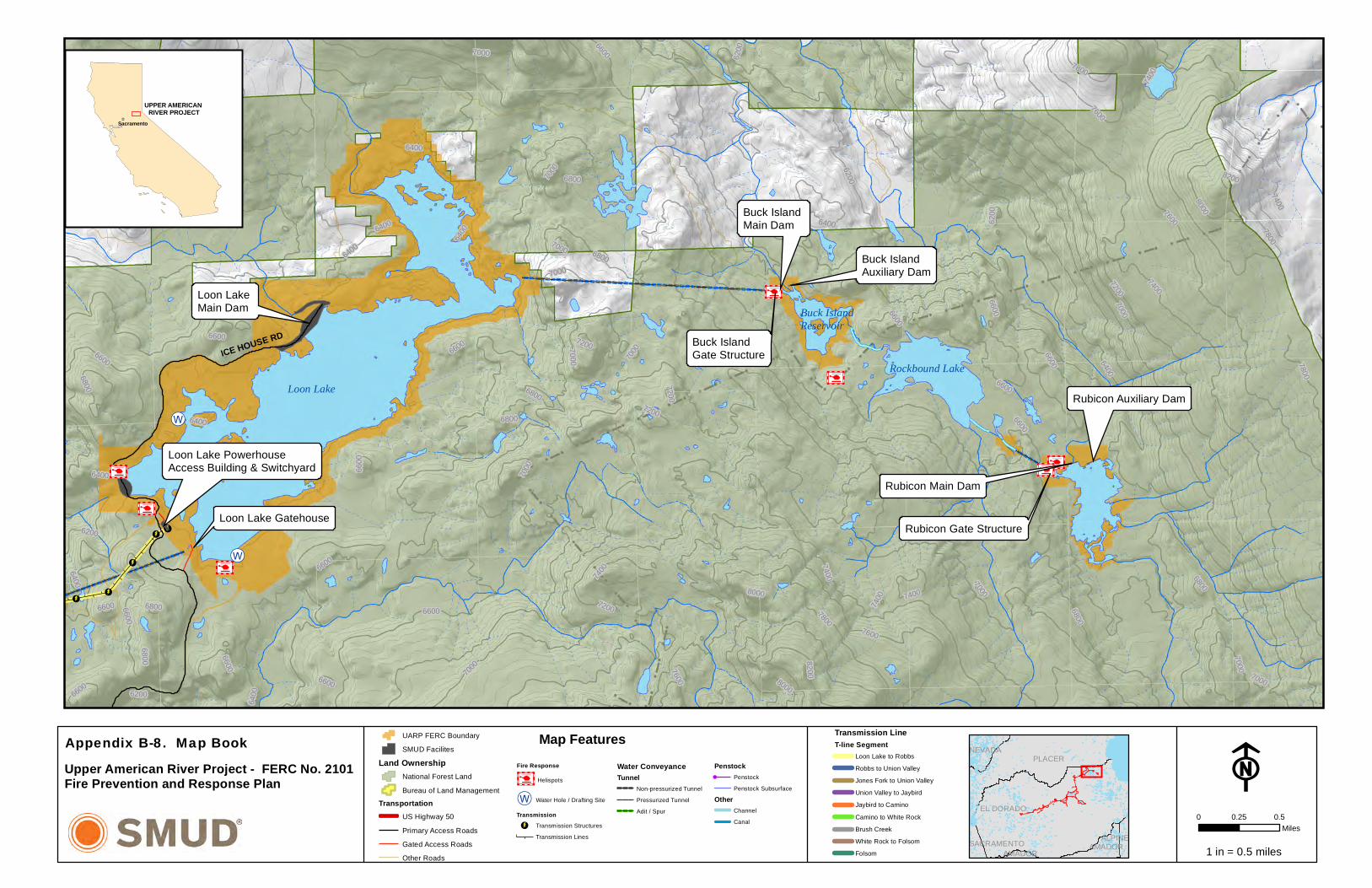
!d !d !d !d!d !d !d!d!d !d !d !d !d!d!d!d!d
!d!d!d!d
!d
!d
!d
!d!d
!d!d
!d!d
!d!d
!d
!d!d
!d!d!d
!d
!d
!d
!d!d!d !d!d!d!d !d!d!d!d!d
!d
!d
!d
!d!d
!d !d!d
!d
!d
!d!d !d!d !d!d !d!d!d !d !d !d!d !d !d !d!d!d!d!d !d !d !d!d!d !d !d!d !d !d !d!d
!d!d !d
!d
!d!d!d!d!d!d!d
!d!d!d!d
!d!d !d!d !d!d !d!d !d!d !d!d !d !d!d !d!d!d !d!d !d!d!d!d !d!d!d !d!d!d!d!d!d!d!d!d !d!d !d!d!d!d!d!d!d!d
!d!d
!d!d!d!d!d !d!d !d !d !d!d !d !d !d !d !d!d !d !d !d !d !d !d !d
!d!d
!d!d
!d!d
!d!d
!d!d
!d!d!d!d!d!d!d
!d!d
!d!d
!d!d
!d!d
!d!d
!d!d
!d!d
!d!d
!d
!d
!d!d
!d!d
!d!d
!d!d!d
!d
!d
!d!d!d
!d!d
!d
!d!d
!d!d
!d
!d!d
!d!d
!d!d
!d
!d
!d
!d!d
!d!d
!d!d
!d!d
!d!d
!d!d
!d!d
!d!d
!d
!d!d
!d!d
!d!d
!d!d
!d
!d!d
!d!d
!d
!d
!d!d
!d
!d!d
!d
!d!d
!d
!d!d
!d!d!d!d!d
!d!d!d
!d
!d!d
!d
!d!d!d
!d
!d!d
!d!d
!d!d
!d !d !d!d
!d !d !d !d!d!d!d !d !d!d!d !d!d!d!d !d!d !d
!d !d !d!d!d !d!d !d !d!d !d!d
!d!d !d!d !d !d !d
!d!d
!d!d
!d!d!d
!d!d !d!d !d !d !d !d !d !d!d !d!d !d !d !d!d!d !d!d!d !d !d!d!d !d !d!d!d !d !d
!d !d !d !d !d!d !d !d !d !d!d !d !d!d!d !d !d !d!d !d!d!d !d !d !d!d !d!d !d!d !d!d !d!d !d!d!d !d!d !d !d !d!d !d!d !d !d!d !d!d
!d!d!d !d !d !d !d !d!d !d!d !d !d!d !d !d !d !d!d !d!d !d !d!d !d !d !d !d !d !d !d !d !d!d !d !d!d !d!d!d!d
!d!d
!d!d!d!d!d !d!d!d !d!d!d!d!d!d!d
!d!d
!d!d!d!d!d
!d!d
!d
!d!d
!d !d!d
!d!d
!d!d
!d!d
!d!d
!d
!d
!d!d
!d!d
!d!d!d
!d!d
!d!d
!d!d
!d!d
!d
!d
!d
!d
!d
!d
!d!d
!d!d
!d!d
!d
!d
!d!d
!d
!d!d!d!d
!d!d
!d!d!d
!d!d!d
!d!d!d
!d!d
!d
!d!d!d
!d!d !d!d!d!d !d !d!d !d !d!d!d !d
!d
!d !d!d!d!d
!d!d
!d
!d!d
!d!d!d!d!d!d
!d!d!d
!d
!d
!d!d
!d
!d
!d
!d
!d
!d!d
!d
!d
!d!d!d!d !d!d !d!d
!d!d !d!d!d
!d!d!d!d
!d!d!d
!d!d!d!d
!d
!d
!d!d
!d!d!d!d!d!d
!d
!d!d!d!d !d!d!d!d
!d!d
!d
!d!d !d
!d!d!d!d
!d
!d!d!d !d!d
!d!d
!d
!d!d !d
!d!d !d
!d
!d!d!d!d
!d!d!d!d !d!d!d
!d
!d!d !d!d!d!d!d!d!d!d
!d
!d !d!d!d
!d!d!d
!d!d!d
!d!d
!d
!d!d!d
!d
!d
!d!d
!d!d
!d!d
!d!d
!d!d
!d
!d!d!d!d !d!d!d !d !d!d!d!d !d!d !d !d !d!d !d!d !d !d!d !d!d!d!d !d
!d
!d!d!d!d !d!d!d!d!d!d !d!d!d !d!d!d!d !d
!d
!d!d!d !d !d!d!d
!d !d!d
!d
!d!d!d !d!d!d !d!d!d !d !d!d!d !d!d
!d
!d !d!d!d !d!d !d!d !d!d
!d
!d !d!d!d!d!d !d
!d!d!d
!d !d
!d!d!d
!d
!d!d
!d
!d
!d!d
!d!d
!d
!d
!d!d
!d!d
!d
!d
!d
!d
!d!d
!d!d
!d
!d
!d
!d
!d!d
!d
!d
!d
!d!d
!d
!d!d!d
!d
!d!d
!d!d
!d
!d!d !d
!d
!d
!d!d!d
!d!d
!d
!d!d!d
!d
!d!d
!d
!d
!d!d
!d
!d
!d!d!d
!d!d
!d!d
!d
!d
!d
!d!d
!d!d
!d!d
!d
!d!d!d!d!d!d
!d
!d!d !d!d!d!d!d!d!d!d
!d!d
!d
!d
!d!d!d
!d!d!d
!d!d!d
!d!d!d
!d!d!d
!d!d!d
!d!d!d
!d!d!d
!d!d!d!d !d !d!d !d!d !d !d!d !d !d
!d
!d!d!d!d
!d!d!d!d!d!d
!d
!d
!d !d!d
!d!d
!d
!d
!d!d !d
!d
!d
!d
!d!d!d
!d
!d
!d!d
!d !d
!d!d
!d !d!d!d!d
!d !d
!d
!d !d!d!d
!d !d
!d!d
!d
!d
!d!d
!d
!d!d!d
!d!d!d
!d!d
!d
!d!d
!d!d !d
!d!d!d
!d !d!d
!d!d!d !d
!d
!d!d!d
!d!d!d!d !d
!d!d
!d
!d!d
!d
!d
!d
!d
!d!d !d
!d!d
!d
!d
!d!d
!d
!d
!d
!d
!d !d
!d!d
!d
!d
!d
!d
!d
!d
!d
!d
!d !d !d !d !d
!d
!d !d!d
!d !d!d!d
!d!d!d!d!d
!d
!d!d!d!d
!d
!d
!d
!d
!d
!d
!d!d
!d
!d
!d
!d !d
!d
!d !d
!d
!d
!d!d
!d
!d
!d
!d!d
!d
!d!d
!d
!d
!d
!d!d
!d
!d
!d
!d!d!d!d
!d
!d!d
!d!d
!d
!d!d!d !d!d !d!d!d !d!d!d
!d
!d
!d
!d!d !d!d !d!d
!d!d
!d
!d
!d
!d!d
!d!d
!d
!d
!d
!d!d
!d!d
!d
!d
!d
!d!d!d!d
!d!d !d
!d
!d !d!d !d !d!d !d!d!d!d
!d
!d !d!d !d!d !d !d!d!d !d
!d
!d!d
!d
!d!d!d
!d!d
!d!d
!d
!d
!d
!d
!d!d
!d
!d!d!d
!d
!d
!d
!d!d!d
!d!d
!d
!d
!d!d!d!d
!d!d
!d !d
!d
!d!d!d!d
!d
!d!d!d
!d!d!d
!d
!d
!d
!d!d
!d!d
!d
!d!d
!d!d
!d
!d!d
!d!d!d
!d
!d
!d
!d
!d!d!d
!d!d
!d!d!d
!d!d
!d
!d
!d
!d
!d!d
!d!d
!d!d
!d!d
!d!d
!d!d
!d
!d !d
!d
!d !d!d
!d!d
!d!d
!d
!d!d
!d
!d!d
!d !d!d !d!d!d !d
!d!d !d!d!d !d!d!d !d!d !d!d !d!d !d
!d !d!d
!d !d!d!d!d !d!d !d!d !d!d!d !d!d!d !d !d
!d
!d
!d!d
!d
!d!d
!d!d
!d !d!d!d!d
!d
!d
!d!d
!d!d
!d
!d!d !d
!d!d!d
!d
!d
!d !d !d !d !d !d!d!d!d
!d !d !d
!d
!d
!d
!d!d !d!d
!d!d
!d!d
!d
!d
!d
!d !d !d!d!d!d!d !d !d !d
!d
!d !d !d !d !d !d !d !d
!d!d
!d!d!d
!d!d
!d!d
!d!d
!d!d
!d!d
!d!d
!d!d!d!d
!d!d!d!d
!d!d
!d
!d!d!d!d
!d
!d
!d
!d
!d
!d
!d
!d
!d
!d
!d
!d
!d
!d
!d
!d
!d
!d!d!d!d!d !d!d !d!d!d!d!d
!d!d !d!d!d!d!d!d !d !d!d!d !d!d
!d!d
!d
!d
!d!d
!d!d
!d
!d
!d
!d!d
!d
!d!d!d
!d!d!d!d !d
!d !d!d !d!d!d!d!d!d
!d!d!d!d!d!d !d!d!d!d!d!d!d!d !d!d!d!d
!d!d!d
!d!d!d
!d!d!d
!d!d
!d!d!d
!d!d
!d!d!d
!d!d!d
!d!d!d!d!d!d!d !d!d!d
!d
!d
!d
!d
!d
!d
!d
!d
!d
!d
!d
!d
!d
!d
!d!d!d
!d
!d!d
!d
!d!d
!d!d
!d!d!d
!d
!d!d!d
!d !d!d
!d
!d
!d
!d
!d
!d
!d
!d
!d
!d
!d
!d
!d
!d
!d
!d
!d
!d
!d
!d!d
!d
!d
!d
!d
!d
!d
!d
!d!d
!d !d!d
!d !d!d
!d
!d!d!d
!d
!d!d!d
!d
!d
!d!d!d
!d!d!d
!d!d !d !d
!d !d
!d!d!d!d!d
!d!d!d!d
!d!d!d!d!d!d!d!d!d!d!d!d!d!d!d!d!d!d!d!d!d!d!d!d!d!d!d!d!d!d!d!d!d!d!d!d!d!d!d
!d!d!d!d!d!d!d!d
!d!d!d!d!d!d!d!d!d!d
!d!d!d!d!d!d!d!d!d!d!d!d!d!d!d!d!d!d!d!d!d!d!d!d!d!d!d!d!d!d!d!d!d!d!d!d!d!d!d!d!d!d!d!d!d!d!d!d!d!d!d!d!d!d!d!d!d!d!d!d
!d!d!d!d!d!d!d!d!d!d!d!d!d!d!d!d!d!d!d!d!d!d!d!d!d
!d
!d!d!d!d!d
!d
!d
!d
!d!d
ÑØ
ÑØ
ÑØ
ÑØ
ÑØ
ÑØ
ÑØ
ÑØ
ÑØ
ÑØ
ÑØ
ÑØ
ÑØ
ÑØ
ÑØ
ÑØ
ÑØ
ÑØ
ÑØ
ÑØ
ÑØ
ÑØ
ÑØ
ÑØ
ÑØ
ÑØ
ÑØ
ÑØ ÑØ
ÑØ
ÑØ
ÑØÑØ
ÑØ
ÑØ
ÑØ
ÑØ
ÑØ
ÑØ
ÑØ
ÑØ
ÑØÑØ
ÑØ
ÑØ
ÑØ
ÑØ
ÑØ
ÑØ
ÑØ
ÑØÑØ
ÑØÑØ ÑØ
ÑØÑØ
ÑØ
ÑØ
ÑØ
ÑØ
ÑØ ÑØ
ÑØ
ÑØ
ÑØ
ÑØ
ÑØÑØ
ÑØ ÑØ
ÑØ
ÑØ
ÑØ
ÑØ
ÑØ
ÑØ
ÑØ
ÑØ
ÑØ
ÑØ
ÑØ
ÑØ
ÑØ
ÑØ ÑØ
ÑØ
ÑØ
ÑØ
ÑØ
ÑØ
ÑØ
ÑØ
ÑØ
ÑØ
ÑØ
ÑØÑØ
ÑØ
ÑØ
ÑØ
ÑØ
ÑØ
ÑØ
ÑØ
ÑØ
ÑØ
ÑØ
ÑØ
ÑØ
ÑØ
ÑØ
ÑØ
ÑØ
ÑØ
ÑØ
ÑØ
ÑØ ÑØ
ÑØ
ÑØ
ÑØ
ÑØ
ÑØÑØ
ÑØ
ÑØ
ÑØ
ÑØ
ÑØ
ÑØ
ÑØ
ÑØ
ÑØ
ÑØ
ÑØ
ÑØ
ÑØ
ÑØ
ÑØ
ÑØ
ÑØ
ÑØ
ÑØ
ÑØ
ÑØ
ÑØ
ÑØ
ÑØ
ÑØ
ÑØ
ÑØ
ÑØ
ÑØ
ÑØ
ÑØ
ÑØ
ÑØ
ÑØ
ÑØ
ÑØ
ÑØ
ÑØ
ÑØ
ÑØ
ÑØÑØ
ÑØ
ÑØ
ÑØ
ÑØ
ÑØ
ÑØ
ÑØ
ÑØ
ÑØ
ÑØ
ÑØ
ÑØ
ÑØ
ÑØ
ÑØ
ÑØ
ÑØ
ÑØ
ÑØ
ÑØ
ÑØ
ÑØ
ÑØ
ÑØ
ÑØ
ÑØ
ÑØ
ÑØ
ÑØ
ÑØ
ÑØ
ÑØÑØ
ÑØ
ÑØ
ÑØ
ÑØ
¥i¤
¥i¤
¥i¤
¥i¤¥i¤
¥i¤
¥i¤
Loon LakeRockbound Lake
Buck IslandReservoir
Loon Lake Main Dam
Loon Lake PowerhouseAccess Building & Switchyard
Rubicon Main Dam
Buck Island Auxiliary Dam
Loon Lake Gatehouse
Rubicon Auxiliary Dam
Buck Island Main Dam
Rubicon Gate Structure
Buck Island Gate Structure
6800
7200
7000
7400
6600
6200
6400
7600
7800
8000
8200
7000
6800
6600
6400
6800
7000
7400
6800
7400
6800
6600
6400
6200
7400
6600
6800
6200
6400
6400
6800
7200
7200
6200
74007000
6800
6600640
0
7800
6600
7000
6800
6800
7800
7600
82007000
6600
6600
7000
6600
7000
6600
7000
7000
6400
6600
6800
6200
6800
8000
7800
80006200
6400
7200
7000
7400
7600
6600
6400
7000
7000
6600
6400
6600
72006600
6600
6400
7000
7000
7400
6600
7200
7600
ICE HOUSE RD
FUARP FERC BoundarySMUD Facilites
Land OwnershipNational Forest LandBureau of Land Management
TransportationUS Highway 50Primary Access RoadsGated Access RoadsOther Roads
UPPER AMERICAN RIVER PROJECT
_Sacramento
1 in = 0.5 miles
Map Features
0 0.50.25Miles
Transmission LineT-line Segment
Loon Lake to RobbsRobbs to Union ValleyJones Fork to Union ValleyUnion Valley to JaybirdJaybird to CaminoCamino to White RockBrush CreekWhite Rock to FolsomFolsom
Appendix B-8. Map BookUpper American River Project - FERC No. 2101Fire Prevention and Response Plan
EL DORADO
PLACERNEVADA
AMADORALPINESACRAMENTO
AMADOR
Fire Response
¥i¤ Helispots
ÑØ Water Hole / Drafting Site
Transmission!d Transmission Structures
Transmission Lines
Water ConveyanceTunnel
Non-pressurized TunnelPressurized TunnelAdit / Spur
Penstock! Penstock
Penstock SubsurfaceOther
ChannelCanal

Slab Creek Reservoir
Silver C
ree
k12N56
12N34
ELD-60
12N59
11N80
12N57
11NY05
11N63
12N60B
12N76
12N53
12N58
11N88
12N19
11N93
11NY25
11NY20
12N74
12N54
11N85
11N70
12NY23
12N34G
11N64
12N70
12NY27
12N56B
11N12
11N12A
12N60H
12N59D
11NY23
11N78
12N60D
12N43
12N61
11NY22
11N63A
12N54D
12N74A
11N97
12N75
11N80A
12N59A
12N54A
11NY25A
12N34L
12N57D
11NY26
12N59E
12N57C
11N63G
12N60C
12NY27A
12N56D
12N56G
12N60J
12N56F
11N63B
12N56E
11N80B
11NY19
12N54C
11NY23A
12N57F
12N54B
11N63H
12N59B
11N89
12N43B
12N43A
11N93B
12N60G
12N69
11NY20B
12N60K
12N70
Sources: Esri, HERE, DeLorme, TomTom, Intermap, increment P Corp., GEBCO, USGS, FAO, NPS, NRCAN, GeoBase, IGN, Kadaster NL, OrdnanceSurvey, Esri Japan, METI, Esri China (Hong Kong), swisstopo, MapmyIndia, © OpenStreetMap contributors, and the GIS User Community
FRoads Open to All Vehicles, YearlongRoads Open to All Vehicles, SeasonalRoads Open to HWY Legal Vehicles, YearlongRoads Open to HWY Legal Vehicles, SeasonalState or US HWYOther Public RoadsAlternate Route
UPPER AMERICAN RIVER PROJECT
_Sacramento
1 in = 0.6 miles
Notes:
1:36,000
D e s o l a t i o n Wi l d e r n e s s
D e s o l a t i o n Wi l d e r n e s s
Map FeaturesSee SMUD's Hydro Safety Procedure Manual, Hazard Control, Alternate Access Roads From the UARP. No. HSP-5-22
Camino Powerhouse
Proceed south on Mosquito Road
From Forebay Road (12N34), turn left and proceed west onforest road12N57; continue until intersection with 11N80 - proceedon 11N80 to Mosquito Road.
Appendix B-9. Map BookUpper American River Project - FERC No. 2101Fire Prevention and Response Plan
EL DORADO
PLACER

! ! ! ! !
!
!
!
!
!
!
!
!
!
!
!
!
!
!
!
!
!
!
!
!
!
!!
!
!
!
!
!!
!
!
!
!
!!
!
!
!
!
!
!
!
!!
!!
!
!
!
!
!!
!
!
!
!
!
!!
!!
!!
!
!
!
!
!
!
!
!
!
!
!
!
!
!!
!
! !
!
!
!
!
!
! !
!
!
!
!
!
!
!
!
!
!
!
!
!
!!
!
!
!
!
!!
!
!
!!
!!
!!
!
!
!
!
!!!!!
!
!
!
!
!
!
!
!
!
!
!
!
!
!
!
!
! !
!
!
!
!
!
! !!
!
!
!
!!
!!
!
!
!
!
!
!
!
!
!!
!!
!
!!
!
!
! !
!
!!
!!
!
!!
! ! !
!
!
!
!
!
!
!
!
!
!
!
!
!
!
!
!
!
!
!
!
!
!
!
!
!
!
!!
!
!
!!!
!!
!!
!!
!!
!!
!
!
!
!!
!
!!
!!
!
!!!!!!!!
!!
!!
!!
!!
!
!
!
!
!
!
!
!
!
!
!
!
!
!
!
!
!
!
!
!
!
!
!
!
!
!
!
!
!!
!
!
!
!
! !
!
!
!
!
!
!
!
!
!!
!
!
!
!
!
!
!
!
!
!
!
!
!
!
!
!
!
!
!
!
!
!!
!!
!!
!!
!!
!!
!!
!!
!!
!!
!
!!
!
!
!
!
!
!
!
!
!
!
!
!
!
!
!
!
!
!
!
!
!
!
!
!
!
!
!
!
!
!
!
!
!
!
!
!
!
!
!
!
!
!
!
!
!
!
!
!
!!
!
!
!
!
!
!
!
!
!
!
!!
Granite Springs Road - 11N99
Wrights Tie Road - 11N37
£¤50
Wrights Lake Road - 11N26Eastern Route to Wrights LakeVia Granite Springs Road
Eastern Route to Wrights LakeVia Wrights Tie Road
Wrights Lake
Ice House Road
Ice House Reservoir
Turn right and proceed southon Wrights Lake Road to HWY 50.
11N99
11N37
11N26
11N41
ELD-147
11N28
US-50E11N38
11N49
11N52
11N29
11N34
12N25B
11N45
11NY24
11N37B
12N40
11N42
11N26E
11N39
12N25
12N28A
11NY28
11N58
11N38E
12NY0
6
12N62
11N37G
11N28E
11N41A
12N23
11N37F
11N29A
11N49A
12N25A
11N99A
11N34A
11N26A
12N28
11N28B
11N52A
12N99
12NY0
6A
11N26C
17N12C
12N99A
11N99C
11N28A
11NY14
A
11N99F1
11N38J
11N49D
11N98
11N38G
11N99F
12NY05B
11N99E
11N26B
11N42D
11N34B
12NY06B
11N38C
11N37H
11N31
11N38B 11NY37
11N37FA
11N42A
12N25C
11N26EN
11N26CN
11N99B
11NY27
11N29C
12N62A
12NY05
11N38A
11NY2
7A
11N37C
11N99D
12N25E
12NY0
5A
11NY24B
12N25D
11N29B
11N37GW
17N12U
11NY24C
11N98B
12N21
12N62C
12N40A
12N24A
11N38D
11N37F
B
11NY24A
12N2411N26D
12N21A
11N42C
11N99A
A
11N41AS
11N37D
11N37A
12N99C
11NY28A11N99H
11N37HC
11N99BS
11N42DE
11N99J
12N99B
11N39A
12N26 12N23A
11N41B
11N37K
11N37J
11N37HA 11N52B
Sources: Esri, HERE, DeLorme, TomTom, Intermap, increment P Corp., GEBCO, USGS, FAO, NPS, NRCAN, GeoBase, IGN, Kadaster NL, OrdnanceSurvey, Esri Japan, METI, Esri China (Hong Kong), swisstopo, MapmyIndia, © OpenStreetMap contributors, and the GIS User Community
FRoads Open to All Vehicles, YearlongRoads Open to All Vehicles, SeasonalRoads Open to HWY Legal Vehicles, YearlongRoads Open to HWY Legal Vehicles, SeasonalState or US HWYOther Public RoadsAlternate Route
UPPER AMERICAN RIVER PROJECT
_Sacramento
1 in = 0.6 miles
Notes:Map Features
1:40,000
See SMUD's Hydro Safety Procedure Manual, Hazard Control, Alternate Access Roads From the UARP. No. HSP-5-22
EL DORADO
PLACERAppendix B-10. Map BookUpper American River Project - FERC No. 2101Fire Prevention and Response Plan

Alternate RouteAround Union Valley - Northwest12N78 to 12N52 to 12N30. 12N30leads back to Peavine Ridge and Ice House
Alternate RouteFollow Bryant Springs Road North to Peavine RidgeHead east on Peavine to Ice House Road.
Union Valley Reservoir
12N30
12N52
ELD-147 12N28
12N68
12N20
12N78
12N35
12N21
12N42
12N36
12N32A
12N28A
17N12P
12NY06
13N12
12N28G
12N35A
12N62
12NY04
17N12L
12N32
12NY17
12N30G
12N21B
13N13
12N52D
12N28B
12N3312N30A
12N52C
11N37
12N44
17N12N
12N30D
17N12X
12N30J
12N28C
12N21A
11N58
12NY05B
17N12Q
12N45
12NY05A
12N30E
17N12H
13N12A
12NY32
12N62A
12NY05
12NY06A
11N37C
12N52CC
12N30F
12N28E12N28D
12N68G
12N30JE
12N36A
12N28CN
12N30M
12N62C
13N12B
13N12C
12N52C
B12NY06B
12N30K
12N35A
B
12N35F
12N36D
12N36B
13N13C
12N33B
12N30B
12N28H
12NY3
2A
12N32F
12N30N
12N78A
17N12R
12N77
17N12T
12N68H
12N21C
12N35H
17N12N
B
12N35I
12NY17A
12N26
12N35B
12N30P
12N35E
12N35D
17N12S
12NY04
B
12N30R
12N52C
A
12N35G
17N12Q
B
17NY1
2D
Sources: Esri, HERE, DeLorme, TomTom, Intermap, increment P Corp., GEBCO, USGS, FAO, NPS, NRCAN, GeoBase, IGN, Kadaster NL, OrdnanceSurvey, Esri Japan, METI, Esri China (Hong Kong), swisstopo, MapmyIndia, © OpenStreetMap contributors, and the GIS User Community
FRoads Open to All Vehicles, YearlongRoads Open to All Vehicles, SeasonalRoads Open to HWY Legal Vehicles, YearlongRoads Open to HWY Legal Vehicles, SeasonalState or US HWYOther Public RoadsAlternate Route
UPPER AMERICAN RIVER PROJECT
_Sacramento
1 in = 0.6 miles
Notes:Map Features
1:36,000
PLACER
EL DORADO
PLACER
D e s o l a t i o n Wi l d e r n e s s
D e s o l a t i o n Wi l d e r n e s s
IceHouse Road
See SMUD's Hydro Safety Procedure Manual, Hazard Control, Alternate Access Roads From the UARP. No. HSP-5-22
Appendix B-11. Map BookUpper American River Project - FERC No. 2101Fire Prevention and Response Plan

Wentworth Springs Road
Follow to Georgetown
If Ice House Road is blocked to the South, preventing access to Highway 50,proceed west on Wentorth Springs.
Ice House Road
Loon Lake
Loon Lake Auxiliary Dam
Gerle Creek Dam
Loon Lake Powerhouse Access Building & Switchyard
Robbs Peak Dam
Loon Lake Gatehouse
ELD-14
7 13N22
13N28
ELD-63
13N31
13N25
13N22C
13N11
13N69
13N4313N86
13N34
12NY31
13N22A
14N11
13N71
17N12
13NY02
13N84
13N24
13N19A
13N25B
13N20
13N72
13N76
12NY30
ELD-147F
13N72A
13N22C
C
13N28G
13N44
14N20
13N26
13N29A
13N85
13N22T
13N31A
13N61
13N11C
13N52
13N69B14N
11C
12N29B
13N23
13N75
13N21
13N98
13N57
13N22H
17N12K
13N22P
13N28K
13N90
13N28A
13N34A
13N17
13N43B
13N69C
13N86A
13N76A
17N12Z
13N72B
13N22AB
17N12V
13N22E
14N01D
13N11A
13N14
13N61B
13N28D
13N20A
13N29C
13N28L
13N22CB
13N70
13N72AN
12N29J
13N22R
13N23A
13N86B
13N22M
13N11B
13N22A
B1
12N29Q
14N11B
13N31AN
13N25A
13N69E
13N44B
13N28G
1
13N44A
13N69A
13N26B
13N69D
13N28M
14N11D
13N44C17NY12K
13N14A
13N22C
A
13N61C
13N22U
13N43C
13N28B
12N29C
13N28G
2
17N12D14N01E
13N22S
13N22C
B1
13N17A
14N01A
ELD-63
13N31
Sources: Esri, HERE, DeLorme, TomTom, Intermap, increment P Corp., GEBCO, USGS, FAO, NPS, NRCAN, GeoBase, IGN, Kadaster NL, OrdnanceSurvey, Esri Japan, METI, Esri China (Hong Kong), swisstopo, MapmyIndia, © OpenStreetMap contributors, and the GIS User Community
FRoads Open to All Vehicles, YearlongRoads Open to All Vehicles, SeasonalRoads Open to HWY Legal Vehicles, YearlongRoads Open to HWY Legal Vehicles, SeasonalState or US HWYOther Public RoadsAlternate Route
UPPER AMERICAN RIVER PROJECT
_Sacramento
1 in = 0.6 miles
Notes:Map Features
1:36,000
D e s o l a t i o n Wi l d e r n e s s
D e s o l a t i o n Wi l d e r n e s s
See SMUD's Hydro Safety Procedure Manual, Hazard Control, Alternate Access Roads From the UARP. No. HSP-5-22
Appendix B-12. Map BookUpper American River Project - FERC No. 2101Fire Prevention and Response Plan
EL DORADO
PLACER

Fire Prevention and Response Plan June 2015
Sacramento Municipal Utility District Upper American River Project Appendix C-1 FERC Project No. 2101
APPENDIX C
SMUD HOT WORK STANDARD
Appendix C.pdf
Hot Work Permit.pdf
apercy
Rectangle

NO: 10-04
SMUD HEALTH AND SAFETY STANDARDS
SECTION SMUD FIRE PROTECTION
OPERATIONAL REQUIREMENTS
SUBJECT
HOT WORK STANDARD
EFFECTIVE DATE
4/23/2013 REVISION NUMBER
REVISION DATE
APPROVED BY
Angie Robinson PAGE PAGE 1 OF 5
1.0 PURPOSE
To establish a SMUD standard that clarifies various portions of the California Fire Code as they pertain to hot work operations.
2.0 SCOPE
Applicable to all SMUD personnel or contractors performing hot work operations on SMUD property.
3.0 DEFINITIONS
3.1 Designated Hot Work Area: An area preapproved for ongoing hot work activities. Hot work designated areas are not required to have fire department permits, but shall still meet the requirements of this standard.
3.2 Hot Work: Operations including cutting, welding, Thermit welding, brazing, soldering, grinding, thermal spraying, thawing pipe, installation of torch-applied roof systems or any other similar activity.
3.3 Hot Work Area: The area exposed to sparks, hot slag, radiant heat, or convective heat as a result of the hot work. This area extends a minimum of 35 feet from the area hot work is being conducted.
3.4 Fire Watch: A temporary measure intended to ensure continuous and systematic surveillance of a building or area by one or more qualified individuals for the purposes of identifying and controlling fire hazards, detecting early signs of unwanted fire, raising an alarm of fire and notifying the fire department.
4.0 RESPONSIBILITIES
4.1 Fire Protection and Loss Control: Responsible for the administration of the Hot Work program and serves as a subject matter expert in fire safety considerations as they pertain to hot work.
4.2 Permit Authorizing Individual (PAI): A person who is capable of recognizing
fire safety considerations as they pertain to hot work. Responsible for

NO: 10-04
SMUD HEALTH AND SAFETY STANDARDS
SECTION SMUD FIRE PROTECTION
OPERATIONAL REQUIREMENTS
SUBJECT
HOT WORK STANDARD
EFFECTIVE DATE
4/23/2013 REVISION NUMBER
REVISION DATE
APPROVED BY
Angie Robinson PAGE PAGE 2 OF 5
conducting a pre-hot work check, filling out a Hot Work permit, and following up as the job progresses.
4.3 Fire Watch Personnel: Responsible for having fire-extinguishing equipment readily available and possess knowledge regarding operation, monitor the hot-work area, stop hot work operations if conditions become unsafe, extinguish spot fires when within the capacity of the fire extinguishing equipment, and sound the alarm in the event of a fire. The person performing the fire watch cannot perform any other duties.
5.0 PROGRAM SPECIFICATIONS
5.1 Pre-hotwork check A pre-hot-work check shall be conducted prior to work to ensure that all equipment is safe and hazards are recognized and protected. A report of the check (hot work permit) shall be kept at the work site during the work and available upon request. The pre-hot-work check shall determine all of the following:
Hot work equipment to be used shall be in satisfactory operating condition and in good repair.
Hot work site is clear of combustibles for 35 feet or combustibles are protected.
Exposed construction is of noncombustible materials or, if combustible, then protected.
Openings are protected. Floors are kept clean. No exposed combustibles are located on the opposite side of partitions,
walls, ceilings or floors. Fire watches, where required, are assigned. Actions have been taken to prevent accidental activation of
suppression and detection equipment. Fire extinguishers and fire hoses (where provided) are operable and
available.
5.2 Protection of combustibles Hot work areas shall not contain combustibles or shall be provided with appropriate shielding to prevent sparks, slag or heat from igniting exposed combustibles.
5.2.1 Openings Openings or cracks in walls, floors, ducts or shafts within the
hot work area shall be tightly covered to prevent the passage of sparks to adjacent combustible areas, or shielded by metal fire-resistant

NO: 10-04
SMUD HEALTH AND SAFETY STANDARDS
SECTION SMUD FIRE PROTECTION
OPERATIONAL REQUIREMENTS
SUBJECT
HOT WORK STANDARD
EFFECTIVE DATE
4/23/2013 REVISION NUMBER
REVISION DATE
APPROVED BY
Angie Robinson PAGE PAGE 3 OF 5
guards, or fire curtains shall be provided to prevent passage of sparks or slag.
5.2.2 Housekeeping Floors shall be kept clean within the hot work area.
5.2.3 Conveyor systems Conveyor systems, such as ventilation systems, that
are capable of carrying sparks to distant combustibles shall be shielded or shut down.
5.2.4 Partitions Partitions segregating hot work areas from other areas of the building shall be noncombustible. In fixed hot work areas, the partitions shall be securely connected to the floor such that no gap exists between the floor and the partition. Partitions shall prevent the passage of sparks, slag, and heat from the hot work area.
5.2.5 Floors Fixed hot work areas shall have floors with noncombustible
surfaces.
5.2.6 Sprinkler protection Automatic sprinkler protection shall not be shut off while hot work is performed. Where hot work is performed close to automatic sprinklers, noncombustible barriers or damp cloth guards shall shield the individual sprinkler heads and shall be removed when the work is completed or at the end of each workday.
5.2.7 Fire detection systems Special precautions shall be taken to avoid
accidental operation of automatic fire detection systems and methods shall be approved by Fire Protection and Loss Control.
5.3 Fire Watch A fire watch shall be provided during hot work activities and shall continue for a minimum of 30 minutes after the conclusion of the work unless the hot work area has no fire hazards or combustible exposures.
5.3.1 Location The fire watch shall include the entire hot work area. Hot work conducted in areas with vertical or horizontal fire exposures that are not observable by a single individual shall have additional personnel assigned to fire watches to ensure that exposed areas are monitored.

NO: 10-04
SMUD HEALTH AND SAFETY STANDARDS
SECTION SMUD FIRE PROTECTION
OPERATIONAL REQUIREMENTS
SUBJECT
HOT WORK STANDARD
EFFECTIVE DATE
4/23/2013 REVISION NUMBER
REVISION DATE
APPROVED BY
Angie Robinson PAGE PAGE 4 OF 5
5.3.2 Fire extinguisher A minimum of one portable fire extinguisher, with a minimum rating of 2-A 20-B:C shall be readily accessible within 30 feet of the location where hot work is performed.
6.0 REFERENCES
California Code of Regulations Title 24 Part 9, California Fire Code, current adopted edition NFPA 51B, Fire Prevention During Welding, Cutting, and Other Hot Work, 2009 edition
7.0 ATTACHMENT
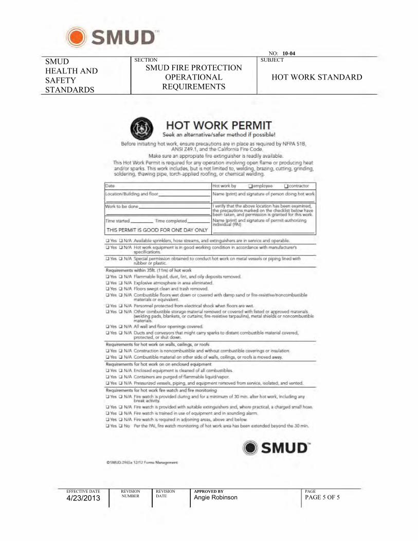
NO: 10-04
SMUD HEALTH AND SAFETY STANDARDS
SECTION SMUD FIRE PROTECTION
OPERATIONAL REQUIREMENTS
SUBJECT
HOT WORK STANDARD
EFFECTIVE DATE
4/23/2013 REVISION NUMBER
REVISION DATE
APPROVED BY
Angie Robinson PAGE PAGE 5 OF 5
• C
::J ~
(/)
.U
1IH
I
" ~
~ 1
Jl 1
i'
' 11 l
Q
~!hfm~' h JIhlJ 1 ~ III
f!] I ~ !~l •
w H
" ~
1 IP
iI 1 1 ,i{
1 f 1 j
I i IJ j "-!:~r .~ p i~H
j" 1 t
j If j
11 ~ 1 ~ 1 Ii gl hfnt I! -d!~>d]
lot HJ i it ittr! till
:::li.~,~,i ~1ifi
fll1l1!lih~IHtPtP' H
'.l']i ~
l' 11
11 j l'
It d~ J.!lll h
l( ~l i~; lh
J ~ n 1 d'i1i 11 fj HJ 111 HnI Hh
• "H
! ~ H
ltntu~ ft Jl i .,I,!,lJllH
J
Or iliI ~
~ nhmdJillnBiHHHlHfHH j
~lIf f ~ 1 ~ ~~ ~ l~H~
H
~~ 1~~ 1~~~ 1~ ~~~~ _l'
II I
~
00
IJ
DO
DD
D
O
IJIJ
IJ
IJ
DO
D
IJ IJ
OIJ
IJ
.t .. !~II;;;;;;;
;;
';;;;;
';;;;;
.E......!:. IJ
IJ
0 «
DO
DO
0
0
IJIJ
"I:]O
"O
OIJ
"I:]
1:]0
01
:]
I ! , I

Fire Prevention and Response Plan June 2015
Sacramento Municipal Utility District Upper American River Project Appendix D-1 FERC Project No. 2101
APPENDIX D
FIRE PLAN FOR SPECIAL USE PERMITS, ELDORADO NATIONAL FOREST

Fire Prevention and Response Plan June 2015
Sacramento Municipal Utility District Upper American River Project Appendix D-2 FERC Project No. 2101
FIRE PLAN FOR SPECIAL USE PERMITS
_____________ RANGER DISTRICT
ELDORADO NATIONAL FOREST
Version: 04-01-2006
(Ref: FSM 5121.3)
PERMITTEE/AGENT:
PROJECT NAME:
PROJECT LOCATION (include legal description, map):
State Response Area (SRA) OR Forest Service Response Area (FSRA)
1. SCOPE:
The provisions set forth below outline the responsibility for fire prevention and suppression activities and establish a suppression plan for fires within the permit area. The permit area is delineated by map in the permit or further defined above. The provisions set forth below also specify conditions under which permitted activities will be curtailed or shut down.
2. RESPONSIBILITIES:
A. Permittee
(1) Shall abide by the requirements of this Fire Plan.
(2) Shall take all steps necessary to prevent his/her employees, subcontractors and their employees from setting fires not required in operation of the permit, shall be responsible for preventing the escape of fires set directly or indirectly as a result of permitted operations, and shall extinguish all such fires which may escape.
(3) Shall complete the Permittee's Plan Regarding Personnel, Equipment and Organization (6.B.) and shall furnish the District Ranger (DR) or their designated representative with a copy prior to commencing work at the site. Shall currently advise the DR of any changes in personnel, equipment and organization as the changes occur. Shall revise Section 6.B. to reflect current activities upon request of the DR or their designated representative.
B. Forest Service
The Forest Service may conduct one or more inspections for compliance with the fire plan. The number, timing, and scope of such inspections will be at the discretion of agency employees responsible for permit administration. Such inspections do not relieve the permittee of responsibility for correcting violations of the fire plan or for fire safety in general, as outlined in paragraph 2.A. above.
3. TOOLS AND EQUIPMENT:
A. The permittee shall comply with the following requirements during the fire precautionary period as defined by unit administering the permit unless waived in writing:
The Fire Precautionary Period is ___________________ to ____________________.

Fire Prevention and Response Plan June 2015
Sacramento Municipal Utility District Upper American River Project Appendix D-3 FERC Project No. 2101
Shall equip all diesel and/or gasoline-operated engines, both stationary and mobile, and all flues used in any project and camp operations with spark arresters that meet Forest Service standards set forth in the National Coordinating Group publication for Multiposition Small Engines, #430-1, or General Purpose and Locomotive, #430-2. Spark arresters are not required on equipment powered by exhaust-driven turbo-charged engines or motor vehicles equipped with a maintained muffler as defined in California Public Resources Code (CPRC), Section 4442 and 4443.
Shall furnish and have available for emergency use on each piece of equipment used in conjunction with performance of the work as listed below, hand tools and/or equipment as follows (CPRC 4427, 4428 and 4431):
(1) One shovel, one axe (or pulaski) and a fully charged fire extinguisher U.L. rated at 2-A:10-B:C, or larger, on each truck, personnel vehicle, tractor, grader and other heavy equipment.
Permittee shall equip each mechanized harvesting machine with hydraulic systems, powered by an internal combustion engine (chipper, feller/buncher, harvester, forwarder, stroke delimber, etc), except tractors and skidders, with at least two 4A:80 B-C fire extinguishers, or equivalent. In addition, concentrations of wood dust and debris shall be removed from such equipment daily.
(2) One shovel and one backpack 5 gallon water-filled tank with pump with each welder.
(3) One shovel and one pressurized chemical fire extinguisher for each gasoline-powered tool, including but not restricted to chain saws, soil augers, rock drills, etc. Fire extinguishers shall be of the type and size set forth in the California Public Resources Code Section 4431. Shovel must be kept within 100 feet from each chain saw when used off cleared landing areas.
(4) The permittee is is not required to furnish a sealed box of firefighting tools, to be located at each operating area, at a point accessible in the event of fire. This box shall contain:
_______ 5-gallon, backpack pump-type fire extinguisher filled with water;
_______ axes;
_______ McCleod fire tools;
______ serviceable chain saw of three and one-half or more horsepower with a cutting bar 20 inches in length or longer;
_______ shovels so that each employee at the operation can be equipped to fight fire.
The box shall remain unlocked, but be sealed with a Forest Service seal to be broken for emergency use only.
All tools and equipment required above shall be in good workable condition and shall meet the following principle Forest Service specifications for fire tools:
(a) Shovels shall be size "O" or larger and be not less than 46 inches in overall length.
(b) Axes (or pulaskis) shall have 2-1/2 pound or larger heads and be not less than 28 inches in overall length.
(5) The permittee is is not required to furnish a water tank truck or trailer on or in proximity to the project area during the Fire Precautionary period and meet the following

Fire Prevention and Response Plan June 2015
Sacramento Municipal Utility District Upper American River Project Appendix D-4 FERC Project No. 2101
minimum specifications: contain at least 300 gallons of water; a combination straight stream-fog nozzle with 300 feet of one-inch fire hose, with no segment longer than 50 feet; fire hose with nozzle closed shall be capable of withstanding 200 psi pump pressure without leaking, slipping of couplings, distortions, or other failures; nozzle discharge rating of six to 20 gallons per minute; a pump capable of delivering 23 gallons per minute at 175 pounds psi at sea level; power unit for pump shall have fuel for at least two hours operation, with ample transport available for immediate and safe movement of tank over roads serving the project area; and shall be in good working order; pump outlet shall be equipped with 1-1/2 inch National Standard Fire Hose thread.
Shall furnish two tractor headlights for each tractor dozer, tractor headlights shall be attachable to each tractor and served by an adequate power source.
B. Any additional fire plan requirements:
________________________________________________________________________________________________________________________________________________________________________________________________________________________________________________________________________________________________________________________________________________________________________________________________________________________________________________________________________________________________________________________________________________________________________________________________________________________________________________________________________________________________________________________________________________________________________________________________
4. GENERAL
A. State Law. The permittee shall comply with all applicable laws of the State of California. In particular, see California Public Resource Codes.
B. Permits Required. The Permittee must secure a special written permit from the District Ranger or designated representative before engaging in any of the activities listed below. The terms and conditions of any of the permits required for this project are as shown on copies attached to the Fire Plan.
(1) Blasting and Storage of Explosives and Detonators. (Explosives Permit required by California Health & Safety Code, Section 12101.)
(2) Burning.
(3) Air Pollution. (Issued by local State or County Air Pollution Control Districts, as applicable.)
(4) Camp, Lunch and Warming Fires.
(5) Welding and Cutting.
C. Regulations for Burning. Before setting any fires whatsoever, the permittee shall notify the DR of his/her intentions. Special care shall be taken to prevent scorching or causing any damage to adjacent structures, trees, and shrubbery. Piles of material to be burned shall be of such size and so placed that during burning no damage shall result to adjacent objects.
D. Smoking and Fire Rules. Smoking shall not be permitted during fire season, except in a barren area or in an area cleared to mineral soil at least three feet in diameter (CPRC 4423.4). In areas closed to smoking, the DR may approve special areas to be used for smoking. Designated smoking areas shall be

Fire Prevention and Response Plan June 2015
Sacramento Municipal Utility District Upper American River Project Appendix D-5 FERC Project No. 2101
signed by the permittee. Permittee shall post signs regarding smoking and fire rules in conspicuous places for all employees to see. Permittee's supervisory personnel shall require compliance with these rules. Under no circumstances shall smoking be permitted during fire season while employees are operating light or heavy equipment, or walking or working in grass and woodlands.
E. Storage and Parking Areas. Equipment service areas, parking areas, and gas and oil storage areas shall be cleared of all flammable material for a radius of at least 10 feet unless otherwise specified by local administrative unit. Small mobile or stationary engine sites shall be cleared of flammable material for a slope distance of at least 10 feet from such engine. The DR or their designated respresentative shall approve such sites in writing.
F. Welding. Permittee shall confine welding activity to cleared areas having a minimum radius of ten feet measured from place of welding.
G. Blasting. Permittee shall use electric caps only. When blasting is necessary in slash areas, a watchperson equipped with shovel and a water-filled backpack can (5 gallon), with hand pump, shall remain in the immediate area for an hour after blasting has been completed.
H. Oil Filter and Glass Jugs. Permittee shall remove from National Forest land all oily rags and used oil filters. Permittee shall prohibit use of glass bottles and jugs on project operations.
I. Reporting Fires. As soon as feasible, after initial control action is taken, within 1 hr, the permittee shall notify Forest Service of any fires along roads or project area within permit area.
J. Communications. Permittee shall furnish an agreed upon communications system connecting each operation with the designated Forest Service Dispatch Center. The communications system shall be capable of contacting the designated Forest Service Dispatch Center within five (5) minutes of discovery of a fire in the permittee’s operating area. The communications system shall be operable during the permittee’s operation in the fire precautionary period.
K. Fire Patrol Person. When required, the sole responsibility of the patrol person shall be to patrol the operation for prevention and detection of fires and to take suppression action where necessary. By agreement, one patrol person may provide patrol on this and adjacent projects.
M. Investigation. In the event of a fire SMUD and the contractor shall participate and cooperate fully in any investigation as requested by the fire agency investigating the fire.
N. Fire Training. All employees working at the project sites shall receive fire familiarization training which will include the proper use of the fire tools in the “Fire Box”.
5. EMERGENCY MEASURES
The table set forth below establishes work restrictions and fire precautions that the permittee must observe at each activity level. The restrictions are cumulative at each level.
Permittee shall conform to the limitations or requirements of Project Activity Level (PAL) obtained from Forest Service before starting work each day. If practicable, Forest Service will determine the following day’s activity level by 4:00 p.m. each afternoon. The permittee can obtain the PAL for the following day by calling, after 4:00 PM, the following phone number 530-644-6048. Activity level may be changed at any time if, in the judgment of the Forest Service, fire danger is higher or lower than predicted and such change is consistent with forest management objectives. The decision to change the activity level, and when, and how to take weather observations for that purpose, are within the discretion of Forest Service.

Fire Prevention and Response Plan June 2015
Sacramento Municipal Utility District Upper American River Project Appendix D-6 FERC Project No. 2101
14.0 PROJECT ACTIVITY LEVELS
Permittee & Forest Service may agree to a variance for operations at levels, B, C, D & Ev. Level Project Activity Requirements Additional Project Activity
Requirements Using Hotsaw
Technology (generally rotary
heads operating at >1100 rpm)
A Minimum required by Section 3 Same as Project Activity Requirements B 1. Furnish fire patrolperson. A fire patrolperson is
required for mechanical operations from cessation of operations until 2 hours after operations cease or sunset, whichever occurs first
2. Tank truck or trailer shall be on or adjacent to
landing (Section 3).
Same as Project Activity Requirements.
C 1. Fire patrolperson is required until sunset local time.
2. The following operations are prohibited from 1:00 PM until 8:00 PM local time:
a. Blasting
Operations are prohibited between 1:00 PM and sunset local time. Operations may continue if they meet the following requirements: 1. A fire patrolperson is required for each piece
of equipment until sunset local time. 2. Provide periodic (once per hour) inspection of
areas treated that day. 3. Provide on-board self-extinguishing fire
suppression system on each piece of equipment capable of extinguishing any equipment related fire or provide a portable Class A fire suppression system capable of extinguishing a 20 foot by 20 foot wildland fire within five minutes of discovery. 1/
D All following activities may operate:
1. Rubber tired skidding 2. Chipping on roads or landings 3. Cable yarding 4. Loading of logs decked at landings 5. Welding or cutting of metal only by special
permit 6. Road maintenance 7. Culvert installation 8. Dirt moving 9. Helicopter Yarding 10. Hand slash disposal 11. Chainsaw operations on landings and
roadbeds
All other operations may continue after 1:00 PM local time, if they meet the following requirements:
A fire patrolperson is required to walk all areas treated that day once per hour, until sunset local time. This includes chainsaw felling, metal track skidding, machines with chainsaw cutting heads and mastication equipment.
Same requirements as listed in PAL C:

Fire Prevention and Response Plan June 2015
Sacramento Municipal Utility District Upper American River Project Appendix D-7 FERC Project No. 2101
Ev All following activities may operate: 1. Hauling and loading of logs decked at
landings 2. Equipment at approved sites may be
serviced. 3. Roads: Dust abatement or rock aggregate
installation (does not include pit development)
4. Chainsaw operation associated with loading All other operations may continue until 1:00 PM local time when Permittee and Forest Service agree to variance.
Operations are prohibited, except variances are permitted for operations until 1:00 PM local time when Permittee and Forest Service agree to additional precautions. Minimum requirements: At this level, the following types of equipment shall be immediately available within one quarter mile of the activity to quickly reach and effectively attack a fire start: tractors, skidders or other equipment with a blade capable of constructing fireline, plus PAL level D requirements.
E The following activities may operate: 1. Hauling and loading of logs decked at
landings 2. Equipment at approved sites may be service. 3. Roads: dust abatement or rock aggregate
installation (does not include pit development
4. Chainsaw operation associated with loading
Operations are prohibited
1/ Suppression system equipment minimum requirements: 100 feet of one inch hose, minimum discharge distance of 50 feet, minimum pressure 100 PSI at discharge orifice, and sustainable for a minimum of 5 minutes.
6. REPORTING ALL WILD FIRES
A. Permittee's employees shall report all fires to any of the following Forest Service facilities and/or
personnel listed below, but not necessarily in the order shown:
Name
Office Address and/or
telephone
Home address and/or
telephone
Dispatch Center Camino Inter-Agency
ECC
9-1-1 530-642-5170
Nearest FS Station Inspector District Ranger D.R. Designated Rep
When reporting a fire, provide the following information; Your Name; Call back telephone number; Project name; Location; Legal description (Township, Range, Section); and Descriptive location (Reference point); Fire Information; Acres; Rate of Spread; and Wind Conditions.
B. Permittee's Plan Regarding Personnel, Equipment and Organization. The permittee shall, prior to
commencing work, furnish the following information relating to key personnel, tools and equipment
available for the purpose of fighting wild fires within and adjacent to the permit area:
(1) Key Personnel: (In order of call preferences)

Fire Prevention and Response Plan June 2015
Sacramento Municipal Utility District Upper American River Project Appendix D-8 FERC Project No. 2101
Title Name Address and/or telephone
Fire Supervisor
Fire Patrolperson
(2) Personnel and Equipment
Number Classification or Type, Make &
Model
Fire Fighters: Fallers: Power Saws: Other Equipment:
(3) Fire Suppression Plan: Permittee's Signature Date ____________________________ District Ranger Date _____________________________

Fire Prevention and Response Plan June 2015
Sacramento Municipal Utility District Upper American River Project Appendix E-1 FERC Project No. 2101
APPENDIX E
PROCEDURES FOR REPORTING A WILDFIRE IN THE UARP

Fire Prevention and Response Plan June 2015
February 2015 Appendix E-2 Draft Fire Prevention and Response Plan
EMPLOYEE PSO DISPATCH Procedure for Reporting a Wildfire in the UARP Procedure for Reporting a Wildfire in the UARP If you discover a fire: Ask for following information:
Move to a safe location. The PSO dispatcher will ask the following questions: Use your radio to report the fire to PSO or call 916-732-
5964 1. What is your name and phone number?
The PSO dispatcher will ask the following questions: 2. What is the location of the fire? 1. What is your name and phone number? 3. What time did you discover the fire? 2. What is the location of the fire? 4. What is the size of the fire? 3. What time did you discover the fire? 5. What is burning? 4. What is the size of the fire? 6. What is the appearance of smoke? 5. What is burning? 7. What is threatened? 6. What is the appearance of smoke? 8. Which direction is the fire spreading? 7. What is threatened? 9. Do you know what started the fire?
8. Which direction is the fire spreading? Call fire dispatch and provide them with the information you
have collected. USFS/CDF (Camino Dispatch) 530-647-5250
9. Do you know what started the fire? ------------------------------------------------------------------------------ Radio or call Freshpond administration at 530-644-2013 FRESHPOND ADMINISTRATION
to report a widlfire Procedure for Reporting a Wildfire in the UARP ------------------------------------------------------------------------------ If someone reports a wildfire in the UARP: Ask for the following information– 1. What is your name? 2. How can you be contacted in case more information is needed? 3. What is the location of the fire?
4. Confirm with employee that PSO dispatch has been notified. If not, notify POS dispatch.
Notify Freshpond Management staff. ------------------------------------------------------------------------------

Fire Prevention and Response Plan June 2015
Sacramento Municipal Utility District Upper American River Project Appendix F-1 FERC Project No. 2101
APPENDIX F
ELDORADO NATIONAL FOREST
PROJECT ACTIVITY LEVEL
FREQUENTLY ASKED QUESTIONS

Fire Prevention and Response Plan June 2015
Sacramento Municipal Utility District Upper American River Project Appendix F-2 FERC Project No. 2101
1. Why is the Region changing from the industrial fire precaution system of SAL to PAL?
The Sale Activity Level (SAL) system has been utilized to regulate industrial fire precautions on Region 5 projects since the early 1980’s. Prior to the implementation of SAL, the Burning Index (BI) from the 1972 version of National Fire Danger Rating System was utilized in the administration of timber sales and public works administration contracts, and prior to that, the Fire Load Index from (FLI) the California Wildland Fire Danger Rating System was the guiding factor for the regulation of industrial operations.
SAL used a limited set of factors, a manually weighed 10-hour fuel stick, and a 10 minute average wind speed measured 20 feet above the vegetation, and one of two fire precaution matrices based on groups of fuel models. A manager would determine the fire precautions for a particular day by locating the predicted wind speed and fuel stick readings in the matrix for a given fuel model which could represent a single project or a large geographic area. The matrix was broken into 5 classes for which instructions were written guiding restrictions and fire precaution activities within each class.
There are several deficiencies associated with SAL. First, the 10-hour fuel stick and wind speed are more subject to daily weather variations and are more difficult to predict in complex terrain. Second, the SAL matrix has proved incapable for evaluating the effects of extended drought or seasonality. Drought reduces fuel moistures resulting in increasing available fuel. The fuel loading helps define how the fire will behave and its ability to grow. Live fuel moisture and larger woody fuel moistures generally decline as the fire season progresses into late summer and early fall. Forest’s fuel structure has also changed as a consequence of fire exclusion practices and changing climate. Fuel loadings have increased and fuels have become spatially arranged such that they foster greater fire intensity and severity, resulting in an increased potential for large, costly, damaging fires. Lastly, equipment used to operate around smaller size trees, such as “hot saws” and masticators, have a greater propensity to ignite fires.
The Crystal Fire of 1994 on the Tahoe National Forest was started by masticating equipment and consumed over 7300 acres as it advanced toward the community of Verdi along the I-80 corridor near Reno, Nevada. The fire cost over $4 million to suppress and resulted in forest and other resource value loses of $33 million dollars. Litigation over the recovery of a portion of the suppression costs revealed that there were some weaknesses associated with SAL. As a result of this event and issues raised on a number of other National Forests, a team of specialists was convened to assess alternatives to SAL. The present Project Activity Level (PAL) process is the culmination of these efforts.
PAL has the advantage of using a scientifically based fire danger rating system that calculates indices and components using weather data from remote automatic weathers stations and danger rating algorithms. The National Fire Danger Rating System

Fire Prevention and Response Plan June 2015
Sacramento Municipal Utility District Upper American River Project Appendix F-3 FERC Project No. 2101
(NFDRS) system has been thoroughly tested and provides for reliable results. The NFDRS process is described in greater detail in (Question 2).
PAL uses the National Fire Danger Rating System (NFDRS) Energy Release Component (ERC) and Ignition Component (IC) in a matrix structure to compute the PAL values. The matrix has undergone a number of enhancements as a result of field input.
2. What is NFDRS?
The National Fire Danger Rating System (NFDRS) is a scientifically based process that integrates the effects of existing and expected states of selected fire danger factors into one or more qualitative or numerical indicators of an area's wildland fire management workload. The climatology-based system considers the current and antecedent weather, how the weather has affected the fuels, and topography. NFDRS provides a modern system to use for making rational and defensible activity level determinations.
Features of the total system include:
a. Data is collected from the Remote Area Weather Stations (RAWS) network via satellite telemetry and data can always be accessed from the danger rating processor (WIMS) when individuals aren’t available to take readings. This automation corrects for the past loss of data when individuals have been unavailable to collect the weather data on a particular day. Reliance on the collection of the manual data by individuals who can make errors in reading, calculating and reporting is reduced.
b. The Ignition Component (IC) and Energy Release Components (ERC) from NFDRS are acknowledged as more accurate indicators and factors for fire risk determinations. The IC has a wind component and the ERC is a fuels component independent of the wind component, so it holds steady. These components use trends in fuel moisture instead of spot indicators so they are more stable and do not give the drastic up and downs that the fuel stick and wind do under the current system.
c. The IC and ERC are standard NFDRS outputs available from with the Weather Information Management System (WIMS) and are utilized in daily fire management decision processes.
d. Records are readily accessed, application is more consistent, and the potential for human error is reduced.
3. What are the options for locating and selection of weather station(s) for determination of PAL values for a unit or project area?
The PAL process was designed with the intent of managing industrial fire precaution measures on a landscape scale, with the Fire Danger Rating Area(s) (FDRA) being the

Fire Prevention and Response Plan June 2015
Sacramento Municipal Utility District Upper American River Project Appendix F-4 FERC Project No. 2101
common denominator. The number of weather stations located within a FDRA may range from one to several; using all available stations within the fire danger rating area is the preferred approach. The Forests may choose to aggregate the weather stations within several Fire Danger Rating Areas to streamline their local process after appropriate analysis. Managing the PAL using a “weather station to project” relationship does remain an option to the Forests; however it is not the preferred approach.
Each Forest’s management philosophy and operational procedures with respect to the Project Activity Level will be fully explained in the appropriate section of their Fire Management Plan. The Regional Predictive Service units located at the North Zone and South Zone Geographic Coordinating Centers (GACC’s) can provide help in validating the proper location of weather stations. They are also available for consultation and interpretation of historic weather and NFDRS component responses and the validation of Special Interest Groups (SIG). The definition and explanation of the development of a weather station Special Interest Group (SIG) may found in (Question 5).
4. How does a unit select a process for generating PAL values for a unit or project area?
Following are the basic steps that a Forest should follow to evaluate and select the fire danger rating area(s), or weather station(s) for a project area.
a. Review weather station locations and fire danger rating areas on the Forest. This information should be documented in the Fire Danger Rating Operating Plan and or the Fire Management Plan. It is important to understand what weather stations are in each fire danger rating area, and how the fire danger rating areas relate to the various portions of the Forest. An understanding of how PAL values relate to traditional percentiles in each fire danger rating area and the thresholds utilized in the PocketCard is also valuable.
b. Review the PAL seasonal climatology for each of the weather station on the Forest to understand the expected frequency of occurrence of the different PAL levels across the Forest. This information has been provided to the Forests several times over the past several years. Copies are available from the North Ops Predictive Service Unit.
c. Evaluate the three typical scenarios for issuing PAL values on a daily basis; (1) by fire danger rating area, (2) by a group of fire danger rating areas, and (3) by individual weather station using the seasonal PAL climatologies. Are the station climatologies similar within each of the fire danger rating areas? Are there significant differences when comparing stations over the same period of time? What might be causing this? Discuss your concerns with the Predictive Services Units.
d. Select the most preferred option from a Forest perspective for issuing daily PAL values. PAL was designed to operate on a landscape (fire danger rating area) scale

Fire Prevention and Response Plan June 2015
Sacramento Municipal Utility District Upper American River Project Appendix F-5 FERC Project No. 2101
and this approach or the grouped fire danger rating areas approach should blend best with the existing daily fire danger rating based decisions already made at the Forest level.
e. Generate the PAL days per month for each individual weather station and for the approach the Forest selected to issue PAL values on a daily basis. The steps in the analysis process using FireFamily Plus and the PAL days per month spreadsheet are outlined in the “PAL Analysis- How to” document.
f. Review the monthly PAL day trends and compare the stations to each other and to the Forest’s selected approach to issuing the daily PAL values. Do the relationships still seem to be logical? No significant differences that cannot be explained? The Predictive Service Units at North Ops and South Ops can provide advice and counsel at this point.
g. Establish the necessary Special Interest Groups (SIGs) in the Weather Information Management Systems (WIMS) to deal with PAL. See the information on the CD that was provided to each Forest at the July 2003 BOD meeting. (This will only be necessary if the Forest is using a different group of stations for PAL values verses what it uses for daily fire danger rating based fire management decisions.)
h. Utilize the functionality of WIMS to compare the Observed PAL values to the Forecast PAL values as generated by the National Fire Danger rating System (NFDRS) processor for the 2005 season using the capabilities of a spreadsheet. The review should look at May through the period of time the National Weather Service was providing forecast (early November). Is there a good relationship between what was forecast and what actually happened? If consistent anomalies are present, they need to be reviewed and discussed with the Predictive Service Units to better understand what may be going on. Are the anomalies forecast issues, station issues, management of the model in WIMS issues?
The group(s) of weather stations may contain Forest Service as well as other agency’s weather stations within the same fire danger rating area. The key is that they meet NFDRS weather station location and operational standards. This guidance is provided in the Weather Station Handbook an Interagency Guide for Wildland Managers (PMS-426-2) and NWCG National Fire Danger Rating System Weather Station Standards (PMS 426-3).
5. What is a SIG?
SIG (a special interest group) is the term used in the fire danger rating arena to identify a number of stations that have been grouped together for a specific purpose, such as creating industrial fire precautions levels or dispatch response levels. Simply stated, a SIG is a tool, which helps fire managers process operational and historic weather observations for NFDRS purposes in an efficient manner.

Fire Prevention and Response Plan June 2015
Sacramento Municipal Utility District Upper American River Project Appendix F-6 FERC Project No. 2101
In the PAL process, a SIG will be the group of stations utilized by the Forests to represent each of the specific landscapes (areas) that they have delineated for the purposes of managing the project activity level. The individual SIG will then facilitate the calculation of the current day’s PAL value and the forecast PAL value for the next day.
The SIG name is unique to the individual process and area for which it is being utilized.
6. How does a unit develop a SIG, and who will provide technical support?
A SIG must be created in the Weather Information Management System (WIMS) to generate a PAL value. Even if the PAL is determined off data from one station a SIG must be created. The Display Average (DAVG) function in WIMS is where the PAL value is generated. You must have a SIG for DAVG. The Edit Average (EAVG) function allows the users to set fuel model and weighting for the SIG. All fuel models in a SIG must be identical for the DAVG to generate IC and ERC, which drive the PAL matrix. Without a SIG set up for fuel model G no PAL will be generated.
Meteorologists, NFDRS, WIMS, and RAWS Subject Matter Experts in the North Ops and South Ops Predictive Service Units are available to provide technical support.
7. When would the unit determine if there is a need to add a new RAWS location into the network and what procedures should be used?
The Forest Service has over 140 automated fire weather stations (RAWS) in California. Cooperating agencies such as the BLM, NPS, BIA, FWS and several counties also have extensive weather station networks that can be utilized in the generation of daily PAL values. There should be very few instances where a Forest has a need to establish additional RAWS to support the PAL process.
Forests should review their existing weather station network for strategic gaps as part of the PAL implementation process (see Question 4). The assessment of the needs for a new station(s) should be completed during project planning (NEPA) stages or during the development of a fire danger rating operating plan (FSM 5120.45).
Short term mitigating actions could include the establishment of a temporary weather station(s) if there is truly a need, or the use of non-tradition weather data sources.
Meteorologists, NFDRS, WIMS, and RAWS Subject Matter Experts in the North Ops and South Ops Predictive Service Units are available to provide technical analysis and support if a Forest establishes the need for an additional RAWS. “Loaner” RAWS may be available for site evaluations.
8. How does the Forest determine the historic PAL climatology data for one or more stations?

Fire Prevention and Response Plan June 2015
Sacramento Municipal Utility District Upper American River Project Appendix F-7 FERC Project No. 2101
The historical occurrence of PAL values by month for a fire danger rating area, a group of fire danger rating area(s) station or individual stations can be determined using the historical weather observations for the site(s) stored in the National Interagency Fire Management Integrated Database (NIFMID) and recent operational outputs available in WIMS. The FireFamily Plus program and an Excel spreadsheet are utilized in the analysis. The FireFamily Plus is a suite of Windows-based computer programs that combine fire climatology and fire occurrence data and provide several analysis capabilities.
Technical support is available from NFDRS Subject Matter Experts in the Predicative Services Unit at North Ops.
FireFamily Plus training should be provided to those who have not completed the S-491 training, where skills using this software are typically developed.
9. How does the Region plan to monitor the effectiveness of weather station locations and PAL performance?
In 2006, the Region will conduct several field visits to projects operating under the new PAL provisions. A team of specialists representing Fire, Fuels and Aviation Management; Forest Management and Acquisition programs; and an industry representative will conduct an onsite review to determine the operational and cost effectiveness of PAL. In addition to doing the field visits, the Region will send out a query to all Forests who have implemented the new PAL provisions seeking their assessment of how well PAL provisions and its implementation are functioning.
10. What is a variance?
The variance concept was developed to provide industry with an “opportunity to operate” once conditions reached the “shutdown threshold” (a PAL value of “E”) provided site specific mitigation measures were in place and external risk factors were “acceptable”. It is an effort to balance the risk and consequences of a large fire with the need to get work done to meet other resource management objectives at specific sites.
The variance process provides the local line officer discretion to manage industrial operations to minimize fire risk for those activities that are normally restricted by contract provisions and determine the fire precautions listed in the fire plan or Emergency Precautions stated in C7.22. This level was named “Ev”. It was later expanded to include the B, C, and D levels of PAL. A variance may be enacted when appropriate criteria are met and mitigations are in place. The Contracting Officer/FSR, in consultation with the assigned Line Officer and Fire Management Officer, may authorize continued specified operations when variance requirements have been fulfilled for an assigned site. Variances may be developed for Activity Levels A through Ev (1300 hours). A Project Activity Level Variance checklist has been designed to lead a local manager and Contracting Officer/FSR through areas of consideration as they prepare a variance and associated mitigations.

Fire Prevention and Response Plan June 2015
Sacramento Municipal Utility District Upper American River Project Appendix F-8 FERC Project No. 2101
11. What is the role of the District Ranger, Contracting Officer, and Fire Management Officer in the development of variance mitigations?
The Regional Forester’s 2430/5100/6320 letter of April 28, 2006 (Project Activity Level (PAL) implementation and monitoring) enabled contractors to continue to operate at the Ev level without further discussions with the agency, provided the minimum contract requirements for specific equipment, and any additional mitigation actions specified by the Forest were in place. This means that the variance mitigations will need to be well thought out during project development and included in the contract, C7.22#. The Agency now must communicate to the contractor if they are not going to be allowed to continue to operate once the Ev level is reached. Situational awareness on the part of the District Ranger, Fire Management Officer and Contracting Officer/FSR is critical.
The variance checklist will provide a baseline for mitigation actions, but site specific analysis should be conducted during the project planning phase to determine actual fuel conditions, response times for fire suppression resources and other specific site and operational information that would affect variance procedures.
The District Ranger has line officer responsibilities for the conduct of activities on their particular unit. They provide leadership and oversight for the proper use of variances and establish local procedures and assign roles and responsibilities for the implementation of additional or special mitigations. The District Ranger will advise the Contracting Officer or FSR when the execution of a variance is appropriate and determine when a PAL level of “E” should be set.
The Contracting Officer (CO) will provide the District Ranger information on contractual obligations, a purchaser’s/contractor’s past performance with fire precautions, a determination of the readiness of the purchaser’s fire suppression equipment, and will execute legal documents as appropriate. The CO/FSR will work with the Contractor/Purchasers to develop Variance options.
The District Fire Management Officer and staff are responsible for providing the District Ranger and CO/FSR with the conduct of fire risk assessment and analysis of variance mitigations. Fire management may be asked to develop mitigation measures and organization support in variance implementation such as locating engines or other fire suppression resources near a project area during certain activity levels.
12. Can variance procedures and mitigations be pre-approved at the pre-op meeting?
The special precautions and site-specific mitigation actions will be spelled out in the contract. These should be reviewed at the pre-ops meeting. Of key importance during this discussion would be the process the Forest will utilize to administratively move from the Ev level to a complete shutdown; the E level.
The Forest Service can modify or exercise unilateral withdrawal of the approval based on non-compliance of the variance or extraordinary circumstances encountered during

Fire Prevention and Response Plan June 2015
Sacramento Municipal Utility District Upper American River Project Appendix F-9 FERC Project No. 2101
the field season such as the loss of local fire suppression resources due to increased fire activity within the Region or nationally, or the advent of north wind conditions.
13. How does the unit address changes in the daily PAL when actual weather and fuel conditions are significantly different from the predicted PAL due to unanticipated changes in weather?
The values in the matrix are intended to be a guide to aid local line officers, fire managers, and contracting authorities in establishing the PAL value for contract administration and other purposes for the coming day. It is appropriate to make minor adjustments to the forecasted PAL for the coming day based on the current PAL values, short-range and longer-range forecasts, and other local knowledge and considerations, at the “Ev” level and below. Situational awareness is important.
Some business rules include:
o The forecasted PAL should not be adjusted to a level below what has been observed for the previous three days.
o If a Forest receives no forecast for the next day, the Forest should use the observed PAL for the current day as the forecast PAL for the next day.
o If a Forest receives overnight precipitation that is not reflected in the forecast PAL, the Forest may roll back the PAL to one level below what was observed on the previous day.
o No adjustments are appropriate once the actual PAL has reached “E” – the shut down level, except for an overnight, on site, precipitation event that was not included in the forecast.
o If predictions made after 6:00 PM are significantly different than originally estimated, Forest Service will inform Purchaser when changes in restrictions or industrial precautions occur.
Forests will include the “how to” of their local adjustment process in their Fire Management Plans, and thoroughly document the rationale for any daily adjustments as they are made.
Meteorologists and NFDRS/PAL Subject Matter Experts in the North Ops and South Ops Predictive Service Units are available to provide technical assistance and recommendations.
14. How does PAL affect the contract term?
PAL may increase the number of shut down days over the days that would have been shutdown under SAL. Contract preparers need to account for this as the additional shutdown days may result in added seasons being needed to complete the terms of the

Fire Prevention and Response Plan June 2015
Sacramento Municipal Utility District Upper American River Project Appendix F-10 FERC Project No. 2101
contract over what SAL would have required. Additional appraisal allowances for additional move-in and move-out costs may become necessary in the R5 appraisal system
15. What is the difference between a normal operating season and a working operating season?
The normal operating season is typically May 15 to October 31, a period of time the purchaser could reasonably be expected to work on the sale area and earn CTA in accordance with B8.21. The working operating season may equal the normal operating season, or it maybe a portion thereof. The working operating season is the season that the FS estimates the purchaser can conduct operations, exclusive of limited operating periods. The PAL appraisal allowance calculation is based on the estimated months (i.e., working operating season) that the purchaser should actually conduct operations.
16. How do you appraise for PAL?
To determine the cost of implementing the new Region 5 Project Activity Levels (PAL) requirements, the contract preparer needs to estimate the number of days during the project’s working operating season in each of the Project Activity Levels. The contract preparer should use the actual number of PAL days from past years to estimate the levels for the project’s working operating season.
The number of days in the project’s working operating season should only be those days where a purchaser or contractor can be expected to work. Sundays or the whole weekend should be deleted from the total days if you do not expect the purchaser or contractor to work on those days. Also any limited operating seasons that shutdown the operations should be deleted. In determining the cost of the PAL implementation, only estimated operating days are to be used.
The Regional Transaction Evidence Appraisal (TEA) and R5 TEARV spreadsheets will calculate this fire precaution cost for timber sale contracts. The appraiser will supply the spreadsheet with needed information as number of days needed to complete logging, cost of a fireperson, number of days in each of the activity levels, etc; and the spreadsheet will calculate the fire precaution cost. The spreadsheet estimates the fire precaution cost by calculating an average cost per day and multiplies it by the number of operating days needed to complete the sale or project. The total shutdown days will be accounted for by subtracting them out of the operating season. This will mean fewer days during the season for the purchaser or contractor to work, thus this could lead to higher logging cost, more operating seasons and more move-in and move-out costs for the sale or project. Also, the cost of idle equipment and crew under an “E” day is calculated in the fire precaution average cost per day.
For service contracts, the contract preparer must take into account the cost of the PAL requirements in determining contractor cost for contract estimates. The number of potential shutdown days also needs to taken into account as a cost against the contract costs as well as contract length in preparation for advertising the contract.

Fire Prevention and Response Plan June 2015
Sacramento Municipal Utility District Upper American River Project Appendix F-11 FERC Project No. 2101
The sale or project prospectus shall announce that the sale or project will be using the Project Activity Level system and then state the fire danger rating area, a grouping of fire danger rating areas, or the individual weather station that will be used to generate PAL values for the sale or project. State the number of historical Project Activity Levels (i.e., A, B, C, D, Ev, & E) days for the “working operating season”. Also, state the dates of the Normal Operating Season.
17. Where, when, and how do you document a variance?
Use the Project Activity Level Variance Check list. Variances can be determined in advance (i.e., at the time of developing the fire plan). The Line Officer or their representative in consultation with the District Fire Management Officer will evaluate the items in the variance check list as they relate to the existing and planned activities, add any mitigation measures as needed and the Line Officer will advise the Contracting Officer they may execute the variance. The name of the Fire Management Representative and the Line Officer involved must be filled in but a signature is not required.
The delegated authority to approve or disapprove the variance or modifications to the variance can occur at the FSR/COR level since they would usually have more knowledge of the ground and have access to the District Ranger.
The project area should be evaluated for differences in potential fire activity should a fire occur. This could necessitate the use of multiple forms. Examples of this would be units on a north slope near riparian areas versus those units located on south slopes that are generally dryer and would be expected to have more severe fire conditions or there is a significant difference from the predicted PAL and the actual conditions.
Consult with the Purchaser/Contractor or their representative when determining types of variances that are being considered. They might be able to come up with other options.
18. Under PAL, is it possible to have one operator shut down due to PAL restrictions while an adjacent operator continues to operate?
Yes, under PAL, this scenario would be possible. One operator could agree to a set of variances, which allows him to operate while the adjacent operator would not agree to same set of variances or be incapable of performing the necessary mitigations, thus shutting him down. Also, if the two operators are operating on two different Ranger Districts or two different National Forests, those respective line officers may impose different variances thus causing one operator to decide not to operate or vice versa. To avoid this situation from happening or to be able explain why its happening it will be imperative that adjacent Districts/Forests communicate with one another frequently enough during the course of the season to anticipate this situation and hopefully avoid it.
19. Why does PAL cost more than SAL?

Fire Prevention and Response Plan June 2015
Sacramento Municipal Utility District Upper American River Project Appendix F-12 FERC Project No. 2101
SAL has under represented the actual fire danger in the past; consequently the purchaser incurred minimal fire mitigation expenses and the Forest Service has assumed a greater measure of the liability due to resulting fires. PAL provides a better assessment of fire danger. A limited analysis has demonstrated that there were a greater number of days of greater restrictions associated with PAL than with SAL. This shift to more days of higher industrial fire precaution levels and the imposition of stronger mitigation/prevention measures has resulted in increased expenses to the Government, purchaser and contractors.
20. Why is there more shutdown days associated with PAL than SAL?
PAL evaluates the level of industrial restriction differently than SAL. PAL uses the Energy Release Component and Ignition Component outputs from NFDRS in determining the activity level rather than the independently observed wind speed and 10-hour timelag fuel moisture used by SAL.
The Energy Release Component tracks seasonal changes in live fuel moisture and large dead fuel moisture as well as the fine dead fuel moisture. ERC describes the dryness of the fuels. The Ignition Component rates the probability that a firebrand will cause a fire requiring suppression action. The IC component factors the ability of fuel to ignite and the resulting spread characteristics through the fuelbed.
SAL variables do not provide the necessary information to properly evaluate the effects of seasonal and long-term drought as is accomplished by the NFDRS components. Additionally, majorities of the current operating periods have been compressed into the heart of the fire season when fire danger is most acute and fire precaution shutdowns are most likely to occur. SAL fire precautions were weighted more strongly by the wind speed and fine dead fuel moisture and thus reacted more to daily weather fluctuations, but did not identify the increasing hazardous fuel conditions evolving in the live fuels, duff, and large fuels as the summer drought progressed. Most of California lies under the influence of a strong high pressure air mass during the months of June, July and August. Wind gradients are generally less intense during this period because of the persistence of this air mass, but the wind gradients tend to intensify during the seasonal transitions as air mass patterns restructure.
Therefore, SAL has historically understated the fire danger during a typical fire season, especially during the critical late fire season patterns. Due to the differences in how the two systems process fire danger, PAL would be expected to post a greater number of higher fire precaution activity levels than SAL given the same weather conditions.
21. Why do we use fuel model G as the standard?
Fire researchers and NFDRS practitioners have found that the fuel model parameters, which comprise the 1978 version of the NFDRS fuel model “G”, correspond well to the relationship between fire occurrence and fire danger outputs and produce replicable results irrespective of local vegetation types.

Fire Prevention and Response Plan June 2015
Sacramento Municipal Utility District Upper American River Project Appendix F-13 FERC Project No. 2101
The “G” fuel model is characterized by a good distribution of live and dead fuel classes. This distribution is especially true in the larger dead fuel classes and contributes to the good stability and seasonality of the ERC.
The use of a single fuel model for Project Activity Level (PAL) determination throughout the Region reduces variables in the calculation of the PAL to that of antecedent, observed, and forecast weather at each fire weather station utilized by the local fire manager for PAL and enhances comparability between stations.
22. Can we use contractor installed weather stations?
Forests need to utilize the agency owned and operated weather network to manage the day-to-day determination of PAL values. This would include BLM, BIA, CDF, NPS, FWS, and local government stations. The agency stations are readily available in WIMS have the necessary history to support the PAL days by month analysis for the appraisal process.
When an operator/contractor has reliable NFDRS values available for specific project sites we should endeavor to include that information in our decision processes at the E level thresholds. The operator’s/contractor’s station should be a point of reference for the decision maker, not the key PAL driver or the sole source of information for the decision process.
Forests must continue to evaluate their existing network for strategic holes and implement appropriate mitigations. Validating that any new site will result in significant differences in the daily PAL values can only be determined thru a season of comparative analysis. This can be completed as part of the development of the Fire Danger Rating Operating Plan (FSM 5124.45).
There is nothing prohibiting a Forest from installing a temporary agency station in an area today and including it in the daily PAL values. The big disadvantage of that approach is that there is no history for that site, but it would provide a point of reference for the local decision maker. You will not know what to expect in the way of outputs over the season. There is no day-to-day PAL climatology for the timber sale appraisal process. It will also require the NWS forecaster to spend more time forecasting for that site, as it is new to them also. Any decision to set up a temporary station needs good staff work and should be discussed with the supporting Predictive Service Unit.
23. Can we expect additional changes to the PAL provisions in the future?
Yes. PAL is in the infant stage of full implementation. The system will be monitored to discover any limitations or needed modifications. Variance procedures and contract requirements may also need adjustments as issues arise.

Fire Prevention and Response Plan June 2015
Sacramento Municipal Utility District Upper American River Project Appendix G-1 FERC Project No. 2101
APPENDIX G KEY PERSONNEL LISTS

Fire Prevention and Response Plan June 2015
Sacramento Municipal Utility District Upper American River Project Appendix G-2 FERC Project No. 2101
Upper American River Project
Fire Prevention and Response Plan Key Personnel
Title or Role Name Phone Numbers
Fresh Pond Headquarters Administration Varies (530) 644-2013
Power Systems Operator Varies (916) 732-5964
On Call Supervisors Varies (530) 368-1547
Emergency Preparedness Specialist III Jeff Briggs (916) 732-5708
Sr. Fire Protection and Loss Control Specialist Michael Steele (916) 732-6941
Superintendent Hydro Generation Maintenance Scott Barker (530) 647-5061
Superintendent Hydro Generation Asset Jon Bertolino (530) 647-5016