
Financing · 2019-01-17 · Once forecasts exceed the danger level, agreed early actions or...
8
Experience in the Peruvian Amazon region Financing Changing the paradigm to act faster
Transcript of Financing · 2019-01-17 · Once forecasts exceed the danger level, agreed early actions or...

Experience in the Peruvian Amazon region
Financing
Changing the paradigm to act faster

FLOODING IN THE PERUVIAN AMAZON REGION
Every year parts of the Amazon forest flood from December to May. This floo-ding is caused by seasonal rains in the Peruvian Andes.
Flooding can be extreme in some years due to chan-ges in rainfall patterns that are getting more extreme and more frequent due to climate change. This cau-ses losses in infrastructure and livelihoods and affects people’s health.
The largest recent floods came in 1999, 2012 and 2015. The highest record was 118.97m river level, in April 2012 at the Enapu station. Many communities were affected (see be-low); 26,000 hectares were flooded, as well as urban areas of the province Maynas.
Source: INDECI
2
Leve
l
Oct 2016 Jan 2017Date
Apr 2017 Jul 2017
displaced families
1,558 18,612affected houses
113,485victims
2012
2015
229,412victimsdisplaced
families
3,417 72,642affected houses
Flow09_10
Flow10_11Flow11_12
Flow13_14
Flow12_13
Flow14_15
Flow15_16
River Amazon monitoring (Enapu)

THE CONCEPT OF FORECAST-BASED FINANCING
Flooding in the Amazon region in 2012 and 2015 reached historical levels. Extreme rainfall and river flooding caused damage in urban, peri-urban and rural areas. There was no access to drinking water or adequate sanitation; people were exposed to diarrheal disease, respiratory infections and malaria and dengue fever.
FbF also promotes the strengthe-ning of early warning systems in the region. Thus the Red Cross can promote health and distribute kits for hygiene and safe drinking water before the disaster, when affected families need them most.
Early actionsWhy is the FbF focused in the Amazon Region?
Implementation of FbF in Peru in 2015 to 2017 shows that early actions can be activated based on a forecast. Funds are automatically released when an ‘activating forecast’ exceeds a certain danger level. Thus early actions prepare vulnerable families, and humanitarian institutions can better face an extreme event.
Mosquitonets
Awareness raising on health
and sanitation
Community first-aid kit
Chlorine tablets and 20-litre water
containers
Posible early actions in the
Amazon region
Hygiene kits
Cash transfer(conditional)
National, regional or community
based early warning
3
Forecast-based financing (FbF) develops new procedures and methodologies to prepare vulnerable people facing a disaster in a more efficient and effective way. Using domestic and international hydro-meteorological forecast information, it sets danger levels and pre-defines early actions. These actions are activated when a forecast exceeds a danger level in the intervention area (for example, a river flow that has caused flooding in the past). Ac-tions can be implemented before the disaster occurs and resilience is strengthened, both at institutional and community level.
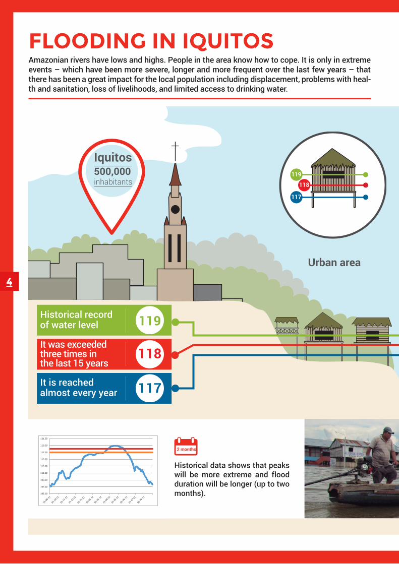
FLOODING IN IQUITOS
4
Amazonian rivers have lows and highs. People in the area know how to cope. It is only in extreme events – which have been more severe, longer and more frequent over the last few years – that there has been a great impact for the local population including displacement, problems with heal-th and sanitation, loss of livelihoods, and limited access to drinking water.
Nanay river
Urban area
Itaya river
Iquitos500,000 inhabitants
Periphery or semi-urban area
Historical record of water level 119
It was exceededthree times in the last 15 years
118
It is reachedalmost every year 117
119
118
117
Is already an extreme hazard for the population. It means most houses in the communities and lower Iquitos neighborhoods flood from 5 to 75 cm for seve-ral weeks.
118.5 river level
There are many vulnerable ‘informal’ houses in the area that are prone to flooding.
105.00
107.00
109.00
111.00
113.00
115.00
117.00
119.00
121.00
2 months
Historical data shows that peaks will be more extreme and flood duration will be longer (up to two months).
ENAPU
Red CrossNormal
Extreme

5
Nanay river
Urban area
Itaya river
Iquitos500,000 inhabitants
Periphery or semi-urban area
Historical record of water level 119
It was exceededthree times in the last 15 years
118
It is reachedalmost every year 117
119
118
117
Is already an extreme hazard for the population. It means most houses in the communities and lower Iquitos neighborhoods flood from 5 to 75 cm for seve-ral weeks.
118.5 river level
There are many vulnerable ‘informal’ houses in the area that are prone to flooding.
105.00
107.00
109.00
111.00
113.00
115.00
117.00
119.00
121.00
2 months
Historical data shows that peaks will be more extreme and flood duration will be longer (up to two months).
ENAPU
Red CrossNormal
Extreme

6
EXAMPLES OF DANGER LEVEL
Punchana 118.5
118.5Belén
District Height in metres (masl)
Maximum annual flow, Amazon river 1987-2016 (Tamshiyacu Station)
Return period (years)
Amazon river water level forecastTamshiyacu
Re
alib
ility
Lim
it
Re
alib
ility
Lim
it
Indicates that the probability of exceeding
the danger level is low (<10%)
Danger level probabilityTamshiyacu Red Cross
PROBABILISTIC FORECAST OCCURRENCE PROBABILITY
1http://globalfloods.jrc.ec.europa.eu
The return period was calculated to determine the Amazon river danger level using historical information at the Tamshiyacu station in Iquitos using 30 years’ worth of data. Impact information from the Civil Defense Institute (SINPAD) was analyzed for the three most extreme events affecting Punchana and Belén districts, close to Iquitos.
DANGER LEVEL DEFINITION
The Global Flood Awareness System (GLoFAS)1 assembles a probabilistic forecast (using 51 members) at 15 days with a 9-day reliability. This forecast goes through an automatic correction process with data observed during the day at the Tamshiyacu station. The forecast is issued by SENAMHI-Loreto on a daily basis and is disseminated to the FbF team for the corresponding analysis and linked to an early alert system.
FORECAST
EXAMPLE OF PROBABILISTIC FORECAST, ON 03.20.2017
Flow

7
EARLY ACTION PROTOCOL
Once forecasts exceed the danger level, agreed early actions or standard operational procedures (SOP) will be activated. The forecast offers some time for early actions of not more than up to nine days. The protocol also specifies a plan to ensure budget, arrangements for distributions, and a list of contacts.
On the first of the nine-day GLoFAS window, the government (national and local authorities and organizations), Red Cross branches and volunteers are warned. On Day 2, the Red Cross prepares its logistics and intervention teams. On Day 3, they also alert the community and community leaders, who can activate their early warning system. On Day 4 and 5, the Red Cross implements early actions (kit distribution and health promotion) to support the community. On Day 6, the Red Cross installs water bladders at places that are pre-established with INDECI and the municipality. On Day 7 to 9, the Red Cross continues its actions and follows up. After the event a forecast validation and an Impact Assessment is carried out. In the meanwhile the Red Cross volunteers provide follow-up to the early actions during a 1 day community visit.
How does the FbF mechanism work?
PREVIOUS ACTIONS: Nov. Dec. and Jan.
DAY 1: Advice, probability
DAY 2: Logistic chain readiness
DAY 3: : Warning, software sends alert
DAY 4 and 5: Early actions to support the community
DAY 7 to 9: Continuity and follow up of early actions
DAY 6: Bladder installation
Monitoring and evaluating actions
DAYS 12 and 14: Impact evaluation
FORECAST / WARNING
FORECAST / ADVICE
IMPACT EVENT
Previous actions: Planning, human resource management, logistic processes, capacity development, SOP.
Early actions: Action protocol at nine days – Loreto FbF.
Monitoring actions: Event validation, kit use monitoring, and impact and early action evaluation
Event impact: river water height at 118.5m or higher.
Probability at nine days of extreme flooding, state of alertPROBABILISTIC WARNING
Once the danger level is exceeded, a warning is issued through software, 118.5 meters in 7 days.FORECAST
CONCLUSIONS
TECHNICAL, SCIENTIFIC AND COORDINATION TEAM
German Red CrossMathieu [email protected]
Red Cross Red Crescent Climate CenterJuan [email protected]
Peruvian Red CrossJuan Carlos [email protected]
8
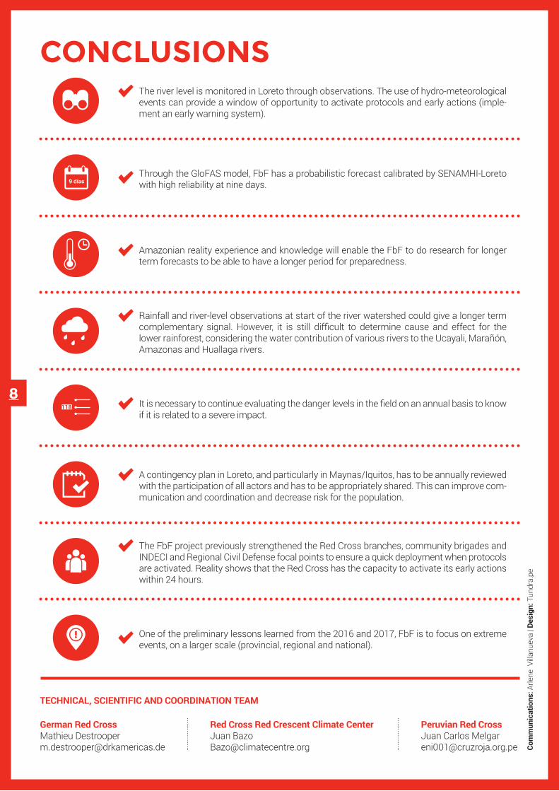
The river level is monitored in Loreto through observations. The use of hydro-meteorological events can provide a window of opportunity to activate protocols and early actions (imple-ment an early warning system).
Through the GloFAS model, FbF has a probabilistic forecast calibrated by SENAMHI-Loreto with high reliability at nine days.9 días
Rainfall and river-level observations at start of the river watershed could give a longer term complementary signal. However, it is still difficult to determine cause and effect for the lower rainforest, considering the water contribution of various rivers to the Ucayali, Marañón, Amazonas and Huallaga rivers.
It is necessary to continue evaluating the danger levels in the field on an annual basis to know if it is related to a severe impact.
The FbF project previously strengthened the Red Cross branches, community brigades and INDECI and Regional Civil Defense focal points to ensure a quick deployment when protocols are activated. Reality shows that the Red Cross has the capacity to activate its early actions within 24 hours.
A contingency plan in Loreto, and particularly in Maynas/Iquitos, has to be annually reviewed with the participation of all actors and has to be appropriately shared. This can improve com-munication and coordination and decrease risk for the population.
One of the preliminary lessons learned from the 2016 and 2017, FbF is to focus on extreme events, on a larger scale (provincial, regional and national).
Com
mun
icat
ions
: Arle
ne V
illanu
eva
| Des
ign:
Tun
dra.
pe
Amazonian reality experience and knowledge will enable the FbF to do research for longer term forecasts to be able to have a longer period for preparedness.
118


