Final Stream Restoration Assessment Report 2009
20
1 Final Stream Restoration Assessment Report – 2009 Prepared by NC State University January 2010 For NC Clean Water Management Trust Fund
Transcript of Final Stream Restoration Assessment Report 2009

1
Final Stream Restoration
Assessment Report – 2009
Prepared by
NC State University January 2010
For
NC Clean Water Management Trust Fund

2
Introduction: In 2006, NC State University was awarded a monitoring contract with the Clean
Water Management Trust Fund (CWMTF) (2005A-900). The purpose of the contract was to
establish an evaluation protocol for assessing a subset of the CWMTF’s stream restoration,
stormwater and agricultural best management practices (BMP) projects. The project includes a
field evaluation of forty two existing stream restoration, stormwater and agricultural projects, to
provide a snapshot of project effectiveness and water quality benefits. NC State University was
asked to prepare a rapid, yet effective evaluation of these projects. These evaluations were
planned for a single project visit and used to assess whether the project were likely to meet their
proposed goals. Eighteen stream sites were selected by review of CWMTF files and discussions
with project managers for the initial assessment work that was conducted during the summer of
2006. In addition, in 2008 and 2009 eleven additional sites were evaluated and five sites from
the 2006 surveys were revisited and rescored. The revisited sites include Ambrose,
Harris/Howard, Raccoon, Sharp and Upper Laurel. It is anticipated that the results and
recommendations from this effort will provide CWMTF with a better understanding of the status
and water quality benefits of stream restoration projects and will aid in the selection process for
future projects. This report provides a summary of the stream restoration assessment component
of this grant project.
Selection Criteria. Stream restoration projects that feature natural channel design approaches
including modification to dimension, pattern and profile and were longer than 1000 linear
feet were the target for this assessment project. Some exceptions were made at the discretion
of NC State University and Clean Water Management Trust Fund staff.
Site Evaluation. An evaluation protocol for stream restoration projects was developed by NC
State University, and is posted online at
http://www.bae.ncsu.edu/programs/extension/wqg/sri/cwmtf/index.html. This protocol was
field tested and subsequently sent to several agencies and individuals for external review.
The goal of this protocol is to be a rapid and effective assessment of four major components
of restoration. As part of this evaluation, numeric values are given to several parameters
within four categories: channel condition including bedform, dominant substrate material and
streambank stability; riparian habitat including riparian vegetation and floodplain condition;
aquatic insect condition including community structure and cover/refuge; and the condition
and function of instream structures. Stream size, land cover, eco-region and the number of
years following construction are variable. Each evaluation was conducted by a group of five
to eight trained individuals divided into teams. An engineering team scored channel
condition and instream structures. Two biology teams sampled and scored vegetation and
macroinvertebrate communities. In addition, photographs, a written log, and GPS locations
were collected. Photographs of each site were also collected and can be provided to CWMTF
upon request.
Results:
Table one and Figure one provide the individual element scores and the total score for all 29
projects assessed and the five sites that were revisited. The total score represents the sum of all
four component evaluations, including channel condition; riparian habitat and floodplain
condition; aquatic insect community structure including a cover/refuge component; and
condition and function of instream structures. The maximum possible score is 168 points.
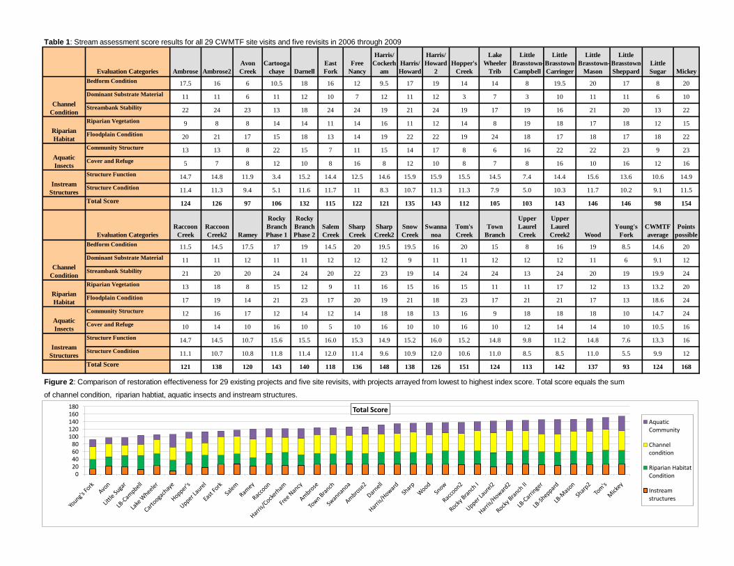
Table 1: Stream assessment score results for all 29 CWMTF site visits and five revisits in 2006 through 2009
Evaluation Categories Ambrose Ambrose2
Avon
Creek
Cartooga
chaye Darnell
East
Fork
Free
Nancy
Harris/
Cockerh
am
Harris/
Howard
Harris/
Howard
2
Hopper's
Creek
Lake
Wheeler
Trib
Little
Brasstown-
Campbell
Little
Brasstown-
Carringer
Little
Brasstown-
Mason
Little
Brasstown-
Sheppard
Little
Sugar Mickey
Bedform Condition 17.5 16 6 10.5 18 16 12 9.5 17 19 14 14 8 19.5 20 17 8 20
Dominant Substrate Material 11 11 6 11 12 10 7 12 11 12 3 7 3 10 11 11 6 10
Streambank Stability 22 24 23 13 18 24 24 19 21 24 19 17 19 16 21 20 13 22
Riparian Vegetation 9 8 8 14 14 11 14 16 11 12 14 8 19 18 17 18 12 15
Floodplain Condition 20 21 17 15 18 13 14 19 22 22 19 24 18 17 18 17 18 22
Community Structure 13 13 8 22 15 7 11 15 14 17 8 6 16 22 22 23 9 23
Cover and Refuge 5 7 8 12 10 8 16 8 12 10 8 7 8 16 10 16 12 16
Structure Function 14.7 14.8 11.9 3.4 15.2 14.4 12.5 14.6 15.9 15.9 15.5 14.5 7.4 14.4 15.6 13.6 10.6 14.9
Structure Condition 11.4 11.3 9.4 5.1 11.6 11.7 11 8.3 10.7 11.3 11.3 7.9 5.0 10.3 11.7 10.2 9.1 11.5
Total Score 124 126 97 106 132 115 122 121 135 143 112 105 103 143 146 146 98 154
Evaluation Categories
Raccoon
Creek
Raccoon
Creek2 Ramey
Rocky
Branch
Phase 1
Rocky
Branch
Phase 2
Salem
Creek
Sharp
Creek
Sharp
Creek2
Snow
Creek
Swanna
noa
Tom's
Creek
Town
Branch
Upper
Laurel
Creek
Upper
Laurel
Creek2 Wood
Young's
Fork
CWMTF
average
Points
possible
Bedform Condition 11.5 14.5 17.5 17 19 14.5 20 19.5 19.5 16 20 15 8 16 19 8.5 14.6 20
Dominant Substrate Material 11 11 12 11 11 12 12 12 9 11 11 12 12 12 11 6 9.1 12
Streambank Stability 21 20 20 24 24 20 22 23 19 14 24 24 13 24 20 19 19.9 24
Riparian Vegetation 13 18 8 15 12 9 11 16 15 16 15 11 11 17 12 13 13.2 20
Floodplain Condition 17 19 14 21 23 17 20 19 21 18 23 17 21 21 17 13 18.6 24
Community Structure 12 16 17 12 14 12 14 18 18 13 16 9 18 18 18 10 14.7 24
Cover and Refuge 10 14 10 16 10 5 10 16 10 10 16 10 12 14 14 10 10.5 16
Structure Function 14.7 14.5 10.7 15.6 15.5 16.0 15.3 14.9 15.2 16.0 15.2 14.8 9.8 11.2 14.8 7.6 13.3 16
Structure Condition 11.1 10.7 10.8 11.8 11.4 12.0 11.4 9.6 10.9 12.0 10.6 11.0 8.5 8.5 11.0 5.5 9.9 12
Total Score 121 138 120 143 140 118 136 148 138 126 151 124 113 142 137 93 124 168
Figure 2: Comparison of restoration effectiveness for 29 existing projects and five site revisits, with projects arrayed from lowest to highest index score. Total score equals the sum
of channel condition, riparian habtiat, aquatic insects and instream structures.
Riparian
Habitat
Aquatic
Insects
Instream
Structures
Channel
Condition
Riparian
Habitat
Aquatic
Insects
Instream
Structures
Channel
Condition
020406080
100120140160180 Total Score
Aquatic Community
Channel condition
Riparian Habitat Condition
Instream structures

4
Figure one illustrates the total scores from all of the projects. Scores range from 93 to 154 with a
mean score of 127 for the 34 assessments conducted.
Figure 1: Overall stream restoration scores (maximum score = 168)
Comparison of projects is difficult due to high variability in environmental conditions, including
stream size (0.2 to 105 square miles), time since construction completion (0 to 8 years) and
ecoregion. In addition, project effectiveness can be influenced by numerous other factors,
including site constraints, design parameters, construction expertise and watershed conditions, all
of which were not included in this evaluation process. Individual evaluation summaries have
been prepared for each project assessed, and brief summaries of these evaluations are noted in
Appendix 1 of this report. Project effectiveness was assessed as it related to the initial goals
stated in the proposals to CWMTF. The primary goal of many projects was to reduce
sedimentation by stabilizing eroding stream banks and/or reconnect the stream to relic
floodplains through natural channel design. These assessments concluded that these initial goals
were accomplished at most of the projects. In addition, some projects also proposed improving
biological integrity and instream habitat as an additional goal. The data are not conclusive but
indicate some positive trends in the biological communities over time. Future studies are needed
to validate long-term improvements.
By combining the information collected for all 29 projects and five revisits for a total of 34 data
points, NC State University staff attempted to evaluate three causal factors contributing to degree
of restoration effectiveness, including:
1. Watershed size
2. Watershed development density
3. Project age
Because of the high variability observed in these projects, many more project assessments are
necessary to document statistically significant conclusions regarding hypothesis testing for these

5
factors evaluated alone or in combination. The results presented below are preliminary
observations intended to inform future studies of restoration effectiveness.
Watershed Size. Watershed drainage areas ranged from 0.2 to 105 square miles. This
area affects the stream size and the complexity of factors influencing water quality and
habitat. We divided projects into two categories: (1) small (less than 3 square mile
drainage area) and, (2) large (greater than or equal to 3 square miles). Figure 3 shows the
comparison of effectiveness ratings for the small and large projects. We expected
projects in smaller drainage areas to have higher effectiveness, because large projects
have more impacts from wastewater, stormwater, upstream sediment sources, and other
external stressors of water quality. This expected trend, however, was not apparent in
this sample set.
Figure 3: Comparison of restoration effectiveness for small and large watershed projects.
Projects are arrayed from lowest to highest index score. Projects in small watersheds (<3 sq mi)
are highlighted with dark columns.
Watershed Development Density. The degree of urbanization in the watershed affects the
potential impact of stormwater, channel instability, and wastewater on water quality and
habitat. We divided projects into two categories: (1) rural (less than 10 percent of the
watershed urbanized) and, (2) urban (greater than or equal to 10 percent urbanized).
Figure 4 shows the comparison of effectiveness ratings for all projects, with urban
projects shown as dark bars (8 projects). Even though the results are not statistically
significant, there is a visual trend indicating that rural projects score higher than urban
watershed projects. This is likely due to urban projects having more impacts from
channel confinement, wastewater, stormwater, upstream sediment sources and other
external stressors of water quality.
6
Figure 4. Comparison of restoration effectiveness for urban and rural watershed projects.
Projects are arrayed from lowest to highest index score with urban projects highlighted by dark
columns.
Project Age. Projects ranged in age from 0 to 8 years since implementation. The age of
the project affects the degree to which the ecosystem has recovered from degradation and
disturbance. Age influences the growth of vegetation, establishment of microhabitats,
and physical sorting of sediments following variable hydrologic events. Unlike
traditional engineering projects, stream restorations are expected to improve over time as
vegetation develops and bedform diversity develops naturally. Three factors confound
this expected trend in this study. The first is the variability between sites, the second is
that different types of projects are selected as CWMTF and grantees become more
sophisticated regarding suitable projects, and the third is improvement in restoration
practices. Figure 5 shows the comparison of effectiveness ratings for all projects in
Figure 5. Comparison of restoration effectiveness (i.e. total index score) to project age.
7
relation to project age. The results are not statistically significant and there is no visual
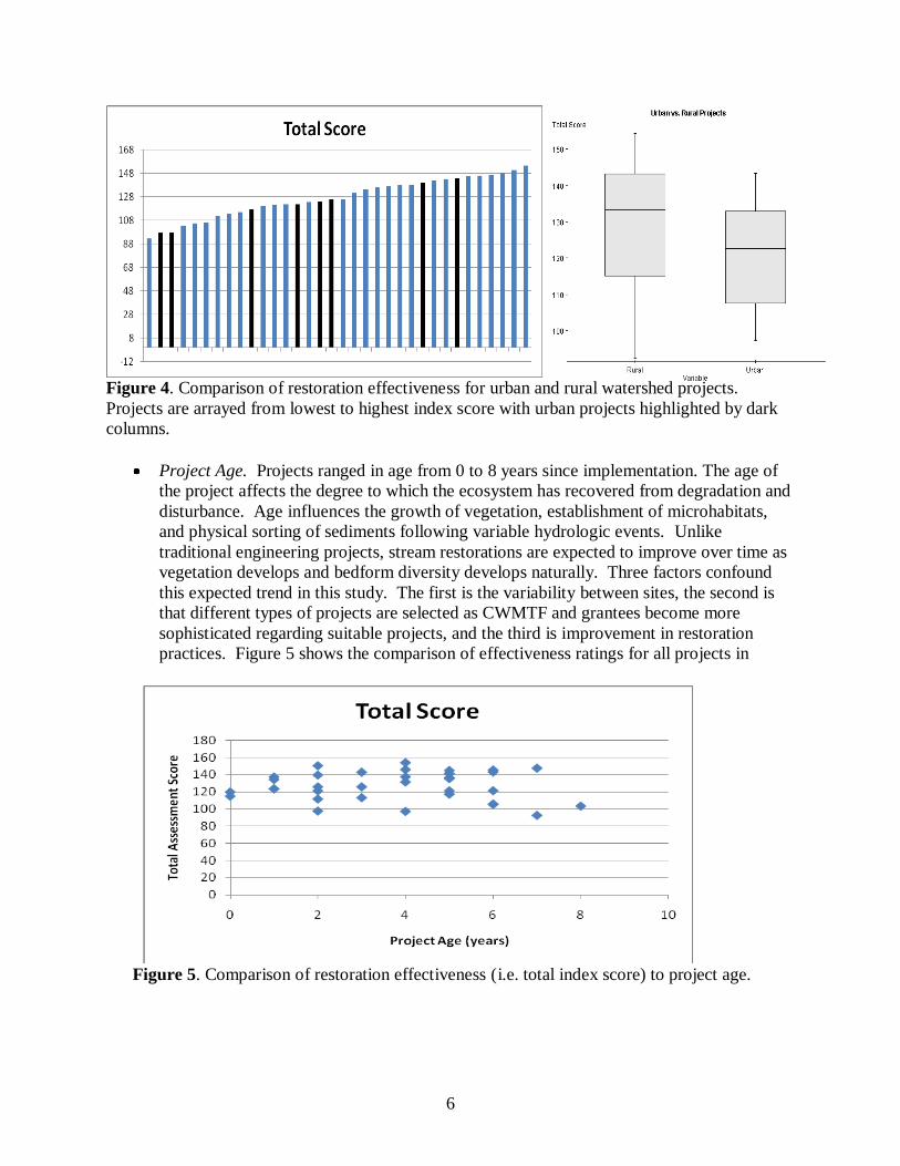
trend indicating a causal relationship. Figure 6 illustrates the separate components of the
evaluation (instream structures, vegetation, invertebrate community composition and
habitat, and channel condition) as they vary with project age. In 2006, no trends were
identified. However, with the 11 new sites and five revisits added to the data set there is a
statistically significant trend indicating an improvement in structure function and
condition with newer projects, likely due to an improvement in design and installation of
structures that has resulted from training, education and more experience.
Figure 6. Comparison of separate aspects of restoration effectiveness (as measured by index
scores) with age. Project ages ranged from zero to eight years.
In 2006, only one variable, “Abundant taxa in common” was identified to have a strong
relationship with age. However, in 2008 with the addition of the 11 new sites and 5
revisits added to the data set, this trend was no longer visibly apparent or statistically
significant to the data set as shown in Figure 7. Invertebrate community measures would
be expected to increase as a project ages and insects from upstream successfully
colonizes the restoration reach. A direct relationship between project age and
macroinvertebrate indices would indicate that the projects are moving toward biological
recovery. However, this particular data set of projects did not provide a clear indication
of benthic recovery. Lake Wheeler tributary, despite maturing for six years post
construction, scored poorly on benthic indices due to a lack of flow at the time of
assessment. When this site was removed from the dataset, the comparison of Aquatic
Insect Score relative to project age revealed a statistically significant positive trend (see
Figure 8).

8
Figure 7. Comparison of project age and the index score for “Abundant taxa in common”, a
measure of invertebrate community similarity between sampling sites above and within the
restoration project. Eighteen sites in 2006 and 34 sites in 2008 (including 5 revisits).
Figure 8: Regression comparison of the aquatic community score to project age excluding Lake
Wheeler Farms restoration project.
In addition, we hypothesized that of the four components assessed the macroinvertebrate
communities are the one factor that is most likely dependent on the other elements assessed,
including riparian habitat, instream structures and channel condition. Therefore, we compared
the aquatic community scores to these other assessment variables to determine if a relationship
exists. Of the three comparisons, it was determined that the aquatic insect score only had a
statistically significant relationship with the riparian habitat score (see Figure 9). The positive
slope of the trend (0.88) indicates that the observed quality of macroinvertebrates was directly
correlated with the quality of riparian habitat.

9
Figure 9: Regression comparison of aquatic insect score to riparian habitat score.
In addition, we evaluated the results of the five site revisits. The five sites, including Ambrose,
Harris/Howard, Raccoon, Sharp and Upper Laurel, were originally scored in 2006 and revisited
and rescored in 2008. These five sites were selected because they were all fairly recently
constructed and showed a great potential to mature and improve in quality over time. Figure 10
indicates that all five revisit sites exhibited an improvement in restoration performance. The
range of improvement was 1.9 to 24 percent with a mean improvement of 11.2%. The least
improvement occurred at Ambrose Creek as a result of recent mowing of the entire creek and
floodplain.
Figure 10: Comparison of restoration effectiveness for five project revisits. Projects are arrayed
from lowest to highest index score. Revisited sites are indicated in purple for their initial
assessment in 2006 and in red for their revisit score in 2008.

10
Figure 11: Comparison of restoration effectiveness for five project revisits.
Figure 11 indicates the relative area of score for the four components assessed, including
instream structures, channel condition, riparian habitat and aquatic insects. The graph indicates
that very little if any change occurred in instream structures as could be expected. Rather
improvements were realized in channel condition, riparian habitat and aquatic insects.
Site Selection Suitability Assessment:
Following discussions with CWMTF staff, NC State University conducted two stream
restoration site selection training days with CWMTF field staff. Working with CWTMF staff,
we identified two proposed stream projects in the mountains and two in the Piedmont to visit and
assess the restoration need and potential for these sites. NCSU developed a draft qualitative
assessment form to use for the field visits. The field form was reviewed by CWMTF and changes
were made accordingly. The assessment form is provided in Appendix 2. NCSU conducted two
stream restoration site selection training days in 2009 with CWMTF field staff on March 19 in
the mountains and March 23 in the Piedmont. The NCSU restoration need assessment form was
used to assess proposed stream restoration projects in both regions. In addition, several existing
projects were visited to review their performance. A quantitative protocol for stream restoration
selection and evaluation, which incorporates clearly stated goals, may still be worthy of future
consideration.
Summary and Evaluation:
Project Effectiveness. Field evaluations were conducted at 29 existing stream restoration
projects. Many projects were initially selected by applicants because of severe bank
erosion rates and incision resulting in sedimentation of streams. Therefore, in most

11
instances, the primary goals noted for these projects were to stabilize eroding stream
banks and to reconnect the stream to a floodplain. Natural channel design was frequently
used as a procedure for correcting these perturbations. At a subset of these projects
improvement of biological habitat or integrity were included as additional goals. In
general the 29 projects that were evaluated by the NCSU teams noted that bank erosion
has been reduced or eliminated and that the use of natural channel design methodologies
has been an effective method for reconnecting streams to relic floodplains or for creating
new accessible floodplains for streams. Therefore initial projects goals at most projects
were achieved and implementation of CWMTF protocols was effective. In addition, the
data indicates a statistically significant positive trend in aquatic insect indices, including
cover and refuge, when compared to project age. In addition, five relatively young
projects were revisited two years after their initial assessment. Revisit scores indicate that
the quality of these projects continued to improve over time as channel condition and
riparian habitat continued to develop and improve as well as the aquatic
macroinvertebrate community that depends on these elements for food, cover and other
habitat aspects.
Pre-construction evaluations (habitat, stability, and benthic macroinvertebrate
communities) were not conducted; therefore improvements in these conditions cannot be
determined. It does appear, however, that many projects are moving toward biological
recovery as project age increases and as riparian vegetation develops and matures, as
noted in figures 8 and 9, respectively. In addition, it is anticipated that complete
ecological recovery which mimics reference conditions will take much longer than most
of these projects have been completed. As a result, longer monitoring programs
following construction are needed to realize ecological recovery as a result of stream
restoration.
Conclusions and Recommendations:
o Project Selection
Institute a standard glossary of terms with regards to natural channel design,
restoration and enhancement for the application submittal and review process.
“Natural channel design” stream projects were targeted for this assessment
project. However it was determined that this term in addition to “stream
restoration” can mean different things to different designers, and can range from
simple enhancement and cattle exclusion to priority one stream restoration, in
which the channel dimension, pattern and profile are all modified.
Train restoration design review personnel in proper design procedures. Many of
the design issues that became apparent during the field evaluations may have been
avoided during the project review phase.
o Pre-Project Assessment
Require project goals to be clearly stated and well documented, with a basis for
assessing whether these goals have been met.
Institute a combined qualitative and quantitative assessment method for
establishing project goals and measureable objectives and for determining if
12
projects are meeting the goals and objectives established. Identify specific
indicators that are appropriate for measuring the objectives for each project.
o Design and Construction Issues. During the evaluations the field teams noted
construction and design issues that were fairly consistent between projects.
Recommendations to address these issues are as follows:
1. Stream channel and floodplain morphology
Adequate floodplain width (entrenchment ratio) and consistent floodplain
grading. Floodplain irregularities (both elevation and width) are detrimental to
project stability
Appropriate width/depth ratio to maintain stability and sediment transport
Low streambank slope and bank height ratio to minimize bank erosion and
promote floodplain access
Appropriate stream channel pattern to dissipate energy and promote bedform
diversity
Appropriate channel sizing to ensure channel cross-sections are not over-
sized, in order to allow adequate frequency for floodplain access during larger
rain storms
Consistent grading of stream channel cross sections to avoid irregularities
2. In-stream structures
Appropriate location, size, and installation of structures for bank protection,
grade control, habitat enhancement, and sediment transport. For example,
boulder structures (cross-vanes and sills) should not be placed at the head of a
riffle or just slightly upstream of the riffle as they frequently result in scour
that erodes the streambed and pushes the constructed riffle downstream,
resulting in short or non-existent riffle sections.
Enhancement of riffles, pools, and steps to promote bedform diversity while
avoiding unnatural scour and channel blocking. Use of native bed material
below the depth of potential scour in constructed riffles is encouraged.
Bedform variability is necessary to establish diverse aquatic habitat.
Proper construction including anchoring the logs and/or boulders into the bed
and banks, appropriate use of geotextiles and chinking rocks, and prevention
of piping and undermining.
3. Streambank stabilization
Appropriate use of temporary biodegradable matting, grasses, live stakes, and
bioengineering to minimize bank erosion and promote permanent native forest
establishment along stream channels.
4. Riparian floodplain forest:
Appropriate planting and maintenance to ensure long-term success of native
forest buffer
5. Stormwater management in the riparian corridor
Appropriate collection and treatment of offsite stormwater delivered to the
stream through pipes or ditches, including the installation of step-pools,

13
plunge pools, wetlands, level spreaders, and other BMPs on or adjacent to the
floodplain
6. Road crossings
Appropriate use of culverts and bridges in conjunction with in-stream
structures to cross streams while maintaining geomorphic stability, sediment
transport, and floodwater passage. Structure construction is critical, as poor
structure placement or construction affects sediment and water movement
downstream, reshaping the channel.
o Evaluation
Metric modification and testing. During the field evaluations, NCSU staff noted
several issues with the metrics themselves that should be re-tested and modified
for any future evaluations.
Project construction disturbs the ecological community. There is a recovery
period, and the length of this recovery period is unknown. Long-term monitoring
is needed to define the length and trajectory of this recovery period. Impacts to
the ecological community such as stormwater, acute disturbances, drought,
sediment input from upstream, wastewater, and agriculture. This monitoring
could not separate external, off-site factors from design and implementation of the
restoration itself. Seasonal variability also has an unknown effect.
The evaluation protocol developed by NC State University proved to be an
effective tool for rapid assessment of stream restoration effectiveness. However,
this protocol needs to be further tested and refined.

14
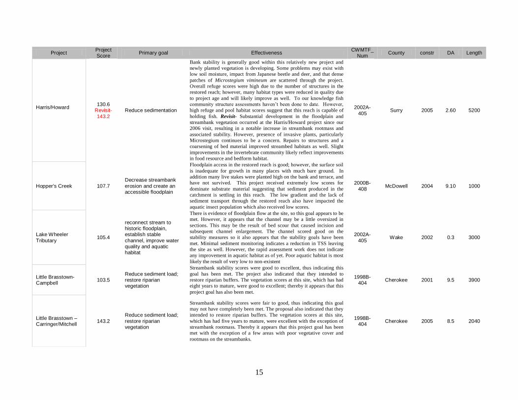
Appendix 1. Existing Stream Restoration Project Evaluations.
Project Project Score
Primary goal Effectiveness CWMTF_
Num County constr DA Length
Ambrose Creek 123.6
Revisit -126 Establish stable channel
Excessive sedimentation is entering the project from upstream and is
impacting pool quality and benthic habitat within the restored reach.
Project effectiveness would be much improved if the sources of this
sediment were controlled. Revisit- The anticipated improvement in
riparian vegetation and invertebrate cover and refuge scores was not
realized due to floodplain and streambank mowing. In addition, bedform
habitat continues to be poor due to upstream sedimentation and reduced
riffle habitat.
2002A-405
Surry 2005 2.30 1250
Avon Creek 97.4 Stabilize Avon Creek
Data from this urban restoration project suggested that catchment-wide
perturbations were impacting the functionality of the stream and its
riparian zone, but that the intended goals of the project were obtained.
Sediment from upstream sources is filling in pools within the restored
reach and it’s also evident from the benthic macroinvertebrate
information that water quality conditions in the catchment are impacted.
2000B-401
Gaston 2002 0.75 985
Cartoogachaye 110.7 Stabilize eroding banks
Data from this evaluation noted that the placement of the log revetment
structures to stabilize eroding stream banks has been compromised by
stream energy following extremely high flow events. In addition, the
field team noted the occurrence of transverse bars and sections of active
bank erosion within this reach of stream.
1997A-006
Macon 2000 22.0 1060
Darnell Reach 129.1 Reduce sedimentation
Surface protection and root density estimates from this project were very
high and in general bank stability is good. These conditions successfully
address the first goal of this project. However the project maintains a
fairly flat gradient and have several long runs dominated by fine mucky
sediment which provide little or no functional habitat.
1999B-408B
Surry 2002 5.50 1250
East Fork 115.1
Reduce sediment load;
restore habitat; restore floodplain function
Streambank stability scores were excellent overall, thus indicating this
goal has been met. The restoration resulted in reconnecting much of the
channel to an existing floodplain. This was achieved for most of the
reach, however, some sections of the channel appeared to still be incised
or have only a moderate floodplain available (near the culvert) restricting
access of some floodwaters.
2007-406 Watauga 2008 0.2 1440
Free Nancy Branch 121.1 Establish stable channel and create an accessible floodplain
Data from this urban restoration project suggested that catchment-wide
perturbations were impacting the functionality of the stream and its
riparian zone, but that the intended goals of the project were obtained.
Sediment from upstream sources is filling in pools within the restored
reach and it’s also evident from the benthic macroinvertebrate
information that water quality conditions in the catchment are impacted.
1998B-410
Iredell 2000 0.79 2280
Harris/Cockerham 121.4 Reduce sedimentation
Bank stability within this reach is generally good with no areas of bank
erosion or sloughing, and herbaceous plant cover is vibrant with woody
stems thriving. However the field team noted that the project maintains a
fairly flat gradient with riffles located only at the beginning and end of
the reach. The rest of the project is notably void of riffles. It is unlike that
these conditions improved aquatic habitat above background conditions.
1999B-408B
Surry 2001 17.50 1200
15
Project Project Score
Primary goal Effectiveness CWMTF_
Num County constr DA Length
Harris/Howard
130.6 Revisit-
143.2
Reduce sedimentation
Bank stability is generally good within this relatively new project and
newly planted vegetation is developing. Some problems may exist with
low soil moisture, impact from Japanese beetle and deer, and that dense
patches of Microstegium vimineum are scattered through the project.
Overall refuge scores were high due to the number of structures in the
restored reach; however, many habitat types were reduced in quality due
to project age and will likely improve as well. To our knowledge fish
community structure assessments haven’t been done to date. However,
high refuge and pool habitat scores suggest that this reach is capable of
holding fish. Revisit- Substantial development in the floodplain and
streambank vegetation occurred at the Harris/Howard project since our
2006 visit, resulting in a notable increase in streambank rootmass and
associated stability. However, presence of invasive plants, particularly
Microstegium continues to be a concern. Repairs to structures and a
coarsening of bed material improved streambed habitats as well. Slight
improvements in the invertebrate community likely reflect improvements
in food resource and bedform habitat.
2002A-
405 Surry 2005 2.60 5200
Hopper's Creek 107.7
Decrease streambank
erosion and create an accessible floodplain
Floodplain access in the restored reach is good; however, the surface soil
is inadequate for growth in many places with much bare ground. In
addition many live stakes were planted high on the bank and terrace, and
have not survived. This project received extremely low scores for
dominate substrate material suggesting that sediment produced in the
catchment is settling in this reach. The low gradient and the lack of
sediment transport through the restored reach also have impacted the
aquatic insect population which also received low scores.
2000B-
408 McDowell 2004 9.10 1000
Lake Wheeler
Tributary 105.4
reconnect stream to historic floodplain, establish stable
channel, improve water quality and aquatic habitat
There is evidence of floodplain flow at the site, so this goal appears to be
met. However, it appears that the channel may be a little oversized in
sections. This may be the result of bed scour that caused incision and
subsequent channel enlargement. The channel scored good on the
stability measures so it also appears that the stability goals have been
met. Minimal sediment monitoring indicates a reduction in TSS leaving
the site as well. However, the rapid assessment work does not indicate
any improvement in aquatic habitat as of yet. Poor aquatic habitat is most
likely the result of very low to non-existent
2002A-
405 Wake 2002 0.3 3000
Little Brasstown-Campbell
103.5 Reduce sediment load; restore riparian vegetation
Streambank stability scores were good to excellent, thus indicating this
goal has been met. The project also indicated that they intended to
restore riparian buffers. The vegetation scores at this site, which has had
eight years to mature, were good to excellent; thereby it appears that this
project goal has also been met.
1998B-404
Cherokee 2001 9.5 3900
Little Brasstown – Carringer/Mitchell
143.2
Reduce sediment load;
restore riparian vegetation
Streambank stability scores were fair to good, thus indicating this goal
may not have completely been met. The proposal also indicated that they
intended to restore riparian buffers. The vegetation scores at this site,
which has had five years to mature, were excellent with the exception of
streambank rootmass. Thereby it appears that this project goal has been
met with the exception of a few areas with poor vegetative cover and
rootmass on the streambanks.
1998B-404
Cherokee 2005 8.5 2040

16
Project Project Score
Primary goal Effectiveness CWMTF_
Num County constr DA Length
Little Brasstown – Mason/Stalcup
146.3
Reduce sediment load;
restore riparian vegetation
Streambank stability scores were good to excellent. It appears that this
goal is being met with the exception of a few areas where the bank
height ratio is slightly higher than desired. The proposal also indicated
that they intended to restore riparian buffers. The vegetation scores at
this site, which has had four years to mature, were excellent with the
exception of invasive species. Thereby it appears that this project goal
has been met with the exception of extensive mowing along the left.
1998B-404B
Cherokee 2005 3.8 1900
Little Brasstown - Sheppard
145.7 Reduce sediment load; restore riparian
vegetation
Streambank stability scores were fair to excellent. It appears that this
goal is being met with the exception of the areas where some channel
incision has resulted in some tall banks that are bare. In addition,
mowing of a powerline corridor that intercepts the creek in several
locations is hampering the quality of the vegetation and the associated
streambank stability in these areas. The vegetation scores at this site,
which has had six years to mature, were excellent with the exception of
invasive species and the powerline corridor.
1998B-404B
Cherokee 2003 5.6 4300
Little Sugar 97.7 Reduce flooding, recapture floodplain function
The stream restoration project at the Hidden Valley Ecological Garden
provides Charlotte residents with an opportunity to enjoy this stream
feature. It is very likely that flooding has been reduced because of the
reattachment to the floodplain within this feature; however, it does not
appear to improve water quality at this point. The fairly flat gradient
within the restored reach and inputs of pollutants from upstream urban
areas are resulting in a reduction of potential project effectiveness.
2001B-704
Mecklenburg 2003 2.00 2420
Mickey Reach 152.4 Reduce sedimentation
Bedform condition, streambank stability and structure condition were all
given average or higher scores, suggesting that the channel itself is stable
and that the project is moving toward accomplishing the primary goal of
stabilizing the channel and in doing so decreasing the sediment delivery
to the stream. Streambank root mass and associated stability can
improve as woody vegetation increases on the banks. Benthic
macroinvertebrates, instream cover and refuge, floodplain habitat, and
structure-related biological habitat scores were all high. These scores
indicate quality aquatic habitat, and habitat should continue to improve
as the project matures.
1998B-408B
Surry 2002 0.45 3500
Raccoon Creek 121.2
Revisit –
137.8
Reduce erosion and
sedimentation
Streambank stability and streambank root mass received higher than
average scores, indicating that the project supports stable banks with low
erosion loss, and is moving toward accomplishing its primary objective.
Vegetative cover along the banks is thick in most places, with only a few
bare areas. Revisit- Raccoon Creek remains very stable with relatively
no bank erosion. It is therefore continuing to meet the desired project
goal. Some channel incision has resulted in taller streambanks and some
erosion at the toe of the streambank as well as a decline in the ability of
the stream to access the floodplain as frequently as needed. Vegetation at
the site continues to grow and flourish with very few bare areas
remaining. Mowing at the site has been greatly reduced. This project
showed notable increases in the morphologic channel bedform, riparian
vegetation, aquatic community structure and cover and refuge scores.
These improvements resulted in a 14 percent increase in the total
assessment score over the two year period between visits.
2000B-
402 Haywood 2004 4.35 2700
17
Project Project Score
Primary goal Effectiveness CWMTF_
Num County constr DA Length
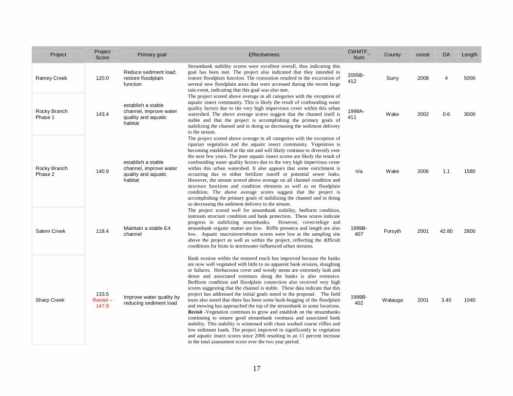
Ramey Creek 120.0 Reduce sediment load; restore floodplain
function
Streambank stability scores were excellent overall, thus indicating this
goal has been met. The project also indicated that they intended to
restore floodplain function. The restoration resulted in the excavation of
several new floodplain areas that were accessed during the recent large
rain event, indicating that this goal was also met.
2005B-
412 Surry 2008 4 5000
Rocky Branch
Phase 1 143.4
establish a stable channel, improve water
quality and aquatic habitat
The project scored above average in all categories with the exception of
aquatic insect community. This is likely the result of confounding water
quality factors due to the very high impervious cover within this urban
watershed. The above average scores suggest that the channel itself is
stable and that the project is accomplishing the primary goals of
stabilizing the channel and in doing so decreasing the sediment delivery
to the stream.
1998A-
411 Wake 2002 0.6 3000
Rocky Branch Phase 2
140.9
establish a stable
channel, improve water quality and aquatic habitat
The project scored above average in all categories with the exception of
riparian vegetation and the aquatic insect community. Vegetation is
becoming established at the site and will likely continue to diversify over
the next few years. The poor aquatic insect scores are likely the result of
confounding water quality factors due to the very high impervious cover
within this urban watershed. It also appears that some enrichment is
occurring due to either fertilizer runoff or potential sewer leaks.
However, the stream scored above average on all channel condition and
structure functions and condition elements as well as on floodplain
condition. The above average scores suggest that the project is
accomplishing the primary goals of stabilizing the channel and in doing
so decreasing the sediment delivery to the stream.
n/a Wake 2006 1.1 1580
Salem Creek 118.4 Maintain a stable E4 channel
The project scored well for streambank stability, bedform condition,
instream structure condition and bank protection. These scores indicate
progress in stabilizing streambanks. However, cover/refuge and
streambank organic matter are low. Riffle presence and length are also
low. Aquatic macroinvertebrate scores were low at the sampling site
above the project as well as within the project, reflecting the difficult
conditions for biota in stormwater-influenced urban streams.
1999B-407
Forsyth 2001 42.80 2800
Sharp Creek 133.5
Revisit – 147.9
Improve water quality by reducing sediment load
Bank erosion within the restored reach has improved because the banks
are now well vegetated with little to no apparent bank erosion, sloughing
or failures. Herbaceous cover and woody stems are extremely lush and
dense and associated rootmass along the banks is also extensive.
Bedform condition and floodplain connection also received very high
scores suggesting that the channel is stable. These data indicate that this
project has addressed the initial goals noted in the proposal. The field
team also noted that there has been some bush-hogging of the floodplain
and mowing has approached the top of the streambank in some locations. Revisit -Vegetation continues to grow and establish on the streambanks
continuing to ensure good streambank rootmass and associated bank
stability. This stability is witnessed with clean washed coarse riffles and
low sediment loads. The project improved in significantly in vegetation
and aquatic insect scores since 2006 resulting in an 11 percent increase
in the total assessment score over the two year period.
1999B-402
Watauga 2001 3.40 1040

18
Project Project Score
Primary goal Effectiveness CWMTF_
Num County constr DA Length
Snow Creek 137.5 Enhance water quality; enhance habitat
Good scores for streambank stability and aquatic macroinvertebrates
indicate that the project is moving toward accomplishing its goal of
improving water quality through reduced sedimentation. Pools have
been established below many structures, but some riffles have been lost.
Vegetation is developing well in the first year of project recovery.
Mature trees provide a diverse onsite seed source. While the restoration
reach contains bedrock, cobble, and gravel, some sedimentation from
upstream influences average particle size and is affecting pools quality.
2004A-413
Surry 2005 8.10 4080
Swannanoa 126.0 improve water quality and restore riparian buffers
Pre and post assessment of water quality were not conducted so
conclusions cannot be made as to whether the first goal is being met. The
restoration covers only 1700 feet of the river, which has a 105 square
mile drainage area. It is not likely that a localized project affecting such a
small portion of the river and that does not address any watershed or
upstream issues would have any significant impact on water quality. In
addition, the streambank and buffer plantings are just beginning to
become established. Drought and soil compaction appear to be
hampering the vegetation. However, it is anticipated that over time, the
buffer will mature and the project will achieve this goal.
2001B-405
Buncombe 2006 105 1700
Tom’s Creek 150.8 Reduce sediment load; restore floodplain
Streambank stability scores were excellent overall, thus indicating this
goal has been met. The project also indicated that they intended to
restore floodplain function. The restoration resulted in the excavation of
an extensive new accessible floodplain area that was accessed during a
recent large rain event, indicating that this goal was also met. However,
at the channel appeared to still be somewhat incised at the downstream
end of the project restricting access of some floodwaters.
2006A-409
Surry 2006 1.8 2930
Town Branch 122.9
Improve water quality
and aquatic habitat by reducing sediment
Streambank stability, bedform condition, and instream structures scored
well, indicating this project is moving toward accomplishing its goals for
stability and reduced erosion. The project is new; so many features of
aquatic habitat have not had time to develop. Macroinvertebrate
monitoring indicated that upstream communities were poor, and
sampling within the reach produced macroinvertebrate taxa associated
with poor water quality. Algae and emergent vegetation within the reach
indicate nutrient enrichment. The growth of trees should improve
riparian functionality, but mowing and poor soil quality limit the
developing biomass. Lower banks have helped floodplain functionality.
2004B-401
Cherokee 2005 0.57 1129
Upper Laurel Creek
112.4 – Revisit
141.7
Correct severe channel
erosion
The project suffered extensive damage during the heavy flooding
associated with Hurricanes Ivan and Frances in 2004. These storms
deposited a torrent of cobble debris in the stream and on the floodplain,
blowing out and burying nearly all of the constructed bedform and
boulder structures. Some repair work has been implemented.
Streambank stability scores were only moderate, with root density and
surface protection observations fairly low. The banks are well vegetated
in some locations with no bank erosion, sloughing or failure in these
areas. However, there are many areas of barren cobble debris torrents on
the streambanks and floodplain with little herbaceous cover and few
woody stems present. Despite the lack of vegetation, many of the banks
are stable due to the resistance of the cobble material. The stream is
1999B-
402 Watauga 2003 2.20 1420
19
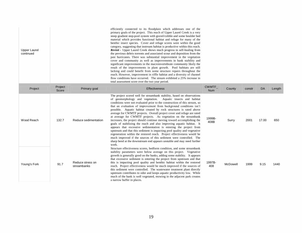
Upper Laurel continued
efficiently connected to its floodplain which addresses one of the
primary goals of the project. This reach of Upper Laurel Creek is a very
steep gradient step-pool system with gravel/cobble and some boulder bed
material which provides functional habitat and refuge for many of the
benthic insect species. Cover and refuge scores were within the good
category, suggesting that instream habitat is productive within this reach. Revisit - Upper Laurel Creek shows much progress in self-healing from
the previous debris torrents and associated scour and deposition from the
past hurricanes. There was substantial improvement in the vegetation
cover and community as well as improvements in bank stability and
significant improvements in the macroinvertebrate community likely the
result of the improvements in plant growth. Pool habitats are still
lacking and could benefit from some structure repairs throughout the
reach. However, improvement in riffle habitat and a diversity of channel
flow conditions have occurred. The stream exhibited a 25% increase in
total assessment score over the two year period.
Project Project
Score Primary goal Effectiveness
CWMTF_
Num County constr DA Length
Wood Reach 132.7 Reduce sedimentation
The project scored well for streambank stability, based on observations
of geomorphology and vegetation. Aquatic insects and habitat
conditions were not evaluated prior to the construction of this stream, so
that an evaluation of improvement from background conditions isn’t
possible. Aquatic habitat created by rock structures is rated above
average for CWMTF projects. Overall project cover and refuge are rated
at average for CWMTF projects. As vegetation on the streambank
increases, the project should continue moving toward accomplishing the
goals of stabilizing the reach and also improving aquatic habitat. It
appears that excessive sedimentation is entering the project from
upstream and that this sediment is impacting pool quality and vegetative
regeneration within the restored reach. Project effectiveness would be
much improved if the sources of this sediment were controlled. The
sharp bend at the downstream end appears unstable and may need further
work.
1999B-408B
Surry 2001 17.00 650
Young's Fork 91.7 Reduce stress on
streambanks
Structure effectiveness scores, bedform condition, and some streambank
stability parameters were below average on this project. Vegetative
growth is generally good on the banks, adding some stability. It appears
that excessive sediment is entering the project from upstream and that
this is impacting pool quality and benthic habitat within the restored
reach. Project effectiveness would be much improved if the sources of
this sediment were controlled. The wastewater treatment plant directly
upstream contributes to odor and keeps aquatic productivity low. While
much of the bank is well vegetated, mowing in the adjacent park creates
a narrow buffer in places.
1997B-
408 McDowell 1999 9.15 1440

Appendix 2. Stream Assessment for Evaluating Restoration Potential
Project name & location
Assessed by Site visit date
Watershed area (acres or sq miles) Available buffer width (ft)
Watershed % forest Stream length (ft)
Watershed % agriculture Stream width in riffle/run (ft)
Watershed % urban Depth from top of bank (ft)
Streambed substrate (sand, gravel, cobble, bedrock) Stream slope (< 2%, 2-4%, > 4%)
Existing Conditions: Score from 0 to 4 indicating natural stream integrity and health (circle contributing factors): 0 = extremely poor; 1 = poor; 2 = fair; 3 = good; 4 = excellent
Dimension (incised, over-wide, highly variable)
Pattern (straightened, sharp bends, cutting into hillslope)
Profile (lacking bedform diversity, over-steep riffles, head-cutting)
Bank stability (eroding bends, high banks, steep banks, lack of roots, high stress)
Bed sediment (embedded with fines, excessive scour, excessive bars)
Floodplain functions (filled, drained, levees, aggrading)
Vegetation (natives removed, invasive plants, poor shade and food sources)
Habitat (poor bedform, poor cover, uniform flow, lack of food and refuge)
Macroinvertebrates (missing populations, tolerant organisms)
Livestock access (trampled banks, missing vegetation, fecal deposition)
Discharges (stormwater, wastewater, agricultural runoff, dumping)
Interventions (armoring, piping, filling, dredging, crossings)
Total Score
Restoration Potential: Score from 0 to 4 indicating constraints for achieving restoration goals (circle
contributing factors): 0 = no limitation; 1 = low; 2 = moderate; 3 = high; 4 = severe
Floodplain connection limitations (lateral or vertical confinement)
Vegetated buffer limitations (narrow buffer, land use restrictions, invasives, beaver, deer)
Constraints (roads, bridges, culverts, sewer lines, utilities, landowner issues)
Uncontrolled on-site pollution (stormwater, sediment, wastewater, agriculture, roads)
Upstream pollution sources (stormwater, sediment, wastewater, agriculture, roads)
Total Score
Comments: __________________________________________________________________________
____________________________________________________________________________________