Final report RS 2014:05e - · PDF fileFinal report RS 2014:05e Trans Agila ... The task of SHK...
26
1 (26) Final report RS 2014:05e Trans Agila- grounding in Kalmarsund, Sweden on 29 November 2012 File No S-184/12 2014-05-13
Transcript of Final report RS 2014:05e - · PDF fileFinal report RS 2014:05e Trans Agila ... The task of SHK...

1 (26)
Final report RS 2014:05e
Trans Agila- grounding in Kalmarsund,
Sweden on 29 November 2012
File No S-184/12
2014-05-13

RS 2014:05e
Postadress/Postal address Besöksadress/Visitors Telefon/Phone Fax/Facsimile E-post/E-mail Internet
P.O. Box 12538 Sveavägen 151 +46 8 508 862 00 +46 8 508 862 90 [email protected] www.havkom.se
SE-102 29 Stockholm Stockholm
Sweden
SHK investigates accidents and incidents from a safety perspective. Its
investigations are aimed at preventing a similar event from occurring again,
or limiting the effects of such an event. The investigations do not deal with
issues of guilt, blame or liability for damages.
The report is also available on SHK´s web site: www.havkom.se
This document is a translation of the original Swedish report. In case of
discrepancies between this translation and the Swedish original text, the
Swedish text shall prevail in the interpretation of the report.
Photos and graphics in this report are protected by copyright. Unless
otherwise noted, SHK is the owner of the intellectual property rights.
With the exception of the SHK logo, and photos and graphics to which a
third party holds copyright, this publication is licensed under a Creative
Commons Attribution 2.5 Sweden license. This means that it is allowed to
copy, distribute and adapt this publication provided that you attribute the
work.
The SHK preference is that you attribute this publication using the following
wording: “Source: Swedish Accident Investigation Authority.”
Where it is noted in the report that a third party holds copyright to photos,
graphics or other material, that party’s consent is needed for reuse of the
material.

RS 2014:05e
3 (26)
Innehåll
GENERAL OBSERVATIONS...................................................................................... 4
SUMMARY ................................................................................................................... 5
1 FACTUAL INFORMATION ............................................................................ 6
1.1 Data on the vessel .............................................................................................. 6 1.2 Information on the voyage ................................................................................. 7 1.3 Information on the accident ............................................................................... 8 1.4 Sequence of events ............................................................................................ 8 1.5 Voyage planning .............................................................................................. 12 1.6 Rescue operations ............................................................................................ 13 1.7 The Kalmarsund northern inlet – Öland Bridge Channel: navigation in
darkness with good visibility ........................................................................... 15 1.8 Applicable regulations ..................................................................................... 16
1.8.1 Compulsory pilotage ........................................................................... 16 1.8.2 Voyage planning ................................................................................. 17 1.8.3 Bulkhead design and inspections ........................................................ 17 1.8.4 Crew on watch ..................................................................................... 18
1.9 Damage ............................................................................................................ 18 1.10 Statistics ........................................................................................................... 19 1.11 Miscellaneous .................................................................................................. 19
2. ANALYSIS ..................................................................................................... 20
2.1 The fairway ...................................................................................................... 20 2.2 Voyage planning .............................................................................................. 21 2.3 Damage ............................................................................................................ 22 2.4 Watch duties .................................................................................................... 22 2.5 Miscellaneous .................................................................................................. 23
3. CONCLUSIONS ............................................................................................. 24
3.1 Results from the investigation ......................................................................... 24 3.2 Causes and contributory factors ....................................................................... 24
4. RECOMMENDATIONS ................................................................................. 25
ENCLOSURE .............................................................................................................. 26

RS 2014:05e
4 (26)
General observations
The Swedish Accident Investigation Authority (Statens haverikommission -
SHK) is a state authority with the task of investigating accidents and near-
accidents with the aim of improving safety. SHK accident investigations are
intended to clarify, as far as possible, the sequence of events and their causes, as
well as damage and other consequences. The results of an investigation shall
provide the basis for decisions aiming at preventing a similar event from
occurring again, or limiting the effects of such an event. The investigation shall
also provide a basis for assessment of the performance of rescue services and,
when appropriate, for improvements to these rescue services.
SHK accident investigations thus aim at answering three questions: What
happened? Why did it happen? How can a similar event be avoided in the
future?
SHK does not have any supervisory role and its investigations do not deal with
issues of guilt, blame or liability for damages. Accident and incidents are,
therefore, neither investigated nor described in the report from any such
perspective. These issues are, when appropriate, dealt with by judicial authorities
or e.g. by insurance companies. The task of SHK does not include investigating
how persons affected by an accident or incident have been cared for by hospital
services, once an emergency operation has been concluded. Measures in support
of such individuals by the social services, for example in the form of post-crisis
management, are not a subject of the investigation.
The report is limited to the actual grounding and the events that led up to it, as
well as to certain issues connected to those.
The investigation
The Swedish Accident Investigation Authority (SHK) was informed on 29
November 2012 at about 03.40 hours that a grounding had occurred in
Kalmarsund on the same morning at about 03.00 hours.
The accident has been investigated by SHK represented by Jonas Bäckstrand,
Chairman, Richard Blomstrand, Investigator in Charge up to and including May
2013, Jörgen Zachau, Investigator in Charge and Operative Investigator from
August 2013, Ylva Bexell, Operative Investigator, and Fred Hansson, Technical
Investigator.
The Investigation has been followed by Erik Sandberg of the Swedish Transport
Agency.

RS 2014:05e
5 (26)
Summary
Early in the morning of 29 November 2012, the vessel Trans Agila entered
Kalmarsund on a journey from Västerås to Åhus. Immediately before a pilot was
due to be taken on board, the vessel passed on the wrong side of the Masknaggen
Lighthouse and ran aground. As a result, the engine room was flooded and filled
with water, making the main engine stopping. The water also found its way into
the cargo hold via a not completely sealed lead-through/bushing, but this flow
could be reduced and controlled by the crew. The vessel was a total loss.
Contributory factors to the grounding were that the second officer, who was
relatively inexperienced, was alone on the bridge within an area that is
considered difficult to navigate, that the passage planning was wrong, that the
navigation had not been sufficiently well planned and that the ship’s SMS had
not been fully implemented.
Recommendations
The Swedish Transport Agency is recommended to:
In consultation with the Swedish Maritime Administration, conduct an
investigation and analysis of accidents in Kalmarsund, and in conjunction
to that review the possible need to change the area for compulsory
pilotage (RS2014:05 R1).
The classification society Germanisher Lloyd is recommended to:
Review its routines in order to avoid work on hulls and machinery, that is
not carried out in conformance with the regulations, being passed as
approved (RS2014:05 R2).
The shipping company Berederungsgesellschaft Speck GmbH & Co. KG is
recommended to:
Take action to ensure that its vessels implement SMS in their daily work
in accordance with the intentions of the system (RS2014:05 R3).

RS 2014:05e
6 (26)
1 FACTUAL INFORMATION
1.1 Data on the vessel
Flag state/Ships’ register Antigua & Barbuda
Identity Trans Agila
IMO identification/ call sign 9113707/V2DB
Ship’s data
Type of vessel General cargo with container capacity
Year of construction J.J. Sietas KG Schiffswerft GmbH & Co. /1995
Gross tonnage 2997
Length, over all 97.53 m
Beam 15.9 m
Draught, max 5.93 m
Deadweight at max.
draught
4550 tons
Main engine, output MAK. 2737 kW
Propulsion
arrangement
Propeller with adjustable propeller blades
Lateral thruster Bow propeller
Rudder arrangement Becker rudder
Service speed 14.0 knots
Ownership and operation Bereederungsgesellschaft Speck GmbH & Co.
KG
Classification society Germanischer Lloyd
According to information received from Lloyd’s Intelligence’s database, prior to
the incident in question the vessel had been involved in four accidents that were
registered in the database. In one of them the ship had lost several containers
while the other three involved groundings.
During the past ten years, the vessel has been subject to a number of port state
controls and was on one occasion issued with a detention. In one of the
inspections, conducted in September 2009, twelve deficiencies were observed on
board the vessel, some of which may be of relevance for the current
investigation. However, none of the shortfalls was such that it constituted
grounds for a detention. The deficiencies concerned, among other aspects, the
vessel’s route planning and the crew’s rest periods (”voyage or passage plan / not
as required” and “records of rest / incorrect entries”). In November 2011 the
classification society Germanischer Lloyd performed an ISM1 audit without any
non-conformities or observations (the audit covered among other aspects the
vessel’s SMS2). After 2009, three port state controls have been conducted
without any deficiencies.
1 ISM – International Safety Management 2 SMS – Safety Management System

RS 2014:05e
7 (26)
The vessel was fitted with two radars, both of them fitted with plotting aid
function (ARPA) and supplied with satellite data from GPS.
Trans Agila
1.2 Information on the voyage
Voyage Västerås – Åhus
Type of voyage Normal sea passage
Cargo information Containers, some containing hazardous goods
Class 5.1 (ammonium nitrate)
Crew 10
Current draught 4.8 m
There were 10 crew members of mixed nationality from Eastern Europe except
the master, who was German. Of these, three had nautical qualifications: the
master, first officer and second officer. The master was at the time 59 years old.
He had long experience of navigation in the area, even though he had no pilot
exemption certificate. The officer on watch at the time of the accident, the
second officer, was at the time 34 years old. He had at the time a number of valid
certificates, including radar (plotting and the plotting aid ARPA) and ECDIS3
and had qualified as a second officer after four years of study at a school of
navigation. He had been at sea for just under ten years, some five of which with
this shipping company, with whom he had started as an able-bodied seaman.
3 ECDIS - Electronic Chart Display and Information System

RS 2014:05e
8 (26)
This was his second four-month contract as second officer and at the time there
was one month left of the contract. Prior to this he had served as third officer on
two similarly long contracts, which gives a total of 15 months’ experience as an
officer. On board Trans Agila he had the 12-4 watch4. He had passed
Kalmarsund earlier, but not as the navigator in charge.
1.3 Information on the accident
Type of accident Grounding
Date and time 2012-11-29, 03.00 hours
Position and location of
accident
N 56° 43,75 E 016° 28,0 / Kalmarsund west of
Masknaggen
Weather conditions Good visibility, wind N-NW 4-6 m/s
Other circumstances Current 0.5 knots (26 cm/s) direction SW,
significant wave height 0.5 m
Consequences
Personal injuries None
Environment No known impact
Vessel Total loss
1.4 Sequence of events
M/S Trans Agila was en route from Västerås (from where she departed at 11.00
hours the day before) to Åhus and planned then to continue to Stettin in Poland.
The voyage was performed through Kalmarsund, where the vessel, shortly
before the pilot was to embark, grounded west of the lighthouse Masknaggen.
The description below is based on interviews with some of the individuals
involved and represents their own story respectively. To the extent that
uncontroversial information occurs in several statements it might only be
presented once.
Pilot boat crew and pilot
Before the pilot boat departed, the pilot boat crew read off on their AIS5 that
Trans Agila was travelling at a speed of approximately 14-15 knots. When they
were approaching the boarding point to await the arrival of the ship, it seemed on
the AIS as Trans Agila had passed the lighthouse on the wrong side, but they
thought that it could be because the information was not completely accurate.
They increased their speed towards the ship anyway (the pilot boat can travel at
35 knots). Trans Agila then asked the pilot to come on board immediately and
stated that they were taking in water. The pilot boat continued in full speed
towards Trans Agila, and the crew on board the pilot vessel said that it should be
prepared to contact the pilotage planning centre if there turned out to be any
problems on board Trans Agila. Once the pilot was on board, he stated that water
was leaking into the engine room and he asked the pilot boat to raise the alarm.
The pilot intended to take the vessel westwards and ground her on shallow
4 12-4 watch means that ordinary working hours are between 00-04 and 12-16 hours 5 AIS - Automatic Identification System: information from vessels that others can see

RS 2014:05e
9 (26)
waters to prevent her from sinking on the southern side of the channel, but after a
few seconds he realised that it would be better to steer for the northern side
bearing in mind the weather conditions. Before the vessel ran aground, however,
the engines cut out and Trans Agila began to drift. Just after this, the vessel cast
her two anchors and it was concluded that Trans Agila had anchored in water
with a depth of 7 m.
The second officer
The second officer always tried to arrive on the bridge in good time, or in other
words about ten minutes before the start of his watch. It was his second watch
since the vessel departed from Västerås. He felt well rested because he had had
two full nights’ sleep during the stopover in Västerås, and he had taken over the
watch from the master at midnight. The master had as usual stated that he should
be called if any problems were to occur. The master had also stated that the
coming passage was the trickiest part of the voyage and that he had to be careful.
But the second officer considered it to be a normal watch, and it was not the first
time he had passed Kalmarsund. He has claimed that he made use of the
equipment that was available on the bridge: radar, electronic sea chart and paper
charts. Everything was in good working order, and he felt that he had full control
over the navigation. He had also taken the measures that were associated with
the watch, e.g. to call the pilots three hours before the ETA at the pilot boarding
point, and to make the general call that had to be made at the reporting point. In
addition, he had made contact with the pilot boat and agreed that the boarding
ladder should be on the port side, 1.5 m over the water line. He had also received
information to the effect that he should buzz (awake) the master ten minutes
before the pilot was due to come on board.
He does not know why he made the early change in course before the lighthouse.
The lighthouse was showing the red sector during the passage (but it should have
been green). The vessel began to shake, which is a sign that the water beneath it
is shallow. However, before he could steer the ship out into the channel he hit a
stone or a shelf of rock. He was at that time alone on the bridge.

RS 2014:05e
10 (26)
Fig. 1. Interior from the ship’s bridge.
At about the same time he was contacted by the pilot boat, which wanted him to
slow down to five knots (in order to take the pilot on board). The master, who
had arrived on the bridge in connection with the vibrations, had received
information from the vessel’s chief engineer that there was water leaking into the
engine room. The master asked the pilot to come on board as soon as possible,
which the pilot did – very quickly, the second officer noted. The second officer
was told to turn starboard and proceed full ahead, but before they managed to
reach the shallows they were aiming for, the engines cut out.
Two AB:s were aforeships while the third began to make an investigation of the
damage that had been caused to the ship.
During the incident, the radar with a three-mile scale, north up and off-centred,
was used. The second officer was seated in front of the radar and kept to the
track that was displayed on the electronic sea chart during navigation.
When he was interviewed by the police, he stated that immediately before the
grounding the steering had been switched over to manual steering, and that it
was he himself who was steering because the lookout had gone down on deck to
prepare for the arrival of the pilot.

RS 2014:05e
11 (26)
The master
The wind was very strong when they came out to Landsort, about 20 m/s. With a
GM6 of 1.80 m, he decided that the vessel should pass through Kalmarsund in
order to obtain a calmer passage. The master was used to passing through
Kalmarsund. The second officer had also passed through the sound a number of
times, and the master had great confidence in the second officer’s competence.
Fig. 2. The engine room after the flooding.
The master arrived on the bridge after the ship had passed Masknaggen and they
had run aground. The vessel sank relatively quickly, and the master had received
information from the chief engineer, who he had met on the companionway
steps, that the engine room was flooding. When the water level rose, the chief
engineer stopped the main engine in order to prevent it from being totally
destroyed.
The master had made preparations to abandon the ship by gathering important
documents. At the shipping company, which he had contacted, they had told him
that the crew should not take any risks. The weather in Kalmarsund was clear
and calm at the time of the accident.
The chief engineer
After departure from Västerås, the auxiliary engines were in use to Landsort
approach, where the pilot disembarked. Then the ship’s shaft generator was
engaged, powered by the main engine. The journey southwards was fully
6 GM: metacentric height– a measure of stability. The higher the reading, the faster and more eratically
the ship rolls in the waves.

RS 2014:05e
12 (26)
normal, and usually they pass through Kalmarsund without switching from shaft
generator to auxiliary engines.
The ship was equipped and approved to have the engine room unmanned, and
the chief engineer was at the time of the accident in his cabin. At the grounding,
he immediately understood what had happened and promptly went to the engine
room, which he realized was heavily flooded. He directly started the emergency
drainage system and the auxiliary engines. Thereafter, he switched the power
supply from the shaft generator.
Then he left the engine room to inform the master about the situation there,
before he went back to turn off as many power consumers as possible (separators
etcetera).
The chief engineer noted how the water level rose and he also decided to switch
the main engine from HFO7 to gasoil as he realized that the drainage system
could not hold the flooding water back.
During this time, the chief engineer ran several times to the bridge to inform
about the situation in the engine room, and at the same time he kept himself
updated about the situation outside the engine room. He put on a survival suit as
there were plans to abandon the ship.
As he noted that the water level was high enough for the main engine flywheel to
whip the water and that there was a risk for water ingress inside the main engine
(i.e. there was a risk for engine break down) he choose to stop the main engine
by using the emergency stop and then immediately headed for the wheel house.
The auxiliary engines were, however, left running in order to maintain the ship’s
electrical power supply as long as possible, even though the chief engineer
already at this time understood that the engine room was to be fully flooded. The
auxiliary engines stopped after a while due to the water ingress, and the ship had
a total black out until the emergency generator started.
1.5 Voyage planning
In the vessel’s route planning (see enclosure) the following positions have been
inserted as waypoints:
N° 7 56°44ʹ530 N 016°29ʹ500 E
N° 8 56°41ʹ420 N 016°24ʹ240 E
A line drawn between these points lies immediately north of both the light buoy
Östra Bredgrund and the lighthouse Masknaggen. This route plan had been
entered in the vessel’s electronic sea chart (see Fig 3).
7 HFO – heavy fuel oil

RS 2014:05e
13 (26)
Fig. 3. The ship’s route planning according to the electronic chart (blue), AIS track (red) and
waypoint in the paper chart.
In addition, there was also a manually inserted position on the paper chart,
southeast of the buoy Östra Bredgrund, marking a waypoint (se Figs 3 and 7).
This waypoint differs from the corresponding one on the electronic sea chart.
From the vessel’s SMS, it can be seen that both the first and second officers had
been responsible for the route planning in general. However, it can be seen from
the ship’s organisation chart that there was an intended distinction between the
two, namely that the first officer was in the first instance responsible for cargo
handling, while the second officer was in the first instance responsible for
security and navigation (ship’s SMS Part 1, Chapter 2, Section 2, page 2). The
second officer was in the interview asked about how the navigation actually had
been performed during the voyage, but could not give any distinct answers
(which differs from his own explanation presented in the chapter about the
sequence of events).
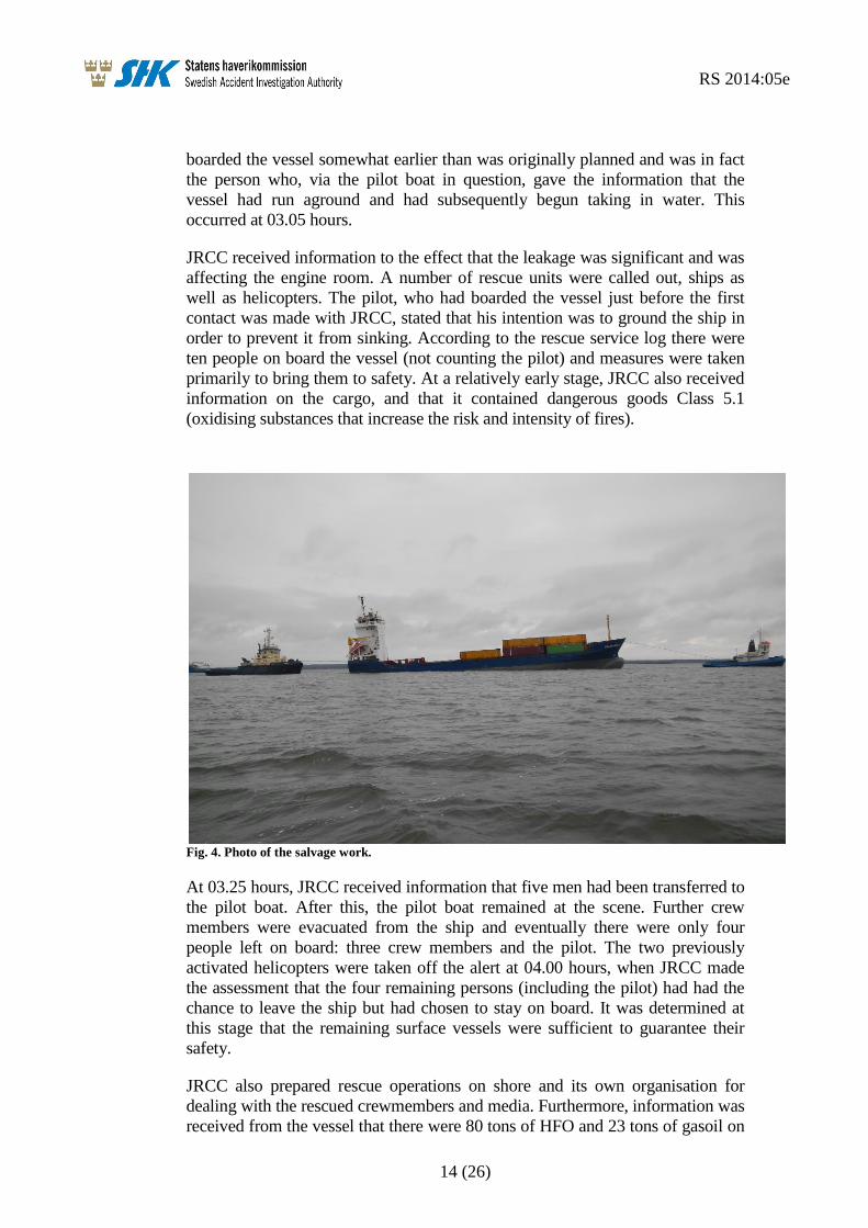
1.6 Rescue operations
The rescue operations were in practice started when the pilot planning centre in
Malmö informed JRCC8 at 03.09 hours that Trans Agila had passed on the
wrong side of a spar buoy (which in fact proved to be the Masknaggen
Lighthouse) and thereafter had run aground. The reason why this was the alarm
route was because the ship’s crew, immediately prior to the accident, had had
contact with the crew of the pilot boat concerning the planned pilot embarkation
at the pilot boarding point at Krongrundet. As a result of the accident, the pilot
8 JRCC – Joint Rescue Coordination Center.
Planned route in the electronic chart
Waypoint, marked in the
paper chart
AIS track
Trans Agila
RS 2014:05e
14 (26)
boarded the vessel somewhat earlier than was originally planned and was in fact
the person who, via the pilot boat in question, gave the information that the
vessel had run aground and had subsequently begun taking in water. This
occurred at 03.05 hours.
JRCC received information to the effect that the leakage was significant and was
affecting the engine room. A number of rescue units were called out, ships as
well as helicopters. The pilot, who had boarded the vessel just before the first
contact was made with JRCC, stated that his intention was to ground the ship in
order to prevent it from sinking. According to the rescue service log there were
ten people on board the vessel (not counting the pilot) and measures were taken
primarily to bring them to safety. At a relatively early stage, JRCC also received
information on the cargo, and that it contained dangerous goods Class 5.1
(oxidising substances that increase the risk and intensity of fires).
Fig. 4. Photo of the salvage work.
At 03.25 hours, JRCC received information that five men had been transferred to
the pilot boat. After this, the pilot boat remained at the scene. Further crew
members were evacuated from the ship and eventually there were only four
people left on board: three crew members and the pilot. The two previously
activated helicopters were taken off the alert at 04.00 hours, when JRCC made
the assessment that the four remaining persons (including the pilot) had had the
chance to leave the ship but had chosen to stay on board. It was determined at
this stage that the remaining surface vessels were sufficient to guarantee their
safety.
JRCC also prepared rescue operations on shore and its own organisation for
dealing with the rescued crewmembers and media. Furthermore, information was
received from the vessel that there were 80 tons of HFO and 23 tons of gasoil on

RS 2014:05e
15 (26)
board. This information was forwarded by JRCC to the coastguard. At 06.24
hours, M/S Trans Agila stated that water was beginning to leak into the cargo
hold from the engine room. Pumps were available in some of the rescue units,
and the vessel was partially standing on a sandbank. At 08.30 hours, the tug
Pampus stated that it had arrived at the scene of the accident. The coastguard
stated that there were no signs of oil in the water. At 12.24 hours, the sea rescue
operation was terminated.
1.7 The Kalmarsund northern inlet – Öland Bridge Channel: navigation in
darkness with good visibility
When navigating in darkness and good visibility, one way to navigate is
lighthouse sector navigation. However, navigation should always be
complemented with at least one alternative, e.g. electronic sea charts or
navigation by radar.
At the northern inlet to Kalmarsund, there are two pilot boarding points. The
southern boarding point lies just outside the area in which compulsory pilotage
applies. However, it is also possible to take on a pilot at the northern boarding
point. Navigation on the stretch of water in question is relatively complicated
and there are, for example, a large number of lighthouse sectors to align with.
When a vessel enters Kalmarsund from the north, it first of all passes a number
of cardinal marks and thereafter the island of Blå Jungfrun. The Dämman
Lighthouse must be passed on the eastern side, after which the vessel enters the
white sector of the Slottsbredan Lighthouse before passing the lighthouse close
on its western side. Then follows a relatively long straight section in sector
navigation from Slottsbredan towards the Sillåsen Lighthouse. Closer to Sillåsen,
off the port bow, ships enter the white sector of the Ispeudde Lighthouse about
the same time as the north point of Skäggernäs island is in bearing 270° and
range 1.7 M9, which indicates when it is suitable to turn to port out of the white
sector from Sillåsen, on to a course between 190° and 195°, depending on where
the turn commences. About 1.3 M before Sillåsen there is a reporting point,
which is followed by the northern pilot boarding point.
Depending on when the vessel exits the Sillåsen white sector, after 2-3 M the
white sector of the Masknaggen Lighthouse appears. When the light buoy Östra
Bredgrund is on starboard side and the point N Fäholmen is at a distance of 0.7
M on the port side, the vessel has to turn on to a course of approximately 220°
towards the Krongrundet Lighthouse, in order to pass about 0.1 M southeast of
Masknaggen. The shallower area south of Sillåsen is delimited towards the
fairway on the one hand by the southern, white/red sector boundary from
Sillåsen, and on the other by the Östra Bredgrund light buoy. On completion of
the Masknaggen passage the vessel makes a slight turn to starboard on to course
227° where the white sector from the Krongrundet Lighthouse can be seen close
on the port side. After travelling about 1.5 M on this course, the ship enters a
green sector from Krongrundet and after a further approximately 1 M it enters a
red sector. This indicates that you have to turn to port to come in on course 203°
9 M – nautical mile

RS 2014:05e
16 (26)
in order to follow the middle of the straight channel that leads under the passage
span of the Öland Bridge and further on past Kalmar. The middle of the channel
is marked on the bridge by a steady white light and a beacon. The sides are
marked with steady red and green lights. The channel is otherwise marked with
lights and fixed marks with facade lighting, and light buoys and spar-buoys – red
on the western side and green on the eastern side. The narrowest part of the
channel is at the Osvallsgrundet Lighthouse, where the channel width is about 60
m.
Compulsory pilotage applies from a line between the points 56° 41.70ʹN
016°23.50ʹE and 56° 41.00ʹN 016°25.40E, which in practice crosses the
navigation channel at the Krongrundet Lighthouse. The southern pilot boarding
point is situated hardly 3.5 cable lengths (0.35 M) before this.
Fig. 5. The northern boarding point is voluntary. Compulsory pilotage does not come into effect
until immediately after the southern boarding point. The red line represents the actual course of
the vessel according to AIS.
1.8 Applicable regulations
1.8.1 Compulsory pilotage
The requirements for compulsory pilotage are decided by the Swedish Transport
Agency and can be found in the Swedish Transport Agency’s Regulation and
General Advice (TSFS 2012:38) on Pilotage. On the other hand, the locations at
which the pilot embarks and disembarks (boarding points) are decided by the
Swedish Maritime Administration. At the time of the accident, this was regulated
by the Swedish Maritime Administration’s Regulation (SJÖFS 2012:3) on the
Provision of Pilots, Pilot Engagement, Assignment of Pilots and Pilotage Fees.
The Swedish Maritime Administration is also the authority that provides

RS 2014:05e
17 (26)
pilotage. It follows from the regulations that compulsory pilotage did not apply
within the area in question, and did not begin to apply until Krongrundet
immediately southwest of the grounding location. The compulsory pilotage
applied to the passage beneath the Öland Bridge down to a point immediately
south of Skansgrundet. The intention was to take the pilot on board Trans Agila
at Krongrundet, or in other words at the southernmost of the two pilot boarding
points. Compulsory pilotage applied to vessels longer than 70 m, i.e. Trans Agila
was obliged to take a pilot on board, unless anyone on board had a Pilot
Exemption Certificate, which was not the case.
At the scene of the grounding, compulsory pilotage did not apply. It would
nevertheless have been possible for the vessel to take a pilot on board
voluntarily, which according to reports received does happen. For this purpose,
as stated above, there was a pilot boarding point, defined on the sea chart about 3
M north of the grounding point, which had thus already been passed shortly
before the occurrence.
1.8.2 Voyage planning
The international requirements that apply with respect to voyage and route
planning are regulated by the International Regulations SOLAS10
Chapter V,
Regulation 34. There it is stipulated, among other things, that the master, before
the voyage, shall make sure that the planning has been carried out with the aid of
adequate equipment and that the guidelines of IMO11
have been considered. The
guidelines referred to include, above all, Resolution A.893(21) Guidelines for
Voyage Planning, in which it is mentioned that the planning shall be clearly
marked on the sea charts concerned:
3.2.1) [The detailed voyage or passage plan should include the following
factors:] the plotting of the intended route or track of the voyage or passage on
appropriate scale charts: the true direction of the planned route or track should
be indicated, as well as all areas of danger, existing ships' routing and
reporting systems, vessel traffic services, and any areas where marine
environmental protection considerations apply;
1.8.3 Bulkhead design and inspections
A vessel is divided into a number of compartments that are separated by the
vessel’s bulkheads. According to SOLAS, Chapter II-1, Regulation 11, the
bulkhead between the cargo hold and the engine room is the type of bulkhead
that must be watertight.
Responsibility for the technical standard of the vessel always rests with the
master and the shipping company, while inspection is the responsibility of the
flag state, which is responsible for that vessels, flying their flag, has the required
certificates and are subjects of inspections according to established time
schedules. Within the frames of the stipulating international conventions,
delegation by contract to recognized organizations (most often a classification
society) of certain parts may occur. Furthermore, certain vessels are required to
10 SOLAS - International Convention for the Safety of Life at Sea 11 IMO – International Maritime Organization

RS 2014:05e
18 (26)
be constructed according to a classification society’s regulations regarding
machinery and hull. As a proof of this, the classification society issues a class
certificate.
The hull construction is regulated by an international SOLAS requirement, in
this case delegated to the vessels classification society.
1.8.4 Crew on watch
According to current international regulations, (STCW12
Part A/VIII Part 4.1)
the crew on a ship’s bridge shall consist of at least an officer and a lookout. An
exception can be made, but only if certain preconditions are met, e.g. daylight,
easily navigated waters, absence of heavy traffic and good visibility.
1.9 Damage
The investigation that was performed by divers after the grounding indicated the
following damage:
There were scrape marks on the bottom of the ship from Span 60 towards the
stern. In addition, there was damage on both the starboard and port sides of the
centre line on the flat bottom. A total of 7 holes/cracks could be seen. One of the
cracks was located between Spans 36 and 37, and ran up into the engine room.
Furthermore, there was a hole between Spans 32 and 33 on the starboard side.
The rudder, of the Becker type, was undamaged but all four propeller blades
were damaged.
The damage to the ship’s bottom meant that water penetrated into the engine
room (See Fig. 2). From here the water continued to the hold via a lead-
through/bushing in the bulkhead between the engine room and the cargo hold.
The opening was situated in a box-shaped extension to the bulkhead in the
engine room and constituted a cable run-through between the hold and the
engine room. After the grounding, the crew tried to stop the water flow from the
hold by sealing the hole with available miscellaneous material (see Fig. 6). By
doing this, and by using submersible pumps in the cargo hold, it was possible to
prevent the ship from sinking completely. Despite the fact that Trans Agila could
be prevented from sinking and that she therefore could be towed away, the vessel
has not been repaired and became regarded as a total loss for the owners.
No other damage or injuries are known to have occurred to either individuals or
to the environment.
It should be noted that during the course of the investigation, SHK requested
information on the damage from the classification society and the shipping
company, neither of whom answered SHK’s enquiries.
12 STCW – Standards of Traning, Certification and Watchkeeping

RS 2014:05e
19 (26)
Fig. 6. An attempt to block the flow of water from the engine room. Photo taken from the cargo
hold.
1.10 Statistics
According to the Swedish Transport Agency’s statistics, eleven vessels have run
aground over the period 2003-2012 in Kalmarsund, in which context the actual
groundings have been the initial events. On none of these occasions was there a
pilot on board. Seven of the incidents involved vessels larger than 500 gross. Of
these incidents, five occurred within the pilot boarding points that were marked
on the charts (see Fig. 5).
1.11 Miscellaneous
The tests conducted by the coastguard on the crew members have not showed
that any of them were under the influence of alcohol. There are no obvious
indications either to the effect that tiredness could have been of any significance
with regard to the sequence of events leading up to the grounding.

RS 2014:05e
20 (26)
2. ANALYSIS
2.1 The fairway
The second officer had approximately 15 months of experience as an officer.
Even though he was regarded as being competent, he should in the opinion of
SHK have been considered as relatively inexperienced. Bearing in mind that that
this was the first time he had been placed in sole charge of negotiating a
navigation channel that was by no means uncomplicated, it would appear
unsuitable for him to be alone on the bridge (the lookout was elsewhere making
preparations to take on the pilot). The master’s instructions to the second officer
also indicate that he was of the opinion that the passage was subject to
navigational difficulties.
According to current regulations, compulsory pilotage applies from Krongrundet
Lighthouse, and the pilot boarding point is located barely 3.5 cable lengths
(about 640 m) before this point. SHK notes that the distance between the pilot
boarding point and the compulsory pilotage boundary is relatively short. From
the time that the pilot comes on board until the vessel is in an area subject to
compulsory pilotage, the pilot have to acquire all necessary information on the
vessel, acquaint himself with the equipment and reach agreement with the
officers on board on how the work on the bridge should continue. Even if the
short distance between the pilot boarding point and the compulsory pilotage
boundary is accepted, there are good reasons to consider an extension of the
compulsory pilotage area northwards up the channel.
As mentioned above, the channel is an area that is difficult to navigate. There
would also appear to be a certain operative need for pilotage north of the
Krongrundet Lighthouse since there is today a more northerly pilot boarding
point that can be chosen on a voluntary basis. In addition, the accident statistics
indicate that it could be reasonable to draw attention to the need for compulsory
pilotage in this sensitive area. SHK’s report on the investigation of Trans Agila’s
grounding focuses on this individual occurrence and makes no claim to be a
comprehensive analysis of accidents and groundings in Kalmarsund.
Nevertheless, from the sequences of events from these other groundings, it
appears reasonable to assume that the presence of a pilot on board would have
prevented the groundings. Hence, there would appear to be a need for a closer
investigation into the accident frequency in the whole of Kalmarsund and to put
this in relation to a possible change in the need for compulsory pilotage.

RS 2014:05e
21 (26)
2.2 Voyage planning
It is evident that the voyage was not planned in an adequate way. The track that
was entered on the electronic sea chart is quite simply incorrect, and leads in the
wrong direction. It has not been possible to determine how this fault occurred in
the course of this investigation, but it could, of course, be a typing error. For
example, if the longitude specified at turning point 7 as 016°29ʹ500E – had
instead been entered as 016°29ʹ800, the course would have been aligned on the
correct side of the lighthouse.
Furthermore, the manually placed waypoint in the paper chart (Fig. 7) indicates
that the crew did not pay much attention to the formally documented voyage
planning in practise. Possibly, this manually marked waypoint is the master’s
instruction or directive to the second officer (which he of some reason did not
follow) but the investigation has not been able to clarify this.
As can be seen in Fig. 3, the vessel did not follow the planned course anyway,
and there are indeed no demands that this must be the case. Deviations are
permitted – it is, after all, the actual physical circumstances that must in the final
instance dictate the route that is taken by the vessel. On the other hand, the
possibility cannot be ignored that the course entered on the electronic sea chart,
which shows a more northerly route, may have caused the second officer, either
consciously or subconsciously, to choose to pass Masknaggen on the northern
side.
Fig. 7. The vessel’s paper chart. Note the manually marked waypoint SE of Östra Bredgrund.
Manually marked
waypoint

RS 2014:05e
22 (26)
As can be seen in the sea chart, there is a green sector on either side of the
Masknaggen Lighthouse white sector, viewed from the direction in which Trans
Agila came (even though the southern green sector is preceded by a narrow red
sector). The possibility cannot be ignored that the second officer was lulled into
a false sense of security if he assured himself that he was on the right course by
concluding that the vessel was in the green sector (without realising there was
another green sector on the wrong side). According to his statement, he knew
that the lighthouse should show green but he began to suspect that something
was wrong when it changed to red (which it would not do if being passed on the
correct side). By then, however, it was too late.
In conclusion, the second officer could have received two indications that he was
on the right position: on the one hand by passing north of the lighthouse, in
accordance with the course planning on the electronic sea chart, and on the other
hand by being in a green sector.
It can be concluded that the navigation, and the planning leading up to it, were
incomplete and inconsistent. It is of outmost importance that a ship’s voyage
planning is carefully checked, in general as well as in connection to any
individual watch. The ship’s earlier deficiencies in connection with port state
controls, together with the above indications that it appears to have had two
parallel systems of voyage planning (one pro forma on the electronic chart, to
fulfil the regulatory requirements of a possible inspection, and one in practice in
the paper charts) suggests that this problem is of a deeper character, and
indicates problems for the shipping company to effectively introduce the vessel’s
SMS.
2.3 Damage
The damage to the bottom of the ship was limited to the engine room.
Nevertheless, the cargo hold was partially filled with water owing to a bulkhead
lead-through that did not fulfil applicable requirements. Responsibility for the
technical standard of the vessel always rests with the master and the shipping
company, while inspection is the responsibility of the flag state or – as in this
case – a classification society, to whom the task has been delegated. It may
appear strange that neither the crew nor the shipping company or the
classification society, had noticed the non-watertight lead-through/bushing. Such
faults, even though they may appear to be minor in nature, can in the long run
lead to major damage.
2.4 Watch duties
The second officer was alone on the bridge at the time of the grounding, which is
not in accordance with current regulations. The conditions for exemption as
specified in the regulations are not considered to be fulfilled in this case since it
was dark and the ship was within a fairway, regarded as difficult to navigate.
RS 2014:05e
23 (26)
2.5 Miscellaneous
The international regulations of maritime accident investigations as well as the
Swedish Accident Investigation Act (1990:712) are based upon the loyal
contribution from shipping companies and classification societies. This may be
accomplished by answering questions within the scope of an investigation.
During the course of the investigation, SHK has requested information on the
damage caused to the vessel from both the shipping company and the
classification society, none of whom have responded. This has to be considered
as problematic. As flag state duties are delegated to classification societies to an
increasing extent also in Sweden and therefore act as supervisory authorities, it is
of essential importance that they, as well as the concerned shipping companies,
cooperate with the responsible investigating body.

RS 2014:05e
24 (26)
3. CONCLUSIONS
3.1 Results from the investigation
a) The second officer had worked as a deck officer for 15 months.
b) The voyage planning was not well performed.
c) The second officer was alone on the bridge in a narrow fairway in darkness.
d) The ship was brought on the wrong side of the Masknaggen Lighthouse.
e) Water ingress in the engine room made the main engine to stop, followed by
the auxiliary engines.
f) A not completely sealed lead-through/bushing led to water ingress in the
cargo hold.
g) The grounding occurred in an area where pilotage was not compulsory.
3.2 Causes and contributory factors
The second officer was inexperienced and, at the time of the grounding,
alone on the bridge.
The area was difficult to navigate but not subject to compulsory pilotage.
A lead-through/bushing in the bulkhead between the engine room and the
cargo hold was not watertight and therefore did not fulfil the stipulated
regulations.
Voyage/route planning had not been carried out nor checked in the correct
way.
The navigation for the single watch had not been sufficiently well planned.
The ship’s SMS had not been fully implemented.

RS 2014:05e
25 (26)
4. RECOMMENDATIONS
The Swedish Transport Agency is recommended to:
In consultation with the Swedish Maritime Administration, conduct an
investigation and analysis of accidents in Kalmarsund, and in conjunction to that,
review the possible need to change the area for compulsory pilotage (RS2014:05
R1).
The classification society Germanisher Lloyd is recommended to:
Review its routines in order to avoid work on hulls and machinery, that is not
carried out in conformance with the regulations, being passed as approved
(RS2014:05 R2).
The shipping company Berederungsgesellschaft Speck GmbH & Co. KG is
recommended to:
Take action to ensure that its vessels implement SMS in their daily work in
accordance with the intentions of the system (RS2014:05 R3).
SHK requests a response, no later than 18 august 2014, on the action that has
been taken as a result of the recommendations made in the Report.
The report is available in Swedish on our web site. In case of any discrepancies,
the Swedish original has precedence.
On behalf of the Swedish Accident Investigation Authority,
Jonas Bäckstrand Jörgen Zachau

RS 2014:05e
26 (26)
ENCLOSURE
Vessel voyage planning