Final report on the assessment of existing disaster ... · forestration, aquaculture and capture...
56
REGIONAL FISHERIES LIVELIHOODS PROGRAMME FOR SOUTH AND SOUTHEAST ASIA (RFLP) - VIETNAM -------------------------------------------------------- A FINAL REPORT ON THE ASSESSMENT OF EXISTING DISASTER WARNING SYSTEMS IN QUANG NAM PROVINCE (Activity Code 2.3.1 - 2010) For the Regional Fisheries Livelihoods Programme for South and Southeast Asia - Viet Nam Prepared by Vo Van Long Tran Van Truong Nguyen Nhu Son July 2011
Transcript of Final report on the assessment of existing disaster ... · forestration, aquaculture and capture...

REGIONAL FISHERIES LIVELIHOODS PROGRAMME FOR SOUTH AND SOUTHEAST ASIA (RFLP) - VIETNAM
--------------------------------------------------------
A FINAL REPORT ON THE ASSESSMENT OF EXISTING
DISASTER WARNING SYSTEMS IN QUANG NAM PROVINCE
(Activity Code 2.3.1 - 2010)
For the Regional Fisheries Livelihoods Programme for South and Southeast Asia - Viet Nam
Prepared by
Vo Van Long Tran Van Truong Nguyen Nhu Son
July 2011

Final report on the Assessment of Existing Disaster Warning Systems in Quang Nam Province
2
This publication has been made with the financial support of the Spanish Agency of International Cooperation for Development (AECID) through an FAO trust-fund project, the Regional Fisheries Livelihoods Programme (RFLP) for South and Southeast Asia - GCP/RAS/237/SPA. The content of this publication does not necessarily reflect the opinion of AECID, FAO, RFLP, or MARD.
All rights reserved. Reproduction and dissemination of material in this information product for educational and other non-commercial purposes are authorized without any prior written permission from the copyright holders provided the source is fully acknowledged. Reproduction of material in this information product for resale or other commercial purposes is prohibited without written permission of the copyright holders. Applications for such permission should be addressed to: Chief Electronic Publishing Policy and Support Branch Communication Division FAO Viale delle Terme di Caracalla, 00153 Rome, Italy or by e-mail to: [email protected] © FAO 2011 For bibliographic purposes, please reference this publication as: Vo, V. L., Tran, V. T., & Nguyen, N. S. (2011). Final report on the assessment of existing disaster warning systems in Quang Nam Province. Regional Fisheries Livelihoods Programme for South and Southeast Asia (GCP/RAS/237/SPA) Field Project Document 2011/VIE/23E.

Final report on the Assessment of Existing Disaster Warning Systems in Quang Nam Province
3
TABLE OF CONTENTS LIST OF TABLES AND FIGURES ....................................................................................................... 4LIST OF ABBREVIATIONS ................................................................................................................. 5EXECUTIVE SUMMARY .................................................................................................................... 6I. NATURAL CONDITIONS OF QUANG NAM PROVINCE ............................................................ 7
1. Geographical location .................................................................................................................... 72. Topography .................................................................................................................................... 73. Climate ........................................................................................................................................... 7
II. METHODOLOGY ............................................................................................................................. 81. Data source .................................................................................................................................... 82. Method of data collection .............................................................................................................. 8
2.1. Secondary data collection ...................................................................................................... 8
2.2. Primary data collection .......................................................................................................... 8
2.3. Data analysis .......................................................................................................................... 8
III. RESEARCH FINDINGS .................................................................................................................. 91. Disasters in the province ................................................................................................................ 9
1.1. Storms and tropical depressions ............................................................................................. 9
1.2. Floods .................................................................................................................................... 9
1.3. Flash floods .......................................................................................................................... 10
1.4. Riverside and seashore landslides ....................................................................................... 10
1.5. Mountain landslides ............................................................................................................. 10
1.6. Northeast monsoon (cold air) ............................................................................................... 11
1.7. Thunderstorms, cyclones, and lightnings ............................................................................. 11
1.8. Drought and saline intrusions .............................................................................................. 11
2. Damage caused by natural disasters in recent years in Quang Nam Province ............................. 123. Types of disaster warnings in Quang Nam Province ................................................................... 14
3.1. Communication systems ...................................................................................................... 14
3.2. Storm warning flares and tropical depression ...................................................................... 15
3.3. Flood markers ...................................................................................................................... 16
3.4. Lighthouses .......................................................................................................................... 18
3.5. Warning system in channels ................................................................................................ 19
4. Assessment of natural disaster warning systems ......................................................................... 204.1. Communication systems ...................................................................................................... 21
4.2. Tropical depression and storm flares ................................................................................... 22
4.3. Flood markers ...................................................................................................................... 22
4.4. Lighthouses .......................................................................................................................... 22
4.5. Warning systems in channels ............................................................................................... 22
5. Proposed solutions to manage and adapt to natural disasters ...................................................... 235.1. Improving the adaptability of managers to natural disasters ............................................... 23
5.2. Integrating adaptation of the existing natural disasters into the local development policies
.................................................................................................................................................... 23
5.3. Recommendations and policies to adapt to the existing disasters in the locality ................. 24

Final report on the Assessment of Existing Disaster Warning Systems in Quang Nam Province
4
5.4. New construction and strengthening of disaster warning systems ....................................... 24
IV. CONCLUSIONS AND RECOMMENDATIONS ......................................................................... 251. Conclusions .................................................................................................................................. 252. Recommendations ........................................................................................................................ 25
ANNEXES ............................................................................................................................................ 27Annex 1: Value of damage caused by natural disasters from 1997 to 2009 in Quang Nam province
......................................................................................................................................................... 28Annex 2: Location of flood markers in Quang Nam province ......................................................... 29Annex 3: Channel marker systems of Ky Ha port ........................................................................... 31Annex 4: Coastal lighthouse systems in Quang Nam province ....................................................... 32Annex 5: Disaster warning systems in Quang Nam province ......................................................... 33Annex 6: Questionnaire of existing disaster warning system at local level ..................................... 35Annex 7: Questionnaire of existing disaster warning system at community level .......................... 41Annex 8: In-depth interview questionnaire for lighthouses at management level ........................... 43Annex 9: In-depth interivews for tropical deppression and storm warning signal fire system at management level ............................................................................................................................ 45Annex 10: In-depth interviews of flood marker managers .............................................................. 47Annex 11: List of interviewees ........................................................................................................ 49Annex 12. DETAILED PLAN OF THE ACTIVITY OF ASSESSMENT OF EXISTING DISASTER WARNINGS ................................................................................................................ 51Annex 13: Minutes of the Validation Workshop ............................................................................. 54Annex 14: List of participants in the validation workhop ............................................................... 56
LIST OF TABLES AND FIGURES Table 1. Statistics of storms and tropical depressions impacted Quang Nam province (1997-2009) ..... 9Table 2. Statistics of the number of dead and injured during landslides in mountainous areas (2004 - 2009) ..................................................................................................................................................... 11Table 3. Statistical data on existing communication systems in the province ...................................... 15Table 4. Warning flares ......................................................................................................................... 15Table 5. Launching location and management agencies for flare operation ......................................... 16 Figure 1. Casualties caused by natural disasters in Quang Nam Province (1997- 2009) ...................... 12Figure 2. Property losses caused by storms and floods from 1997 to 2009 .......................................... 13Figure 3. Property losses caused by cyclones and lightning from 1997 to 2009 .................................. 13Figure 4. Loss of lives caused by cyclones and lightning from 1997 to 2009 ...................................... 14Figure 5. Flood marker ......................................................................................................................... 17Figure 6. Map of flood marker distribution in Quang Nam province ................................................... 18Figure 7. Lighthouse tower ................................................................................................................... 18Figure 8. Distribution of lighthouses in Quang Nam Province ............................................................. 19Figure 9. Distribution of marine navigation buoy markers in Ky Ha seaport, Quang Nam province .. 20

Final report on the Assessment of Existing Disaster Warning Systems in Quang Nam Province
5
LIST OF ABBREVIATIONS CPC: Commune People’s Committee CV: Cheval (French)/ Horsepower (English) DARD: Department of Agriculture and Rural Development. DPC: District People’s Committee KHz: Kilohertz LF: Low frequency MF: Medium frequency No.: Number PMU: Project Management Unit PPC: Provincial People’s Committee RFLP: Regional Fisheries Livelihoods Program VHF: Very high frequency VND: Vietnamese Dong
Final report on the Assessment of Existing Disaster Warning Systems in Quang Nam Province
6
EXECUTIVE SUMMARY The assessment of existing disaster warnings was implemented in project communes and localities where the early disaster warning systems have been installed. The survey shows that Quang Nam province is prone to natural disasters. In the current climatic conditions, natural disasters tend to increase in the number and serevity. The common types of natural disasters in the province include storms, tropical depressions, floods, flash floods, riverside/seashore/mountain landslides, northeastern monsoon (cold air), thunderstorms, cyclones, lightning, drought and saline intrusion. Currently, early disaster warning systems may be classified into: (i) information and communication systems; (ii) signal-flares for storms and tropical depressions; (iii) flood markers; (iv) lighthouses; and, (v) navigational warning systems. Such systems do not exist for tsunami, riverside/seashore/mountain landslides. The investment and construction of these early warning systems in coastal areas is therefore very important. In general, early disaster warning systems have effectively helped locals fishers in preventing and avoiding natural disasters. However, there is a shortage of synchronized investment in the systems, leading to the lack of such systems in some communes. Many local officials are unaware of the system usage. Additionally, fishing communities’ awareness in the areas often hit by natural disasters is limited. Most fishers have not been instructed or trained in disaster preparedness.
Solutions to disaster management and adaptation for the province would include capacity building for managers, incorporation of existing disaster adaptation into local development policies and directions, and construction/upgrading of current disaster warning systems.

Final report on the Assessment of Existing Disaster Warning Systems in Quang Nam Province
7
I. NATURAL CONDITIONS OF QUANG NAM PROVINCE 1. Geographical location Quang Nam province is situated in the key economic zone of Central Vietnam. Its coordinates are 15034' N and 108040' E. The province covers a total area 10,400 km2
. The province is at the intersection of railway, highway, sea and air routes connecting the North and the South, and National Highway No. 14B that links Danang Port, to the northern districts of the province, the Central Highlands, and the Vietnam-Laos Border.
The province has 125 km of coastline and two estuaries of Cua Dai (Hoi An) and An Ha (Nui Thanh). It is characterized by a river network evenly distributed over the province, in which the most important ones include the Vu Gia River (170 km in length and 5,500 km2 of lower-basin), the Thu Bon River (180 km in length and 3,350 km2 of basin), and, the Tam Ky River (40 km in length and 800 km2
of basin). These rivers are short with high slopes, providing water for irrigation, hydro-power, navigation and aquaculture, and creating favourable conditions for the development of marine economics and tourism.
2. Topography Quang Nam‘s territory slopes from West to East. In the West are mountains, accounting for 75% of its total natural area. The province are divided by the basins of rivers like the Vu Gia, Thu Bon, Tam Ky, etc., forming sub-areas with special features as follows:
· Sandy coastal plains: The main activities in these areas include cash crops, anti-sand forestration, aquaculture and capture fisheries. For industrialisation, the areas have some advantages including being close to airports, fishing ports, national roads, railways and on the national power grid.
· Highland, with an average elevation of 100 m: The topography is a mix between mountains and plain strips, such as those in the districts of Thang Binh, Duy Xuyen, Dai Loc, Que Son, etc. Major activities include cultivation, husbandry and small-scale mining. The areas are also rich in minerals such as gold and placer gold that are being exploited in Bong Mieu, Du Hiep, Tra Duong, and Doc Kien with average production of hundreds of kilograms per year. Coal reserves, mostly concentrated in Nong Son, Ngoc Kinh and An Diem, are as large as 10 million tons in volume.
· Upland, in the eight western districts of the province: The majority of residents are ethnic minority groups, living on cultivation and husbandry with traditional farming methods.
3. Climate Rains and storms often take place from October to December, and especially November. The average rainfall is 2,200 to 2,500 mm for the province in general, and 4,000 mm for the highland areas. Annually, there are usually three floods/flash floods, three to four cyclones, and hail on one to two occasions. Temperatures range between 12oC and 38oC and the average is 25.5 o
C which could be observed in four months. The coldest time is in December. No fog has been recorded.
In general, in recent years Quang Nam weather appears to have been greatly influenced by climate change phenomena, such as the global warming and sea level rise. Floods and storms
Final report on the Assessment of Existing Disaster Warning Systems in Quang Nam Province
8
are getting harder to forecast. The control and prevention of natural disasters have faced numerous difficulties. In particular, Storm No. 9 in 2009 caused heavy loss of human life and property, which severely negatively impacted on the development of the province and livelihoods of coastal fishers.
II. METHODOLOGY 1. Data source The data used for this research was collected from agencies in charge of management of disaster warning systems, such as the Provincial Committee for Flood and Storm Control, the Provincial Metereological and Hydrographical Forecast Station, the Border Defence Force, DPCs, CPCs, etc. Data was also gathered from periodical reports, managers, interviews with management agencies, fishing communities and information from workshops. 2. Method of data collection 2.1. Secondary data collection Secondary data was collected from local administrations in charge of disaster warning systems including the Provincial Committee for Flood and Storm Control, the Meteorology Station, the Border Defence Force, DPCs, CPCs, etc. The collected data covers the status of disaster warning systems, data on types of natural disasters in the province, the educational background of managers, the methods of awareness raising for communities, etc. 2.2. Primary data collection Primary data was collected by inverviews with officials running the disaster warning systems and fishing communities living and working in the proximity of such systems, using questionnaires designed by the researchers including:
· 10 in-depth questionnaires for the interviews with agencies in charge of managing and using disaster warning systems, authorities of the communes in proximity of such systems, in order to get the following information: o Lighthouses: height, placing points, visibility (good or bad weather), advantages
and disadvantages, etc. o Flood markers: Locations, size, total costs, operational mechanism, management
agencies and their expertise, etc. o Signal flares: Launching places and time, visibility, colour, etc.
· Interviewing fishers living in the proximity of the disaster warning systems, using 120
questionnaires in seven communes (15 in each commune of Duy Nghia, Duy Hai, Duy Thanh, Binh Minh, Binh Hai, and Binh Nam, and 30 in Tam Quang). The interviews were aimed to get information on fishers’ awareness of existing disaster warning systems in their communes.
2.3. Data analysis The data collected in questionnaires was input into the Excel software and then analyzed by descriptive statistic method and other common formulas.

Final report on the Assessment of Existing Disaster Warning Systems in Quang Nam Province
9
III. RESEARCH FINDINGS 1. Disasters in the province The Central coastal province of Quang Nam province is prone to natural disasters. In the current climatic conditions, natural disasters tend to increase in the number and serevity. The common types of natural disasters in the province include storms, tropical depressions, floods, flash floods, riverside/seashore/moountain landslides, northeastern monsoon (cold air), thunderstorms, cyclones, lightning, drought and saline intrusion. 1.1. Storms and tropical depressions Storms and tropical depressions usually hit the province from May to December, especially in October and November. The data collected shows that out of 174 storms and tropical depressions taking place in the South China Sea between 1997 and 2009, 26 (27%) storms and 12 (30%) tropical depressions affected the province. In particular, Storm No. 6 (Sangsane) in 2006 and No. 9 (Kesana) in 2009 caused heavy loss of human life and property of the State and people in the province.
Table 1. Statistics of storms and tropical depressions impacted Quang Nam province (1997-2009)
Source: Quang Nam Provincial Command for Storm and Flood Control, 2010 The above table shows that suggest there may be an increasing number of storms and tropical depressions in the South China Sea and in Quang Nam province. Other data suggest the storms may be getting more severe. 1.2. Floods The monsoon flood season in Quang Nam usually lasts from September to November. It
Year Storms in the South China Sea Tropical depressions in the
South China Sea
Total Affecting Directly hiting Total Affecting
1997 5 1 - - - 1998 8 5 - 3 3 1999 10 2 - 9 1 2000 4 2 - 3 1 2001 8 2 - 1 1 2002 4 - - 1 - 2003 7 1 - - - 2004 4 2 - 1 1 2005 7 6 - 2 2 2006 9 3 1 6 1 2007 8 - - 4 - 2008 10 - - 7 2 2009 10 2 1 3 - Total 96 24 2 40 12

Final report on the Assessment of Existing Disaster Warning Systems in Quang Nam Province
10
rains heavily from mid-October to early December. The major causes of floods in the province were:
· Direct influence by a storm or tropical depression hitting the province or moving along its seashore. Or, when the Northern part of Quang Ngai or the Southern part of Thua Thien Hue provinces were hit by a storm or tropical depression.
· Strong northeastern monsoons head towards the province, combined with the circulation of a storm or tropical depression. This complicated weather causes the heaviest rain.
· When the tropical depression zone appears in the South of the South China Sea. Simultaneously, in the North, a monsoon or northeast wind is moving towards the South. This weather causes heavy rain for several days.
1.3. Flash floods Every year, flash floods cause severe mountain landslides and erosions to the areas along rivers and streams. Particularly, in recent years, in mountainous districts and midlands, there have been more and more flash flood occurrences. On average, there are from two to three flash floods of varying scale every year. Flash floods usually appear suddenly in small areas. However, the violence of flash floods cause huge losses of human lives and property. Poor land use, including clear felling of trees, cultivating crops on too steep slopes, and planting down instead of across slopes increase the likelihood of landslides, and mudslides and can increase the severity of mud and land slides caused by severe rainfall events. Similarly there are good land use management practices which can reduce the likelihood and severity of mud and land slides. 1.4. Riverside and seashore landslides
· Riverside landslides: Thu Bon and Vu Gia rivers of Quang Nam province are short in
length. Its meander feature makes the river curve 1.3 - 2 times. Every year, in flooding seasons, erosion takes place in areas along the rivers, extending far to 10-20 m into productive arable land. Many irrigation works are washed away.
· Seashore landslides: Quang Nam possesses 125 km of the coastline whose different parts suffer from the erosion every year. The survey shows that from 1997 to now, some coastal areas have been under the impact of erosion. More than 300 households in the villages of Thuan An, Binh Trung and Xuan My, of Tam Hai commune, Nui Thanh district had to be relocated to safer areas. The estuary accretion and shore erosion is more serious in the Cua Dai area, of Hoi An city. Around 100 households in Village 1, Duy Hai commune, Duy Xuyen district were evacuated after a flood in 1999 due to a landslide of the Thu Bon River bank. 3 km of coastline in Tam Thanh commune (Tam Ky Town) and Tam Tien commune (Nui Thanh district) was affected by erosion. In 2004 State Budget funds were used to improve the reinforce of the coastline.
1.5. Mountain landslides Mountain blasting, road construction, deforestrations and heavy rains are the contributors of mountain landslides in many areas, causing a serious loss of human lives. The data is shown in the following table.

Final report on the Assessment of Existing Disaster Warning Systems in Quang Nam Province
11
Table 2. Statistics of the number of dead and injured during landslides in mountainous areas (2004 - 2009)
Source: Quang Nam Provincial Command for Storm and Flood Control, 2010 In three events, 38 deaths and one injury were reported between 2004 - 2009. However, the data was reported for the largest mountain landslides in the years. No data on property damage was collected. Other communes were predicted to be at a high risk of landslides including Tien An and Tien Loc (Tien Phuoc district), Aroi (Prao town), and Talu, Song Con, Jo Ngay, Ca Dang and Ating (Dong Giang district) communes. These communes were forwarned to evaculate to safe areas. 1.6. Northeast monsoon (cold air) On average, Quang Nam province is impacted by 14-15 Northeast monsoon storms per year. From October to December, Northeast monsoons affect the province, combined with tropical turbulences in the South of South China Sea such as typhoons, tropical depressions, tropical depression zones, etc. Heavy onland rains cause flooding. From January to March, the northeast monsoons arrive in the province, followed by rains and gusts that significantly lower the air temperatures. 1.7. Thunderstorms, cyclones, and lightnings Most thunderstorms occur from April to September, with typically between six to ten thunderstorms per month. Thunderstorms often take place in the midlands and mountains. In 2008, there were 16 thunderstorms, which killed 10 people, injuring 03 others. During the same period 21 houses collapsed, and 37 houses had their rooves blown off. In 2009, nine thunderstorms occurred in the districts of Bac Tra My, Nam Giang, Phuoc Son, Thang Binh, Nong Son, and Nui Thanh, killing 02 people, causing the destruction of 29 houses collapsed and causing severe crop damage. During 2010 until the time of the survey two thunderstorms have taken place in the province. On 14 April 2010, in Nong Son district, thunderstorms and lighting injured 04 people, destroyed 09 houses and blew the rooves off 756 houses, schools, health care centres, the office building of the Commune People’s Committee, and the commune police station. Moreover there was reduced productivity of 176 ha of spring-winter rice, 95 ha of vegetables, and 28 ha of fruit trees and damage to property of both private individuals and the State. The total damage was estimated at about 10 billion VND. 1.8. Drought and saline intrusions Drought and saline intrusion often occur in the dry season. The occurrence depends on the rainfall regime and water flow. Rainfall in the dry season (from January to August each year) accounts for 25-30% of rainfall of the whole year. The absence of rain for long periods can lead to serious drought over large areas. According to statistics from the Quang Nam Provincial
Year Locality No. of deaths (people)
No. of injuries (people)
2004 Phuoc Son district 19 -
2008 Tam Lanh commune - Phu Ninh district 6 -
2009 Tra Giac commune – Bac Tra My district 13 1

Final report on the Assessment of Existing Disaster Warning Systems in Quang Nam Province
12
Command for Storm and Flood Control (2010), from April to July, drought and saline intrusion often occur when spring-winter and summer-autumn rice is in blossom and industrial plants are expanding their production. Drought and saline intrusion lead to decreased productivity and water shortage for domestic use. Saline intrusion occurs when there are prolonged period of drought. When there is insufficient freshwater flow into river estuaries and tributaries saline intrusion occurs into the lower basins of Thu Bon, Tam Ky and Vinh Dien rivers. Saline intrusion usually pushes deeper inland, from April to July, negatively affecting the production and life of the people. According to the statistics from the Quang Nam Provincial Command for Storm and Flood Control (2010), in 1998 and from 2001 to 2005, about 122,418 hectares of rice and crops and over 10,000 hectares of short-termed and long-termed industrial plants suffered from water shortage. About 20,000 residents suffered from reduced drinking water supply. 2. Damage caused by natural disasters in recent years in Quang Nam Province From 1997 to 2009, natural disasters killed 663 and injured 1,699 people respectively. The value of damaged property was estimated at 9,578 billion VND (Annex 1). Figure 1. Casualties caused by natural disasters in Quang Nam Province (1997- 2009)
Source: Quang Nam Provincial Command for Storm and Flood Control, 2010 Natural disasters have caused big damages in the province. On average, there are 51 deaths and over 130 injuries annually In 2006, typhoon Sangsane killed 181 and injured 574.

Final report on the Assessment of Existing Disaster Warning Systems in Quang Nam Province
13
Figure 2. Property losses caused by storms and floods from 1997 to 2009
0500
1000150020002500300035004000
Properties (billion VND)
Source: Quang Nam Provincial Command for Storm and Flood Control, 2010 Figure 2 shows that natural disasters in Quang Nam province have caused increasing more damage over time. In 2009, the total damage caused by natural disasters was valued at around 3,700 billion VND, of which damage to human lives was estimated to be 33.3% and to agriculture 38.2%. The damage was mainly caused by typhoon Ketsana that came with heavy rains and inundating tides. Figure 3. Property losses caused by cyclones and lightning from 1997 to 2009
02468
101214
Properties(billion VND)
Source: Quang Nam Provincial Command for Storm and Flood Control, 2010 Apart from the damage caused by storms, floods, lightning and cyclones also caused huge damage to human lives and property of the people and State. From 1997 to 2009, lightning and cyclones killed 45 and, injured 95 people respectively and caused a total loss of 95 billion VND. The year 2005 witnessed the highest damage valued at 12 billion VND. Ranked second was 1997 with damage valued at 10 billion VND.

Final report on the Assessment of Existing Disaster Warning Systems in Quang Nam Province
14
Figure 4. Loss of lives caused by cyclones and lightning from 1997 to 2009
05
101520253035
Quantity(persons)
Dead Injured
d
Source: Quang Nam Provincial Command for Storm and Flood Control, 2010 3. Types of disaster warnings in Quang Nam Province Disaster warning systems have contributed to minimizing the risks to fishers and their property. Currently, existing natural disaster warnings in Quang Nam Province include: 3.1. Communication systems
· Communication systems play the most important role and provides timely warnings.
It receives and disseminates information from the mass media related to disaster forecast and other relevant information to fishing communities for prevention and preparedness. The physical system includes different means including television, radio, transceivers, etc.
· Forms of communication with communities include: o Inland communication system, through the Voice of Vietnam, Vietnam Television,
and Coastal Radio Stations, provides updated information on the disaster situation and preparedness 24 hours per day to fishers using TVs, radios and transceivers.
o Boat-to-shore communication: Most larger vessels use six-band tranceivers and long-range transceivers.
o Boat-to-boat communication: Larger fishing vessels are using radios and single-side band receiver (SSB) to receive information on disaster warnings from mass media.
· Locations and distribution: The locations of communication stations, their management agencies and other details are shown in Table 3 below:

Final report on the Assessment of Existing Disaster Warning Systems in Quang Nam Province
15
Table 3. Statistical data on existing communication systems in the province
Note: (*) Frequency 7,903 KHz is used to receive/transmit information on rescue, while frequency 7,906 KHz is used to receive/transmit information on emergencies.
· Operation and maintenance: The radio station of the Border Defence Force of Ky Ha
port broadcasts from 07.15 to 14.15 hours every day. Other radio stations hardly operate and only broadcast information of natural disasters upon the request of the local authorities. The monitoring of fishing vessel operation is carried out over registered frequencies. However, maiintenance has not been conducted.
· Qualifications of managers: One Border Station has two staff who have diplomas of secondary-level vocational education, and are responsible to monitor the radio broadcast. In other stations, there are no full-time staff for communication of information on bad weather events.
3.2. Storm warning flares and tropical depression
· Flares are used to alert fishing vessels about potential tropical depressions and storms so that they can find safe shelters. This form of communication provide fishers with information on the severity of tropical depressions and storms through the use of different assigned flare colors as follows:
Table 4. Warning flares
No. Equipment name Location Frequency (KHz) Management agencies Year of
installation
1 ICOM 710 Nui Thanh town, Nui Thanh district
-
Nui Thanh district’s Storm and Flood Prevention Steering Committee
2004
2 ICOM 710 Tam Hai commune, Nui Thanh district
- Tam Hai CPC 2009
3 ICOM 710 Tam Quang
commune, Nui Thanh district
- Tam Quang CPC 2009
4 ICOM 710 Tam Giang commune, Nui Thanh district
-
Tam Giang commune, Nui Thanh district 2008
5 ICOM 710 Binh Minh commune, Thang Binh district
-
Binh Minh commune, Thang Binh district 2007
6 ICOM700BR Tam Quang
commune, Nui Thanh district
9,126 Border Defence Force Station of Ky Ha Port 2004
7 Dung Quoc
Coastal Radio Station
An Hoa cape, Tam Quang commune, Nui
Thanh district
7,903 and 7,906 (*) An Hoa’s Station for
marine signal management 2004
Name
Storms in South China
Sea
Urgent storms
Near-shore
storms
Near-shore tropical depressions
Colours Blue Red Red Blue
Time of launching 05.00 & 19.00 hours,
01.00, 05.00, 19.00, & 23.00 hours
05.00, 19.00, & 23.00 hours
01.00, 05.00, 19.00, & 23.00 hours
Frequency 3 times 3 times 3 times 3 times Distance between launches (minutes) 3’ 3’ 3’ 3’
Visibility (miles) 25 25 25 25

Final report on the Assessment of Existing Disaster Warning Systems in Quang Nam Province
16
Table 5. Launching location and management agencies for flare operation
· Operation and maintenance: In case of storm/tropical depression/disaster, Ky Ha Port
Border Station is directed by the Border Defence Command of Quang Nam province to shoot the flares as regulated. The guns are regularly cleaned and technically checked.
· Qualifications of the manager: The Border Station is responsible for the management and operation of shooting flares. Staff work on part-time basis and are not trained.
3.3. Flood markers
· Flood markers play an important role in tracking water levels and assisting the Hydrology Station in determining and informing people about the seriousness of floods. The agency also makes early warnings on the flooding level in different areas so that local communities can take preparedness measures and minimize damage. Information on flood levels in different areas to the community is disseminated based on the water level shown on flood markers.
· Locations and distribution: At present, the province has a total of 25 flood markers installed along rivers and in wetlands where floods frequently occur and the place is densely populated. The locations of the installed flood markers are listed in Annex 2.
· Operation and maintenance: On each flood marker, there are three markings indicating flood water level. It helps people to take prompt preparedness action. Howerver, since the installation, the flood markers have not undergone any maintenance.
· Managers’ qualifications: the Provincial Storm and Flood Prevention Steering Committee is responisble for the marker management and operation. However, no full-time staff are designated to monitor these markers.
No. Launching location
Implementation and management agencies
Duration of each launch
(minutes) Visibility (miles)
1 Ban Than Cape An Ha Port Border
Station 45’ 25 An Hoa Cape (An Hoa Lighthouse)
2 Cu Lao Cham, Tan Hiep Commune Border Station 276 45’
25
3 Dai Estuary – Hoi An City Dai Estuary Border Station 45’
25

Final report on the Assessment of Existing Disaster Warning Systems in Quang Nam Province
17
· ·
Figure 5. Flood marker

Final report on the Assessment of Existing Disaster Warning Systems in Quang Nam Province
18
Figure 6. Map of flood marker distribution in Quang Nam province
3.4. Lighthouses Figure 7. Lighthouse tower
· · · · · · · ·

Final report on the Assessment of Existing Disaster Warning Systems in Quang Nam Province
19
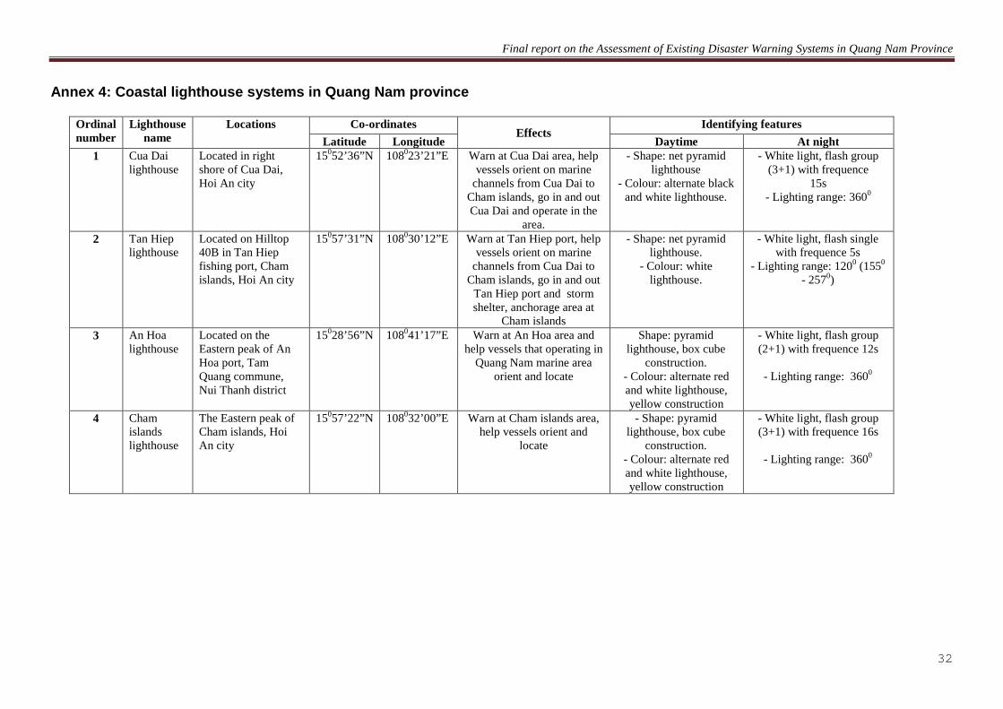
· Locations: Lighthouses help vessels determine the coordinates, location and
directions to seaports and channels. The locations of lighthouses (see Annex 4) include An Hoa (Tam Quang commune, Nui Thanh district) and three in Hoi An, namely Cua Dai, Cu Lao Cham and Tan Hiep fishing port - Hoi An city.
· Operation and maintenance: The provincial lighthouses are operated in accordance with international and national marine safety regulations. Maintenance is fulfilled once a month by staff of the An Hoa Maritime Signal Management Station.
· Qualifications of managers: There are six staff with the intermediate education in charge of monitoring the lighthouses and channel systems of Ky Ha seaport.
Figure 8. Distribution of lighthouses in Quang Nam Province
3.5. Warning system in channels
· This system provides information on the depth, junctions, intersection or other dangerous points to help captains maneuver their vessels safely. There are two types of warnings in channels: o Pillar buoys are installed in the inlets of An Hoa, Cua Lo, and Cua Dai and in
some river parts that are dangerous for passing vessels. o Sign boards are installed along rivers and sea inlets to guide vessels along safe
routes. However, the warning system in small rivers is unreliable and do not
Cua Dai lighthouse Tan Hiep lighthouse
An Hoa lighthouse
Cham islands
lighthouse

Final report on the Assessment of Existing Disaster Warning Systems in Quang Nam Province
20
meet regulated standards. Only the warning system in Ky Ha port meets regulated standards.
· How the warning system provides information? On every pillar buoy, there are flashing lights using solar energy charged in 12 V batteries to guide vessels along safe routes at night and during the daytime.
· The ocation of the navigational warning system in Ky Ha seaport is shown at Annex 3.
· Distribution of warning system in marine channels in Ky Ha Seaport (Map). · Operation and maintenance: The channel warning system and the lighthouses are
operated by the An Hoa Maritime Signal Management Station in line with the Vietnam rules of marine navigation, while maintenance is conducted monthly and includes regular tasks like bulb replacement, cleaning fouling from, and checking of mooring ropes.
· Qualifications of managers: There are six staff with high-school diplomas in charge of monitoring the channels and the lighhouse of Ky Ha seaport.
Figure 9. Distribution of marine navigation buoy markers in Ky Ha seaport, Quang Nam province
4. Assessment of natural disaster warning systems In recent years, despite the complicated occurrence of weather and high devastation level, damages caused by natural disasters, especially to human lives have declined. Early warning systems have played a significant role in assisting local people to take active and prompt prevention and preparedness measures. However, the survey reveals that the current systems are incomplete and do not cover all disaster types such as tsunami and landslides. The efficient management and operation of the current disaster warning systems, is constrained by a shortage of qualified staff.

Final report on the Assessment of Existing Disaster Warning Systems in Quang Nam Province
21
4.1. Communication systems
· Inland communication: Most fishers get weather forecasts and economic information from radios and/or television. CPCs also disseminate information to the people through the commune loudspeaker public address system. Therefore, people can get prompt updated information and take suitable preparedness solutions.
· Boat-to-boat communication: All larger vessels use radios for communication. 100% of offshore fishing vessels over 90 are equipped with VHF and MF radios. 90% of fishing vessels from 20 to 90 HP are equipped with LF and MF radios (40% of fishing vessels have 12-band radios, and 50% of fishing vessels have three- and six-band radios). Although all vessels of more than 20 HP in capacity have transceivers, only 10% of those less than 20 HP are equiped with these devices, i.e. 90% of vessels less than 20 HP have no tranceivers. Moreover most communication devices on fishing vessels below 50 HP are outdated, leading to poor communication among fishing vessels. Small inshore fishing vessels rely primarily on mobile phones for communication with each other, where the network is active.
· Boat-to-shore communication: o The device most commonly used devices for receiving information from the mainland were single-sideband radios (SSB) and transceivers. Only SSB (specifically designed for marine fishing vessels) and long-range transceivers that help get information from the mainland (families, Border Stations, Storm and Flood Control Committee, and coastal radio stations) work well. Other equipment is outdated and not so effective. o Mainland-based devices for transmiting information are mainly located in Nui Thanh and Thang Binh districts. No other places have such equipment. There are one full-time staff in Dung Quoc Coastal Radio Station and part-time officers in border stations who are in charge of the device operation. In other places, staff are only mandated to use the devices to send warning messages to fishing shelters in the event of bad weather (e.g. storms, tropical depressions, etc.).
· The survey shows limited use of communications systems in terms of operation, management and information dissemination, due to the following reasons: o Staff in charge of management of the communication stations (where long-range communication equipment is available on the mainland) have limited professional knowledge. The majority of them have never been offered professional training, and are mandated to undertake too many tasks simultaneously and get little allowance. Typically they only get paid when requested to broadcast information of storms and tropical depressions to fishers. o Communication stations only operate when storms/tropical depressions come. o The two-way communication system between border stations, the Storm and Flood Prevention Steering Committee and fishers are often limited within exchange of information related to storm or tropical depression occurrence. Information about fishing grounds and other natural disasters is not communicated. o Fishers receive information through the Voice of Vietnam, television stations, coastal radio stations, etc. Information from local authorities to fishers is limited. Only fishing vessels equipped with long-range transceivers can get updated information of storms and tropical depressions from competent authorities and their families.

Final report on the Assessment of Existing Disaster Warning Systems in Quang Nam Province
22
o 90% of fishing vessels below 20 HP operate in inshore waters and are not equipped with any means of communication except mobile phones in some cases.
4.2. Tropical depression and storm flares Tropical depression and storm warning flares illuminate up to a visible distance of approximately 25 nautical miles in good weather. However, the survey shows that the actual visibility is only about 10-15km when there are bad weather occurrences in the South China Sea. Therefore, fishing vessels that are operating more than ten miles distant from the flare launching position are unlikely to receive notification of approaching bad weather. Additionally the knowledge of most fishers on the warning system is quite poor. Many of them were unaware of the meanings of the different flare colors and/or the routing time of flare launching. Tropical depression and storm warning flares are most often launched in areas with a high density of fishing vessels. However, fishers pay little attention to this type of warning, because most vessels operate in coastal areas, travelling to and back from fishing grounds on the same day. Therefore, they can get information constantly from the mass media. For nearshore fishing vessels that operate within 20 miles from the shore and which spend longer fishing at sea, flares are an early warning signal before a storm enters the South China Sea, and thus helps to identify danger levels of the disasters and to allow fishing vessels to return to the shore and safely. 4.3. Flood markers Flood markers were mainly installed in the districts of Duy Xuyen and Dai Loc and Hoi An city by the Provincial Hydro-meteorology Center of Quang Nam province in 2003 and under the management of the Provincial Storm and Flood Prevention Steering Committee. There are a small number of part-time staff who have to undertake too many tasks while only working part-time. Therefore, maintenance has not been properly done. This warning system has not been used efficiently to disseminate information to communities. Fishers identify the flooding levels by observing the levels of water shown on flood markers and getting forecasts from the Hydrometeorological Radio Stations for flood preparedness. There are only flood markers in those riverine areas which are frequently flooded. There are no flood markers in the RFLP target communes. 4.4. Lighthouses The provincial authorities have installed four lighthouses to guide fishing vessels safely into estuaries, seaports, ports and channels. The visibility in good weather conditions is about 25 miles. The survey shows that in bad weather, the visibility is 10-15 miles. Therefore, in bad weather conditions, the lighthouses are less useful in signalling to vessels moving into estuaries and ports. However, most larger fishing vessels have GPSs that record the coordinates of lighthouses. Therefore, when the weather is bad, larger vessels can still orient themselves and move safely into estuaries and seaports. 4.5. Warning systems in channels There are many navigational warning systems in estuaries and seaports. Nevertheless, only Ky Ha port has float marker buoy system which meets the national standard (with 08 channel floats and 01 marking float), while the other river systems are short in quantity and quality.

Final report on the Assessment of Existing Disaster Warning Systems in Quang Nam Province
23
Currently, management of lighthouse systems is implemented by An Hoa Maritime Signal Management Station. The workload here is high, but there are only 6 staff with intermediate level to both manage, and operate, so there will be limitations if there is bad weather. 5. Proposed solutions to manage and adapt to natural disasters 5.1. Improving the adaptability of managers to natural disasters Assessment of the impacts of the natural disasters to date in the locality is limited by the statistics, while an assessment of the adaptability to the natural disasters has not been conducted. If better data was available on the occurance and impact of natural disasters, this would be an important sound basis on where to prioritize effort and resources in the future. The ability to adapt and to learn from natural disasters depends on the enhancement of current staff capacity in terms of:
· Understanding natural disasters to date; · Assessing the impacts of natural disasters that occur in the locality; · Supervision, monitoring and forecasting of the trends of natural disasters in the local
area; · Integrating adaptation to natural disasters into the socio-economic development
strategies, and establishing appropriate policies and planning for the locality; and, · Taking an integrated approach to collecting and sharing data on natural disasters
throughout the province. 5.2. Integrating adaptation of the existing natural disasters into the local development policies
· Natural disasters impact on all humanity, all sectors/ fields, and need to be fully integrated into development strategies and plans of the different sectors andlocalities. The development of infrastructure to mitigate against climate change impacts including protective sea dikes, and emergency transportation, food stores, etc. should be given priority in the development strategies and plans of the various sectors and units with the participation of the relevant sectors.
· The poor are most vulnerable to the impacts of natural disasters, and so they need to have special emegency assistance immediately after such events in order to survice and thereafter to protect and restore their livelihoods. Livelihoods diversification support will enhance the resilience of the poor community members.
· Enhancing community awareness on natural disaster impacts, preparedness and management is very important. Based on specific objectives and local realities, enhancing community awareness needs to be done in each specific context, aware of the necessities. Local officials should have deep understanding about the potential impacts of natural disasters and major disasters in their areas and implement direct preparatory activities and relief activities due to mitigate the consequences of natural disasters and other disaster types. Officials should be given and should actively participating in appropriate training courses, so that they themselves can identify appropriate solutions for their own localities.
Final report on the Assessment of Existing Disaster Warning Systems in Quang Nam Province
24
5.3. Recommendations and policies to adapt to the existing disasters in the locality
· Through the survey, most people generally have specific experiences of disasters in
their localities such as storms, tropical depressions, floods,etc., but many do not have a good understanding of the causes of such natural disasters. Therefore, it is necessary to conduct trainings, launch awareness raising campaigns, and to develop policies and long-term directions for the communities.
· It is important to have in place post-disaster plans to support local people by supplying them with finance and other resources to restore their livelihoods and to cope with post-disaster risks.
· It is important to strengthen and line irrigation canal systems with concrete to improve water drainage during the rainy season.
· Better land use practicies should be promoted including re-forestation, banning cultivation on steep slopes, cross contour cultivation rather than down slope cultivation in order to reduce the likelihood of mud and land slides, to reduce water runoff speeds, and to limit downstream flooding,
· Following appropropriate feasibility studies breakwaters, and wind control dikes should be constructed in critical areas to prevent floods, saline intrusion, coastal landslides, sustainable planting and management of mangroves in coastal areas, lower-basins of rivers/streams, etc.
· It is important to upgrade fishing ports, landing areas and storm shelters for vessel in two areas of Cua Dai estuary of Hoi An city and Ky Hoa estuary of Nui Thanh District to reduce loss and damage of fishing vessels during storms.
· It is important to forecast disaster scenarios and to develop: o Overall masterplan, for direct and comprehensive protection; o Adaptation plan, which is aimed to improve infrastructure and restructure the
economy; and/or, o Evacuation plans, in order to deal indirectly with the impacts of disasters caused
by climate change such as taking actions to move houses/ structures from the dangerous areas.
5.4. New construction and strengthening of disaster warning systems
· Quang Nam in particular and Vietnam in general has a extensive coastline stretching over 3,400 km from North to South, and so one location which could be affected by tsunamis. The development of a tsunami warning system in central region of Vietnam would benefit the highly dense coastal localities such as Hoi An city, Tam Thanh commune - Tam Ky city, Nui Thanh district, Thang Binh district.
· Some existing sea dike sections in Quang Nam have been seriously degraded or destroyed by ocean waves and cross shore drifts. In some localities no sea protection dikes have ever been constructed, or the construction has been slow, which has

Final report on the Assessment of Existing Disaster Warning Systems in Quang Nam Province
25
negatively affected the lives of coastal communities. The coastal embankment system in Thang Binh and Nui Thanh districts in particular have been seriously damaged by wave action with some sections having been completely destroyed by wave action. The government of Vietnam needs to consider investing in rebuild sea protection dikes in these high priority areas.
IV. CONCLUSIONS AND RECOMMENDATIONS 1. Conclusions
· Complicated by the impacts of climate change, extreme weather events and natural
disasters in Quang Nam province have been advsersly caused significant loss of human life and injuries, and property destruction and damage in the last decade. Fishing communities have often been the very first victims and have suffered the most damage from storms in particular.
· Currently, in the province and the RFLP project areas, disaster warning systems including communications, signal flares, lighthouses and channel systems, are in place and have played a useful role in reducing the impacts of extreme weather events which have occured.
· However the management ability of staff responsible for disaster warning systems in the areas where natural disasters usually occur is generally weak, due to the lack of well qualified professionally trained managers, limited government budget allocation for disaster preparedness and a lack of modern facilities and equipment throughout the area of Quang Nam province, etc.
· In the RFLP project areas, community members’ awareness on where natural disasters usually occur is low, many have conservative thinking, lack updated information and most people have had no training courses on being proactive in the prevention of natural disasters which can occur in their localities.
2. Recommendations In the current weather conditions, community activities must be foremost. Therefore, it is important to focus on the following actions:
· To equip localities with modern disaster warning systems, and to enhance the capacity
of managers to meet the present, and future needs for disaster preparedness and management.
· To organize training courses for local government officials on reducing the human and physical impacts of storms, tropical depressions, floods, etc., in order to improve staff knowledge on how to take proactive measures for effective and efficient disaster prevention.
· To promote research on adaptation to the disasters in order to make better plans and measures to overcome and prevent disasters in each locality.

Final report on the Assessment of Existing Disaster Warning Systems in Quang Nam Province
26
· To support for the coastal communes by providing each with a VHF radio to communicate with fishing vessels to share information on fishing grounds, storms, tropical depressions, rescue, etc.; organize training courses for local staff on installation and use of these systems to fully exploit the functions of the machines and to use them effectively.
· To equip each vessel with a device to receive weather information that is automatically
updated, alarming when set off, and functional similarly to radio.
· Train fishers to become chief engineers on fishing vessels.
· To provide mobile phones for coastal fishers for boat-to-shore communication.
· To assist fishers in acquisition of lightning protection systems for fishing vessels.
· To construct lighting systems along the coast to warn of disaster for coastal fishing fishers.
· To construct additional flood markers to warn people of the water level status in areas that are flooded frequently.
· To support poor fishers to buy LF and MF radios.
· Conduct training courses for local government officials and people on preparedness for floods, tsunamis, flash floods, etc.; and to raise their awareness of proactive measures to be taken to reduce the impact of disasters.
· To organize trainings and awareness-raising campaigns on existing local disaster warnings, especially for coastal people so that they can identify the danger level of disaster warnings and can take prompt action to ensure safely.

Final report on the Assessment of Existing Disaster Warning Systems in Quang Nam Province
27
ANNEXES

Final report on the Assessment of Existing Disaster Warning Systems in Quang Nam Province
28
Annex 1: Value of damage caused by natural disasters from 1997 to 2009 in Quang Nam province
Ordinal number Damage items Unit 1997 1998 1999 2000 2001 2002 2003 2004 2005 2006 2007 2008 2009 Total
1 Welfares billion VND 300.90 4.45 21.60 16.40 15.11 964.57 279.460 7.35 1,231.00 1.1 Deaths person 39 66 118 13 18 0 34 43 18 181 48 33 52 663 1.2 Injured persons person 24 38 399 0 9 0 7 22 34 574 369 3 220 1,699 1.3 Collapsed houses house 21 6,793 4,197 84 326 0 0 95 557 8,491 1,550 44 15,229 37,387 1.4 Ramshackle houses house 2,237 20,364 17,532 100,964 1,059 0 3,449 1,723 7,540 132,768 6,231 581 155,340 449,788 1.5 Flooded houses house 0 199,625 277,869 100,964 0 0 15,000 68,719 10,500 0 200,000 18,570 76,377 967,624 1.6 Residents moving household 0 4,367 156,000 884 9,000 0 0 100 6,757 70,000 70,000 1,398 15,300 333,806 1.7 Poverty household 0 149,070 339,054 0 0 0 0 0 0 0 200,000 0 0 688,124 2 Forestry – Agriculture billion VND 143.91 45.10 0.75 36.50 35.22 31.45 353.60 1008.282 59.00 1.413,22 3 Irrigation billion VND 119.10 11.29 22.50 29.40 16.82 30.00 437.816 18.00 167.15 4 Traffic billion VND 112.81 10.80 10.80 54.50 45.00 128.650 21.00 362.65 5 Education billion VND 19.11 0.15 1.23 0.70 180.00 8.850 6 Health billion VND 4.67 0.90 0.10 35.00 4.5 7 Fisheries billion VND 12.60 2.55 0.50 2.25 22.00 127.68 7.00 60.70 8 Electricity billion VND 8.90 0.75 0.95 2.05 3.320 0.15 10.00 9 Telecom – postal services billion VND 1.15 1.08 0.40 30.00 10 Radio-television broadcast billion VND 4.82 10.00 11 Other damage billion VND 24 139 0 1 15 10 220 42.5 380.62 Total billion VND 100 390 758 139 76 2 91 156 110 1,901 2,000 155 3,700.00 9,578.0

Final report on the Assessment of Existing Disaster Warning Systems in Quang Nam Province
29
Annex 2: Location of flood markers in Quang Nam province
Landmark
Co-ordinates
Address Size Built
year
Total of expenses (million VND)
Longitude Latitude Height Width
1 108º32'03" 15º31'07" Phu Khe Dong village, Tam Xuan commune, Nui Thanh district
- From natural ground upward: 4.7m.
- From natural ground downward : 1.5m
- Above part 0.7m, - Body 0.5m, - Footing 2.2m
(cylindrical body is designed to a
rectangular area
2003
20
2 108º29'04" 15º33'08" Tam Ky Market
3 108º23'05" 15º45'04" Duoc market area, Binh Trieu commune, Thanh Binh district
4 108º19'01" 15º49'04" Village 2, Duy Thanh commune, Duy Xuyen district 5 108º15'01" 15º49'03" Son Tay village, Nam Phuoc town, Duy Xuyen district
6 108º16'05" 15º50'02" Long Xuyen village, Nam Phuoc town, Duy Xuyen district
7 108º19' 02" 15º52'00" Village 3, Cam Kim commune, Hoi An city 8 108º19'05" 15º52'03" Village 1, Cam Nam commune, Hoi An city 9 108º18'06" 15º52'05" Block 7, Thanh Ha ward, Hoi An city
10 108º15'00" 15º53'02" Block 3, Vinh Dien town, Dien Ban district
11 108º10'06" 15º53'02" Phong Thu village – Dien Tho commune - Dien Ban district
12 108º07'01" 15º52'06" Area 7, Ai Nghia town, Dai Loc district 13 108º06'04" 15º53'02" Area 3, Ai Nghia town, Dai Loc district 14 108º03'06" 15º50'06" Tay Gia village, Dai Minh commune, Dai Loc district
15 108º04'04" 15º52'04" Truong An village, Dai Quang commune, Dai Loc district
16 108º05' 29" 15º50'50" Thanh Van 2 village, Dai Cuong commune, Dai Loc district
17 108º07'15" 15º51'19" Quang Hue village, Dai Hoa commune, Dai Loc district
18 108º15'19" 15º52'43" Trung Phu village, Dai Minh commune, Dien Ban district
19 108º16'47" 15º52'41" Trung Liem 2 village, Dien Phuong commune, Dien Ban district
20 108º18'18" 15º52'47" Thanh Ha block, Thanh Ha ward, Hoi An city
21 108º16'34" 15º51'07" Binh An village, Nam Phuoc town, Duy Xuyen district
22 108º17'46" 15º51'29" My Phuoc village, Duy Phuoc commune, Duy Xuyen district

Final report on the Assessment of Existing Disaster Warning Systems in Quang Nam Province
30
Landmark
Co-ordinates
Address Size Built
year
Total of expenses (million VND)
Longitude Latitude Height Width
23 108º17'47" 15º49'10" Ba Ren village, Que Xuan 1 commune, Que Son district
24 108º25'57" 15º38'28" An Thanh 2 village, Binh An commune, Thanh Binh district
25 108º27'44" 15º35'39" Dan Ha village, Tam Dan commune, Tam Ky city

Final report on the Assessment of Existing Disaster Warning Systems in Quang Nam Province
31
Annex 3: Channel marker systems of Ky Ha port
Name of signboard
Location Effect
Identifiable signs
Latitude Longitude Daytime At night (light feature)
Float No.0 15°29'49.9'' 108°42'14.3'' Signal safe water White float, No. “0” on float body Flash the white light, frequency of 6s
Float No.1 15°29'34.0'' 108°41'24.4'' Signal the right side of
channel Blue float, No. “1” on float body Flash the blue light, frequency of 3s
Float No.2 15°29'26.9'' 108°41'15.8'' Signal the left side of channel Red float, No. “2” on float body Flash the red light, frequency of 3s
Float No.3 15°29'20.7'' 108°40'43.8'' Signal main channel direction
to left side Blue float, No. “3” on float body Flash the blue light, frequency of (2+1).10s
Float No.4 15°29'15.8'' 108°40'49.3'' Signal the left side of channel Red float, No. “4” on float body Flash the red light, frequency of 3s
Float No.5 15°29'03.8'' 108°40'39.7'' Signal the right side of
channel Blue float, No. “5” on float body Flash the blue light, frequency of 3s
Float No.6 15°29'01.5'' 108°40'50.9'' Signal the left side of channel Red-blue float, No. “6” on float body Flash the red light, frequency of 3s
Float No.7 15°28'51.8'' 108°40'54.0'' Signal the right side of
channel Blue float, No. “7” on float body Flash the blue light, frequency of 3s
Float No.9 15°28'42.2'' 108°40'54.4'' Signal the right side of
channel Blue float, No. “9” on float body Flash the blue light, frequency of 3s
(Note: Not float No.“8”)
Final report on the Assessment of Existing Disaster Warning Systems in Quang Nam Province
32
Annex 4: Coastal lighthouse systems in Quang Nam province
Ordinal number
Lighthouse name
Locations Co-ordinates Effects
Identifying features Latitude Longitude Daytime At night
1 Cua Dai lighthouse
Located in right shore of Cua Dai, Hoi An city
150 10852’36”N 0 Warn at Cua Dai area, help vessels orient on marine
channels from Cua Dai to Cham islands, go in and out Cua Dai and operate in the
area.
23’21”E - Shape: net pyramid lighthouse
- Colour: alternate black and white lighthouse.
- White light, flash group (3+1) with frequence
15s - Lighting range: 3600
2 Tan Hiep lighthouse
Located on Hilltop 40B in Tan Hiep fishing port, Cham islands, Hoi An city
150 10857’31”N 0 Warn at Tan Hiep port, help vessels orient on marine
channels from Cua Dai to Cham islands, go in and out
Tan Hiep port and storm shelter, anchorage area at
Cham islands
30’12”E - Shape: net pyramid lighthouse.
- Colour: white lighthouse.
- White light, flash single with frequence 5s
- Lighting range: 1200 (1550 - 2570)
3 An Hoa lighthouse
Located on the Eastern peak of An Hoa port, Tam Quang commune, Nui Thanh district
150 10828’56”N 0 Warn at An Hoa area and help vessels that operating in
Quang Nam marine area orient and locate
41’17”E Shape: pyramid lighthouse, box cube
construction. - Colour: alternate red and white lighthouse, yellow construction
- White light, flash group (2+1) with frequence 12s
- Lighting range: 360
0
4 Cham islands lighthouse
The Eastern peak of Cham islands, Hoi An city
150 10857’22”N 0 Warn at Cham islands area, help vessels orient and
locate
32’00”E - Shape: pyramid lighthouse, box cube
construction. - Colour: alternate red and white lighthouse, yellow construction
- White light, flash group (3+1) with frequence 16s
- Lighting range: 360
0

Final report on the Assessment of Existing Disaster Warning Systems in Quang Nam Province
33
Annex 5: Disaster warning systems in Quang Nam province
Ordinal number System name Quantity
(thing)
Management Units Functions of systems Operation mechanism Information supply forms
Name Professional level of staff
1 Flood markers 25 Provincial Storm and Flood Prevention
Steering Committee
02 university level (part-
time)
To signal dangerous water levels for residents actively in the prevention, avoiding,
evacuating to safe places before water runs high
Based on water levels on the flood marker to predict the
situation of floods in the area of the flood marker
Flood markers provide the flood levels of each area for the
community to help people actively in the prevention and avoidance of
floods in order to minimize damage the lowest on humans and
property of people 2 Tropical
depression and storm warning signal flares
2.1 Ban Than cape, An Hoa cape
01 Ky Ha Seaport Border Station
02 university level,
01 intermediate
level
To provide identification information of the storm situation on South China
Sea and near-shore tropical depressions for coastal
communities
When there are storms, tropical depressions or disasters, coastal
communes Border Stations receives orders from the Border High Command and provincial border steering committee to
fire/ shoot signal flares as prescribed.
Each color and number of firing times corresponding for each type of disaster that fishers know how to move vessels into safe storm
shelters. This form provides very useful information for fishing vessels especially for coastal
vessels without media
2.2 Cham islands 01 Border Station 276 2.3 Cua Dai/Dai
Estuary 01 Cua Dai Border
Station
3 Lighthouses 3.1 An Hoa
lighthouse 01 An Hoa maritime
signal management station
06 intermediate
level
To orient and locate for vessels in operation process
Operating according to the maritime signal rules issued by the Ministry of Communications and Transport
Light from lighthouses helps vessels orient and locate the
position of vessels 3.2 Cham islands
lighthouse 01 Cu Lao Cham
maritime signal management station
3.3 Tan Hiep lighthouse
01 Tan Hiep maritime signal management
station
3.4 Cua Dai lighthouse
01 Cua Dai maritime signal management
station
4 Navigational

Final report on the Assessment of Existing Disaster Warning Systems in Quang Nam Province
34
Ordinal number System name Quantity
(thing) Management Units Functions of systems Operation mechanism Information supply forms
warning systems 4.1 Channel floats 08 An Hoa maritime
signal management station
06 intermediate
level
To help vessels move safely in the channels, avoiding
obstacles on channels
According to the maritime signal rules of Vietnam
Color (daytime) and light (at night) signal the safe moving
direction for vessels when they move into channels
4.2 Channel marking buoys
01 An Hoa maritime signal management
station
06 intermediate
level
Color and light of marking buoys signal the dangerous areas for vessels when they move into
channels 5 Communication
systems
5.1 Communication machines
Coastal districts and Provincial Storm and
Flood Prevention Steering Committee,
Provincial Border Station Steering
Committee
To supply information for vessels when there are
natural disasters
Operating when natural disasters or accidents occur on the sea.
To transmit information of natural disasters, positions of vessels in
danger, instruct vessels move into the safe shelters
5.2 Dung Quoc coastal radio station
01 An Hoa maritime signal management
station
06 intermediate
level
To receive the rescuing information in the area and
report to the center
Operating accoding to regulations and common
frequence of Vietnam coastal radio systems
To receive the rescuing information

Final report on the Assessment of Existing Disaster Warning Systems in Quang Nam Province
35
Annex 6: Questionnaire of existing disaster warning system at local level QUESTIONNAIRE OF EXISTING DISASTER WARNINGS AT LOCAL LEVEL I. GENERAL INFORMATION: 1. Name of questionnaire answerer:……………………………………………………………………. 2. Position: ……………………………………………………………………………………………… 3. Working Unit/Agency etc:.……………………………………………………...................................... 4. Location: Commune…………………..District………………………….Province…………………. II. DETAILED INFORMATION 1. Currently, what types of disaster warning are there in the locality? 1.1. Flood marker: Yes ¨ No ¨ If any: - Where is flood marker?............................................................................................................... - What are functions of flood marker for the locality? .................................................................. ................................................................................................................................................................... - Who is management Unit of flood marker?.................................................................................. - What is flood information supply form from flood marker for the community?........................................ ..................................................................................................................................................................... 1.2. Tropical depression and storm warning signal flares
Yes ¨ No ¨ If any: - Where is signal fire?................................................................................................................................. - What are functions of signal fire for the locality? ...................................................................................
Quang Nam Fisheries Livelihoods Project Management Unit use this questionnaire to find out the accidents caused by natural disasters in the localities and existing disaster warning systems in the localities to research and propose effective measures to reduce accidents caused by natural disasters.
Thanks for your help of the localities!

Final report on the Assessment of Existing Disaster Warning Systems in Quang Nam Province
36
- Who is management Unit of signal fire?.................................................................................................. - What is information supply form of storm and tropical depression for the community?........................ .................................................................................................................................................................... - When there are storms, tropical depressions, how are signal flares shot? how is the colour of each type? + For storms on South China Sea (times/day):..................................................................................................... + For urgent storms (times/day)................................................................................................................. + For near-shore storms (times/day)........................................................................................................... + For near-shore tropical depressions (times/day):..................................................................................... - How many miles is visibility of signal flares from fishing vessels on the sea to the shore? ................................................................................................................................................................... - What does the colour of signal fire show?................................................................................................ 1.3. Lighthouse: Yes ¨ No ¨ If any: - Where is lighthouse?................................................................................................................................. - Is position of lighthouse favourable for fishers to identify signals? ........................................................ - What are functions of lighthouse for the locality?................................................................................... ..................................................................................................................................................................... - Who is management unit of lighthouse?................................................................................................... - What is information supply form of lighthouse for the community?........................................................ ...................................................................................................................................................................... - How many miles is visibility of lighthouse?........................................................................... 1.4. Navigational warning systems: Yes ¨ No ¨ It any: - Where is navigational warning system?........................................................................................................... - Is position of channel system favourable for vessels to move into estuaries, seaports?.......................... ..................................................................................................................................................................... - What are functions of channel systems for the locality?.......................................................................... ..................................................................................................................................................................... - Who is management unit of channel system?..........................................................................................

Final report on the Assessment of Existing Disaster Warning Systems in Quang Nam Province
37
................................................................................................................................................................
.... - What is information supply form of channel for the community?........................................................... ..................................................................................................................................................................... 1.5. Communication systems with vessels: 1.5.1. Communication on mainland: Yes ¨ No ¨ If any: - What is communication device? (receive and transmit signals):.............................................................. ..................................................................................................................................................................... - What are main functions of communication devices?:.............................................................................. ..................................................................................................................................................................... - What is information supply form of this communication system?........................................................... .................................................................................................................................................................... - Who is management unit of this communication system?....................................................................... .................................................................................................................................................................... - How to operate this system?.................................................................................................................... ................................................................................................................................................................... - What is information supply form for the community? ........................................................................... 1.5.2. Communication between vessels and vessels: Yes ¨ No ¨ If any: - What is communication device? (receive and transmit signals):.............................................................. ..................................................................................................................................................................... - What are main functions of communication devices?:.............................................................................. ..................................................................................................................................................................... - What is information supply form of this communication system?........................................................... .................................................................................................................................................................... - Who is management unit of this communication system?....................................................................... .................................................................................................................................................................... - How to operate this system?....................................................................................................................
Final report on the Assessment of Existing Disaster Warning Systems in Quang Nam Province
38
................................................................................................................................................................
... - What is information supply form between vessels with each other? ..................................................... 1.5.3. Communication between vessels and mainland:
Yes ¨ No ¨ If any: What is communication device? (receive and transmit signals):.............................................................. ..................................................................................................................................................................... - What are main functions of communication devices?:.............................................................................. ..................................................................................................................................................................... - What is information supply form of this communication system?........................................................... .................................................................................................................................................................... - Who is management unit of this communication system?....................................................................... .................................................................................................................................................................... - How to operate this system?.................................................................................................................... ................................................................................................................................................................... - What is information supply form between vessels with mainland? .......................................................
¨ Other systems, write clearly .......................................................................................................

Final report on the Assessment of Existing Disaster Warning Systems in Quang Nam Province
39
2.Types of natural disaster risks have happened in the locality:
Types of natural disaster risks
Frequency Damage level on human beings (Please specify most damaged subjects in the community: women / men / fishers....)
Damage level of materials
Damage causes
¨ Floods
¨ Droughts
¨ Storms

Final report on the Assessment of Existing Disaster Warning Systems in Quang Nam Province
40
Types of natural disaster risks
Frequency Damage level on human beings (Please specify most damaged subjects in the community: women / men / fishers....)
Damage level of materials
Damage causes
¨ Tropical depressions
¨ Waterspouts
¨ Cyclones
¨ Landslides

Final report on the Assessment of Existing Disaster Warning Systems in Quang Nam Province
41
Annex 7: Questionnaire of existing disaster warning system at community level
QUESTIONNAIRE OF EXISTING DISASTER WARNINGS AT COMMUNITY LEVEL
Name of questionnaire answerer:……………………………………………………………………. Location: Commune…………………..District………………………….Province…………………. Profession: ………………………………............................................................................................ 1. Common types of disasters at the locality (floods, droughts, storms, tropical depressions, ...): .......................................................................................................................................................................................
No. of times/year: .............. times; Damage of properties: ............................million VND. 2. Causes of damage:
Subjectively: .................; Suddently: ....................; Others: ...................... 3. Which disasters are there in the locality, currently? 3.1. Flood marker: Yes ¨ No ¨ If any: - Do you understand the markings on flood markers? What do those lines show?...................................................................................................................................................... - From built flood marker up to now, do it help you actively in preventing floods? ................................................................................................................................................................. - In your opinion, is the current position of flood marker reasonable? Does the locality need to install more flood marker?..................................................................................................................................... - When there are floods, you see the flood marker to actively prevent or anyone inform you? ............................................................................................................................................................... - Your opinions on the flood marker:...................................................................................................... 3.2. Tropical depression and storm warning signal flares: Yes ¨ No ¨ If any: - Do you distinguish the colors of signal flares when there are storms, tropical depressions? If you know, which colors are corresponding with signal news? ..............................................................................
Quang Nam Fisheries Livelihoods Project Management Unit use this questionnaire to find out the accidents caused by natural disasters in the localities and existing disaster warning systems in the localities to research and propose effective measures to reduce accidents caused by natural disasters.
Thanks for your help!

Final report on the Assessment of Existing Disaster Warning Systems in Quang Nam Province
42
- How many miles are from operating tropical depression and storm warning signal flares to the shore? ................................................................................................................................................................ - In your opinion, does the current visibility ensure inform fishing vessels to find in order to avoid and shelter storms timely? .......................................................................................................... .............................................................................................................................................................. - In your opinion, is the current position of signal flares reasonable? Does the locality need change or install more signal flares?....................................................................................................................... - From when there are tropical depression and storm warning signal flares shot, do they help you actively move vessels into safe storm shelters? .................................................................................. - Your opinion on this system: ............................................................................................................ 3.3. Lighthouses: Yes ¨ No ¨ If any: - How many miles are the visibility of lighthouse signal? ............................................ - In your opinion, is the current position of lighthouse convenient for vessels to go in and out estuaries? Need to change or install more lighthouse? ..................................................................................... - From installed lighthouse up to now, is moving vessels in and out ports favourable? Do accidents of vessels reduce more than before? ....................................................................................................... - Your opinion on this system.............................................................................................................. 3.4. Navigational warning system: Yes ¨ No ¨ If any: - Where is navigational warning system?................................................................................................... - Is this system useful for you? Yes ¨ No ¨ - Your opinion on this system?............................................................................................................. 3.5. Communication system 3.5.1. Fishing on the sea - What information do you receive when fishing on the sea? What is means of communication? ..... ............................................................................................................................................................. - In your vessel, are there any devices to receive information? ......................................................... - Which communication forms are there in your locality? Do they help you in fishing? ............................................................................................................................................................. - Your opinion on the using communication forms .......................................................................... ............................................................................................................................................................ 3.5.2. Coastal fisher communities - How do you update information (especially about disasters are going to occur)? ........................................................................................................................................................ - Are there any communication devices in your family? ............................................................... - Is received information helpful for you? ..................................................................................... - In your locality, what communication systems are there? Operating frequently or not? How is its quality? ............................................................................................................................................... - Your opinion about communication forms that you usually use: ................................................................................................................................................................. ................................................................................................................................................................
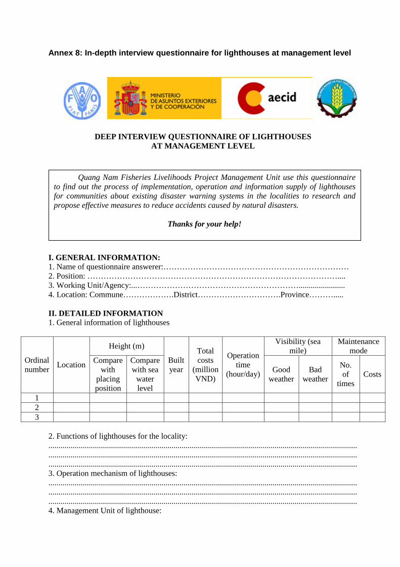
Annex 8: In-depth interview questionnaire for lighthouses at management level
DEEP INTERVIEW QUESTIONNAIRE OF LIGHTHOUSES AT MANAGEMENT LEVEL
I. GENERAL INFORMATION: 1. Name of questionnaire answerer:…………………………………………………………… 2. Position: ………………………………………………………………………………….... 3. Working Unit/Agency:...……………………………………………………....................... 4. Location: Commune……………….District………………………….Province………..... II. DETAILED INFORMATION 1. General information of lighthouses
Ordinal number Location
Height (m)
Built year
Total costs
(million VND)
Operation time
(hour/day)
Visibility (sea mile)
Maintenance mode
Compare with
placing position
Compare with sea
water level
Good weather
Bad weather
No. of
times Costs
1 2 3
2. Functions of lighthouses for the locality: ........................................................................................................................................................................................................................................................................................................................................................................................................................................................................... 3. Operation mechanism of lighthouses: ......................................................................................................................................................... ......................................................................................................................................................... ......................................................................................................................................................... 4. Management Unit of lighthouse:
Quang Nam Fisheries Livelihoods Project Management Unit use this questionnaire to find out the process of implementation, operation and information supply of lighthouses for communities about existing disaster warning systems in the localities to research and propose effective measures to reduce accidents caused by natural disasters.
Thanks for your help!

Final report on the Assessment of Existing Disaster Warning Systems in Quang Nam Province
44
........................................................................................................................................................
.........................................................................................................................................................
........................................................................................................................................................ 5. Professional qualifications of manager of lighthouse
- Postgraduate: …………persons; - University: ……………persons; - College:……………... persons; - Intermediate: ………….persons.
6. Information supply form from lighthouse to the community ........................................................................................................................................................................................................................................................................................................................................................................................................................................................................... 7. Advantages in management/operation of lighthouse: ........................................................................................................................................................................................................................................................................................................................................................................................................................................................................... 8. Disadvantages in management/operation of lighthouse: ........................................................................................................................................................................................................................................................................................................................................................................................................................................................................... 9. Suggestions: …………………………………………………………………………………............................. .........................................................................................................................................................
Interviewee Investigator

Final report on the Assessment of Existing Disaster Warning Systems in Quang Nam Province
45
Annex 9: In-depth interivews for tropical deppression and storm warning signal fire system at management level
DEEP INTERVIEW QUESTIONNAIRE OF TROPICAL DEPRESSION AND STORM WARNING SIGNAL FIRE SYSTEM
AT MANAGEMENT LEVEL
I. GENERAL INFORMATION: 1. Name of questionnaire answerer:…………………………………………………………… 2. Position: ………………………………………………………………………………….... 3. Working Unit/Agency:...……………………………………………………....................... 4. Location: Commune……………….District………………………….Province………..... II. DETAILED INFORMATION 1. General information of signal flares
Ordinal number Location Built
year
Total costs
(million VND)
Flaring time
(minute)
Visibility of signal
(sea mile) Maintenance mode
1 No. of times Costs
2
3
2. Functions of signal fire for the locality: ........................................................................................................................................................................................................................................................................................................................................................................................................................................................................... 3. Operation mechanism of signal fire: .........................................................................................................................................................
Quang Nam Fisheries Livelihoods Project Management Unit use this questionnaire to find out the process of implementation, operation and information supply of tropical depression and storm warning signal fires for communities about existing disaster warnings in the localities to research and propose effective measures to reduce accidents caused by natural disasters.
Thanks for your help!

Final report on the Assessment of Existing Disaster Warning Systems in Quang Nam Province
46
.........................................................................................................................................................
......................................................................................................................................................... 4. Management Unit of signal fire: ........................................................................................................................................................ ......................................................................................................................................................... ........................................................................................................................................................ 5. Professional qualifications of manager of signal fire
- Postgraduate: …………persons; - University: ……………persons; - College:……………... persons; - Intermediate: ………….persons.
6. Information supply form from signal fire to the community ........................................................................................................................................................................................................................................................................................................................................................................................................................................................................... 7. Advantages in management/operation of signal fire: ........................................................................................................................................................................................................................................................................................................................................................................................................................................................................... 8. Disadvantages in management/operation of signal fire: ........................................................................................................................................................................................................................................................................................................................................................................................................................................................................... 9. Suggestions: …………………………………………………………………………………............................. .........................................................................................................................................................
Interviewee Investigator

Final report on the Assessment of Existing Disaster Warning Systems in Quang Nam Province
47
Annex 10: In-depth interviews of flood marker managers
DEEP INTERVIEW QUESTIONNAIRE OF FLOOD MARKERS AT MANAGEMENT LEVEL
I. GENERAL INFORMATION: 1. Name of questionnaire answerer:…………………………………………………………… 2. Position: ………………………………………………………………………………….... 3. Working Unit/Agency:...……………………………………………………....................... 4. Location: Commune……………….District………………………….Province………..... II. DETAILED INFORMATION 1. General information of flood markers:
Ordinal number Location Size Built
year
Total costs
(million VND)
Maintenance mode
1 Height Width No. of times Costs 2 3
2. Functions of flood marker for the locality: ........................................................................................................................................................................................................................................................................................................................................................................................................................................................................... 3. Operation mechanism of flood marker: ......................................................................................................................................................... ......................................................................................................................................................... ......................................................................................................................................................... 4. Management Unit of flood marker: ........................................................................................................................................................ ......................................................................................................................................................... ........................................................................................................................................................
Quang Nam Fisheries Livelihoods Project Management Unit use this questionnaire to find out the process of implementation, operation and information supply of flood markers for communities about existing natural disasters in the localities to research and propose effective measures to reduce accidents caused by natural disasters.
Thanks for your help!

Final report on the Assessment of Existing Disaster Warning Systems in Quang Nam Province
48
5. Professional qualifications of manager of flood marker: - Postgraduate: …………persons; - University: ……………persons; - College:……………... persons; - Intermediate: ………….persons.
6. Information supply form from flood marker to the community ........................................................................................................................................................................................................................................................................................................................................................................................................................................................................... 7. Advantages in management/operation of flood marker: ........................................................................................................................................................................................................................................................................................................................................................................................................................................................................... 8. Disadvantages in management/operation of flood marker: ........................................................................................................................................................................................................................................................................................................................................................................................................................................................................... 9. Suggestions: …………………………………………………………………………………............................. .........................................................................................................................................................
Interviewee Investigator

Final report on the Assessment of Existing Disaster Warning Systems in Quang Nam Province
49
Annex 11: List of interviewees
Ordinal number Full name Position Address
01 Le Van Long Station chief An Hoa maritime signal management station
02 Nguyen Van Hoa Captain Ky Ha Port Border Post/Station 03 Lam Van Quyet Post vice-chief Ky Ha Port Border Post/Station
04 Nguyen Minh Tuan Office manager Provincial Storm and Flood Prevention Steering Committee
05 Nguyen Hoai Phuong
Office vice-manager
Provincial Storm and Flood Prevention Steering Committee
06 Le Van Thu Specialist Provincial Storm and Flood Prevention Steering Committee
07 Nguyen Thanh Phat Specialist Provincial Storm and Flood Prevention Steering Committee
08 Le Cong Duan Specialist Provincial Storm and Flood Prevention Steering Committee
09 Truong Tuyen Vice-director Quang Nam hydro-meteorological Center
10 Nguyen Thi Thu Hang
Specialist Quang Nam hydro-meteorological Center
11 Nguyen Manh Ha Specialist Quang Nam hydro-meteorological Center 12 Vu Van Tinh Specialist Quang Nam hydro-meteorological Center 13 Nguyen Đinh Huan Specialist Quang Nam hydro-meteorological Center
14 Nguyen Van Thong Vice-chairman People’s Committee of Duy Hai commune, Duy Xuyen district
15 Vo Quoc Hai Staff in charge of fisheries
People’s Committee of Duy Hai commune, Duy Xuyen district
16 Diep Tan Luc Vice-chairman People’s Committee of Duy Hai commune, Duy Xuyen district
17 Pham Huu Thap Staff in charge of fisheries
People’s Committee of Duy Hai commune, Duy Xuyen district
18 Tran Van Tot Chairman People’s Committee of Binh Nam commune, Thang Binh district
19 Tang Tha Anh Duyen Vice-chairman People’s Committee of Binh Nam
commune, Thang Binh district
20 Nguyen Thanh Chung
Staff in charge of fisheries
People’s Committee of Binh Nam commune, Thang Binh district
21 Tran Cong Long Office manager People’s Committee of Binh Minh commune, Thang Binh district
22 Tran Cong Minh Chairman People’s Committee of Binh Minh commune, Thang Binh district
23 Le Quoc Cuong
Commune Storm and Flood Prevention Steering
Committee
People’s Committee of Binh Minh commune, Thang Binh district
24 Ho Van Chung Vice-chairman People’s Committee of Binh Hai commune, Thang Binh district

Final report on the Assessment of Existing Disaster Warning Systems in Quang Nam Province
50
Ordinal number Full name Position Address
25 Tran Thanh Binh Staff in charge of fisheries
People’s Committee of Binh Hai commune, Thang Binh district
26 Le Trung Xuan Chairman People’s Committee of Duy Thanh commune, Duy Xuyen district
27 Nguyen Huu Dinh Staff in charge of fisheries
People’s Committee of Tam Quang commune, Nui Thanh district
28 Huynh Van Tao Fisher People’s Committee of Tam Quang commune
29 Tran Dinh Nhan Fisher People’s Committee of Tam Quang commune
30 Do Van Tuan Fisher People’s Committee of Tam Quang commune
31 Phan Van Thai Fisher People’s Committee of Tam Quang commune

Annex 12. DETAILED PLAN OF THE ACTIVITY OF ASSESSMENT OF EXISTING DISASTER WARNINGS
Ordinal number Work items Contents Time Human resources Coordinating Unit Note
Main Assistant (1) (2) (3) (4) (5) (6) (7) (8)
1
Send official documents and contact to work with local authorities to determine subjects, range of survey
Contents of official documents and work schedule
29 November - 02
December
Project Management Unit
+ Fisheries Resources
Protection and Capture Sub-department
Local fisheries
staff
People's Committee of Project Communes
2
Deep survey of existing disaster warnings in Duy Xuyen district
- Survey, interview deeply staff of Division of Agriculture and Rural Development. + Quantity: 01 questionnaire. + Content: Questionnaire form attached - Survey, interview deeply leaders of People's Committee of Duy Hai commune, People's Committee of Duy Nghia commune; People's Committee of Duy Thanh commune; + Quantity: each commune one questionnaire + Content: Questionnaire form attached
3 -7 December 2010
Project Management Unit
(2 persons)
Fisheries Capture
engineer (1 person)
People's Committee of Project Communes
3 Deep survey, interview of existing disaster
- Survey, interview deeply staffs of Division of Agriculture and Rural Development.
14-20 December 2010
Project Management Unit
(2 persons)
Fisheries Capture
engineer (1
People's Committee of
Project
Final report on the Assessment of Existing Disaster Warning Systems in Quang Nam Province
52
Ordinal number Work items Contents Time Human resources Coordinating Unit Note
Main Assistant (1) (2) (3) (4) (5) (6) (7) (8)
warnings in Thang Binh district
+ Quantity: 01 questionnaire. + Content: Questionnaire form attached - Survey, interview deeply leaders of People's Committee of Binh Minh commune, People's Committee of Binh Hai commune, People's Committee of Binh Nam commune. + Quantity: each commune one questionnaire + Content: Questionnaire form attached
person) Communes
4 Survey fishers of existing disaster warnings in the localities
- Survey fishers of communes of Duy Hai, Duy Nghia, Binh Nam, Binh Minh, Binh Hai: each commune one questionnaire, Tam Quang commune: 30 questionnaires - Content: Questionnaire form attached
25 -30 December 2010
Project Management Unit
(2 persons)
5 Deep survey, interview of typical disaster warnings
- Survey flood markers, interview Flood Tower Operation and Management Unit. - Survey warning systems for vessels which go in and out the port (lighthouse), interview deeply Lighthouse Operation and Maintenance Unit. - Survey storm signal flares,
10 -20 January 2011
Project Management Unit
(2 persons)
Fisheries Capture
engineer (1 person)
People's Committee of
Project Communes

Final report on the Assessment of Existing Disaster Warning Systems in Quang Nam Province
53
Ordinal number Work items Contents Time Human resources Coordinating Unit Note
Main Assistant (1) (2) (3) (4) (5) (6) (7) (8)
interview with responsible units 6 Work with Storm
and Flood Prevention and Control Steering Committee of Quang Nam province
- Review types of existing disaster warnings in the locality; methods of operation and management of those disaster warnings.
24 January 2011 Project Management Unit
(2 persons)
7 Work with Meteorological and hydrological Radio Station
- Reassess the information exchange, information receiving and feedback; how to collect information of storm and flood warning, ...
26 January 2011 Project Management Unit
(2 persons)
8 Process information and prepare the report
- Interim report on results of assessment of existing disaster warnings in the localities
30 Jan-15 Feb 2011
Project Management Unit
9 Collect suggestions for draft assessment report of existing disaster warning systems
- Organize a meeting at provincial level to collect suggestions for draft report.
26 June 2011 Project Management Unit
managed the meeting
10 Complete and submit the report
30 June 2011 Project Management Unit

Annex 13: Minutes of the Validation Workshop
THE SOCIALIST REPUBLIC OF VIETNAM Independence - Freedom - Happiness
WORKSHOP MINUTES ON
ASSESSMENT OF EXISTING DISASTER WARNINGS
Today, at 13h30 on July 12th
.
2011 at Hoang Ngoc Hotel of Quang Nam province, a workshop on assessment of existing disaster warnings is organized.
I. Participants + Representative for leaders of DARD. + Quang Nam PMU. + Representative for Provincial Storm and Flood Prevention Steering Committee. + Representative for Fisheries Resources Protection and Capture Sub-department. + Representative for Quang Nam Hydro-meteorological Center. + Representative for Ky Ha Port Border Post/Station.. + Representative for An Hoa Maritime Signal Management Station. + Representative for district DARDs: Thang Binh district, Duy Xuyen district, Nui Thanh
district.. + Representative for leaders of CPCs, fishers of communes: Binh Minh, Binh Nam,
Binh Hai, Duy Hai, Duy Nghia, Duy Thanh, Tam Quang. II. Content of the workshop
Reporting and getting feedback on survey results of existing disaster warnings in Quang Nam.
1. Mr. Vo Van Nam – Director of Quang Nam PMU represents main objectives of the projects and speak the workshop opening.
2. Mr. Vo Van Long – Project staff, representative for groups in charge of 2.3.1 activity reports results of survey, assessment of existing disaster warnings in Quang Nam.
3. Participants discuss: The majority of participants agree with the report on the existing disaster warnings, the
report provides fairly complete data and a comprehensive assessment of existing disaster warnings in the locality. However, need to add some of the following content:
In the report, need to determine the specific locations for installing the flood markers as well as need to support how many VHF radios, how many mobile phones for fishers?
Time for shooting the signal fire is very short, need to shoot longer so that fishers can find.
Need to install the lighthouses along the seashores to warn the disasters for coastal fishers.
To support for fishing vessels each vessel one satellite locating machine. To train on how to arrange, move and anchor the vessels in the ports, channels and
vessel boat anchoring areas. To support the lightning protection system on the fishing vessels. For staffs who work with communication machines with a high toxicity, need to more
allowance in the next time. When organizing the training for fishers, need to have the manuals and awareness-
raising leaflets on flood, disaster prevention so that fishers read in their spare time if necessary because most fishers often forget quickly.

Final report on the Assessment of Existing Disaster Warning Systems in Quang Nam Province
55
To build the community houses in the coastal area and flooded area so that fishers can avoid floods, storms.
To support each fishing vessel one mobile phone so that they can communicate each other and inform the authorities concerned when fishing vessels violate the fisheries resources.
To support to train the captains, the chief mechanics for coastal fishing vessels. To propose the Central to install the warning systems of tsunami, seaside, riverside
landslides. 4. Feedbacks from groups in charge of 2.3.1 activity: Thank participants with very necessary comments so that groups have proposals
suitable to fishers and groups have some following feedbacks: Agree to propose the project to support mobile phones for coastal fishing fishers so that
they can communicate to the mainland. At present, the project has supported the training of captains at small and fifth level, the
project has not supported the training of chief mechanics yet. Agree to propose the project to support the training of chief mechanics for fishers in the next time.
In the report, we have not presented the specific locations to install the flood markers as well as the specific quantity of how many VHF radios, how many mobile phones supported because we need to have time and funds and have surveys. So, when the donor agrees, we will conduct the survey and propose more specifically.
Agree to propose the project to support the lightning protection system on the fishing vessels.
Agree to propose the project to install the lighthouses along the seashores to warn the disasters for coastal fishers.
Time for shooting the signal fire is very short, need to shoot longer, it is difficult to change because of the general provisions of the Government. So, need to have meeting to review in the whole nation with a final conclusion. So in the project activities we cannot propose this problem.
Build the community houses in the coastal area and flooded area so that fishers can avoid floods, storms: this is a good idea, however, with the present funds, the project cannot implement. Moreover, The Government has the budgets for building the flood protection houses.
Installation of tsunami, landslide warning systems is a very big scope (of the Government), so in the report, we only mention without propose in the report.
The workshop ends at 17h00’ on the same date, the minutes is read in the Workshop
and participants agree with above content./. Secretary Chairman
Tran Van Truong Vo Van Long

Final report on the Assessment of Existing Disaster Warning Systems in Quang Nam Province
56
Annex 14: List of participants in the validation workhop
Ordinal number Full name Position Address
01 Nguyen Đinh Toan Room chief Fisheries Resources Protection and Capture Sub-department
02 Le Van Thu Room chief Provincial Storm and Flood Prevention Steering Committee
03 Đo Xuan Trinh Post vice-chief Ky Ha Port Border Post/Station
04 Le Van Hung Staff An Hoa Maritime Signal Management Station
05 Nguyen Đinh Huan Specialist Quang Nam Hydro-meteorological Center 06 Luong Cong Bay Vice-chairman Binh Minh CPC, Thang Binh district 07 Le Xuan Toi Staff Quang Nam Hydro-meteorological Center 08 Tran Chau Giang Room vice-chief Duy Xuyen district DARD 09 Vo Quoc Hai Staff Duy Hai CPC, Duy Xuyen district 10 Pham Huu Thap Staff Duy Nghia CPC, Duy Xuyen district 11 Nguyen Thanh Chung Staff Binh Nam CPC, Thang Binh district 12 Tran Cong Đao Fisher Binh Minh commune, Thang Binh district 13 Tran Cong Cham Fisher Binh Minh commune, Thang Binh district 14 Ha Thanh Binh Staff Binh Hai CPC, Thang Binh district 15 Tran Anh Bao Fisher Duy Hai commune, Duy Xuyen district 16 Vo Van Tuan Fisher Duy Hai commune, Duy Xuyen district 17 Tran Van Trung Fisher Duy Hai commune, Duy Xuyen district 18 Nguyen Than Ai Fisher Duy Nghia commune, Duy Xuyen district 19 Pham Van Anh Fisher Duy Nghia commune, Duy Xuyen district 20 Tran Đinh Nam Fisher Duy Nghia commune, Duy Xuyen district 21 Le Van Hang Fisher Duy Thanh commune, Duy Xuyen district 22 Tran Đen Fisher Duy Thanh commune, Duy Xuyen district 23 Nguyen Viet Anh Fisher Binh Nam commune, Thang Binh district 24 Le Thi Hoe Fisher Binh Nam commune, Thang Binh district 25 Vo Đinh Phuong Fisher Binh Nam commune, Thang Binh district 26 Ho Thanh Tuan Fisher Binh Hai commune, Thang Binh district 27 Ho Van Thai Fisher Binh Hai commune, Thang Binh district 28 Huynh Van Tao Fisher Tam Quang commune, Nui Thanh district 29 Tran Đinh Nhan Fisher Tam Quang commune, Nui Thanh district 30 Tran Van Tin Fisher Tam Quang commune, Nui Thanh district