Final Report on - MnDOT · 2018-01-02 · Final Report on . Minnesota Trunk Highway 55 and Wilkin...
33
Highway 55 and Wilkin Co. CSAH 19 Intersection-Final Report 1 Final Report on Minnesota Trunk Highway 55 and Wilkin County State Aid Highway 19 Intersection November 2017
Transcript of Final Report on - MnDOT · 2018-01-02 · Final Report on . Minnesota Trunk Highway 55 and Wilkin...

Highway 55 and Wilkin Co. CSAH 19 Intersection-Final Report 1
Final Report on
Minnesota Trunk Highway 55 and Wilkin County State Aid Highway 19 Intersection
November 2017

Highway 55 and Wilkin Co. CSAH 19 Intersection-Final Report 2
Prepared by:
The Minnesota Department of Transportation 395 John Ireland Boulevard Saint Paul, Minnesota 55155-1899
Phone: 651-296-3000 Toll-Free: 1-800-657-3774 TTY, Voice or ASCII: 1-800-627-3529
To request this document in an alternative format, call 651-366-4718 or 1-800-657-3774 (Greater Minnesota). You may also send an email to [email protected]

Highway 55 and Wilkin Co. CSAH 19 Intersection-Final Report 3
Contents
Legislative Request ........................................................................................................................................4
Introduction ..................................................................................................................................................5
Background .............................................................................................................................................................5
Initial discussions ....................................................................................................................................................6
Stakeholders ..................................................................................................................................................8
Working Group: ......................................................................................................................................................8
Meetings Summary ........................................................................................................................................9
Final Recommendation ................................................................................................................................ 11
Options 1-6 .......................................................................................................................................................... 11
Conclusion ................................................................................................................................................... 14
Appendix A: Memo and Preliminary Maps of Options ................................................................................... 15
Appendix B: Preliminary Cost Estimates of the Options ................................................................................. 27

Highway 55 and Wilkin Co. CSAH 19 Intersection-Final Report 4
Legislative Request
This report is issued to comply with Laws of Minnesota 2017, 1st Spec. Sess., Chapter 3, Section 139.
Sec. 139. WORKING GROUP FOR INTERSECTION IN WILKIN COUNTY; REPORT. (a) By September 1, 2017, the commissioner of transportation must convene a working group
to consider potential options for Wilkin County Road 19 between marked Trunk Highway 55 and the railroad tracks north of marked Trunk Highway 55. The working group must consist of the commissioner, or designee, and one representative from each of the following: Minn-Dak Farmers Cooperative; the Wilkin County Board; the town board of Champion; and the city council of Nashua. By December 15, 2017, the working group must identify project options to address safety concerns of local residents at this location. For each identified project, the commissioner must include an estimated cost and the estimated date by which the project would be completed. The working group must then identify a preferred option. Based on that preferred option, the responsible parties must develop funding strategies and a delivery schedule with the goal that the project be completed by December 31, 2019.
(b) By January 1, 2018, the commissioner must report to the chairs, ranking minority members, and staff of the senate and house of representatives committees or divisions with jurisdiction over transportation policy and finance. The report must, at a minimum, include: a summary of the meetings held by the working group; the project options identified and the commissioner estimates associated with each option; and, if identified, the preferred option and the funding and delivery schedule for that option.
The cost of preparing this report is about $34,000.

Highway 55 and Wilkin Co. CSAH 19 Intersection-Final Report 5
Introduction The 2017 Minnesota Legislature passed legislation requiring the Minnesota Department of Transportation to study a transportation issue involving the intersection of Minnesota Trunk Highway 55 and Wilkin County State Aid Highway 19 in Nashua.
The issue involves trains blocking CSAH 19 which causes backups on both CSAH 19 and Highway 55. The blockages occur when trains stop on the siding track of the Canadian Pacific Railway that crosses CSAH 19. Highway 55 is a rural two lane highway with traffic moving at 60 miles per hour. Cars and trucks on Highway 55 form queues waiting to turn into Nashua.
A working group consisting of MnDOT staff, a Wilkin county board member, county highway department staff, Nashua city officials, a Champion township board member, Minn-Dak Farmers Cooperative representatives and nearby property owners was formed to study and discuss possible solutions to the crossing problem.
Background
In the Nashua area, Highway 55 and the CP Railway line have been located adjacent to each other in their current locations since at least the 1930s. In the city, Wilkin CSAH 19 intersects both Highway 55 and the CP Railway. Historical photographs and plans show that from the 1930s until 2014, the CSAH 19 crossing with the CP Railway line consisted of one mainline east-west track and a spur line just to the north. The CSAH 19 intersection with Highway 55 is located just to the south of the rail crossings.
Figure 1 - Highway 55 and CSAH 19 before the siding extension (image from Google Earth)
In 2015, CP Railway extended a siding track between the mainline railroad track and Highway 55, crossing CSAH 19. A siding track allows for one train to pull off the mainline track while a separate train passes from either direction. The work was entirely within the CP Railway right of way.

Highway 55 and Wilkin Co. CSAH 19 Intersection-Final Report 6
Figure 2- Highway 55 and CSAH 19 after the siding extension (image from Google Earth)
As a result of the siding extension, the distance between the tracks and Highway 55 was reduced to about 21 feet. In addition, the railroad crossing is blocked for significantly longer periods of time for staging and parked trains.
Initial discussions
Prior to this legislation, MnDOT discussed the issue with concerned residents on March 9, 2017. The initial meeting was a listening session allowing attendees to share their concerns about the crossing and related issues. Representatives from Minn-Dak Farmers Co-op, the Campbell-Tintah School District, the city of Nashua, Champion Township, the Wilkin County Highway Department and local Emergency Medical Services agencies provided input at the meeting and through emails.
The primary concerns from the March 2017 meeting focused around two issues:
1. The new siding on the rail line allows trains to block the CSAH 19 crossing for extended periods, occasionally more than 30 minutes at a time.
2. The new siding reduced the space on CSAH 19 between the tracks and Highway 55, adding additional safety concerns to an already tight intersection.
Attendees also brought up several other observations, categorized into three primary areas:
1. Vehicles on Highway 55 wanting to go north on CSAH 19 stop on the state highway waiting for the tracks to clear. The problem is year-round but much worse during the harvest season. Attendees said the situation is unsafe.

Highway 55 and Wilkin Co. CSAH 19 Intersection-Final Report 7
2. Buses and other large vehicles do not have adequate space to safely stop on CSAH 19 between the STOP sign and the tracks to turn onto Hwy 55. Only 21 feet of roadway is available for stopping between the tracks and Highway 55.
3. Vehicles, including emergency vehicles, cannot get from Hwy 55 to Nashua (and north of Nashua) without a lengthy detour or a short detour on a minimum maintenance road not equipped for heavy year-round traffic.
Many of the representatives of this initial meeting were asked to be a part of the working group.

Highway 55 and Wilkin Co. CSAH 19 Intersection-Final Report 8
Stakeholders MnDOT addressed the legislative requirements by engaging both public and private sector stakeholders to identify potential solutions to the issue of CSAH 19 railroad crossing blockages by CP Railway trains at Nashua.
Working Group:
The role of the working group was to review and provide feedback to MnDOT regarding various design options that address the problem at the railroad crossing. MnDOT’s consultant, Interstate Engineering, developed six options for the working group to consider. The goal of the working group was to reach consensus on a preferred option to address the CSAH 19 rail crossing issue.
The working group was comprised of the following stakeholders. Not everyone attended each meeting.
Minn-Dak Farmers Cooperative and nearby landowners:
• Troy Koltes • Andy Finkral • Tom Knudsen • Brent Davison • Tanner Davison • Frank Davison • Darin Raguse
Wilkin County:
• Eric Klindt, Commissioner • Brian Noetzelman, Engineer
• Steve Neppl, Highway Department
• Rick Fiedler, Sheriff • Josh Nack, Sheriff’s Deputy
Champion Township:
• Jim Arnhalt, Township Clerk
City of Nashua:
• Sharon Rittenour, City Clerk • Jim Stargel, Mayor
Minnesota Department of Transportation:
• Mike Ginnaty, Assistant District Engineer • Tom Swenson, Traffic Engineer • Nathan Gannon, State Aid Engineer • Brian Bausman, Project Manager
Other attendees:
• Dean Toella, city of Tintah
• Donald Holte
• Jeffrey Loeks • Craig Carter
• Reg Hawes
• Jean and Doug Daniels • Randy Rittenour

Highway 55 and Wilkin Co. CSAH 19 Intersection-Final Report 9
Meetings Summary The focal point of the meetings was to identify the issues with blockages at the CSAH 19 railroad crossing at Nashua and arrive at a recommendation from the working group for a preferred option to resolve the problem. Below is a list of the meetings held by the working group and a summary of the discussions.
Local Government Agency meeting – May 10, 2017
MnDOT presented its findings after discussions with CP. CP indicated its intention to review its operations to reduce the number of blockages at CSAH 19. It was suggested that residents contact the Community Connect telephone number for assistance when the crossing was blocked. MnDOT and Wilkin County agreed to install distance signage on both Highway 55 and CSAH 19 and add the Community Connect telephone number to signs on both highways. MnDOT presented a possible solution of moving the crossing west of Nashua to approximately 0.5 mile east of Nashua and construct a road connecting to CSAH 19. The group agreed to review this proposal further to present to the full working group. MnDOT agreed to hire a consultant, Interstate Engineering, to develop alignments for this option.
Working Group meeting – June 28, 2017
MnDOT presented three options for a new alternate railroad crossing about a half mile east of CSAH 19. The three options cured the blocked crossing issue, but the affected property owner was not willing to sell the required right of way for any of the alternate options. The working group decided none of the three alternate options could work. The group asked MnDOT to develop two additional options. One was to construct turn lanes and vehicle storage on Highway 55. The second was to realign Highway 55 to provide additional vehicle stacking area. MnDOT agreed to have the consultant develop these two options.
Working Group meeting – Sept. 6, 2017
MnDOT presented and reviewed the additional options 4 and 5. Option 4 involved constructing right and left turn lanes on Highway 55. Option 5 included a realignment of Highway 55 to the south in addition to right and left turn lanes. Option 5 also added storage for vehicles waiting to cross the tracks. Neither option 4 nor option 5 addressed the blockage at the crossing. After a lengthy discussion by the working group, a sixth option was proposed as a solution. Option 6 used an existing crossing one mile east of Nashua. Existing township roads would provide the route from Highway 55 to CSAH 19. The group requested MnDOT explore option 6 and develop a cost estimate similar to options 1 thru 5. MnDOT also provided an update on additional signage being installed warning motorists of “Traffic Stopped Ahead” on both Highway 55 and CSAH 19.

Highway 55 and Wilkin Co. CSAH 19 Intersection-Final Report 10
Working Group meeting – Nov. 1, 2017
Option 6 was presented to the working group along with the cost estimate. The cost of Option 6 and the proximity to Nashua for emergency responders was a concern to the groups. There was additional discussion about the possible viability of Option 1 that resurfaced during the meeting. The group agreed to contact the property owner and CP Railway for input on Option 1, the shortest route and least expensive alternative, as a potential solution.
Working Group meeting – Nov. 14, 2017
MnDOT briefed the group on discussions it had with CP Railway. For Option 1 to be viable, the public road crossing west of Nashua would either need to be removed or converted from a public road crossing to a private crossing. In addition, the parties managing the private crossing would need to execute an agreement with the railroad and purchase liability insurance. The property owners affected by the conversion were not in favor of either removal or the conversion. The group discussion then centered on Option 6, which would improve the township roads one mile east and one mile north of Nashua. The working group agreed to modify the improvements to the township road to accommodate only a gravel surface and not include a future bituminous surface. The main issue remaining for Option 6 is the maintenance cost. Further discussions will be held between the township and county to resolve this issue. The group also asked MnDOT to consider turn lanes on Highway 55 to CSAH 19 during the proposed 2023 Highway 55 project.
All of the options presented to the working group are described and shown below, and can be found in Appendix A of this report, including cost estimates for each option.
Highway 55 and Wilkin Co. CSAH 19 Intersection-Final Report 11
Final Recommendation
Options 1-6
Options 1-3
These three options all included constructing a local frontage road and diverting traffic to a new railroad crossing to the east of the current crossing. Each of these three options was a bit different because of where it connected to CSAH 19.
Option 4
This option constructed right and left turn lanes for Trunk Highway 55 to give vehicles space to wait to turn onto CSAH 19 when trains are blocking the intersection.
Option 5
This option realigned Highway 55 and provided for extra-long turn lanes to safely accommodate all vehicles, including commercial vehicles, waiting to turn onto CSAH 19.
Option 6
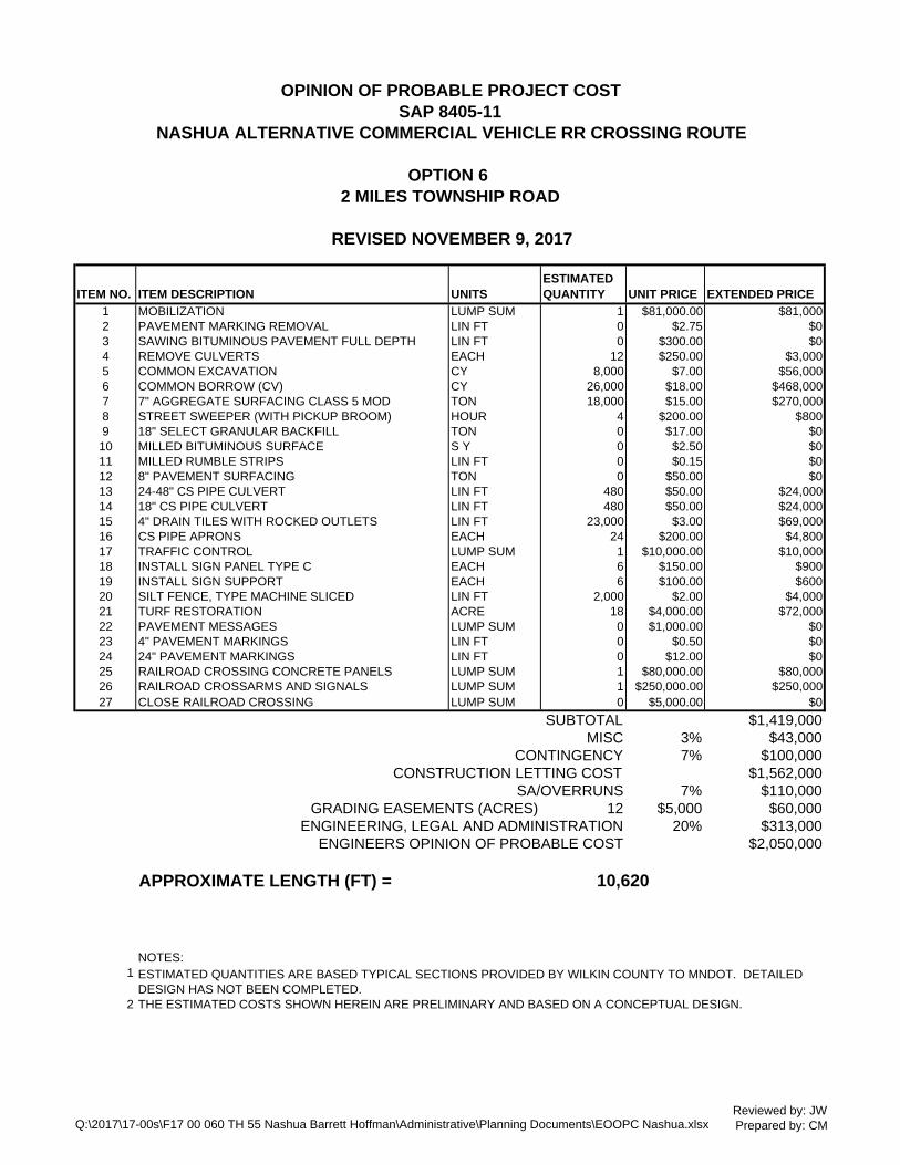
This option is the recommended option. It includes improving two miles of township roads to accommodate traffic, including commercial vehicles, by bypassing the crossing.
Each proposed option is shown on the following map.

Highway 55 and Wilkin Co. CSAH 19 Intersection-Final Report 12
Figure 3: Map of Proposed Options for Highway 55 and CSAH 19 Intersection

Highway 55 and Wilkin Co. CSAH 19 Intersection-Final Report 13
The working group selected option 6 as the preferred option to solve the problem of crossing blockages at CSAH 19 in Nashua. It is recommending this solution over the others because it addresses the issue of trains blocking the tracks causing traffic back-ups. This option also allows emergency vehicles to cross the tracks if the CSAH 19 crossing is blocked.
Option 6 uses local township roads for the route from Highway 55 to CSAH 19. It begins one mile east of Nashua at the intersection of Highway 55, travels north one mile and then west to CSAH 19. These roads will require upgrading to 9 ton load limit.
Wilkin County will assume the lead agency role, with MnDOT’s assistance, moving forward with the project. In addition, MnDOT will review the intersection of Minnesota Trunk Highway 55 and Wilkin County State Aid Highway 19 for needed improvements as part of its future project in 2023. Once funding has been identified, the project delivery schedule will be developed. Wilkin County, Champion Township and the City of Nashua have prepared an application for funding from the Local Road Improvement Program through MnDOT’s Office of State Aid. Applications are due December 2017 with project selection in the spring of 2018. If this project is not selected for LRIP funding, Wilkin County and other working group stakeholders will explore additional funding alternatives. Assuming funding is fully secured, Wilkin County plans to complete project construction by fall 2019.

Highway 55 and Wilkin Co. CSAH 19 Intersection-Final Report 14
Conclusion As a result of 2017 legislation passed by the Minnesota Legislature a working group was formed to study the possible solutions for an at-grade railroad crossing in Nashua frequently blocked by rail traffic. The group consisted of various stakeholders including MnDOT staff, Wilkin County staff and Nashua city officials. Stakeholders also included representatives of Minn-Dak Farmers Cooperative, Wilkin County Board, town board of Champion and several local residents.
Meetings were held between March and November 2017. The results of these meeting included a final recommendation. The preferred option of the working group was Option 6. This option addressed the crossing blockages by trains remaining stationary keeping mainline traffic from proceeding through the Nashua area. This option addresses the blocked crossing for vehicles that want to move into and out of Nashua by bypassing the CP siding tracks near Highway 55 and CSAH 19.Local township roads will be used for this route. The location of the route is one mile east of Nashua and uses an existing crossing. The township roads will be reconstructed to a 9-ton load limit with a gravel surface.
Finally, the process outlined in this report provided stakeholders with an opportunity to voice concerns with existing crossing conditions and participate in recommended solutions for the problem. Funding for the local road project is uncertain at this time. One potential revenue source is the Local Road Improvement Program through MnDOT’s State Aid program. Wilkin County, in conjunction with Champion Township, will submit an application for this project. A proposed construction schedule has not been determined and is dependent on funding.

Highway 55 and Wilkin Co. CSAH 19 Intersection-Final Report 15
Appendix A: Memo and Preliminary Maps of Options

INTERSTATE ENGINEERING
MEMO
To:
From:
CC:
Date:
Re:
Tom Lundberg, MnDOT 04 Mike Ginnaty, MnDOT 04 Brian Bausman, MnDOT 04
Chris Mcconn, Interstate Engineering a YL Damon DeVillers, P.E. (IE) Dan Harris (IE)
November 9, 2017
SAP 8405-11 Nashua Preliminary Commercial Traffic options for Crossing Rail
BACKGROUND
The existing railroad crossing for Wilkin County CSAH 19 (2014 AADT = 410) at the CSAH 19 and Minnesota Trunk Highway 55 (TH 55, 2014 AADT = 415) is currently located too close to the intersection to allow adequate storage space to allow commercial vehicles to stop between the railroad tracks and the TH 55. There is currently about 21 feet of storage between the railroad crossing signals and the stop sign. Currently, there are two railroad crossings operated by the Canadian Pacific (CP) railroad at this location. The northern rail is the mainline rail used for interstate rail traffic. The southern crossing was added to allow for storage of mainline traffic to allow for rail traffic heading in opposite directions to pass each other. This area experiences a relatively high seasonal volume of commercial traffic due to agricultural traffic. There are two sugar beet piling grounds and a regional grain terminal within 10 miles of this intersection. The entire project area is within the Bois de Sioux Watershed District (BDSWD). Ditches JD 7 and GCD 22 follow TH 55 in this area.
The following options and cost estimates have been prepared to determine the most appropriate improvements to create a safer rail crossing for commercial vehicles:
a. Options 1-3 b. Option 4 c. Option 5 d. Option 6
Construct frontage road for new crossing location Add turn lanes and bypass lanes to TH 55 Re-align TH 55 with turn lanes Two Miles Township Road
Professionals you need, people you trust
P.O. Box 316 • 116 East Washington Avenue • Fergus Falls, MN 56538-0316 • P: 218-739-5545 • F: 218-739-4814 • www.inlerslaleeng .com
Offices in: North Dakota • Montana • Minnesota • South Dakota

SAP 8405-11 Nashua Preliminary Commercial Traffic
Options for Crossing Rail Page 2 of 4
November 9, 2017
Professionals you need, people you trust
P.O. Box 316 • 116 East Washington Avenue • Fergus Falls, MN 56538-0316 • P: 218-739-5545 • F: 218-739-4814 • www.interstateeng.com
Offices in: North Dakota • Montana • Minnesota • South Dakota
Q:\2017\17-00s\F17 00 060 TH 55 Nashua Barrett Hoffman\Administrative\Correspondence\M Nashua 11092017.docx
OPTIONS 1-3 CONSTRUCT FRONTAGE ROAD FOR NEW CROSSING LOCATION Options 1 through 3 include constructing a locally owned and operated frontage road to divert commercial traffic to a new public railroad crossing approximately 2,100 feet east of the existing crossing where there is adequate distance between the new rail crossing and TH 55. The difference between each option is the location where it connects to CSAH 19. All three options would include closure of the public crossing at 310th Avenue (1 mile west of CSAH 19) to create a net zero increase in crossings. The private rail crossing approximately 850 feet east of the proposed crossing may be closed and the driveway reconstructed to share the new crossing. Preliminary Drawings for all options are provided in Appendix A. Cost Estimates for each Option are provided in Appendix B. The cost estimate includes signalization of the new crossing, cross arms and concrete panels. These options would leave the existing CSAH 19 crossings in operation. These options would require obtaining right of way in agricultural fields. Below is a summary of design criteria for each option: 1. Typical section as shown for a 37 foot wide road 2. 7” of Aggregate Base Class 5 3. 4” drain tile on each side of road 4. 280’ radii for curves in road
The benefit of this option would be avoiding construction on TH 55. Signage on TH 55 and CSAH 19 would direct commercial vehicle traffic to the alternate route. The new crossing would provide approximately 75 feet of storage, allowing school busses and WB-62 vehicles space to stop between the rail crossing and TH 55. Turn lanes on TH 55 are not included in the cost estimate for Options 1 through 3.
OPTION 4 – ADD TURN LANES AND BYPASS LANES TO TH 55 Option 4 would include the construction of right and left turn lanes for eastbound and westbound traffic on TH 55 as illustrated in Figure 5-3.01C of the MnDOT Road Design Manual, entitled, “Painted Median Left-Turn Lane on Existing Highway – At Cross Road Intersections”. This option provides storage for vehicles desiring to turn north onto CSAH 19 while a train is occupying the intersection. However, it does not allow for safe storage of northbound or southbound commercial vehicles on CSAH 19 that are stopped between the tracks and TH 55 while they are waiting for trains to clear; or traffic on TH 55 to pass. The ditches along TH 55 near this intersection are deep with steep inslopes. The improvements included obtaining additional right of way to construct 4:1 slopes and widen the ditch bottom. This ditch is regulated by the BDSWD and will require permitting.

SAP 8405-11 Nashua Preliminary Commercial Traffic
Options for Crossing Rail Page 3 of 4
November 9, 2017
Professionals you need, people you trust
P.O. Box 316 • 116 East Washington Avenue • Fergus Falls, MN 56538-0316 • P: 218-739-5545 • F: 218-739-4814 • www.interstateeng.com
Offices in: North Dakota • Montana • Minnesota • South Dakota
Q:\2017\17-00s\F17 00 060 TH 55 Nashua Barrett Hoffman\Administrative\Correspondence\M Nashua 11092017.docx
OPTION 5 – TH 55 REALIGNMENT WITH TURN LANES Option 5 would be for a re-alignment of TH 55 to increase the storage area between the railroad tracks and the intersection. This option would include the construction of both right and left turn lanes on TH 55 at the intersection. As shown in Appendix A, the proposed re-alignment moves the westbound lane of TH 55 approximately 47 feet southward to provide 68 feet of storage between the cross arms and the stop sign (98 feet from center of rail to edge of westbound driving lane). This design includes full reconstruction of TH 55 for approximately 4,100 feet. The length utilized is longer than the standard turn lane arrangement for several reasons. Below is a summary of site specific conditions: a. Design is based on a 2,000 foot turning radii for re-alignment of the road. The MnDOT
design manual specifies in Table 3-2.03A that 1,660 lineal feet is the minimum radius for a 65 mph design speed.
b. Tangents between reverse curves were provided. c. Tangents for 67% of superelevation runout were provided at the beginning and end of
realignment. d. Left turn lanes provide 730 feet of storage. Based on MnDOT staff meetings with local
representatives, turn lane storage demands peak during the fall sugar beet harvest due to the harvest campaign with sugar beets delivered to the Minn-Dak pileground immediately southwest of Nashua. Producer owned vehicles are often tandem axel straight trucks. Based on discussions with a Minn-Dak representative, storage for up to 10 vehicles would be necessary.
Similar to Option 4, this option would require re-alignment of BDSWD ditches and require permitting therefor. Construction limits on the south side of TH 55 would require right of way acquisition of multiple properties. Based on a 4 foot deep ditch, 1:4 inslopes, 1:3 backslopes, 10’ wide ditch bottom, approximately 42 feet would be required for construction limits. The limits as shown in the figures are approximately 40-50 wide based on modeling with LIDAR data. OPTION 6 – TWO MILES TOWNSHIP ROAD Option 6 improves township roads 500th Street and 330th Avenue so that commercial traffic will cross the railroad one mile east of the existing CSAH 19 crossing in Nashua as illustrated in Figure 6. Eastbound traffic on TH 55 intending to travel north on CSAH 19 would continue 1 mile past CSAH 19 and turn north onto 330th Avenue, travel north one mile, turn west and travel one mile arriving back at CSAH 19. This would ultimately add an additional 2 miles to their trip.

SAP 8405-11 Nashua Preliminary Commercial Traffic
Options for Crossing Rail Page 4 of 4
November 9, 2017
Professionals you need, people you trust
P.O. Box 316 • 116 East Washington Avenue • Fergus Falls, MN 56538-0316 • P: 218-739-5545 • F: 218-739-4814 • www.interstateeng.com
Offices in: North Dakota • Montana • Minnesota • South Dakota
Q:\2017\17-00s\F17 00 060 TH 55 Nashua Barrett Hoffman\Administrative\Correspondence\M Nashua 11092017.docx
There is an existing rail crossing at 330th Avenue that would be improved with cross arms and concrete panels. This crossing would provide approximately 75 feet of storage for vehicles between TH 55 and the rail crossing. The existing township roads are approximately 20 feet wide. The proposed road would be 37 feet wide with 7 inches of aggregate and drain tile. The typical section used for this option is the same as for Options 1 through 3 and was furnished by Wilkin County. See also Figure 6. Existing culverts would be replaced with new corrugated steel culverts. Additional road right of way or temporary easements would be necessary for the widening. The addition of turn lanes on CSAH 19 and TH 55 was not included with this option. ESTIMATED COSTS Below is a table summarizing the costs for each option. The details for each cost estimate are provided in Appendix 2. TABLE 1 ESTIMATED COSTS OPTION DESCRIPTION ESTIMATED COST
1 Frontage Road to First Street N $1,030,000.00 2 Frontage Road to Third Street N $1,150,000.00 3 Frontage Road North of Third Street $1,200,000.00 4 Turn Lanes and Bypass Lanes on TH 55 $1,190,000.00 5 Re-alignment of TH 55 $2,790,000.00 6 Two Mile Township Road Alternate Route $2,050,000.00
The estimated costs provided include numerous assumptions: a. The real estate acquisition values are not based on appraisals or discussions with
property owners. b. A percentage based cost was added for contingency, miscellaneous, overruns,
engineering, legal and administration. c. Excavation and embankment values are based on assumed average cut and fill depths. d. Salvaging of existing aggregates for re-use was not considered. e. An environmental assessment of the properties needed for Option 5 have not been
reviewed for possible mitigation requirements. f. A subsurface soils investigation was not performed to determine aggregate and
bituminous thicknesses, or subgrade conditions. g. Based on a review of the National Wetland Inventory maps, wetlands were not identified
in any of the Option project areas. No additional efforts were made to confirm the presence of wetlands.

NASHUA APPROACH REMOVAL STATE PROJ. NO. 8405-11 <TH 55) SHEET NO. 1 OF 1 SHEETS

NASHUA OPTION 1
STATE PROJ. NO. 8405-11 <TH 55J SHEET NO. 2 OF 7 SHEETS

NASHUA OPTION 2
STATE PROJ. NO. 8405-11 <TH 55J SHEET NO. 3 OF 7 SHEETS

NASHUA OPTION 3
ST A TE PROJ. NO. 8405-11 <TH 55J SHEET NO. 4 OF 7 SHEETS

NASHUA OPTION 4
ST A TE PROJ. NO. 8405-11 (TH 55) SHEET NO. 5 OF 1 SHEETS

ENLARGED TURN LANE VIEW STATE PROJ. NO. 8405-11 <TH 55> SHEET NO. 6 OF 7 SHEETS

NASHUA OPTION 6
ST ATE PROJ. NO. 8405-11 <TH 55) SHEET NO. 7 OF 7 SHEETS
Highway 55 and Wilkin Co. CSAH 19 Intersection-Final Report 27
Appendix B: Preliminary Cost Estimates of the Options

ITEM NO. ITEM DESCRIPTION UNITSESTIMATED QUANTITY UNIT PRICE EXTENDED PRICE
1 MOBILIZATION (10%) LUMP SUM 1 $64,000.00 $64,0002 PAVEMENT MARKING REMOVAL LIN FT 0 $2.75 $03 SALVAGE CONCRETE APRON EACH 0 $250.00 $04 COMMON EXCAVATION CY 3,000 $7.00 $21,0005 COMMON BORROW (CV) CY 9,500 $18.00 $171,0006 7" AGGREGATE SURFACING CLASS 5 TON 3,800 $15.00 $57,0007 STREET SWEEPER (WITH PICKUP BROOM) HOUR 4 $200.00 $8008 18" SELECT GRANULAR BACKFILL TON 0 $17.00 $09 6" PAVEMENT SURFACING TON 0 $50.00 $010 24" RC PIPE CULVERT LIN FT 80 $55.00 $4,40011 18" RC PIPE CULVERT LIN FT 80 $45.00 $3,60012 INSTALL PIPE APRON EACH 4 $300.00 $1,20013 4" DRAIN TILES WITH ROCKED OUTLETS LIN FT 5,000 $3.00 $15,00014 TRAFFIC CONTROL LUMP SUM 1 $5,000.00 $5,00015 INSTALL SIGN EACH 5 $150.00 $75016 INSTALL SIGN SUPPORT EACH 5 $100.00 $50017 SILT FENCE, TYPE MACHINE SLICED LIN FT 2,300 $2.00 $4,60018 TURF RESTORATION ACRE 2.5 $5,000.00 $12,50019 RAILROAD CROSSING CONCRETE PANELS LUMP SUM 1 $80,000.00 $80,00020 RAILROAD CROSSARMS AND SIGNALS LUMP SUM 1 $250,000.00 $250,00021 CLOSE RAILROAD CROSSING LUMP SUM 2 $5,000.00 $10,000
SUBTOTAL $702,000MISC 3% $22,000
CONTINGENCY 7% $50,000CONSTRUCTION LETTING COST $774,000
SA/OVERRUNS 7% $54,000REAL ESTATE ACQUISITION $40,000
ENGINEERING, LEGAL AND ADMINISTRATION 20% $155,000ENGINEERS OPINION OF PROBABLE COST $1,030,000
LENGTH (FT) =
NOTES:1
2 TURF RESTORATION AND EROSION CONTROL COSTS BASED ON $5,000/ACRE FOR DISTURBED AREAS3 ASSUMED 2 FEET OF COMMON BORROW4 BASIS OF COMPUTATIONS: SEE TYPICAL SECTION5 DOES NOT INCLUDE TURN LANES ONTO TH 556 THE ESTIMATED COSTS SHOWN HEREIN ARE PRELIMINARY AND BASED ON A CONCEPTUAL DESIGN.
TOTAL COSTS ARE ROUNDED TO THE NEAREST $10,000.
ESTIMATED QUANTITIES ARE BASED TYPICAL SECTIONS PROVIDED BY WILKIN COUNTY TO MNDOT. DETAILED DESIGN HAS NOT BEEN COMPLETED.
OPINION OF PROBABLE PROJECT COSTSAP 8405-11
NASHUA ALTERNATIVE COMMERCIAL VEHICLE RR CROSSING ROUTE
REVISED NOVEMBER 9, 2017
OPTION 1 (FRONTAGE ROAD TO FIRST STREET NORTH)
2,313
Q:\2017\17-00s\F17 00 060 TH 55 Nashua Barrett Hoffman\Administrative\Planning Documents\EOOPC NashuaReviewed by: JWPrepared by : CM

ITEM NO. ITEM DESCRIPTION UNITSESTIMATED QUANTITY UNIT PRICE EXTENDED PRICE
1 MOBILIZATION LUMP SUM 1 $72,000.00 $72,0002 PAVEMENT MARKING REMOVAL LIN FT 0 $2.75 $03 SALVAGE CONCRETE APRON EACH 0 $250.00 $04 COMMON EXCAVATION CY 3,500 $7.00 $24,5005 COMMON BORROW (CV) CY 12,000 $18.00 $216,0006 7" AGGREGATE SURFACING CLASS 5 TON 4,700 $15.00 $70,5007 STREET SWEEPER (WITH PICKUP BROOM) HOUR 4 $200.00 $8008 18" SELECT GRANULAR BACKFILL TON 0 $17.00 $09 6" PAVEMENT SURFACING TON 0 $50.00 $0
10 24" RC PIPE CULVERT LIN FT 80 $55.00 $4,40011 18" RC PIPE CULVERT LIN FT 160 $45.00 $7,20012 INSTALL PIPE APRON EACH 6 $300.00 $1,80013 4" DRAIN TILES WITH ROCKED OUTLETS LIN FT 6,200 $3.00 $18,60014 TRAFFIC CONTROL LUMP SUM 1 $5,000.00 $5,00015 INSTALL SIGN EACH 5 $150.00 $75016 INSTALL SIGN SUPPORT EACH 5 $100.00 $50017 SILT FENCE, TYPE MACHINE SLICED LIN FT 2,900 $2.00 $5,80018 TURF RESTORATION ACRE 3 $5,000.00 $15,00019 RAILROAD CROSSING CONCRETE PANELS LUMP SUM 1 $80,000.00 $80,00020 RAILROAD CROSSARMS AND SIGNALS LUMP SUM 1 $250,000.00 $250,00021 CLOSE RAILROAD CROSSING LUMP SUM 2 $5,000.00 $10,000
SUBTOTAL $783,000MISC 3% $24,000
CONTINGENCY 7% $55,000CONSTRUCTION LETTING COST $862,000
SA/OVERRUNS 7% $61,000REAL ESTATE ACQUISITION $50,000
ENGINEERING, LEGAL AND ADMINISTRATION 20% $173,000ENGINEERS OPINION OF PROBABLE COST $1,150,000
LENGTH (FT) =
NOTES:1
2 TURF RESTORATION AND EROSION CONTROL COSTS BASED ON $5,000/ACRE FOR DISTURBED AREAS3 ASSUMED 2 FEET OF COMMON BORROW4 BASIS OF COMPUTATIONS: SEE TYPICAL SECTION5 DOES NOT INCLUDE TURN LANES ONTO TH 556 THE ESTIMATED COSTS SHOWN HEREIN ARE PRELIMINARY AND BASED ON A CONCEPTUAL DESIGN.
TOTAL COSTS ARE ROUNDED TO THE NEAREST $10,000.
ESTIMATED QUANTITIES ARE BASED TYPICAL SECTIONS PROVIDED BY WILKIN COUNTY TO MNDOT. DETAILED DESIGN HAS NOT BEEN COMPLETED.
OPINION OF PROBABLE PROJECT COSTSAP 8405-11
NASHUA ALTERNATIVE COMMERCIAL VEHICLE RR CROSSING ROUTE
REVISED NOVEMBER 9, 2017
2,892
OPTION 2 (FRONTAGE ROAD TO THIRD STREET N.)
Q:\2017\17-00s\F17 00 060 TH 55 Nashua Barrett Hoffman\Administrative\Planning Documents\EOOPC NashuaReviewed by: JWPrepared by: CM

ITEM NO. ITEM DESCRIPTION UNITSESTIMATED QUANTITY UNIT PRICE EXTENDED PRICE
1 MOBILIZATION LUMP SUM 1 $75,000.00 $75,0002 PAVEMENT MARKING REMOVAL LIN FT 0 $2.75 $03 SALVAGE CONCRETE APRON EACH 0 $250.00 $04 COMMON EXCAVATION CY 4,000 $7.00 $28,0005 COMMON BORROW (CV) CY 13,000 $18.00 $234,0006 7" AGGREGATE SURFACING CLASS 5 TON 5,200 $15.00 $78,0007 STREET SWEEPER (WITH PICKUP BROOM) HOUR 4 $200.00 $8008 18" SELECT GRANULAR BACKFILL TON 0 $17.00 $09 6" PAVEMENT SURFACING TON 0 $50.00 $0
10 24" RC PIPE CULVERT LIN FT 80 $55.00 $4,40011 18" RC PIPE CULVERT LIN FT 80 $45.00 $3,60012 INSTALL PIPE APRON EACH 4 $300.00 $1,20013 4" DRAIN TILES WITH ROCKED OUTLETS LIN FT 6,700 $3.00 $20,10014 TRAFFIC CONTROL LUMP SUM 1 $5,000.00 $5,00015 INSTALL SIGN EACH 5 $150.00 $75016 INSTALL SIGN SUPPORT EACH 5 $100.00 $50017 SILT FENCE, TYPE MACHINE SLICED LIN FT 3,200 $2.00 $6,40018 TURF RESTORATION ACRE 3.5 $5,000.00 $17,50019 RAILROAD CROSSING CONCRETE PANELS LUMP SUM 1 $80,000.00 $80,00020 RAILROAD CROSSARMS AND SIGNALS LUMP SUM 1 $250,000.00 $250,00021 CLOSE RAILROAD CROSSING LUMP SUM 2 $5,000.00 $10,000
SUBTOTAL $816,000MISC 3% $25,000
CONTINGENCY 7% $58,000CONSTRUCTION LETTING COST $899,000
SA/OVERRUNS 7% $63,000REAL ESTATE ACQUISITION $55,000
ENGINEERING, LEGAL AND ADMINISTRATION 20% $180,000ENGINEERS OPINION OF PROBABLE COST $1,200,000
LENGTH (FT) =
NOTES:1
2 TURF RESTORATION AND EROSION CONTROL COSTS BASED ON $5,000/ACRE FOR DISTURBED AREAS3 ASSUMED 2 FEET OF COMMON BORROW4 BASIS OF COMPUTATIONS: SEE TYPICAL SECTION5 DOES NOT INCLUDE TURN LANES ONTO TH 556 THE ESTIMATED COSTS SHOWN HEREIN ARE PRELIMINARY AND BASED ON A CONCEPTUAL DESIGN.
TOTAL COSTS ARE ROUNDED TO THE NEAREST $10,000.
ESTIMATED QUANTITIES ARE BASED TYPICAL SECTIONS PROVIDED BY WILKIN COUNTY TO MNDOT. DETAILED DESIGN HAS NOT BEEN COMPLETED.
OPINION OF PROBABLE PROJECT COSTSAP 8405-11
NASHUA ALTERNATIVE COMMERCIAL VEHICLE RR CROSSING ROUTE
REVISED NOVEMBER 9, 2017
3,205
OPTION 3 (FRONTAGE ROAD NORTH OF TOWN)
Q:\2017\17-00s\F17 00 060 TH 55 Nashua Barrett Hoffman\Administrative\Planning Documents\EOOPC NashuaReviewed by: JWPrepared by: CM

ITEM NO. ITEM DESCRIPTION UNITSESTIMATED QUANTITY UNIT PRICE EXTENDED PRICE
1 MOBILIZATION LUMP SUM 1 $71,000.00 $71,0002 PAVEMENT MARKING REMOVAL LIN FT 5400 $2.75 $14,8503 SAWING BITUMINOUS PAVEMENT FULL DEPTH LIN FT 3000 $3.00 $9,0004 SALVAGE CONCRETE APRON EACH 4 $250.00 $1,0005 COMMON EXCAVATION CY 12000 $7.00 $84,0006 COMMON BORROW (CV) CY 10000 $18.00 $180,0007 12" AGGREGATE SURFACING CLASS 5 TON 4000 $15.00 $60,0008 STREET SWEEPER (WITH PICKUP BROOM) HOUR 40 $200.00 $8,0009 18" SELECT GRANULAR BACKFILL TON 5800 $17.00 $98,60010 MILLED BITUMINOUS SURFACE S Y 1200 $2.50 $3,00011 MILLED RUMBLE STRIPS LIN FT 5400 $0.15 $81012 8" PAVEMENT SURFACING TON 2700 $50.00 $135,00013 24" RC PIPE CULVERT LIN FT 120 $55.00 $6,60014 18" RC PIPE CULVERT LIN FT 120 $45.00 $5,40015 DRAIN TILES AND CONCRETE HEAD WALLS LIN FT 3000 $10.00 $30,00016 INSTALL PIPE APRON EACH 8 $300.00 $2,40017 TRAFFIC CONTROL LUMP SUM 1 $20,000.00 $20,00018 INSTALL SIGN PANEL TYPE C EACH 12 $150.00 $1,80019 INSTALL SIGN SUPPORT EACH 12 $100.00 $1,20020 SILT FENCE, TYPE MACHINE SLICED LIN FT 2700 $2.00 $5,40021 TURF RESTORATION ACRE 4 $5,000.00 $20,00022 PAVEMENT MESSAGES LUMP SUM 1 $1,000.00 $1,00023 4" PAVEMENT MARKINGS LIN FT 10000 $0.50 $5,00024 24" PAVEMENT MARKINGS LIN FT 600 $12.00 $7,20025 RAILROAD CROSSING CONCRETE PANELS LUMP SUM 0 $80,000.00 $026 CLOSE RAILROAD CROSSING LUMP SUM 0 $5,000.00 $0
SUBTOTAL $772,000MISC 3% $24,000
CONTINGENCY 7% $55,000CONSTRUCTION LETTING COST $851,000
SA/OVERRUNS 7% $60,000REAL ESTATE ACQUISITION $100,000
ENGINEERING, LEGAL AND ADMINISTRATION 20% $171,000ENGINEERS OPINION OF PROBABLE COST $1,190,000
LENGTH (FT) =
NOTES:12 TURF RESTORATION AND EROSION CONTROL COSTS BASED ON $5,000/ACRE FOR DISTURBED AREAS3 THE ESTIMATED COSTS SHOWN HEREIN ARE PRELIMINARY AND BASED ON A CONCEPTUAL DESIGN.
TOTAL COSTS ARE ROUNDED TO THE NEAREST $10,000.
ESTIMATED QUANTITIES ARE BASED ON PLANAR AREAS AND BITUMINOUS SURFACING TYPICAL SECTION.
OPINION OF PROBABLE PROJECT COSTSAP 8405-11
NASHUA ALTERNATIVE COMMERCIAL VEHICLE RR CROSSING ROUTE
REVISED NOVEMBER 9, 2017
OPTION 4 (TURN LANES ON TH 55)
2700
Q:\2017\17-00s\F17 00 060 TH 55 Nashua Barrett Hoffman\Administrative\Planning Documents\EOOPC NashuaReviewed by: JWPrepared by: CM

ITEM NO. ITEM DESCRIPTION UNITSESTIMATED QUANTITY UNIT PRICE EXTENDED PRICE
1 MOBILIZATION LUMP SUM 1 $162,000.00 $162,0002 PAVEMENT MARKING REMOVAL LIN FT 400 $2.75 $1,1003 SAWING BITUMINOUS PAVEMENT FULL DEPTH LIN FT 140 $3.00 $4204 SALVAGE CONCRETE APRON EACH 4 $250.00 $1,0005 COMMON EXCAVATION CY 24000 $7.00 $168,0006 COMMON BORROW (CV) CY 24000 $18.00 $432,0007 12" AGGREGATE SURFACING CLASS 5 TON 9600 $15.00 $144,0008 STREET SWEEPER (WITH PICKUP BROOM) HOUR 50 $200.00 $10,0009 18" SELECT GRANULAR BACKFILL TON 14500 $17.00 $246,50010 MILLED BITUMINOUS SURFACE S Y 13000 $2.50 $32,50011 MILLED RUMBLE STRIPS LIN FT 8500 $0.15 $1,27512 8" PAVEMENT SURFACING TON 7000 $50.00 $350,00013 24" RC PIPE CULVERT LIN FT 120 $55.00 $6,60014 18" RC PIPE CULVERT LIN FT 120 $45.00 $5,40015 DRAIN TILES AND CONCRETE HEAD WALLS LIN FT 8500 $10.00 $85,00016 INSTALL PIPE APRON EACH 8 $300.00 $2,40017 TRAFFIC CONTROL LUMP SUM 1 $45,000.00 $45,00018 INSTALL SIGN PANEL TYPE C EACH 12 $150.00 $1,80019 INSTALL SIGN SUPPORT EACH 12 $100.00 $1,20020 SILT FENCE, TYPE MACHINE SLICED LIN FT 8400 $2.00 $16,80021 TURF RESTORATION ACRE 10 $5,000.00 $50,00022 PAVEMENT MESSAGES LUMP SUM 8 $1,000.00 $8,00023 4" PAVEMENT MARKINGS LIN FT 17000 $0.50 $8,50024 24" PAVEMENT MARKINGS LIN FT 48 $12.00 $57625 RAILROAD CROSSING CONCRETE PANELS LUMP SUM 0 $80,000.00 $026 CLOSE RAILROAD CROSSING LUMP SUM 0 $5,000.00 $0
SUBTOTAL $1,781,000MISC 3% $54,000
CONTINGENCY 7% $125,000CONSTRUCTION LETTING COST $1,960,000
SA/OVERRUNS 7% $138,000REAL ESTATE ACQUISITION $300,000
ENGINEERING, LEGAL AND ADMINISTRATION 20% $392,000ENGINEERS OPINION OF PROBABLE COST $2,790,000
LENGTH (FT) =
NOTES:1
2 TURF RESTORATION AND EROSION CONTROL COSTS BASED ON $5,000/ACRE FOR DISTURBED AREAS3 THE ESTIMATED COSTS SHOWN HEREIN ARE PRELIMINARY AND BASED ON A CONCEPTUAL DESIGN.
TOTAL COSTS ARE ROUNDED TO THE NEAREST $10,000.
4100
ESTIMATED QUANTITIES ARE BASED ON PLANAR AREAS AND BITUMINOUS SURFACING TYPICAL SECTION. DETAILED DESIGN HAS NOT BEEN COMPLETED.
REVISED NOVEMBER 9, 2017
OPINION OF PROBABLE PROJECT COSTSAP 8405-11
NASHUA ALTERNATIVE COMMERCIAL VEHICLE RR CROSSING ROUTE
OPTION 5 RE-ALIGNMENT OF TH 55 WITH TURN LANES
Q:\2017\17-00s\F17 00 060 TH 55 Nashua Barrett Hoffman\Administrative\Planning Documents\EOOPC NashuaReviewed by: JWPrepared by: CM
ITEM NO. ITEM DESCRIPTION UNITSESTIMATED QUANTITY UNIT PRICE EXTENDED PRICE
1 MOBILIZATION LUMP SUM 1 $81,000.00 $81,0002 PAVEMENT MARKING REMOVAL LIN FT 0 $2.75 $03 SAWING BITUMINOUS PAVEMENT FULL DEPTH LIN FT 0 $300.00 $04 REMOVE CULVERTS EACH 12 $250.00 $3,0005 COMMON EXCAVATION CY 8,000 $7.00 $56,0006 COMMON BORROW (CV) CY 26,000 $18.00 $468,0007 7" AGGREGATE SURFACING CLASS 5 MOD TON 18,000 $15.00 $270,0008 STREET SWEEPER (WITH PICKUP BROOM) HOUR 4 $200.00 $8009 18" SELECT GRANULAR BACKFILL TON 0 $17.00 $010 MILLED BITUMINOUS SURFACE S Y 0 $2.50 $011 MILLED RUMBLE STRIPS LIN FT 0 $0.15 $012 8" PAVEMENT SURFACING TON 0 $50.00 $013 24-48" CS PIPE CULVERT LIN FT 480 $50.00 $24,00014 18" CS PIPE CULVERT LIN FT 480 $50.00 $24,00015 4" DRAIN TILES WITH ROCKED OUTLETS LIN FT 23,000 $3.00 $69,00016 CS PIPE APRONS EACH 24 $200.00 $4,80017 TRAFFIC CONTROL LUMP SUM 1 $10,000.00 $10,00018 INSTALL SIGN PANEL TYPE C EACH 6 $150.00 $90019 INSTALL SIGN SUPPORT EACH 6 $100.00 $60020 SILT FENCE, TYPE MACHINE SLICED LIN FT 2,000 $2.00 $4,00021 TURF RESTORATION ACRE 18 $4,000.00 $72,00022 PAVEMENT MESSAGES LUMP SUM 0 $1,000.00 $023 4" PAVEMENT MARKINGS LIN FT 0 $0.50 $024 24" PAVEMENT MARKINGS LIN FT 0 $12.00 $025 RAILROAD CROSSING CONCRETE PANELS LUMP SUM 1 $80,000.00 $80,00026 RAILROAD CROSSARMS AND SIGNALS LUMP SUM 1 $250,000.00 $250,00027 CLOSE RAILROAD CROSSING LUMP SUM 0 $5,000.00 $0
SUBTOTAL $1,419,000MISC 3% $43,000
CONTINGENCY 7% $100,000CONSTRUCTION LETTING COST $1,562,000
SA/OVERRUNS 7% $110,000GRADING EASEMENTS (ACRES) 12 $5,000 $60,000
ENGINEERING, LEGAL AND ADMINISTRATION 20% $313,000ENGINEERS OPINION OF PROBABLE COST $2,050,000
APPROXIMATE LENGTH (FT) =
NOTES:1
2 THE ESTIMATED COSTS SHOWN HEREIN ARE PRELIMINARY AND BASED ON A CONCEPTUAL DESIGN.
REVISED NOVEMBER 9, 2017
10,620
ESTIMATED QUANTITIES ARE BASED TYPICAL SECTIONS PROVIDED BY WILKIN COUNTY TO MNDOT. DETAILED DESIGN HAS NOT BEEN COMPLETED.
OPINION OF PROBABLE PROJECT COSTSAP 8405-11
NASHUA ALTERNATIVE COMMERCIAL VEHICLE RR CROSSING ROUTE
OPTION 6 2 MILES TOWNSHIP ROAD
Q:\2017\17-00s\F17 00 060 TH 55 Nashua Barrett Hoffman\Administrative\Planning Documents\EOOPC Nashua.xlsxReviewed by: JWPrepared by: CM


![[Linda Voss, Terry Wilkin] Adult Obesity a Paedia(BookZZ.org)](https://static.fdocuments.net/doc/165x107/55cf8f6b550346703b9c38f4/linda-voss-terry-wilkin-adult-obesity-a-paediabookzzorg.jpg)