FINAL MCDONALD ROAD SIDEWALK FEASIBILITY STUDY · FINAL MCDONALD ROAD SIDEWALK FEASIBILITY STUDY...
50
FINAL MCDONALD ROAD SIDEWALK FEASIBILITY STUDY APRIL 2015 Prepared For: Prepared By:
Transcript of FINAL MCDONALD ROAD SIDEWALK FEASIBILITY STUDY · FINAL MCDONALD ROAD SIDEWALK FEASIBILITY STUDY...
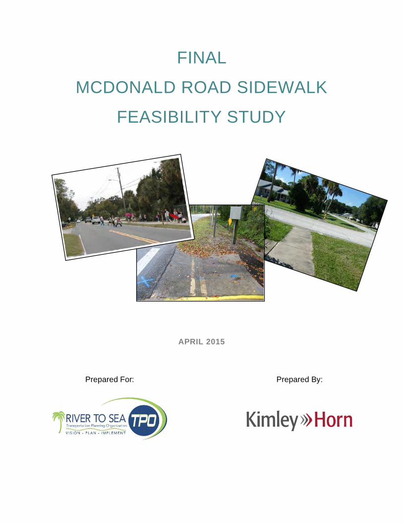
FINAL
MCDONALD ROAD SIDEWALK
FEASIBILITY STUDY
APRIL 2015
Prepared For: Prepared By:

McDonald Road Sidewalk │ Feasibility StudyApril 2015 │ Kimley-Horn and Associates, Inc.
2
CONTENTS
1 EXECUTIVE SUMMARY ................................................................................................. 4
2 INTRODUCTION ............................................................................................................. 5
PURPOSE AND OBJECTIVES ................................................................................................... 5
CITY OF PORT ORANGE ........................................................................................................... 7
PROJECT HISTORY .................................................................................................................. 7
3 STUDY METHODOLOGY AND DESIGN PRINCIPLES .................................................. 8
ORIGINAL STUDY METHODOLOGY ......................................................................................... 8
REVISED STUDY METHODOLOGY ........................................................................................... 9
GENERAL DESIGN PRINCIPLES............................................................................................... 9
4 EXISTING CONDITIONS .............................................................................................. 14
INTERSECTION WITH SAULS STREET/SUGAR HOUSE DRIVE ............................................ 14
INTERSECTION WITH CHRISTY DRIVE .................................................................................. 15
INTERSECTION WITH CHARLES STREET ............................................................................. 15
EXISTING DRAINAGE CROSSING UNDER MCDONALD ROAD ............................................. 16
INTERSECTION WITH 6TH STREET ....................................................................................... 16
5 CONCEPTUAL DESIGN RECOMMENDATIONS .......................................................... 17
CORRIDOR RECOMMENDATIONS ......................................................................................... 17
LOCATION SPECIFIC RECOMMENDATIONS ......................................................................... 18
6 FINANCIAL FEASIBILITY.............................................................................................. 20
7 CONCLUSION AND SUMMARY OF RECOMMENDATIONS........................................ 22
8 DATA COLLECTION REFERENCES ............................................................................ 23
TABLES
Table 1 – Engineer’s Estimate Opinion of Probable Costs ........................................................21
McDonald Road Sidewalk │ Feasibility StudyApril 2015 │ Kimley-Horn and Associates, Inc.
3
FIGURES
Figure 1 – Location Map .............................................................................................................6
APPENDICES
Appendix A – Sugar Mill Elementary School Safe Routes to School Study Excerpts
Appendix B - Existing Corridor Photos
Appendix C - Conceptual Design Plans
Appendix D - Response to FDOT Comments
Appendix E - FDOT Right of Way Acquisition Reference Material

McDonald Road Sidewalk │ Feasibility StudyApril 2015 │ Kimley-Horn and Associates, Inc.
4
1 EXECUTIVE SUMMARY
The River to Sea Transportation Planning Organization (R2CTPO) recognizes the importance ofdeveloping a cohesive transportation network that provides safe, efficient, and accessiblepedestrian and bicycle facilities. One way to accomplish this goal is to expand the integratedbicycle and pedestrian transportation system by continuing the feasibility studies of prioritizedprojects. The McDonald Road Sidewalk Feasibility Study is a R2CTPO 2011 prioritized XUBicycle/Pedestrian project as requested by the City of Port Orange, Volusia County, Florida.
The purpose of this project was to conduct a limited corridor study that assesses the feasibilityof providing a minimum five (5) foot wide sidewalk along the west side of McDonald Roadextending approximately 2,640 feet from the intersection of Madeline Avenue and SugarhouseDrive through the intersection of Sauls Street/Madeline Avenue to 6 th Street. The objective ofthe project was to identify the width of the path and its location in an effort to design a cost-effective path that fits within the existing right-of-way.
This project was identified as a needed project in the Sugar Mill Elementary School Safe Routesto School Study conducted in 2007 for increasing safety to and from the school. The CityCouncil approved submittal of this project to the R2CTPO as part of the call for 2011 prioritizedXU Bicycle/Pedestrian projects. The City has also received a letter of support from the Principalof Sugar Mill Elementary School.
A feasibility study was previously completed in February 2013. However, in April 2014, FDOTissued comments on the previously finalized study. In order to address FDOT’s comments, newfield investigations were completed, and the study was updated to incorporate current featuresand design recommendations.
This project will provide a safer pedestrian and bicycle route on the west side of McDonaldRoad, particularly for school children who cross the street to access the residentialdevelopments on the west side. The sidewalk will provide a formal route to direct children to thecrosswalks and is expected to be constructed within the existing apparent right-of-way (ROW),with one possible exception. Coordination efforts are recommended with this property owner, toenhance the effectiveness of the sidewalk through these limits.
This report contains the recommended conceptual alignment for the study corridors, as well asa planning level estimate of the anticipated costs associated with the recommendedimprovements. It is noted that a corridor specific survey should be conducted prior todevelopment of a sidewalk design and engineering drawings. In addition, no drainagepermitting is anticipated to be required; however, coordination with St. Johns River WaterManagement District will be necessary to obtain an exemption verification letter.
McDonald Road Sidewalk │ Feasibility StudyApril 2015 │ Kimley-Horn and Associates, Inc.
5
2 INTRODUCTION
The River to Sea Transportation Planning Organization (R2CTPO) recognizes the importance ofdeveloping a cohesive transportation network that provides safe, efficient, and accessiblepedestrian and bicycle facilities. One way to accomplish this goal is to expand the integratedbicycle and pedestrian transportation system by continuing the feasibility studies of prioritizedprojects.
The McDonald Road Sidewalk Feasibility Study was identified as a R2CTPO (formerly theVolusia Transportation Planning Organization) 2011 prioritized XU Bicycle/Pedestrian projectas requested by the City of Port Orange, Volusia County, Florida.
PURPOSE AND OBJECTIVES
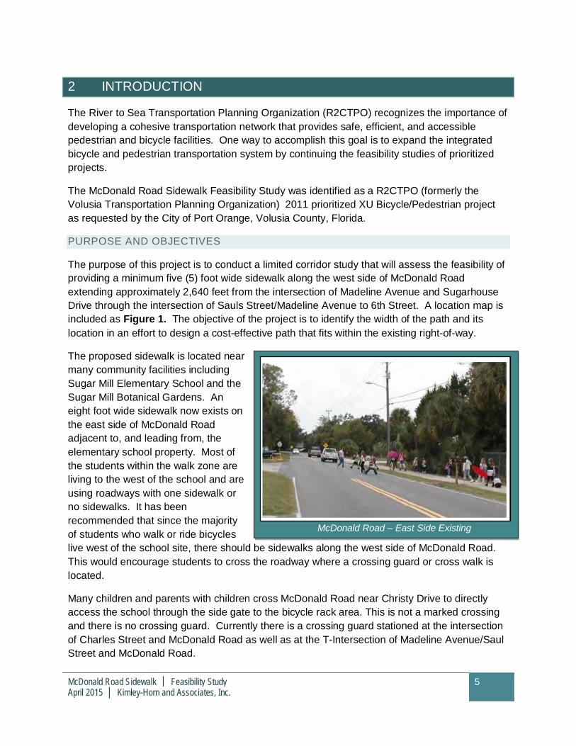
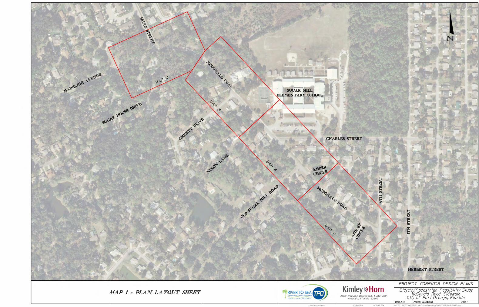
The purpose of this project is to conduct a limited corridor study that will assess the feasibility ofproviding a minimum five (5) foot wide sidewalk along the west side of McDonald Roadextending approximately 2,640 feet from the intersection of Madeline Avenue and SugarhouseDrive through the intersection of Sauls Street/Madeline Avenue to 6th Street. A location map isincluded as Figure 1. The objective of the project is to identify the width of the path and itslocation in an effort to design a cost-effective path that fits within the existing right-of-way.
The proposed sidewalk is located nearmany community facilities includingSugar Mill Elementary School and theSugar Mill Botanical Gardens. Aneight foot wide sidewalk now exists onthe east side of McDonald Roadadjacent to, and leading from, theelementary school property. Most ofthe students within the walk zone areliving to the west of the school and areusing roadways with one sidewalk orno sidewalks. It has beenrecommended that since the majorityof students who walk or ride bicycleslive west of the school site, there should be sidewalks along the west side of McDonald Road.This would encourage students to cross the roadway where a crossing guard or cross walk islocated.
Many children and parents with children cross McDonald Road near Christy Drive to directlyaccess the school through the side gate to the bicycle rack area. This is not a marked crossingand there is no crossing guard. Currently there is a crossing guard stationed at the intersectionof Charles Street and McDonald Road as well as at the T-Intersection of Madeline Avenue/SaulStreet and McDonald Road.
McDonald Road – East Side Existing

6
McDonald Road Sidewalk │ Feasibility StudyApril 2015 │ Kimley-Horn and Associates, Inc.
7
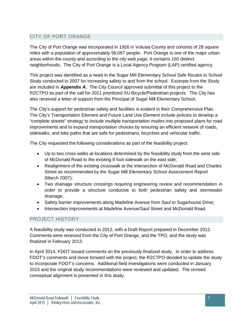
CITY OF PORT ORANGE
The City of Port Orange was incorporated in 1926 in Volusia County and consists of 28 squaremiles with a population of approximately 56,067 people. Port Orange is one of the major urbanareas within the county and according to the city web page, it contains 150 distinctneighborhoods. The City of Port Orange is a Local Agency Program (LAP) certified agency.
This project was identified as a need in the Sugar Mill Elementary School Safe Routes to SchoolStudy conducted in 2007 for increasing safety to and from the school. Excerpts from the Studyare included in Appendix A. The City Council approved submittal of this project to theR2CTPO as part of the call for 2011 prioritized XU Bicycle/Pedestrian projects. The City hasalso received a letter of support from the Principal of Sugar Mill Elementary School.
The City’s support for pedestrian safety and facilities is evident in their Comprehensive Plan.The City’s Transportation Element and Future Land Use Element include policies to develop a“complete streets” strategy to include multiple transportation modes into proposed plans for roadimprovements and to expand transportation choices by ensuring an efficient network of roads,sidewalks, and bike paths that are safe for pedestrians, bicyclists and vehicular traffic.
The City requested the following considerations as part of the feasibility project:
· Up to two cross walks at locations determined by the feasibility study from the west sideof McDonald Road to the existing 8 foot sidewalk on the east side;
· Realignment of the existing crosswalk at the intersection of McDonald Road and CharlesStreet as recommended by the Sugar Mill Elementary School Assessment Report(March 2007);
· Two drainage structure crossings requiring engineering review and recommendation inorder to provide a structure conducive to both pedestrian safety and stormwaterdrainage;
· Safety barrier improvements along Madeline Avenue from Saul to Sugarhouse Drive;· Intersection improvements at Madeline Avenue/Saul Street and McDonald Road.
PROJECT HISTORY
A feasibility study was conducted in 2012, with a Draft Report prepared in December 2012.Comments were received from the City of Port Orange, and the TPO, and the study wasfinalized in February 2013.
In April 2014, FDOT issued comments on the previously finalized study. In order to addressFDOT’s comments and move forward with the project, the R2CTPO decided to update the studyto incorporate FDOT’s concerns. Additional field investigations were conducted in January2015 and the original study recommendations were reviewed and updated. The revisedconceptual alignment is presented in this study.
McDonald Road Sidewalk │ Feasibility StudyApril 2015 │ Kimley-Horn and Associates, Inc.
8
3 STUDY METHODOLOGY AND DESIGN PRINCIPLES
ORIGINAL STUDY METHODOLOGY
For the study completed in 2013, the following tasks were completed per the project scope toprovide an informed feasibility report in accordance with R2CTPO policies, procedures,guidelines and rules.
1. A project coordination meeting was held with the R2CTPO’s Project Manager and theCity of Port Orange representatives on September 26, 2012 for the purpose of scopingthe project and obtaining relevant project information.
2. Data collection for the project consisted of obtaining copies of readily available planning,land use, and engineering information, including the following:
a. City of Port Orange, as-built drawings for Amber Woods from Ashley Ct. to 6 th Street(West side). Right-of-way and as-built for McDonald Road sidewalk in Amber VillageSD.
b. City of Port Orange, Amber Village Plat, January 1995.
c. City of Port Orange, Plantation Acres Plat, February 1955.
d. City of Port Orange, Map of Dun-Lawton, January 1882.
e. City of Port Orange, LIDAR.
f. City of Port Orange McDonald Road specific purpose survey, January 2006.
g. Volusia County Property Appraisers parcel maps were downloaded to furtherdelineate the area. This information serves as the most current apparent right of waydata available at the time of this evaluation. All measurements are assumed and forplanning purposes only.
h. Data also consisted of referencing readily available information from a variety ofsources, including: R2CTPO, Volusia County, City of Port Orange, and FDOT.
3. Site visits were conducted on September 26, 2012 and November 14, 2012 whichconsisted of traversing the project corridor in order to document the current constraintsand opportunities within the apparent right of way. Photographic documentation, graphicdepiction and measurements, and aerial maps assisted in recording the important detailsof the project and to note obstacles that might impede the project’s constructability.Members of the evaluation team collected information on field conditions and locatedpotential constraints and opportunities associated with the proposed project.
4. A concept plan and typical cross sections were formulated based on the results of theprevious tasks and applicable design guidelines. The concept plan and the typicalsection are based on design criteria for pedestrian facilities contained in the FloridaDepartment of Transportation (FDOT) Pedestrian Facilities Planning and Design

McDonald Road Sidewalk │ Feasibility StudyApril 2015 │ Kimley-Horn and Associates, Inc.
9
Handbook; the FDOT Plans Preparation Manual (PPM); and the Manual on UniformMinimum Standards for Design, Construction and Maintenance for Streets andHighways, The Florida Greenbook. In accordance with these reference manuals, afeasible design for the project was determined.
5. An Engineer’s Opinion of Probable Costs (EOPC) for Construction based on the refinedconceptual design was prepared to construct a sidewalk within the proposed corridor.The EOPC was formulated based on FDOT District Five standards using their historicalcost data.
6. Preparation of a Final Report followed receipt of comments by the R2CTPO, the FDOT,and the City.
REVISED STUDY METHODOLOGY
Because of the length of time between the finalization of the study and the comments providedby FDOT, a complete review of the study was warranted. In order to update the study, thefollowing tasks were completed:
1. A project coordination conference call was held with the R2CTPO’s Project Manager,FDOT representatives, and the City of Port Orange representatives on November 19,2014, for the purpose of scoping the project and obtaining relevant project information.
2. A site visit was conducted on January 27, 2015, to verify existing conditions along theproject corridor and review the specific locations.
3. Additional data collection consisted of updating the information previously obtained forthe corridor.
4. The FDOT comments were reviewed in conjunction with the conceptual design.Adjustments were made to the alignment to reflect existing conditions and to addressFDOT’s concerns with the previous alignment.
5. The OPC was updated with current historical costs, pay item numbers, and inflationfactors
6. The Report was updated to include the revised analysis and conceptual plan.
GENERAL DESIGN PRINCIPLES
The concept plan and typical cross sections included within this report were formulated basedon the results of compiling data regarding existing conditions and applicable FDOT designguidelines. Study recommendations are based on design criteria for pedestrian facilitiescontained in the FDOT Pedestrian Facilities Planning and Design Handbook, the FDOT PlansPreparation Manual (PPM) and the Manual on Uniform Minimum Standards for Design,Construction and Maintenance for Streets and Highways, The Florida Greenbook. Thefollowing summarizes design guidelines applicable to this feasibility report.
McDonald Road Sidewalk │ Feasibility StudyApril 2015 │ Kimley-Horn and Associates, Inc.
10
HORIZONTAL SEPARATION
Sidewalks according to the Florida Pedestrian Planning and Design Handbook are defined as“paved area (typically concrete) which normally runs parallel to vehicular traffic and is separatedfrom the road surface by at least a curb and gutter.” A sidewalk is designed for preferential orexclusive use by pedestrians. The number one goal in designing sidewalks shall be theelimination of vehicle-pedestrian conflicts. Though it is not possible to eliminate all vehicle-pedestrian conflicts within the typical roadway corridor, steps should be taken to minimize theeffects of all vehicle-pedestrian conflicts through proper design.
1. The effective minimum width of a sidewalk within a residential area is 5 feet. A minimumwidth of 6 feet of horizontal clear zone is recommended for urban facilities where no curband gutter is present. If 6 feet is not available, a “barrier” is recommended between thepedestrian way and the vehicular travel way. The definition of “barrier” may consist ofcurb and gutter, landscaping, or a permanent structure, such as railing or fencing.
2. To properly account for horizontal separation (clear zone) between the roadway andsidewalk, the design must, at a minimum, meet Florida Greenbook requirements. TheFlorida Greenbook states that sidewalks shall be separated from the travel lane of arural (non-curbed) roadway based on the following criteria listed in order of desirability:
a. Outside of the highway right-of-way in a separately dedicated corridor
b. At or near the right-of-way line
c. Outside of the designed roadside clear zone.
d. Outside of the minimum required roadside clear zone
e. As far from the edge of the driving lane as possible.
3. On curbed roadways, the minimum width of a sidewalk shall be 5 ft. when separatedfrom the curb by a buffer strip. The minimum recommended separation for a 5 ft.sidewalk from the back of curb is 2 ft. The buffer strip should be 6 ft. where possible toeliminate the need to narrow or reroute sidewalks around driveways. If the sidewalk islocated adjacent to the curb, the minimum recommended width of sidewalk is 6 ft.
4. The following guidelines will be useful in standardizing the identification and treatment ofdrop-off hazards for pedestrians and bicyclists. There are two cases that requireshielding: a drop-off greater than 10 inches that is closer than 2 feet from the edge ofsidewalk and a slope steeper than 1:2 that begins closer than 2 feet from the edge ofsidewalk. Installing fencing or railings are two ways to shield the drop-offs. Fencing isgenerally intended for use in rural areas along paths and trails. Standard railing isgenerally intended for urbanized areas, locations attaching to bridge rail or alongconcrete walkways.
McDonald Road Sidewalk │ Feasibility StudyApril 2015 │ Kimley-Horn and Associates, Inc.
11
ACCESSIBILITY/SAFETY
Curb ramps, maximum slopes, minimum widths, clear zones, and design treatments for thevisually impaired, such as truncated domes, are design features that result in part from theAmericans with Disabilities Act (ADA). These design features, when included in pedestrianfacility planning, produce “ADA-compliant” facilities.
1. The Florida Greenbook states that curb ramps meeting the requirements of ADAAccessibility Guidelines and the Florida Accessibility Code for Building Constructionshall be constructed at crosswalks at all intersections where curbs and sidewalks areconstructed in order to give persons with disabilities safe access.
2. In general, proper design of pedestrian crossings shall consider the following:
a. Crossings should be placed at locations with ample sight distances
b. At crossings, the roadway should be free from changes in alignment or crosssection
c. The entire length of the crosswalk shall be visible to drivers at a sufficientdistance to allow a stopping maneuver
d. STOP bars shall be provided adjacent to all signalized crosswalks to informdrivers of the proper location to stop. The STOP bar should be well separatedfrom the crosswalk, but should not be closer than 4 feet.
e. All crosswalks shall be easily identified and clearly delineated, in accordance withManual on Uniform Traffic Control Devices (MUTCD) (Rule 14-15.010)
3. The single most important design consideration for persons with disabilities is curb cuts.Therefore, new and retrofitted streets with sidewalks should have curb cuts installed atall delineated crossings and it is desirable to provide separate ramps for each crosswalkat intersections with perpendicular approaches. Two curb cuts at each corner with acurb separating each ramp provides a greater amount of information to visually impairedpedestrians in street crossing designs. However a single uniform diagonal rampincluding both crossings is also acceptable, when installed with truncated dome warningstrips along the edge of the curb line.
4. Crossings shall also meet the same grade and cross slope requirements as sidewalkswhere the grade should not exceed 5%, and the maximum cross slope shall be no morethan 2%.
5. Marked crosswalks shall be provided at all side streets where a pedestrian facility meetsthe roadway.
6. Marked crosswalks on an uncontrolled leg of an intersection or midblock shall besupplemented with other treatments (including beacons, curb extensions, raisedmedians, raised traffic islands, or enhanced overhead lighting) when any of the followingconditions exist: 1. Where posted speeds are greater than 40 miles per hour (MPH), 2.Inadequate stopping sight distance exists such as on hills or curves, 3. Block length is

McDonald Road Sidewalk │ Feasibility StudyApril 2015 │ Kimley-Horn and Associates, Inc.
12
shorter than 600 feet and high pedestrian volumes exist, and 4. Multiple conflict pointsthat demand driver attention away from the crosswalk.
7. All new facilities (and existing when possible) should have some degree of accesscontrol, since each point of access produces a traffic conflict. The control of access isone of the most effective, efficient, and economical methods for improving the capacityand safety characteristics of streets and highways. The reduction of the frequency ofaccess points and the restriction of turning and crossing maneuvers, which should beprimary objectives, is accomplished more effectively by the design of the roadwaygeometry than by the use of traffic control devices.
SIGNAGE
Pedestrian safety is maximized when drivers are aware of the crosswalk location and knowwhen a pedestrian is attempting to cross. Flashing lights that are activated only when apedestrian is attempting to cross can enhance crosswalk detection by motorists. The flashinglights, in conjunction with advanced warning signs for the lights, can provide the motorists withmore warning of the crossing.
Signs and markings should be utilized whenever possible to provide the pedestrian cleardirection. The signs and markings should conform to the standards set forth in the MUTCD.
1. School pavement markings andcrosswalk markings should be clearand visible in order to warn motoriststhat they are entering a school zoneand children are crossing the road.
2. The FDOT’s current standard (IndexNo. 17346) uses a special emphasiscrosswalk that lengthens the life ofthe crosswalk marking.
3. Crosswalks should align with sidewalk ramps and should be installed where walkers andbicyclists are in the pavement for the shortest distance and time possible.
4. Pavement markings should be accompanied by the required signage standards set forthin the MUTCD.
5. Walkers and bicyclists should be dissuaded from crossing at intersections or mid-blockcrossings where heavy traffic exists unless accompanied by crossing guards.
6. Finally, illumination of the roadway should also provide sufficient lighting for thepedestrian facility. This is particularly important at pedestrian crossings or other areas ofpotential vehicle-pedestrian conflict.

McDonald Road Sidewalk │ Feasibility StudyApril 2015 │ Kimley-Horn and Associates, Inc.
13
A variety of intermittent lighting styles may be used, including:
a. Flashing traffic signals over the crosswalk;
b. Imbedded flashing lights in the crosswalk surface; and
c. Flashing signals to warn motorists if pedestrians are present.
The purpose of the In-Roadway Warning Light enhanced crosswalk system and associatedsignage is for safety purposes (Refer to Exhibit 1). This system is to both inform motorists thatthere is a pedestrian in the crosswalk and to increase the visibility of the crosswalk.
Imbedding lights in the asphalt at the edge of a crosswalk is amethod for making crosswalks more visible to motorists.
McDonald Road Sidewalk │ Feasibility StudyApril 2015 │ Kimley-Horn and Associates, Inc.
14
4 EXISTING CONDITIONS
The project is located within the City of Port Orange along the south/west side of McDonaldRoad from the intersection of Madeline Avenue and Sugar House Drive to the intersection of 6 th
Street and McDonald Road. This section of McDonald Road serves mainly residential,recreational, and public land uses. Due to the number and variety of residential land uses in thearea and the proximity to Sugar Mill Elementary School, it is recommended that a designatedpedestrian path be provided for the residents and students. No known road improvementprojects are currently scheduled for McDonald Road.
General observations of the corridor include the following:
· McDonald is a two-lane undivided City collector through the project limits.· The corridor is a rural section with open drainage.· The speed limit is 25 miles per hour (MPH) along the entire project length, including the
curve. The speed limit becomes 15 MPH in the school zone when flashing.· There are several residential driveways located along the corridor.· There is an existing eight foot sidewalk on the north/east side of the roadway.· There are existing crosswalks at the intersection of McDonald Road/Madeline Avenue at
Sauls Street and McDonald Road at Charles Street. These crossing locations arecontrolled by crossing guards during school hours.
· Utilities along the corridor include: water, cable, phone, sewer, storm water, andoverhead electric.
Photos of the corridor are included in Appendix B. Additional details on specific locationswithin the corridor are detailed below.
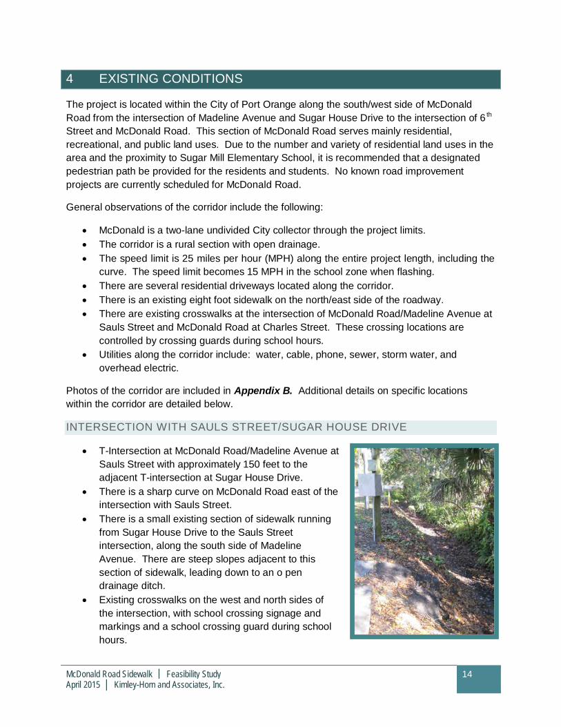
INTERSECTION WITH SAULS STREET/SUGAR HOUSE DRIVE
· T-Intersection at McDonald Road/Madeline Avenue atSauls Street with approximately 150 feet to theadjacent T-intersection at Sugar House Drive.
· There is a sharp curve on McDonald Road east of theintersection with Sauls Street.
· There is a small existing section of sidewalk runningfrom Sugar House Drive to the Sauls Streetintersection, along the south side of MadelineAvenue. There are steep slopes adjacent to thissection of sidewalk, leading down to an o pendrainage ditch.
· Existing crosswalks on the west and north sides ofthe intersection, with school crossing signage andmarkings and a school crossing guard during schoolhours.
McDonald Road Sidewalk │ Feasibility StudyApril 2015 │ Kimley-Horn and Associates, Inc.
15
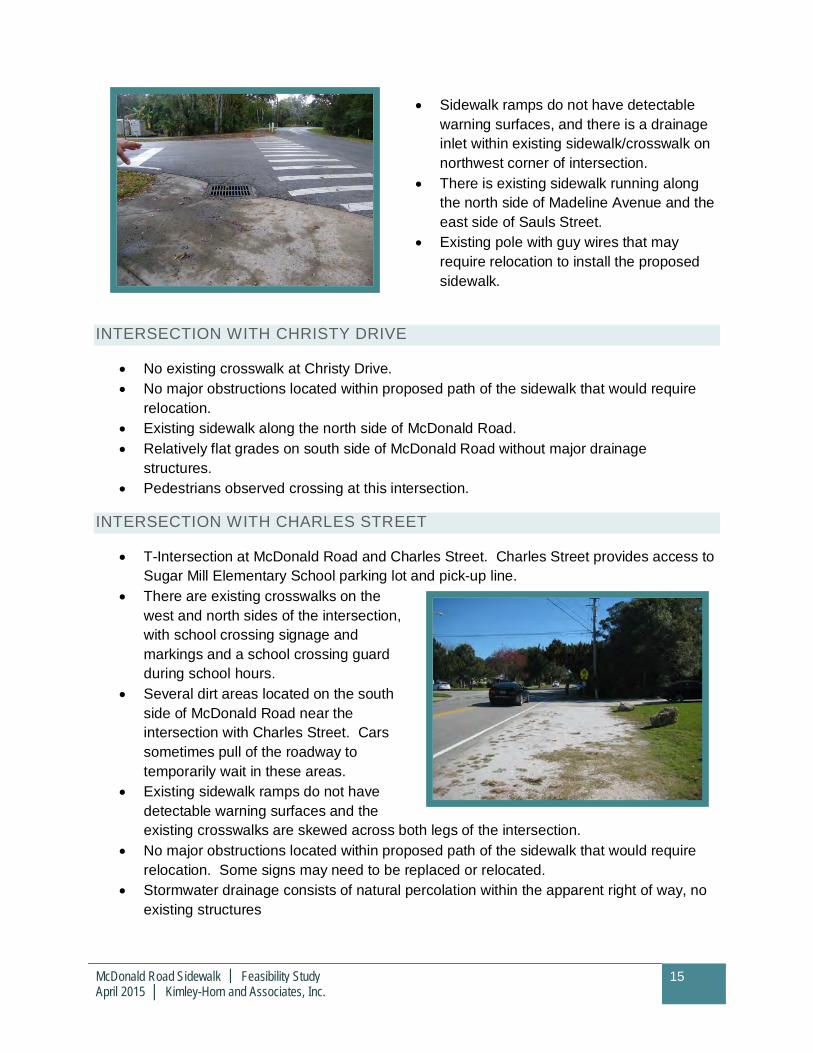
· Sidewalk ramps do not have detectablewarning surfaces, and there is a drainageinlet within existing sidewalk/crosswalk onnorthwest corner of intersection.
· There is existing sidewalk running alongthe north side of Madeline Avenue and theeast side of Sauls Street.
· Existing pole with guy wires that mayrequire relocation to install the proposedsidewalk.
INTERSECTION WITH CHRISTY DRIVE
· No existing crosswalk at Christy Drive.· No major obstructions located within proposed path of the sidewalk that would require
relocation.· Existing sidewalk along the north side of McDonald Road.· Relatively flat grades on south side of McDonald Road without major drainage
structures.· Pedestrians observed crossing at this intersection.
INTERSECTION WITH CHARLES STREET
· T-Intersection at McDonald Road and Charles Street. Charles Street provides access toSugar Mill Elementary School parking lot and pick-up line.
· There are existing crosswalks on thewest and north sides of the intersection,with school crossing signage andmarkings and a school crossing guardduring school hours.
· Several dirt areas located on the southside of McDonald Road near theintersection with Charles Street. Carssometimes pull of the roadway totemporarily wait in these areas.
· Existing sidewalk ramps do not havedetectable warning surfaces and theexisting crosswalks are skewed across both legs of the intersection.
· No major obstructions located within proposed path of the sidewalk that would requirerelocation. Some signs may need to be replaced or relocated.
· Stormwater drainage consists of natural percolation within the apparent right of way, noexisting structures
McDonald Road Sidewalk │ Feasibility StudyApril 2015 │ Kimley-Horn and Associates, Inc.
16
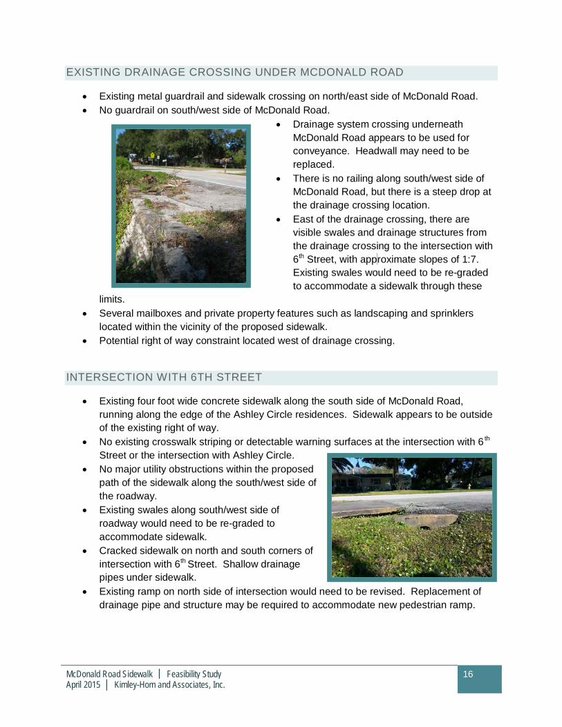
EXISTING DRAINAGE CROSSING UNDER MCDONALD ROAD
· Existing metal guardrail and sidewalk crossing on north/east side of McDonald Road.· No guardrail on south/west side of McDonald Road.
· Drainage system crossing underneathMcDonald Road appears to be used forconveyance. Headwall may need to bereplaced.
· There is no railing along south/west side ofMcDonald Road, but there is a steep drop atthe drainage crossing location.
· East of the drainage crossing, there arevisible swales and drainage structures fromthe drainage crossing to the intersection with6th Street, with approximate slopes of 1:7.Existing swales would need to be re-gradedto accommodate a sidewalk through these
limits.· Several mailboxes and private property features such as landscaping and sprinklers
located within the vicinity of the proposed sidewalk.· Potential right of way constraint located west of drainage crossing.
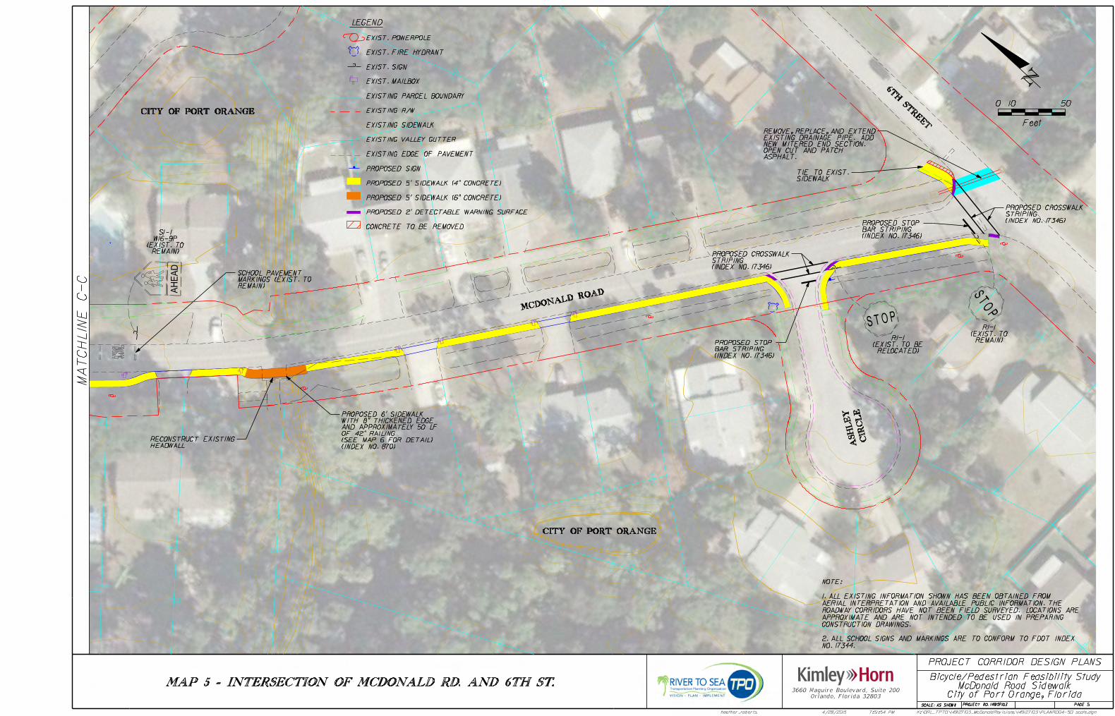
INTERSECTION WITH 6TH STREET
· Existing four foot wide concrete sidewalk along the south side of McDonald Road,running along the edge of the Ashley Circle residences. Sidewalk appears to be outsideof the existing right of way.
· No existing crosswalk striping or detectable warning surfaces at the intersection with 6 th
Street or the intersection with Ashley Circle.· No major utility obstructions within the proposed
path of the sidewalk along the south/west side ofthe roadway.
· Existing swales along south/west side ofroadway would need to be re-graded toaccommodate sidewalk.
· Cracked sidewalk on north and south corners ofintersection with 6th Street. Shallow drainagepipes under sidewalk.
· Existing ramp on north side of intersection would need to be revised. Replacement ofdrainage pipe and structure may be required to accommodate new pedestrian ramp.
McDonald Road Sidewalk │ Feasibility StudyApril 2015 │ Kimley-Horn and Associates, Inc.
17
5 CONCEPTUAL DESIGN RECOMMENDATIONS
In accordance with the opportunities and constraints described above and applicable industrydesign standards, a conceptual alignment was developed for McDonald Road. Details of therecommended conceptual alignment are detailed below and further illustrated in the ConceptualDesign Plans included in Appendix C.
CORRIDOR RECOMMENDATIONS
Generally, sidewalks may be field relocated to rout around existing utility structures as shown inthe corridor design plans. Potential encroachment of private property landscape and mailboxeswas noted during the site reconnaissance of the corridor. A corridor specific survey for thestudy area should be completed prior to the development of a sidewalk design and engineeringdrawings in order to identify the placement and limits of these obstructions.
The following lists the general conceptual design recommendations for the corridor:
· Construct longitudinal grade of the sidewalk to be at grade or less than five percent inaccordance with ADA Guidelines.
· Install pedestrian signage and a special emphasis crosswalk at Christy Drive to preventuncontrolled crossing of students/parents during school hours.
· Reconstruct crosswalks and curb ramps at intersection with Charles Street to addemphasis to the area, and reduce skew of crossing locations.
· Utilize additional signs and markings whenever possible to provide the pedestrian andmotorist clear direction.
· Provide ADA compliant sidewalk ramps and detectable warnings at all new and modifiedcrosswalk locations.
· Route sidewalk around existing utilities within the proposed path of the sidewalk.
· Construct the sidewalk in accordance with the City of Port Orange StandardConstruction requirements utilizing fiberglass rebar.
· Install flashing pedestrian signage to signal traffic approaching mid-block crosswalk atChristy Drive and T-intersection crosswalks. Recommended to maximize awareness ofthe crosswalk location and when a pedestrian is attempting to cross.
PUBLIC INVOLVEMENT
As noted in the existing conditions, there are several locations along the corridor wheremailboxes, sprinklers, and landscaping may be located within the proposed path of thesidewalk. Therefore it is recommended that the property owners be made aware of theproposed improvements prior to construction of the improvements.
McDonald Road Sidewalk │ Feasibility StudyApril 2015 │ Kimley-Horn and Associates, Inc.
18
RIGHT OF WAY COORDINATION
Right-of-way width and encroachments dictate the most feasible and cost effective location of asidewalk. Based on the recommended conceptual alignment, adequate clear zone andapparent right of way exists along the corridor for a five foot concrete sidewalk to be locatedalong the south/west side of McDonald Road with one possible exception:
· In the vicinity of the drainage crossing, one property appears to be locatedapproximately five feet from the existing edge of pavement. It is recommended that thisproperty owner be contacted to discuss the potential for easements and/or right of wayacquisition that would provide for a full five foot wide sidewalk to be installed at thislocation. In the event that right of way acquisition is not possible, a four foot widesidewalk could still be installed at this location. While not preferred, this option wouldstill allow for a continuous sidewalk path along the south/west side of McDonald Road.
· The property has a Parcel ID of 33163704000196. Available data from the VolusiaCounty property appraiser was used to calculate a planning level estimate for potentialright of way acquisition for this property. This estimate is listed in the planning levelopinion of probable cost included in Section 6.
PERMITTING
The proposed recommendations along the corridor result in minor modifications to existingdrainage ditches and structures. Typically this work falls under St. Johns Water ManagementDistrict exemption criteria. As such, an exemption verification letter could be obtained duringdesign development. This process usually takes approximately 30 days and is anticipated to beaccommodated within design schedule for the project.
LOCATION SPECIFIC RECOMMENDATIONS
FDOT’s concerns focused primarily on two sections: the intersection of Madeline Avenue andSugar House Drive, and the location of the drainage conveyance system in the middle of thecorridor. A third area of concern, the intersection of McDonald Road and 6 th Street, wasidentified during the field observations. Full comments and responses are included inAppendix D. Details of the improvements recommended at these three locations are describedbelow.
INTERSECTION WITH SAULS STREET/SUGAR HOUSE DRIVE
The following is recommended to provide appropriate, constructible, and cost effective solutionsat this location:
· The existing sidewalk located along the south side of MadelineAvenue from Sugar House Drive is proposed to bereconstructed as a six foot wide sidewalk. A pedestrian railing isproposed to be added to provide additional safety next to theopen drainage ditch.
McDonald Road Sidewalk │ Feasibility StudyApril 2015 │ Kimley-Horn and Associates, Inc.
19
· The crosswalks are proposed to be reconstructed to eliminate skew and increasevisibility with special emphasis markings.
· No sidewalk is proposed on the east side of the intersection for the following reasons:
o Potential wetland and/or major drainage impacts at the east side of the T-intersection.
o No sidewalk located along the south side of Madeline Avenue west of the T-intersection.
o No direct driveway access onto Madeline Avenue/McDonald Road in the vicinityof this intersection.
· Relocation of the existing pole and guy wires to provide additional clearance forproposed pedestrian features.
EXISTING DRAINAGE CROSSING UNDER MCDONALD ROAD
The following is recommended to provide appropriate, constructible, and cost effective solutionsat this location:
· The existing headwall is proposed to be reconstructed. A pedestrian railing is proposedalong the drainage crossing to increase safety, similar to the existing features on thenorth side of McDonald Road.
· East of this location, sidewalks are proposed to be added two feet from the existing edgeof pavement. This will provide some clearance from vehicular traffic, while minimizingimpacts to the existing drainage ditches. The ditches will be re-graded to provideadequate cross-slope along the proposed sidewalk.
INTERSECTION WITH 6TH STREET
The following is recommended to provide appropriate, constructible, and cost effective solutionsat this location:
· A new crosswalk is proposed at this location to connect the existing sidewalk on thenorth side of McDonald Road with the proposed sidewalk on the south side of McDonaldRoad.
· The existing pipe is proposed to be removed and replaced with a longer piece of pipe.This will provide additional space in the northwest corner of the intersection to enhancethe pedestrian crossing features and provide for ADA requirements.
· Existing drainage swales are proposed to be re-graded to accommodate the proposedsidewalk.

McDonald Road Sidewalk │ Feasibility StudyApril 2015 │ Kimley-Horn and Associates, Inc.
20
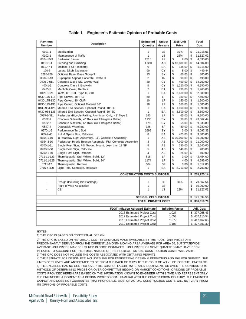
6 FINANCIAL FEASIBILITY
Table 1 provides a planning level Opinion of Probable Cost to construct the proposed corridorbased on the conceptual alignment. The item numbers and units of measure are based on theFDOT 2015 Basis of Estimates Manual. Inflation factors provided by FDOT were used to adjustthe total project cost on an annual basis from 2016 to 2019.
Explanations of the key items included in the cost estimate are included below. Additional detailis included in Table 1.
· Mobilization – Consists of work and operations necessary to begin work on a project.Includes moving in equipment and personnel, establishing temporary offices, safetyequipment and sanitary facilities. May include surveying, bond and insurance expenses.
· Maintenance of Traffic – Includes all items required to safely maintain traffic throughouta transportation work zone with minimal inconvenience to the public and fit into one ofthe following categories:1) cannot reasonably be quantified; 2) cannot be addressedunder current pay items; 3) are incidental to the operation necessary to safely maintaintraffic throughout a work zone.
· Clearing and Grubbing – This Item is included to account for the clearing that isnecessary to build the sidewalk.
· Pedestrian/Bicycle Railing – Tubular Railing – This item is included to account for theconstruction of a pedestrian railing to guard against hazardous field conditions.
· Sidewalk Concrete – These items are included to account for the cost of placingsidewalk along the proposed route. The sidewalk ramps are also included in this cost aswell as the Fiberglass Rebar in accordance with the City of Port Orange StandardConstruction Sidewalk requirements.
· Detectable Warning Surface – This item is included as an ADA compliant featureincluded within all sidewalk ramps. This item accounts for retrofitting existing sidewalkramps with detectable warning surfaces.
· Performance Turf, Sod – This item is included to sod all areas disturbed by constructionof the proposed sidewalk.
· LED Crosswalk System – This item is included to account for the signs with LED borderenhancement and in-pavement lighting. The cost includes the conduit, conductors,advance warning signs and any other items required for complete installation.
· Single Post Sign, F&I, Relocate, Remove – These items are included for the pedestriancrosswalk signage, as well as the installation, relocation and removal of variousadditional signs throughout the project.
· Thermoplastic, Std, White, Solid, 12” and 24” – These items are included to mark thespecial emphasis crosswalks, as detailed in the FDOT Design Standards, Index 17346.
McDonald Road Sidewalk │ Feasibility StudyApril 2015 │ Kimley-Horn and Associates, Inc.
21
Table 1 – Engineer’s Estimate Opinion of Probable Costs
0101-1 Mobilization 1 LS 10% 21,218.01$0102-1 Maintenance of Traffic 1 LS 15% 31,827.02$
0104-10-3 Sediment Barrier 2315 LF 2.00$ 4,630.00$0110-1-1 Clearing and Grubbing 1.380 AC 10,800.00$ 14,904.00$0110-7-1 Mailbox, F&I (Relocate) 9 EA 135.00$ 1,215.00$
120-3 Lateral Ditch Excavation 90 CY 5.00$ 449.44$0285-709 Optional Base, Base Group 9 13 SY 60.00$ 800.00$0334-1-13 Superpave Asphalt Concrete, Traffic C 2 TN 90.00$ 198.00$0400-0-011 Concrete Class NS, Gravity Wall 30 CY 490.00$ 14,700.00$
400-1-2 Concrete Class I, Endwalls 5 CY 1,250.00$ 6,250.00$0425-5 Manhole Cover, Replace 2 EA 730.00$ 1,460.00$
0425-1521 Inlets, DT BOT, Type C, <10' 1 EA 2,600.00$ 2,600.00$0430-175-118 Pipe Culvert, 18" RCP 50 LF 150.00$ 7,500.00$0430-175-130 Pipe Culvert, 30'' CMP 10 LF 150.00$ 1,500.00$0430-175-136 Pipe Culvert, Optional Material 36" 10 LF 160.00$ 1,600.00$0430-984-125 Mitered End Section, Optional Round, 18'' SD 1 EA 1,090.00$ 1,090.00$0430-984-138 Mitered End Section, Optional Round, 30'' SD 1 EA 3,800.00$ 3,800.00$0515-2-311 Pedestrian/Bicycle Railing, Aluminum Only, 42'' Type 1 140 LF 65.00$ 9,100.00$
0522-1 Concrete Sidewalk, 4" Thick (w/ Fiberglass Rebar) 1133 SY 38.00$ 43,062.44$0522-2 Concrete Sidewalk, 6" Thick (w/ Fiberglass Rebar) 179 SY 55.00$ 9,838.89$0527-2 Detectable Warnings 326 SF 30.00$ 9,780.00$
0570-1-2 Performance Turf, Sod 2699 SY 3.00$ 8,097.33$635-2-40 Pull & Splice Box, Relocate 8 EA 475.00$ 3,800.00$
0654-1-10 In Roadway Light Assembly, F&I, Complete Assembly 1 AS 30,000.00$ 30,000.00$0654-3-10 Pedestrian Hybrid Beacon Assembly, F&I, Complete Assembly 3 AS 7,000.00$ 21,000.00$0700-1-11 Single Post Sign, F&I Ground Mount, Less than 12 SF 8 AS 330.00$ 2,640.00$0700-1-50 Single Post Sign, Relocate 5 AS 140.00$ 700.00$0700-1-60 Single Post Sign, Remove 4 AS 25.00$ 100.00$
0711-11-123 Thermoplastic, Std, White, Solid, 12" 818 LF 3.00$ 2,454.00$0711-11-125 Thermoplastic, Std, White, Solid, 24" 1174 LF 4.00$ 4,696.00$
0711-17 Thermoplastic, Remove 504 SF 3.00$ 1,512.00$0715-4-400 Light Pole, Complete, Relocate 1 EA 2,703.00$ 2,703.00$
265,225.14$
- Design (Including Bid Package) 1 LS 30% 79,567.54$- Right-of-Way Acquisition 1 LS -- 10,000.00$- CEI 1 LS 12% 31,827.02$
121,394.56$386,619.70$
Adj. Cost397,058.43$407,110.54$417,162.65$427,601.39$
NOTES:1) THIS OPC IS BASED ON CONCEPTUAL DESIGN.
3) THIS OPC DOES NOT INCLUDE THE COSTS ASSOCIATED WITH OBTAINING PERMITS.
2016 Estimated Project Cost
1.0791.106
Unit ofMeasure
2015 UnitPrice
FDOT Inflation-Adjusted Estimate Inflation Factor1.027
EstimatedQuantity
5) THE ENGINEER HAS NO CONTROL OVER THE COST OF LABOR, MATERIALS, EQUIPMENT, OR OVER THE CONTRACTOR'SMETHODS OF DETERMINING PRICES OR OVER COMPETITIVE BIDDING OR MARKET CONDITIONS. OPINIONS OF PROBABLECOSTS PROVIDED HEREIN ARE BASED ON THE INFORMATION KNOWN TO ENGINEER AT THIS TIME AND REPRESENT ONLYTHE ENGINEER'S JUDGMENT AS A DESIGN PROFESSIONAL FAMILIAR WITH THE CONSTRUCTION INDUSTRY. THE ENGINEERCANNOT AND DOES NOT GUARANTEE THAT PROPOSALS, BIDS, OR ACTUAL CONSTRUCTION COSTS WILL NOT VARY FROMITS OPINIONS OF PROBABLE COSTS.
CONSTRUCTION COSTS SUBTOTAL
DESIGN / CEI SUBTOTALTOTAL PROJECT COST
2) THIS OPC IS BASED ON HISTORICAL COST INFORMATION MADE AVAILABLE BY THE FDOT. UNIT PRICES AREPREDOMINANTLY DERIVED FROM THE CURRENT 12-MONTH MOVING AREA AVERAGE FOR AREA 06, BUT STATEWIDEAVERAGE UNIT PRICES MAY BE UTILIZED IN SOME INSTANCES. UNIT PRICES OF SOME QUANITIES MAY HAVE BEENINFLATED TO ACCOUNT FOR THE SMALL NATURE OF THE PROJECT. ACTUAL CONSTRUCTION COSTS WILL VARY.
4) THE ESTIMATE FOR DESIGN FEE INCLUDES 20% FOR ENGINEERING DESIGN & PERMITTING AND 10% FOR SURVEY. THELIMITS OF SURVEY ARE ANTICIPATED TO BE FROM THE BACK OF CURB TO THE RIGHT OF WAY LINE FOR THE LENGTH OF
1.0532017 Estimated Project Cost2018 Estimated Project Cost2019 Estimated Project Cost
TotalCost
Pay ItemNumber Description
McDonald Road Sidewalk │ Feasibility StudyApril 2015 │ Kimley-Horn and Associates, Inc.
22
7 CONCLUSION AND SUMMARY OF RECOMMENDATIONS
The purpose of this project was to conduct a limited corridor study to assess the feasibility ofproviding sidewalk along the south side of McDonald Road from the intersection of MadelineAvenue at Sugar House Drive to 6th Street. The conceptual alignment for the proposedsidewalk is included in Appendix C. Constructing sidewalk along the specified limits appears tobe feasible.
The key issues on the project corridor are noted below. Appropriate time should be allottedwithin the project schedule to address these issues either before or during design asappropriate.
PUBLIC INVOLVEMENT
The project corridor is located in mainly residential areas. Although it is anticipated that allimprovements (with one exception) will be accommodated within the existing right of way, it isnoted that the modifications may require re-grading of existing drainage areas, addition of newconcrete aprons, re-grading of existing driveways, relocation of mailboxes, and othermodifications that may impact the existing property owners.
A coordination effort should be conducted to reach out to the property owners along McDonaldRoad regarding the planned improvements prior to making any changes. It is anticipated thatreception to the sidewalk will be positive. From field observations and discussions, manypeople are concerned about the lack of sidewalk along the south/west side of McDonald Road.
RIGHT OF WAY
A right of way map was provided by the City of Port Orange. Based on the conceptualalignment identified, there is one area of a potential right of way constraint on the corridor. It isrecommended that the ultimate schedule of the project allow time to pursue right of wayacquisition with this property owner. In the event that right of way negotiations are notsuccessful, other options may be pursued such as the installation of a four foot sidewalk alongthe property limits.
It is noted that right of way lines are apparent. The corridor specific survey may identifyadditional right of way at this location. FDOT’s right of way forms are included in Appendix E.
DRAINAGE PERMITTING
The proposed recommendations along the corridor result in minor modifications to existingdrainage ditches and structures. Typically this work falls under St. Johns Water ManagementDistrict exemption criteria. As such, an exemption verification letter could be obtained duringdesign development. This process usually takes less than 30 days and is anticipated to beaccommodated within design schedule for the project.

McDonald Road Sidewalk │ Feasibility StudyApril 2015 │ Kimley-Horn and Associates, Inc.
23
8 DATA COLLECTION REFERENCES
Data collection consisted of referencing readily available information including:
· The Volusia County MPO Bicycle/Pedestrian Plan, January 25, 2005· Volusia County, http://www.volusia.org/· River to Sea TPO, http://www.r2ctpo.org/· The City of Port Orange, https://www.port-orange.org/· Florida Department of Transportation (FDOT), http://www.dot.state.fl.us/· Florida Pedestrian Planning and Design Handbook, FDOT, 1999· Manual of Uniform Minimum Standards for Design, Construction and Maintenance for
Streets and Highways, May 2011, (Florida Greenbook”)· American Association of State Highway and Transportation Officials (AASHTO) Guide
for the Planning, Design, and Operation of Pedestrian Facilities, 2004· FDOT Plans Preparation Manual (PPM), January 2015· FDOT 2015 Basis of Estimates Handbook§ ADA Standards for Accessible Design, Code of Federal Regulations, 28 CFR Part 36,§ Manual on Uniform Traffic Control Devices (MUTCD), 2009§ FDOT Roadway and Traffic Design Standards, 2015§ City of Port Orange Comprehensive Plan Policy Document 2010-2025, October 2010§ Bicycle and Pedestrian Safety Review Study, Sugar Mill Elementary School, Port
Orange, Florida, March 2007

APPENDIX
APPENDIX ASugar Mill Elementary School Safe Routes to School Study Excerpts

Sugar Mill Elementary School March 2007 Hoke Design, Inc. 1
Sugar Mill Elementary School Assessment Report Volusia County MPO
Bicycle and Pedestrian Safety Review Study
Implementation Report
Sugar Mill Elementary school
Port Orange, Florida
March 2007
Hoke Design, Inc.

Sugar Mill Elementary School March 2007 Hoke Design, Inc. 16
Sugar Mill Elementary School Assessment Report Volusia County MPO
Section 3: Findings and Recommendations Findings and Recommendations
Sugar Mill Elementary School – Fact Sheet
• Number of Students: 840
• Number of Walkers/Bicycle Riders (observed from site visit): The
day of the site visit was overcast with some sprinkles, possibly reducing the
number of walkers and bicycle riders. There appeared to be fewer than 60
students walking or riding their bicycles.
• Number of Bicycle and Pedestrian Crash Events (2000-2004): 4 located within walk zone, 12 outside of walk zone but within 2 miles.
• Year School Opened: 1982
• Number of School Buses: 8
• Number of Students for School Site Aftercare: pending
• Number of Aftercare Buses/Vans: one Votran bus 5 vans for the YMCA
private aftercare
• Number of Students for Breakfast: 150 (estimated) • Number of Bicycles: 24
• Number of Bicycle Helmets: 11
• Backpack Policy: No policy, students are allowed rolling backpacks
• Teachers Assisting in Arrival and Dismissal Safety: 1 teacher assists with car loading and unloading in the morning; 4 assist in the afternoon.
Existing Safety Education: The City of Port Orange provides free helmets for students who need them. The City has recently started giving tickets instead of warnings to children bicycling without helmets. Summary of Principal Comments: The lack of sidewalks near the school is the primary concern. Summary of Crossing Guard Supervisor Comments: The intersection of Nova Road and Madeline Avenue is too large and busy for students to cross even with crossing guards.
Crossing Guard Locations:
Herbert Street and Old Sugar Mill Road Madeline Avenue and Sauls Street McDonald Road and Charles Street
Port Orange community traffic officer staff directs traffic and crosses children at car line entrance/exit.
Sugar Mill Elementary School March, 2007 Hoke Design, Inc. 17
Sugar Mill Elementary School Assessment Report Volusia County MPO
Note: Issues and recommendations in this report are based on data collected in the second half of 2006. Walk zone and school-site conditions can change rapidly, and should be verified before any recommendations are implemented. Several factors limit the number of students walking or riding bicycles to Sugar Mill Elementary School. These include:
• An incomplete sidewalk system - direct routes from high density residential areas to the Elementary school do not have sidewalks or sufficient right-of way for the construction of sidewalks. Specifically, Nixon Lane has very limited right of way and Old Sugar Mill Road has limited right of way and sight distance problems due to the location of the Old Sugar Mill.
• The railroad track located east of the school does not have a complete sidewalk system nor a pedestrian arm. Because of this hazardous condition, the school system currently provides courtesy transportation for Sugar Mill students living east of the railroad. US Highway 1, located east of the railroad tracks, creates an additional barrier for students wishing to walk or bicycle to school.
• Nova Road, to the west of the school, is a six-lane divided road. Crossing this roadway would require two light cycle changes and the students would need to wait in the median between cycles. The school system currently provides courtesy transportation for students living west of Nova Road.
These factors all contribute to the high percentage of students whose parents drop them off at the school, causing congestion on-site during arrival and dismissal times. The planned Madeline Avenue extension will provide additional access to the school, allowing modification of the current on-campus circulation. The school Principal is reviewing the possibility of creating a one-way entrance from the proposed section of Madeline Avenue that will align with the northern border of the school site. This entrance road would exit onto Charles Street, reducing the amount of traffic near the intersection of Charles Street and McDonald Road. Because the Madeline Avenue extension is not currently funded, these measures will not provide immediate relief. At least eight new condominium units (Madeline Commons PUD) are planned for east of the school along the 5th Street, potentially adding to the number of students living east of the school currently receiving courtesy transportation. These residents will also attend the Silver Sands Middle School on Herbert Street, west of Nova Road. The City should consider enhancing the sidewalk system between the waterfront and the elementary and middle school. Although the attendance zone does not officially include the residential development to the north of the school, many students have obtained variances to attend Sugar Mill Elementary School. Many of the students this living this close to the school may choose to walk or ride their bicycles to and from school. When the school is reviewed for attendance re-zoning, the School Board may wish to consider adding the students east of Sauls Street and along Spinnaker Circle to encourage more walkers and bicycle riders. There is a proposed multi-use trail on the FPL corridor that will provide additional

Sugar Mill Elementary School March, 2007 Hoke Design, Inc. 18
Sugar Mill Elementary School Assessment Report Volusia County MPO
bicycle and pedestrian connectivity in this area, especially for the nearby Silver Sands Middle School. Findings and Recommendations School-Site Issue: A new bridge that spans a ditch in the staff parking lot was not installed to provide handicapped accessibility. The older concrete bridge does provide flush access from the parking area to the bus drop off travel lane but does not connect to a ramp along the school sidewalk. Recommendation: At least one bridge and ramp route should be completely flush to grade to allow for a direct path of travel for persons with disabilities, strollers and wheeled carts. Off-Campus Walk Zone Issue: Most of the students within the walk zone are living to the west of the school and are using roadways with one sidewalk or no sidewalks. Recommendation: Since the majority of students who walk or ride bicycles live west of the school site, there should be sidewalks along the west side of McDonald Road. This would encourage students to cross the roadway where a crossing guard is located at McDonald Road and Charles Street. Many children and parents with children crossed McDonald Road near Christy Drive to directly access the gate and sidewalk to the bicycle rack area and school. This is not a marked crossing and there is no crossing guard.
A new bridge in the parking area was not installed flush to grade
Multiple students cross McDonald Road at an unmarked crossing
Sugar Mill Elementary School March, 2007 Hoke Design, Inc. 19
Sugar Mill Elementary School Assessment Report Volusia County MPO
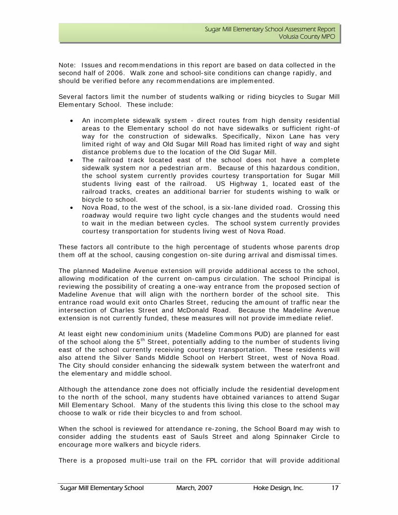
This student uses the existing sidewalk on McDonald Road and crosses McDonald Road to access Christy Drive. Sidewalks on both sides of McDonald would have allowed this student to cross with the crossing guard at McDonald Road and Charles Street, then ride on the sidewalk to Christy Drive without riding against traffic and violating bicycle safety procedures.
Issue: The bus driveway exit at McDonald Road has an area in front of the gate that provides unofficial temporary parking. Buses may have the height to see beyond the vehicle to notice children on the sidewalk approaching from the south, but other vehicles crossing this entrance may not be able to see approaching students. This is also the entrance to the staff parking area, adding to vehicular traffic. Recommendation: Do not allow parking in the area in front of this gate. Use cones or enforcement to deter motorists from using this space for parking.
Issue: The crosswalk at the intersection of McDonald Road and Charles Street is painted to avoid the stop bar on Charles Street. This layout places the student in the roadway for a longer distance. Recommendation: Obtain an engineering review of this intersection for a more direct route to be applied during the next scheduled re-painting of the crosswalk.
A student crosses McDonald away from the crossing guard location
The vehicle parked near the bus/staff exit may block motorist’s visibility of sidewalk users
The crosswalk across Charles Street angles toward McDonald Road

Sugar Mill Elementary School March, 2007 Hoke Design, Inc. 20
Sugar Mill Elementary School Assessment Report Volusia County MPO
Issue: There is no crosswalk at the car drop off entrance to the school along Charles Street. The amount of traffic at the school entrance requires a traffic control person in the morning and the afternoon. He directs traffic and crosses students and their parents. The sidewalk to the school is located west of the entrance. Recommendation: Paint a crosswalk across the entrance to increase pedestrian and bicycle user safety at this crossing. The sidewalk should also be painted with yellow “stop bars” to provide students with direction on where to stand while waiting to be crossed. School crossing signs and pedestrian warning signs to MUTCD standards should also be implemented.
Issue: School District staff was considering the addition of crossing guards at the intersection of Madeline Avenue and Nova Road to eliminate courtesy busing. Crossing Nova Road would require students to wait in the median for a second signal cycle to reach the opposite side of the roadway. There are no sidewalks along the south side of Madeline Avenue and students would need to cross Madeline Avenue to reach sidewalk on the north side of the road. Students living to the west of Nova Road are currently provided courtesy bus transportation due to the hazardous crossing conditions. Recommendation: Continue to provide courtesy transportation. Many of the students living to the west of Nova Road may not have any transportation options other than walking or bicycling to and from school. Any roadway that is wide enough and busy enough to merit two different walk cycles to cross the road should not be considered as an option for student crossings.
A crosswalk is needed at the school entrance off of Charles Street
Crosswalk users crossing Nova Road at Madeline Avenue must wait in the median for a second signal cycle

APPENDIX
APPENDIX BExisting Corridor Photos

A-A
MATCHLINE
51 2 3 4
10 9 8
6
49
10
6
7
8
11
12
13
N
7
1112
EXISTING CORRIDOR PHOTOS
SCALE: NTS
21 35
13
NSAULS
STREET
MADELINE AVENUE
MCDON
ALD ROA
D
SUG
AR H
OUSE D
RIV
E
MADELINE AVENUE
SUG
AR H
OUSE D
RIV
E
SAULS
STREET
MCDON
ALD ROA
D
AREA 1: INTERSECTION OF MADELINE AVENUE AND SUGAR HOUSE DRIVE
2/8/2015 1:26:46 PM K:\ORL_TPTO\149127103_McDonaldRevisions\149127103\PLAYRD01.dgnheather.roberts
City of Port Orange, FloridaMcDonald Road Sidewalk
Bicycle/Pedestrian Feasibility Study
PROJECT NO. 149127103
Orlando, Florida 32803
3660 Maguire Boulevard, Suite 200
FEBRUARY 2015

MA
TC
HLIN
E
A-
A
MA
TC
HLIN
E
B-
B
1
2
3 42
4
31
N
SCALE: NTS
EXISTING CORRIDOR PHOTOS
N
CHRISTY D
RIV
ECHRISTY D
RIV
E
MCDONALD ROAD
AREA 2: INTERSECTION OF MCDONALD ROAD AND CHRISTY DRIVE
2/8/2015 1:29:38 PM K:\ORL_TPTO\149127103_McDonaldRevisions\149127103\PLAYRD02.dgnheather.roberts
City of Port Orange, FloridaMcDonald Road Sidewalk
Bicycle/Pedestrian Feasibility Study
PROJECT NO. 149127103
Orlando, Florida 32803
3660 Maguire Boulevard, Suite 200
FEBRUARY 2015

MA
TC
HLIN
E
B-
B
MA
TC
HLIN
E
C-
C
1 2 3 4
11 10 9
2 1
3
9
4
5
1110
6
N
5
6
78
8
7
EXISTING CORRIDOR PHOTOS
SCALE: NTS
OLD S
UG
AR MIL
L R
OA
D
NIX
ON L
ANE
AM
BER CIR
CLE
N
SCHOOLELEMENTARY SUGAR MILL
CHARL
ES STR
EET
MCDONALD ROAD
AREA 3: INTERSECTION OF MCDONALD ROAD AND CHARLES STREET
2/8/2015 1:27:55 PM K:\ORL_TPTO\149127103_McDonaldRevisions\149127103\PLAYRD03.dgnheather.roberts
City of Port Orange, FloridaMcDonald Road Sidewalk
Bicycle/Pedestrian Feasibility Study
PROJECT NO. 149127103
Orlando, Florida 32803
3660 Maguire Boulevard, Suite 200
FEBRUARY 2015

MA
TC
HLIN
E
C-
C
1 2 3 4 5 6
7
8
91011121314
10
11
12
13
14
9
8
6 7
51
23
4
SCALE: NTS
EXISTING CORRIDOR PHOTOS
NN
MCDONALD ROAD
ASH
LEY CIR
CLE
6TH STREET
AREA 4: INTERSECTION OF MCDONALD ROAD AND 6TH STREET
2/8/2015 1:29:14 PM K:\ORL_TPTO\149127103_McDonaldRevisions\149127103\PLAYRD04.dgnheather.roberts
City of Port Orange, FloridaMcDonald Road Sidewalk
Bicycle/Pedestrian Feasibility Study
PROJECT NO. 149127103
Orlando, Florida 32803
3660 Maguire Boulevard, Suite 200
FEBRUARY 2015

APPENDIX
APPENDIX CConceptual Design Plans
N
CHRIST
Y DRIVE
NIXON L
ANE
OLD SU
GAR
MILL
ROAD
MADELINE AVE
NUE
SUGAR H
OUSE
DRIVE
MCDON
ALD ROA
D
CHARLES STREET
MCDONALD ROAD
6TH S
TREET
5TH S
TREET
HERBERT STREET
CIRC
LE
ASH
LEY
ELEMENTARY SCHOOLSUGAR MILL
SAULS ST
REET
MAP 2
MAP 3
MAP 4
MAP 5
SCALE: NTS
MAP 1 - PLAN LAYOUT SHEET
CIRCLEAMBER
PAGE 1
2/8/2015 1:15:58 PM K:\ORL_TPTO\149127103_McDonaldRevisions\149127103\PLAYRD00.dgnheather.roberts
PROJECT CORRIDOR DESIGN PLANS
City of Port Orange, FloridaMcDonald Road Sidewalk
Bicycle/Pedestrian Feasibility Study
PROJECT NO. 149127103
Orlando, Florida 32803
3660 Maguire Boulevard, Suite 200
FEBRUARY 2015

4/28/2015 6:01:37 PM K:\ORL_TPTO\149127103_McDonaldRevisions\149127103\PLANRD01-50 scale.dgnheather.roberts
PROJECT CORRIDOR DESIGN PLANS
City of Port Orange, FloridaMcDonald Road Sidewalk
Bicycle/Pedestrian Feasibility Study
PROJECT NO. 149127103SCALE: AS SHOWN
PLAN SHEETOrlando, Florida 32803
3660 Maguire Boulevard, Suite 200
APRIL 2015
**
**
*
*
*
*
**
* *
*
*
*
*
AHEAD
BIK
E R
OUTE
BE
GIN E
ND
ST
OP
N
50
Feet
0 10
REMAIN)
(EXIST. TO
R6-4 (2)
OM1-1 (4)
(INDEX NO. 17346)EMPHASIS CROSSWALK PROPOSED SPECIAL
(INDEX NO. 17346) LED CROSSWALK SYSTEMCROSSWALK WITH IN PAVEMENT PROPOSED SPECIAL EMPHASIS
EXIST. INLET TO REMAIN
INFORMATIONSEE INSET A FOR
EXIST. R/W
EXIST. R/W
TO REMAINAND PAVEMENT EXIST. INLET
TO REMAINEXIST. HEADWALL
LEGEND
EXIST. FIRE HYDRANT
EXIST. SIGN
PROPOSED SIGN
PROPOSED 2' DETECTABLE WARNING SURFACE
EXISTING R/W
EXISTING PARCEL BOUNDARY
EXISTING SIDEWALK
EXISTING VALLEY GUTTER
EXISTING EDGE OF PAVEMENT
EXIST. POWERPOLE
CONCRETE TO BE REMOVED
MADELINE AVENUE
SAULS ST
REET
SUG
AR H
OUSE D
RIV
E
MCDONALD ROAD
PAVEMENT TO REMAIN
COUNTY OF VOLUSIA
NO. 17344.
2. ALL SCHOOL SIGNS AND MARKINGS ARE TO CONFORM TO FDOT INDEX
CONSTRUCTION DRAWINGS.
APPROXIMATE AND ARE NOT INTENDED TO BE USED IN PREPARING
ROADWAY CORRIDORS HAVE NOT BEEN FIELD SURVEYED. LOCATIONS ARE
AERIAL INTERPRETATION AND AVAILABLE PUBLIC INFORMATION. THE
1. ALL EXISTING INFORMATION SHOWN HAS BEEN OBTAINED FROM
NOTE:
BE REMOVED)
(EXIST. TO
W16-9P
S1-1
BE REMOVED)
(EXIST. TO
W16-7P
S1-1
BE REMOVED)
(EXIST. TO
W16-7P
S1-1
ENHANCEMENT)
BORDER
WITH LED
(PROPOSED SIGN
W16-7P
S1-1
ENHANCEMENT)
BORDER
WITH LED
(PROPOSED SIGN
W16-7P
S1-1
PROPOSED 5' SIDEWALK (4" CONCRETE)
PROPOSED 6' SIDEWALK (4" CONCRETE)
PROPOSED 8' SIDEWALK (4" CONCRETE)
SIDEWALKTIE TO EXIST.
EXIST. PULL BOX
RELOCATED)
TO BE
(EXIST.
D11-1
TO BE RELOCATEDAND GUY WIRES EXIST. POLE
(TYP.) (INDEX NO. 310)WARNING SURFACE PROPOSED DETECTABLE
(TYP.)REMOVED TO BE CONCRETE
DITCH AREA.REGRADE SURROUNDING MITERED END SECTION. EXTEND PIPE AND ADD
ENHANCEMENT)
BORDER
WITH LED
(PROPOSED SIGN
W16-7P
S1-1
MATCHLINE
A-A
TO REMAINEXIST. HEADWALL INSET A
MAP 2 - INTERSECTION OF MADELINE AVENUE AND SUGAR HOUSE DRIVE
EXIST. FLUME(INDEX NO. 852, 6011)BACK OF PROPOSED SIDEWALK AND PEDESTRIAN RAILING ALONGPROPOSED CONCRETE GRAVITY WALL
PAGE 2
42" PEDESTRIAN RAILINGPROPOSED 6' SIDEWALK WITH

MA
TC
HLIN
E
A-
A
MA
TC
HLIN
E
B-
B
MAP 3 - INTERSECTION OF MCDONALD RD. AND CHRISTY DR.
PAGE 3
2/8/2015 1:32:19 PM K:\ORL_TPTO\149127103_McDonaldRevisions\149127103\PLANRD02-50 scale.dgnheather.roberts
PROJECT CORRIDOR DESIGN PLANS
City of Port Orange, FloridaMcDonald Road Sidewalk
Bicycle/Pedestrian Feasibility Study
PROJECT NO. 149127103SCALE: AS SHOWN
Orlando, Florida 32803
3660 Maguire Boulevard, Suite 200
FEBRUARY 2015
CR
OSS H
ER
E
AH
EA
DSID
EW
ALK E
NDS
DO
UB
LE
D
FIN
ES
SP
EE
DIN
G
DO
UB
LE
D
FIN
ES
SP
EE
DIN
G
SC
HO
OL
LIM
IT
SP
EE
D
15
DA
YS
SC
HO
OL
1:4
5 - 2
:45
7:1
5 - 8
:15
AF
TE
RN
OO
N
WE
DN
ES
DA
Y
12:4
5 - 1
:45
AH
EA
D
**
**
*
*
*
*
SA
N
SA
N
NO PARKING ORSTOP
SC
HO
OL
SP
EE
D
LIM
IT
15
SC
HO
OL
DA
YS
7:1
5 - 8
:15 A
M1:4
5 - 2
:45 P
M
AH
EA
D
SC
HO
OL
SP
EE
D
LIM
IT
15
SC
HO
OL
DA
YS
7:1
5 - 8:1
5 A
M
1:4
5 - 2:4
5 P
M
25
WE
DN
ES
DA
YA
FT
ER
NO
ON
WE
DN
ES
DA
Y
AF
TE
RN
OO
N
12:4
5 - 1:4
5 P
M
12:4
5 - 1
:45 P
M
N
50
Feet
0 10
REMAIN)
(EXIST. TO
R1-1
REMAIN
EXIST. TO
S4-1P (2)
R2-1
S4-3P
SIGN)
(PROPOSED
W16-7PL
S1-1
SIGN)
(PROPOSED
W16-7PL
S1-1
EXIST. R/W
EXIST. R/W
NO. 17346)CROSSWALK (INDEX SPECIAL EMPHASIS PROPOSED
TO REMAIN)
(EXIST. SIGN
W1-2A
REMAIN)
(EXIST. TO
W16-9P
S1-1
(INDEX NO. 17346)STRIPINGPROPOSED CROSSWALK
CHRISTY D
RIV
E
MCDONALD ROAD
SCHOOLELEMENTARY SUGAR MILL
CITY OF PORT ORANGE
VOLUSIA COUNTYSCHOOL BOARD OF
SIGN)
(PROPOSED
OM4-1 (2)
SIGN)
(PROPOSED
FTP-35-06
*MODIFIED
FTP-30-06
(PROPOSED SIGN)
FTP-38-06
(PROPOSED SIGN)
FTP-38-06
SIGN)
(PROPOSED
*MODIFIED
R9-11
NO.
17344.
2.
ALL S
CH
OOL SIG
NS
AN
D
MA
RKIN
GS
AR
E
TO
CO
NF
OR
M
TO F
DOT IN
DE
X
CO
NS
TR
UCTIO
N
DR
AWIN
GS.
AP
PR
OXIM
AT
E
AN
D
AR
E
NOT IN
TE
ND
ED
TO
BE
US
ED IN P
RE
PA
RIN
G
RO
AD
WA
Y C
OR
RID
OR
S
HA
VE
NOT
BE
EN FIE
LD S
UR
VE
YE
D. L
OC
ATIO
NS
AR
E
AE
RIA
L IN
TE
RP
RE
TA
TIO
N
AN
D
AV
AIL
AB
LE
PU
BLIC IN
FO
RM
ATIO
N.
TH
E
1. A
LL E
XIS
TIN
G IN
FO
RM
ATIO
N S
HO
WN
HAS
BE
EN
OB
TAIN
ED F
RO
M
NOT
E:
NO. 17344.
2. ALL SCHOOL SIGNS AND MARKINGS ARE TO CONFORM TO FDOT INDEX
CONSTRUCTION DRAWINGS.
APPROXIMATE AND ARE NOT INTENDED TO BE USED IN PREPARING
ROADWAY CORRIDORS HAVE NOT BEEN FIELD SURVEYED. LOCATIONS ARE
AERIAL INTERPRETATION AND AVAILABLE PUBLIC INFORMATION. THE
1. ALL EXISTING INFORMATION SHOWN HAS BEEN OBTAINED FROM
NOTE:
ENHANCEMENT)
BORDER
WITH LED
(PROPOSED SIGN
W16-7P
S1-1
LEGEND
EXIST. FIRE HYDRANT
EXIST. SIGN
PROPOSED SIGN
PROPOSED 2' DETECTABLE WARNING SURFACE
EXISTING R/W
EXISTING PARCEL BOUNDARY
EXISTING SIDEWALK
EXISTING VALLEY GUTTER
EXISTING EDGE OF PAVEMENT
EXIST. POWERPOLE
CONCRETE TO BE REMOVED
PROPOSED 5' SIDEWALK (4" CONCRETE)
PROPOSED 5' SIDEWALK (6" CONCRETE)
REMAIN)
(EXIST. TO
S4-1P (2)
R2-1
S4-3P
REMAIN)
(EXIST. TO
R7-2M
TO REMAIN
EXIST. GATE
EXIST. PULL BOX
(EXIST. TO REMAIN)SCHOOL PAVEMENT MARKINGS

MA
TC
HLIN
E
B-
B
MA
TC
HLIN
E
C-
C
MAP 4 - INTERSECTION OF MCDONALD RD AND CHARLES ST.
PAGE 4
2/8/2015 1:10:42 PM K:\ORL_TPTO\149127103_McDonaldRevisions\149127103\PLANRD03-50 scale.dgnheather.roberts
PROJECT CORRIDOR DESIGN PLANS
City of Port Orange, FloridaMcDonald Road Sidewalk
Bicycle/Pedestrian Feasibility Study
PROJECT NO. 149127103SCALE: AS SHOWN
Orlando, Florida 32803
3660 Maguire Boulevard, Suite 200
FEBRUARY 2015
5
AH
EA
D
NO PARKING OROR STANDING
7:15 - 8:15 AM1:45 - 2:45 PM
NO PARKING OROR STANDING
7:15 - 8:15 AM1:45 - 2:45 PM
NO PARKING OROR STANDING
7:15 - 8:15 AM1:45 - 2:45 PM
NO PARKING OROR STANDING
7:15 - 8:15 AM1:45 - 2:45 PM
EN
D
SC
HO
OL
ZO
NE
STOPSTOP
NO PARKING OROR STANDING
7:15 - 8:15 AM1:45 - 2:45 PM
DO NO
TBLO
CKDRIVE
STOP
SP
EE
D
LIM
IT
SC
HO
OL
WH
EN
FL
AS
HIN
G
15
NO
PARKI
NG
AN
YTIM
E
NO PARKING OROR STANDING
7:15 - 8:15 AM1:45 - 2:45 PM
N
50
Feet
0 10
REMAIN)
(EXIST. TO
R1-1
REMAIN)
(EXIST. TO
R1-1
EXIST. R/W
EXIST. R/W
EXIST. R/W
REMAIN)
(EXIST TO
S5-1
(INDEX NO. 17346)CROSSWALKSPECIAL EMPHASIS PROPOSED
REMAIN)(EXIST. TO
W1-7OM1-1
(INDEX NO. 17346)BAR STRIPINGPROPOSED STOP
RELOCATED)
(EXIST. TO BE
R1-1
(INDEX NO. 17346)STRIPINGPROPOSED CROSSWALK
(INDEX NO. 17346)BAR STRIPING PROPOSED STOP
(INDEX NO. 17346)STRIPINGPROPOSED CROSSWALK
(INDEX NO. 17346)BAR STRIPING PROPOSED STOP
NIX
ON L
ANE
OLD S
UG
AR MIL
L R
OA
D
MCDONALD ROAD
SCHOOLELEMENTARY SUGAR MILL
AMBE
R CI
RCLE
VOLUSIA COUNTYSCHOOL BOARD OF
SIGN)
(PROPOSED
W16-9P
S1-1
BE RELOCATED)
(EXIST. SIGN TO
W16-7P
S1-1
RELOCATED)
(EXIST. TO BE
R10-7 *MODIFIED
W16-7P
S1-1
TIE TO EXIST. SIDEWALK
NO. 17344.
2. ALL SCHOOL SIGNS AND MARKINGS ARE TO CONFORM TO FDOT INDEX
CONSTRUCTION DRAWINGS.
APPROXIMATE AND ARE NOT INTENDED TO BE USED IN PREPARING
ROADWAY CORRIDORS HAVE NOT BEEN FIELD SURVEYED. LOCATIONS ARE
AERIAL INTERPRETATION AND AVAILABLE PUBLIC INFORMATION. THE
1. ALL EXISTING INFORMATION SHOWN HAS BEEN OBTAINED FROM
NOTE:
LEGEND
EXIST. FIRE HYDRANT
EXIST. SIGN
PROPOSED SIGN
PROPOSED 2' DETECTABLE WARNING SURFACE
EXISTING R/W
EXISTING PARCEL BOUNDARY
EXISTING SIDEWALK
EXISTING VALLEY GUTTER
EXISTING EDGE OF PAVEMENT
EXIST. POWERPOLE
CONCRETE TO BE REMOVED
PROPOSED 5' SIDEWALK (6" CONCRETE)
PROPOSED 5' SIDEWALK (4" CONCRETE)
PROPOSED 6' SIDEWALK (4" CONCRETE)
PROPOSED 8' SIDEWALK (4" CONCRETE)
REMAIN)
(EXIST. TO
R7-2M
REMAIN)
(EXIST. TO
R7-2M
REMAIN)
(EXIST. TO
R7-2M
REMAIN)
(EXIST. TO
R7-2M
REMAIN)
(EXIST. TO
R7-2M
SIDEWALKTIE TO EXIST.
SIDEWALKTIE TO EXIST.
EXIST. PULL BOX
EXIST. MAILBOX
RELOCATED)
TO BE
(EXIST.
S5-2
RELOCATED)
TO BE
(EXIST.
R7-1
REMAIN)
(EXIST. TO
R7-2M
MA
TC
HLIN
E
C-
C
MAP 5 - INTERSECTION OF MCDONALD RD. AND 6TH ST.
PAGE 5
4/28/2015 7:51:54 PM K:\ORL_TPTO\149127103_McDonaldRevisions\149127103\PLANRD04-50 scale.dgnheather.roberts
PROJECT CORRIDOR DESIGN PLANS
City of Port Orange, FloridaMcDonald Road Sidewalk
Bicycle/Pedestrian Feasibility Study
PROJECT NO. 149127103SCALE: AS SHOWN
Orlando, Florida 32803
3660 Maguire Boulevard, Suite 200
APRIL 2015
5
STOP
AH
EA
D
STOP
N
50
Feet
0 10
REMAIN)(EXIST. TO
W16-9PS1-1
MCDONALD ROAD
6TH STREET
CIR
CLE
ASH
LEY
CITY OF PORT ORANGE
CITY OF PORT ORANGE
REMAIN)(EXIST. TO
R1-1
NO. 17344.
2. ALL SCHOOL SIGNS AND MARKINGS ARE TO CONFORM TO FDOT INDEX
CONSTRUCTION DRAWINGS.
APPROXIMATE AND ARE NOT INTENDED TO BE USED IN PREPARING
ROADWAY CORRIDORS HAVE NOT BEEN FIELD SURVEYED. LOCATIONS ARE
AERIAL INTERPRETATION AND AVAILABLE PUBLIC INFORMATION. THE
1. ALL EXISTING INFORMATION SHOWN HAS BEEN OBTAINED FROM
NOTE:
RELOCATED)(EXIST. TO BE
R1-1
(INDEX NO. 17346)STRIPINGPROPOSED CROSSWALK
(INDEX NO. 17346)BAR STRIPING PROPOSED STOP
LEGEND
EXIST. FIRE HYDRANT
EXIST. SIGN
PROPOSED SIGN
PROPOSED 2' DETECTABLE WARNING SURFACE
EXISTING R/W
EXISTING PARCEL BOUNDARY
EXISTING SIDEWALK
EXISTING VALLEY GUTTER
EXISTING EDGE OF PAVEMENT
EXIST. POWERPOLE
CONCRETE TO BE REMOVED
PROPOSED 5' SIDEWALK (4" CONCRETE)
PROPOSED 5' SIDEWALK (6" CONCRETE)
(INDEX NO. 17346)STRIPINGPROPOSED CROSSWALK
(INDEX NO. 17346)BAR STRIPING PROPOSED STOP
EXIST. MAILBOX
(INDEX NO. 870)(SEE MAP 6 FOR DETAIL) OF 42" RAILINGAND APPROXIMATELY 50 LF WITH 8" THICKENED EDGE PROPOSED 6' SIDEWALK
SIDEWALKTIE TO EXIST.
REMAIN)MARKINGS (EXIST. TO SCHOOL PAVEMENT
ASPHALT.OPEN CUT AND PATCH NEW MITERED END SECTION. EXISTING DRAINAGE PIPE. ADD REMOVE, REPLACE, AND EXTEND
HEADWALLRECONSTRUCT EXISTING
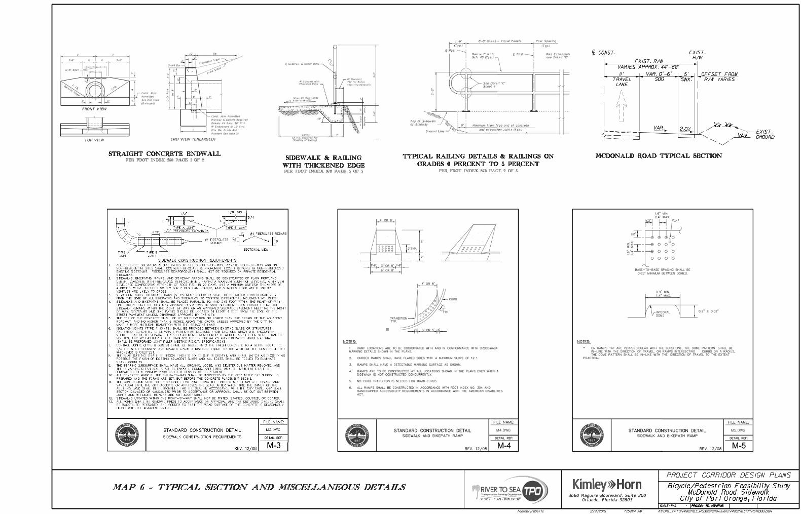

APPENDIX
APPENDIX DResponse to FDOT Comments
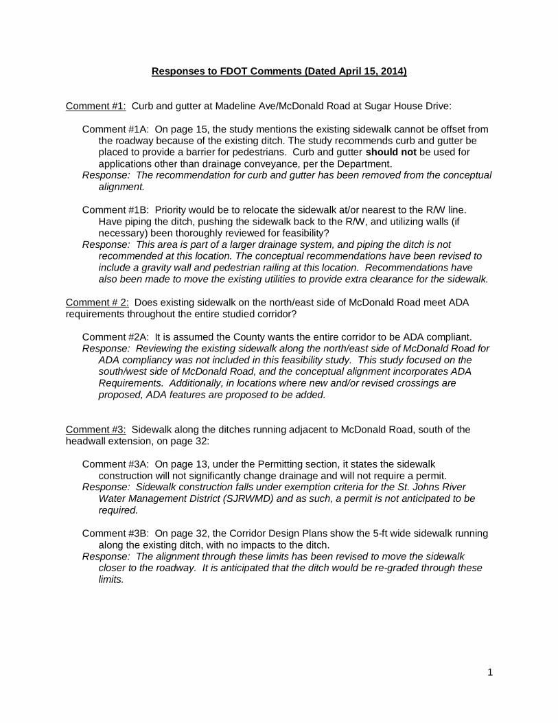
1
Responses to FDOT Comments (Dated April 15, 2014)
Comment #1: Curb and gutter at Madeline Ave/McDonald Road at Sugar House Drive:
Comment #1A: On page 15, the study mentions the existing sidewalk cannot be offset fromthe roadway because of the existing ditch. The study recommends curb and gutter beplaced to provide a barrier for pedestrians. Curb and gutter should not be used forapplications other than drainage conveyance, per the Department.
Response: The recommendation for curb and gutter has been removed from the conceptualalignment.
Comment #1B: Priority would be to relocate the sidewalk at/or nearest to the R/W line.Have piping the ditch, pushing the sidewalk back to the R/W, and utilizing walls (ifnecessary) been thoroughly reviewed for feasibility?
Response: This area is part of a larger drainage system, and piping the ditch is notrecommended at this location. The conceptual recommendations have been revised toinclude a gravity wall and pedestrian railing at this location. Recommendations havealso been made to move the existing utilities to provide extra clearance for the sidewalk.
Comment # 2: Does existing sidewalk on the north/east side of McDonald Road meet ADArequirements throughout the entire studied corridor?
Comment #2A: It is assumed the County wants the entire corridor to be ADA compliant.Response: Reviewing the existing sidewalk along the north/east side of McDonald Road for
ADA compliancy was not included in this feasibility study. This study focused on thesouth/west side of McDonald Road, and the conceptual alignment incorporates ADARequirements. Additionally, in locations where new and/or revised crossings areproposed, ADA features are proposed to be added.
Comment #3: Sidewalk along the ditches running adjacent to McDonald Road, south of theheadwall extension, on page 32:
Comment #3A: On page 13, under the Permitting section, it states the sidewalkconstruction will not significantly change drainage and will not require a permit.
Response: Sidewalk construction falls under exemption criteria for the St. Johns RiverWater Management District (SJRWMD) and as such, a permit is not anticipated to berequired.
Comment #3B: On page 32, the Corridor Design Plans show the 5-ft wide sidewalk runningalong the existing ditch, with no impacts to the ditch.
Response: The alignment through these limits has been revised to move the sidewalkcloser to the roadway. It is anticipated that the ditch would be re-graded through theselimits.
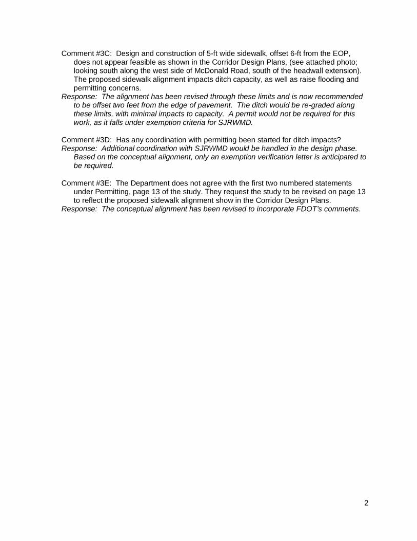
2
Comment #3C: Design and construction of 5-ft wide sidewalk, offset 6-ft from the EOP,does not appear feasible as shown in the Corridor Design Plans, (see attached photo;looking south along the west side of McDonald Road, south of the headwall extension).The proposed sidewalk alignment impacts ditch capacity, as well as raise flooding andpermitting concerns.
Response: The alignment has been revised through these limits and is now recommendedto be offset two feet from the edge of pavement. The ditch would be re-graded alongthese limits, with minimal impacts to capacity. A permit would not be required for thiswork, as it falls under exemption criteria for SJRWMD.
Comment #3D: Has any coordination with permitting been started for ditch impacts?Response: Additional coordination with SJRWMD would be handled in the design phase.
Based on the conceptual alignment, only an exemption verification letter is anticipated tobe required.
Comment #3E: The Department does not agree with the first two numbered statementsunder Permitting, page 13 of the study. They request the study to be revised on page 13to reflect the proposed sidewalk alignment show in the Corridor Design Plans.
Response: The conceptual alignment has been revised to incorporate FDOT’s comments.
APPENDIX
APPENDIX EFDOT Right of Way Acquisition Reference Material

RIGHT OF ENTRY AGREEMENT
Financial Project ID: 2402333 County Road: SR 434 County: SEMINOLE Parcel No.: 116 (Claire Beatrice Clegg) STATE OF Florida COUNTY OF Seminole
THIS AGREEMENT, made and entered into on the _____ day of _______________, 2009, by
and between
CLAIRE BEATRICE CLEGG
Hereinafter called the “owner” and the State of Florida Department of Transportation, herein after called the ‘DEPARTMENT”.
WITNESSETH: WHEREAS, the Department is conducting roadway improvements relative to the above referenced project; and NOW, THEREFORE, in consideration of the above stated premises, the Owner and the Department hereby agree that the Department and/or its duly authorized representative shall have the right to enter upon the Owner’s remaining lands for the purpose of performing demolition activities as noted below*. It is further understood and agreed that the Department and/or its duly authorized representative will restore the remaining lands to a safe and sanitary condition. *1. The contractor shall maintain access to 1311 Windsor Avenue during demolition in accordance with FDOT regulations. *2. The contractor shall contact the owner at 407/831-4053, prior to commencing any work on the owner’s property. *3. This right of entry is limited to demolishing the owner’s tennis court and accessory structures only (consisting of fencing, a light post, 10’clf, net/posts, water fountain, and concrete court itself) and re-seeding with grass. OWNER: DEPARTMENT: Claire Beatrice Clegg STATE OF FLORIDA DEPARTMENT OF TRANSPORATION By:____________________________ By:____________________________ Signature Date Signature Date _ _____________ _Dana Cole Wainwright____________ Name (Please print or type) Name (Please print or type)

575-030-12 RIGHT OF WAY - 06/99
NOTE: THIS FORM SHOULD BE PRINTED ON
OFFICIAL LETTERHEAD
Donation of Property to the County / or City
USE THIS AREA FOR TYPING NAME & ADDRESS
ITEM/SEGMENT NO.:
F.A.P. NO.:
COUNTY / CITY ROAD NO. or PROPERTY ADDRESS:
COUNTY/CITY:
PARCEL NO.:
INTEREST CONVEYED:
This is to advise that the undersigned, as owner of the property or property interest referenced above and as shown on Right of Way maps for referenced project, desires to make a voluntary donation of said property or property interest to the County / City for the use and benefit of the County / City. The undersigned hereby acknowledges that he/she has been fully advised by a City / County representative of his/her right to have the referenced property or property interest appraised, to accompany the appraiser during the appraisal inspection of the property, to receive full compensation for the above referenced property, and to receive reimbursement for reasonable fees and costs incurred, if any. Having been fully informed of the above rights, I hereby waive those rights unless otherwise noted below.
Owner's Signature
Type or Print Property Owner's Name
Street Address
City, State, Zip Code
Date

Local Agency Program Right of Way Acquisition Worksheet Quality Assurance Review
Agency: _____________________ Project No.:_______________ Parcel No.:________ Consultant/Agent:___________________ Project Description:__________________________________________________________________________________________ FDOT Item/Segment No.:____________ FAP No.:____________ Owner:_____________________________ IN Date:___________ QA Review by:________________ QA Review Date:_________
I. Property Owner Notification Yes No N/A Comments
1. Was Notice to Owner (FDOT Form No. 575-030-031(32) or equivalent) delivered at or before Negotiations? Date Delivered:. ____ .
2. Was the Notice sent to the owner’s last known address listed on the county ad valorem tax roll?
3. Was the Notice personally delivered or sent certified mail, return receipt requested? 4. Was ownership in the form of a representative capacity, i.e., corporation, partnership or
trust?
5. If answer to #4 is yes, was Public Disclosure Notice (FDOT Form No. 575-030-18 or equivalent), delivered to the owner?
II. Business Owner Notification Yes No N/A Comments
1. Are there any businesses located on this parcel? 2. If answer to #1 is yes, was Notice to Business Owner (FDOT Form No. 575-030-033(34)
or equivalent) delivered at or after I.N.? Date Delivered:___________________
3. Based on the Secretary of State, Division of Corporations, was the registered agent notified?
4. Was the business eligible for business damages?
5. Was a business damage claim paid?
III. Offer(s) Yes No N/A Comments
1. Was Offer and Purchase Agreement (FDOT Form No. 575-030-07 or equivalent) delivered directly to the Property Owner?
2. Did we obtain a written acknowledgement of the Property Owner’s receipt of the Offer? If property owner refused to sign, note in comment section.
3. Was the offer amount based on recommended compensation?
4. Was use of Appraisal Waiver properly executed? 5. If an uneconomic remnant was identified by the review appraiser, was an offer to
purchase the uneconomic remnant made?
IV. Good Faith Negotiations Yes No N/A Comments
1. Were good faith negotiations carried out with representative after Representative Authorization (FDOT Form No. 575-030-02 or equivalent) was received? If property owner was not represented, write “N/A” in the comment section.
2. Did property owner request copies of appraisal, maps or plans?
3. If answer to #2 is yes, were copies provided within 15 days of owner’s request?
4. Were good faith negotiations conducted with current appraisal values? 5. If real property was donated, was the owner informed of his/her right to have an
appraisal performed and a right to compensation?
6. Did the Agency provide any construction or regulatory elements in lieu of compensation that exceeded the value of the real estate?
V. Suit Yes No N/A Comments
1. Did 30 days pass after offer was made before suit was filed?
2. If applicable, was notice to business owner delivered prior to filing of suit? 3. Was the Public Disclosure Affidavit returned within 48 hours after OT deposit was made
for ownerships in the form of a representative capacity such as a corporation, partnership or trust?
VI. Agreement Yes No N/A Comments
1. Was an Agreement reached?
2. Was Agreement inclusive of Fees & Costs?
3. Was Agreement reviewed by Legal?
4. Was Final Agency Acceptance granted at least 30 days after agreement was signed by both parties? FAA Date. .
VII. Closing Yes No N/A Comments 1. Was Closing Statement (FDOT Form No. 575-030-16 or equivalent) prepared? Date
of Closing. .
2. Did the closing take place within 60 days after Final Agency Acceptance?
3. Were documents accurate and properly executed?
4. Were all closing documents recorded no later than 48 hours after closing? 5. Was the Public Disclosure Affidavit returned at least 10 days prior to closing for
ownerships in the form of a representative capacity, such as a corporation, partnership or trust?
VIII. Settlements Yes No N/A Comments
1. Was Settlement Approval (FDOT Form No. 575-030-24 or equivalent) approved by the proper authority?
2. Was the settlement a justifiable expenditure based on settlement criteria?
IX. Fees and Costs Yes No N/A Comments
1. Were fees and costs based on an invoice or statutory formula? Method Used: ____________________
2. Were fees and costs identified on the Purchase Agreement/Supplemental Agreement?
X. 1099S Yes No N/A Comments
1. Was Request for Taxpayer ID (FDOT Form No. 575-030-27 or equivalent) delivered to non-excluded property owners? (Excluded = de minimis transactions and exempt transferors)
2. Was Form 1099S delivered to the property owner at closing or before December 31 of the calendar year in which the closing was held?.1099S Delivery Date: .
XI. LAP Certification Yes No N/A Comments 1. Was the Right of Way Certification (FDOT Form No. 575-095-05 or equivalent)
executed, accurate, and submitted to the Right of Way Office prior to letting? Date Certified :________________________
Additional Comments: