FINAL FISH AND WILDLIFE COORDINATION ACT REPORT · hurricane protection -houma navigation canal...
48
Appendix E FINAL FISH AND WILDLIFE COORDINATION ACT REPORT
Transcript of FINAL FISH AND WILDLIFE COORDINATION ACT REPORT · hurricane protection -houma navigation canal...
Appendix E
FINAL FISH AND WILDLIFE COORDINATION ACT REPORT

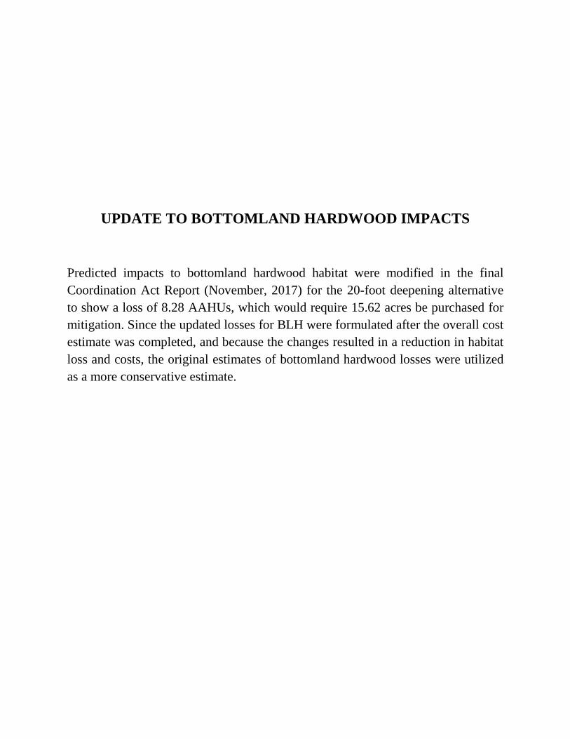
UPDATE TO BOTTOMLAND HARDWOOD IMPACTS
Predicted impacts to bottomland hardwood habitat were modified in the final Coordination Act Report (November, 2017) for the 20-foot deepening alternative to show a loss of 8.28 AAHUs, which would require 15.62 acres be purchased for mitigation. Since the updated losses for BLH were formulated after the overall cost estimate was completed, and because the changes resulted in a reduction in habitat loss and costs, the original estimates of bottomland hardwood losses were utilized as a more conservative estimate.
MISSISSIPPI RIVER & TRIBUTARIESMORGANZA, LOUISIANA, TO THE GULF OF MEXICO HURRICANE PROTECTION - HOUMA NAVIGATION
CANAL DEEPENING GENERAL RE-EVALUATION
FISH AND WILDLIFE COORDINATION ACT REPORT
PROVIDED TO
NEW ORLEANS DISTRICT
U.S. ARMY CORPS OF ENGINEERS
NEW ORLEANS, LOUISIANA
PREPARED BY
RONNY PAILLE FISH AND WILDLIFE BIOLOGIST
U.S. FISH AND WILDLIFE SERVICE
ECOLOGICAL SERVICES
LAFAYETTE, LOUISIANA
November 2017
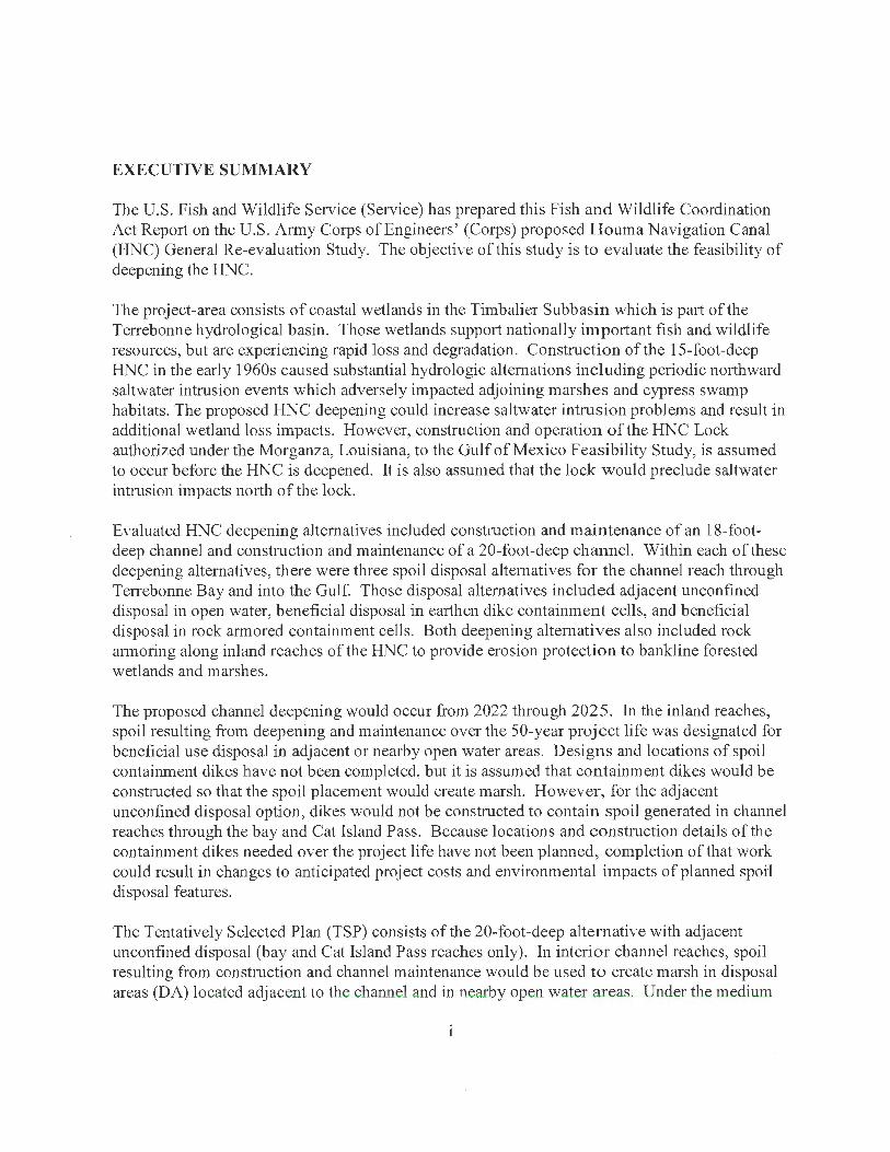
EXECUTIVE SUMMARY
The U.S. Fish and Wildlife Service (Service) has prepared this Fish and Wildlife Coordination Act Rep01i on the U.S. Army Corps of Engineers' (Corps) proposed Houma Navigation Canal (HNC) General Re-evaluation Study. The objecti\·e of this study is to evaluate the feasibility of deepening the HNC.
The project-area consists of coastal wetlands in the Timbalier Sub basin which is part of the Terrebonne hydrological basin. Those wetlands support nationally important fish and wildlife resources, but are experiencing rapid loss and degradation. Construction of the 15-foot-deep HNC in the early 1960s caused substantial hydrologic alternations including periodic northward saltwater intrusion events which adversely impacted adjoining marshes and cypress swamp habitats. The proposed HNC deepening could increase saltwater intrusion problems and result in additional wetland loss impacts. However, construction and operation of the HNC Lock authorized under the Morganza, Louisiana, to the Gulf of Mexico Feasibility Study, is assumed to occur before the HNC is deepened. It is also assumed that the lock would preclude saltwater intrusion impacts north of the lock.
Evaluated HNC deepening alternatives included construction and maintenance of an 18-footdeep channel and construction and maintenance of a 20-foot-deep channel. Within each of these deepening alternatives, there were three spoil disposal alternatives for the channel reach through Terrebonne Bay and into the Gulf. Those disposal alternatives included adjacent unconfined disposal in open water, beneficial disposal in earthen dike containment cells, and beneficial disposal in rock armored containment cells. Both deepening alternatives also included rock armoring along inland reaches of the HNC to provide erosion protection to bankline forested wetlands and marshes.
The proposed channel deepening would occur from 2022 through 2025. In the inland reaches, spoil resulting from deepening and maintenance over the 50-year project life was designated for beneficial use disposal in adjacent or nearby open water areas. Designs and locations of spoil containment dikes have not been completed, but it is assumed that containment dikes would be constructed so that the spoil placement would create marsh. However, for the adjacent unconfined disposal option, dikes would not be constructed to contain spoil generated in channel reaches through the bay and Cat Island Pass. Because locations and construction details of the containment dikes needed over the project life have not been planned, completion of that work could result in changes to anticipated project costs and environmental impacts of planned spoil disposal features.
The Tentatively Selected Plan (TSP) consists of the 20-foot-deep alternative with adjacent unconfined disposal (bay and Cat Island Pass reaches only). In interior channel reaches, spoil resulting from construction and channel maintenance would be used to create marsh in disposal areas (DA) located adjacent to the channel and in nearby open water areas. Under the medium
sea level rise (SLR) scenario, the TSP would result in the creation of an additional 126 acres of fresh/intermediate marsh, 164 acres of brackish marsh, and 278 acres of saline marsh, compared to that under future without deepening. Because of spoil disposal in existing bottomland hardwood forest (DA 3 ), the TSP would result in the loss of 40 acres of bottomland hardwood forest.
Based on a Corps of Engineers analysis, the deeper channel alternatives would result in increased vessel traffic and a 5% increase in bank erosion rates. However, the TSP would include 14. 7 miles of rock armor along the inland reaches to counter that increased erosion. Because most of the proposed bank armoring would be located in brackish and saline marsh zones south of the HNC lock, over the project life, the armoring will save 63 and 161 acres respectively, compared to that lost without the project. However, deepening related increased erosion would result in an additional loss of 6 acres ofbottomland hardwood forest, 2 acres of cypress swamp, and 2 acres of fresh/intermediate marsh, over the project life.
The TSP would produce 39.3 Average Annual Habitat Units (AAHUs) for fresh-intermediate marsh, 103.0 AAHUs for brackish marsh, 756.7 AAHUs for saline marsh, -8.28 AAHUs for bottomland hardwoods, and -0.72 AAHUs for cypress swamp. Because Louisiana' s coastal wetlands are converting to open water habitat at a rate of 24 mi2 per year, open water habitat is becoming more abundant over time. Therefore, mitigation for project-related open-water habitat losses will not be sought.
Implementation of the TSP would result in net increases in intermediate, brackish, and saline marsh habitat. In support of comprehensive State and Federal efforts to conserve Louisiana's nationally significant coastal wetlands, avoidance and minimization of direct wetland impacts should be pursued to the greatest extent practicable, regardless of whether or not the project would produce net environmental benefits (expressed in AAHUs). Minimization of direct and indirect project-related impacts would also help to ensure that the proposed project is consistent with the purposes of the restoration plan as required by Section 303 (d) of CWPPRA. In 1998, the Louisiana Coastal Wetlands Conservation and Restoration Task Force updated and revised that plan which is now entitled the Coast 2050 Plan (Louisiana Coastal Wetlands Conservation and Restoration Task Force 1998). More recently, the state released a document that is entitled "Louisiana's Comprehensive Master Plan for a Sustainable Coast". These documents lay out many of the problems and solutions related to the Louisiana coastal environments.
Because of the complexity and scope of this proposed project and its relationship to coastal ecosystem restoration and other proposed deep-draft navigation projects, extensive coordination between the Corps and the Service will be required throughout the post-authorization and detailed design phases to ensure that opportunities to protect and restore coastal wetlands and their associated fish and wildlife resource values are fully addressed. This report incorporates comments provided by the National Marine Fisheries Service (NMFS) on the Service's Draft Fish and Wildlife Coordination Act Report, dated December 2015 (Appendix A). The Louisiana Department of Wildlife and Fisheries did not provide comments on the Draft Report.
11
The Sef\'ice would not object to fi.niher detailed planning and implementation of the TSP, provided that the project incorporates the following measures to avoid unnecessary impacts to fish and wildlife resources, to achieve the anticipated wetland creation benefits, and to mitigate for unavoidable project-related wetland impacts:
1. Surveys should be conducted to document active, but undocumented, wading bird rookeries, colonial nesting birds, and bald eagle nests within the project area. If active nests are found, consultation with the Service should be initiated to ensure that project activities do not impact any colonial nesting bird colonies, threatened or endangered species, or their critical habitat.
2. Detailed planning and design of project features during the pre-construction engineering and design phase should be conducted in consultation with the Service, the National Marine Fisheries Service (NMFS), the Louisiana Department of Natural Resources (DNR), and the Louisiana Department of Wildlife and Fisheries (LDWF) to avoid unnecessary wetland impacts and to achieve the anticipated wetland creation benefits. Those planning and design features include containment dike locations, spill box locations, slurry target elevation, target marsh elevation, and settlement curves and/or estimates.
3. The Service supports the proposed rock armoring erosion protection features; however, such protection should be installed on remaining unprotected wetland bank lines to avoid deepening related increased wake erosion of wetlands. The inclusion of dike gaps to maintain tidal exchange should be determined in coordination with the natural resource agencies identified in recommendation # 2 above.
4. Disposal area containment dikes should be gapped within one to three years after fill is placed in disposal areas to restore tidal influence and fisheries access. The location and design of containment dike gaps should be determined in coordination with the natural resource agencies identified in recommendation # 2 above.
5. Project sponsors should mitigate for unavoidable project impacts to swamp and bottomland hardwood forest (0.72 and 8.28 AAHUs, respectively). If the sponsors use the Bayou Grand Coteau Mitigation Bank, compensatory mitigation would be achieved through the purchase of 2.06 acres or credits of swamp, and 15.92 acres or credits of bottomland hardwood forest.
6. To minimize deepening related saltwater intrusion impacts, the proposed HNC deepening should not be conducted until the HNC lock has been constructed and is functioning.
7. Contaminants screening of material to be dredged from the upper reaches of the HNC and from the HNC at the junction with Bayou Grand Caillou should be conducted to verify
lll

that there would be no contaminants related impacts when that spoil is placed in adjoining wetlands. If the material is contaminated, then appropriate measures should be taken to avoid potential exposure of the aquatic ecosystem to their harmful effects.
IV
Table of Contents EXECUTIVE SUMMARY ............................................................................................................. i INTRODUCTION .......................................................................................................................... 1 DESCRIPTION OF PROJECT AREA ........................................................................................... 1 EXISTING FISH AND WILDLIFE RESOURCES ....................................................................... 2
Description of Habitats ............................................................................................................... 2 Forested Wetlands .................................................................................................................. 2 Scrub-Shrub ............................................................................................................................ 3 Fresh Marsh ............................................................................................................................ 3 lnterniediate Marsh ......................................................... ... ..................................................... 3 Brackish Marsh ....................................................................................................................... 3 Saline Marsh ........................................................................................................................... 4 Ponds and Lakes ..................................................................................................................... 4 Canals and Bayous ................................................................................................................. 4 Developed Areas ................... ... ..................................... .......................................... .... ............ 4
Fishery Resources ......................................................................................................... .............. 4 Essential Fish Habitat ................................................................................................................. 5 Wildlife Resources ...................................................................................................................... 5 Migratory Birds ......................... .... .............................................................................................. 7 Threatened and Endangered Species .................................... ...... ................................................ 9 Refuges and Wildlife Management Areas ................................................................................ 13
FUTURE WITHOUT-PROJECT FISH AND WILDLIFE RESOURCES .................................. 13 DESCRIPTION OF ALTERNATIVES AND TENTATIVELY SELECTED PLAN ................. 13
Alternatives .................................................................................................................. .... ......... 13 Tentatively Selected Plan ................................................................................. ... ... ................... 14
Figure 1. Map delineating the locations of northern disposal areas ............................................ 16 Figure 2. Map delineating the locations of southern disposal areas ............................................ 17 Figure 3. Map delineating the locations of proposed bank armoring .......................................... 18 FISH AND WILDLIFE CONCERNS IN THE PROJECT AREA .............................................. 19 EVALUATION METHODOLOGY ............................................................................................ 20 PROJECT IMP ACTS ................................................................................................................... 23 EVALUATION OF TENTATIVELY SELECTED PLAN ......................................................... 25 FISH AND WILDLIFE CONSERVATION MEASURES .......................................................... 26 SERVICE POSITION AND RECOMMENDATIONS .............................................. .. ............... 28 LITERATURE CITED ................................................................................................................. 3 0 APPENDIX A ....................................................................... .... ..................................... ........ .. A - 1 APPENDIX B ...................... . ...................................................................... B - 1
v
LIST OF FIGURES
Figure 1. Map delineating the locations of northern disposal areas ........ ................................. 16 Figure 2. Map delineating the locations of southern disposal areas ... .... .................................. .1 7 Figure 3. Map delineating the locations of proposed bank armoring ....... ... ......... ..................... 18
Table 1. Table 2. Table 3.
Table 4.
Table 5. Table 6.
LIST OF TABLES
Marsh type acreage changes in the Timbalier Sub basin ................... ..... .... .... ..... .. ... .. 19 Total marsh creation acreages by disposal area, alternative, and habitat type .......... 24 Wetland erosion losses along the HNC by alternative and habitat type, over
the 50-year project life ................ .. ....... .. ..... .... .............. ...... .. ...... ... .... ..... .. ... .... ..... 25 Summary of all environmental benefits by SLR scenario, alternative, and
habitat type ............................ .. ... ... ... .. ...... ..... ... .... .......................... ....... ..... ....... ... . 26 TSP related net wetland acres by habitat type .. ..... .. ..... ...................... .. ............ ... ...... 26 U.S. Fish and Wildlife Service resource categories ............................ ....... ........ ...... .. 27
Vl

Vll
INTRODUCTION
The Houma Navigation Canal (HNC) General Re-evaluation Study is being conducted in response to requests from the Te1rebonne P01i Commission as part of the Mississippi River and Tributaries - Morganza, Louisiana, to the Gulf of Mexico Feasibility Study. That study authorization was modified by the Energy and Water Development Appropriations Act of 1995, which directed the U.S. Army Corps of Engineers (Corps) to give particular attention to the intelTelationships of the various ongoing studies in the area, and to consider improvements for the HNC. That Act also authorized the Corps to address" .. . wetland conservation and restoration, wildlife habitat, commercial and recreational fishing, saltwater intrusion, and fresh water and sediment diversion . . . " in the project area. In addition to the No-action alternative (maintenance of the existing 15-foot-deep channel), two channel deepening alternatives were evaluated. Post-authorization detailed engineering and design work could result in changes to the design, cost, and environmental impacts of project features ultimately scheduled for implementation.
The analysis of project related benefits and impacts was conducted by the U.S. Fish and Wildlife Service (Service). Where engineering details were unavailable, assumptions were based on a worst-case scenario. This report fulfills the requirements of the Fish and Wildlife Coordination Act (48 Stat. 401 , as amended; 16 U.S.C. 661 et seq.), and constitutes the rep01i of the Secretary of the Interior required by Section 2(b) of that Act. This report incorporates comments provided by the National Marine Fisheries Service (NMFS) (Appendix A). The Louisiana Department of Wildlife and Fisheries (LDWF) did not provide comments or recommendations for inclusion in this Final Coordination Act Report.
DESCRIPTION OF PROJECT AREA
The HNC is a Federally maintained waterway which begins at the Gulflntracoastal Waterway (GIWW) in Houma, Louisiana, and ends approximately 41 miles south of Houma terminating at the -15-foot depth contour in the Gulf of Mexico (i.e., Cat Island Pass). Construction of the HNC began in 1958 and it was officially opened to navigation in June 1962. Over 20 dredged material disposal areas (DA) are adjacent to channel throughout its inland reach.
The proposed channel deepening project (Figure 1) would be located entirely within TeITebonne Parish, Louisiana. It would extend approximately 41 channel miles from the P01i of Houma, southward into the Gulf of Mexico to the -20-foot depth contour (i.e., approximately 0.3 to 0.4 miles south of the cmrently maintained waterway). The project area includes the wetlands and open waters on either side of the HNC, as well as p01iions of the communities of Houma, Theriot, Dulac, and Cocodrie.
The HNC was dredged through interdistributary basin wetlands located between Bayou du Large to the west and Bayous Grand Caillou and Petit Caillou on the east. The northern portion of that
1
inter-distributary basin supports an extensive cypress swamp zone. South of the living swamps, dead swamps and low-salinity intennediate marshes grade into brackish and saline marshes. The hydrology of this basin is strongly influenced by the HNC and the Atchafalaya River. During high Atchafalaya River stage, river water flows east through the Gulf Intracoastal Waterv.:ay (GIWW), and then southward down the HNC to the Gulf of Mexico. Under these conditions, the HNC and some of the surrounding wetlands are seasonally freshened. Freshwater from the HNC also flows southward down lower Bayou Grand Caillou, which freshens adjacent marshes along that bayou.
During periods of low Atchafalaya river stages, especially during the fall , brackish and saline conditions prevail throughout much of the marshes within the project area. High-salinity waters adversely affect the cypress swamps and adjacent low-salinity marshes located in the middle and northern reaches of the HNC. These adverse effects may be attributed to several factors including the fact that the HNC is a highly efficient conveyance channel, which allows saline water to encroach northward. Saltwater intrusion is also accelerated by numerous oil and gasrelated access canals as well as continual erosion and eventual breaching of the HNC spoil banks by wakes from large vessels which allows saltwater to enter adjacent marshes, and subjects those fragile lands to more direct wake- and storm-related erosion. Erosion rates along the HNC are estimated by the Corps to range up to 10 feet per year.
The remaining wetlands fringing Terrebonne Bay help to impede the northward intrusion of saltwater, but continued erosion of those wetlands, with or without the project, would also exacerbate saltwater intrusion. Although coastal land loss rates during the 1980s and 1990s have decreased compared to peak loss rates of the 1970s, altered hydrology, subsidence, and wind and wave erosion continue to be major factors in the continued loss of project-area marshes (Louisiana Coastal Wetlands Conservation and Restoration Task Force l 993b ).
EXISTING FISH AND WILDLIFE RESOURCES
The complex interplay of natural processes (e.g., storms, subsidence, deltaic formation) and human activities (e.g., navigation, flood control projects, commercial and residential development, and coastal restoration) has profoundly influenced existing project-area fish and wildlife resources. Overall, however, the study-area still supports a rich diversity of nationally significant fish and wildlife resources.
Description of Habitats
Forested Wetlands Forested wetlands in the project area consist ofbottomland hardwood forests and cypress swamps. Bottomland hardwood forests found in coastal portions of the project area occur primarily on the natural and manmade levees along distributary channels and dredge DAs. Dominant vegetation in those areas generally includes sugarberry, water oak, live oak, bitter pecan, black willow, American elm, Drummond red maple, Chinese tallow-tree, boxelder, green ash, baldcypress, and elderberry. Cypress swamps are located along the flanks of larger
2
distributary ridges as a transition zone between bottomland hardwoods and lower-elevation marsh or scrub-shrub habitats. Cypress swamps generally exist where there is little or no salinity and minimal daily tidal action.
Most of the project-area wetlands located along the northern reaches of the HNC consist of cypress swamps in which many of the cypress trees are either dead or dying. Those trees are being stressed by several environmental influences, including subsidence and saltwater intrusion compounded by the construction of HNC spoil banks and associated unintentional impoundment of water.
Scrub-Shrub Scrub-shrub habitat is often found along the flanks of distributary ridges and is typically bordered by marsh at lower elevations and by developed areas, cypress-tupelo swamp, or bottomland hardwoods at higher elevations. Typical scrub-shrub vegetation includes elderberry, wax myrtle, buttonbush, black willow, Drummond red maple, Chinese tallow-tree, and eastern baccharis.
Fresh Marsh Fresh marshes occur at the upper ends of inter-distributary basins. They are generally subject to minimal daily tidal action and are often characterized by floating or semi-floating organic soils. Characteristic vegetation may include maidencane, bulltongue, cattail, California bulrush, pennywort, giant cutgrass, American cupscale, spikerushes, bacopa, and alligatonveed. Associated open-water habitats may often support extensive beds of floating-leafed and submerged aquatic vegetation, including water hyacinth, Salvinia, duckweeds, American lotus, white water lily, water lettuce, coontail, Eurasian milfoil, hydrilla, pondweeds, naiads, fanwort, wild celery, water stargrass, elodea, and others.
Intermediate Marsh Intermediate marshes are a transitional zone between fresh and brackish marshes, and are often characterized by organic, semi-floating soils. Typically, intermediate marshes experience low levels of daily tidal action. Salinities are negligible or low throughout much of the year, and generally peak during late summer and fall. Representative vegetation includes saltmeadow cordgrass, deer pea, three-cornered grass, cattail, bulltongue, seashore paspalum, wild millet, fall panicum, and bacopa. Ponds and lakes within the intermediate marsh zone often support extensive beds of submerged aquatic vegetation that include southern naiad, Eurasian milfoiL and wigeongrass.
Brackish Jvfarsh Brackish marshes are characterized by low-to-moderate daily tidal energy, and by substrates ranging from firm mineral soils to organic semi-floating soils. Freshwater conditions may prevail for several months during early spring; however, low to moderate salinities occur during much of the year, with peak salinities in the late summer or fall. Vegetation is usually dominated by saltmeadow cordgrass, but also includes saltgrass, three-cornered grass, leafy three-square, and deer pea. Shallow brackish marsh ponds occasionally support abundant beds of wigeon grass.
3
Saline Marsh Saline marshes occur along the southern fringe of the project-area coastal wetlands. Those marshes usually exhibit fairly firm mineral soils and experience moderate to high daily tidal energy. Vegetation is dominated by saltmarsh cordgrass, but may also include saltgrass, saltmeadow cordgrass, black needlerush, and leafy three-square. Although submerged aquatic vegetation is rare, intertidal mud flats and oyster reefs are relatively common in project-area saline marshes.
Ponds and Lakes Natural marsh ponds and lakes are typically shallow, ranging in depth from 6 inches to over 2 feet. Typically, the smaller ponds are shallow and the larger lakes are deeper. In fresh and lowsalinity areas, ponds and lakes may support varying amounts of submerged and/or floatingleaved aquatic vegetation. Brackish and, much less frequently, saline marsh ponds and lakes may support beds of wigeongrass.
Canals and Bayous Canals and larger bayous typically range in depth from 4 or 5 feet, to more than 15 feet. Strong tidal flows may occur at times through those waterways, especially where they provide hydrologic connections to other large waterbodies. Such canals and bayous may have mud or clay bottoms that range from soft to firm. Dead-end canals and small bayous are typically shallow and their bottoms may be filled to varying degrees with semi-fluid organic material. Erosion, due to wave action and boat wakes, together with shading from overhanging woody vegetation, may retard the amount of intertidal marsh vegetation growing along the edges of those waterways.
Developed Areas Most developed areas are located on higher elevations of former distributary channel banks, and are typically well-drained. They include agricultural lands, and commercial and residential developments.
Fishery Resources Fresh-water and low-salinity wetlands throughout the upper portion of project area abound with small resident fishes and shellfishes, such as least killifish, rainwater killifish, sheepshead minnow, mosquitofish, sailfin molly, grass shrimp, and others. Those species are typically found along marsh edges or among submerged aquatic vegetation, and provide forage for a variety of fish and wildlife. Such wetlands provide habitat for recreationally and commercially important resident freshwater fishes such as largemouth bass, yellow bass, black crappie, bluegill , redear sunfish, warmouth, blue catfish, channel catfish, buffalo, freshwater drum, bowfin, and gar. Freshwater fishes may also utilize low-salinity areas (intermediate marsh zone), provided they have access to fresher areas during periods of high salinity.
Intermediate, brackish, and saline coastal marshes provide nursery habitat for many estuarinedependent recreational and commercial fishes and shellfishes. Because of the protection and abundant food afforded by those wetlands, they are essential to the growth and production of recreationally or commercially important species such as blue crab, white shrimp, brown shrimp, Gulf menhaden, Atlantic croaker, red drum, spotted seatrout, black drum, sand seatrout, spot,
4
southern flounder, striped mullet, and others. Those species are generally most abundant in the brackish and saline marshes; however, blue crab, Gulf menhaden, Atlantic croaker, and several other species also utilize fresh and low-salinity marshes as nursery habitat.
Because tidal marshes provide essential nursery habitat, commercial shrimp harvests are positively correlated with the area of tidal emergent wetlands, rather than the area of open-water (Turner 1977 and 1982). Future commercial harvests of shrimp and other fishes and shellfishes could be adversely impacted by the high rates of marsh loss throughout the project area (Turner 1982). The American oyster occurs throughout much of the brackish and saline marsh zones within the project area. Oyster harvesting constitutes a valuable fishery in the middle portions of that zone, where salinities range from 10 to 15 parts per thousand (ppt).
Essential Fish Habitat Estuarine wetlands and associated shallow waters within the project area have been identified as Essential Fish Habitat (EFH) for both postlarval, juvenile and sub-adult stages of brown shrimp, white shrimp, and red drum, as well as the adult stages of those species in the nearshore and offshore reaches. EFH in the nearshore, marine-portion of the project area and in the lower portions of the estuary has also been designated for the following species and their associated life stages: lane snapper, larvae and juvenile life stages; dog snapper, juvenile life stage; and bonnethead shark, juvenile life stage. EFH requirements vary depending upon species and life stage. Categories of EFH in the project area include estuarine emergent wetlands, estuarine water column, submerged aquatic vegetation, and estuarine water bottoms.
In addition to being designated as EFH for the above species and life stages, wetlands and water bottoms in the project area provide nursery and foraging habitats supportive of a variety of forage species that serve as prey for other fish species managed under the Magnuson-Stevens Act by the GMFMC (e.g., mackerels, snappers, and groupers) and highly migratory species managed by the NMFS (e.g., billfishes and sharks). Some prey species include striped mullet, white mullet, Atlantic croaker, sand seatrout, silver perch, pinfish, spot, anchovies, silYersides, and killifish, as well as various shellfish species and benthic organisms. These wetlands also produce nutrients and detritus, important components of the aquatic food web, which contribute to the overall productivity of study area estuary.
Wildlife Resources Forested wetlands and scrub-shrub areas provide important habitat for songbirds such as the mockingbird, yellow-billed cuckoo, northern parula, yellow-rumped warbler, prothonotary warbler, white-eyed vireo, Carolina chickadee, and tufted titmouse. Additionally. these areas also provide important resting and feeding habitat for neotropical songbirds that migrate across the Gulf of Mexico. Other avian species found in forested wetlands include the American woodcock, common flicker, brown thrasher, white-eyed vireo, belted kingfisher, pileated woodpecker, red-headed woodpecker, downy woodpecker, common grackle, and common crow.
Forested wetland habitats and associated waterbodies also support raptors such as the bald eagle, red-tailed hawk, red-shouldered hawk, Mississippi kite, northern harrier, screech owl, great homed owl, and barred owl. Wading bird colonies (many of which are migrants) typically occur
5
in cypress swamp and scrub-shrub habitats. Species found in those nesting colonies include great egret, white ibis, black-crowned night heron, tri-colored heron, little blue heron, snowy egret, white-faced ibis, an<l glossy ibises. Residential and migratory waterfowl species that utilize forested wetlands and adjacent waterbodies in the project area include, but are not limited to, wood duck, mallard, green-winged teal, gadwall, and hooded merganser.
Game mammals associated with forested wetlands include eastern cottontail, swamp rabbit, gray and fox squirrels, and white-tailed deer. Commercially important furbearers include river otter, muskrat, nutria, mink, and raccoon. Other mammals found in forested wetlands include striped skunk, coyote, Virginia opossum, bobcat, armadillo, gray fox , and red bat. Smaller mammal species serve as forage for both mammalian and avian carnivores and include the cotton rat, marsh rice rat, white-footed mouse, eastern wood rat, harvest mouse, least shrew, and southern flying squirrel.
Reptiles which utilize project-area bottomland hardwoods, cypress swamps, and associated shallow water habitats include the American alligator, ground skink, five-lined skink, broadheaded skink, green anole, Gulf coast ribbon snake, yellow-bellied water snake, speckled kingsnake, southern copperhead, western cottonmouth, pygmy rattlesnake, broad-banded water snake, diamond-backed water snake, spiny softshell turtle, red-eared turtle, southern painted turtle, Mississippi mud turtle, stinkpot, common and alligator snapping turtle, in addition to numerous other species.
Amphibians utilizing project-area forested wetlands include dwarf salamander, three-toed amphiuma, lesser western siren, central newt, Gulf coast toad, eastern narrow-mouthed toad, green treefrog, squirrel treefrog, pigfrog, bullfrog, southern leopard frog, bronze frog, upland chorus frog, southern cricket frog, and spring peeper.
Most developed areas provide low-quality wildlife habitat. Sites deYeloped for agricultural purposes are located on low ridges and on lower eleyation areas that have improved drainage. In agricultural areas, wildlife habitat is primarily provided by unmaintained ditch banks and field edges, fallow fields, pasture lands, and rainfall-flooded fields. Game species that utilize agricultural lands include the white-tailed deer, mourning dove, bobwhite quail, eastern cottontail, and common snipe. Seasonally flooded cropland and fallow fields may pro\ ide important feeding habitat for wintering waterfowl, wading birds, and other waterbirds.
Marshes and associated shallow, open-water areas provide habitat for a number ofresident and migratory wading birds, shorebirds, seabirds, and other nongame birds. Common wading birds include the little blue heron, great blue heron, green-backed heron, yellow-crowned night heron, black-crowned night heron, great egret, snowy egret, cattle egret, white-faced ibis, white ibis, and roseate spoonbill. Shorebirds include the piping plover, killdeer, American avocet, blacknecked stilt, common snipe, and various species of sandpipers. Seabirds include white pelican, brown pelican, black skimmer, herring gull, laughing gull, and several species of terns. One nesting bird colony is known to occur in the project area according to recent nesting bird survey (U.S. Geological Survey 2003). Other non-game birds, such as boat-tailed grackle, red-winged
6
blackbird, seaside sparrow, northern harrier, belted kingfisher, and sedge wren, also utilize coastal areas.
Common mammals in the coastal marshes include nutria, muskrat, mink, river otter, raccoon, swamp rabbit, white-tailed deer, and coyote. Reptiles are also found in fresh and low-salinity coastal wetlands. Common species include the American alligator, western cottonmouth, water snakes, mud snake, speckled kingsnake, ribbon snakes, rat snakes, red-eared turtle, common snapping turtle, alligator snapping turtle, mud turtles, and softshell turtles. Amphibians commonly found in the area include the bullfrog, pig frog, bronze frog, leopard frog, cricket frogs, tree frogs, chorus frogs, three-toed amphiuma, sirens, and several species of toads. In brackish and saline marshes, reptiles are limited primarily to the American alligator and the diamond-backed terrapin, respectively.
Migratory Birds As noted above, numerous species of migratory game and non-game birds utilize project-area habitats. Project-area fresh and intermediate marshes provide excellent wintering habitat for migratory waterfowl, especially puddle ducks. For this reason, the North American Waterfowl Management Plan' s Gulf Coast Joint Venture has recognized the Terrebonne Unit (which includes the fresh and intermediate marshes comprising the project area) as a key waterfowl wintering area. Brackish marshes with abundant submerged aquatic vegetation also support large numbers of puddle ducks, and the resident mottled duck inhabits project-area coastal marshes. Other migratory game birds found in coastal marshes include the king rail, clapper rail, Virginia rail, sora, American coot, common moorhen, and common snipe. Migratory non-game birds that utilize the project-area habitats include bald eagle, great crested flycatcher, prothonotary warbler, swamp spaiTow, American bittern, and willet. Several of the above species can also be found on the Service's 2008 Birds of Conservation Concern list along with the peregrine falcon, least bittern, little blue heron, American oyster catcher, black skimmer, least tern, blackrail, and yellow rail (U.S. Fish and Wildlife Service 2008).
Bald Eagle Breeding bald eagles occupy "territories" that they will typically defend against intrusion by other eagles, and that they likely return to each year. A territory may include one or more alternate nests that are built and maintained by the eagles, but which may not be used for nesting in a given year. Potential nest trees within a nesting territory may, therefore, provide important alternative bald eagle nest sites. In forested areas, bald eagles often select the tallest trees with limbs strong enough to support a nest that may weigh more than 1,000 pounds. Most nests are located in the upper 30 feet of the tree; the cone-shaped nest may be 6 to 8 feet in diameter and 6 to 8 feet from top to bottom. Nest sites typically include at least one perch with a clear view of the water or area where the eagles usually forage. Shoreline trees or snags located near large waterbodies provide the visibility and accessibility needed to locate aquatic prey. Bald eagles are vulnerable to disturbance during courtship, nest building, egg laying, incubation, and brooding. Disturbance during thi s critical period may lead to nest abandonment, cracked and chilled eggs, and exposure of small young to the elements. Human activity near a nest late in the
7
nesting cycle may also cause flightless birds to jump from the nest tree, thus reducing their chance of survival.
Although the bald eagle has been remoYed from the List of Endangered and Threatened Species, it continues to be protected under the MBTA and the BGEPA. The Service developed the National Bald Eagle Management (NBEM) Guidelines to provide landowners, land managers, and others with information and recommendations to minimize potential project impacts to bald eagles , particularly where such impacts may constitute "disturbance,' ' which is prohibited by the BGEPA. A copy of the NBEM Guidelines is available at: http://www.fws.gov /southeast/es/baldeagle/NationalBaldEagleManagementGuidelines.pdf. Those guidelines recommend: (1) maintaining a specified distance between the activity and the nest (buffer area); (2) maintaining natural areas (preferably forested) between the acti\·ity and nest trees (landscape buffers); and (3) avoiding certain activities during the breeding season. Onsite personnel should be informed of the possible presence of nesting bald eagles within the project boundary, and should identify, avoid, and immediately report any such nests to this office. If a bald eagle nest is discovered within or adjacent to the proposed project area, then an evaluation must be performed to detem1ine whether the project is likely to disturb nesting bald eagles. That evaluation may be conducted on-line at: http://www.fws.gov/southeast/es/baldeagle. Following completion of the evaluation, that website will provide a determination of whether additional consultation is necessary. The Division of Migratory Birds for the Southeast Region of the Service (phone: 404/679-7051 , email: [email protected]) has the lead role in conducting such consultations. Should you need further assistance interpreting the guidelines or performing an on-line project evaluation, please contact this office.
Colonial Nesting Birds The proposed project would be located in an area where colonial nesting waterbirds may be present. Colonies may be present that are not currently listed in the database maintained by the Louisiana Department of Wildlife and Fisheries. That database is updated primarily by monitoring the colony sites that were previously surveyed during the 1980s. Until a new, comprehensive coast-wide survey is conducted to determine the location of newly-established nesting colonies, we recommend that a qualified biologist inspect the proposed work site for the presence of undocumented nesting colonies during the nesting season. To minimize disturbance to colonial nesting birds, the following restrictions on activity should be observed:
1. For colonies containing nesting brown pelicans, all activity occurring within 2,000 feet of a rookery should be restricted to the non-nesting pe1iod (i.e. , September 15 through March 31 ). Nesting periods vary considerably among Louisiana' s brown pelican colonies, however, so it is possible that this activity window could be altered based upon the dynamics of the individual colony. The Louisiana Department of Wildlife and Fisheries' Fur and Refuge Division should be contacted to obtain the most current information about the nesting chronology of individual brown pelican colonies. Brown pelicans are known to nest on banier islands and other coastal islands in St. Bernard,
8
Plaquemines, Jefferson, Lafourche, and Terrebonne Parishes, and on Rabbit Island in lower Calcasieu Lake, in Cameron Parish.
2. For colonies containing nesting wading birds (i.e., herons, egrets, night-herons, ibis, and roseate spoonbills), anhingas, and/or cormorants, all activity occurring within 1,000 feet of a rookery should be restricted to the non-nesting period (i.e., September 1 through February 15, exact dates may Yary within this window depending on species present).
3. For colonies containing nesting gulls, terns, and/or black skimmers, all activity occurring within 650 feet of a rookery should be restricted to the non-nesting period (i.e., September 16 through April 1, exact dates may vary within this window depending on species present).
In addition, we recommend that on-site contract personnel be informed of the need to identify colonial nesting birds and their nests, and should avoid affecting them during the breeding season.
Brown Pelican Although the brown pelican has been removed from the List of Endangered and Threatened Species, brown pelicans and their nests continue to be protected under the Migratory Bird Treaty Act. Brown pelicans feed along the Louisiana coast in shallow estuarine waters, and range up to 25 miles offshore. Brown pelicans also use sand spits and offshore sandbars as rest and roost areas. Major threats to that species include chemical pollutants, colony site erosion, disease, and human disturbance. The brown pelican nests at several specific locations along barrier islands including Wine Island, which is located in the southern portion of the project area. Brown pelicans may also forage in waterbodies throughout the project area. To minimize disturbance to nesting colonies of brown pelicans, all activity occurring within 2,000 feet of a rookery should be restricted to the non-nesting period (i.e., September 15 through March 31).
Threatened and Endangered Species Federally listed threatened and endangered species known to occur in the project area include the threatened piping plover (Charadrius melodus), the threatened red knot (Calidris canutus rufa), the endangered West Indian manatee (Trichechus manatus), and several species of sea turtles. The NMFS is responsible for consultation on project effects to marine threatened or endangered species occurring in the project area. Accordingly, the Corps should contact Mr. Eric Hawk (727 /570-5312) in St. Petersburg, Florida, for information regarding those species.
Piping Plover Federally listed as a threatened species, the piping plover, as well as its designated critical habitat, occur along the Louisiana coast. That includes portions of the project area located along the chain of barrier islands east and west of the HNC, including West Timbalier Island and the easternmost portion of the Isle Dernier Chain, i.e., East Island; however, Wine Island is not included in the designated piping plover critical habitat. Piping plovers winter in Louisiana, and may be present for 8 to 10 months annually. They anive from the breeding grounds as early as late July and remain until late March or April. Piping plovers feed extensively on intertidal
9
beaches, mudflats, sand flats, algal flats , and wash-over passes with no or very sparse emergent vegetation; they also require unvegetated or sparsely vegetated areas for roosting. Roosting areas may have deb1is, detritus, or micro-topographic relief offe1ing refuge to plovers from high winds and cold weather. In most areas, wintering piping plovers are dependent on a mosaic of sites distributed throughout the landscape, because the suitability of a particular site for foraging or roosting is dependent on local weather and tidal conditions. Plovers move among sites as environmental conditions change, and studies have indicated that they generally remain within a 2-mile area. Major threats to this species include the loss and degradation of habitat due to development, disturbance by humans and pets, and predation.
On July 10, 2001 , the Service designated c1itical habitat for wintering piping plovers (Federal Register Volume 66, No. 132). Their designated c1itical habitat identifies specific areas that are essential to the conservation of the species. The primary constituent elements for piping plover wintering habitat are those habitat components that support foraging, roosting, and sheltering and the physical features necessary for maintaining the natural processes that support those habitat components. Constituent elements are found in geologically dynamic coastal areas that contain intertidal beaches and flats (between annual low tide and annual high tide), and associated dune systems and flats above annual high tide. Important components (or primary constituent elements) of intertidal flats include sand and/or mud flats with no or very sparse emergent vegetation. Adjacent unvegetated or sparsely vegetated sand, mud, or algal flats above high tide are also important, especially for roosting plovers. Should the proposed project directly or indirectly affect the piping plover or its critical habitat, further consultation with this office will be necessary.
Red Knot The red knot, federally listed as a threatened species, is a medium-sized shorebird about 9 to 11 inches (23 to 28 centimeters) in length with a proportionately small head, small eyes, short neck, and short legs. The black bill tapers steadily from a relatively thick base to a relatively fine tip; bill length is not much longer than head length. Legs are typically dark gray to black, but sometimes greenish in juveniles or older birds in non-breeding plumage. Non-breeding plumage is dusky gray above and whitish below. The red knot breeds in the central Canadian arctic but is found in Louisiana during spring and fall migrations and the winter months (generally September through May).
During migration and on their wintering grounds, red knots forage along sandy beaches, tidal mudflats, salt marshes, and peat banks. Observations along the Texas coast indicate that red knots forage on beaches, oyster reefs, and exposed bay bottoms, and they roost on high sand flats , reefs, and other sites protected from high tides. In wintering and migration habitats, red knots commonly forage on bivalves, gastropods, and crustaceans. Coquina clams (Donax variabilis), a frequent and often important food resource for red knots, are common along many gulf beaches. Major threats to this species along the Gulf of Mexico include the loss and degradation of habitat due to erosion, shoreline stabilization, and development; disturbance by humans and pets; and predation.
10
Manatee The endangered West Indian manatee is known to regularly occur in Lakes Pontchartrain and Maurepas and their associated coastal waters and streams. It also can be found less regularly in other Louisiana coastal areas, most likely while the average water temperature is warm. Based on data maintained by the Louisiana Natural Heritage Program (LNHP), over 80 percent of reported manatee sightings (1999-2011) in Louisiana have occurred from the months of June through December. Manatee occurrences in Louisiana appear to be increasing and they have been regularly reported in the Amite, Blind, Tchefuncte, and Tickfaw Rivers, and in canals within the adjacent coastal marshes of southeastern Louisiana. Manatees may also infrequently be observed in the Mississippi River and coastal areas of southwestern Louisiana. Cold weather and outbreaks of red tide may adversely affect these animals. However, human activity is the p1imary cause for declines in species number due to collisions with boats and barges, entrapment in flood control structures, poaching, habitat loss, and pollution.
During in-water work in areas that potentially support manatees all personnel associated with the project should be instructed about the potential presence of manatees, manatee speed zones, and the need to avoid collisions with and injury to manatees. All personnel should be advised that there are civil and criminal penalties for harn1ing, harassing, or killing manatees which are protected under the Marine Mammal Protection Act of 1972 and the Endangered Species Act of 1973. Additionally, personnel should be instructed not to attempt to feed or otherwise interact with the animal, although passively taking pictures or video would be acceptable. The following conservation measures should be included in any plans and specifications for water based activities:
• All on-site personnel are responsible for obsen-ing water-related activities for the presence of manatee(s). We recommend the following to minimize potential impacts to manatees in areas of their potential presence:
• All work, equipment, and vessel operation should cease if a manatee is spotted within a 50-foot radius (buffer zone) of the active work area. Once the manatee has left the buffer zone on its own accord (manatees must not be herded or harassed into leaving), or after 30 minutes have passed without additional sightings of manatee(s) in the buffer zone, inwater work can resume under careful observation for manatee(s).
• If a manatee(s) is sighted in or near the project area, all vessels associated with the project should operate at "no wake/idle" speeds within the construction area and at all times while in waters where the draft of the vessel provides less than a four-foot clearance from the bottom. Vessels should foll ow routes of deep water whenever possible.
• If used, siltation or turbidity barriers should be properly secured, made ofmate1ial in which manatees cannot become entangled, and be monitored to avoid manatee entrapment or impeding their movement.
11
• Temporary signs concerning manatees should be posted prior to and during all in-water project activities and remoYed upon completion. Each vessel involved in construction activities should display at the Yessel control station or in a prominent location, Yisible to all employees operating the vessel, a temporary sign at least 8 Yz " X 11" reading language similar to the following: "CAUTION BOATERS: MANA TEE AREA/ IDLE SPEED IS REQUIRED IN CONSRUCTION AREA AND WHERE THERE IS LESS THAN FOUR FOOT BOTTOM CLEARANCE WHEN MANA TEE IS PRESENT". A second temporary sign measuring 8 Yz " X 11" should be posted at a location prominently visible to all personnel engaged in water-related activities and should read language similar to the following: "CAUTION: MANA TEE AREA/ EQUIPMENT MUST BE SHUTDOWN IMMEDIATELY IF A MANATEE COMES WITHIN 50 FEET OF OPERATION".
• Collisions with, injury to, or sightings of manatees should be immediately reported to the Sef\"ice's Louisiana Ecological Services Office (337/291-3100) and the Louisiana Department of Wildlife and Fisheries, Natural Heritage Program (225/765-2821). Please provide the nature of the call (i.e., report of an incident, manatee sighting, etc.); time of incident/sighting; and the approximate location, including the latitude and longitude coordinates, if possible.
Sea Turtles Endangered and threatened sea turtles forage in the nearshore waters, bays and sounds of Louisiana. The National Marine Fisheries Service (NMFS) is responsible for aquatic marine threatened or endangered species. Please contact Eric Hawk (727/824-5312) at the NMFS Regional Office in St. Petersburg, Flo1ida, for information concerning those species in the aquatic environment. When sea turtles leave the aquatic environment and come onshore to nest, the Service is responsible for consultation. Accordingly, we recommend that you contact this office if your activities would occur on beach areas during the sea turtle nesting season (depending on the species in question).
Authorization and implementation of any plan recommended at the conclusion of this feasibility study would constitute a significant Federal action. In accordance with the Section 7(c) consultation requirements of the Endangered Species Act, the Corps must prepare a Biological Assessment (BA) to determine whether the proposed project is "likely/not likely to adversely affect" each of the aboYe-listed species and/or their designated critical habitat. That BA should be completed and submitted to this office prior to or with, the draft Environmental Impact Statement (EIS) for the project, and prior to initiating constrnction or operation of proposed management options.
If the Corps determines that the proposed work "may affect" any listed species or its designated critical habitat, but "not adversely affect" them, they must request written concunence from the Service with that determination and its underlying rationale. Should the Corps detennine (and the Service concur) that the proposed action "may adversely affect" a Federally listed species
12
and/or its critical habitat, a written request to initiate consultation (whether formal or informal) should be submitted to the Service's Lafayette Field Office pursuant to Section 7(a) of the Endangered Species Act. A request to initiate formal consultation can accompany submission of the BA to the Service; however, formal consultation must be completed prior to signing the Record of Decision (ROD) for the final EIS or signing of a Finding of no Significant Impact for an Environmental Assessment.
Refuges and Wildlife Management Areas There are no refuges or wildlife management areas located within the project-area boundaries.
FUTURE WITHOUT-PROJECT FISH AND WILDLIFE RESOURCES
As the Atchafalaya River Delta continues to expand, project-area wetlands along the upper reaches of HNC may receive increased amounts of Atchafalaya River freshwater, nutrients, and sediments via the Gulf Intracoastal Waterway. Those seasonal freshwater flows will help to protect the marshes and swamps along the upper reaches of the HNC, reducing wetland loss to low levels driven primarily by bank erosion. Conversely, as marshes fringing Terrebonne Bay continue to erode, the frequency of occasional short-term saltwater intrusion events will increase during periods of low Atchafalaya River stages. Therefore, under future without project conditions, wetlands within the project area will likely continue to experience losses at the 1983-1990 rate. Without the project, fish and wildlife habitat quality should remain roughly at or slightly below present levels, but habitat shifts will occur causing the southern brackish marshes to convert to salt marsh. Tidal action may increase gradually as the buffering effects of marshes to the south are lost. Consequently, fish populations associated with saline habitats should remain relatively constant as those habitats transition northward. Fish and wildlife populations associated with emergent fresh and intermediate marshes will likely decrease as the acreage of those habitats changes decreases under future without-project conditions.
DESCRIPTION OF ALTERNATIVES AND TENTATIVELY SELECTED PLAN
Alternatives Several alternatives were examined that would provide increased efficiency for commercial navigation. Widening the channel was considered initially, but was removed from further consideration due to environmental, geological, and structural engineering reasons. Nonstructural alternatives were also considered, but no non-structural alternatives were formulated that would increase the efficiency of commercial navigation. In addition to the No-action alternative (which includes maintenance of the existing channel), two action alternatives were selected for further evaluation: the 18-foot-deep channel with a lock, and the 20-foot-deep channel with a lock.
Impacts associated with the 18- and 20-foot-deep alternatives differ primarily in the greater amount of material dredged during construction and maintenance of the 20-foot-deep channel
13

compared to that for the 18-foot channel. Hydrologic impacts were not investigated, in part because channel deepening would be conducted after the HNC lock was installed, and the lock is assumed to preclude saltwater intrusion impact north of the lock.
Each deepening alternative includes three dredged material disposal options within the Tenebonne Bay and Cat Island Pass reaches. Those options include: earthen dike containment cells; rock-armored containment dike cells; and, unconfined disposal adjacent to the HNC. Additionally, each deepening alternative includes 14. 7 miles of bank armoring to reduce or preclude erosion of forested wetlands and marshes along the channel banks. The majority of proposed armoring would be located in brackish and saline marsh portions of the inland channel reach.
Beneficial use of spoil material was evaluated for a number of DAs located along the entire length of the HNC (Figures 1 and 2). To the greatest degree possible, those DAs were located in open water areas within approximately 2 miles of the channel. However, near channel mile 30, more distant sites were identified in the northern Lake Boudreaux Basin (DAs 7B - 7E) to avoid placement of spoil on existing wetlands closer to the HNC. DA 3 is an existing bottom land hardwood forest, and is the only site where spoil would not be used beneficially to create vegetated wetlands in existing open water areas. This site was chosen because no nearby open water was available where the material could be used beneficially.
The TSP also includes rock foreshore bank protection and armored containment dikes where DAs border the HNC. The total length of these rock annor features is 14. 7 miles. Although some of these features are located north of the lock, most of this armoring would protect both banks of the HNC south of the lock, in areas where brackish and saline marshes border the HNC.
Tentatively Selected Plan The Tentatively Selected Plan (TSP) consists of the 20-foot-deep alternafrve with unconfined adjacent disposal in the Bay and Cat Island Pass reach (Figures 2 and 3 ). The 20 foot-deep channel would have a bottom width of 150 feet. A cutterhead dredge would be used to deepen and maintain the channel, and construction dredging would include 2 to 4 feet of advanced maintenance dredging. The TSP also includes 14.7 miles of bank armoring to preclude deepening-related increased erosion of existing banks.
Dredged material placed in all DAs would be stacked to an initial elevation conducive to the long-term development of wetlands. Bonow mate1ial for earthen containment dikes, closures, and weirs would primarily come from within the individual DAs, and earthen containment dikes associated with those DAs would be breached no later than three years after construction.
Foreshore protection and/or rock retention dikes are proposed along 14.7 miles of the HNC's historic bank line (Figure 3). Suitably sized rock armoring would be placed on geotextile fabric to a maxim um elevation of 5 feet NA VD 8 8 for foreshore protection and 6 feet for rock retention enclosures. Certain water exchange points (i.e., intersections with navigable waterways, canals, cuts, trenasses, etc.) would be left open to maintain navigation and estuarine fishery access to foraging and nursery habitat.
14
Material dredged from Terrebonne Bay (Miles 10.1 to 0.0) would be discharged into the bay west of the HNC channel. Because that material would not be placed in confined disposal areas, no benefits are assumed to accrue from the discharge of this material. Similarly, material excavated from within the Cat Island Pass Bar Channel reach (Mile 0.0 to approximate Mile -3.5) would be discharged at two single-point discharge locations along the west side of the channel. These two single point discharge locations are cmTently paii of an existing ocean DA and no benefits would accrue through this discharge.
The Terrebonne Basin has experienced the greatest land loss of all other basins in coastal Louisiana during 1956 through 1990 (Louisiana Coastal Wetlands Conservation and Restoration Task Force 1993a). According to Barras et al. (1994), much of that loss has occurred in those portions of the Timbalier Sub basin, located east of Bayou DuLarge, (i.e., the same area that would be most affected by the TSP). Since 1956, the Timbalier Subbasin has lost approximately 42 percent of its wetland acreage (Table 1 ), and projected wetland losses oyer the next 50 years total 150,250 acres (Louisiana Coastal Wetlands Conservation and Restoration Task Force 1993b ). Continuing wetland losses constitute a serious threat to the nationally significant fish and wildlife resources.
15
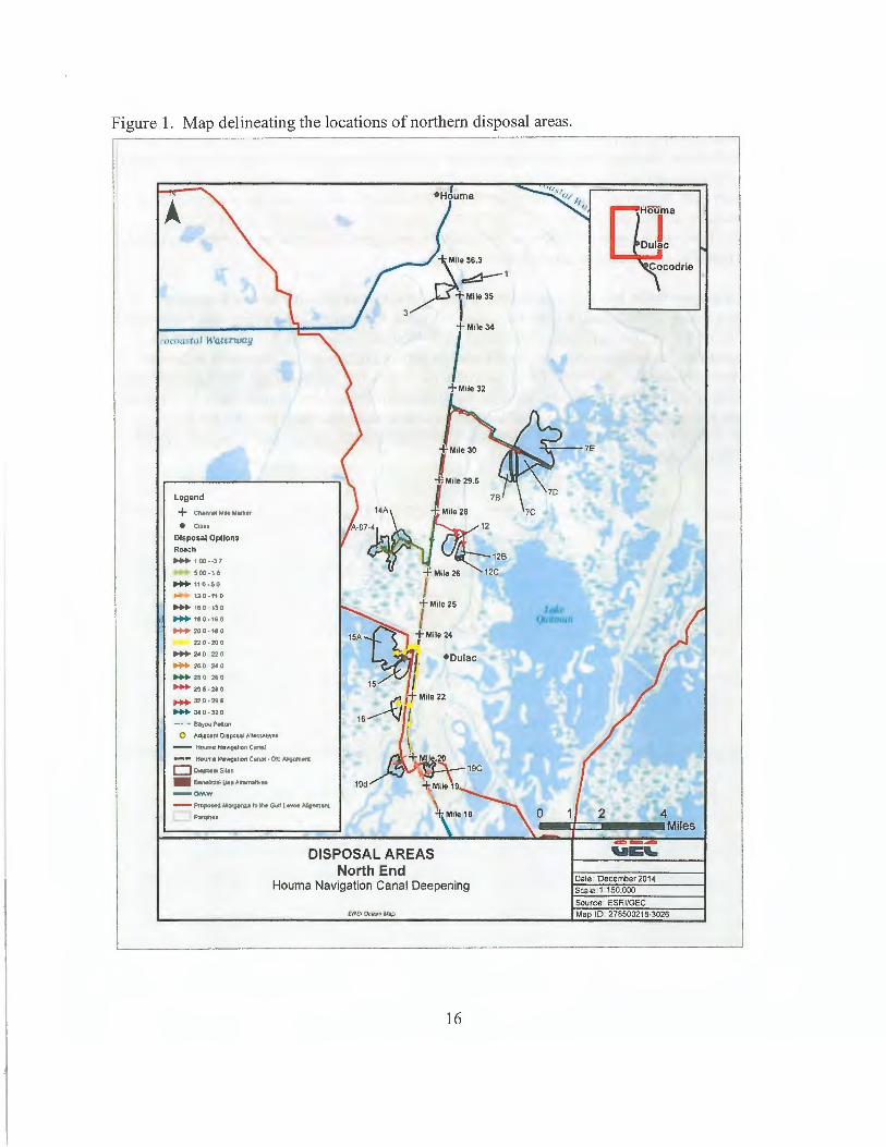
Figure 1. Map delineating the locations of northern disposal areas.
Legend
+ Chamel Mil• Mtlrtl•r
• cw.es Disposal Options Reach
.... 100··37
500-16
.... 110·50
..... t:J:0-110
.... 160 130
.... 180·160
.... 200·180
220·200
..... 240 220
..... ~o 2co
.... 210 MO
..... 29!·2i0
.... ~.0-29i
..... 3t0·32Q
-· ·• Bayou p .. gn
0 Ad.,ce"' 0~0111 AllernativH
- HoURta Nev1gtt1on Ceftl.I
•-• Kouml Ne'i1Galion Canat • Otd AllGM'leti o .,,.... ... ,. .. .. BaoefictlllUHARWnatirl'H 19d --O<WW
- ProposK t.lorgtni.1 ti' .... Gi.tf ll'#etl Allfrwn"'1 Panaties
\ +.Mile 18
DISPOSAL AREAS North End
Houma Navigation Canal Deepening
16
n:J:a ~codrie
0 2 4 -•t::::=----Miles
Dale December 2014 Scale 1 150,000
Source ESRl/GEC Map ID 278500218-3026
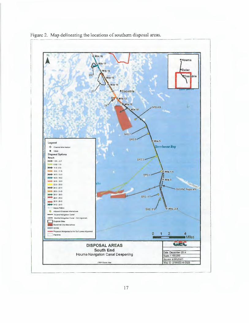
Figure 2. Map delineating the locations of southern disposal areas.
+\ile18
:i: Mlle 17
T.Mile 16
20C :J. Mile 15
!f: Mile 14
21 :r •Cocodrle
Legend
+ c_..,.....,.., • ca. ..
Disposal Options Reach
-·00·-3.1
500-11
.... 110·10
..... 130·11 0
.... 180·13.D
.... , • . 0.11..0
..... 200 -180
22.D ·20.0
- 140 220
... 210 ·2•0
- 210 210 - 2115-280
- 32.0 · 2115
- .. o.:1u - ~ Bayou Pelon
0 Adj~l'll Dispose! AIWfla~H
- Hotin• Nawtga»on C•ttal
·-- liouma Nav;gaon CaJ\11 · Old AJIO'nlfttld c:J o1111QsatSM1
.. 8enefiae!OHA1ttfnat1Yes
- GllHW
- PJOPOStO Morpnz1 to &he GYtf L...,.• Ahgnment
P.,th"
DISPOSAL AREAS South End
Houma Navigation Canal Deepening
cRSI O!~eat> Iha
17
SPD 8.8
0 4 ••==---•Miles
2
---"I:'-Date. December 2014
Scale. 1 165,000
Source ESRVGEC
Map ID 278500218-3026
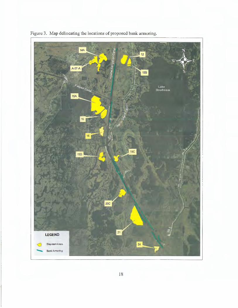
Figure 3. Map delineating the locations of proposed bank am1oring.
<J Disposal Areas
...._. BanltArmomg
18
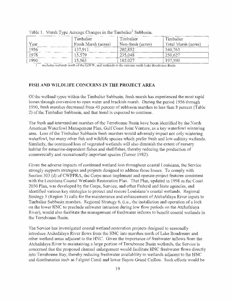
Table 1. Marsh Type Acreage Changes in the Timbalier1 Subbasin.
Timbalier Timbalier Timbalier Year Fresh Marsh (acres) Non-fresh (acres) Total Marsh (acres) 1956 137,911 202,852 340,763 1978 15,579 235,048 250,627 1990 15,563 182.027 197,590
excludes wetlands north of the GI\\. W, and wetlands m the extreme north Lake Boudreaux Basin
FISH AND WILDLIFE CONCERNS IN THE PROJECT AREA
Of the wetland types within the Timbalier Sub basin, fresh marsh has experienced the most rapid losses through conversion to open water and brackish marsh. During the period 1956 through 1990, fresh marshes decreased from 40 percent of subbasin marshes to less than 8 percent (Table 2) of the Timbalier Sub basin, and that trend is expected to continue.
The fresh and intermediate marshes of the Terrebonne Basin have been identified by the North American Waterfowl Management Plan, Gulf Coast Joint Venture, as a key waterfowl wintering area. Loss of the Timbalier Subbasin fresh marshes would adversely impact not only wintering waterfowl, but many other fish and wildlife species which prefer fresh and low-salinity wetlands. Similarly, the continued loss of vegetated wetlands will also diminish the extent of nursery habitat for estuarine-dependent fishes and shellfishes, thereby reducing the production of commercially and recreationally important species (Turner 1982).
Given the adverse impacts of continued wetland loss throughout coastal Louisiana, the Service strongly supports strategies and projects designed to address those losses. To comply with Section 303 (d) of CWPPRA, the Corps must implement and operate project features consistent with the Louisiana Coastal Wetlands Restoration Plan. That Plan, updated in 1998 as the Coast 2050 Plan, was developed by the Corps, Service, and other Federal and State agencies, and identified various key strategies to protect and restore Louisiana's coastal wetlands. Regional Strategy 5 (Region 3) calls for the maintenance and enhancement of Atchafalaya River inputs to Timbalier Subbasin marshes. Regional Strategy 6, (i.e. , the installation and operation of a lock on the lower HNC to preclude saltwater intrusion during low flow periods on the Atchafalaya River), would also facilitate the management of freshwater inflows to benefit coastal wetlands in the Terrebonne Basin.
The Service has investigated coastal wetland restoration projects designed to seasonally introduce Atchafalaya River flows from the HNC into marshes north of Lake Boudreaux and other wetland areas adjacent to the HNC. Given the importance of freshwater inflows from the Atchafalaya River to maintaining a large portion of Terrebonne Basin wetlands, the Service is concerned that the proposed channel enlargement would facilitate HNC freshwater flows directly into Terrebonne Bay, thereby reducing freshwater availability to wetlands adjacent to the HNC and distributaries such as Falgout Canal and lower Bayou Grand Caillou. Such effects would be
19
contrary to one of the above-described regional wetland restoration strategies identified for the Timbalier Subbasin.
The Service is also concerned about with-project wake-induced increased bank erosion along the HNC. The original project authorization provided for a 250-foot-wide channel; however, many reaches of the channel now range from 450 to 1,000 feet in width. The Corps is authorized to maintain an approved minimum depth and width along the HNC, but they are not authorized to control erosion of banks along that channel. That responsibility typically rests with the local sponsor (Houma Port Commission). Using 1998 to 2005 imagery to determine erosion rates for half mile segments along the entire channel, the Corps found that the annual erosion of wetlands along unprotected HNC banks results in the loss of approximately 14 acres per year. Based on anticipated increases in HNC vessel traffic with channel deepening, the Corps concluded that the HNC shoreline erosion rates would increase 5 percent. For consistency with current and future efforts to restore and maintain Louisiana's coastal ecosystem, wetlands adjacent to the channel should, be protected as an authorized project feature to avoid further long-term wetland losses, and to reduce future channel maintenance costs.
The Service is also concerned about potentially contaminated sediments that would be excavated to implement the proposed project. This is especially true for those areas near the Port of Houma and the intersection of HN C with Bayou Grand Calliou, where sediment contamination has a greater probability of occurrence due to the high amount of commercial activity. Consequently, further feasibility study evaluations and NEPA-compliance documents should include appropriate contaminants screening and analysis of the material to be dredged, as well as approp1iate measures (if needed) to avoid potential exposure of the aquatic ecosystem to their harmful effects.
EVALUATION METHODOLOGY
Project-related impacts on fish and wildlife resources were evaluated using the Wetland Value Assessment (WV A) methodology, which was developed to quantify benefits of proposed CWPPRA projects. The WVA is similar to the Service's Habitat Evaluation Procedures (HEP). in that habitat quality and quantity (acreage) are measured for baseline conditions, and predicted for future without-project and future with-project conditions. Instead of the species-based approach of HEP, each WV A model utilizes an assemblage of variables considered important to the suitability of that habitat type for an airny of fish and wildlife species. As with HEP, the community based WV A provides a quantitative estimate of project-related impacts to fish and wildlife resources; however, the WVA is based on separate models for bottomland hardwoods, fresh/inte1mediate marsh, brackish marsh, and saline marsh. Although the WV A may not include every environmental or behavioral vaiiable that could affect fish and wildlife populations, it is widely acknowledged to provide a cost-effective means of assessing restoration measures in Louisiana's coastal wetland communities.
20
The WV A models operate under the assumption that optimal conditions for fish and wildlife habitat within a given wetland type can be characterized, and that existing or predicted conditions can be compared to that optimum to provide an index of habitat quality. Habitat quality is estimated and expressed through the use of a mathematical model developed specifically for each wetland type. Each model consists of: 1) a list of variables that are considered important in characterizing community-level fish and wildlife habitat values; 2) a Suitability Index graph for each variable, which defines the assumed relationship between habitat quality (Suitability Index) and different variable values; and, 3) a mathematical formula that combines the Suitability Indices for each variable into a single value for wetland habitat quality, termed the Habitat Suitability Index (HSI).
Field data are typically used to compute baseline HSI values and to predict HS Is for each target year (TY). Target years are established when future significant changes in habitat quality or quantity were expected under future with-project and future without-project conditions. Records of the WV A inputs and projected habitat changes are on file in the Service's Lafayette, Louisiana, Field Office.
The product of an HSI value and the acreage of available habitat for a given target year is the Habitat Unit (HU), which is the basic unit for measuring project effects on fish and wildlife habitat. HUs are annualized over the project life to determine the Average Annual Habitat Units (AAHUs) available for each habitat type.
The change (i.e., increase or decrease) in AAHUs for each future with-project scenario, compared to future without-project conditions, provides a measure of anticipated impacts. A net gain in AAHUs indicates that the project is beneficial to the fish and wildlife community within that habitat type; a net loss of AAHUs indicates that the project would adversely impact fish and wildlife resources. In determining future with-project conditions, project-related direct (construction) impacts were assumed to occur in TYl (2022) for the upper HNC. The last disposal event would occur in year 2072. Because the project life includes 2022 and 2072. the project life is 51 years. For the middle and lower portions of the inland reach, TYl occurs in 2023, and the last disposal event is in 2073 (51 year project life). For Bay and Cat Island Pass reaches, construction would begin in 2024 and 2025, respectively, and end in 2075 for both.
The WV A models for fresh/intermediate, brackish, and saline marsh consist of six variables: 1) percent of wetland covered by emergent vegetation; 2) percent open water dominated by submerged aquatic vegetation (SA V); 3) degree of marsh edge and interspersion; 4) percent of open water less than or equal to 1.5 feet deep; 5) salinity; and, 6) aquatic organism access. Variable 1, percent marsh was determined by applying loss rates from a regional wetland loss assessment to marshes and DAs adjacent to the HNC.
Because the marsh WV As incorporate variables for SA V and shallow open water into the models, impacts to those habitat components are combined with impacts to emergent marshes. However, SA V and percent shallow open water variables, receive proportionally less weight that the marsh variables, when variable scores are combined into a single AAHU value which
21
measures the combined quantity and quality of the marsh/water matrix. The bottomland hardwood forest and swamp models do not include SA V or shallow open-water variables; hence, impacts to those habitats are not included in the WVA analysis for those habitat types.
Rather than using current field measurements, equations were used to estimate values for variables 2, 3, and 4 over the target years ranging from 2022 through 2072. For V2 (percent SA V coverage), baseline coverage was estimated via field knowledge. Subsequent V2 values were assumed to increase incrementally as Vl values (percent marsh) exceeded 30%, 50%, and 70%. Those relationships varied with each DA based on field knowledge (information is available upon request from the FWS). The Marsh Interspersion variable (V3) was also estimated based on Vl values, such that ifVl was 90% or greater, V3 was assumed to be 100% Class 1. IfVI was 10% or less, V3 was assumed to be 100% Class 5. When VI was between IO and 90%, that VI value was assumed to equal the V3 Class 2 percentage, and the V3 Class 4 value was equal to I00% minus the Class 2 percentage. For the Percent Shallow Open Water variable (V4), the baseline value was established based on field experience in the area. Values for subsequent years were computed as follows:
Target Years I-I 9: Baseline value+ (VI value x O. I) Target Years 20-39: (Baseline value x 0.8) + (VI value x 0.1) Target Years 40-50: (Baseline value x 0.6) + (VI value x O. I)
Current salinity data, obtained from the Coastal Reference Monitoring System (CRMS) website, was assumed to represent baseline conditions. Where a DA was located between two CRMS stations, the VS value was estimated by extrapolating between those CRMS station salinities. Additionally, salinities for sites south of the lock were assumed to increase over time whereas little or no future increases were estimated for sites north of the lock. The magnitude of salinity increases was greatest for the high SLR scenario, and moderate for the intermediate SLR scenario.
When marsh creation projects are assessed using the WV A, typically the fill site is not assumed to be functioning vegetated marsh until 3 to 5 years after spoil placement. To avoid the need to create additional target years to capture vegetation coverage of fill material, a simplifying assumption was made whereby all marsh creation sites were assumed to be fully functioning marsh with full fish access in year I.
The WV A model for bottomland hardwoods consists of seven variables: 1) tree species association; 2) stand maturity; 3) percent understory and midstory coverage; 4) hydrology; 5) size of contiguous forested area; 6) surrounding land use; and, 7) disturbance type and disturbance distance. The WV A model for swamp incorporates 4 variables: I) stand structure; 2) stand maturity; 3) water regime; and 4) salinity. Field data collected in 2009 was used in these WVAs.
22
PROJECT IMPACTS
Because the HNC is such an efficient conduit for water exchange between Terrebonne Bay and the GIWW, it is considered to be a primary cause of saltwater intrusion in the project area. If that channel is deepened before the lock and bypass channel are installed, saltwater intrusion would likely increase, with corresponding increased wetland deterioration and loss in portions of the project area. It was assumed that north of the Morganza HNC lock, increased Atchafalaya River flow down the HNC will largely offset increased saltwater intrusion. However, south of the lock, increased salinities are more likely to occur with deepening.
Most of the wetlands surrounding the northern portions of the HNC consist of dead or dying cypress swamp and bottomland hardwood forest which have already converted to, or are in the process of converting to, fresh marsh habitat interspersed with open-water areas. Therefore, there are a limited number of potential areas in the northern reaches of the HNC in which dredged material could be deposited in a beneficial manner. For this reason, dredged material would be placed in DA 1 and DA3, which consist of existing bottomland hardwood forest. Placement of material in DAl has preyiously been approved of and mitigated by the Corps of Engineers. Placement of spoil in DA3 is the only instance where project-related spoil disposal would result in wetland impacts.
Remaining DAs consist of existing open water areas. To successfully create marsh, earthen containment dikes would be constructed to contain hydraulically dredged spoil in order to stack the material to an elevation sufficient to support emergent vegetation upon dewatering and settlement. Typically, the containment dikes are constructed in open water using adjacent borrow from within the enclosed DA. Construction and usage of these DAs would result in a temporal loss of estuarine fisheries habitat until settlement and compaction reduce the fill elevation to marsh level and containment dikes are gapped (usually 1 to 3 years after filled). However, those adverse impacts would be fully compensated by the creation of high-quality emergent intermediate, brackish, and saline marsh habitats. The total acreage of constructed marsh by DA, alternative, and habitat type are listed in Table 2. The DA's adjacent to the HNC would be protected from wave erosion by placing rock armoring along the HNC bankline. Marsh creation acreages for each DA by target year are available in Appendix A.
Construction of DA containment dikes and drainage of turbid effluent from DAs may temporarily increase turbidity in adjacent water bodies. Those impacts would be minor, and positive effects might occur if sufficient sediment escapes the DAs to cause shoaling of existing water bodies, unintentional fornrntion of marshes outside the D As, and improved accretion of nearby marshes. Benefit calculations, however, assume no positive or negative effects outside of the DAs. Because the deeper HNC alternatives are assumed to require more maintenance dredging than shallower channels, the total acreage of marsh created through beneficial use increases with channel depth, due to the greater volume of spoil generated during both construction and maintenance.
23
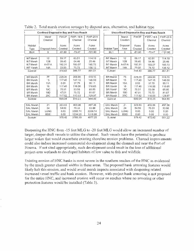
Table 2. Total marsh creation acreages by disposal area, alternative, and habitat type.
Confined Disposal in Bay and Pass Reach Unconfined Disposal in Bay and Pass Reach
Marsh FWOP FWP-18 ft FWP-20 ft Marsh FWOP FWP-18ft FWP-20 ft Creation Channel Channel Creation Channel Channel
Habitat Acres Acres Acres Disposal Acres Acres Acres Type Disposal Area Created Created Created Habitat Type Area Created Created Created BLH 3 -61.80 -73.47 -101.90 BLH 3 -61.80 -73.47 -101.90
INT Marsh 12 59.17 63.51 114.19 INT Marsh 12 59.17 63.51 114.1 9 INT Marsh 12B 39.45 54.46 25.48 INT Marsh 12B 39.45 54.46 25.48 INT Marsh A-07-A 192.31 193.07 185.73 INT Marsh A-07-A 192.31 193.07 185.73 INT Marsh 14A 23.50 75.72 136.12 INT Marsh 14A 23.50 75.72 136.12
Subtotal 314.43 386.77 461.51 Subtotal 314.43 386.77 461.51
BR Marsh 7E 229.20 269.90 319.15 BR Marsh 7E 229.20 269.90 319.15 BR Marsh 15 117.40 147.15 146.50 BR Marsh 15 117.40 147.15 146.50 BR Marsh 15A 0.00 37.79 95.11 BR Marsh 15A 0.00 37.79 95.11 BR Marsh 16 117.40 116.06 116.65 BR Marsh 16 117.40 11 6.06 116.65 BR Marsh 19C 70.51 53.08 65.85 BR Marsh 19C 70.51 53.08 65.85 BR Marsh 19D 47.01 75.72 81.67 BR Marsh 19D 47.01 75.72 81.67 BR Marsh 20C 117.52 110.53 129.97 BR Marsh 20C 11 7.52 110.53 129.97 Subtotal 699.04 810.23 954.90 Subtotal 699.04 810.23 954.90
SAL Marsh 21 323.93 403.06 497.36 SAL Marsh 21 323 .93 403.06 497.36 SAL Marsh 24 54.50 70.33 53.86 SAL Marsh 24 54.50 70.33 53.86 SAL Marsh LUNG 0.00 2085.74 2209.14 SAL Marsh LUNG 0.00 0.00 0.00 SAL Marsh BSEI 0.00 1234.25 1316.89 SAL Marsh BSEI 0.00 0.00 0.00
Subtotal 378.42 3793.39 4077.25 Subtotal 378.42 473.40 551 .22
Deepening the HNC from -15 feet MLG to -20 feet MLG would allow an increased number of larger, deeper-draft vessels to utilize the channel. Such vessels have the potential to produce larger wakes that would exacerbate existing shoreline erosion problems. Channel improYements could also induce increased commercial development along the channel and near the Port of Houma. If not sited appropriately, such deYelopment could result in the loss of additional project-area wetlands to developed habitats of low value to fish and wildlife.
Existing erosion of HNC banks is most severe in the southern reaches of the HNC as evidenced by the much greater channel widths in these areas. The proposed bank armoring features would likely halt this erosion, and would avoid marsh impacts associated with deepening related increased Yessel traffic and bank erosion. However, with-project bank armo1ing is not proposed for the entire HNC, and increased erosion will occur on reaches where no armoring or other protection features would be installed (Table 3).
24
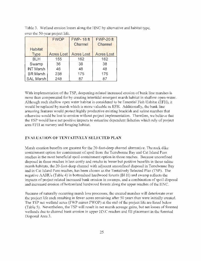
Table 3. Wetland erosion losses along the HNC by alternative and habitat type,
over the 50-year project life.
FWOP FWP-18 ft FWP-20 ft Channel Channel
Habitat Type Acres Lost Acres Lost Acres Lost BLH 155 162 162
Swamp 36 38 38 INT Marsh 46 48 48 BR Marsh 238 175 175
SAL Marsh 248 87 87
With implementation of the TSP, deepening-related increased erosion of bank line marshes is more than compensated for by creating intertidal emergent marsh habitat in shallow open-water. Although such shallow open water habitat is considered to be Essential Fish Habitat (EFH), it would be replaced by marsh which is more valuable as EFH. Additionally, the bank line armoring features would protect highly productive existing brackish and saline marshes that otherwise would be lost to erosion without project implementation. Therefore, we believe that the TSP would have net positive impacts to estuarine dependent fisheries which rely of project area EFH as nursery and foraging habitat.
EVALUATION OF TENTATIVELY SELECTED PLAN
Marsh creation benefits are greatest for the 20-foot-deep channel alternative. The rock dike containment option for containment of spoil from the Terrebonne Bay and Cat Island Pass reaches is the most beneficial spoil containment option in those reaches. Because unconfined disposal in those reaches is less costly and results in lesser but positive benefits in those saline marsh habitats, the 20-foot-deep channel with adjacent unconfined disposal in Terrebonne Bay and in Cat Island Pass reaches, has been chosen as the Tentatively Selected Plan (TSP). The negative AAHUs (Table 4) in bottomland hardwood forests (BLH) and swamp reflects the impacts of project related increased bank erosion in swamps, and a combination of spoil disposal and increased erosion of bottomland hardwood forests along the upper reaches of the HNC.
Because of naturally occurring marsh loss processes, the created marshes will deteriorate oYer the project life such resulting in fewer acres remaining after 50 years than were initially created. The TSP net wetland acres (FWP minus FWOP) at the end of the project life are listed below (Table 5 ). Nevertheless, the TSP will result in net marsh acreage gains, but net losses of forested wetlands due to channel bank erosion in upper HNC reaches and fill placement in the forested Disposal Area 3.
25
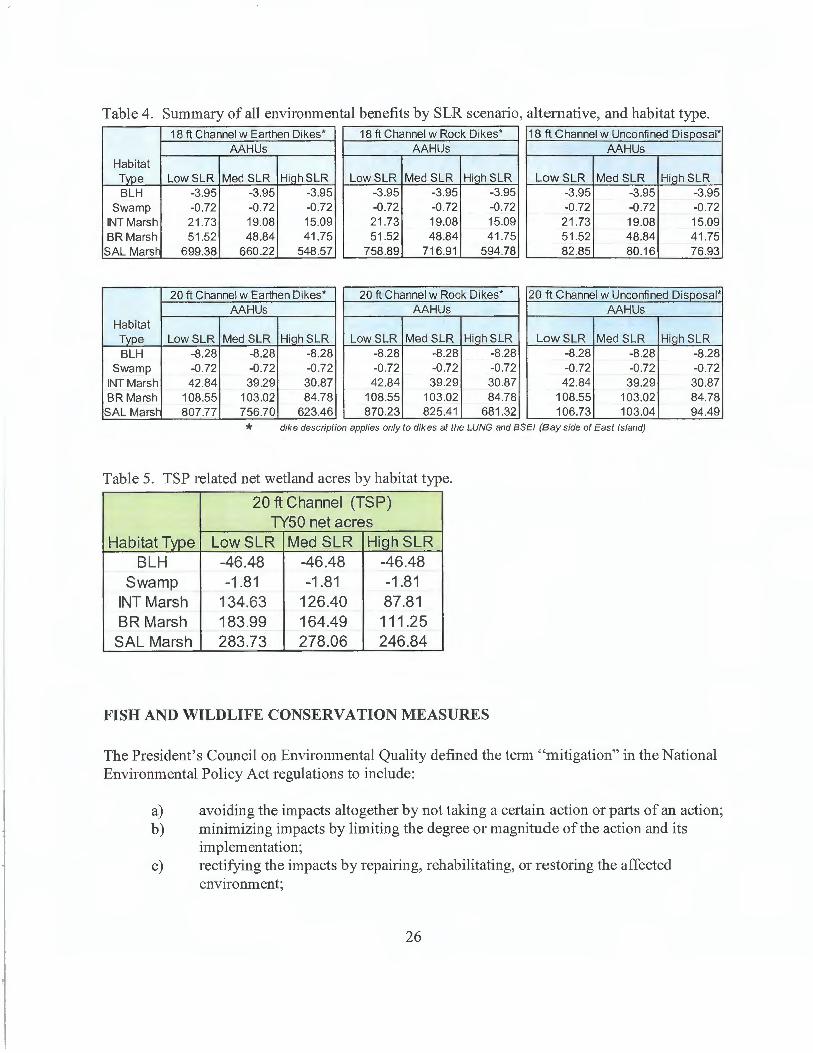
Table 4. Summary of all environmental benefits by SLR scenario, alternative, and habitat type. 18 ft Channel w Earthen Dikes* 18 ft Channel w Rock Dikes* 18 ft Channel w Unconfined Disposal*
AAHUs AAHUs AAHUs Habitat Type Low SLR Med SLR HiahSLR Low SLR Med SLR HiahSLR Low SLR Med SLR HiahSLR BLH -3.95 -3.95 -3.95 -3.95 -3.95 -3.95 -3.95 -3.95 -3.95
Swamp -0.72 -0.72 -0.72 -0.72 -0.72 -0.72 -0.72 -0.72 -0.72 INT Marsh 21 .73 19.08 15.09 21 .73 19.08 15.09 21.73 19.08 15.09 BR Marsh 51.52 48.84 41 .75 51 .52 48.84 41.75 51.52 48.84 41 .75
SAL Mars~ 699.38 660.22 548.57 758.89 716.91 594.78 82.85 80.16 76.93
20 ft Channel w Earthen Dikes* 20 ft Channel w Rock Dikes* 20 ft Channel w Unconfined Disposal* AAHUs AAHUs AAHUs
Habitat Type Low SLR Med SLR HiahSLR Low SLR Med SLR HiahSLR Low SLR Med SLR HiahSLR BLH -8.28 -8.28 -8.28 -8.28 -8.28 -8.28 -8.28 -8.28 -8.28
Swamp -0.72 -0.72 -0.72 -0 .72 -0.72 -0.72 -0.72 -0.72 -0.72 INT Marsh 42.84 39.29 30.87 42.84 39.29 30.87 42.84 39.29 30.87 BR Marsh 108.55 103.02 84.78 108.55 103.02 84.78 108.55 103.02 84.78 SAL Mars~ 807.77 756.70 623.46 870.23 825.41 681.32 106.73 103.04 94.49
* dike description applies only to dikes at the LUNG and BSEI (Bay side of East Island)
Table 5. TSP related net wetland acres by habitat type.
20 ft Channel (TSP) TY50 net acres
Habitat Type Low SLR Med SLR HiqhSLR BLH -46.48 -46.48 -46.48
Swamp -1 .81 -1.81 -1.81 INT Marsh 134.63 126.40 87.81 BR Marsh 183.99 164.49 111.25
SAL Marsh 283.73 278.06 246.84
FISH AND WILDLIFE CONSERVATION MEASURES
The President's Council on Environmental Quality defined the term "mitigation" in the National Environmental Policy Act regulations to include:
a) avoiding the impacts altogether by not taking a certain action or parts of an action; b) minimizing impacts by limiting the degree or magnitude of the action and its
implementation; c) rectifying the impacts by repairing, rehabilitating, or restoring the affected
environment;
26
d) reducing or eliminating the impacts over time by preservation and maintenance operations during the life of the action: and
e) compensating for the impacts by replacing or providing substitute resources or environments.
The Service's mitigation policy (Federal Register, Volume 46, Number 15, pages 7656-7663, January 23, 1991) provides guidance to help ensure that the level of mitigation recommended by the Service is consistent with the Yalue and scarcity of the fish and wildlife resources involved. In keeping with that policy, the Service usually recommends that losses of high-value habitats which are becoming scarce be avoided or minimized to the greatest extent possible, and that unavoidable losses of such habitats be fully compensated by replacement of the same kind of habitat value (in-kind mitigation). HNC project mitigation planning goals and associated Service recommendations are based on those four categories, as shown in Table 6.
Table: 6. U. S. Fish and Wildlife Service Resource Categories.
FWS Resource Categories
Resource Category 1 - Habitat to be impacted is of high value for evaluation species and is unique and irreplaceable on a national basis or in the ecoregion section. The mitigation goal for this Resource Category is that there should be no loss of existing habitat value.
Resource Category 2 - Habitat to be impacted is of high value for evaluation species and is relatively scarce or becoming scarce on a national basis or in the ecoregion section. The mitigation goal for habitat placed in this category is that there should be no net loss of in-kind habitat value.
Resource Category 3 - Habitat to be impacted is of high to medium value fore\ aluation species and is relatively abundant on a national basis. FWS's mitigation goal here is that there be no net loss of habitat value while minimizing loss of in-kind habitat value.
Resource Category 4 - Habitat to be impacted is of medium to low value for evaluation species. The mitigation goal is to minimize loss of habitat value.
Coastal marshes, coastal cypress swamps, and bottomland hardwood forests are considered by the Service to be aquatic resources of national importance due to their increasing scarcity and high habitat value for fish and wildlife within Federal trusteeship (i.e., migratory waterfowl, wading birds, other migratory birds, threatened and endangered species and interjurisdictional fisheries) and are considered to be Resource Category 2 habitats. Therefore, the Service recommends that any losses of those habitats be avoided, and that any unavoidable losses of those habitats be compensated via in-kind replacement.
27
The project would result in beneficial or positive impacts to marshes. In addition to the beneficial use of dredged material to create new marshes, the bank line aimoring would preYent the loss of 63 and 161 acres of existing brackish and saline marshes, respecti\'ely. The TSP would have net adverse or negative impacts to bottomland hardwoods and swamps. Those adverse impacts would require mitigation. The nearby Bayou Grand Coteau Mitigation Bank has credits a\'ailable for these habitats. To determine the extent of compensatory mitigation the project sponsors would haYe to purchase from that bank, the Service re-ran the bank valuation WV As using the recently Corps-ce11ified WVA models and determined that the mitigation potential \'alues (weighted for restored vs enhanced acres) for that bank are:
Swamp: BLH:
0.35 AAHUs per acre restored or enhanced 0.52 AAHUs per acre restored or enhanced
To achieve compensatory mitigation for project related wetland impacts (listed in Table 4) using the Bayou Grand Coteau Mitigation Bank, the project sponsors would have to purchase mitigation credits as per the following calculations:
Swamp: BLH:
0.72 AAHUs/0.35 AAHUs/ac 8.28 AAHUs/0.52 AAHUs/ac
2.06 acres or credits 15.92 acres or credits
SERVICE POSITION AND RECOMMENDATIONS
In addition to providing improved deep-draft navigation, implementation of the TSP could result in an increase in future-with-project acreage of brackish and saline marsh habitat. Nevertheless, avoidance and minimization of direct wetland impacts should be pursued to the greatest extent practicable, regardless of whether or not the project would produce net en\'ironmental benefits (expressed in AAHUs ). Minimization of such impacts would also help to ensure that Corps projects are consistent with the purposes of the restoration plan that was prepared in compliance with Section 303 (d) of the CWPPRA. In 1998, the Louisiana Coastal Wetlands Conservation and Restoration Task Force updated and revised that plan which is now the Coast 2050 Plan (Louisiana Coastal Wetlands Conservation and Restoration Task Force 1998). The Ser\'ice would not object to further detailed planning and implementation of the TSP, provided that the project incorporates the following measures to avoid unnecessary impacts to fish and wildlife resources, to achieve the anticipated wetland creation benefits, and to mitigate for unavoidable project-related wetland impacts:
1. Surveys should be conducted to document active, but undocumented, wading bird rookeries, colonial nesting birds, and bald eagle nests within the project area. If active nests are found, consultation with the Service should be initiated to ensure that project activities do not impact any colonial nesting bird colonies, threatened or endangered species, or their critical habitat.
28
2. Detailed planning and design of project features during the pre-constmction engineering and design phase should be conducted in consultation with the Service, the National Marine Fisheries Service (NMFS), the Louisiana Department of Natural Resources (DNR), and the Louisiana Department of Wildlife and Fisheries (LDWF) to avoid unnecessary wetland impacts and to achieve the anticipated wetland creation benefits. Those planning and design features include containment dike locations, spill box locations, slurry target ele\'ation, target marsh ele\'ation, and settlement curves and/or estimates.
3. The Service supports the proposed rock armoring erosion protection features; however, such protection should be installed on remaining unprotected wetland bank lines to avoid deepening related increased wake erosion of wetlands. The inclusion of dike gaps to maintain tidal exchange should be determined in coordination with the natural resource agencies identified in recommendation # 2 above.
4. Disposal area containment dikes should be gapped within one to three years after fill is placed in disposal areas to restore tidal influence and fisheries access. The location and design of containment dike gaps should be determined in coordination with the natural resource agencies identified in recommendation # 2 aboYe.
5. Project sponsors should mitigate for unavoidable project impacts to swamp and bottomland hardwood forest (0.72 and 8.28 AAHUs, respectiYely). If the sponsors use the Bayou Grand Coteau Mitigation Bank, compensatory mitigation would be achieved through the purchase of 2.06 acres or credits of swamp, and 15.92 acres or credits of bottomland hardwood forest.
6. To minimize deepening related saltwater intmsion impacts, the proposed HNC deepening should not be conducted until the HNC lock has been constructed and is functioning.
7. Contaminants screening of material to be dredged from the upper reaches of the HNC and from the HNC at the junction with Bayou Grand Caillou should be conducted to verify that there would be no contaminants related impacts when that spoil is placed in adjoining wetlands. If the material is contaminated, then appropriate measures should be taken to avoid potential exposure of the aquatic ecosystem to their harmful effects.
29
LITERATURE CITED
Barras, J.P., P.E. Bourgeois, and L.R. Handley. 1994. Land loss in coastal Louisiana 1956-90. National Biological Survey, National Wetlands Research Center Open File Report 94-01.
Louisiana Coastal Wetlands Conservation and Restoration Task Force. 1993a. Louisiana Coastal Wetlands Restoration Plan, Main Report and Environmental Impact Statement. 308p.
Louisiana Coastal Wetlands Conservation and Restoration Task Force. 1993b. Louisiana Coastal Wetlands Restoration Plan, Appendix E, Terrebonne Basin.
Louisiana Coastal Wetlands Conservation and Restoration Task Force and the Wetlands Conservation and Restoration Authority. 1998. Coast 2050: Toward a Sustainable Coastal Louisiana. Louisiana Department of Natural Resources. Baton Rouge, Louisiana. 161 p.
Turner, R. E. 1977. Intertidal vegetation and commercial yields of penaeid shrimp. Trans. Am. Fish. Soc. 106: 411-416.
Turner, R. E. 1982. Wetland losses and coastal fisheries: an enigmatic and economically significant dependency. Pages 112-120 In Boesch, D. F., ed. 1982. Proceedings of the conference on coastal erosion and wetland modification in Louisiana: causes, consequences, and options. U.S. Fish and Wildlife Service, Biological Sen:ice Program, Washington, D. C. FWS/OBS-82/59. 256 pp.
U.S. Fish and Wildlife Service. 2008. Birds of Conservation Concern 2008. Division of Migratory Bird Management. Arlington, Virginia.
U.S. Geological Survey. 2003. Louisiana Coastal Colonial Waterbirds Surveys. unpublished report. Biological Research Division, National Wetlands Research Center, Lafayette, Louisiana.
30
APPENDIX A
NMFS Comment Letter on the December 2015 Draft Fish and Wildlife Coordination Act Report
A - 1
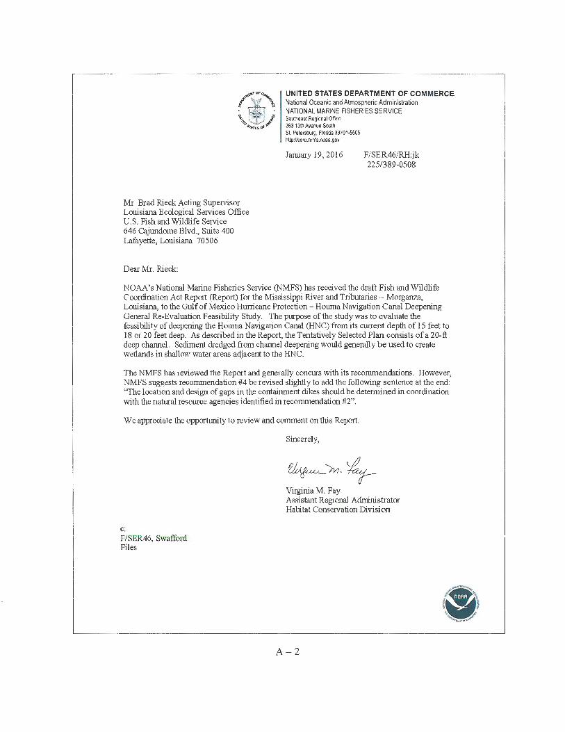
Mr. Brad Rieck Acting Supervisor Louisiana Ecological Seivices Office U.S. Fish and Wildlife Service 646 Cajundome Blvd., Suite 400 Lafayette, Louisiana 70506
Dear Mr. Rieck:
UNITED STATES DEPARTMENT OF COMMERCE National Oceanic and Atmospheric Administration NATIONAL MARINE FISHERIES SERVICE Soutlleast Regional Office 263 13th Avenue South St. Petersburg, Florida 33701-5505 http://sero.nmfs.noaa.gov
January 19, 2016 F/SER46/RH:jk 225/389-0508
NOAA's National Marine Fisheries Service (NMFS) has received the draft Fish and Wildlife Coordination Act Repo1t (Report) for the Mississippi River and Tributaries - Morganza, Louisiana, to the Gulf of Mexico Hurricane Protection - Houma Navigation Canal Deepening General Re-Evaluation Feasibility Study. The purpose of the study was to evaluate the feasibility of deepening the Houma Navigation Canal (HNC) from its current depth of 15 feet to 18 or 20 feet deep. As described in the Report, the Tentatively Selected Plan consists of a 20-ft deep channel. Sediment dredged from channel deepening would generally be used to create wetlands in shallow water areas adjacent to the HNC.
The NMFS has reviewed the Report and generally concurs with its recommendations. However, NMFS suggests recommendation #4 be revised slight! y to add the following sentence at the end: 'The location and design of gaps in the containment dikes should be determined in coordination with the natural resource agencies identified in recommendation #2".
We appreciate the opportunity to review and comment on this Report.
c: F/SER46, Swafford Files
Sincerely,
~~10-~ Virginia M. Fay Assistant Regional Administrator Habitat Conservation Division
A - 2
APPENDIX B
Marsh Creation Acreages by DA and Year
B - 1
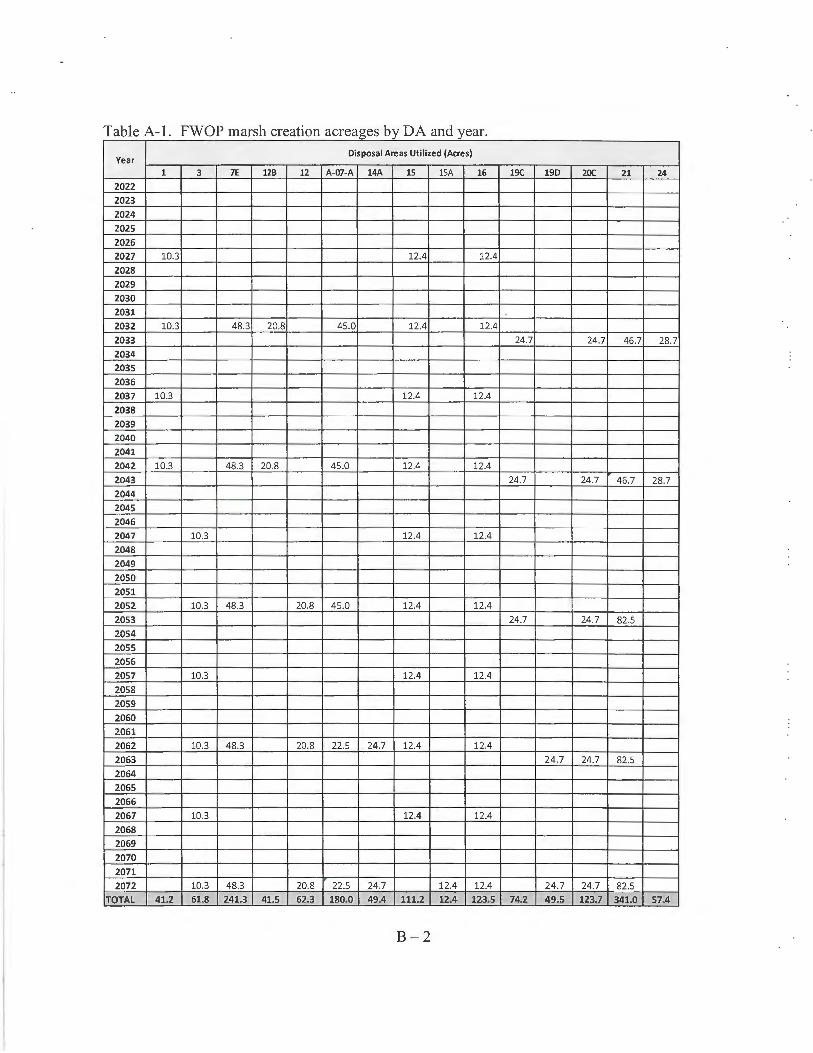
T bl A 1 FWOP a e - mars h f crea 10n acreages b DA d y an year.
Year Disposal Areas Utilized (Acres)
1 3 7E UB 12 A-07-A 14A 15 lSA 16 19C 190 20C 21 24
2022 2023
2024
2025
2026 2027 10.3 12.4 12.4
2028 2029
2030 2031
2032 10.3 48.3 20.8 45.0 12.4 12.4
2033 24.7 24.7 46.7 28.7 2034
2035 2036
2037 10.3 12.4 12.4
2038
2039 2040
2041
2042 10.3 48.3 20.8 45.0 12.4 12.4 2043 24.7 24.7 46.7 28.7 2044 2045
2046
2047 10.3 12.4 12.4
2048 2049 2050
2051 2052 10.3 48.3 20.8 45.0 12.4 12.4
2053 24.7 24.7 82.5
2054
2055 2056 2057 10.3 12.4 12.4
2058
2059
2060 2061
2062 10.3 48.3 20.8 22.5 24.7 12.4 12.4
2063 24.7 24.7 82.5 2064 2065
2066
2067 10.3 12.4 12.4
2068 2069
2070 2071
2072 10.3 48.3 20.8 22.5 24.7 12.4 12.4 24.7 24.7 82.5 TOTAL 41.2 61,8 241.3 41.5 62.3 180.0 49.4 111.2 12.4 123,5 74.Z 49.5 123.7 341,0 57.4
B- 2
MODEL CERTIFICATION
DEPARTMENT OF THE ARMY U.S. ARMY CORPS OF ENGINEERS
441 G STREET, NW WASHINGTON, DC 20314-1000
CECW-P
REPLY TO ATTENTION OF
28 February 2012
MEMORANDUM FOR Director, National Ecosystem Restoration Planning Center of Expertise (ECO-PCX)
SUBJECT: Wetland Value Assessment Models - Coastal Marsh Module Version 1.0 -Approval for Use
1. The Coastal Marsh Community model is one of seven WV A community models that were developed by the Coastal Wetlands Planning, Protection and Restoration Act (CWPPRA) Environmental Work Group. Based on information provided by the ECO-PCX, it is the understanding of the HQUSACE Model Certification Panel that this model will be used on the following projects over the next five years:
a. MRGO Ecosystem Restoration b. Barataria Basin Barrier Shoreline c. Lake Pontchatrain and Vicinity Hurricane Storm Damage Risk Reduction System (HSDRRS) Mitigation d. West Bank and Vicinity HSDRRS Mitigation e. HSDRRS IERS -total number unknown f. Louisiana Coastal Area (LCA) 4 Davis Pond Modification g. LCA4 Modification to Caernarvon h. LCA4 Point Au Fer Island i. LCA4 Caillou Lake Land Bridge j. LCA Myrtle Grove k. LCA White Ditch PED I. LCA Mississippi River Hydrodynamic and Delta Management m. LCA Caernarvon n. Larose to Golden Meadow (LGM) PostAuthorization Change (PAC) Study o. Larose to Golden Meadow Intracoastal Floodwall Reach 2b (LGM-022C). p. Larose to Golden Meadow Intracoastal Floodwall Reach 2a (LGM-022B). q. Larose to Golden Meadow C-North Highway 24 Relocation (LGM-OOlC).
r. Baptiste Collette Bayou Deepening study s. Barataria Bay Waterway (CAP 204) t. Buras Marina (CAP 206) u. Calcasieu River and Pass (CAP 204) v. Calcasieu Lock Replacement w. Morganza to the Gulf PAC x. Morganza to the Gulf Supplemental NEPA documents -total number unknown y. Southwest Coastal z. Coastal Wetlands Planning, Protection and Restoration Act (CWPPRA)- West Bay Closure aa. Houma Navigation Canal Deepening bb. West Shore Lake Pontchartrain Hurricane & Flood Risk Reduction cc. LCA Terrebonne Basin Barrier Shoreline Restoration dd. LCA Demonstration Projects Grand Isle and Vicinity Project ee. CAP 103 Grand Isle Highway 1 Shoreline Stabilization ff. Donalsonville to the Gulf gg. NOV Plaquemines Parish hh. NFL Plaquemines Parish
Printed on ® Recycled Paper
CECW-P SUBJECT: Wetland Value Assessment Models - Coastal Marsh Module Version 1.0 -Approval for Use
2. Version 1.0 of the Coastal Marsh Community model is approved for use for the above projects. This approval for use is based on the decision of the HQ USA CE Model Certification Panel which considered the ECO-PCX assessment of the model. Adequate technical reviews have been accomplished and the model meets the certification criteria contained in EC 1105-2-412. As indicated by the ECO-PCX, there are a number of unresolved issues related to the form of suitability graphs for Variables 1, 2 and 3 and the aggregation methods used to combine the marsh habitat units and open water habitat units for each sub-model. To increase the understanding of the sensitivity of the model to the unresolved issues and the impact the model differences may have on decision-making, the ECO-PCX is to work with the project delivery teams to conduct sensitivity analyses for each application of the marsh models. A summary of the sensitivity analyses must be presented in the project documentation and Agency Technical Review teams must be charged with reviewing the adequacy and findings of the sensitivity analyses.
3. It is expected that compiliation of the findings of the multiple sensitivity analyses will lead to updates and improvements of the model. As such, version control is imperative. The PCX must ensure that project delivery teams are are utilizing the most appropriate version of the model for their analyses and that they are properly identifiying the version of the model being used.
APPLICABILITY: This approval for use expires 28 February 2017 and is limited to the above studies with the caveat that updated versions of the model be used if appropriate.
d ;;%.:# HARR~H, P.E. Deputy Chief, Planning and Policy Division Directorate of Civil Works
-2-