FINAL ENVIRONMENTAL ASSESSMENT WITH …...FINAL ENVIRONMENTAL ASSESSMENT WITH FINDING OF NO...
265
FINAL ENVIRONMENTAL ASSESSMENT WITH FINDING OF NO SIGNIFICANT IMPACT REGULATING WORKS PROJECT DOGTOOTH BEND PHASE 5 MIDDLE MISSISSIPPI RIVER MILES 40.0-20.0 ALEXANDER COUNTY, IL MISSISSIPPI AND SCOTT COUNTIES, MO APRIL 2014 U.S. Army Corps of Engineers, St. Louis District Regional Planning and Environment Division North 1222 Spruce St. St. Louis, MO 63103-2833
Transcript of FINAL ENVIRONMENTAL ASSESSMENT WITH …...FINAL ENVIRONMENTAL ASSESSMENT WITH FINDING OF NO...

FINAL ENVIRONMENTAL ASSESSMENT
WITH
FINDING OF NO SIGNIFICANT IMPACT
REGULATING WORKS PROJECT DOGTOOTH BEND PHASE 5
MIDDLE MISSISSIPPI RIVER MILES 40.0-20.0 ALEXANDER COUNTY, IL
MISSISSIPPI AND SCOTT COUNTIES, MO
APRIL 2014
U.S. Army Corps of Engineers, St. Louis District Regional Planning and Environment Division North
1222 Spruce St. St. Louis, MO 63103-2833
i
TABLE OF CONTENTS TABLE OF CONTENTS ................................................................................................................. i 1. Purpose of and Need for Action .................................................................................................. 1
2. Alternatives Including the Proposed Action ............................................................................... 5
3. Affected Environment ............................................................................................................... 11
Physical Resources.................................................................................................................... 11
Biological Resources ................................................................................................................ 16
Socioeconomic Resources ........................................................................................................ 19
Historic and Cultural Resources ............................................................................................... 20
4. Environmental Consequences ................................................................................................... 22
Physical Resources.................................................................................................................... 22
Biological Resources ................................................................................................................ 24
Socioeconomic Resources ........................................................................................................ 28
Historic and Cultural Resources ............................................................................................... 29
Climate Change. ........................................................................................................................ 29
Cumulative Impacts .................................................................................................................. 31
Mitigation .................................................................................................................................. 36
5. Relationship of Proposed Action to Environmental Requirements .......................................... 36
6. Conclusion ................................................................................................................................ 37
7. List of Preparers ........................................................................................................................ 37
8. Literature Cited. ........................................................................................................................ 38
FINDING OF NO SIGNIFICANT IMPACT (FONSI) ................................................................ 42
APPENDICES ................................................................................................................................ Appendix A. Summary of Research on the Effects of River Training Structures on Flood Levels ............................................................................................................................................ Appendix B. Biological Assessment ............................................................................................. Appendix C. Cumulative Impacts Analysis .................................................................................. Appendix D. Clean Water Act Section 404(b)(1) Evaluation ...................................................... Appendix E. Public Comments and Responses ............................................................................ Appendix F. Agency and Tribal Government Coordination ........................................................ Appendix G. Distribution List ......................................................................................................
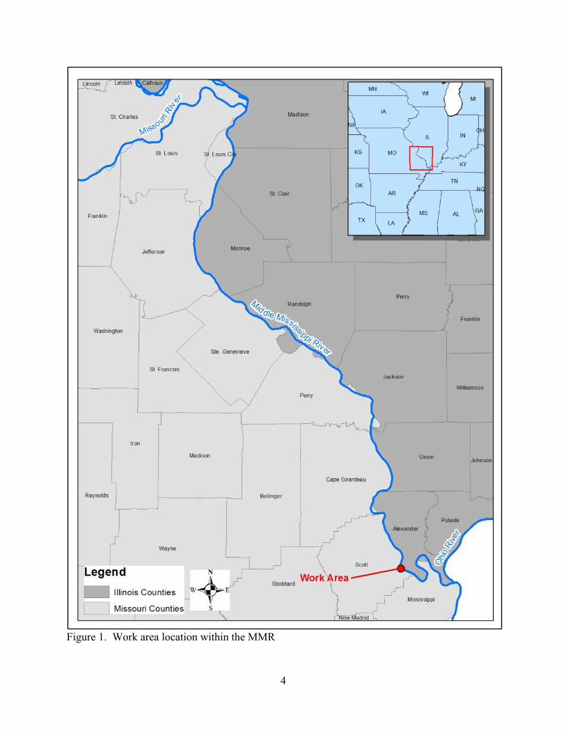
1. Purpose of and Need for Action The Congress of the United States, through the enactment of a series of Rivers and Harbors Acts beginning in 1824, authorized the Secretary of the Army, by and through the U.S. Army Corps of Engineers St. Louis District (District), to provide a safe and dependable navigation channel, currently 9 feet deep and not less than 300 feet wide, with additional width in the bends as required, on the Middle Mississippi River (MMR).1 The MMR is defined as that portion of the Mississippi River that lies between its confluence with the Ohio and the Missouri rivers (hereinafter referred to as the Project; Figure 1). This ongoing Project is also commonly referred to as the Regulating Works Project. The Regulating Works Project utilizes bank stabilization and sediment management to maintain bank stability and ensure adequate navigation depth and width. Bank stabilization is achieved by revetments, while sediment management is achieved by river training structures, i.e. dikes. Other activities performed to obtain the navigation channel are rock removal and construction dredging. The Project is maintained through dredging and any needed maintenance to already constructed features. The long-term goal of the Project, as authorized by Congress, is to provide a sustainable and safe navigation channel and reduce federal expenditures by alleviating the amount of annual maintenance dredging and the occurrence of vessel accidents through the construction of regulating works. Therefore, pursuant to the Congressionally authorized purpose of the Project, the District continually monitors areas of the MMR that require frequent and costly dredging to determine if a long-term sustainable solution through regulating works is reasonable.
1 Congress originally authorized the project of improving navigation of the Mississippi River from the mouth of the Missouri to New Orleans in the Rivers and Harbors Act dated May 24, 1824, by the removal of trees that were endangering the safety of navigating the river. In the Rivers and Harbors Act dated June 10, 1872, Section 2, Congress mandated that an examination and/or survey be completed of the Mississippi River between the mouth of the Missouri River and the mouth of the Ohio River, providing the first Congressional action to define this portion of the Mississippi River as distinct from the rest of the Mississippi River. Congress authorized the specific improvement of the Mississippi River between the mouth of the Missouri River and the mouth of the Ohio River in the Rivers and Harbors Act dated March 3, 1873. Between 1874-1892, Congress expanded this section of the Mississippi River to include that portion between the mouth of the Missouri and the mouth of the Illinois, but in the Rivers and Harbors Act dated July 13, 1892, Congress removed this additional section of the river and once again referred to it as the Mississippi River between the mouth of the Ohio River and the mouth of the Missouri River. In the Rivers and Harbors Act dated June 25, 1910, Congress provided exactly how this Project was to be carried out by authorizing the construction, completion, repair, and preservation of “[i]mproving [the] Mississippi River from the mouth of the Ohio River to and including the mouth of the Missouri River: Continuing improvement in accordance with the plan adopted in [1881], which has for its object to eventually obtain by regularization works and by dredging a minimum depth.” The 1881 plan called for the removal of rock hindering navigation, the contraction of the river to compel the river to scour its bed (now known as regulating works), and to be aided by dredging, if necessary. The 1881 plan also provided for bank protection improvements (now known as revetment) wherever the river is causing any serious caving of its banks. (Letter from the Secretary of War, dated November 25, 1881, 47th Congress, 1st Session, Ex. Doc. No. 10). The Project’s current dimensions of the navigation channel were established in the Rivers and Harbors Acts dated January 21, 1927 and July 3, 1930. The Rivers and Harbors Act dated January 21, 1927 modified the Project pursuant to the Chief of Engineers recommendations, which further detailed the purpose of the Project to construct the channel through regulating works and augment this by dredging, stating that dredging should be reduced to a minimum. The Project was also later modified to provide for the Chain of Rocks Canal and Lock 27 in the Rivers and Harbors Acts dated March 2, 1945 to address the rock formation hindering navigation in this area, and the rock filled low water dam at the Chain of Rocks was authorized in the Rivers and Harbors Act dated July 3, 1958 to assure adequate depth over the lower gate sills at Locks and Dam 26.

2
To the extent possible under existing authorities, environmental laws, regulations, and policies, the District considers the environmental consequences of its activities as it constructs and operates the Project and acts accordingly. An important component of each activity is the use of scientific, economic, and social knowledge to understand the environmental context and effects of District actions in a collaborative manner, employing an open, transparent process that respects the views of Federal and State stakeholders, individuals, and groups interested in District activities. Frequent dredging has been required in the area of the proposed Regulating Works, Dogtooth Bend Phase 5 Construction work area (Dogtooth Bend Phase 5 work area; see a detailed discussion of this in Section 3, Affected Environment.) Therefore, after analysis of this area, the District concluded that construction of the Dogtooth Bend Phase 5 work area is reasonable and necessary to address the repetitive channel maintenance dredging in order to provide a sustainable, less costly navigation channel in this area. The District has concluded through analysis and modeling that construction of river training structures would provide a sustainable alternative to repetitive maintenance dredging. Construction of the Dogtooth Bend Phase 5 work area is proposed to begin in 2014. The planning of specific construction areas, including the Dogtooth Bend Phase 5 work area, requires extensive coordination with resource agency partners and the navigation industry. The U.S. Fish and Wildlife Service (USFWS), Missouri Department of Conservation (MDC), Illinois Department of Natural Resources (IDNR), and multiple navigation industry groups were involved in the planning of the Dogtooth Bend Phase 5 work area to avoid and minimize any impacts on the navigation industry and environmental resources. Prior Reports - This site-specific Environmental Assessment (EA) is tiered off of the 1976 Environmental Impact Statement (1976 EIS) covering the District’s Regulating Works Project – Mississippi River between the Ohio and Missouri Rivers (Regulating Works), (USACE 1976). The 1976 EIS was recently reviewed by the District to determine whether or not the document should be supplemented. The District has concluded that the Regulating Works Project has not substantially changed since 1976 but that there are significant new circumstances and information on the potential impacts of the Regulating Works Project on the resources, ecosystem and human environment to warrant the preparation of a Supplemental EIS (SEIS). The significant new circumstances and information on the potential impacts of the Regulating Works Project relevant to this EA include the following:
• New federally threatened and endangered species have been listed since preparation of the 1976 EIS. Information on threatened and endangered species and impacts on those species can be found in Section 3, Section 4, and Appendix B of this document.
• New information exists on the changes in average river planform width (the river’s outline or morphology as defined by the tree line) in response to river training structure placement. Information on recent studies of planform width can be found in Section 3 of this document.
• New information exists on the impacts of river training structures and dredging on fish and macroinvertebrates. Information on fish and macroinvertebrates and projected impacts can be found in Sections 3 and 4 of this document.

3
• The District has implemented new programs to restore fish and wildlife habitat on the MMR. Information on the Biological Opinion Program and the Avoid and Minimize Program can be found in Section 4 of this document.
• New information exists on the effects of navigation on fish and wildlife resources. Information on navigation effects can be found in Appendix C, Cumulative Impacts Analysis.
The Dogtooth Bend Phase 5 EA has incorporated new information and circumstances relevant to the impacts of the action on the environment to the greatest extent possible. Should the analyses undertaken as part of the SEIS process reveal any new impacts on the resources, ecosystem, and human environment not accounted for in this EA, measures will be taken within our authority to avoid, minimize, and/or compensate for the impacts during that process as appropriate. Information on the SEIS can be found on the District’s SEIS web site: http://www.mvs.usace.army.mil/Missions/Navigation/SEIS.aspx
4
Figure 1. Work area location within the MMR

5
2. Alternatives Including the Proposed Action This section describes the alternatives or potential actions that were considered as ways to address the issues with maintaining the authorized depth, width, and alignment of the navigation channel at the Dogtooth Bend Phase 5 work area. The primary biological goal of the work in this area is to minimize negative impacts to the environmental features within the reach and specifically to maintain existing physical conditions in the side channel. Alternatives will be described and their environmental impacts and usefulness in achieving the Project objectives will be compared. Alternative 1: No Action Alternative. The No Action Alternative consists of not constructing any new river training structures in the work area but continuing to maintain the existing river training structures. Dredging would continue as needed to address the shoaling (shallowing of the navigation channel) issue in the work area to fulfill the Project’s navigation purpose. Alternative 2: Proposed Action. The Proposed Action consists of construction of two bendway weirs along the left descending bank (L) near river mile (RM) 34.0, four bendway weirs along the left descending bank near RM 32.0, a dike along the right descending bank (R) at RM 31.6 and two bendway weirs along the right descending bank near RM 31.0 (Table 1, Figure 2).

6
Table 1. Features associated with the Proposed Action.
Location by river
mile Work to be completed
Potential Physical Results (from Hydraulic Sediment Response Model)
34.2 (L) Construct bendway weir 600 feet long -Top elevation of the Weir will be 277.5 (-20 feet Low Water Reference Plane).
The proposed bendway weirs at RM 34.2, 34.1, and 32.5 thru 32.2 (L) improved the width of the channel at RM 34.00, and reduced the sedimentation in the channel between RM 31.9-30.6. Dike 31.6 (R) provided more constriction to the channel, thus, contributing to the sediment reduction. Weirs 30.8 & 30.7(R) helped the flow transition from the crossing into the bend at RM 31.00. The design alternative also showed great improvement in the channel depth between RM 29.00 - 27.20 although there was some slight sedimentation. The channel was also wider along the bendway weir field between RM 30.6 - 29.15 without affecting Bumgard Island or its side channel.
34.1 (L) Construct bendway weir 600 feet long -Top elevation of the weir will be 277.25.
32.5 (L) Construct bendway weir 400 feet long -Top elevation of the weir will be 281.1 (-15 feet Low Water Reference Plane).
32.4 (L) Construct bendway weir 500 feet long -Top elevation of the weir will be 281.0.
32.3 (L) Construct bendway weir 650 feet long -Top elevation of the weir will be 280.9.
32.2 (L) Construct bendway weir 500 feet long -Top elevation of the weir will be 280.8.
31.6 (R) Construct Dike 300 ft long -Top elevation of the dike will be 310.4 (+15 feet Low Water Reference Plane).
30.8 (R) Construct bendway weir 160 ft long -Top elevation of the weir will be 279 (-15 feet Low Water Reference Plane).
30.7(R) Construct bendway weir 162 ft long -Top elevation of the weir will be 279.

7
Figure 2. Features associated with the Proposed Action.
8
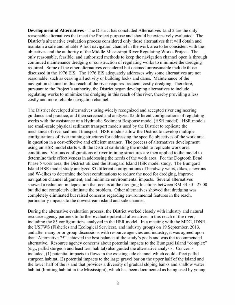
Development of Alternatives - The District has concluded Alternatives 1and 2 are the only reasonable alternatives that meet the Project purpose and should be extensively evaluated. The District’s alternative evaluation process considered only those alternatives that will obtain and maintain a safe and reliable 9-foot navigation channel in the work area to be consistent with the objectives and the authority of the Middle Mississippi River Regulating Works Project. The only reasonable, feasible, and authorized methods to keep the navigation channel open is through continued maintenance dredging or construction of regulating works to minimize the dredging required. Some of the other alternatives considered but deemed unreasonable include those discussed in the 1976 EIS. The 1976 EIS adequately addresses why some alternatives are not reasonable, such as ceasing all activity or building locks and dams. Maintenance of the navigation channel in this reach of the river requires frequent, costly dredging. Therefore, pursuant to the Project’s authority, the District began developing alternatives to include regulating works to minimize the dredging in this reach of the river, thereby providing a less costly and more reliable navigation channel. The District developed alternatives using widely recognized and accepted river engineering guidance and practice, and then screened and analyzed 85 different configurations of regulating works with the assistance of a Hydraulic Sediment Response model (HSR model). HSR models are small-scale physical sediment transport models used by the District to replicate the mechanics of river sediment transport. HSR models allow the District to develop multiple configurations of river training structures for addressing the specific objectives of the work area in question in a cost-effective and efficient manner. The process of alternatives development using an HSR model starts with the District calibrating the model to replicate work area conditions. Various configurations of river training structures are then applied to the model to determine their effectiveness in addressing the needs of the work area. For the Dogtooth Bend Phase 5 work area, the District utilized the Bumgard Island HSR model study. The Bumgard Island HSR model study analyzed 85 different configurations of bendway weirs, dikes, chevrons and W-dikes to determine the best combinations to reduce the need for dredging, improve navigation channel alignment, and minimize environmental impacts. Several alternatives showed a reduction in deposition that occurs at the dredging locations between RM 34.50 - 27.00 but did not completely eliminate the problem. Other alternatives showed that dredging was completely eliminated but raised concerns regarding environmental features in the reach, particularly impacts to the downstream island and side channel. During the alternative evaluation process, the District worked closely with industry and natural resource agency partners to further evaluate potential alternatives in this reach of the river, including the 85 configurations analyzed in the HSR model. In a meeting with the MDC, IDNR, the USFWS (Fisheries and Ecological Services), and industry groups on 19 September, 2013, and after many prior group discussions with resource agencies and industry, it was agreed upon that “Alternative 75” achieved the best balance of the study’s goals and was the recommended alternative. Resource agency concerns about potential impacts to the Bumgard Island “complex” (e.g., pallid sturgeon and least tern habitat) also guided the alternative analysis. Concerns included, (1) potential impacts to flows in the existing side channel which could affect pallid sturgeon habitat, (2) potential impacts to the large gravel bar on the upper half of the island and the lower half of the island that provides a diversity of gradual sloping banks and shallow water habitat (limiting habitat in the Mississippi), which has been documented as being used by young

9
of year pallid sturgeon, and (3) an overall reduction in the size of the island. Alternative 75 showed reduction in sedimentation between RM 34.50 - 27.00 while appearing to avoid impacts to Bumgard Island and its side channel. Note that while there was a reduction in sedimentation, the bendway weirs will not completely eliminate the need to dredge at RM 33.00 or RM 28.00. This process resulted in the Proposed Action, which reasonably met the Project purpose while also avoiding/minimizing environmental impacts. Based on this extensive evaluation of alternatives, the District determined that the Proposed Action was the only reasonable alternative to dredging at the current level and that more extensive analysis of any of the additional configurations of regulating works in the EA would be unnecessary. Detailed information on the Alternatives development process, partner agency coordination, and alternatives eliminated from further consideration can be found in the on-line HSR model study report, see Bumgard Island at: http://mvs-wc.mvs.usace.army.mil/arec/Reports_HSR_Model.html
10
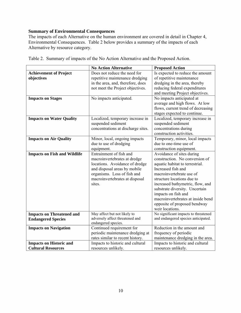
Summary of Environmental Consequences The impacts of each Alternative on the human environment are covered in detail in Chapter 4, Environmental Consequences. Table 2 below provides a summary of the impacts of each Alternative by resource category. Table 2. Summary of impacts of the No Action Alternative and the Proposed Action.
No Action Alternative Proposed Action Achievement of Project objectives
Does not reduce the need for repetitive maintenance dredging in the area, and, therefore, does not meet the Project objectives.
Is expected to reduce the amount of repetitive maintenance dredging in the area, thereby reducing federal expenditures and meeting Project objectives.
Impacts on Stages No impacts anticipated. No impacts anticipated at average and high flows. At low flows, current trend of decreasing stages expected to continue.
Impacts on Water Quality Localized, temporary increase in suspended sediment concentrations at discharge sites.
Localized, temporary increase in suspended sediment concentrations during construction activities.
Impacts on Air Quality Minor, local, ongoing impacts due to use of dredging equipment.
Temporary, minor, local impacts due to one-time use of construction equipment.
Impacts on Fish and Wildlife Entrainment of fish and macroinvertebrates at dredge locations. Avoidance of dredge and disposal areas by mobile organisms. Loss of fish and macroinvertebrates at disposal sites.
Avoidance of sites during construction. No conversion of aquatic habitat to terrestrial. Increased fish and macroinvertebrate use of structure locations due to increased bathymetric, flow, and substrate diversity. Uncertain impacts on fish and macroinvertebrates at inside bend opposite of proposed bendway weir locations.
Impacts on Threatened and Endangered Species
May affect but not likely to adversely affect threatened and endangered species.
No significant impacts to threatened and endangered species anticipated.
Impacts on Navigation Continued requirement for periodic maintenance dredging at rates similar to recent history.
Reduction in the amount and frequency of periodic maintenance dredging in the area.
Impacts on Historic and Cultural Resources
Impacts to historic and cultural resources unlikely.
Impacts to historic and cultural resources unlikely.

11
3. Affected Environment This section presents details on the historic and existing conditions of resources within the area that would potentially be affected by Project-related activities. The section is broken into four resource categories: physical resources, biological resources, socioeconomic resources, and historic and cultural resources. This section does not address impacts of the Alternatives, but provides a background against which Alternatives can be compared in Section 4, Environmental Consequences.
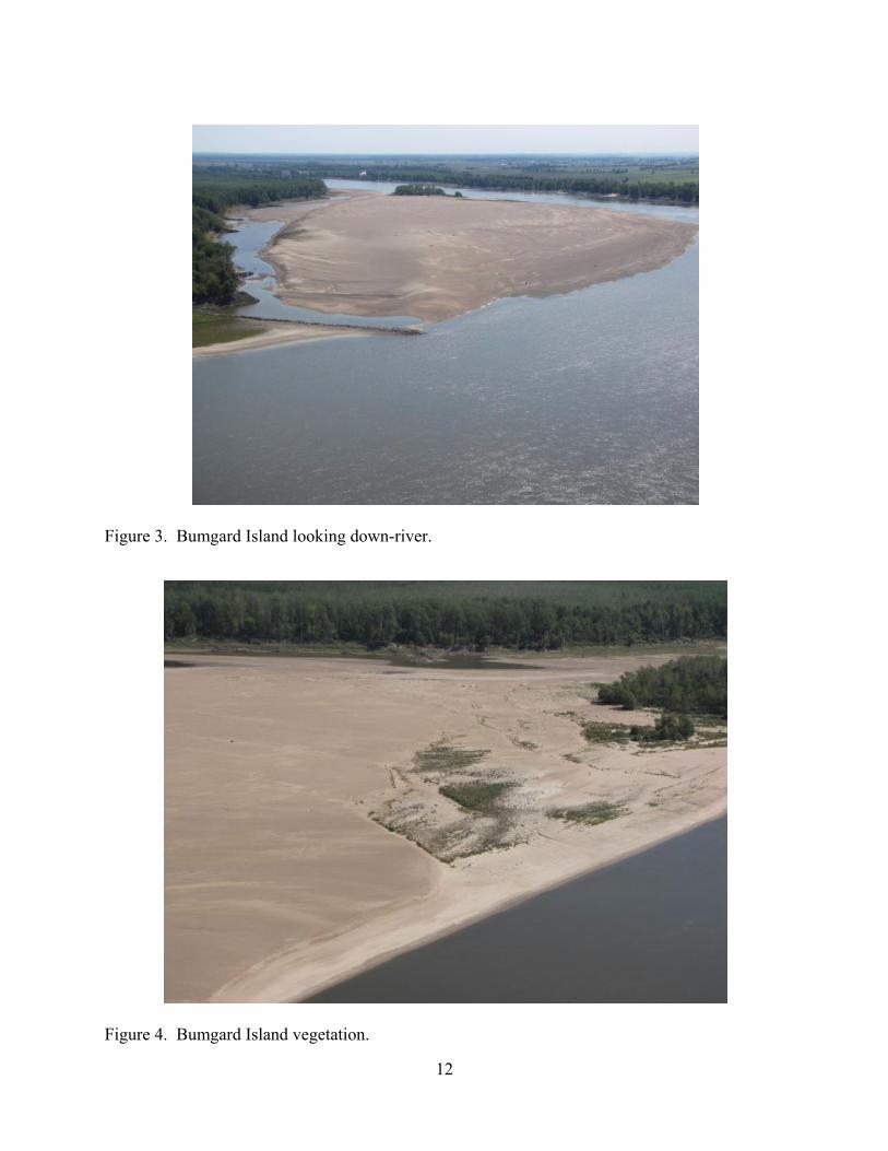
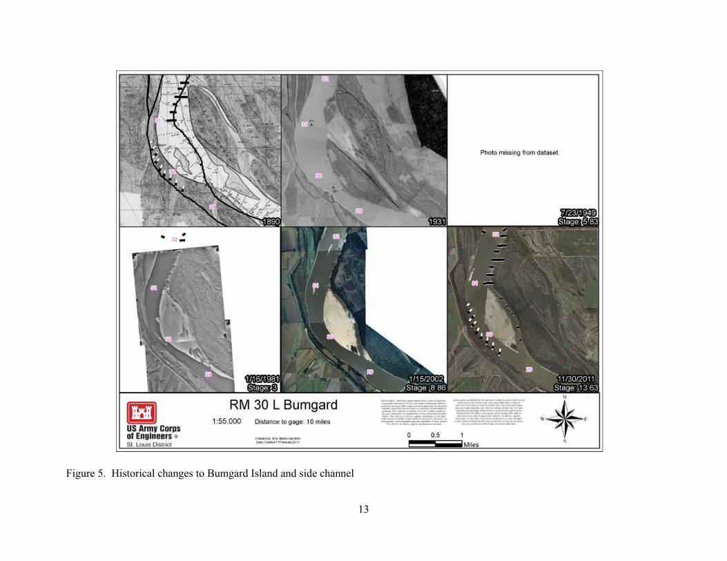
Physical Resources General - Bumgard Island is one of only two side channels in the lower 80 miles of the MMR that is not disconnected from the river by a closing structure at its upstream end, and maintains flow-through conditions during most river stages (Figure 3). There is a dike immediately upstream of the inlet (31.1 L) and five hard points along the left descending bank of the side channel (30.5 L, 30.3 L, 29.8 L, 29.3 L, and 29.5 L). This lateral connectivity influences species diversity, population densities, fish dispersal, as well as predator-prey interactions of fishes and other wildlife. Because of this connectivity, natural resource agencies have been cautious about adding additional river training structures in this area of the river. Substrate composition in the side channel is composed predominately of cobble, gravel, and sand. The hard points create small scour holes off their tips. However, the remainder of the side channel is shallow. On occasion, sediment deposition disconnects this side channel from the main channel during low river stages. This results mainly from depositions of gravel in the upstream portion of the side channel and sand deposition in the downstream portion. At times, gravel extends from the downstream side of the dike to the island, which also prohibits access to the side channel at lower river stages. Water velocity in this side channel can be high during average to high river flows (recorded in excess of 4.6 ft/s). Woody structure inside the side channel is scarce and depth diversity is considered moderately poor. The terrestrial component of the island is predominantly sand with patchy areas of vegetation (Figure 4). In general, MMR side channels and islands do not support extensive plant communities because the range of the river stage is very wide, fluctuating more than twenty feet in an annual cycle, thus not providing the conditions necessary for plants to take root. The island has gone through a number of changes over the years, not only due to the natural dynamic nature of big river systems, but from human attempts to stabilize this area of the Mississippi River for navigation purposes (Figure 5).
12
Figure 3. Bumgard Island looking down-river.
Figure 4. Bumgard Island vegetation.
13
Figure 5. Historical changes to Bumgard Island and side channel

14
Stages - Rated gages, locations where both discharge and stage is collected and combined to create a rating curve, are good sources of long term stage and discharge data. Only three rated gages exist on the MMR: St. Louis, Chester and Thebes. Due to backwater effects from the Ohio River the gage at Thebes is not a good indicator of changes in stage over time. Throughout the period of record (1866 to present) the two agencies that have been responsible for the collection of gage data on the MMR are the Corps of Engineers and U.S. Geological Survey (USGS). The USGS has been the primary agency responsible for stream gaging since 1933. Due to discrepancies in methodology and instrumentation used by the Corps and USGS it is impossible to analyze the entire period of record with confidence; therefore only data collected by the USGS will be used here to describe the changes in stage for fixed discharges over time (Watson et al. 2013a; Watson et al. 2013b; Huizinga 2009; Munger et al. 1976). Stages have been decreasing over time for flows below 200,000 cfs at the St. Louis gage (Figure 6). For other in-bank flows between 200,000 cfs and 500,000 cfs there has been no change over time. There is a slight upward but statistically insignificant trend for stages at the overbank flow of 700,000 cfs. Stages at Chester for lower in-bank flows up to 200,000 cfs have decreased with time. There was no change in stages at flows of 200,000 cfs and 400,000 cfs. There was a slightly increasing trend at 300,000 cfs. For overbank flows of 500,000 cfs and 700,000 cfs, there were slight increasing trends observed at the Chester gage. In general, at both the St. Louis and Chester gages there has been a decrease in stage over time for lower flows, no change in stages over time for flows between midbank and bankfull, and a slight increase in stages for high overbank flows (Huizinga 2009). Huizinga (2009) and Watson et al. (2013a) attributed the slight increase in out of bank flows to the construction of levees and the disconnection of the river from the floodplains. Both Watson et al. (2013a) and Huizinga (2009) observed a shift occurring in the out of bank flows in the mid-1960s and attributed it to the completion of the Alton to Gale levee system which paralleled the entire MMR. At these high flows navigation structures are submerged by 7 to 10 feet.

15
Figure 6. Stage for a given discharge range with time from measurements made at the streamgages at (A) St. Louis, Missouri, and (B) Chester, Illinois, on the MMR (from Huizinga 2009).

16
Water Quality – Consideration of water quality encompasses a wide range of physical, hydrologic, and biological parameters. Watershed influences, including tributary streams, point and non-point pollution sources, flow alteration due to navigation structures, and drought and flood events all influence water quality. Variations in land use practices, cover types, and watershed area will determine the level and type of sediment, nutrient, and contaminant inputs into the Mississippi River and its tributaries. The Mississippi River has a long history of water quality impairment due to contamination from industrial, residential, municipal, and agricultural sources. Recent changes in wastewater treatment laws and technologies, regulation of point source discharges, and changes in public awareness have contributed to overall improvements in water quality. Section 303(d) of the Clean Water Act requires states to generate lists of impaired water bodies every two years. Impaired water bodies are those that do not meet state water quality standards for the water bodies’ designated uses. On the 2012 303(d) list for Illinois, the Mississippi River in the vicinity of the work area was listed as impaired for fish consumption due to mercury and polychlorinated biphenyls (PCB) contamination, impaired for public and food processing water supplies due to manganese concentration, and impaired for primary contact recreation due to fecal coliform bacteria contamination. The Mississippi River is not on the 2012 303(d) list for Missouri. Illinois has fish consumption advisories for the Mississippi River for channel catfish (one meal per week), common carp (one meal per week), and sturgeon (one meal per month) due to PCB contamination. Missouri has fish consumption advisories for the Mississippi River for shovelnose sturgeon (1 per month) due to PCB and chlordane contamination, and for flathead catfish, blue catfish, channel catfish, and common carp (1 per week) due to PCB, chlordane, and mercury contamination. Air Quality – The Clean Air Act requires the Environmental Protection Agency (EPA) to set National Ambient Air Quality Standards for six criteria air pollutants: ozone, particulate matter, carbon monoxide, nitrogen oxides, sulfur dioxide, and lead. EPA regulates these pollutants by developing human health-based or environmentally-based permissible pollutant concentrations. EPA then publishes the results of air quality monitoring, designating areas as meeting (attainment) or not meeting (nonattainment) the standards. Scott and Mississippi Counties, Missouri and Alexander County, Illinois are designated as attainment areas for all six criteria air pollutants (USEPA 2013). Biological Resources Fish and Wildlife – The changes in fish and wildlife habitat in the Mississippi River Basin that have occurred over the past 200 years are well documented. Many studies have analyzed the historic changes in habitat in the Mississippi River Basin from pre-colonization times to present day (Simons et al. 1974; UMRBC 1982; Theiling et al. 2000; WEST 2000; and Heitmeyer 2008). A variety of actions have impacted the makeup of the Mississippi River basin since colonization including urbanization, agriculture, levee construction, dam construction, and river training structure placement. Many of the changes in the MMR planform are attributable to improvements made for navigation including river training structure placement and associated sedimentation patterns.
17
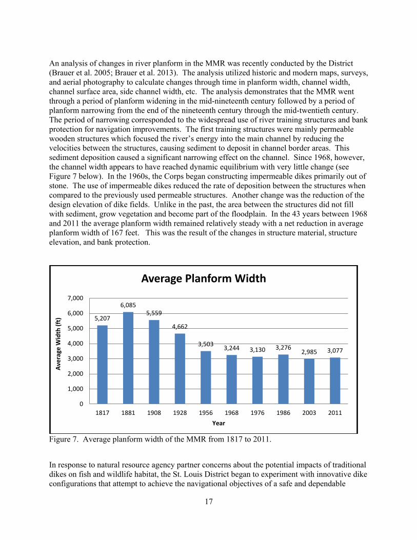
An analysis of changes in river planform in the MMR was recently conducted by the District (Brauer et al. 2005; Brauer et al. 2013). The analysis utilized historic and modern maps, surveys, and aerial photography to calculate changes through time in planform width, channel width, channel surface area, side channel width, etc. The analysis demonstrates that the MMR went through a period of planform widening in the mid-nineteenth century followed by a period of planform narrowing from the end of the nineteenth century through the mid-twentieth century. The period of narrowing corresponded to the widespread use of river training structures and bank protection for navigation improvements. The first training structures were mainly permeable wooden structures which focused the river’s energy into the main channel by reducing the velocities between the structures, causing sediment to deposit in channel border areas. This sediment deposition caused a significant narrowing effect on the channel. Since 1968, however, the channel width appears to have reached dynamic equilibrium with very little change (see Figure 7 below). In the 1960s, the Corps began constructing impermeable dikes primarily out of stone. The use of impermeable dikes reduced the rate of deposition between the structures when compared to the previously used permeable structures. Another change was the reduction of the design elevation of dike fields. Unlike in the past, the area between the structures did not fill with sediment, grow vegetation and become part of the floodplain. In the 43 years between 1968 and 2011 the average planform width remained relatively steady with a net reduction in average planform width of 167 feet. This was the result of the changes in structure material, structure elevation, and bank protection.
Figure 7. Average planform width of the MMR from 1817 to 2011.
In response to natural resource agency partner concerns about the potential impacts of traditional dikes on fish and wildlife habitat, the St. Louis District began to experiment with innovative dike configurations that attempt to achieve the navigational objectives of a safe and dependable
5,207
6,085 5,559
4,662
3,503 3,244 3,130 3,276 2,985 3,077
0
1,000
2,000
3,000
4,000
5,000
6,000
7,000
1817 1881 1908 1928 1956 1968 1976 1986 2003 2011
Aver
age
Wid
th (f
t)
Year
Average Planform Width
18
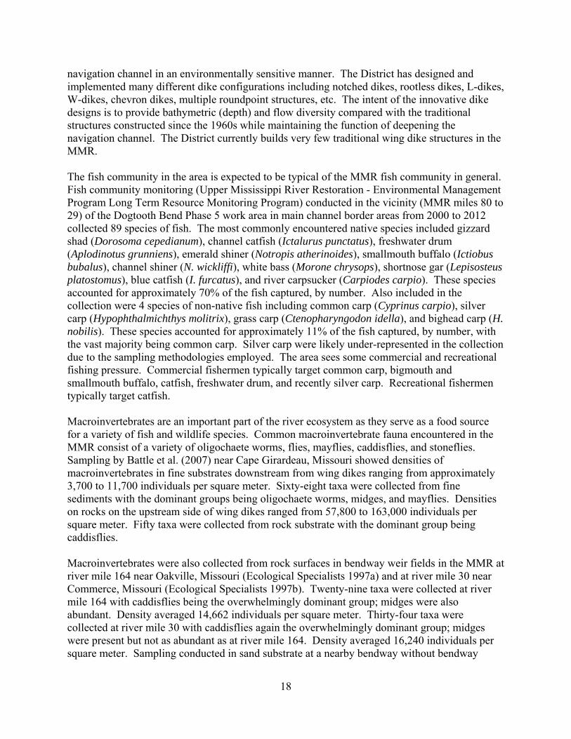
navigation channel in an environmentally sensitive manner. The District has designed and implemented many different dike configurations including notched dikes, rootless dikes, L-dikes, W-dikes, chevron dikes, multiple roundpoint structures, etc. The intent of the innovative dike designs is to provide bathymetric (depth) and flow diversity compared with the traditional structures constructed since the 1960s while maintaining the function of deepening the navigation channel. The District currently builds very few traditional wing dike structures in the MMR. The fish community in the area is expected to be typical of the MMR fish community in general. Fish community monitoring (Upper Mississippi River Restoration - Environmental Management Program Long Term Resource Monitoring Program) conducted in the vicinity (MMR miles 80 to 29) of the Dogtooth Bend Phase 5 work area in main channel border areas from 2000 to 2012 collected 89 species of fish. The most commonly encountered native species included gizzard shad (Dorosoma cepedianum), channel catfish (Ictalurus punctatus), freshwater drum (Aplodinotus grunniens), emerald shiner (Notropis atherinoides), smallmouth buffalo (Ictiobus bubalus), channel shiner (N. wickliffi), white bass (Morone chrysops), shortnose gar (Lepisosteus platostomus), blue catfish (I. furcatus), and river carpsucker (Carpiodes carpio). These species accounted for approximately 70% of the fish captured, by number. Also included in the collection were 4 species of non-native fish including common carp (Cyprinus carpio), silver carp (Hypophthalmichthys molitrix), grass carp (Ctenopharyngodon idella), and bighead carp (H. nobilis). These species accounted for approximately 11% of the fish captured, by number, with the vast majority being common carp. Silver carp were likely under-represented in the collection due to the sampling methodologies employed. The area sees some commercial and recreational fishing pressure. Commercial fishermen typically target common carp, bigmouth and smallmouth buffalo, catfish, freshwater drum, and recently silver carp. Recreational fishermen typically target catfish. Macroinvertebrates are an important part of the river ecosystem as they serve as a food source for a variety of fish and wildlife species. Common macroinvertebrate fauna encountered in the MMR consist of a variety of oligochaete worms, flies, mayflies, caddisflies, and stoneflies. Sampling by Battle et al. (2007) near Cape Girardeau, Missouri showed densities of macroinvertebrates in fine substrates downstream from wing dikes ranging from approximately 3,700 to 11,700 individuals per square meter. Sixty-eight taxa were collected from fine sediments with the dominant groups being oligochaete worms, midges, and mayflies. Densities on rocks on the upstream side of wing dikes ranged from 57,800 to 163,000 individuals per square meter. Fifty taxa were collected from rock substrate with the dominant group being caddisflies. Macroinvertebrates were also collected from rock surfaces in bendway weir fields in the MMR at river mile 164 near Oakville, Missouri (Ecological Specialists 1997a) and at river mile 30 near Commerce, Missouri (Ecological Specialists 1997b). Twenty-nine taxa were collected at river mile 164 with caddisflies being the overwhelmingly dominant group; midges were also abundant. Density averaged 14,662 individuals per square meter. Thirty-four taxa were collected at river mile 30 with caddisflies again the overwhelmingly dominant group; midges were present but not as abundant as at river mile 164. Density averaged 16,240 individuals per square meter. Sampling conducted in sand substrate at a nearby bendway without bendway
19
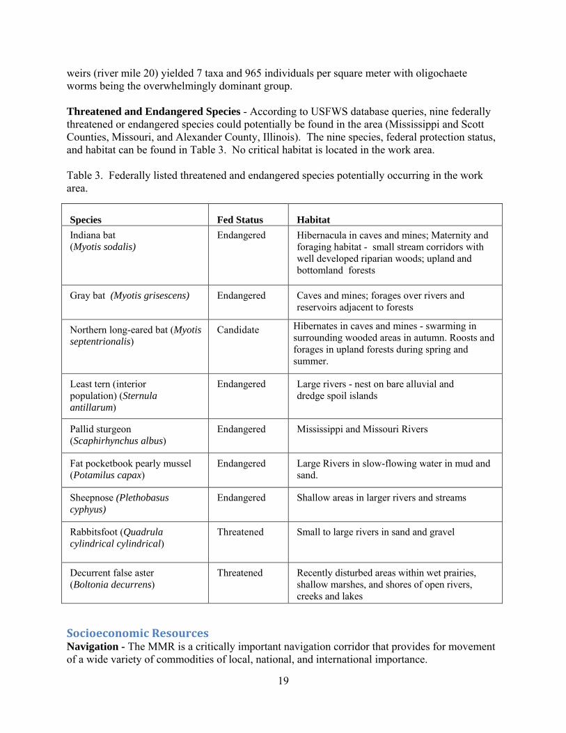
weirs (river mile 20) yielded 7 taxa and 965 individuals per square meter with oligochaete worms being the overwhelmingly dominant group. Threatened and Endangered Species - According to USFWS database queries, nine federally threatened or endangered species could potentially be found in the area (Mississippi and Scott Counties, Missouri, and Alexander County, Illinois). The nine species, federal protection status, and habitat can be found in Table 3. No critical habitat is located in the work area. Table 3. Federally listed threatened and endangered species potentially occurring in the work area.
Species Fed Status Habitat Indiana bat (Myotis sodalis)
Endangered Hibernacula in caves and mines; Maternity and foraging habitat - small stream corridors with well developed riparian woods; upland and bottomland forests
Gray bat (Myotis grisescens) Endangered Caves and mines; forages over rivers and reservoirs adjacent to forests
Northern long-eared bat (Myotis septentrionalis)
Candidate Hibernates in caves and mines - swarming in surrounding wooded areas in autumn. Roosts and forages in upland forests during spring and summer.
Least tern (interior population) (Sternula antillarum)
Endangered Large rivers - nest on bare alluvial and dredge spoil islands
Pallid sturgeon (Scaphirhynchus albus)
Endangered Mississippi and Missouri Rivers
Fat pocketbook pearly mussel (Potamilus capax)
Endangered Large Rivers in slow-flowing water in mud and sand.
Sheepnose (Plethobasus cyphyus)
Endangered Shallow areas in larger rivers and streams
Rabbitsfoot (Quadrula cylindrical cylindrical)
Threatened Small to large rivers in sand and gravel
Decurrent false aster (Boltonia decurrens)
Threatened Recently disturbed areas within wet prairies, shallow marshes, and shores of open rivers, creeks and lakes
Socioeconomic Resources Navigation - The MMR is a critically important navigation corridor that provides for movement of a wide variety of commodities of local, national, and international importance.
20
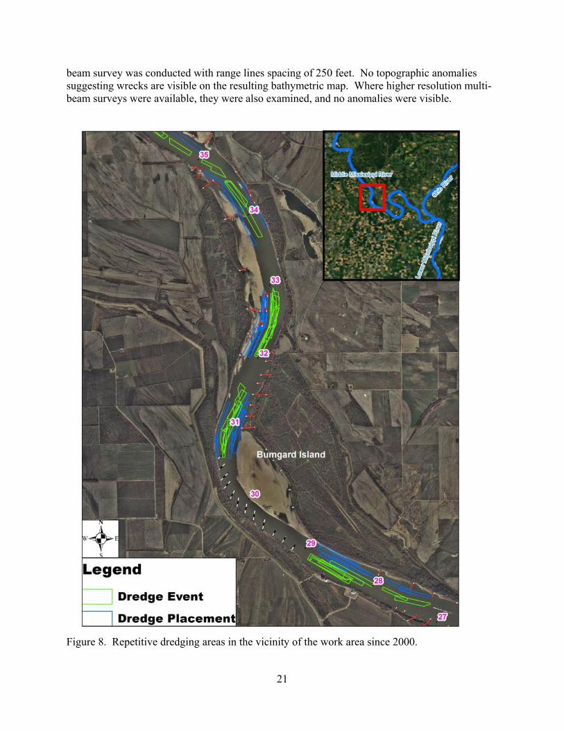
Approximately 106 million tons of cargo passed through the MMR in 2011, the most recent year with data available (USACE 2013). Food and farm products (37 million tons), coal (26 million tons), crude materials (14 million tons), fertilizers (12 million tons), and petroleum products (10 million tons) accounted for the majority (93%) of shipments in 2011. Dredging in the Mississippi River is commonly used to provide required navigation dimensions of depth, width, alignment, or a combination thereof. In this area repetitive channel maintenance dredging was required in four different areas along the reach (Figure 8). The sandbar located along the right descending bank near RM 35.00 to 31.80 has grown in size between RM 34.50 to 33.80 and RM 32.90 to 31.50. Bumgard Island, located along the left descending bank between RM 31.00 to 29.00, has also grown causing shoaling between RM 31.40 to 30.60. Downstream of Bumgard Island on the left descending bank, shoaling has occurred between RM 28.90 to 27.20. On average, dredging in this reach has been required nearly every year from 2001 to 2012 at an average cost of approximately $470,000 per year. During this twelve year period, the following total estimates of dredge material quantities in cubic yards (cy) and costs were calculated:
• RM 34.50 to 33.80: 315,516 cy at a cost of $408,414 • RM 32.90 to 31.50: 946,670 cy at a cost of $2,328,255 • RM 31.40 to 30.60: 639,035 cy at a cost of $973,146 • RM 28.90 to 27.20: 1,201,738 cy at a cost of $1,930,945.
Historic and Cultural Resources The bankline of the Bumgard Reach has significantly changed in the past century and a half. The locations of seven of the in-water features were on land as late as 1908. Conversely, due to the Mississippi’s migration most of the other feature locations were closer to the middle of the channel than they are now. It was not until the first quarter of the twentieth century that the shoreline stabilized near its current position. The construction of revetments and river regulating structures, including those used to close the western branch of the river (i.e., the Doolan Slough), were responsible for the stabilization. Any cultural resources located on land eroded prior to that stabilization would have been destroyed by the bankline recession and any shipwreck located there would post date it. During the summer of 1988 when the Mississippi River was at its lowest level on record, the St. Louis District Corps of Engineers conducted an aerial survey of exposed wrecks on 300 miles of the Mississippi River, within the St. Louis District, between Saverton, Missouri, and the mouth of the Ohio River. The nearest observed wreck to the work area features was located approximately at river mile 33.5R within the reach. The wreck, however, was sighted on the opposite bank and downstream from the nearest feature (Weir 32.2L), while the nearest feature on the same bank is approximately two miles downstream. The Bumgard Reach has been regularly dredged over the years, and it is likely that any unrecorded wreckage located in the path of those dredge events was destroyed and removed during the process. Most of the proposed structures are next to dredged channels, which probably resulted in channel slump and sediment reworking in these locations. The river bed in the area is surveyed every two to three years, with the latest survey having been completed on July 20, 2011, or June 21, 2012 (depending upon the river section). The single-
21
beam survey was conducted with range lines spacing of 250 feet. No topographic anomalies suggesting wrecks are visible on the resulting bathymetric map. Where higher resolution multi-beam surveys were available, they were also examined, and no anomalies were visible.
Figure 8. Repetitive dredging areas in the vicinity of the work area since 2000.

22
4. Environmental Consequences The Environmental Consequences Section of this report details the impacts of the Alternatives on the human environment. The section is organized by resource, in the same order in which they were covered in Section 3, Affected Environment. Within each resource category, impacts will be broken out by Alternative. The No Action Alternative consists of not constructing any new river training structures in the area but continuing to maintain the existing river training structures. Dredging would continue at levels similar to recent history as needed to address the shoaling issue in the area. The Proposed Action consists of construction of two bendway weirs near RM 34.00, four bendway weirs near RM 32.00, a dike at RM 31.60 and two bendway weirs near RM 31.00.
Physical Resources Stages Impacts of the No Action Alternative on Stages – Stages in the vicinity of the work area and the MMR would be expected to be similar to current conditions under the No Action Alternative. Impacts of the Proposed Action on Stages – With implementation of the Proposed Action, stages at average and high flows both in the vicinity of the work area and on the MMR are expected to be similar to current conditions. An abundance of research has been conducted analyzing the impacts of river training structures on water surfaces dating to the 1940s. This research has analyzed historic gage data, velocity data, and cross sectional data. Physical and numerical models have also been used to determine the effects of dikes on water surfaces. It should be noted that some published research supports the contention that river training structures raise flood heights. A summary of research on the effects of river training structures on flood heights can be found in Appendix A. Based on an analysis of this research by the Corps and other external reviewers, the District has concluded that river training structures do not affect water surface elevations at higher flows. With respect to water surface elevations at low flows, analysis of the data shows a trend of decreasing stages over time. This decrease could be a result of river training structure placement and/or a decrease in the sediment load in the river due to construction of reservoirs on Mississippi River tributaries (Huizinga 2009). The same conclusion regarding decreasing stages at low flows was reached in the 1976 Regulating Works EIS (USACE 1976). The 1976 EIS concluded that, as a result of stage decreases, many of the remaining side channels in the MMR might be lost at some point in the future due to sedimentation. While much research has been performed on the impacts of river training structures at high flows, similar research has not been performed on the impacts at low flows. However, since the 1976 EIS, there has been an increasing recognition of the importance of side channel habitat on the MMR and increased emphasis on side channel restoration. Through the District’s Biological Opinion Program, (http://mvs-wc.mvs.usace.army.mil/arec/Bio_Op.html, Avoid and Minimize Program (http://mvs-wc.mvs.usace.army.mil/arec/AM.html), innovative river training structure design, and other restoration initiatives, side channel restoration and preservation on the MMR has occurred and will continue to occur for the foreseeable future, resulting in a substantial preservation of the side channels that existed in 1976. While the Proposed Action may have
23
some minor local effect on water surface elevations at lower flows, any impacts locally or cumulatively are being minimized through the use of innovative river training structures and through other District programs, which have currently seen success in restoring and preserving side channels affected by river training structures. Water Quality Impacts of the No Action Alternative on Water Quality – Periodic dredging activities would continue to cause re-suspension of river sediments at the point of discharge, causing turbidity, increased suspended sediment concentration, and decreased light penetration. The impact would be localized and would dissipate quickly. Dredged sediments in the area are typically sand with little associated fines and would, therefore, not be expected to release contaminants into the water column at concentrations that alone or in combination with other contaminants would cause toxic effects to aquatic organisms. Impacts of the Proposed Action on Water Quality – Construction activities would cause temporary increases in turbidity and suspended sediment concentrations in the immediate vicinity of the structure locations. The impact would be localized and would dissipate quickly. Sediments in the area are typically sand with little associated fines and would, therefore, not be expected to release contaminants into the water column at concentrations that alone or in combination with other contaminants would cause toxic effects to aquatic organisms. The proposed structures are designed to change the sedimentation patterns in the area and would, therefore, cause some minor temporary changes in the suspended sediment concentration in the area. Limestone material used for construction could potentially affect local water chemistry (e.g., alkalinity, hardness, and pH). However, given the prevalence of limestone in the watershed geology and the quick dissipation of any associated fine materials in the water column, the impact is likely to be negligible. Alternative 75 showed a reduction in sedimentation between RM 34.50 - 27.00 although the work would not completely eliminate the need to dredge at RM 33.00 or RM 28.00 The District is currently in the process of obtaining authorization for the work under sections 404 and 401 of the Clean Water Act. All permits necessary for completion of the work have been applied for and will be obtained prior to implementation. Air Quality Impacts of the No Action Alternative on Air Quality – Air quality in the vicinity of the work area would be expected to be similar to current conditions. Equipment used for repetitive dredging activities would generate emissions on an occasional, ongoing basis from the use of petroleum products. Impacts would be minor and local in nature. Impacts of the Proposed Action on Air Quality – Air quality in the vicinity of the work area would be expected to be similar to current conditions. Equipment used for construction activities would generate emissions from the use of petroleum products but impacts would be temporary, minor, and local in nature.

24
Biological Resources Fish and Wildlife Impacts of the No Action Alternative on Fish and Wildlife – Periodic maintenance dredging and dredged material disposal operations would have the potential to affect fish and wildlife resources through direct removal of individual organisms (entrainment) at the dredging site. The degree to which fish and wildlife resources are impacted is largely a factor of the density of the organisms in the area of the dredge cut at the time of dredging operations. Macroinvertebrate densities tend to increase with greater sediment stability, lower water velocities, and higher silt and organic matter concentrations (Galat et al. 2005). Given the shifting nature of the sediments, high water velocities, and low silt concentrations in the main channel of the MMR, the area is not ideal habitat for colonization by bottom-dwelling macroinvertebrates (Koel and Stevenson 2002; Sauer 2004), but likely provides habitat for low densities to exist. Various fish species likely utilize the habitat as well and could be impacted at dredge sites. The Corps’ Engineer Research and Development Center published a Technical Note in 1998 that summarized existing literature regarding potential impacts to aquatic organisms from dredging operations (Reine and Clarke 1998). Fish entrainment rates varied widely among species and studies and were reported as ranging from <0.001 to 0.594 fish/cubic yard of material dredged. The St. Louis District recently contracted a dredge monitoring study for the Chain of Rocks East Canal Levee Project (Blodgett 2010). The project involved the use of sand dredged from the main channel of the MMR for construction of a seepage berm on the Chain of Rocks Canal Levee. Because there was concern that dredging operations could entrain endangered pallid sturgeon in the project area, monitoring of dredged material was conducted to quantify impacts of dredging operations on the fish community. Approximately 1,000,000 cubic yards of material was dredged during the project, and fish entrainment monitoring was conducted during roughly 15% of the operation. No pallid sturgeon were captured during the study. However, nine shovelnose sturgeon and 38 other fish representing 6 species were captured during the study. Aside from direct impacts from dredge entrainment, fish and wildlife could also be impacted directly by disposal of dredged material. Organisms in the vicinity of the disposal area could be affected by changes in water quality including increased suspended solids and could be covered by settling sediments. Increased suspended solids in the water column could cause abrasion of body and respiratory surfaces. Most mobile organisms in the vicinity of the disposal location, however, would likely avoid the area during dredging operations. Changes in water quality would be short-lived and localized in extent. Recovery of fish and wildlife resources at the dredge and disposal location occurs over a period of weeks, months, or years, depending on the species in question (USACE 1983). Areas with unstable sediment such as those in the main channel of the MMR are much more likely to have associated fish and wildlife species more adapted to physically stressful conditions and, therefore, would be more likely to withstand stresses imposed by dredging and disposal and recover more quickly (USACE 1983). In summary, the amount of dredging going forward would remain similar to what has been experienced recently. Dredging and disposal impacts would include potential entrainment of

25
aquatic species as well as behavioral changes associated with noise and turbidity levels. Some mortality of individual fish and invertebrates would be anticipated. Overall impacts to the fish and invertebrate communities in the area would be expected to be localized, minor, and short-term in nature. Impacts of the Proposed Action on Fish and Wildlife General – As detailed in Section 2, Alternatives Including the Proposed Action, during coordination with fish and wildlife resource agency partners, concerns were expressed that a number of the proposed alternatives could result in impacts to Bumgard Island or the amount of flow in the side channel. Therefore, features were specifically chosen that showed a reduction in sedimentation between RM 34.5- 27.00 while avoiding impacts to Bumgard Island and its side channel. The Proposed Action was chosen to avoid any substantial changes in velocity patterns that could alter the large gravel bar on the upper half of the island, as well as the diversity of gradually sloping banks and shallow water habitat (limiting habitat in the MMR) along the lower half of the island. The Proposed Action is not anticipated to affect this habitat, nor affect the size of the island. In order to ensure that Bumgard Island and its side channel are not negatively impacted, the reach will be monitored prior to and extensively after construction to evaluate habitat changes. During coordination with partner agencies it was agreed that if monitoring showed unanticipated changes in hydrodynamic parameters in the island/side channel area, further coordination would occur to determine the proper course of action. Dike Effects – The hydrodynamics around training structures are complex and vary greatly depending upon the type of training structure in question - and where it is located within the river channel. A traditional wing dike constructed perpendicular to flow and tied in to the river bank would be expected to deepen the adjacent navigation channel, cause a scour hole to develop at the dike tip, and cause sediment accretion downstream from the structure near the river bank. Shields (1995) studied 26 groups of traditional dikes in the Lower Mississippi River and determined that the aquatic volume and area of associated low-velocity habitat (important aquatic habitat) were reduced by 38% and 17%, respectively. Most of the changes occurred shortly after construction, and after initial adjustment, habitat area and volume fluctuated around a condition of dynamic equilibrium. As detailed in Section 3 above, dike construction on the MMR has, historically, caused a narrowing of the river planform over time due to this sediment accretion process followed by growth of terrestrial vegetation. However, the analysis of changes in river planform in the MMR recently conducted by the District (Brauer et al. 2005; Brauer et al. 2013) demonstrates that channel widths in the MMR appear to have reached a state of dynamic equilibrium where very little conversion to terrestrial habitat is occurring subsequent to river training structure placement. Regardless of the specific configuration of the river training structures utilized, rock structures can provide improved habitat for fish by providing areas of reduced flow, a more diverse substrate, and additional cover. In addition, they can provide more suitable substrate for a wide variety of benthic organisms. Barko et al. (2004) found that species richness was greatest at wing dikes in the MMR for both adult and age-0 fishes when compared with main channel borders. However, they did find differences in species composition. Hartman and Titus (2009) studied dikes and reference sites on the Kanawha River, West Virginia and found that fish used
26
dikes as much as or more than sites without dikes and that differences in taxonomic composition occurred. A study of larval fish use of dike structures on the Kanawha River found significantly higher capture rates of larval fish at dike sites than at reference sites (Niles and Hartman 2009). The difference in capture rates was attributed to reduced velocities provided by dikes. On the Upper Mississippi River, Madejczyk et al. (1998) found that fish abundance and diversity measures differed little among channel border habitat types in Pool 6, but significantly larger fish were present at locations with structure (wing dikes, woody snags) than at sites with bare shorelines. Riprapped shorelines had fish assemblages different from those in river sections containing only instream artificial rocky structures. Similar results were found in Pool 24 by Farabee (1986) where revetted main channel border sites had higher fish abundance than natural shorelines and larger revetment stone supported larger numbers of fish than small, tightly packed revetment stone. On the Lower Mississippi River, Pennington et al. (1983) found that the number of fish species taken from natural and revetted banks were similar. However, the relative abundance of individual species was different in the two habitats. Limited sampling conducted by the St. Louis District at an offset dike field in the MMR (USACE 2012) showed an increase in bathymetric, flow, and sediment diversity from pre-construction to post-construction and showed similar fish community composition pre- and post-project. Schneider (2012) investigated fish community and habitat changes associated with chevron dike construction in the MMR St. Louis Harbor and found increased fish use and increased habitat diversity associated with chevrons dikes as compared to pre-construction conditions and open water control sites. In summary, the dike is not expected to result in a loss of aquatic habitat due to sedimentation and conversion to terrestrial habitat. The structure is expected to increase bathymetric, flow, and sediment diversity in the immediate vicinity of the work area. Fish response to these changes in habitat is difficult to predict quantitatively, but, based on prior studies, fish use of the area may increase after construction related disturbance ends. Bendway Weir Effects - Bendway weirs are designed to reduce dredging requirements in river bends by controlling point bar development (Davinroy 1990). They consist of a series of low-level submerged dikes (top elevation >15 feet below the low water reference plane) constructed around the outer edge of a river bend. Each bendway weir is angled 30 degrees upstream of perpendicular to divert flow, in progression, toward the inner bank. The result is hydraulically controlled point bar development, reduced erosion of the outside bank, and a wider and safer navigation channel. While providing benefits for navigation and channel maintenance, bendway weirs also provide complex habitat for macroinvertebrate and fish communities. Extreme main channel water depths found at outside bends without bendway weir fields are thought to be of little fisheries value (Baker et al. 1991). The bendway weir fields themselves provide a more heterogeneous environment than the surrounding homogenous sand substrate, resulting in greater species richness and diversity of benthic invertebrates (Ecological Specialists, Inc. 1997a, 1997b). Hydroacoustic surveys of fishes were conducted by Kasul and Baker (1996) in four river bends of the MMR between Cairo, Illinois, and Cape Girardeau, Missouri (River Miles 2-50).
27
Comparisons of fish density based on the hydroacoustic surveys suggested that bendway weirs increased the local abundance of fishes in affected areas of the river channel more than two-fold when compared to bends without bendway weirs. While the presumed benefits of bendway weir fields on fish communities at outside bends are acknowledged by natural resource agency partners, there is also concern that there may be an associated negative impact on fish communities at the adjacent inside bend point bar. The effects of bendway weirs on point-bar fishery habitat were studied on the Lower Mississippi River (Schramm et al. 1998) by comparing the changes in late-falling and low-river stage electrofishing catch rates of prevalent fishes before (1994) and after (1996) installation of bendway weirs at Victoria Bend relative to the changes in catch rates of the same fishes at Rosedale Bend, a nearby reference site without bendway weirs. Large interyear variation in catch rates was observed and, for most prevalent species, catch rates declined from 1994 to 1996 in sandbar habitats. However, significant declines in catch rates of prevalent species at Victoria Bend relative to changes in catch rates at the reference site were only noted for gizzard shad. Conversely, catch rates of goldeye, channel catfish, and flathead catfish at sandbar habitat during late-falling river stage significantly declined from 1994 to 1996 at Rosedale Bend while catch rates remained similar at Victoria Bend. Based on this limited study, the bendway weirs appeared to reduce gizzard shad abundance but, at certain river stages, may have improved habitat conditions for threadfin shad, goldeye, channel catfish, and flathead catfish. In order to attempt to address resource agency partner concerns about the potential impacts of bendway weir fields on inside bend point bar habitat, the District completed a study in 2011 entitled “Analysis of the Effects of Bendway Weir Construction on Channel Cross-Sectional Geometry” (USACE 2011). The study utilized bathymetric data collected before and after bendway weir construction at 21 bendways in the MMR and one in Pool 24. The bathymetric data were used to analyze the cross-sectional changes in channel bed geometry associated with the bendway weirs. Area, width, wetted perimeter, and slope were compared pre- to post-bendway weir installation. The inner bend longitudinal slope was of particular interest due to concerns that the slopes were increasing, threatening shallow water habitat. The study showed that channel width at Low Water Reference Plane (LWRP) increased for 77% of the cross sections with an average increase of approximately 330 ft. The average slope decreased for 59% of all cross sections, with an average decrease of 1.27 ft. per 100 ft. The study concluded that bendway weirs are largely achieving their primary goal of widening the navigable portion of the channel without a serious detrimental effect on inside bar slopes. The proposed placement of eight bendway weirs in the area is expected to improve fish and macroinvertebrate habitat in the outside bend by providing substrate diversity, flow refugia, and increased macroinvertebrate colonization surface area. The impacts on fish and macroinvertebrate habitat on the inside bend opposite the bendway weirs are uncertain. Studies to date do not provide conclusive results for predicting fish or macroinvertebrate community response to bendway weir placement at adjacent inside bends.

28
Threatened and Endangered Species A programmatic (Tier I) consultation (USACE 1999), conducted under Section 7 of the Endangered Species Act, considered the systemic impacts of the operation and maintenance of the 9-Foot Channel Navigation Project on the Upper Mississippi River System (including the MMR) and addressed listed species as projected 50 years into the future (USFWS 2000). The consultation did not include individual, site specific effects or new construction. It was agreed that site specific impacts and new construction impacts would be handled under separate Tier II consultation. Although channel structure impacts were covered under the Tier I consultation, other site and species specific impacts could occur. As such, the District has prepared a Tier II Biological Assessment to determine the potential impacts of the work on federally threatened and endangered species. The Biological Assessment can be found at Appendix B. As outlined in the Biological Assessment (Appendix B) and associated USFWS correspondence (Appendix F) the determination has been made that the Proposed Action is not likely to adversely affect Indiana bat, gray bat, northern long-eared bat, fat pocketbook pearly mussel, sheepnose mussel, rabbitsfoot (mussel), and decurrent false aster. With respect to pallid sturgeon and the least tern, although adverse impacts associated with the proposed action have been avoided and minimized to the greatest extent possible and design modifications have been incorporated to provide habitat benefits, exact impacts remain unclear. However, the potential adverse effects of the work on pallid sturgeon and least tern are consistent with those anticipated in the programmatic Biological Opinion, and the District has implemented the Reasonable and Prudent Measures and Terms and Conditions prescribed therein as appropriate. Thus, the determination has been made that no significant impacts to pallid sturgeon and least tern are anticipated. Although the bald eagle was removed from the federal list of threatened and endangered species in 2007, it continues to be protected under the Migratory Bird Treaty Act and the Bald and Golden Eagle Protection Act (BGEPA). The BGEPA prohibits unregulated take of bald eagles, including disturbance. The USFWS developed the National Bald Eagle Management Guidelines (USFWS 2007) to provide landowners, land managers, and others with information and recommendations regarding how to minimize potential project impacts to bald eagles, particularly where such impacts may constitute disturbance. No bald eagle nest trees are known to occur in the immediate vicinity of the work area at this time. If any nest trees are identified in the work area, the National Bald Eagle Management Guidelines will be implemented to minimize potential impacts and appropriate coordination with the USFWS will be conducted.
Socioeconomic Resources Navigation Impacts of the No Action Alternative on Navigation – With the No Action Alternative, periodic maintenance dredging activities would be expected to continue at a rate similar to recent history. Dredging costs in the area over the past 12 years have averaged approximately $470,000 per year. These expenditures would be expected to continue in the future. Impacts of the Proposed Action on Navigation – Implementation of the Proposed Action is expected to reduce the amount and frequency of dredging necessary in the area. Extensive

29
coordination with navigation industry partners was conducted in order to ensure that unintended navigation impacts were avoided. The cost of the Proposed Action is not expected to exceed $3,000,000.
Historic and Cultural Resources Impacts of the No Action Alternative on Historic and Cultural Resources – Continued dredging and disposal operations under the No Action Alternative are not anticipated to impact any known historic and cultural resources in the area. Any undocumented historic and cultural resources that may have existed in the area likely would have been destroyed by previous dredging activities. Future maintenance dredging and disposal under the No Action Alternative would likely occur in the same locations as previous dredging and disposal, and, therefore, would be unlikely to impact undocumented historic and cultural resources. Impacts of the Proposed Action on Historic and Cultural Resources – All construction and modification work will be carried out via barge, without recourse to land access; therefore, any effects are limited to submerged cultural resources. Primary among these are historic period shipwrecks. The continual river flow and associated sedimentary erosion, deposition, and reworking make it highly unlikely that any more ephemeral cultural material remains on the river bed. Given the features’ construction method (with no land impact), the recent age of the landform, and the lack of any survey evidence for existing wrecks or other significant cultural resources, it is the District’s opinion that the proposed undertaking will have no significant effect on cultural resources. Both the Illinois and Missouri State Historic Preservation Officers (SHPO) concurred that the proposed actions would not affect listed or eligible historic properties. A copy of the correspondence is included in Appendix F. If, however, cultural resources were to be encountered during construction, all work would stop in the affected area and further consultation would take place. Twenty-eight federally recognized tribes affiliated with the St. Louis District were consulted and no objections to the work were raised. Copies of the consultation letter and response are included in Appendix F. Climate Change. To date, no official guidance applicable to the Middle Mississippi River Regulating Works Project has been established for federal agencies in determining impacts of proposed actions on climate change or the impacts of climate change on proposed actions. Nonetheless, a general assessment of climate trends and the most likely future climate conditions can assist decision makers in characterizing the potential impacts of their actions on climate change and the potential impacts of climate change on water resources and the future efficacy of infrastructure. As part of the requirements of the Global Change Research Act enacted in 1990, the United States Global Change Research Program periodically conducts National Climate Assessments. National Climate Assessments are intended to evaluate, integrate, and assess the most current

30
climate change information available and make it available to the public. National Climate Assessments were prepared in 2000 and 2009 and a draft of the third report was released in 2013 and is expected to be completed in 2014. The information below (Kunkel et al. 2013a; Kunkel et al. 2013b) comes from the technical reports prepared in support of the third National Climate Assessment and represents the most up-to-date information available on climate trends and forecasts for the area. For the National Climate Assessment analysis, the Midwest was defined as Minnesota, Wisconsin, Michigan, Iowa, Illinois, Indiana, Ohio, and Missouri. Despite a large degree of interannual variability, analyses of recent trends for annual precipitation totals and extreme precipitation events in the Midwest show upward trends (Kunkel et al. 2013a; Karl et al. 2009). Predictions of future precipitation characteristics for the Midwest are characterized by a high degree of variability and uncertainty (Winkler et al. 2012; Kunkel et al. 2013a), but the following conclusions about simulated future precipitation in the Midwest were drawn (Kunkel et al. 2013a):
• The greatest simulated increases in average annual precipitation are seen in the far north, while a decrease is indicated in the southwestern corner of the region. Seasonal changes are generally upward in winter, spring, and fall and downward in summer in the south. However, the range of model-simulated precipitation changes is considerably larger than the multi-model mean change. Thus, there is great uncertainty associated with future precipitation changes in these scenarios.
• Simulated changes in the number of days with precipitation exceeding 1 inch are upward
for the entire Midwest region, with increases of up to 60% (for the A2 scenario at mid-century). The largest changes are seen in the states bordering Canada. The increases are statistically significant generally in the north, but not in the south.
• Statistically significant decreases in the number of consecutive days with less than 0.1
inches of precipitation are simulated for the north (for the A2 scenario at mid-century). Elsewhere changes are not statistically significant.
• Many of the modeled values of decadal precipitation change are not statistically significant, with respect to 2001-2010, out to 2091-2099.
Precipitation trends for the Great Plains watershed are also important considerations for the Middle Mississippi River given the contribution of the Missouri River to Middle Mississippi River flows. For the National Climate Assessment analysis, the Great Plains was defined as Montana, North Dakota, South Dakota, Wyoming, Nebraska, Kansas, Oklahoma, and Texas (Kunkel et al. 2013b). The following general conclusions about simulated future precipitation in the Great Plains were drawn (Kunkel et al. 2013b):
• Southern regions show the largest simulated decreases in average annual precipitation, while northern areas show increases. NARCCAP models show increases across most of the region in all seasons except summer. For the most part, these changes are either not statistically significant or the models do not agree on the sign of the change. An

31
exception is the modeled changes in the far northern and far southern portions of the region for 2070-2099 under the high (A2) emissions scenario where the models simulate statistically significant increases and decreases, respectively. For most time periods and locations, the range of model-simulated precipitation changes is considerably larger than the multi-model mean change. Thus, there is great uncertainty associated with future precipitation changes in these scenarios.
• Nearly the entire region is simulated to see increases (up to 27%) in the annual number
of days with precipitation exceeding 1 inch (for the A2 scenario at mid-century), with small areas in the far western portions of the region simulated to see slight decreases (up to 23%). However, these changes are mostly not statistically significant.
• Consecutive days with little or no precipitation (less than 0.1 inches) are simulated to
increase in the south by 3-13 days per year and decrease in parts of the north by up to 8 days per year (for the A2 scenario at mid-century). The decreases in Texas and Oklahoma are mostly statistically significant.
• Many of the modeled values of decadal precipitation change are not statistically significant, with respect to 2001-2010, out to 2091-2099.
Given the high degree of variability and uncertainty in weather patterns in general and in predictions of future weather patterns in particular, quantifying future Project impacts is inexact. However, if the assumption is made that changes in future precipitation in the Middle Mississippi River watershed are going to be characterized by increased average annual precipitation, more frequent extreme rainfall events, and consequently more frequent and greater flood events, then the basic functionality of river training structures and their ability to change sedimentation patterns should not be affected going forward. Also, given that the District has concluded that river training structures do not increase flood heights (see Section 4, Environmental Consequences and Appendix A), river training structures would not contribute any increase to potential future flood events. Nonetheless, climate change could impact navigation by changing sedimentation patterns and associated impediments to navigation, increasing the need for dredging, and decreasing the dependability of the navigation channel due to floods and droughts (Moser et al. 2008; Karl et al. 2009). With respect to impacts on climate change, implementation of the Proposed Action would result in some minor greenhouse gas emissions due to equipment used for construction activities, rock transportation, etc. However, the Proposed Action would result in an overall decrease in greenhouse gas emissions due to the reduction in the amount of repetitive maintenance dredging required in the work area.
Cumulative Impacts Council on Environmental Quality (CEQ) regulations define cumulative impacts as “the impact on the environment which results from the incremental impact of the action when added to other past, present, and reasonably foreseeable future actions regardless of what agency (Federal or non-Federal) or person undertakes such other actions. Cumulative impacts can result from
32
individually minor but collectively significant actions taking place over a period of time.” (40 CFR §1508.7. In order to assist federal agencies in producing better cumulative impact analyses, CEQ developed a handbook, “Considering Cumulative Effects under the National Environmental Policy Act” (CEQ 1997). Accordingly, the Dogtooth Bend Phase 5 EA cumulative impact analysis generally followed the steps laid out by the handbook. As detailed in Appendix C and summarized in Table 4 below, the cumulative impact analysis involved determining the incremental impact of the Alternatives on resources in the area in the context of all of the other past, present, and reasonably foreseeable future actions that might also impact each resource category. The analysis looked beyond the footprint of the work area to include impacts to the resources throughout the Middle Mississippi River. Clearly the human environment in the MMR has been, and will continue to be, impacted by a wide range of actions. The cumulative impact analysis evaluates the same resources (Physical Resources [River Stages, Water Quality, and Air Quality]; Biological Resources [Fish and Wildlife: Dike Effects, Bendway Weir Effects, Threatened & Endangered Species, and Climate Change]; Socioeconomic Resources [Navigation]; and Historic & Cultural Resources) that were evaluated in the Environmental Consequences section. In addition, the cumulative impacts for the No Action Alternative and Action Alternative were evaluated for navigation effects and side channel impacts. The Regulating Works Project, in combination with the other actions throughout the watershed, has had past impacts, both positive and negative, on the human environment. However, this analysis is meant to characterize the incremental impact of the current action in the broader context of other actions affecting the same resources. Although past actions associated with the Regulating Works Project have impacted these resources, the current method of conducting business for the Project – involving partner agencies throughout the planning process, avoiding and minimizing impacts during the planning process, and utilizing innovative river training structures to provide habitat diversity while still providing benefits to the navigation system – has been successful in accomplishing the desired effect of avoiding significant environmental consequences. Although our understanding of the actions that bear upon the resources of the MMR continues to evolve, an equilibrium in habitat conditions appears to have been reached. Accordingly, no significant impacts to the human environment are anticipated for the Dogtooth Bend Phase 5 construction.

33
Table 4. Summary of cumulative impacts.
Resource Past Actions Present Actions Future Actions No Action
Alternative Proposed Action Stages Flows and stages
impacted by watershed land use changes, levee construction, mainline and watershed dam construction, consumptive water use, climate change
Continued impacts due to land use changes in watershed, consumptive water use, levee construction, climate change
Continued impacts due to land use changes in watershed, consumptive water use, levee construction, climate change
No impacts on stages anticipated
No impacts on stages anticipated at average and high flows. At low flows, current trend of decreasing stages expected to continue.
Water Quality Increasing human populations and industrialization result in increased water quality problems. Establishment of Clean Water Act, NEPA, USEPA, state environmental agencies and associated regulations greatly improve conditions.
Continued population growth and development result in increased potential for water quality impacts. Continued regulation enforcement and societal recognition prevent water quality degradation.
Continued regulation enforcement and societal recognition. Continued population growth and development result in increased potential for water quality impacts.
Localized, temporary increase in suspended sediment concentrations at dredge material discharge sites
Localized, temporary increase in suspended sediment concentrations during construction activities
Air Quality Increasing human populations and industrialization result in deterioration of air quality. Establishment of Clean Air Act, NEPA, USEPA, air quality standards, improve conditions. Attainment status in work area.
Continued population growth and development result in increased potential for air quality impacts. Continued regulation enforcement and societal recognition. Continued attainment status in work area.
Continued population growth and development result in increased potential for air quality impacts. Continued regulation enforcement and societal recognition. Continued attainment status in work area.
Occasional and ongoing minor and local impacts due to use of dredging equipment
Temporary, minor, local impacts to air quality due to one-time use of construction equipment
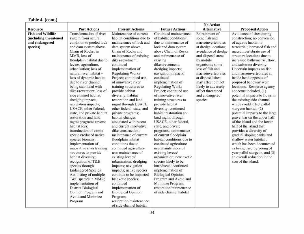
34
Table 4. (cont.)
Resource Past Actions Present Actions Future Actions No Action
Alternative Proposed Action Fish and Wildlife (including threatened and endangered species)
Transformation of river system from natural condition to pooled lock and dam system above Chain of Rocks; in MMR, loss of floodplain habitat due to levees, agriculture, urbanization; loss of natural river habitat – loss of dynamic habitat due to river channel being stabilized with dikes/revetment; loss of side channel habitat; dredging impacts; navigation impacts; USACE, other federal, state, and private habitat restoration and land mgmt programs reverse habitat loss; introduction of exotic species/reduced native species biomass; implementation of innovative river training structures to provide habitat diversity; recognition of T&E species through Endangered Species Act; listing of multiple T&E species in MMR; implementation of District Biological Opinion Program and Avoid and Minimize Program
Maintenance of current habitat conditions due to maintenance of lock and dam system above Chain of Rocks and maintenance of existing dikes/revetment; continued implementation of Regulating Works Project; continued use of innovative river training structures to provide habitat diversity; habitat restoration and land mgmt through USACE, other federal, state, and private programs; habitat changes associated with recent and current innovative dike construction; maintenance of current floodplain habitat conditions due to continued agriculture use/ maintenance of existing levees/ urbanization; dredging impacts; navigation impacts; native species continue to be impacted by exotic species; continued implementation of Biological Opinion Program; restoration/maintenance of side channel habitat
Continued maintenance of habitat conditions due to maintenance of lock and dam system above Chain of Rocks and maintenance of existing dikes/revetment; dredging impacts; navigation impacts; continued implementation of Regulating Works Project; continued use of innovative river training structures to provide habitat diversity; continued habitat restoration and land mgmt through USACE, other federal, state, and private programs; maintenance of current floodplain habitat conditions due to continued agriculture use/ maintenance of existing levees/ urbanization; new exotic species likely to be introduced; continued implementation of Biological Opinion Program and Avoid and Minimize Program; restoration/maintenance of side channel habitat
Entrainment of some fish and macroinvertebrates at dredge locations; avoidance of dredge and disposal areas by mobile organisms; some loss of fish and macroinvertebrates at disposal sites; may affect but not likely to adversely affect threatened and endangered species
Avoidance of sites during construction; no conversion of aquatic habitat to terrestrial; increased fish and macroinvertebrate use of structure locations due to increased bathymetric, flow, and substrate diversity; Uncertain impacts on fish and macroinvertebrates at inside bend opposite of proposed bendway weir locations. Resource agency concerns included, (1) potential impacts to flows in the existing side channel which could affect pallid sturgeon habitat, (2) potential impacts to the large gravel bar on the upper half of the island and the lower half of the island that provides a diversity of gradual sloping banks and shallow water habitat , which has been documented as being used by young of year pallid sturgeon, and (3) an overall reduction in the size of the island.

35
Table 4. (cont.)
Resource Past Actions Present Actions Future Actions No Action
Alternative Proposed Action Navigation 1927 River and Harbor
Act authorized USACE to provide 9-foot Nav channel on MMR; USACE transformed free-flowing Mississippi River system into navigable waterway with 37 lock and dam complexes above Chain of Rocks, some dredging, dikes, revetment; growth of port facilities and inland waterways and traffic throughout Mississippi River system provided for movement of commodities with local, national, and international importance
Operation of lock and dam system above Chain of Rocks continues; traditional and innovative stone dike, revetment construction, rock removal, and dredging continue to provide safe and dependable navigation channel; navigation continues to be an important part of local / national / international transportation and commerce activities
Operation of lock and dam system above Chain of Rocks continues; traditional and innovative stone dike, revetment construction, rock removal, and dredging continue to provide safe and dependable navigation channel; navigation continues to be an important part of local / national / international transportation and commerce activities
Continued requirement for periodic maintenance dredging at rates similar to recent history.
Reduction in the amount and frequency of periodic maintenance dredging in the area.
Historic and Cultural Resources
Historic and cultural resources subjected to natural processes and manmade actions (e.g., erosion, floodplain development); recognition of importance of historic and cultural resources through National Historic Preservation Act (and others)
Historic and cultural resources continue to be impacted by human activities as well as natural processes; continued societal recognition of importance of historic and cultural resources
Historic and cultural resources continue to be impacted by human activities as well as natural processes; continued societal recognition of importance of historic and cultural resources
Impacts to historic and cultural resources unlikely.
No known historic resources would be affected. Impacts to unknown historic and cultural resources unlikely.

36
Mitigation Mitigation measures are used to avoid, minimize, or compensate for adverse impacts to environmental resources. The Dogtooth Bend Phase 5 work has avoided and minimized adverse impacts throughout the alternative development process. No adverse impacts have been identified that would require compensatory mitigation. 5. Relationship of Proposed Action to Environmental Requirements Federal Policy Compliance Status Bald Eagle Protection Act, 16 USC 668-668d Full Clean Air Act, 42 USC 7401-7542 Full Clean Water Act, 33 USC 1251-1375 Partial 1* Comprehensive Environmental Response, Compensation, and Liability Act, 42 USC 9601-9675
Full
Endangered Species Act, 16 USC 1531-1543 Full Farmland Protection Policy Act, 7 USC 4201-4208 Full Fish and Wildlife Coordination Act, 16 USC 661-666c Full Land and Water Conservation Fund Act, 16 USC 460d-461 Full Migratory Bird Treaty Act of 1918, 16 USC 703-712 Full National Environmental Policy Act, 42 USC 4321-4347 Full National Historic Preservation Act, 16 USC 470 et seq. Full Noise Control Act, 42 USC 7591-7642 Full Resource Conservation and Recovery Act, 42 USC 6901-6987 Full Rivers and Harbors Act, 33 USC 401-413 Partial 1* Water Resources Development Acts of 1986 and 1990 Full Federal Actions to Address Environmental Justice in Minority Populations and Low-Income Populations (EO 12898)
Full
Floodplain Management (EO 11988 as amended by EO 12148) Full Prevention, Control, and Abatement of Air and Water Pollution at Federal Facilities (EO 11282 as amended by EO’s 11288 and 11507)
Full
Protection and Enhancement of Environmental Quality (EO 11991) Full Protection and Enhancement of the Cultural Environment (EO 11593) Full Protection of Wetlands (EO 11990 as amended by EO 12608) Full Responsibilities of Federal Agencies to Protect Migratory Birds (EO 13186)
Full
1* Full compliance will be obtained prior to construction.
37
6. Conclusion The St. Louis District has assessed the impacts of the Proposed Action on the physical, biological, socioeconomic, and historic and cultural resources of the work area and determined that the proposed work would have no significant direct, indirect, or cumulative impacts upon the human environment. 7. List of Preparers
Name Role Experience
Mike Rodgers Project Manager 12 years, hydraulic engineering
Jasen Brown Project Manager 12 years, hydraulic engineering
Eddie Brauer Engineering Lead 12 years, hydraulic engineering
Kip Runyon Environmental Lead 16 years, biology
Ken Cook Environmental 20 years, biology
Tom Keevin Cumulative Impacts 33 years, aquatic ecology
Kevin Slattery HTRW 15 years, environmental science
Mark Smith Historic and Cultural Resources 20 years, archaeology
Danny McClendon Regulatory 27 years, regulatory compliance and biology
Keli Broadstock Legal Review 2 years USACE, 6 years private sector law

38
8. Literature Cited. Baker J.A., K.J. Killgore, and R.L. Kasul. 1991. Aquatic habitats and fish communities in the
lower Mississippi River. Aquatic Sciences. 3: 313–356. Barko, V.A., D.P. Herzog, R.A. Hrabik, and J.S. Scheibe. 2004. Relationship among fish
assemblages and main channel border physical habitats in the unimpounded Upper Mississippi River. Transactions of the American Fisheries Society, 133:2, 371-384.
Battle, J.M., J.K. Jackson, B.W. Sweeney. 2007. Annual and spatial variation for
macroinvertebrates in the Upper Mississippi River near Cape Girardeau, Missouri. Fundamental and Applied Limnology. 168/1: 39-54.
Blodgett, N. 2010. Final Report: Monitoring of Dredged Material for Fish Entrainment with
Special Emphasis on the Pallid Sturgeon, Phase III North Berms Dredging, Chain of Rocks Canal, Mississippi River, Madison County, IL. Prepared by Ecological Specialists, Inc. for the U.S. Army Corps of Engineers, St. Louis District, St. Louis, MO.
Brauer, E.J., R.D. Davinroy, L. Briggs, and D. Fisher. 2013. Draft Supplement to
Geomorphology Study of the Middle Mississippi River (2005). U.S. Army Corps of Engineers, St. Louis District, Applied River Engineering Center, St. Louis, Missouri. 12 pp.
Brauer, E.J., D.R. Busse, C. Strauser, R.D. Davinroy, D.C. Gordon, J.L. Brown, J.E. Myers,
A.M. Rhoads, and D. Lamm. 2005. Geomorphology Study of the Middle Mississippi River. U.S. Army Corps of Engineers, St. Louis District, Applied River Engineering Center, St. Louis, Missouri. 43 pp.
Davinroy, R. D. 1990. Bendway weirs, a new structural solution to navigation problems
experienced on the Mississippi River. Permanent International Association of Navigation Congresses 69:5-18.
Ecological Specialists, Inc. 1997a. Macroinvertebrates associated with Carl Baer bendway weirs
in the Mississippi River. In: Melvin Price Locks and Dam, Progress Report 1997 for Design Memorandum No. 24 Avoid and Minimize Measures. U.S. Army Corps of Engineers, St. Louis District.
Ecological Specialists, Inc. 1997b. Macroinvertebrates associated with bendway weirs at
Mississippi River mile 30. In: Melvin Price Locks and Dam, Progress Report 1997 for Design Memorandum No. 24 Avoid and Minimize Measures. U.S. Army Corps of Engineers, St. Louis District.
Farabee, G. F. 1986. Fish species associated with revetted and natural main channel border
habitats in Pool 24 of the Upper Mississippi River. North American Journal Fisheries Management 6: 504-508.

39
Galat, D. L., C. R. Berry, Jr., E. J. Peters, and R. G. White. 2005. Missouri River Basin. Pp. 427–480 in A. C. Benke and C. E. Cushing (eds.). Rivers of North America, Elsevier, Oxford.
Hartman, K.J. and J.L. Titus. 2009. Fish use of artificial dike structures in a navigable river.
River Research and Applications. 26: 1170-1186. Heitmeyer, M.E. 2008. An evaluation of ecosystem restoration options for the Middle
Mississippi River Regional Corridor. Greenbrier Wetland Services Report 08-02, Advance, MO.
Huizinga, R.J. 2009. Examination of direct discharge measurement data and historic daily data
for selected gages on the Middle Mississippi River, 1861-2008. U.S. Geological Survey Scientific Investigations Report 2009-5232. 60pp. (Available at http://pubs.usgs.gov/sir/2009/5232/)
Kasul, R. L., and J. A. Baker. 1996. Results of September 1995 hydroacoustic surveys of fishes
in five reaches of the Middle Mississippi River (RM 2-50). Waterways Experiment Station Report prepared for the St. Louis District, U.S. Army Corps of Engineers.
Koel, T. M., and K. E. Stevenson. 2002. Effects of dredge material placement on benthic
macroinvertebrates of the Illinois River. Hydrobiologia 474:229-238. Madejczyk, J.C., N.D. Mundahl, and R.M. Lehtinen. 1998. Fish assemblages of natural and
artificial habitats within the channel border of the Upper Mississippi River. American Midland Naturalist, Vol. 139, No. 2, pp. 296-310.
Munger, P.R., G.T. Stevens, S.P. Clemence, D.J. Barr, J.A. Westphal, C.D. Muir, F.J. Kern, T.R.
Beveridge, and J.B. Heagler, Jr. 1976. SLD Potamology Study (T-1). University of Missouri-Rolla, Institute of River Studies, Rolla, Missouri.
Niles, J.M. and K.J. Hartman. 2009. Larval fish use of dike structures on a navigable river. North
American Journal of Fisheries Management. 29: 1035-1045. Pennington, C.H., J.A. Baker, and M.E. Potter. 1983. Fish populations along natural and revetted
banks on the Lower Mississippi River. North American Journal of Fisheries Management 3: 204-211.
Reine, K., and D. Clarke. 1998. “Entrainment by hydraulic dredges–A review of potential
impacts.” Technical Note DOER-E1. U.S. Army Engineer Research and Development Center, Vicksburg, MS.
Sauer, J. 2004. Multiyear synthesis of the macroinvertebrate component from 1992 to 2002 for
the Long Term Resource Monitoring Program. 2004. Final report submitted to U.S. Army Corps of Engineers from the U.S. Geological Survey, Upper Midwest Environment Sciences Center, La Crosse, Wisconsin, December 2004. Technical Report LTRMP 2004-T005. 31 pp. + Appendixes A–C.
40
Schneider, B. 2012. Changes in fish use and habitat diversity associated with placement of three chevron dikes in the Middle Mississippi River. M.S. thesis, Southern Illinois University Edwardsville.
Schramm, H.L., Jr., L.H. Pugh, M.A. Eggleton, and R.M. Mayo. 1998. Lower Mississippi River
Fisheries Investigations 1996 Annual Report. Report prepared by the Mississippi Cooperative Fish and Wildlife Research Unit for the Lower Mississippi Valley Division, U.S. Army Corps of Engineers.
Shields, Jr., F. D. 1995. Fate of Lower Mississippi River habitats associated with river training
dikes. Aquatic Conservation and Freshwater Ecosystems 5:97-108. Simons, D.B., S.A. Schumm, and M.A. Stevens. 1974. Geomorphology of the Middle
Mississippi River. Report DACW39-73-C-0026 prepared for the U.S. Army Corps of Engineers, St. Louis District, St. Louis, Missouri. 110 pp.
Theiling, C.H., C. Korschgen, H. De Haan, T. Fox, J. Rohweder, and L. Robinson. 2000. Habitat
Needs Assessment for the Upper Mississippi River System: Technical Report. U.S. Geological Survey, Upper Midwest Environmental Sciences Center, La Crosse, Wisconsin. Contract report prepared for U.S. Army Corps of Engineers, St. Louis District, St. Louis, Missouri. 248 pp.
UMRBC. 1982. Comprehensive Master Plan for the Management of the Upper Mississippi River
System. Upper Mississippi River Basin Commission, Minneapolis, Minnesota. 193pp. USACE. 1976. Environmental Statement, Mississippi River between the Ohio and Missouri
Rivers (Regulating Works). U.S. Army Corps of Engineers, St. Louis District, St. Louis, Missouri.
USACE. 1983. Dredging and dredged material disposal. Engineer Manual 1110-2-5025. U.S.
Army Corps of Engineers, Washington, DC. USACE. 1999. Tier I of a two tiered Biological Assessment - Operation and Maintenance of the
Upper Mississippi River Navigation Project within St. Paul, Rock Island, and St. Louis Districts. Mississippi Valley Division, Vicksburg, MS.
USACE. 2011. Analysis of the effects of bendway weir construction on channel cross-sectional
geometry. U.S. Army Corps of Engineers, St. Louis District, St. Louis, MO. USACE. 2012. Devils Island offset dikes: pre- and post-construction monitoring completion
report. U.S. Army Corps of Engineers, St. Louis District, St. Louis, MO. USACE. 2013. Waterborne commerce of the United States. U.S. Army Corps of Engineers
Navigation Data Center Waterborne Commerce Statistics Center. http://www.navigationdatacenter.us/wcsc/wcsc.htm . Accessed 21 August 2013.

41
USFWS. 2000. Biological opinion for the operation and maintenance of the 9-foot navigation channel on the Upper Mississippi River System. U. S. Department of the Interior, Fort Snelling, Minnesota.
USEPA. 2013. U. S. Environmental Protection Agency green book nonattainment areas for
criteria pollutants as of July 31, 2013. http://www.epa.gov/airquality/greenbk/ . Accessed 13 August 2013.
USFWS. 2007. National Bald Eagle Management Guidelines. U.S. Fish and Wildlife Service,
Arlington, VA. Watson, C.C., D.S. Biedenharn, and C.R. Thorne. 2013a. Analysis of the impacts of dikes on
flood stages in the Middle Mississippi River. Journal of Hydraulic Engineering 139:1071-1078.
Watson, C.C., R.R. Holmes, and D.S. Biedenharn. 2013b. Mississippi River streamflow
measurement techniques at St. Louis, Missouri. Journal of Hydraulic Engineering 139:1062-1070.
WEST Consultants, Inc. 2000. Upper Mississippi River and Illinois Waterway Navigation
Feasibility Study – Cumulative Effects Study, Volumes 1-2. Prepared by WEST Consultants, Inc. for the U.S. Army Corps of Engineers, Rock Island District, Rock Island, Illinois
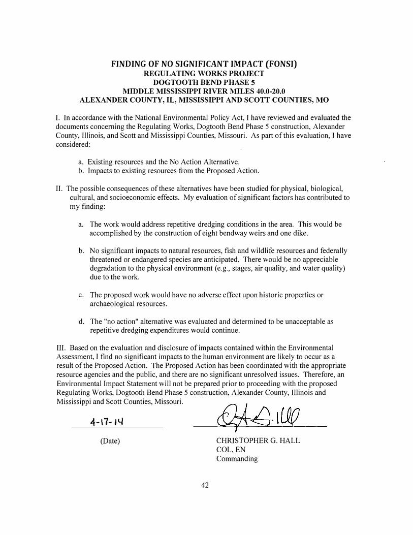
FINDING OF NO SIGNIFICANT IMPACT (FONSI) REGULATING WORKS PROJECT
DOGTOOTH BEND PHASE 5
MIDDLE MISSISSIPPI RIVER MILES 40.0-20.0
ALEXANDER COUNTY, IL, MISSISSIPPI AND SCOTT COUNTIES, MO
I. In accordance with the National Environmental Policy Act, I have reviewed and evaluated the documents concerning the Regulating Works, Dogtooth Bend Phase 5 construction, Alexander County, Illinois, and Scott and Mississippi Counties, Missouri. As part of this evaluation, I have considered:
a. Existing resources and the No Action Alternative. b. Impacts to existing resources from the Proposed Action.
II. The possible consequences of these alternatives have been studied for physical, biological, cultural, and socioeconomic effects. My evaluation of significant factors has contributed to my finding:
a. The work would address repetitive dredging conditions in the area. This would be accomplished by the construction of eight bendway weirs and one dike.
b. No significant impacts to natural resources, fish and wildlife resources and federally threatened or endangered species are anticipated. There would be no appreciable degradation to the physical environment (e.g., stages, air quality, and water quality) due to the work.
c. The proposed work would have no adverse effect upon historic properties or archaeological resources.
d. The "no action" alternative was evaluated and determined to be unacceptable as repetitive dredging expenditures would continue.
III. Based on the evaluation and disclosure of impacts contained within the Environmental Assessment, I find no significant impacts to the human environment are likely to occur as a result of the Proposed Action. The Proposed Action has been coordinated with the appropriate resource agencies and the public, and there are no significant unresolved issues. Therefore, an Environmental Impact Statement will not be prepared prior to proceeding with the proposed Regulating Works, Dogtooth Bend Phase 5 construction, Alexander County, Illinois and Mississippi and Scott Counties, Missouri.
4-\7-14
(Date)
42
CHRISTOPHER G. HALL COL, EN Commanding

FINAL ENVIRONMENTAL ASSESSMENT
WITH
FINDING OF NO SIGNIFICANT IMPACT
REGULATING WORKS PROJECT DOGTOOTH BEND PHASE 5
MIDDLE MISSISSIPPI RIVER MILES 40.0-20.0 ALEXANDER COUNTY, IL
MISSISSIPPI AND SCOTT COUNTIES, MO
APRIL 2014
APPENDICES

Appendix A. Summary of Research on the Effects of River Training Structures on Flood Levels

A-1
Summary of Research on the Effects of River Training Structures on Flood Levels
1. Introduction With implementation of the Proposed Action, stages at average and high flows both in the vicinity of the project area and on the Middle Mississippi River are expected to be similar to current conditions. An abundance of research has been conducted analyzing the impacts of river training structures on water surfaces dating to the 1930s. This research includes numerical and physical models as well as analyses of historic gage data, velocity data, and cross sectional data. In addition to continued monitoring and analysis, the U.S. Army Corps of Engineers (Corps) has conducted a literature review of all available literature on the impact of river traning structures on flood levels. A summary of research on the topic is detailed below. Based on an analysis of this research by the Corps and other external reviewers, the District has concluded that river training structures do not impact flood levels.
2. Studies concluding no impact on flood levels
2.1 Historic Research One of the early studies specifically addressing the effect of river training structure construction on water surfaces was conducted during the extreme high water of June and July 1935 (Ressegieu 1952). This study was prompted by the differences in observed streamflow for equal stages following the transfer of streamgaging responsibility from the Corps to the United States Geological Survey (USGS) in March 1933. When observed field data showed a major change in the stage for which a specific discharge was passing, the Corps and USGS initiated a study to determine the cause. This study addressed the accuracy of the standard equipment and method of observation between the two agencies. Similar simultaneous streamflow studies were conducted between 1935 and 1948. In 1952, the results of all of the studies were analyzed and it was concluded that, on average, the discharges measured by the Corps generally exceeded those measured by the USGS by zero percent at mean stage to slightly more than ten percent at high stages. Ressegieu (1952) concluded that “the reduction in floodway capacity was not an actual physical reduction but an apparent reduction caused by a discrepancy in the accuracy of measuring streamflow by older methods and equipment”. The conclusions by Ressegieu (1952) were analyzed along with new information and confirmed by Watson et al. (2013a). Monroe (1962) conducted a comprehensive analysis of all factors which are believed to have had some effect on the St. Louis rating curve including: accuracy of discharge measurements, man-made obstructions and hydrology and hydraulic changes. Monroe (1962) observed a spread in stage for equivalent discharge at flows with stages of about 35 and 40 ft on the St. Louis gage. The analysis concluded that the change in stage for higher flows was due to the

A-2
construction and raising of levees between 1935 and 1951. In an analysis of river training structures, Monroe (1962) found that “the contraction by permeable dikes has had a negligible effect on the increase in flood heights.” A number of natural factors were found to affect stages for equivalent discharge including: season (water temperature), rapidity of rise of the flood wave, amount of flow contribution by the upper Mississippi River and the amount of bed material carried by the Missouri River. In a comprehensive study of hydrologic, hydraulic, geologic and morphologic factors which relate to the Mississippi River downstream of Alton, IL, Munger et al. (1976) studied the changes in hydraulics on the Mississippi River resulting from river confinement by levees and the construction of river training structures. As was the case in previous studies using gage data, the reliability of early discharge data collected by the Corps was brought into question. In a study of velocity, stage and discharge data, Munger et al. (1976) concluded that “generalizations about the effect of dikes on stage-discharge relations are not justified.” When examining cross section shape and velocity distributions at the St. Louis gage, it was observed that there had been no striking changes in cross-section shape or velocity distributions at the section between 1942 and 1973. Dyhouse (1985, 1995) found through numerical and physical modeling that published discharges for historic floods, including 1844 and 1903, were overestimated by 33 and 23 percent, respectively. Dyhouse concluded that the use of early discharge data collected by the Corps, including historic peak flood discharges in conjunction with streamflow measurements by the USGS, will result in incorrect conclusions. Other reach scale numerical and physical models studying the effect of river training structures on water surfaces include USACE (1996) which used a Hydrologic Engineering Center (HEC-2) model used to analyze pre- and post- construction water surface elevations for the Nebraska Point Dike field on the Lower Mississippi River. For each cross section analyzed, the dike field construction lowered water surface elevations and reduced overbank discharges for the 50%, 20%, and 10% annual chance exceedance events. Xia (2009) used an Adaptive Hydraulics (AdH) model to study the changes in water surface resulting from the construction of a dike field. In this fixed bed analysis, Xia found that changes in water surface elevation due to the dikes was greatest at average flows and decreased with increasing and decreasing river flow. Azinfar and Kells (2007) developed a multiple function model to predict the drag coefficient and backwater effect of a single spur dike in a fixed bed. This study concluded that increasing submergence levels resulted in a decreasing backwater effect. In a moveable bed model study conducted to develop structural alternatives for a power plant on the Minnesota River, Parker et al. (1988) measured water surface changes from a baseline for a series of dikes and determined that construction of the structures had a negligible effect on flood stages compared to calibration values. Yossef (2005) used a 1:40 scale fixed bed physical model of the Dutch River Waal to study the morphodynamics of rivers with groynes (dikes are referred to as groynes in other parts of the world including the Netherlands) including their effect on water surface. Yossef found that on the River Waal, the effect of groynes decreased with increasing submergence. It was also observed that the maximum possible water level reduction

A-3
of the design flood (378,000 cfs) by lowering all of the groynes in the system was 0.06 meters (2.4 inches). Other international research supports the conclusion that river training structures do not impact flood levels. An international technical working group made up of experts from around the world organized by PIANC, the World Association for Waterborne Transport Infrastructure, analyzed the impact of dikes on high discharges. It was determined that dikes can be designed to avoid high water impacts by having a top elevation below mean high water (similar to what is used on the Middle Mississippi River (MMR). The report describes that although dikes may increase hydraulic resistance, the erosion of the low water bed may compensate for the water level upset entirely. The report also cites conventional practice that requires dikes to be designed so they do not increase stage during high discharges (PIANC 2009). As an engineering organization, the Corps follows this conventional practice and ethical code to ensure that dike construction does not cause an impact to public safety.
2.2 Updated Evaluations
2.2.1 Watson & Biedenharn To update ongoing evaluations of the physical effects of river training structures, the Corps initiated a new study on the possible effect of these structures on water surfaces in 2008. This series of studies included an analysis of past research, an analysis of the available gage data on the MMR, an analysis of historic measurement technique and instrumentation and its effect on the rating curve, specific gage analysis, numerical and physical modeling. In addition to the research conducted by the Corps, the St. Louis District engaged with external technical experts in the fields of river data collection, river engineering, geomorphology, hydraulics and statistics. In a review of historic streamflow data collected prior to the USGS, Watson & Biedenharn (2010) determined that pre-USGS data should be omitted for the following reasons: (1) It has been confirmed through simultaneous measurement comparisons that there is much uncertainty in the historic data due to differences in methodology and equipment; (2) there is much uncertainty with respect to the location of the discharge range; (3) there is insufficient measured data at the higher flow ranges to produce reliable specific gage records; and (4) the homogeneous data set containing all discharges collected by the USGS provides an adequate long-term, consistent record of the modern-day river system including periods of significant dike construction. A more detailed description of the limitations of early discharge measurements can be found in Watson et al. (2013a). In their analysis, Watson & Biedenharn (2010) studied the specific gage records at the three rated gages on the MMR: St. Louis, Chester and Thebes. A summary of the analysis techniques used and a detailed analysis of the specific gage record at St. Louis can be found in Watson et al. (2013b). The analysis for the gage at Thebes was omitted due to the effect of backwater from the Ohio River. For each streamgage studied, the specific gage record was analyzed and compared with a record of river training structure construction for a reach extending 20 river

A-4
miles downstream. All data used in their study were collected by the USGS and retrieved from the USGS website (http://www.usgs.gov). Bankfull stage at the St. Louis gage is approximately +30 feet with a corresponding discharge of approximately 500,000 cubic feet per second (cfs). Flows below 400,000 cfs are contained within the top bank and flows above 700,000 cfs are well above the top-bank elevation. The time period 1933-2009 was studied. The top elevation of training structures in this reach was between +12 and +16 feet referenced to the St. Louis gage. All structures are completely submerged at discharges exceeding 280,000 cfs. In their analysis, Watson and Biedenharn (2010) found a statistically significant slightly decreasing trend in streamflows below 200,000 cfs. In streamflows between 300,000 cfs and 500,000 cfs, a statistically significant horizontal trend in stages was observed. At 700,000 cfs a non-statistically significant, slightly increasing trend in stages was observed. The slight upward trend in stages at 700,000 cfs had considerable variability in the data and was strongly influenced by the 1993 flood. Bankfull stage at the Chester gage is approximately +27 feet with a corresponding discharge of approximately 420,000 cfs. The time period 1942-2009 was studied. The top elevation of navigation structures in this reach was +14 to +17 feet referenced to the Chester gage. All structures are completely submerged at discharges exceeding 280,000 cfs. The only statistically significant trend found was a slightly decreasing trend for streamflows below 100,000 cfs. There was a horizontal trend for 200,000 and 400,000 cfs. There was a slightly increasing trend at 300,000 cfs. For both overbank flows, 500,000 cfs and 700,000 cfs, there were slight increasing trends. After a closer examination of the specific gage trends it was apparent that the long term trends for both St. Louis and Chester were not continuous and there was a shift in stages that occurred in 1973. This year was significant because (1) 1973 was marked by the occurrence of a major flood event that is documented as having significant impacts on the morphology of the MMR, (2) the year 1973 marked the end of a remarkably flood free period and (3) the pre-1973 period was characterized by extensive dike construction whereas the post-1973 period saw 50% less dike construction. When the record was broken into pre- and post-1973 sections, different trends were observed. Prior to 1973 at all gages studied, there were no increasing trends for any of the flows. Post-1973 there were no increasing stage trends for within-bank flows at any of the gages. A slightly increasing stage trend occurred for overbank flows of 500,000 cfs (statistically significant) and 700,000 cfs (not statistically significant) at the Chester gage. A majority of the construction of river training structures on the Middle Mississippi was performed prior to 1973. In conjunction with the specific gage record, Watson & Biedenharn (2010) and Watson et al. (2013) analyzed the record of training structure construction including an analysis of the top elevation of the structures. The typical top elevation of the structures was 10-16 feet below the top bank. Since the top elevation is so far below top-bank elevations, the most dramatic impacts of the structures should be in the low to moderate stages below top bank where the specific gage analysis revealed decreasing or no trends (Sukhodolov, 2013; Watson & Biedenharn 2010; USGAO 2011, PIANC 2009, Azinfar & Kells 2007, Stevens et al. 1975, Chow 1959).
A-5
Watson & Biedenharn (2010) concluded that, “based on the specific gage records, there has been no significant increase in stages for within-bank flows that can be attributable to river training structure construction. Any increase in overbank flood stages may be the result of levees, floodplain encroachments, and extreme hydrologic events; and cannot be attributed to river training structures based solely on specific gage records.”
2.2.2 United States Geological Survey Huizinga (2009) conducted a specific gage analysis using the direct step method on only data collected by the USGS for the gages at St. Louis and Chester. Similar to Watson & Biedenharn (2010), an apparent decrease of stage with time for smaller, in bank discharges was observed at both the St. Louis and Chester gages. This decrease in stage was attributed to the construction of river training structures and/or a decrease in sediment load available for transport on the Mississippi River due to the construction of reservoirs on the main stem tributaries of the Mississippi River, particularly the Missouri River. Huizinga (2009) found a slight increase in stage over time for higher flows at both St. Louis and Chester over the entire period of record. The transitional discharge was 400,000 cfs and 300,000 cfs for the St. Louis and Chester gages respectively. These discharges correspond to stages of +25 feet at St. Louis and +22 feet at Chester. At these stages the navigation structures are submerged by 5-13 feet. Huizinga (2009) attributed the slight increase in out of bank flows to the construction of levees and the disconnection of the river to the floodplains. Similar to Watson & Biedenharn (2010), Huizinga (2009) observed a shift occurring in the out of bank flows in the mid-1960s and attributed it to the completion of the Alton to Gale levee system which paralleled the entire Middle Mississippi River. In an analysis of cross sectional data collected at the St. Louis and Chester gages, it was found that although the shape of the cross section had changed, the cross sectional area for moderate (400,000 cfs) and high (600,000 cfs) flows remained relatively constant throughout the period of record. The construction of river training structures immediately upstream of the Chester gage provided a case study on the effect of the absence and construction of structures on the cross section over time. Prior to the construction of the structures, the channel thalweg repeatedly shifted between the left and right banks. Following the construction of the structures, the cross sections displayed much less variability. An overall stabilizing effect of the structures was seen on the cross section for discharges of 100,000 cfs and 400,000 cfs. The cross sectional area for the first and last measurements of the period of record remained similar despite the river training structure construction upstream for all discharges. Huizinga (2009) conducted a study of all rating curves developed for St. Louis and Chester, including those developed prior to 1933 by the Corps. When comparing daily values from the Corps from 1861-1927 to the original USGS rating in 1933 there appeared to be an abrupt change in the upper end of the ratings used before 1933. When these daily values developed by the Corps were adjusted to compensate for the overestimation of Corps discharge measurements detailed in the simultaneous discharge measurement studies between the Corps and USGS, the adjusted daily discharge values plotted in line with the original USGS rating. This study is further evidence of the overestimation of early discharges.
A-6
2.2.3 Statistical Evaluation A critical review of the statistical analysis used to support specific gage analyses by Pinter et al., (2001) and Pinter and Thomas (2003) was conducted by V.A. Samaranayake (2009) from the department of Mathematics and Statistics at Missouri University of Science and Technology. Samaranayake (2009) concluded that the analysis presented by Pinter et al., (2001) and Pinter and Thomas (2003) did not support the conclusions that river training structures are increasing stages for higher discharges. In an evaluation of the two types of specific gage analysis, Samaranayake (2009) concluded that the direct step method was the most appropriate on the MMR. This is due to the data points being more homogeneous than those obtained from the rating method as far as variance is concerned and therefore they can be considered devoid of simultaneity bias and other such artifacts. Samaranayake (2009) also found that, when using computed daily discharge values, the researcher is essentially recreating the original USGS rating curves used to obtain the daily discharges. The computed daily discharge data lacks the natural variability found in measured streamflow and can lead to conclusions that are due to artifacts created by errors in the original rating curves. This error is compounded by the fact that the USGS uses the same rating curves for several years producing results that, rather than being independent, are correlated across several years. Samaranayake (2009) questioned the cause and effect relationship concluded by Pinter et al., (2001). The straight trend lines concluded by Pinter et al. (2001) revealed an increasing trend in stages reflecting a smooth gradual increase. Dike construction was not constant throughout history. The history of dike construction revealed much variability in magnitude throughout the period of record and did not directly correlate with the trends observed by Pinter (2001). Pinter et al., (2001) failed to prove that the relationship between stage trends on the MMR and dike construction was statistically significant.
2.2.4 Numerical and physical modeling studies The Iowa Institute of Hydraulic Research (IIHR) at the University of Iowa performed a series of hydrodynamic simulations of a recently constructed chevron field and dike extension using the United States Bureau of Reclamation Sedimentation and River Hydraulics Two-Dimensional (SRH-2D) modeling software (Piotrowski et al. 2012). Simulations studied the impact of the construction on water surfaces and the magnitude of natural variation on water surfaces. The results indicated that structures did not cause significant differences in reach-scale water surface elevations. The simulations also found that the differences in pre- and post- construction water surface elevations were less than the differences resulting from natural variability in two post-construction scenarios. A physical sediment transport model at the University of Illinois, Urbana-Champaign was used to test the effect of submerged dikes and dike fields on water surfaces (Brauer 2013). The study tested flows and stages along a rating curve from ½ bankfull to a flow with a 0.5% annual chance exceedance. The study concluded that the magnitude of the effect of dikes on water
A-7
surfaces was smaller than the natural variability in the stage and discharge relationship and decreased with increasing flow/submergence. The study also found that there was no direct cumulative effect for up to four structures.
2.2.5 Analysis of Updated Evaluations Dike elevation information relative to the gages at St. Louis, Chester and Thebes are important in the interpretation of the specific gage results. On the MMR, dike elevations are well below the top-bank elevations and are submerged by over thirty feet during major floods. The most dramatic impacts of the dikes are expected to be observed in the low to moderate stages below top bank (Sukhodolov, 2013; Watson & Biedenharn, 2010; USGAO, 2011; PIANC, 2009; Azinfar & Kells, 2007; Stevens et al., 1975; Chow 1959). Once the flows spill overbank, the specific gage trends are impacted by changes in the floodplain including bridge abutments, levee construction, vegetation changes, etc. (Huizinga 2009, Heine and Pinter 2012). The effect of levees on the stages of larger floods is more pronounced than at lesser floods due to the additional conveyance loss of the floodplain (Simons et al. 1975, Heine and Pinter 2012). The magnitude of the stage changes for overbank discharges observed by Watson & Biedenharn (2010), Watson et al. (2013), and Huizinga (2009) are consistent with the expected changes due to the construction of levees along the MMR. The Upper Mississippi River Comprehensive Plan (USACE 2008) calculated that levees contributed an increase of up to 2.9 feet at St. Louis, Missouri and up to 7.3 feet at Chester, Illinois of the 1% annual chance exceedance flood (100-year). The Floodplain Management Assessment of the Upper Mississippi River and Lower Missouri Rivers and Tributaries report (USACE 1995) calculated that agricultural levees contributed an average peak stage increase of up to 4.9 feet on the MMR between St. Louis and Cape Girardeau. The Mississippi Basin Model (MBM) tests showed an increase of up to 4 feet compared to 1820 conditions, depending on discharge and location of flooding (Dyhouse 1995). The magnitude of levee impact is dependent on the roughness of the floodplain being protected. The values detailed above generally assume agricultural land. Through the use of numerical and physical models, Piotrowski (2012) and Brauer (2013) reinforced the conclusion that river training structures do not impact flood flows. Additionally, Piotrowski (2012) and Brauer (2013) quantified the impact of natural variability in the channel on stage. Brauer (2013), through the use of a moveable bed model, demonstrated the importance of sediment transport and bed changes when analyzing how river training structures influence stages.
3. Analysis of research proposing a link between instream structures and an increase in flood levels. The Corps has researched and analyzed all available literature that either purports or has been claimed to purport that river training structures increase flood heights. Comments received on
A-8
the draft Environmental Assessment have provided a list of 51 studies claimed to link the construction of instream structures to increases in flood levels. However, only 21 of the 51 journal articles, technical notes, book chapters, and conference papers cited attempt to link the construction of instream structures to increases in flood levels. The remaining thirty studies cited do not discuss the construction of instream structures and/or increases in flood levels. Some of the cited papers simply reference the research of others as background information. Others discuss the topics of flow frequency, physical modeling and model scale distortion, and levee construction. Others are on topics unrelated to instream structures and/or flood levels. This appendix only discusses in detail the journal articles, technical notes, book chapters, and conference papers whose conclusions claim a link between instream structure construction and an increase in flood levels. Some of the analyses are presented in multiple papers. Since the analysis in Pinter et al. (2000) is the basis for Pinter et al. (2001a), Pinter et al. (2001b), Pinter et al. (2002), Pinter et al. (2003), Pinter and Heine (2005), Pinter et al. (2006b) and Szilagyi et al. (2008), only Pinter et al. (2000) will be discussed in detail. Similarly, the analysis in Jemberie et al. (2008) is the basis for Pinter et al. (2008), Pinter (2009), and Pinter et al. (2010). Only Jemberie et al. (2008) will be discussed in detail. The studies whose conclusions claim a link between instream structure construction and an increase in flood levels have been grouped below into three categories: specific gage analysis, numerical simulations and physical fixed bed modeling.
3.1 Specific Gage Analysis Fifteen of the journal articles, technical notes, book chapters, conference papers and editorials proposing a link between instream structures and an increase in flood levels rely on the use of specific gage analysis.
3.1.1 Description Specific gage analysis is a graph of stage for a specific fixed discharge at a particular gaging location plotted against time (Watson et al 1999). The use of specific gage analysis is a simple and straightforward method to illustrate aggradation and degradational trends in a river or the response of a river to various alterations in the channel. Similar to most engineering analyses, the interpretation of specific gage records can be complex. Specific gage analysis is an analysis of field data collected at gage locations along a river. The measurements that are collected at the gage locations are stage (water height), velocity (speed of the water) and cross sectional area (area of the channel). Velocity and area are multiplied together to calculate the discharge which is the volume of water passing a fixed location. It is important to ensure that the methodology and instrumentation used to collect velocity and cross sectional area has not changed during the period of record being examined. If it has changed, it is important to understand how those changes in instrumentation and methodology impact the results. As detailed above, the period of record on the MMR includes two distinctly different data sets.
A-9
3.1.2 Papers using specific gage analysis to link instream structure construction to flood level increases The first use of specific gage analysis to link instream structures to apparent changes to the stage-discharge relationship on the Middle Mississippi River dates back to Stevens et al. (1975) and Belt (1975). Flaws in the source data, methodology and analysis used by Stevens et al. (1975) were addressed by Stevens (1976), Dyhouse (1976) Strauser & Long (1976) and Westphal & Munger (1976). These include the following: use of limited cross-sectional data from one highly engineered reach of the MMR (St. Louis harbor) to represent the entire Middle Mississippi River; use of the unmeasured 1844 flood discharge and the 1903 flood discharge, which was measured only at Chester and Thebes using a different analysis to draw sweeping conclusions; use of early inaccurate and overestimated discharge measurements in conjunction with more accurate contemporary measurements; and the lack of a direct correlation between dike construction and trends in water surface changes. Through a comparison of trends in stage and streamflow measurements from floods from 1862-1904 to those after the 1980s, Criss & Shock (2001) concluded that stages have increased over time on rivers due to the construction of river training structures. Criss & Shock (2001) also analyzed rivers with and without river training structures to determine the impact structures have on water surfaces. The conclusions of Criss & Shock (2001) are driven by the comparison of two distinctly different data sets: early discharges collected by the Corps and contemporary discharges collected by the USGS. As detailed above, combining early Corps discharge measurements with contemporary USGS discharge measurements without appropriately accounting for the differences in accuracy of those measurements can result in flawed conclusions. Pinter et al. (2000) used specific gage analysis to study changes to the stage-discharge relationship, cross-sectional area and velocity on the Middle Mississippi River. A specific gage trend was developed using daily stage and discharge data from the Middle Mississippi River gages at St. Louis, Chester, and Thebes. Pinter et al. (2000) concluded that engineering modifications on the Middle Mississippi River have caused changes in the cross-sectional geometry and flow regime leading to a decrease in stages for low discharges and rising stages for water levels starting at 40%-65% of bankfull discharge and above. Since their analysis shows rises in stages are greater for larger discharges, the authors conclude that the impact of the changes is greatest for large flood events. One limitation of specific gage analysis is that it can only be performed on rated gages (gages with a discharge record). Jemberie et al. (2008) developed a refined specific gage approach attempting to overcome this limitation by developing “synthetic discharges” at stage only gages. The synthetic discharges were created by interpolating discharge values at nearby gages to create a stage- discharge relationship at stage only gages. Rare discharges were created using “enhanced interpolation” to formulate a continuous specific gage time series for large, rare discharges. The results of the refined specific gage study were that stages that correspond to flood discharges increased substantially at all stations consistent with what was documented by Pinter (2001).

A-10
3.1.3 Errors in specific gage papers 3.1.3.1 Use of a non-homogeneous data set The analysis in Pinter et al. (2000) and Jemberie et al. (2008) includes data, assumptions and analysis techniques that have been brought into question by engineers and scientists within the Corps, USGS and academia. The period of record data set used by Pinter et al. (2000) and Jemberie et al. (2008) combines daily discharge measurements from rating curves developed by both the Corps of Engineers and USGS. The use of daily discharge data from the entire period of record implies the assumption that the rating curves have been developed using the same methods throughout the period of record and the measured discharges used to develop the rating curves were collected similarly throughout the period of record. On the MMR, this assumption is not valid since the period of record of discharge measurements is two distinctly different data sets as discussed above. In an effort to disprove the long standing joint conclusion of the Corps and USGS that Corps measurements overestimated discharges compared to the USGS standard used after 1933 (Ressegieu 1952, Huizinga 2009, Watson et al. 2013a, Dyhouse 1976, Dyhouse 1985, Dyhouse 1995, Dieckmann & Dyhouse 1998), Pinter (2010) analyzed 2,015 measurements collected by the Corps on the Middle Mississippi River. The author concluded that early Corps discharges were not overestimated but were, in fact, underestimated. Based on this faulty conclusion, the author questions the adjustment of early data in the Upper Mississippi River System Flow Frequency Study and the flood frequencies and flood profiles used by the Corps on the Middle Mississippi River. Pinter (2010) did not analyze a data set sufficient to prove his hypothesis. The source data used by the author, Corps of Engineers, 1935, Stream-flow measurements of the Mississippi River and its Tributaries between Clarksville, MO., and the Mouth of the Ohio River 1866-1934, included only early Corps measurements using different instruments and methodologies employed by the Corps. The author did not analyze any measurements collected using USGS instruments and methodology or compare any early Corps measurements to ones collected by the USGS. 3.1.3.2 Use of Daily Discharge Values The analysis by Pinter et al. (2000) used daily discharge values instead of measured discharges. Daily discharge values are values of discharge that are extracted from the rating curve using a measured value of stage for a specified gage location. A rating curve is a relationship between stage and discharge that is developed by creating a smooth equation using observed measured data. Rating curves usually incorporate data from multiple years to develop their relationship and therefore are not reflective of the river for one particular year. The use of daily discharge data over direct measured discharges for the creation of a specific gage record is discouraged by many experts including Stevens (1979), Samaranayake (2009), Huizinga (2009) and Watson and Biedenharn (2010). Stevens (1979) recommended that “measured discharges should gain quick acceptance over estimates obtained from rating curves because they reveal the relationship that exists between discharge and the controlling variables at

A-11
the time of measurement.” Samaranayake (2009) cautioned against the use of data obtained from rating curves since “such data lacks the natural variability one finds in actual data and can lead to conclusions that are due to the artifacts created by errors in the original rating curves.” Watson and Biedenharn (2010) acknowledged that it is often tempting to use the computed daily discharge values since they increase the number of data points and improve the statistics of the rating curve, but caution that these values are not valid and risk masking actual trends. 3.1.3.3 Analysis of early Corps and USGS rating curve development Compounding the issues with using daily discharge measurements is the use of rating curves developed by multiple agencies using different standards and practices. Over the sixty-six years between 1861-1927, the Corps created five independent rating curves for the St. Louis gage. Curves were developed for the time periods 1861-1881, 1882-1895, 1896-1915, 1916-1918 and 1919-1927. Each curve was created with discharges collected within that time period. In most cases, the discharge measurements were not collected continuously through the rating period. For example, the first rating period which spans 1861 to 1881 was created using only 181 discharge measurements. All but four of the measurements were made in 1880 and 1881 (Huizinga 2009). The rating curves employed by the USGS (starting in 1933 in St. Louis) are not as static as the early ratings used by the Corps. USGS rating curves are often shifted and changed to account for changes in the shape, size, slope and roughness of the channel. To keep the ratings accurate and up to date, USGS technicians visit each streamgage about once every 6 weeks to measure flow directly. The USGS also emphasizes measuring extreme high and low flows since they are less common and can greatly impact the ends of the rating curve. Regardless of whether the early Corps or contemporary USGS rating curves are used, daily discharge measurements extracted from a rating curve do not represent the characteristics of the river at the gage location for a particular year. To analyze changes over time it is recommended to create independent annual rating curves using measured discharges all collected in a specific year or analyze measured discharges for specific discharge ranges over time. 3.1.3.4 Statistical Errors There are significantly fewer points associated with the larger discharge values of the specific gage records than the more frequent discharges. For example, as of March 2014 there have been approximately 3,435 discharge measurements collected at the St. Louis gage since 1933. Only 253 measurements (7.4 percent) have been collected for flows above bankfull (500,000 cfs). Only 80 measurements (2.3 percent) have been collected for flows above 700,000 cfs. Forty percent of the measurements observed for flows greater than 700,000 cfs were collected during the 1993 flood. When using the direct step method of specific gage analysis, the uncertainty for the flows with limited data is revealed in the statistics (Watson & Biedenharn 2010). Pinter et al. (2000) used the rating curve method of specific gage analysis using daily discharge which the author called “a powerful tool for reducing scatter in hydrologic time-series” (Pinter 2001). As with most
A-12
dependent variable values predicted using a regression equation, the error in the regression equation is less close to the mean of the independent variable and increases toward the more extreme values (small and large discharge values). The net result is that Pinter et al. (2000) generated data that has varying degrees of error variance and the use of ordinary least squares estimation under such circumstances has lead to incorrect results (Samaranayake 2009). 3.1.3.5 Physical Changes on the MMR Inherent in the use of a specific gage that spans a long time period is the understanding that errors and inconsistencies associated with the measurement of discharge and stage are captured in the record. Substantial changes in the river, if not accounted for, would all render the specific gage record unreliable. For example, Pinter et al. (2000) uses a single linear regression to represent the trend for a given discharge value curve. This is problematic since it does not accurately represent all the time periods in the record. There are shorter periods of time observed in the presented specific gage records when stages are decreasing rather than increasing, and the linear trend sorely misrepresents the observed changes. Other problems with this approach are there were major physical changes that occurred throughout the period of record which are reflected by changes in the stage-discharge record. These include the capture of the Kaskaskia River which shortened the MMR by 5 miles, the construction of reservoirs which reduced the sediment load in the MMR, and the construction of levees throughout the period of record including the completion of the Alton to Gale levee system. 3.1.3.6 Creation and use of “Synthetic Discharges” and “enhanced interpolation” Much of the analysis of Jemberie et al. (2008) is similar to the analysis of Pinter et al. (2000) and has the same issues as described above. The new contributions of Jemberie et al. (2008) are the development of ‘synthetic discharges’ for unrated gages and ‘enhanced interpolation’ to calculate continuous specific-stage time series for rare discharges. The development of ‘synthetic discharges’ is simply the development of a discharge record for gages where discharge was not measured by interpolating between rated gages. The purpose of creating a discharge record is so a specific gage analysis can be performed at that gage. Since the discharge record at the ‘synthetic gages’ is inherently dependent on the discharge record at the legitimately rated gages, the data at the ‘synthetic’ gages are not independent and should not be treated as such. The creation of a rating for the ‘synthetic gages’ incorporates an abundance of uncertainty due to the many assumptions that need to be made. Compounding the problems with interpolating between gages to create a discharge value at an unrated gage is the use of daily discharges as the source data for the interpolation. As detailed above, daily discharges are not measured values. The use of daily discharge values incorporates more error and uncertainty into the fabricated rating at the ‘synthetic gages’. For rare high flows, the true rating curve for an unrated gage may be heavily influenced by levee overtopping or other phenomena which would only be reflected through discharge

A-13
measurements. The author does not detail or account for the impact of the assumptions made on the ‘data’ created for the ‘synthetic gages’. The practice of using ‘enhanced interpolation’ to generate a continuous time series for a particular fixed discharge is not supported by the Corps and many other engineers and scientists. Similar to the ‘synthetic gage’ data, the data created using ‘enhanced interpolation’ is based off of an interpolation scheme and is not measured data. The fabricated values are dependent on the other values used to create the time series trend. To create the data using ‘enhanced interpolation’ one must assume that the time series for Q and Qt
* is continuous and linear. Watson et al. (2013b), Watson and Biedenharn (2010), Huizinga (2009) and Brauer (2009) have all shown that this assumption is not valid. Another assumption necessary is that there is only one specific stage value for each independent discharge, specifically at the highest and lowest discharges. Analyses of measured discharges have shown that stage is dependent not only on discharge but other physical characteristics of the channel (bed roughness, vegetation, sediment load, temperature, etc.). The use of ‘enhanced interpolation’ masks the natural variability in the relationship between stage and discharge. Jemberie et al. (2008) does not make any attempt to verify the validity of the ‘enhanced interpolation’ technique by proving the relationship using stage and discharge relationships at rated gages.
3.1.4 Summary A majority of the journal articles, technical notes, book chapters, and conference papers whose conclusions claim a link between instream structure construction and an increase in flood levels rely on specific gage analysis. The specific gage analyses that conclude that instream structures impact flood levels are all driven by the use of source data and methodology not supported by many engineers and scientists in the fields of river data collection, river engineering, geomorphology, hydraulics and statistics. Specific gage analysis studies conducted on the MMR also conclude that instream structures do not impact flood levels (Huizinga 2009, Watson & Biedenharn 2010 and Watson et al. 2013). The Corps does not give credibility to the conclusions of the specific gage analysis studies that attempt to link instream structures with increases in flood level due to the methodology and data use errors.
3.2 Papers using numerical simulations to link instream structure construction to flood level increases
3.2.1“Retro-Modeling” Remo and Pinter (2007) developed a one-dimensional unsteady-flow “retro-model” of the Middle Mississippi River using historical hydrologic and geospatial data to assess the magnitude and types of changes in flood stages associated with twentieth century river engineering.

A-14
Comparison of the retro-model results with the 2004 Upper Mississippi River System Flow Frequency Study (UMRSFFS) revealed increases in flood stages of 0.7 – 4.7 m. The difference in flood stages between the UMRSFFS and retro-model increased with increasing discharge. 3.2.1.1 Errors in “Retro-Modeling” studies 3.2.1.1.1 Source Data The large stage differences between current and early discharge estimates are partly due to the use of incorrect discharge values for historic hydrographs and floods occurring prior to 1933 as discussed above. The retro-modeling period of 1900-1904 includes one major flood in 1903 and a small one in 1904. The original estimated historic discharge of 1,020,000 cfs at St. Louis is used for the peak of the 1903 flood. This flow was originally developed for St. Louis from discharge measurements made at Chester. Tests conducted with the Mississippi Basin Model in the late 1980s found that a match of the 1903 high water marks through the entire reach of stream at St. Louis occurred for a discharge of about 790,000 cfs. The actual value of the 1903 discharge at St. Louis is likely to be approximately 230,000 cfs (or 23 percent) less than the value used by Remo and Pinter (2007) in the model calibration. 3.2.1.1.2 Channel Roughness Manning’s ‘n’ is the value most often modified to achieve a calibration of the model results to known stages. Manning’s ‘n’ represents the relative roughness of a channel. The larger the Manning’s ‘n’ the more resistance there is to flow. Forcing a calibration of the high and incorrect discharge of the 1903 flood would require a surprisingly low ‘n’ value for the channel of about 0.02, as used by Remo and Pinter (2007). The authors observe that the ‘n’ values for the historical period were systematically at the lower end of the published ranges. In practice, this usually indicates a problem with the model geometry or input data. The authors describe HEC-RAS as only allowing a single roughness coefficient value in the channel and separate values for the floodplains. The limitation of having “fixed” values was described as a source of model uncertainty. This statement by the authors is untrue — not only does HEC-RAS have the ability to vary the ‘n’ value horizontally across the cross sections, but it can also be varied for flow or season. All of these techniques are standard hydraulic engineering practice. Horizontal variation of the roughness may be necessary to generate reasonable model results and has a solid foundation in the literature, as noted by Remo and Pinter (2007). 3.2.1.1.3 Model Assumptions One assumption that could affect model results is the absence of flows from tributaries in the model calibration. Another problematic model assumption is that land use in unmapped areas was forested. Large tracts of timber in the Mississippi Valley were harvested in the late 1800s and early 1900s. The ‘retro-model’ also does not appear to consider how under the natural (before levee construction) conditions, flood water entering the floodplain over natural levees likely returned to the channel through a series of backwater swamps and channels. This may explain the apparent tendency of the model to over predict stages on the falling limb of the

A-15
hydrograph. This natural drainage system was likely altered during conversion of the floodplain to agricultural production. 3.2.1.2 Corps Conclusions and Analysis The calibration of the “retro-model” has been questioned by the Corps due to the use of early Corps discharges, surprisingly low ‘n’ values used, and other model assumptions detailed above. The Corps believes that the surprisingly low Manning’s roughness values were necessary to compensate for the overestimated flows used in the model and are not representative of the characteristics of the historic channel. The Corps takes the conclusions of Remo & Pinter (2007) very seriously and has attempted to work with the authors to verify the model results and gain a full understanding of the physical processes driving their concluded increase in flood stage. This research was carried out with support from the US National Science Foundation (NSF) grants EAR-0229578 and BCS-0552364. National Science Foundation policy states that, “Investigators are expected to share with other researchers, at no more than incremental cost and within a reasonable time, the primary data, samples, physical collections and other supporting materials created or gathered in the course of work under NSF grants.” However, to date, the authors have refused to provide the model, data or any other supporting materials to the Corps’ St. Louis District, although multiple requests for this information have been made.
3.2.2 Retro and Scenario Modeling Remo et al. (2009) is an expansion of Remo and Pinter (2007). In addition to the comparison of the ‘retro-model’ to the UMRSFFS, Remo et al. (2009) run a series of scenario models to quantify the impact of levees, channel change and land cover. Remo et al. (2009) concluded that on the MMR in the “St. Louis Reach” levees accounted for 0.1 – 1.0 m of increase in stage, changes in channel geometry accounted for a stage increase of 0.1-2.9 m, changes in total roughness accounted for a stage increase of 0.1 – 1.4 m, and changes in land cover accounted for a stage increase of up to 0.4 m. Similar to the model effort of Remo and Pinter (2007), the Corps has attempted to work with the authors to verify the model results and gain a full understanding of the physical processes driving their concluded increase in flood stage. To date the authors have refused to provide a copy of the model and associated data used to develop the conclusions of Remo et al. (2009) for review by the Corps in spite of the NSF policy requirements detailed above. This research was funded by NSF Grants EAR-0229578 and BCS-0552364. Remo et al. (2009) concludes that “changes in total roughness (channel and floodplain Manning’s n) between the ca. 1900 retro-model and the values used in the UMRSFFS UNET model explained much of the increases in stage observed along St. Louis Study reach.” The Corps believes these stage changes are due to errors in the modeling process as detailed above and are not representative of physical changes on the MMR.

A-16
3.2.3 Theoretical Analysis Huthoff et al. (2013) used a simplified theoretical analysis to test the impact of wing dikes on flood levels. This analysis used a simplified cross section to test three scenarios: with no wing dikes, with wing dikes without bed response, and with wing dikes including bed response. The overall channel discharge is calculated for each stage using Manning’s equation for steady uniform flow. The discharge for separate flow compartments is calculated using the divided channel method. The Manning’s roughness for the dike region is calculated using a flow resistance equation from Yossef (2004, 2005). The author concludes that although the roughness in the dike reach decreases with increasing water levels, the submergence is not great enough for the roughness to return to the base roughness. The authors conclude that the increase in stage for four times the average flow (4Qave) due to the wing dikes is 0.6 m, 0.7 m, 1.1 m and 0.6 m at St. Louis, Chester, Grand Tower and Thebes, respectively. 3.2.3.1 Errors in Theoretical Analysis 3.2.3.1.1 Applicability of Effective Roughness Equation The theoretical analysis proposed by Huthoff et al. (2013) is an oversimplified method to quantify an extremely complex and dynamic hydraulic problem. The basis of this analysis is the effective ‘n’ value formula developed by Yossef (2004, 2005) which was developed using a fixed bed physical model scaled to represent a reach of the Dutch River Waal which has much different geometry, dike size, and dike spacing than those used on the Middle Mississippi River. Although this relationship can be used to give insight into the effective roughness in the dike zone and submergence, it is only suitable to deduce trends rather than quantify accurate magnitudes of change. 3.2.3.1.2 Bank Roughness As detailed in the editor’s note, Huthoff et al. (2013) initially submitted a manuscript with an error in the calculation of Manning’s roughness which resulted in an overestimation of the roughness by a factor of 10. Due to the theoretical model’s sensitivity to the bank roughness value, this overestimation was the primary driver for the stage changes concluded. A simple correction of the calculation error with no additional manipulation in input data results in stage changes of -0.12 m at St. Louis, +0.21 m at Chester, +0.84 m at Grand Tower, and -0.00 m at Thebes for 4Qave. In addition to correcting the error, the authors changed the input values of bank roughness, mean dike crest elevation, and assumed bed level changes. The impact of each of these input changes in the model was an increase in stage for 4Qave. The bank roughness values used in Huthoff et al. (2013) were much lower than what is typically used for the MMR and much lower than those used for the main channel. The authors used a combination of ‘n’ values from different sources: the bank values were arbitrarily taken from literature whereas the values for other zones were taken from a hydraulic model. This resulted in velocity distribution in the channel that had high velocities along the bank and lower velocities in the channel at high flow. This is contrary to observed and theoretical velocity patterns in an open channel (Chow 1959).
A-17
3.2.3.1.3 Model Verification The model used in this analysis did not have adequate validation to prove that it has the ability to reproduce empirical results. The attempt of validation showed that the model matched the empirical values which it was calibrated to. The author did not validate the model to an independent observed flow which is customary engineering practice. The author also did not attempt to verify the ability of the model to reproduce any flood flows. 3.2.3.2 Discussion Since the relationship by Yossef (2004, 2005) was developed studying a river whose geometry and structures are very different to those used on the MMR, it cannot be used to quantify accurate magnitudes of change on the MMR. Although the model used by Huthoff et al. (2013) has many limitations preventing it from being used quantitatively, insight can be gained by the shape of the relationship between water level and dike roughness. The reduction of roughness with an increase in submergence is consistent with what has been observed by many scientists and engineers (Sukhodolov 2013; Watson & Biedenharn 2010; GAO 2011; PIANC 2009; Azinfar & Kells 2007; Stevens et al. 1975; Chow 1959) and in conflict with what has been concluded by Pinter (2000) and Remo & Pinter (2007).
3.3 Physical Fixed Bed Modeling Azinfar and Kells (2009, 2008, and 2007) use the results of fixed bed physical model studies to analyze flow resistance and backwater effect of a single dike. The authors use the conclusions of Criss & Shock (2001), Pinter et al. (2001) and Pinter (2004) as a foundation for their research. The purpose of the analysis in Azinfar and Kells (2009, 2008, and 2007) was to “quantify the amount of backwater effect that occurs so that the impacts of spur dike construction can be determined by those charged with managing the river system.” Azinfar and Kells (2007) developed a multi-functional backwater model calibrated to fixed bed physical model studies by Oak (1992) to study the backwater effect due to a single spur dike in an open-channel flow. Parameters analyzed using the model include the spur dike aspect ratio (height/length), spur dike opening ratio (1-length/channel width), spur dike submergence ratio (water depth/height) and upstream Froude number. Azinfar and Kells (2007) found that the parameter that has the greatest effect on the drag coefficient of a spur dike was the submergence ratio— the more the structure is submerged, the less the drag coefficient and therefore the less impact it has on water surfaces. This conclusion is contrary to the conclusion of Pinter (2000) and Remo & Pinter (2007) that conclude that the impact of dikes on water surfaces increases with increasing discharge and are highest at flood stage. Azinfar and Kells (2008) propose a predictive relationship developed in Azinfar and Kells (2007) that can be used to obtain a first-level estimate of the backwater effect due to a single, submerged spur dike in an open channel flow. Azinfar and Kells (2009) conclude that in a rigid flume an increase in blockage due to a spur dike is the main parameter responsible for an increase in the drag coefficient and associated flow resistance.

A-18
There is no debate that in a fixed bed scenario any channel blockage will produce a backwater effect. This is due to the decrease in cross sectional area resulting from the presence of the structure. The conclusions of Azinfar and Kells (2009, 2008, and 2007) reinforce why incorporating sediment transport is critical in having a full understanding of the impacts of dikes on water surfaces, particularly flood levels. The purpose of dikes is to induce bed scour and deepen the channel. Analysis of cross sectional changes on the Mississippi River has shown that once equilibrium is reached, although the dimensions of the channel may be different (i.e., deeper and narrower), the cross sectional area is preserved.
4. Studies cited that do not link the construction of instream structures to increases in flood levels Other journal articles, editorials and conference papers have been incorrectly referenced as linking the construction of instream structures to increases in flood levels: 1. Chen and Simmons (1986), Roberge (2002), Pinter et al. (2006a), Sondergaard and Jeppesen (2007), Theiling and Nestler (2010), and Borman et al. (2011) simply reference the research detailed in the aforementioned papers as background but do not present any new analysis. 2. Bowen et al. (2003), Wasklewicz et al. (2004), Ehlmann and Criss (2006), Criss and Vinston (2008), Criss (2009) and Pinter et al. (2012) analyze flow frequency and/or propose changes to the way flow frequency is calculated. They do not present any new analysis linking instream structures to increasing flood levels. 3. Struiksma and Klaasen (1987), Ettema and Muste (2004), and Maynord (2006), are about physical modeling and model scaling and distortion and do not discuss instream structure construction or flood levels. 4. Pinter (2005) and Van Ogtrop et al. (2005) present arguments linking the construction of levees to increases in flood levels. These papers do not present any analysis on instream structures and how they impact flood levels. 5. Maher (1964) presents changes in river regime of the Mississippi River and the variations in rating curves with respect to time and stage. The analysis includes causes for some of the stage-discharge relationship changes. The author analyzes the changes of three reaches of the MMR over three different time periods. Maher (1964) concludes that “the construction of levees in the Mississippi River floodplain during the period 1908-1927 has been the main factor in reducing floodway capacity to approximately 54% of the 1908 area. Between 1927 and 1943, when no additional levees were constructed, the floodway capacity remained practically constant, being reduced in area by only an additional ½ of 1%.” Maher (1964) does not attempt to link the construction of instream structures to increases in flood levels. 6. Paz et al. (2010) describes a HEC-RAS model study of the Paraguay River and its tributaries with limited data.
A-19
7. Doyle and Havlick (2009) examines current infrastructure and current understanding of environmental impacts for different types of infrastructure. This paper discusses the impact of levees on flooding. 8. Remo et al. (2008) discusses a database compiled by the authors with hydrologic and geospatial data on the Mississippi, lower Missouri and Illinois rivers. No analysis is conducted or conclusions drawn. 9. Remo and Pinter (2007) is a conference paper that discusses the database compiled by the authors detailed in Remo et al. (2008) and summarizes “retro-modeling” as a tool to analyze historic changes. 10. O’Donnell and Galat (2007) discusses river enhancement projects on the Upper Mississippi River and recommends improvement in management practices and project data collection, entry, management, and quality control/assurance across agencies. 11. Jai et al. (2005) used CCHE3D, a three-dimensional model for free surface turbulent flows developed at the National Center for Computational Hydroscience and Engineering, to study the helical secondary current and near-field flow distribution around one submerged weir. The model was validated using flow data measured during a physical model study conducted at the Coastal and Hydraulic Laboratory of ERDC. The models used in this study did not simulate sediment transport and channel change. Although water surface elevation contours are discussed near the submerged weir, the paper does not present a detailed analysis of the structures’ impact on water surfaces. 12. Pinter et al. (2004) provides an evaluation of dredging on a particular reach of the Middle and Upper Mississippi River based on dredging records obtained from the USACE St. Louis District. Although references to the impact of river training structures on flood stages are made several times, Pinter et al. (2004) does not have any analysis, discussion or conclusions on the topic. 13. Smith and Winkley (1996) examine the response of the Lower Mississippi River to a variety of engineering activities. This paper presents a brief history of engineering investigation on the Lower Mississippi River, analyzes the impact of artificial cutoffs on the channel geometry and water surface profiles, analyzes the impact of channel alignment activities on channel morphology and the apparent impact of all of the Lower Mississippi River engineering activities on sediment dynamics in the channel. There is no discussion or analysis by Smith and Winkley (1996) on how the construction of river training structures impacts flow levels. 14. Huang and Ng (2006) use a CCHE3D model calibrated to a fixed bed physical model to study basic flow structure around a single submerged weir in a bend. Conclusions are made on the near field changes in water surface. With the weir installed, the water surface elevation reflected the existence of the weir in the whole channel with an increase in the water surface elevation upstream of the weir due to an increase in resistance when the flow approaches the weir. Downstream of the weir the model found a decrease in water surface due to the acceleration of the flow after passing through the weir. Huang and Ng (2006) describe the changes in water

A-20
surface as a “local effect.” The scenario analyzed in Huang and Ng (2006) is for a single weir added to a fixed bed channel with no change in channel bathymetry, thus presenting an obstruction to flow. The author does not test flood flows or attempt to extrapolate his results to conclude that instream structures raise flood levels.
5. Studies the Corps was unable to gain access to The Corps was unable to retrieve copies of the following study and therefore was unable to use it in their analysis of the impact of instream structures on flood levels: Clifford, N.J., Soar, P.J., Gurnell, A.M., Petts, G.E., 2002. Numerical flow modeling for eco-hydraulic and river rehabilitation applications: a case study of the River Cole, Birmingham, U.K.. In River Flow 2002, Bousmar D, Zech Y (eds). Swets & Zeitlinger/Balkema: Lisse; 1195-1204.
6. Conclusion Based upon all of the available research analyzed above, the Corps has concluded that river training structures do not impact flood levels. The research efforts, as detailed in the published papers, book chapters, editorials and conference proceedings that conflict with the Corps’ conclusions all rely on analysis, assumptions and data that is not supported by engineers and scientists within the Corps, other Federal Agencies with expertise in water resources, and academia. The claims in the literature detailed above that river training structures have an impact on flood flows are not new. The Corps was concerned in the 1930s that the construction of dikes may have reduced the floodway capacity of the MMR (Ressegieu 1952). The Corps worked with the USGS and other experts to understand the issue and determined that there was not a change in floodway capacity rather a change in the way data was collected. Through the incorrect use of early Corps discharge data (Watson et al. 2013a) scientists in the 1970s again claimed that dikes have increased flood levels. In response, the Corps worked with experts from academia to understand the issue and study the problem using the latest technology. The conclusions of the experts reinforced previous conclusions that river training structures do not increase flood levels. Recently, the Corps worked with experts from other agencies and academia to evaluate the impact of river training structures on flood levels. The conclusions of these studies reinforce the previous conclusions that river training structures do not increase flood levels. As has been the case throughout the history of the Regulating Works Project, the Corps will continue to monitor and study the physical effects of river training structures using the most up-to-date methods and technology as it becomes available.
A-21
The majority of research attempting to link river training structures to an increase in flood heights is based off of a handful of research efforts primarily by researchers from three academic institutions: Washington University (Criss, Shock), Southern Illinois University –Carbondale (Pinter, Remo, Jemberie, Huthoff), and University of Saskatchewan (Azinfar, Kells). The Corps takes the claims of these researchers very seriously and has made repeated attempts to engage and collaborate with them to fully understand their conclusions that link river training structures to increases in flood levels. These efforts have had limited success (USGAO 2011).
7. References Azinfar, H., and J.A. Kells, 2009. Flow resistance due to a single spur dike in an open channel. Journal of Hydraulic Research, 47: 755-763. Azinfar, H., J.A. Kells, 2008. Backwater prediction due to the blockage caused by a single, submerged spur dike in an open channel. Journal of Hydraulic Engineering, 134: 1153-1157. Azinfar, H., and J.A. Kells, 2007. Backwater effect due to a single spur dike. Canadian Journal of Civil Engineering, 34: 107-115. Belt, C.B. 1975. The 1973 flood and man’s constriction of the Mississippi River. Science, 189: 681-684. Brauer, E.J., and Duncan, D.L., in press. Discussion of “Theoretical Analysis of Wing Dike Impact on River Flood Stages” by Fredrik Huthoff, Nicholas Pinter and Jonathan W.F. Remo. Journal of Hydraulic Engineering Brauer, E.J. 2009. The limitations of using specific gage analysis to analyze the effect of navigation structures on flood heights in the Middle Mississippi River. Vienna, Austria, Proceedings of the 4th international congress of Smart Rivers ’21. Sept 6-9. p156-163. Brauer, E.J. 2012. The effect of river training structures on flood heights on the Middle Mississippi River. San Jose, Costa Rica. Proceedings of the 6th edition of the International Conference on Fluvial Hydraulics. Sept 5-7. CRC Press. Brauer, E.J. 2013. The Effect of Dikes on Water Surfaces in a Mobile Bed. MS Thesis. University of Illinois, Urbana-Champaign. Bormann, H., N. Pinter, and S. Elfert, 2011. Hydrological signatures of flood trends on German Rivers: Flood frequencies, flood heights, and specific stages. Journal of Hydrology 404 (2011) 50–66.

A-22
Bowen, Z.H., Bovee, K.D., Waddle, T.J. 2003. Effects of Regulation on Shallow-Water Habitat Dynamics and Floodplain Connectivity. Transactions of the American Fisheries Society 132, 809-823. Chen Y.H., and Simmons D.B., 1986. Hydrology, hydraulics, and geomorphology of the Upper Mississippi River system. Hydrobiologia 136, 5-20. Chow, V.T., 1959. Open-channel hydraulics: New York, McGraw-Hill. Clifford, N.J., Soar, P.J., Gurnell, A.M., Petts, G.E., 2002. Numerical flow modeling for eco-hydraulic and river rehabilitation applications: a case study of the River Cole, Birmingham, U.K.. In River Flow 2002, Bousmar D, Zech Y (eds). Swets & Zeitlinger/Balkema: Lisse; 1195-1204. Criss, R.E., 2009. Increased flooding of large and small watersheds of the central USA and the consequences for flood frequency predictions. In R. E. Criss and Timothy M. Kusky (Eds.), Finding the Balance between Floods, Flood Protection, and River Navigation, pp. 16-21. Saint Louis University, Center for Environmental Sciences. Criss, R.E., and W.E. Vinston, 2008. Public Safety and Faulty Flood Statistics. Environmental Health Perspectives, 116: A516. Criss, R. E., & Shock, E. L. 2001. Flood enhancement through flood control. Geology , 29 (10), 875-878. Doyle, M.W., D.G. Havlick, 2009. Infrastructure and the Environment. Annual Review of Environment and Resources, 34: 349-373. Dieckmann, R.J., Dyhouse, G.R. 1998. Changing history at St. Louis – adjusting historic flows for frequency analysis. First Federal Inter-Avency Hydrologic Modeling Conference, April 20-22, 1998. Las Vegas, NV. Dyhouse, G.R. 1995. Effects of Federal Levees and Reservoirs on 1993 Flood Stages in St. Louis. Washington, DC. National Research Council, Transportation Research Board, Record No. 1483. 7p. Dyhouse, G.R. 1985. Comparing flood stage-discharge data- Be Careful! In Hydraulics and Hydrology in the Small Computer Age: Proceedings of the Specialty Conference. Waldrop WR (ed.) American Soc. Of Civil Engineers Hydraulics Divison: New York; 73-78. Dyhouse, G.R. 1976. Discussion of “Man-induced changes of Middle Mississippi River”. Journal of the waterways harbors, and coastal engineering division. Proceedings of the American Society of Civil Engineers. 102(WW2). 277-279. Ehlmann, B.L., and R.E. Criss, 2006. Enhanced stage and stage variability on the lower Missouri River benchmarked by Lewis and Clark. Geology, 34: 977-980.

A-23
Ettema, R., Muste, M. 2004. Scale effects in flume experiments on flow around a spur dike in a flat bed channel. Journal of Hydraulic Engineering. 130 (7), 635-646. Heine, R.A., Pinter, N. 2012. Levee effects upon flood levels: an empirical assessment. Hydrological Processes, 26, 3225-3240. DOI: 10.1002/hyp.8261. Huang, S.L., Ng C. 2007. Hydraulics of a submerged weir and applicability in navigational channels: Basin flow structures. International Journal for Numerical Methods in Engineering 69, 2264-2278. Huizinga, R.J. 2009. Examination of measurement and historic daily data for several gaging stations on the Middle Mississippi River, 1861-2008. U.S. Geologicial Survey Scientific Investigations Report 2009-5232. 60p. (Also available at http://pubs.usgs.gov/sir/2009/5232/) Huthoff, F., N. Pinter, J.W.F. Remo, 2013. Theoretical analysis of wing dike impact on river flood stages. Journal of Hydraulic Engineering. 139(5), 550-556. DOI: 10:1061/(ASCE)HY.1943-7900.0000698. Jai, Y., Scott S., Xu, Y., Huang, S. and Wang, S.S.Y. 2005. Three-dimensional numerical simulation and analysis of flow around submerged weir in a channel bendway. Journal of Hydraulic Engineering. 131, 682-693. Jemberie, A.A., N. Pinter, and J.W.F. Remo, 2008. Hydrologic history of the Mississippi and Lower Missouri Rivers based upon a refined specific-gage approach. Hydrologic Processes, 22: 7736-4447, doi:10.1002/hyp.7046. Maher, T.F. 1964. Study of regulation works on stream flow. Paper presented at ASCE Meeting, Cincinnati, Ohio, February, 1-24.
Maynord, S.T. 2006. Evaluation of the Micromodel: An Extremely Small-Scale Movable Bed Model. Journal of Hydraulic Engineering 132, 343-353. Monroe, R.H. 1962. U.S. Geological Survey, unpublished data. Munger, P.R., Stevens, G.T., Clemence, S.P., Barr, D.J., Westphal, J.A., Muir, C.D., Kern, F.J., Beveridge, T.R., and Heagler, Jr., J.B. 1976. SLD Potamology Study (T-1). University of Missouri-Rolla, Institute of River Studies, Rolla, Missouri. O’ Donnell, K.T. Galat D.L., 2007. River Enhancement in the Upper Mississippi River Basin: Approaches Based on River Uses, Alterations, and Management Agencies. Restoration Ecology, 15, 538-549. Parker, G., Garcia, MH, Joannesson, J. and Okabe, K. 1988. Model Study of the Minnesota River near Wilmarth Power Plant, Minnesota, Project Report No. 284, Saint Anthony Falls Hydraulic Laboratory, University of Minnesota.
A-24
Paz, A.R., J.M. Bravo, D. Allasia, W. Collischonn, and C.E.M. Tucci, 2010. Large-scale hydrodynamic modeling of a complex river network and floodplains. Journal of Hydrologic Engineering, 15: 152-165. PIANC, 2009. Sustainable waterways within the context of navigation and flood management. Envi-Com Report n°107-2009. Pinter, N., J. Dierauer, and J.W.F. Remo, 2012. Flood-loss modeling for assessing impacts of flood-frequency adjustment, Middle Mississippi River, USA. Hydrologic Processes, doi:10.1002/hyp.9321. Pinter, N., A.A. Jemberie, J.W.F. Remo, R.A. Heine, and B.A. Ickes, 2010. Cumulative impacts of river engineering, Mississippi and Lower Missouri Rivers. River Research and Applications, 26: 546-571. Pinter, N., 2010. Historical discharge measurements on the Middle Mississippi River, USA: No basis for “changing history.” Hydrological Processes, 24: 1088-1093. Pinter, N., 2009. Non-stationary flood occurrence on the Upper Mississippi-Lower Missouri River system: Review and current status. In R. E. Criss and Timothy M. Kusky (Eds.), Finding the Balance between Floods, Flood Protection, and River Navigation, pp. 34-40. Saint Louis University, Center for Environmental Sciences. Pinter, N., A.A. Jemberie, J.W.F. Remo, R.A. Heine, and B.S. Ickes, 2008. Flood trends and river engineering on the Mississippi River system, Geophysical Research Letters, 35, L23404, doi:10.1029/2008GL035987. Pinter, N., R.R. van der Ploeg, P. Schweigert, and G. Hoefer, 2006. Flood Magnification on the River Rhine. Hydrological Processes, 20: 147-164. Pinter, N., B.S. Ickes, J.H. Wlosinski, and R.R. van der Ploeg, 2006. Trends in flood stages: Contrasting trends in flooding on the Mississippi and Rhine river systems. Journal of Hydrology, 331: 554-566. Pinter, N., 2005. Policy Forum: One step forward, two steps back on U.S. floodplains. Science, 308: 207-208. Pinter, N., and R.A. Heine, 2005. Hydrodynamic and morphodynamic response to river engineering documented by fixed-discharge analysis, Lower Missouri River, USA. Journal of Hydrology, 302: 70-91. Pinter, N., K. Miller, J.H. Wlosinski, and R.R. van der Ploeg, 2004. Recurrent shoaling and dredging on the Middle and Upper Mississippi River, USA. Journal of Hydrology, 290: 275-296.

A-25
Pinter, N., and R. Thomas, 2003. Engineering modifications and changes in flood behavior of the Middle Mississippi River. In R. Criss and D. Wilson, (eds.), At The Confluence: Rivers, Floods, and Water Quality in the St. Louis Region, pp. 96-114. Pinter, N., R. Thomas, and J.H. Wlosinski, 2002. Reply to U.S. Army Corps of Engineers Comment on “Assessing flood hazard on dynamic rivers.” Eos: Transactions of the American Geophysical Union, 83(36): 397-398. Pinter, N., J.H. Wlosinski, and R. Heine, 2002. The case for utilization of stage data in flood-frequency analysis: Preliminary results from the Middle Mississippi and Lower Missouri River. Hydrologic Science and Technology Journal, 18(1-4): 173-185. Pinter, N., R. Thomas, and N.S. Philippi, 2001b. Side-stepping environmental conflicts: The role of natural-hazards assessment, planning, and mitigation. E. Petzold-Bradley, A. Carius, and A. Vincze (eds.), Responding to Environmental Conflicts: Implications for Theory and Practice, p. 113-132. Dordrecht: Kluwer Academic Publishers. Pinter, N., R. Thomas, and J.H. Wlosinski, 2001a. Flood-hazard assessment on dynamic rivers. Eos: Transactions of the American Geophysical Union, 82(31): 333-339. Pinter, N., R. Thomas, and J.H. Wlosinski, 2000. Regional impacts of levee construction and channelization, Middle Mississippi River, USA. In J. Marsalek, W.E. Watt, E. Zeman, and F. Sieker (eds.), Flood Issues in Contemporary Water Management, p. 351- 361. Dordrecht: Kluwer Academic Publishers. Piotrowski, J.A., Young, N.C., Weber, L.J. 2012. Supplemental Investigatoin of the Influence of River Training Structures on Flood Stages From River Mile 179.5 to 190.0 of the Middle Mississippi River. Submitted to the U.S. Army Corps of Engineers, St. Louis, Missouri. Remo, J.W.F., N. Pinter, and R.A. Heine, 2009. The use of retro- and scenario- modeling to assess effects of 100+ years river engineering and land cover change on Middle and Lower Mississippi River flood stages. Journal of Hydrology, 376: 403–416. Remo, J.W.F., N. Pinter, B. Ickes, and R. Heine, 2008. New databases reveal 200 years of change on the Mississippi River System. Eos, 89(14): 134-135. Remo, J.W.F, and Pinter, N., 2007. The use of spatial systems, historic remote sensing and retro-modeling to assess man-made changes to the Mississippi River System. In: Zaho, P. et al. (eds.), Proceedings of International Association of Mathematical Geology 2007: Geomathematics and GIS Analysis of Resources, Environment and Hazards. State Key Laboratory of Geological Processes and Mineral Resources, Beijing, China, pp. 286- 288. Remo, J.W.F., and N. Pinter, 2007. Retro-modeling of the Middle Mississippi River. Journal of Hydrology. doi: 10.1016/j.hydrol.2007.02.008.

A-26
Ressegieu, F.E. 1952. Comparative discharge measurements, Mississippi River by USGS and Corps of Engineers. St. Louis District, U.S. Army Corps of Engineers. Roberge, M., 2002. Human modification of the geomorphically unstable Salt River in metropolitan Phoenix. Professional Geographer, 54: 175-189. Samaranayake, V.A. 2009. The statistical review of three papers on specific gage analysis. Report to U.S. Army Corps of Engineers, St. Louis District. Smith, L. M., and Winkley, B.R. 1996. The response of Lower Mississippi River to river engineering . Engineering Geology. 45, 433-455. Sondergaard, M., and E. Jeppesen, 2007. Anthropogenic impacts on lake and stream ecosystems, and approaches to restoration. Journal of Applied Ecology, 44: 1089-1094. Stevens, M. A., Simons, D. B., & Schumm, S. A. 1975. Man-induced changes of Middle Mississippi River. Journal of the Waterways Harbors and Coastal Engineering Division , 119-133. Stevens, G.T. 1976. Discussion of “Man-induced changes of Middle Mississippi River”.Journal of the waterways, harbors, and costal engineering division. Proceedings of the American Society of Civil Engineers. 102(WW2). 280. Strauser, C.N. and N.C. Long. 1976. Discussion of “Man-induced changes of Middle Mississippi River”. Journal of the waterways, harbors, and costal engineering division. Proceedings of the American Society of Civil Engineers. 102(WW2). 281-282. Struiksma, N. Klaasen, G.J., 1987. On scale effects in moveable river models. Communication No. 381, Delft Hydralics Laboratory, Delft, The Netherlands. Sukhodolov, A.N. 2014. Hydrodynamic of groyne fields in a straight river reach: insight from field experiments. Journal of Hydraulic Research. 52:1, 105-120. DOI: 10.1080/00221686.2014.880859. Szilagyi, J., N. Pinter, and R. Venczel, 2008. Application of a routing model for detecting channel flow changes with minimal data. Journal of Hydrologic Engineering, 13: 521-526. Theiling, C.H., and J.M. Nestler, 2010. River stage response to alteration of Upper Mississippi River channels, floodplains, and watersheds. Hydrobiologia, 640: 17-47. USACE. 1996. Barfield Bend Potomology Study Update, Mississippi River, Hydraulics and Hydrology Branch. USACE. 2008. Upper Mississippi River Comprehensive Plan. U.S. Army Corps of Engineers Rock Island District, St. Louis District, St. Paul District.
A-27
USACE. 1995. Floodplain Management Assessment of the Upper Mississippi River and Lower Missouri Rivers and Tributaries. USACE. 1942. Mississippi River flood discharge capacity. Prepared by U.S. Army Engineer District, St. Louis. USACE. 1935. Stream-flow measurements of the Mississippi River and its Tributaries between Clarksville, MO and the Mouth of the Ohio River 1866-1934, Hydrologic Pamphlet No. 1, U.S. Engineer Office, St. Louis, MO. U.S. Government Printing Office: Washington, D.C. U.S. Government Accountability Office (USGAO). 2011. “Mississippi River: Actions are needed to help resolve environmental and flooding concerns about the use of river training structures”. Rep. GAO-12-41, Washington, DC. Van Ogtrop, F.F., A.Y. Hoekstra, and F. van der Meulen, 2005. Flood management in the Lower Incomati River Basin, Mozambique: Two alternatives. Journal of the American Water Resources Association, 41: 607-619. Wasklewicz T.A., J. Grubaugh, and S. Franklin, 2004. 20th century stage trends along the Mississippi River. Physical Geography, 25: 208-224. Watson, C.C. and Biedenharn, D.C. 2010. Specific gage analyses of stage trends on the Middle Mississippi River. Report to U.S. Army Corps of Engineers, St. Louis District. Watson, C.C., R.R. Holmes, D.S. Biedenharn. 2013a. Mississippi River Streamflow Measurement Techniques at St. Louis, Missouri. J. Hydraulic Engineering: 139:1062- 1070. Watson, C.C., Holmes, R.R., Jr., and Biedenharn, D.S., 2013a. Mississippi River streamflow measurement techniques at St. Louis, Missouri. Journal of Hydraulic Engineering., 139(10), 1062-1070. Watson, C.C., D.S. Biedehnarn, C.R. Thorne. 2013b. Analysis of the Impacts of Dikes on Flood Stages in the Middle Mississippi River. J. Hydraulic Engineering. 139:1071-1078. Watson, C.C., and Biedenharn, D.S. 2010. Specific gage analysis of stage trends on the Middle Mississippi River. Report to U.S. Army Corps of Engineers, St. Louis District. Watson, C.C, Biedenharn, D.S., Scott, S.H., 1999. Channel Rehabilitation: Process, Design, and Implementation. U.S. Army Corps of Engineers. Westphal, J.A. and P.R. Munger. 1976. Discussion of “Man-induced changes of Middle Mississippi River”. Journal of the waterways, harbors, and costal engineering division. Proceedings of the American Society of Civil Engineers. 102(WW2). 283-284.

A-28
Xia, R. 2009. “Using computational model- ADH to evaluate relationship of water surface elevation to wing dikes”. World Environmental and Water Resource Congress. ASCE. Yossef, M.F. 2002. The effect of groynes on rivers: Literature review. Delft Cluster project no. 03.03.04. Yossef, M.F.M. 2005. Morphodynamics of rivers with groynes, Delft University Press, Delft.

Appendix B. Biological Assessment

APPENDIX B TIER II BIOLOGICAL ASSESSMENT:
DOGTOOTH BEND PHASE 5 RIVER MILES 40-20
ALEXANDER COUNTY, ILLINOIS SCOTT AND MISSISSIPPI COUNTIES, MISSOURI
ON THE MIDDLE MISSISSIPPI RIVER SYSTEM
U.S. Army Corps of Engineers St. Louis District
Environmental Branch (CEMVS-PM-E) Attn: Ken Cook
1222 Spruce Street St. Louis, Missouri 63103-2833
Commercial Telephone Number: (314) 331-8498
April 2014

B-1
1. Programmatic Endangered Species Compliance A programmatic (Tier I) consultation(USACE 1999a), conducted under Section 7 of the Endangered Species Act, considered the systemic impacts of the operation and maintenance of the 9-Foot Channel Navigation Project on the Upper Mississippi River System and addressed listed species as projected 50 years into the future (USFWS 2000). The consultation did not include site specific project effects or new construction. It was agreed that site specific project impacts and new construction impacts would be handled under separate Tier II consultation. Although channel structure impacts were covered under the Tier I consultation, other site and species specific impacts may occur. As such, the Regulating Works, Dogtooth Bend Phase 5 Construction Project (Dogtooth Bend Phase 5 Project) requires a Tier II consultation. 2. Project Authority The project is authorized under the Regulating Works Project that was authorized by River and Harbor Acts beginning in 1881. The project purpose is to provide a safe and dependable navigation channel. It consists of a navigation channel 9-feet deep and not less than 300 feet wide with additional width in bends, from the mouth of the Ohio River to the mouth of the Missouri River, a distance of approximately 195 miles. Project improvements are achieved by means of dikes, revetment, construction and maintenance dredging, and rock removal. 3. Project Need The purpose of the Dogtooth Bend Phase 5 Project is to enhance the aquatic habitat diversity and flow dynamics within the reach, specifically the Bumgard Island project is located between Mississippi River miles (MRM) 34.2 and 30.7. Dredging in the Mississippi River is commonly used to provide required navigation dimensions of depth, width, alignment, or a combination thereof. In the case of this study, repetitive channel maintenance dredging was required in four different areas along the reach (Figure 1). The sandbar located along the Right Descending Bank (RDB) near River Mile (RM) 35.00 to 31.80 has grown in size between RM 34.50 to 33.80 and RM 32.90 to 31.50. Bumgard Island, located along the Left Descending Bank (LDB) between RM 31.00 to 29.00, has also grown causing shoaling between RM 31.40 to 30.60. Downstream of Bumgard Island on the LDB, shoaling has occurred between RM 28.90 to 27.20. On average, dredging in this reach has been required nearly every year from 2001 to 2012. During this twelve year period, the following total estimates of dredge material quantities in cubic yards (cy) and costs were calculated:
• RM 34.50 to 33.80: 315,516 cy at a cost of $408,414 • RM 32.90 to 31.50: 946,670 cy at a cost of $2,328,255 • RM 31.40 to 30.60: 639,035 cy at a cost of $973,146 • RM 28.90 to 27.20: 1,201,738 cy at a cost of $1,930,945.

B-2
Figure 1. Repetitive dredging areas in the vicinity of the project since 2000.

B-3
The Proposed Action consists of construction of two bendway weirs near RM 34.00, four bendway weirs near RM 32.00, a dike at RM 31.60 and two bendway weirs near RM 31.00. (Table 1, Figure 2). Specifically, the Bumgard project would involve the following actions in order to attain the desired conditions: Table 1. Proposed Action and potential results.
Location by river
mile Work to be completed
Potential Physical Results (from Hydraulic Sediment Response Model)
34.2 (L) Construct bendway weir 600 feet long -Top elevation of the Weir will be 282 (-15 Low Water Reference Plane).
The bendway weirs at RM 34.2, 34.1, and 32.5 thru 32.2 (L) improved the width of the channel at RM 34.00, and reduced the sedimentation in the channel between RM 31.9-30.6. Dike 31.6 (R) provided more constriction to the channel, thus, contributing to the sediment reduction. Weirs 30.8 & 30.7(R) helped the flow transition from the crossing into the bend at RM 31.00. The design alternative also showed great improvement in the channel depth between RM 29.00 - 27.20 although there was some slight sedimentation. The channel was also wider along the bendway weir field between RM 30.6 - 29.15 without affecting Bumgard Island or its side channel.
34.1 (L) Construct bendway weir 600 feet long -Top elevation of the weir will be 282.
32.5 (L) Construct bendway weir 400 feet long -Top elevation of the weir will be 281.1 (-15 Low Water Reference Plane).
32.4 (L) Construct bendway weir 500 feet long -Top elevation of the weir will be 281.0.
32.3 (L) Construct bendway weir 650 feet long -Top elevation of the weir will be 280.9.
32.2 (L) Construct bendway weir 500 feet long -Top elevation of the weir will be 280.8.
31.6 (R) Construct Dike 300 ft long -Top elevation of the dike will be 310.4 (+15 Low Water Reference Plane).
30.8 (R) Construct bendway weir 160 ft long -Top elevation of the weir will be 279 (-15 Low Water Reference Plane).
30.7(R) Construct bendway weir 162 ft long -Top elevation of the weir will be 279.

B-4
Figure 2. Features associated with the Proposed Action

B-5
4. Species Covered in this Consultation: This species list is in agreement with the Mississippi and Scott Counties, Missouri, and Alexander County, endangered species lists posted on U.S Fish and Wildlife Service (USFWS) Region 3 IPaC website as of December 2013. https://ecos.fws.gov/ipac/
Species Fed Status Habitat Indiana bat (Myotis sodalis)
Endangered Hibernacula in caves and mines; Maternity and foraging habitat - small stream corridors with well developed riparian woods; upland and bottomland forests
Gray bat (Myotis grisescens) Endangered Caves and mines; forages over rivers and reservoirs adjacent to forests
Northern long-eared bat (Myotis septentrionalis)
Candidate Hibernates in caves and mines - swarming in surrounding wooded areas in autumn. Roosts and forages in upland forests during spring and summer.
Least tern (interior population) (Sternula antillarum)
Endangered Large rivers - nest on bare alluvial and dredge spoil islands
Pallid sturgeon (Scaphirhynchus albus)
Endangered Mississippi and Missouri Rivers
Fat pocketbook pearly mussel (Potamilus capax)
Endangered Large Rivers in slow-flowing water in mud and sand.
Sheepnose (Plethobasus cyphyus)
Endangered Shallow areas in larger rivers and streams
Rabbitsfoot (Quadrula cylindrical cylindrical)
Threatened Small to large rivers in sand and gravel
Decurrent false aster (Boltonia decurrens)
Threatened Recently disturbed areas within wet prairies, shallow marshes, and shores of open rivers, creeks and lakes
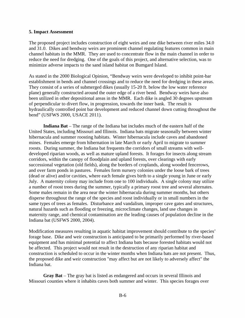
B-6
5. Impact Assessment The proposed project includes construction of eight weirs and one dike between river miles 34.0 and 31.0. Dikes and bendway weirs are prominent channel regulating features common in main channel habitats in the MMR. They are used to concentrate flow in the main channel in order to reduce the need for dredging. One of the goals of this project, and alternative selection, was to minimize adverse impacts to the sand island habitat on Bumgard Island. As stated in the 2000 Biological Opinion, “Bendway weirs were developed to inhibit point-bar establishment in bends and channel crossings and to reduce the need for dredging in these areas. They consist of a series of submerged dikes (usually 15-20 ft. below the low water reference plane) generally constructed around the outer edge of a river bend. Bendway weirs have also been utilized in other depositional areas in the MMR. Each dike is angled 30 degrees upstream of perpendicular to divert flow, in progression, towards the inner bank. The result is hydraulically controlled point bar development and reduced channel down cutting throughout the bend” (USFWS 2000, USACE 2011). Indiana Bat – The range of the Indiana bat includes much of the eastern half of the United States, including Missouri and Illinois. Indiana bats migrate seasonally between winter hibernacula and summer roosting habitats. Winter hibernacula include caves and abandoned mines. Females emerge from hibernation in late March or early April to migrate to summer roosts. During summer, the Indiana bat frequents the corridors of small streams with well-developed riparian woods, as well as mature upland forests. It forages for insects along stream corridors, within the canopy of floodplain and upland forests, over clearings with early successional vegetation (old fields), along the borders of croplands, along wooded fencerows, and over farm ponds in pastures. Females form nursery colonies under the loose bark of trees (dead or alive) and/or cavities, where each female gives birth to a single young in June or early July. A maternity colony may include from one to 100 individuals. A single colony may utilize a number of roost trees during the summer, typically a primary roost tree and several alternates. Some males remain in the area near the winter hibernacula during summer months, but others disperse throughout the range of the species and roost individually or in small numbers in the same types of trees as females. Disturbance and vandalism, improper cave gates and structures, natural hazards such as flooding or freezing, microclimate changes, land use changes in maternity range, and chemical contamination are the leading causes of population decline in the Indiana bat (USFWS 2000, 2004). Modification measures resulting in aquatic habitat improvement should contribute to the species’ forage base. Dike and weir construction is anticipated to be primarily performed by river-based equipment and has minimal potential to affect Indiana bats because forested habitats would not be affected. This project would not result in the destruction of any riparian habitat and construction is scheduled to occur in the winter months when Indiana bats are not present. Thus, the proposed dike and weir construction "may affect but are not likely to adversely affect" the Indiana bat.
Gray Bat – The gray bat is listed as endangered and occurs in several Illinois and Missouri counties where it inhabits caves both summer and winter. This species forages over
B-7
rivers and reservoirs adjacent to forests. No caves would be impacted by the proposed action; therefore, this project would have “no effect” on the gray bat.
Northern long-eared bat - The northern long-eared bat is a federal candidate for listing as an endangered species throughout its range (Federal Register 2 October 2013). The northern long-eared bat is sparsely found across much of the eastern and north central United States, and all Canadian provinces from the Atlantic Ocean west to the southern Yukon Territory and eastern British Columbia. Northern long-eared bats spend winter hibernating in large caves and mines. During summer, this species roosts singly or in colonies underneath bark, in cavities, in crevices of both live and dead trees. Foraging occurs in interior upland forests. Forest fragmentation, logging and forest conversion are major threats to the species. One of the primary threats to the northern long-eared bat is the fungal disease, white-nose syndrome, which has killed an estimated 5.5 million cave-hibernating bats in the Northeast, Southeast, Midwest and Canada. No caves or upland forests would be impacted by the proposed action; therefore, this project would have “no effect” on the northern long-eared bat.
Least Tern – The least tern is a colonial, migratory waterbird which resides and breeds along the Mississippi River during the spring and summer. Least terns arrive on the Mississippi River from late April to mid-May. Reproduction takes place from May through August, and the birds migrate to the wintering grounds in late August or early September (USACE 1999b). Sparsely vegetated portions of sandbars and islands are typical breeding, nesting, rearing, loafing, and roosting sites for least terns along the MMR. Nests are often at higher elevations and well removed from the water’s edge, a reflection of the fact that nesting starts when river stages are relatively high (USACE 1999b). In alluvial rivers, sandbars are dynamic channel bedforms. Individual sandbars typically wax and wane over time as fluvial processes and the construction of river engineering works adjust channel geometry according to varying sediment load and discharge. There is limited data on site fidelity for Mississippi River least terns. Given the highly dynamic bed and planform of the historic river, ability to return to previously used colony sites is not likely a critical life history requirement. The availability of sandbar habitat to least terns for breeding, nesting, and rearing of chicks from 15 May to 31 August is a key variable in the population ecology of this water bird. Only portions of sandbars that are not densely covered by woody vegetation and that are exposed during the 15 May to 31 August period are potentially available to least terns (USACE 1999b). The size of nesting areas and the number of nests within a colony depend on water levels and the extent of associated sandbars (Sidle and Harrison 1990). Sandbars have a greater possibility of colonization by least terns if river levels remain low during the breeding season. Smith and Renken (1991) found that sites were more likely to be used by interior least terns in the Mississippi River Valley adjacent to Missouri if sites were continuously exposed for at least 100 days during the breeding season. A 1999 report (USACE 1999b) estimated that there were approximately 20,412 acres of nonvegetated sandbar habitat above the MMR low water reference plane (LWRP). About 4,975 acres (111 ac/RM) were located between the Mouth of the Ohio and Thebes Gap (RM 0-45) and 15,437 acres (103 ac/RM) between Thebes Gap and the Mouth of the Missouri River (RM 45-195). Currently, reoccurring nesting is known at Marquette Island (RM 50.5), Bumgard Island (RM 30), and Brown’s Bar (RM 24.5-23.5) (Jones 2009, USFWS 2004). Some nesting attempts have also been made at Ellis Island (RM 202), however these are not considered to be reoccurring. While the Mississippi River appears to have a large amount of sandbar habitat,

B-8
much of this habitat is not likely available to least terns for nesting and may not be located near suitable foraging habitats (USFWS 2009). Least terns are almost exclusively piscivorous (Anderson 1983), preying on small fish, primarily minnows (Cyprinidae). Prey size appears to be a more important factor determining dietary composition than preference for a particular species or group of fishes (Moseley 1976, Whitman 1988, USACE 1999b). Fishing occurs close to the nesting colonies and may occur in both shallow and deep water, in main stem river habitats or backwater lakes or overflow areas. Radiotelemetry studies have shown that terns will travel up to 2.5 miles to fish (Sidle and Harrison 1990, USACE 1999b). Along the Mississippi River, individuals are commonly observed hovering and diving for fish over current divergences (boils) in the main channel, in areas of turbulence and eddies along natural and revetted banks, and at “run outs” from floodplain lakes where forage fish may be concentrated (USACE 1999b). As noted above, least terns are known to nest on Bumgard Island (Jones 2009, Keith McMullen St. Louis District USACE pers. comm.). In a meeting with the Missouri Department of Conservation (MDC), Illinois Department of Natural Resources (IDNR), the U.S Fish & Wildlife Service, Fisheries and Ecological Services (USFWS), and industry groups on 18 September, 2013, (and after many prior group discussions with the natural resource agencies and industry), a design for the placement of the rock structures was chosen to minimize the impacts to Bumgard Island and hence the least tern habitat. In order to comply with the programmatic Biological Opinion and implementation of the Reasonable and prudent Measures and Terms and Conditions prescribed therein (USFWS 2000), it was agreed upon that Alternative 75 achieved the best balance of the study’s goals, including pre- and post construction monitoring, and was the recommended alternative. However, it was also agreed upon that Alternative 75 could have some impacts to the Bumgard Island complex especially regarding side channel flows and loss of island habitat. Concerns were expressed that there could be possible decreases or increases in the amount of flow in the side channel that the model could not detect with the proposed alternatives. Under present conditions flow is maintained in the side channel for most of the year making it accessible to fish and keeping the island isolated from the bank - important components of least tern habitat. The combination of the proposed weirs and dike in the model have shown a slight reduction in the size of the island and a loss of the shallow water habitat on the downstream end of the island. As the recommended course of action, Alternative 75 would be proposed for construction during late FY14 or early FY15, pending completion of required environmental compliance review. The reach would be physically monitored prior to and extensively after construction, to evaluate hydrologic and geomorphic changes. After the river has had time to react to the structures, the group would evaluate the reach again to determine if adverse changes to side channel flows and/or losses to island habitat were taking place. If so, a re-evaluation of the alternatives would be required. Details of the hydraulic sediment response model (HSR) that led to the formation and analysis of alternatives can be found at: http://mvs-wc.mvs.usace.army.mil/arec/Reports_HSR_Model.html

B-9
Although adverse impacts to the least tern associated with this project have been avoided and minimized to the greatest extent possible and design modifications have been incorporated to provide habitat benefits, the least tern may still be adversely affected by the project. However, the adverse effects of the project on the least tern are consistent with those anticipated in the programmatic Biological Opinion and the District has implemented the Reasonable and Prudent Measures and Terms and Conditions prescribed therein as appropriate for the project. Pallid Sturgeon – The estimated population of pallid sturgeon in the MMR ranges between 4900 and 1600 individuals (Garvey et al. 2009). Pallid sturgeon are very rare relative to shovelnose sturgeon in the MMR (a 1:82 ratio), whereas at Baton Rouge, Louisiana the ratio is 1:6. Threats to population recovery of pallid sturgeon include limited rearing and nursery habitat and loss of mature female adults. Pallids apparent non-reproductive habitat includes wing dikes with sandy substrate, and areas with contrasting flow velocities, complexes of island point bars, and side channels. During low water as in late summer, pallids are found more in the main channel. Reproductive habitat includes the Chain of Rocks area, known gravel bars in the MMR, tributary confluences and side channels (Peterson and Herzog 1999, Garvey et al. 2009). According to Garvey et al. (2009), adult pallid habitat for foraging and holding station in flow in the MMR is adequate and related primarily to the wing dike areas, although all habitats have been occupied. Hypothetically, some wing dikes may mimic natural depositional areas adjacent to the main channel. Pallid sturgeon need main channel conditions, island areas that provide an ecotone between flow with deposition. These areas cause an accumulation of insects and small insectivorous fish that facilitate foraging, growth and ultimately reproductive condition. The availability and quality of reproductive habitat for spawning and production of offspring in the MMR is unknown (Sheehan and Heidinger 2001, Garvey et al. 2009). If adult pallid sturgeon densities increase, wing dikes creating preferred habitat will likely become limited and habitat restoration that creates needed main-channel conditions should be a priority (Garvey et al. 2009). It is the position of the U.S. Fish and Wildlife Service (2000) that over time, channel training structures have adversely affected pallid sturgeon by altering the quality and quantity of habitats in the MMR to which the species is adapted (e.g., braided channels, irregular flow patterns, flood cycles, extensive microhabitat diversity, and turbid waters). According to the Service, this loss of habitat has reduced pallid sturgeon reproduction, growth, and survival by (1) decreasing the availability of spawning habitat; (2) reducing larval and juvenile pallid sturgeon rearing habitat; (3) reducing the availability of seasonal refugia, and (4) reducing the availability of foraging habitat (USFWS 2000). Additionally, some authors believe that loss of habitat contributes to the hybridization of pallid and shovelnose sturgeon (Carlson et al. 1985, Keenlyne et al. 1993, Campton et al. 1995, USFWS 2000). The Service also asserts that these habitat changes have also reduced the natural forage base of the pallid sturgeon, and is another likely contributing factor in its decline (Mayden and Kuhajda 1997, USFWS 2000). The Service states that channel training structures have also altered the natural hydrograph of the MMR by contributing to higher water surface elevations at lower discharges than in the past and to a downward trend in annual minimum stages (Simons et al. 1974, Wlosinski 1999, USFWS 2000). Thus, as a result, previously aquatic habitats are now dry at low discharges (Wlosinski 1999). According to the Service, this has potentially reduced the availability of pallid sturgeon spawning habitat through
B-10
the loss of habitat complexity (USFWS 2000). Confinement and simplification of the main channel likely reduce habitat features such as instream islands and side channels (Garvey et al. 2009). Construction activities may result in short-term adverse effects for pallid sturgeon. Activities that impact any existing deepwater habitat may result in displacement of pallid sturgeon. Disruption of existing sand bar habitat may impact foraging habitat. However, these adverse effects are expected to occur at a local, individual dike/weir scale. By completing regulating works projects with incorporated modifications and limitations to increase habitat diversity at the scale of the dike/weir field, long-term beneficial effects for pallid sturgeon should result. The creation of scour holes is expected to create additional larval/juvenile rearing habitat and seasonal refugia, and improve forage food production (USFWS 2004). It is the position of the St. Louis District that short-term adverse impacts that may occur are limited, and the long-term impacts associated with reduced dredging and increased habitat diversity, which is expected as a consequence of river training structure modification and dike placement, are predicted to be beneficial to pallid sturgeon. As above for the least tern, in a meeting with the MDC, IDNR, the USFWS, and industry groups on 18 September, 2013, (and after many prior group discussions with the natural resource agencies and industry), a design for the placement of the rock structures was chosen to minimize the impacts to the Bumgard Island complex including adjacent and localized pallid sturgeon habitat. In order to comply with the programmatic Biological Opinion and implementation of the Reasonable and prudent Measures and Terms and Conditions prescribed therein (USFWS 2000), it was agreed upon that Alternative 75 achieved the best balance of the study’s goals, including pre- and post construction monitoring, and was the recommended alternative. However, as mentioned above for the least tern, it was also agreed upon that Alternative 75 could also potentially cause some adverse impacts to the Bumgard Island complex, especially regarding side channel flows which currently provides suitable habitat for the pallid sturgeon. Concerns were expressed that there could be possible decreases or increases in the amount of flow in the side channel that the model could not detect with the proposed alternatives. Under present conditions flow is maintained in the side channel for most of the year making it accessible to fish and keeping the island isolated from the bank. The island complex also provides a variety of habitats that are used not only by adult and juvenile pallid sturgeon, but also many other species. There is a large gravel bar on the upper half of the island and the lower half of the island that provides a diversity of gradual sloping banks and shallow water habitat (limiting habitat in the Mississippi), which has been documented as being used by young of year pallid sturgeon. The combination of the proposed weirs and dike in the model has shown a slight reduction in the size of the island and a loss of the shallow water habitat on the downstream end of the island. As the recommended course of action, Alternative 75 would be proposed for construction during late FY14 or early FY15, pending completion of required environmental compliance review. The reach would be physically monitored prior to and extensively after construction, to evaluate hydrologic and geomorphic changes. After the river has had time to react to the structures, the group would evaluate the reach again to determine if adverse changes to side channel flows
B-11
and/or losses to island habitat were taking place. If so, a re-evaluation of the alternatives would be required. Details of the hydraulic sediment response model (HSR) that led to the formation and analysis of alternatives can be found at: http://mvs-wc.mvs.usace.army.mil/arec/Reports_HSR_Model.html Although adverse impacts to pallid sturgeon associated with this project have been avoided and minimized to the greatest extent possible and design modifications have been incorporated to provide habitat benefits, pallid sturgeon may still be adversely affected by the project. However, the adverse effects of the project on the pallid sturgeon are consistent with those anticipated in the programmatic Biological Opinion and the District has implemented the Reasonable and Prudent Measures and Terms and Conditions prescribed therein as appropriate for the project. Fat pocketbook pearlymussel - The fat pocketbook pearly mussel is listed as endangered has has only been found occasionally within the Mississippi River, although currently there are no known viable populations (USFWS 1989). Collection records suggest that this mussel prefers lotic habitat with firm substrate (USFWS 1989). Because of its rarity and preferred habitat which does not normally exist within the construction area the project would have “no effect” on the fat pocketbook pearlymussel. Sheepnose mussel – The sheepnose is listed as a federally endangered species and occurs in the Meramec River in Jefferson County, Missouri. This species inhabits gravel and mixed sand and gravel habitats in medium to large rivers (USFWS 2003). The sheepnose is thought to be extant in five pools (3, 5, 15, 20 and 22) in very low numbers. In the Upper Mississippi River, the sheepnose is an example of a rare species becoming rarer. Despite the discovery of juvenile recruitment in Mississippi River Pool 7, the sheepnose population levels in the Upper Mississippi River appear to be very small and of questionable long-term viability given the threats outlined below. The sheepnose and other mussel populations in the Upper Mississippi River are seriously threatened by zebra mussels. Even if some level of sheepnose recruitment was documented, the status of this species in the Mississippi is highly jeopardized, with imminent extirpation a distinct possibility (USFWS 2003). This project could potentially benefit this species by providing some of its necessary habitat features, i.e. shallow shoal habitats and flow refugia. This project “may affect, but is unlikely to adversely affect” the sheepnose mussel. Rabbitsfoot - The rabbitsfoot is listed as federally threatened (SSFWS 2009). It is primarily an inhabitant of small to medium sized streams and some larger rivers. It usually occurs in shallow water areas along the bank and adjacent runs and shoals with reduced water velocity and in moderately compacted gravel and sand substrate. It has also been documented in mixed cobble and gravel substrate. It feeds on the bottom of a stream, lake, or pond but rarely burrows into the substrate. In small streams, this species is associated with bars or gravel and cobble near fast current, and it has also been found in eddies along the periphery of midstream currents. Spawning occurs between May and July. Threats include siltation, drainage, pollution, zebra mussels, impoundments, livestock, and poor water quality. This species is not known
B-12
historically to occur in the Mississippi River; therefore, this project will have “no effect” on the rabbitsfoot mussel.
Decurrent false aster – The decurrent false aster is presently known from scattered floodplain localities from the confluence of the Mississippi River with the Illinois River south to Madison County, Illinois (USFWS 1990a). Its natural habitat was lake shores and stream banks with abundant light. Populations presently grow in natural habitat, but are more common in disturbed lowland areas where they appear to be dependent on human activity for survival (USFWS 1990). Because this species is not known from the project area, the project “may affect, but is not likely to adversely affect” the decurrent false aster. 6. Literature Cited Anderson, E.A. 1983. “Nesting Productivity of the interior or Least Tern in Illinois.”
Unpublished Report. Cooperative Wildlife Research Laboratory, Southern Illinois University, Carbondale, Illinois, 19 pp.
Campton, D.E., A.I. Garcia, B.W. Bowen, and F.A. Chapman. 1995. Genetic Evaluation of
Pallid, Shovelnose and Alabama Sturgeon (Scaphirhynchus albus, S. platorhynchus, and S. suttkusi) Based on Control Region (D-loop) Sequences of Mitochondrial DNA. Report from Dept. of Fisheries and Aquatic Sciences, Univ. of Florida, Gainesville, Florida.
Carlson, D.M., W.L. Pflieger, L. Trial, and P.S. Haverland. 1985. Distribution, biology, and
hybridization of Scaphirhynchus albus and S. platorhynchus in the Missouri and Mississippi Rivers. Environmental Biology of Fishes. 14:51-59.
Garvey, J.E., E.J. Heist, R.C. Brooks, D.P. Herzog, R. A. Hrabik, K.J. Killgore, J. Hoover, and
C. Murphy. 2009. Current status of the pallid sturgeon in the Middle Mississippi River: habitat, movement, and demographics. Saint Louis District, US Army Corps of Engineers. http://fishdata.siu.edu/pallid
Jones, K. H. 2009. Population Survey of the Interior Least Tern on the Mississippi River from
Cape Girardeau, Missouri to Baton Rouge, Louisiana. Under contract with Choctaw Transportation Company, Inc. Dyersburg, Tennessee. 18 pp. with appendix.
Keenlyne, K.D., L.K. Graham, and B.C. Reed. 1993. Natural hybrids between two species of
Scaphirhynchinae sturgeon. U.S. Fish and Wildlife Service, Pierre, South Dakota. Unpubl. Report.
Mayden, R.L., and B.R. Kuhajda. 1997. Threatened fishes of the world: Scaphirhynchus albus
(Forbes and Richardson, 1905) (Acipenseridae). Environmental Biology of Fishes. 48:420-421.
Moseley, L.J. 1976. “Behavior and Communication in the Least Tern (Sterna albifrons).” Ph.D.
Dissertation, University of North Carolina, Chapel Hill. 164 pp.
B-13
Petersen, M., and D. Herzog. 1999. Open River Field Station Report: Young-of-the-year pallid
sturgeon collected in the Mississippi River. Missouri Department of Conservation, Long Term Resource Monitoring Station, Cape Girardeau, Missouri.
Sheehan, R.J., R.C. Heidinger, K. Hurley, P.S. Wills, M.A. Schmidt. 1998. Middle Mississippi
River pallid sturgeon habitat use project: Year 3 Annual Progress Report, December 1998. Fisheries Research Laboratory and Department of Zoology, Southern Illinois University at Carbondale, Carbondale, Illinois.
Sheehan, R.J., and R. C. Heidinger. 2001. Middle Mississippi River Pallid Sturgeon Habitat
Use Project. In: Upper Mississippi River Basin, Mississippi River Missouri and Illinois, Progress Report 2000, Design Memorandum Number 24, Avoid and Minimize Measures, June 2001.
Sidle, J.G. and W.F. Harrison, 1990. Recovery Plan for the Interior Population of the Least
Tern (Sterna antillarum). U.S. Fish and Wildlife Service, Twin Cities, Minnesota. 90 pp. (1)
Simons, D.B., S.A. Schumm, and M.A. Stevens. 1974. Geomorphology of the Middle
Mississippi River. Report DACW39-73-C-0026 prepared for the U.S. Army Corps of Engineers, St. Louis District, St. Louis, Missouri. 110 pp.
Smith, J. W., and R. B. Renken. 1991. Least tern nesting habitat in the Missisippi River valley
adjacent to Missouri. Journal of Field Ornithology 62:497-504. USACE (U.S. Army Corps of Engineers). 1999a. Tier I of a Two Tiered Biological
Assessment. Operation and Maintenance of the Upper Mississippi River Navigation Project within St. Paul, Rock Island, and St. Louis Districts. U.S. Army Corps of Engineers. April 1999.
USACE (U.S. Army Corps of Engineers). 1999b. Biological Assessment, Interior Population of
the Least Tern, Sterna Antillarum, Regulating Works Project, Upper Mississippi River (River Miles 0-195) and Mississippi River and Tributaries Project, Channel Improvement Feature, Lower Mississippi River (River Miles 0-954.5, AHP). U. S. Army Corps of Engineers, Mississippi Valley Division/Mississippi River Commission, Vicksburg, Mississippi, December 1999.
USACE (U.S. Army Corps of Engineers). 2011 Analysis of the Effects of Bendway Weir
Construction on Channel Cross-Sectional Geometry 34 pp. USFWS (U.S. Fish and Wildlife Service). (1989). "A Recovery Plan for the Fat Pocketbook Pearly
Mussel Potamilus canax (Green 1832) ," U.S. Fish and Wildlife Service. Atlanta, Georgia. 22 pp. USFWS (U.S. Fish and Wildlife Service). 1990. Decurrent False Aster Recovery Plan. Twin
Cities, Minnesota: U.S. Fish and Wildlife Service. 26 pp.
B-14
USFWS (U.S. Fish and Wildlife Service). 2000. Biological Opinion for the Operation and Maintenance of the 9-Food Navigation Channel on the Upper Mississippi River System, May 15, 2000.
USFWS (U.S. Fish and Wildlife Service). 2003. Status Assessment Report for the sheepnose,
Plethobasus cyphyus, occurring in the Mississippi River system (U.S. Fish and Wildlife Service Regions 3, 4, and 5)
USFWS (U.S. Fish and Wildlife Service). 2004. Final Biological Opinion for the Upper
Mississippi River-Illinois Waterway System Navigation Feasibility Study, August 2004. USFWS (U.S. Fish and Wildlife Service). 2009. Section 7 Consultation: Operation and
Maintenance of the Upper Mississippi River 9-Foot Channel [Online Source] Available: Interior Least Tern http://www.fws.gov/midwest/endangered/section7/tern.html
USFWS (U.S. Fish and Wildlife Service). 2009. Rabbitsfoot Candidate Form
http://www.fws.gov/midwest/endangered/clams/pdf/rabbistfoot_cand_elevation.pdf. Whitman, P.L. 1988. Biology and Conservation of the Endangered Interior Least Tern: A
Literature Review. Biological Report 88(3). U.S. Fish and Wildlife Service, Division of Endangered Species, Twin Cities, Minnesota.
Wlosinski, J. 1999. Hydrology. Pages 6-1 to 6-10 in USGS, ed., Ecological Status and Trends
of the Upper Mississippi River System. USGS Upper Midwest Environmental Sciences Center, LaCrosse, Wisconsin. 241 pp.

Appendix C. Cumulative Impacts Analysis
C-1
Cumulative Impacts Analysis The Council on Environmental Quality (CEQ) regulations define cumulative impacts as “the impact on the environment which results from the incremental impact of the action when added to other past, present, and reasonably foreseeable future actions regardless of what agency (Federal or non-Federal) or person undertakes such other actions. Cumulative impacts can result from individually minor but collectively significant actions taking place over a period of time.” (40 CFR §1508.7). In order to assist federal agencies in producing better cumulative impact analyses, CEQ developed a handbook, “Considering Cumulative Effects under the National Environmental Policy Act” (CEQ 1997). Accordingly, the Dogtooth Bend Phase 5 EA cumulative impact analysis generally followed the steps laid out by the handbook. Cumulative impact analysis involved determining the incremental impact of the Alternatives on resources in the area in the context of all of the other past, present, and reasonably foreseeable future actions that might also impact each resource category. The analysis looked beyond the footprint of the work area to include impacts to the resources throughout the Middle Mississippi River. Clearly the resources, ecosystem and human environment in the Middle Mississippi River have been, and will continue to be, impacted by a wide range of actions. The cumulative impact analysis evaluates the same resources (Physical Resources [River Stages, Water Quality, and Air Quality]; Biological Resources [Fish and Wildlife: Dike Effects, Bendway Weir Effects, Threatened & Endangered Species, and Climate Change]; Socioeconomic Resources [Navigation]; and Historic & Cultural Resources) that were evaluated in the Environmental Consequences section. In addition, the cumulative impacts for the No Action Alternative and Action Alternative were evaluated for navigation effects and side channel impacts. The Regulating Works Project, in combination with the other actions throughout the watershed, has had past impacts, both positive and negative, on the resources, ecosystem and human environment. However, this analysis is meant to characterize the incremental impact of the current action in the broader context of other actions affecting the same resources. Although past actions associated with the Regulating Works Project have impacted these resources, the current method of conducting business for the Project – involving partner agencies throughout the planning process, avoiding and minimizing impacts during the planning process, and utilizing innovative river training structure configurations to provide habitat diversity while still providing benefits to the navigation system – has been successful in accomplishing the desired effect of avoiding significant environmental consequences. Although our understanding of the actions that bear upon the resources of the Middle Mississippi River continues to evolve, equilibrium in habitat conditions appears to have been reached. Accordingly, no significant impacts to the resources, ecosystem and human environment are anticipated for the Dogtooth Bend Phase 5 work area.

C-2
Physical Resources
River Stages A summary of research on the effects of river training structures on flood heights is provided in Appendix A. As noted in the Environmental Consequences (Physical Resources, River Stages) section, the District has concluded that river training structures do not affect water surface elevations at higher flows. With respect to water surface elevations at low flows, analysis of data show a trend of decreasing stages. It is not known if this is a result of construction of river training structures or the reduction of sediment load due to the construction of reservoirs on Mississippi River tributaries (Huizinga 2009). Reduced stages was acknowledged in the 1976 Regulating Works EIS (USACE) and the potential loss of side channels was discussed. The District acknowledges the importance of side channels and has continued to monitor the changes in the morphology and geometry of existing side channels. To offset potential impacts to side channels the District has initiated side channel restoration planning (USACE 1999; Nestler et al. 2012) and has conducted a number of restoration projects. The number of side channels has been substantially preserved through these monitoring and restoration efforts combined with natural processes within the side channels. Based on this analysis, the impacts of No Action and the Proposed Action, when evaluated in relation to past and present stage heights, are not anticipated to rise above what would occur naturally. The potential reduction in stages and impacts on side channels were addressed in the 1976 EIS. Potential impacts, if they are being caused by river training structures, should be offset by side channel restoration/enhancement features constructed in the future by the District under various authorities and the use of innovative river training structure configurations designed to divert flow into existing side channels.
Water Quality Prior to the implementation of the Clean Water Act, the MMR was an open sewer and a convenient place to dump solid waste (Bi-State Development Agency 1958; U.S. Public Health Service 1958). Raw sewage, untreated industrial waste, and ground garbage were discharged into the MMR (in 1952, approximately 212 tons/day of garbage [animal and vegetable waste] were collected in St. Louis, ground, and discharged.) This resulted in high oxygen demand; extremely high fecal coliform levels; low dissolved oxygen levels (< 5 mg/l); transport of toilet paper, animal entrails, and other solid wastes; elimination of aquatic life below St. Louis and reduction of aquatic life for a large portion of the MMR; and unpalatable fish where they did exist (Ellis 1931; Ellis 1943; Platner 1943; Bi-State Development Agency 1954; U.S. Public Health Service 1958; Baldwin 1970). Severely degraded water quality conditions in the MMR rose to the level of a human health hazard and a conference was convened in St. Louis (U.S. Public Health Service 1958) to discuss remedies. Water quality in the MMR has improved dramatically since the implementation of the Clean Water Act. Although the MMR has improved, it currently exceeds suggested nutrient (total nitrogen and phosphorus) guidelines either part of the time (nitrogen) or most of the time (phosphorous) (Johnson and Hagerty 2008). As discussed in the affected environment section, there are also fish consumption advisories for PCB, chlordane, and mercury contamination.

C-3
During major storm events, raw sewage enters the river because of sewage treatment plant overloads due to combined (sewage/stormwater) sewage systems. Crites et al. (2012) found that water quality conditions in Buffalo Chute (River Mile 26) during isolation (mid-June through March during their study) from the river channel were not conducive to supporting healthy native fish communities. Thermal and chemical stratifications coupled with high water temperatures and anoxic conditions were observed during the summer months during two years of study. Johnson and Hagerty (2008) indicated that future changes in nutrient inputs to the river are difficult to predict, and largely a function of outputs from sewage treatment plants and runoff from fertilizer application on land. There are ongoing efforts in the St. Louis area to improve wastewater treatment and alleviate the problems associated with combined sewage systems. These efforts should improve nutrient loading and eventually eliminate raw sewage overflow events. It is not anticipated that nutrients from agriculture will rise; however, this is driven by agricultural economics. The St. Louis District has conducted side channel restoration planning (USACE, 1999; Nestler et al. 2012) and has been restoring side channels under various authorities. Water quality and aquatic ecosystem improvement are basic goals of these restoration efforts. So, water quality conditions in the MMR are expected to improve with time. The No Action Alternative would have no additional impacts (existing level of dredging associated short-term turbidity plume) on water quality. The Proposed Action would have only minor, short-term construction impacts on water quality. Navigation traffic levels and associated turbidity pulses will remain the same under both the No Action and Proposed Action. As such, the impacts of No Action and the Proposed Action, when evaluated in relation to past, present, and future water quality impacts, are not anticipated to rise to the level of a significant impact.
Air Quality The work area is currently designated as attainment areas for all six criteria air pollutants (ozone, particulate matter, carbon monoxide, nitrogen oxides, sulfur dioxide, and lead) (USEPA 2013). There are no known foreseeable projects in the work area that would adversely impact air quality. The No Action Alternative would have no additional impacts on air quality. The Proposed Action would have only minor, short-term, air quality impacts associated with the use of construction equipment. Navigation traffic levels and associated engine exhaust will remain the same under both the No Action and Action Alternatives. As such, the impacts of No Action and the Proposed Action, when evaluated in relation to past, present, and future air quality, are not anticipated to rise to the level of a significant impact. Biological Resources (Fish & Wildlife)
Dike & Revetments (Dikes, Bendway Weirs, and Revetment) Currently, there are 1,375 river training structures on the MMR, which include wing dikes, bendway weirs, chevrons, and other configurations. Of this total, 175 are bendway weirs. The pace of construction has changed over time and the shape, size, elevation and configuration of

C-4
river training structures has also changed. The St. Louis District built approximately 450 river training structures in the late 19th century and another 250 in the 1930s. The District constructed 150 bendway weirs from 1990 to 2000. Table 1 lists work areas that are considered likely to be constructed in the reasonably foreseeable future. Table 1. List of Regulating Works work areas showing location and structure type that are considered likely to be constructed in the reasonably foreseeable future (USACE 2012a; USACE 2012b; USACE 2013a; USACE 2013b).
Major Reach Localized Reach Work in Reach
Mosenthein-Ivory Landing Phase 4 (RM 195-154) St. Louis Harbor
Revetment RM (175-171) Raise Dike 181.7L Dike 173.4L
Eliza Point/Greenfield Bend Phase 3 (RM 20 - 0)
Bird's Point (RM 4 - 0)
Rootless Dike 3.0L Weir 2.6R Weir 2.5R Weir 2.3R Weir 2.2R
Grand Tower Phase 5 (RM 90 - 67)
Crawford Towhead (RM 75 - 71)
Chevron 73.6L Dike Extension 72.9L Chevron 72.5L
Vancil Towhead (RM 70-66)
Weir 69.15L Weir 68.95L Weir 68.75L Diverter Dike 68.10L Diverter Dike 67.80L Diverter Dike 67.50L Repair Dike 67.80L Shorten Dike 67.30L Shorten Dike 67.10L 600 ft revetment
Dogtooth Bend Phase 5 (RM 40-20)
Bumgard (RM 33-27)
Weir 34.20L Weir 34.10L Weir 32.50L Weir 32.40L Weir 32.30L Weir 32.20L Dike 31.60R Weir 30.80R Weir 30.70R

C-5
The St. Louis District has three Regulating Works HSR model studies that are ongoing and will likely result in future construction. They are the Mouth of the Meramec HSR Model Study, the Gray’s Point HSR Model Study, and the Upper Brown’s Bar HSR Model Study. The Mouth of the Meramec HSR Model Study is intended to identify a river engineering design that will reduce or eliminate the need for repetitive dredging at approximately UMR 161. The Gray's Point HSR Model Study is intended to identify a river engineering design that will reduce or eliminate the need for repetitive dredging at approximately UMR 46. The Upper Brown’s Bar HSR Model Study is intended to identify a river engineering design that will reduce or eliminate the need for repetitive dredging at approximately UMR 24. Specific designs for construction are dependent on the modeling efforts which are anticipated to be available by September 30, 2014. Success of the Regulating Works Project is dependent on careful evaluation of conditions on the Middle Mississippi River over time while incrementally implementing river training structures to provide a safe and dependable navigation channel while reducing the need for repetitive dredging. Future needs are based on priority work locations that are determined by examining repetitive dredging problems on the Middle Mississippi River. The District then develops alternatives using widely recognized and accepted river engineering guidance and practice, and then screens and analyzes different configurations of regulating works with the assistance of a Hydraulic Sediment Response (HSR) model. During the alternative evaluation process, the District works closely with industry and natural resource agency partners to further evaluate potential alternatives, including configurations analyzed in the HSR model. This process results in alternatives which reasonably meet the project purpose while also avoiding/minimizing environmental impacts. The timing of future construction is heavily dependent on Congressional funding and modeling results. A discussion of the environmental impacts of dike and revetments is contained in Section 4 Environmental Consequences (Physical Resources: River Stages and Biological Resources: Dike Effects and Bendway Weir Effects). Potential cumulative impacts of the Regulating Works Project on biological resources fall into a number of general categories: 1. Biological effects of training structures and their construction, and the biological implications of existing and reduced dredging; 2. Potential impacts of reduced channel migration; and, 3. Potential effects of changed flow patterns.
1. Construction impacts (actual construction related impacts) would be minimal under the no action alternative because no new construction (no construction impacts) would occur and structure repair would have minimal impacts. Under the no action alternative, dredging frequency, quantity, and area dredged would remain similar to what it is today. Benthic invertebrates in the dredged area would be killed and dredged material disposal would cover and kill benthic invertebrates in the disposal area. These areas would recover at a rate that is most likely site specific, but the cycle would continue the next time dredging is required (Koel and Stevenson 2002). Under the action alternative, benthic invertebrates in any future construction areas would be covered by the structure (rock) and killed. The area under the structures would be covered and unavailable for future colonization by benthic invertebrates. The environmental effects of training structures have been described in detail in Section 4 – Environmental Consequences. Although the benthic fauna type will change, rock is far more attractive to benthic invertebrates than shifting sand and the density

C-6
(numbers/meter) will increase dramatically. This increase in benthic invertebrate density will also be more attractive to fish species. Construction of dikes has been suggested as a method for ecological enhancement (Radspinner et al. 2010) of river ecosystems and construction guidelines have been developed for revetment to benefit the environment (Shields and Tesa III et al. 1995). The St. Louis District has worked with partner agencies to develop innovative training structure configurations that fully serve their intended navigation function while providing environmental benefits at the same time. The structures themselves directly create/enhance aquatic habitat and provide fishery benefits. For example, chevron dike construction in St. Louis Harbor provided increased habitat diversity and increased fish use (Schneider 2012); off-bank dike notching has been used for island creation (River Mile 100 Islands) which has benefited the fishery (Allen 2010); wing dikes provide adult (Barko et al. 2004) and larval fish (Niles and Hartman 2009) habitat, wing dike tips provide summer habitats for juvenile rheophilic fishes (Bischoff and Wolter 2001) and dike scour holes provide fish habitat, especially during the winter. Under the action alternative, future dredging and associated impacts to the benthic fauna would be reduced in frequency and quantity. Following a period of widening and instability on the MMR, historic dike construction caused a narrowing of the river planform due to sediment accretion followed by terrestrial vegetation growth (Brauer et al. 2005; Brauer et al. 2013). Continued operation and maintenance of the training structures has maintained the narrowed channel. Table 7 in the EA shows the average planform width of the MMR from 1817 through 2011. Since 1968, the channel width appears to have reached a dynamic equilibrium with very little change occurring. It is anticipated that dynamic equilibrium in channel width will be maintained with little change resulting from additional training structure construction. As such, the impacts of No Action and the Proposed Action, when evaluated in relation to past, present, and future biological impacts of structure construction and operation and maintenance of the structures, are not anticipated to rise to the level of a significant impact.
2. As noted in Cumulative Impact Analysis (Side Channels), the potential for the natural development of new MMR side channels, which is a natural geomorphic process in fluvial river systems (Grenfell et al., 2012), has been restricted by the placement of stone revetment on the bankline as part of the Regulating Works Project. Bankline revetment restricts channel migration and has fixed the MMR in place, thus eliminating the potential for new natural side channel development. Since no new natural side channels are being created, it is essential to engineer new side channels through the manipulation of existing river training structures and new innovative river training structure configurations as well as maintain and restore those that remain through other programs authorized to so. Based on the analysis conducted in the Side Channel Section, the impacts of No Action and the Proposed Action, when evaluated in relation to past, present, and future condition of MMR side channels, are not anticipated to rise beyond the levels previously described in the 1976 EIS.
3. Dikes change flow patterns and increase both velocity and turbulence near the structure
(Yossef and de Vriend 2011; Jia et al. 2009; and Ouillon and Dartus 1997 and others).

C-7
McElroy et al. (2012) have recently found that fish use particular paths for migrations that take advantage of flow velocities (both high and low velocities) to reduce their energy output during migrations. Currently, the extent of this potential impact in the MMR is unknown, and the means to obtain a full understanding of how this information may or may not impact the MMR is not known as this would be scientifically difficult to evaluate. The Corps continues to remain apprised, analyze, and consider any research or potential issues with respect to the impact of changing flow patterns on fish and wildlife.
Navigation Traffic
The movement of commercial navigation traffic has both physical and biological effects (Table 2) that affect the ecosystem health of the MMR. These impacts are discussed in greater detail in USACE (2004) and Söhngen et al. (2008). With respect to cumulative impacts (past, present, and future actions), the impacts of commercial navigation traffic resulted from the original development of the navigation project and subsequent operation and maintenance of the navigation channel. Because none of the actions associated with operation and maintenance will increase traffic and associated impacts, the impacts of the No Action Alternative and the Action Alternative are identical. In other words, only an action (construction project) that would increase traffic would also increase impacts beyond what we have today. Table 2: Potential Aquatic Impacts Associated with the Movement of Tows on the Middle Mississippi River ______________________________________________________________________________ Impact Reference ______________________________________________________________________________ Fish Recruitment (Nielsen et al. 1986; Arlinghaus et al. 2002;
Huckstorf et al. 2010) Propeller Mortality
Adult Fish (Gutreuter et al. 2003; Killgore et al. 2005; Killgore, et al. 2011; Miranda & Killgore 2013)
Adult Fish during Lockage (Keevin et al. 2005) Larval Fish (Holland and Sylvester 1983; Holland 1987;
Odum et al, 1992; Killgore et al. 2001; Bartell & Campbell 2000)
Fish Disturbance (Displacement from Channel) (Todd et al. 1989; Wolter and Bischoff 2001; Gutreuter et al. 2006)
Wave Wash Physical (Bhowmik et al 1999)
Fish (Sheehan et al. 2000a, 2000b; Wolter & Arlinghaus 2003; Wolter et al. 2005; Kucera-Hirzinger et al. 2009; Gabel et al. 2011b)
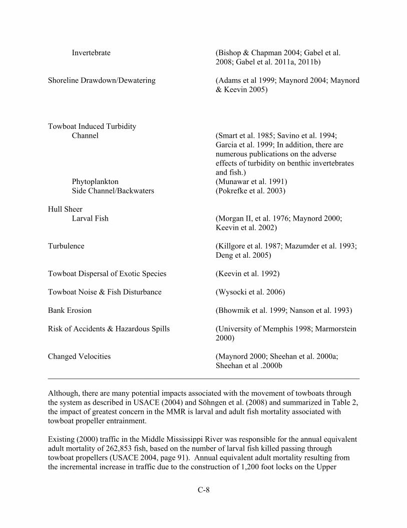
C-8
Invertebrate (Bishop & Chapman 2004; Gabel et al. 2008; Gabel et al. 2011a, 2011b) Shoreline Drawdown/Dewatering (Adams et al 1999; Maynord 2004; Maynord
& Keevin 2005) Towboat Induced Turbidity
Channel (Smart et al. 1985; Savino et al. 1994; Garcia et al. 1999; In addition, there are numerous publications on the adverse effects of turbidity on benthic invertebrates and fish.)
Phytoplankton (Munawar et al. 1991) Side Channel/Backwaters (Pokrefke et al. 2003) Hull Sheer
Larval Fish (Morgan II, et al. 1976; Maynord 2000; Keevin et al. 2002)
Turbulence (Killgore et al. 1987; Mazumder et al. 1993;
Deng et al. 2005) Towboat Dispersal of Exotic Species (Keevin et al. 1992) Towboat Noise & Fish Disturbance (Wysocki et al. 2006) Bank Erosion (Bhowmik et al. 1999; Nanson et al. 1993) Risk of Accidents & Hazardous Spills (University of Memphis 1998; Marmorstein
2000) Changed Velocities (Maynord 2000; Sheehan et al. 2000a;
Sheehan et al .2000b ______________________________________________________________________________ Although, there are many potential impacts associated with the movement of towboats through the system as described in USACE (2004) and Söhngen et al. (2008) and summarized in Table 2, the impact of greatest concern in the MMR is larval and adult fish mortality associated with towboat propeller entrainment. Existing (2000) traffic in the Middle Mississippi River was responsible for the annual equivalent adult mortality of 262,853 fish, based on the number of larval fish killed passing through towboat propellers (USACE 2004, page 91). Annual equivalent adult mortality resulting from the incremental increase in traffic due to the construction of 1,200 foot locks on the Upper

C-9
Mississippi River (USACE 2004 – a project not funded for construction) was projected to be between 11,612 and 79,274 fishes in the Middle Mississippi River for the year 2040 (USACE 2004, 396-397). Killgore et al. (2011) published a towboat propeller entrainment paper for adult fish for the pooled portion of the Upper Mississippi River. It indicated that fish entrainment was low (< 1 fish/km) in wide, deep and fast sections of the river, while it was variable and occasionally high (> 30 fish/km) in narrow, shallow, and slow reaches of the UMR. If you used the value of 1 fish/km injured or killed (the MMR is wide, deep and fast), then approximately 151,161 fish would be injured or killed per year (313.822 km x 19,938 towboats/year x .024 injury-mortality rate) in the Middle Mississippi River under existing traffic conditions. This number overestimates mortality, because only a fraction of towboats/year actually navigate the entire length of the system (only 7,750 locked through Locks 27). Additionally, another 34,972 adult fish are killed per year locking through Locks 27 (4.5125 average fish mortality per lockage x 7,750 commercial lockages in 2001) (Keevin et al. 2005). Entrainment mortality of some fish species, for example the shovelnose sturgeon, combined with other mortality factors (commercial fishing) may be responsible for unsustainable population levels in the Upper Mississippi River (Miranda and Killgore 2013). In addition to the above projected mortality numbers, an unknown number of fish would be killed due to egg mortality from propeller entrainment (Holland and Sylvester 1983; Odum et al, 1992), shoreline dewatering (Adams et al 1999; Maynord & Keevin 2005), hull shear (Morgan II, et al. 1976; Maynord 2000; Keevin et al. 2002), and fish being washed out of protected areas (especially during the winter) due to wave wash (Sheehan et al. 2000a, 2000b; Wolter and Arlinghaus 2003; Wolter et al. 2005; Kucera-Hirzinger et al. 2009). Based on this analysis, the impacts of No Action and the Proposed Action (no increases in navigation traffic), when evaluated in relation to past, present, and future impacts associated with the movement of navigation traffic, are not anticipated to rise beyond the existing conditions and projected traffic increases which have been addressed in USACE (2004).
Side Channels With the draining of floodplain lakes for agricultural development and the reduction of overbank flooding during high flows due to levee construction, side channels represent the major source of off-channel water bodies on the MMR. Secondary channels typically provide a well-defined gradient between flowing to non-flowing water depending on their level of connectivity to the main channel. Based on the level of water flow, secondary channels can function as wetlands, isolated backwaters, connected backwaters, isolated secondary channels (at low stages), and flowing secondary channels. Level of connectivity also affects substrates, water quality conditions (Crites et al. 2012), benthic invertebrate communities (Bij de Vaate et al. 2007; Paillex et al. 2009) and fish faunas (Barko and Herzog 2003; Barko et al. 2004). Flowing secondary channels, those connected to the main channel, generally have course bottom substrates (i.e., sand and gravel) and support large river aquatic species (suckers, minnows, and darters) tolerant of current and/or turbidity. Disconnected secondary channels generally have finer substrate types (sand and silt) and support lentic species that prefer moderate to low current
C-10
and low turbidity levels (Barko and Herzog 2003). This diversity of habitat provides important feeding, spawning, nursery, and overwintering habitat for fish (Lowery et al. 1987; Scheaffer and Nickum 1986; Grift et al. 2001), and habitat for other environmentally sensitive invertebrates, fish, and wildlife (Eckblad et al. 1984; Siegrest and Cobb 1987; Barko and Herzog 2003). Secondary channels also export nutrients, detritus, plankton, invertebrates, and fish to the main channel and the Gulf of Mexico (Eckblad et al. 1984; Cellot 1996; Simons et al. 2001; Hein et al. 2004; Preiner et al. 2008). Secondary channels are also important because they are a refuge for fish escaping navigation related disturbances. Galat and Zweimuller (2001) and Wolter and Bischoff (2001) hypothesized that commercial navigation traffic may push fish toward the littoral zone or into secondary channels. Gutreuter et al. (2006) estimated the magnitude of traffic-induced reduction of fishes in the main channel of the Upper Mississippi River by comparing fish abundance in the navigation channel relative to abundance in secondary channels. They found the presence of some species was unaffected by traffic disturbances; whereas, the presence of others was reduced. Thus, secondary channels contribute to the overall health of the riverine system (Baker et al. 1991; Simons et al. 2001). Due to the placement of rock closing structures, almost all MMR side channels are isolated from the main channel based on river stages and the crown elevation of the closing structure. The purpose of closing structures is to shunt water to the main channel to support navigation flows. Of the extant thirty-two side channels, only one (Cottonwood Side Channel) does not have closing structures. The remaining MMR side-channels are in various successional stages, including wetlands, isolated backwater, connected backwaters, isolated side channels (at low stages), and flowing side channels. The successional stage is related to ground elevation and river discharge, which translate into the level of connectivity to the main channel. The current median level of connectivity on a monthly basis for MMR side channels is shown in Table 3.

C-11
Table 3: A visual representation of flow conditions for Middle Mississippi River side channels showing months when channels are connected to the river and flowing (green) and when they are not flowing (red) based on median monthly stages and 2011 bathymetric data. Yellow represents side channels with high barriers restricting flow during all but extremely high water events (Modified from Keevin et al. 2014).
Side Channel (River Mile) Jan Feb Mar Apr May Jun Jul Aug Sep Oct Nov Dec
Duck (195) Mosenthein (189) Arsenal (176) Jefferson Barracks (168) Atwood (161) Calico (148) Osborne (146) Harlow (144) Salt Lake (139) Fort Chartres (134) Establishment (132) Moro (122)
Kaskaskia (118) Crains (105) Liberty (103) Jones (97) Cottonwood (79) Crawford (74) Vancil Towhead (67) Schenimann (62) Picayune (61) Marquette (51) Santa Fe (39) Billings (34)

C-12
Table 3 (cont.)
Side Channel (River
Mile) Jan Feb Mar Apr May Jun Jul Aug Sep Oct Nov Dec
Bumgard (31) Buffalo (26) Browns (25) Thompson (19) Sister (14) Boston (10) Angelo (5)

C-13
The 1976 MMR Regulating Works EIS indicated that most of the side channels would be lost “Based on Colorado State University studies of man-induced changes in the Middle Mississippi River, most of the side channel and main channel border habitat will eventually become filled with sediment (Simons, Schumm, and Stevens, 1974), unless artificial means, i.e., dredging, are employed to maintain side channels (page 216).” This is supported by the findings of Theiling et al. (2000) who found that, based on a GIS analysis of land cover change, MMR side channels were showing trends toward filling with sediment. Contrary to these conclusions, an analysis of MMR geomorphology by Brauer (2013) found that, similar to main channel widths, side channel widths have reached a dynamic equilibrium and remained relatively steady since 1968. These trends were found both in average trends and reach scale trends. These trends were also found in Guntren 2011. This study found that while some side channels decreased over the course of the study, others were increasing, suggesting that side channels in the MMR are dynamic. Further, since the 1976 EIS, there has been an increasing recognition of the importance of side channel habitat on the MMR and increased emphasis on side channel restoration. Through the District’s Biological Opinion Program (http://mvs-wc.mvs.usace.army.mil/arec/Bio_Op.html), Avoid and Minimize Program (http://mvs-wc.mvs.usace.army.mil/arec/AM.html), innovative river training structure design, and other restoration initiatives, side channel restoration and preservation on the MMR has occurred and will continue to occur for the foreseeable future, resulting in a substantial preservation of the side channels that existed in 1976. The potential for the natural development of new MMR side channels, which is a natural geomorphic process in fluvial river systems (Grenfell et al., 2012), has been restricted by the placement of stone revetment on the bankline as part of the navigation system’s Regulating Works Project. Bankline revetment restricts channel migration and has fixed the MMR in place, thus eliminating the potential for new natural side channel development. Since no new natural side channels are being created, it is essential to engineer new side channels as well as maintain and restore those that remain. The reduced potential for the natural formation of new side channels and the current degree of connectivity to the main channel is the existing condition. Any future construction of bankline revetment will not impact the potential for major channel migration and the creation of a new side channel complex. There are no plans to build new closing structures on any side channels. The St. Louis District understands the biological importance of side channels and has conducted environmental planning, in coordination with our agency partners, for side channel restoration in the MMR (USACE, 1999; Nestler et al., 2012). A number of side channel projects have been completed to improve flow and create more diverse aquatic habitat (i.e., environmental dredging of Sister Chute to provide more open water; environmental engineering to create/restore habitat in Santa Fe Chute, Marquette Chute, Jones Chute, and Establishment Chute) under a variety of authorities outside of the Regulating Works Project. It is anticipated that more side channel restoration will occur in the future as discussed above. Based on this analysis, the impacts of No Action and the Proposed Action, when evaluated in relation to past, present, and future condition of MMR side channels, are not anticipated to rise to the level of being significant.

C-14
Threatened and Endangered Species
Section 7 consultation, under the Endangered Species Act, and compliance with the Act has a very structured coordination process between an action agency (the St. Louis District for this work area) and the U.S. Fish and Wildlife Service. In 1999, a Biological Assessment was prepared for the operation and maintenance of the 9-foot navigation project on the Upper Mississippi River (USACE 1999). The U.S. Fish & Wildlife Service prepared a Biological Opinion in response to the BA (USFWS 2000). The Service made a jeopardy determination for a number of species and provided Reasonable and Prudent Alternatives to avoid jeopardy. The Service also prepared an Incidental Take Statement and provided Reasonable and Prudent Measures for a number of species. The Biological Opinion assessed the impacts of past and on-going operation and maintenance activities. An agreement was made that Tier II Biological Assessments would be prepared to address potential future site specific impacts of construction projects related to the operation and maintenance of the navigation project. This coordination and compliance process has been followed since 2000. Recently, four Biological Assessments were prepared for construction of regulating works (USACE 2012a; USACE 2012b; USACE 2013a; USACE 2013b) on the MMR. For these work areas, the U.S. Fish and Wildlife Service conducted a Tier II Formal Consultation. The Service determined that the work falls within the scope of the programmatic BO issued for Operation and Maintenance of the 9-Foot Navigation Channel on the Upper Mississippi River System and that incidental take was considered programmatically in the BO. As such no new incidental take statement was included with the opinions. It was the Service’s biological opinion that the Proposed Actions are not likely to jeopardize the continued existence of the pallid sturgeon. The impacts of the Proposed Actions, when considered in relation to the past and present (2000 study evaluation baseline) did not rise to the level that any of the species being evaluated would be jeopardized or that the existing incidental take criteria were exceeded. In addition, the St. Louis District has implemented a number of projects under a variety of authorities to benefit the pallid sturgeon (e.g., placement of large woody structures; incorporation of woody debris into dikes; environmental dredging of Sister Chute; environmental engineering to create/restore habitat in Santa Fe Chute, Marquette Chute, Jones Chute, and Establishment Chute; dike modification to create habitat; design and utilization of innovative dike configurations to create habitat diversity; testing of flexible dredge pipe for future habitat creation; etc.) and least tern (e.g., modification of island tip at Ellis Island to create nesting habitat; creation of nesting habitat on floating barges; sandbar isolation from shoreline in the MMR to provide nesting habitat) These types of restoration/rehabilitation/enhancement projects will continue into the future to benefit threatened and endangered species in the MMR.
Climate Change A cumulative impact assessment of the impact of climate changes on the MMR is highly speculative because the projected trends are so general and can be offsetting predictions (one area receives more rain while another receives less). Should climate change result in more frequent and more severe storms, then there is a potential for more sediment input into the
C-15
system which “might” result in more dredging (under the No Action Alternative and the Proposed Action), depending on the level of increase. The Proposed Action should offset some of the need for additional dredging in the existing repetitive dredging area, but the nature and extent of future dredging requirements under different climate change scenarios is nearly impossible to predict. If flow levels rise, there is a possibility that the side channels would be connected to the main channel more often (under both the No Action and Action Alternatives), depending on the level and duration of stage increase. Although highly speculative based on the existing data, the past, present, and future impacts of both the no action and the Proposed Action, are not anticipated to rise to the level of being significant. Socioeconomic Resources The Mississippi River is essential to the economies of the counties and states that border it. The people living and working in those places rely on the river system for their livelihood. Water transportation supports thousands of jobs throughout the river corridor, and the Nation, in a variety of industries. Agricultural, mining, and manufacturing industries; public utilities; waterside commercial development; and water-based recreational activities depend on the inland waterway for their livelihood. The Regional Economic Development study conducted as part of the Upper Mississippi River-Illinois Waterway System Navigation Feasibility Study (USACE 2004) traced expenditures and transportation cost savings throughout the economy in terms of additional full-time employment, wage and salary income, and output of the value of the goods produced. The analysis reported that within the study area States of Illinois, Iowa, Minnesota, Missouri, and Wisconsin, 21,891 man-years of employment are generated by water based industries. This benefit also has an impact on other regions as well as the entire United States. In the states bordering the study area, income generated by these business activities was estimated to be over $509 million, and for the entire United States it was estimated to be over $1.2 billion. Inland water transportation generates thousands of jobs and millions of dollars in taxes for State and Federal governments. The Middle Mississippi River Regulating Works Project is an integral part of the inland water transportation system. The long-term goal of the Project, as authorized by Congress, is to provide a sustainable and safe navigation channel and reduce federal expenditures by alleviating the amount of annual maintenance dredging and the occurrence of vessel accidents through the construction of regulating works. Past Regulating Works Project actions have been successful in providing a sustainable and safe navigation channel, reducing vessel accidents, and reducing the average annual dredging requirements in the MMR. Present and reasonably foreseeable future actions are expected to continue this trend. Historic and Cultural Resources Historic and cultural resources within and in proximity to the Middle Mississippi River have been, and continue to be, subjected to natural riverine processes (e.g., bankline and riverbed erosion). Anthropogenic changes to the system have also impacted those resources since at least the 18th century. As Euro-American settlements developed along the river, levee systems began to be constructed by landowners and communities for flood control. Beginning in the mid-19th century, structures were constructed in the river to modify water-flow to either decrease or
C-16
increase sedimentation in specific locations. Dikes, for example, directed the water current to eliminate sandbars, and hurdles were used to close off chutes between towheads and riverbanks causing them to fill with sediment, and effectively narrow the river. While specific cultural resources might be adversely impacted by increased waterflow and resulting erosion, others were protected by increased sedimentation. In 1879 the Mississippi River Commission (MRC) was created by Congress to promote commerce and prevent flooding. Part of the MRC mission was to permanently locate and deepen the navigation channel and stabilize river banks. The construction of dikes and embankments has greatly reduced bankline erosion and halted river migration, thereby protecting cultural resources, both known and unknown, from destruction. All construction and modification work on dikes and weirs is carried out using barges, without recourse to land access; therefore, any potential effects are limited to submerged cultural resources. Primary among these are historic period shipwrecks. Given the continual river flow and associated sedimentary erosion, deposition, and reworking, it is highly unlikely that any more ephemeral cultural material remains on the river bed. Historic research and bathymetric surveys are conducted to determine if any wrecks are likely to be present prior to construction. The construction of revetments can potentially have adverse effects on cultural resources. As with other training structures work is conducted via barge, without recourse to land access. The placement of the rock, however, has the potential to damage or destroy any resource on the bankline. With all revetment segments, historical research is conducted on the proposed location to determine if it is on recently accreted land or cut-banks in an existing, older, landform. Recently accreted land is highly unlikely to contain deeply buried cultural resources. If necessary terrestrial surveys are conducted to determine if any cultural resources are present. Long term impacts of the river training structures is continued bankline stability, reducing the likelihood of cultural resources being damaged or destroyed by erosion. Continued dredging operations under the No Action Alternative are not anticipated to impact any known historic and cultural resources in the work area. Any undocumented historic and cultural resources that may have existed in the work area likely would have been destroyed by previous dredging and disposal activities. Future maintenance dredging and disposal under the No Action Alternative would likely occur in the same locations as previous dredging, and, therefore, would be unlikely to impact undocumented historic and cultural resources. The Proposed Action would have no impact on known historic resources and impacts to unknown resources are very unlikely. As such, the past, present, and future impacts to historic and cultural resources of No Action and the Proposed Action, are not anticipated to rise to the level of being significant.

C-17
References Adams, S.R., T.M. Keevin, K.J. Killgore, and J.J. Hoover. 1999. Stranding potential of young
fishes subjected to simulated vessel-induced drawdown. Transactions of the American Fisheries Society 128:1230-1234.
Allen, T. C. 2010. Middle Mississippi River islands: historical distribution, restoration planning,
and biological importance. Ph.D. Dissertation, University of Missouri-St. Louis. 170 pp. Arlinghaus, R., C. Engelhardt, A. Sukhodolov, and C. Wolter. 2002. Fish recruitment in a canal
with intensive navigation: implications for ecosystem management. Journal of Fish Biology 61:1386-1402.
Baker, J.A., K.J. Killgore, and R.L. Kasul. 1991. Aquatic habitats and fish communities in the
Lower Mississippi River. CRC Reviews in Aquatic Sciences 3:313-414. Baldwin, R. E. 1970. Palatability of three species of fish and aroma of water from sites on the
Mississippi River. Journal of Food Science 35:413-417 Barko, V.A., and D.P. Herzog. 2003. Relationship among side channels, fish assemblages, and
environmental gradients in the unimpounded Upper Mississippi River. Journal of Freshwater Ecology 18:377-383.
Barko, V.A., M.W. Palmer, and D.P. Herzog. 2004. Influential environmental gradients and
spatiotemporal patterns of fish assemblages in the unimpounded Upper Mississippi River. American Midland Naturalist 152:369-385.
Bartell, S.M., and K. Campbell. 2000. Ecological risk assessment of the effects of incremental
increase in commercial navigation on fish. Upper Mississippi River-Illinois Waterway System Navigation Study ENV 16.
Bhowmik, N.D. Soong, T. Nakato, M. Spoor, J. Anderson, and D. Johnson. 1999. Bank erosion
field survey report of the Upper Mississippi River and Illinois Waterway. Upper Mississippi River-Illinois Waterway System Navigation Study ENV Report 8.
Bij de Vaate, A., A.G. Klink, M. Greijdanus-Klaas, L.H. Jans, J. Oosterbaan, and F. Kok. 2007.
Effects of habitat restoration on the macroinvertebrate fauna in a foreland along the River Waal, the Main distributary in the Rhine Delta. River Research and Applications 23:171-183.
Bischoff, A., and C. Wolter. 2001. Groyne-heads as potential summer habitats for juvenile
rheophilic fishes in the lower order, Germany. Limnologica 31:17-26 Bishop, M.J., and M.G. Chapman. 2004. Managerial decisions as experiments: an opportunity
to determine the ecological impacts of boat-generated waves on macrobenthic infauna. Estuarine Coastal and Shelf Science 61:613-622.

C-18
Bi-State Development Agency. 1954. Mississippi River water pollution investigation. St. Louis
Metropolitan Area. 378 pp. Brauer, E.J., R.D. Davinroy, L. Briggs, and D. Fisher. 2013. Draft Supplement to
Geomorphology Study of the Middle Mississippi River (2005). U.S. Army Corps of Engineers, St. Louis District, Applied River Engineering Center, St. Louis, Missouri. 12 pp.
Brauer, E.J., D.R. Busse, C. Strauser, R.D. Davinroy, D.C. Gordon, J.L. Brown, J.E. Myers,
A.M. Rhoads, and D. Lamm. 2005. Geomorphology Study of the Middle Mississippi River. U.S. Army Corps of Engineers, St. Louis District, Applied River Engineering Center, St. Louis, Missouri. 43 pp.
Cellot, B. 1996. Influence of side-arms on aquatic macroinvertebrate drift in the main channel
of a large river. Freshwater Biology 35:149-164. Chipps, S. R., D. H. Bennett, and T. J. Dresser, Jr. 1997. Patterns of fish abundance associated
with a dredge disposal island: Implications for fish habitat enhancement in a large reservoir. North American Journal of Fishery Management 17:378-386
Crites, J. W., Q. E. Phelps, K. N. S. McCain, D. P. Herzog, and R. A. Hrabik. 2012. An
investigation of fish community and water quality composition in an isolated side channel of the Upper Mississippi River. Journal of Freshwater Ecology 27:19-29.
Deng, Z., G.R. Guensch, C A. McKinstry, R.P. Mueller, D.D. Dauble, and M C. Richmond. 2005.
Evaluation of fish-injury mechanisms during exposure to turbulent shear flow. Canadian Journal of Fisheries and Aquatic Sciences 62:1513-1522.
Ellis, M. M. 1931. A survey of conditions affecting fisheries in the Upper Mississippi River.
U.S. Bureau of Fisheries. Fishery Circular 5. 18 pp. Ellis, M. M. 1943. A study of the Mississippi River from Chain of Rocks, St. Louis, Missouri,
to Cairo, Illinois, with special reference to the proposed introduction of ground garbage into the river by the City of St. Louis. U.S. Fish and Wildlife Service Special Science Report 8. 22 pp.
Eckblad, J.W., C.S. Volden, and L.S. Weilgart. 1984. Allochthonous drift from backwaters to
the main channel of the Mississippi River. American Midland Naturalist 111:16-22. Gabel, F., M.T. Pusch, P. Breyer, V. Burmester, N. Walz, and X.-F. Garcia. 2011a. Differential
effect of wave stress on the physiology and behavior of native versus non-native benthic invertebrates. Biological Invasions 13:1843-1853.
Gabel, F. S. Stoll, P. Fischer, M.T. Pusch, X.-F. Garcia. 2011b. Waves affect predator-prey
interactions between fish and benthic invertebrates. Oecologia 165:101-109.

C-19
Gabel, F., X.-F. Garcia, M. Brauns, A. Sukhodolov, M. Leszinski, and M.T. Pusch. 2008.
Resistance to ship-induced waves of benthic invertebrates in various littoral habitats. Freshwater Biology 53:1567-1578.
Galat, D.L., and I. Zweimuller. 2001. Conserving large-river fishes: is the highway analogy an
appropriate paradigm? Journal of the North American Benthological Society 20:255-265.
Garcia, M.H., D.M. Admiraal, and J.F. Rodriguez. 1999. Laboratory experiments on
navigation-induced bed shear stresses and sediment resuspension. Int. J. Sed. Res. 14:303-317.
Grenfell M, Aalto R, Nicholas A. 2012. Chute channel dynamics in large, sand-bed meandering
rivers. Earth Surface Processes and Landforms 37:315-331. Grift, R.E., A.D. Buijse, W.L.T. Van Densen, and J.G.P. Klein Breteler. 2001. Restoration of
the river-floodplain interaction: benefits for the fish community in the River Rhine. Archiv für Hydrobiologie 12:173-185.
Guntren, E. M. 2011. Modeling Planform Changes Over Time in Middle Mississippi River Side
Channels to Determine General Trends and Impacts on Aquatic Habitats. M.S. Thesis, Southern Illinois University Edwardsville.
Gutreuter, S., J.M. Dettmers, and D.H. Wahl. 2003. Estimating mortality rates of adult fish from
entrainment through the propellers of river towboats. Transactions of the American Fisheries Society 132:646-661.
Gutreuter, S., J.M. Vallazza, and B.C. Knights. 2006. Persistent disturbance by commercial
navigation alters the relative abundance of channel-dwelling fishes in a large river. Canadian Journal of Fisheries and Aquatic Sciences 63:2418-2433.
Hein, T., C. Baranyi, W. Reckendorfer, and F. Schiemer. 2004. The impact of surface water
exchange on nutrient and particle dynamics in side-arms along the River Danube, Austria. Science of the Total Environment 328:207-218.
Holland, L.E. 1986. Effects of barge traffic on distribution and survival of ichthyoplankton and
small fishes in the Upper Mississippi River. Transactions of the American Fisheries Society 115:162-165.
Holland, L.E. 1987. Effects of brief navigation-related dewatering on fish eggs and larvae.
North American Journal of Fisheries Management 7:145-147. Holland, L.E., and J.R. Sylvester. 1983. Distribution of larval fishes related to potential
navigation impacts on the upper Mississippi River, Pool 7. Transactions of the American Fisheries Society 112:293-301.

C-20
Huckstorf, V., W.-C. Lewin, T. Mehner, and C. Wolter. 2011. Impoverishment of YOY-fish
assemblages by intensive commercial navigation in a large lowland river. River Research and Applications 27:1253-1263.
Huizinga, R.J. 2009. Examination of direct discharge measurement data and historic daily data
for selected gages on the Middle Mississippi River, 1861-2008. U.S. Geological Survey Scientific Investigations Report 2009-5232. 60pp. (Available at http://pubs.usgs.gov/sir/2009/5232/)
Jia, Y., S Scott, Y. Xu, and S. Wang. 2009. Numerical study of flow affected by bendway weirs
in Victoria Bendway, the Mississippi River. Journal of Hydraulic Engineering 135:902-916.
Johnson, B.L., and K.H. Hagerty, editors. 2008. Status and trends of selected resources of the
Upper Mississippi River System. U.S. Geological Survey,Upper Midwest Environmental Sciences Center, La Crosse, Wisconsin, December 2008. Technical Report LTRMP 2008-T002. 102 pp + Appendixes A-B.
Keevin, T.M., B.L. Johnson, E.A. Laux, T.B. Miller, K.P. Slattery, and D.J. Schaeffer. 2005.
Adult fish mortality during lockage of commercial navigation traffic at Lock and Dam 25, Upper Mississippi River. Upper Mississippi River-Illinois Waterway System Navigation Study ENV Report 58. 14 pp.
Keevin, T.M., E. Marks Guntren, and R. Barkau. 2014. Middle Mississippi River side channels:
Existing hydraulic connectivity to the river with implications for restoration planning. Report, in preparation.
Keevin, T.M., R.E. Yarbrough, and A.C. Miller 1992. Long-distance dispersal of zebra mussels
(Dreissena polymorpha) attached to hulls of commercial vessels. Journal of Freshwater Ecology 7: 437.
Keevin, T.M., S.T. Maynord, S.R. Adams, and K.J. Killgore. 2002. Mortality of fish early life
stages resulting from hull shear stress associated with passage of commercial navigation traffic. Upper Mississippi River - Illinois Waterway System Navigation Study ENV Report 35. 17 pp.
Killgore, K.J., A.C. Miller, and K.C. Conley. 1987. Effects of turbulence on yolk-sac larvae of
paddlefish. Transactions of the American Fisheries Society 116:670-673. Killgore, K.J., L.W. Miranda, C.E. Murphy, D.M. Wolff, J.J. Hoover, T.M. Keevin. S.
T.Maynord, and M.A.Cornish. 2011. Fish entrainment through towboat propellers in the Upper Mississippi-Illinois Waterway System. Transactions of the American Fisheries Society 140:570-581.
C-21
Killgore, J., C. Murphy, D. Wolff, and T. Keevin. 2005. Evaluation of towboat propeller-induced mortality of juvenile and adult fishes. Upper Mississippi River-Illinois Waterway System Navigation Study ENV Report 56. 14 pp.
Killgore, K. J., S. T. Maynord, M. D. Chan, and R. M. Morgan II. 2001. Evaluation of
propeller-induced mortality on early life stages of selected fish species. North American Journal of Fisheries Management 21:947-955.
Koel, T. M., and K. E. Stevenson. 2002. Effects of dredge material placement on benthic
macroinvertebrates of the Illinois. Hydrobiologia 474:229-238. Kucera-Hizinger, V., E. Schludermann, H. Zornig, A. Weissenbacher, M. Schabuss, and F.
Schiemer. 2009. Potential effects of navigation-induced wave wash on the early life history stages of riverine fish. Aquatic Science 71:94-102.
Lowery, D. R., Pasch, R. W., and E. M. Scott. 1987. Hydroacoustic survey of fish populations
of the lower Cumberland River. Final Report to the U.S. Army Corps of Engineers. U.S. Army Corps of Engineers, Nashville, TN.
Marmorstein, J. 2000. Analysis of the impact of infrastructure improvements on the risk of
accidents and hazardous spills. Report Prepared for the U.S. Army Corps of Engineers. Maynord, S. T. 2000. Velocity patterns downstream of Mississippi River dikes with and
without tow traffic. Upper Mississippi River-Illinois Waterway System Navigation Study ENV Report 21.
Maynord, S. T. 2004. Decay of tow-induced drawdown in backwaters and secondary channels.
Upper Mississippi River-Illinois Waterway System Navigation Study ENV Report 45. Maynord, S. T., and T. M. Keevin. 2005. Commercial navigation traffic induced shoreline
dewatering on the Upper Mississippi River: Implications for larval fish stranding. Upper Mississippi River - Illinois Waterway System Navigation Study ENV Report 55. 14 pp.
Mazumder, B. S., N. G. Bhowmik, and T. W. Soong. 1993. Turbulence in rivers due to
navigation Traffic. Journal of Hydraulic Engineering 119:581-597. McElroy, B., A. DeLonay, and R. Jacobson. 2012. Optimum swimming pathways of fish
spawning migrations in rivers. Ecology 93:29-34. Miranda, L.E., and K.J. Killgore. 2013. Entrainment of shovelnose sturgeon by towboat
navigation in the Upper Mississippi River. Journal of Applied Ichthyology 29:316-322. Morgan II, R.P., R.E. Ulanowicz, V.J. Rasin, Jr., L.A. Noe, and G.B. Gray. 1976. Effects of
shear on eggs and larvae of striped bass, Morone saxatilis, and white perch, M. Americana. Transactions of the American Fisheries Society 105:149-154.

C-22
Munawar, M., W.P. Norwood, and L.H. McCarthy. 1991. A method for evaluating the impacts of navigationally induced suspended sediments from the Upper Great Lakes Connecting Channels on primary productivity. Hydrobiologia 219:325-332.
Nanson, G.C., A. von Krusenstierna, E.A. Bryant, and M.R. Renilson. 1993. Experimental
measurements of river-bank erosion caused by boat-generated waves on the Gordon River, Tasmania. Regulated Rivers: Research and Management 9:1-14.
Nestler J.M., D.L Galat, and R.A.Hrabik. 2012. Side channels of the impounded and Middle
Mississippi River: Opportunities and challenges to maximize restoration potential. Report of a Workshop held 10-14 January 2011 for the Corps of Engineers Navigation & Environmental Sustainability Program (NESP) and Water Operations Technology Support Program (WOTS), and Missouri Department of Conservation.
Nielsen, L.A.R.J. Sheehan, D.J. Orth. 1986. Impacts of navigation on riverine fish production in
the United States. Polish Archives of Hydrobiology 33:277-294. Niles, J.M. and K.J. Hartman. 2009. Larval fish use of dike structures on a navigable river.
North American Journal of Fisheries Management. 29:1035-1045. Odum, M.C., D.J. Orth, and L.A. Nielsen. 1992. Investigation of barge-associated mortality of
larval fishes in the Kanawha River. Virginia Journal of Science 43:41-45. Ouillon, S. and D. Dartus. 1997. Three-dimensional computation of flow around groyne.
Journal of Hydraulic Engineering 123: 962–970. Paillex, A, S. Dolédec, E. Castella, and S. Mérigoux. 2009. Large river floodplain restoration:
predicting species richness and trait responses to the restoration of hydrological connectivity. Journal of Applied Ecology 46:250-258.
Penczak, T., K. O’Hara, and J. Kostrzewa. 2002. Fish bioenergetics model used for estimation
of food consumption in a navigation canal with heavy traffic. Hydrobiologia 479:109-123.
Platner, W. S. 1946. Water quality studies of the Mississippi River. U.S. Fish and Wildlife
Service Special Science Report 30. 77 pp. Pokrefke, T.J., C. Berger, J.P. Rhee, S.T. Maynord. 2003. Tow-induced backwater and
secondary channel sedimentation, Upper Mississippi River System. Upper Mississippi River-Illinois Waterway System Navigation Study ENV Report 41.
Preiner, S., I. Drozdowski, M. Schagerl, F. Schiemer, and T. Hein. 2008. The significance of
side-arm connectivity for carbon dynamics of the River Danube, Austria. Freshwater Biology 53:238-252.
C-23
Radspinner, R. R., P. Diplas, A. F. Lightbody, and F. Sotiropoulos. 2010. River training and ecological enhancement potential using in-stream structures. Journal of Hydraulic Engineering 136:967-980.
Savino, J.F., M.A. Blouin, B.M. Davis, P.L. Hudson, T.N. Todd, and G.W. Fleischer. 1994.
Effects of pulsed turbidity and vessel traffic on lake herring eggs and larvae. Journal Great Lakes Research 20:366-376.
Scheaffer, W.A., and J.G. Nickum. 1986. Backwater areas as nursery habitats for fishes in Pool
13 of the Upper Mississippi River. Hydrobiologia 136:131-140. Schneider, B. 2012. Changes in fish use and habitat diversity associated with placement of three
chevron dikes in the Middle Mississippi River. M.S. thesis, Southern Illinois University Edwardsville.
Sheehan, R.J., P.S. Willis, M.A. Schmidt, and J.M. Hennessy. 2000a. Determination of the fate
of fish displaced from low-velocity habitats at low temperatures. Upper Mississippi River-Illinois Waterway System Navigation Study ENV Report 32.
Sheehan, R.J., P.S. Willis, M. Schmidt, and J.M. Hennessy. 2000b. Determination of tolerance
of fish in low-velocity habitats to hydraulic disturbance at low temperatures. Upper Mississippi River-Illinois Waterway System Navigation Study ENV Report 33.
Shields, F. D., Jr., C. M. Commer, and S. Tesa III. 1995. Toward greener riprap: environmental
considerations from microscale to macroscale. Pp. 557-574. In: River, Coastal and Shoreline Protection: Erosion Control Using Riprap and Armourstone, Thorne, C. R. et al. (eds). John Wiley and Sons: Chichester.
Siegrest, J.M., and S.P. Cobb. 1987. Evaluation of bird and mammal utilization of dike systems
along the Lower Mississippi River. USACE Lower Mississippi River Environmental Program. Report 10.
Simons, J.H. E.J., C. Bakker, M.H.J. Schropp, L.H. Jans, F.R. Kok, and R.E. Grift. 2001. Man-
made secondary channels along the River Rhine (The Netherlands): results of post-project monitoring. Regulated Rivers: Research & Management 17:473-491.
Smart, M.M., R.G. Rada, D.N. Nielsen, and T.O. Clafin. 1985. The effect of commercial and
recreational traffic on the resuspension of sediment in navigation pool 9 on the Upper Mississippi River. Hydrobiologia 126:263-274.
Söhngen, B., J. Koop, S. Knight, J. Rythönen, P. Beckwith, N. Ferrari, J. Iribarren, T. Keevin,
C. Wolter, S. Maynord. 2008. Considerations to Reduce Environmental Impacts of Vessels. Permanent International Navigation Congress (PIANC) Report Series #99: 113 pp. + CD Appendices.

C-24
Theiling, C., M.R. Craig, and K.S. Lubinski. 2000. Side channel sedimentation and land cover change in the Middle Mississippi River reach of the Upper Mississippi River System. U.S. Geological Survey Report. 82 pp.
Todd, B.L., F.S. Dillon, and R.E. Sparks. 1989. Barge effects on channel catfish. Illinois
Natural History Survey, Aquatic Ecology Technical Report 89/5, Champaign, Illinois. University of Memphis. 1998. Accidents and hazardous spills analysis for Upper Mississippi
River Basin. Transportation Studies Institute, prepared for the U.S. Army Corps of Engineers, Rock Island District.
USACE. 1999. Middle Mississippi River side channels: A habitat rehabilitation and
conservation initiative. U.S. Army Corps of Engineers, Rock Island District. 31 pp. + Appendicies.
USACE. 1999. Tier I of a two tiered Biological Assessment - Operation and Maintenance of the
Upper Mississippi River Navigation Project within St. Paul, Rock Island, and St. Louis Districts. Mississippi Valley Division, Vicksburg, MS.
USACE. 2004. Final Integrated Feasibility Report and Programmatic Environmental Impact
Statement for the UMR-IWW System Navigation Feasibility Study. U.S. Army Corps of Engineers, St. Paul, Rock Island, and St. Louis Districts.
USACE. 2006. Environmental Assessment with Draft Finding of No Significant Impact:
Explosive Removal of Rock Pinnacles and Outcroppings Considered to be Navigation Obstructions During Low-Flow Periods on the Middle Mississippi River. St. Louis District, U.S. Army Corps of Engineers. 31 pp.
USACE. 2009. Tier II Supplemental Environmental Assessment with Draft Finding of No
Significant Impact: Removal of Rock Pinnacles and Outcroppings Considered to be Navigation Obstructions During Low-Flow Periods on the Middle Mississippi River. 10 pp.
USACE. 2012. Supplemental Environmental Assessment with Draft Finding of No Significant
Impact: Removal of Rock Pinnacles and Outcroppings Considered to be Navigation Obstructions During Low-Flow Periods on the Middlle Mississippi River. 26 pp.
USACE. 2012a. Tier II Biological Assessment: Grand Tower, Crawford Towhead, Vancill
Towhead (Grand Tower Phase V Regulating Works), MRM 80.6-67, Operation and Maintenance of the 9-foot Navigation Channel on the Upper Mississippi River System. U.S. Army Corps of Engineers, St. Louis District. 16 pp.
USACE. . 2012b. Tier II Biological Assessment: Regulating Works Project, Eliza
Point/Greenfield Bend Phase 3, MRM 20.0-0, Alexander County, Illinois, Mississippi County, Missouri, on the Middle Mississippi River. U.S. Army Corps of Engineers, St. Louis District. 12 pp.

C-25
USACE. 2013a. Tier II Biological Assessment: Dogtooth Bend Phase 5, River Miles 40-20,
Alexander County, Illinois, Scott and Mississippi Counties, Missouri, on the Middle Mississippi River. U.S. Army Corps of Engineers, St. Louis District. 14 pp.
USACE. 2013b. Tier II Biological Assessment: Regulating Works Project, Mosenthein/Ivory
Landing Phase 4, Middle Mississippi River Miles 175-170, St. Clair County, IL, St. Louis City, MO. U.S. Army Corps of Engineers, St. Louis District. 16 pp.
USEPA. 2013. U. S. Environmental Protection Agency green book nonattainment areas for
criteria pollutants as of July 31, 2013. http://www.epa.gov/airquality/greenbk/ . Accessed 13 August 2013.
USFWS. 2000. Biological opinion for the operation and maintenance of the 9-foot navigation
channel on the Upper Mississippi River System. U. S. Department of the Interior, Fort Snelling, Minnesota.
U.S. Public Health Service. 1958. Transcript of conference. Pollution of interstate waters:
Mississippi River, St. Louis Metropolitan Area. 121 pp + Appendix. Wolter, C., and R. Arlinghaus. 2003. Navigation impacts on freshwater fish assemblages: the
ecological relevance of swimming performance. Reviews in Fish Biology and Fisheries 13:63-89.
Wolter, C., and A. Bischoff. 2001. Seasonal changes of fish diversity in the main channel of the
large lowland river Oder. Regulated Rivers: Research and Management 17:595-608. Wolter, C., R. Arlinghaus, A. Sukhodolov, and C. Engehardt. 2005. A model of navigation-
induced currents in inland waterways and implications for juvenile fish displacement. Environmental Management 34:656-668.
Wysocki, L.E., J P. Dittami, and F. Ladich. 2006. Ship noise and cortisol secretion in European
freshwater fishes. Biological Conservation 128:501.508. Yossef, M., and H. de Vriend. 2011. Flow details near river groynes: experimental
investigation. Journal of Hydraulic Engineering 137:504-516.

Appendix D. Clean Water Act Section 404(b)(1) Evaluation

REGULATING WORKS PROJECT DOGTOOTH BEND PHASE 5
MIDDLE MISSISSIPPI RIVER MILES 40-20 ALEXANDER COUNTY, IL
MISSISSIPPI AND SCOTT COUNTIES, MO
April 2014
APPENDIX D CLEAN WATER ACT
SECTION 404(b)(1) Evaluation
CONTENTS
1. PROJECT DESCRIPTION 1
A. Location. 1
B. General Description. 1
C. Authority and Purpose. 1
D. General Description of the Fill Material 1
E. Description of the Proposed Placement Site 2
F. Description of the Placement Method. 2
2. FACTUAL DETERMINATIONS 2
A. Physical Substrate Determinations 2
B. Water Circulation, Fluctuation, and Salinity Determinations 3
C. Suspended Particulate/Turbidity Determinations 4
D. Contaminant Determinations. 5
E. Aquatic Ecosystem and Organism Determinations 5
F. Proposed Placement Site Determinations 6
G. Determinations of Cumulative Effects on the Aquatic Ecosystem. 6
H. Determinations of Secondary Effects on the Aquatic Ecosystem. 6
3. FINDINGS OF COMPLIANCE OR NON-COMPLIANCE WITH THE RESTRICTIONS ON PLACEMENT 6
D-1
APPENDIX D CLEAN WATER ACT
SECTION 404(b)(1) Evaluation
1. PROJECT DESCRIPTION A. Location. The Dogtooth Bend Phase 5 work area is located in the Middle Mississippi River (MMR) between river miles 40.0 and 20.0 in Scott and Mississippi Counties, Missouri and Alexander County, Illinois, roughly 3.5 miles downstream of Commerce, Missouri. The MMR is defined as that portion of the Mississippi River that lies between the confluences of the Ohio and Missouri rivers. B. General Description. The Corps of Engineers St. Louis District is proposing to construct Dogtooth Bend Phase 5 as part of its Regulating Works Project. The Regulating Works Project utilizes bank stabilization and sediment management to maintain bank stability and ensure adequate navigation depth and width. Bank stabilization is achieved by revetments, while sediment management is achieved by river training structures, e.g., dikes and weirs. The Dogtooth Bend Phase 5 work area is designed to address repetitive dredging in the area. The Proposed Action consists of construction of two weirs near RM 34.00, four weirs near RM 32.00, a dike at RM 31.60 and two weirs near RM 31.00. C. Authority and Purpose. The Middle Mississippi River Regulating Works Project is specifically and currently authorized pursuant to Rivers and Harbors Acts beginning in the mid-1800’s. These authorize USACE to provide a 9-foot-deep by minimum of 300-foot-wide, with additional width in bends, navigation channel at low river levels. The purpose of this work is to provide a sustainable, safe and dependable navigation channel through regulation works to reduce the need for repetitive channel maintenance dredging in the area. D. General Description of the Fill Material. Fill material would include quarry run limestone consisting of graded “A” stone. Size requirements for graded “A” stone are shown below. Stone (35,000 tons) used for construction would be obtained from commercial stone quarries in the vicinity of the work area capable of producing stone which meets USACE specifications.
GRADED “A” STONE
Stone Weight (LBS)
Cumulative % Finer by Weight
5000 100 2500 70-100
500 40-65 100 20-45 5 0-15 1 0-5
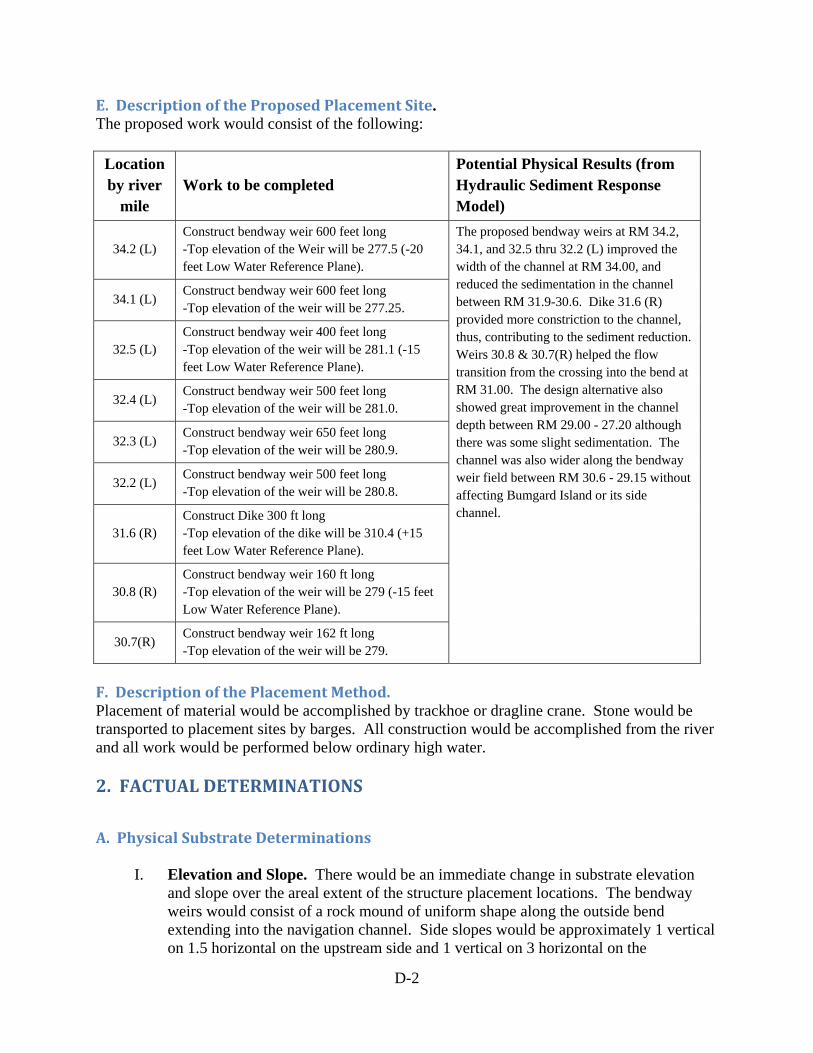
D-2
E. Description of the Proposed Placement Site. The proposed work would consist of the following:
Location by river
mile Work to be completed
Potential Physical Results (from Hydraulic Sediment Response Model)
34.2 (L) Construct bendway weir 600 feet long -Top elevation of the Weir will be 277.5 (-20 feet Low Water Reference Plane).
The proposed bendway weirs at RM 34.2, 34.1, and 32.5 thru 32.2 (L) improved the width of the channel at RM 34.00, and reduced the sedimentation in the channel between RM 31.9-30.6. Dike 31.6 (R) provided more constriction to the channel, thus, contributing to the sediment reduction. Weirs 30.8 & 30.7(R) helped the flow transition from the crossing into the bend at RM 31.00. The design alternative also showed great improvement in the channel depth between RM 29.00 - 27.20 although there was some slight sedimentation. The channel was also wider along the bendway weir field between RM 30.6 - 29.15 without affecting Bumgard Island or its side channel.
34.1 (L) Construct bendway weir 600 feet long -Top elevation of the weir will be 277.25.
32.5 (L) Construct bendway weir 400 feet long -Top elevation of the weir will be 281.1 (-15 feet Low Water Reference Plane).
32.4 (L) Construct bendway weir 500 feet long -Top elevation of the weir will be 281.0.
32.3 (L) Construct bendway weir 650 feet long -Top elevation of the weir will be 280.9.
32.2 (L) Construct bendway weir 500 feet long -Top elevation of the weir will be 280.8.
31.6 (R) Construct Dike 300 ft long -Top elevation of the dike will be 310.4 (+15 feet Low Water Reference Plane).
30.8 (R) Construct bendway weir 160 ft long -Top elevation of the weir will be 279 (-15 feet Low Water Reference Plane).
30.7(R) Construct bendway weir 162 ft long -Top elevation of the weir will be 279.
F. Description of the Placement Method. Placement of material would be accomplished by trackhoe or dragline crane. Stone would be transported to placement sites by barges. All construction would be accomplished from the river and all work would be performed below ordinary high water. 2. FACTUAL DETERMINATIONS
A. Physical Substrate Determinations
I. Elevation and Slope. There would be an immediate change in substrate elevation and slope over the areal extent of the structure placement locations. The bendway weirs would consist of a rock mound of uniform shape along the outside bend extending into the navigation channel. Side slopes would be approximately 1 vertical on 1.5 horizontal on the upstream side and 1 vertical on 3 horizontal on the

D-3
downstream side. After placement, sediment would be captured between the underwater weirs raising the channel depth along the outside bend. A portion of the opposite point bar would be eroded as the currents shift away from the outside bend. The slope of the opposite point bar would be expected to remain similar to existing conditions. The dike would consist of a rock mound of uniform shape along the RDB. The top elevation of the dike would be 310.4. Side slopes would be approximately 1 vertical on 1.5 horizontal. After placement, sediment patterns in the immediate vicinity of the structure would change with scour occurring off the tip of the dike. Areas immediately downstream of the dike would experience some areas of accretion and some areas of scour.
II. Sediment Type. The work area is located entirely within the existing channel of the
Middle Mississippi River. The Middle Mississippi River channel is comprised mainly of sands with some gravels, silts, and clays. The stone used for construction would be Graded “A” Stone.
III. Fill Material Movement. No bank grading or excavation would be required for the installation of structures. Draglines and/or trackhoes would pull rock from floating barges and place the material into the river. Fill materials would be subject to periodic high flows which may cause some potential movement and dislodging of stone from the structures. This may result in the need for minor repairs; however, no major failures are anticipated.
IV. Physical Effects on Benthos. Material placement should not significantly affect
benthic organisms. Shifting sediments at structure placement sites likely harbor low densities of oligochaetes, chironomids, caddisflies, and turbellaria. High densities of hydropsychid caddisflies and other macroinvertebrates would be expected to colonize the large limestone rocks after construction. Fish would temporarily avoid the area during construction. Greater utilization of the location by fish is expected after construction due to the expected increase in densities of macroinvertebrates.
V. Actions Taken to Minimize Impacts. Best Management Practices for construction would be enforced. Stone used for construction will be of sufficient size to withstand periodic high flows. Stone would be transported to placement sites by barges. All construction would be accomplished from the river and all work would be performed below ordinary high water.
B. Water Circulation, Fluctuation, and Salinity Determinations
I. Water. Some sediments (mostly sands) would be disturbed when the rock used for construction is deposited onto the riverbed. This increased sediment load would be local and minor compared to the natural sediment load of the river, especially during high river stages.

D-4
II. Current Patterns and Circulation. The bendway weirs would redirect the swift currents away from the outside bend, toward the opposite point bar, allowing for a wider and safer navigation channel. Current patterns shifting toward the opposite point bar would cause a small portion of the point bar to be eroded. The dike would cause scour on the navigation channel side and along the adjacent bankline.
III. Normal Water Level Fluctuations. Stages at average and high flows both in the
vicinity of the work area and on the MMR are expected to be similar to current conditions. Stages at low flows on the MMR show a decreasing trend over time and this trend is expected to continue with implementation of the Proposed Action.
IV. Actions Taken to Minimize Impacts. Best Management Practices for construction
would be enforced. Hydraulic Sediment Response model was conducted in cooperation with natural resource agencies and other stakeholders to evaluate hydrologic changes that minimize adverse impacts.
C. Suspended Particulate/Turbidity Determinations
I. Expected Changes in Suspended Particles and Turbidity Levels in Vicinity of Placement Site. Increases in suspended particulates and turbidity due to construction activities are expected to be greatest within the immediate vicinity of the rock structures. The increased sediment load would be local and minor compared to the natural sediment load of the river. This would cease soon after construction completion.
II. Effects on Chemical and Physical Properties of the Water Column
a. Light Penetration. There would be a temporary reduction in light penetration
until sediments suspended as part of construction activities settled out of the water column.
b. Dissolved Oxygen. No adverse effects expected. c. Toxic Metals and Organics. No adverse effects are expected. d. Aesthetics. Aesthetics of work sites are likely to be adversely affected during
construction, but are expected to return to normal after construction.
III. Effects on Biota. The work would likely result in some short-term displacement of biota in the immediate vicinity of construction activities due to temporary decreases in water quality and disturbance by construction equipment. Long-term beneficial effects should occur as macroinvertebrates colonize new rock substrate and fish utilize macroinvertebrate prey resources.
IV. Actions Taken to Minimize Impacts. Impacts are anticipated to be minimized by the use of clean, physically stable, and chemically non-contaminating limestone rock for construction. Hydraulic Sediment Response model was conducted in cooperation with natural resource agencies and other stakeholders. Stone used for construction will be of sufficient size to minimize turbidity.

D-5
D. Contaminant Determinations. It is not anticipated that any contaminants would be introduced or translocated as a result of construction activities.
E. Aquatic Ecosystem and Organism Determinations
I. Effects on Plankton. The work could have a temporary, minor effect on plankton communities in the immediate vicinity of the work area. This would cease after construction completion.
II. Effects on Benthos. Shifting sediments at structure placement sites likely harbor low
densities of oligochaetes, chironomids, caddisflies, and turbellaria. Construction activities would eliminate some of these organisms. High densities of hydropsychid caddisflies and other macroinvertebrates would be expected to colonize the large limestone rocks after construction. Fish would be expected to temporarily avoid the area during construction. Greater utilization of the location by fish is expected after construction due to the expected increase in densities of macroinvertebrates. Fish habitat is expected to improve at the structure placement sites due to improved flow, bathymetry, and prey resource conditions. The impacts on fish and macroinvertebrate habitat on the inside bend opposite the weirs are uncertain. Studies to date do not provide conclusive results for predicting fish or macroinvertebrate community response to weir placement at adjacent inside bends.
III. Effects on Nekton. Nekton would be temporarily displaced during construction activities, but would return shortly after completion. Greater utilization of the area by fish may occur after construction due to the expected increase in densities of macroinvertebrates and areas of improved flow and bathymetry.
IV. Effects on Aquatic Food Web. Temporary reductions in macroinvertebrate and fish
communities during construction in the relatively small work area should not significantly impact the aquatic food web in the Middle Mississippi River. Improvements in lower trophic levels (macroinvertebrates) subsequent to completion should benefit the aquatic food web.
V. Effects on Special Aquatic Sites. There are no special aquatic sites within the work
area. VI. Threatened and Endangered Species. Presence of, or use by, endangered and
threatened species is discussed in the Environmental Assessment and Biological Assessment. No significant adverse impacts to threatened and endangered species are expected to result from this work.
VII. Other Wildlife. The work would likely result in some very localized, short-term
displacement of wildlife in the immediate vicinity of construction activities. Displacement would end immediately after construction completion.

D-6
VIII. Actions Taken to Minimize Impacts. Best Management Practices for construction would be enforced. Hydraulic Sediment Response model was conducted in cooperation with natural resource agencies and other stakeholders to evaluate alternatives that minimize impacts to existing fauna. Pre- and post-construction monitoring will be conducted to evaluate effects on fish and wildlife.
F. Proposed Placement Site Determinations
I. Mixing Zone Determinations. The fill material is inert and would not mix with the water. The lack of fine particulate typically contained in rock fill and main channel sediments indicates negligible chemical or turbidity effects resulting from the proposed action.
II. Determination of Compliance with Applicable Water Quality Standards. Section
401 water quality certifications have been obtained from the states of Illinois and Missouri (see Appendix F). All other permits necessary for the completion of the work have been applied for and will be obtained prior to implementation.
III. Potential Effects on Human Use Characteristics. The proposed work would have
no adverse impact on municipal or private water supplies; water-related recreation; aesthetics; or parks, national and historic monuments, national seashores, wilderness areas, research sites or similar preserves. During construction the area would not be available for recreational and commercial fishing.
G. Determinations of Cumulative Effects on the Aquatic Ecosystem. Dikes and bendway weirs have been used extensively throughout the Lower, Middle, and Upper Mississippi River System to provide a safe and dependable navigation channel. Due to concerns from natural resource agency partners about the potential cumulative impacts of river training structures, and other actions within the watershed, on the aquatic ecosystem, the St. Louis District conducts extensive coordination with resource agency and navigation industry partners to ensure that implementation is accomplished effectively from an ecological and navigation viewpoint. Although minor short-term construction-related impacts to local fish and wildlife populations are likely to occur, no significant cumulative impacts on the aquatic ecosystem are identified for the Dogtooth Bend Phase 5 work. H. Determinations of Secondary Effects on the Aquatic Ecosystem. No adverse secondary effects would be expected to result from the proposed action. 3. FINDINGS OF COMPLIANCE OR NON-COMPLIANCE WITH THE RESTRICTIONS ON PLACEMENT A. No significant adaptations of the 404(b)(1) guidelines were made relative to this evaluation. B. Alternatives that were considered for the proposed action included:

1. No Action Alternative - The No Action Alternative consists of not constructing any new river training structures in the area but continuing to maintain the existing river training structures. Dredging would continue as needed to address the shoaling issue in the area.
2. Proposed Action - The Proposed Action consists of construction of two weirs near RM 34.00, four weirs near RM 32.00, a dike at RM 31.60 and two weirs near RM 31.00.
C. Certification under Section 401 of the Clean Water Act has been obtained from the Missouri Department of Natural Resources and the Illinois Environmental Protection Agency (see Appendix F).
D. The proposed fill activity is in compliance with Applicable Toxic Effluent Standards of Prohibition under Section 307 of the Clean Water Act.
E. No significant impact to threatened or endangered species is anticipated from this work. Prior to construction, full compliance with the Endangered Species Act would be documented.
F. No municipal or private water supplies would be affected by the proposed action, and no degradation of waters of the United States is anticipated.
G. The work area is situated along an inland freshwater river system. No marine sanctuaries are involved or would be affected by the proposed action.
H. The materials used for construction would be chemically and physically stable and noncontaminating.
I. The proposed construction activity would not have a significant adverse effect on human health and welfare, recreation and commercial fisheries, plankton, fish, shellfish, wildlife, or special aquatic sites. No significant adverse effects on life stages of aquatic life and other wildlife dependent on aquatic ecosystems are expected to result. The proposed construction activity would have no significant adverse effects on aquatic ecosystem diversity, productivity, and stability. No significant adverse effects on recreational, aesthetic, and economic values would occur.
J. No other practical alternatives have been identified. The proposed action is in compliance with Section 404(b)(l) of the Clean water Act, as amended. The proposed action would not significantly impact water quality and would improve the integrity of an authorized navigation system.
4-11- t4
(Date)
D-7
CHRISTOPHER G. HALL COL, EN Commanding

Appendix E. Public Comments and Responses
Appendix E. Public Comments and Responses TABLE OF CONTENTS Comments of Professor Nicholas Pinter E1 Comments of the Conservation Organizations E3 Attachment A E21 Attachment B E33 Comments of David Korando E38 Comments of Virgil Knupp E39 Transcript of the February 19, 2014 Public Hearing E40 District Responses to Comments E72
I GEOLOGY CARBONDALE
U.S. Army Corps of Engineers attn.: CEMVS-OD-F (Danny McClendon)
1222 Spruce Street St. Louis, MO 63103-2833
re: P-2857
To Whom It May Concern:
Jan. 9,2014
1 .'J;
': . �; ·:. ' r r··
) :� 1 - j '
) . : ' ! i j , · i i ! �. • , ! I )
,, \,''' ,;(,1'·:! �'.'·.1
This letter is in response to your Public Notice P-2857 regard the proposed construction of new
river training structures between Middle Mississippi River (MMR) river miles 20 and 40, referred to as
the Dogtooth Bend Phase 5 Regulating Works Project.
I hereby request one or more public hearings to discuss the impacts of, and alternatives to
the proposed project. I request that at least one of these meetings be held in Illinois, preferably
in or around the Village of Olive Branch.
The public hearing(s) should be held to solicit input and public involvement regarding the Corps
Finding of No Significant Impact resulting from this project. This Finding is inconsistent with
available evidence and inconsistent with majority scientific opinion, in particular regarding the effects
of such river training structures on flood levels, levee performance, and public safety. The Corps has
initiated a Supplemental Environmental Impact Study to assess the effects of river training structures,
including the question of flood magnification. No new structures should be planned or built until a
comprehensive, balanced, and independent assessment is completed.
E1

The proposed Dogtooth Bend project is of particularly grave concern, given its location along the
Len Small Levee on the Illinois side and the Commerce Levee on the Missouri side. In particular, new
Dogtooth Bend structures would be constructed just downstream of one of the sites at which the Len
Small Levee failed and/or overtopped during the 2011 floods. Empirical hydrologic data, geospatial
analyses, hydraulic modeling, and engineering theory all suggest that elevated flood levels associated
with river training structures are greatest just upstream, due to backwater etTects of such roughness
elements added to the channel.
In addition to f1ood hazard, levee, and public safety concerns, public hearing(s) should be held to
solicit input and public engagement on the role of river training structures in management of the
Middle Mississippi River. River training structures are have become the signature project of the Corps'
St. Louis District, but the purported benefits of these structures- including for river habitat
improvement, navigation, and sediment transport- have not been rigorously documented or discussed
by affected stakeholders. The "Draft Environmental Assessment with Unsigned Finding of No
Significant Impact" for the new Dogtooth Bend project includes little or no stakeholder involvement
and an inadequate assessment of alternatives to the proposed construction activities.
Sincerely: ·
�\cJ!JPvj Prof. Nicholas Pinter
E2

National Wildlife Federation Izaak Walton League of America
Missouri Coalition for the Environment Prairie Rivers Network
Sierra Club January 24, 2014 Via Email: [email protected] Danny D. McClendon Chief, Regulatory Branch U.S. Army Corps of Engineers St. Louis District 1222 Spruce Street St. Louis, Missouri 63103 Re: Comments on Draft Environmental Assessment with Unsigned Finding of No Significant Impact,
Regulating Works Project Dogtooth Bend Phase 5, Middle Mississippi River Miles 40.0-20.0 Alexander County IL, Mississippi and Scott Counties MO; Public Notice P-2856 (2013-743)
Dear Mr. McClendon: The National Wildlife Federation, Izaak Walton League of America, Missouri Coalition for the Environment, Prairie Rivers Network, and Sierra Club (collectively, the Conservation Organizations”) appreciate the opportunity to submit these comments on the above-referenced Dogtooth Bend Phase 5 Draft Environmental Assessment with Unsigned Finding of No Significant Impact (the Dogtooth Bend EA). The National Wildlife Federation (NWF) is the Nation’s largest conservation education and advocacy organization. NWF has more than four million members and supporters and conservation affiliate organizations in forty-seven states and territories. NWF has a long history of interest and involvement in the programs of the U.S. Army Corps of Engineers (Corps) and the management and protection of the Mississippi River. NWF is a strong supporter of ecologically sound efforts to restore the Mississippi River and the nation’s many other damaged rivers, coasts, and wetlands. Founded in 1922, the Izaak Walton League is one of the nation's oldest and most respected conservation organizations. With a powerful grassroots network of more than 240 local chapters nationwide, the League takes a common-sense approach toward protecting our country's natural heritage and improving outdoor recreation opportunities for all Americans. The Missouri Coalition for the Environment is Missouri’s independent, citizens environmental organization for clean water, clean air, clean energy, and a healthy environment. The Missouri Coalition for the Environment works to protect and restore the environment through education, public engagement, and legal action.
E3
Prairie Rivers Network is Illinois’ only statewide river conservation organization and is the Illinois affiliate of the National Wildlife Federation. We are a 501(c)(3), tax-exempt nonprofit based in Champaign, Illinois. Our mission is to protect the rivers of Illinois and to promote the lasting health and beauty of watershed communities. We use sound science and policy analysis to stand up for strong, fair laws to protect clean water and natural areas. We engage citizens, businesses, and governments across Illinois in this effort, providing them with the policy information, scientific data, technical assistance, and outreach programs needed to support effective river advocacy. A recognized leader on issues involving the implementation and enforcement of the Clean Water Act in Illinois, Prairie Rivers Network leads efforts to improve clean water standards, review pollution permits, protect wetlands, reduce polluted runoff from farms and streets, and restore natural areas along rivers and streams. Founded by legendary conservationist John Muir in 1892, the Sierra Club is now the nation's largest and most influential grassroots environmental organization – with more than two million members and supporters. The Sierra Club's members are inspired by nature, working together to protect our communities and the planet.
General Comments
The Conservation Organizations urge the Corps to withdraw the Dogtooth Bend EA and place the proposed Dogtooth Bend project on hold at least until the Corps completes the recently announced supplemental environmental impact statement for the Middle Mississippi River Regulating Works Project, Missouri and Illinois (SEIS).1 The Dogtooth Bend EA does not comply with the requirements of the National Environmental Policy Act (NEPA) and presents flawed science as the basis for its conclusion of no significant impact. As a whole, the EA is far too limited and lacking in scientific support to adequately assess risks to public safety and the environment or to determine whether less damaging alternatives are available. The Conservation Organizations also call on the Corps to:
1. Expand the SEIS to evaluate the full suite of operations and maintenance (O&M) activities for the Upper Mississippi River – Illinois Waterway (UMR-IWW) navigation system. As the Corps is well aware, the Regulating Works Project, including the proposed Dogtooth Bend project, is just one of a number of activities carried out by the Corps to maintain navigation on the UMR-IWW. In addition to construction of river training structures, other O&M activities include water level regulation, dredging and disposal of dredged material, construction of revetment, and operation and maintenance of the system’s 37 locks and dams. Since all O&M activities are designed to maintain a single project, individual activities should not be evaluated in isolation.
2. Initiate a National Academy of Sciences study on the effect of river training structures on flood heights to inform development of the SEIS. A National Academy of Sciences review is critical for ensuring that: (a) the SEIS is based on the best possible scientific understanding of the role of river training structures on increasing flood heights; (b) the SEIS produces recommendations that will provide the highest possible protection to the public; and (c) the public will have
1 78 Fed. Reg. 77108 (December 20, 2013). The Conservation Organizations appreciate the Corps’ decision to prepare the SEIS but urge the Corps to prepare a supplemental EIS for the Corps’ entire suite of navigation operations and maintenance activities on the Upper Mississippi River – Illinois Waterway (UMR-IWW) navigation system.
E4
confidence in this aspect of the evaluation and recommendations contained in the final SEIS.
3. Impose a moratorium on the construction of new river training structures pending completion of the SEIS. As discussed below, extensive peer-reviewed science demonstrates that river training structures have increased flood levels by up to 15 feet in some locations and 10 feet in broad stretches of the Mississippi River where these structures are prevalent. In light of these findings, it is critical that additional river training structures not be built unless and until a comprehensive SEIS establishes that such construction will not contribute to increased flood risks to communities.
Because of the significant potential for increasing the risk of flooding for river communities, the Conservation Organizations also request a public hearing on the proposed Dogtooth Bend project during which members of the public will have an opportunity to present oral testimony directly to the decision makers for this proposed project.
Specific Comments A. The Corps May Not Tier The Dogtooth Bend EA to the 1976 Regulating Works EIS The Dogtooth Bend EA states that it is being “tiered off of the 1976 Environmental Impact Statement (1976 EIS) covering the District’s Regulating Works Project – Mississippi River between the Ohio and Missouri Rivers (Regulating Works) . . . .” Dogtooth Bend EA at 1. But as the Corps has acknowledged, the 1976 Regulating Works EIS requires supplementation, in the form of a Supplemental EIS, because “there are significant new circumstances and information on the potential impacts of the Regulating Works Project on the human environment.” Dogtooth Bend EA at 1 (emphasis added); 78 Fed. Reg. 77108 (December 20, 2013) (stating that significant new information and circumstances require preparation of a supplemental environmental impact statement for the Middle Mississippi River Regulating Works Project, Missouri and Illinois). However, the law is clear that the Corps may not tier the Dogtooth Bend EA to the 1976 Regulating Work EIS because: (1) there have been material changes in circumstances and significant new information on environmental impacts since completion of the 1976 Regulating Works EIS which requires preparation of a supplemental EIS as a matter of law; and (2) the 1976 Regulating Works EIS does not discuss the proposed Dogtooth Bend project. As a result, the 1976 Regulating Works EIS may not (and as a factual matter, could not) cure the many deficiencies in the Dogtooth Bend EA.
1. The 1976 Regulating Works EIS Must Be Supplemented As set forth in the Council on Environmental Quality NEPA regulations, tiering is appropriate only when the sequence of statements or analyses is:
(a) From a program, plan, or policy environmental impact statement to a program, plan, or policy statement of analysis of lesser scope or to a site-specific statement or analysis. (b) From an environmental impact statement on a specific action at an early stage (such as need and site selection) to a supplement (which is preferred) or a subsequent
E5
statement or analysis at a later stage (such as environmental mitigation). Tiering in such cases is appropriate when it helps the lead agency to focus on the issues which are ripe for decision and exclude from consideration issues already decided or not yet ripe.
40 C.F.R. § 1508.28. However, even under these circumstances tiering is inappropriate when there has been “a material change in circumstances or a departure from the policy covered in the overall EIS.”2 A “significant circumstantial change is the triggering factor requiring a new or supplemental EIS” which cannot be addressed by merely tiering to a prior “programmatic EIS.”3 It is not enough that the Dogtooth Bend EA will allegedly “incorporate any new information and circumstances . . . to the greatest extent possible.” Dogtooth Bend EA at 1 (emphasis added). Nor may the Corps take action on the Dogtooth Bend project now, before any supplemental EIS is prepared, and then impose additional mitigation measures in the future based on what “the analyses undertaken as part of the SEIS process reveal.” Id. Instead, the Corps is “required” to prepare “an individual EIS for each” specific project within the Regulating Works Project, including for the proposed Dogtooth Bend project.4 Because the 1976 Regulating Works EIS must be supplemented, tiering to the 1976 Regulating Works EIS is inappropriate and cannot cure the many deficiencies in the Dogtooth Bend EA.
2. The 1976 Regulating Works EIS Does Not Discuss the Proposed Dogtooth Bend Project
While tiering “to a previous EIS is sometimes permissible, the previous document must actually discuss the impacts of the Project at issue” and must supplement the environmental assessments’ own analysis.5 The 1976 Regulating Works EIS does not discuss the proposed Dogtooth Bend project and does not evaluate its direct, indirect, or cumulative impacts. Indeed, the 1976 Regulating Works EIS could not have evaluated the impacts of the structures proposed for the Dogtooth Bend project because most of the types of structures included in that project were not invented until well after 1976.
2 Minnesota Public Interest Research Group v. Butz, 498 F.2d 1314, 1323 n. 29 (8th Cir. 1974) (emphasis added); Association of Public Agency Customers, Inc. v. Bonneville Power Administration, 126 F.3d 1158, 1184 (9th Cir. 1997); Salmon River Concerned Citizens v. Robertson, 32 F.3d 1346, 1356 (9th Cir. 1994). 3 Association of Public Agency Customers, Inc. v. Bonneville Power Administration, 126 F.3d at 1184. 4 Minnesota Public Interest Research Group v. Butz, 498 F.2d at 1323 n. 29. 5 South Fork Band Council of Western Shoshone of NV. v. United States Dept. of Interior, 588 F.3d 718, 726 (9th Cir. 2009) (citing Muckleshoot Indian Tribe v. United States Forest Serv., 177 F.3d 800, 810 (9th Cir. 1999) (holding that reliance on the EIS accompanying an earlier planning document was improper because it did not discuss the subsequent specific Project in detail); Klamath-Siskiyou Wildlands Center v. Bureau of Land Management, 387 F.3d 989, 998 (9th Cir. 2004) (tiering to an EIS was insufficient to cure an EA's shortcomings where the EIS contained only general statements about the cumulative effects of logging in the area but mentioned no information specific to the timber sales at issue); Idaho Conservation League v. U.S. Forest Service, 2012 WL 3758161 D.Idaho, (2012) (Case No. 1:11-CV-00341-EJL, August 29, 2012, not reported in F.Supp.2d)(holding that the “documents to which the EA in question is tiered must actually supplement the EA's own analysis and address the particular impacts of the Project in question in order to satisfy NEPA.”).
E6

As a result, the 1976 Regulating Works EIS cannot – and does not – cure any of the many shortcomings in the Dogtooth Bend EA. B. The Dogtooth Bend EA Fails to Demonstrate a Need for the Proposed Project and Improperly
Restricts the Project Purpose The Dogtooth Bend EA is deficient because it: (1) fails to demonstrate a need for the proposed Dogtooth Bend project; and (2) improperly restricts the project purpose. The Dogtooth Bend EA states that the proposed Dogtooth Bend Project “is needed to address repetitive channel maintenance dredging issues in the project area. Frequent dredging has been required in order to address channel depth, width, and alignment issues. Construction of river training structures would provide a sustainable alternative to repetitive maintenance dredging.” Dogtooth Bend EA at 1.
1. The Dogtooth Bend EA Fails to Demonstrate Project Need The Dogtooth Bend EA fails to demonstrate a need for the proposed project. Properly demonstrating project need is fundamental to an adequate NEPA review. It is absolutely critical in this case given that the proposed project creates far more risks to public safety (by increasing flood hazards) than the current dredging regime which has a long history of effectively maintaining navigation. The current dredging regime is clearly sufficient to maintain navigation in this portion of the Mississippi River since navigation has not been stopped due to lack of channel depth. The Conservation Organizations are unaware of any navigation closures in the project reach resulting from the inability of dredging activities to maintain an adequate channel depth and the Dogtooth Bend EA does not identify any such closures. Despite assertions within the EA to the contrary, the proposed Dogtooth Bend project has credible potential to significantly increase the risk of flooding to river communities and floodplain areas. This is particularly true given the project’s large scale construction of 8 new bendway weirs and 1 new dike. As discussed in more detail below, there is extensive peer reviewed science linking river training structures, including dikes and bendway weirs in particular, to significant increases in flood heights.6 This science shows that these structures have increased flood levels by up to 15 feet in some locations in the Mississippi River and 10 feet in broad stretches of the Mississippi River where these structures are prevalent.7 Even studies commissioned by the St. Louis District and cited in the Dogtooth Bend EA (e.g., Watson et al., 2013a) find statistically significant increases in water levels for flood flows.
6 While the Corps continues to deny that river training structures lead to increased flood heights, this effect is so well recognized that the Dutch have “begun lowering dozens of wing dikes along a branch of the Rhine River and [have] plans to lower hundreds more as part of a nationwide effort to reduce flood risk in that river’s floodplain.” Government Accountability Office, GAO-12-41, Mississippi River, Actions Are Needed to Help Resolve Environmental and Flooding Concerns about the Use of River Training Structures (December 2011) (GAO Study on River Training Structures) (concluding that the Corps is out of compliance with both the National Environmental Policy Act and the Clean Water Act). 7 Pinter, N., A.A. Jemberie, J.W.F. Remo, R.A. Heine, and B.A. Ickes, 2010. Empirical modeling of hydrologic response to river engineering, Mississippi and Lower Missouri Rivers. River Research and Applications, 26: 546-571; Remo, J.W.F., N. Pinter, and R.A. Heine, 2009. The use of retro- and scenario- modeling to assess effects of
E7
The proposed Dogtooth Bend project is of particularly grave concern, given its location along the Len Small Levee on the Illinois side and the Commerce Levee on the Missouri side. New Dogtooth Bend structures would be constructed just downstream of one of the sites at which the Len Small Levee failed and/or overtopped during the 2011 floods. Empirical hydrologic data, geospatial analyses, hydraulic modeling, and engineering theory all suggest that elevated flood levels associated with river training structures are greatest just upstream, due to backwater effects of such roughness elements added to the channel. To assist the public and decision makers in determining whether there is in fact a need for the proposed Dogtooth Bend project, the Dogtooth Bend EA should evaluate at least the following information in addition to fully assessing the project’s environmental impacts:
• The projected future costs of required dredging under the no action alternative calculated for the life of the proposed Dogtooth Bend project,8 and an assessment of the ability of dredging to continue to maintain navigation in those stretches.
• The number of times, if any, when dredging has been insufficient to maintain navigation in the Project area.
• The construction9 and full life cycle maintenance costs of the proposed Dogtooth Bend project, and the projected costs of the dredging that will still be needed even if the project is constructed. The Dogtooth Bend EA makes clear that implementation of the project is only “expected to reduce the amount and frequency of dredging necessary in the project area,” it will not end the need for dredging. Dogtooth Bend EA at 21. As a result, an accurate comparison of costs with and without the project must include future dredging costs with the project in place.
• The potential adverse impacts to navigation from the proposed Dogtooth Bend project (the Conservation organizations have been advised that river training structures can create difficulties for safe navigation).
• The increased risks of upstream or nearby levee failures should the proposed Dogtooth Bend project increase flood heights.
This information would assist the public and decision makers in assessing both the need for, and the true costs and benefits of, the project. The Dogtooth Bend EA addresses none of these critical issues, and does not provide a benefit-cost analysis for the proposed project.
100+ years river engineering and land cover change on Middle and Lower Mississippi River flood stages. Journal of Hydrology, 376: 403-416. 8 The Dogtooth Bend EA states that dredging costs over the past 12 years have averaged approximately $470,000 per year. Dogtooth Bend EA at 23. The EA summarily concludes that these expenditures would be expected to continue under the no action alternative in the future but provides no additional information. 9 The Dogtooth Bend EA states that the proposed Dogtooth Bend project is estimated to cost approximately $1.35 million, but fails to provide any assessment of how that number was reached. It also fails to provide life cycle maintenance costs or the costs of dredging that will need to continue even if the proposed project is constructed. The Dogtooth Bend EA also does not provide a benefit-cost analysis for the proposed project.
E8

2. The Dogtooth Bend EA Improperly Restricts the Project Purpose The Dogtooth Bend EA defines the purpose of this project as the construction of river training structures to reduce repetitive dredging. This project purpose is so narrow that it precludes consideration of reasonable alternatives. For example, this narrow project purpose precludes consideration of alternative measures for maintaining channel depth and essentially precludes adoption of the no action alternative despite the fact that navigation can be maintained through dredging. A more appropriate project purpose would be “to maintain navigation in the project area.” Establishing an appropriate project purpose is extremely important as the purpose is closely tied to the range of reasonable alternatives that must be evaluated. All reasonable alternatives that accomplish the project purpose must be examined in an environmental impact statement, while alternatives that are not reasonably related to project purpose do not have to be examined.10 Indeed, an overly narrow project purpose defeats the very purpose of NEPA:
“One obvious way for an agency to slip past the strictures of NEPA is to contrive a purpose so slender as to define competing “reasonable alternatives” out of consideration (and even out of existence). The federal courts cannot condone an agency’s frustration of Congressional will. If the agency constricts the definition of the project’s purpose and thereby excludes what truly are reasonable alternatives, the EIS cannot fulfill its role. Nor can the agency satisfy the Act. 42 U.S.C. § 4332(2)(E).”11
The project purpose in the Dogtooth Bend EA is impermissibly narrow as it drives consideration of only those alternatives that recommend construction of river training structures. / / / / / / / / / /
10 Methow Valley Citizens Council v. Regional Forester, 833 F.2d 810, 815-16 (9th Cir. 1987). 11 Simmons v. United States Army Corps of Eng’rs, 120 F.3d 664, 666 (7th Cir. 1997); City of Carmel-by-the-Sea v. United States Dep’t of Transp., 123 F.3d 1142, 1155 (9th Cir. 1997) (“an agency cannot define its objectives in unreasonably narrow terms”); Citizens Against Burlington, Inc. v. Busey, 938 F.2d 190, 195-96 (D.C. Cir. 1991), cert. denied, 502 U.S. 994 (1991) (“an agency may not define the objectives of its action in terms so unreasonably narrow that only one alternative from among the environmentally benign ones in the agency’s power would accomplish the goals of the agency’s action”); City of New York v. United States Dep’t of Transp., 715 F.2d 732, 743 (2d Cir. 1983), cert. denied, 456 U.S. 1005 (1984) (“an agency will not be permitted to narrow the objective of its action artificially and thereby circumvent the requirement that relevant alternatives be considered”).
E9
C. The Dogtooth Bend EA Fails to Evaluate a Reasonable Range of Alternatives The Dogtooth Bend EA examines only two alternatives, the no action alternative and the proposed alternative. This is legally insufficient because an environmental assessment must examine a full range of reasonable alternatives.12 An environmental assessment, like an environmental impact statement, “must evaluate a reasonable range of alternatives to the agency's proposed action, to allow decision-makers and the public to evaluate different ways of accomplishing an agency goal.”13 This is because the consideration of alternatives required by NEPA is both independent of, and broader than, the requirement to prepare an environmental impact statement.14 As a result “[c]onsideration of alternatives is critical to the goals of NEPA even where a proposed action does not trigger the EIS process.”15 The Dogtooth Bend EA does not evaluate a reasonable range of alternatives. It instead looks only at the proposed alternative and the no action alternative. D. The Dogtooth Bend EA Fails to Properly Evaluate the Full Suite of Impacts to the Environment The Dogtooth Bend EA fails to evaluate the full suite of impacts, provides only the most limited analysis of those impacts it does evaluate, and fails to provide a reasonable explanation between the information presented and the conclusions drawn. In addition, the Dogtooth Bend EA appears not to include important information already assembled by the Corps on the impacts of the Regulating Works program. This would include the information utilized by the Corps when it “determined that there is sufficient significant new information regarding the potential impacts of the [Regulating Works] project on the human environment to warrant the preparation of a supplemental environmental impact statement.” 78 Fed. Reg. 77108 (December 20, 2013).
12 While other configurations of river training structures were examined prior to preparation of the environmental assessment, this does not exempt the Corps from the requirement to examine a reasonable range of alternatives in the EA. Moreover, evaluations of alternative configurations of river training structures cannot satisfy the requirement to evaluate a reasonable range of alternatives because each alternative would have the same end result – construction of river training structures in the project area. State of California v. Block, 690 F.2d 753, 767 (9th Cir. 1982) (holding that an inadequate range of alternatives was considered where the end result of all eight alternatives evaluated was development of a substantial portion of wilderness). 13 Pacific Marine Conservation Council v. Evans, 200 F. Supp. 2d 1194, 1206 (N.D.Cal 2002); Akiak Native Community v. United States Postal Serv., 213 F.3d 1140, 1148 (9th Cir. 2000) (EA must consider a reasonable range of alternatives). 14 Bob Marshall Alliance v. Hodel, 852 F.2d 1223 (9th Cir. 1988), cert. denied, 489 U.S. 1066 (1988); City of New York v. United States Department of Transportation, 715 F.2d 732, 742 (2d Cir.1983), cert. denied, 465 U.S. 1055 (1984); Environmental Defense Fund, Inc. v. Corps of Engineers, 492 F.2d 1123, 1135 (5th Cir.1974). 15 Bob Marshall Alliance, 852 F.2d at 1228-29.
E10
1. The Dogtooth Bend EA Fails to Properly Evaluate Hydrologic Impacts The extensive amount of peer reviewed science demonstrating that river training structures are causing significant increases in flood heights in the Middle Mississippi River, and the proposed project’s location along the Len Small Levee on the Illinois side and the Commerce Levee on the Missouri side just downstream of one of the sites at which the Len Small Levee failed and/or overtopped during the 2011 floods, makes the evaluation of the hydrologic impacts of the project particularly important. Despite this, however, the Dogtooth Bend EA fails to evaluate hydrologic impacts in any meaningful way for at least the following reasons. First, the proposed alternative was developed using a Hydraulic Sediment Response model (HSR model), which “is a small-scale physical sediment transport model used by the District to replicate the mechanics of river sediment transport.” Dogtooth Bend EA at 5. However, such models cannot be relied upon to provide accurate planning information as they lack “predictive capability”. Stephen T. Maynord, Journal of Hydraulic Engineering, Evaluation of the Micromodel: An Extremely Small-Scale Movable Bed Model (April 2006). Maynord concludes that because of the “lack of predictive evidence, the micromodel should be limited to demonstration, education, and communication.” A copy of this study is attached to these comments at Attachment A. The Corps should be utilizing the most up-to-date modeling to evaluate the potential impacts of the proposed project such as by using state of the art two-dimensional and three-dimensional hydrodynamic models with inputs that recognize the current conditions in the river system. Second, the Dogtooth Bend EA and Appendix A fail to analyze the full range of scientific studies that address the role of river training structures in raising flood heights. They also fail to provide a reasonable explanation as to why the conclusions from this extensive body of science should be rejected. Since 1986, at least 51 scientific studies have been published linking the construction of river training structures to increased flood heights. More than 15 studies published from 2000-2010 demonstrate the role of river training structures on flood heights in the Mississippi River. These studies show that river training structures constructed by the Corps to reduce navigation dredging costs have increased flood levels by 10 to 15 feet and more in some locations of the Mississippi River during large floods. A list of the 51 studies assessing the role of instream structures on increasing flood heights is attached to these comments at Attachment B. We request that these studies be included in the record for this project. While the Dogtooth Bend EA presents findings of St. Louis District consultants in an attempt to cast doubt on various aspects of the extensive research on river training structures, the Conservation Organizations note that the burden of proof is on the Corps to establish the safety and efficacy of river training structures before building any additional structures. The Dogtooth Bend EA does not do this. Fourth, the Dogtooth Bend EA fails to address a global consensus that river training structures can and do increase flood heights. For example, the government of the Netherlands is expending a significant amount of resources to modify hundreds of river training structures to reduce flood risks.16 Because of these failings, the public and decision makers cannot know what the true impacts of the proposed Dogtooth Bend project will be on flooding. Potential impacts can be deadly and must be taken
16 Government Accountability Office, GAO-12-41, Mississippi River, Actions Are Needed to Help Resolve Environmental and Flooding Concerns about the Use of River Training Structures (December 2011) at 41.
E11

seriously by the Corps. As noted above, the Conservation Organizations urge the Corps to initiate a National Academy of Sciences study to evaluate this issue.
2. The Dogtooth Bend EA Fails to Properly Evaluate Cumulative Impacts The Dogtooth Bend EA fails to properly evaluate – and account for – cumulative impacts. Notable failings in this section include the failure to assess the cumulative impacts of the Corps’ many other activities on the Mississippi River, including already constructed river training structures, and the failure to assess the cumulative impacts of climate change. New training structures proposed in the Dogtooth Bend reach were prototyped (using the St. Louis District's table-top modeling system) only on a local basis and over short time scales. This approach and the EA fail to recognize that this incremental approach in no way addresses system-wide changes to the Middle Mississippi River system. Moreover, the new surge in construction of training structures in the past several years appears to be merely shifting the loci of sedimentation which could eventually lead to even more river training structure construction. Instead of conducting an appropriate cumulative impacts analysis, the EA contains just one highly generalized and speculative table (Table 4). The Dogtooth Bend EA uses this table to draw the following sweeping and unsupported conclusion:
The Regulating Works Project, in combination with the other stressors throughout the watershed, has had past impacts, both positive and negative, on the human environment. However, this analysis is meant to characterize the incremental impact of the current action in the broader context of other actions affecting the same resources. Although past actions associated with the Regulating Works Project have impacted these resources, the current method of conducting business for the Project – involving partner agencies throughout the planning process, avoiding and minimizing impacts during the planning process, and utilizing innovative river training structures to provide habitat diversity while still providing benefits to the navigation system – has been successful in accomplishing the desired effect of avoiding significant environmental consequences. Although our understanding of the processes and stressors that bear upon the resources of the MMMR continues to evolve, an equilibrium in habitat conditions appears to have been reached. Accordingly, no significant impacts to the human environment are anticipated for the Dogtooth Bend Phase 5 Construction Project.
Dogtooth Bend EA at 24-25.
(a) Cumulative Impacts of Other Corps Activities on the Mississippi River The Dogtooth Bend EA fails to meaningfully evaluate the cumulative impacts of the Corps’ many other activities on the Mississippi River. These include the full suite of past, present, and reasonably foreseeable future O&M activities for the Mississippi River navigation system and other reasonably foreseeable projects including construction of river training structures in the Herculaneum Reach for so-called restoration purposes.
E12
The numbers of river training structures, and their impacts, are significant. For example, the Conservation Organizations understand that between 1980 and 2009, the Corps built at least 380 new river training structures in the Middle Mississippi, including 40,000 feet of wing dikes and bendway weirs between 1990 and 1993. The Corps built at least 23 chevrons between 2003 and 2010. The proposed Dogtooth Bend project would add 8 new bendway weirs and 1 new dike. The Corps has also recently proposed at least the following additional projects utilizing a significant number of river training structures:
• The Grand Tower project which would include 2 new chevrons, 3 new S-dikes, 3 new weirs, 1 dike extension, and additional new revetment.
• The Eliza Point project which would include 4 new bendway weirs and 1 new rootless dike. • The Moosenthein Ivory project which would include 1 new rootles dike and 2.2 miles of new
revetment. • The Herculaneum Reach project which would include 12 new chevrons in a narrow, 3.5 mile
stretch of the Mississippi River (creating the River’s largest concentration of chevrons). The Corps also carries out other major O&M activities to maintain navigation on the 1,200 miles of the UMR-IWW. These activities include: dredging and disposal of dredged material, water level regulation, construction of revetment, and operation and maintenance of the system’s 37 locks and dams. Maintaining this navigation system requires “continuous regular operations and maintenance” at a cost of more than $120 million each year.17 The Dogtooth Bend EA fails to address in any meaningful way – or account for – the very significant adverse impacts caused by these O&M activities. A significant body of scientific evidence, much of which was prepared with the Corps’ input, demonstrates that the Corps’ O&M activities are a significant cause of the severe decline in the ecological health of the UMR-IWW system and have completely altered the natural processes in the Upper Mississippi River.18 In a 1999 report on the Status and Trends of the Upper Mississippi River System, the U.S. Geological Survey concluded that the Corps’ O&M activities in the UMR-IWW system were: destroying critical habitats including the rivers’ backwaters, side channels and wetlands; altering water depth; destroying bathymetric diversity; causing nonnative species to proliferate; and severely impacting native species.19 The 1999 Status and Trends Report also rated the health of the Mississippi River System as follows:
1. The Lower Reach of the Illinois River is degraded for all 6 criteria of ecosystem health
evaluated by the report.20 2. The Unimpounded Reach of the Mississippi River is degraded for 3 criteria, heavily impacted
17 USACE Brochure, Upper Mississippi River – Illinois Waterway System Locks and Dams (September 2009) available at http://www.mvr.usace.army.mil/brochures/documents/UMRSLocksandDams.pdf; Congressional Research Service, Inland Waterways: Recent Proposals and Issues for Congress (July 14, 2011) at 15. 18 U.S. Geological Survey, Ecological Status and Trends of the Upper Mississippi River System 1998: A Report of the Long Term Resource Monitoring Program (April 1999) (1999 Status and Trends Report). 19 Id. 20 “Degraded” is the lowest possible grade issued by the report and is defined as a condition where the factors associated with the criteria “are now below ecologically acceptable levels” and where “[m]ultiple management actions are required to raise these conditions to acceptable levels.” 1999 Status and Trends Report at 16-2.
E13
for 2 criteria, and moderately impacted for 1 criterion. 3. The Lower Impounded Reach of the Mississippi River (Pools 14-26) is degraded for 2 criteria,
heavily impacted for 3 criteria, and moderately impacted for 1 criterion. 4. The Upper Impounded Reach of the Mississippi River (Pools 1-13) is degraded for 1 criterion
and moderately impacted for 5 criteria. The 1999 Status and Trends report further concluded that no segment of the Upper Mississippi River system was unchanged from historic conditions, or deemed to require no management action to maintain, restore or improve conditions. Equally important, no segment of the system was improving in quality.21 In December 2008, the U.S. Geological Survey issued a second report on the status and trends of selected resources in the Upper Mississippi River system which also found that the Corps’ O&M activities were causing significant adverse impacts.22 For example:
The current condition of the UMRS is heavily influenced by its agriculture-dominated basin and by the dams, channel training structures, dredging, and levees that regulate flow distribution during most of the year. Although substantial improvements in some conditions have occurred since the 1960s because of improvements in sewage treatment and land use practices, the UMRS still faces substantial challenges including
1. High sedimentation rates in some backwaters and side channels; 2. An altered hydrologic regime resulting from modifications of river channels, the
floodplain, and land use within the basin, and from dams and their operation; 3. Loss of connection between the floodplain and the river, particularly in the southern
reaches of the UMRS; 4. Nonnative species (e.g., common carp [Cyprinus carpio], Asian carps [Hypophtalmichthys
spp.], zebra mussels [Dreissena polymorpha]); 5. High levels of nutrients and suspended sediments; and 6. Degradation of floodplain forests.23
The 2008 Status and Trends report also recognized that there has been “a substantial loss of habitat diversity”24 in the system over the past 50 years due in large part to excessive sedimentation and erosion:
In all reaches, sedimentation has filled-in many backwaters, channels, and deep holes. In the lower reaches, sediments have completely filled the area between many wing dikes producing a narrower channel and new terrestrial habitat. Erosion has eliminated many islands, especially in impounded zones.25
21 1999 Status and Trends Report at 16-1 to 16.-2. 22 Johnson, B. L., and K. H. Hagerty, editors. 2008. U.S. Geological Survey, Status and Trends of Selected Resources of the Upper Mississippi River System, December 2008, Technical Report LTRMP 2008-T002. 102 pp + Appendixes A–B (Upper Midwest Environmental Sciences Center, La Crosse, Wisconsin) (2008 Status and Trends Report). 23 Id. at 3. 24 Id. at 6. 25 Id. at 6.
E14

In addition to this significant environmental harm, an extensive body of peer-reviewed scientific literature also demonstrates that river training structures constructed by the Corps to help maintain the 9 foot navigation channel are significantly increasing the risks of floods for riverside communities.26 These structures, constructed by the Corps to reduce navigation dredging costs, have increased flood levels by up to 15 feet in some locations and 10 feet in broad stretches of the river where these structures are prevalent.27 While the Corps continues to deny the validity of this science, the flood height inducing effects of river training structures are so well recognized that the Dutch have “begun lowering dozens of wing dikes along a branch of the Rhine River and [have] plans to lower hundreds more as part of a nationwide effort to reduce flood risk in that river’s floodplain.” 28 The Dogtooth Bend EA fails to meaningfully address these impacts.
(b) Cumulative Impacts of Climate Change
Despite a clear legal requirement to do so, the Dogtooth Bend EA fails to evaluate the additive and magnifying effects of climate change on the proposed Dogtooth Bend project. Of critical concern is the additive and magnifying effect of climate change on increased flood risks and on harm to migratory species. The Corps is required as a matter of law to evaluate the cumulative impacts of climate change.29 This evaluation is extremely important as:
“Climate change can increase the vulnerability of a resource, ecosystem, or human community, causing a proposed action to result in consequences that are more damaging than prior experience with environmental impacts analysis might indicate . . . . [and] climate change can magnify the damaging strength of certain effects of a proposed action.”
* * *
26 See Attachment B listing 51 peer reviewed studies linking instream structures to increased flood heights. 27 Pinter, N., A.A. Jemberie, J.W.F. Remo, R.A. Heine, and B.A. Ickes, 2010. Empirical modeling of hydrologic response to river engineering, Mississippi and Lower Missouri Rivers. River Research and Applications, 26: 546-571; Remo, J.W.F., N. Pinter, and R.A. Heine, 2009. The use of retro- and scenario- modeling to assess effects of 100+ years river engineering and land cover change on Middle and Lower Mississippi River flood stages. Journal of Hydrology, 376: 403-416. 28 Government Accountability Office, GAO-12-41, Mississippi River, Actions Are Needed to Help Resolve Environmental and Flooding Concerns about the Use of River Training Structures (December 2011). 29 See Center for Biological Diversity v. Nat’l Hwy Traffic Safety Administration, 538 F.3d 1172, 1217 (9th Cir. 2008) (holding that analyzing the impacts of climate change is “precisely the kind of cumulative impacts analysis that NEPA requires agencies to conduct” and that NEPA requires analysis of the cumulative impact of greenhouse gas emissions when deciding not to set certain CAFE standards); Center for Biological Diversity v. Kempthorne, 588 F.3d 701, 711 (9th Cir. 2009) (NEPA analysis properly included analysis of the effects of climate change on polar bears, including “increased use of coastal environments, increased bear/human encounters, changes in polar bear body condition, decline in cub survival, and increased potential for stress and mortality, and energetic needs in hunting for seals, as well as traveling and swimming to denning sites and feeding areas.”).
E15

“Agencies should consider the specific effects of the proposed action (including the proposed action’s effect on the vulnerability of affected ecosystems), the nexus of those effects with projected climate change effects on the same aspects of our environment, and the implications for the environment to adapt to the projected effects of climate change.”30
Notably, climate change could significantly exacerbate the public safety impacts of the proposed Dogtooth Bend project because climate change-induced variability in the Upper Mississippi River Basin will likely lead to more extreme weather and higher flows than have been experienced in the past. The Conservation Organizations urge the Corps to begin its assessment of climate change impacts by evaluating:
• The Midwest regional inputs to the National Climate Assessment.31
• The 2013 Regional Climate Trends and Scenarios for the Midwest U.S. showing that for the Midwest region, annual and summer trends for precipitation in the 20th century are upward and statistically significant; the frequency and intensity of extreme precipitation in the region has increased, as indicated by multiple metrics; and models predict increases in the number of wet days (defined as precipitation exceeding 1 inch) for the entire Midwest region, with increases of up to 60%.32
• The 2009 U.S. Global Change Research Program report showing that the Midwest experienced a
31% increase in very heavy precipitation events (defined as the heaviest 1% of all daily events) between 1958 and 2007.33 That study also reports that during the past 50 years, “the greatest increases in heavy precipitation occurred in the Northeast and the Midwest.” 34 Models predict that heavy downfalls will continue to increase:
Climate models project continued increases in the heaviest downpours during this century, while the lightest precipitation is projected to decrease. Heavy downpours that are now 1-in-20-year occurrences are projected to occur about every 4 to 15 years by the end of this century, depending on location, and the intensity of heavy downpours is also expected to increase. The 1-in-20-year heavy downpour is expected to be between 10 and 25 percent heavier by the end of the century than it is now. . . . Changes in these
30 Council on Environmental Quality, Draft NEPA Guidance on Consideration of the Effects of Climate Change and Greenhouse Gas Emissions (February 18, 2010). The CEQ guidance makes it clear that analyzing the impacts of climate change is not restricted to evaluating whether a project could itself exacerbate global warming. The magnifying and additive effects of global warming also must be evaluated. 31 The Midwest regional assessment can be accessed at http://glisa.msu.edu/great_lakes_climate/nca.php (visited January 22, 2014). 32 Kunkel, K.E, L.E. Stevens, S.E. Stevens, L. Sun, E. Janssen, D. Wuebbles, S.D. Hilberg, M.S. Timlin, L. Stoecker, N.E. Westcott, and J.G. Dobson, 2013: Regional Climate Trends and Scenarios for the U.S. National Climate Assessment. Part 3. Climate of the Midwest U.S., NOAA Technical Report NESDIS 142-3, 95 pp. (available at http://scenarios.globalchange.gov/regions/midwest). 33 Global Climate Change Impacts in the United States, Thomas R. Karl, Jerry M. Melillo, and Thomas C. Peterson, (eds.). Cambridge University Press, 2009, at page 32 (available at http://nca2009.globalchange.gov/). 34 Id.
E16

kinds of extreme weather and climate events are among the most serious challenges to our nation in coping with a changing climate.35
• The March 2005 study by the U.S. Geological Survey showing upward trends in rainfall and
streamflow for the Mississippi River.36 Climate change may also significantly exacerbate the impacts on the many migratory species that utilize the Mississippi River, Mississippi River Flyway, and the project area, and these impacts must be analyzed. As recognized by the United Nations Environment Program and the Convention on the Conservation of Migratory Species of Wild Animals, migratory wildlife is particularly vulnerable to the impacts of climate change:
“As a group, migratory wildlife appears to be particularly vulnerable to the impacts of Climate Change because it uses multiple habitats and sites and use a wide range of resources at different points of their migratory cycle. They are also subject to a wide range of physical conditions and often rely on predictable weather patterns, such as winds and ocean currents, which might change under the influence of Climate Change. Finally, they face a wide range of biological influences, such as predators, competitors and diseases that could be affected by Climate Change. While some of this is also true for more sedentary species, migrants have the potential to be affected by Climate Change not only on their breeding and non-breeding grounds but also while on migration.” “Apart from such direct impacts, factors that affect the migratory journey itself may affect other parts of a species’ life cycle. Changes in the timing of migration may affect breeding or hibernation, for example if a species has to take longer than normal on migration, due to changes in conditions en route, then it may arrive late, obtain poorer quality breeding resources (such as territory) and be less productive as a result. If migration consumes more resources than normal, then individuals may have fewer resources to put into breeding . . . .”
* * * “Key factors that are likely to affect all species, regardless of migratory tendency, are changes in prey distributions and changes or loss of habitat. Changes in prey may occur in terms of their distributions or in timing. The latter may occur though differential changes in developmental rates and can lead to a mismatch in timing between predators and prey (“phenological disjunction”). Changes in habitat quality (leading ultimately to habitat loss) may be important for migratory species that need a coherent network of sites to facilitate their migratory journeys. Habitat quality is especially important on staging or stop-over sites, as individuals need to consume large amounts
35 Id. 36 USGS Fact Sheet 2005-3020, Trends in the Water Budget of the Mississippi River Basin, 1949-1997.
E17

of resource rapidly to continue their onward journey. Such high quality sites may [be] crucial to allow migrants to cross large ecological barriers, such as oceans or deserts.”37
Migratory birds are at particular risk from climate change. Migratory birds are affected by changes in water regime, mismatches with food supply, sea level rise, and habitat shifts, changes in prey range, and increased storm frequency.38 The Dogtooth Bend EA must carefully consider whether the impacts of climate change could exacerbate the impacts of the proposed Dogtooth Bend Project.
3. The Dogtooth Bend EA Fails to Adequately Evaluate Impacts to Fish and Wildlife, Including Endangered Species
The Corps has not conducted the modeling or monitoring needed to draw the conclusion that the project will have no adverse impacts to fish and wildlife. For example, as discussed above, the Dogtooth Bend EA fails to adequately assess the hydrologic and cumulative impacts and thus it has no basis for assessing the resulting changes in habitat for fish and wildlife species. Critically for the evaluation of fish and wildlife impacts, the Dogtooth Bend EA ignores the large-scale loss of backwater and side channel habitat in the Mississippi River and the potential for additional losses of natural side channels, crossover habitat and mid-channel bars if the proposed Dogtooth Bend project is constructed. The Corps’ vague reference to other Corps programs working to restore and preserve this type of habitat does not cure this critical failing. See Dogtooth Bend EA at 18 (other USACE programs “have currently seen success in restoring and preserving side channels affected by river training structures.”) These failings are particularly problematic for assessing potential impacts to endangered species. As noted in the December 2013 Tier II Biological Assessment, the project could affect important habitat for both the endangered pallid sturgeon and the endangered least tern. Least terns are known to nest on Bumgard Island in the project area, and the Bumgard Island complex provides important pallid sturgeon habitat. The U.S. Fish and Wildlife Service has concluded that river training structures have had significant adverse impacts on least tern and pallid sturgeon habitat and that the proposed Dogtooth Bend project will cause additional adverse impacts to such habitat, including to Bumgard Island and the Bumgard Island project. Dogtooth Bend EA, Appendix B (Tier II Biological Assessment) at B-8 to B-10. The Corps’ response to this significant concern is to proceed with the project, monitor the impacts, and then maybe figure out what to do next if the likely impacts occur:
As the recommended course of action, Alternative 75 would be proposed for construction during late FY14 or early FY15, pending completion of required environmental compliance review. The reach would be physically monitored prior to and extensively after construction, to evaluate hydrologic and geomorphic changes. After the river has had time to react to the
37 UNEP/CMS Secretariat, Bonn, Germany, Migratory Species and Climate Change: Impacts of a Changing Environment on Wild Animals (2006) at 40-41 (available at http://www.cms.int/publications/pdf/CMS_CimateChange.pdf). 38 Id. at 42-43.
E18

structures, the group would evaluate the reach again to determine if adverse changes to side channel flows and/or losses to island habitat were taking place. If so, a re-evaluation of the alternatives would be required.
Dogtooth Bend EA, Appendix B (Tier II Biological Assessment) at B-8 (least tern) and B-10 to B-11 (pallid sturgeon). This is neither legally adequate nor acceptable. The Conservation groups note that while the Dogtooth Bend EA states at page 22 that correspondence with the Fish and Wildlife Service regarding the biological assessment was included in an appendix, no such correspondence was in fact provided. As a result, the Service’s position on this approach was not made available for the public’s review. The Dogtooth Bend EA asserts that the project will not adversely impact fish and wildlife, including the endangered least tern and pallid sturgeon, because the proposed project will create more diverse habitats, but the EA fails to provide any evidence to support that contention. It is far more likely that the structures in the proposed Dogtooth Bend project will add to the loss of diverse river habitats, since like other river training structures, their very purpose is to create a deeper, self scouring channel which in turn leads to losses in natural backwater and braided channel habitats. E. The Dogtooth Bend EA Fails to Properly Evaluate Mitigation Needs Because the Dogtooth Bend EA fails to adequately evaluate project impacts, it also fails to adequately evaluate whether compensatory mitigation is required. F. The Dogtooth Bend EA Fails to Include the Required Clean Water Act Section 404(b)(1) Evaluation Although the Dogtooth Bend EA contains a page labeled “Appendix D. Clean Water Act Section 404(b)(1) Evaluation”, no Clean Water Act Section 404(b)(1) Evaluation was provided in the copy of the EA available to the public online. This project must comply with all Clean Water Act permitting requirements, and as such, the EA must include a 404(b)(1) Evaluation for this project. This analysis should be available to the public for comment. The Conservation Organizations also note, however, that the many failings in the Dogtooth Bend EA would likely result in a Clean Water Act Section 404(b)(1) Evaluation that fails to provide an accurate and supportable assessment of the impacts of the proposed project. / / / / / / / / /
E19
G. Conclusion For at least the reasons set forth in these comments, the Dogtooth Bend EA is legally deficient and cannot be relied upon to satisfy the requirements of NEPA for the proposed project. The Conservation Organizations urge the Corps to withdraw the Dogtooth Bend EA and put the project on hold at least until the Corps completes a legally adequate supplemental environmental impact statement that examines all O&M activities carried out on the Upper Mississippi River – Illinois Waterway navigation system. Sincerely,
Melissa Samet Senior Water Resources Counsel National Wildlife Federation 83 Valley Road San Anselmo, CA 94960 415-762-8264 [email protected]
Elliot Brinkman Habitat Conservation Specialist Prairie Rivers Network 1902 Fox Drive, Suite G Champaign, IL 61820 (217) 344-2371 [email protected]
Olivia Dorothy Regional Conservation Coordinator Upper Mississippi River Initiative Izaak Walton League of America 3018 22nd Ave Rock Island, IL 61201 (217)390-3658 [email protected]
Christine Favilla Three Rivers Project Coordinator Piasa Palisades Group of the Sierra Club Riverbender Community Center 200 W 3rd Street, Suite 101 Alton IL, 62002-6180 (618)462-6802 [email protected]
Brad Walker Rivers and Sustainability Director Missouri Coalition for the Environment 3115 S. Grand Blvd, Ste. 650 St. Louis, MO 63116 (314) 727-0600 www.moenviron.org
Attachments
E20

Attachment A
to the
Comments of the Conservation Organizations on the Dogtooth Bend EA
E21

Evaluation of the Micromodel: An Extremely Small-ScaleMovable Bed ModelStephen T. Maynord, A.M.ASCE1
Abstract: The micromodel is an extremely small physical river model having a movable bed, varying discharge, and numerous inno-vations to achieve quick answers to river engineering problems. In addition to its size being as small as 4 cm in channel width, the verticalscale distortion up to 20, Froude number exaggeration up to 3.7, and no correspondence of stage in model and prototype, place themicromodel in a category by itself. The writer was assigned to evaluate the micromodel’s capabilities and limitations to ensure properapplication. A portion of this evaluation documents the deviation of the micromodel from similarity considerations used in previousmovable bed models. The primary basis for this evaluation is the comparison of the micromodel to the prototype. The writer looked forcomparisons that had �1� a reasonable calibration of the micromodel and �2� about the same river engineering structures constructed in theprototype that were tested in the micromodel and �3� a prediction by the micromodel of the approximate trends in the prototype.Evaluation of these comparisons shows a lack of predictive capability by the micromodel. Differences in micromodel and prototype likelyresult from uncertainty in prototype data and the large relaxations in similitude. Based on the lack of predictive evidence, the micromodelshould be limited to demonstration, education, and communication for which it has been useful and should be of value to the profession.
DOI: 10.1061/�ASCE�0733-9429�2006�132:4�343�
CE Database subject headings: Scale models; Channel flow; Sediment; River beds; Water discharge.
Introduction
The micromodel is an extremely small physical river model hav-ing a movable bed and varying discharge. It was developed in1994 by the St. Louis District �Davinroy 1994� of the U.S. ArmyCorps of Engineers �USACE�. Horizontal scales of up to 1:20,000result in micromodel channel widths as small as 4 cm. PreviousMississippi River micromodels typically reproduced about 20 kmof the river on the standard 1.9-m-long micromodel table. Themicromodel has been used to predict the bathymetry and flowpattern trends for proposed river training structures for purposesof navigation and environmental effects. To date, over 20 reportshave been published detailing micromodel studies. The writer wasassigned to a USACE team in 1999 to evaluate the capabilitiesand limitations of the micromodel. The two other members of theevaluation team were developers and present users of the micro-model. The team could not reach a consensus on the capabilitiesof the micromodel and the USACE had the USACE Committeeon Channel Stabilization �CCS� provide an evaluation of the mi-cromodel based on a meeting with the team members. The CCS�USACE 2004� report concluded that the micromodel is not adetailed design tool but that the micromodel can be used forscreening alternatives except for study types where human life orthe overall project are at risk. For such critical study types, the
1Research Hydraulic Engineer, U.S. Army Corps of Engineers,Engineering Research and Development Center, Coastal and HydraulicsLaboratory, 3909 Halls Ferry Rd., Vicksburg, MS 39180.
Note. Discussion open until September 1, 2006. Separate discussionsmust be submitted for individual papers. To extend the closing date byone month, a written request must be filed with the ASCE ManagingEditor. The manuscript for this paper was submitted for review and pos-sible publication on October 18, 2004; approved on February 3, 2005.This paper is part of the Journal of Hydraulic Engineering, Vol. 132,
No. 4, April 1, 2006. ©ASCE, ISSN 0733-9429/2006/4-343–353/$25.00.JOE22
CCS concluded micromodel use should be “limited.” The CCSreport states that “During the discussions, it became apparent tosome that there is a considerable gap between the pure academic/scientific views of the micromodel technology and the practicaluse of the micromodel as a tool in an overall river engineeringprocess which has been used on large rivers in MVD �MississippiValley Division of the USACE�.” The inability to resolve theissue of whether to evaluate the river engineering process thatuses a micromodel, or only the micromodel, was a major impedi-ment to the evaluation. The proper evaluation parameter for theriver engineering process is whether the project was a success.The proper evaluation parameter for the micromodel is compari-son of bathymetric and flow features to the prototype. This writeris evaluating one component of the river engineering process, themicromodel, and whether it can approximately predict the bathy-metric and flow features of a large river like the Mississippi.
Some observers of micromodel technology have been criticalof its use. Falvey �1999� stated “Civil Engineering and the St.Louis District are doing the profession a disservice by implyingthat a micro-model is a tool that can be used for serious engineer-ing investigations.” Yalin, an expert in movable bed modeling,was able to observe and discuss the micromodel with the evalu-ation team. Yalin stated in a letter to this writer, “I regret that sucha ‘model’ cannot be used for predictive purposes.” Both criticismswere almost certainly the result of the micromodel’s small sizeand lack of adherence to similarity principles used in movablebed modeling. From early in the team evaluation, this writer feltthat if the size and similarity issues were significant, their effectswould be seen in attempts to use the micromodel to predict re-sponse in the river. For that reason, this writer spent a large por-tion of the multiyear study evaluating micromodel-prototypecomparisons, particularly predictions.
The objective of this paper is to present results of an evalua-
tion funded by the USACE Research and Development ProgramURNAL OF HYDRAULIC ENGINEERING © ASCE / APRIL 2006 / 343
wantsmetochange
Highlight
wantsmetochange
Highlight
wantsmetochange
Highlight

to determine the capabilities and limitations of the micromodel.Specific focus is directed at critical study types where human lifeor the overall project is at risk if the model is not correct.
Movable Bed Modeling
Yalin �1971� states that a model can be scientifically valid only ifmeasured quantities in the model are related to their counterpartsin the prototype by scale ratios that satisfy the criteria of similar-ity. Ettema �2001� presents the dimensionless parameters associ-ated with flow of water and sediment in channels with a bed ofcohesionless particles including movable bed models �MBMs� as
�A = fA�D�g��s − ����2 �1/3
,�Ri
D��s − ��,�s
�,D
R,B
R,
�
�giR2� �1�
where the dependent variable A in �A might be flow resistance,thalweg sinuosity, sediment transport, or some other variablein alluvial channels; D=particle size; g=gravity; �s=particledensity; �=water density; �=kinematic viscosity of water;R=hydraulic radius; i=slope; B=channel width; and �=surfacetension. Scale distortions arise when the dimensionless param-eters on the right side of the equation are not the same in modeland prototype. However, some of the dimensionless ratios, undercertain conditions, do not cause significant effects when modeland prototype values differ. For example, in a model of sufficientsize, the last parameter on the right side of Eq. �1� will not be thesame in model and prototype but the effects of differences insurface tension in model and prototype will be negligible. It re-mains to be determined if the surface tension term can be ne-glected in a micromodel. The first term on the right hand side is aparticle density term which shows that if a lightweight bed mate-rial is used, the particle size in the model will be larger than in theprototype. The second term is the Shields parameter that ispresent in almost all movable bed model criteria and defines theamount of movement of sediment. The third term ��s /�� is oftenignored because density effects are addressed in the first and sec-ond terms of the right side of the equation. The fourth term on theright hand side, D /R, is the relative roughness that is rarely equalin model and prototype of sand bed streams and is often assumedto have negligible effects on model results. However, Ettema etal. �1998� have shown significant scale effects of D /R on bridgepier scour. The fifth term on the right side is the aspect ratio thatis another term that can rarely be maintained the same in MBMand prototype of sand bed rivers.
Three techniques have been used in MBM �and are used in themicromodel� to increase model Reynolds number and sedimentmobility in the model and, in some MBMs, to achieve equalShields parameter in model and prototype. In the Shields param-eter, the water density � is fixed, prototype sediment density �s isrelatively constant, and the model particle size D cannot be scaleddown due to particle cohesion problems and will be roughly thesame in model and prototype when dealing with sand bed alluvialstreams. Therefore, if the model Shields parameter is to be in-creased or made equal to the prototype, the only parameters thatcan be varied in the model are �s, R, and i. Adjustment of thesethree parameters has led to three techniques often used jointly inMBMs as follows.1. Lightweight sediment. Minimum specific gravity of MBM
sediment has been about 1.05 but sediment this light has tobe carefully handled and model flooding and startup are dif-
ficult. Walnut shells having a specific gravity of 1.3 have344 / JOURNAL OF HYDRAULIC ENGINEERING © ASCE / APRIL 2006E23
been used. Coal having a specific gravity of 1.3 is common.A wide range of plastics are available. ASCE �2000� de-scribes some of the various sediment types used in MBM.
2. Vertical scale distortion. Vertical scale distortion is the sec-ond technique used to achieve correct sediment movement.Vertical scale distortion results in attempting to model a pro-totype channel with a model that has an aspect ratio �width/depth� that is less than the prototype. Jaeggi �1986� con-cludes that morphological processes are highly dependent onthe aspect ratio and that a distorted model should be avoided.Glazik �1984� stated that distortion should be avoided inmovable bed river models but that a value of 1.5 �ratio ofmodel horizontal scale to vertical scale� provided adequateresults. Suga �1973� reports that distortions used in his labo-ratory’s MBM studies were 5 or less and concludes that dis-tortion should not be used when scour depth and location arethe main subjects. Foster �1975� presented cross section plotsof velocity from a model with a distortion of 3 and an un-distorted model of the St. Lawrence River. Foster concluded“The velocities in the distorted model shifted several hun-dred feet �prototype� toward the outside of the bend fromthose in the undistorted model.” Channel width in thisreach was 360–460 m �1,200–1,500 ft�. Zimmerman andKennedy �1978� conducted research on curved channels todetermine the transverse bed slope in bends and concludeddistorted models can be used if distortion is limited to nomore than 2 or 3. ASCE �2000� suggests a limit of 6. Whilethese previous studies consider distortion to be a necessaryevil and have recommended limitations, application of re-gime theory to MBM requires distortion.
3. Increased model slope. Increased model slope is the thirdtechnique used to achieve correct sediment movement. Thisleads to a Froude number in the model that is greater thanthat of the prototype, which then raises concerns about theability of the model to reproduce flow patterns. Einstein andChien �1955� allow some exaggeration of model Froudenumber but do not recommend a limit. In an example pre-sented by Gujar �1981�, a Froude number exaggeration ofFm /Fp=2.5 was classified as large whereas 1.67 was classi-fied as acceptable. Latteux �1986� reported that a Froudenumber exaggeration of 2.5 was unsatisfactory but 2.2 pro-vided acceptable results. Vollmers �1986� used Froude num-ber exaggeration of 1.4 in the MBM of the Elbe estuary,which had a vertical scale distortion of 8. Froude numberexaggeration is based on the concept that the Froude numberhas limited significance for low values typical of alluvialstreams. A problem arises when the Froude number is exag-gerated to the point where it is no longer insignificant in themodel.
Calibration versus Validation and Base Test
The terms calibration and validation must be defined as usedherein. Based on ASCE �2000�, “Model calibration is the tuningof the model to reproduce a single known event. Tuning themodel to reproduce the prototype behavior in this event does notensure that the model will reproduce different or future events.However, if the model cannot reproduce a known event, littleconfidence can be maintained that the model will reproduce futureevents.” Vernon-Harcourt �in Freeman �1929�� used the validationconcept in which he calibrated his model until it reproduced a
known prototype condition. He then tested the model against a
different set of prototype boundary conditions �validation� to seeif it could reproduce these known changes. If satisfactory in thevalidation, Vernon-Harcourt then declared the model ready forprediction. The same validation concept is used herein to evaluatepredictive/screening capability of the micromodel.
The micromodel uses the concept of a base test in which thecalibrated model is run with a hydrograph and the resultingbathymetry and flow patterns are referred to as the base test. Allplans/project alternatives are run with the same base test hy-drograph and all plan results are compared to the base test results.Changes from base test results to plan results are assumed indica-tive of what changes will occur in the prototype. The use of a basetest may reduce the required accuracy of the model somewhat butthere should be some resemblance of model predictions to whatoccurs in the prototype.
Types of Physical Movable Bed Models
Graf �1971� categorizes MBMs as rational models that are semi-quantitative and empirical models that are qualitative. The Grafcategories generally correspond to the degree to which the Eq. �1�parameters are equal in model and prototype.
Rational Movable Bed Models
Graf �1971� credits Einstein and Chien �1955� with developmentof the rational method of MBMs. Yalin �1965� and de Vries andvan der Zwaard �1975� also developed methods that fall underGraf’s category of a rational MBM. The rational method is simplya more rigorous adherence to the similarity criteria in Eq. �1� andgenerally requires large models to apply the method. Rationalmodels are characterized by low vertical scale distortion, lowFroude number exaggeration, and equality of Shields parametersin model and prototype.
Empirical Movable Bed Models
Graf’s second category, empirical MBMs, places less reliance onsimilarity requirements and allows greater relaxation of the Eq.�1� parameters. Warnock �1949� states, “Instead of arranging thevarious hydraulic forces involved to meet definite requirementslaid down in any law of similitude, the successful prosecution ofa movable-bed model study requires that the combined action ofthe hydraulic forces bring about similitude with respect to theall-important phenomenon of bed movement, which is the essenceof this type of model study.” Although less rigorous than therational MBM, most empirical models attempt to limit verticalscale distortion and Froude number exaggeration. EmpiricalMBMs have a Shields parameter that is generally less than theprototype that is required in order to limit model size, verticalscale distortion, and Froude number exaggeration. EmpiricalMBMs previously used at the Engineering Research and Devel-opment Center �ERDC, formerly Waterways Experiment Station�employed coal as the model bed material and had a model Shieldsparameter of less than 0.1, whereas the prototypes being studiedhad Shields parameters in excess of 1. Glazik and Schinke �1986�describe MBM experience using a model Shields parameter sig-nificantly less than the prototype. Due to the importance of theequality of the Shields parameter in the model and prototype,empirical models are generally limited to assessing bathymetric
response.JOE24
Other Movable Bed Models
Some MBMs do not fit into the two categories delineated by Graf�1971�. Freeman �1929� discusses early studies by Reynolds andVernon-Harcourt, which were similar to the empirical model butused Froude scale velocities and simulated water levels in modelswith large vertical scale distortions. Reynolds conducted a studyof the Mersey estuary in England in a model with a vertical dis-tortion of 27.
Pertinent Features of the Micromodel
Micromodel Description and Operation
Gaines and Maynord �2001� provide details of the design andoperation of the micromodel and only a brief summary is pre-sented herein. Past micromodel studies have selected horizontalscales so that the modeled reach will fit on a standard 0.9-m-wideby 1.9-m-long flume table that is equipped with a recirculatingpump, sump, and regulating valves. Sediment is recirculated inthe micromodel. Horizontal scales range up to 1:20,000 and mini-mum model channel widths of 4 cm are employed in the mainchannel and lesser model widths in side channels or tributaries.The model banks are cut vertically and the channel is filled withgranular plastic that ranges in size from 0.25 to 1.2 mm and has aspecific gravity of 1.48. Some recent experiments have exploredusing lower density model sediment. The downstream end of thechannel has a fixed free overfall. Islands are simulated with solidboundaries and vertical banks in the model. After having prob-lems of exaggerated scour with solid river training structures typi-cally found in MBMs, river training structures in the micromodelsuch as dikes or bendway weirs are represented by pervious steelmesh having 3�3 mm2 openings. A typical micromodel is shownin Fig. 1.
In the calibration process, the micromodel bed is not pre-molded to a specific bed condition as done in other types ofMBMs. Calibration of the model begins with selection of the highand low flow used to simulate the effects of the variable hy-drograph in the prototype. High flow is based on a visual assess-ment of both the amount of sediment movement and the energylevel in the model. Low flow is based on the model producing aslight amount of sediment movement. Model hydrograph cycletimes have ranged from 1.8 to 6 min with 3 to 5 min being typi-cal. To assess whether the model is calibrated, the model is runfor numerous hydrograph cycles until the bed reaches equilib-rium. The model is surveyed using an innovative laser profilerand the model bathymetry is compared to the trends of availableprototype surveys. If the trends are replicated in the model, themodel is declared calibrated and ready for screening alternatives.If the trends are not replicated in the model, adjustments are madeto one or more of the following: �1� flume table slope; �2� amountof sediment in the model; �3� size, shape, and elevation of thefixed free overfall at the downstream end; �4� inflow baffling; �5�discharge hydrograph; and �6� vertical scale and datum. Variousvertical scales and vertical datum are used to convert modelbathymetry to corresponding prototype numbers throughout thecalibration process to achieve the best agreement of model andprototype bathymetry.
Micromodel Contrasted with Previous Movable BedModels
Of the two Graf �1971� categories, the micromodel is closest to
the empirical MBM category. While similarity laws are not fol-URNAL OF HYDRAULIC ENGINEERING © ASCE / APRIL 2006 / 345

lowed closely in empirical MBMs, there are definite differencesbetween the micromodel and most previous empirical models asfollows.1. Small size. The micromodel is one to two orders of magni-
tude smaller than most empirical models. Model channelwidths are as low as 4 cm. Model channel depths as low as1 cm are an order of magnitude less than the minimum of10 cm recommended in Gujar �1981�. No requirements forminimum Reynolds number are used in the micromodel. Thesmall model depths result in large distortion of relativeroughness.
2. Large vertical scale distortion. With a few exceptions, distor-tion ratios used in the micromodel are at least twice that inmost empirical models. Micromodels commonly use distor-tions of 8 to 15.
3. No correspondence of stage in micromodel and prototype.Most empirical models relate stage to a corresponding stagein the prototype.
4. Low stages run in micromodel. Typical alluvial streams havedominant or channel forming discharges that are roughly at abank-full stage. Maximum stages in the micromodel areabout 2 /3 of bank full.
5. Calibration of micromodel based on equilibrium bed. Previ-ous MBMs conduct calibration by starting with a known bedconfiguration, running representations of the subsequentstage and discharge hydrographs, and comparing the endingbed topography in model and prototype �Franco 1978�. Themicromodel starts with an unmolded bed, runs a generic hy-
Fig. 1. Micromodel of Vicksburg Front, Mississippi River.Micromodel scale=1:14,400 horizontal, 1:1,200 vertical.
drograph for many repetitions until the bed reaches equilib-
346 / JOURNAL OF HYDRAULIC ENGINEERING © ASCE / APRIL 2006E25
rium, and compares the equilibrium bed to as many proto-type hydrographic surveys as possible to see if the correcttrends are reproduced.
6. The small size of the micromodel and the relatively heavy�heavy for plastic� bed material �specific gravity 1.48� resultsin steep slopes in the micromodel. Water-surface slopes ofthe few micromodels that have been measured are about 1%.Steep slopes result in significant exaggeration of the Froudenumber. Froude numbers in the two micromodel studieswhere appropriate measurements were taken, are 2.7 and 3.7times the prototype Froude number.
7. Model sediment, when scaled to prototype dimensions usinga typical vertical scale, is 0.6–1.2 m in diameter.
8. No similarity of friction in the micromodel. Even with thelarge exaggeration of the relative roughness, the large distor-tion in the micromodel results in the model being toosmooth, which is typical of highly distorted models. Thissmoothness is possibly the reason the micromodel cannot beused to simulate high stages.
9. Micromodel uses porous dikes to solve the exaggerated scourproblems around dikes that occur in distorted models.
10. Due to short duration hydrographs, no bed molding, and au-tomated bathymetry measurement, the micromodel canevaluate an enormous number of conditions in a short periodof time.
The most significant differences in the micromodel comparedto empirical models are small size, large vertical scale distortion,large Froude number/slope distortion, and no correspondence ofstages. These differences place the micromodel in the third cat-egory of “other” in addition to rational and empirical models.Rational models are designed and operated with similarity con-siderations and only small deviations are allowed. Empirical mod-els often do not follow similarity criteria, but the manner in whichthey are operated results in the existence of significant but limiteddeviations from similarity criteria. In like manner, the operationof micromodels results in even larger departures from similaritycriteria.
Proposed Uses of the Micromodel
The categorization of micromodel and other MBM capabilitiescan be dealt with in a variety of ways. One option is to categorizebased on structure type such as bendway weirs versus traditionaldikes. Another option is to categorize based on problem type suchas minimization of maintenance dredging in the main navigationchannel versus rehabilitation of side channels for environmentalenhancement. Ettema �2001� differentiates MBMs based on thedegree of freedom of lateral movement, with micromodels of along constriction having a greater chance of success than those inwhich lateral movement of the thalweg is relatively unrestricted.The categorization adopted herein is based on the categorizationdeveloped in CCS �ASCE 2004� as follows.1. Demonstration, education, and communication. This includes
demonstration of river engineering concepts including thegeneric effects of structures placed in the river.
2. Screening tool for alternatives to reduce maintenance anddredging of the navigation channel. Failure to perform aspredicted would not be damaging to the overall project orendanger human life.
3. Screening tool for alternatives of channel and navigationalignments. This category does not include navigable bridge
approaches. Failure to perform as predicted would not be
damaging to the overall project or endanger human life.4. Screening tool for environmental evaluation of river modifi-
cations, side channel modifications, notches in dikes, etc.Failure to perform as predicted would not be damaging to theoverall project or endanger human life.
5. Screening tool for major navigation problems, around struc-tures such as lock approaches, bridge approaches, conflu-ences, etc. Failure to perform as predicted could be damagingto the overall project or endanger human life.
For category 1, the micromodel has proven to be useful andbeneficial as a demonstration, education, and communication tool,and the developers have presented a valuable tool to the profes-sion. Many of the benefits of the micromodel to the river engi-neering process have been a result of its value in demonstration,education, and communication. The micromodel has allowed di-verse groups to reach a consensus on controversial projects. Allparties in this evaluation agreed that the micromodel is effectivefor demonstration, education, and communication. A demonstra-tion tool shows the generic effects of a river training structuresuch as traditional contracting dike causing a shoaling area toreduce or a redirection of the currents and no specific dimensionsare attached to the dike characteristics or the observations fromthe micromodel.
Categories 2–5 require greater capability than a demonstrationtool. Any conclusions about the screening capabilities of the mi-cromodel should answer the following three questions: �1� Whatis a screening tool? �2� What does it take to show any model is ascreening tool? �3� What facts show the micromodel is a screen-ing tool? A screening tool is able to identify likely or unlikelysolutions or rank/compare alternatives. Screening tools are usedto discard some alternatives and select others for further study.Some view a screening tool as quantitative relative to model in-puts like dike length, elevation, location, orientation, etc. Othersview a screening tool as completely qualitative with model inputssuch as dike characteristics having little or no quantitative signifi-cance. A screening tool does not always predict the correct trendsbut should be correct some or most of the time. A screening toolis different from a demonstration tool because it crosses thethreshold between nonprediction and prediction or, stated other-wise, the threshold between telling the user information he/shemight not have known. To show that any model is a screeningtool requires a modest record of an approximate prediction oftrends that occurred in the prototype.
The CCS concluded that screening in categories 2–4 can bebased on analysis of both bathymetry and surface flow patternsbut screening for category 5 can only be based on bathymetrybecause surface flow patterns are not considered adequate forcategory 5 problems. This CCS criterion is a major limitation forcategory 5 problems because this writer has not seen a category 5problem that could be addressed without analysis of surface flowpatterns.
Model/Prototype Comparisons
General
The previous discussion shows that the micromodel is operatedwith large differences from similarity principles. The remainingquestion is whether these differences are significant. This writerpresents model-prototype comparisons to address this question ofsignificance. Although the primary question is whether the micro-
model can predict prototype response in a calibrated model, theJOE26
ability of the micromodel to be adequately calibrated, i.e. repli-cate existing conditions, is the only information available in manymicromodel studies. The reports from previous micromodel stud-ies were evaluated to determine the ability of the micromodelregarding both calibration and prediction but the selected com-parisons focus on projects that provide insight into the predictivecapabilities of the micromodel. Some of the project comparisonswere selected because those projects have been cited as evidenceof micromodel success. Other micromodels achieved reasonablecalibrations while some did not. These other micromodels are notdiscussed herein because these models did not provide informa-tion on predictive capabilities and because of page limitations inthis paper.
New Madrid, Mississippi River
The New Madrid, Mississippi River micromodel study �Davinroy1996� was conducted to develop a structural solution to repetitivemaintenance dredging in the main navigation channel. The cali-bration has large departures in depth within the problem areacompared to the prototype. Fig. 2 shows the channel schematicand the location of cross section AA about one channel widthupstream of New Madrid Bar. Section AA is the location of someof the structures used in alternative tests. As shown in Fig. 3,scour reached an elevation of about 21 m below the low waterreference plane �LWRP� in the prototype compared to 6 m below
Fig. 2. Schematic of New Madrid, Mississippi River. Micromodelscale=1:19,000 horizontal, 1:1,200 vertical.
Fig. 3. Prototype and micromodel cross sections at New Madrid
URNAL OF HYDRAULIC ENGINEERING © ASCE / APRIL 2006 / 347

the LWRP in the calibrated model. The LWRP is the stage in theMississippi River that is exceeded about 97% of the time. Thechannel cross section area below LWRP=0.0 is roughly 1/3 ofbank-full cross section area. The bank-full stage is about 9–10 mabove the LWRP. The New Madrid study also provides informa-tion on prediction. The longitudinal dike shown in Fig. 2 wasconstructed in 1998. The longitudinal dike was studied in the1996 micromodel study but was not one of the two recommendedplans. The 1996 report stated that tests with a longitudinal dikeindicated �1� slight channel deepening and �2� the navigationchannel narrowed approximately 120 m. Subsequent prototypeexperience with a similar longitudinal dike in place has shownreduced dredging and an increase in the width of the navigationchannel. While the project appears to be successful, the micro-model did not predict the trends of the prototype.
Mouth of the White River
The primary objective of the Mouth of the White River �MOWR�study �Gordon et al. 1998� was to evaluate design alternatives thatwould provide improved conditions for navigation near theMOWR �Fig. 4�. The MOWR study involved navigation condi-tions at the confluence of two navigable rivers, the Mississippiand White Rivers. The micromodel calibration test comparisonwith the prototype was satisfactory upstream of the mouth, but atand downstream of the mouth, the model bathymetry differedsignificantly from the prototype. Fig. 5 shows the hydraulic depth�area/top width� at the LWRP along the reach. Differences inhydraulic depth in the calibration are up to 10 m at Range 19. Fig.
Fig. 4. Schematic of the Mouth of the White River, MississippiRiver. Micromodel scale=1:12,000 horizontal, 1:1,200 vertical.
Fig. 5. Hydraulic depth at Mouth of the White River
348 / JOURNAL OF HYDRAULIC ENGINEERING © ASCE / APRIL 2006E27
6 shows a cross section plot from the calibration at about Range17 where the bed of the micromodel is up to 15 m higher than theaverage of 4 years of relatively consistent prototype survey data.The MOWR study is pertinent to this evaluation because �1� themicromodel procedure allows many attempts at calibration; �2�4 years of prototype data used for calibration were relatively con-sistent; and �3� the best calibration was unsatisfactory. In additionto large differences in the calibration, the micromodel plan closestto the plan constructed in the prototype had top elevation of thebendway weirs at elevation −4.6 m LWRP compared to an aver-age elevation of −7.6 m LWRP as surveyed in the prototype. Thedifference in calibration and in the bendway weir elevationsmeans that the Mouth of the White River provides little informa-tion about the predictive capabilities of the micromodel.
Vicksburg Front
The Vicksburg Front comparison addresses the validity ofbathymetry trends and surface currents in a calibrated micro-model and does not provide any information on prediction/validation. Maynord �2002� presents results of a comparison ofsurface currents in the Vicksburg Front micromodel and the pro-totype. Confetti streaks and particle image velocimetry �PIV�were used to determine surface velocities in the Vicksburg Frontmicromodel. Recording global positioning system �GPS� unitsused in differential mode were placed on surface floats in thebend of the Mississippi River at Vicksburg, Mississippi. The GPSfloats were placed at various locations across the channel up-stream of the bend at Vicksburg and retrieved at the lower end ofthe bend. The average stage in the river during the 4-day mea-surement period and the stage in the micromodel were almostidentical. Fig. 7 shows a schematic of the Vicksburg bend and thelocation of a cross section at river mile 439.5 where velocitieswere compared from the GPS prototype and the PIV micromodel.Fig. 8 shows the cross section velocity plot from the micromodeland prototype. Velocities in the micromodel were converted toprototype using the square root of the vertical scale ratio that isthe ratio typically applicable to distorted models. The plot showsthe exaggeration of velocity that is typical of MBMs. In this casethe exaggeration is large, about 3.7 times the Froude scale veloci-ties. The plot also shows velocities in the micromodel are con-centrated on the left descending bankline when compared to the
Fig. 6. Cross section at the Mouth of the White River, Range 17
prototype data. The concentration of flow on the left bank in the
micromodel is consistent with the incorrect sediment depositionin the micromodel along the right bank at river mile 437.5 thatdoes not occur in the prototype.
Kate Aubrey
The Kate Aubrey reach of the Mississippi River has experiencedshoaling problems that required repeated dredging. Two micro-models of the Kate Aubrey reach were constructed as part of theUSACE micromodel evaluation to validate or test predictive ca-pability. The Kate Aubrey models were a major component of theteam evaluation. The two micromodels included a traditional sizemicromodel having a 1:16,000 horizontal scale and 1:900 verticalscale and a larger �2� � micromodel having a 1:8,000 horizontalscale and 1:600 vertical scale. Both micromodels were calibratedto 1975 and 1976 bathymetry. The predicted micromodel bathym-etry was compared to the 1998 bathymetry �Fig. 9� and was notsimilar to the prototype in both the 1:8,000 �Fig. 10� and 1:16,000�Fig. 11� micromodels. The problem area is centered at about mile791–792. Extensive dredging was conducted in this reach in 1988and may have contributed to some of the differences betweenmodel and prototype. However, the high flows during the mid-1990s would likely minimize the effects of dredging ten yearsearlier in 1988 and the dredging impacts would not show up inthe 1998 bathymetry. The Kate Aubrey comparisons leads to theconclusion that a micromodel can be calibrated yet not be vali-dated and thus, cannot be used for prediction of alternativeeffects.
Fig. 7. Schematic of Vicksburg Front, Mississippi River.Micromodel scale=1:14,400 horizontal, 1:1,200 vertical.
Fig. 8. Prototype GPS and micromodel velocities at Vicksburg Front
JOE28
Bolter’s Bar
The Bolter’s Bar micromodel study was conducted to evaluatealternatives to alleviate dredging in the main channel without ad-versely affecting side channels. A schematic of the reach with thedikes that were present in 1997–1998 is shown in Fig. 12. Thedredging problem was primarily between river miles 225 and 226.Fig. 13 shows the plan constructed in the prototype in 2002 thatincludes four chevron dikes on the right side of the navigationchannel between river miles 225 and 226, a longitudinal dike onthe right bank at river mile 226, and raising and notching theexisting closure dike. The four left bank dikes between river miles226 and 225.4 were removed from the micromodel but remain inthe prototype. Little is known about the characteristics of the leftbank dikes. The micromodelers have stated they believe the leftbank dikes have little impact on the bathymetry. Since the 2002construction of the improvement plan, dredging has been reducedin the reach and survey data show an improved navigation chan-nel through the problem dredging reach. However, the differencein model and prototype because of the left bank dikes and thelimited time since construction make it difficult to evaluate thisvalidation/prediction.
Lock and Dam 24
The Lock and Dam 24 micromodel was conducted to evaluatemeans of reducing outdraft. Outdraft results from the cross cur-rents in the upstream lock approach that cause a tow to movetoward the dam rather than into the lock �Fig. 14�. Outdraft is adangerous condition at many locks and dams and has resulted innumerous accidents. The guardwall in the Lock and Dam 24 mi-cromodel was solid but the guardwall in the prototype was portedwhich means that it has openings at the bottom to pass flow out of
Fig. 9. Kate Aubrey, Mississippi River, 1998 prototype bathymetry.Flow from right to left.
Fig. 10. Kate Aubrey, Mississippi River, 1:8,000 micromodelprediction of 1998 conditions. Flow from right to left. Upper end ofmodel at mile 803.
URNAL OF HYDRAULIC ENGINEERING © ASCE / APRIL 2006 / 349

the lock approach. A solid guardwall was used in the micromodelto represent a worst case and because the guardwall ports oftenclog with debris. The currents behind the guardwall in the predic-tion of the micromodel did not agree with the currents measuredin the prototype. The micromodel showed slackwater just up-stream of the area between the upper end of the guardwall and thebank. The prototype showed significant currents in this area. Thisraises two possibilities. If the ports were clogged at the time ofprototype measurement, the model predicted incorrect currents. Ifthe ports were open during prototype measurement, the differencein guardwall configuration could explain all or part of the differ-ence in flow patterns and the Lock and Dam 24 comparison pro-vides no information about the predictive capabilities of themicromodel.
Comparison of Micromodel and ERDC Coal BedModels
In addition to the Kate Aubrey micromodels built and studied bythe evaluation team, another major portion was an evaluation ofmicromodels relative to coal bed models previously used atERDC. This component of the evaluation began with the objec-tive of using comparison of model and prototype cross sectionareas, channel widths, and other bathymetric parameters to deter-mine if a MBM was calibrated rather than using the subjective/visual comparisons that have been used traditionally. Several
Fig. 11. Kate Aubrey, Mississippi River, 1:16,000 micromodelprediction of 1998 conditions. Flow from right to left. Upper end ofmodel at mile 803.
Fig. 12. Schematic of Bolter’s Bar, Mississippi River, withoutproject. Micromodel scale=1:9,600 horizontal, 1:600 vertical. Upperend of model at mile 231.5.
350 / JOURNAL OF HYDRAULIC ENGINEERING © ASCE / APRIL 2006E29
modelers were skeptical about quantifying whether a model wascalibrated.
The techniques developed for determining calibration werealso used to compare the coal-bed model and the micromodel. Forexample, the ratio of difference in model and prototype crosssection area to cross section area in the prototype was determinedfor each cross section. A mean squared error �MSE� measure ofdispersion of the data was defined as the square of this ratio foreach cross section that was averaged over the length of the model�except for entrance and exit reaches�. For cross sectional area,the MSE for 16 coal bed models ranged from 0.014 to 0.33 withan overall average MSE for all models of 0.12. The MSE for areain 14 micromodels ranged from 0.024 to 0.456 with an overallaverage MSE for all models of 0.16. The MSE for area in theMOWR micromodel discussed previously was 0.16. An MSE of0.16 for area means that prototype and model area differed by anaverage of 40% of the prototype area over the length of themodel. Other bathymetric parameters used in the comparisonwere �1� thalweg location had overall MSE=0.11 in the coal bedand 0.05 in the micromodel; �2� width had the same overallMSE=0.06; and �3� hydraulic depth had overall MSE=0.09 in thecoal bed and 0.14 in the micromodel. Because of limited proto-type data, the bathymetry parameters were evaluated at an eleva-tion of 0.0 LWRP that is a low stage. Consequently, these errormeasures are somewhat larger than would be the case had databeen available at higher stages. An LWRP of 0.0 is significant fornavigation purposes because it roughly corresponds to the width
Fig. 13. Schematic of Bolter’s Bar, Mississippi River, with project.Micromodel scale=1:9,600 horizontal, 1:600 vertical. Upper end ofmodel at mile 231.5.
Fig. 14. Schematic of Lock 24 outdraft at upstream lock approach onMississippi River. Micromodel scale=1:9,600 horizontal, 1:600vertical. Dimension “A” in micromodel is about 0.8 cm versus aprototype distance of about 80 m.

of the navigable portion of the channel. With the exception of onemodel �Kate Aubrey�, the comparison micromodels were all dif-ferent projects than the comparison coal-bed models. Gaines�2002� used similar geometric techniques with only the KateAubrey coal-bed and micromodels and concluded that “There-fore, there is no advantage in using the larger scale models�coal-bed models� to evaluate river training structures over thesmall-scale models �micromodels�.” This writer does not placesignificant weight on the comparison of coal-bed models and mi-cromodels because of the following.1. The comparison was based on calibration only. As stated in
ASCE �2000�, calibration does not ensure the model willpredict. As stated previously, the micromodel is significantlydifferent from previous empirical models like the ERDCcoal-bed models and equivalency based only on calibration isnot valid.
2. The adjustment of vertical scale and vertical datum in thecalibration process should insure that reach averaged valueswill be close in micromodel and prototype. To a lesser extent,this same factor is true in the coal bed model because ofother adjustments.
Basis of Unsatisfactory Calibration and Validation
Why are the previous calibrations and validations �predictions� ofmicromodels unsatisfactory? Some of the differences can be at-tributed to variability and uncertainty in the prototype bathymetrydata. The large relaxations in similarity criteria must also be aprimary factor. Ettema and Muste �2004� conducted scale effectfixed-bed flume experiments and found that thalweg alignmentand extent of separation around spur dikes do not scale withmodel length scale for a range of small models. Ettema and May-nord �2002� note that in hydraulic models, the usual causes ofscale effects are �1� large length scales; �2� distortion of verticalscale relative to horizontal scale; �3� inflation of bed sedimentsize; and �4� amplification of channel slope. All of these scaleeffect causes are present in the micromodel as discussed previ-ously. In addition to these four causes, the micromodel does nothave correspondence of stage in model and prototype. Since allfour causes plus the stage issue are present in the micromodel andthere are unknown interactions, it is not possible to state whichspecific causes are responsible for the differences in model andprototype shown previously. At the small dimensions of flow inthe micromodel, Reynolds and Weber numbers are sufficientlydifferent than at full scale as to influence flow behavior and dis-tribution �Ettema 2001�. Froude number exaggerations up to 3.7and vertical scale distortion up to 20 are likely causes of pooragreement of lateral velocity distribution and thus bathymetry inthe model. Struiksma and Klaasen �1987� report scale effect prob-lems resulting from exaggerations in Froude number and frombed roughness not being reproduced. Ettema �2001� and Ettemaand Muste �2002� conclude that micromodels can be useful insituations where the thalweg is constrained to only vertical move-ment such as in a long constriction. In cases where the thalwegcan move laterally, model utility diminishes quickly.
Is the Micromodel Capable of Quantitative Inputs?
Quantitative inputs describe dikes or other river engineeringstructures by their length, elevation, location, etc. River engineer-
ing often uses contraction of the channel to achieve a desiredJOE30
navigation channel. The amount of contraction of a proposed planand thus dike characteristics cannot be specified when the waterlevels and thus the channel area are not modeled. The effective-ness of a dike cannot be assumed equal in model and prototypewhen the model velocities are roughly 2.7 to 3.7 times higher thanscaling by Froude criteria. While the porous dikes used in themicromodel have some significant advantages, they have not beenshown to address the problems of incorrect water level and highvelocities regarding quantitative inputs.
Conclusions and Recommended Capabilitiesand Limitations
The micromodel, because of its small size and large deviationsfrom similarity considerations, is different from previous MBMsand does not fit into either of Graf’s categories of empirical orrational models. In addition to its size being as small as 4 cmchannel width, large vertical scale distortion, large Froude num-ber exaggeration, and no correspondence of stage in model andprototype, place the micromodel in a category by itself.
The micromodel is effective for demonstration, education, andcommunication and the developers have provided a valuable toolto the profession.
The disagreement over the micromodel concerns screening ca-pability and can best be resolved by answering the followingthree questions: �1� What is a screening tool? �2� What does ittake to show any model is a screening tool? �3� What facts showthe micromodel is a screening tool? A screening tool is able toidentify likely or unlikely solutions or rank/compare alternatives.A screening tool is used for prediction in order to eliminate somealternatives and keep others for further study. To show that anymodel is a screening tool requires a modest record of predictionof the approximate trends that occurred in the prototype. Thepertinent facts regarding screening capability in the micromodelare as follows.1. The two Kate Aubrey models provided unsatisfactory predic-
tions of bathymetry.2. The New Madrid micromodel predicted narrowing of navi-
gation channel but widening occurred in the prototype. NewMadrid is one of the examples of a successful project notbeing a successful model-prototype comparison.
3. Bolter’s Bar appears to come closest to a successful predic-tion but the comparison has uncertainty because the left bankdikes are present in the prototype and not present in themicromodel prediction.
4. The calibrated Vicksburg Front model had velocity and sedi-mentation trends that did not agree with the prototype.
5. No prediction evidence is provided by the Mouth of theWhite River micromodel because the calibration differsgreatly from the prototype and the bendway weirs have adifferent elevation in model and prototype.
6. Predicted model velocities did not agree with the prototype atLock and Dam 24. Depending on whether the guardwallports were clogged during the time of prototype measure-ment, the micromodel predictions were either incorrect orcan be explained by the difference in micromodel and proto-type ports.
7. The micromodel achieves calibration similar to coal-bedmodels used at ERDC based on bathymetric parameters av-eraged over most of the length of the model. Data were notavailable to evaluate prediction using these same parameters.
8. The large departures from similarity principles in the micro-
URNAL OF HYDRAULIC ENGINEERING © ASCE / APRIL 2006 / 351

model and no correspondence of water level in the micro-model and prototype are of concern.
This writer found successful projects that had been micromod-eled but looked for micromodel-prototype comparisons that had�1� a reasonable calibration; �2� about the same river engineeringstructures constructed in the prototype that were tested in themodel; and �3� a prediction of the correct trends in the prototype.The evidence is not overwhelming �because there are relativelyfew studies providing information on prediction� but shows a lackof predictive capability. Based on the lack of predictive evidence,the micromodel should be limited to demonstration, education,and communication for which it is effective and useful. This con-clusion differs from the CCS �ASCE 2004� report that concludedscreening capability for all but category 5 problems.
Quantitative inputs have little significance in the micromodelbecause the water level is not correct and the velocities are 2.7 to3.7 times greater than given by Froude scaling.
Screening for category 5 studies that are complex and wherehuman life or the overall project are at risk such as navigationnear structures, bridge approaches, and confluences is of particu-lar importance to this evaluator. In this writer’s opinion, the mi-cromodel should not be used for category 5 problems. This con-clusion is consistent with the recommendations of the CCS�ASCE 2004� for category 5 problems.
Acknowledgments
The study described herein was funded by the USACE. The viewsexpressed herein are the writer’s. Diverse views of micromodelcapability exist within the USACE.
Notation
The following symbols are used in this paper:B � channel width;D � particle size;
Fm � Froude number in model;Fp � Froude number in prototype;g � gravitational acceleration;i � slope;
R � hydraulic radius;� � kinematic viscosity;� � water density;
�s � particle density; and� � surface tension.
References
ASCE Task Committee on Hydraulic Modeling, Environmental andWater Resources Institute. �2000�. “Hydraulic modeling: Conceptsand practice.” Manual and Report No. 97, ASCE, Reston, Va.
Davinroy, R. D. �1994�. “Physical sediment modeling of the MississippiRiver on a micro scale.” Ph.D. thesis, Univ. of Missouri–Rolla, Mo.
Davinroy, R. D. �1996�. “Sedimentation study of the Mississippi River,New Madrid Bar Reach, miles 891 to 883, hydraulic micro modelinvestigation.” USACE Rep., U.S. Army Engineer District, St. Louis,
Mo.352 / JOURNAL OF HYDRAULIC ENGINEERING © ASCE / APRIL 2006E31
de Vries, M., and van der Zwaard, J. J. �1975�. “Movable-bed river-models.” Publication No. 156, Delft Hydraulics Laboratory, Delft,The Netherlands.
Einstein, H. A., and Chien, N. �1955�. “Similarity of distorted river mod-els with movable beds.” Paper No. 2805, Transactions of the ASCE.
Ettema, R. �2001�. “A framework for evaluating micro-models.” LimitedDistribution Report No. 295, Iowa Institute of Hydraulic Research,The Univ. of Iowa, Iowa City, Iowa.
Ettema, R., and Maynord, S. T. �2002�. “Framework for evaluating verysmall hydraulic models of channel-control works.” Hydraulic Mea-surements and Experimental Methods 2002, ASCE, Reston, Va.
Ettema, R., Melville, B. W., and Barkdoll, B. �1998�. “Scale effect inpier-scour experiments.” J. Hydraul. Eng., 124�6�, 639–642.
Ettema, R., and Muste, M. �2002�. “Scale-effect trends on flow thalwegand flow separation at dikes in flat-bed channels.” IIHR TechnicalRep. No. 426, Iowa Institute of Hydraulic Research, Iowa City, Iowa.
Ettema, R., and Muste, M. �2004�. “Scale effects in flume experiments onflow around a spur dike in flatbed channel.” J. Hydraul. Eng., 130�7�,635–646.
Falvey, H. T. �1999�. Letter to Editor, “Misuse of term model.” CivilEngineering Magazine, ASCE, Reston, Va., Vol. 69, No. 12,December.
Foster, J. E. �1975�. “Physical modeling techniques used in river models.”Symposium on Modeling Techniques, ASCE, Reston, Va.
Franco, J. J. �1978�. “Guidelines for the design, adjustment and operationof models for the study of river sedimentation problems.” InstructionRep. No. H-78-1, U.S. Army Engineer Waterways Experiment Station,Vicksburg, Miss.
Freeman, J. R. �1929�. Hydraulic laboratory practice, American Societyof Mechanical Engineers, New York.
Gaines, R. A. �2002�. “Micro-scale moveable bed physical model.” PhDdissertation, Univ. of Missouri–Rolla, Mo.
Gaines, R. A., and Maynord, S. T. �2001�. “Microscale loose-bed hydrau-lic models.” J. Hydraul. Eng., 127�5�, 335–338.
Glazik, G. �1984�. “Influence of river model distortion on hydraulic simi-larity of structures arranged at the channel.” Symp. on Scale Effects inModeling Hydraulic Structures, Germany, International Associationfor Hydraulic Reserch, Esslingen, Germany.
Glazik, G., and Schinke, H. �1986�. “Demonstration of scale effects inriver models with movable bed by means of comparison of prototypeand model family.” Symp. on Scale Effects in Modelling SedimentTransport Phenomenon, supplement, International Association forHydraulic Research, Toronto.
Gordon, D. C., Davinroy, R. D., and Riiff, E. H. �1998�. “Sedimentationand navigation study of the Lower Mississippi River at the WhiteRiver Confluence, miles 603 to 596.” USACE Rep., U.S. Army Engi-neer District, St. Louis, Mo.
Graf, W. H. �1971�. Hydraulics of sediment transport, McGraw-Hill, NewYork.
Gujar, V. G. �1981�. “Determination of scales for mobile bed models withspecial reference to river models.” Irrig. Power, 38�2�, New Delhi,India.
Jaeggi, M. N. R. �1986�. “Non distorted models for research on rivermorphology.” Symp. on Scale Effects in Modelling Sediment Trans-port Phenomenon, International Association for Hydraulic Research,Toronto.
Latteux, B. �1986�. “The LNH experience in modelling sediment trans-port under combined wave and current action.” Symp. on Scale Effectsin Modelling Sediment Transport Phenomenon, supplement, Interna-tional Association for Hydraulic Research, Toronto.
Maynord, S. T. �2002�. “Comparison of surface velocities in micro-modeland prototype.” Hydraulic measurements and experimental methods2002, ASCE, Reston, Va.
Struiksma, N., and Klaasen, G. J. �1987�. “On scale effects in movable-bed river models.” Communication No. 381, Delft Hydraulics Labo-ratory, Delft, The Netherlands.
Suga, K. �1973�. “Some notes on hydraulic model tests of river chan-
wantsmetochange
Highlight
wantsmetochange
Highlight
wantsmetochange
Highlight

nels.” IAHR Int. Symp. on River Mechanics, Bangkok, Thailand.U.S. Army Corps of Engineers �USACE�. �2004�. Rep. on the 68th Meet-
ing, Micromodeling, Committee on Channel Stabilization, MississippiValley Division, Vicksburg, Miss.
Vollmers, H. J. �1986�. “Physical modelling of sediment transport incoastal models.” Third Int. Proc., Symp. on River Sedimentation, S. Y.Wang, H. W. Shen, and L. Z. Ding, eds., Jackson, Miss.
Warnock, J. E. �1949�. “Chapter 2: Hydraulic similitude.” Engineering
JOE32
hydraulics, Hunter Rouse, ed., John Wiley, New York.Yalin, M. S. �1965�. “Similarity in sediment transport by currents.” Hy-
draulics Research Paper No. 6, Hydraulics Research Station, Walling-ford, U.K.
Yalin, M. S. �1971�. Theory of hydraulic models, McMillan, London.Zimmerman, C., and Kennedy, J. F. �1978�. “Transverse bed slopes in
curved alluvial streams.” J. Hydraul. Div., Am. Soc. Civ. Eng., 104�1�,33–48.
URNAL OF HYDRAULIC ENGINEERING © ASCE / APRIL 2006 / 353

Attachment B
to the
Comments of the Conservation Organizations on the Dogtooth Bend EA
E33
Attachment B
Studies Linking the Construction of Instream Structures to Increases in Flood Levels
1. Huthoff, F., N. Pinter, J.W.F. Remo, in press. Theoretical analysis of wing dike impact on river flood stages. Journal of Hydraulic Engineering, in press.
2. Pinter, N., J. Dierauer, and J.W.F. Remo, 2012. Flood-loss modeling for assessing
impacts of flood-frequency adjustment, Middle Mississippi River, USA. Hydrologic Processes, doi:10.1002/hyp.9321.
3. Bormann, H., N. Pinter, and S. Elfert, 2011. Hydrological signatures of flood trends on
German Rivers: Flood frequencies, flood heights, and specific stages. Journal of Hydrology 404 (2011) 50–66
4. Pinter, N., A.A. Jemberie, J.W.F. Remo, R.A. Heine, and B.A. Ickes, 2010. Cumukative
impacts of river engineering, Mississippi and Lower Missouri Rivers. River Research and Applications, 26: 546-571.
5. Paz, A.R., J.M. Bravo, D. Allasia, W. Collischonn, and C.E.M. Tucci, 2010. Large-scale hydrodynamic modeling of a complex river network and floodplains. Journal of Hydrologic Engineering, 15: 152-165.
6. Pinter, N., 2010. Historical discharge measurements on the Middle Mississippi River, USA: No basis for “changing history.” Hydrological Processes, 24: 1088-1093.
7. Theiling, C.H., and J.M. Nestler, 2010. River stage response to alteration of Upper Mississippi River channels, floodplains, and watersheds. Hydrobiologia, 640: 17-47.
8. Remo, J.W.F., N. Pinter, and R.A. Heine, 2009. The use of retro- and scenario- modeling to assess effects of 100+ years river engineering and land cover change on Middle and Lower Mississippi River flood stages. Journal of Hydrology, 376: 403–416.
9. Criss, R.E., 2009. Increased flooding of large and small watersheds of the central USA and the consequences for flood frequency predictions. In R. E. Criss and Timothy M. Kusky (Eds.), Finding the Balance between Floods, Flood Protection, and River Navigation, pp. 16-21. Saint Louis University, Center for Environmental Sciences.
10. Azinfar, H., and J.A. Kells, 2009. Flow resistance due to a single spur dike in an open channel. Journal of Hydraulic Research, 47: 755-763.
11. Doyle, M.W., D.G. Havlick, 2009. Infrastructure and the Environment. Annual Review of Environment and Resources, 34: 349-373.
12. Pinter, N., 2009. Non-stationary flood occurrence on the Upper Mississippi-Lower Missouri River system: Review and current status. In R. E. Criss and Timothy M. Kusky (Eds.), Finding the Balance between Floods, Flood Protection, and River Navigation, pp. 34-40. Saint Louis University, Center for Environmental Sciences.
E34

13. Criss, R.E., and W.E. Winston, 2008. Public Safety and Faulty Flood Statistics. Environmental Health Perspectives, 116: A516.
14. Pinter, N., A.A. Jemberie, J.W.F. Remo, R.A. Heine, and B.S. Ickes, 2008. Flood trends and river engineering on the Mississippi River system, Geophysical Research Letters, 35, L23404, doi:10.1029/2008GL035987.
15. Jemberie, A.A., N. Pinter, and J.W.F. Remo, 2008. Hydrologic history of the Mississippi and Lower Missouri Rivers based upon a refined specific-gage approach. Hydrologic Processes, 22: 7736-4447, doi:10.1002/hyp.7046.
16. Szilagyi, J., N. Pinter, and R. Venczel, 2008. Application of a routing model for detecting channel flow changes with minimal data. Journal of Hydrologic Engineering, 13: 521-526.
17. Remo, J.W.F., N. Pinter, B. Ickes, and R. Heine, 2008. New databases reveal 200 years of change on the Mississippi River System. Eos, 89(14): 134-135.
18. Azinfar, H., and J.A. Kells, 2007. Backwater effect due to a single spur dike. Canadian Journal of Civil Engineering, 34: 107-115.
19. Remo, J.W.F, and Pinter, N., 2007. The use of spatial systems, historic remote sensing and retro-modeling to assess man-made changes to the Mississippi River System. In: Zaho, P. et al. (eds.), Proceedings of International Association of Mathematical Geology 2007: Geomathematics and GIS Analysis of Resources, Environment and Hazards. State Key Laboratory of Geological Processes and Mineral Resources, Beijing, China, pp. 286-288.
20. O’ Donnell, K.T. Galat D.L., 2007. River Enhancement in the Upper Mississippi River Basin: Approaches Based on River Uses, Alterations, and Management Agencies. Restoration Ecology, 15, 538-549.
21. Sondergaard, M., and E. Jeppesen, 2007. Anthropogenic impacts on lake and stream ecosystems, and approaches to restoration. Journal of Applied Ecology, 44: 1089-1094.
22. Remo, J.W.F., and N. Pinter, 2007. Retro-modeling of the Middle Mississippi River. Journal of Hydrology. doi: 10.1016/j.hydrol.2007.02.008.
23. Azinfar, H., J.A. Kells, 2007. Backwater prediction due to the blockage caused by a single, submerged spur dike in an open channel. Journal of Hydraulic Engineering, 134: 1153-1157.
24. Maynord, S.T. 2006. Evaluation of the Micromodel: An Extremely Small-Scale Movable Bed Model. Journal of Hydraulic Engineering 132, 343-353.
25. Pinter, N., B.S. Ickes, J.H. Wlosinski, and R.R. van der Ploeg, 2006. Trends in flood stages: Contrasting trends in flooding on the Mississippi and Rhine river systems. Journal of Hydrology, 331: 554-566.
26. Ehlmann, B.L., and R.E. Criss, 2006. Enhanced stage and stage variability on the lower Missouri River benchmarked by Lewis and Clark. Geology, 34: 977-980.
E35

27. Pinter, N., R.R. van der Ploeg, P. Schweigert, and G. Hoefer, 2006. Flood Magnification on the River Rhine. Hydrological Processes, 20: 147-164.
28. Huang, S.L., Ng C. 2007. Hydraulics of a submerged weir and applicability in navigational channels: Basin flow structures. International Journal for Numerical Methods in Engineering 69, 2264-2278.
29. Pinter, N., 2005. Policy Forum: One step forward, two steps back on U.S. floodplains. Science, 308: 207-208.
30. Jia, Y., Scott S., Xu, Y., Huang, S. and Wang, S.S.Y. 2005. Three-dimensional numerical simulation and analysis of flow around submerged weir in a channel bendway. Journal of Hydraulic Engineering. 131, 682-693.
31. Van Ogtrop, F.F., A.Y. Hoekstra, and F. van der Meulen, 2005. Flood management in the Lower Incomati River Basin, Mozambique: Two alternatives. Journal of the American Water Resources Association, 41: 607-619.
32. Pinter, N., and R.A. Heine, 2005. Hydrodynamic and morphodynamic response to river engineering documented by fixed-discharge analysis, Lower Missouri River, USA. Journal of Hydrology, 302: 70-91.
33. Ettema, R., Muste, M. 2004 Scale effects in flume experiments on flow around a spur dike in a flat bed channel. Journal of Hydraulic Engineering. 130 (7), 635-646.
34. Pinter, N., K. Miller, J.H. Wlosinski, and R.R. van der Ploeg, 2004. Recurrent shoaling and dredging on the Middle and Upper Mississippi River, USA. Journal of Hydrology, 290: 275-296.
35. Wasklewicz T.A., J. Grubaugh, and S. Franklin, 2004. 20th century stage trends along the Mississippi River. Physical Geography, 25: 208-224.
36. Pinter, N., and R. Thomas, 2003. Engineering modifications and changes in flood behavior of the Middle Mississippi River. In R. Criss and D. Wilson, (eds.), At The Confluence: Rivers, Floods, and Water Quality in the St. Louis Region, pp. 96-114.
37. Bowen, Z.H., Bovee, K.D., Waddle, T.J. 2003. Effects of Regulation on Shallow-Water Habitat Dynamics and Floodplain Connectivity. Transactions of the American Fisheries Society 132, 809-823.
38. Pinter, N., R. Thomas, and J.H. Wlosinski, 2002. Reply to U.S. Army Corps of Engineers Comment on “Assessing flood hazard on dynamic rivers.” Eos: Transactions of the American Geophysical Union, 83(36): 397-398.
39. Clifford, N.J., Soar, P.J., Gurnell, A.M., Petts, G.E., 2002. Numerical flow modeling for eco-hydraulic and river rehabilitation applications: a case study of the River Cole, Birmingham, U.K.. In River Flow 2002, Bousmar D, Zech Y (eds). Swets & Zeitlinger/Balkema: Lisse; 1195-1204.
E36

40. Pinter, N., J.H. Wlosinski, and R. Heine, 2002. The case for utilization of stage data in flood-frequency analysis: Preliminary results from the Middle Mississippi and Lower Missouri River. Hydrologic Science and Technology Journal, 18(1-4): 173-185.
41. Roberge, M., 2002. Human modification of the geomorphically unstable Salt River in metropolitan Phoenix. Professional Geographer, 54: 175-189.
42. Pinter, N., R. Thomas, and J.H. Wlosinski, 2001. Flood-hazard assessment on dynamic rivers. Eos: Transactions of the American Geophysical Union, 82(31): 333-339.
43. Criss, R. E., & Shock, E. L. (2001). Flood enhancement through flood control. Geology , 29 (10), 875-878.
44. Pinter, N., R. Thomas, and N.S. Philippi, 2001. Side-stepping environmental conflicts: The role of natural-hazards assessment, planning, and mitigation. E. Petzold-Bradley, A. Carius, and A. Vincze (eds.), Responding to Environmental Conflicts: Implications for Theory and Practice, p. 113-132. Dordrecht: Kluwer Academic Publishers.
45. Pinter, N., R. Thomas, and J.H. Wlosinski, 2000. Regional impacts of levee construction and channelization, Middle Mississippi River, USA. In J. Marsalek, W.E. Watt, E. Zeman, and F. Sieker (eds.), Flood Issues in Contemporary Water Management, p. 351-361. Dordrecht: Kluwer Academic Publishers.
46. Smith, L. M., and Winkley, B.R. 1996. The response of Lower Mississippi River to river engineering . Engineering Geology. 45, 433-455.
47. Struiksma, N. Klaasen, G.J., 1987. On scale effects in moveable river models. Communication No. 381, Delft Hydralics Laboratory, Delft, The Netherlands.
48. Chen Y.H., and Simons D.B., 1986. Hydrology, hydraulics, and geomorphology of the Upper Mississippi River system. Hydrobiologia 136, 5-20.
49. Belt, C.B. 1975. The 1973 flood and man’s constriction of the Mississippi River. Science, 189: 681-684.
50. Stevens, M. A., Simons, D. B., & Schumm, S. A. (1975). Man-induced changes of Middle Mississippi River. Journal of the Waterways Harbors and Coastal Engineering Division , 119-133.
51. Maher, T.F. 1964. Study of regulation works on stream flow. Paper presented at ASCE Meeting, Cincinnati, Ohio, February, 1-24.
E37
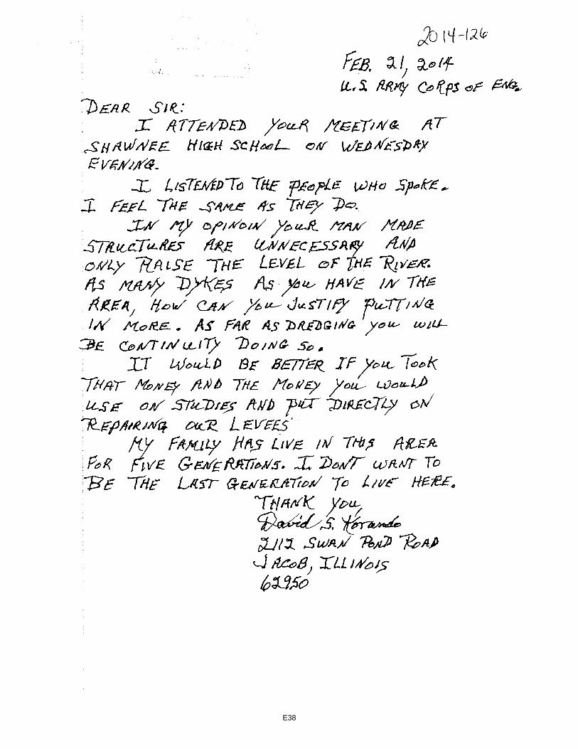
E38
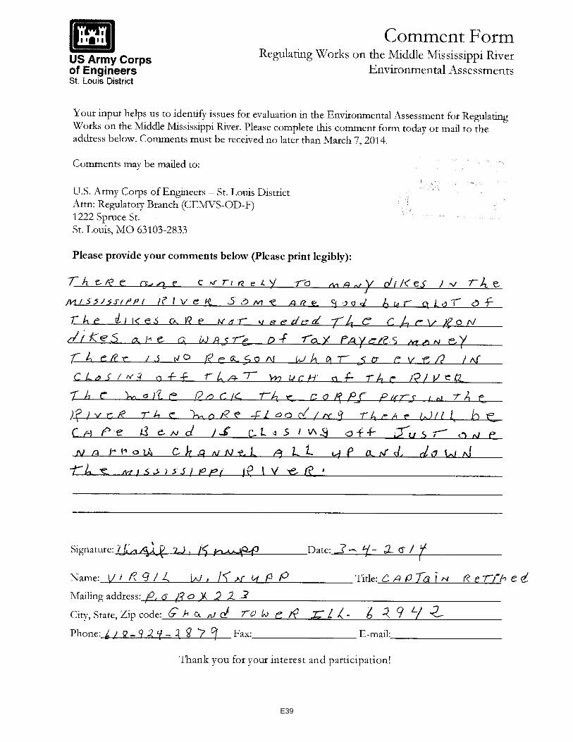
E39

POHLMANUSA COURT REPORTING (877) 421-0099
PUBLIC HEARING
RIVER TRAINING STRUCTURE CONSTRUCTION ACTIVITIES
FOR THE GRAND TOWER PHASE 5 PROJECT AND
THE DOGTOOTH BEND PHASE 5 PROJECT
Taken at Shawnee High School Library, 3365 State Route 3 North, Wolf Lake, Illinois Between the hours of 6:55 p.m. and 7:29 p.m.
February 19, 2014
Sherrie L. Merz, RDR/CSR/CCR
CSR No. 084-002840
CCR No. 995
E40

POHLMANUSA COURT REPORTING (877) 421-0099
Page 2
1 A P P E A R A N C E S
2
3 COLONEL CHRISTOPHER G. HALL, CommanderSt. Louis District
4 U.S. Army Corps of Engineers
5
MARY MARKOS, Hearing Moderator6 Public Affairs Specialist
St. Louis District7 U.S. Army Corps of Engineers
8
JASEN BROWN, Project Manager9 Hydraulic Engineer
St. Louis District10 U.S. Army Corps of Engineers
11
12
13
14
15
16
17
18
19
20
21
22
23
24
25
E41
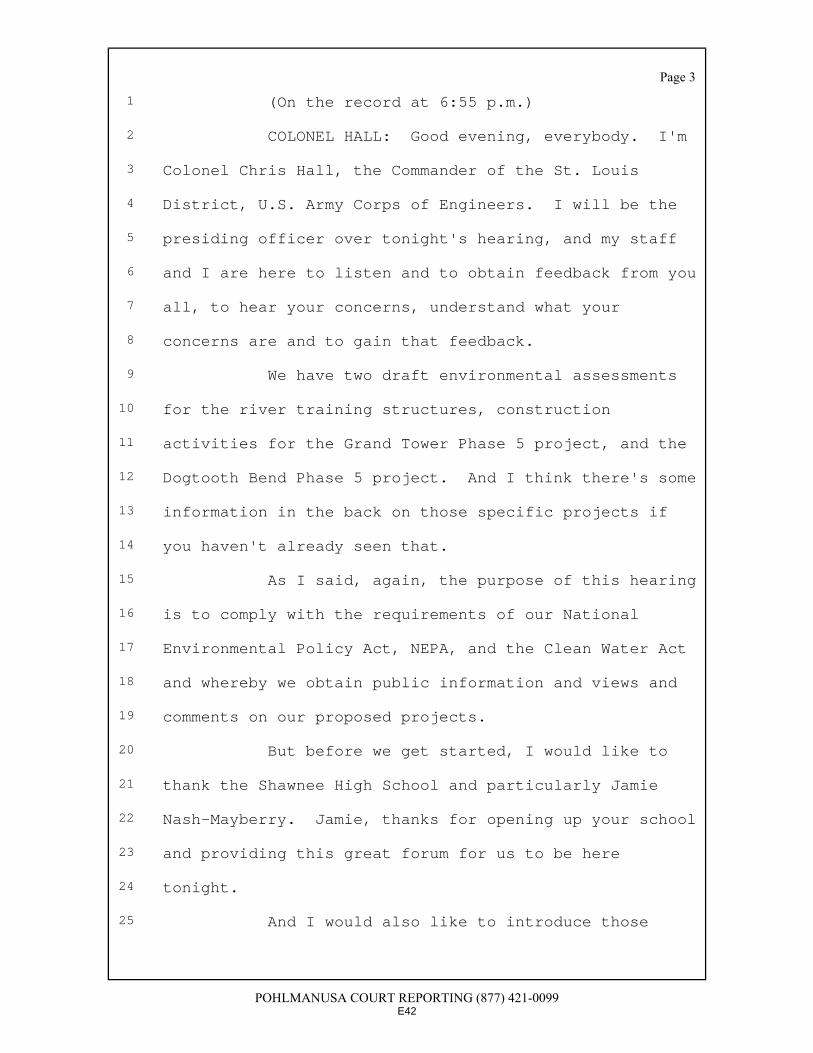
POHLMANUSA COURT REPORTING (877) 421-0099
Page 3
1 (On the record at 6:55 p.m.)
2 COLONEL HALL: Good evening, everybody. I'm
3 Colonel Chris Hall, the Commander of the St. Louis
4 District, U.S. Army Corps of Engineers. I will be the
5 presiding officer over tonight's hearing, and my staff
6 and I are here to listen and to obtain feedback from you
7 all, to hear your concerns, understand what your
8 concerns are and to gain that feedback.
9 We have two draft environmental assessments
10 for the river training structures, construction
11 activities for the Grand Tower Phase 5 project, and the
12 Dogtooth Bend Phase 5 project. And I think there's some
13 information in the back on those specific projects if
14 you haven't already seen that.
15 As I said, again, the purpose of this hearing
16 is to comply with the requirements of our National
17 Environmental Policy Act, NEPA, and the Clean Water Act
18 and whereby we obtain public information and views and
19 comments on our proposed projects.
20 But before we get started, I would like to
21 thank the Shawnee High School and particularly Jamie
22 Nash-Mayberry. Jamie, thanks for opening up your school
23 and providing this great forum for us to be here
24 tonight.
25 And I would also like to introduce those
E42
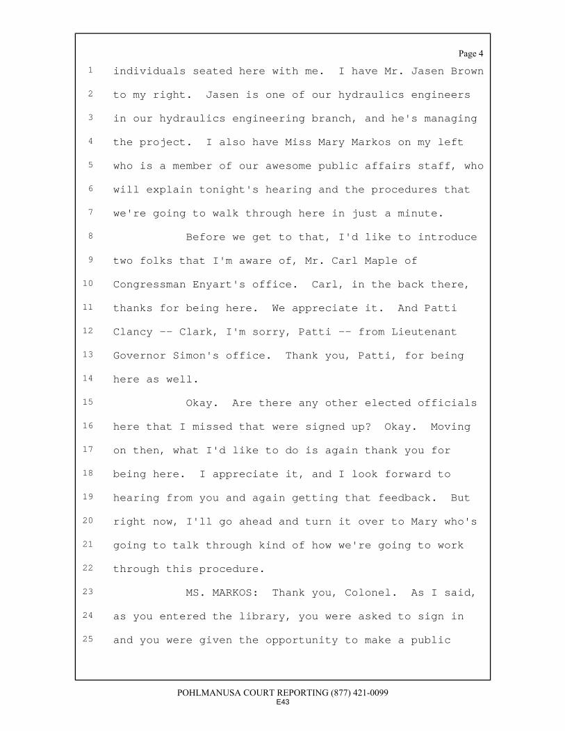
POHLMANUSA COURT REPORTING (877) 421-0099
Page 4
1 individuals seated here with me. I have Mr. Jasen Brown
2 to my right. Jasen is one of our hydraulics engineers
3 in our hydraulics engineering branch, and he's managing
4 the project. I also have Miss Mary Markos on my left
5 who is a member of our awesome public affairs staff, who
6 will explain tonight's hearing and the procedures that
7 we're going to walk through here in just a minute.
8 Before we get to that, I'd like to introduce
9 two folks that I'm aware of, Mr. Carl Maple of
10 Congressman Enyart's office. Carl, in the back there,
11 thanks for being here. We appreciate it. And Patti
12 Clancy -- Clark, I'm sorry, Patti -- from Lieutenant
13 Governor Simon's office. Thank you, Patti, for being
14 here as well.
15 Okay. Are there any other elected officials
16 here that I missed that were signed up? Okay. Moving
17 on then, what I'd like to do is again thank you for
18 being here. I appreciate it, and I look forward to
19 hearing from you and again getting that feedback. But
20 right now, I'll go ahead and turn it over to Mary who's
21 going to talk through kind of how we're going to work
22 through this procedure.
23 MS. MARKOS: Thank you, Colonel. As I said,
24 as you entered the library, you were asked to sign in
25 and you were given the opportunity to make a public
E43
POHLMANUSA COURT REPORTING (877) 421-0099
Page 5
1 comment. If you have not done that, and you want to
2 make a comment, please raise your hand, and we'll get a
3 card to you. Those cards can be passed down or forward,
4 and we'll get them up here so that you can be added to
5 the list to speak.
6 As Colonel Hall said, the purpose of
7 tonight's hearing is for us to hear your thoughts and
8 concerns. This is not a discussion, and it is not a
9 question and answer session. We are here to listen to
10 you. The hearing is being transcribed in its entirety
11 by a stenographer, so we ask those speakers that do come
12 up to speak directly into the mike, to state their name
13 and address and any organization or agency that they are
14 representing.
15 The way this will go is I will call
16 individuals forward. We have approximately 14 people
17 that would like to speak. Each individual will be
18 allowed or given three minutes to make their remarks.
19 We're asking that everyone give them the opportunity
20 without interruption. When we get to the two-minute
21 mark for all speakers, I will hold up a yellow card so
22 they know that their time is about up.
23 If you are speaking and your time runs out
24 before you get the opportunity to finish your statement,
25 we have those comment sheets that I mentioned earlier
E44
POHLMANUSA COURT REPORTING (877) 421-0099
Page 6
1 that you can fill out, and they will be included in the
2 record. As I said, this hearing is for us to hear from
3 you. We ask that everyone does not interrupt the
4 speakers so that everyone does have the opportunity to
5 express their concerns.
6 The public record will be open through Friday
7 March 7th. Anyone who wishes to add further comments to
8 fill out a comment sheet or submit comments to our
9 office can do so before that time. Written statements
10 submitted after the public hearing after tonight must be
11 mailed to the Corps of Engineers' Office. That address
12 is on the fact sheet which is available at the sign-in
13 desk, and all the information will also be posted on the
14 website. That website is also on this fact sheet.
15 As I said, will all speakers please remember
16 to state their name and their zip code and to speak
17 clearly into the microphone. At this time, our first
18 speaker is Mr. William Ellis. Mr. Ellis, would you like
19 to come forward?
20 Okay. So our first speaker tonight will be
21 Miss Amanda Damptz. Miss Amanda Damptz from SIU
22 Carbondale, would you like to come forward and speak?
23 MS. AMANDA DAMPTZ: My name is Amanda Damptz.
24 I'm from SIU Carbondale, and I would just like to make
25 one brief comment, that the National Wildlife Federation
E45
POHLMANUSA COURT REPORTING (877) 421-0099
Page 7
1 has targeted these two dike projects and put issues on
2 the action alert system. And as of this afternoon,
3 there's 17,000 people nationwide that have signed up in
4 opposition to the construction of these dikes.
5 MS. MARKOS: Thank you, ma'am. Our next
6 speaker, I'd like to call up LaRae Verble-Whitaker from
7 the Shawnee School Board.
8 MS. LARAE VERBLE-WHITAKER: My name is LaRae
9 Verble-Whitaker. I'm from Wolf Lake, Illinois. I'm a
10 community member. I'm also a Shawnee Valley Water Board
11 member, and I'm also Shawnee School District Board
12 President. Right now, I would like to ask the board or
13 actually ask the Army Corps of Engineers to please
14 consider further studies with your experiments and
15 please consider what you're doing before you go forth or
16 at least postpone them, because right now, our levees
17 are, as you know, very fragile.
18 And we are working very hard to get them back
19 to a standard where they can withhold some water, but
20 please give them some time. And postponing a project a
21 couple years, what will that hurt? I know it's
22 experimental, and please just consider that. Thank you.
23 COLONEL HALL: Thank you.
24 MS. MARKOS: Thank you. Our next speaker is
25 Miss Shelly Clover Hill.
E46

POHLMANUSA COURT REPORTING (877) 421-0099
Page 8
1 MS. SHELLY CLOVER HILL: My name is Shelly
2 Clover Hill, and I am the proud superintendent of
3 Shawnee District 84. And before I get started, I would
4 like to say to our current and former students and their
5 teacher Miss Jamie Nash-Mayberry how proud this district
6 is of you guys for highlighting the issues with the
7 levee, so thank you very much.
8 And I'd like to thank you for giving us the
9 opportunity this evening to have this hearing and thank
10 you for listening.
11 COLONEL HALL: My pleasure.
12 MS. SHELLY CLOVER HILL: With the safety of
13 all of our community's students and school district in
14 mind, I urge you to suspend the dike construction at
15 Dogtooth Bend and Grand Tower until after thorough
16 scientific assessment of dikes and other maintenance
17 activities is completed using computer modeling and real
18 world testing of their effects.
19 As you know, the current states of the levees
20 in our surrounding area, they are weakened. We are all
21 very concerned about them. We are concerned about our
22 homes. We are concerned about our businesses and our
23 farms and, of course, our school district. So we would
24 urge you to suspend those activities until further
25 research can be conducted. Thank you very much for
E47

POHLMANUSA COURT REPORTING (877) 421-0099
Page 9
1 listening. I appreciate your time.
2 COLONEL HALL: Thank you.
3 MS. MARKOS: Our next speaker is Mr. Jim
4 Taflinger.
5 MR. JIM TAFLINGER: Hello. I'm Jim
6 Taflinger, Len Small Levee District, live in Miller
7 City. We've had Weir dikes in Dogtooth Bend for over 20
8 years. They work. They don't cause any other problem
9 with high water, because they work on normal flow of the
10 river.
11 My concern is that we need to use hard points
12 or some kind of a diking system to protect on the
13 opposite side of the Weir dikes so you don't have land
14 erosion and loss of acreage on islands. And the second
15 thing I'd like to say is that we need to put more hard
16 points in the chute banks along the river to protect.
17 We're having so much loss of river bank,
18 because you no longer put dikes across the, you know,
19 across the sloughs and the -- what am I trying to say --
20 and if you put hard points, they sure work on the island
21 of Santa Fe Chute. You've got hard points staggered on
22 both sides, and it's working fine. So we don't have any
23 loss of stream bank against our levees. But as I said,
24 the Weir dikes are working. Do I get a star for being
25 for it?
E48
POHLMANUSA COURT REPORTING (877) 421-0099
Page 10
1 COLONEL HALL: Thank you, sir.
2 MS. MARKOS: Thank you, sir. What I'm going
3 to do is I'll read the next two names of speakers. That
4 way everyone can start working their way to the mike.
5 Our next speaker will be Mr. Ron Shepard, and following
6 Mr. Shepard, we will have Miss Olivia Dorothy, please.
7 MR. RON SHEPARD: Ron Shepard, Wolf Lake. I
8 just want to say that the dikes as I see, and being over
9 on the river after every time the water is up and all
10 the sand and sludge that's just left behind and building
11 up the land, the dikes apparently aren't doing that much
12 good and hasn't for several years. So I don't see why
13 to continue to put money into something that apparently
14 is not working that well. Thank you very much.
15 COLONEL HALL: Thank you, sir.
16 MS. MARKOS: Thank you. Olivia Dorothy, and
17 following Olivia we will have Miss Elena Houston.
18 MS. OLIVIA DOROTHY: Good evening. My name
19 is Olivia Dorothy, and I'm actually from Rock Island,
20 Illinois, so I had quite a drive coming down here. I
21 work for the Izaak Walton League of America, and I also
22 am the facilitator for the Nicollet Island Coalition,
23 which is a collaboration of conservation and taxpayer
24 organizations on the Upper Mississippi River. That
25 includes the Prairie Rivers Network, National Wildlife
E49
POHLMANUSA COURT REPORTING (877) 421-0099
Page 11
1 Federation, the Sierra Club, Missouri Coalition for the
2 Environment, and others.
3 Tonight I want to ask you to please withdraw
4 the Dogtooth Bend and Grand Tower projects in their
5 environmental assessments until the supplemental
6 environmental impact statements for the Middle
7 Mississippi for regulating works project is complete.
8 The St. Louis District of the Army Corps has
9 already determined that the 1976 environmental impact
10 statement is outdated, flawed and otherwise inadequate
11 for continued applicability on the Mississippi River.
12 To tier these projects, that 1976 document is
13 unacceptable.
14 The driving impetus for updating the 1976
15 environmental impact statement is concerned that river
16 training structures are increasing the flood risk along
17 the Mississippi River and its riverfront communities.
18 Both of these projects will construct 18 new structures
19 in the Mississippi River, including an S dike, a
20 structure that has never before been built.
21 This raises significant concerns since there
22 have been more than 50 peer-reviewed studies, and I have
23 the list here to provide you with that correlate
24 increasing flood risk to river training structures such
25 as those proposed to be built at Dogtooth Bend and Grand
E50
POHLMANUSA COURT REPORTING (877) 421-0099
Page 12
1 Tower.
2 Additionally, very limited evidence exists
3 documenting the environmental impacts and cost
4 effectiveness of the river training structures that will
5 be built at Dogtooth Bend and Grand Tower. Much of that
6 evidence identifying these structures as environmentally
7 preferable and cost effective is anecdotal, and the
8 district relies too much on the HSR model, which other
9 professional organizations call unreliable due to its
10 inability to provide accurate predictions. This is why
11 it's essential for the environmental impact statement
12 for the Middle Mississippi River regulating works
13 projects be completed before the Dogtooth Bend and Grand
14 Tower projects advance.
15 If done correctly, the supplemental
16 environmental impact statement for the Middle Miss
17 regulating works projects will include an independent
18 study evaluating the flood risk associated with river
19 training structures, a moratorium on the construction of
20 river training structures until the environmental impact
21 statement is completed, and the independent study can
22 ensure their safety, and a properly expanded project
23 purpose preferable one that encompasses the entire
24 9-foot channel project.
25 This supplemental review on the Middle Miss
E51
POHLMANUSA COURT REPORTING (877) 421-0099
Page 13
1 regulating works may render the construction of the
2 river training structures at Dogtooth Bend and Grand
3 Tower unadvisable. At the very least, it is likely the
4 supplemental environmental impact statement for the
5 regulating works will install new conditions and
6 restrictions that will apply to projects like Dogtooth
7 and Grand Tower.
8 Since there are so many concerns about the
9 safety of river training structures and the likelihood
10 that new rules will apply to the construction of them
11 after the supplemental EIS on the Middle Miss is
12 complete, I insist the Dogtooth Bend and Grand Tower
13 projects be postponed. Thank you.
14 MS. MARKOS: Miss Elena Houston and then
15 Mr. Kenneth Verble, please.
16 MS. ELENA HOUSTON: Hello. I am Elena
17 Houston. I'm from Grand Tower, and as a former student
18 of Shawnee High School, I've seen a lot of research that
19 has been done on wing dikes and the effects they have on
20 flooding. And from what I've seen, that it hasn't been
21 very beneficial in relation to flooding. So before you
22 guys put these dikes in, I would just like for more
23 research to be done to show that it's not going to
24 affect us in negative ways. Thank you.
25 MS. MARKOS: Thank you.
E52
POHLMANUSA COURT REPORTING (877) 421-0099
Page 14
1 COLONEL HALL: Thank you.
2 MS. MARKOS: Mr. Kenneth Verble and then Miss
3 Jamie Nash-Mayberry.
4 MR. KENNETH VERBLE: My name is Kenneth
5 Verble. I live in Wolf Lake, and a farm owner and
6 concerned with anything that affects the river and any
7 flooding that may occur from it. I guess one of my
8 first thoughts was have we done a computer modeling
9 program to determine what these dikes are going to do in
10 the future? Have we looked at the existing dikes as to
11 what they have done? Just noticed in your brochure here
12 that Congress has given us a blank check to go out and
13 build these things, but I don't see anything going back
14 towards what's happened in the past, such as the old
15 dikes that have built up and consumed the water volume
16 that used to exist. It's no longer there, so water
17 can't take its place during any high waters.
18 So I would like to see you use some of that
19 money to do both things. I'm sure Congress didn't allot
20 that money just to keep the river 9 foot deep, 300 foot
21 wide. I'm sure they had other things in mind to protect
22 the citizens in the Bottoms as well as the traffic on
23 the river. So those things should be studied.
24 And that computer model I would like to see,
25 and also, who are you reporting to within the state?
E53
POHLMANUSA COURT REPORTING (877) 421-0099
Page 15
1 This is Illinois. When you're on the Illinois side,
2 somebody in Illinois needs to be working with the Corps
3 of Engineers, say yes, I agree with you or no, I don't
4 agree with you, yes, you've done the right studies and
5 this independent agency over here has verified that.
6 And being from a background of codes and
7 standards, you never go with one study. You have more
8 than one study, and then you mock it up, make sure your
9 studies are right. The mock-ups and studies will cost
10 more than the actual project. So those things need to
11 be done and not forgotten.
12 So again, looks like we got a blank check to
13 work on this river. Let's work on both sides of it to
14 benefit the farmer, the Bottoms and the traffic.
15 MS. MARKOS: Miss Jamie Nash-Mayberry and
16 then Miss Jessica Spurlock.
17 MS. JAMIE NASH-MAYBERRY: My name is Jamie
18 Nash-Mayberry. I'm from Cobden, Illinois 62920, but I'd
19 like to claim myself as a Bottoms person. Many of you
20 already know me, and you know that my students and I
21 have studied this issue extensively. We came to your
22 Corps base in St. Louis, and Eddie Brauer presented his
23 side of the issue. And we kept an open mind, but we
24 couldn't deny what all the other sources we examined
25 were saying.
E54

POHLMANUSA COURT REPORTING (877) 421-0099
Page 16
1 We didn't just talk to Dr. Nicholas Pinter of
2 SIU, a geologist, geographer; we went on. We talked to
3 others. We talked to Fredrik Huthoff of the
4 Netherlands. He was studying abroad. We talked to a
5 Washington University professor. We read peer-reviewed
6 journals. We even read comments from the National
7 Wildlife Federation.
8 And then we talked to the real experts, the
9 locals, who've seen these dikes be put in over the
10 years. And the thing is, they all concluded the same
11 thing, that these wing dikes lead to increased flood
12 heights.
13 Here's my point: If we're wrong, all of us,
14 the consequences are really minimal. But if you are
15 wrong as the Corps, the consequences are enormous. Why
16 not stop putting them in, get an outside group to come
17 in, do a study -- and I don't mean a group that you're
18 paying; an outside group -- and have them conclude
19 what's happening here? And you could spend your money
20 blowing up shale to help the barges. You could dredge
21 to help the barges. You could use your money to open up
22 other rivers to help the barges, or perhaps you could
23 even use that money to fix some of these slides in Grand
24 Tower.
25 But the National Wildlife Federation just a
E55

POHLMANUSA COURT REPORTING (877) 421-0099
Page 17
1 minute ago recommended the National Academy of Sciences
2 could come in and do a study. I know they've tried
3 before to do that, and I don't understand why you
4 haven't had them come in and do the study. My
5 conclusion is you're afraid of what they might conclude
6 and perhaps the future lawsuits that might follow that.
7 Finally, I simply ask this of you: Think
8 about the consequences of all these people. I know you
9 have hearts. You've come down here. You've done
10 excellent presentations for my students and I anytime
11 we've asked, so I know you're caring people. I know
12 that. I'm asking you to care about these people and
13 think about what the risk might be.
14 And finally, because many of them didn't sign
15 up to comment -- but I know how they feel -- how many of
16 you out there would be in favor if the Corps stopped
17 putting wing dikes in until an outside group could study
18 it further? Show of hands. Thank you.
19 COLONEL HALL: Thank you.
20 MS. MARKOS: Miss Jessica Spurlock and then
21 Mr. Braden Mezo.
22 MS. JESSICA SPURLOCK: My name is Jessica
23 Spurlock. I live in Wolf Lake, Illinois, and I'm a
24 senior this year at Shawnee High School and a proud
25 supporter and proud to be a part of Save the Levee
E56

POHLMANUSA COURT REPORTING (877) 421-0099
Page 18
1 Project. Grand Tower, if there was to be another flood,
2 and it be to where the levees would break, it would be
3 disastrous, and we would lose our district because it's
4 a third. And we all know -- half of it now is from what
5 Miss Nash-Mayberry has told us -- in this construction,
6 there would be new S dikes. And that is new, and that
7 has not been tested yet further.
8 There should be more people looking into this
9 S dike program like the National Academy of Science look
10 into it and see what they think and their opinion is on
11 it on how these dikes will or will they not break our
12 levees and if the levee will rise if these dikes are put
13 in. Thanks.
14 COLONEL HALL: Thank you.
15 MS. MARKOS: Mr. Braden Mezo, and then we
16 have Dr. Nicholas Pinter.
17 MR. BRADEN MEZO: My name is Braden Mezo, and
18 I am a senior at Shawnee High School. And it is common
19 knowledge that there are going to be many new -- that
20 this project will present as many different kinds of
21 wing dikes, the S dike as previously mentioned. Knowing
22 that it had not been tested thoroughly yet, I believe
23 that this raises many concerns, and I humbly request
24 that you put a little bit more research into it.
25 Being a resident of this area, it is very
E57
POHLMANUSA COURT REPORTING (877) 421-0099
Page 19
1 important to me that I graduate from this school. I do
2 not want to lose my home, and it is very important to
3 me. So I humbly request you put it off maybe for a year
4 or two. Like it was said before, what can it hurt? And
5 that is all. Thank you.
6 COLONEL HALL: Thank you.
7 MS. MARKOS: After Mr. Pinter, we will have
8 Mr. Virgil Knupp.
9 PROFESSOR NICHOLAS PINTER: My name is
10 Nicholas Pinter, Professor at Illinois University of
11 Carbondale. I wanted to thank the Colonel and the rest
12 of the Corps staff for making the drive down here. We
13 heard a rumor that the Corps had requested police
14 protection here in Wolf Lake. We were a little amused
15 by this, not sure what you expected to find south of 64.
16 We hope you find us a little bit more hospitable than
17 you feared.
18 COLONEL HALL: I've been in worse places.
19 PROFESSOR NICHOLAS PINTER: Nice to hear, I
20 think. So I have about two and a half minutes left to
21 talk about a hundred-plus years of research on a link
22 between wing dikes and the river training structures and
23 flooding. And I can't do that, so just a couple quick
24 points.
25 One is the starting point for this
E58
POHLMANUSA COURT REPORTING (877) 421-0099
Page 20
1 discussion. So we sat down with Corps staff, some of
2 them in this room and their consulting scientists in
3 2008, I believe. And there was one area of broad
4 agreement, and that is flood risk, flood levels and
5 flood frequencies on our stretch of river, the Middle
6 Mississippi River, had increased by most agreement
7 dramatically during the last decades to a century or
8 more, which really brings all this to a question of what
9 exactly is causing this increase in flood levels.
10 And what we need to do is point out anyone
11 needs to look at the maps in Jamie's room, look at the
12 number of these structures that have been in place,
13 thousands of these structures on this river over the
14 past decades. This is the epicenter of wing dike
15 construction, certainly in the country, and if there is
16 a river anywhere in the world with more of these
17 structures of greater density than the Middle
18 Mississippi River, we haven't found it yet, and we've
19 been looking for it.
20 So I guess what I would suggest is, Colonel,
21 we just returned to the conversation we had several
22 years ago when you first arrived in St. Louis, where my
23 colleagues and I suggested the same thing that you've
24 heard in the room tonight, that you're hearing from your
25 staff that these navigation structures do not cause any
E59

POHLMANUSA COURT REPORTING (877) 421-0099
Page 21
1 increase in flood levels, and you're hearing the
2 opposite from a number of academic scientists. What are
3 you to do with that?
4 So what you've heard, particularly from Miss
5 Nash-Mayberry already, is you can take one or the other,
6 or given that public safety is the question that we're
7 all most concerned about, you can say you don't know the
8 answer to that question, and you're going to send it out
9 to another group, an independent group, with no vested
10 interest in the answer to that question to finally
11 assess the result of that question.
12 The National Academy of Scientists is a
13 suggestion that's been made a number of times tonight.
14 We suggest that that study be initiated as part of the
15 supplemental environmental impact statement that is now
16 just being initiated and, meanwhile, that a moratorium
17 be declared, that no new structures be built on our
18 Middle Mississippi River until their safety be
19 thoroughly addressed. Thank you very much.
20 MR. VIRGIL KNUPP: My name is Virgil Knupp,
21 and I'm from Grand Tower. I worked on the river for
22 35 years for Luhr Brothers. We built a lot of these
23 dikes out there, and about 40 percent of them we don't
24 need. We're over-diked. That's why we had the flood.
25 If we had a flood the same height as '93 right now, it
E60

POHLMANUSA COURT REPORTING (877) 421-0099
Page 22
1 would go over the levee at Grand Tower. That's how many
2 dikes you've put in since then.
3 And you extended dikes down there at
4 Pikayune, 75 feet, five dikes, 75 feet each. They
5 didn't need to be extended. They need to be took out.
6 And all the way down to Caruthersville, the dike down
7 there is over three quarters of the river closed off.
8 Behind Wolf Island, there's two dikes that blocks the
9 island off. There's two trap holes in behind it.
10 That's why they flooded down on the Missouri side that
11 time.
12 There's too much river shut off with these
13 dikes. If some of these dikes were shortened up, the
14 one above Robinson Bayou, you can take a hundred 50 foot
15 of that dike out and all the way around that bend some
16 of them dikes. Down above the Boot Point Bridge, them
17 dikes, you ain't got a channel left no more. It's not
18 the Mississippi River. It's the Mississippi Creek.
19 It's over-diked, and that's where the
20 flooding is coming out. It's putting too much strain on
21 the levees. It's nothing to take and sit 8, 10,
22 12 hours on a boat trying to get up to another hole.
23 It's that swift out there anymore. And you don't have
24 no room no more. And as far as swift, a lot of times
25 they get in Grand Tower chute, it shoots them out.
E61

POHLMANUSA COURT REPORTING (877) 421-0099
Page 23
1 So they don't need no more dikes in here.
2 Don't need none down south. What they need is to figure
3 out a way to eliminate some of the dikes and still hold
4 the channel so that next flood we have is not going to
5 top. If we have another one like '93, it's over. It's
6 coming over.
7 Wolf Lake had all them boils out on their
8 levees that year and they thought they was going to lose
9 it. Well, that's going to affect Grand Tower,
10 Howardton, Gorham, Jacob, Neunert, all the way up to
11 Cora levee -- well, you might as well say McClure, East
12 Cape. Everybody is going to go if they don't take some
13 of the pressure off of some of these dikes. They're
14 just too long, too many.
15 I mean, a lot of them I don't even know what
16 they're in there for. They're worthless. They ain't no
17 good. And they're too long. If you fly over
18 Caruthersville north of Robinson Bayou and look at the
19 dike and look at how much water you have left, one boat
20 at a time can go through there. If it wasn't for them
21 dikes, you could put four boats through there at a time,
22 side by side. That's how much of it, take that off.
23 But as far as that dike they're going to put
24 in up there at Grand Tower, I can show you how to put
25 that in without all of them straight-out dikes. And it
E62
POHLMANUSA COURT REPORTING (877) 421-0099
Page 24
1 will work better than what you're going to do. It will
2 kick the sand off. The sand won't have to be dredged no
3 more.
4 Because I worked with them building dikes for
5 35 years, and I know a lot about the dikes, what it's
6 going to do. Because we like to lost a dike -- we
7 changed I don't know how many channels. The channel
8 used to be over here. The channel is over here now.
9 The channel used to be over here; it's not there no
10 more. Down at Buck Island where the casino is, the
11 channel that's on the opposite side of the river, now
12 it's over here on this side of the river, and that's all
13 diked off completely. So that's it. Okay. Thank you.
14 COLONEL HALL: Thank you.
15 MS. MARKOS: That's our list of anyone who
16 turned in a card stating they would like to make a
17 comment. Is there anyone else at this time who would
18 like to make a comment? If not, I'll turn the hearing
19 back over to you.
20 COLONEL HALL: Okay. As I said before, we're
21 here to listen. I'm here to listen. I appreciate the
22 comments. I appreciate the passion. And all of this is
23 part of the process to make a determination on how we go
24 forward with these. I think it was mentioned we have a
25 supplemental EIS in progress. We are doing separate
E63
POHLMANUSA COURT REPORTING (877) 421-0099
Page 25
1 environmental assessments for these projects in order to
2 establish where we're going with them until that
3 supplemental EIS is complete, and I heard some comments
4 on the timing of that and what you would desire to have
5 that be. We'll take all these things under advisement,
6 I will with my staff. But again I appreciate your
7 feedback. That's what we're here for. I wanted to hear
8 from you all personally and understand what it is that
9 -- what your viewpoints are and what your concerns are.
10 So again, as Miss Markos said, we will still
11 -- I think we'll be taking written comments until March
12 7th, so if there's something on your mind you want to
13 make sure we understand, please get that in to us. This
14 is part of the process. And I don't take it lightly, or
15 I wouldn't be here.
16 MR. VIRGIL KNUPP: Me neither.
17 COLONEL HALL: Again, thank all of you and
18 safe travels home. And listen, I grew up in a small
19 town, no stoplights, farm community, so it wasn't
20 protected by dikes, you know. It's about 50 miles from
21 Lake Erie in Northeastern Ohio. So I have no fear of
22 being in a small community. Trust me, I've been in
23 Sauder City (phonetic). That's what I was remarking
24 when --
25 MR. VIRGIL KNUPP: Well, you can kind of see,
E64

POHLMANUSA COURT REPORTING (877) 421-0099
Page 26
1 though, they want to overlook small towns, like there's
2 not enough there. It's not like St. Louis or Chicago.
3 But everybody has got their thing. They're all tied up.
4 Their livelihood is here.
5 MS. MARKOS: Again, thank you guys all for
6 coming. We appreciate it very much.
7 (Off the record at 7:29 p.m.)
8
9
10
11
12
13
14
15
16
17
18
19
20
21
22
23
24
25
E65

POHLMANUSA COURT REPORTING (877) 421-0099
Page 27
1 CERTIFICATE
2
3 I, SHERRIE L. MERZ, Registered DiplomateReporter, Certified Shorthand Reporter and Certified
4 Court Reporter, do hereby certify that the foregoingPublic Hearing was taken by me at the Shawnee High
5 School Library, 3365 State Route 3 North, Wolf Lake,Illinois, and that this transcript is a true and correct
6 record of the proceedings recorded by me.
7
I further certify that I am neither attorney8 nor counsel for nor related nor employed by any of the
parties to the action in which this deposition is taken;9 further, that I am not a relative or employee of any
attorney or counsel employed by the parties hereto or10 financially interested in this action.
11
IN WITNESS WHEREOF, I have hereunto12 subscribed my name this 26th day of February, 2014.
13
14
________________________________15 SHERRIE L. MERZ, RDR, CSR, CCR
16
17
18
19
20
21
22
23
24
25
E66

POHLMANUSA COURT REPORTING (877) 421-0099POHLMANUSA COURT REPORTING (877) 421-0099
Page 28
Aabroad 16:4academic 21:2academy 17:1 18:921:12
accurate 12:10acreage 9:14act 3:17,17action 7:2 27:8,10activities 1:23:11 8:17,24
actual 15:10add 6:7added 5:4additionally 12:2address 5:13 6:11addressed 21:19advance 12:14advisement 25:5affairs 2:6 4:5affect 13:24 23:9afraid 17:5afternoon 7:2agency 5:13 15:5ago 17:1 20:22agree 15:3,4agreement 20:4,6ahead 4:20aint 22:17 23:16alert 7:2allot 14:19allowed 5:18amanda 6:21,21,236:23
america 10:21amused 19:14anecdotal 12:7answer 5:9 21:8,10anymore 22:23anytime 17:10apparently 10:1110:13
applicability11:11
apply 13:6,10appreciate 4:11,189:1 24:21,2225:6 26:6
approximately 5:16area 8:20 18:2520:3
arent 10:11army 2:4,7,10 3:47:13 11:8
arrived 20:22asked 4:24 17:11asking 5:19 17:12assess 21:11assessment 8:16assessments 3:911:5 25:1
associated 12:18attorney 27:7,9available 6:12aware 4:9awesome 4:5
B
back 3:13 4:107:18 14:1324:19
background 15:6bank 9:17,23banks 9:16barges 16:20,21,22base 15:22bayou 22:14 23:18believe 18:22 20:3bend 1:4 3:12 8:159:7 11:4,2512:5,13 13:2,1222:15
beneficial 13:21benefit 15:14better 24:1bit 18:24 19:16blank 14:12 15:12blocks 22:8blowing 16:20board 7:7,10,11,12boat 22:22 23:19boats 23:21boils 23:7boot 22:16bottoms 14:2215:14,19
braden 17:21 18:1518:17,17
branch 4:3brauer 15:22break 18:2,11bridge 22:16brief 6:25brings 20:8broad 20:3brochure 14:11brothers 21:22brown 2:8 4:1buck 24:10build 14:13building 10:1024:4
built 11:20,2512:5 14:1521:17,22
businesses 8:22
Cc 2:1call 5:15 7:6 12:9cant 14:17 19:23cape 23:12carbondale 6:22,2419:11
card 5:3,21 24:16cards 5:3care 17:12caring 17:11carl 4:9,10caruthersville22:6 23:18
casino 24:10cause 9:8 20:25causing 20:9ccr 1:23,25 27:15century 20:7
certainly 20:15certificate 27:1certified 27:3,3certify 27:4,7changed 24:7channel 12:2422:17 23:4 24:724:8,9,11
channels 24:7check 14:12 15:12chicago 26:2chris 3:3christopher 2:3chute 9:16,2122:25
citizens 14:22city 9:7 25:23claim 15:19clancy 4:12clark 4:12clean 3:17clearly 6:17closed 22:7clover 7:25 8:1,28:12
club 11:1coalition 10:2211:1
cobden 15:18code 6:16codes 15:6collaboration10:23
colleagues 20:23colonel 2:3 3:2,34:23 5:6 7:238:11 9:2 10:110:15 14:117:19 18:1419:6,11,1820:20 24:14,2025:17
come 5:11 6:19,2216:16 17:2,4,9
coming 10:20 22:2023:6 26:6
commander 2:3 3:3comment 5:1,2,256:8,25 17:1524:17,18
comments 3:19 6:76:8 16:6 24:2225:3,11
common 18:18communities 11:17community 7:1025:19,22
communitys 8:13complete 11:713:12 25:3
completed 8:1712:13,21
completely 24:13comply 3:16computer 8:17 14:814:24
concern 9:11concerned 8:21,21
8:22 11:15 14:621:7
concerns 3:7,8 5:86:5 11:21 13:818:23 25:9
conclude 16:1817:5
concluded 16:10conclusion 17:5conditions 13:5conducted 8:25congress 14:12,19congressman 4:10consequences 16:1416:15 17:8
conservation 10:23consider 7:14,157:22
construct 11:18construction 1:23:10 7:4 8:1412:19 13:1,1018:5 20:15
consulting 20:2consumed 14:15continue 10:13continued 11:11conversation 20:21cora 23:11corps 2:4,7,10 3:46:11 7:13 11:815:2,22 16:1517:16 19:12,1320:1
correct 27:5correctly 12:15correlate 11:23cost 12:3,7 15:9couldnt 15:24counsel 27:8,9country 20:15couple 7:21 19:23course 8:23court 27:4creek 22:18csr 1:23,24 27:15current 8:4,19
Ddamptz 6:21,21,236:23
day 27:12decades 20:7,14declared 21:17deep 14:20density 20:17deny 15:24deposition 27:8desire 25:4desk 6:13determination24:23
determine 14:9determined 11:9didnt 14:19 16:117:14 22:5
different 18:20dike 7:1 8:14
11:19 18:9,2120:14 22:6,1523:19,23 24:6
diked 24:13dikes 7:4 8:16 9:79:13,18,24 10:810:11 13:19,2214:9,10,15 16:916:11 17:1718:6,11,12,2119:22 21:2322:2,3,4,8,1322:13,16,1723:1,3,13,21,2524:4,5 25:20
diking 9:12diplomate 27:3directly 5:12disastrous 18:3discussion 5:820:1
district 2:3,6,93:4 7:11 8:3,58:13,23 9:611:8 12:8 18:3
document 11:12documenting 12:3dogtooth 1:4 3:128:15 9:7 11:411:25 12:5,1313:2,6,12
doing 7:15 10:1124:25
dont 9:8,13,2210:12 14:1315:3 16:17 17:321:7,23 22:2323:1,2,12,1524:7 25:14
dorothy 10:6,16,1810:19
dr 16:1 18:16draft 3:9dramatically 20:7dredge 16:20dredged 24:2drive 10:20 19:12driving 11:14due 12:9
Ee 2:1,1earlier 5:25east 23:11eddie 15:22effective 12:7effectiveness 12:4effects 8:18 13:19eis 13:11 24:2525:3
elected 4:15elena 10:17 13:1413:16,16
eliminate 23:3ellis 6:18,18employed 27:8,9employee 27:9encompasses 12:23
E67

POHLMANUSA COURT REPORTING (877) 421-0099
Page 29
engineer 2:9engineering 4:3engineers 2:4,7,103:4 4:2 6:117:13 15:3
enormous 16:15ensure 12:22entered 4:24entire 12:23entirety 5:10environment 11:2environmental 3:93:17 11:5,6,911:15 12:3,1112:16,20 13:421:15 25:1
environmentally12:6
enyarts 4:10epicenter 20:14erie 25:21erosion 9:14essential 12:11establish 25:2evaluating 12:18evening 3:2 8:910:18
everybody 3:223:12 26:3
evidence 12:2,6exactly 20:9examined 15:24excellent 17:10exist 14:16existing 14:10exists 12:2expanded 12:22expected 19:15experimental 7:22experiments 7:14experts 16:8explain 4:6express 6:5extended 22:3,5extensively 15:21
Ffacilitator 10:22fact 6:12,14far 22:24 23:23farm 14:5 25:19farmer 15:14farms 8:23favor 17:16fe 9:21fear 25:21feared 19:17february 1:1227:12
federation 6:2511:1 16:7,25
feedback 3:6,84:19 25:7
feel 17:15feet 22:4,4figure 23:2fill 6:1,8finally 17:7,14
21:10financially 27:10find 19:15,16fine 9:22finish 5:24first 6:17,20 14:820:22
five 22:4fix 16:23flawed 11:10flood 11:16,2412:18 16:1118:1 20:4,4,5,921:1,24,25 23:4
flooded 22:10flooding 13:20,2114:7 19:2322:20
flow 9:9fly 23:17folks 4:9follow 17:6following 10:5,17foot 14:20,2022:14
foregoing 27:4forgotten 15:11former 8:4 13:17forth 7:15forum 3:23forward 4:18 5:35:16 6:19,2224:24
found 20:18four 23:21fragile 7:17fredrik 16:3frequencies 20:5friday 6:6further 6:7 7:148:24 17:18 18:727:7,9
future 14:10 17:6
Gg 2:3gain 3:8geographer 16:2geologist 16:2getting 4:19give 5:19 7:20given 4:25 5:1814:12 21:6
giving 8:8go 4:20 5:15 7:1514:12 15:7 22:123:12,20 24:23
going 4:7,21,2110:2 13:23 14:914:13 18:1921:8 23:4,8,923:12,23 24:1,625:2
good 3:2 10:12,1823:17
gorham 23:10governor 4:13graduate 19:1
grand 1:3 3:118:15 11:4,2512:5,13 13:2,713:12,17 16:2318:1 21:21 22:122:25 23:9,24
great 3:23greater 20:17grew 25:18group 16:16,17,1817:17 21:9,9
guess 14:7 20:20guys 8:6 13:2226:5
Hhalf 18:4 19:20hall 2:3 3:2,3 5:67:23 8:11 9:210:1,15 14:117:19 18:1419:6,18 24:1424:20 25:17
hand 5:2hands 17:18happened 14:14happening 16:19hard 7:18 9:11,159:20,21
hasnt 10:12 13:20havent 3:14 17:420:18
hear 3:7 5:7 6:219:19 25:7
heard 19:13 20:2421:4 25:3
hearing 1:1 2:53:5,15 4:6,195:7,10 6:2,108:9 20:24 21:124:18 27:4
hearts 17:9height 21:25heights 16:12hello 9:5 13:16help 16:20,21,22heres 16:13hereto 27:9hereunto 27:11hes 4:3high 1:9 3:21 9:913:18 14:1717:24 18:1827:4
highlighting 8:6hill 7:25 8:1,2,12hold 5:21 23:3hole 22:22holes 22:9home 19:2 25:18homes 8:22hope 19:16hospitable 19:16hours 1:10 22:22houston 10:1713:14,16,17
howardton 23:10hsr 12:8
humbly 18:23 19:3hundred 22:14hundredplus 19:21hurt 7:21 19:4huthoff 16:3hydraulic 2:9hydraulics 4:2,3
Iid 4:8,17 7:6 8:89:15 15:18
identifying 12:6ill 4:20 10:324:18
illinois 1:10 7:910:20 15:1,1,215:18 17:2319:10 27:5
im 3:2 4:9,12 6:247:9,9,10,11 9:510:2,19 13:1714:19,21 15:1817:12,23 21:2124:21
impact 11:6,9,1512:11,16,2013:4 21:15
impacts 12:3impetus 11:14important 19:1,2inability 12:10inadequate 11:10include 12:17included 6:1includes 10:25including 11:19increase 20:9 21:1increased 16:1120:6
increasing 11:1611:24
independent 12:1712:21 15:5 21:9
individual 5:17individuals 4:15:16
information 3:133:18 6:13
initiated 21:14,16insist 13:12install 13:5interest 21:10interested 27:10interrupt 6:3interruption 5:20introduce 3:25 4:8island 9:20 10:1910:22 22:8,924:10
islands 9:14issue 15:21,23issues 7:1 8:6ive 13:18,20 19:1825:22
izaak 10:21
Jjacob 23:10
jamie 3:21,22 8:514:3 15:15,1715:17
jamies 20:11jasen 2:8 4:1,2jessica 15:1617:20,22,22
jim 9:3,5,5journals 16:6
Kkeep 14:20kenneth 13:15 14:214:4,4
kept 15:23kick 24:2kind 4:21 9:1225:25
kinds 18:20know 5:22 7:17,218:19 9:18 15:2015:20 17:2,8,1117:11,15 18:421:7 23:15 24:524:7 25:20
knowing 18:21knowledge 18:19knupp 19:8 21:2021:20 25:16,25
Ll 1:23 27:3,15lake 1:10 7:9 10:714:5 17:2319:14 23:725:21 27:5
land 9:13 10:11larae 7:6,8,8lawsuits 17:6lead 16:11league 10:21left 4:4 10:1019:20 22:1723:19
len 9:6levee 8:7 9:617:25 18:1222:1 23:11
levees 7:16 8:199:23 18:2,1222:21 23:8
levels 20:4,9 21:1library 1:9 4:2427:5
lieutenant 4:12lightly 25:14likelihood 13:9limited 12:2link 19:21list 5:5 11:2324:15
listen 3:6 5:924:21,21 25:18
listening 8:10 9:1little 18:24 19:1419:16
live 9:6 14:517:23
E68

POHLMANUSA COURT REPORTING (877) 421-0099
Page 30
livelihood 26:4locals 16:9long 23:14,17longer 9:18 14:16look 4:18 18:920:11,11 23:1823:19
looked 14:10looking 18:8 20:19looks 15:12lose 18:3 19:223:8
loss 9:14,17,23lost 24:6lot 13:18 21:2222:24 23:1524:5
louis 2:3,6,9 3:311:8 15:2220:22 26:2
luhr 21:22
Mm 1:10,10 3:1 26:7maam 7:5mailed 6:11maintenance 8:16making 19:12manager 2:8managing 4:3maple 4:9maps 20:11march 6:7 25:11mark 5:21markos 2:5 4:4,237:5,24 9:3 10:210:16 13:14,2514:2 15:1517:20 18:1519:7 24:1525:10 26:5
mary 2:5 4:4,20mcclure 23:11mean 16:17 23:15member 4:5 7:10,11mentioned 5:2518:21 24:24
merz 1:23 27:3,15mezo 17:21 18:1518:17,17
microphone 6:17middle 11:6 12:1212:16,25 13:1120:5,17 21:18
mike 5:12 10:4miles 25:20miller 9:6mind 8:14 14:2115:23 25:12
minimal 16:14minute 4:7 17:1minutes 5:18 19:20missed 4:16mississippi 10:2411:7,11,17,1912:12 20:6,1821:18 22:18,18
missouri 11:1
22:10mock 15:8mockups 15:9model 12:8 14:24modeling 8:17 14:8moderator 2:5money 10:13 14:1914:20 16:19,2116:23
moratorium 12:1921:16
moving 4:16
Nn 2:1name 5:12 6:16,237:8 8:1 10:1814:4 15:1717:22 18:1719:9 21:2027:12
names 10:3nashmayberry 3:228:5 14:3 15:1515:17,18 18:521:5
national 3:16 6:2510:25 16:6,2517:1 18:9 21:12
nationwide 7:3navigation 20:25need 9:11,15 15:1020:10 21:2422:5,5 23:1,2,2
needs 15:2 20:11negative 13:24neither 25:16 27:7nepa 3:17netherlands 16:4network 10:25neunert 23:10never 11:20 15:7new 11:18 13:5,1018:6,6,19 21:17
nice 19:19nicholas 16:118:16 19:9,1019:19
nicollet 10:22normal 9:9north 1:10 23:1827:5
northeastern 25:21noticed 14:11number 20:12 21:221:13
Oobtain 3:6,18occur 14:7office 4:10,13 6:96:11
officer 3:5officials 4:15ohio 25:21okay 4:15,16 6:2024:13,20
old 14:14
olivia 10:6,16,1710:18,19
open 6:6 15:2316:21
opening 3:22opinion 18:10opportunity 4:255:19,24 6:4 8:9
opposite 9:13 21:224:11
opposition 7:4order 25:1organization 5:13organizations10:24 12:9
outdated 11:10outside 16:16,1817:17
overdiked 21:2422:19
overlook 26:1owner 14:5
Pp 1:10,10 2:1,13:1 26:7
part 17:25 21:1424:23 25:14
particularly 3:2121:4
parties 27:8,9passed 5:3passion 24:22patti 4:11,12,13paying 16:18peerreviewed 11:2216:5
people 5:16 7:317:8,11,12 18:8
percent 21:23person 15:19personally 25:8phase 1:3,4 3:113:12
phonetic 25:23pikayune 22:4pinter 16:1 18:1619:7,9,10,19
place 14:17 20:12places 19:18please 5:2 6:157:13,15,20,2210:6 11:3 13:1525:13
pleasure 8:11point 16:13 19:2520:10 22:16
points 9:11,16,209:21 19:24
police 19:13policy 3:17posted 6:13postpone 7:16postponed 13:13postponing 7:20prairie 10:25predictions 12:10preferable 12:7,23
present 18:20presentations17:10
presented 15:22president 7:12presiding 3:5pressure 23:13previously 18:21problem 9:8procedure 4:22procedures 4:6proceedings 27:6process 24:2325:14
professional 12:9professor 16:519:9,10,19
program 14:9 18:9progress 24:25project 1:3,4 2:83:11,12 4:47:20 11:7 12:2212:24 15:1018:1,20
projects 3:13,197:1 11:4,12,1812:13,14,1713:6,13 25:1
properly 12:22proposed 3:1911:25
protect 9:12,1614:21
protected 25:20protection 19:14proud 8:2,5 17:2417:25
provide 11:2312:10
providing 3:23public 1:1 2:63:18 4:5,25 6:66:10 21:6 27:4
purpose 3:15 5:612:23
put 7:1 9:15,18,2010:13 13:2216:9 18:12,2419:3 22:2 23:2123:23,24
putting 16:1617:17 22:20
Qquarters 22:7question 5:9 20:821:6,8,10,11
quick 19:23quite 10:20
Rr 2:1raise 5:2raises 11:21 18:23rdr 1:23 27:15read 10:3 16:5,6real 8:17 16:8really 16:14 20:8
recommended 17:1record 3:1 6:2,626:7 27:6
recorded 27:6registered 27:3regulating 11:712:12,17 13:1,5
related 27:8relation 13:21relative 27:9relies 12:8remarking 25:23remarks 5:18remember 6:15render 13:1reporter 27:3,3,4reporting 14:25representing 5:14request 18:23 19:3requested 19:13requirements 3:16research 8:2513:18,23 18:2419:21
resident 18:25rest 19:11restrictions 13:6result 21:11returned 20:21review 12:25right 4:2,20 7:127:16 15:4,921:25
rise 18:12risk 11:16,2412:18 17:1320:4
river 1:2 3:109:10,16,17 10:910:24 11:11,1511:17,19,2412:4,12,18,2013:2,9 14:6,2014:23 15:1319:22 20:5,6,1320:16,18 21:1821:21 22:7,1222:18 24:11,12
riverfront 11:17rivers 10:25 16:22robinson 22:1423:18
rock 10:19ron 10:5,7,7room 20:2,11,2422:24
route 1:10 27:5rules 13:10rumor 19:13runs 5:23
Ss 2:1,4,7,10 3:411:19 18:6,9,21
safe 25:18safety 8:12 12:2213:9 21:6,18
sand 10:10 24:2,2
E69

POHLMANUSA COURT REPORTING (877) 421-0099
Page 31
santa 9:21sat 20:1sauder 25:23save 17:25saying 15:25school 1:9 3:21,227:7,11 8:13,2313:18 17:2418:18 19:1 27:5
science 18:9sciences 17:1scientific 8:16scientists 20:221:2,12
seated 4:1second 9:14see 10:8,12 14:1314:18,24 18:1025:25
seen 3:14 13:18,2016:9
send 21:8senior 17:24 18:18separate 24:25session 5:9shale 16:20shawnee 1:9 3:217:7,10,11 8:313:18 17:2418:18 27:4
sheet 6:8,12,14sheets 5:25shelly 7:25 8:1,18:12
shepard 10:5,6,7,7sherrie 1:23 27:327:15
shoots 22:25shortened 22:13shorthand 27:3show 13:23 17:1823:24
shut 22:12side 9:13 15:1,2322:10 23:22,2224:11,12
sides 9:22 15:13sierra 11:1sign 4:24 17:14signed 4:16 7:3significant 11:21signin 6:12simons 4:13simply 17:7sir 10:1,2,15sit 22:21siu 6:21,24 16:2slides 16:23sloughs 9:19sludge 10:10small 9:6 25:18,2226:1
somebody 15:2sorry 4:12sources 15:24south 19:15 23:2speak 5:5,12,176:16,22
speaker 6:18,207:6,24 9:3 10:5
speakers 5:11,216:4,15 10:3
speaking 5:23specialist 2:6specific 3:13spend 16:19spurlock 15:1617:20,22,23
st 2:3,6,9 3:311:8 15:2220:22 26:2
staff 3:5 4:519:12 20:1,2525:6
staggered 9:21standard 7:19standards 15:7star 9:24start 10:4started 3:20 8:3starting 19:25state 1:9 5:126:16 14:25 27:5
statement 5:2411:10,15 12:1112:16,21 13:421:15
statements 6:911:6
states 8:19stating 24:16stenographer 5:11stop 16:16stoplights 25:19stopped 17:16straightout 23:25strain 22:20stream 9:23stretch 20:5structure 1:211:20
structures 3:1011:16,18,2412:4,6,19,2013:2,9 19:2220:12,13,17,2521:17
student 13:17students 8:4,1315:20 17:10
studied 14:2315:21
studies 7:14 11:2215:4,9,9
study 12:18,2115:7,8 16:1717:2,4,17 21:14
studying 16:4submit 6:8submitted 6:10subscribed 27:12suggest 20:2021:14
suggested 20:23suggestion 21:13superintendent 8:2
supplemental 11:512:15,25 13:413:11 21:1524:25 25:3
supporter 17:25sure 9:20 14:19,2115:8 19:1525:13
surrounding 8:20suspend 8:14,24swift 22:23,24system 7:2 9:12
Ttaflinger 9:4,5,6take 14:17 21:522:14,21 23:1223:22 25:5,14
taken 1:9 27:4,8talk 4:21 16:119:21
talked 16:2,3,4,8targeted 7:1taxpayer 10:23teacher 8:5tested 18:7,22testing 8:18thank 3:21 4:13,174:23 7:5,22,237:24 8:7,8,9,259:2 10:1,2,1410:15,16 13:1313:24,25 14:117:18,19 18:1419:5,6,11 21:1924:13,14 25:1726:5
thanks 3:22 4:1118:13
thats 10:10 21:1321:24 22:1,1022:19 23:9,2224:11,12,13,1525:7,23
theres 3:12 7:322:8,9,12 25:1226:1
theyre 23:13,16,1623:17,23 26:3
theyve 17:2thing 9:15 16:1016:11 20:2326:3
things 14:13,19,2114:23 15:1025:5
think 3:12 17:7,1318:10 19:2024:24 25:11
third 18:4thorough 8:15thoroughly 18:2221:19
thought 23:8thoughts 5:7 14:8thousands 20:13three 5:18 22:7tied 26:3
tier 11:12time 5:22,23 6:96:17 7:20 9:110:9 22:1123:20,21 24:17
times 21:13 22:24timing 25:4told 18:5tonight 3:24 6:106:20 11:3 20:2421:13
tonights 3:5 4:65:7
top 23:5tower 1:3 3:118:15 11:4 12:112:5,14 13:3,713:12,17 16:2418:1 21:21 22:122:25 23:9,24
town 25:19towns 26:1traffic 14:2215:14
training 1:2 3:1011:16,24 12:412:19,20 13:2,919:22
transcribed 5:10transcript 27:5trap 22:9travels 25:18tried 17:2true 27:5trust 25:22trying 9:19 22:22turn 4:20 24:18turned 24:16two 3:9 4:9 7:110:3 19:4,2022:8,9
twominute 5:20
Uu 2:4,7,10 3:4unacceptable 11:13unadvisable 13:3understand 3:717:3 25:8,13
university 16:519:10
unreliable 12:9updating 11:14upper 10:24urge 8:14,24use 9:11 14:1816:21,23
Vvalley 7:10verble 13:15 14:214:4,5
verblewhitaker 7:67:8,9
verified 15:5vested 21:9viewpoints 25:9views 3:18
virgil 19:8 21:2021:20 25:16,25
volume 14:15
Wwalk 4:7walton 10:21want 5:1 10:8 11:319:2 25:12 26:1
wanted 19:11 25:7washington 16:5wasnt 23:20 25:19water 3:17 7:10,199:9 10:9 14:1514:16 23:19
waters 14:17way 5:15 10:4,422:6,15 23:3,10
ways 13:24weakened 8:20website 6:14,14weir 9:7,13,24went 16:2weve 9:7 17:1120:18
whats 14:14 16:19whereof 27:11whos 4:20whove 16:9wide 14:21wildlife 6:2510:25 16:7,25
william 6:18wing 13:19 16:1117:17 18:2119:22 20:14
wishes 6:7withdraw 11:3withhold 7:19witness 27:11wolf 1:10 7:9 10:714:5 17:2319:14 22:8 23:727:5
wont 24:2work 4:21 9:8,9,2010:21 15:13,1324:1
worked 21:21 24:4working 7:18 9:229:24 10:4,1415:2
works 11:7 12:1212:17 13:1,5
world 8:18 20:16worse 19:18worthless 23:16wouldnt 25:15written 6:9 25:11wrong 16:13,15
X
Yyear 17:24 19:323:8
years 7:21 9:810:12 16:10
E70

POHLMANUSA COURT REPORTING (877) 421-0099
Page 32
19:21 20:2221:22 24:5
yellow 5:21youre 7:15 15:116:17 17:5,1120:24 21:1,824:1
youve 9:21 15:417:9,9 20:2321:4 22:2
Zzip 6:16
0000 7:3084002840 1:24
110 22:2112 22:2214 5:1617 7:318 11:1819 1:121976 11:9,12,14
220 9:72008 20:32014 1:12 27:1226th 27:1229 1:10 26:7
33 1:10 27:5300 14:203365 1:9 27:535 21:22 24:5
440 21:23
55 1:3,4 3:11,1250 11:22 22:1425:20
55 1:10 3:1
66 1:10 3:162920 15:1864 19:15
77 1:10 26:775 22:4,47th 6:7 25:12
88 22:2184 8:3
99 14:2093 21:25 23:5
995 1:259foot 12:24
E71

Comment Responses Note: Any comments provided that were not relevant to the Dogtooth Bend Phase 5 work area were not addressed herein. For further information please contact the Project Manager, Mr. Jasen Brown, at 314-331-8540 or [email protected].
E72
Responses to Written Comments Responses to January 9, 2014 Professor Nicholas Pinter (SIUC) Comments Comment 1: I hereby request one or more public hearings to discuss the impacts of, and alternatives to the proposed project. I request that at least one of these meetings be held in Illinois, preferably in or around the Village of Olive Branch. The public hearing(s) should be held to solicit input and public involvement regarding the Corps Finding of No Significant Impact resulting from this project. Response: A public hearing was held to solicit public input as requested. Comment 2: …the Corps Finding of No Significant Impact…is inconsistent with available evidence and inconsistent with majority scientific opinion, in particular regarding the effects of such river training structures on flood levels, levee performance, and public safety. Response: The Corps of Engineers considers public safety to be of paramount importance when designing and evaluating projects. The agency believes strongly that the best available science shows that this project will not increase flood heights, and consequently the project does not pose a significant risk to public safety. The Corps, other federal agencies and academic institutions have performed extensive research dating back to at least the 1930s on the physical effects of river training structures, including their impact on flood heights, and have concluded that river training structures do not raise flood heights. These evaluations have fully considered all available literature and science. In an effort to update this research, the Corps commissioned independent technical reviews to examine if river training structures had measureable impacts on flood stages within the Middle Mississippi River. The conclusions of the independent technical reviews reaffirmed that river training structures do not raise the stage of the river and do not increase flood risk. Appendix A of the EA, Summary of Research on the Effects of River Training Structures on Flood Levels, has been expanded to more clearly articulate the District’s position on the existing body of research on the topic. Comment 3: The Corps has initiated a Supplemental Environmental Impact Study to assess the effects of river training structures, including the question of flood magnification. No new structures should be planned or built until a comprehensive, balanced, and independent assessment is completed. Response: We have concluded that river training structures do not raise river stages and do not pose a significant risk to public safety (see response to Comment 2 above and the revised Appendix A). Therefore, we do not believe that a moratorium on the construction of new river training structures is warranted. The Supplemental Environmental Impact Statement (SEIS) that the District has initiated will include any new information or circumstances on flood heights that was not addressed in the 1976 EIS pursuant to current law, regulations, and guidance. However, a comprehensive, balanced, and independent assessment of the flood height issue has already
E73

been conducted and included in the Dogtooth Bend Phase 5 EA. The District does not believe that a moratorium on construction is warranted. Comment 4: The Dogtooth Bend project is of particularly grave concern, given its location along the Len Small Levee on the Illinois side and the Commerce Levee on the Missouri side. In particular, new Dogtooth Bend structures would be constructed just downstream of one of the sites at which the Len Small Levee failed and/or overtopped during the 2011 floods. Empirical hydrologic data, geospatial analyses, hydraulic modeling, and engineering theory all suggest that elevated flood levels associated with river training structures are greatest just upstream, due to backwater effects of such roughness elements added to the channel. Response: See response to Comment 2 above and the revised Appendix A. Comment 5: River training structures are have become the signature project of the Corps’ St. Louis District, but the purported benefits of these structures – including for river habitat improvement, navigation, and sediment transport – have not been rigorously documented or discussed by affected stakeholders. The “Draft Environmental Assessment with Unsigned Finding of No Significant Impact” for the new Dogtooth Bend project includes little or no stakeholder involvement and an inadequate assessment of alternatives to the proposed construction activities. Response: The District works continually with our fish and wildlife resource agency and navigation industry partners to ensure that projects are implemented with their input. Section 2 of the EA, Alternatives Including the Proposed Action, has been expanded to more clearly articulate the alternatives analysis process utilized. Responses to January 24, 2014 National Wildlife Federation, Izaak Walton League of America, Missouri Coalition for the Environment, Prairie Rivers Network, and Sierra Club Comments Comment 6: The Conservation Organizations urge the Corps to withdraw the Dogtooth Bend EA and place the proposed Dogtooth Bend project on hold at least until the Corps completes the recently announced supplemental environmental impact statement for the Middle Mississippi River Regulating Works Project, Missouri and Illinois (SEIS). The Dogtooth Bend EA does not comply with the requirements of the National Environmental Policy Act (NEPA) and presents flawed science as the basis for its conclusion of no significant impact. As a whole, the EA is far too limited and lacking in scientific support to adequately assess risks to public safety and the environment or to determine whether less damaging alternatives are available. Response: The District does not believe that it is necessary to place the Dogtooth Bend project on hold while the SEIS is being prepared. The District believes that the Dogtooth Bend EA is in
E74
compliance with all applicable laws and policies, including NEPA, and adequately assesses impacts to the human environment to support the conclusions drawn. Comment 7: Initiate a National Academy of Sciences study on the effect of river training structures on flood heights to inform development of the SEIS. A National Academy of Sciences review is critical for ensuring that: (a) the SEIS is based on the best possible scientific understanding of the role of river training structures on increasing flood heights; (b) the SEIS produces recommendations that will provide the highest possible protection to the public; and (c) the public will have confidence in this aspect of the evaluation and recommendations contained in the final SEIS. Response: See response to Comment 2 above and the revised Appendix A. The Corps recognizes that a few academics do not agree with the conclusions of the Corps, other federal agencies, and academic institutions. Due to the extensive research supporting the conclusions of the Corps, we do not believe that there is sufficient evidence to warrant funding costly and time-consuming research efforts at this time. The Corps welcomes and will participate in any independent reviews or research funded by an outside agency or organization that will further the science and understanding of the impacts of river training structures on flood heights. Comment 8: Impose a moratorium on the construction of new river training structures pending completion of the SEIS. As discussed below, extensive peer-reviewed science demonstrates that river training structures have increased flood levels by up to 15 feet in some locations and 10 feet in broad stretches of the Mississippi River where these structures are prevalent. In light of these findings, it is critical that additional river training structures not be built unless and until a comprehensive SEIS establishes that such construction will not contribute to increased flood risks to communities. Response: See responses to Comments 2 and 3 above and the revised Appendix A. Comment 9: Because of the significant potential for increasing the risk of flooding for river communities, the Conservation Organizations also request a public hearing on the proposed Dogtooth Bend project during which members of the public will have an opportunity to present oral testimony directly to the decision makers for this proposed project. Response: A public hearing was held to solicit public input as requested. Comment 10: The Corps may not tier the Dogtooth Bend EA to the 1976 Regulating Works EIS…The 1976 Regulating Works EIS Must Be Supplemented. Response: The District believes that it is appropriate to tier the Dogtooth Bend EA to the 1976 EIS even though the 1976 EIS is being supplemented. The 1976 EIS is not being supplemented due to a change in the Regulating Works Project but due to new circumstances and information relevant to environmental concerns of the Regulating Works Project on the human environment.
E75

The fact that the 1976 EIS is being supplemented does not invalidate the document. The 1976 EIS discussed and analyzed generally the impacts of regulating works; such analysis still applies today. The Dogtooth Bend EA describes and analyzes new circumstances and information relevant to the Dogtooth Bend work area and includes these new circumstances and information in the analysis of potential impacts rather than relying solely on the general analysis in the 1976 EIS. The Prior Reports discussion in Section 1 of the EA has been revised to provide specifics on the new information and circumstances addressed. Comment 11: The Corps may not tier the Dogtooth Bend EA to the 1976 Regulating Works EIS…The 1976 Regulating Works EIS does not discuss the proposed Dogtooth Bend Project. Response: It is not necessary for the 1976 EIS to specifically discuss the Dogtooth Bend work area as this would defeat the entire concept of tiering provided in the CEQ regulations and guidance. The 1976 EIS generally includes analysis of regulating works and their impacts (see response to Comment 10 above). The Dogtooth Bend EA incorporates this information and includes a description and analysis of new circumstances and information on regulating works generally as well as impacts to the site-specific Dogtooth Bend work area. The Prior Reports discussion in Section 1 of the EA has been revised to provide specifics on the new information and circumstances addressed. Comment 12: The Dogtooth Bend EA Fails to Demonstrate Project Need . . . the Dogtooth Bend EA should evaluate . . . the projected future costs of required dredging under the no action alternative calculated for the life of the proposed Dogtooth Bend Project, and an assessment of the ability of the dredging to continue to maintain navigation in those stretches. Response: See the discussion of Navigation under the Socioeconomic Resources of Sections 3 and 4 of the EA. Repetitive channel maintenance dredging costs over the time period of 2001 – 2012 are provided. In total, the cost of dredging during this period was $5,640,760, or approximately $470,000 per year. Utilizing our best engineering judgment, under the no action alternative, dredging would continue at levels similar to recent history as needed to address the shoaling issue in the area to keep the navigation channel open. Also see discussion below in the responses to Comments 13 and 14. However, the long-term goal of the Regulating Works Project, as authorized by Congress, is to alleviate or eliminate the amount of annual maintenance dredging and the occurrence of vessel accidents through the construction of river training structures to provide a sustainable navigation channel and reduce federal expenditures. See Section 1 of the EA for more detail on the Purpose and Need of the Project. Comment 13: The Dogtooth Bend EA Fails to Demonstrate Project Need . . . the Dogtooth Bend EA should evaluate . . . the number of times, if any, when dredging has been insufficient to maintain navigation in the Project area.
E76

Response: The St. Louis District has demonstrated that even during low water events on the MMR, such as the 2012 dredge season where the St. Louis Gage reached a low point of -4.4 ft on the St. Louis Gage, the agency has the capability to maintain a safe and dependable navigation channel. It is unclear whether or not dredging alone would suffice to maintain a safe and dependable navigation channel to a depth below -4.4 ft on the St. Louis Gage given the current configuration of structures on the MMR. However, please refer to the long term goal of the Regulating Works Project, described in the response to Comment 12 above. Sufficiency of ongoing dredging in the work area is related to accident frequency. As noted in the HSR model report for this work area, there have been nine groundings and one collision in the area during the period between 2000 and 2010. The HSR model study report (M65, Bumgard Island) can be found at the following link: http://mvs-wc.mvs.usace.army.mil/arec/Reports_HSR_Model.html Comment 14: The Dogtooth Bend EA Fails to Demonstrate Project Need . . . the Dogtooth Bend EA should evaluate . . . the construction and full life cycle maintenance costs of the proposed Dogtooth Bend project, and the projected costs of the dredging that will still be needed even if the project is constructed. Response: The proposed alternative is described in the HSR model report as "the most desirable alternative because of its observed ability to significantly reduce dredging . . . .” This is a qualitative assessment of the anticipated performance of the proposed action. Quantitative forecasts of dredging reduction as a result of the proposed action would be inappropriate given the dynamic nature of the MMR. Though the design process for river training structure configurations is geared toward identifying the alternative most likely to minimize the need for repetitive channel maintenance dredging (per the Project’s authorization) while also taking into consideration environmental impacts, the need for repetitive channel maintenance is also heavily impacted by the MMR hydrograph and sediment loads from tributaries such as the Missouri River. However, a review of two recent low water dredging seasons provides a quantitative look at the reduction of dredging as a result of the Regulating Works Project. During the 1988 dredge season, the river gage at St. Louis dropped below zero for 94 days. During this time, the Corps dredged approximately 19.1 million cubic yards of material to keep the channel open down to a stage of -4 ft on the St. Louis Gage. However, during the 2012 dredge season, the St. Louis Gage dropped below zero for 160 days. During this time the Corps dredged approximately 9.3 million cubic yards of material to keep the channel open while water surfaces dropped as low as -4.4 ft on the St. Louis Gage. Note that even though the river stayed below zero on the St. Louis Gage for much longer, and the channel was maintained to a greater depth, the 2012 dredge season showed over a 50% reduction in dredge quantities versus the 1988 dredge season. Also notable was a significant decrease in accidents within the navigation channel when comparing the 1988 and 2012 dredge seasons.
E77
The maintenance cost of a structure or set of structures is heavily dependent on year to year conditions on the MMR. Significant flood events, ice flows, and even barge impacts can contribute to the need for structure maintenance. The budget for Operation &Maintenance of the Regulating Works Project on the entire 195 river mile stretch of the MMR is approximately $3,000,000 in a typical year. It is not anticipated at this time that additional construction will lead to an increase in the operation and maintenance budget. Comment 15: The Dogtooth Bend EA Fails to Demonstrate Project Need . . . the Dogtooth Bend EA should evaluate . . . the potential adverse impacts to navigation from the proposed Dogtooth Bend project (the Conservation Organizations have been advised that river training structures can create difficulties for safe navigation). Response: The Corps has coordinated the proposed alternative with the River Industry Action Committee (RIAC), as it does for all work involving the placement of river training structures. No specific safety or efficiency issues were brought to the attention of Corps personnel. Comment 16: The Dogtooth Bend EA Fails to Demonstrate Project Need . . . the Dogtooth Bend EA should evaluate . . . the increased risks of upstream or nearby levee failures should the proposed Dogtooth Bend project increase flood heights. Response: See response to Comment 2 above and the revised Appendix A. Comment 17: The Dogtooth Bend EA Improperly Restricts the Project Purpose. Response: Section 1, Purpose of and Need for Action, of the Dogtooth Bend EA has been expanded to more clearly articulate the authorized Project purpose. Comment 18: The Dogtooth Bend EA fails to evaluate a reasonable range of alternatives. Response: Section 2 of the EA, Alternatives Including the Proposed Action, has been expanded to more clearly articulate the alternatives analysis process utilized. Comment 19: The Dogtooth Bend EA fails to properly evaluate hydrologic impacts…the proposed alternative was developed using a Hydraulic Sediment Response model (HSR model)… such models cannot be relied upon to provide accurate planning information as they lack “predictive capability.” Response: The screening of alternatives using an HSR model is one of many steps in the river engineering process used to solve complex river engineering problems. Alternatives tested in the HSR model or other river engineering tools are initially developed by experienced river engineers using accepted river engineering guidance and practice. The alternatives considered are coordinated directly with all project partners including resource agencies, navigation
E78

industry, and other interested stakeholders to develop the recommended alterative. The recommended alternative proposed is then subject to technical review both within the District and Division before the final design. HSR models have proven to be an effective tool to compare and analyze bathymetry and velocity trends of multiple alternatives. The purpose of HSR models is to predict the hydraulic response of the tested alternatives, not to analyze hydrologic impacts including water surface changes. HSR model technology has been used successfully in solutions for over 50 complex sediment transport problems on 9 different rivers spanning 10 Corps districts. Monitoring of approximately 20 constructed projects has demonstrated the predictive capability of HSR models. HSR modeling technology and projects developed using HSR models have gained recognition through numerous design awards from the Corps, environmental and navigation organizations and the engineering community. Projects developed using HSR models have been the subject of national and international technical papers and presentations including the PIANC Certificate of Recognition for following the “Working with Nature” philosophy by achieving our desired engineering outcome in conjunction with environmental considerations. Comment 20: … the Dogtooth Bend EA and Appendix A fail to analyze the full range of scientific studies that address the role of river training structures in raising flood heights. They also fail to provide a reasonable explanation as to why the conclusions from this extensive body of science should be rejected. Response: See response to Comment 2 above and the revised Appendix A. Comment 21: ...the Dogtooth Bend EA fails to address a global consensus that river training structures can and do increase flood heights. For example, the government of the Netherlands is expending a significant amount of resources to modify hundreds of river training structures to reduce flood risks. Response: There does not exist a “global consensus” that river training structures can and do increase flood heights. A literature review on the topic reveals an abundance of research conducted by scientists around the world that supports the conclusion that river training structures do not increase flood heights (see the revised Appendix A). Dikes (referred to in the Netherlands as ‘groynes’) are being modified in the Netherlands in conjunction with other measures including the lowering of the floodplain, deepening of the summer bed, creation of storage basins, levee relocation, creation of high water diversion channels, and obstacle removal as part of the “Room for the River” program. The structures used on the Middle Mississippi River are much different in size, spacing, and top elevation than those used by the Dutch; our structures have greater spacing, smaller crown width and are constructed to a much lower top elevation. Unlike the structures in the Netherlands, which have a crest elevation of top of bank, the structures on the Middle Mississippi River are constructed to
E79
an elevation of approximately one-half bankfull. Structures used on the Middle Mississippi River will still be lower than the modified structures in the Netherlands and research shows they have no impact on flood levels. The Corps continues to work with engineers from the Netherlands to monitor and study the impacts of dikes both in the Netherlands and the United States.
Comment 22: The Dogtooth Bend EA fails to properly evaluate cumulative impacts…of other Corps activities on the Mississippi River. Response: Appendix C of the EA supplements the Cumulative Impacts analysis and includes information on other river training structures presently planned for construction. The Herculaneum Reach project referenced in the comments was proposed under the Navigation and Ecosystem Sustainability Program (NESP). It is currently considered highly unlikely that any NESP projects will receive funding anytime in the future, and, therefore, the Herculaneum Reach project is not considered part of the reasonably foreseeable future. The impacts of Corps O&M activities in support of navigation as well as a host of other factors affecting the human environment in the Mississippi River have been well documented for decades in a multitude of publications (including the 1976 Middle Mississippi River Regulating Works EIS). This understanding is clearly acknowledged and addressed in the EA. Comment 23: The Dogtooth Bend EA fails to properly evaluate cumulative impacts…of climate change. Response: Climate change information has been added to the EA in Section 4, Environmental Consequences. Comment 24: The Dogtooth Bend EA fails to adequately evaluate impacts to fish and wildlife, including endangered species. Response: Development of the Dogtooth Bend project was conducted in close coordination with fish and wildlife resource partner agencies. As outlined in the Biological Assessment (Appendix B of the EA) and the associated response letter from the U.S. Fish and Wildlife Service (Appendix F), the project falls within the scope of the programmatic Biological Opinion for the Operation and Maintenance of the 9-Foot Navigation Channel on the Upper Mississippi River System (programmatic BO). The effects of the proposed Dogtooth Bend project on endangered species are consistent with those anticipated in the programmatic BO and the District has adhered to the appropriate Terms and Conditions and associated Reasonable and Prudent Measures prescribed therein.
Comment 25: The Dogtooth Bend EA fails to properly evaluate mitigation needs.
E80

Response: The Dogtooth Bend Phase 5 Project avoided and minimized adverse impacts throughout the alternative development process and no adverse impacts that would require compensatory mitigation were identified.
Comment 26: The Dogtooth Bend EA Fails to Include the Required Clean Water Act Section 404(b)(1) Evaluation Response: The Clean Water Act 404(b)(1) evaluation (Appendix D) was inadvertently omitted from the on-line version of the EA during the initial public review period. However, this omission was acknowledged in the Notice of Public Hearing for the Dogtooth Bend EA and a link to the evaluation was provided and an extension for submission of comments of 30 days was provided. Responses to February 21, 2014 David S. Korando Comments Comment 27: In my opinion, your man made structures are unnecessary and only raise the level of the river. As many dykes as you have in the area, how can you justify putting in more. As far as dredging you will be continuity doing so. It would be better if you took that money and the money you would use on studies and put directly on repairing our levees. Response: See response to Comment 2 above and the revised Appendix A. The proposed structures are designed to reduce the repetitive maintenance dredging required in the area, thereby reducing taxpayer expenditures. See Section 1 of the EA, Purpose of and Need for the Action, for more detail on this. Also see response to Comment 14 above for a discussion of how the Regulating Works Project is reducing the overall dredging in the MMR. The District does not have the authority to utilize funding appropriated for the Regulating Works Project for levee repairs. Responses to February 21, 2014 Virgil W. Knupp Comments Comment 28: There are entirely to many dikes in the Mississippi River some are good but a lot of the dikes are not needed. The chevron dikes are a waste of taxpayers money. There is no reason whatsoever in closing off that much of the river. Response: The structures in the Mississippi River are designed to reduce repetitive maintenance dredging required to provide a safe and dependable navigation channel. Use of structures to reduce dredging reduces taxpayer expenditures. See Section 1 of the EA, Purpose of and Need for the Action, for more detail on this. Also see response to Comment 14 above for a discussion of how the Regulating Works Project is reducing the overall dredging in the MMR. Chevron dikes were developed by the District in close coordination with fish and wildlife resource agency partners. The innovative design of chevron dikes provides habitat diversity while still providing benefits to the navigation channel.
E81

Comment 29: The more rock the Corps puts in the river the more flooding there will be. Response: See response to Comment 2 above and the revised Appendix A. Public Hearing Comment Responses There was a Public Hearing held on February 19, 2014 at Shawnee High School in Wolf Lake, IL that addressed both the Dogtooth Bend Phase 5 work area and a proposed work area for Grand Tower Phase 5. The full transcript of the public hearing is included in this Appendix. Only comments relevant to the Dogtooth Bend Phase 5 work area are addressed in the responses below. Comment 30: MS. AMANDA DAMPTZ: I'm from SIU Carbondale, and I would just like to make one brief comment, that the National Wildlife Federation has targeted these two dike projects and put issues on the action alert system. And as of this afternoon, there's 17,000 people nationwide that have signed up in opposition to the construction of these dikes. Response: The Corps is aware of the strong public interest in the Regulating Works Project on the Middle Mississippi River and will address all public comments directly or within the NEPA documents for the project. Comment 31: MS. LARAE VERBLE-WHITAKER: I'm from Wolf Lake, Illinois. I'm a community member. I'm also a Shawnee Valley Water Board member, and I'm also Shawnee School District Board President. Right now, I would like to ask the board or actually ask the Army Corps of Engineers to please . . . consider what you're doing before you go forth or at least postpone them, because right now, our levees are, as you know, very fragile. And we are working very hard to get them back to a standard where they can withhold some water, but please give them some time. And postponing a project a couple years, what will that hurt? Response: See responses to Comments 2 and 3 above and the revised Appendix A. Comment 32: MS. SHELLY CLOVER HILL: My name is Shelly Clover Hill, and I am the proud superintendent of Shawnee District 84. With the safety of all of our community's students and school district in mind, I urge you to suspend the dike construction at Dogtooth Bend . . . until after thorough scientific assessment of dikes and other maintenance activities is completed using computer modeling and real world testing of their effects. As you know, the current states of the levees in our surrounding area, they are weakened. We are all very concerned about them. We are concerned about our homes. We are concerned about our businesses and our farms and, of course, our school district. So we would urge you to suspend those activities until further research can be conducted.
E82

Response: See responses to Comments 2, 3, and 7 above and the revised Appendix A. Comment 33: MR. JIM TAFLINGER: I'm Jim Taflinger, Len Small Levee District, live in Miller City. We've had Weir dikes in Dogtooth Bend for over 20 years. They work. They don't cause any other problem with high water, because they work on normal flow of the river. My concern is that we need to use hard points or some kind of a diking system to protect on the opposite side of the Weir dikes so you don't have land erosion and loss of acreage on islands. And the second thing I'd like to say is that we need to put more hard points in the chute banks along the river to protect. We're having so much loss of river bank, because you no longer put dikes across the, you know, across the sloughs and the -- what am I trying to say -- and if you put hard points, they sure work on the island of Santa Fe Chute. You've got hard points staggered on both sides, and it's working fine. So we don't have any loss of stream bank against our levees. But as I said, the Weir dikes are working. Response: Based on professional judgment and HSR Model test results, Corps personnel do not anticipate that the weirs being constructed for Dogtooth Bend Phase 5 will cause any significant bankline erosion along the bank opposite the proposed weirs. Six of the eight proposed bendway weirs already have rock dikes on the opposite river bank that should work to minimize bankline erosion. Weirs 30.8L and 30.7L do not have rock dikes along the opposite bank, however these weirs are relatively small in size (only 160' in length) and will likely not present any issues with bankline degradation. The Corps will continue to monitor bankline conditions in this area, and will remediate any bankline erosion that may impact the navigation channel. Comment 34: MR. RON SHEPARD: Wolf Lake. I just want to say that the dikes as I see, and being over on the river after every time the water is up and all the sand and sludge that's just left behind and building up the land, the dikes apparently aren't doing that much good and hasn't for several years. So I don't see why to continue to put money into something that apparently is not working that well. Response: River engineering and river training structures, such as the dikes discussed at the meeting, support our navigation mission by promoting a safe and efficient navigation channel. See response to Comment 14 above for a discussion of how the Regulating Works Project is reducing the overall dredging in the MMR. Additionally, river training structures reduce dredging costs and create biologically diverse habitats. Please refer to Section 1 of the EA, Purpose and Need for Action for additional information. Comment 35: MS. OLIVIA DOROTHY: I work for the Izaak Walton League of America, and I also am the facilitator for the Nicollet Island Coalition, which is a collaboration of conservation and taxpayer organizations on the Upper Mississippi River. That includes the Prairie Rivers Network, National Wildlife Federation, the Sierra Club, Missouri Coalition for the Environment, and others.
E83
Response: Ms. Dorothy’s comments at the public hearing raised identical concerns and comments that were provided in writing by the same Conservation Organizations, so please see the comments and responses on the written correspondence (Comments 6-26) and the public hearing transcript for Ms. Dorothy’s full public hearing comment. Comment 36: MS. ELENA HOUSTON: I'm from Grand Tower, and as a former student of Shawnee High School, I've seen a lot of research that has been done on wing dikes and the effects they have on flooding. And from what I've seen, that it hasn't been very beneficial in relation to flooding. So before you guys put these dikes in, I would just like for more research to be done to show that it's not going to affect us in negative ways. Response: See responses to Comments 2, 3, and 7 above and the revised Appendix A. Comment 37: MR. KENNETH VERBLE: I live in Wolf Lake, and a farm owner and concerned with anything that affects the river and any flooding that may occur from it. I guess one of my first thoughts was have we done a computer modeling program to determine what these dikes are going to do in the future? Have we looked at the existing dikes as to what they have done? Just noticed in your brochure here that Congress has given us a blank check to go out and build these things, but I don't see anything going back towards what's happened in the past, such as the old dikes that have built up and consumed the water volume that used to exist. It's no longer there, so water can't take its place during any high waters. So I would like to see you use some of that money to do both things. I'm sure Congress didn't allot that money just to keep the river 9 foot deep, 300 foot wide. I'm sure they had other things in mind to protect the citizens in the Bottoms as well as the traffic on the river. So those things should be studied. And that computer model I would like to see, and also, who are you reporting to within the state? This is Illinois. When you're on the Illinois side, somebody in Illinois needs to be working with the Corps of Engineers, say yes, I agree with you or no, I don't agree with you, yes, you've done the right studies and this independent agency over here has verified that. And being from a background of codes and standards, you never go with one study. You have more than one study, and then you mock it up, make sure your studies are right. The mock-ups and studies will cost more than the actual project. So those things need to be done and not forgotten. So again, looks like we got a blank check to work on this river. Let's work on both sides of it to benefit the farmer, the Bottoms and the traffic. Response: Please refer to Section1, Purpose and Need for Action, in the EA for a discussion of the congressional authorization of the Regulating Works Project. See Section 2, Alternatives Including the Proposed Action, for a discussion of the modeling done on the Dogtooth Bend Phase 5 area. See responses to Comments 2, 3, and 7 above and the revised Appendix A for a discussion and analysis of the research conducted on river training structures’ effect on stages. See response to Comment 14 above for a discussion of how the Regulating Works Project is reducing the overall dredging in the MMR.
E84
The Corps routinely coordinates with state agencies from Missouri and Illinois for the Regulating Works Project, including Dogtooth Bend Phase 5. Agencies include the Illinois Department of Natural Resources (IDNR) and the Illinois Environmental Protection Agency (IEPA). Further, the Corps has obtained Water Quality Certification from IEPA pursuant to the Clean Water Act Section 401 specifically for the Dogtooth Bend Phase 5 work. All other necessary permits have been applied for and will be obtained prior to construction. Comment 38: MS. JAMIE NASH-MAYBERRY: You know that my students and I have studied this issue extensively. We came to your Corps base in St. Louis, and Eddie Brauer presented his side of the issue. And we kept an open mind, but we couldn't deny what all the other sources we examined were saying. We didn't just talk to Dr. Nicholas Pinter of SIU, a geologist, geographer; we went on. We talked to others. We talked to Fredrik Huthoff of the Netherlands. He was studying abroad. We talked to a Washington University professor. We read peer-reviewed journals. We even read comments from the National Wildlife Federation. And then we talked to the real experts, the locals, who've seen these dikes be put in over the years. And the thing is, they all concluded the same thing, that these wing dikes lead to increased flood heights. Here's my point: If we're wrong, all of us, the consequences are really minimal. But if you are wrong as the Corps, the consequences are enormous. Why not stop putting them in, get an outside group to come in, do a study -- and I don't mean a group that you're paying; an outside group -- and have them conclude what's happening here? And you could spend your money blowing up shale to help the barges. You could dredge to help the barges. You could use your money to open up other rivers to help the barges, or perhaps you could even use that money to fix some of these slides in Grand Tower. But the National Wildlife Federation just a minute ago recommended the National Academy of Sciences could come in and do a study. I know they've tried before to do that, and I don't understand why you haven't had them come in and do the study. My conclusion is you're afraid of what they might conclude and perhaps the future lawsuits that might follow that. Finally, I simply ask this of you: Think about the consequences of all these people. I know you have hearts. You've come down here. You've done excellent presentations for my students and I anytime we've asked, so I know you're caring people. I know that. I'm asking you to care about these people and think about what the risk might be.. Response: See responses to Comments 2, 3, and 7 above and the revised Appendix A for a discussion and analysis of the research conducted on river training structures’ effects on stages. The Corps is currently expending funds for the Regulating Works Project pursuant to its authority on rock removal and dredging where necessary as well as constructing river training structures and revetment. However, see Section 1, Purpose and Need, for an explanation of the Corps' authority to minimize dredging by constructing regulating works. Further, the Corps lacks the legal authority to expend funds appropriated by Congress for one project, in this case the Regulating Works Project, on other projects or activities.
E85

Comment 39: PROFESSOR NICHOLAS PINTER: My name is Nicholas Pinter, Professor at Illinois University of Carbondale. Response: Mr. Pinter’s comments at the public hearing raised identical concerns and comments that he provided in writing, so please see the comments and responses on the written correspondence (Comments 1-5) and the public hearing transcript. Comment 40: MR. VIRGIL KNUPP: I'm from Grand Tower. I worked on the river for 35 years for Luhr Brothers. Response: Mr. Knupp’s comments at the public hearing raised identical concerns and comments that he provided in writing with specific examples of areas of the Mississippi River not relevant to the Dogtooth Bend Phase 5 area, so please see the comments and responses on the written correspondence (Comments 28-29) and the public hearing transcript for Mr. Knupp’s full public hearing comment.
E86

Appendix F. Agency and Tribal Government Coordination

Appendix F. Agency and Tribal Government Coordination TABLE OF CONTENTS Missouri Historic Preservation Officer Coordination Letter F1 Illinois Historic Preservation Agency Coordination Letter F2 Missouri DNR Water Quality Certification F3 Illinois EPA Water Quality Certification F6 District Tribal Coordination Letter F8 Comments of the Delaware Tribe F24 Comments of the Cherokee Nation F25 Comments of the Kickapoo Tribe of Oklahoma F26 Comments of the United Keetoowah Band of Cherokee Indians in Oklahoma F27 Comments of the Winnebago Tribe of Nebraska F28 Comments of the U.S. Fish and Wildlife Service F29 Comments of the U.S. Environmental Protection Agency F33 District Responses to Agency and Tribal Government Comments F37

F1

F2
Mr. Kevin P. Slattery U.S. Army Corps of Engineers St. Louis District 1222 Spruce St. St. Louis, MO 63103
Dear Mr. Slattery:
Jeremiah W. Qay) Nixon, Governor • Sara Parker Pauley, Direcror
T OF NATURAL RESOURCES
www.dnr.mo.gov
Mississippi & Scott Counties P-2857/2013-743/CES002770
The Missouri Department ofNatural Resources' Water Protection Program has reviewed your request for Clean Water Act Section 401 Water Quality Certification (WQC) to accompany the U.S. Army Corps of Engineers' (USACE) Permit No. P-2857/2013-743 in which the USACE's St. Louis District is proposing to construct two weirs near Mississippi River Mile (RM) 34.00, four weirs near RM 32.00, a dike at RM 31.60, and two weirs near RM 31.00 as part of the Dogtooth Bend Phase 5- Bumgard Island Project. The purpose ofthe structures is to reduce repetitive dredging and enhance alignment for safe and dependable navigation. All site access will be via the river and all construction will be from floating plant. The project is located in the Middle Mississippi River between RMs 20.0 and 40.0, roughly 3.5 miles downstream of Commerce in Mississippi and Scott Counties, Missouri.
This WQC is being issued under Section 401 ofPublic Law 95-217, The Clean Water Act of 1977 and subsequent revisions. This office certifies that the proposed project will not cause the general or numeric criteria to be exceeded nor impair beneficial uses established in the Water Quality Standards, 10 CSR 20-7.031, provided the following conditions are met:
1. Unwanted dredged material and river water extracted from onl)!l.the Mississippi River may be placed back into the Mississippi River. You shall not dispose of waste materials, water, or garbage below the ordinary high water mark of any other water body, in a wetland area, or at any location where the materials could be introduced into the water body or an adjacent wetland as a result of runoff, flooding, wind, or other natural forces.
2. Operations in the Mississippi River shall be conducted such that there will be no unreasonable interference with navigation by the existence or use of the activity.
3. A Total Maximum Daily Load (T:rv'IDL) was approved for Chlordane and Polychlorinated Biphenyls (PCB) on November 3, 2006, and allocations were set at zero pounds per day. No new Chlordane or PCB loading of the Mississippi River is allowed. Any excavated Chlordane or PCB contained sediment shall be disposed of at an appropriate upland disposal facility.
0 R�'.\ ch.·d l•ai)Cr
F3

Mr. Kevin P. Slattery Page2
4. Fuel, oil and other petroleum products, equipment, construction materials and any solid waste shall not be stored below the ordinary high water mark at any time or in the adjacent floodway beyond normal working hours. All precautions shall be taken to avoid the release of wastes or fuel to streams and other adjacent waters as a result of this operation.
5. Petroleum products spilled into any water or on the banks where the material may enter waters of the state shall be immediately cleaned up and disposed of properly. Any such spills of petroleum shall be reported as soon as possible, but no later than 24 hours after discovery to the Department's Environmental Emergency Response number at (573) 634-2436.
6. Only clean, nonpolluting fill shall be used. The following materials are not suitable for bank stabilization and shall not be used due to their potential to cause violations of the general criteria of the Water Quality Standards (10 CSR 20-7.031 (3)(A)-(H)):
a. Earthen fill, gravel, broken concrete where the material does not meet the "
specifications stated in the Missouri Nationwide Permit Regional Conditions (http:// www.nwk.usace.army.mil/Portals/29/ docs/regulatory/nationwidepermits/2012/ MORegCon.pdf) and fragmented asphalt, since these materials are usually not substantial enough to withstand erosive flows;
b. Concrete with exposed rebar; c. Tires, vehicles or vehicle bodies, construction or demolition debris are solid waste
and are excluded from placement in the waters of the state; d. Liquid concrete, including grouted riprap, if not placed as part of an engineered
structure; and e. Any material containing chemical pollutants (including but not limited to creosote or
pentachlorophenol).
7. To the maximum extent practicable, use bioengineering methods for bank stabilization that minimize the amount of sediment and other pollutants entering the water ways. As opportunity allows, limit the amount of rock or other hard points while increasing the amount of native vegetation or a combination of rock and vegetation.
8. Best Management Practices shall be used during all phases of the project to limit the amount of discharge of water contaminants to waters of the state. The project shall not involve more than normal stormwater or incidental loading of sediment caused by construction disturbances.
9. Conduct activity at low flows and water levels to limit the amount of sediment disturbance caused by the heavy equipment. Limit the duration and extent that the heavy equipment is required to be in-stream.
F4

Mr. Kevin P. Slattery Page 3
10. The WQC is based on the plans as submitted. Should any plan modifications occur, please contact the Department to determine whether the WQC remains valid or may be amended or revoked.
Pursuant to Chapter 644.052.9, RSMo, commonly referred to as the Missouri Clean Water Law, this WQC shall be valid only upon payment of a fee of seventy-five dollars ($75.00). The enclosed invoice contains the necessary information on how to submit your fee. Payment must be received within fifteen (15) days of receipt of this WQC. Upon receipt of the fee, the applicable office of the USAC:g will be informed that the WQC is now in effect and fmal.
You may appeal to have the matter heard by the Administrative Hearing Commission (AHC). To appeal, you must file a petition with the AHC within thirty (30) days after the date this decision was mailed or the date it was delivered, whichever date was earlier. If any such petition is sent by registered mail or certified mail, it will be deemed filed on the date it is mailed; if it is �ent by any method other than registered mail or certified mail, it will be deemed filed on the date it is received by the AHC.
This WQC is part of the USACE's permit. Water Quality Standards must be met during any operations authorized. If you have any questions, please contact Ms. Stacia Bax by phone at (573) 526-4586, by e-mail at [email protected], or by mail at the Missouri Department of Natural Resources, Water Protection Program, Operating Permits Section, P.O. Box 176, Jefferson City, MO 65102-0176. Thank you for working with the Department to protect our environment.
Sincerely,
WATER PROTECTION PROGRAM
�L), Chris Wieberg, Chief Operating Permits Section
CW:sbp
Enclosures
c: Mr. Jasen Brown, U.S. Army Corps of Engineers, St. Louis District Mr. Bradley Ledbetter, Southeast Regional Office Mr. Kevin Vanover, Southeast Regional Office
F5
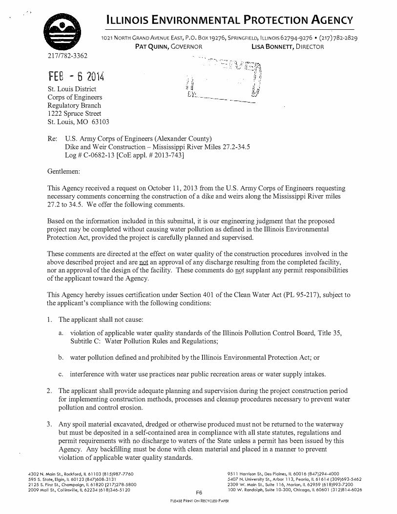
ILLINOIS ENVIRONMENTAL PROTECTION AGENCY
1021 NORTH GRAND AVENUE EAST, P.O. Box 19276, SPRINGFIELD, ILLINOIS 62794-9276 • (217)782-2829
PAT QUINN, GOVERNOR LISA BONNETT, DIRECTOR
217/782-3362
fEB - 5 '2014 St. Louis District Corps of Engineers Regulatory Branch 1222 Spmce Street St. Louis, MO 63103
Re: U.S. Army Corps of Engineers (Alexander County) Dike and Weir Constmction- Mississippi River Miles 27.2-34.5 Log# C-0682-13 [CoE appl. # 2013-743]
Gentlemen:
This Agency received a request on October 11, 2013 from the U.S. Army Corps of Engineers requesting necessary comments concerning the constmction of a dike and weirs along the Mississippi River miles 27.2 to 34.5. We offer the following comments.
Based on the information included in this submittal, it is our engineering judgment that the proposed project may be completed without causing water pollution as defined in the Illinois Enviromnental Protection Act, provided the project is carefully planned and supervised.
These comments are directed at the effect on water quality of the constmction procedures involved in the above described project and are not an approval of any discharge resulting from the completed facility, nor an approval of the design of the facility. These comments do not supplant any permit responsibilities of the applicant toward the Agency.
This Agency hereby issues certification under Section 401 of the Clean Water Act (PL 95-217), subject to the applicant's compliance with the following conditions:
1. The applicant shall not cause:
a. violation of applicable water quality standards of the Illinois Pollution Control Board, Title 35, Subtitle C: Water Pollution Rules and Regulations;
b. water pollution defined and prohibited by the Illinois Envirolll11ental Protection Act; or
c. interference with water use practices near public recreation areas or water supply intakes.
2. The applicant shall provide adequate planning and supervision during the project constmction period for implementing constmction methods, processes and cleanup procedures necessary to prevent water pollution and control erosion.
3. Any spoil material excavated, dredged or otherwise produced must not be returned to the waterway but must be deposited in a self-contained area in compliance with all state statutes, regulations and permit requirements with no discharge to waters of the State unless a permit has been issued by this Agency. Any backfilling must be done with clean material and placed in a manner to prevent violation of applicable water quality standards.
4302 N. Main St., Rockford, IL 611 03 (815)987 -77 60 595 S. State, Elgin, ll 60123 (847)608-3131 2125 S. First St., Champaign, IL 61820 (217)278-5800 2009 Mall St., Collinsville, IL 62234 (61 8)346-51 20
9511 Harrison St., Des Plaines, IL 60016 (847)294-4000 5407 N. University St., Arbor 113, Peoria, IL 61614 (309)693-5462 2309 W. Main St., Suite 116, Marion, IL 62959 (618)993-7200 100 W. Randolph, Suite 10-300, Chicago, IL 60601 (312)814-6026
PLEASE PRINT ON RECYCLED PAPER
F6

Page No. 2 Log No. C-0682-13
4. All areas affected by construction shall be mulched and seeded as soon after construction as possible. The applicant shall undertake necessary measures and procedures to reduce erosion during construction. Interim measures to prevent erosion during construction shall be taken and may include the installation of staked straw bales, sedimentation basins and temporary mulching. All construction within the waterway shall be constructed during zero or low flow conditions. The applicant shall be responsible for obtaining an NPDES Stom1 Water Pem1it prior to initiating construction if the construction activity associated with the project will result in the disturbance of 1 (one) or more acres, total land area. An NPDES Stann Water Permit may be obtained by submitting a properly completed Notice of Intent (NOI) form by certified mail to the Agency's Division of Water Pollution Control, Permit Section.
5. The applicant shall implement erosion control measures consistent with the "Illinois Urban Manual" (IEP A/USDA, NRCS; 2013).
6. The proposed work shall be constructed with adequate erosion control measures (i.e., silt fences, straw bales, etc.) to prevent transport of sediment and materials downstream.
7. The fill material used in waters of the State shall be predominantly sand or larger size material, with <20% passing a #230 U. S. sieve.
8. Asphalt, bituminous material and concrete with protruding material such as reinforcing bar or mesh shall not be 1) used for backfill, 2) placed on shorelines/streambanks, or 3) placed in waters of the State.
Tllis certification becomes effective when the Department of the Army, Corps of Engineers, includes the above conditions# 1 through# 8 as conditions of the requested approval issued pursuant to Section 404 of PL 95-217.
This certification does not grant immunity from any enforcement action found necessary by tlns Agency to meet its responsibilities in prevention, abatement, and control of water pollution.
Sincerely,
Ala�/i(_ Manager, Permit Section Division of Water Pollution Control
SAK:TJF:0682-13.docx
cc: IEPA, Records Unit IEPA, DWPC, FOS, Marion IDNR, OWR, Springfield USEP A, Region 5 Mr. Kevin Slattery, U.S. Army Corps of Engineers, St. Louis District
F7

F8
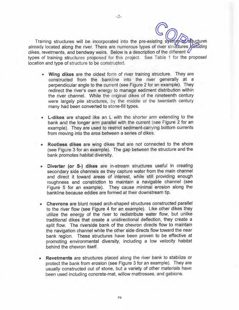
F9

F10
F11
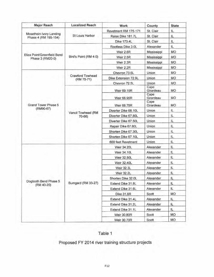
F12

F13

F14
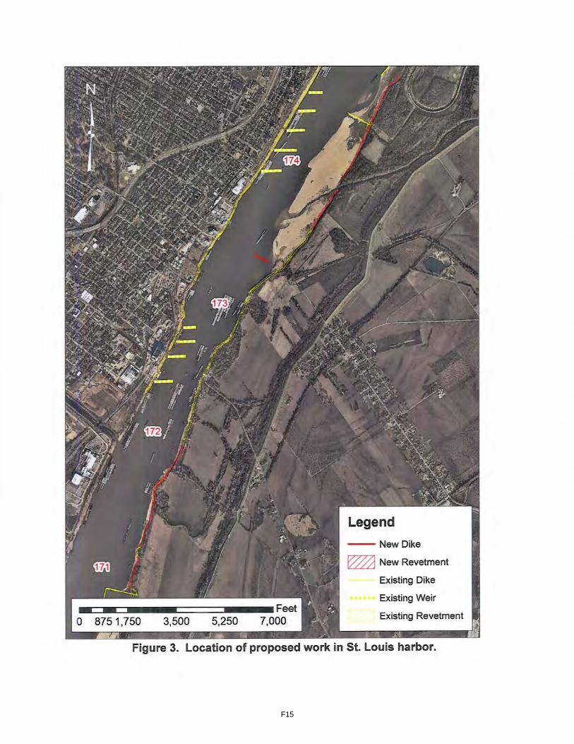
F15
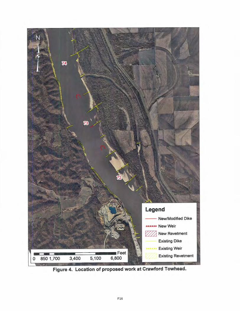
F16

F17

F18
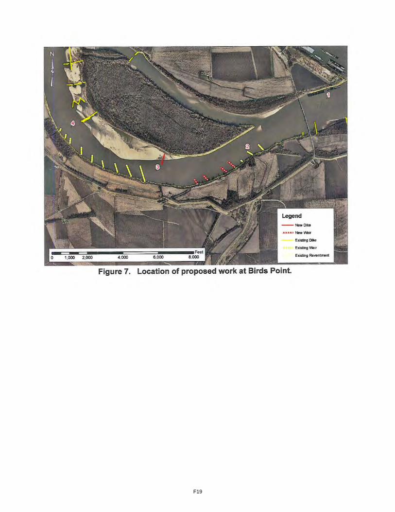
F19

F20

F21

F22

F23

F24

082613 Michael K. Trimble, Ph.D. Chief, Curation and Archives / Analyses Branch Dept. of the Army St. Louis District, Corps of Engineers 61222 Spruce St. St. Louis, MO 63103 Re: construction of river training structures in 4 major areas Dr. Trimble: The Cherokee Nation appreciates the opportunity to comment upon the “construction of river training structures in 4 major areas”. The Cherokee Nation does not currently maintain records of cultural resources in this geographic area. Thus, we would request you conduct your inquiries with the Illinois and Missouri State Historic Preservation Offices and any geographically appropriate/pertinent Tribal Historic Preservation Office(s). However, if during the conduct of these projects, items of cultural significance are discovered, the Cherokee Nation requests you recontact our Offices for further consultation. If you have any questions or require further information, please contact Mr. Pat Gwin, Administration Liaison, at 918/453-5704. Thank you. Sincerely,
Pat Gwin, Administration Liaison
F25

F26

From: Lisa LaRue-Baker - UKB THPO [[email protected]] Sent: Wednesday, September 18, 2013 1:53 PM To: Hayworth, Roberta L MVS Cc: verna Subject: [EXTERNAL] Mississippi River Training Facilities The United Keetoowah Band of Cherokee Indians in Oklahoma has reviewed your project under Section 106 of the NHPA, and at this time, have no comments or objections. However, if any human remains are inadvertently discovered, please cease all work and contact us immediately. Thank you, Lisa C. Baker Acting THPO United Keetoowah Band of Cherokee Indians in Oklahoma PO Box 746 Tahlequah, OK 74465
F27

TRIBAL HISTORIC PRESERVATION OFFICE Winnebago Tribe of NE P.O. Box 687 Winnebago, NE 68071 402-878-3313
November 10, 2013
US Army Corps of Engineers Attn: CEMVS-OD-F 1222 Spruce St St Louis, Missouri 63103 RE: P-2857 & 2856 Dear Mr. McClendon,
Thank you for your recent letter to the Tribal Historic Preservation Office of the Winnebago Tribe of Nebraska. The Preservation Office would like to inform you that the Winnebago Tribe of Nebraska does not have cultural properties in the area of your proposed construciton.
You may proceed with your proposed construction, but if there are any burial sites or other cultural properties found we would like for your office to notify the appropriate office right away. Thank you.
Sincerely,
Emily Smith-DeLeon
THPO, Winnebago Tribe of NE
F28

January 16, 2014
Colonel Christopher G. Hall U.S. Army Corps of Engineers St. Louis District 1222 Spruce Street St. Louis, Missouri 63103-2833 Attn: Mr. Danny McClendon Dear Colonel Hall: Thank you for the opportunity to review and comment on the Environmental Assessment (EA), Unsigned Finding of No Significant Impact (FONSI), and Public Notice P-2857 addressing the Dogtooth Bend Phase 5 Regulating Works Project located in Alexander County, Illinois and Mississippi and Scott Counties, Missouri. The proposed project involves the construction eight bendway weirs and a dike between Upper Mississippi River Miles 30.7 and 34.2. Alternatives considered for this project included no action and a preferred alternative described above. These comments are prepared under the authority of and in accordance with the provisions of the Fish and Wildlife Coordination Act (48 Stat. 401, as amended; 16 U.S.C. 661 et seq.); the Endangered Species Act of 1973 (87 Stat. 884, as amended; 16 U.S.C. 1531 et seq.); and, the National Environmental Policy Act (83 Stat. 852, as amended P.L. 91-190, 42 U.S.C. 4321 et seq.). Fish and Wildlife Resources The purpose of constructing the proposed project is to address a repetitive channel maintenance dredging issue to ensure adequate navigation depth and width. Information provided in the EA indicates that the proposed dike is expected to increase bathymetric, flow, and sediment diversity in the immediate vicinity of the structure. The bendway weirs are expected to improve fish and macroinvertebrate habitat in the outside bend by providing substrate diversity, flow refuge, and increased macroinvertebrate colonization surface area. While not disagreeing with this assessment, the Service is concerned that the proposed construction is likely to reduce/remove habitats on the inside bends that are utilized by larval and juvenile fisheries resources and is concerned that the proposed construction may impact Bumgard Island which is utilized by least terns for nesting. Given our concerns, the Service recommends that the Corps develop a pre- and post-construction monitoring plan to evaluate any changes to the island and side channel and to determine if there is any impact on fish and wildlife resources utilizing the proposed project area.
United States Department of the Interior
U.S. FISH AND WILDLIFE SERVICE
Marion Illinois Sub-Office (ES) 8588 Route 148
Marion, Illinois 62959 (618) 997-3344
F29
The Service is also concerned about the cumulative loss of habitat and potential impacts on fisheries resources in the Mississippi River from past, present, and reasonably foreseeable future actions utilized to maintain the navigation channel. The Service recommends that the U.S. Army Corps of Engineers (Corps) continue to utilize its authorities and programs (Biological Opinion Program, Avoid and Minimize Program, and Environmental Management Program) to restore/enhance habitats in the Mississippi River. The Service also recommends that the Corps seek a post authorization change to provide for environmental protection and enhancement under the Regulating Works Project as described in the 1976 Environmental Impact Statement (EIS). As stated in the 1976 EIS, “the overall effects of the attainment of a nine-foot-navigation channel upon the riverine ecosystem has not been beneficial” and “A significant amount of fish and wildlife habitat has been affected.” Threatened and Endangered Species The EA includes a Tier II Biological Assessment (BA) which was prepared in order to comply with the requirements of the 2000 Biological Opinion for Operation and Maintenance of the 9-Foot Navigation Channel on the Upper Mississippi River System. The 2000 Biological Opinion (BO) was prepared as a result of the programmatic consultation under Section 7 of the Endangered Species Act of 1973, as amended, which evaluated the effects of operation and maintenance of the 9-foot navigation channel on federally listed threatened and endangered species. The BA evaluated the impacts of the proposed project on the endangered gray bat (Myotis grisescens), endangered Indiana bat (Myotis sodalis), endangered least tern (Sterna antillarum), endangered pallid sturgeon (Scaphirynchus albus), endangered fat pocketbook (Potamilus capax), endangered sheepnose mussel (Plethobasus cyphyus), endangered rabbitsfoot mussel (Quadrula cylindrica cylindrica), threatened decurrent false aster (Boltonia decurrens), and proposed as endangered northern long-eared bat (Mytois septentrionalis). Information provided in the BA indicates that no caves or upland forests would be impacted by the proposed action; therefore, the Corps has determined the proposed project will have no effect on the gray bat and northern long-eared bat. The fat pocketbook pearlymussel and the rabbitsfoot mussel are not known to occur in the project area; therefore, the Corps has determined the proposed project will have no effect on either species. This precludes the need for further action on this project as required under Section 7 of the Endangered Species Act of 1973, as amended for the gray bat, northern long-eared bat, fat pocketbook pearlymussel, and rabbitsfoot mussel. Information provided in the BA indicates that the decurrent false aster and sheepnose mussel are not known to occur with the project area; therefore, the Corps has determined the proposed project is not likely to adversely affect either of these species. Based on this information, the Service concurs that the proposed project is not likely to adversely affect the decurrent false aster and sheepnose mussel. Information in the BA indicates that the proposed project will not result in the destruction of any riparian habitat and the aquatic habitat improvements may contribute to the Indiana bats forage base; therefore, the Corps has determined the proposed project is not likely to adversely affect the Indiana bat. The Service concurs that the proposed project is not likely to adversely affect the Indiana bat. Information in the BA indicates that although adverse impacts to the least tern and pallid sturgeon associated with the proposed project have been avoided and minimized to the greatest
F30

extent possible and design modifications have been incorporated to provide habitat benefits, the proposed project may still adversely affect the least tern and pallid sturgeon due to loss of habitat. The Service concurs that the proposed project is likely to adversely affect the least tern and pallid sturgeon and that Tier II formal consultation is necessary. Tier II Formal Consultation The Service has determined that the proposed project falls within the scope of the programmatic BO issued for Operation and Maintenance of the 9-Foot Navigation Channel on the Upper Mississippi River System (Section 1.2.4.2 River Regulatory Structures). The effects of this proposed action on the least tern and pallid sturgeon are consistent with those anticipated in the programmatic BO (Sections 4.3.1.2 and 8.3.1.2 Maintenance of the 9-Foot Channel Project), and the appropriate Terms and Conditions associated with the Reasonable and Prudent Measures (RPMs) identified in the programmatic BO have been adhered to (Sections 4.5.3, 4.5.4, 8.5.3 and 8.5.4). Specifically, the Corps adhered to Term and Condition 2 and RPM 1 for the least tern by submitting the project to the Service for a 30 day review period and incorporating Service recommendations for least tern nesting/foraging habitat improvement into project construction plans. The Corps has also indicated pre-and post-project physical monitoring will be conducted which partially addresses Term and Condition 3 and RPM 3. The Corps adhered to Term and Condition 2 and RPM 1 for the pallid sturgeon by submitting the project to the Service for a 30 day review period and incorporating Service recommendations for aquatic habitat improvement into project construction plans. Based on this information, it is the Service’s biological opinion that the proposed project is not likely to jeopardize the continued existence of the pallid sturgeon. Incidental take was considered programmatically in the BO (Section 8.5 Incidental Take Statement) and will be evaluated at program level. Thus no incidental take statement is included with this opinion. This concludes formal consultation on the proposed action. As provided in 50 CFR §402.16, reinitiation of formal consultation is required where discretionary Federal agency involvement or control over the action has been retained (or is authorized by law) and if: (1) the amount or extent of incidental take is exceeded; (2) new information reveals effects of the agency action that may affect listed species or critical habitat in a manner or to an extent not considered in this opinion; (3) the agency action is subsequently modified in a manner that causes an effect to the listed species or critical habitat not considered in this opinion; or (4) a new species is listed or critical habitat designated that may be affected by the action. In instances where the amount or extent of incidental take is exceeded, any operations causing such take must cease pending reinitiation. Conclusion Thank you for the opportunity to provide comment on the EA, FONSI, and Public Notice. The Service looks forward to reviewing the pre- and post-project monitoring plan for the proposed project. For additional coordination, please contact me at (618) 997-3344, ext. 345.
Sincerely,
F31

/s/ Matthew T. Mangan
Matthew T. Mangan Biologist in Charge cc: IDNR (Atwood) MDC (Sternberg)
F32
From: Shepard, Larry [mailto:[email protected]] Sent: Friday, January 24, 2014 6:11 PM To: Doerr, Jaynie G MVS Cc: Brown, Jasen L MVS; Westlake, Kenneth Subject: [EXTERNAL] RE: US EPA Region 7 Comments on the draft Environmental Assessments supporting the Dogtooth Bend Phase 5 and Grand Tower Phase 5 projects under USACE, St. Louis District Public Notices P-2857 and P-2856 Thank you for the opportunity to review the draft Environmental Assessments supporting the Dogtooth Bend Phase 5 and Grand Tower Phase 5 projects. Both site-specific EAs are tiered from the 1976 Environmental Impact Statement covering the Corps of Engineers, St. Louis District’s ‘Regulating Works Project-Mississippi River between the Ohio and Missouri Rivers.’ The District recently public noticed its intent to supplement this EIS (2013-744) after determining that there is sufficient significant new information regarding the potential impacts of the Project on the environment. EPA Region 7 intends to participate in this process and we will provide comments to the District as a part of the National Environmental Policy Act scoping process as well as review and rate the draft SEIS under the Clean Air Act, Section 309. Please consider the following comments pertaining to the site-specific EAs supporting each of the projects. In addition, I am copying Mr. Jasen Brown with MVS on these comments as a means of initiating our input into the SEIS development process. Dogtooth Bend The proposed action consists of construction of two weirs near River Mile 34, four weirs near RM 32, a dike at RM 31.6 and two weirs near RM 31. Placement of rock training structures would provide a sustainable alternative to repeated maintenance dredging in this reach of the Middle Mississippi River. Fill material would include approximately 35,000 tons of quarry run limestone from the local area. The draft EA includes a ‘no action’ alternative which would rely on existing training structures and continued maintenance dredging and an ‘action’ alternative selected from 85 possible structure designs and placements which are intended to reduce the need for the existing frequency of maintenance dredging. Alternatives Analysis We would recommend that the planned SEIS for the Regulating Works Project include a thorough characterization of how site- or project-specific NEPA documents tiering from the SEIS will include a robust range of alternatives. For example, this EA includes only two alternatives – no action and action, referencing some 85 possible alternatives for structure design and placement which were narrowed to one (Alternative 75). A detailed characterization in the SEIS of the process by which a robust range of alternatives will be developed within each tiering
F33

document and further narrowed for detailed assessment would support what appears to be a truncated assessment in the individual project document. At a minimum, the SEIS should characterize a general process and rationale for how the development, selection and assessment of alternatives in tiered NEPA documents meeting individual project purpose is consistent with CEQ regulations governing alternatives analysis. While there are obvious reasons why carrying forward 85 action alternatives does not serve the purposes of NEPA and makes for a confusing assessment, there should also be some greater comfort and assurance with assessing the impacts of only 2 alternatives within the tiered documents defined by ‘action’ and ‘no action.’ Potentially, the best place to provide that analysis and rationale is the SEIS rather than each project-specific NEPA document. Affected Environment The EA would be improved with a more thorough characterization of important river habitat potentially affected by either alternative, e.g., the Bumgard Island “complex” referenced on page 6. Whether as ‘physical’ or ‘biological’ resources, important habitat should be identified, described and delineated in these project-specific NEPA documents. Perhaps extended descriptions of habitat types, their source of importance, their availability in the MMR and the river conditions necessary to their maintenance could be addressed in the SEIS. Reach-specific habitats within each project affected area should be included in the project-specific NEPA documents. Environmental Consequences We recommend that the SEIS comprehensively address the impacts of river training structures resulting in lowered stages/water surface elevations at lower flows. Bed loss in navigable rivers with river training structures designed to reduce the need for dredging to maintain a navigable channel or “self-scouring” channels is being documented elsewhere and the inclusion of the assessment of impacts of such bed loss on infrastructure and river habitat is critically important to the NEPA assessment. We recommend that an updated and comprehensive assessment of the impacts of maintenance dredging on aquatic life be included within the SEIS to support project-specific impact assessments. Although this EA reflects a recent expansion in the amount of biological data describing the impacts of training structures on aquatic organisms, particularly
F34

fish, we suggest that, where current data is inconclusive regarding the impacts of structure types, design and placement on the aquatic community, the SEIS include additional recent data or include a commitment by the Corps to acquire additional necessary data. Regardless of the availability of additional data, the SEIS should include a comparative analysis of the impacts of different structures and placement on river biota. This EA would be improved with a detailed discussion of the impacts of each alternative on specific resources associated with the Bumgard Island “complex” and any other important shoreline habitats between River Mile 35 and 27. This was a significant omission within this assessment. We would expect the planned SEIS to include a comprehensive and updated assessment of the cumulative impacts of the entire Regulating Works Project within the MMR, including all existing and planned structure placement and other actions undertaken by entities other than the Army Corps of Engineers. Grand Tower The proposed action includes the construction of two chevrons and the extension of one dike in the Crawford Towhead between RMs 72 and 74; and construction of 3 weirs, 3 diverter dikes or S dikes, repair of a dike at RM 67.8, construction of a revetment at RM 67.3 and shortening the dikes at RMs 67.3 and 67.1 in the Vancill Towhead between RMs 67 and70. Placement of rock training structures would provide a sustainable alternative to repeated maintenance dredging in this reach of the Middle Mississippi River. Fill material would include approximately 35,000 tons of quarry run limestone from the local area. The draft EA includes a ‘no action’ alternative which would rely on existing training structures and continued maintenance dredging and an ‘action’ alternative which, for the Vancill Towhead area, was selected from 37 possible structure designs and placements intended to reduce the need for the existing frequency of maintenance dredging. As the Crawford Towhead site bathymetry was uncomplicated and the project objectives more limited, this component of the ‘action’ alternative was formulated using engineering judgment to reduce shoreline erosion, improve conditions for navigation and improve aquatic habitat. Alternatives Analysis See the comment above addressing similar issues with the Dogtooth Bend Phase 5 project.
F35

Affected Environment Again, please review the comments offered above for the Dogtooth Bend project regarding the need to include in this EA a more thorough characterization of important river habitat potentially affected by either alternative, e.g., Crawford chute, Vancill Towhead side channel, other shallow water habitat in the affected reaches. Environmental Consequences Again, refer to the comments offered for the Dogtooth Bend project, particularly regarding the absence of a detailed discussion of the impacts of each alternative on specific resources associated with important reach habitat. Again, thank you for the opportunity to review these two documents and we look forward to working with the District on the planned SEIS for these projects. If you have any questions regarding these comments, please contact me using the information listed below. Sincerely, Larry Shepard NEPA Team U.S. Environmental Protection Agency Region 7 11201 Renner Blvd. Lenexa, Kansas 66219 913-551-7441 [email protected]
F36

Response to August 23, 2013 Delaware Tribe Comment Letter Comment 1: Our review indicates that there are no religious or culturally significant sites in the project area. As such, we defer comment to your office as well as to the State Historic Preservation Office and/or the State Archaeologist. We wish to continue as a consulting party on this project and look forward to receiving a copy of the cultural resources survey report if one is performed. We also ask that if any human remains are accidentally unearthed during the course of the survey and/or the construction project that you cease development immediately and inform the Delaware Tribe of Indians of the inadvertent discovery. Response: Coordination with the appropriate State Historic Preservation Offices has been conducted (see coordination letters in this appendix). If any human remains are unearthed, construction will cease and all appropriate parties will be notified.
F37

Response to August 26, 2013 Cherokee Nation Comment Letter Comment 1: The Cherokee Nation does not currently maintain records of cultural resources in this geographic area. Thus, we would request you conduct your inquiries with the Illinois and Missouri State Historic Preservation Offices and any geographically appropriate/pertinent Tribal Historic Preservation Office(s). However, if during the conduct of these projects, items of cultural significance are discovered, the Cherokee Nation requests you recontact our Offices for further consultation. Response: Coordination with the appropriate State and Tribal Historic Preservation Offices has been conducted (see coordination letters in this appendix). If items of cultural significance are discovered during construction your Offices will be contacted for further consultation.
F38

Response to August 29, 2013 Kickapoo Tribe Comment Letter Comment 1: At this time, the Kickapoo Tribe of Oklahoma has no objections to the proposed project at the intended site(s). However, in the event burial remains and/or artifacts are discovered during the development or construction process, the Kickapoo Tribe of Oklahoma would ask for immediate notification of such findings. Response: If any burial remains and/or artifacts are discovered, all appropriate parties will be notified as soon as possible.
F39

Response to September 18, 2013 United Keetoowah Band Comment Letter Comment 1: … if any human remains are inadvertently discovered, please cease all work and contact us immediately. Response: If any human remains are discovered, construction will cease and all appropriate parties will be notified as soon as possible.
F40

Response to November 10, 2013 Winnebago Tribe Comment Letter Comment 1: You may proceed with your proposed construction, but if there are any burial sites or other cultural properties found we would like for your office to notify us right away… Response: If any burial sites or other cultural properties are found during construction, all appropriate parties will be notified as soon as possible.
F41
Responses to January 16, 2014 U.S. Fish and Wildlife Service Comments Comment 1: …the Service is concerned that the proposed construction is likely to reduce/remove habitats on the inside bends that are utilized by larval and juvenile fisheries resources and is concerned that the proposed construction may impact Bumgard Island which is utilized by least terns for nesting. Given our concerns, the Service recommends that the Corps develop a pre- and post-construction monitoring plan to evaluate any changes to the island and side channel and to determine if there is any impact on fish and wildlife resources utilizing the proposed project area. Response: A pre- and post-construction monitoring plan will be developed, with the Service’s input, to evaluate any changes to the island and side channel and any potential impacts on fish and wildlife resources. Comment 2: The Service recommends that the U.S. Army Corps of Engineers (Corps) continue to utilize its authorities and programs (Biological Opinion Program, Avoid and Minimize Program, and Environmental Management Program) to restore/enhance habitats in the Mississippi River. The Service also recommends that the Corps seek a post authorization change to provide for environmental protection and enhancement under the Regulating Works Project as described in the 1976 Environmental Impact Statement (EIS). As stated in the 1976 EIS, “the overall effects of the attainment of a nine-foot-navigation channel upon the riverine ecosystem has not been beneficial” and “A significant amount of fish and wildlife habitat has been affected.” Response: The District will continue to utilize existing authorities and programs, including the Biological Opinion Program, Avoid and Minimize Program, and Environmental Management Program, as appropriate, to restore and enhance Mississippi River habitats. As part of the current process to supplement the 1976 Middle Mississippi River Regulating Works Environmental Impact Statement, the District will utilize the alternatives and analysis provided in the 1976 EIS, including the post authorization change, and will update and consider the information as appropriate.
F42
Responses to January 24, 2014 USEPA Comments Comment 1: We would recommend that the planned SEIS for the Regulating Works Project include a thorough characterization of how site- or project-specific NEPA documents tiering from the SEIS will include a robust range of alternatives. Response: The SEIS will include a thorough characterization of how subsequent site-specific NEPA documents will be tiered. In addition, for the Dogtooth Bend Phase 5 EA, Section 2, Alternatives Including the Proposed Action, has been expanded to more clearly articulate the alternatives analysis process utilized. Comment 2: The EA would be improved with a more thorough characterization of important river habitat potentially affected by either alternative, e.g., the Bumgard Island “complex” referenced on page 6. Whether as ‘physical’ or ‘biological’ resources, important habitat should be identified, described and delineated in these project-specific NEPA documents. Perhaps extended descriptions of habitat types, their source of importance, their availability in the MMR and the river conditions necessary to their maintenance could be addressed in the SEIS. Reach-specific habitats within each project affected area should be included in the project-specific NEPA documents. Response: Section 3, Affected Environment, in the Dogtooth Bend EA has been expanded accordingly. Important habitat types and their availability in the MMR will be discussed in the SEIS. Comment 3: This EA would be improved with a detailed discussion of the impacts of each alternative on specific resources associated with the Bumgard Island “complex” and any other important shoreline habitats between River Mile 35 and 27. This was a significant omission within this assessment. Response: Section 4, Environmental Consequences, in the Dogtooth Bend EA has been expanded accordingly.
F43

Appendix G. Distribution List

The following individuals and organizations received a hard copy mailing of the Public Notice:
Governor Jay Nixon P.O. Box 720 Jefferson City, MO 65102
The Osage Nation Assistant Chief Scott Bighorse 627 Grandview P.O. Box 779 Pawhuska, Ok 74056
Anne Haaker IL State Historic Preservation Office Springfield, IL 62701
Russell Bradley Kickapoo Tribe in Kansas Chairman 1107 Goldfinch Road Horton, KS 66439
MDNR Division of State Parks Planning and Development PO Box 176 Jefferson City, MO 65102
Yvonne Homeyer Webster Groves Nature Society 1508 Oriole Lane St. Louis, MO 63144
Honorable Blaine Luetkemeyer 1118 Longworth HOB Washington, DC 20515
Senator Gary Forby 903 West Washington, Suite 5 Benton, IL 62812
Honorable Claire McCaskill 5850 A Delmar Blvd St. Louis, MO 63112
Advisory Council on Historic Preservation 1100 Pennsylvania Avenue NW, Suite 803 Old Post Office Building Washington, DC 20004
Kelly Isherwood 5072 Oak Tree Lane House Springs, MO 63051
Pat Malone IDNR Natural Resource Review 1 Natural Resource Way Springfield, IL 62702
Raymond Hopkins RIAC/ARTCO P.O. Box 2889 St. Louis, MO 63111
Mike Larson MDNR Land Reclamation Program Jefferson City, MO 65102
Honorable Lacy Clay 6830 Gravois St. Louis, MO 63116
Honorable Ann Wagner 301 Sovereign Court, Suite 201 Ballwin, MO 63011
Honorable John M. Shimkus 15 Professional Park Drive Maryville, IL 62062
Representative Ed Schieffer Missouri House of Representatives 201 West Capitol Avenue Jefferson City, MO 65101-6806
US Coast Guard Marine Safety Office Commanding Officer 225 Tully Street Paducah, KY 42003
Rose M. Schulte 2842 Chadwick Dr. St. Louis, MO 63121
Honorable Roy Blunt United States Senator
2502 Tanner Drive – Suite 208 Cape Girardeau, MO 63703
Leon Campbell, Chairman Iowa Tribe of Kansas and Nebraska 3345B Thrasher Road White Cloud, Kansas 66094
Jack Norman 906 N. Metter Avenue Columbia, IL 62236
Donald Rea City of St. Louis Water Division 10450 Riverview Drive St. Louis, MO 63137
Nick Nichols City of St. Louis Port Authority 1520 Market Street St. Louis, MO 63103
Timothy V. Johnson, M.C. IL15 202 N. Prospect Rd., Suite 203 Bloomington, IL 61704
Nellie Keo Kickapoo Tribe in Kansas Land/NAGPRA Office 1107 Goldfinch Road Horton, KS 66439
Hoppies Marine P.O. Box 44 Kimmwick, MO 63053
Environmental Coordinator Planning and Compliance Office Natural Park Service, Midwest Region 601 Riverfront Drive Omaha, NE 68102-4226
Joseph Standing Bear Schranz Midwest Soaring 5158 S. Mobile Avenue Chicago, IL 60638

Great Rivers Environ. Law Center 705 Olive Street, Ste. 614 St. Louis, MO 63101
Southern Illinois Sand Company P.O. Box 262 Chester, IL 62233
Russell Cissell 1075 LeSieur Portage des Sioux, MO 63373
Mike Diedrichsen IDNR Natural Resource Review 1 Natural Resource Way Springfield, IL 62702
David Jones Environmental Director Nottawaseppi Huron Band of Potawatomi 2221 1-1/2 Mike Road Fulton, MI 49052
Patrick J. Lamping Executive Director The Jefferson County Port Authority PO Box 603 Hillsboro, MO 63050
Representative Daniel Beiser 528 Henry Street Alton, IL 62002-2611
Governor Pat Quinn Office of the Governor 207 State House Springfield, IL 62706
Fay Houghton Land Management Director Winnebago Tribe of Nebraska P.O. Box 687 Winnebago, NE 68071
Senator John Jones 2929 Broadway Suite 5 Mt. Vernon, IL 62864
Honorable William Enyart 23 Public Square Belleville, IL 62220
Mr. Ed Schieffer 183 Thornhill Cemetery Road Troy, MO 63379
Dave Schulenburg US EPA Wetland and Watersheds Section WW16J 77 W. Jackson Boulevard Chicago, IL 60604-3590
Honorable Richard Durbin 525 South 8th Street Springfield, IL 62703-1601
Senator Dale Righter 88 Broadway Avenue, Suite 1 Mattoon, IL 61938-4597
Senator Larry Bomke 307 Capitol Building Springfield, IL 62706
Senator Mark Kirk Springfield Senate Office 607 East Adams, Suite 1520 Springfield, IL 62701
Senator James Clayborne Jr. Kenneth Hall State Office Building #10 Collinsville Avenue East St. Louis, IL 62201
Honorable Aaron Schock 235 S. Sixth Street Springfield, IL 62701
Honorable Rodney Davis 2004 Fox Drive Champaign, IL 61820
Honorable Jason Smith 2502 Tanner Drive, Suite 205 Cape Girardeau, MO 63703
Honorable Sam Graves 906 Broadway P.O. Box 364 Hannibal, MO 63401

The following individuals and organizations received e-mail notification of the Public Notice:
Adams, R. Adrian, D. Amato, Joel Andria, Kathy Atwood, Butch Bacon, T. Barnes, Robert Bax, Stacia Beardslee, Tom Bellville, Colette Bensman, Jim Boaz, Tracy Boehm, Gerry Brandom, Ellen Brescia, Chris Brown, Danny Brown, Doyle Buan, Steve Buffalo, Jonathan Burlingame, Chuck Byer, J. R. Caito, J. Campbell-Allison, Jennifer Carney, Doug Clements, Mark Coder, Justin S. Crowley, Steve Cruse, Lester Darst, E. B. Deel, Judith Dewey, Dave Dock Hardware and Marine Fabrication Dodd, Harold Dorothy, Olivia Dougherty, Mark Duncan, Cecil Ebey, Mike Elmestad, Gary Enos, Tim Erickson, Tom Fabrizio, Christi Favilla, Christy Foster, Bill Goldstein, Jeff

Genz, Greg Glenn, S. Goode, Peter Goodwin, Bill Greer, Courtney Gross, Andrea Hammond, Cheryl Hanke Terminals Hanneman, M. Hansen, Rick Hansens Harbor Harding, Scott Held, Eric Henleben, Ed Herschler, Mike Herzog, Dave Hilburn, Craig Hogan-Smith, Shelly Howard, Chuck Hubertz, Elizabeth Hughes, Shannon Hunter, Andrea Hussell, B. Illinois Corn Growers Association Illinois Department of Natural Resources Illinois Environmental Protection Agency Jamison, Larry Johnson, Erick Johnson, Frank Johnson, Tom Knowles, Kim Knuth, Dave Lauer, Steve Leary, Alan Leipus, Ed Leiser, Ken Lensing, Brian Lipeles, Maxie Louis Marine Mangan, Matthew Mannion, Clare Mauer, Paul Melgin, Wendy Miller, Kenneth Miller, Melissa Missouri Corn Growers Association

Missouri Department of Conservation Missouri Department of Natural Resources Muench, Lynn Muir, T. Nelson, Lee Nelson, Rick Novak, Ron O'Carroll, J. Overbey, Dan Paurus, Tim Pehler, Kent Phillip, C. Pinter, Nicholas Pivor, Jeremy Pondrom, Gary Popplewell, Mickey Porter, Jason Red, Chief John Reichert, Joe Reitz, Paul Reuters Chicago Rickert, Ron Roark, Bev Rodenberg, V. Rowe, Kelly Samet, Melissa Sauer, Randy Schieffer, Ed Shepard, Larry Shoulberg, J. Slay, Glen Smith, David Southeast Missouri Regional Port Authority Southern Illinois Transfer Spath, Robert Stahlman, Bill Staten, Shane Sternburg, Janet Stevens, Mark Stout, Robert Streight, Tom Teah, Philip Todd, Brian Tow Inc. Tyson, J. Urban, David

U.S. Coast Guard Marine Safety Office U.S. Environmental Protection Agency Region 7 Weber, Angie Welge, Owen Werner, Paul Wilmsmeyer, Dennis York Bridge Co. Zupan, T.