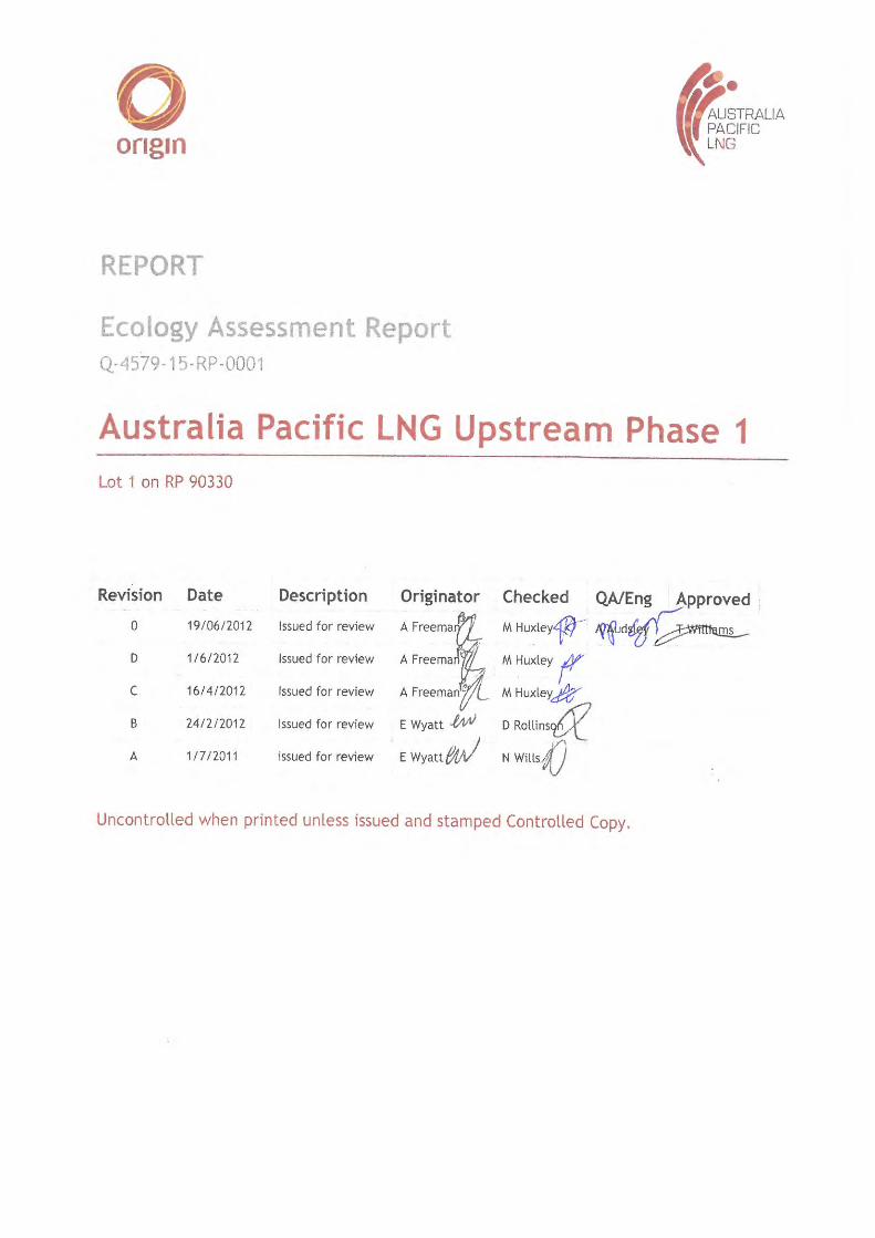
Final - Electricity Providers & Gas Suppliers - Origin Energy · Final. Ecology Assessment Report...
62
Transcript of Final - Electricity Providers & Gas Suppliers - Origin Energy · Final. Ecology Assessment Report...
marion.huxley
Typewriter
Final

Ecology Assessment Report Lot 1 on RP 90330
Ref: Q-4579-15-RP-0001 Page 2 of 42
Land, Environment and Stakeholder, Australia LNG Upstream Phase 1
Uncontrolled when printed unless issued and stamped Controlled Copy
Release Notice This document is available through the Australia Pacific LNG Upstream Phase 1 Project controlled document system TeamBinder™. The responsibility for ensuring that printed copies remain valid rests with the user. Once printed, this is an uncontrolled document unless issued and stamped Controlled Copy.
Third-party issue can be requested via the Australia Pacific LNG Upstream Phase 1 Project Document Control Group.
Document Conventions The following terms in this document apply:
• Will, shall or must indicate a mandatory course of action
• Should indicates a recommended course of action
• May or can indicate a possible course of action.
Document Custodian The custodian of this document is the Australia Pacific LNG Upstream Phase 1 Project – Environmental Approvals Team Leader. The custodian is responsible for maintaining and controlling changes (additions and modifications) to this document and ensuring the stakeholders validate any changes made to this document.
Deviations from Document Any deviation from this document must be approved by the Australia Pacific LNG Upstream Phase 1 Project – Environmental Approvals Team Leader.
Ecology Assessment Report Lot 1 on RP 90330
Ref: Q-4579-15-RP-0001 Page 3 of 42
Land, Environment and Stakeholder, Australia LNG Upstream Phase 1
Uncontrolled when printed unless issued and stamped Controlled Copy
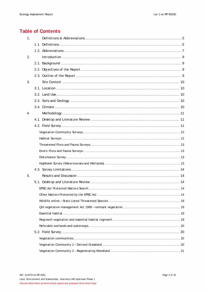
Table of Contents 1. Definitions & Abbreviations .............................................................................. 5
1.1. Definitions .................................................................................................. 5
1.2. Abbreviations ............................................................................................... 7
2. Introduction ................................................................................................ 9
2.1. Background ................................................................................................. 9
2.2. Objectives of the Report ................................................................................. 9
2.3. Outline of the Report ..................................................................................... 9
3. Site Context .............................................................................................. 10
3.1. Location ................................................................................................... 10
3.2. Land Use ................................................................................................... 10
3.3. Soils and Geology ........................................................................................ 10
3.4. Climate .................................................................................................... 10
4. Methodology .............................................................................................. 11
4.1. Desktop and Literature Review ....................................................................... 11
4.2. Field Survey ............................................................................................... 11
Vegetation Community Surveys .................................................................................... 12
Habitat Surveys ...................................................................................................... 12
Threatened Flora and Fauna Surveys ............................................................................. 13
Exotic Flora and Fauna Surveys .................................................................................... 13
Disturbance Survey .................................................................................................. 13
Highbank Survey (Watercourses and Wetlands) ................................................................. 13
4.3. Survey Limitations ....................................................................................... 14
5. Results and Discussion .................................................................................. 14
5.1. Desktop and Literature Review ....................................................................... 14
EPBC Act Protected Matters Search ............................................................................... 14
Other Matters Protected by the EPBC Act ....................................................................... 14
Wildlife online – State Listed Threatened Species .............................................................. 19
Qld vegetation management Act 1999 – remnant vegetation ................................................. 19
Essential habitat ..................................................................................................... 19
Regrowth vegetation and essential habitat regrowth .......................................................... 19
Referable wetlands and waterways ............................................................................... 20
5.2. Field Survey ............................................................................................... 20
Vegetation communities ............................................................................................ 20
Vegetation Community 1 – Derived Grassland ................................................................... 20
Vegetation Community 2 – Regenerating Woodland ............................................................ 21
Ecology Assessment Report Lot 1 on RP 90330
Ref: Q-4579-15-RP-0001 Page 4 of 42
Land, Environment and Stakeholder, Australia LNG Upstream Phase 1
Uncontrolled when printed unless issued and stamped Controlled Copy
Vegetation Community 3 – Mixed Eucalypt Riparian Woodland ............................................... 22
Threatened Flora .................................................................................................... 23
Exotic Flora Species ................................................................................................. 23
Habitat Assessment ................................................................................................. 24
Threatened Fauna ................................................................................................... 27
Migratory Species .................................................................................................... 27
Pest Fauna 27
Significant Ecological Features and Functions ................................................................... 27
Significant Ecological Communities ............................................................................... 29
High Value Regrowth Polygon - Central Watercourse .......................................................... 29
Watercourses, Wetlands and Dams ............................................................................... 30
Disturbance 30
6. Conclusion and Recommendations .................................................................... 30
7. References ................................................................................................ 31
Tables Table 1: Definitions .........................................................................................................5
Table 2: Abbreviations ......................................................................................................7
Table 3: EPBC Act Protected Matters Search Tool – Results and Discussion..................................... 15
Table 4: Consideration of Additional Protected Matters under the EPBC Act .................................. 17
Table 5: Vegetation community 1 ...................................................................................... 21
Table 6: Vegetation community 2 ...................................................................................... 22
Table 7: Vegetation community 3 ...................................................................................... 23
Table 8: Subject threatened fauna species ........................................................................... 28
Figures Figure 2.1 – Locality Plan
Figure 4.1 – Ecological Survey Locations
Figure 5.1 – Regrowth Mapping Extract
Figure 5.2- Vegetation Community Plan
Appendices Appendix A - EPBC Act Protected Matters Search Results
Appendix B – Subject Species Table
Appendix C - Wildlife Online Results
Appendix D – Species Observed on Site
Ecology Assessment Report Lot 1 on RP 90330
Ref: Q-4579-15-RP-0001 Page 5 of 42
Land, Environment and Stakeholder, Australia LNG Upstream Phase 1
Uncontrolled when printed unless issued and stamped Controlled Copy
1. Definitions & Abbreviations
1.1. Definitions Table 1: Definitions
Term Definition
Remnant vegetation As defined by the Vegetation Management Act 1999 remnant vegetation is defined as vegetation, part of which forms the predominant canopy of the vegetation covering more than 50% of the undisturbed predominant canopy; and averaging more than 70% of the vegetation’s undisturbed height.
Regional ecosystem As defined by the Vegetation Management Act 1999 a Regional Ecosystem is a vegetation community in a bioregion that is consistently associated with a particular combination of geology, landform and soil.
Regrowth Regional Ecosystem
As defined by the Regrowth Vegetation Code regrowth vegetation is vegetation indicated on a map certified by the chief executive as the regrowth vegetation and includes endangered regional ecosystems, of concern regional ecosystem, a least concern regional ecosystem, vegetation not cleared since 31 December 1989, certain watercourses and areas deemed regrowth by the chief executive.
Threatened Ecological Community
Threatened ecological communities are those listed under the Environment Protection and Biodiversity Conservation Act 1999 (EPBC Act). An ecological community may be categorised as Critically endangered; Endangered or Vulnerable.
Referable Wetland As defined by the Environmental Protection Regulation 2008, a referable wetland is an area shown as a wetland on a document called ‘Map of referable wetlands’ made available by the chief executive.
Watercourse As defined by the Water Act 2000 a watercourse is a river, creek or other stream, including a stream in the form of an anabranch or a tributary, in which water flows permanently or intermittently, regardless of the frequency of flow event in a natural channel, whether artificially modified or not; or in an artificial channel that has changed the course of the stream.
Water feature As defined by the Water Act 2000 a water feature means a natural landscape feature, e.g. gully, drain, drainage depression formed by the concentration of, or operates to confine or concentrate, overland flow water during and immediately after rainfall events. Such features only flow for a short duration after a rainfall event, regardless of the frequency of flow events; and commonly, does not have enough continuing flow to create a riverine environment.
Spring A spring (as defined by the Water Act 2000) means the land to which water rises naturally from below the ground and the land over which the water then flows.
Ecology Assessment Report Lot 1 on RP 90330
Ref: Q-4579-15-RP-0001 Page 6 of 42
Land, Environment and Stakeholder, Australia LNG Upstream Phase 1
Uncontrolled when printed unless issued and stamped Controlled Copy
Term Definition
Declared Pest Defined to mean a declared pest (flora and fauna) under the Land Protection (Pest and Stock Route Management) Act 2002
Matters of National Environmental Significance
As defined in the EPBC Act, matters of national environmental significance. Provides a legal framework to protect and manage nationally and internationally important flora, fauna, ecological communities and heritage places.
Environmentally Sensitive Area
Environmentally Sensitive Areas (ESA’s) are those defined as either category A, B or C ESA’s within the Environmental Protection Regulation 2008.
Wetland As defined from the Wetland Mapping & Classification Methodology a wetland is an area of permanent or periodic/intermittent inundation, with water that is static or flowing fresh, brackish or salt, including areas of marine water the depth of which at low tide does not exceed 6 m. Wetlands must have one or more of the following;
i. at least periodically the land supports plants or animals that are adapted to and dependent on living in wet conditions for at least part of their life cycle, or
ii. the substratum is predominantly undrained soils that are saturated, flooded or ponded long enough to develop anaerobic conditions in the upper layers, or
iii. the substratum is not soil and is saturated with water, or covered by water at some time.
Derived Grassland Areas of former woodland vegetation, which have been cleared, typically for the purpose of providing grazing pasture.
Threatened Species Species of flora and fauna that are vulnerable to endangerment in the near future. Federal and State (Qld) listings and conservation status of threatened species are defined under the EPBC Act and Nature Conservation Act 1992.
the Client Origin Energy
the Site Lot 1 on RP 90330
Study Area Specific areas of investigation with the Site

Ecology Assessment Report Lot 1 on RP 90330
Ref: Q-4579-15-RP-0001 Page 7 of 42
Land, Environment and Stakeholder, Australia LNG Upstream Phase 1
Uncontrolled when printed unless issued and stamped Controlled Copy
1.2. Abbreviations Table 2: Abbreviations
Abbreviation Description
AHD Australian Height Datum
API Aerial photo interpretation
BOM Bureau of Meteorology
DBH Diameter at Breast Height
DERM Department of Environment and Resource Management
DSEWPaC Department of Sustainability, Environment, Water, Population and Communities
EAR Terrestrial Ecology Assessment Report
EPA Environmental Protection Agency
EPBC Act Environmental Protection and Biodiversity and Conservation Act 1999
ESA Environmentally Sensitive Area
EVNT Endangered, Vulnerable, Near Threatened
FPC Foliage Projective Cover
HB High Bank location points
HSSE Health, Safety Security and Environment
HVR High Value Regrowth
km kilometre
LNG Liquefied Natural Gas
LP [PSRM] Act Land Protection (Pest and Stock Route Management) Act 2002
m metre

Ecology Assessment Report Lot 1 on RP 90330
Ref: Q-4579-15-RP-0001 Page 8 of 42
Land, Environment and Stakeholder, Australia LNG Upstream Phase 1
Uncontrolled when printed unless issued and stamped Controlled Copy
Abbreviation Description
mm millimetre
MNES Matters of National Environmental Significance
NCA Nature Conservation Act 1992
NC Reg Nature Conservation (Wildlife) Regulation 2006
PMAV Property Map of Assessable Vegetation
Qld Queensland
RE Regional Ecosystem
REMAP Regional Ecosystem and Remnant Map – Version 6.1
TEC Threatened Ecological Community
VMA Vegetation Management Act 1999
VM Reg Vegetation Management Regulation 2000
Water Act Water Act 2000
WONS Weeds of National Significance

Ecology Assessment Report Lot 1 on RP 90330
Ref: Q-4579-15-RP-0001 Page 9 of 42
Land, Environment and Stakeholder, Australia LNG Upstream Phase 1
Uncontrolled when printed unless issued and stamped Controlled Copy
2. Introduction
2.1. Background Orogen Qld Pty Ltd (Orogen) has been commissioned by Origin Energy (the Client) to prepare a terrestrial ecology assessment report (EAR) over a targeted area within Lot 1 RP90330. Lot 1 RP90330 is referred to as the Site, while the specific areas within the Site that were targeted for the investigation are referred to as the Study Area (Figure 2.1).
This report presents detail on the ecological values of the Study Area and immediate surrounds. The intention of this report is to provide information to guide detailed project planning.
This report has been prepared by Orogen. Orogen has been approved by the Commonwealth Department of Sustainability, Environment, Water, Population and Communities (DSEWPaC) in writing as per the letter dated 28 June 2011 for the purpose of undertaking ecological assessment works for the Australia Pacific LNG Project.
2.2. Objectives of the Report The objectives of this EAR are:
• to assess and describe the existing ecological features and functions of the Study Area to allow for targeted development planning by the client;
• to provide recommendations to alleviate the potential ecological impacts of future development on the Study Area and surrounding locality; and
• to provide ecological data suitable for the client’s purposes in working toward ongoing compliance with relevant environmental conditions and obligations prior to construction.
2.3. Outline of the Report The EAR is structured as follows:
• Section 3 - describes the environmental context of the Study Area ;
• Section 4 - describes the desktop and field study methodology employed;
• Section 5 - provides the results and discussion of desktop review and field assessment work; and
• Section 6 – provides a conclusion and recommendations.
Ecology Assessment Report Lot 1 on RP 90330
Ref: Q-4579-15-RP-0001 Page 10 of 42
Land, Environment and Stakeholder, Australia LNG Upstream Phase 1
Uncontrolled when printed unless issued and stamped Controlled Copy
3. Site Context
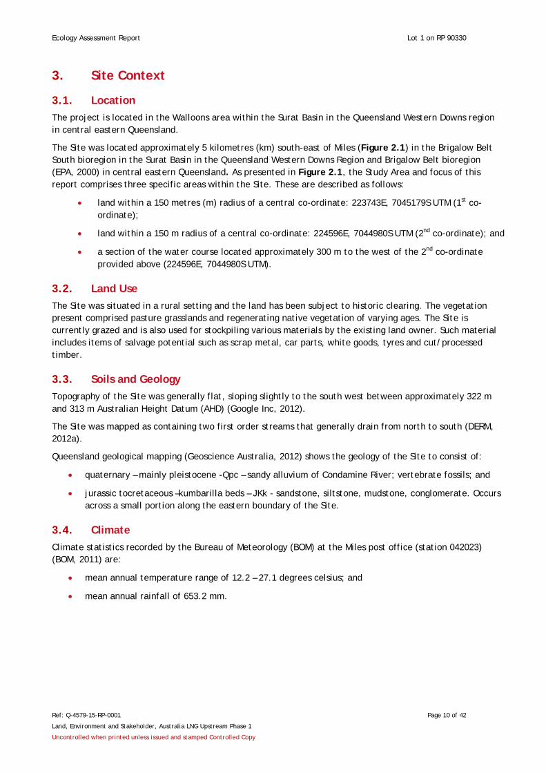
3.1. Location The project is located in the Walloons area within the Surat Basin in the Queensland Western Downs region in central eastern Queensland.
The Site was located approximately 5 kilometres (km) south-east of Miles (Figure 2.1) in the Brigalow Belt South bioregion in the Surat Basin in the Queensland Western Downs Region and Brigalow Belt bioregion (EPA, 2000) in central eastern Queensland. As presented in Figure 2.1, the Study Area and focus of this report comprises three specific areas within the Site. These are described as follows:
• land within a 150 metres (m) radius of a central co-ordinate: 223743E, 7045179S UTM (1st co-ordinate);
• land within a 150 m radius of a central co-ordinate: 224596E, 7044980S UTM (2nd co-ordinate); and
• a section of the water course located approximately 300 m to the west of the 2nd co-ordinate provided above (224596E, 7044980S UTM).
3.2. Land Use The Site was situated in a rural setting and the land has been subject to historic clearing. The vegetation present comprised pasture grasslands and regenerating native vegetation of varying ages. The Site is currently grazed and is also used for stockpiling various materials by the existing land owner. Such material includes items of salvage potential such as scrap metal, car parts, white goods, tyres and cut/processed timber.
3.3. Soils and Geology Topography of the Site was generally flat, sloping slightly to the south west between approximately 322 m and 313 m Australian Height Datum (AHD) (Google Inc, 2012).
The Site was mapped as containing two first order streams that generally drain from north to south (DERM, 2012a).
Queensland geological mapping (Geoscience Australia, 2012) shows the geology of the Site to consist of:
• quaternary – mainly pleistocene -Qpc – sandy alluvium of Condamine River; vertebrate fossils; and
• jurassic tocretaceous –kumbarilla beds – JKk - sandstone, siltstone, mudstone, conglomerate. Occurs across a small portion along the eastern boundary of the Site.
3.4. Climate Climate statistics recorded by the Bureau of Meteorology (BOM) at the Miles post office (station 042023) (BOM, 2011) are:
• mean annual temperature range of 12.2 – 27.1 degrees celsius; and
• mean annual rainfall of 653.2 mm.

Ecology Assessment Report Lot 1 on RP 90330
Ref: Q-4579-15-RP-0001 Page 11 of 42
Land, Environment and Stakeholder, Australia LNG Upstream Phase 1
Uncontrolled when printed unless issued and stamped Controlled Copy
4. Methodology The following sections outline the methodologies applied in determining the Site’s ecological context and attributes for the purpose of identifying ecological constraints and opportunities for the Study Area.
4.1. Desktop and Literature Review A desktop review was undertaken to assist in determining the Site’s ecological attributes and associated constraints/opportunities prior to field survey works. Data searches using the Environmental Protection and Biodiversity Conservation Act 1999 (EPBC Act) (DSEWPaC, 1999) protected matters search tool and the wildlife online database were conducted using a 10 km search radii from the central area of the Site. The following desktop review works were undertaken to support field survey design:
• Nature Conservation (Wildlife) Regulation 2006 (NC Reg) (DERM, 2010) and Nature Conservation Act 1992 (NCA) (DERM, 2012b) protected species lists;
• Environment Protection and Biodiversity Conservation Act 1999 (EPBC Act) protected matters search tool (DSEWPAC, 2012a);
• Department of Environment and Resource Management (DERM) regional ecosystem remnant map version 6.1 (REMAP) digital GIS layer (DERM, 2012a);
• DERM regrowth vegetation map version 2 (DERM, 2012c);
• DERM wildlife online database (DERM, 2012d);
• DERM map of referable wetlands (DERM, 2012e);
• DERM environmentally sensitive areas (ESA) mapping (DERM, 2012f);
• DERM WetlandMaps (DERM, 2012g);
• Aerial photography interpretation (API); and
• the Client supplied constraints/context mapping (e.g. soils, geology, waterways/wetlands, slope).
4.2. Field Survey Ecological surveys were conducted in general accordance with the BioCondition – A Condition Assessment Framework for Terrestrial Biodiversity in Queensland – Assessment Manual – Version 2.1 (Biocondition Manual) (Eyre et al. 2011) and the Methodology for Survey and Mapping of Regional Ecosystems and Vegetation Communities in Queensland (Neldner et al. 2005). The results of raw data collected during field surveys are summarised and presented in the appendices of this EAR.
The surveys were concentrated within a 150 m radius of the following central co-ordinates provided by the Client:
• 223743E, 7045179S UTM (1st co-ordinate); and
• 224596E, 7044980S UTM (2nd co-ordinate).
A section of the watercourse located approximately 300 m to the west of the 2nd co-ordinate (224596E, 7044980S UTM) was also included in the survey due to the proximity to the co-ordinate provided.
Survey locations were selected in consideration of:
• specific areas requested by the Client;
• the distribution of regional ecosystems (regrowth and remnant);
• the presence and distribution of other distinct vegetation communities;
Ecology Assessment Report Lot 1 on RP 90330
Ref: Q-4579-15-RP-0001 Page 12 of 42
Land, Environment and Stakeholder, Australia LNG Upstream Phase 1
Uncontrolled when printed unless issued and stamped Controlled Copy
• the known or potential presence and distribution of threatened species/communities; and
• the presence of other ecological features of interest (e.g. wetlands/waterways).
All data was recorded in accordance with the data fields provided by the supplied Trimble Nomad® data capture unit in accordance with the environmental constraints planning and field development protocols (Australian Pacific LNG, 2011). The ecological surveys described in this report were undertaken by two (2) Orogen Ecologists on 11 May 2011.
Vegetation Community Surveys
General baseline botanical surveys were undertaken to describe dominant flora and vegetation community structure within the Study Area. Botanical surveys were generally consistent with the tertiary level of data collection as described in the Methodology for Survey and Mapping of Regional Ecosystems and Vegetation Communities in Queensland (Neldner et al. 2005).
The vegetation community surveys were undertaken within 50 m x 10 m plots for the purpose of typifying the ecotype under assessment. Vegetation community data was entered into the data fields provided by the Trimble data capture system. A total of three formal vegetation community surveys were undertaken. In addition, ground-truthing of the DERM regional ecosystem (RE) and high value regrowth (HVR) designation (DERM, 2012a and DERM, 2012c respectively) immediately surrounding the Study Area was undertaken via Quaternary level random meander transect assessments, as defined by Neldner et al. (2005).
The locations of the vegetation community quadrat survey sites are presented in Figure 4.1. Relative abundance data was collected for each stratum within the community as per the data fields presented by the vegetation structure point data sheet of the Trimble unit. Representative photo(s) were taken of the subject vegetation community via the Trimble unit. Photo aspect data was entered into the relevant data sheet within the Trimble.
Vegetation community polygons were mapped in the field by Orogen and identified in accordance with Queensland RE descriptions (biodiversity status) and general EPBC Act threatened ecological community (TEC) criteria.
Habitat Surveys
Habitat surveys were undertaken in conjunction with each vegetation community survey site within a 50 m x 10 m quadrant. Three additional habitat survey sites were undertaken opportunistically and therefore a total of six (6) habitat survey sites were recorded.
Within each habitat survey site, a range of habitat features, were entered into the respective Trimble Nomad® data sheet such as:
• rocks and boulders: (abundance);
• logs (abundance);
• trees with hollows (abundance);
• trees and/or logs with loose bark (abundance);
• shrub layer (estimated % cover);
• ground cover (estimated % cover);
• leaf litter (% cover);
• termite mounds (abundance); • mistletoe (abundance).
Where deemed appropriate, representative photo(s) were taken of the given habitat patch via the Trimble Nomad® unit. Photo aspect data was entered into the relevant data sheet within the Trimble Nomad® unit.

Ecology Assessment Report Lot 1 on RP 90330
Ref: Q-4579-15-RP-0001 Page 13 of 42
Land, Environment and Stakeholder, Australia LNG Upstream Phase 1
Uncontrolled when printed unless issued and stamped Controlled Copy
Threatened Flora and Fauna Surveys
Targeted searches for threatened flora and fauna species listed by the EPBC Act and NC Reg were undertaken within each vegetation community survey/habitat feature survey site where field ecologists deemed the given area to warrant such a search. The searches were undertaken for one (1) person per hour per survey site. Searches for threatened species were also undertaken opportunistically while traversing between formal survey sites.
Exotic Flora and Fauna Surveys
Any declared pest species (as defined by the Land Protection (Pest and Stock Route Management) Act 2002 (LP [PSRM] Act) (DPIF, 2012) observed within a formal vegetation community survey plot were recorded on the vegetation community data sheets within the Trimble Nomad® unit. Outbreaks of environmental and declared pests were also recorded via the respective Trimble Nomad® data collection sheet.
Any declared flora infestations observed opportunistically while traversing the Site were recorded on relevant data sheets within the Trimble Nomad® unit.
Disturbance Survey
A disturbance survey was undertaken at each vegetation community/habitat feature survey site. Disturbance surveys were also undertaken opportunistically, outside the three (3) formal survey sites (Figure 4.1). Where evidence of disturbance was observed, it was recorded using the Trimble Nomad® data capture system, and was categorised in terms of disturbance type (e.g. erosion, grazing), severity (e.g. minimal, severe), and the estimated time of the most recent occurrence for the disturbance event (e.g. current, > 20 years).
Highbank Survey (Watercourses and Wetlands)
The definitions provided by the Wetland Mapping and Classification Methodology (EPA, 2005) and the Water Act 2000 (Qld) (Water Act) (DERM, 2012h) were used in this study for the purpose of identifying the following wetland/waterway features;
• water feature;
• watercourse;
• wetland;
• outer bank; and
For the purpose of verification and/or amendment of preliminary mapping of riparian and/or wetland buffers, the ground-truthing of the high banks of water features was undertaken where such features were in immediate proximity to the targeted search areas. Accordingly, a high bank survey was undertaken along a section of the central watercourse to the west of the second set of co-ordinates provided by the client (224596E, 7044980S UTM).
The water feature was traversed on foot and the outer bank point locations were recorded on the Trimble Nomad® unit using the respective data sheet. Figure 4.1 presents the distribution of high bank location plots (HB). Representative photo(s) were taken of the subject drainage line via the Trimble Nomad® unit and photo aspect data entered into the relevant data sheet within the Trimble Nomad® unit.

Ecology Assessment Report Lot 1 on RP 90330
Ref: Q-4579-15-RP-0001 Page 14 of 42
Land, Environment and Stakeholder, Australia LNG Upstream Phase 1
Uncontrolled when printed unless issued and stamped Controlled Copy
4.3. Survey Limitations A number of factors are considered likely to influence survey results for particular species or species groups. These factors are:
• timing (seasons) of the survey period;
• duration of the survey;
• weather conditions during the survey and in the preceding seasons; and
• restricted spatial area of the habitats within the Site.
The surveys undertaken may not provide a true indication of seasonal habitat utilisation by fauna species within the Site and some cryptic flora species may only be detected during particular flowering periods. The field investigations undertaken were limited to passive techniques (e.g. no live trapping) and the investigations were undertaken when some species are not as active.
Notwithstanding the limitations, the precautionary principle (Foster et al. 2000) was applied in determining a number of threatened species potentially utilising the habitats with the Site.
5. Results and Discussion This section includes the results of the desktop review and field assessment, and provides an interpretation and discussion of key findings from desktop review and field survey.
5.1. Desktop and Literature Review
EPBC Act Protected Matters Search
The results of the EPBC Act PMST are provided in Table 3, which also provides a discussion regarding the Matters of National Environmental Significance (MNES) in the context of the Study Area and the field survey undertaken on 11 May 2011. A copy of the EPBC Act protected matters search results is provided in Appendix A. The search was undertaken for the coordinates - 26.6886, 150.2272, and captured in a 10 km buffer.
Other Matters Protected by the EPBC Act
In addition to MNES, consideration must be given to other matters protected by the EPBC Act when assessing proposals. A discussion of these matters in relation to the Study Area has therefore been undertaken with reference to the EPBC Act PMST and field survey.
The results of the EPBC Act PMST and a discussion in relation to other matters are provided in Table 3 in the context of the Study Area and field results. A copy of the EPBC Act PMST results is provided in Appendix A.
Ecology Assessment Report Lot 1 on RP 90330
Ref: Q-4579-15-RP-0001 Page 15 of 42
Land, Environment and Stakeholder, Australia LNG Upstream Phase 1
Uncontrolled when printed unless issued and stamped Controlled Copy
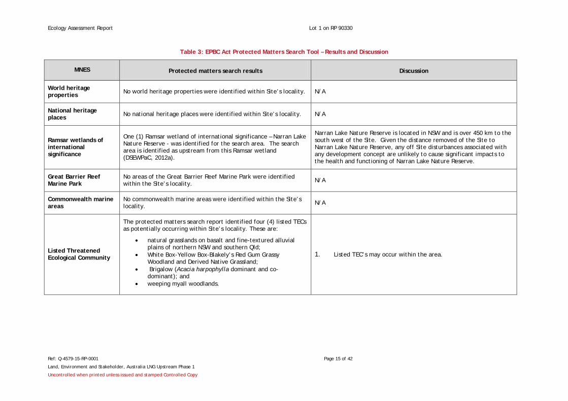
Table 3: EPBC Act Protected Matters Search Tool – Results and Discussion
MNES Protected matters search results Discussion
World heritage properties No world heritage properties were identified within Site’s locality. N/A
National heritage places No national heritage places were identified within Site’s locality. N/A
Ramsar wetlands of international significance
One (1) Ramsar wetland of international significance – Narran Lake Nature Reserve - was identified for the search area. The search area is identified as upstream from this Ramsar wetland (DSEWPaC, 2012a).
Narran Lake Nature Reserve is located in NSW and is over 450 km to the south west of the Site. Given the distance removed of the Site to Narran Lake Nature Reserve, any off Site disturbances associated with any development concept are unlikely to cause significant impacts to the health and functioning of Narran Lake Nature Reserve.
Great Barrier Reef Marine Park
No areas of the Great Barrier Reef Marine Park were identified within the Site’s locality. N/A
Commonwealth marine areas
No commonwealth marine areas were identified within the Site’s locality. N/A
Listed Threatened Ecological Community
The protected matters search report identified four (4) listed TECs as potentially occurring within Site’s locality. These are:
• natural grasslands on basalt and fine-textured alluvial plains of northern NSW and southern Qld;
• White Box-Yellow Box-Blakely’s Red Gum Grassy Woodland and Derived Native Grassland;
• Brigalow (Acacia harpophylla dominant and co-dominant); and
• weeping myall woodlands.
1. Listed TEC’s may occur within the area.
Ecology Assessment Report Lot 1 on RP 90330
Ref: Q-4579-15-RP-0001 Page 16 of 42
Land, Environment and Stakeholder, Australia LNG Upstream Phase 1
Uncontrolled when printed unless issued and stamped Controlled Copy
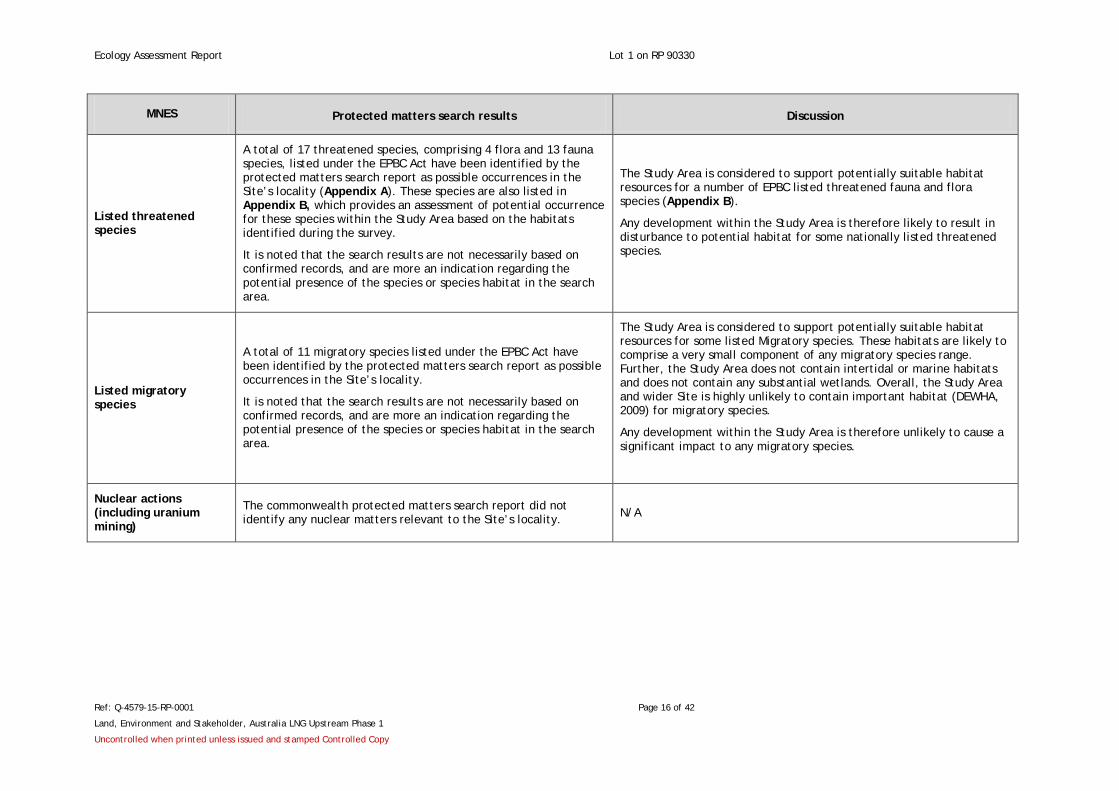
MNES Protected matters search results Discussion
Listed threatened species
A total of 17 threatened species, comprising 4 flora and 13 fauna species, listed under the EPBC Act have been identified by the protected matters search report as possible occurrences in the Site’s locality (Appendix A). These species are also listed in Appendix B, which provides an assessment of potential occurrence for these species within the Study Area based on the habitats identified during the survey.
It is noted that the search results are not necessarily based on confirmed records, and are more an indication regarding the potential presence of the species or species habitat in the search area.
The Study Area is considered to support potentially suitable habitat resources for a number of EPBC listed threatened fauna and flora species (Appendix B).
Any development within the Study Area is therefore likely to result in disturbance to potential habitat for some nationally listed threatened species.
Listed migratory species
A total of 11 migratory species listed under the EPBC Act have been identified by the protected matters search report as possible occurrences in the Site’s locality.
It is noted that the search results are not necessarily based on confirmed records, and are more an indication regarding the potential presence of the species or species habitat in the search area.
The Study Area is considered to support potentially suitable habitat resources for some listed Migratory species. These habitats are likely to comprise a very small component of any migratory species range. Further, the Study Area does not contain intertidal or marine habitats and does not contain any substantial wetlands. Overall, the Study Area and wider Site is highly unlikely to contain important habitat (DEWHA, 2009) for migratory species.
Any development within the Study Area is therefore unlikely to cause a significant impact to any migratory species.
Nuclear actions (including uranium mining)
The commonwealth protected matters search report did not identify any nuclear matters relevant to the Site’s locality. N/A

Ecology Assessment Report Lot 1 on RP 90330
Ref: Q-4579-15-RP-0001 Page 17 of 42
Land, Environment and Stakeholder, Australia LNG Upstream Phase 1
Uncontrolled when printed unless issued and stamped Controlled Copy
Table 4: Consideration of Additional Protected Matters under the EPBC Act
Protected Matters Protected matters search results Discussion
Commonwealth lands No commonwealth lands were identified within the Site’s locality. N/A
Commonwealth heritage places No commonwealth heritage places were identified within the Site’s locality. N/A
Listed marine species
A total of 11 listed marine species under the EPBC Act have been identified by the protected matters search report as possible occurrences in the locality.
It is noted that the search results are not necessarily based on confirmed records, and are more an indication regarding the potential presence of the species or species habitat in the search area.
The Site is located over 250 km inland and does not support oceanic marine habitats. Any development within the Site would not directly impact upon marine habitats.
The Study Area is considered to support potentially suitable habitat resources for some terrestrial Marine species (e.g. cattle egret). The habitats within the Study Area are, however, unlikely to represent an important area for such terrestrial marine species.
Whales and other No whales and other cetaceans listed under the EPBC Act have been identified by the protected matters search report as possible occurrences in the Site’s locality.
The Site is located over 250 km inland and does not support oceanic habitats for whales and other cetaceans. Any proposed development concept would not directly impact upon habitat for such species.
Critical habitats No critical habitats listed under the EPBC Act have been identified within the Site’s locality.
N/A
Commonwealth reserves No commonwealth reserves have been identified within the Site’s locality. N/A
Places on the register of the national estate
No places on the register of the national estate have been identified within the Site’s locality.
N/A
State and territory reserves No state and territory reserves have been identified within the Site’s locality. N/A
Regional forest agreements No regional forest agreements have been identified within the Site’s locality. N/A
Ecology Assessment Report Lot 1 on RP 90330
Ref: Q-4579-15-RP-0001 Page 18 of 42
Land, Environment and Stakeholder, Australia LNG Upstream Phase 1
Uncontrolled when printed unless issued and stamped Controlled Copy
Protected Matters Protected matters search results Discussion
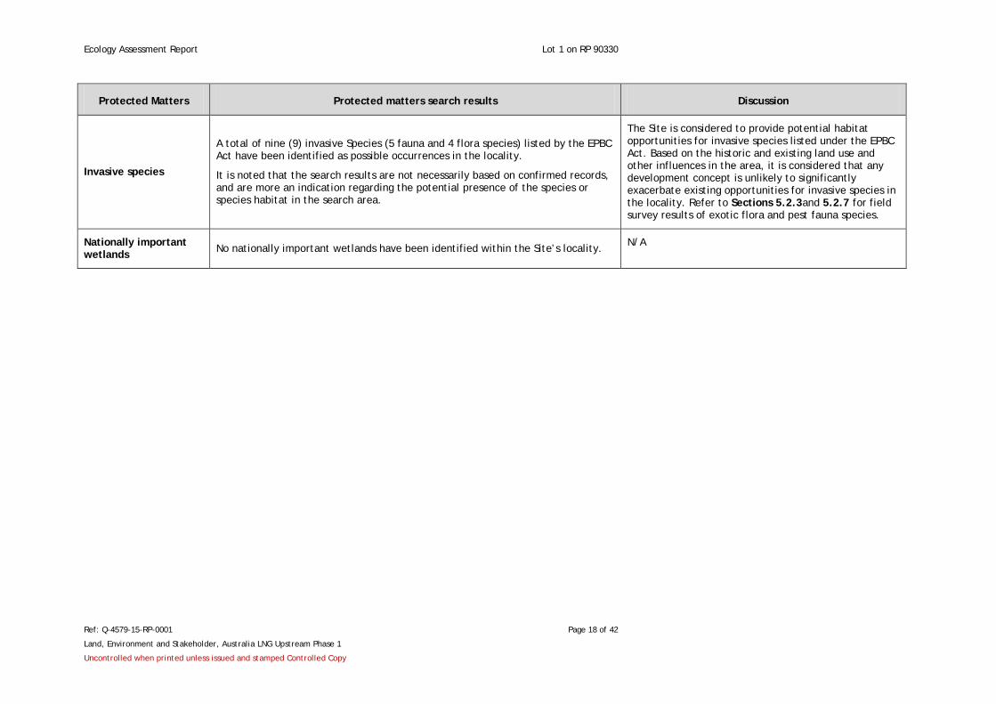
Invasive species
A total of nine (9) invasive Species (5 fauna and 4 flora species) listed by the EPBC Act have been identified as possible occurrences in the locality.
It is noted that the search results are not necessarily based on confirmed records, and are more an indication regarding the potential presence of the species or species habitat in the search area.
The Site is considered to provide potential habitat opportunities for invasive species listed under the EPBC Act. Based on the historic and existing land use and other influences in the area, it is considered that any development concept is unlikely to significantly exacerbate existing opportunities for invasive species in the locality. Refer to Sections 5.2.3and 5.2.7 for field survey results of exotic flora and pest fauna species.
Nationally important wetlands No nationally important wetlands have been identified within the Site’s locality. N/A

Ecology Assessment Report Lot 1 on RP 90330
Ref: Q-4579-15-RP-0001 Page 19 of 42
Land, Environment and Stakeholder, Australia LNG Upstream Phase 1
Uncontrolled when printed unless issued and stamped Controlled Copy
Wildlife online – State Listed Threatened Species
A search of DERM wildlife online records was undertaken for the locality of the Site (10 km radius around -26.6883, 150.2274) (Appendix C). The search identified that three (3) threatened fauna species and one (1) threatened flora species listed under the NC Reg have been recorded within the Site’s locality. An assessment of potential occurrence for these species within the Study Area is provided in Appendix B.
Qld vegetation management Act 1999 – remnant vegetation
The DERM regional ecosystems and remnant map – version 6.1 (REMAP) (DERM, 2012a) presents the distribution and status of regional ecosystems as gazetted under the Vegetation Management Act 1999 (VMA) (DERM, 2011a) (Vegetation Management Status). The Vegetation Management Status used in this report is based on DERM’s assessment of the pre-clearing and remnant extent of a regional ecosystem as per the Vegetation Management Regulation 2000 (VM Reg) (DERM, 2011b). The VMA defines a community as remnant when the vegetation exhibits more than 50 % of the undisturbed predominant canopy, averages more than 70 % of the vegetation's undisturbed height and is composed of species characteristic of the undisturbed predominant canopy of the given vegetation community.
The desktop review identified that no areas of the Site are mapped as containing remnant vegetation.
Essential habitat
Essential habitat is a vegetation ecosystem that is designated by DERM and is considered to identify potential habitat for species that are listed as; endangered, vulnerable or near threatened under the Qld NC Reg. Essential habitat mapping is provided in conjunction with regional ecosystem maps by DERM and is represented as diagonal blue lines over a remnant vegetation polygon. Essential habitat species records are represented as a blue dot.
Review of the mapping indicated that no essential habitat is designated as occurring on Site.
Regrowth vegetation and essential habitat regrowth
Regulated regrowth vegetation is defined under the VMA as either:
• identified on the regrowth vegetation map as HVR Vegetation;
• located within 50 m of a watercourse identified on the regrowth vegetation map as a regrowth watercourse (regrowth watercourse vegetation); or
• contained in a category C or category 4 area on a property map of assessable vegetation (PMAV).
Following review of the regrowth vegetation map – version 2, it has been identified that parts of the Site have been mapped as containing HVR (DERM, 2012c) (Figure 5.1):
• a small polygon designated as HVR vegetation containing endangered regional ecosystems occurs along a section of the central water course within the Site, and correlates to part of the Study Area investigated by Orogen;
• a small portion of a polygon designated as HVR containing endangered regional ecosystems, encroaches into the north eastern corner of the Site. This polygon occurs outside of the Study Area and as such was not investigated in detail during Orogen’s survey;

Ecology Assessment Report Lot 1 on RP 90330
Ref: Q-4579-15-RP-0001 Page 20 of 42
Land, Environment and Stakeholder, Australia LNG Upstream Phase 1
Uncontrolled when printed unless issued and stamped Controlled Copy
• the edge of a polygon designated as HVR containing least concern regional ecosystems encroaches into a small part of the Site’s southern boundary. This polygon occurs outside of the Study Area and as such was not investigated in detail during Orogen’s survey; and
• a small polygon designated as HRV containing endangered regional ecosystems encroaches into a small part of the Site’s southern boundary. This polygon occurs outside of the Study Area and as such was not investigated in detail during Orogen’s survey.
Referable wetlands and waterways
The desktop review identified that no areas of the Site contain referable wetlands as per the map of referable wetlands (DERM, 2012e). Further, the Site is not designated as hosting any wetlands by DERM’s online Wetland Maps mapping tool (DERM, 2012g).
The Site is mapped by the regrowth vegetation map – version 2 as containing a 1st and a 2nd order stream (Figure 5.1) (DERM, 2012c). These water features were also evident in the results of a search of the Wetland Maps mapping tool (DERM, 2012g). It should be noted however that these streams are not referable wetlands as per the map of referable wetlands.
5.2. Field Survey The results of field surveys undertaken on 11 May 2011 are presented in the following sections.
Vegetation communities
The vegetation community surveys conducted during field surveys determined the presence of three vegetation communities including:
• Vegetation community 1 – derived grassland;
• Vegetation community 2 – regenerating woodland dominated by Allocasuarina luehmannii and Callitris glaucophylla; and
• Vegetation community 3 – mixed eucalypt riparian woodland (refer survey site V3-Table 7).
The vegetation communities identified within the Study Area are not analogous to any TECs listed under the EPBC Act.
A summary of the vegetation community survey results is provided below and a vegetation community plan pertaining to the Study Area is provided in Figure 5.2. A list of flora species recorded during the survey is provided in Appendix D.
Vegetation Community 1 – Derived Grassland
Vegetation community 1 (see Table 5) was observed within the part of the Study Area that corresponded with the first co-ordinate provided by the Client (coordinates: 223743E, 7045179S UTM). The vegetation within a large proportion of the Study Area appeared to be subject to regular maintenance such as slashing/mowing. The vegetation community found at this location corresponds with vegetation survey site V1 (Figure 4.1).
The ground layer dominated the vegetation community and predominantly comprised of non-native buffel grass (Cenchrus ciliaris syn Pennisetum ciliare). A small proportion of the ground layer was comprised of a mixture of native species. Vegetation community 1 also contained regenerating shrubs, primarily wattle (acacia) species, and occasional native trees such as Eucalyptus spp. and white cyrpress pine (Callitris glaucophylla). The vegetation community also contained areas devoid of vegetation.

Ecology Assessment Report Lot 1 on RP 90330
Ref: Q-4579-15-RP-0001 Page 21 of 42
Land, Environment and Stakeholder, Australia LNG Upstream Phase 1
Uncontrolled when printed unless issued and stamped Controlled Copy
The introduced buffel grass (C. ciliaris) was frequently found to be a dominant species in this community. The presence of buffel grass (C. ciliaris), regenerating wattles (acacias) and a sparse tree component indicated that this vegetation has been subject to historic clearing, pasture improvement and grazing. The community was highly degraded and not considered to be representative of any naturally occurring native vegetation community, including any RE’s listed by DERM.
Table 5: Vegetation community 1
Stratum Species
Upper T1 stratum
FPC 0-10%
Height range 8-12 m
The layer was very sparse and primarily comprised of regenerating native trees such as Allocasuarina luehmannii (bull oak), Callitris glaucophylla (white cypress pine), Corymbia trachyphloia (brown bloodwood), Eucalyptus tereticornis (Queensland blue gum), and E. populnea (poplar box).
Shrub S1 stratum
FPC 0-10%
Height range 0.5-3 m
Primarily regenerating Acacias including Acacia montana, Acacia stenophylla and Acacia spectabilis.
Ground stratum
FPC 70-99%
Height range 0.1-0.7 m
Aristida caput-medusae, Aristida spp. Bothriochloa sp. Cymbopogon refractus, Digitaria divaricatissima, Eragrostis spp. Fimbristylis dichotoma, Panicum sp. and Cenchlrus ciliaris* (syn Pennisetum ciliare), Sporobolus creber.
* = Introduced species
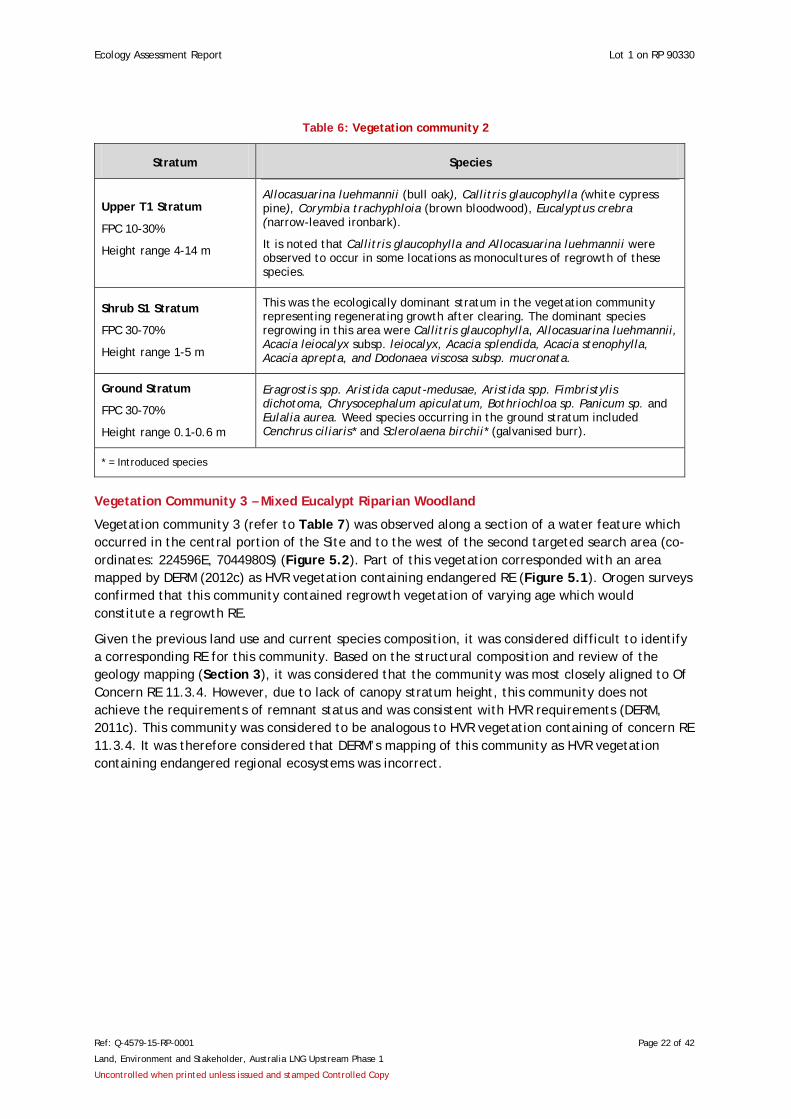
Vegetation Community 2 – Regenerating Woodland
Vegetation community 2 (refer to Table 6) was observed within and adjoining the investigation area around the second targeted study (co-ordinates: 224596E, 7044980S UTM) (Figure 5.2). This community corresponds with vegetation survey site V2 and general observations suggested that this vegetation type occupies the majority of the Site. The mid-layer dominated this community and comprised regenerating shrubs and juvenile tree species. The ground layer was comprised of native and exotic species, in particular introduced buffel grass (C. ciliaris), which occurred in dense patches throughout the survey site.
The presence of buffel grass (C. ciliaris) and a dominant layer of regenerating trees and shrubs indicated that this vegetation had been subject to historic clearing, pasture improvement and grazing. The community was highly degraded and not considered to be representative of a remnant regional ecosystem listed by DERM.
Ecology Assessment Report Lot 1 on RP 90330
Ref: Q-4579-15-RP-0001 Page 22 of 42
Land, Environment and Stakeholder, Australia LNG Upstream Phase 1
Uncontrolled when printed unless issued and stamped Controlled Copy
Table 6: Vegetation community 2
Stratum Species
Upper T1 Stratum
FPC 10-30%
Height range 4-14 m
Allocasuarina luehmannii (bull oak), Callitris glaucophylla (white cypress pine), Corymbia trachyphloia (brown bloodwood), Eucalyptus crebra (narrow-leaved ironbark).
It is noted that Callitris glaucophylla and Allocasuarina luehmannii were observed to occur in some locations as monocultures of regrowth of these species.
Shrub S1 Stratum
FPC 30-70%
Height range 1-5 m
This was the ecologically dominant stratum in the vegetation community representing regenerating growth after clearing. The dominant species regrowing in this area were Callitris glaucophylla, Allocasuarina luehmannii, Acacia leiocalyx subsp. leiocalyx, Acacia splendida, Acacia stenophylla, Acacia aprepta, and Dodonaea viscosa subsp. mucronata.
Ground Stratum
FPC 30-70%
Height range 0.1-0.6 m
Eragrostis spp. Aristida caput-medusae, Aristida spp. Fimbristylis dichotoma, Chrysocephalum apiculatum, Bothriochloa sp. Panicum sp. and Eulalia aurea. Weed species occurring in the ground stratum included Cenchrus ciliaris* and Sclerolaena birchii* (galvanised burr).
* = Introduced species
Vegetation Community 3 – Mixed Eucalypt Riparian Woodland
Vegetation community 3 (refer to Table 7) was observed along a section of a water feature which occurred in the central portion of the Site and to the west of the second targeted search area (co-ordinates: 224596E, 7044980S) (Figure 5.2). Part of this vegetation corresponded with an area mapped by DERM (2012c) as HVR vegetation containing endangered RE (Figure 5.1). Orogen surveys confirmed that this community contained regrowth vegetation of varying age which would constitute a regrowth RE.
Given the previous land use and current species composition, it was considered difficult to identify a corresponding RE for this community. Based on the structural composition and review of the geology mapping (Section 3), it was considered that the community was most closely aligned to Of Concern RE 11.3.4. However, due to lack of canopy stratum height, this community does not achieve the requirements of remnant status and was consistent with HVR requirements (DERM, 2011c). This community was considered to be analogous to HVR vegetation containing of concern RE 11.3.4. It was therefore considered that DERM’s mapping of this community as HVR vegetation containing endangered regional ecosystems was incorrect.

Ecology Assessment Report Lot 1 on RP 90330
Ref: Q-4579-15-RP-0001 Page 23 of 42
Land, Environment and Stakeholder, Australia LNG Upstream Phase 1
Uncontrolled when printed unless issued and stamped Controlled Copy
Table 7: Vegetation community 3
Stratum Species
Upper T1 Stratum
FPC 30-70%
Height range 10-16 m
This was the ecologically dominant stratum and primarily comprised a mixture of eucalypts. The most prevalent species observed included Eucalyptus tereticornis, E. populnea, and E. crebra. Trees comprised regrowth of varying age, including some older trees with a DBH greater than 30 cm. The percentage composition of each tree species within the community shifted along the water course. For example, in one location the community was dominated by E. tereticornis, while in other locations this species was a minor associate with E. populnea and E. crebra.
Mid T2 Stratum
FPC 30-70%
Height range 6-12 m
This stratum was dominated by Allocasuarina luehmannii and Callitris glaucophylla. Younger regrowth of T1 species were also common.
Shrub S1 Stratum
FPC 30-70%
Height range 1-4 m
Dominance was mixed between Acacia spectabilis and Dodonaea viscosa subsp. mucronata. Subdominants included regrowth Allocasuarina luehmannii and Callitris glaucophylla. Associates included Acacia leiocalyx subsp. leiocalyx, and Geijera parviflora.
Ground Stratum
FPC 30-70%
Height range 0.1-0.6 m
Ground stratum was characterised by a mixture of native grasses including:
Cenchrus ciliaris*, Eragrostis spp. Aristida caput-medusae, Aristida spp. Panicum sp. Digitaria divaricatissima, Digitaria sp. Bothriochloa bladhii subsp. bladhii, and Chrysocephalum apiculatum.
* = Introduced species
Threatened Flora
No threatened flora species listed under the EPBC Act or NC Reg were identified during the preliminary assessment of the Site. Two (2) species identified by the desktop searches, Belson’s panic (Homopholis belsonii) and Raspweed (Gonocarpus urceolatus), were considered to potentially occur within each of the three communities identified within the Study Area (Appendix B, Table B1).
Exotic Flora Species
5.2.1.1. Declared Weed Species
A declared weed species is defined as such if listed under the Qld LP [PSRM] Act. No declared weed species were recorded during the current surveys.
5.2.1.2. Environmental Weeds
An environmental weed species is defined as such if included in the List of the 200 Most Invasive Environmental Weeds in SEQ (NRM, 2003). One environmental weed species, buffel grass (C. ciliaris), was recorded within the Study Area during the field surveys.
5.2.1.3. Invasive Species Listed Under the EPBC Act
Five (5) invasive flora species listed by the EPBC Act were identified as possibly occurring within the locality (Appendix A). None of these listed invasive species were observed within the Study Area.
Ecology Assessment Report Lot 1 on RP 90330
Ref: Q-4579-15-RP-0001 Page 24 of 42
Land, Environment and Stakeholder, Australia LNG Upstream Phase 1
Uncontrolled when printed unless issued and stamped Controlled Copy
Habitat Assessment
The field assessments undertaken by Orogen identified that the Study Area supported four main habitat types, namely:
• habitat type 1 – derived grassland;
• habitat type 2 – regenerating woodland;
• habitat type 3 – riparian woodland; and
• habitat type 4 – aquatic habitat.
Habitat types 1- 3 are associated with the corresponding vegetation types observed during the survey (Section 5.2.1). Habitat type 4 comprised the central water course associated with the riparian woodland, and also a small anthropogenic dam found near the edge of survey site H1 (Figure 4.1). General observations suggested that habitat type 2 – regenerating woodland, occupied the majority of the Site. Additional surveys would be required to confirm this.
General habitat quality of the Study Area for potential threatened species is deemed to be low. (Appendix B) provides further discussion on the potential occurrences and of threatened species their requirements within the Site.
5.2.1.4. Habitat Type 1 – Derived Grassland
Despite the presence of some habitat resources (outlined below), the overall habitat value of the derived grassland for fauna was considered to be low. Extensive clearing and modification has severely degraded the habitat value of this ecosystem. Habitat for hollow dependent fauna was found to be very limited and no hollow bearing trees were observed within the survey site.
Fauna resources within this habitat type included occasional trees and shrubs that would provide opportunistic foraging resources for a variety of insectivorous and nectivorous species such as micro-chiropteran bats, flying foxes, birds and arboreal mammals. Additionally, the ground cover vegetation contained mixed native grasses and buffel grass (C. ciliaris), providing potential foraging resources for macropods, smaller mammals, ground dwelling birds and other passerines, and reptiles. The minimal amount of leaf litter and small pieces of scattered timber may also provide limited foraging and shelter resources for reptiles, while bare ground areas could provide some basking habitat for reptiles.
Given the presence of habitat for a variety of faunal groups, the derived grassland would also represent potential hunting habitat for predatory birds and mammals.
Potential habitat for threatened species was limited. The Site contained low densities of Allocasuarina luehmannii, which is a suitable food tree for the glossy black-cockatoo (Calyptorhynchus lathami lathami). Potential utilisation of these trees would likely be opportunistic, due to the low densities observed in this habitat type. No evidence of habitat utilisation (i.e. chewed allocasuarina fruit) by the glossy black-cockatoo (C. lathami lathami) was observed. The derived grassland may also provide suitable habitat for the squatter pigeon (Geophaps scripta), a species known to occur within areas of disturbed grassland habitat.
The derived grassland habitat occurring within the Site represented a very small proportion of similar habitat within the surrounding landscape. Similarly, the area of derived grassland within the Study Area represented a minuscule area of habitat in relation to the home range of any threatened species considered to potentially occur within the Site.
5.2.1.5. Habitat Type 2 – Regenerating Woodland
This habitat type provided similar habitat values to the derived grassland; however it contained a higher density of regenerating trees and shrubs. Despite the presence of some habitat resources,

Ecology Assessment Report Lot 1 on RP 90330
Ref: Q-4579-15-RP-0001 Page 25 of 42
Land, Environment and Stakeholder, Australia LNG Upstream Phase 1
Uncontrolled when printed unless issued and stamped Controlled Copy
the overall habitat value of the regenerating woodland for fauna was considered to be low. Extensive clearing and dumping has severely degraded the habitat value of this modified ecosystem. The refuse piles may provide some shelter and foraging resources for certain fauna species, particular reptiles and rodents. However, this is not a natural habitat and may favour pest species. The trees and shrubs represent potential foraging resources for a variety of insectivorous and nectivorous species such as micro-chiropteran bats, flying foxes, birds and arboreal mammals. A higher density of trees and shrubs may also offer relatively higher opportunities for shelter and nesting resources for small birds. Resources for hollow dependent fauna were limited within the survey site, with no hollow bearing trees being recorded. Similarly, this habitat lacked large pieces of fallen timber and hollow logs.
The ground cover vegetation contained mixed native grasses and buffel grass (C. ciliaris), providing potential foraging resources for macropods, smaller mammals, ground dwelling birds and other passerines, and reptiles. The minimal amount of leaf litter and small pieces of scattered timber may also provide limited foraging and shelter resources for reptiles.
Given the presence of habitat for a variety of faunal groups, the derived grassland would also represent potential hunting habitat for predatory birds and mammals.
A suitable food tree for the glossy black-cockatoo (C. lathami lathami), Allocasuarina luehmannii, was a co-dominant species within this habitat type. Additionally, this tree species formed small monoculture patches in some areas. Despite this, the habitat type represented a very small amount of potential foraging resources for the glossy black-cockatoo (C. lathami lathami) in a local or regional context. No evidence of habitat utilisation by the glossy black-cockatoo (C. lathami lathami) (i.e. chewed allocasuarina fruit) was observed.
The regenerating woodland habitat occurring within the Site represented a very small proportion of similar habitat within the surrounding landscape. Similarly, the area of regenerating woodland within the Study Area provides a minimal area of habitat in relation to the home range of any threatened species considered to potentially occur within the Site.
5.2.1.6. Habitat Type 3 – Riparian Woodland
This riparian woodland was associated with the central watercourse. The values of the watercourse are discussed below as a separate habitat type (Habitat Type 4).
Despite the presence of some habitat resources, the overall habitat value of the riparian woodland for fauna was considered to be low. Extensive clearing, grazing and erosion have severely degraded the habitat value of this modified ecosystem.
This habitat contains a diversity of trees and shrubs that represented potential foraging resources for a variety of insectivorous and nectivorous species such as micro-chiropteran bats, flying foxes, birds and arboreal mammals. This vegetation may also offer shelter and nesting resources for small birds.
Resources for hollow dependent fauna were found to be limited with no hollow bearing trees observed within the survey site. This habitat contained some scattered timber and occasional large-sized hollow logs.
The ground cover vegetation contained mixed native grasses and buffel grass (C. ciliaris), providing potential foraging resources for macropods, smaller mammals, ground dwelling birds and other passerines, and reptiles. The minimal amount of leaf litter and small pieces of scattered timber may also provide limited foraging and shelter resources for reptiles.
Given the presence of habitat for a variety of faunal groups, the derived grassland would also represent potential hunting habitat for predatory birds and mammals.

Ecology Assessment Report Lot 1 on RP 90330
Ref: Q-4579-15-RP-0001 Page 26 of 42
Land, Environment and Stakeholder, Australia LNG Upstream Phase 1
Uncontrolled when printed unless issued and stamped Controlled Copy
A suitable food tree for the glossy black-cockatoo (C. lathami lathami), Allocasuarina luehmannii, was a co-dominant species within this habitat type. The habitat type represents a very small amount of potential foraging resources for the glossy black-cockatoo (C. lathami lathami) in a local or regional context. No evidence of habitat utilisation by the glossy black-cockatoo (C. lathami lathami) (i.e. chewed allocasuarina fruit) was observed.
The area of riparian woodland within the Study Area represented a very small proportion of similar habitat within the surrounding landscape. Similarly, the area of riparian woodland within the Study Area provides a minimal area of habitat in relation to the home range of any threatened species considered to potentially occur within the Site.
5.2.1.7. Habitat Type 4 – Aquatic habitat
The central watercourse contained limited emergent vegetation and the overall habitat value was considered to be low, particularly threatened amphibians.
The aquatic habitats observed within the Study Area were comprised of two main habitats types:
• a small anthropogenic dam; and
• a water course.
A small anthropogenic dam approximately 20 m in diameter was located to the west of the Site. The dam contained limited aquatic and emergent vegetation, and represented limited value for wetland birds. Visual assessment of the water in the dam noted that the water present was highly turbid; the cause of this turbidity was not known. No threatened amphibian species was recorded to occur or potentially occur within the Site (through the desktop assessment and field assessment). It is considered unlikely that the Site hosts threatened amphibians.
The identified central watercourse of the Site corresponded to the general area mapped by DERM (2012c) as a 1st order stream. The field surveys included mapping the high bank on either side of this watercourse, and the exact route of the drainage line was found to vary from the formally delineated line on DERM’s WetlandMaps and regrowth mapping (Figure 5.1) (DERM, 2012g and DERM, 2012c). The watercourse occurred as a relatively small area within the Site. However, it formed part of a more extensive area of connected riparian habitat which occurred to the south-west of the Site. Potential disturbance to this area may impact on aquatic habitats downstream.
The high bank survey identified that the central watercourse became heavily degraded towards the eastern boundary of the Site. The following disturbances were observed around this section:
• general absence (or limited densities) of native riparian vegetation, including canopy vegetation observed along other sections;
• lack of defined bed and banks;
• higher densities of pasture weeds; and
• refuse piles.
The identifiable section of the watercourse within the Site was observed to contain pooling water and also dry beds, indicating the section is subject to periodic flows. The riparian vegetation associated with this section of the watercourse was generally degraded as a result of historic disturbance (e.g. clearing). Exposed tree roots, litter and dense ground cover provided habitat for small fauna species such as reptiles and small mammals and foraging areas for small birds. The watercourse, however, provided limited opportunities for waterbirds and waders.
Potential breeding habitat for amphibians was provided by the pooling and ephemeral habitats during periods of flow. Visual assessment of the pooled areas identified that the water present was highly turbid.
Ecology Assessment Report Lot 1 on RP 90330
Ref: Q-4579-15-RP-0001 Page 27 of 42
Land, Environment and Stakeholder, Australia LNG Upstream Phase 1
Uncontrolled when printed unless issued and stamped Controlled Copy
Threatened Fauna
No threatened fauna species listed under the EPBC Act or NC Reg were identified during the Orogen EAR. There was no evidence identified to suggest habitat utilisation by threatened fauna species. However, it is noted that there is potential for threatened species listed by the EPBC Act and NC Reg to occur in the locality. Refer to Appendix B to view the threatened fauna species recorded as potentially occurring in the locality and discussions on the habitat value within the Site.
Migratory Species
The Study Area lacked oceanic habitats and substantial wetland environments, and no listed migratory species were observed during the survey. The Study Area was, however, considered to provide habitat resources for some listed migratory bird species, such as the rainbow bee-eater (Merops ornatus) and cattle egret (Ardea ibis). Despite this, the habitats represented a very small component of any migratory species distribution and home range. Overall, the Site is highly unlikely to contain ‘important habitat’ (DEWHA, 2009) for migratory species (Table 3).
Pest Fauna
There were no declared pest fauna species listed by LP [PSRM] Act observed within the Site during the survey. Similarly, there were no invasive species listed by the PMST recorded within the Study Area.
Given the currently known distribution and mobility of the pest species, it is possible that some pest species could occur on or traverse the Site (e.g. cane toad and wild pig). Based on the modified state of the Site and the historic and existing disturbances, it is considered that any development concept is unlikely to significantly exacerbate existing opportunities for pest species in the locality.
Significant Ecological Features and Functions
5.2.1.8. Fauna Corridors
The Site has been subject to historical clearing and grazing and following a review of API, it is identified that the vegetation within the Site occurs within a fragmented landscape. The fragmented nature of the vegetation within the Site limits the value of this vegetation as a corridor. The Site’s vegetation is more likely to facilitate movement for more mobile species such as birds and bats.
The central watercourse would facilitate a patchy connection between an area of relatively connected habitat occurring to the east and riparian habitats occurring to the south-west of the Site. This may support movement for most fauna including small fauna such as reptiles and small mammals. The retention of vegetation along this watercourse is recommended as this vegetation provides a connection for species requiring the specific attributes of riparian areas.
The southern boundary of the Site adjoins the road reserve of Cameby Road. Both sides of the road reserve contain a narrow strip of vegetation, providing a potential connection to the east and west along the edge of Old Cameby Road. It would be expected this would facilitate movement for birds, bats and arboreal mammals.
5.2.1.9. Significant (Subject) Species
No threatened species listed under the EPBC Act or NC Reg were identified during the preliminary assessment of the Site. There was no evidence identified to suggest habitat utilisation by threatened fauna species. Appendix B provides a summary and discussion of the Subject Species.
5.2.1.9.1. Flora Species
A total of five (5) threatened flora species were identified by the desktop review (combined PMST and wildlife online) as either known or potentially occurring within the locality of the Site
Ecology Assessment Report Lot 1 on RP 90330
Ref: Q-4579-15-RP-0001 Page 28 of 42
Land, Environment and Stakeholder, Australia LNG Upstream Phase 1
Uncontrolled when printed unless issued and stamped Controlled Copy
(Appendix B). In consideration of habitat requirements, two (2) species identified by the desktop searches, Belson’s panic (Homopholis belsonii) and Raspweed (Gonocarpus urceolatus), were considered to potentially occur within the Study Area’s three (3) vegetation communities. However, these species were not detected during assessment of the Site.
5.2.1.9.2. Fauna Species
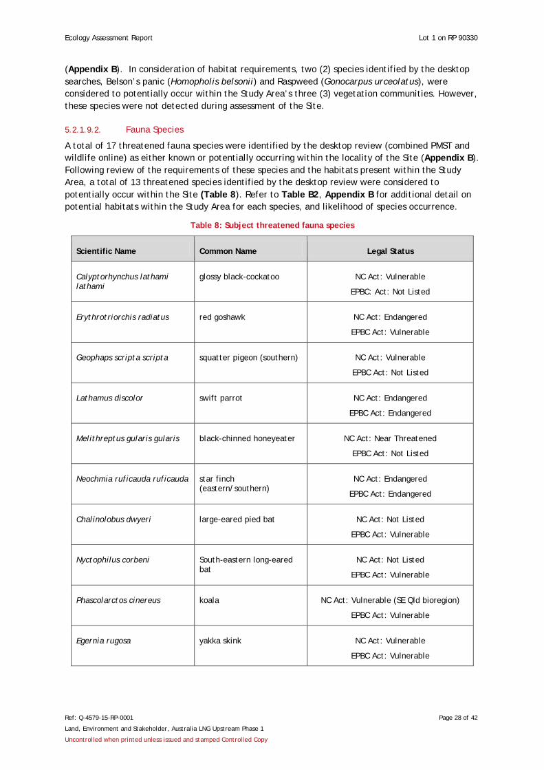
A total of 17 threatened fauna species were identified by the desktop review (combined PMST and wildlife online) as either known or potentially occurring within the locality of the Site (Appendix B). Following review of the requirements of these species and the habitats present within the Study Area, a total of 13 threatened species identified by the desktop review were considered to potentially occur within the Site (Table 8). Refer to Table B2, Appendix B for additional detail on potential habitats within the Study Area for each species, and likelihood of species occurrence.
Table 8: Subject threatened fauna species
Scientific Name Common Name Legal Status
Calyptorhynchus lathami lathami
glossy black-cockatoo NC Act: Vulnerable
EPBC: Act: Not Listed
Erythrotriorchis radiatus red goshawk NC Act: Endangered
EPBC Act: Vulnerable
Geophaps scripta scripta squatter pigeon (southern) NC Act: Vulnerable
EPBC Act: Not Listed
Lathamus discolor swift parrot NC Act: Endangered
EPBC Act: Endangered
Melithreptus gularis gularis black-chinned honeyeater NC Act: Near Threatened
EPBC Act: Not Listed
Neochmia ruficauda ruficauda star finch (eastern/southern)
NC Act: Endangered
EPBC Act: Endangered
Chalinolobus dwyeri large-eared pied bat NC Act: Not Listed
EPBC Act: Vulnerable
Nyctophilus corbeni South-eastern long-eared bat
NC Act: Not Listed
EPBC Act: Vulnerable
Phascolarctos cinereus koala NC Act: Vulnerable (SE Qld bioregion)
EPBC Act: Vulnerable
Egernia rugosa yakka skink NC Act: Vulnerable
EPBC Act: Vulnerable
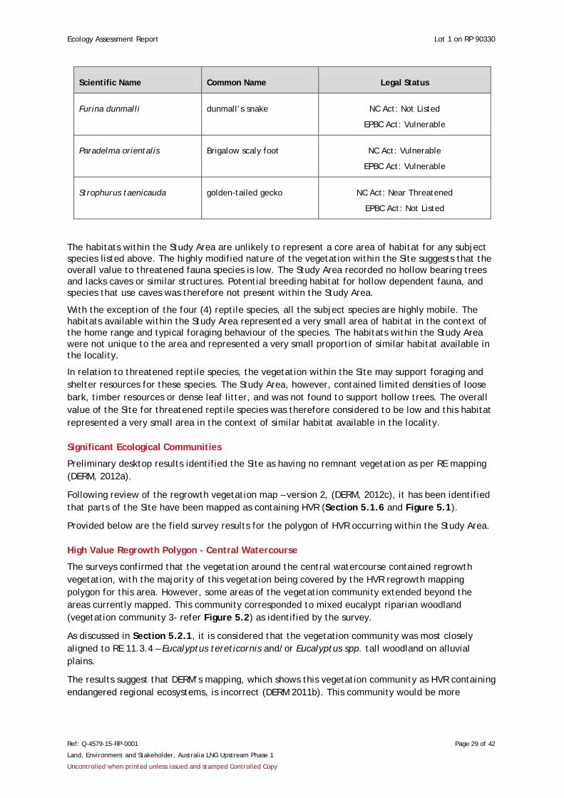
Ecology Assessment Report Lot 1 on RP 90330
Ref: Q-4579-15-RP-0001 Page 29 of 42
Land, Environment and Stakeholder, Australia LNG Upstream Phase 1
Uncontrolled when printed unless issued and stamped Controlled Copy
Scientific Name Common Name Legal Status
Furina dunmalli dunmall’s snake NC Act: Not Listed
EPBC Act: Vulnerable
Paradelma orientalis Brigalow scaly foot NC Act: Vulnerable
EPBC Act: Vulnerable
Strophurus taenicauda golden-tailed gecko NC Act: Near Threatened
EPBC Act: Not Listed
The habitats within the Study Area are unlikely to represent a core area of habitat for any subject species listed above. The highly modified nature of the vegetation within the Site suggests that the overall value to threatened fauna species is low. The Study Area recorded no hollow bearing trees and lacks caves or similar structures. Potential breeding habitat for hollow dependent fauna, and species that use caves was therefore not present within the Study Area.
With the exception of the four (4) reptile species, all the subject species are highly mobile. The habitats available within the Study Area represented a very small area of habitat in the context of the home range and typical foraging behaviour of the species. The habitats within the Study Area were not unique to the area and represented a very small proportion of similar habitat available in the locality.
In relation to threatened reptile species, the vegetation within the Site may support foraging and shelter resources for these species. The Study Area, however, contained limited densities of loose bark, timber resources or dense leaf litter, and was not found to support hollow trees. The overall value of the Site for threatened reptile species was therefore considered to be low and this habitat represented a very small area in the context of similar habitat available in the locality.
Significant Ecological Communities
Preliminary desktop results identified the Site as having no remnant vegetation as per RE mapping (DERM, 2012a).
Following review of the regrowth vegetation map – version 2, (DERM, 2012c), it has been identified that parts of the Site have been mapped as containing HVR (Section 5.1.6 and Figure 5.1).
Provided below are the field survey results for the polygon of HVR occurring within the Study Area.
High Value Regrowth Polygon - Central Watercourse
The surveys confirmed that the vegetation around the central watercourse contained regrowth vegetation, with the majority of this vegetation being covered by the HVR regrowth mapping polygon for this area. However, some areas of the vegetation community extended beyond the areas currently mapped. This community corresponded to mixed eucalypt riparian woodland (vegetation community 3- refer Figure 5.2) as identified by the survey.
As discussed in Section 5.2.1, it is considered that the vegetation community was most closely aligned to RE 11.3.4 – Eucalyptus tereticornis and/or Eucalyptus spp. tall woodland on alluvial plains.
The results suggest that DERM’s mapping, which shows this vegetation community as HVR containing endangered regional ecosystems, is incorrect (DERM 2011b). This community would be more
Ecology Assessment Report Lot 1 on RP 90330
Ref: Q-4579-15-RP-0001 Page 30 of 42
Land, Environment and Stakeholder, Australia LNG Upstream Phase 1
Uncontrolled when printed unless issued and stamped Controlled Copy
appropriately mapped as HVR containing Of Concern RE. Additionally, the canopy height of this vegetation community does not satisfy the requirements for remnant status.
Watercourses, Wetlands and Dams
The water feature associated with vegetation community 3 (refer to Figures 5.1 and 5.2) was characterised as a watercourse as per the definition given under the Water Act. The key feature which distinguished the subject watercourse from the Water Act definition of a water feature was the presence of a riverine environment (a distinct riparian vegetation zone).
The small anthropogenic dam observed in the Study Area was classified as an H2M1 waterbody in accordance with the wetland classification definitions presented by the Wetland Mapping and Classification Methodology (EPA, 2005).
Disturbance
The prevalent disturbances on the Site were most likely due to historic agricultural management practices associated with grazing activities and the maintenance of pasture including mechanical clearing, logging and thinning of vegetation. Removal of vegetation from riparian areas appeared to have promoted erosion along some parts of the central watercourse.
The majority of the Site was subject to existing grazing by horses. Other disturbances impacting on the ecological value of the Site included anthropogenic refuse piles such as car tyres and white goods observed at various locations within the Site.
6. Conclusion and Recommendations In conclusion, desktop review and ecological field surveys identified that the Study Area contained a series of ecological features and functions which require careful management through future development planning within the Site. The known and potential elements of ecological value within the Site are listed below:
• The Study Area was found not to support category A, B or C ESA’s.
• Riparian vegetation was considered to meet the definition of HVR vegetation containing Of Concern RE. This was identified along the central watercourse and is currently incorrectly mapped by DERM as HVR containing an endangered RE. Other sections of the Site were identified to contain HVR polygons at a desktop level; however, these areas were outside the Study Area for this EAR and were not assessed.
• A watercourse (as defined by the Water Act) was associated with the central water feature. Other watercourses may be present within the Site, but were outside the defined Study Area for this survey.
• The overall habitat value for threatened flora and fauna species was considered to be relatively low as the Site has been significantly degraded due to historic land use practices. However, potential habitat resources, albeit limited, were recorded within the Study Area for a variety of threatened flora and fauna species listed by the EPBC Act and/or NCA.
• Varying levels of existing and historic disturbances were observed, with the most commonly recorded disturbance events being: grazing, selective logging, mechanical clearing and erosion.
Ecology Assessment Report Lot 1 on RP 90330
Ref: Q-4579-15-RP-0001 Page 31 of 42
Land, Environment and Stakeholder, Australia LNG Upstream Phase 1
Uncontrolled when printed unless issued and stamped Controlled Copy
It is recommended that the findings of this report are considered during detailed development planning works such that disturbance to the ecological values of the Study Area and locality may be avoided wherever practicable. Where disturbance is unavoidable, impact mitigation measures are to be implemented in accordance with the approved site environmental management plan and regulatory approval conditions.
7. References
Australian Pacific LNG (2011) Australian Pacific LNG Environmental Constraints Planning and Field Development Protocols.
BOM (2011). Bureau of Meteorology - Climate statistics for Australian Locations. Australian Government. http://www.bom.gov.au/climate/averages/tables/cw_042023.shtml.
DECC (2005). Threatened Species Populations and Ecological Communities of NSW, Department of Environment and Climate Change, NSW Government. http://www.threatenedspecies.environment.nsw.gov.au/tsprofile/index.aspx.
DEH (2003). Nationally Threatened Species & Ecological Communities: Australian Painted Snipe (Rostratula australis). Commonwealth Department of Environment and Heritage, Canberra ACT.
DERM (2010). Nature Conservation (Wildlife) Regulation 2006. Department of Environment and Resource Management, Brisbane.
DERM (2011a). Vegetation Management Act 1999. Department of Environment and Resource Management, Brisbane.
DERM (2011b). Vegetation Management Regulation 2000. Department of Environment and Resource Management, Brisbane.
DERM (2011c). Regrowth vegetation code — On freehold and Indigenous land and leasehold land for agriculture and grazing—version 2. Department of Environment and Resource Management, Brisbane. http://www.derm.qld.gov.au/vegetation/pdf/regrowth-code-sept-2011.pdf.
DERM (2012a). Regional Ecosystem and Remnant Map—version 6.0b for the purpose of the Vegetation Management Act 1999. Online RE Maps, The Department of Environment and Resource Management, Brisbane. http://www.derm.qld.gov.au/REMAP. Accessed 16/05/2012.
DERM (2012b) Nature Conservation Act 1992. Queensland Department of Environment and Resource Management, Brisbane.
DERM (2012c). Regrowth Vegetation Map—version 2 for the purpose of the Vegetation Management Act 1999. Online RE Maps, The Department of Environment and Resource Management, Brisbane. http://www.derm.qld.gov.au/REMAP. Accessed 16/05/2012.
DERM (2012d). Wildlife Online. Department of Environment and Resource Management, Brisbane. http://www.derm.qld.gov.au/wildlife-ecosystems/wildlife/wildlife_online. Accessed 16/05/2012.
DERM (2012e). Map of Referable Wetlands. Department of Environment and Resource Management, Brisbane. [URL: http://www.derm.qld.gov.au/wildlife-ecosystems/ecosystems/referable-wetlands-form.php. Accessed 16/05/2012.
DERM (2012f). Environmentally Sensitive Areas – Chapter 5 Activities (EP Act). http://www.derm.qld.gov.au/ecoaccess/maps_of_environmentally_sensitive_areas.php. Accessed 16/05/2012.
Ecology Assessment Report Lot 1 on RP 90330
Ref: Q-4579-15-RP-0001 Page 32 of 42
Land, Environment and Stakeholder, Australia LNG Upstream Phase 1
Uncontrolled when printed unless issued and stamped Controlled Copy
DERM (2012g). WetlandMaps – Version 2.0. Department of Environment and Resource Management, Brisbane. http://www.derm.qld.gov.au/wetlandmaps/. Accessed 16/05/2012.
DERM (2012h). Water Act 2000. Department of Environment and Resource Management, Queensland Government, Brisbane. http://www.legislation.qld.gov.au/legisltn/current/w/watera00.pdf.
DEWHA, (2003). Murray Cod (Maccullochella peelii peelii). Nationally Threatened Species and Ecological Communities Information Sheet. Department of Environment, Water, Heritage and the Arts, Australian Government. http://www.environment.gov.au/biodiversity/threatened/publications/pubs/murray-cod.pdf.
DEWHA, (2009). Matters of National Environmental Significance: Significant impact guidelines 1.1. Environment Protection and Biodiversity Conservation Act 1999. Department of Environment, Water, Heritage and the Arts, Australian Government.
DSEWPaC (1999). Environmental Protection and Biodiversity Conservation Act 1999. Department of Sustainability, Environment, Water, Population and Communities, Canberra.
DSEWPaC (2012a). Protected Matters Search Tool. Department of Sustainability, Environment, Water, Population and Communities. Canberra ACT. http://www.environment.gov.au/epbc/pmst/index.html. Accessed 16/05/2012.
DSEWPaC (2012b). Phascolarctos cinereus (combined populations of Qld, NSW and the ACT) in Species Profile and Threats Database, Department of Sustainability, Environment, Water, Population and Communities, Canberra. Available from: http://www.environment.gov.au/sprat. Accessed 16/05/2012.
DPIF (2012). Land Protection (Pest and Stock Route Management) Act 2002. Department of Primary Industries and Fisheries, Queensland Government, Brisbane. http://www.legislation.qld.gov.au/legisltn/current/l/landprpsrma02.pdf.
EPA (2000). Bioregional Map of Queensland, version 0001, Environmental Protection Authority, Queensland.
EPA (2005). Wetland Mapping and Classification Methodology – Overall Framework – A Method to Provide Baseline Mapping and Classification for Wetlands in Queensland, Version 1.2, Environmental Protection Agency, Queensland Government, Brisbane. http://www.epa.qld.gov.au/wetlandinfo/resources/static/pdf/MappingMethod/p01769aa.pdf.
Eyre, T.J. Kelly, A.L, Neldner, V.J. Wilson, B.A. Ferguson, D.J. Laidlaw, M.J. and Franks, A.J. (2011). BioCondition: A Condition Assessment Framework for Terrestrial Biodiversity in Queensland. Assessment Manual. Version 2.1. Department of Environment and Resource Management (DERM), Biodiversity and Ecosystem Sciences, Brisbane.
Foster K.R. Vecchia P. and Repacholi M.H. (2000). Science and the Precautionary Principle. Science 288: 979–981.
Geoscience Australia (2012), 1:250’000 Geology Maps, Department of Resources, Energy and Tourism.
Google Inc (2012), Google Earth, version 6.2.2.6613 (software), Google Inc. http://www.google.com/earth/index.html.

Ecology Assessment Report Lot 1 on RP 90330
Ref: Q-4579-15-RP-0001 Page 33 of 42
Land, Environment and Stakeholder, Australia LNG Upstream Phase 1
Uncontrolled when printed unless issued and stamped Controlled Copy
Jacobs and Wall, (2009). Homopholis belsonii. in PlantNET - The Plant Information Network System of Botanic Gardens Trust, Sydney, Australia. http://plantnet.rbgsyd.nsw.gov.au/cgi-bin/NSWfl.pl?page=nswfl&lvl=sp&name=Homopholis~belsonii].
Menkhorst, P. and Knight, F. (2004). A Field Guide to the Mammals of Australia. 2nd ed. Oxford University Press, Melbourne, Australia.
Neldner, V.J. Wilson, B.A. Thompson E.J. Dillewaard, H.A (2005). Methodology for Survey and Mapping of Regional Ecosystems and Vegetation Communities in Queensland. Version 3.1. Updated September 2005. Queensland Herbarium, Environmental Protection Agency, Brisbane.
NPWS, (1999). Threatened Species Information. New South Wales National Parks and Wildlife Service, Hurstville.
NPWS, (2000). Threatened Species of the Lower North Coast of New South Wales. National Parks and Wildlife Service, Coffs Harbour.
NRM (2003). List of the 200 Most Invasive Environmental Weeds in South East Queensland. Queensland Government Department of Natural Resources and Mines. June 2003. http://www.dpi.qld.gov.au/documents/Biosecurity_EnvironmentalPests/IPA-Assessment-Invasive-Plants.pdf.
Pizzey, G. and Knight, F. (1997). Field Guide to the Birds of Australia. Angus & Robertson, Sydney.
Schodde, R and Tidemann, S.C. (1993) Reader’s Digest Complete Book of Australian Birds. Reader’s Digest, Sydney.
Strahan, R. (1995). The Mammals of Australia. Second Edition. Reed Books, Chatswood.
TSN (2009). Yakka Skink; Egernia rugosa; National Threatened Species Day Information Sheet. Threatened Species Network. Department of the Environment, Water, Heritage and the Arts. http://www.environment.gov.au/biodiversity/threatened/species/pubs/9828-conservation-advice.pdf.
TSSC (2008a). Commonwealth Conservation Advice on Cadellia pentastylis (Ooline). Threatened Species Scientific Committee. http://www.environment.gov.au/biodiversity/threatened/species/pubs/9828-conservation-advice.pdf.
TSSC (2008b). Commonwealth Conservation Advice on Pterostylis cobarensis. Threatened Species Scientific Committee. Available online at: http://www.environment.gov.au/biodiversity/threatened/species/pubs/12993-conservation-advice.pdf.
TSSC (2008c). Commonwealth Conservation Advice on Westringia parvifolia. Threatened Species Scientific Committee. http://www.environment.gov.au/biodiversity/threatened/species/pubs/4822-conservation-advice.pdf.
TSSC (2008d). Commonwealth Conservation Advice on Neochmia ruficauda ruficauda (Star Finch (eastern)). Threatened Species Scientific Committee. http://www.environment.gov.au/biodiversity/threatened/species/pubs/26027-conservation-advice.pdf.

Ecology Assessment Report Lot 1 on RP 90330
Ref: Q-4579-15-RP-0001 Page 34 of 42
Land, Environment and Stakeholder, Australia LNG Upstream Phase 1
Uncontrolled when printed unless issued and stamped Controlled Copy
TSSC (2008e). Commonwealth Conservation Advice on Delma torquata (Collared Delma). Threatened Species Scientific Committee. http://www.environment.gov.au/biodiversity/threatened/species/pubs/1656-conservation-advice.pdf.
TSSC (2008f). Commonwealth Conservation Advice on Paradelma orientalis (Brigalow Scaly-foot). Threatened Species Scientific Committee. http://www.environment.gov.au/biodiversity/threatened/species/pubs/59134-conservation-advice.pdf.
Unidel (2011). Pre-clearing Ecological Survey Report. Prepared for QGC. QGC020-ENV-RPT-0007 Rev 2. Dated 28 March 2011.
Wilson, S. (2005). A Field Guide to Reptiles of Queensland. Reed New Holland, Australia.

Ecology Assessment Report Lot 1 on RP 90330
Ref: Q-4579-15-RP-0001
Australia Pacific LNG ABN 68 001 646 331 Level 3, 135 Coronation Drive, Milton, QLD 4064
PO Box 148, Brisbane, QLD 4001 Telephone (07) 3858 0600 Facsimile (07) 3369 7840 originenergy.com.au
Page 37 of 44
Figure 2.1: Locality Plan

X-XXXX-XX-XX-XXXX211022-CAMEBY-RD-1-LOCALITY-120526
211022QUEENSLAND
Locality
Date:
Orig
in E
nerg
y Lt
d gi
ves
no w
arra
nty
in r
elat
ion
to th
e da
ta (
incl
udin
g ac
cura
cy, r
elia
bilit
y, c
ompl
eten
ess
or s
uita
bilit
y) a
nd a
ccep
ts n
o lia
bilit
y fo
r an
y lo
ss, d
amag
e or
cos
ts (
incl
udin
g co
nseq
uent
ial d
amag
e) r
elat
ing
to a
ny u
se o
f the
dat
a in
this
map
.
State:
Map No:Map ID: Doc ID:
Project:
REVISIONS
REV DESCRIPTION DATE
A LOCALITY <XXX>
Cameby Road
26/05/2012
Permit:1
NAME SIGNATURE
DRAWN
CHECK
QA
APP
Projection: MGA94 Z56 Units: metres Locations indicative and subject to change
Digital Cadastral Database © The State of Queensland (DERM) 2012.
OLD CAMEBY ROAD
PR
OP
OS
ED
RO
AD
0 150 300 450
Metres
The Site
1:6,000A3 Scale
26/05/2012 AV
NW
Study Area
Site boundary
Watercourse
Cadastral boundary

Ecology Assessment Report Lot 1 on RP 90330
Ref: Q-4579-15-RP-0001
Australia Pacific LNG ABN 68 001 646 331 Level 3, 135 Coronation Drive, Milton, QLD 4064
PO Box 148, Brisbane, QLD 4001 Telephone (07) 3858 0600 Facsimile (07) 3369 7840 originenergy.com.au
Page 38 of 44
Figure 4.1: Ecological Survey Locations Map

X-XXXX-XX-XX-XXXX211022-CAMEBY-RD-2-SURVEY-LOCATIONS-120526
211022QUEENSLAND
Ecological Survey Locations
Date:
Orig
in E
nerg
y Lt
d gi
ves
no w
arra
nty
in r
elat
ion
to th
e da
ta (
incl
udin
g ac
cura
cy, r
elia
bilit
y, c
ompl
eten
ess
or s
uita
bilit
y) a
nd a
ccep
ts n
o lia
bilit
y fo
r an
y lo
ss, d
amag
e or
cos
ts (
incl
udin
g co
nseq
uent
ial d
amag
e) r
elat
ing
to a
ny u
se o
f the
dat
a in
this
map
.
State:
Map No:Map ID: Doc ID:
Project:
REVISIONS
REV DESCRIPTION DATE
A ECOLOGICAL SURVEY LOCATIONS <XXX>
Cameby Road26/05/2012
Permit:2
NAME SIGNATURE
DRAWN
CHECK
QA
APP
Projection: MGA94 Z56 Units: metres Locations indicative and subject to change
Digital Cadastral Database © The State of Queensland (DERM) 2012.
V1/H1/D1
H5/D5/D9
HB
H6/D4
V3/H3/D3
HB
H4
D10
D6/D7/D8
HB
V2/H2/D2
OLD CAMEBY ROAD
PR
OP
OS
ED
RO
AD
0 150 300 450
Metres 1:6,000A3 Scale
26/05/2012 AV
NW
Site boundary
Watercourse
Cadastral boundary
Survey Locations
Disturbance Observation (e.g. D1)
Habitat Survey (e.g.H1)
Highbank Survey (e.g. HB)
Vegetation Community Survey (e.g. V1)

Ecology Assessment Report Lot 1 on RP 90330
Ref: Q-4579-15-RP-0001
Australia Pacific LNG ABN 68 001 646 331 Level 3, 135 Coronation Drive, Milton, QLD 4064
PO Box 148, Brisbane, QLD 4001 Telephone (07) 3858 0600 Facsimile (07) 3369 7840 originenergy.com.au
Page 39 of 44
Figure 5.1: Regrowth Mapping Extract

X-XXXX-XX-XX-XXXX211022-CAMEBY-RD-3-REGROWTH-VEG-120526
211022QUEENSLAND
Regrowth Vegetation
Date:
Orig
in E
nerg
y Lt
d gi
ves
no w
arra
nty
in r
elat
ion
to th
e da
ta (
incl
udin
g ac
cura
cy, r
elia
bilit
y, c
ompl
eten
ess
or s
uita
bilit
y) a
nd a
ccep
ts n
o lia
bilit
y fo
r an
y lo
ss, d
amag
e or
cos
ts (
incl
udin
g co
nseq
uent
ial d
amag
e) r
elat
ing
to a
ny u
se o
f the
dat
a in
this
map
.
State:
Map No:Map ID: Doc ID:
Project:
REVISIONS
REV DESCRIPTION DATE
A REGROWTH VEGETATION <XXX>
Cameby Road26/05/2012
Permit:3
NAME SIGNATURE
DRAWN
CHECK
QA
APP
Projection: MGA94 Z56 Units: metres Locations indicative and subject to change
Digital Cadastral Database © The State of Queensland (DERM) 2012.
1
2
1
1
1
1
1
1
1
2
OLD
CA
ME
BY R
OA
D
PR
OP
OS
ED
RO
AD
0 400 800 1,200
Metres 1:15,000A3 Scale
26/05/2012 AV
NW
Site boundary
Watercourse
Cadastral boundary
VMA_Watercourses Other watercourse
Remnant Vegetation
High Value Regrowth
Containing Endangered regional ecosystems
Is a Least Concern regional ecosystem
Ecology Assessment Report Lot 1 on RP 90330
Ref: Q-4579-15-RP-0001
Australia Pacific LNG ABN 68 001 646 331 Level 3, 135 Coronation Drive, Milton, QLD 4064
PO Box 148, Brisbane, QLD 4001 Telephone (07) 3858 0600 Facsimile (07) 3369 7840 originenergy.com.au
Page 40 of 44
Figure 5.2: Vegetation Community Plan

X-XXXX-XX-XX-XXXX211022-CAMEBY-RD-4-VEGETATION-120526
211022QUEENSLAND
VegetationCommunity Plan
Date:
Orig
in E
nerg
y Lt
d gi
ves
no w
arra
nty
in r
elat
ion
to th
e da
ta (
incl
udin
g ac
cura
cy, r
elia
bilit
y, c
ompl
eten
ess
or s
uita
bilit
y) a
nd a
ccep
ts n
o lia
bilit
y fo
r an
y lo
ss, d
amag
e or
cos
ts (
incl
udin
g co
nseq
uent
ial d
amag
e) r
elat
ing
to a
ny u
se o
f the
dat
a in
this
map
.
State:
Map No:Map ID: Doc ID:
Project:
REVISIONS
REV DESCRIPTION DATE
A LOCALITY <XXX>
Cameby Road26/05/2012
Permit:1
NAME SIGNATURE
DRAWN
CHECK
QA
APP
Projection: MGA94 Z56 Units: metres Locations indicative and subject to change
Digital Cadastral Database © The State of Queensland (DERM) 2012.
OLD CAMEBY ROAD
PR
OP
OS
ED
RO
AD
0 150 300 450
Metres 1:6,000A3 Scale
26/05/2012 AV
NW
Site boundary
Watercourse
Cadastral boundary
Vegetation Community
1 - Derived Grassland
2 - Regenerating Woodland
3 - Mixed Eucalypt Riparian Woodland (analogous to High Value Regrowth vegetation containing Of Concern RE 11.3.4)

Ecology Assessment Report Lot 1 on RP 90330
Ref: Q-4579-15-RP-0001
Australia Pacific LNG ABN 68 001 646 331 Level 3, 135 Coronation Drive, Milton, QLD 4064
PO Box 148, Brisbane, QLD 4001 Telephone (07) 3858 0600 Facsimile (07) 3369 7840 originenergy.com.au
Page 41 of 44
Appendix A: EPBC Act Protected Matters Search Results

None
10
None1NoneNone518
Matters of National Environment Significance
This part of the report summarises the matters of national environmental significance that may occurin, or may relate to, the area you nominated. Further information is available in the detail part of thereport, which can be accessed by scrolling or following the links below. If you are proposing toundertake an activity that may have a significant impact on one or more matters of nationalenvironmental significance then you should consider the Administrative Guidelines on Significance -see http://www.environment.gov.au/epbc/assessmentsapprovals/guidelines/index.html
World Heritage Properties:National Heritage Places:Wetlands of InternationalGreat Barrier Reef Marine Park:Commonwealth Marine Areas:Threatened Ecological Communities:Threatened Species:Migratory Species:
Summary
EPBC Act Protected Matters Report
Coordinates
Summary
Matters of NES
This map may contain data which are©Commonwealth of Australia(Geoscience Australia), ©PSMA 2010
Extra Information
Buffer: 10.0Km
Report created: 16/05/12 13:41:40
This report provides general guidance on matters of national environmental significance and othermatters protected by the EPBC Act in the area you have selected.
Information on the coverage of this report and qualifications on data supporting this report arecontained in the caveat at the end of the report.
Information about the EPBC Act including significance guidelines, forms and application processdetails can be found at http://www.environment.gov.au/epbc/assessmentsapprovals/index.html
Other Matters Protected by the EPBC Act
CaveatAcknowledgements
Details
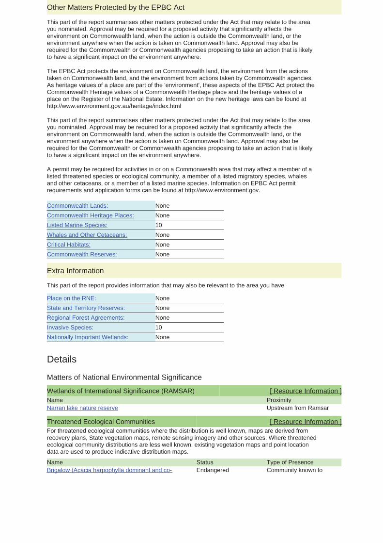
Details
Matters of National Environmental Significance
Wetlands of International Significance (RAMSAR) [ Resource Information ]Name ProximityNarran lake nature reserve Upstream from Ramsar
Threatened Ecological Communities [ Resource Information ]
Name
For threatened ecological communities where the distribution is well known, maps are derived fromrecovery plans, State vegetation maps, remote sensing imagery and other sources. Where threatenedecological community distributions are less well known, existing vegetation maps and point locationdata are used to produce indicative distribution maps.
Status Type of PresenceBrigalow (Acacia harpophylla dominant and co- Endangered Community known to
None
NoneNone10None
None
None
NoneNone
None
10
Other Matters Protected by the EPBC Act
Critical Habitats:Whales and Other Cetaceans:
Commonwealth Heritage Places:Listed Marine Species:
Commonwealth Reserves:
Commonwealth Lands:
This part of the report summarises other matters protected under the Act that may relate to the areayou nominated. Approval may be required for a proposed activity that significantly affects theenvironment on Commonwealth land, when the action is outside the Commonwealth land, or theenvironment anywhere when the action is taken on Commonwealth land. Approval may also berequired for the Commonwealth or Commonwealth agencies proposing to take an action that is likelyto have a significant impact on the environment anywhere.
This part of the report summarises other matters protected under the Act that may relate to the areayou nominated. Approval may be required for a proposed activity that significantly affects theenvironment on Commonwealth land, when the action is outside the Commonwealth land, or theenvironment anywhere when the action is taken on Commonwealth land. Approval may also berequired for the Commonwealth or Commonwealth agencies proposing to take an action that is likelyto have a significant impact on the environment anywhere.
The EPBC Act protects the environment on Commonwealth land, the environment from the actionstaken on Commonwealth land, and the environment from actions taken by Commonwealth agencies.As heritage values of a place are part of the 'environment', these aspects of the EPBC Act protect theCommonwealth Heritage values of a Commonwealth Heritage place and the heritage values of aplace on the Register of the National Estate. Information on the new heritage laws can be found athttp://www.environment.gov.au/heritage/index.html
A permit may be required for activities in or on a Commonwealth area that may affect a member of alisted threatened species or ecological community, a member of a listed migratory species, whalesand other cetaceans, or a member of a listed marine species. Information on EPBC Act permitrequirements and application forms can be found at http://www.environment.gov.
Extra Information
This part of the report provides information that may also be relevant to the area you have
State and Territory Reserves:
Nationally Important Wetlands:
Place on the RNE:
Regional Forest Agreements:Invasive Species:
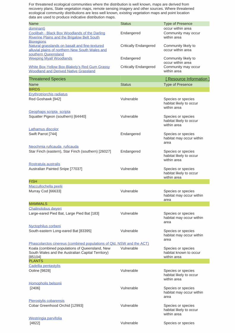
Name
For threatened ecological communities where the distribution is well known, maps are derived fromrecovery plans, State vegetation maps, remote sensing imagery and other sources. Where threatenedecological community distributions are less well known, existing vegetation maps and point locationdata are used to produce indicative distribution maps.
Status Type of Presencedominant) occur within areaCoolibah - Black Box Woodlands of the DarlingRiverine Plains and the Brigalow Belt SouthBioregions
Endangered Community may occurwithin area
Natural grasslands on basalt and fine-texturedalluvial plains of northern New South Wales andsouthern Queensland
Critically Endangered Community likely tooccur within area
Weeping Myall Woodlands Endangered Community likely tooccur within area
White Box-Yellow Box-Blakely's Red Gum GrassyWoodland and Derived Native Grassland
Critically Endangered Community may occurwithin area
Threatened Species [ Resource Information ]Name Status Type of PresenceBIRDS
Red Goshawk [942] Vulnerable Species or specieshabitat likely to occurwithin area
Erythrotriorchis radiatus
Squatter Pigeon (southern) [64440] Vulnerable Species or specieshabitat likely to occurwithin area
Geophaps scripta scripta
Swift Parrot [744] Endangered Species or specieshabitat may occur withinarea
Lathamus discolor
Star Finch (eastern), Star Finch (southern) [26027] Endangered Species or specieshabitat likely to occurwithin area
Neochmia ruficauda ruficauda
Australian Painted Snipe [77037] Vulnerable Species or specieshabitat likely to occurwithin area
Rostratula australis
FISH
Murray Cod [66633] Vulnerable Species or specieshabitat may occur withinarea
Maccullochella peelii
MAMMALS
Large-eared Pied Bat, Large Pied Bat [183] Vulnerable Species or specieshabitat may occur withinarea
Chalinolobus dwyeri
South-eastern Long-eared Bat [83395] Vulnerable Species or specieshabitat may occur withinarea
Nyctophilus corbeni
Koala (combined populations of Queensland, NewSouth Wales and the Australian Capital Territory)[85104]
Vulnerable Species or specieshabitat known to occurwithin area
Phascolarctos cinereus (combined populations of Qld, NSW and the ACT)
PLANTS
Ooline [9828] Vulnerable Species or specieshabitat likely to occurwithin area
Cadellia pentastylis
[2406] Vulnerable Species or specieshabitat may occur withinarea
Homopholis belsonii
Cobar Greenhood Orchid [12993] Vulnerable Species or specieshabitat likely to occurwithin area
Pterostylis cobarensis
[4822] Vulnerable Species or speciesWestringia parvifolia
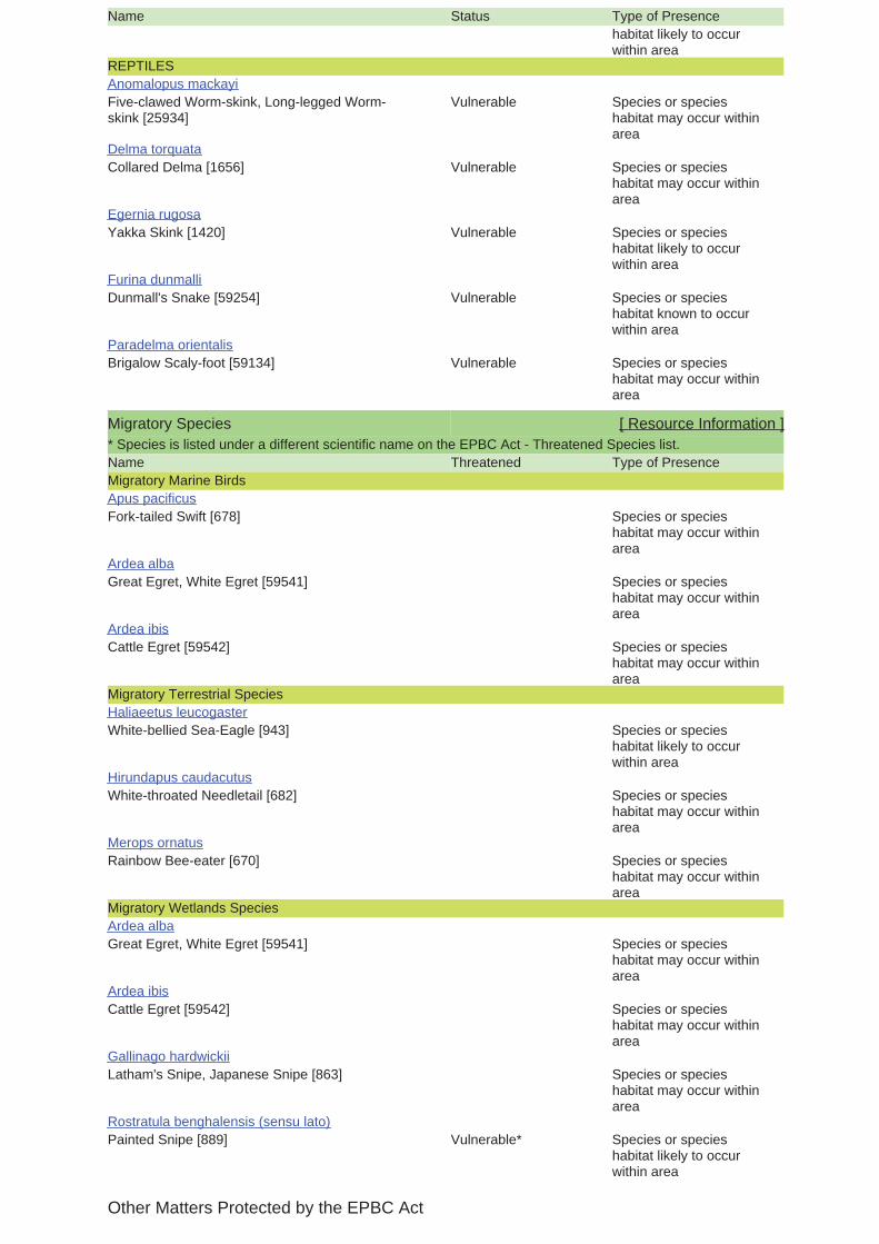
Name Status Type of Presencehabitat likely to occurwithin area
REPTILES
Five-clawed Worm-skink, Long-legged Worm-skink [25934]
Vulnerable Species or specieshabitat may occur withinarea
Anomalopus mackayi
Collared Delma [1656] Vulnerable Species or specieshabitat may occur withinarea
Delma torquata
Yakka Skink [1420] Vulnerable Species or specieshabitat likely to occurwithin area
Egernia rugosa
Dunmall's Snake [59254] Vulnerable Species or specieshabitat known to occurwithin area
Furina dunmalli
Brigalow Scaly-foot [59134] Vulnerable Species or specieshabitat may occur withinarea
Paradelma orientalis
Migratory Species [ Resource Information ]* Species is listed under a different scientific name on the EPBC Act - Threatened Species list.Name Threatened Type of PresenceMigratory Marine Birds
Fork-tailed Swift [678] Species or specieshabitat may occur withinarea
Apus pacificus
Great Egret, White Egret [59541] Species or specieshabitat may occur withinarea
Ardea alba
Cattle Egret [59542] Species or specieshabitat may occur withinarea
Ardea ibis
Migratory Terrestrial Species
White-bellied Sea-Eagle [943] Species or specieshabitat likely to occurwithin area
Haliaeetus leucogaster
White-throated Needletail [682] Species or specieshabitat may occur withinarea
Hirundapus caudacutus
Rainbow Bee-eater [670] Species or specieshabitat may occur withinarea
Merops ornatus
Migratory Wetlands Species
Great Egret, White Egret [59541] Species or specieshabitat may occur withinarea
Ardea alba
Cattle Egret [59542] Species or specieshabitat may occur withinarea
Ardea ibis
Latham's Snipe, Japanese Snipe [863] Species or specieshabitat may occur withinarea
Gallinago hardwickii
Painted Snipe [889] Vulnerable* Species or specieshabitat likely to occurwithin area
Rostratula benghalensis (sensu lato)
Other Matters Protected by the EPBC Act

Listed Marine Species [ Resource Information ]* Species is listed under a different scientific name on the EPBC Act - Threatened Species list.Name Threatened Type of PresenceBirds
Magpie Goose [978] Species or specieshabitat may occur withinarea
Anseranas semipalmata
Fork-tailed Swift [678] Species or specieshabitat may occur withinarea
Apus pacificus
Great Egret, White Egret [59541] Species or specieshabitat may occur withinarea
Ardea alba
Cattle Egret [59542] Species or specieshabitat may occur withinarea
Ardea ibis
Latham's Snipe, Japanese Snipe [863] Species or specieshabitat may occur withinarea
Gallinago hardwickii
White-bellied Sea-Eagle [943] Species or specieshabitat likely to occurwithin area
Haliaeetus leucogaster
White-throated Needletail [682] Species or specieshabitat may occur withinarea
Hirundapus caudacutus
Swift Parrot [744] Endangered Species or specieshabitat may occur withinarea
Lathamus discolor
Rainbow Bee-eater [670] Species or specieshabitat may occur withinarea
Merops ornatus
Painted Snipe [889] Vulnerable* Species or specieshabitat likely to occurwithin area
Rostratula benghalensis (sensu lato)
Extra Information
Invasive Species [ Resource Information ]Weeds reported here are the 20 species of national significance (WoNS), along with other introducedplants that are considered by the States and Territories to pose a particularly significant threat tobiodiversity. The following feral animals are reported: Goat, Red Fox, Cat, Rabbit, Pig, Water Buffaloand Cane Toad. Maps from Landscape Health Project, National Land and Water Resouces Audit,Name Status Type of PresenceFrogs
Cane Toad [1772] Species or specieshabitat likely to occurwithin area
Bufo marinus
Mammals

Name Status Type of Presence
Cat, House Cat, Domestic Cat [19] Species or specieshabitat likely to occurwithin area
Felis catus
Rabbit, European Rabbit [128] Species or specieshabitat likely to occurwithin area
Oryctolagus cuniculus
Pig [6] Species or specieshabitat likely to occurwithin area
Sus scrofa
Red Fox, Fox [18] Species or specieshabitat likely to occurwithin area
Vulpes vulpes
Plants
Prickly Acacia [6196] Species or specieshabitat may occur withinarea
Acacia nilotica subsp. indica
Hymenachne, Olive Hymenachne, Water Stargrass,West Indian Grass, West Indian Marsh Grass[31754]
Species or specieshabitat likely to occurwithin area
Hymenachne amplexicaulis
Parkinsonia, Jerusalem Thorn, Jelly Bean Tree,Horse Bean [12301]
Species or specieshabitat likely to occurwithin area
Parkinsonia aculeata
Parthenium Weed, Bitter Weed, Carrot Grass, FalseRagweed [19566]
Species or specieshabitat likely to occurwithin area
Parthenium hysterophorus
Salvinia, Giant Salvinia, Aquarium Watermoss,Kariba Weed [13665]
Species or specieshabitat likely to occurwithin area
Salvinia molesta
Caveat
-26.68861 150.22722Coordinates
For threatened ecological communities where the distribution is well known, maps are derived fromrecovery plans, State vegetation maps, remote sensing imagery and other sources. Where threatenedecological community distributions are less well known, existing vegetation maps and point locationdata are used to produce indicative distribution maps.
The information presented in this report has been provided by a range of data sources asacknowledged at the end of the report.
Only selected species covered by the following provisions of the EPBC Act have been mapped:
Not all species listed under the EPBC Act have been mapped (see below) and therefore a report is ageneral guide only. Where available data supports mapping, the type of presence that can bedetermined from the data is indicated in general terms. People using this information in making areferral may need to consider the qualifications below and may need to seek and consider other
- migratory and
This report is designed to assist in identifying the locations of places which may be relevant indetermining obligations under the Environment Protection and Biodiversity Conservation Act 1999. Itholds mapped locations of World Heritage and Register of National Estate properties, Wetlands ofInternational Importance, Commonwealth and State/Territory reserves, listed threatened, migratoryand marine species and listed threatened ecological communities. Mapping of Commonwealth landis not complete at this stage. Maps have been collated from a range of sources at various
For species where the distributions are well known, maps are digitised from sources such asrecovery plans and detailed habitat studies. Where appropriate, core breeding, foraging and roostingareas are indicated under 'type of presence'. For species whose distributions are less well known,point locations are collated from government wildlife authorities, museums, and non-governmentorganisations; bioclimatic distribution models are generated and these validated by experts. In somecases, the distribution maps are based solely on expert knowledge.
Please feel free to provide feedback via the Contact Us page.
GPO Box 787Canberra ACT 2601 Australia
Department of Sustainability, Environment, Water, Population and Communities© Commonwealth of Australia
+61 2 6274 1111
Acknowledgements
- migratory species that are very widespread, vagrant, or only occur in small numbersThe following groups have been mapped, but may not cover the complete distribution of the species:
Such breeding sites may be important for the protection of the Commonwealth Marine environment.- seals which have only been mapped for breeding sites near the Australian continent
The following species and ecological communities have not been mapped and do not appear inreports produced from this database:
- some species and ecological communities that have only recently been listed
- marine
- non-threatened seabirds which have only been mapped for recorded breeding sites
- some terrestrial species that overfly the Commonwealth marine area
- threatened species listed as extinct or considered as vagrants
This database has been compiled from a range of data sources. The department acknowledges thefollowing custodians who have contributed valuable data and advice:
-National Herbarium of NSW
-Parks and Wildlife Service NT, NT Dept of Natural Resources, Environment and the Arts
-Queensland Museum-Online Zoological Collections of Australian Museums
-Birds Australia
-State Forests of NSW
-University of New England
-Queensland Herbarium
-Environmental and Resource Management, Queensland
-Royal Botanic Gardens and National Herbarium of Victoria-Tasmanian Herbarium
-Australian National Herbarium, Atherton and Canberra
-Department of Environment and Conservation, Western Australia
-Australian Government, Department of Defence
-SA Museum
-State Herbarium of South Australia
-Department of Primary Industries, Parks, Water and Environment, Tasmania
-Australian National Wildlife Collection
-Department of Environment and Natural Resources, South Australia
-Western Australian Herbarium
The Department is extremely grateful to the many organisations and individuals who providedexpert advice and information on numerous draft distributions.
-Department of the Environment, Climate Change, Energy and Water
-Australian Museum
-Other groups and individuals
-Natural history museums of Australia
-Department of Environment, Climate Change and Water, New South Wales
-Museum Victoria
-Department of Sustainability and Environment, Victoria
-Australian Bird and Bat Banding Scheme
-Northern Territory Herbarium
-Ocean Biogeographic Information System
Ecology Assessment Report Lot 1 on RP 90330
Ref: Q-4579-15-RP-0001
Australia Pacific LNG ABN 68 001 646 331 Level 3, 135 Coronation Drive, Milton, QLD 4064
PO Box 148, Brisbane, QLD 4001 Telephone (07) 3858 0600 Facsimile (07) 3369 7840 originenergy.com.au
Page 42 of 44
Appendix B: Subject Species Table
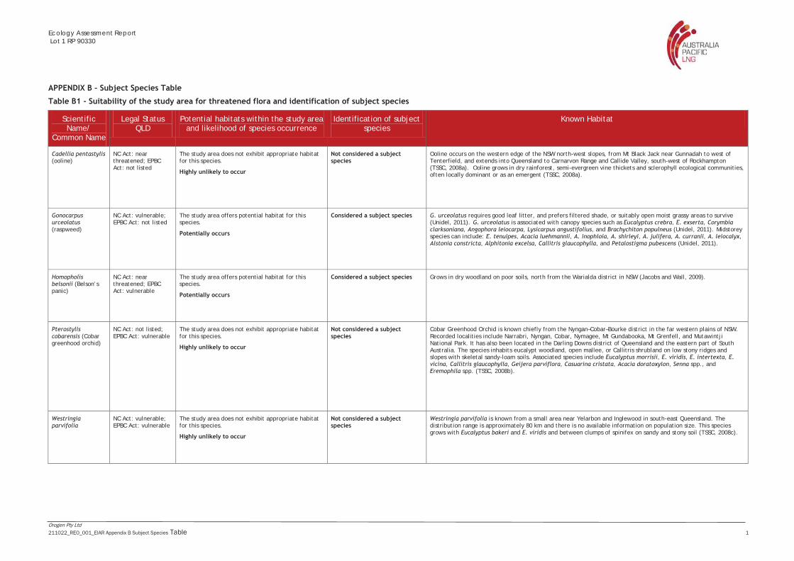
Ecology Assessment Report Lot 1 RP 90330
Orogen Pty Ltd 211022_REO_001_EIAR Appendix B Subject Species Table 1
APPENDIX B – Subject Species Table
Table B1 - Suitability of the study area for threatened flora and identification of subject species
Scientific Name/
Common Name
Legal Status QLD
Potential habitats within the study area and likelihood of species occurrence
Identification of subject species
Known Habitat
Cadellia pentastylis (ooline)
NC Act: near threatened; EPBC Act: not listed
The study area does not exhibit appropriate habitat for this species.
Highly unlikely to occur
Not considered a subject species
Ooline occurs on the western edge of the NSW north-west slopes, from Mt Black Jack near Gunnadah to west of Tenterfield, and extends into Queensland to Carnarvon Range and Callide Valley, south-west of Rockhampton (TSSC, 2008a). Ooline grows in dry rainforest, semi-evergreen vine thickets and sclerophyll ecological communities, often locally dominant or as an emergent (TSSC, 2008a).
Gonocarpus urceolatus (raspweed)
NC Act: vulnerable; EPBC Act: not listed
The study area offers potential habitat for this species.
Potentially occurs
Considered a subject species G. urceolatus requires good leaf litter, and prefers filtered shade, or suitably open moist grassy areas to survive (Unidel, 2011). G. urceolatus is associated with canopy species such as Eucalyptus crebra, E. exserta, Corymbia clarksoniana, Angophora leiocarpa, Lysicarpus angustifolius, and Brachychiton populneus (Unidel, 2011). Midstorey species can include: E. tenuipes, Acacia luehmannii, A. inophloia, A. shirleyi, A. julifera, A. curranii, A. leiocalyx, Alstonia constricta, Alphitonia excelsa, Callitris glaucophylla, and Petalostigma pubescens (Unidel, 2011).
Homopholis belsonii (Belson’s panic)
NC Act: near threatened; EPBC Act: vulnerable
The study area offers potential habitat for this species.
Potentially occurs
Considered a subject species Grows in dry woodland on poor soils, north from the Warialda district in NSW (Jacobs and Wall, 2009).
Pterostylis cobarensis (Cobar greenhood orchid)
NC Act: not listed; EPBC Act: vulnerable
The study area does not exhibit appropriate habitat for this species.
Highly unlikely to occur
Not considered a subject species
Cobar Greenhood Orchid is known chiefly from the Nyngan–Cobar–Bourke district in the far western plains of NSW. Recorded localities include Narrabri, Nyngan, Cobar, Nymagee, Mt Gundabooka, Mt Grenfell, and Mutawintji National Park. It has also been located in the Darling Downs district of Queensland and the eastern part of South Australia. The species inhabits eucalypt woodland, open mallee, or Callitris shrubland on low stony ridges and slopes with skeletal sandy-loam soils. Associated species include Eucalyptus morrisii, E. viridis, E. intertexta, E. vicina, Callitris glaucophylla, Geijera parviflora, Casuarina cristata, Acacia doratoxylon, Senna spp., and Eremophila spp. (TSSC, 2008b).
Westringia parvifolia
NC Act: vulnerable; EPBC Act: vulnerable
The study area does not exhibit appropriate habitat for this species.
Highly unlikely to occur
Not considered a subject species
Westringia parvifolia is known from a small area near Yelarbon and Inglewood in south-east Queensland. The distribution range is approximately 80 km and there is no available information on population size. This species grows with Eucalyptus bakeri and E. viridis and between clumps of spinifex on sandy and stony soil (TSSC, 2008c).
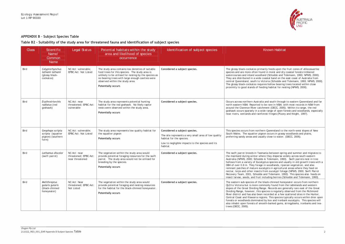
Ecology Assessment RepoLot 1 RP 90330
Orogen Pty Ltd 211022_REO_001_EIAR Appendix B Subject Species Table 2
APPENDIX B – Subject Species Table
Table B2 - Suitability of the study area for threatened fauna and identification of subject species
Class Scientific Name/
Common Name
Legal Status Potential habitats within the study area and likelihood of species
occurrence
Identification of subject species Known Habitat
Bird Calyptorhynchus lathami lathami (glossy black-cockatoo)
NC Act: vulnerable; EPBC Act: Not Listed
The study area contains low densities of suitable food trees for this species. The study area is unlikely to be utilised for nesting by the species as no bearing trees with large enough cavities were observed within the study area.
Potentially occurs
Considered a subject species.
The glossy black-cockatoo primarily feeds upon the fruit cones of Allocasuarina species and are more often found in moist and dry coastal forests timbered watercourses and inland woodland (Schodde and Tidemann, 1993; NPWS, 2000). They are distributed in a wide coastal band on the east coast of Australia from central Queensland, south to Victoria (Schodde and Tidemann, 1993; NPWS, 2000). The glossy black-cockatoo requires hollow bearing trees located within close proximity to good stands of feeding habitat for nesting (NPWS, 2000).
Bird Erythrotriorchis radiatus (red goshawk)
NC Act: near threatened; EPBC Act: vulnerable
The study area represents potential hunting habitat for the red goshawk. No likely raptor nests were observed within the study area.
Potentially occurs
Considered a subject species.
Occurs across northern Australia and south through to eastern Queensland and far north eastern NSW. Reported to be rare in NSW, with most records in NSW from around the Clarence River catchment (DECC, 2005). Within its range, the red goshawk occurs sparsely in a wide range of open forests and woodlands, especially near rivers, wetlands and rainforest fringes (Pizzey and Knight, 1997).
Bird Geophaps scripta scripta (squatter pigeon) (southern form)
NC Act: vulnerable; EPBC Act: Not Listed
The study area represents low quality habitat for the squatter pigeon
Potentially occurs
Considered a subject species.
The site represents a very small area of low quality habitat for the species.
Low to negligible impacts to the species and its habitat.
This species occurs from northern Queensland to the north-west slopes of New South Wales. The squatter pigeon occurs in grassy woodlands and plains, preferring sandy areas and usually close to water. (DECC, 2005).
Bird Lathamus discolor (swift parrot)
NC Act: near threatened; EPBC Act: near threatened
The vegetation within the study area would provide potential foraging resources for the swift parrot. The study area would not be utilised for breeding by the species.
Potentially occurs
Considered a subject species.
The swift parrot breeds in Tasmania between spring and summer and migrates to the mainland during winter where they disperse widely across south eastern Australia (NPWS, 2000; Schodde & Tidemann, 1993). Swift parrots nest in tree hollows from a variety of Eucalyptus species and usually in old growth trees with a DBH of over 0.8 m. They forage in woodlands, riparian vegetation, and also remnant patches of mature eucalypts in agricultural areas where they feed on nectar, lerps and other insects from eucalypt foliage (NPWS, 2000; Swift Parrot Recovery Team, 2001, Schodde and Tidemann, 1993). This species also feeds on insect larvae, seeds, and fruit including berries (Schodde and Tidemann, 1993).
Bird Melithreptus gularis gularis (black-chinned honeyeater)
NC Act: Near threatened; EPBC Act: Not Listed
The vegetation within the study area would provide potential foraging and nesting resources for the habitat for the black-chinned honeyeater.
Potentially occurs
Considered a subject species.
The eastern sub-species of the black-chinned honeyeater occurs from northern QLD to Victoria but is more commonly found from the tablelands and western slopes of the Great Dividing Range. Records are generally rare east of the Great Dividing Range, however, this species is regularly observed from the Richmond River district and has also been recorded at a few scattered sites in the Hunter, Central Coast and Illawarra regions. This species typically occurs within drier open forests or woodlands dominated by box and ironbark eucalypts. This species will also inhabit open forests of smooth-barked gums, stringybarks, ironbarks and tea-trees (DECC, 2005).

Ecology Assessment Report1 RP 90330
Orogen Pty Ltd 211022_REO_001_EIAR Appendix B Subject Species Table 3
Class Scientific Name/
Common Name
Legal Status Potential habitats within the study area and likelihood of species
occurrence
Identification of subject species Known Habitat
Bird Neochmia ruficauda ruficauda (star finch) (eastern/southern)
NC Act: near threatened; EPBC Act: near threatened
The vegetation within the study area represents low quality habitat for the star finch.
Potentially occurs
Considered a subject species.
The star finch (eastern/southern) occurs in central Qld and its population is extremely limited. The distribution of this subspecies is poorly known, and it has disappeared from much of its former range. The most recent records occur in an area from near Wowan, north to Bowen, west to beyond Winton. The Star Finch (eastern) occurs within the Desert Channels, Burdekin and Fitzroy (Qld) Natural Resource Management Regions. It has been recorded from damp grasslands, sedgelands or grassy woodlands near permanent water or areas of regular inundation. Occasionally, individuals have been reported in disturbed habitat and suburban areas (TSSC, 2008d).
Bird Rostratula australis (Australian painted snipe) (formally R. benghalensis australis and R. benghalensis s. lat.)
NC Act: vulnerable; EPBC Act: vulnerable (as R. australis) and Migratory
The study area does not exhibit appropriate habitat for this species.
Highly unlikely to occur
Not considered a subject species for the site. The Australian Painted Snipe primarily occurs along the east coast from North Queensland to Eyre Peninsula in South Australia. This species is often found in shallow inland wetlands that are both brackish and freshwater and is also found among fringes of swamps, dams and marshy areas (NPWS, 2000; DEH, 2003). This species nests on the ground among tall vegetation including grass tussocks or reeds and feeds near the water’s edge and on mudflats, taking invertebrates, such as insects and worms, and seeds (DEH, 2003; NPWS, 1999).
Fish Maccullochella peelii peelii (Murray cod)
NC Act: not listed; EPBC Act: vulnerable
The study area does not exhibit appropriate habitat for this species.
Highly unlikely to occur
Not considered a subject species for the site. The Murray cod is highly territorial and aggressive (DEWHA, 2003). It occurs in the waterways of the Murray–Darling Basin in a wide range of warm water habitats ranging from clear, rocky streams to slow flowing turbid rivers and billabongs (DEWHA, 2003). The upper reaches of the Murray and Murrumbidgee Rivers are considered too cold to contain suitable habitat (DEWHA, 2003).
Mammal Chalinolobus dwyeri (large-eared pied bat)
NC Act: Not Listed; EPBC Act: vulnerable
The vegetation within the site represents potential habitat for the large-eared pied bat. The study area lacks caves and is unlikely to support communal roosting.
Potentially occurs
Considered a subject species.
The large-eared pied bat is a recent discovery, first found in the early 1960's in Copeton NSW (Strahan 1995). Found in scattered locations from near Rockhampton in Queensland to Bungonia in southern NSW (Strahan 1995). It is generally found in drier habitats such as dry sclerophyll forests and woodlands, however, recent records include from sub alpine woodland and Rainforest edges. The Large-eared Pied bat is known to utilise day time roosts, including; caves, mine, tunnels and abandoned mud nests of Fairy Martins (Strahan 1995, and DECC, 2005).
Mammal Nyctophilus corbeni) south-eastern long-eared bat) (formally N. timoriensis)
NC Act: Not Listed; EPBC Act: vulnerable
The vegetation within the study area represents potential habitat for the eastern long-eared bat. The vegetation within the study area is limited to regrowth and contains few mature trees. Potential roosting resources are therefore limited and no hollow bearing trees were observed within the study area.
Potentially occurs
Considered a subject species.
Nyctophilus corbeni inhabits a range of dry woodland and shrubland communities in arid and semi-arid regions in the eastern mainland of Australia (Menkhorst and Knight, 2004). The species roosts mostly in tree hollows and forages low amongst the canopy and shrub layers (Menkhorst and Knight, 2004).

Ecology Assessment Report Lot 1 RP 90330
Orogen Pty Ltd 211022_REO_001_EIAR Appendix B Subject Species Table 4
Class Scientific Name/
Common Name
Legal Status Potential habitats within the study area and likelihood of species
occurrence
Identification of subject species Known Habitat
Mammal Phascolarctos cinereus (combined populations of Qld, NSW and the ACT) (koala)
NC Act: vulnerable (SE Qld bioregion); EPBC Act: Vulnerable
The vegetation within the study area represents potential habitat for the koala.
Potentially occurs
Considered a subject species Koalas inhabit a range of temperate, sub-tropical and tropical forest, woodland and semi-arid communities dominated by species from the genus Eucalyptus (DSEWPaC, 2012b). The distribution of Koalas is also affected by altitude (limited to <800m ASL), temperature and, at the western and northern ends of the range, leaf moisture (DSEWPaC, 2012b).
Reptile Anomalopus mackayi (five-clawed worm skink)
NC Act: Not Listed; EPBC Act: vulnerable
The study area does not exhibit appropriate habitat for this species.
Highly unlikely to occur
Not considered a subject species for the site. Open grasslands on heavy cracking soil in the Darling Downs (Wilson, 2005). It is normally found under dead grass and is largely confined to relict roadside verges (Wilson, 2005).
Reptile Delma torquata (collared delma)
NC Act: Not Listed; EPBC Act: vulnerable
The study area does not exhibit appropriate habitat for this species.
Highly unlikely to occur
Not considered a subject species for the site. The species occurs on rocky hillsides on basalt and lateritic soils supporting open eucalypt and Acacia woodland with a sparse understorey of shrubs and tussocks or semi-evergreen vine thicket (TSSC, 2008e).
Reptile Egernia rugosa (yakka skink)
NC Act: vulnerable; EPBC Act: vulnerable
The study area offers potential habitat for this species.
Potentially occurs
Considered a subject species.
Open dry sclerophyll forest or woodland. The core habitat of this species is within the Mulga Lands and Brigalow Belt South Bioregions. Often take refuge among dense ground vegetation, large hollow logs, cavities in soil-bound root systems of fallen trees and beneath rocks. Alternatively, this species may also excavate burrow systems among low vegetation or below logs. In cleared habitat, this species can persist where shelter sites such as tunnel erosion, rabbit warrens and log piles exist. This species is not generally found in trees or rocky habitats (TSN, 2009).
Reptile Furina dunmalli (Dunmall’s snake)
NC Act: Not Listed; EPBC Act: vulnerable
The study area offers potential habitat for this species.
Potentially occurs Considered a subject species.
Mainly on Darling Downs in Brigalow (Acacia harpophylla) forest and woodland growing on cracking black clay and clay loam soils. Preferred habitat includes fallen timber and ground litter. Also occurs in Eucalyptus and Callitris woodland (DECC, 2005).
Reptile Paradelma orientalis (brigalow scaly-foot)
NC Act: vulnerable; EPBC Act: vulnerable
The study area offers potential habitat for this species.
Potentially occurs Considered a subject species.
Brigalow Belt between the Carnarvon Ranges and Eena SF, and between the Chesterton Ranges and Boyne Island (TSSC, 2008f). Found in a wide variety of open forest habitats on several soil types, with specimens often found sheltering under sandstone slabs, surface debris or in grass hummocks (TSSC, 2008f). However, the species has also been collected on cultivated areas, suggesting persistence despite clearing (TSSC, 2008f).
Reptile Strophurus taenicauda (golden-tailed gecko)
NC Act: Near threatened; EPBC Act: Not Listed
The site contains potential habitat resources for the golden-tailed gecko. The vegetation within the study area is primarily regrowth and contains very limited hollow bearing trees for the species.
Potentially occurs
Considered a subject species.
The golden-tailed gecko occurs in the southern Brigalow Belt bioregion, in dry sclerophyll forests featuring a mix of ironbark eucalypts, cypress pine and brigalow. The golden-tailed gecko is an arboreal species, and shelters behind loose dead bark, in hollows or clings to exposed slender branches in dappled sunlight (Wilson, 2005).

Ecology Assessment Report Lot 1 on RP 90330
Ref: Q-4579-15-RP-0001
Australia Pacific LNG ABN 68 001 646 331 Level 3, 135 Coronation Drive, Milton, QLD 4064
PO Box 148, Brisbane, QLD 4001 Telephone (07) 3858 0600 Facsimile (07) 3369 7840 originenergy.com.au
Page 43 of 44
Appendix C: Wildlife Online Results

Wildlife Online Extract
Search Criteria: Species List for a Specified PointSpecies: AllType: AllStatus: Rare and threatened speciesRecords: AllDate: AllLatitude: 26.6883Longitude: 150.2274Distance: 10Email: [email protected] submitted: Wednesday 16 May 2012 13:47:15Date extracted: Wednesday 16 May 2012 13:50:03
The number of records retrieved = 4
Disclaimer
As the DERM is still in a process of collating and vetting data, it is possible the information given is not complete. The information provided should only be usedfor the project for which it was requested and it should be appropriately acknowledged as being derived from Wildlife Online when it is used.
The State of Queensland does not invite reliance upon, nor accept responsibility for this information. Persons should satisfy themselves through independentmeans as to the accuracy and completeness of this information.
No statements, representations or warranties are made about the accuracy or completeness of this information. The State of Queensland disclaims allresponsibility for this information and all liability (including without limitation, liability in negligence) for all expenses, losses, damagesand costs you may incur as a result of the information being inaccurate or incomplete in any way for any reason.

Kingdom Class Family Scientific Name Common Name I Q A Records
animals birds Cacatuidae Calyptorhynchus lathami glossy black-cockatoo V 1 animals birds Meliphagidae Melithreptus gularis black-chinned honeyeater NT 1 animals reptiles Diplodactylidae Strophurus taenicauda golden-tailed gecko NT 2/2plants higher dicots Haloragaceae Gonocarpus urceolatus V 2/2
CODESI - Y indicates that the taxon is introduced to Queensland and has naturalised.Q - Indicates the Queensland conservation status of each taxon under the Nature Conservation Act 1992. The codes are Extinct in the Wild (PE), Endangered (E),
Vulnerable (V), Near Threatened (NT), Least Concern (C) or Not Protected ( ).A - Indicates the Australian conservation status of each taxon under the Environment Protection and Biodiversity Conservation Act 1999. The values of EPBC are
Conservation Dependent (CD), Critically Endangered (CE), Endangered (E), Extinct (EX), Extinct in the Wild (XW) and Vulnerable (V).Records – The first number indicates the total number of records of the taxon for the record option selected (i.e. All, Confirmed or Specimens).This number is output as 99999 if it equals or exceeds this value. The second number located after the / indicates the number of specimen records for the taxon.This number is output as 999 if it equals or exceeds this value.
Page 1 of 1Department of Environment and Resource Management Wildlife Online - Extract Date 16/05/2012 at 13:50:03
Ecology Assessment Report Lot 1 on RP 90330
Ref: Q-4579-15-RP-0001
Australia Pacific LNG ABN 68 001 646 331 Level 3, 135 Coronation Drive, Milton, QLD 4064
PO Box 148, Brisbane, QLD 4001 Telephone (07) 3858 0600 Facsimile (07) 3369 7840 originenergy.com.au
Page 44 of 44
Appendix D: Species Observed on Site

Appendix D
APPENDIX D - Species Observed on Site
Table D1 - Flora Recorded During Orogen Fieldwork
Family Scientific Name Common Name Form
APOCYNACEAE Carissa ovata currant bush shrub
ASTERACEAE Chrysocephalum apiculatum yellow buttons herb
CHENOPODIACEAE Sclerolaena birchii* galvinised burr shrub
CUPRESSACEAE Callitris glaucophylla white cypress pine tree
CYPERACEAE Fimbristylis dichotoma common fringe rush sedge
MIMOSACEAE Acacia aprepta - shrub
MIMOSACEAE Acacia concurrens Curracabah shrub
MIMOSACEAE Acacia montana mallee wattle tree
MIMOSACEAE Acacia spectabilis - tree
MIMOSACEAE Acacia splendida - tree
MIMOSACEAE Acacia stenophylla river myall tree
MYRTACEAE Corymbia trachyphloia white bloodwood tree
MYRTACEAE Eucalyptus crebra narrow-leaved ironbark tree
MYRTACEAE Eucalyptus populnea poplar box tree
MYRTACEAE Eucalyptus tereticornis Queensland blue gum tree
POACEAE Aristida caput-medusae many-headed wire grass grass
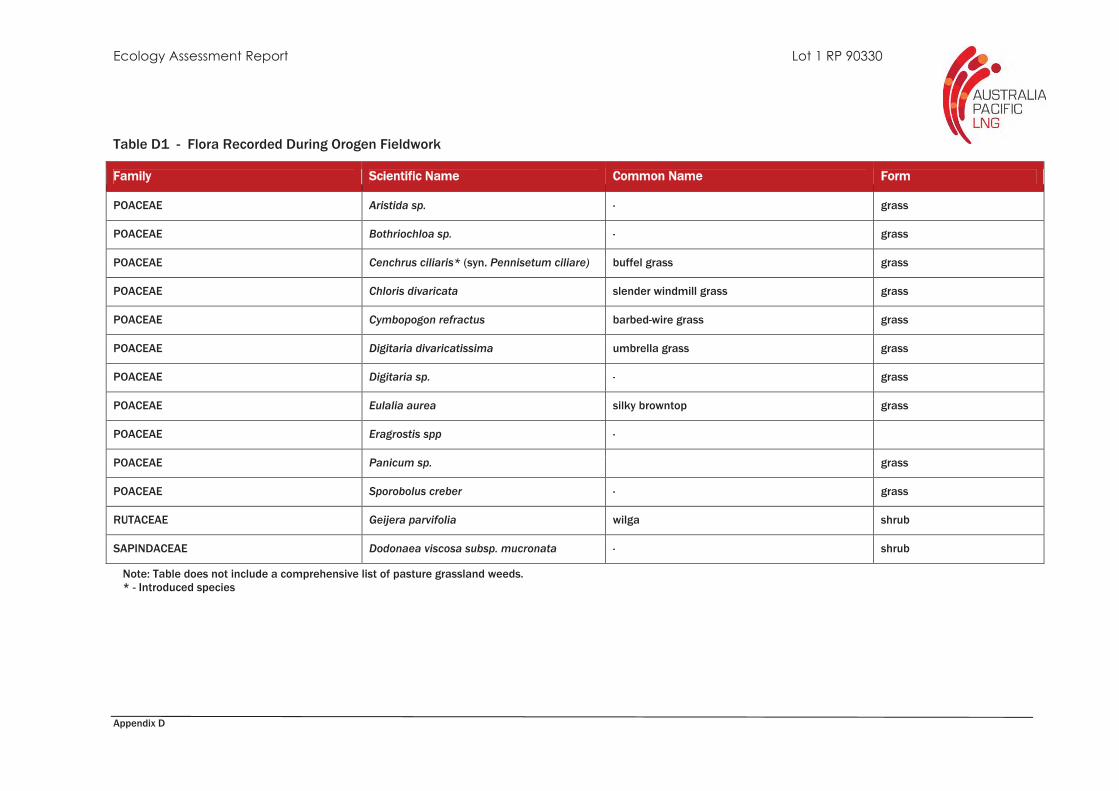
Appendix D
Table D1 - Flora Recorded During Orogen Fieldwork
Family Scientific Name Common Name Form
POACEAE Aristida sp. - grass
POACEAE Bothriochloa sp. - grass
POACEAE Cenchrus ciliaris* (syn. Pennisetum ciliare) buffel grass grass
POACEAE Chloris divaricata slender windmill grass grass
POACEAE Cymbopogon refractus barbed-wire grass grass
POACEAE Digitaria divaricatissima umbrella grass grass
POACEAE Digitaria sp. - grass
POACEAE Eulalia aurea silky browntop grass
POACEAE Eragrostis spp -
POACEAE Panicum sp. grass
POACEAE Sporobolus creber - grass
RUTACEAE Geijera parvifolia wilga shrub
SAPINDACEAE Dodonaea viscosa subsp. mucronata - shrub
Note: Table does not include a comprehensive list of pasture grassland weeds. * - Introduced species

Appendix D
APPENDIX D
Table D2 – Fauna Recorded During Orogen Fieldworks
Common Name Scientific Name
BIRDS
Australian magpie Gymnorhina tibicen
red-backed fairy wren Malurus melanocephalus
superb fairy wren Malurus cyaneus
Torresian crow Corvus orru
willy wagtail Rhipidura leucophrys
AMPHIBIANS
beeping froglet Crinia parinsignifera
clicking froglet Crinia signifera


![Untitled-1 []...Sponsorship Dana Usaha A cara Sponsorship Perlengkapan Pubdok Medis Keamanan Konsumsi BPH Rp. Rp. Rp. Rp. Rp Rp Rp Rp Rp Rp Rp Rp Rp. 4000.000,00 ...](https://static.fdocuments.net/doc/165x107/61443310aa0cd638b460b395/untitled-1-sponsorship-dana-usaha-a-cara-sponsorship-perlengkapan-pubdok.jpg)