Final drill results include further high-grade ... · 20 metres at 3.46% REO including 0.68% NdPr...
30
100 Pall Mall, St James, London, SW1Y 5NQ, United Kingdom www.pensana.co.uk *LSE: PRE; ASX: PM8, CN 12206525 4 August 2020 Final drill results include further high-grade intersections in fresh rock below pit design Pensana Rare Earths Plc (LSE: PRE, ASX: PM8) is pleased to report the final assay results from the last 86 holes of the 8,000 metre drill programme completed at the Longonjo NdPr Project in Angola. The programme is in support of a Bankable Feasibility Study which is due to be reported in mid‐October. The latest results confirm the continuity of the weathered zone mineralisation from surface and also outline a wide area of mineralisation in fresh rock immediately below the current pit design that could add an extra dimension to the project beyond the initial mine life. Initial Mine Plan: Latest and final results continue to confirm the continuity of high grade rare earth mineralisation from surface in the weathered zone. The Company expects to upgrade substantial amounts of Inferred mineralisation to higher categories, supporting an extended mine life. Fresh rock mineralisation ‐ adding a whole new dimension to the project: Wide, continuous high‐grade intersections grading 2% to 4% REO have been returned from the fresh rock immediately below the weathered zone. The mineralisation remains open below the 80 metre drill depth and to the north and west. The reported grades and potential size of the further mineralisation are very encouraging and whilst not currently included in the current Bankable Feasibility Studies work has commenced on including this mineralisation in the overall development of the project. New Mineral Resource estimate: Work has commenced on an updated Mineral Resource estimate to be reported in September 2020. For personal use only
Transcript of Final drill results include further high-grade ... · 20 metres at 3.46% REO including 0.68% NdPr...

100 Pall Mall, St James, London, SW1Y 5NQ, United Kingdom www.pensana.co.uk *LSE: PRE; ASX: PM8, CN 12206525
4 August 2020
Final drill results include further high-grade intersections in fresh rock below pit design
Pensana Rare Earths Plc (LSE: PRE, ASX: PM8) is pleased to report the final assay
results from the last 86 holes of the 8,000 metre drill programme completed at the
Longonjo NdPr Project in Angola.
The programme is in support of a Bankable Feasibility Study which is due to be
reported in mid‐October.
The latest results confirm the continuity of the weathered zone mineralisation
from surface and also outline a wide area of mineralisation in fresh rock
immediately below the current pit design that could add an extra dimension to the
project beyond the initial mine life.
Initial Mine Plan: Latest and final results continue to confirm the continuity
of high grade rare earth mineralisation from surface in the weathered zone.
The Company expects to upgrade substantial amounts of Inferred
mineralisation to higher categories, supporting an extended mine life.
Fresh rock mineralisation ‐ adding a whole new dimension to the project:
Wide, continuous high‐grade intersections grading 2% to 4% REO have been
returned from the fresh rock immediately below the weathered zone. The
mineralisation remains open below the 80 metre drill depth and to the north
and west. The reported grades and potential size of the further
mineralisation are very encouraging and whilst not currently included in the
current Bankable Feasibility Studies work has commenced on including this
mineralisation in the overall development of the project.
New Mineral Resource estimate: Work has commenced on an updated
Mineral Resource estimate to be reported in September 2020.
For
per
sona
l use
onl
y

Intersection highlights from the new drill results include:
Weathered Zone:
Drill hole Intersection*
LRC295: 18 metres at 7.93% REO including 1.50% NdPr from surface
LRC298: 22 metres at 6.69% REO including 1.30% NdPr from surface
LRC310: 22 metres at 5.61% REO including 1.11% NdPr from surface
LRC344: 14 metres at 5.37% REO including 1.01% NdPr from surface *NdPr = neodymium – praseodymium oxide. REO = total rare earth oxides. Intersections reported
at a +0.4% NdPr lower grade cut off. See Table 1 for details of all new results, including wider
intersections at a +0.2% NdPr cut
Fresh Rock:
Drill hole Intersection
LRC274: 18 metres at 4.40% REO including 0.86% NdPr from 44 metres and
10 metres at 3.90% REO including 0.76% NdPr from 66 metres
LRC293: 24 metres at 3.64% REO including 0.60% NdPr from 28 metres and
8 metres at 4.45% REO including 0.79% NdPr from 58 metres
LRC289: 14 metres at 3.23% REO including 0.64% NdPr from 18 metres and
20 metres at 3.46% REO including 0.68% NdPr from 60 metres to end
of hole *NdPr = neodymium – praseodymium oxide. REO = total rare earth oxides. Intersections reported
at a +0.4% NdPr lower grade cut off. See Table 1 for details of all new results, including wider
intersections at a +0.2% NdPr cut
Executive Director & COO Dave Hammond commented:
“These final results have further highlighted the world‐class opportunity at the
Longonjo Project. The drilling continues to prove the continuity of the weathered
mineralisation, returning significant grades from surface outside of our current
mine plan. We expect these infill drilling results will allow us to upgrade the existing
resource categories and extend the mine life.
For
per
sona
l use
onl
y

Further drill testing of the fresh rock zone, which is not in the current mine plan, has
also exceeded expectations. With many holes ending in mineralisation at eighty
metres depth, identifying several open positions, the potential for a sizeable deposit
of this second style of mineralisation is an exciting possibility.
All assay results have now been received, and SRK Consulting has commenced the
estimation process. We look forward to reporting a new Mineral Resource estimate
in September.”
Authorised by the Board of Pensana Rare Earths Plc For further information:
Pensana Rare Earths Plc
Website:
Paul Atherley Chairman / Tim George, CEO
www.pensana.co.uk
Buchanan (UK Financial PR)
Bobby Morse/ Augustine Chipungu /James
Husband
+44 (0) 207 466 5000
For
per
sona
l use
onl
y
Technical Report
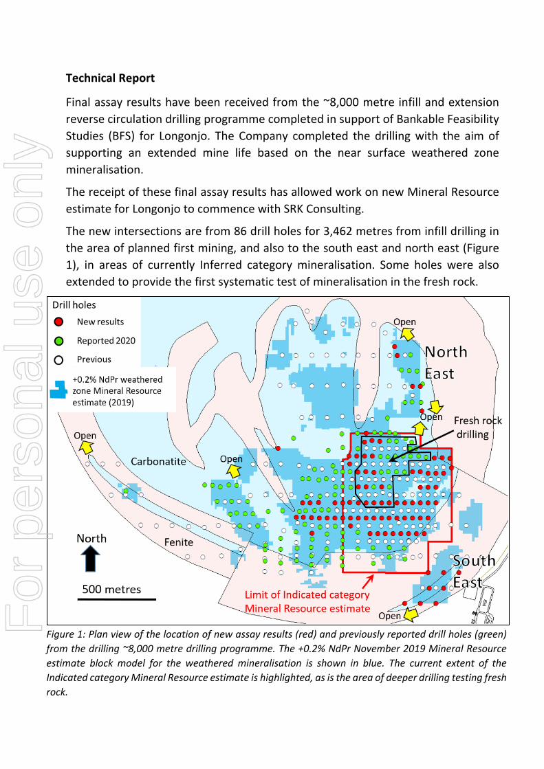
Final assay results have been received from the ~8,000 metre infill and extension
reverse circulation drilling programme completed in support of Bankable Feasibility
Studies (BFS) for Longonjo. The Company completed the drilling with the aim of
supporting an extended mine life based on the near surface weathered zone
mineralisation.
The receipt of these final assay results has allowed work on new Mineral Resource
estimate for Longonjo to commence with SRK Consulting.
The new intersections are from 86 drill holes for 3,462 metres from infill drilling in
the area of planned first mining, and also to the south east and north east (Figure
1), in areas of currently Inferred category mineralisation. Some holes were also
extended to provide the first systematic test of mineralisation in the fresh rock.
Figure 1: Plan view of the location of new assay results (red) and previously reported drill holes (green)
from the drilling ~8,000 metre drilling programme. The +0.2% NdPr November 2019 Mineral Resource
estimate block model for the weathered mineralisation is shown in blue. The current extent of the
Indicated category Mineral Resource estimate is highlighted, as is the area of deeper drilling testing fresh
rock.
For
per
sona
l use
onl
y

See ASX announcement 15 November 2019 for Mineral Resource estimate and PFS
mine plan details. All material assumptions and technical parameters underpinning
the estimates continue to apply and have not materially changed.
The drill spacing in the majority of the project is now closed to 50 x 100 metres or
closer, which is expected to support the upgrade of Inferred to Indicated and
thereby support an extended mine life as the majority of the Inferred mineralisation
was excluded from the PFS mine plan.
Infill and fresh rock drilling
Additional high grade intersections from the area of proposed first mining continue
to demonstrate the continuity of the weathered mineralisation from surface. The 50
x 50 metre hole spacing is expected to provide the detailed data required to support
an upgrade of the current Indicated to a Measured mineral resource.
Highlights of the numerous new high grade weathered zone intersections from
surface include:
Drill hole Intersection*
LRC289: 16 metres at 5.08% REO including 1.00% NdPr from surface
LRC295: 18 metres at 7.93% REO including 1.50% NdPr from surface
LRC298: 22 metres at 6.69% REO including 1.30% NdPr from surface
LRC303: 16 metres at 5.05% REO including 0.91% NdPr from surface
LRC310: 22 metres at 5.61% REO including 1.11% NdPr from surface
LRC316: 10 metres at 5.11% REO including 0.99% NdPr from surface
LRC344: 14 metres at 5.37% REO including 1.01% NdPr from surface *NdPr = neodymium – praseodymium oxide. REO = total rare earth oxides. Intersections reported
at a +0.4% NdPr lower grade cut off. Refer appendix‐ Table 1 for details of all new results, including
wider intersections at a +0.2% NdPr cut
For
per
sona
l use
onl
y

Figure 2: Location of new drilling results (red) in the area of initial proposed mining within the PFS open pit.
Intersection highlights are shown over the +0.2% NdPr November 2019 Mineral Resource estimate block
model (blue) for the weathered mineralisation (see Figure 1 for location).
Figure 3: Vertical east – west section 8,570,950mN looking north. New results include some very high
grades and prove the continuity of weathered mineralisation from surface. See Figure 2 for location.
For
per
sona
l use
onl
y

Holes were extended through the weathered zone to 80 metres depth to test a 450
x 300 metre area of potential fresh rock mineralisation at a 50 x 100 metre hole
spacing. This provided the first systematic test of the fresh rock potential. Fresh rock
mineralisation is excluded from the current BFS studies. The drilling identified thick
continuous zones of +0.2% NdPr mineralisation (see Table 1) hosted within
unweathered carbonatite breccia and including higher grade zones at a 0.4% NdPr
grade cut:
Drill hole Intersection*
LRC274: 18 metres at 4.40% REO including 0.86% NdPr from 44 metres and
10 metres at 3.90% REO including 0.76% NdPr from 66 metres
LRC277: 10 metres at 3.60% REO including 0.90% NdPr from 70 metres to end
of hole
LRC278: 10 metres at 4.65% REO including 0.77% NdPr from 68 metres to end
of hole
LRC289: 14 metres at 3.23% REO including 0.64% NdPr from 18 metres and
20 metres at 3.46% REO including 0.68% NdPr from 60 metres to end
of hole
LRC293: 24 metres at 3.64% REO including 0.60% NdPr from 28 metres and
8 metres at 4.45% REO including 0.79% NdPr from 58 metres
LRC301: 6 metres at 3.26% REO including 0.60% NdPr from 28 metres and
12 metres at 3.73% REO including 0.63% NdPr from 38 metres * Intersections reported at a +0.4% NdPr lower grade cut off. Refer Appendix‐ Table 1 for details
of all new results, including wider intersections at a +0.2% NdPr cut.
With fresh rock hosted mineralisation in the 2 to +4% REO range open at depth and in
many directions (see cross sections, Figures 4 and 5), the potential for widespread fresh
rock hosted mineralisation is substantial.
The Company has commenced metallurgical test work to evaluate the processing of this
second style of mineralisation which, if successful, could add substantially to the mine
life of the initial weathered zone – based project.
For
per
sona
l use
onl
y

Figures 4 and 5: Vertical east – west section 8,571,050mN (above) and 8,571,350mN (below) looking
north See Figure 2 for location. New results demonstrate continuous mineralisation and include some
very high grade intersections in both the weathered zone and immediately beneath in fresh rock.
For
per
sona
l use
onl
y
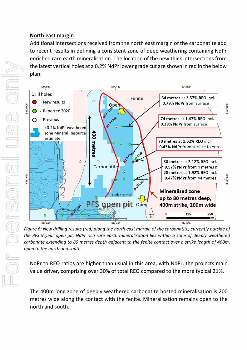
North east margin
Additional intersections received from the north east margin of the carbonatite add
to recent results in defining a consistent zone of deep weathering containing NdPr
enriched rare earth mineralisation. The location of the new thick intersections from
the latest vertical holes at a 0.2% NdPr lower grade cut are shown in red in the below
plan:
Figure 6: New drilling results (red) along the north east margin of the carbonatite, currently outside of
the PFS 9 year open pit. NdPr rich rare earth mineralisation lies within a zone of deeply weathered
carbonate extending to 80 metres depth adjacent to the fenite contact over a strike length of 400m,
open to the north and south.
NdPr to REO ratios are higher than usual in this area, with NdPr, the projects main
value driver, comprising over 30% of total REO compared to the more typical 21%.
The 400m long zone of deeply weathered carbonatite hosted mineralisation is 200
metres wide along the contact with the fenite. Mineralisation remains open to the
north and south.
For
per
sona
l use
onl
y

South East
Eight vertical holes were completed to test the continuity of mineralisation within
thick transported gravels and deeply weathered carbonatite beneath. Previous and
new intersections in this south east area of the project (see Figure 1 for location)
show mineralisation to continue over a 400 strike length where it remains open to
the south west and north east (Figure 7).
Figure 7: New drilling results (red) in the south west area. Mineralisation remains open to the north
east and south west over a strike length of 400m, open to the north and south.
In summary, the ~8,000 metre drilling programme completed at Longonjo from
November 2019 to March 2020 has been successful in:
demonstrating the continuity of mineralisation in the weathered zone
o to support the upgrade of Inferred to Indicated category, and thereby supporting an extended mine life
o and to upgrade Indicated to Measured in the area of proposed first
mining
proving extensions to weathered zone mineralisation in some areas
identifying thick zones of primary mineralisation within fresh bedrock
immediately beneath the weathered zone
For
per
sona
l use
onl
y

The plan below provides an overview of the maximum NdPr% grade distribution
from all drill holes within the weathered zone. The extent of the November 2019
Mineral Resource block model is shown in blue. The extensive areas of consistent
high grade mineralisation (green, red and purple) both within and outside of the PFS
9 year pit illustrate the potential to extend the mine in many areas on successful
completion of the Bankable Feasibility technical programmes currently in progress.
Figure 8: Maximum downhole NdPr% in the weathered zone in 2 metre samples with 9 year PFS open
pit and Mineral Resource estimate block model extents. Mineralisation remains open in several
positions.
With all assay results now received, SRK Consulting have commenced work on a
revised Mineral Resource estimate for Longonjo that will incorporate the new data
from the ~8,000 metre drilling programme.
The new Mineral Resource estimate is on track for completion in September 2020
and will form the basis of the BFS mine plan.
For
per
sona
l use
onl
y

Competent Persons Statement
The information in this report that relates to Geology, Data Quality and Exploration results is based on
information compiled and/or reviewed by David Hammond, who is a Member of The Australasian Institute of
Mining and Metallurgy. David Hammond is the Chief Operating Officer and a Director of the Company. He has
sufficient experience which is relevant to the style of mineralisation and type of deposit under consideration
and the activity which he is undertaking to qualify as a Competent Person in terms of the 2012 Edition of the
Australian Code for the Reporting of Exploration Results, Mineral Resources and Ore Reserves. David
Hammond consents to the inclusion in the report of the matters based on his information in the form and
contest in which it appears.
The information in this statement that relates to the 2019 Mineral Resource estimates is based on work done
by Rodney Brown of SRK Consulting (Australasia) Pty Ltd. Rodney Brown is a member of The Australasian
Institute of Mining and Metallurgy and has sufficient experience that is relevant to the style of mineralisation
and type of deposit under consideration, and to the activity he is undertaking, to qualify as a Competent Person
in terms of The Australasian Code for Reporting of Exploration Results, Mineral Resources and Ore Reserves
(JORC Code 2012 edition).
The Company confirms that it is not aware of any new information or data that materially affects the information included in the above original market announcements. The Company confirms that the form and context in which the Competent Person’s findings are presented have not been materially modified from the original market announcement. This announcement contains inside information for the purposes of Article 7 of Regulation (EU) 596/2014
For
per
sona
l use
onl
y

Appendix
Table 1: Longonjo NdPr Project, RC drill intersections at least 4m thick and ≥0.20% NdPr lower
grade cut. Intersections > 0.40% NdPr lower grade cut shown in bold italics
Hole ID East North RL
Hole
Depth
(m)
From
(m)
To
(m) Interval (m) REO % NdPr %
LRC274 524,249 8,571,054 1,592 80
(incl.
and
and
0
0
44
66
80
28
62
76
80eoh
28
18
10
3.49
4.40
4.19
3.92
0.68
0.86
0.79
0.76)
LRC277 524,202 8,571,150 1,602 80
(incl.
and
and
and
0
0
32
52
70
80
16
38
62
80
80eoh
16
6
10
10eoh
2.26
3.05
2.37
2.47
3.60
0.50
0.71
0.46
0.52
0.77)
LRC278 524,150 8,571,053 1,596 80
0
68
12
78
12
10
4.08
4.65
0.73
0.90
LRC279 524,149 8,571,152 1,605 80
(incl.
and
(incl.
0
0
56
68
72
62
54
60
80
76
62
54
4
12eoh
4
3.95
4.26
2.15
2.23
4.02
0.79
0.85
0.43)
0.47
0.80)
LRC280 524,099 8,571,054 1,599 80
(incl.
and
0
0
18
48
42
14
22
56
42
14
4
8
2.90
4.43
3.42
1.52
0.51
0.79
0.56)
0.31
LRC281 524,099 8,571,151 1,608 80
(incl.
(incl.
and
0
0
12
16
32
72
8
6
50
30
42
76
8
6
38
14
10
4
3.02
3.56
2.22
2.78
2.23
1.28
0.65
0.76)
0.47
0.58
0.43)
0.29
LRC289 524,238 8,571,349 1,625 80 0 80 80eoh 3.03 0.61
For
per
sona
l use
onl
y

Hole ID East North RL
Hole
Depth
(m)
From
(m)
To
(m) Interval (m) REO % NdPr %
(incl.
and
and
0
18
60
16
32
80
16
14
20eoh
5.08
3.23
3.46
1.00
0.64
0.68)
LRC290 524,193 8,571,252 1,614 80
(incl.
and
and
0
22
26
52
68
18
80
34
66
78
18
58
8
14
10
3.44
2.13
2.23
2.29
3.49
0.84
0.46
0.50
0.50
0.67)
LRC291 524,187 8,571,353 1,629 80
(incl.
and
and
and
0
0
52
70
76
80
46
56
74
80
80eoh
46
4
4
4eoh
2.80
3.40
2.05
2.70
3.01
0.56
0.67
0.42
0.53
0.59)
LRC292 524,140 8,571,250 1,617 80
(incl.
and
and
and
0
0
24
30
64
80
22
28
36
78
80eoh
22
4
6
14
2.40
2.81
2.58
2.74
3.17
0.50
0.64
0.51
0.54
0.59)
LRC293 524,138 8,571,344 1,630 80
(incl.
and
and
and
0
0
28
58
72
80
24
52
66
80
80eoh
24
24
8
8eoh
3.42
4.30
3.64
4.45
2.76
0.67
1.01
0.60
0.79
0.51)
LRC294 524,249 8,570,950 1,585 85
(incl.
and
and
0
0
38
48
58
26
44
56
58
26
6
8
3.19
4.90
2.60
2.67
0.65
1.00
0.43
0.59)
LRC295 524,149 8,570,951 1,588 85
(incl.
(incl.
0
0
52
64
46
18
82
78
46
18
30
14
4.29
7.93
2.09
2.70
0.83
1.50)
0.42
0.54)
LRC296 524,300 8,570,950 1,583 85 0 52 52 2.55 0.52
For
per
sona
l use
onl
y

Hole ID East North RL
Hole
Depth
(m)
From
(m)
To
(m) Interval (m) REO % NdPr %
(incl.
and
0
30
22
46
22
16
3.47
2.55
0.70
0.52)
LRC297 524,099 8,570,951 1,590 30 2 30 28eoh 4.46 0.92
LRC298 524,045 8,570,951 1,591 30
(incl.
0
0
28
22
28
22
5.55
6.69
1.08
1.30)
LRC299 524,349 8,570,949 1,581 39
(incl.
and
0
0
14
34
32
8
30
38
32
8
16
4
1.94
3.22
1.79
1.13
0.50
0.73
0.51)
0.28
LRC300 523,997 8,570,950 1,591 32
(incl.
and
0
0
24
30
16
28
30
16
4
2.75
3.80
2.08
0.57
0.76
0.53)
LRC301 524,200 8,570,950 1,587 85
(incl.
and
and
0
0
28
38
54
68
82
52
26
34
50
66
78
85
52
26
6
12
12
10
3eoh
3.37
3.93
3.26
3.73
1.46
1.25
1.61
0.63
0.77
0.60
0.63)
0.28
0.24
0.29
LRC302 523,950 8,570,951 1,589 22
(incl.
0
0
8
6
8
6
2.36
2.79
0.51
0.61)
LRC303 523,843 8,570,951 1,578 27
(incl.
0
0
27
16
27eoh
16
3.56
5.05
0.65
0.91)
LRC304 523,790 8,570,951 1,572 29
(incl.
0
0
20
14
12
28
14
12
8
3.85
4.35
1.29
0.88
0.98)
0.32
LRC305 524,051 8,570,801 1,586 39
(incl.
and
0
0
8
28
4
22
28
4
14
2.31
2.09
3.27
0.56
0.53
0.80)
LRC306 523,740 8,570,951 1,566 25 0 12 12 2.10 0.46
For
per
sona
l use
onl
y
Hole ID East North RL
Hole
Depth
(m)
From
(m)
To
(m) Interval (m) REO % NdPr %
(incl.
16
16
25
20
9eoh
4
1.90
3.11
0.35
0.57)
LRC307 523,801 8,570,757 1,568 27
(incl.
and
0
0
10
26
6
16
26
6
6
2.12
2.36
3.04
0.49
0.63
0.67)
LRC308 523,699 8,570,860 1,556 20
(incl.
0
0
20
4
20eoh
4
2.33
3.34
0.51
0.68)
LRC310 524,172 8,570,750 1,581 42
(incl.
0
0
24
22
24
22
5.30
5.61
1.04
1.11)
LRC311 523,750 8,570,859 1,563 32
(incl.
0
0
24
10
24
10
2.55
4.22
0.56
0.93)
LRC312 524,226 8,570,750 1,578 36
(incl.
and
0
0
26
36
14
36
36eoh
14
10eoh
2.94
4.59
2.21
0.58
0.89
0.45)
LRC313 523,799 8,570,856 1,568 36
(incl.
and
and
0
0
14
24
36
10
20
32
36eoh
10
6
8
2.47
2.61
4.26
2.62
0.60
0.56
1.10
0.69)
LRC314 524,274 8,570,750 1,575 27
(incl.
and
0
0
10
24
6
20
24
6
10
2.68
3.54
3.36
0.58
0.77
0.71)
LRC315 523,850 8,570,852 1,573 30
(incl.
0
0
28
18
28
18
2.59
3.29
0.65
0.84)
LRC316 524,325 8,570,750 1,573 19
(incl.
0
0
19
10
19eoh
10
3.55
5.11
0.69
0.99)
LRC317 524,374 8,570,750 1,571 42
(incl.
0
0
36
8
4
40
8
4
4
2.82
4.25
2.92
0.59
0.90)
0.56
LRC318 523,900 8,570,854 1,577 30 0
22
16
30
16
8eoh
2.04
1.40
0.46
0.32
For
per
sona
l use
onl
y

Hole ID East North RL
Hole
Depth
(m)
From
(m)
To
(m) Interval (m) REO % NdPr %
LRC319 524,434 8,570,750 1,568 26
(incl.
0
0
8
6
8
6
2.79
3.28
0.58
0.68)
LRC320 523,951 8,570,852 1,582 25
(incl.
0
0
24
22
24
22
3.05
3.16
0.62
0.64)
LRC321 524,475 8,570,752 1,566 29
(incl.
and
0
0
24
29
18
29
29eoh
18
5eoh
3.50
4.15
3.77
0.60
0.74
0.54)
LRC322 524,001 8,570,850 1,585 24
(incl.
0
4
18
8
18
4
2.08
2.88
0.41
0.62)
LRC323 524,526 8,570,752 1,564 20 0 4 4 2.07 0.42
LRC324 524,051 8,570,851 1,587 26
(incl.
and
and
0
0
6
14
26
4
12
18
26eoh
4
6
4
1.90
2.69
2.46
2.13
0.42
0.60
0.54
0.47)
LRC325 524,749 8,570,499 1,547 39
(incl.
0
0
28
12
10
34
12
10
6
2.06
2.12
1.37
0.50
0.52)
0.47)
LRC326 524,100 8,570,850 1,585 44
(incl.
and
0
0
22
42
20
32
42
20
10
3.14
3.84
3.95
0.71
0.83
0.97)
LRC327 524,151 8,570,849 1,583 46
(incl.
and
0
0
22
46
20
28
46eoh
20
6
2.26
2.94
2.30
0.51
0.65
0.55)
LRC328 524,548 8,570,500 1,548 40
(incl.
and
0
0
22
32
30
10
30
36
30
10
8
4
2.05
2.80
2.24
1.90
0.48
0.57
0.60)
0.52
LRC329 524,200 8,570,849 1,581 44
(incl.
and
0
0
26
44
14
30
44eoh
14
4
1.81
2.88
1.55
0.42
0.66
0.42)
For
per
sona
l use
onl
y

Hole ID East North RL
Hole
Depth
(m)
From
(m)
To
(m) Interval (m) REO % NdPr %
LRC330 524,649 8,570,500 1,548 55
(incl.
(incl.
0
0
30
32
10
8
54
50
10
8
24
18
2.25
2.57
1.75
2.02
0.52
0.57)
0.54
0.63)
LRC331 524,249 8,570,849 1,580 30
(incl.
0
0
24
10
24
10
2.33
3.81
0.53
0.87)
LRC332 524,651 8,570,400 1,543 37
(incl.
0
14
20
18
20
4
1.51
2.08
0.40
0.60)
LRC333 524,300 8,570,851 1,578 28
(incl.
0
0
28
12
28eoh
12
2.85
4.92
0.61
1.04)
LRC334 524,350 8,570,850 1,576 26
(incl.
and
0
0
14
24
8
22
24
8
8
2.39
3.21
2.54
0.52
0.70
0.54)
LRC335 524,399 8,570,850 1,574 44
(incl.
0
0
38
28
38
28
2.88
3.41
0.62
0.75)
LRC336 524,450 8,570,850 1,572 45
(incl.
0
0
30
6
4
45
6
4
15eoh
2.28
2.94
1.81
0.48
0.60)
0.35
LRC337 524,511 8,571,547 1,729 36
(incl.
0
2
12
6
12
4
1.56
1.85
0.35
0.45)
LRC338 524,559 8,570,398 1,543 24
(incl.
0
0
18
16
18
16
2.55
2.71
0.53
0.56)
LRC339 524,597 8,570,302 1,538 36 0
12
28
6
26
34
6
14
6
1.13
0.97
0.68
0.26
0.28
0.21
LRC340 524,500 8,571,700 1,725 70
(incl.
and
and
and
0
0
10
24
36
70
8
18
28
64
70eoh
8
8
4
28
1.62
1.76
1.70
1.57
2.01
0.43
0.47
0.48
0.49
0.52)
For
per
sona
l use
onl
y

Hole ID East North RL
Hole
Depth
(m)
From
(m)
To
(m) Interval (m) REO % NdPr %
LRC341 524,498 8,570,301 1,537 20
(incl.
0
0
10
8
10
8
2.67
3.03
0.54
0.60)
LRC342 524,398 8,570,301 1,537 24 0 4 4 1.53 0.27
LRC343 524,449 8,571,700 1,713 83
(incl.
and
0
0
24
74
14
28
74
14
4
1.47
1.51
1.53
0.38
0.42
0.44)
LRC344 524,590 8,571,237 1,611 20
(incl.
0
0
20
14
20eoh
14
4.49
5.37
0.85
1.01)
LRC345 524,639 8,571,243 1,611 12
(incl.
0
0
10
4
10
4
2.08
3.41
0.42
0.69)
LRC346 524,700 8,571,178 1,591 24 NSI
LRC347 524,649 8,571,140 1,588 23 0 14 14 4.01 0.75
LRC348 524,351 8,571,898 1,690 40
(incl.
0
0
19
10
19
10
2.02
2.88
0.48
0.70)
LRC349 524,605 8,571,141 1,590 25
(incl.
and
0
0
10
24
6
14
24
6
4
2.01
3.94
1.86
0.50
0.96
0.49)
LRC350 524,549 8,571,140 1,592 26 0 12 12 2.22 0.55
LRC351 524,335 8,571,957 1,683 33 NSI
LRC352 524,497 8,571,150 1,594 24 0 6 6 1.53 0.38
LRC353 524,449 8,571,150 1,594 20
(incl.
0
0
18
10
18
10
2.30
3.15
0.52
0.71)
LRC354 524,139 8,571,398 1,642 30 0 30 30eoh 2.92 0.68
LRC355 524,598 8,571,050 1,579 24
(incl.
and
0
0
12
18
10
16
18
10
4
2.73
3.62
2.42
0.66
0.89
0.55)
LRC356 524,549 8,571,049 1,581 30
(incl.
0
0
10
8
10
8
3.66
4.18
0.95
1.09)
For
per
sona
l use
onl
y

Hole ID East North RL
Hole
Depth
(m)
From
(m)
To
(m) Interval (m) REO % NdPr %
LRC357 524,044 8,571,250 1,623 18
(incl.
0
0
18
8
18eoh
8
2.04
2.84
0.49
0.67)
LRC358 524,498 8,571,051 1,582 33
0
14
4
18
4
4
2.17
2.22
0.48
0.46
LRC359 524,091 8,571,250 1,620 34 0 34 34eoh 3.66 0.76
LRC360 524,041 8,571,206 1,615 36
(incl.
0
0
32
26
32
26
3.51
3.86
0.74
0.83)
LRC361 523,576 8,571,302 1,612 27
(incl.
0
0
27
12
27eoh
12
2.45
3.72
0.49
0.75)
LRC362 524,405 8,570,953 1,580 36
(incl.
and
and
0
0
10
24
36
6
14
30
36eoh
6
4
6
2.03
3.69
1.98
3.48
0.46
0.77
0.48
0.79)
LRC363 524,691 8,571,235 1,606 20
(incl.
0
6
12
12
12
6
2.20
3.53
0.43
0.65)
LRC364 524,449 8,570,950 1,577 26
(incl.
0
0
14
10
6
20
10
6
6
2.62
3.32
3.55
0.51
0.67)
0.62
LRC365 524,500 8,570,949 1,575 29
(incl.
0
0
26
12
4
29
12
4
3eoh
1.76
2.71
1.39
0.37
0.60)
0.29
LRC366 524,555 8,570,951 1,572 27
(incl.
0
0
10
4
10
4
1.74
2.76
0.37
0.58)
LRC367 524,498 8,570,854 1,570 27
(incl.
0
0
22
20
22
20
3.05
3.23
0.57
0.60)
LRC368 524,598 8,570,948 1,571 26
(incl.
0
0
6
4
6
4
2.10
2.66
0.45
0.55)
LRC369 524,547 8,570,854 1,567 32
(incl.
and
0
0
10
26
6
18
26
6
8
2.21
3.09
3.05
0.50
0.64
0.68)
For
per
sona
l use
onl
y

*All holes are vertical reverse circulation. REO = Total rare earth oxide includes NdPr and is the sum of
La2O3, CeO2, Pr6O11, Nd2O3, Sm2O3, Eu2O3, Gd2O3, Tb4O7, Dy2O3, Ho2O3, Er2O3, Tm2O3, Yb2O3, Lu2O3, Y2O3.
NdPr = neodymium + praseodymium oxide. eoh = intersection to end of hole. Co‐ordinate system is
WGS84 UTM Zone 33 south, rounded to nearest metre. Assays of 2m composite samples by peroxide
fusion and ICP analysis, Nagrom laboratories Perth, Western Australia. Maximum of 2m internal subgrade
included.
For
per
sona
l use
onl
y

APPENDIX
Section 1 Sampling Techniques and Data (Criteria in this section apply to all succeeding sections)
Criteria JORC Code explanation Commentary
Sampling techniques
Nature and quality of sampling (e.g. cut channels, random chips, or specific specialised industry standard measurement tools appropriate to the minerals under investigation, such as down hole gamma sondes, or handheld XRF instruments, etc). These examples should not be taken as limiting the broad meaning of sampling.
All samples are from reverse circulation (RC) drilling sampled to 2m composites using a 3 tier riffle splitter to obtain approximately 4kg of sample from the whole one metre rig sample for sample preparation. Entire down hole lengths were sampled from surface to end of hole.
Include reference to measures taken to ensure sample representivity and the appropriate calibration of any measurement tools or systems used.
During RC drilling the drill string is cleaned by flushing with air and the cyclone cleaned regularly.
Sampling is carried out under Pensana QAQC protocols and as per industry best practise.
RC sample returns are closely monitored, managed and recorded. A reference weight is used to calibrate the weighing scale.
Samples are riffle split using a 3 tier splitter which is cleaned between every sample
Aspects of the determination of mineralisation that are Material to the Public Report. In cases where ‘industry standard’ work has been done this would be relatively simple (e.g. ‘reverse circulation drilling was used to obtain 1 m samples from which 3 kg was pulverised to produce a 30 g charge for fire assay’). In other cases more explanation may be required, such as where there is coarse gold that has inherent sampling problems. Unusual commodities or mineralisation types (e.g. submarine nodules) may warrant disclosure of detailed information.
Reverse circulation drilling and a riffle splitter were used to obtain 2m samples of approximately 3 to 4kgs. Samples are prepared (dry, split, pulverise, split) to a 100g pulp for analysis at Analabs laboratories Windhoek, Namibia
Samples are assayed at for Ca, Fe, K, Mg, Mn, P Pb, S, Si, Sr, Ti, Zn, Ce, Dy, Er, Eu, Gd, Hf, Ho, La, Lu, Nb, Nd, Pr, Sm, Ta, Tb, Th, Tm, U, Y, Yb, Al, Ba by peroxide fusion followed by ICP analysis at Nagrom laboratories, Perth, Western Australia.
All commercial laboratories used use industry best practise procedures and QAQC checks.
Entire hole lengths were submitted for assay.
Drilling techniques
Drill type (e.g. core, reverse circulation, open-hole hammer, rotary air blast, auger, Bangka, sonic, etc) and details (e.g. core diameter, triple or standard tube, depth of diamond tails, face-sampling bit or other type,
Reverse circulation (RC) drilling was completed using a Super rock 100 drill rig with a face sampling hammer button bit of 131mm diameter and 5 metre rods. A 131mm diameter blade RC bit was used in most holes in the weathered zone, generally for around 10 metres.
For
per
sona
l use
onl
y

Criteria JORC Code explanation Commentary
whether core is oriented and if so, by what method, etc).
Drill sample recovery
Method of recording and assessing core and chip sample recoveries and results assessed.
Measures taken to maximise
sample recovery and ensure representative nature of the samples.
Whether a relationship exists
between sample recovery and grade and whether sample bias may have occurred due to preferential loss/gain of fine/coarse material.
RC recoveries were monitored closely, recorded and assessed regularly over the drilling programme.
Every 1m sample from the rig was weighed and recorded for moisture content. The weigh scale was calibrated frequently.
RC sample weights are compared against expected
weights for the drill diameter and geology. Drill pipes and cyclone were flushed and cleaned
regularly Some short intervals 1 to 3 metres of reduced sample
recovery occur in the soft weathered zone in some holes. Data analysis to date including diamond hole twins to RC holes, has not identified any relationship between recovery and grade.
Logging Whether core and chip samples have been geologically and geotechnically logged to a level of detail to support appropriate Mineral Resource estimation, mining studies and metallurgical studies.
Whether logging is qualitative or quantitative in nature. Core (or costean, channel, etc) photography.
The total length and percentage of the relevant intersections logged.
RC 1m samples were geological logged by specifically trained geologists for the entire length of all holes. All relevant features such as lithology, mineralogy, weathering, structure, texture, grain-size, alteration, veining style and mineralisation were recorded in the geological log.
All logging was quantitative. All RC chip trays were
photographed.
All holes were logged in full 100%
Sub-sampling techniques and sample preparation
If core, whether cut or sawn and whether quarter, half or all core taken.
If non-core, whether riffled, tube sampled, rotary split, etc and whether sampled wet or dry.
For all sample types, the nature, quality and appropriateness of the sample preparation technique.
Quality control procedures
adopted for all sub-sampling stages to maximise representivity of samples.
Measures taken to ensure that the sampling is representative of the in situ material collected, including for instance results for field duplicate/second-half sampling.
RC drilling only, no core drilling results reported 1m rig samples were riffle split using a 3 tier splitter.
All samples were dry or wet samples were sun-dried in a protected environment before sampling.
The preparation of samples follows industry practice.
This involves oven drying of the full 4kg 2m composite sample, splitting to a representative 1kg sample, pulverising to 85% passing 75 micron and splitting to a 100g sample pulp.
Field duplicates, certified reference standards and blanks were inserted at random but on average every 27 samples for each as part of Pensana QAQC protocols as per industry best practise. Laboratories also have and report internal QAQC checks including assay and preparation duplicates
Field, preparation and assay lab duplicate results indicate no significant sampling variance
For
per
sona
l use
onl
y

Criteria JORC Code explanation Commentary
Whether sample sizes are appropriate to the grain size of the material being sampled.
The sample sizes are considered more than adequate for this disseminated style and grainsize of material sampled. Repeatability of assays is good.
Quality of assay data and laboratory tests
The nature, quality and appropriateness of the assaying and laboratory procedures used and whether the technique is considered partial or total.
For geophysical tools, spectrometers, handheld XRF instruments, etc, the parameters used in determining the analysis including instrument make and model, reading times, calibrations factors applied and their derivation, etc.
Nature of quality control procedures adopted (e.g. standards, blanks, duplicates, external laboratory checks) and whether acceptable levels of accuracy (ie lack of bias) and precision have been established.
The analysis was carried out by an accredited independent assay laboratory.
Samples are assayed at for Ca, Fe, K, Mg, Mn, P Pb, S, Si, Sr, Ti, Zn, Ce, Dy, Er, Eu, Gd, Hf, Ho, La, Lu, Nb, Nd, Pr, Sm, Ta, Tb, Th, Tm, U, Y, Yb, Al, Ba by peroxide fusion, hydrochloric leach and followed by ICP analysis at Nagrom laboratories, Perth, Western Australia.
The assay technique is total.
Laboratory data only. No geophysical or portable analysis tools were used to determine assay values stored in the database.
Certified reference materials (CRM’s) –standards and blanks - were submitted at random with the field samples on an average of 1 of each type every in 27 field samples basis, as well as the laboratory’s standard QAQC procedures.
Samples were selected periodically and screened tested to ensure pulps are pulverised to the required specifications.
Analysis of QAQC data results indicates acceptable levels of accuracy and precision
Verification of sampling and assaying
The verification of significant intersections by either independent or alternative company personnel.
The use of twinned holes.
Documentation of primary data, data entry procedures, data verification, data storage (physical and electronic) protocols.
Significant intersections have been verified by company management.
No twins completed for the current programme. Twin diamond holes have been completed for previous RC drill programmes with no bias observed.
Field data was logged into an Ocris logging package and uploaded to the main, secure, database in Perth once complete. The data collection package has built in validation settings and look-up codes. All field data and assay data was verified and validated upon receipt. The database is managed by an independent and professional database manager offsite
Data collection and entry procedures are documented and training given to all staff
Scans of original field data sheets are stored digitally and never altered
Digital data entry is checked and validated against original field sheets if not entered directly
For
per
sona
l use
onl
y

Criteria JORC Code explanation Commentary
Discuss any adjustment to assay data.
Laboratory assay data for rare earths is received in element form and converted to oxides for the reporting of rare earth results using molecular weight conversion and the oxide states factors: La to La2O3 – 1.1728 Ce to CeO2 – 1.2284 Pr to Pr6O11 – 1.2082 Nd to Nd2O3 – 1.1664 Sm to Sm2O3 – 1.1596 Eu to Eu2O3 – 1.1579 Gd to Gd2O3 – 1.1526 Tb to Tb4O7 – 1.1762 Dy to Dy2O3 – 1.1477 Ho to Ho2O3 – 1.1455 Er to Er2O3 - 1.1435 Tm to Tm2O3 – 1.1421 Yb to Yb2O3 – 1.1387 Lu to Lu2O3 - 1.1371 Y to Y2O3 – 1.2699
Intersection grades are reported as REO (the sum of the above oxides) and as NdPr (the sum of Nd2O3 and Pr6O11, which is included in the REO grade
Location of data points
Accuracy and quality of surveys used to locate drill holes (collar and down-hole surveys), trenches, mine workings and other locations used in Mineral Resource estimation.
Specification of the grid system used.
Quality and adequacy of topographic control.
All drill hole collar locations have been accurately surveyed by a professional surveyor using an RTK DGPS at the end of the programme.
All new drill holes reported are vertical, with no down hole survey completed. 33 holes from the current programme previously reported are angled at -60 degrees to the south or east and were surveyed at 5m intervals using a down hole gyro tool. The collar set up was checked on every hole by measuring the angle of the mast is vertical using a spirit level clinometer.
The grid system used is WGS84 UTM Zone 33S. All reported coordinates are referenced to this grid.
Topography is modelled using a high precision satellite based topographic survey and surveyed drill collars fitted to the surface. An RTK DGPS survey has been completed on ground control points to ensure accuracy and precision of the satellite DTM survey.
Data spacing and distribution
Data spacing for reporting of Exploration Results.
Whether the data spacing and distribution is sufficient to establish the degree of geological and grade continuity appropriate for the Mineral Resource and Ore Reserve estimation procedure(s) and classifications applied.
Drill hole spacing is 50m x 50m in the central area and 100m x 50m elsewhere. Samples are 2m down hole.
Data spacing is considered sufficient to establish geological and grade continuity of this disseminated style of NdPr and REO mineralisation and support Mineral Resource estimation.
1m RC drill samples were combined in the field after riffle splitting for a final 2m composite sample for submission to laboratory.
Two metre composites are considered adequate for the resource estimation, variography studies
For
per
sona
l use
onl
y

Criteria JORC Code explanation Commentary
Whether sample compositing has been applied.
and potential mining techniques for this style of mineralisation
Orientation of data in relation to geological structure
Whether the orientation of sampling achieves unbiased sampling of possible structures and the extent to which this is known, considering the deposit type.
If the relationship between the drilling orientation and the orientation of key mineralised structures is considered to have introduced a sampling bias, this should be assessed and reported if material.
High grade NdPr mineralisation within the central parts of the Longonjo carbonatite occurs as a thick horizontal blanket of disseminated mineralisation within weathered carbonatite averaging 20m or more in thickness and with good lateral continuity. The vertical drilling and 2m sampling is optimum for this style of mineralisation.
Subvertical carbonatite dykes and carbonatite:country rock contacts occur on the margins of the carbonatite body, overprinted by a zone of subhorizontal weathering of variable thickness. This peripheral zone is tested by angled -600 drill holes perpendicular to strike, which are considered optimum to intersect both vertical and horizontal orientations to the mineralisation.
No sampling bias is considered to have been introduced by the drilling orientation.
Sample security
The measures taken to ensure sample security.
Sample security is managed by the Company. After collection in the field the samples are stored at camp in locked sea containers.
A customs officer checks and seals the samples into containers on site before transportation by the Company directly to the preparation laboratory. The preparation laboratory submits the samples to the assay laboratory by international air freight – the samples again being inspected by customs and sealed prior to despatch.
The laboratories audit the samples on arrival and reports any discrepancies back to the Company. No such discrepancies occurred.
Audits or reviews
The results of any audits or reviews of sampling techniques and data.
SRK has completed a site visit and conducted a review of the primary and QAQC data as part of the November 2019 Mineral Resource estimation work. The database is compiled by an independent consultant and is considered by the Company to be of sufficient quality to support the results reported. In addition, from time to time, the Company carries out its own internal data audits.
For
per
sona
l use
onl
y

Section 2 Reporting of Exploration Results (Criteria listed in the preceding section also apply to this section.)
Criteria JORC Code explanation Commentary
Mineral tenement and land tenure status
Type, reference name/number, location and ownership including agreements or material issues with third parties such as joint ventures, partnerships, overriding royalties, native title interests, historical sites, wilderness or national park and environmental settings.
The security of the tenure held at the time of reporting along with any known impediments to obtaining a licence to operate in the area.
Mining License Nº298/05/01/T.E/ANG‐MIREMPET/2020. Pensana owns an 84% holding in the Project with Ferrangol (10%), an agency of the Angolan government, and other Angolan partners (6%).
The concession is in good standing and no
known impediments exist.
Exploration done by other parties
Acknowledgment and appraisal of exploration by other parties.
Previous workers in the area include Black Fire Minerals and Cityview Corporation Ltd.
Geology Deposit type, geological setting and style of mineralisation.
The Longonjo NdPr deposit occurs within the rare earth enriched Longonjo Carbonatite, a sub circular and subvertical explosive volcanic vent (diatreme) approximately 2.6km x 2.4km in diameter. Primary rocktypes include carbonatite lava and magma, extensive mixed carbonatite - fenite breccia and tuffaceous deposits. Mineralisation is disseminated in style. Particularly high grades occur within the iron rich weathered zone that extends from surface over much of the carbonatite. The higher grades in the regolith are a result of residual enrichment through dissolution of primary carbonate minerals. NdPr rare earth mineralisation also occurs within fresh rock carbonatite and carbonatite:fenite breccia beneath the weathered zone and associated with subvertical carbonatite ring dykes on the carbonatite margins.
Drill hole Information
A summary of all information material to the understanding of the exploration results including a tabulation of the following information for all Material drill holes:
o easting and northing of the drill hole collar
o elevation or RL (Reduced Level – elevation above sea level
Refer to the Table 1 in the body of the text. All drill holes reported in the current announcement are vertical.
For
per
sona
l use
onl
y
Criteria JORC Code explanation Commentary
in metres) of the drill hole collar
o dip and azimuth of the hole
o down hole length and interception depth
o hole length. If the exclusion of this
information is justified on the basis that the information is not Material and this exclusion does not detract from the understanding of the report, the Competent Person should clearly explain why this is the case.
No material information was excluded.
Data aggregation methods
In reporting Exploration Results, weighting averaging techniques, maximum and/or minimum grade truncations (e.g. cutting of high grades) and cut-off grades are usually Material and should be stated.
Where aggregate intercepts incorporate short lengths of high grade results and longer lengths of low grade results, the procedure used for such aggregation should be stated and some typical examples of such aggregations should be shown in detail.
The assumptions used for any reporting of metal equivalent values should be clearly stated.
Cut-off grade of 0.20% NdPr oxide applied in reporting of intersections and 0.40% NdPr oxide for high grade ‘Highlights’. No upper grade cuts have been applied.
Intersections are reported as length weighted averages above the specified cut-off grade. Length weighted grade averages for REO and NdPr are presented
Intercepts may include a maximum of 2m internal dilution.
No metal equivalent values have been used for
the reporting of these exploration results.
Relationship between mineralisation widths and intercept lengths
These relationships are particularly important in the reporting of Exploration Results.
If the geometry of the mineralisation with respect to the drill hole angle is known, its nature should be reported.
If it is not known and only the down hole
Geometry of the mineralisation is a sub horizontal blanket, the drill holes are vertical. As such mineralisation is at a high angle to the drill holes.
Drill hole intercepts reported can be considered true thicknesses in the centre of the carbonatite
For
per
sona
l use
onl
y

Criteria JORC Code explanation Commentary
lengths are reported, there should be a clear statement to this effect (e.g. ‘down hole length, true width not known’).
Diagrams Appropriate maps and sections (with scales) and tabulations of intercepts should be included for any significant discovery being reported These should include, but not be limited to a plan view of drill hole collar locations and appropriate sectional views.
Appropriate plans and sections are included in this release.
Balanced reporting
Where comprehensive reporting of all Exploration Results is not practicable, representative reporting of both low and high grades and/or widths should be practiced to avoid misleading reporting of Exploration Results.
All new exploration results above the specified cut off grade are reported.
Other substantive exploration data
Other exploration data, if meaningful and material, should be reported including (but not limited to): geological observations; geophysical survey results; geochemical survey results; bulk samples – size and method of treatment; metallurgical test results; bulk density, groundwater, geotechnical and rock characteristics; potential deleterious or contaminating substances.
Previously reported evaluations of the NdPr mineralisation at Longonjo, including the November 2019 Mineral Resource estimate and drilling programme results are contained within ASX releases
Further work The nature and scale of planned further work (e.g. tests for lateral extensions or depth extensions or large-scale step-out drilling).
The reported results are the fifth and final batch from 86 of a total 195 hole infill and extension RC drilling programme testing the shallow weathered zone and an area of underlying fresh rock mineralisation at Longonjo. Drilling is designed to provide data for a revised Mineral Resource estimate and to upgrade a significant portion of the large amount of Inferred weathered zone Mineral Resource at Longonjo to Indicated or Measured category, thereby
For
per
sona
l use
onl
y

Criteria JORC Code explanation Commentary
Diagrams clearly highlighting the areas of possible extensions, including the main geological interpretations and future drilling areas, provided this information is not commercially sensitive.
enabling the current 9 year mine life as defined in the November 2019 Preliminary Feasibility Study to be extended. The revised Mineral Resource estimate will form part of the Bankable Feasibility Study for Longonjo.
Appropriate diagrams accompany this release.
For
per
sona
l use
onl
y