FINAL - Bureau of Land Management
281
BLM Wyoming State Offce – Casper Field Offce FINAL Environmental Impact Statement for the West Antelope II Coal Lease Application WYW163340 Volume 2 of 2 Appendices December 2008
Transcript of FINAL - Bureau of Land Management

BLM
Wyom
ing State Office – C
asper Field Office
FINAL Environmental Impact Statement for theWest Antelope II Coal Lease Application WYW163340
Volume 2 of 2 Appendices
December 2008

MISSION STATEMENT
It is the mission of the Bureau of Land Management to sustain the health, diversity, and productivity of the public lands for the use and enjoyment of present and future generations.
BLM/WY/PL-09/011+1320

Table of Contents
VOLUME 2
LIST OF APPENDICES
Appendix A. Federal and State Agencies and Permitting Requirements
Appendix B. Unsuitability Criteria for the West Antelope II LBA Tract
Appendix C. Coal Lease-by-Application Flow Chart
Appendix D. BLM Special Coal Lease Stipulations and Form 3400-12 Coal Lease
Appendix E. CBNG Wells Capable of Production
Appendix F. Supplemental Air Quality Information
Appendix G. Non-Mine Groundwater and Surface Water Rights
Appendix H. USDA-FS Region 2 Sensitive Species and Management Indicator Species and BLM Sensitive Species Evaluation for the West Antelope II Coal Lease Application EIS
Appendix I. Biological Assessment
Appendix J. Comment Letters on the Final EIS and Response
Final EIS, West Antelope II Coal Lease Application i

APPENDIX A
FEDERAL AND STATE PERMITTING REQUIREMENTS AND AGENCIES

Appendix A
APPENDIX A: FEDERAL AND STATE AGENCIES & PERMITTING REQUIREMENTS
Agency Lease/Permit/Action FEDERAL
Bureau of Land Management Coal Lease Resource Recovery & Protection Plan Scoria Sales Contract Exploration Drilling Permit
Office of Surface Mining Reclamation and Enforcement
Preparation of MLA Mining Plan Approval Document SMCRA Oversight
Office of the Secretary of the Interior Approval of MLA Mining Plan
Mine Safety and Health Administration Safety Permit and Legal ID Ground Control Plan Major Impoundments Explosives Use and Storage Permit
Bureau of Alcohol, Tobacco, and Firearms Explosive’s Manufacturer’s License Explosives Use and Storage Permit
Federal Communication Commission Radio Permit: Ambulance Mobile Relay System Radio License
Nuclear Regulatory Commission Radioactive By-Products Material License
Army Corps of Engineers Authorization of Impacts to Wetlands and Other Waters of the U.S.
Department of Transportation Hazardous Waste Shipment Notification
Federal Aviation Administration Radio Tower Permits
STATE State Land Commission Coal Lease
Scoria Lease
Department of Environmental Quality-Land Quality Division
Permit and License to Mine
Department of Environmental Quality-Air Quality Division
Air Quality Permit to Operate Air Quality Permit to Construct Air Quality Permit to Modify
Department of Environmental Quality-Water Quality Division
National Pollutant Discharge Elimination System Water Discharge Permit Permit to Construct Sedimentation Pond Authorization to Construct Septic Tank & Leach Field Authorization to Construct and Install a Public Water Supply and Sewage Treatment System
Department of Environmental Quality-Solid Waste Management Program
Solid Waste Disposal Permit-Permanent and Construction
State Engineer’s Office Appropriation of Surface Water Permits Appropriation of Ground Water Permits
Industrial Siting Council Industrial Siting Certificate of Non-Jurisdiction
Department of Health Radioactive Material Certificate of Registration
Final EIS, West Antelope II Coal Lease Application A-1

APPENDIX B
UNSUITABILITY CRITERIA FOR THE WEST ANTELOPE II LBA TRACT

Appendix B
APPENDIX B. UNSUITABILITY CRITERIA FOR THE WEST ANTELOPE II LBA TRACT
UNSUITABILITY CRITERIA GENERAL RECOMMENDATIONS FOR BUFFALO RESOURCE AREA (BLM 1985a, 2001a)
FINDINGS FOR WEST ANTELOPE II LBA TRACT
1. Federal Land Systems. All federal lands included in the following systems are unsuitable for mining: National Parks, National Wildlife Refuges, National System of Trails, National Wilderness Preservation System, National Wild and Scenic Rivers, National Recreation Areas, Lands acquired through the Land and Water Conservation Fund, National Forests and Federal lands in incorporated cities, towns and villages.
There are Federal lands located around Gillette, Sheridan, and Wright which were determined to be unsuitable under this criterion. TBNG is not a National Forest.
None of the federal lands determined to be unsuitable under Criterion 1 are present on the West Antelope II LBA tract, and therefore there are no unsuitable findings.
2. Rights-Of-Way and Easements. Federal lands that are within ROWs or easements or within surface leases for residential, commercial, industrial or other public purposes, on federally owned surface, are unsuitable for mining.
Portions of the BNSF & UP railroad ROWs, the Tri-County 230-Kv transmission line ROW, the Wyoming State Highway 450 ROW, and the I-90 ROW on federal surface were found to be unsuitable under this criterion within the general review area.
The portions of the Tri-County 230-Kv transmission line ROW, the Wyoming State Highway 450 ROW, and the I-90 ROW that were determined to be unsuitable are not located on the West Antelope II LBA tract. The West Antelope II LBA tract includes a portion of the BNSF & UP railroad ROW. This ROW was designated unsuitable for mining and the lease will be stipulated to exclude mining within the ROW.
3. Buffer Zones for Rights-Of-Way, Communities, and Buildings. Federal lands within 100 ft of a ROW of a public road or a cemetery; or within 300 ft of any public building, school, church, community or institutional building or public park; or within 300 ft of an occupied dwelling are unsuitable for mining.
Portions of Wyoming State Highway 450, Interstate Highway I-90, and one cemetery were found to be unsuitable under this criterion. Decisions were deferred on other highways/roads, occupied dwellings, and one school.
The unsuitable portions of the Wyoming State Highway 450 ROW and the I-90 ROW, and the cemetery are not located on the West Antelope II LBA tract. A portion of Wyoming State. Highway 59, a public road, is located on the BLM Study Area for the West Antelope II LBA tract. Therefore, the portion of the West Antelope II LBA tract within the highway ROW and the associated 100-ft buffer zone are designated unsuitable for mining and the lease will be stipulated to exclude mining within these areas unless a permit to move the highway is approved by WYDOT. No occupied dwellings or schools are located on the tract.
4. Wilderness Study Areas. Federal lands designated as wilderness study areas are unsuitable for mining while under review for possible wilderness designation.
No lands in the general review area are within a wilderness study area.
There are no unsuitable findings under Criterion 4 for the West Antelope II LBA tract.
5. Scenic Areas. Scenic federal lands designated by visual resource management analysis as Class I (outstanding visual quality or high visual sensitivity) but not currently on National Register of Natural Landmarks are unsuitable.
No lands in the general review area meet the scenic criteria as outlined.
There are no unsuitable findings under Criterion 5 for the West Antelope II LBA tract.
6. Land Used for Scientific Study. Federal lands under permit by the surface management agency and being used for scientific studies involving food or fiber production, natural resources, or technology demonstrations and experiments are unsuitable for the duration of the study except where mining would not jeopardize the purpose of the study.
Two vegetation monitoring study sites on the TBNG (NE¼ of Sec. 1, T.41N., R.71W. and NW¼ NW¼ of Sec. 30, T.41N., R.69W.), and the Hoe Creek Site (Sec. 7, T.47N., R.72W.) were found to be unsuitable under this criterion.
The vegetation monitoring sites and the Hoe Creek site are not located on the West Antelope II LBA tract. There are no unsuitable findings under Criterion 6 for the West Antelope II LBA tract.
Final EIS, West Antelope II Coal Lease Application B-1

Appendix B
UNSUITABILITY CRITERIA GENERAL RECOMMENDATIONS FOR BUFFALO RESOURCE AREA (BLM 1985a, 2001a)
FINDINGS FOR WEST ANTELOPE II LBA TRACT
7. Cultural Resources. All publicly or privately owned places which are included in or are eligible for inclusion in the NRHP and an appropriate buffer zone are unsuitable.
On the basis of the consultation with SHPO, there are no sites within the general review area that are listed on the NRHP. Continue using the standard “Archeological Stipulation” on all new coal leases.
There are no unsuitable findings under Criterion 7 for the West Antelope II LBA tract. The standard “Archeological Stipulation” should be applied if this tract is leased.
8. Natural Areas. Federal lands designated as natural areas or National Natural Landmarks are unsuitable.
No lands in the general review area are designated as natural areas or as National Natural Landmarks.
There are no unsuitable findings under Criterion 8 for the West Antelope II LBA tract.
9. Critical Habitat for Threatened or Endangered Plant and Animal Species. Federally designated critical habitat and habitat proposed to be designated as critical for listed threatened or endangered plant and animal species, and essential habitat where threatened or endangered species have been scientifically documented are unsuitable.
There is no federally designated critical habitat for threatened or endangered plant or animal species within the general review area.
There are no unsuitable findings under Criterion 9 for the West Antelope II LBA tract.
10. State Listed Threatened or Endangered Species. Federal lands containing habitat determined to be critical or essential for plant or animal species listed by a state pursuant to state law as threatened or endangered shall be considered unsuitable.
Wyoming does not maintain a state list of threatened or endangered species of plants or animals. Therefore, this criterion does not apply.
There are no unsuitable findings under Criterion 10 for the West Antelope II LBA tract.
11. Bald or Golden Eagle Nests. An active bald or golden eagle nest and appropriate buffer zone are unsuitable unless the lease can be conditioned so that eagles will not be disturbed during breeding season or unless golden eagle nests will be moved.
Defer suitability decisions and evaluate bald and golden eagle nests on a case by case basis at the time of leasing. Establish buffer zones around nests during mining and reclamation planning after consultation with USFWS.
There are currently no bald eagle nests on the West Antelope II LBA tract. Two golden eagle nests are located on or near the tract. Evaluate suitability prior to lease issuance during consultation with USFWS.
12. Bald and Golden Eagle Roost and Concentration Areas. Bald and golden eagle roost and concentration areas on federal lands used during migration and wintering are unsuitable unless mining can be conducted in such a way and during such periods of time as to ensure that eagles shall not be adversely disturbed.
Defer suitability decisions and evaluate bald and golden eagle roost areas on a case by case basis prior to lease issuance. Establish buffer zones after consultation with USFWS.
There are no identified roost sites on the West Antelope II LBA tract. Evaluate suitability prior to lease issuance during consultation with USFWS.
13. Falcon Nesting Sites and Buffer Zones. Federal lands containing active falcon (excluding kestrel) cliff nesting sites and a suitable buffer zone shall be considered unsuitable unless mining can be conducted in such a way as to ensure the falcons will not be adversely affected during the period when the habitat is used by the falcons.
Defer suitability decisions on falcon nesting sites and evaluate on a case by case basis prior to lease issuance. Establish buffer zones around nesting sites after consultation with USFWS.
No falcon nesting sites (with the exception of kestrels) have been identified on the West Antelope II LBA tract. There are no unsuitable findings under Criterion 13 for the West Antelope II LBA tract.
Final EIS, West Antelope II Coal Lease Application B-2

Appendix B
UNSUITABILITY CRITERIA GENERAL RECOMMENDATIONS FOR BUFFALO RESOURCE AREA (BLM 1985a, 2001a)
FINDINGS FOR WEST ANTELOPE II LBA TRACT
14. Habitat for Migratory Bird Species. Federal lands which are high priority habitat for migratory bird species of management concern in Wyoming shall be considered unsuitable unless mining can be conducted in such a way as to ensure that migratory bird habitat will not be adversely affected during the period it is in use.
Defer suitability decisions on high priority habitat for migratory bird species of management concern in Wyoming and evaluate on a case by case basis prior to lease issuance. Establish buffer zones for nesting areas during mining and reclamation planning after consultation with USFWS.
Nineteen of 40 species on the list entitled Coal Mine List of 40 Migratory Bird Species of Management Concern in Wyoming have historically been observed in the general analysis area at least once. Evaluate suitability during consultation with USFWS.
15. Fish and Wildlife Habitat for Resident Species. Federal lands which the surface management agency and state jointly agree are for resident species of fish, wildlife and plants of high interest to the state and which are essential for maintaining these priority wildlife species shall be considered unsuitable unless all or stipulated methods of coal mining can be conducted in such a way as to ensure no long-term impact on the species being protected will occur.
Defer suitability decisions on grouse leks and evaluate on a case by case basis prior to lease issuance. Establish buffer zones after consultation with WGFD.
There are no active or inactive sage grouse leks on the West Antelope II LBA tract. The nearest sage grouse lek is more than 5 miles northeast of the West Antelope II LBA tract. Therefore, there are no unsuitable findings under Criterion 15 for the West Antelope II LBA tract.
16. Floodplains. Federal lands in riverine, coastal, and special floodplains shall be considered unsuitable where it is determined that mining could not be undertaken without substantial threat of loss of life or property.
The BLM and USDA-FS have determined that the identified floodplains in the general review area could potentially be mined. Therefore, all lands within the general review area are considered suitable.
Site-specific stipulations and resource protection safeguards will be applied if necessary during mining and reclamation planning. There are no unsuitable findings under Criterion 16 for the West Antelope II LBA tract.
17. Municipal Watersheds. Federal lands which have been committed by the surface management agency to use as municipal watersheds shall be considered unsuitable.
There are no designated municipal watersheds in the general review area.
There are no unsuitable findings under Criterion 17 for the West Antelope II LBA tract.
18. National Resource Waters. Federal lands with national resource waters, as identified by states in their water quality management plans, and 1/4-mile buffer zones shall be unsuitable.
There are no designated national resource waters within the general review area.
There are no unsuitable findings under Criterion 18 for the West Antelope II LBA tract.
19. Alluvial Valley Floors. Federal lands identified by the surface management agency, in consultation with the state, as AVFs where mining would interrupt, discontinue or preclude farming, are unsuitable. Additionally, when mining federal lands outside an AVF would materially damage the quality or quantity of water in surface or underground water systems that would supply AVFs, the land shall be considered unsuitable.
Consider areas determined to contain AVFs significant to farming as unsuitable. Defer decisions on other AVFs and analyze on a case-by-case basis prior to lease issuance.
The West Antelope II LBA tract has not yet been formally evaluated for the presence of AVFs. A site-specific study will be part of the mine permitting process if a lease sale is held and the LBA tract is proposed for mining. Declarations of the presence or absence of AVFs, their significance to agriculture, and the appropriate perimeters will then be made by the WDEQ/LQD. Evaluate suitability during consultation with WDEQ/LQD.
20. State or Indian Tribe Criteria. Federal lands to which is applicable a criterion proposed by the state or Indian tribe located in the planning area and adopted by rulemaking by the Secretary are unsuitable.
There are no criterion proposed by state or Indian tribes that have been approved by the Secretary of the Interior. No tribal lands are located in or near the general review area.
There are no unsuitability findings for this criterion on the West Antelope II LBA tract.
Final EIS, West Antelope II Coal Lease Application B-3

APPENDIX C
COAL LEASE-BY-APPLICATION FLOW CHART

Appendix C
COAL LEASE-BY-APPLICATION
State Director (SD) notifies Governor and Regional Coal Team
of application
Field Office Manager (FM) ensures that application is in conformance
with Land Use Plan (LUP)
Minerals Staff receives application and prepares report on maximum
economic recovery
BLM STATE OFFICE RECEIVES APPLICATION
Conformance with LUP: FM prepares site-specific
Environmental Analysis
Non-Conformance with LUP: FM recommends amendment of LUP and/or modification of
application area
FM prepares Environmental Analysis of LUP amendment
and application
Adjudicator evaluates applicant’s qualifications
FM HOLDS PUBLIC HEARING
Applicant submits/ Adjudicator reviews surface owner
consent agreement(s) (if necessary)
SD DECISION
HOLD SALE
REJECT APPLICATION
SD consults with Surface Management Agency, Governor,
Attorney General, and Indian Tribes
Final EIS, West Antelope II Coal Lease Application C-1
APPENDIX D
BUREAU OF LAND MANAGEMENT SPECIAL COAL LEASE STIPULATIONS
AND FORM 3400-12 COAL LEASE

Appendix D
BLM will attach the following special stipulations to the West Antelope II LBA tract if it is leased:
SPECIAL STIPULATIONS
In addition to observing the general obligations and standards of performance set out in the current regulations, the lessee shall comply with and be bound by the following special stipulations.
These stipulations are also imposed upon the lessee's agents and employees. The failure or refusal of any of these persons to comply with these stipulations shall be deemed a failure of the lessee to comply with the terms of the lease. The lessee shall require his agents, contractors and subcontractors involved in activities concerning this lease to include these stipulations in the contracts between and among them. These stipulations may be revised or amended, in writing, by the mutual consent of the lessor and the lessee at any time to adjust to changed conditions or to correct an oversight.
(a) CULTURAL RESOURCES
(1) Before undertaking any activities that may disturb the surface of the leased lands, the lessee shall conduct a cultural resource intensive field inventory in a manner specified by the Authorized Officer of the BLM or of the surface managing agency, if different, on portions of the mine plan area and adjacent areas, or exploration plan area, that may be adversely affected by lease-related activities and which were not previously inventoried at such a level of intensity. The inventory shall be conducted by a qualified professional cultural resource specialist (i.e., archeologist, historian, historical architect, as appropriate), approved by the Authorized Officer of the surface managing agency (BLM, if the surface is privately owned), and a report of the inventory and recommendations for protecting any cultural resources identified shall be submitted to the Regional Director of the Western Region of the Office of Surface Mining (the Western Regional Director), the Authorized Officer of the BLM, if activities are associated with coal exploration outside an approved mining permit area (hereinafter called Authorized Officer), and the Authorized Officer of the surface managing agency, if different. The lessee shall undertake measures, in accordance with instructions from the Western Regional Director, or Authorized Officer, to protect cultural resources on the leased lands. The lessee shall not commence the surface disturbing activities until permission to proceed is given by the Western Regional Director or Authorized Officer.
(2) The lessee shall protect all cultural resource properties that have been determined eligible to the National Register of Historic Places within the lease area from lease-related activities until the cultural resource mitigation measures can be implemented as part of an approved mining and reclamation
Final EIS, West Antelope II Coal Lease Application D-1

Appendix D or exploration plan unless modified by mutual agreement in consultation with the State Historic Preservation Officer.
(3) The cost of conducting the inventory, preparing reports, and carrying out mitigation measures shall be borne by the lessee.
(4) If cultural resources are discovered during operations under this lease, the lessee shall immediately bring them to the attention of the Western Regional Director or Authorized Officer, or the Authorized Officer of the surface managing agency, if the Western Regional Director is not available. The lessee shall not disturb such resources except as may be subsequently authorized by the Western Regional Director or Authorized Officer.
Within two (2) working days of notification, the Western Regional Director or Authorized Officer will evaluate or have evaluated any cultural resources discovered and will determine if any action may be required to protect or preserve such discoveries. The cost of data recovery for cultural resources discovered during lease operations shall be borne by the lessee unless otherwise specified by the Authorized Officer of the BLM or of the surface managing agency, if different.
(5) All cultural resources shall remain under the jurisdiction of the United States until ownership is determined under applicable law.
(b) PALEONTOLOGICAL RESOURCES
If paleontological resources, either large and conspicuous, and/or of significant scientific value are discovered during mining operations, the find will be reported to the Authorized Officer immediately. Mining operations will be suspended within 250 feet of said find. An evaluation of the paleontological discovery will be made by a BLM-approved professional paleontologist within five (5) working days, weather permitting, to determine the appropriate action(s) to prevent the potential loss of any significant paleontological value. Operations within 250 feet of such discovery will not be resumed until written authorization to proceed is issued by the Authorized Officer. The lessee will bear the cost of any required paleontological appraisals, surface collection of fossils, or salvage of any large conspicuous fossils of significant scientific interest discovered during the operations.
(c) THREATENED, ENDANGERED, CANDIDATE, or OTHER SPECIAL STATUS PLANT and ANIMAL SPECIES
The lease area may now or hereafter contain plants, animals, or their habitats determined to be threatened or endangered under the Endangered Species Act of 1973, as amended, 16 U.S.C. 1531 et seq., or that have other special status. The Authorized Officer may recommend modifications to exploration and development proposals to further conservation and management objectives or to avoid activity
Final EIS, West Antelope II Coal Lease Application D-2

Appendix D
that will contribute to a need to list such species or their habitat or to comply with any biological opinion issued by the Fish and Wildlife Service for the Proposed Action. The Authorized Officer will not approve any ground-disturbing activity that may affect any such species or critical habitat until it completes its obligations under applicable requirements of the Endangered Species Act. The Authorized Officer may require modifications to, or disapprove a proposed activity that is likely to result in jeopardy to the continued existence of a proposed or listed threatened or endangered species, or result in the destruction or adverse modification of designated or proposed critical habitat.
The lessee shall comply with instructions from the Authorized Officer of the surface managing agency (BLM, if the surface is private) for ground disturbing activities associated with coal exploration on federal coal leases prior to approval of a mining and reclamation permit or outside an approved mining and reclamation permit area. The lessee shall comply with instructions from the Authorized Officer of the Office of Surface Mining Reclamation and Enforcement, or his designated representative, for all ground disturbing activities taking place within an approved mining and reclamation permit area or associated with such a permit.
(d) MULTIPLE MINERAL DEVELOPMENT
Operations will not be approved which, in the opinion of the Authorized Officer, would unreasonably interfere with the orderly development and/or production from a valid existing mineral lease issued prior to this one for the same lands.
(e) OIL AND GAS/COAL RESOURCES
The BLM realizes that coal mining operations conducted on Federal coal leases issued within producing oil and gas fields may interfere with the economic recovery of oil and gas; just as Federal oil and gas leases issued in a Federal coal lease area may inhibit coal recovery. BLM retains the authority to alter and/or modify the resource recovery and protection plans for coal operations and/or oil and gas operations on those lands covered by Federal mineral leases so as to obtain maximum resource recovery.
(f) RESOURCE RECOVERY AND PROTECTION
Notwithstanding the approval of a resource recovery and protection plan (R2P2) by the BLM, lessor reserves the right to seek damages against the operator/lessee in the event (i) the operator/lessee fails to achieve maximum economic recovery (MER) (as defined at 43 CFR 3480.0-5(21)) of the recoverable coal reserves or (ii) the operator/lessee is determined to have caused a wasting of recoverable coal reserves. Damages shall be measured on the basis of the royalty that would have been payable on the wasted or unrecovered coal.
Final EIS, West Antelope II Coal Lease Application D-3

Appendix D The parties recognize that under an approved R2P2, conditions may require a modification by the operator/lessee of that plan. In the event a coal bed or portion thereof is not to be mined or is rendered unmineable by the operation, the operator/lessee shall submit appropriate justification to obtain approval by the Authorized Officer to leave such reserves unmined. Upon approval by the Authorized Officer, such coal beds or portions thereof shall not be subject to damages as described above. Further, nothing in this section shall prevent the operator/lessee from exercising its right to relinquish all or portion of the lease as authorized by statute and regulation.
In the event the Authorized Officer determines that the R2P2, as approved, will not attain MER as the result of changed conditions, the Authorized Officer will give proper notice to the operator/lessee as required under applicable regulations. The Authorized Officer will order a modification if necessary, identifying additional reserves to be mined in order to attain MER. Upon a final administrative or judicial ruling upholding such an ordered modification, any reserves left unmined (wasted) under that plan will be subject to damages as described in the first paragraph under this section.
Subject to the right to appeal hereinafter set forth, payment of the value of the royalty on such unmined recoverable coal reserves shall become due and payable upon determination by the Authorized Officer that the coal reserves have been rendered unmineable or at such time that the operator/lessee has demonstrated an unwillingness to extract the coal.
The BLM may enforce this provision either by issuing a written decision requiring payment of the Mineral Management Service demand for such royalties, or by issuing a notice of non-compliance. A decision or notice of non-compliance issued by the lessor that payment is due under this stipulation is appealable as allowed by law.
(g) PUBLIC LAND SURVEY PROTECTION
The lessee will protect all survey monuments, witness corners, reference monuments, and bearing trees against destruction, obliteration, or damage during operations on the lease areas. If any monuments, corners or accessories are destroyed, obliterated, or damaged by this operation, the lessee will hire an appropriate county surveyor or registered land surveyor to reestablish or restore the monuments, corners, or accessories at the same location, using surveying procedures in accordance with the "Manual of Surveying Instructions for the Survey of the Public Lands of the United States." The survey will be recorded in the appropriate county records, with a copy sent to the Authorized Officer.
(h) RAILROAD RIGHT-OF-WAY
No mining activity of any kind may be conducted within the Burlington Northern/Santa Fe and Union Pacific railroad right-of-way. The lessee shall
Final EIS, West Antelope II Coal Lease Application D-4

Appendix D
recover all legally and economically recoverable coal from all leased lands not within the foregoing right-of-way. Lessee shall pay all royalties on any legally and economically recoverable coal which it fails to mine without the written permission of the Authorized Officer.
(i) BUFFER ZONES FOR RIGHTS-OF-WAY OF PUBLIC ROADS
No mining activity of any kind may be conducted within the Wyoming State Highway 59 right-of-way or the Converse County Road 37 right-of way and their associated 100-feet buffer zones while those public roads remain in their current (2008) locations. The lessee shall recover all legally and economically recoverable coal from all leased lands not within the foregoing rights-of-way and associated buffer zones. Provided a permit to move one or both public roads is approved by the appropriate authority, the lessee shall recover all legally and economically recoverable coal from all leased lands within the foregoing rights-of-way and associated buffer zones. The lessee shall pay all royalties on any legally and economically recoverable coal which it fails to mine without the written permission of the Authorized Officer.
Final EIS, West Antelope II Coal Lease Application D-5

Form 3400-12 FORM APPROVED (February 2005) UNITED STATES OMB NO. 1004-0073
DEPARTMENT OF THE INTERIOR Expires: January 31, 2007 BUREAU OF LAND MANAGEMENT Serial Number
COAL LEASE
PART 1. LEASE RIGHTS GRANTED
This lease, entered into by and between the UNITED STATES OF AMERICA, hereinafter called lessor, through the Bureau of Land Management (BLM), and (Name and Address)
hereinafter called lessee, is effective (date) / / , for a period of 20 years and for so long thereafter as coal is produced in commercial quantities from the leased lands, subject to readjustment of lease terms at the end of the 20th lease year and each 10-year period thereafter.
Sec. 1.This lease is issued pursuant and subject to the terms and provisions of the: Mineral Lands Leasing Act of 1920, Act of February 25, 1920, as amended, 41 Stat. 437, 30 U.S.C. 181-287, hereinafter referred to as the Act; Mineral Leasing Act for Acquired Lands, Act of August 7, 1947, 61 Stat. 913, 30 U.S.C. 351-359;
and to the regulations and formal orders of the Secretary of the Interior which are now or hereafter in force, when not inconsistent with the express and specific provisions herein.
Sec. 2. Lessor, in consideration of any bonuses, rents, and royalties to be paid, and the conditions and covenants to be observed as herein set forth, hereby grants and leases to lessee the exclusive right and privilege to drill for, mine, extract, remove, or otherwise process and dispose of the coal deposits in, upon, or under the following described lands:
containing acres, more or less, together with the right to construct such works, buildings, plants, structures, equipment and appliances and the right to use such on-lease rights-of-way which may be necessary and convenient in the exercise of the rights and privileges granted, subject to the conditions herein provided.
PART II. TERMS AND CONDITIONS Sec. 1. (a) RENTAL RATE -Lessee must pay lessor rental annually and in advance for each acre or fraction thereof during the continuance of the lease at the rate of $ for each lease year.
(b) RENTAL CREDITS -Rental will not be credited against either production or advance royalties for any year.
Sec. 2. (a) PRODUCTION ROYALTIES - The royalty will be percent of the value of the coal as set forth in the regulations. Royalties are due to lessor the final day of the month succeeding the calendar month in which the royalty obligation accrues.
(b) ADVANCE ROYALTIES - Upon request by the lessee, the BLM may accept, for a total of not more than 10 years, the payment of advance royalties in lieu of continued operation, consistent with the regulations. The advance royalty will be based on a percent of the value of a minimum number of tons determined in the manner established by the advance royalty regulations in effect at the time the lessee requests approval to pay advance royalties in lieu of continued operation.
Sec. 3. BONDS - Lessee must maintain in the proper office a lease bond in the amount of $ . The BLM may require an increase in this amount when additional coverage is determined appropriate.
Sec. 4. DILIGENCE - This lease is subject to the conditions of diligent development and continued operation, except that these conditions are excused
when operations under the lease are interrupted by strikes, the elements, or casualties not attributable to the lessee. The lessor, in the public interest, may suspend the condition of continued operation upon payment of advance royalties in accordance with the regulations in existence at the time of the suspension. Lessee's failure to produce coal in commercial quantities at the end of 10 years will terminate the lease. Lessee must submit an operation and reclamation plan pursuant to Section 7 of the Act not later than 3 years after lease issuance.
The lessor reserves the power to assent to or order the suspension of the terms and conditions of this lease in accordance with, inter alia, Section 39 of the Mineral Leasing Act, 30 U.S.C. 209.
5. LOGICAL MINING UNIT (LMU) - Either upon approval by the lessor of the lessee's application or at the direction of the lessor, this lease will become an LMU or part of an LMU, subject to the provisions set forth in the regulations.
The stipulations established in an LMU approval in effect at the time of LMU approval will supersede the relevant inconsistent terms of this lease so long as the lease remains committed to the LMU. If the LMU of which this lease is a part is dissolved, the lease will then be subject to the lease terms which would have been applied if the lease had not been included in an LMU.
(Continued on page 2)

Sec. 6. DOCUMENTS, EVIDENCE AND INSPECTION - At such times and in such form as lessor may prescribe, lessee must furnish detailed statements showing the amounts and quality of all products removed and sold from the lease, the proceeds therefrom, and the amount used for production purposes or unavoidably lost.
Lessee must keep open at all reasonable times for the inspection by BLM the leased premises and all surface and underground improvements, works, machinery, ore stockpiles, equipment, and all books, accounts, maps, and records relative to operations, surveys, or investigations on or under the leased lands.
Lessee must allow lessor access to and copying of documents reasonably necessary to verify lessee compliance with terms and conditions of the lease.
While this lease remains in effect, information obtained under this section will be closed to inspection by the public in accordance with the Freedom of Information Act (5 U.S.C. 552).
Sec. 7. DAMAGES TO PROPERTY AND CONDUCT OF OPERATIONS -Lessee must comply at its own expense with all reasonable orders of the Secretary, respecting diligent operations, prevention of waste, and protection of other resources.
Lessee must not conduct exploration operations, other than casual use, without an approved exploration plan. All exploration plans prior to the commencement of mining operations within an approved mining permit area must be submitted to the BLM.
Lessee must carry on all operations in accordance with approved methods and practices as provided in the operating regulations, having due regard for the prevention of injury to life, health, or property, and prevention of waste, damage or degradation to any land, air, water, cultural, biological, visual, and other resources, including mineral deposits and formations of mineral deposits not leased hereunder, and to other land uses or users. Lessee must take measures deemed necessary by lessor to accomplish the intent of this lease term. Such measures may include, but are not limited to, modification to proposed siting or design of facilities, timing of operations, and specification of interim and final reclamation procedures. Lessor reserves to itself the right to lease, sell, or otherwise dispose of the surface or other mineral deposits in the lands and the right to continue existing uses and to authorize future uses upon or in the leased lands, including issuing leases for mineral deposits not covered hereunder and approving easements or rights-of-way. Lessor must condition such uses to prevent unnecessary or unreasonable interference with rights of lessee as may be consistent with concepts of multiple use and multiple mineral development.
Sec. 8. PROTECTION OF DIVERSE INTERESTS, AND EQUAL OPPORTU-NITY - Lessee must: pay when due all taxes legally assessed and levied under the laws of the State or the United States; accord all employees complete freedom of purchase; pay all wages at least twice each month in lawful money of the United States; maintain a safe working environment in accordance with standard industry practices; restrict the workday to not more than 8 hours in any one day for underground workers, except in emergencies; and take measures necessary to protect the health and safety of the public. No person under the age of 16 years should be employed in any mine below the surface. To the extent that laws of the State in which the lands are situated are more restrictive than the provisions in this paragraph, then the State laws apply.
Lessee will comply with all provisions of Executive Order No. 11246 of September 24, 1965, as amended, and the rules, regulations, and relevant orders of the Secretary of Labor. Neither lessee nor lessee's subcontractors should maintain segregated facilities.
Sec. 15. SPECIAL STIPULATIONS
Sec. 9. (a) TRANSFERS This lease may be transferred in whole or in part to any person, association or corporation qualified to hold such lease interest. This lease may be transferred in whole or in part to another public body or to a person who will mine coal on behalf of, and for the use of, the public body or to a person who for the limited purpose of creating a security interest in favor of a lender agrees to be obligated to mine the coal on behalf of the public body. This lease may only be transferred in whole or in part to another small business qualified under 13 CFR 121. Transfers of record title, working or royalty interest must be approved in accordance with the regulations.
(b) RELINQUISHMENT - The lessee may relinquish in writing at any time all rights under this lease or any portion thereof as provided in the regulations. Upon lessor's acceptance of the relinquishment, lessee will be relieved of all future obligations under the lease or the relinquished portion thereof, whichever is applicable.
Sec. 10. DELIVERY OF PREMISES, REMOVAL OF MACHINERY, EQUIPMENT, ETC. - At such time as all portions of this lease are returned to lessor, lessee must deliver up to lessor the land leased, underground timbering, and such other supports and structures necessary for the preservation of the mine workings on the leased premises or deposits and place all workings in condition for suspension or abandonment. Within 180 days thereof, lessee must remove from the premises all other structures, machinery, equipment, tools, and materials that it elects to or as required by the BLM. Any such structures, machinery, equipment, tools, and materials remaining on the leased lands beyond 180 days, or approved extension thereof, will become the property of the lessor, but lessee may either remove any or all such property or continue to be liable for the cost of removal and disposal in the amount actually incurred by the lessor. If the surface is owned by third parties, lessor will waive the requirement for removal, provided the third parties do not object to such waiver. Lessee must, prior to the termination of bond liability or at any other time when required and in accordance with all applicable laws and regulations, reclaim all lands the surface of which has been disturbed, dispose of all debris or solid waste, repair the offsite and onsite damage caused by lessee's activity or activities incidental thereto, and reclaim access roads or trails.
Sec. 11. PROCEEDINGS IN CASE OF DEFAULT - If lessee fails to comply with applicable laws, existing regulations, or the terms, conditions and stipulations of this lease, and the noncompliance continues for 30 days after written notice thereof, this lease will be subject to cancellation by the lessor only by judicial proceedings. This provision will not be construed to prevent the exercise by lessor of any other legal and equitable remedy, including waiver of the default. Any such remedy or waiver will not prevent later cancellation for the same default occurring at any other time.
Sec. 12. HEIRS AND SUCCESSORS-IN-INTEREST - Each obligation of this lease will extend to and be binding upon, and every benefit hereof will inure to, the heirs, executors, administrators, successors, or assigns of the respective parties hereto.
Sec. 13. INDEMNIFICATION -Lessee must indemnify and hold harmless the United States from any and all claims arising out of the lessee's activities and operations under this lease.
Sec. 14. SPECIAL STATUTES - This lease is subject to the Clean Water Act (33 U.S.C. 1252 et seq.), the Clean Air Act (42 U.S.C. 4274 et seq.), and to all other applicable laws pertaining to exploration activities, mining operations and reclamation, including the Surface Mining Control and Reclamation Act of 1977 (30 U.S.C. 1201 et seq.).
(Continued on page 3) (Form 3400-12, page 2)

_____________________________________________________________
_____________________________________________________________ _____________________________________________________________
_____________________________________________________________ _____________________________________________________________
_____________________________________________________________ _____________________________________________________________
Sec. 15. SPECIAL STIPULATIONS (Cont’d.) -
(Company or Lessee Name)
(Signature of Lessee)
(Title)
(Date)
THE UNITED STATES OF AMERICA
By _________________________________________________________
(BLM)
(Title)
(Date)
Title 18 U.S.C. Section 1001, makes it a crime for any person knowingly and willfully to make to any department or agency of the United States any false, fictitious or fraudulent statements or representations as to any matter within its jurisdiction.
NOTICES
The Privacy Act of 1974 and the regulation in 43 CFR 2.48(d) provide that you be furnished with the following information in connection with information required by this application. AUTHORITY: 30 U.S.C. 181-287 and 30 U.S.C. 351-359. PRINCIPAL PURPOSE: BLM will use the information you provide to process your application and determine if you are eligible to hold a lease on BLM Land. ROUTINE USES: BLM will only disclose the information according to the regulations at 43 CFR 2.56(d). EFFECT OF NOT PROVIDING INFORMATION: Disclosing the information is necessary to receive a benefit. Not disclosing the information may result in BLM's rejecting your request for a lease.
The Paperwork Reduction Act of 1995 requires us to inform you that: The BLM collects this information to authorize and evaluate proposed exploration and mining operations on public lands. Response to the provisions of this lease form is mandatory for the types of activities specified. The BLM would like you to know that you do not have to respond to this or any other Federal agency-sponsored information collection unless it displays a currently valid OMB control number.
BURDEN HOURS STATEMENT: Public reporting burden for this form is estimated to average one hour per response including the time for reading the instructions and provisions, and completing and reviewing the form. Direct comments regarding the burden estimate or any other aspect of this form to U.S. Department of the Interior, Bureau of Land Management (1004-0073), Bureau Information Collection Clearance Officer (WO-630), 1849 C Street, Mail Stop 401 LS, Washington, D.C. 20240.
(Form 3400-12, page 3)

APPENDIX E
CBNG WELLS CAPABLE OF PRODUCTION ON OR IN SECTIONS ADJACENT TO THE
WEST ANTELOPE II LBA TRACT

Appendix E
Coal Bed Natural Gas Wells Capable of Production Antelope Mine
West Antelope II Coal Lease By Application Area (T.40N. R.71W., T.41N. R.71W.)
API Company Well Number TWP RNG Section Status
536267 LANCE OIL & GAS COMPANY INC No. 31-7-4171 41N 71W 7 PG 536268 LANCE OIL & GAS COMPANY INC No. 23-6-4171 41N 71W 6 PG 536269 LANCE OIL & GAS COMPANY INC No. 21-6-4171 41N 71W 6 PG 536271 LANCE OIL & GAS COMPANY INC No. 14-6-4171 41N 71W 6 PG 536272 LANCE OIL & GAS COMPANY INC No. 12-6-4171 41N 71W 6 PG 537933 LANCE OIL & GAS COMPANY INC No. 23-15-4171 41N 71W 15 PG 541468 BILL BARRETT CORPORATION No. 43-2-4171 41N 71W 2 PG 541470 BILL BARRETT CORPORATION No. 32-2-4171 41N 71W 2 PG 541471 BILL BARRETT CORPORATION No. 34-2-4171 41N 71W 2 PG 541473 BILL BARRETT CORPORATION No. 41-11-4171 41N 71W 11 PG 541474 BILL BARRETT CORPORATION No. 32-11-4171 41N 71W 11 PG 541475 BILL BARRETT CORPORATION No. 12-11-4171 41N 71W 11 PG 542928 COLEMAN OIL & GAS INC No. 21-19 41N 71W 19 PG 545382 COLEMAN OIL & GAS INC No. 5-19 LW 41N 71W 19 PG 545385 COLEMAN OIL & GAS INC No. 23-19 41N 71W 19 PG 545387 COLEMAN OIL & GAS INC No. 12-30 41N 71W 30 PG 545389 COLEMAN OIL & GAS INC No. 21-30 41N 71W 30 PS 545391 COLEMAN OIL & GAS INC No. 32-30 41N 71W 30 PG 549076 COLEMAN OIL & GAS INC No. 43-19 41N 71W 19 PG 549078 COLEMAN OIL & GAS INC No. 41-19 41N 71W 19 PG 549080 COLEMAN OIL & GAS INC No. 34-19 41N 71W 19 PG 549091 COLEMAN OIL & GAS INC No. 12-7 41N 71W 7 PG
Well Data Obtained from WOGCC, April 2007. Status Codes: AP = Active Permit; FL = Flowing; PG = Producing Gas; PS = Pumping Submersible; SI = Shut-in; SP = Well Spudded; WP = Waiting on Approval.
Final EIS, West Antelope II Coal Lease Application E-1

Appendix E
Coal Bed Natural Gas Wells (Continued)
API Company Well Name TWP RNG Section Status
549092 COLEMAN OIL & GAS INC No. 14-7 41N 71W 7 PG 549094 COLEMAN OIL & GAS INC No. 23-7 41N 71W 7 PG 549095 COLEMAN OIL & GAS INC No. 32-18 41N 71W 18 PG 549096 COLEMAN OIL & GAS INC No. 34-18 41N 71W 18 PG 549097 COLEMAN OIL & GAS INC No. 41-18 41N 71W 18 PG 549098 COLEMAN OIL & GAS INC No. 43-18 41N 71W 18 PG 549099 COLEMAN OIL & GAS INC No. 32-19 41N 71W 19 PG 549250 COLEMAN OIL & GAS INC No. 21-5 41N 71W 5 PG 549251 COLEMAN OIL & GAS INC No. 12-5 41N 71W 5 PG 549252 COLEMAN OIL & GAS INC No. 41-17 41N 71W 17 PG 549253 COLEMAN OIL & GAS INC No. 32-17 41N 71W 17 PG 549254 COLEMAN OIL & GAS INC No. 41-8 41N 71W 8 PG 549255 COLEMAN OIL & GAS INC No. 32-8 41N 71W 8 PS 549256 COLEMAN OIL & GAS INC No. 23-8 41N 71W 8 PG 549257 COLEMAN OIL & GAS INC No. 21-8 41N 71W 8 PG 549258 COLEMAN OIL & GAS INC No. 14-8 41N 71W 8 PS 549259 COLEMAN OIL & GAS INC No. 12-8 41N 71W 8 PS 549260 COLEMAN OIL & GAS INC No. 23-5 41N 71W 5 PG 549261 COLEMAN OIL & GAS INC No. 14-5 41N 71W 5 PG 549275 REDSTONE RESOURCES INC No. 14LW-511 41N 71W 5 WP 549600 COLEMAN OIL & GAS INC No. 3-19P 41N 71W 19 SI 549740 LANCE OIL & GAS COMPANY INC No. 12-15-4171 41N 71W 15 PG 549741 LANCE OIL & GAS COMPANY INC No. 14-15-4171 41N 71W 15 PG 549742 LANCE OIL & GAS COMPANY INC No. 34-15-4171 41N 71W 15 PG 549743 LANCE OIL & GAS COMPANY INC No. 32-22-4171 41N 71W 22 PG 549744 LANCE OIL & GAS COMPANY INC No. 41-22-4171 41N 71W 22 PG 550552 LANCE OIL & GAS COMPANY INC No. 12-14-4171 41N 71W 14 PG 550708 LANCE OIL & GAS COMPANY INC No. 43-16-4171 41N 71W 16 PG 550709 LANCE OIL & GAS COMPANY INC No. 14-16-4171 41N 71W 16 PG 550710 LANCE OIL & GAS COMPANY INC No. 12-16-4171 41N 71W 16 PG
Final EIS, West Antelope II Coal Lease Application E-2

Appendix E
Coal Bed Natural Gas Wells (Continued) API Company Well Name TWP RNG Section Status
550711 LANCE OIL & GAS COMPANY INC No. 23-16-4171 41N 71W 16 PG 550712 LANCE OIL & GAS COMPANY INC No. 32-16-4171 41N 71W 16 PG 550714 LANCE OIL & GAS COMPANY INC No. 34-16-4171 41N 71W 16 PG 550716 LANCE OIL & GAS COMPANY INC No. 41-16-4171 41N 71W 16 PG 550781 LANCE OIL & GAS COMPANY INC No. 21-16-4171 41N 71W 16 PG 550926 LANCE OIL & GAS COMPANY INC No. 14-4-4171 41N 71W 4 PS 550927 LANCE OIL & GAS COMPANY INC No. 23-4-4171 41N 71W 4 PS 550928 LANCE OIL & GAS COMPANY INC No. 34-4-4171 41N 71W 4 PS 550929 LANCE OIL & GAS COMPANY INC No. 43-4-4171 41N 71W 4 PS 550930 LANCE OIL & GAS COMPANY INC No. 32-5-4171 41N 71W 5 PG 550931 LANCE OIL & GAS COMPANY INC No. 34-5-4171 41N 71W 5 PS 550932 LANCE OIL & GAS COMPANY INC No. 41-5-4171 41N 71W 5 PS 550933 LANCE OIL & GAS COMPANY INC No. 43-5-4171 41N 71W 5 PS 550934 LANCE OIL & GAS COMPANY INC No. 12-9-4171 41N 71W 9 PS 550935 LANCE OIL & GAS COMPANY INC No. 43-9-4171 41N 71W 9 PS 550936 LANCE OIL & GAS COMPANY INC No. 12-10-4171 41N 71W 10 PS 550943 LANCE OIL & GAS COMPANY INC No. 21-15-4171 41N 71W 15 PG 550944 LANCE OIL & GAS COMPANY INC No. 32-15-4171 41N 71W 15 PS 550945 LANCE OIL & GAS COMPANY INC No. 41-15-4171 41N 71W 15 PG 550946 LANCE OIL & GAS COMPANY INC No. 12-22-4171 41N 71W 22 PG 550947 LANCE OIL & GAS COMPANY INC No. 21-22-4171 41N 71W 22 PG 550948 LANCE OIL & GAS COMPANY INC No. 23-22-4171 41N 71W 22 SI 550949 LANCE OIL & GAS COMPANY INC No. 43-22-4171 41N 71W 22 SI 550976 BOWERS OIL & GAS INC No. 3-29 41N 71W 29 FL 550996 LANCE OIL & GAS COMPANY INC No. 21-9-4171 41N 71W 9 PS 551073 BILL BARRETT CORPORATION No. 12-4-4171 41N 71W 4 PG 551074 BILL BARRETT CORPORATION No. 21-4-4171 41N 71W 4 PG 551075 BILL BARRETT CORPORATION No. 32-4-4171 41N 71W 4 PG 551076 BILL BARRETT CORPORATION No. 41-4-4171 41N 71W 4 PG 551169 PEABODY NATURAL GAS LLC No. 41-2-4171 41N 71W 2 PS
Final EIS, West Antelope II Coal Lease Application E-3

Appendix E
Coal Bed Natural Gas Wells (Continued)
API Company Well Name TWP RNG Section Status
551170 BILL BARRETT CORPORATION No. 21-11-4171 41N 71W 11 PG 551244 BILL BARRETT CORPORATION No. 12-2-41-71 41N 71W 2 PS 551245 BILL BARRETT CORPORATION No. 14-2-41-71 41N 71W 2 PS 551246 PEABODY NATURAL GAS LLC No. 21-2-41-71 41N 71W 2 PG 551247 BILL BARRETT CORPORATION No. 23-2-41-71 41N 71W 2 PS 551248 BILL BARRETT CORPORATION No. 34-11-41-71 41N 71W 11 PG 551249 BILL BARRETT CORPORATION No. 43-11-41-71 41N 71W 11 PS 551452 BOWERS OIL & GAS INC No. 4-28 41N 71W 28 FL 551453 BOWERS OIL & GAS INC No. 3-28 41N 71W 28 FL 551652 LANCE OIL & GAS COMPANY INC No. 21-21-4171CA 41N 71W 21 PG 551654 LANCE OIL & GAS COMPANY INC No. 41-30-4171CA 41N 71W 30 SI 552008 BILL BARRETT CORPORATION No. 12-3-41-71 41N 71W 3 PG 552009 BILL BARRETT CORPORATION No. 14-3-41-71 41N 71W 3 PG 552010 BILL BARRETT CORPORATION No. 21-3-41-71 41N 71W 3 PG 552011 BILL BARRETT CORPORATION No. 23-3-41-71 41N 71W 3 PG 552012 BILL BARRETT CORPORATION No. 32-3-41-71 41N 71W 3 PG 552013 BILL BARRETT CORPORATION No. 34-3-41-71 41N 71W 3 PG 552014 BILL BARRETT CORPORATION No. 41-3-41-71 41N 71W 3 PG 552015 BILL BARRETT CORPORATION No. 43-3-41-71 41N 71W 3 PG 553254 COLEMAN OIL & GAS INC No. 21-7 41N 71W 7 PG 553440 COLEMAN OIL & GAS INC No. 14-19 41N 71W 19 PG 553817 BILL BARRETT CORPORATION No. 12-12-4171 41N 71W 12 SI 553818 BILL BARRETT CORPORATION No. 14-12-4171 41N 71W 12 PG 553819 BILL BARRETT CORPORATION No. 23-12-4171 41N 71W 12 SI 553934 COLEMAN OIL & GAS INC No. 43-8 41N 71W 8 PG 554210 YATES PETROLEUM CORPORATION No. 1 41N 71W 13 PG 554211 YATES PETROLEUM CORPORATION No. 3 41N 71W 11 PG 554212 YATES PETROLEUM CORPORATION No. 2 41N 71W 11 PG 554213 YATES PETROLEUM CORPORATION No. 1 41N 71W 10 PG 554214 YATES PETROLEUM CORPORATION No. 12 41N 71W 17 PG
Final EIS, West Antelope II Coal Lease Application E-4

Appendix E
Coal Bed Natural Gas Wells (Continued)
API Company Well Name TWP RNG Section Status
554215 YATES PETROLEUM CORPORATION No. 11 41N 71W 17 PG 554216 YATES PETROLEUM CORPORATION No. 7 41N 71W 17 PG 554217 YATES PETROLEUM CORPORATION No. 5 41N 71W 7 PG 554218 YATES PETROLEUM CORPORATION No. 4 41N 71W 6 PG 554219 YATES PETROLEUM CORPORATION No. 3 41N 71W 6 PG 554220 YATES PETROLEUM CORPORATION No. 2 41N 71W 6 PG 554221 YATES PETROLEUM CORPORATION No. 1 41N 71W 6 PG 554222 YATES PETROLEUM CORPORATION No. 1 41N 71W 21 PG 554223 YATES PETROLEUM CORPORATION No. 3 41N 71W 10 PG 554224 YATES PETROLEUM CORPORATION No. 2 41N 71W 10 PG 554225 YATES PETROLEUM CORPORATION No. 9 41N 71W 15 PG 554226 YATES PETROLEUM CORPORATION No. 8 41N 71W 10 PG 554227 YATES PETROLEUM CORPORATION No. 7 41N 71W 10 PG 554228 YATES PETROLEUM CORPORATION No. 6 41N 71W 10 PG 554229 YATES PETROLEUM CORPORATION No. 5 41N 71W 9 PG 554230 YATES PETROLEUM CORPORATION No. 4 41N 71W 9 PG 554231 YATES PETROLEUM CORPORATION No. 3 41N 71W 9 PG 554232 YATES PETROLEUM CORPORATION No. 2 41N 71W 9 PG 554233 YATES PETROLEUM CORPORATION No. 1 41N 71W 9 PG 554237 YATES PETROLEUM CORPORATION No. 4 41N 71W 23 AP 554238 YATES PETROLEUM CORPORATION No. 3 41N 71W 14 PG 554239 YATES PETROLEUM CORPORATION No. 2 41N 71W 14 PG 554285 YATES PETROLEUM CORPORATION No. 6 41N 71W 8 PG 554286 YATES PETROLEUM CORPORATION No. 8 41N 71W 17 PG 554287 YATES PETROLEUM CORPORATION No. 9 41N 71W 17 PG 554303 PEABODY NATURAL GAS LLC No. 23-1-41-71 41N 71W 1 SP 554305 PEABODY NATURAL GAS LLC No. 14-1-41-71 41N 71W 1 SP 554306 PEABODY NATURAL GAS LLC No. 12-1-41-71 41N 71W 1 SP 554552 LANCE OIL & GAS COMPANY INC No. 12-20-4171CA 41N 71W 20 PG 554553 LANCE OIL & GAS COMPANY INC No. 34-14-4171CA 41N 71W 14 PG
Final EIS, West Antelope II Coal Lease Application E-5

Appendix E
Coal Bed Natural Gas Wells (Continued)
API Company Well Name TWP RNG Section Status
554554 LANCE OIL & GAS COMPANY INC No. 43-7-4171WY 41N 71W 7 PG 554555 LANCE OIL & GAS COMPANY INC No. 34-7-4171CA 41N 71W 7 SI 554566 LANCE OIL & GAS COMPANY INC No. 14-20-4171CA 41N 71W 20 PG 554567 LANCE OIL & GAS COMPANY INC No. 21-20-4171CA 41N 71W 20 SI 554568 LANCE OIL & GAS COMPANY INC No. 23-20-4171CA 41N 71W 20 SI 554569 LANCE OIL & GAS COMPANY INC No. 32-20-4171CA 41N 71W 20 SI 554570 LANCE OIL & GAS COMPANY INC No. 34-20-4171CA 41N 71W 20 PG 554571 LANCE OIL & GAS COMPANY INC No. 41-20-4171CA 41N 71W 20 SI 554572 LANCE OIL & GAS COMPANY INC No. 43-20-4171CA 41N 71W 20 SI 554574 LANCE OIL & GAS COMPANY INC No. 14-21-4171CA 41N 71W 21 SI 554575 LANCE OIL & GAS COMPANY INC No. 23-21-4171CA 41N 71W 21 SI 554576 LANCE OIL & GAS COMPANY INC No. 34-22-4171CA 41N 71W 22 PG 554577 LANCE OIL & GAS COMPANY INC No. 14-22-4171CA 41N 71W 22 SI 554578 LANCE OIL & GAS COMPANY INC No. 21-29-4171CA 41N 71W 29 SI 554579 LANCE OIL & GAS COMPANY INC No. 32-29-4171CA 41N 71W 29 PG 554580 LANCE OIL & GAS COMPANY INC No. 41-29-4171CA 41N 71W 29 SI 554755 LANCE OIL & GAS COMPANY INC No. 12-18-4171 41N 71W 18 PG 555297 YATES PETROLEUM CORPORATION No. 10NEW 41N 71W 17 PG 556665 LANCE OIL & GAS COMPANY INC No. 14-18-4171 41N 71W 18 PG 556666 LANCE OIL & GAS COMPANY INC No. 21-18-4171 41N 71W 18 SI 556667 LANCE OIL & GAS COMPANY INC No. 23-18-4171 41N 71W 18 PG 927865 BOWERS OIL & GAS INC No. 1-33 41N 71W 33 PG 927888 COLEMAN OIL & GAS INC No. 43-30 41N 71W 30 PG 927889 COLEMAN OIL & GAS INC No. 23-31 41N 71W 31 PG 927891 COLEMAN OIL & GAS INC No. 14-31 41N 71W 31 PG 927894 COLEMAN OIL & GAS INC No. 12-31 41N 71W 31 PG 927912 BOWERS OIL & GAS INC No. 2-29 41N 71W 29 FL 927913 BOWERS OIL & GAS INC No. 1-29 41N 71W 29 FL 927944 BOWERS OIL & GAS INC No. 2-28 41N 71W 28 FL 927945 BOWERS OIL & GAS INC No. 1-28 41N 71W 28 FL
Final EIS, West Antelope II Coal Lease Application E-6

Appendix E
Coal Bed Natural Gas Wells (Continued)
API Company Well Name TWP RNG Section Status
927947 BOWERS OIL & GAS INC No. 5-29 41N 71W 29 FL 928002 COLEMAN OIL & GAS INC No. 21-31 41N 71W 31 PG 928049 YATES PETROLEUM CORPORATION No. 3 41N 71W 31 PG 928050 YATES PETROLEUM CORPORATION No. 2 41N 71W 31 PG 928051 YATES PETROLEUM CORPORATION No. 1 41N 71W 31 PG 928063 YATES PETROLEUM CORPORATION No. 4 41N 71W 31 PG 928083 COLEMAN OIL & GAS INC No. 23-30 41N 71W 30 PG 928084 COLEMAN OIL & GAS INC No. 14-30 41N 71W 30 PG
Final EIS, West Antelope II Coal Lease Application E-7

APPENDIX F
SUPPLEMENTAL AIR QUALITY INFORMATION

Appendix F
TABLE OF CONTENTS
F-1.0 INTRODUCTION.............................................................................F-1
F-2.0 REGULATORY BACKGROUND .......................................................F-1
F-2.1 National Ambient Air Quality Standards ......................................F-2
F-2.2 Attainment/Non-Attainment Area Designations ...........................F-2
F-2.3 Prevention of Significant Deterioration (PSD)................................F-3
F-2.4 Best Available Control Technology (BACT)....................................F-4
F-2.5 New Source Performance Standards (NSPS) .................................F-4
F-2.6 Federal Operating Permit Program ...............................................F-4
F-2.7 Summary of Pre-Construction Permitting Procedures...................F-4
F-3.0 EXISTING AIR QUALITY.................................................................F-7
F-3.1 Particulates .................................................................................F-9 F-3.1.1 Regional Particulate Emissions ...........................................F-9
F-3.2 Nitrogen Dioxide (NO2) ...............................................................F-11 F-3.2.1 Regional NO2 Concentrations............................................F-11
LIST OF TABLES
Table F-1. Summary of Air Quality Monitoring in Wyoming’s Powder River Basin, 1980-2004....................................................................F-10
LIST OF FIGURES
Figure F-1. Active PM10 Monitoring Stations in Northeastern Wyoming.......F-8
LIST OF ATTACHMENTS
Attachment A. Air Quality Modeling Summary, Antelope Mine Permit MD-1543
Final EIS, West Antelope II Coal Lease Application F-i

Appendix F
F-1.0 INTRODUCTION
The information in this air quality appendix is taken from the Air Quality Technical Support Document prepared by McVehil-Monnett Associates, Inc. for ACC for use in the West Antelope II Coal Lease Application EIS1. The Air Quality Technical Support Document (MMA 2007) is a stand-alone document which is available for review. The purpose of this appendix is to provide background information on air quality issues, including the regulatory framework, regional air quality conditions, dispersion model methodologies, and the BACT process.
The air quality discussion in Chapter 3 of this EIS focuses on potential air quality impacts specific to the Antelope Mine and the West Antelope II LBA tract. Cumulative air quality-related impacts associated with coal leasing in the PRB of Wyoming are addressed in Section 4.2.3 of this EIS, which summarizes the results the Task 1A (Current Air Quality Conditions) and Task 3-A (Cumulative Air Quality Effects) Reports of the Powder River Basin Coal Review, prepared by the ENSR Corporation for the BLM Wyoming State Office, BLM Wyoming Casper Field Office, and BLM Montana Miles City Field Office, September 2005.
Analysis methods utilized in preparing the Air Quality Technical Support Document meet or exceed the BLM’s “Data Adequacy Standards for the Powder River Coal Region” (1987) and include use of recent and extensive air quality modeling analyses conducted at the Antelope Mine by McVehil-Monnett Associates, Inc. for recent permitting actions. An air quality modeling summary is included as an attachment to this appendix.
F-2.0 REGULATORY BACKGROUND
Ambient air quality and air pollution emissions are regulated under federal and state laws and regulations. In Wyoming, the WDEQ/AQD is responsible for managing air quality through state regulations promulgated in the WAQSR and through the Wyoming SIP. WDEQ/AQD has also been delegated authority by the EPA to implement federal programs of the CAAA of 1990.
The WDEQ/AQD implements WAQSR and CAAA requirements through various air permitting programs. A proponent initiating a project must undergo new source review and obtain a pre-construction permit or a permit waiver authorizing construction of the project. This process ensures that the project will comply with the air quality requirements at the time of construction. To ensure on-going compliance, WDEQ/AQD also implements an operating permit program that can require on-going monitoring of emissions sources and/or source control systems.
Refer to page xvi of the EIS for a list of abbreviations and acronyms used in this document.
Final EIS, West Antelope II Coal Lease Application F-1
1

Appendix F F-2.1 National Ambient Air Quality Standards
The CAA requires the EPA to establish National Ambient Air Quality Standards or NAAQS to protect public health and welfare. These standards define the maximum level of air pollution allowed in the ambient air. The Act established NAAQS for six pollutants, known as “criteria” pollutants, which “… cause or contribute to air pollution which may be reasonably anticipated to endanger public health or welfare and the presence of which in the ambient air results from numerous or diverse mobile or stationary sources.” The six, present-day criteria pollutants are lead, nitrogen dioxide (NO2), sulfur dioxide (SO2), carbon monoxide (CO), ozone (O3) and particulate matter (PM10 and PM2.5), where PM10 is coarse particulate with mean aerodynamic diameters less than 10 microns and PM2.5 is fine particulate with a diameter of 2.5 microns or less.
The CAA and CAAA allow states to promulgate additional ambient air standards that are at least as stringent, or more stringent, than the NAAQS. A list of the criteria pollutants regulated by the CAA, and the currently applicable NAAQS set by the EPA for each, is presented in Table 3-3 of Section 3.4.1.2 of the EIS. The Wyoming Ambient Air Quality Standards, or WAAQS, set by the WDEQ/AQD are also listed in this table. In some instances, the Wyoming standards are more stringent than the NAAQS.
During the new source review process, applicants must demonstrate that the facility will not cause or significantly contribute to exceedance of these standards. These demonstrations are made via atmospheric dispersion modeling or other means, including monitoring data approved by the WDEQ/AQD administrator.
F-2.2 Attainment/Non-Attainment Area Designations
Pursuant to the CAA, the EPA has developed a method for classifying existing air quality in distinct geographic regions known as air basins, or air quality control regions, and/or MSAs. For each federal criteria pollutant, each air basin (or portion of a basin or MSA) is classified as in “attainment” if the area has “attained” compliance with (that is, not exceeded) the adopted NAAQS for that pollutant, or is classified as in “non-attainment” if the levels of ambient air pollution exceed the NAAQS for that pollutant. Areas for which sufficient ambient monitoring data are not available to define attainment status are designated as “unclassified” for those particular pollutants.
States use the EPA method to designate areas within their borders as being in “attainment” or “non-attainment” with the NAAQS. Existing air quality throughout most of the PRB in Wyoming, including the area of the West Antelope II LBA tract, is designated an attainment area for all pollutants. However, the town of Sheridan, Wyoming, located in Sheridan County about 150 miles northwest of the project area, is a moderate non-attainment area for PM10 due to localized sources and activity within the town. There are no other non-attainment areas within 150 miles of the project area.
Final EIS, West Antelope II Coal Lease Application F-2

Appendix F
F-2.3 Prevention of Significant Deterioration (PSD)
Under requirements of the CAA, the EPA has established PSD rules, intended to prevent deterioration of air quality in attainment (and unclassifiable) areas. Increases in ambient concentrations of NO2, SO2, and PM10 are limited to modest increments above the existing or “baseline” air quality in most attainment areas of the country (Class II areas discussed below), and to very small incremental increases in pristine attainment areas (Class I areas discussed below).
For the purposes of PSD, the EPA has categorized each attainment area within the United States into one of three PSD area classifications. PSD Class I is the most restrictive air quality category, and was created by Congress to prevent further deterioration of air quality in national and international parks, national memorial parks and national wilderness areas of a given size threshold which were in existence prior to 1977, or those additional areas which have since been designated Class I under federal regulations (40 CFR 52.21). All remaining areas outside of the designated Class I boundaries were designated Class II areas, which allow a relatively greater deterioration of air quality over that in existence in 1977, although still within the NAAQS. No Class III areas, which would allow further degradation, have been designated.
The federal land managers have also identified certain federal assets with Class II status as “sensitive” Class II areas for which air quality and/or visibility are valued resources.
The closest Class I area to the West Antelope II LBA tract is Wind Cave National Park in South Dakota, located about 94 miles east of the site. The next closest Class I area is the North Absaroka Wilderness, located about 256 miles to the west-northwest. The closest sensitive Class II areas are the Devils Tower National Monument, the Cloud Peak Wilderness Area and the Northern Cheyenne Indian Reservation (in Montana), which are approximately 86, 108 and 155 miles from the Antelope Mine, respectively. See EIS Table 3-8 for a list of Class I and sensitive Class II areas in the vicinity of the PRB and their distance from the Antelope Mine.
PSD regulations limit the maximum allowable increase (increment) in ambient PM10 in a Class I airshed resulting from major stationary sources or major modifications to 4 µg/m3 (annual geometric mean) and 8 µg/m3 (24-hour average). Increases in other criteria pollutants are similarly limited. Specific types of facilities listed in the PSD rules which emit, or have the PTE, 100 tons per year or more of PM10 or other criteria air pollutants, or any other facility which emits, or has the PTE, 250 tons per year or more of PM10 or other criteria air pollutants, are considered major stationary sources and must therefore demonstrate compliance with those incremental standards during the new source permitting process. However, fugitive emissions are not counted against the PSD major source applicability threshold unless the source is so designated by federal rule (40 CFR 52.21). As a result, the surface coal mines in the PRB have not been subject to permitting under the PSD regulations Final EIS, West Antelope II Coal Lease Application F-3

Appendix F because the mine emissions that are subject to PSD applicability levels fall below these thresholds.
F-2.4 Best Available Control Technology (BACT)
All sources being permitted within Wyoming must meet state-specific BACT requirements, regardless of whether the source is subject to state/federal PSD review. During new source review, a BACT analysis is developed for the proposed project. The BACT analysis must evaluate all control options on the basis of technical, economic and environmental feasibility. BACT for mining operations in the PRB is largely dictated by categorical control requirements defined in the WAQSR. BACT decisions are mandated through the new source review pre-construction permit.
F-2.5 New Source Performance Standards (NSPS)
The NSPS are a program of “end-of-stack” technology-based controls/ approaches required by the CAA and adopted by reference into the WAQSR. These standards, which apply to specific types of new, modified or reconstructed stationary sources, require the sources to achieve some base level of emissions control. For surface coal mining in the PRB, this includes certain activities at coal preparation plants. Specifically, the applicable requirements can be found at 40 CFR Part 60, Subpart Y (Standards of Performance for Coal Preparation Plants), and in the WAQSR. However, in Wyoming these standards are typically less stringent than state-level BACT limits.
F-2.6 Federal Operating Permit Program
The CAAA of 1990 required the establishment of a facility-wide permitting program for larger sources of pollution. This program, known as the Federal Operating Permit Program, or “Title V” (codified at Title V of the 1990 CAAA), requires that “major sources” of air pollutants obtain a federal operating permit. Under this program, a “major source” is a facility that has the PTE more than 100 tpy of any regulated pollutant, 10 tpy of any single HAP, or 25 tpy or more of any combination of HAPs, from applicable sources. The operating permit is a compilation of all applicable air quality requirements for a facility and requires an ongoing demonstration of compliance through testing, monitoring, reporting and recordkeeping requirements. Under its proposed permit application, the Antelope Mine’s PTE for PM10 would be 12.1 tons per year, well below the 100 tpy applicability threshold.
F-2.7 Summary of Pre-Construction Permitting Procedures
The WDEQ/AQD administers a permitting program to assist the agency in managing the state’s air resources. Under this program, anyone planning to construct, modify, or use a facility capable of emitting designated pollutants into the atmosphere must obtain an air quality permit to construct. Coal mines fall into this category. A new coal mine, or a modification to an existing mine, must be permitted by WDEQ/AQD, pursuant to the provisions of
Final EIS, West Antelope II Coal Lease Application F-4

Appendix F
WAQSR Chapter 6, Section 2. Under these provisions, a successful permittee must demonstrate that it will comply with all applicable aspects of the WAQSR including state and federal ambient air standards.
When a permittee decides to construct a new surface coal mine or modify operations at an existing surface coal mine that will cause an increase in pollutant emissions, they must submit an application, which is reviewed by WDEQ/AQD new source review staff and the applicable WDEQ/AQD field office. Typically, a company will meet with the WDEQ/AQD prior to submitting an application to determine issues and details that need to be included in the application. A surface coal mining application will include the standard application, BACT measures that will be implemented, an inventory of point and fugitive sources for the mine in question as well as neighboring mines and other sources, and air quality modeling analyses addressing cumulative impacts in the mining region.
BACT must be employed at all sources permitted/exempted in Wyoming. Per WAQSR Chapter 6, Section 2, BACT at large mining operations typically include but may not be limited to: paving of access roads, treating of haul routes with chemical dust suppressant (and water) and storage of large amounts of materials/coal awaiting shipment in enclosures such as silos, troughs or barns. These (and other) mitigation measures are considered in the development of emission inventories used for modeling/permitting.
For the modeling analyses, an applicant must compile an emission inventory of PM10 from their mining operation, neighboring mines and other surrounding sources. For PM10 from the applicant mine, both point source and fugitive dust emissions are quantified. The emissions are based on the facility’s potential to emit in each year of the LOM. The applicant also examines the surrounding coal mining operations and their previous air quality permits to determine their emissions throughout the LOM. Two or more worst-case years (generally with the highest potential emissions) are then modeled in detail. Other surrounding emission sources, such as power plants, compressor stations, paved highways, long-haul railroad lines and municipalities are also considered in the modeling analysis. More information about modeling conducted at Antelope Mine is provided in Attachment A.
Coal mines in the PRB are also required to quantify NOx emissions from their operations. Dispersion modeling is required to demonstrate compliance with the ambient NO2 standard. Potential emissions from diesel powered mining equipment, blasting and locomotive emissions (on mine property) are considered in the modeling analyses. In a fashion similar to the PM10 analysis, neighboring mining operations and other surrounding sources are also included in the NOx /NO2 analysis.
Long-term PM10 modeling is conducted for the permit application to demonstrate compliance with the annual PM10 standard. For both point and area sources, the Industrial Source Complex Long Term model, version 3 (ISCLT3) is typically used. Final EIS, West Antelope II Coal Lease Application F-5

Appendix F
The AQD has recently required all mines in the PRB to “submit and justify a background PM10 concentration with each permit application” (WDEQ-AQD, 2006b). A site specific PM10 background concentration of 12 µg/m3 was developed in the modeling analysis and submitted to the AQD in May, 2006, in the Application to Modify the Antelope Mine. The WDEQ approved the permit on April 23, 2007. The modeling results are added to the background and compared to the annual standard. Likewise, compliance with the annual NO2
standard is verified using ISCLT3 and an NO2 background concentration of 20 µg/m3.
Short-term PM10 modeling is not required by WDEQ-AQD, nor does WDEQAQD consider it to be an accurate representation of short-term impacts. Section 234 of the 1990 CAAA mandates the administrator of the EPA to analyze the accuracy of short-term modeling of fugitive particulate emissions from surface coal mines. A June 26, 1996 letter from EPA Region VIII to Wyoming state representative, Ms. Barbara Cubin, details the results of an EPA study wherein the short-term model failed to meet evaluation criteria and tended to significantly overpredict 24-hour impacts of surface coal mines. The memorandum of agreement of January 24, 1994 between EPA Region VIII and the state of Wyoming allows WDEQ-AQD to conduct monitoring in lieu of short-term modeling for assessing coal mining-related impacts in the PRB. This agreement remains in effect and ambient particulate monitoring is required of each coal mine through conditions of their respective permits. The 1994 Memorandum of Agreement also requires WDEQ/AQD to implement “Best Available Work Practice” mitigation measures at any mine where an exceedance of the PM10 air quality standard has occurred.
The permit application is reviewed by WDEQ/AQD to determine compliance with all applicable air quality standards and regulations. This includes review of compliance with emission limitations established by NSPS, review of compliance with ambient standards through modeling analyses, and establishment of control measures to meet BACT requirements. The WDEQ/AQD proposed permit conditions are sent to public notice for a 30-day review period after which a final decision on the permit is made (or a public hearing is held prior to a final permit decision).
The Antelope Mine has prepared permit applications and conducted air quality modeling analyses (Attachment A) when mine plan changes have dictated and as required by WDEQ/AQD. These applications and analyses demonstrate that mining operations have complied, and will continue to comply, with all applicable aspects of the WAQSR and the federal CAAA.
In conducting an analysis of air quality impacts in the PRB for the Wyoming and Montana BLM, the Task 1a Report for the Powder River Basin Coal Review reports a background concentration of 5 µg/m3 for NOx for the entire PRB. The air permit action for the Antelope Mine used a background concentration of 12 µg/m3 for PM10 (See EIS Table 3-3). These concentrations are based on recently monitored values in Gillette, Wyoming and at the Antelope Mine
Final EIS, West Antelope II Coal Lease Application F-6

Appendix F
respectively, and include all sources operating at the time the value was measured, including existing coal mine operations located around Gillette.
In 2006, the Antelope Mine submitted detailed modeling analyses to the WDEQ-AQD in support of a request for a permit modification, which addressed the impacts associated with a proposed production increase. These analyses considered all emissions sources and included the neighboring Jacobs Ranch, Black Thunder, and North Antelope Rochelle mines, as well as the former North Rochelle Mine. The WDEQ approved the mine modification in Permit MD-1543 on April 23, 2007.
F-3.0 EXISTING AIR QUALITY
WDEQ monitors air quality through an extensive network of air quality monitors throughout the state. Particulate matter is generally measured as particulate matter with mean aerodynamic diameters smaller than 10 microns (PM10). The eastern portion of the PRB has an extensive network of PM10
monitors operated by the mining industry due to the density of coal mines in the region (Figure F-1). There are also monitors in Sheridan, Gillette, Arvada and Wright, Wyoming.
This network is sited to measure ambient air quality and to infer impacts from specific sources. Source-specific monitors may also be used for developing trends in PM10 concentrations. WDEQ uses data from this monitoring network to identify potential air quality problems and to anticipate issues related to air quality. With this information, the WDEQ can stop or reverse trends that negatively affect the ambient air. Part of that effort has resulted in the formation of a coalition involving the counties, coal companies and coal bed methane operators to focus on minimizing dust from roads.
The WDEQ may also take enforcement action to remedy a situation where monitoring shows a violation of any standard. If a monitored standard is exceeded at a specific source, the state agency may initiate enforcement against that source. In those instances, the state agency may use a negotiated settlement agreement to seek corrective action.
WDEQ operates two visibility monitoring stations in the PRB, both of which are IMPROVE sites. One of these sites is located north of Gillette. This site includes a nephelometer, a transmissometer, an aerosol monitor (IMPROVE protocol), and meteorological instruments to measure wind speed, direction, temperature, and relative humidity. The site is also equipped with a digital camera and analyzers for ozone and nitrogen oxides (NO, NO2, NOx). The second visibility monitoring station is located west of Buffalo and includes a nephelometer, a transmissometer, an aerosol monitor (IMPROVE), meteorological instruments to measure wind speed, direction, temperature, and relative humidity, plus a digital camera.
Final EIS, West Antelope II Coal Lease Application F-7

!
Appendix F
MONTANA
Buffalo
Sheridan
ts14
Sheridan County
WZ90
ts16
ts14
Gillette
Campbell County
ts16
!(59
WZ90
Crook County
Johnson County
Wright
!(59
Weston County
WZ25
Natrona County
Converse County
!(59
Niobrara County
Casper
Douglas
SO
UTH
DA
KO
TA
£ LEGEND
PM 10 Monitoring Station ( Active in 2006
Source: EPA Airdata
Existing Federal Coal Leases 0 25 50
Cities in Northeastern Wyoming
GRAPHIC SCALE - MILES
Figure F-1. Active PM10 Monitoring Stations in Northeastern Wyoming.
Final EIS, West Antelope II Coal Lease Application F-8

Appendix F
Air quality monitoring equipment for NO2 within the PRB includes a WARMS operated by the BLM to detect sulfur and nitrogen concentrations near Buffalo, Sheridan, and Newcastle and a NADP monitoring system for precipitation chemistry in Newcastle.
F-3.1 Particulates
The federal and state standards for particulate matter pollutant are discussed in Chapter 3, Section 3.4.2.1 of the EIS.
F-3.1.1 Regional Particulate Emissions
WDEQ/AQD requires monitoring data to document the air quality at all of the PRB mines. Each mine monitored PM10 for a 24-hour period every six days at multiple monitoring sites through the end of 2001. This frequency was increased by the WDEQ/AQD to one in every three days beginning in 2002. Available monitoring data for TSP began in 1980 and data for PM10 began in 1989. As a result, over 57,000 TSP and 27,000 PM10 samples have been collected through 2004 making the eastern PRB one of the most densely monitored areas in the country (See Figure F-1). Table F-1 uses the annual arithmetic average of all sites to summarize these data.
As indicated in Table F-1, the long-term trend in particulate emissions was relatively flat through 1998. TSP concentration from 1980 through 2003 averaged 37.7 µg/m3, ranging between 27.8 µg/m3 and 57.5 µg/m3. There were increases in 1988 and 1996, which may have been the result of fires in the region during those years. Increases from 1999 to 2003 may be related to drought conditions as well as increases in coal and overburden production and increases in other natural resource development activities, including CBNG, during that period. PM10 concentrations from 1989 through 2004 averaged 20.0 µg/m3, ranging between 12.9 and 27.2 µg/m3.
Significant surface coal mining growth occurred in the PRB during the period 1980-2004. Coal production increased from about 59 mmtpy to over 380 mmtpy (an increase of over 331 mmtpy), and associated overburden production increased from 105 mmbcy to over 1184 mmbcy. From 1980 through 2005, the annual coal production increased six-fold, while annual overburden production increased ten-fold over the same period. The proportionately larger annual increase in overburden production is probably because mines are gradually moving into areas of higher stripping ratios.
The relatively flat trend in particulate emissions from 1980 through 1998 is due in large part to the BACT requirements of the Wyoming air quality program. These control measures include watering and chemical treatment of roads, limiting the amount of area disturbed, temporary revegetation of disturbed areas to reduce wind erosion, and expedited final reclamation.
Final EIS, West Antelope II Coal Lease Application F-9

Appendix F The average annual TSP concentration increased from 33.9 g/m3 in 1998 to 55.3 g/m3 in 1999 and 57.5 µg/m3 in 2001. The 2003 average annual TSP concentration was 53.0 µg/m3.
The average annual PM10 concentration increased from 15.9 µg/m3 in 1998 to 21.6 µg/m3 in 1999 and reached 27.2 µg/m3 in 2001; one of the largest increases in PM10 since it has been monitored in the PRB. The monitored concentrations have decreased since 2001. In 2004, the average annual concentration dropped to 20.0 µg/m3.
Table F-1. Summary of Air Quality Monitoring in Wyoming’s Powder River Basin, 1980-2004
Year Coal Yards Number of Mines Number of TSP PM10 Produced Moved Operating/Monitoring Sites Average Average (mmtpy) (mmbcy) TSP/Monitoring PM10 TSP/PM10 (µg/m3) (µg/m3)
1980 58.7 105.3 10/14/0 34/0 35.3 1981 71.0 133.4 11/13/0 35/0 39.4 1982 76.1 141.1 11/14/0 40/0 31.2 1983 84.9 150.9 13/14/1 41/1 32.6 11.2 1984 105.3 169.5 14/16/1 42/1 33.9 11.1 1985 113.0 203.4 16/17/0 49/0 32.3 1986 111.2 165.7 16/17/0 45/0 29.3 1987 120.7 174.6 16/17/0 43/0 31.7 1988 138.8 209.7 16/17/0 43/0 37.7 1989 147.5 215.6 15/17/3 40/3 32.1 15.9 1990 160.7 223.5 17/17/5 47/5 34.3 14.8 1991 171.4 245.9 17/17/5 46/6 32.7 16.5 1992 166.1 296.0 17/17/7 41/7 31.7 15.9 1993 188.8 389.5 17/17/8 40/11 27.8 14.5 1994 213.6 483.9 17/18/8 44/11 31.7 15.5 1995 242.6 512.7 16/18/8 41/12 29.6 12.9 1996 257.0 605.4 17/18/8 41/12 35.4 16.0 1997 259.7 622.0 16/17/10 39/15 33.3 15.9 1998 308.6 710.7 16/17/12 36/17 33.9 15.9 1999 317.1 758.0 15/17/12 36/18 55.3 21.6 2000 322.5 845.3 15/15/12 31/17 56.1 23.4 2001 354.1 927.1 12/11/12 29/29 57.5 27.2 2002 359.7 1032.1 13/11/13 23/38 56.0 23.3 2003 363.7 1043.6 13/10/11 15/30 53.0 22.7 2004 381.6 1184.4 13/5/13 6/36 --* 20.0 Sources: 1980-1996 emissions and production data: April 1997 WMA report for WDEQ/AQD. 1997-2004 emissions: EPA AirData/ WDEQ/AQD databases (EPA 2005a, WDEQ/AQD 2005b). 1997-2004 data: WDEQ/AQD and Wyoming State Inspector of Mines (WDEQ/AQD 2005c and Wyoming Department of Employment 1997-2004).
*Data no longer pertinent due to paucity of monitoring sites
Final EIS, West Antelope II Coal Lease Application F-10

Appendix F
Emissions control measures that are used to control particulate emissions at the PRB mines, including the Antelope Mine, are discussed in Chapter 3, Section 3.4.2.3 of the EIS.
County roads are also responsible for some portion of the fugitive dust related to transportation. To help address this problem, the Campbell County Commissioners, coal bed methane and oil production companies and coal mine operators have formed a coalition to implement the most effective dust control measures on a number of county roads. Measures taken have ranged from the implementation of speed limits to paving of heavily traveled roads. The coalition has utilized chemical treatments to control dust as well as closing roads where appropriate or necessary and rebuilding existing roads to higher specifications. The coalition requested money from the Wyoming State Legislature to fund acquisition of Rotomill (ground up asphalt) to be mixed with gravel for use in treating some of the roads in the PRB. The Rotomill/gravel mixture has been demonstrated to be effective in reducing dust; the life of the mixture on treated roads is estimated to be from five to six years (Bott, 2006).
F-3.2 Nitrogen Dioxide (NO2)
The federal and state standards for NO2 are discussed in Chapter 3, Section 3.4.3.1 of the EIS.
F-3.2.1 Regional NO2 Concentrations
As discussed in Section 3.4.3.3 of the EIS, annual mean NO2 concentrations have been periodically measured in the PRB since 1975. The annual mean NO2 concentrations recorded by those monitoring efforts have all been well below the 100 µg/m3 standard. The highest annual mean concentration recorded to date was 22 µg/m3 at two separate sites between March 1996 and April 1997.
NO2 is a product of incomplete combustion at sources such as gasoline- and diesel-burning engines or from mine blasting activities. Incomplete combustion during blasting may be caused by wet conditions, incompetent or fractured geological formations, deformation of bore holes, and other factors. Generally, blasting-related NOx emissions are more prevalent at operations that use the blasting technique referred to as cast blasting (Chancellor 2003). Cast blasting refers to a type of direct blasting in which the blast is designed to cast the overburden from on top of the coal into the previously mined area.
In the mid-to late-1990s, OSM received complaints from several citizens about blasting clouds from several mines in the PRB. EPA expressed concerns that NO2 levels in some of those blasting clouds may have been sufficiently high at times to cause human health effects. In response to those concerns, several studies have been conducted, the mines have modified their blasting techniques, and the WDEQ has imposed additional blasting restrictions at a limited number of mines. More information about these studies and restrictions is presented in the following discussion. Final EIS, West Antelope II Coal Lease Application F-11

Appendix F
On the order of the Director of the WDEQ, members of the mining industry in the PRB conducted a comprehensive, multi-year monitoring and modeling study of NO2 exposures from blast clouds. Results of the study (TBCC 2002), conducted pursuant to protocols reviewed and approved by the WDEQ, were provided to the WDEQ and the public in July 2002.
Using a combination of NO2 measurements collected near 91 blast sites (78 valid runs) and a conservative modeling/extrapolation approach, the authors developed a series of “safe” setback curves for coal, overburden and cast shots for various wind speed classes. The curves were derived from the sampled data, conservative projections of concentrations at greater/lesser distances than measured and an assumed safe level (based on a comprehensive review of available health effects data) of 5.0 ppm for 10 minutes.
Subsequently, the data in the 2002 report (collected at the Black Thunder Mine) were augmented with monitored data/analyses from an additional 45 validated blast events at the Eagle Butte, North Antelope Rochelle, Buckskin and Cordero-Rojo mines. New curves, based on the entire basin-wide data set encompassing 123 valid tests, were developed but differed only slightly from the original Black Thunder curves.
Measures that are used by the mines to control NO2 emissions related to blasting by the PRB mines are discussed in Chapter 3, Section 3.4.3.3 of the EIS.
Final EIS, West Antelope II Coal Lease Application F-12

Appendix F
ATTACHMENT A – AIR QUALITY MODELING SUMMARY
Final EIS, West Antelope II Coal Lease Application F-13

for Bureau of Land Management
BLM Wyoming State Office Casper Field Office Casper, Wyoming
Air Quality Modeling Summary Antelope Mine Permit MD-1543
May 2008 MMA Project Number P-2106-07
by McVehil-Monnett Associates, Inc.
44 Inverness Drive East, Building C Englewood, CO 80112 (303) 790-1332

1.0 Introduction
In May 2006, McVehil-Monnett Associates, Inc. (MMA) submitted a modeling study to the
Wyoming Department of Environmental Quality, Air Quality Division (AQD) on behalf of the
Antelope Coal Company (ACC). This study was performed in support of an ACC permit
application to increase annual coal production at the ACC Antelope Mine from 36 MMTPY to
42 MMTPY and to install control equipment on all existing point sources at the preparation plant
area. Based on the modeling and permit application, Permit MD-1543 was subsequently issued
on April 23, 2007 by the AQD. This document summarizes the modeling process and results
from that study, that has been referenced in the WAII Environmental Impact Study.
Since mine plan changes were necessitated by this coal production increase, the goal of this
modeling study was to demonstrate that the proposed changes would not prevent the attainment
or maintenance of the PM10 or NO2 air quality standard in Wyoming. To that end, air quality
modeling in Wyoming consists of the following steps:
• Development of an updated mine plan to account for the coal production increase
• Update list of equipment required to achieve production increase
• Determination of “open acreage” requirements
• Determination of BACT for qualifying fugitive and point sources
• Determination of miscellaneous emission control practices
• Development of emission inventory and “worst-case” year determination
• Model selection, execution and results
The following sections describe this process for the ACC Antelope Mine in greater detail.
2.1 Mine Plan
ACC Antelope Mine is an existing multiple pit, surface coal mine that utilizes one dragline and
traditional truck and shovel techniques to mine coal. To account for the proposed production
increase, ACC developed an updated coal sequence, which would allow for coal extraction at the
Antelope Mine through the year 2020. This mine plan was finalized and subsequently submitted
to MMA for use in the model.
1

2.2 Mine Equipment List
ACC developed an inventory of mine equipment required to attain the proposed production
increase. This inventory varies from year to year depending on haul distance, overburden
thickness, and other factors. The percentage of larger equipment generally increases through
time as older, smaller equipment is retired. There will be no equipment added to the existing
coal preparation facilities at the Mine under this production increase. This information was
submitted to MMA for use in the model.
2.3 Open Acreage
Permitting requirements established by AQD in 2002 include a discussion of open acreage
potentially subject to wind erosion. More specifically, the requirement is to discuss, summarize,
and map the land status for the current year and for the years modeled. This is similar to a
Wyoming Department of Environmental Quality, Land Quality Division (LQD) annual report
requirement. Much of the information used in the model was obtained from the annual report to
LQD for the 2004/2005 reporting year, which represented the “current year” for the application.
Detailed plan information was not available for the modeled years of 2010 and 2012. Current
conditions or information were assumed to represent a reasonable estimate for those years.
Because of this assumption, the information has not been mapped, but may be assumed to
generally resemble the configuration of the operation in 2005. Once this information was
determined, it was used in the specific modeled year’s emission inventory.
2.4 BACT
For this modeling study, a BACT analysis was performed by MMA to take into account control
measures, such as chemical applications to roads, enclosing silos, bins and other storage areas
and treatment of active work areas. These active work areas include those for scrapers, blasting,
overburden/coal loading areas, coal dumping, haul road repair and areas susceptible to wind
erosion. Once these control measures were determined, they were used in the development of
the emission inventory.
2

2.5 Miscellaneous Emission Control Practices
Other control practices contained in the emission inventory include a coal fire mitigation
program and a haul road dust suppression program. Both of these programs act to minimize
fugitive emissions at the mine.
2.6 Emission Inventory Development and Worst-Case Year Selection
Fugitive and point source emission inventories for PM10 and NOx were developed for Antelope
Mine based on site-specific information provided by the mine. Fugitive and point source
emissions for PM10 and NOx from nearby mines (North Antelope Rochelle, Black Thunder, and
Jacobs Ranch Mines) were also developed. The resultant particulate emission inventories were
used to determine the years that would be modeled.
It is important to note that future mine-wide emissions from Antelope and other regional sources
are based on methodologies prescribed by the AQD. Specifically, those methodologies were
discussed with AQD staff in a pre-application conference on March 17, 2006. It was decided to
use the most recent Memorandum, PRB Coal Mine Permitting Guidance, issued by WDEQ
AQD on February 27, 2006 (WDEQ-AQD, 2006a). One additional requirement discussed was
to add updated Coal Bed Methane (CBM) NOX emissions from regional sources which were
provided by AQD on March 24, 2006 (WDEQ-AQD, 2006b). This memo forms the primary
basis for how the permitting analysis was performed.
2.6.1 Fugitive and Point Source PM10 Emission Inventory
Antelope provided life-of-mine (LOM) coal production, overburden handling and related
operational parameters needed for emission inventory development for the 42 MMTPY mine
plan evaluated for this study. The parameters were used in conjunction with a set of emission
factors endorsed by the AQD (WDEQ-AQD, 1979) and EPA’s AP-42 to calculate annual
emissions of PM10 and NOx from each emission-producing activity. Note that the AQD emission
factors calculate TSP emissions, which are then multiplied by AQD’s factor of 0.30 to arrive at
the PM10 emission factors.
The Antelope coal preparation and processing facilities include crushers, material transfers and
3

loadouts. All existing point sources at the coal preparation facilities will be outfitted with
Passive Enclosure Systems (PECS). The PECS will eliminate the points’ potential to emit
fugitive emissions. Such controls are deemed by WDEQ-AQD to be zero emitters.
2.6.2 Mobile and Stationary Source PM10 Emission Inventory
Mobile PM10 emission sources include scrapers, haul trucks, graders, dozers, water trucks,
locomotives, drills and loaders. Emissions were calculated using AP-42 emission factors for all
sources except locomotives, where the emission factor was taken from the WDEQ-AQD 2000
database.
PM10 emissions from stationary engines were calculated using operating hours from calendar
year 2005, which were increased to reflect a maximum coal production level of 42 million tons
per year. The engines include light plants, compressors, pumps, welders and generators.
2.6.2 Mobile and Fugitive Source NOx Emission Inventory
Emission sources included in this inventory are mobile source mining equipment, such as
scrapers, haul trucks, graders, dozers, water trucks and locomotives, and fugitive sources such as
overburden and coal blasting events. Mobile source (tailpipe) NOx emissions were calculated
using estimated operating hours necessary to mine coal at the future projected production rate
and EPA approved mobile source emission factors. NOx emissions from blasting were
calculated using estimated explosive usage necessary to mine coal at the future projected rate and
an EPA approved emission factor.
2.6.2 Stationary Engine NOx Emission Inventory
Emissions from stationary engines were calculated using actual operating hours from calendar
year 2005, which have been increased to reflect a maximum coal production level of
42 million tons per year.
2.7 Regional Source Emission Inventories
The following neighboring mines in the South Group were included in the PM10 modeling
analysis: North Antelope Rochelle, Black Thunder (formerly North Rochelle and Black
4

Thunder), and Jacobs Ranch. These mines, plus regional sources provided by AQD (regional
power plants and point sources, CBM sources, mainline trains, urban areas, and road emissions),
were considered in the NOx analysis. All regional NOx sources and emissions were obtained in
accordance with methodologies defined during the AQD pre-application conference.
2.7.1 Railroad, Road, Power Plant, Urban, Coal Bed Methane and Regional Point
Sources
The information for railroads, highways, power plants, urban areas, and regional point sources
were taken from the previously completed permit application for Antelope Mine (MMA, 2005).
Specifically, the north/south main line railroad, Highway 59 and other small road segments, Two
Elk Power Plant, Neil Simpson I and II Power Plants, Wyodak Power Plant, WYGEN Units I
and II Power Plants, the town of Wright and several compressor stations supporting oil/gas are
included in this category (these sources were not included in the list of Coal Bed Methane
sources provided by the state (WDEQ-AQD, 2006b). The Coal Bed Methane sources consist of
approximately 300 point sources within a 31 km radius of Antelope. Only NOx emissions were
considered from these sources and it is important to note that no scale-up factors were used on
any of these sources; they were used as provided by the AQD.
2.8 Selection of Worst-Case Years
AQD policy requires that the maximum PM10 and NOx impacts (during the life-of-mine) from all
mine sources be identified and compared to the applicable air quality standards. Because it is not
practical to model all of the years in the life-of-mine, years with maximum annual emissions
from mining operations are determined and then modeled. Model results for these “worst-case”
emission years are then compared to the applicable ambient air quality standards. If the
maximum impact is below the air quality standard, it can be assumed that the standard will be
achieved throughout the LOM.
Based on mine plan parameters and emission inventories, LOM years 2010 and 2012 were
chosen as worst-cases to be modeled. Year 2012 was selected primarily because it represents
the highest annual PM10 emission year (11,110 tons/year) for all South Group mines combined
and the maximum year of PM10 emissions from Antelope alone (1,422 tons/year). Year 2010
5
was selected because it represents the second highest year of PM10 emissions from Antelope
alone (1,268 tons/year). In addition to the maximum emission levels, in 2010 the Antelope
Horse Creek Mine Area pit is located less than 150 meters from the LNCM boundary. Also,
North Antelope Rochelle’s pit is located close to both Antelope’s and North Antelope Rochelle’s
LNCM boundary. Therefore the selection of these two years should ensure that the maximum
potential PM10 impacts on ambient air quality are addressed.
These model years are also worst-case for Antelope NOx emissions, with 2012 having the
highest annual emissions (1,593 tons/year), and 2010 having the second highest annual emissions
(1,422 tons/year). Therefore, the selection of these worst-case years will also provide the
maximum potential NOx impacts on the South Group modeling area.
2.9 Dispersion Modeling Methodology
Cumulative PM10 impacts from Antelope Mine and neighboring mines were modeled using the
Industrial Source Complex Long-Term (ISCLT3) Model. PM10 impacts were modeled for all
facilities for the two worst-case years, and concentrations were calculated at receptors located
along the LNCMs for the South Group mines. The cumulative PM10 concentrations at each
receptor location were compared to the Wyoming and Federal annual ambient air quality
standard of 50 µg/m3 to determine compliance with that standard.
NO2 impacts from Antelope and neighboring sources were also modeled for the two worst-case
years. However, an initial model run was first performed for each worst-case year to determine
the significant impact area (≥ 1µg/m3 annual NOx impact) produced on a regional receptor grid
from sources within the Antelope Mine only. Then, additional model runs for each worst-case
year considered all sources from the area mines, as well as the regional sources, to determine
cumulative NO2 impacts at receptors within the significant impact area. The cumulative NO2
concentrations were compared to the Wyoming and Federal ambient air quality standard of
100 µg/m3 to determine compliance. Emissions were modeled as NOx, and the final
concentrations were multiplied by 0.75 to account for chemical conversion to NO2.
6

2.9.1 Dispersion Model
The Industrial Source Complex Long-Term (ISCLT3) Model dated 96113 [i.e., the year (96) and
Julian day (113) that the model was released for public use] was used to model annual average
PM10 and NO2 concentrations from both fugitive emission sources and point sources per AQD
directive (WDEQ-AQD, 2006a). ISCLT3 was run in regulatory default mode with rural
dispersion parameters. In addition, the model was run using elevations for all sources and
receptors. Elevations were determined from USGS 7.5-minute digital elevation models
(DEM’s).
2.9.2 Terrain Data
The DEM’s, all source locations, and receptor locations for each worst-case year were used as
inputs into the EPA’s terrain processor, AERMAP. AERMAP uses the input data to extract
elevations in meters for all sources and receptors. These elevations were then used in each
respective ISCLT3 input file.
2.9.3 Meteorological Data
Hourly on-site meteorological data collected at the Antelope Mine was used in this modeling
analysis. AQD provided MMA with the Antelope six-year (1995 – 2000) Joint Frequency
Distribution (JFD) of wind speed, wind direction, and atmospheric stability class for use in this
analysis (WDEQ-AQD, 2006b).
2.9.4 Receptors
For PM10 modeling, receptors were placed at approximate 500-meter intervals along mine
LNCM boundaries. The AQD “Mine A/Mine B” policy for cumulative impacts did not apply to
this analysis because none of the mines adjacent to Antelope have LNCM boundaries that
overlap with Antelope’s boundary. However, Antelope Mine and the North Antelope Rochelle
Mine do share the same LNCM boundary (with no overlap) in places. The receptors for these
two mines were placed along their entire boundaries and are shared at certain locations. Black
Thunder and Jacobs Ranch Mines do not have LNCM boundaries that overlap Antelope’s and
therefore, are also not applicable to the “Mine A/Mine B” procedures. Receptors for each of
7
these mines were not placed along the entire LNCM boundaries, but were placed only along the
LNCM outline of the two mines.
For NO2 significant impact area modeling, additional receptors were placed outside Antelope’s
LNCM boundary. The significant impact area modeling utilized a regional grid extending out at
least 17 km from the center of Antelope’s LNCM. This large receptor grid size ensures that the
modeling result will show the significant impact area inside the regional grid. The cumulative
modeling analysis utilized a subset of the regional grid contained within the significant impact
area. All NO2 modeling receptors were spaced at 500-meter intervals.
2.9.5 Emission Apportioning
Fugitive PM10 and NOx emissions for each of the worst-case years were apportioned into area
sources based on the activity type. The number and location of the area sources, as well as their
dimensions and orientation, were based on the pit configuration and road orientation provided in
the coal progression map. Emissions were divided by the area of each area source in which they
occurred to arrive at an emission rate in grams/second/square meter. NOx emissions for the
regional roads and mainline trains were also apportioned into area sources.
2.9.6 Point Source Modeling Parameters
For this study, Antelope Mine removed all baghouses at their coal preparation facilities and
replaced them with PECS. This type of control is considered a zero emission control, effectively
eliminating all point source emissions at Antelope. Point source parameters from regional mines
were used in the model as identified in each mine’s most recent permit or pending application.
2.9.7 PM10 and NO2 Background Concentration
The AQD has required all mines in the PRB to “submit and justify a background PM10
concentration with each permit application” (WDEQ-AQD, 2006a). Antelope Mine submitted
an analysis to the AQD on August 11, 2005. A site-specific PM10 background concentration of
12 µg/m3 was developed in this analysis and approved by the AQD on November 29, 2005 in the
Application Analysis (AP-3630) and subsequent Air Quality Permit MD-1304.
8

A background value of 20 µg/m3 NO2 was added to modeled NO2 concentrations. The NO2
background value was determined from NO2 monitoring conducted by AQD in 1996 at four
locations in the southern PRB (Gillette, Belle Ayr Mine, Black Thunder Mine, and the town of
Bill). This background value is conservative, as three of the four monitors that determined the
values were located in areas that were directly impacted by either mining activity or train
emissions. Thus, some double counting occurred, as these emissions were also included within
the model.
2.10 Modeling Results
2.10.1 PM10 Modeling Analysis and Results
The area source, haul road, and point source PM10 information for Antelope Mine and other
sources in the area were input into ISCLT3 for each worst-case year. The LNCM receptors and
JFD were also input to the model. The site-specific background concentration of 12 µg/m3 was
added to the results from the model to obtain the total impact from the fugitive and point sources.
All model results from the Antelope Mine impact analysis show concentrations, after adding
background, below the Federal and Wyoming annual PM10 air quality standard of 50 µg/m3. The
maximum cumulative concentration predicted in 2010 was 47.84 µg/m3 (including 12.0 µg/m3
background) and occurred along the Antelope LNCM. For year 2012, the maximum predicted
cumulative concentration of 51.59 µg/m3 (including background) occurred along the Black
Thunder LNCM. Note that sources within the Antelope Mine contributed only 0.19 µg/m3 to
this cumulative concentration. Since Antelope contributes an insignificant amount (<1 µg/m3) to
the total PM10 concentration at this receptor, the receptor can be eliminated from this modeling
analysis with respect to compliance with the annual PM10 standard of 50 µg/m3. The maximum
predicted concentration in 2012 for which Antelope has a significant contribution was
49.88 µg/m3, occurring at receptor 78 on the Antelope LNCM.
2.10.2 NO2 Modeling Analysis and Results
Antelope mine emission sources were modeled for each worst-case year in order to determine the
extent of the annual average 1 µg/m3 contour defining the significant impact area. Receptors
9

within the significant impact areas were then modeled to determine compliance with the ambient
air standard in the cumulative impact modeling assessment, as discussed below.
The area source and point source NOx information for Antelope and other South Group mines
were input into ISCLT3 for each worst-case year along with the significant impact area receptor
grid and JFD. Annual NOx emissions from other regional sources were also input into the
model. Emissions were modeled as NOx, with the resulting concentrations multiplied by 0.75 to
account for chemical conversion to NO2. The AQD-specified background concentration of 20
µg/m3 NO2 was then added to the model results to obtain the total impact.
The Wyoming and Federal annual NO2 air quality standard, to which the model results are
compared, is 100 µg/m3. All model results for the Antelope impact analysis show concentration
predictions below this value.
The maximum cumulative concentration predicted in 2010 was 65.13 µg/m3 (including
background) and occurred along the Antelope LNCM boundary. For 2012, the maximum
predicted cumulative concentration was 67.54 µg/m3 (including background) and also occurred
along the Antelope LNCM boundary.
2.10.3 Short-term Particulates
AQD does not require modeling of fugitive dust emissions to predict compliance with the 24
hour PM10 standard (which is 150 µg/m3, not to be exceeded more than one time per year).
Neither EPA nor the AQD have been able to demonstrate that available modeling tools and
emission factors are adequate for this task. Section 234 of the 1990 Clean Air Act Amendments
required EPA to demonstrate that it had adequate modeling tools before the agency could require
states to employ 24-hour modeling at surface coal mines. To date, that demonstration has not
been made.
Instead, it has been AQD’s position that ambient air monitoring data collected by the mines
demonstrates that compliance with short-term ambient standards can be achieved when a mine
employs BACT. In 2002 the agency also began requiring a demonstration that “…mining
10

operations will not cause or contribute to ambient violations…” (WDEQ-AQD, 2006a). The
following discussion is a demonstration that Antelope will not cause or contribute to a 24-hour
PM10 ambient air violation in the area of the South Group.
2.10.4.1 Historical Ambient Air Quality
2.10.4.2 Antelope Mine
Ambient PM10 concentrations are monitored at three locations at the Antelope Mine. These
locations are identified as Site 4, Site 5, and Site 6. Concentrations of PM10 are currently
monitored using Partisol low volume type monitors at the three monitoring sites. The samplers
are collecting 24-hour samples on a 1-in-3 day sampling schedule. The highest second-high
measured PM10 concentration at the Antelope Mine was 114 µg/m3, which occurred in 2005.
While none of the highest second-high PM10 concentrations at the Antelope Mine have ever been
over the 24-hour standard, one monitored concentration (first-high) in 2005 did exceed the
standard. On September 19, 2005, the Partisol sampler at Site 5 recorded an elevated
concentration. Maintenance of the main railroad line in the vicinity of the sampler is most likely
responsible for this high value. Burlington Northern/Santa Fe and Union Pacific maintenance
activities on the main line occurred as close as 250 feet from the sampler, while mining activities
on that day were nearly 3 miles away to the northwest. The wind direction data from
September 19 do not support the transport of Antelope mining activity dust in the direction of
this particulate sampler. Therefore, it is clear that mining activities did not cause or necessarily
contribute to the elevated concentration.
2.10.4.3 South Group Mines (Jacobs Ranch, Black Thunder and North Antelope
Rochelle)
The three other mines in the South Group currently operate a total of 12 PM10 monitors. Jacobs
Ranch and North Antelope Rochelle mines did not record a monitored exceedance of the 24-hr
PM10 standard during the years 2003-2005. North Antelope Rochelle recorded an elevated
measurement in 2005 of 149 µg/m3 at site NA-5, but averaged around 60% of the standard at the
remainder of the sites during the previous three years. Monitored concentrations for Jacobs
Ranch averaged about 50% of the standard. Black Thunder recorded two measurements that
11

exceeded the 24-hour PM10 standard in 2004 and 2005 of 436 µg/m3 and 167 µg/m3,
respectively. All other measurements at Black Thunder have been averaging around 70% of the
standard.
To help prevent any future exceedances, Black Thunder Mine has instituted internal activities to
mitigate high concentrations, such as replacing existing controls on a large number of their
fugitive dust sources with zero emission control systems. Other regional mines have voluntarily
taken action to help understand and improve air quality in the South Group.
2.10.4.4 Compliance Demonstration
Under the revised mining operation modeled in this application, the Antelope Mine will not
cause or contribute to a violation of the 24-hour ambient air standard. The following points form
the reasoning for this conclusion.
• By virtue of monitored concentrations collected at the Antelope Mine over the past three
years, it is clear that mining activities at the Antelope Mine do not cause or significantly
contribute to violations of the 24-hour ambient air standard. The maximum highest
second-high 24-hour PM10 concentration monitored at the Antelope Mine during the past
three years was below the standard at 114 µg/m3, and the average of the highest second-
high concentrations was 64 µg/m3. The maximum first-high concentration that exceeded
the standard in 2005 was due to BNSF and UP main railroad line maintenance activities
occurring very near the sampler, while mining activities were nearly 3 miles away.
• The replacement of baghouse controls with zero-emission PECS on all existing point
sources will reduce dust emissions at Antelope Mine. This will have a beneficial effect on
air quality and monitored concentrations.
• It is unlikely that the Antelope Mine has contributed in the past, or that it will contribute
in the future, to a violation. Given the predominant wind directions for the South Group,
and the geographic locations of the nearest neighboring mines, it is clear that emissions
from the Antelope Mine are most frequently blown towards open rangeland away from
other mining activities. Wind directions which would potentially transport dust from the
Antelope Mine across the other mines in the South Group include those blowing towards
the east through north. Winds blowing towards these directions occurred only 33% of the
12

time. The remaining wind directions (winds blowing towards the east-southeast
clockwise through the north-northwest, occurring about 67% of the time) would transport
dust generated from mining activities at the Antelope Mine over open rangeland away
from other mining activities.
• During the times when mining emissions from the Antelope Mine do blow towards
neighboring mines, it is unlikely that such emissions would contribute to a violation
because of the nature of the emissions released and the distance that they must travel
before impacting an air monitor. Mining emissions are typically low-level releases
consisting of particulate matter that is subject to gravitational settling. Emissions from
current Antelope mining operations would have to travel about 2.5 miles before reaching
North Antelope Rochelle, which is the closest mine to Antelope. Particulate settling over
these distances will minimize possible contributions to violations.
13

REFERENCES
MMA, 2005. Permit Application to Modify the Antelope Mine. McVehil-Monnett Associates
Inc., Englewood, CO. July. 2005 (MMA Project # 1899-05).
WDEQ-AQD, 2006a, (2/27/06) Memorandum From Bernie Dailey to Powder River Basin Coal
Mine Operators. PRB Coal Mine Permitting Guidance.
WDEQ-AQD, 2006b, (3/24/06) Email from Andrew Keyfauver transmitting meteorological data
and CBM sources for South Group modeling.
WDEQ-AQD, 1979, Memorandum from Charles Collins. (Wyoming) Fugitive Dust Emission
Factors.
14

APPENDIX G
NON-MINE GROUNDWATER AND SURFACE WATER RIGHTS WITHIN AND ADJACENT TO THE WEST ANTELOPE II
LBA TRACT

Appendix G
NON-MINING GROUND WATER RIGHTS WITHIN THREE MILES OF THE WEST ANTELOPE II LBA TRACT Permit Priority T R S QQ Applicant Facility Name Status Uses YLD T.D.
35/5/530W 11/13/2003 41 71 22 NENE WILLIAMS PRODUCTION RMT COMPANY BRIDLE BIT RANCH 41-22-4171 GSI STO,CBM
35/6/530W 11/13/2003 41 71 15 SWSE WILLIAMS PRODUCTION RMT COMPANY BRIDLE BIT RANCH 34-15-4171 GSI STO,CBM
39/10/554W 2/23/2007 41 71 4 SWSW COLEMAN OIL & GAS, INC. JAROSH FEDERAL #14-4 UNA CBM 39/7/554W 2/23/2007 41 71 4 NESE COLEMAN OIL & GAS, INC. JAROSH FEDERAL #43-8 UNA CBM 39/8/554W 2/23/2007 41 71 4 NENE COLEMAN OIL & GAS, INC. JAROSH FEDERAL #41-8 UNA CBM 39/9/308W 9/25/2006 42 71 27 SESE West Roundup Resources, Inc. SCT-5 UNA MIS 39/9/554W 2/23/2007 41 71 4 SESW COLEMAN OIL & GAS, INC. JAROSH FEDERAL #24-4 UNA CBM P108190W 12/4/1997 41 71 8 SWNE JERRY DILTS** KEY PRODUCTION CO. INC. SAPELO #1 UNA STO,MIS 80 780 P108419W 12/16/1997 41 71 1 NWSW REDSTONE RESOURCES, INC FEDERAL 13AC-111 UNA STO,MIS,CBM
P109370W 3/25/1998 41 71 17 NESW WYO BOARD OF LAND COMMISSIONERS** YATES PETROLEUM CORP. SAPELO FEDERAL #1 A&C STO,MIS,CBM
P109953W 5/1/1998 41 71 19 NWNE PARTICIA L. ISENBERGER LITTON ENL LY #2 A&C MIS 5 350
P111000W 7/13/1998 42 72 36 SESE
WY STATE BOARD OF LAND COMMISSIONERS** BOWERS OIL/GAS, INC. BOG-State #3-36 GST STO,CBM 30 780
P11652W 8/1/1954 41 71 35 SENE ROBERT E. ISENBERGER COAL MINE #1 GST STO 25 30 P11718W 12/24/1971 41 71 31 SESE ROBERT E. ISENBERGER ARTESIAN #2 GST STO 5 508 P122938W 1/19/2000 41 71 18 NWSW WILLIAMS PRODUCTION RMT, COMPANY KILMER 13-18-4171 CAN CBM P12477P 12/31/1930 40 72 13 SESW DUANE & CHLOE HAEFELE HAEFELE #1 1930 GST DOM,STO 10 880 P12478P 12/31/1933 40 72 14 NESE DUANE & CHLOE HAEFELE HAEFELE #2 1933 GST DOM,STO 15 640 P12479P 12/31/1952 40 72 23 NESW DUANE & CHLOE HAEFELE HAEFELE #3 1952 GST STO 20 -1 P125697W 5/16/2000 41 71 18 SENE Coleman Oil & Gas, Inc. FEDERAL #42-18 GST CBM 0 631 P12753P 12/30/1963 40 71 17 NESE USDA FOREST SERVICE JACOBS #TB 92 GST STO 4 -1 P12754P 12/30/1951 41 71 3 NESW USDA FOREST SERVICE MATHESON #TB 42 GST STO 4 122 P12756P 12/30/1966 42 71 35 SWSE USDA FOREST SERVICE WILKINSON #TB 129 GST STO 4 20 P12758P 12/30/1963 42 71 33 SENE USDA FOREST SERVICE MATHESON #TB 72 GST STO 4 -1
P12906W 9/21/2004 41 71 20 NENW LANCE OIL AND GAS COMPANY P LITTON FEDERAL 21-20-4171 CA GST CBM 13 606
P131960W 1/5/2001 41 71 19 NENW Coleman Oil & Gas, Inc. ISSENBERGER #21-19 GST CBM 11 492
P136801W 7/9/2001 41 71 27 SWNE CONOCO PHILLIPS COMPANY ANTELOPE CREEK #32-27-41-71 GST CBM 20 425
P137066W 7/17/2001 41 72 1 SWSW COLEMAN OIL & GAS, INC. SIOUX RANCH # 14-1 GST STO,CBM 18 651
P137310W 7/23/2001 41 72 12 SWNW COLEMAN OIL & GAS, INC.** SIOUX RANCH, INC/RENO SIOUX RANCH # 12-12 GST STO,CBM 20 604
P137311W 7/23/2001 41 72 12 SWSW COLEMAN OIL & GAS, INC.** SIOUX RANCH, INC/RENO SIOUX RANCH # 14-12 GST STO,CBM 20 584
P138505W 8/20/2001 41 71 30 NESE COLEMAN OIL & GAS, INC. ISENBERGER # 9-30LW GSI CBM P138508W 8/20/2001 41 71 30 SWNE NORTH FINN, LLC ISENBERGER # 7-30UW GSI CBM P138520W 8/20/2001 41 71 31 SWNW NORTH FINN, LLC ISENBERGER # 5-31UW GSI CBM P138522W 8/20/2001 41 71 31 NESW NORTH FINN, LLC ISENBERGER # 11-31UW GSI CBM P138524W 8/20/2001 41 71 31 SWSW NORTH FINN, LLC ISENBERGER # 13-31UW GSI CBM
Final EIS, West Antelope II Coal Lease Application G-1

Appendix G
NON-MINING GROUND WATER RIGHTS WITHIN THREE MILES OF THE WEST ANTELOPE II LBA TRACT Permit Priority T R S QQ Applicant Facility Name Status Uses YLD T.D. P138526W 8/20/2001 41 72 13 NENW Coleman Oil & Gas, Inc. ISENBERGER # 3-13UW GST CBM 25 537 P138528W 8/20/2001 41 72 13 SWNW Coleman Oil & Gas, Inc. ISENBERGER 12-13 GST CBM 25 540 P138530W 8/20/2001 41 72 13 NESW Coleman Oil & Gas, Inc. ISENBERGER # 23-13 GST CBM 25 503 P138532W 8/20/2001 41 72 13 SWSW Coleman Oil & Gas, Inc. ISENBERGER #14-13 GST CBM 25 512 P138538W 8/20/2001 41 72 24 NENW NORTH FINN, LLC ISENBERGER # 3-24UW GSI CBM P138540W 8/20/2001 41 72 24 NENE NORTH FINN, LLC ISENBERGER # 1-24UW GSI CBM
P139742W 10/1/2001 41 71 33 NESW YATES PETROLEUM CORP. ROCHELLE HILLS CS FEDERAL #1 GSE STO,CBM
P143882W 3/28/2002 41 71 7 SWNW REDSTONE RESOURCES INC. FEDERAL 12LW-711 GSI CBM P143883W 3/28/2002 41 71 8 SWNW REDSTONE RESOURCES INC. FEDERAL 12LW-811 GSI CBM P143884W 3/28/2002 41 71 7 SWNW REDSTONE RESOURCES INC. FEDERAL 12UW-711 GSI CBM P143885W 3/28/2002 41 71 8 SWNW REDSTONE RESOURCES INC. FEDERAL 12UW-811 GSI CBM P143886W 3/28/2002 41 71 5 SWNW REDSTONE RESOURCES INC. FEDERAL 12W-511 GSI CBM P143887W 3/28/2002 41 71 5 SWSW REDSTONE RESOURCES INC. FEDERAL 14LW-511 GSI CBM P143888W 3/28/2002 41 71 7 SWSW REDSTONE RESOURCES INC. FEDERAL 14LW-711 GSI CBM P143889W 3/28/2002 41 71 8 SWSW REDSTONE RESOURCES INC. FEDERAL 14LW-811 GSI CBM P143890W 3/28/2002 41 71 5 SWSW REDSTONE RESOURCES INC. FEDERAL 14UW-511 GSI CBM P143891W 3/28/2002 41 71 7 SWSW REDSTONE RESOURCES INC. FEDERAL 14UW-711 GSI CBM P143892W 3/28/2002 41 71 8 SWSW REDSTONE RESOURCES INC. FEDERAL 14UW-811 GSI CBM P143893W 3/28/2002 41 71 7 NENW REDSTONE RESOURCES INC. FEDERAL 21UW-711 GSI CBM P143894W 3/28/2002 41 71 8 NENW REDSTONE RESOURCES INC. FEDERAL 21UW-811 GSI CBM P143895W 3/28/2002 41 71 5 NENW REDSTONE RESOURCES INC. FEDERAL 21W-511 GSI CBM P143896W 3/28/2002 41 71 7 NENW REDSTONE RESOURCES INC. FEDERAL 21W-711 GSI CBM P143897W 3/28/2002 41 71 8 NENW REDSTONE RESOURCES INC. FEDERAL 21W-811 GSI CBM P143898W 3/28/2002 41 71 5 NESW REDSTONE RESOURCES INC. FEDERAL 23LW-511 GSI CBM P143899W 3/28/2002 41 71 7 NESW REDSTONE RESOURCES INC. FEDERAL 23LW-711 GSI CBM P143900W 3/28/2002 41 71 8 NESW REDSTONE RESOURCES INC. FEDERAL 23LW-811 GSI CBM P143901W 3/28/2002 41 71 5 NESW REDSTONE RESOURCES INC. FEDERAL 23UW-511 GSI CBM P143902W 3/28/2002 41 71 7 NESW REDSTONE RESOURCES INC. FEDERAL 23UW-711 GSI CBM P143903W 3/28/2002 41 71 8 NESW REDSTONE RESOURCES INC. FEDERAL 23UW-811 GSI CBM
P143904W 3/28/2002 41 71 17 SWNE REDSTONE RESOURCES INC.** WY STATE BOARD OF LAND COMMISSIONERS FEDERAL 32LW-1711 GSI CBM
P143905W 3/28/2002 41 71 18 SWNE REDSTONE RESOURCES INC. FEDERAL 32LW-1811 GSI CBM P143906W 3/28/2002 41 71 19 SWNE REDSTONE RESOURCES INC. FEDERAL 32LW-1911 GSI CBM P143907W 3/28/2002 41 71 8 SWNE REDSTONE RESOURCES INC. FEDERAL 32LW-811 GSI CBM
P143908W 3/28/2002 41 71 17 SWNE REDSTONE RESOURCES INC.** WY STATE BOARD OF LAND COMMISSIONERS FEDERAL 32UW-1711 GSI CBM
P143909W 3/28/2002 41 71 18 SWNE REDSTONE RESOURCES INC. FEDERAL 32UW-1811 GSI CBM P143910W 3/28/2002 41 71 19 SWNE REDSTONE RESOURCES INC. FEDERAL 32UW-1911 GSI CBM P143911W 3/28/2002 41 71 8 SWNE REDSTONE RESOURCES INC. FEDERAL 32UW-811 GSI CBM P143912W 3/28/2002 41 71 18 SWSE REDSTONE RESOURCES INC. FEDERAL 34LW-1811 GSI CBM P143913W 3/28/2002 41 71 19 SWSE REDSTONE RESOURCES INC. FEDERAL 34LW-1911 GSI CBM
Final EIS, West Antelope II Coal Lease Application G-2

Appendix G
NON-MINING GROUND WATER RIGHTS WITHIN THREE MILES OF THE WEST ANTELOPE II LBA TRACT Permit Priority T R S QQ Applicant Facility Name Status Uses YLD T.D. P143914W 3/28/2002 41 71 18 SWSE REDSTONE RESOURCES INC. FEDERAL 34UW-1811 GSI CBM P143915W 3/28/2002 41 71 19 SWSE REDSTONE RESOURCES INC. FEDERAL 34UW-1911 GSI CBM P143916W 3/28/2002 41 71 17 NENE REDSTONE RESOURCES INC. FEDERAL 41LW-1711 GSI CBM P143917W 3/28/2002 41 71 18 NENE REDSTONE RESOURCES INC. FEDERAL 41LW-1811 GSI CBM P143918W 3/28/2002 41 71 19 NENE REDSTONE RESOURCES INC. FEDERAL 41LW-1911 GSI CBM P143919W 3/28/2002 41 71 8 NENE REDSTONE RESOURCES INC. FEDERAL 41LW-811 GSI CBM P143920W 3/28/2002 41 71 17 NENE REDSTONE RESOURCES INC. FEDERAL 41UW-1711 GSI CBM P143921W 3/28/2002 41 71 18 NENE REDSTONE RESOURCES INC. FEDERAL 41UW-1811 GSI CBM P143922W 3/28/2002 41 71 19 NENE REDSTONE RESOURCES INC. FEDERAL 41UW-1911 GSI CBM P143923W 3/28/2002 41 71 8 NENE REDSTONE RESOURCES INC. FEDERAL 41UW-811 GSI CBM P143924W 3/28/2002 41 71 18 NESE REDSTONE RESOURCES INC. FEDERAL 43LW-1811 GSI CBM P143925W 3/28/2002 41 71 19 NESE REDSTONE RESOURCES INC. FEDERAL 43LW-1911 GSI CBM P143926W 3/28/2002 41 71 18 NESE REDSTONE RESOURCES INC. FEDERAL 43UW-1811 GSI CBM P143927W 3/28/2002 41 71 19 NESE REDSTONE RESOURCES INC. FEDERAL 43UW-1911 GSI CBM P143928W 3/28/2002 41 71 19 NESW REDSTONE RESOURCES INC. ISENBERGER #11-19LW GSI CBM P143929W 3/28/2002 41 71 19 NESW REDSTONE RESOURCES INC. ISENBERGER #11-19UW GSI CBM P143930W 3/28/2002 41 71 19 SWSW REDSTONE RESOURCES INC. ISENBERGER #13-19LW GSI CBM P143931W 3/28/2002 41 71 19 SWSW Coleman Oil & Gas, Inc. ISENBERGER #13-19UW GST CBM 18 403 P143932W 3/28/2002 41 71 19 NENW REDSTONE RESOURCES INC. ISENBERGER #3-19LW GSI CBM P143933W 3/28/2002 41 71 19 NENW COLEMAN OIL & GAS, INC. ISENBERGER #3-19P GSE CBM P143934W 3/28/2002 41 71 19 NENW REDSTONE RESOURCES INC. ISENBERGER #3-19UW GSI CBM P143935W 3/28/2002 41 71 19 SWNW COLEMAN OIL & GAS, INC. ISENBERGER #5-19 LW GST CBM 21 442 P143936W 3/28/2002 41 71 19 SWNW REDSTONE RESOURCES INC. ISENBERGER #5-19 UW GSI CBM P143937W 3/28/2002 41 71 30 SWNW REDSTONE RESOURCES INC. ISENBERGER 12LW-3011 GSI CBM P143938W 3/28/2002 41 71 30 SWNW REDSTONE RESOURCES INC. ISENBERGER 12UW-3011 GSI CBM P143939W 3/28/2002 41 71 30 NENW REDSTONE RESOURCES INC. ISENBERGER 21LW-3011 GSI CBM P143940W 3/28/2002 41 71 30 NENW REDSTONE RESOURCES INC. ISENBERGER 21UW-3011 GSI CBM P144971W 5/14/2002 42 72 25 NENE PRIMA OIL AND GAS COMPANY LITTON FED 4272-25-11UW GST STO,CBM 25 743 P144972W 5/14/2002 42 72 25 SWNE PRIMA OIL AND GAS COMPANY LITTON FED 4272-25-13UW GST STO,CBM 25 817 P144973W 5/14/2002 42 72 25 NENW PRIMA OIL AND GAS COMPANY LITTON FED 4272-25-21UW GST STO,CBM 25 843 P144975W 5/14/2002 42 71 20 SWSE PRIMA OIL AND GAS COMPANY PORCUPINE TUIT 20-43 UW GST STO,CBM 25 585
P144977W 5/14/2002 42 72 23 NENE PRIMA OIL AND GAS COMPANY PORCUPINE TUIT S. FED #23-11 UW GSI STO,CBM
P144978W 5/14/2002 42 72 23 SWNE PRIMA OIL AND GAS COMPANY PORCUPINE TUIT S. FED #23-13 UW GST STO,CBM 15 910
P144979W 5/14/2002 42 72 23 NESE PRIMA OIL AND GAS COMPANY PORCUPINE TUIT S. FED #23-41UW GST STO,CBM 17 863
P144980W 5/14/2002 42 72 23 SWSE PRIMA OIL AND GAS COMPANY PORCUPINE TUIT S. FED #23-43 UW GST STO,CBM 15 933
P144981W 5/14/2002 42 72 24 NENE PRIMA OIL AND GAS COMPANY PORCUPINE TUIT S. FED 24-11 UW GST STO,CBM 19 636
P144982W 5/14/2002 42 72 24 SWNE PETRO-CANADA RESOURCES (INC) PORCUPINE TUIT S. FED 24-13 UW GSE STO,CBM
Final EIS, West Antelope II Coal Lease Application G-3

Appendix G
NON-MINING GROUND WATER RIGHTS WITHIN THREE MILES OF THE WEST ANTELOPE II LBA TRACT Permit Priority T R S QQ Applicant Facility Name Status Uses YLD T.D.
P144983W 5/14/2002 42 72 24 NENW PRIMA OIL AND GAS COMPANY PORCUPINE TUIT S. FED #24-21UW GST STO,CBM 21 725
P144984W 5/14/2002 42 72 24 SWNW PRIMA OIL AND GAS COMPANY PORCUPINE TUIT S. FED #24-23UW GST STO,CBM 19 772
P144985W 5/14/2002 42 72 24 NESW PRIMA OIL AND GAS COMPANY PORCUPINE TUIT S. FED #24-31UW GST STO,CBM 18 765
P144986W 5/14/2002 42 72 24 SWSW PRIMA OIL AND GAS COMPANY PORCUPINE TUIT S. FED #24-33UW GST STO,CBM 16 814
P144987W 5/14/2002 42 72 24 NESE PETRO-CANADA RESOURCES (INC) PORCUPINE TUIT S. FED 24-41 UW GSE STO,CBM
P144988W 5/14/2002 42 72 24 SWSE PRIMA OIL AND GAS COMPANY PORCUPINE TUIT S. FED 24-43 UW GST STO,CBM 17 780
P144989W 5/14/2002 42 71 29 NENW PRIMA OIL AND GAS COMPANY DILTS FED 4271-29-21 UW GST STO,CBM 25 587 P144990W 5/14/2002 42 71 29 SWNW PRIMA OIL AND GAS COMPANY DILTS FED 4271-29-23 UW GST STO,CBM 25 626 P144991W 5/14/2002 42 71 30 NENE PRIMA OIL AND GAS COMPANY DILTS FED 4271-30-11 UW GST STO,CBM 25 626 P144992W 5/14/2002 42 71 30 SWNE PRIMA OIL AND GAS COMPANY DILTS FED 4271-30-13 UW GST STO,CBM 25 679 P144993W 5/14/2002 42 71 30 NENW PRIMA OIL AND GAS COMPANY DILTS FED 4271-30-21 UW GST STO,CBM 25 668 P144994W 5/14/2002 42 71 30 SWNW PRIMA OIL AND GAS COMPANY DILTS FED 4271-30-23 UW GSI STO,CBM P144995W 5/14/2002 42 71 30 NESW PRIMA OIL AND GAS COMPANY DILTS FED 4271-30-31 UW GST STO,CBM 25 694 P144996W 5/14/2002 42 71 30 SWSW PRIMA OIL AND GAS COMPANY DILTS FED 4271-30-33 UW GST STO,CBM 25 726
P145115W 5/20/2002 42 71 4 SWSW MERIT ENERGY COMPANY PORCUPINE FEDERAL #14-4-4271 GSI CBM
P145116W 5/20/2002 42 71 4 NENW MERIT ENERGY COMPANY PORCUPINE FEDERAL #21-4-4271 GSI CBM
P145117W 5/20/2002 42 71 4 NESW MERIT ENERGY COMPANY PORCUPINE FEDERAL #23-4-4271 GSI CBM
P145118W 5/20/2002 42 71 4 SWNE MERIT ENERGY COMPANY PORCUPINE FEDERAL #32-4-4271 GSI CBM
P145119W 5/20/2002 42 71 4 SWSE MERIT ENERGY COMPANY PORCUPINE FEDERAL #34-4-4271 GSI CBM
P145120W 5/20/2002 42 71 4 NENE MERIT ENERGY COMPANY PORCUPINE FEDERAL #41-4-4271 GSI CBM
P145121W 5/20/2002 42 71 4 NESE MERIT ENERGY COMPANY PORCUPINE FEDERAL #43-4-4271 GSI CBM
P145123W 5/20/2002 42 71 5 NESE MERIT ENERGY COMPANY PORCUPINE FEDERAL #43-5-4271 GSI CBM
P145144W 5/20/2002 42 71 4 SWNW MERIT ENERGY COMPANY PORCUPINE FEDERAL #12-4-4271 GSI CBM
P146184W 7/19/2002 42 71 26 SENW CONTINENTAL INDUSTRIES, L.C. PORK 22-26 GSI CBM P146185W 7/19/2002 42 71 26 SESW CONTINENTAL INDUSTRIES, L.C. PORK 24-26 GSI CBM P146186W 7/19/2002 42 71 26 NESW CONTINENTAL INDUSTRIES, L.C. PORK 23-26 GST CBM 15 402 P146187W 7/19/2002 42 71 26 NWSW CONTINENTAL INDUSTRIES, L.C. PORK 13-26 GSI CBM P146188W 7/19/2002 42 71 26 SWNW CONTINENTAL INDUSTRIES, L.C. PORK 12-26 GST CBM 15 423 P146189W 7/19/2002 42 71 26 SWSW CONTINENTAL INDUSTRIES, L.C. PORK 14-26 GST CBM 15 382 P146190W 7/19/2002 42 71 26 NWSE CONTINENTAL INDUSTRIES, L.C. PORK 33-26 GST CBM 15 363
Final EIS, West Antelope II Coal Lease Application G-4

Appendix G
NON-MINING GROUND WATER RIGHTS WITHIN THREE MILES OF THE WEST ANTELOPE II LBA TRACT Permit Priority T R S QQ Applicant Facility Name Status Uses YLD T.D. P146191W 7/19/2002 42 71 26 NESE CONTINENTAL INDUSTRIES, L.C. PORK 43-26 GST CBM 15 392 P146192W 7/19/2002 42 71 26 SESE CONTINENTAL INDUSTRIES, L.C. PORK 44-26 GSI CBM P146193W 7/19/2002 42 71 26 SWSE CONTINENTAL INDUSTRIES, L.C. PORK 34-26 GSI CBM
P147635W 10/4/2002 41 71 15 SWNW LANCE OIL AND GAS COMPANY BRIDLE BIT RANCH 12-15-4171 GST CBM 18 310
P147636W 10/4/2002 41 71 15 SWSW WILLIAMS PRODUCTION RMT COMPANY BRIDLE BIT RANCH 14-15-4171 GSI CBM
P147637W 10/4/2002 41 71 15 SWSE LANCE OIL & GAS COMPANY, INC. BRIDLE BIT RANCH 34-15-4171 GST CBM 15 286
P147638W 10/4/2002 41 71 22 SWNE WILLIAMS PRODUCTION RMT COMPANY BRIDLE BIT RANCH 32-22-4171 GSI CBM
P147639W 10/4/2002 41 71 22 NENE LANCE OIL & GAS COMPANY, INC. BRIDLE BIT RANCH 41-22-4171 GST CBM 17 270
P148097W 10/28/2002 42 71 19 NENE PRIMA OIL AND GAS COMPANY ENL DILTS FED 4271-19-11UW GSI STO,CBM P148098W 10/28/2002 42 71 19 SWNE PRIMA OIL AND GAS COMPANY ENL DILTS FED 4271-19-13UW GSI STO,CBM P148099W 10/28/2002 42 71 19 NENW PRIMA OIL AND GAS COMPANY ENL DILTS FED 4271-19-21UW GSI STO,CBM P148100W 10/28/2002 42 71 19 SWNW PRIMA OIL AND GAS COMPANY ENL DILTS FED 4271-19-23UW GSI STO,CBM P148101W 10/28/2002 42 71 19 NESE PRIMA OIL AND GAS COMPANY ENL DILTS FED 4271-19-41UW GSI STO,CBM P148102W 10/28/2002 42 71 19 SWSE PRIMA OIL AND GAS COMPANY ENL DILTS FED 4271-19-43UW GSI STO,CBM P148103W 10/28/2002 42 71 20 NENW PRIMA OIL AND GAS COMPANY ENL DILTS FED 4271-20-21UW GSI STO,CBM P148104W 10/28/2002 42 71 20 SWNW PRIMA OIL AND GAS COMPANY ENL DILTS FED 4271-20-23UW GSI STO,CBM P148105W 10/28/2002 42 71 20 NESW PRIMA OIL AND GAS COMPANY ENL DILTS FED 4271-20-31UW GSI STO,CBM P148106W 10/28/2002 42 71 20 SWSW PRIMA OIL AND GAS COMPANY ENL DILTS FED 4271-20-33UW GSI STO,CBM
P148107W 10/28/2002 42 71 21 SWNW PRIMA OIL AND GAS COMPANY ENL CAMPBELL FED 4271-21-23UW GSI STO,CBM
P148108W 10/28/2002 42 71 21 NESW PRIMA OIL AND GAS COMPANY ENL CAMPBELL FED 4271-21-31UW GSI STO,CBM
P148109W 10/28/2002 42 72 25 NENE PRIMA OIL AND GAS COMPANY ENL LITTON FED 4272-25-11UW GSI STO,CBM
P148110W 10/28/2002 42 72 25 SWNE PRIMA OIL AND GAS COMPANY ENL LITTON FED 4272-25-13UW GSI STO,CBM
P148111W 10/28/2002 42 72 25 NENW PRIMA OIL AND GAS COMPANY ENL LITTON FED 4272-25-21UW GSI STO,CBM
P148112W 10/28/2002 42 71 29 NENW PRIMA OIL AND GAS COMPANY ENL DILTS FED 4271-29-21UW GSI STO,CBM P148113W 10/28/2002 42 71 29 SWNW PRIMA OIL AND GAS COMPANY ENL DILTS FED 4271-29-23UW GSI STO,CBM P148114W 10/28/2002 42 71 30 NENE PRIMA OIL AND GAS COMPANY ENL DILTS FED 4271-30-11UW GSI STO,CBM P148115W 10/28/2002 42 71 30 SWNE PRIMA OIL AND GAS COMPANY ENL DILTS FED 4271-30-13UW GSI STO,CBM P148116W 10/28/2002 42 71 30 NENW PRIMA OIL AND GAS COMPANY ENL DILTS FED 4271-30-21UW GSI STO,CBM P148117W 10/28/2002 42 71 30 SWNW PRIMA OIL AND GAS COMPANY ENL DILTS FED 4271-30-23UW GSI STO,CBM P148118W 10/28/2002 42 71 30 NESW PRIMA OIL AND GAS COMPANY ENL DILTS FED 4271-30-31UW GSI STO,CBM
P148440W 12/4/2002 42 71 30 SWSW PRIMA OIL AND GAS COMPANY ENL. DILTS FED 4271-30-33UW GSI STO,CBM
P149569W 2/4/2003 41 71 14 SWNW LANCE OIL & GAS COMPANY, INC BRIDLE BIT RANCH 12-14-4171 GSE STO,CBM
P149687W 2/19/2003 41 72 12 NENE LANCE OIL & GAS COMPANY, INC LITTON FED 41-12-4172 GST CBM 11 703
Final EIS, West Antelope II Coal Lease Application G-5

Appendix G
NON-MINING GROUND WATER RIGHTS WITHIN THREE MILES OF THE WEST ANTELOPE II LBA TRACT Permit Priority T R S QQ Applicant Facility Name Status Uses YLD T.D. P149737W 2/19/2003 41 72 12 SWNE LANCE OIL & GAS COMPANY, INC LITTON FED 32-12-4172 GST CBM 11 626 P149738W 2/19/2003 41 71 6 NESW LANCE OIL & GAS COMPANY, INC LITTON FED 23-6-4171 GST CBM 13 753 P149739W 2/19/2003 41 71 6 SWNW LANCE OIL & GAS COMPANY, INC LITTON FED 12-6-4171 GSI CBM 12 768 P149740W 2/19/2003 41 71 6 NENW LANCE OIL & GAS COMPANY, INC LITTON FED 12-6-4171 GST CBM 12 765 P149741W 2/19/2003 41 71 7 NWNE LANCE OIL & GAS COMPANY, INC LITTON FED 31-7-4171 GST STO,CBM 17 646 P149742W 2/19/2003 41 71 6 SWSW LANCE OIL & GAS COMPANY, INC LITTON FED 14-6-4171 GSI CBM 12 714 P149743W 2/19/2003 41 72 1 NESE LANCE OIL & GAS COMPANY, INC LITTON FED 43-1-4172 GSI CBM 6 743
P149895W 2/21/2003 41 72 1 NESW COLEMAN OIL & GAS, INC.**PATRICIA L LITTON LITTON #23-1 GST STO,CBM 20 733
P149896W 2/21/2003 41 72 1 SWSE COLEMAN OIL & GAS, INC.**PATRICIA L LITTON LITTON #34-1 GST STO,CBM 20 708
P149897W 2/21/2003 41 72 12 NENW COLEMAN OIL & GAS, INC.**PATRICIA L LITTON LITTON #21-12 GST STO,CBM 20 671
P149898W 2/21/2003 41 72 12 NESW COLEMAN OIL & GAS, INC.**PATRICIA L LITTON LITTON #23-12 GST STO,CBM 20 580
P149899W 2/21/2003 42 71 28 SWNW COLEMAN OIL & GAS, INC.**JERRY J/BARBARA H DILTS & BRIDLE BIT RANCH BRIDLE BIT RANCH #12-28 GST STO,CBM 20 536
P149901W 2/21/2003 42 71 28 SWSW
COLEMAN OIL & GAS, INC.**JERRY J/BARBARA H DILTS & BRIDLE BIT RANCH COMPANY BRIDLE BIT RANCH #14-28 GST STO,CBM 20 574
P149902W 2/21/2003 42 71 28 NESW
COLEMAN OIL & GAS, INC.**JERRY J/BARBARA H DILTS & BRIDLE BIT RANCH COMPANY BRIDLE BIT RANCH #23-28 GST STO,CBM 20 525
P149903W 2/21/2003 42 71 29 SWNE
COLEMAN OIL & GAS, INC.**JERRY J/BARBARA H DILTS & BRIDLE BIT RANCH COMPANY BRIDLE BIT RANCH #32-29 GST STO,CBM 20 602
P149904W 2/21/2003 42 71 29 SWSE
COLEMAN OIL & GAS, INC.**JERRY J/BARBARA H DILTS & BRIDLE BIT RANCH COMPANY BRIDLE BIT RANCH #34-29 GST STO,CBM 20 631
P149905W 2/21/2003 42 71 29 NESE
COLEMAN OIL & GAS, INC.**JERRY J/BARBARA H DILTS & BRIDLE BIT RANCH COMPANY BRIDLE BIT RANCH #43-29 GST STO,CBM 20 582
P150116W 3/14/2003 41 71 16 SWNW
WY STATE BOARD OF LAND COMMISSIONERS** LANCE OIL & GAS COMPANY, INC STATE 12-16-4171 GST STO,CBM 9 534
P150117W 3/14/2003 41 71 16 SWSW
WY STATE BOARD OF LAND COMMISSIONERS** LANCE OIL & GAS COMPANY, INC STATE 14-16-4171 GST STO,CBM 12 582
P150118W 3/14/2003 41 71 16 NENW
WY STATE BOARD OF LAND COMMISSIONERS** LANCE OIL & GAS COMPANY, INC STATE 21-16-4171 GSI STO,CBM 7 437
P150119W 3/14/2003 41 71 16 NESW
WY STATE BOARD OF LAND COMMISSIONERS** LANCE OIL & GAS COMPANY, INC STATE 23-16-4171 GST CBM 9 571
P150120W 3/14/2003 41 71 16 SWNE
WY STATE BOARD OF LAND COMMISSIONERS** LANCE OIL & GAS COMPANY, INC STATE 32-16-4171 GST STO,CBM 9 415
Final EIS, West Antelope II Coal Lease Application G-6

Appendix G
NON-MINING GROUND WATER RIGHTS WITHIN THREE MILES OF THE WEST ANTELOPE II LBA TRACT Permit Priority T R S QQ Applicant Facility Name Status Uses YLD T.D.
P150121W 3/14/2003 41 71 16 SWSE
WY STATE BOARD OF LAND COMMISSIONERS** LANCE OIL & GAS COMPANY, INC STATE 34-16-4171 GST STO,CBM 9 451
P150122W 3/14/2003 41 71 16 NENE
WY STATE BOARD OF LAND COMMISSIONERS** LANCE OIL & GAS COMPANY, INC STATE 41-16-4171 GST STO,CBM 8 0
P150123W 3/14/2003 41 71 16 NESE LANCE OIL & GAS COMPANY, INC STATE 43-16-4171 GST STO,CBM 428
P150124W 3/14/2003 42 71 31 NESW LANCE OIL & GAS COMPANY, INC BRIDLE BIT RANCH 23-31-4271 GSI STO,CBM
P150125W 3/14/2003 42 71 31 NENW LANCE OIL & GAS COMPANY, INC BRIDLE BIT RANCH 21-31-4271 GSI STO,CBM
P150126W 3/14/2003 42 71 31 SWSW LANCE OIL AND GAS COMPANY BRIDLE BIT RANCH 14-31-4271 GST STO,CBM 16 755
P150127W 3/14/2003 42 71 31 SWNW LANCE OIL & GAS COMPANY, INC BRIDLE BIT RANCH 12-31-4271 GSI STO,CBM
P151083W 4/28/2003 42 71 31 SWNE LANCE OIL & GAS COMPANY, INC BRIDLE BIT FEDERAL 32-31-4271 GST STO,CBM 13 728
P151084W 4/28/2003 42 71 31 SWSE LANCE OIL & GAS COMPANY, INC BRIDLE BIT FEDERAL 34-31-4271 GST STO,CBM 20 741
P151085W 4/28/2003 42 71 31 NENE LANCE OIL & GAS COMPANY, INC BRIDLE BIT FEDERAL 41-31-4271 GST STO,CBM 7 683
P151086W 4/28/2003 42 71 31 NESE LANCE OIL & GAS COMPANY, INC BRIDLE BIT FEDERAL 43-31-4271 GST STO,CBM 13 719
P151087W 4/28/2003 41 71 4 SWSW WILLIAMS PRODUCTION RMT** WY STATE BOARD OF LAND COMMISSIONERS STATE FEDERAL 14-4-4171 GST STO,CBM 8 647
P151088W 4/28/2003 41 71 4 NESW WILLIAMS PRODUCTION RMT** WY STATE BOARD OF LAND COMMISSIONERS STATE FEDERAL 23-4-4171 GST STO,CBM 13 620
P151089W 4/28/2003 41 71 4 SWSE
WY STATE BOARD OF LAND COMMISSIONERS** LANCE OIL & GAS COMPANY, INC STATE FEDERAL 34-4-4171 GST STO,CBM 13 586
P151090W 4/28/2003 41 71 4 NESE
WY STATE BOARD OF LAND COMMISSIONERS** LANCE OIL & GAS COMPANY, INC STATE FEDERAL 43-4-4171 GST STO,CBM 13 573
P151091W 4/28/2003 41 71 5 SWNE Lance Oil & Gas BRIDLE BIT FEDERAL 32-5-4171 GST STO,CBM 13 665
P151092W 4/28/2003 41 71 5 SWSE Lance Oil & Gas BRIDLE BIT FEDERAL 34-5-4171 GST STO,CBM 13 566
P151093W 4/28/2003 41 71 5 NENE LANCE OIL & GAS COMPANY, INC BRIDLE BIT FEDERAL 41-5-4171 GST STO,CBM 10 687
P151094W 4/28/2003 41 71 5 NESE LANCE OIL & GAS COMPANY, INC BRIDLE BIT FEDERAL 43-5-4171 GST CBM 9 606
P151095W 4/28/2003 41 71 9 SWNW LANCE OIL & GAS COMPANY, INC BRIDLE BIT FEDERAL 12-9-4171 GST STO,CBM 13 503
P151096W 4/28/2003 41 71 9 NENW Lance Oil & Gas BRIDLE BIT FEDERAL 21-9-4171 GST STO,CBM 13 623
P151097W 4/28/2003 41 71 9 NESE LANCE OIL & GAS COMPANY, INC BRIDLE BIT FEDERAL 43-9-4171 GST STO,CBM 42 486
P151098W 4/28/2003 41 71 10 SWNW LANCE OIL & GAS COMPANY, INC BRIDLE BIT FEDERAL 12-10- GST CBM 10 533
Final EIS, West Antelope II Coal Lease Application G-7

Appendix G
NON-MINING GROUND WATER RIGHTS WITHIN THREE MILES OF THE WEST ANTELOPE II LBA TRACT Permit Priority T R S QQ Applicant Facility Name Status Uses YLD T.D.
4171
P151099W 4/28/2003 42 71 32 SWNW LANCE OIL & GAS COMPANY, INC BRIDLE BIT FEDERAL 12-32-4271 GST STO,CBM 6 721
P151100W 4/28/2003 42 71 32 SWSW LANCE OIL & GAS COMPANY, INC BRIDLE BIT FEDERAL 14-32-4271 GST STO,CBM 6 711
P151101W 4/28/2003 42 71 32 NENW LANCE OIL & GAS COMPANY, INC BRIDLE BIT FEDERAL 21-32-4271 GST CBM 6 678
P151102W 4/28/2003 42 71 32 NESW LANCE OIL & GAS COMPANY, INC BRIDLE BIT FEDERAL 23-32-4271 GST STO,CBM 9 712
P151103W 4/28/2003 42 71 32 SWSE LANCE OIL & GAS COMPANY, INC BRIDLE BIT FEDERAL 34-32-4271 GST STO,CBM 9 718
P151104W 4/28/2003 42 71 32 NESE LANCE OIL & GAS COMPANY, INC BRIDLE BIT FEDERAL 43-32-4271 GST CBM 10 643
P151106W 4/28/2003 41 71 15 NENW LANCE OIL & GAS COMPANY, INC BRIDLE BIT FEDERAL 21-15-4171 GST STO,CBM 9 365
P151107W 4/28/2003 41 71 15 SWNE LANCE OIL & GAS COMPANY, INC ANTELOPE COAL FEDERAL 32-15-4171 GST STO,CBM 9 355
P151108W 4/28/2003 41 71 15 NENE LANCE OIL & GAS COMPANY, INC. BRIDLE BIT FEDERAL 41-15-4171 GST STO,CBM 5 430
P151109W 4/28/2003 41 71 22 SWNW LANCE OIL & GAS COMPANY, INC BRIDLE BIT FEDERAL 12-22-4171 GSI STO,CBM
P151110W 4/28/2003 41 71 22 NENW LANCE OIL & GAS COMPANY, INC BRIDLE BIT FEDERAL 21-22-4171 GSI STO,CBM
P151111W 4/28/2003 41 71 22 NESW LANCE OIL & GAS COMPANY, INC ANTELOPE COAL FEDERAL 23-22-4171 GSI STO,CBM
P151112W 4/28/2003 41 71 22 SWNE LANCE OIL & GAS COMPANY, INC BRIDLE BIT FEDERAL 32-22-4171 GST STO,CBM 11 297
P151113W 4/28/2003 41 71 22 NESE LANCE OIL & GAS COMPANY, INC ANTELOPE COAL FEDERAL 43-22-4171 GST CBM 11 264
P151358W 5/14/2003 41 71 32 NENE BOWERS OIL/GAS, INC. BOG-FEE #1-32 GSI CBM P151359W 5/14/2003 41 71 29 SWSE BOWERS OIL/GAS, INC. BOG-FEE #1-29 GST CBM 8 346 P151360W 5/14/2003 41 71 29 NESW BOWERS OIL/GAS, INC. BOG-FEE #2-29 GST CBM 11 366 P151361W 5/14/2003 41 71 29 SWNW BOWERS OIL/GAS, INC. BOG-FEE #3-29 GST CBM 9 390 P151400W 5/19/2003 42 71 30 NESE PETRO-CANADA RESOURCES (INC) DILTS FED 4271-30-41UW GSE STO,CBM P151401W 5/19/2003 42 71 30 SWSE PETRO-CANADA RESOURCES (INC) DILTS FED 4271-30-43UW GSE STO,CBM P151418W 5/19/2003 42 72 25 NESW PETRO-CANADA RESOURCES (INC) LITTON FED 4272-25-31UW GSE STO,CBM P151419W 5/19/2003 42 72 25 SWSW PETRO-CANADA RESOURCES (INC) LITTON FED 4272-25-33UW GSE STO,CBM P151420W 5/19/2003 42 72 25 NESE PETRO-CANADA RESOURCES (INC) LITTON FED 4272-25-41UW GSE STO,CBM P151421W 5/19/2003 42 72 25 SWSE PETRO-CANADA RESOURCES (INC) LITTON FED 4272-25-43UW GSE STO,CBM P151422W 5/19/2003 42 72 26 NENE PETRO-CANADA RESOURCES (INC) LITTON FED 4272-26-11UW GSE STO,CBM P151423W 5/19/2003 42 72 26 SWNE PETRO-CANADA RESOURCES (INC) LITTON FED 4272-26-13UW GSE STO,CBM P151424W 5/19/2003 42 72 26 NENW PETRO-CANADA RESOURCES (INC) LITTON FED 4272-26-21UW GSE STO,CBM P151425W 5/19/2003 42 72 26 SWNW PETRO-CANADA RESOURCES (INC) LITTON FED 4272-26-23UW GSE STO,CBM P151426W 5/19/2003 42 72 26 NESW PETRO-CANADA RESOURCES (INC) LITTON FED 4272-26-31UW GSE STO,CBM P151427W 5/19/2003 42 72 26 SWSW PETRO-CANADA RESOURCES (INC) LITTON FED 4272-26-33UW GSE STO,CBM
Final EIS, West Antelope II Coal Lease Application G-8

Appendix G
NON-MINING GROUND WATER RIGHTS WITHIN THREE MILES OF THE WEST ANTELOPE II LBA TRACT Permit Priority T R S QQ Applicant Facility Name Status Uses YLD T.D. P151428W 5/19/2003 42 72 26 NESE PETRO-CANADA RESOURCES (INC) LITTON FED 4272-26-41UW GSE STO,CBM P151429W 5/19/2003 42 72 26 SWSE PETRO-CANADA RESOURCES (INC) LITTON FED 4272-26-43UW GSE STO,CBM
P152258W 6/2/2003 41 71 4 SWNE BILL BARRETT CORPORATION** WY STATE BOARD OF LAND COMMISSIONERS STATE 32-4-4171 GST CBM 12 646
P152259W 6/2/2003 41 71 4 NENW BILL BARRETT CORPORATION** WY STATE BOARD OF LAND COMMISSIONERS STATE 21-4-4171 GST CBM 11 650
P152260W 6/2/2003 41 71 4 SWNW BILL BARRETT CORPORATION** WY STATE BOARD OF LAND COMMISSIONERS STATE 12-4-4171 GST CBM 11 640
P152261W 6/2/2003 41 71 4 NENE BILL BARRETT CORPORATION** WY STATE BOARD OF LAND COMMISSIONERS STATE 41-4-4171 GST CBM 8 619
P152660W 6/23/2003 42 71 28 SWNE BILL BARRETT CORPORATION J DILTS 32-28-4271 GST CBM 9 500 P152661W 6/23/2003 42 71 28 SWSE BILL BARRETT CORPORATION J DILTS 34-28-4271 GST CBM 8 520 P152662W 6/23/2003 42 71 28 NENE BILL BARRETT CORPORATION J DILTS 41-28-4271 GST CBM 11 502 P152663W 6/23/2003 42 71 28 NESE BILL BARRETT CORPORATION J DILTS 43-28-4271 GST CBM 9 480 P152730W 7/2/2003 41 71 2 SWNE BILL BARRETT CORPORATION H. Putnam 32-2-4171 GST CBM 11 486.53 P152731W 7/2/2003 41 71 2 SWSE BILL BARRETT CORPORATION H. Putnam 34-2-4171 GST CBM 11 464 P152733W 7/2/2003 41 71 2 NESE BILL BARRETT CORPORATION H. Putnam 43-2-4171 GST CBM 12 486 P152734W 7/2/2003 41 71 11 SWNW BILL BARRETT CORPORATION H. Putnam 12-11-4171 GST CBM 12 533 P152735W 7/2/2003 41 71 11 NENW BILL BARRETT CORPORATION H. Putnam 21-11-4171 GST CBM 12 501 P152736W 7/2/2003 41 71 11 SWNE BILL BARRETT CORPORATION H. Putnam 32-11-4171 GST CBM 12 481 P152737W 7/2/2003 41 71 11 NENE BILL BARRETT CORPORATION H. Putnam 41-11-4171 A&C CBM 15 490 P152880W 7/25/2003 41 71 22 NWNE WILLIAMS PRODUCTION RMT COMPANY ANTELOPE COAL 31-22-4171 GSI STO,CBM P152881W 7/25/2003 41 71 15 NWSW WILLIAMS PRODUCTION RMT COMPANY ANTELOPE COAL 13-15-4171 GSI STO,CBM P153116W 7/28/2003 42 71 33 SWNW BILL BARRETT CORPORATION J DILTS 12-33-42-71 GST CBM 11 590 P153117W 7/28/2003 42 71 33 SWSW BILL BARRETT CORPORATION J DILTS 14-33-42-71 GST CBM 9 605 P153118W 7/28/2003 42 71 33 NENW BILL BARRETT CORPORATION J DILTS 21-33-42-71 GST CBM 11 567 P153119W 7/28/2003 42 71 33 NESW BILL BARRETT CORPORATION J DILTS 23-33-42-71 GST CBM 11 601 P153120W 7/28/2003 41 71 2 SWNW BILL BARRETT CORPORATION FEDERAL 12-2-41-71 GST CBM 13 507.71 P153123W 7/28/2003 41 71 2 NESW BILL BARRETT CORPORATION FEDERAL 23-2-41-71 GST CBM 12 505.54 P153124W 7/28/2003 41 71 11 SWSE BILL BARRETT CORPORATION PORK S FED 34-11-41-71 GST CBM 13 439 P153125W 7/28/2003 41 71 11 NESE BILL BARRETT CORPORATION PORK S FED 43-11-41-71 GST CBM 0 492 P153136W 7/28/2003 42 71 27 SWNW BILL BARRETT CORPORATION PORK NW FED 12-27-42-71 GST CBM 12 495 P153137W 7/28/2003 42 71 27 SWSW BILL BARRETT CORPORATION PORK NW FED 14-27-42-71 GST CBM 18 489 P153138W 7/28/2003 42 71 27 NENW BILL BARRETT CORPORATION PORK NW FED 21-27-42-71 GST CBM 19 472 P153139W 7/28/2003 42 71 27 NESW BILL BARRETT CORPORATION PORK NW FED 23-27-42-71 GST CBM 20 484 P153140W 7/28/2003 42 71 28 NENW BILL BARRETT CORPORATION FEDERAL 21-28-4271 GST CBM 0 525 P153141W 7/28/2003 42 71 29 SWSW BILL BARRETT CORPORATION FEDERAL 14-29-4271 GST CBM 20 683 P153142W 7/28/2003 42 71 29 NESW BILL BARRETT CORPORATION FEDERAL 23-29-4271 GST CBM 13 611 P153143W 7/28/2003 42 71 32 SWNE BILL BARRETT CORPORATION PORK NW FED 32-32-42-71 GST CBM 21 667 P153144W 7/28/2003 42 71 32 NENE BILL BARRETT CORPORATION PORK NW FED 41-32-42-71 GST CBM 24 662
P153145W 7/28/2003 42 71 33 SWNE BILL BARRETT CORPORATION JWS FED-DL COOK 32-33-42-71 GST CBM 21 591
P153146W 7/28/2003 42 71 33 SWSE BILL BARRETT CORPORATION JWS FED-DL COOK 34-33-42- GST CBM 21 648
Final EIS, West Antelope II Coal Lease Application G-9

Appendix G
NON-MINING GROUND WATER RIGHTS WITHIN THREE MILES OF THE WEST ANTELOPE II LBA TRACT Permit Priority T R S QQ Applicant Facility Name Status Uses YLD T.D.
71
P153147W 7/28/2003 42 71 33 NENE BILL BARRETT CORPORATION JWS FED-DL COOK 41-33-42-71 GST CBM 21 488
P153148W 7/28/2003 42 71 33 NESE BILL BARRETT CORPORATION JWS FED-DL COOK 43-33-42-71 GST CBM 24 530
P153764W 8/18/2003 42 72 23 NWNE PETRO-CANADA RESOURCES (USA) INC USFS 4272-23-2UW GST STO,CBM 17 915 P153936W 9/4/2003 41 71 29 SWSW BOWERS OIL/GAS, INC. BOG-FED #4-29 GST CBM 11 350 P153937W 9/4/2003 41 71 29 NESE BOWERS OIL/GAS, INC. BOG-FED #5-29 GST CBM 30 366 P153938W 9/4/2003 41 71 28 SWSW BOWERS OIL/GAS, INC. BOG-FED #1-28 GST CBM 19 344 P153939W 9/4/2003 41 71 28 NESW BOWERS OIL/GAS, INC. BOG-FED #2-28 GST CBM 12 300 P153940W 9/4/2003 41 71 28 SWNW BOWERS OIL/GAS, INC. BOG-FED #3-28 GST CBM 11 354 P153941W 9/4/2003 41 71 28 NENW BOWERS OIL/GAS, INC. BOG-FED #4-28 GST CBM 11 385
P156293W 11/28/2003 42 71 34 SWNE BILL BARRETT CORPORATION JWS FED 32-34-42-71 DL COOK GST CBM 12 451
P156294W 11/28/2003 42 71 34 NENW BILL BARRETT CORPORATION JWS FED 21-34-42-71 DL COOK GST CBM 9 483
P156295W 11/28/2003 42 71 34 SWNW BILL BARRETT CORPORATION JWS FED 12-34-42-71 DL COOK GST CBM 17 483
P156296W 11/28/2003 42 71 34 NENE BILL BARRETT CORPORATION JWS FED 41-34-42-71 DL COOK GST CBM 13 428
P156299W 11/28/2003 41 71 3 NESE BILL BARRETT CORPORATION PORK S FED 43-3-41-71 GST CBM 12 550 P156300W 11/28/2003 41 71 3 NENE BILL BARRETT CORPORATION PORK S FED 41-3-41-71 GST CBM 13 545 P156301W 11/28/2003 41 71 3 SWSE BILL BARRETT CORPORATION PORK S FED 34-3-41-71 GST CBM 16 583 P156302W 11/28/2003 41 71 3 SWNE BILL BARRETT CORPORATION PORK S FED 32-3-41-71 GST CBM 11 577 P156303W 11/28/2003 41 71 3 NESW BILL BARRETT CORPORATION PORK S FED 23-3-41-71 GST CBM 9 540 P156304W 11/28/2003 41 71 3 NENW BILL BARRETT CORPORATION PORK S FED 21-3-41-71 GST CBM 13 600 P156305W 11/28/2003 41 71 3 SWSW BILL BARRETT CORPORATION PORK S FED 14-3-41-71 GST CBM 11 577 P156306W 11/28/2003 41 71 3 SWNW BILL BARRETT CORPORATION PORK S FED 12-3-41-71 GST CBM 11 562 P156944W 3/8/2004 41 71 15 NESW LANCE OIL & GAS COMPANY, INC. MATHESON 23-15-4171 GSI CBM P156975W 12/8/2003 42 71 29 NENE COLEMAN OIL & GAS, INC. DILTS #41-29 GST STO,CBM 20 581 P159417W 5/12/2004 41 71 5 SWNW COLEMAN OIL & GAS, INC. BRIDLE BIT FEDERAL #12-5 GST CBM,RES 20 645 P159418W 5/12/2004 41 71 5 SWSW COLEMAN OIL & GAS, INC. BRIDLE BIT FEDERAL #14-5 GST CBM,RES 20 584 P159419W 5/12/2004 41 71 5 NENW COLEMAN OIL & GAS, INC. BRIDLE BIT FEDERAL #21-5 GST CBM,RES 20 706 P159420W 5/12/2004 41 71 5 NESW COLEMAN OIL & GAS, INC. BRIDLE BIT FEDERAL #23-5 GST CBM,RES 20 614 P159421W 5/12/2004 41 71 7 SWNW Coleman Oil & Gas, Inc.**PATRICIA LITTON ISENBERGER FEDERAL #12-7 GST CBM,RES 20 662 P159422W 5/12/2004 41 71 7 SWSW Coleman Oil & Gas, Inc.**PATRICIA LITTON ISENBERGER FEDERAL #14-7 GST CBM,RES 20 584 P159423W 5/12/2004 41 71 7 NENW Coleman Oil & Gas, Inc.**PATRICIA LITTON ISENBERGER FEDERAL #21-7 GST CBM,RES 20 648 P159424W 5/12/2004 41 71 7 NESW Coleman Oil & Gas, Inc.**PATRICIA LITTON ISENBERGER FEDERAL #23-7 GST CBM,RES 20 658 P159425W 5/12/2004 41 71 8 SWNW COLEMAN OIL & GAS, INC. BRIDLE BIT FEDERAL #12-8 GST STO,CBM 20 543 P159426W 5/12/2004 41 71 8 SWSW COLEMAN OIL & GAS, INC. BRIDLE BIT FEDERAL #14-8 GST CBM,RES 20 522 P159427W 5/12/2004 41 71 8 NENW COLEMAN OIL & GAS, INC. BRIDLE BIT FEDERAL #21-8 GST CBM,RES 20 544
P159428W 5/12/2004 41 71 8 NESW Coleman Oil & Gas, Inc.**JERRY J. AND THE BRIDLE BIT RANCH COMPANY DILTS BRIDLE BIT FEDERAL #23-8 GST CBM,RES 20 508
Final EIS, West Antelope II Coal Lease Application G-10
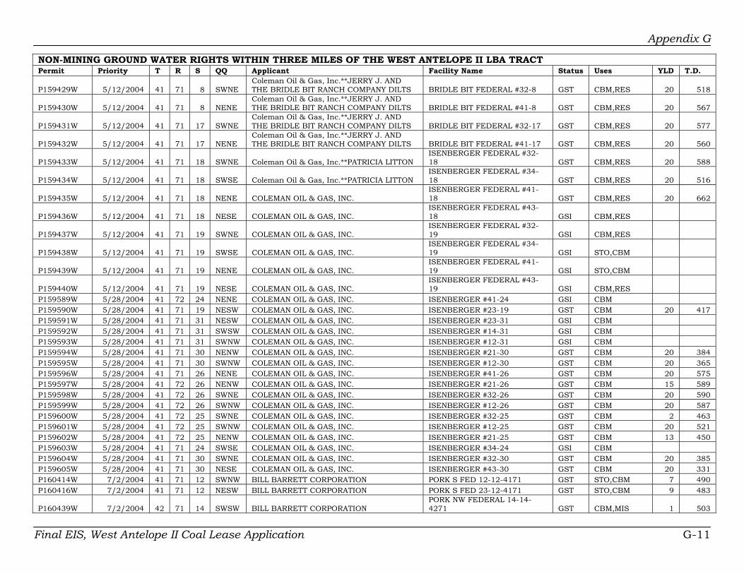
Appendix G
NON-MINING GROUND WATER RIGHTS WITHIN THREE MILES OF THE WEST ANTELOPE II LBA TRACT Permit Priority T R S QQ Applicant Facility Name Status Uses YLD T.D.
P159429W 5/12/2004 41 71 8 SWNE Coleman Oil & Gas, Inc.**JERRY J. AND THE BRIDLE BIT RANCH COMPANY DILTS BRIDLE BIT FEDERAL #32-8 GST CBM,RES 20 518
P159430W 5/12/2004 41 71 8 NENE Coleman Oil & Gas, Inc.**JERRY J. AND THE BRIDLE BIT RANCH COMPANY DILTS BRIDLE BIT FEDERAL #41-8 GST CBM,RES 20 567
P159431W 5/12/2004 41 71 17 SWNE Coleman Oil & Gas, Inc.**JERRY J. AND THE BRIDLE BIT RANCH COMPANY DILTS BRIDLE BIT FEDERAL #32-17 GST CBM,RES 20 577
P159432W 5/12/2004 41 71 17 NENE Coleman Oil & Gas, Inc.**JERRY J. AND THE BRIDLE BIT RANCH COMPANY DILTS BRIDLE BIT FEDERAL #41-17 GST CBM,RES 20 560
P159433W 5/12/2004 41 71 18 SWNE Coleman Oil & Gas, Inc.**PATRICIA LITTON ISENBERGER FEDERAL #32-18 GST CBM,RES 20 588
P159434W 5/12/2004 41 71 18 SWSE Coleman Oil & Gas, Inc.**PATRICIA LITTON ISENBERGER FEDERAL #34-18 GST CBM,RES 20 516
P159435W 5/12/2004 41 71 18 NENE COLEMAN OIL & GAS, INC. ISENBERGER FEDERAL #41-18 GST CBM,RES 20 662
P159436W 5/12/2004 41 71 18 NESE COLEMAN OIL & GAS, INC. ISENBERGER FEDERAL #43-18 GSI CBM,RES
P159437W 5/12/2004 41 71 19 SWNE COLEMAN OIL & GAS, INC. ISENBERGER FEDERAL #32-19 GSI CBM,RES
P159438W 5/12/2004 41 71 19 SWSE COLEMAN OIL & GAS, INC. ISENBERGER FEDERAL #34-19 GSI STO,CBM
P159439W 5/12/2004 41 71 19 NENE COLEMAN OIL & GAS, INC. ISENBERGER FEDERAL #41-19 GSI STO,CBM
P159440W 5/12/2004 41 71 19 NESE COLEMAN OIL & GAS, INC. ISENBERGER FEDERAL #43-19 GSI CBM,RES
P159589W 5/28/2004 41 72 24 NENE COLEMAN OIL & GAS, INC. ISENBERGER #41-24 GSI CBM P159590W 5/28/2004 41 71 19 NESW COLEMAN OIL & GAS, INC. ISENBERGER #23-19 GST CBM 20 417 P159591W 5/28/2004 41 71 31 NESW COLEMAN OIL & GAS, INC. ISENBERGER #23-31 GSI CBM P159592W 5/28/2004 41 71 31 SWSW COLEMAN OIL & GAS, INC. ISENBERGER #14-31 GSI CBM P159593W 5/28/2004 41 71 31 SWNW COLEMAN OIL & GAS, INC. ISENBERGER #12-31 GSI CBM P159594W 5/28/2004 41 71 30 NENW COLEMAN OIL & GAS, INC. ISENBERGER #21-30 GST CBM 20 384 P159595W 5/28/2004 41 71 30 SWNW COLEMAN OIL & GAS, INC. ISENBERGER #12-30 GST CBM 20 365 P159596W 5/28/2004 41 71 26 NENE COLEMAN OIL & GAS, INC. ISENBERGER #41-26 GST CBM 20 575 P159597W 5/28/2004 41 72 26 NENW COLEMAN OIL & GAS, INC. ISENBERGER #21-26 GST CBM 15 589 P159598W 5/28/2004 41 72 26 SWNE COLEMAN OIL & GAS, INC. ISENBERGER #32-26 GST CBM 20 590 P159599W 5/28/2004 41 72 26 SWNW COLEMAN OIL & GAS, INC. ISENBERGER #12-26 GST CBM 20 587 P159600W 5/28/2004 41 72 25 SWNE COLEMAN OIL & GAS, INC. ISENBERGER #32-25 GST CBM 2 463 P159601W 5/28/2004 41 72 25 SWNW COLEMAN OIL & GAS, INC. ISENBERGER #12-25 GST CBM 20 521 P159602W 5/28/2004 41 72 25 NENW COLEMAN OIL & GAS, INC. ISENBERGER #21-25 GST CBM 13 450 P159603W 5/28/2004 41 71 24 SWSE COLEMAN OIL & GAS, INC. ISENBERGER #34-24 GSI CBM P159604W 5/28/2004 41 71 30 SWNE COLEMAN OIL & GAS, INC. ISENBERGER #32-30 GST CBM 20 385 P159605W 5/28/2004 41 71 30 NESE COLEMAN OIL & GAS, INC. ISENBERGER #43-30 GST CBM 20 331 P160414W 7/2/2004 41 71 12 SWNW BILL BARRETT CORPORATION PORK S FED 12-12-4171 GST STO,CBM 7 490 P160416W 7/2/2004 41 71 12 NESW BILL BARRETT CORPORATION PORK S FED 23-12-4171 GST STO,CBM 9 483
P160439W 7/2/2004 42 71 14 SWSW BILL BARRETT CORPORATION PORK NW FEDERAL 14-14-4271 GST CBM,MIS 1 503
Final EIS, West Antelope II Coal Lease Application G-11

Appendix G
NON-MINING GROUND WATER RIGHTS WITHIN THREE MILES OF THE WEST ANTELOPE II LBA TRACT Permit Priority T R S QQ Applicant Facility Name Status Uses YLD T.D.
P160440W 7/2/2004 42 71 14 NESW BILL BARRETT CORPORATION** WY STATE BOARD OF LAND COMMISSIONERS
PORK NW FEDERAL 23-14-4271 GST CBM,MIS 0 517
P160441W 7/2/2004 42 71 14 SWSE BILL BARRETT CORPORATION** WY STATE BOARD OF LAND COMMISSIONERS
PORK NW FEDERAL 34-14-4271 GST CBM,MIS 8 500
P160442W 7/2/2004 42 71 14 NESE BILL BARRETT CORPORATION PORK NW FEDERAL 43-14-4271 GST CBM,MIS 3 511
P160444W 7/2/2004 42 71 23 SWSW BILL BARRETT CORPORATION PORK NW FEDERAL 14-23-4271 GST STO,CBM 1 460
P160445W 7/2/2004 42 71 23 NENW BILL BARRETT CORPORATION PORK NW FEDERAL 21-23-4271 GST CBM,MIS 2 469
P160446W 7/2/2004 42 71 23 NESW BILL BARRETT CORPORATION PORK NW FEDERAL 23-23-4271 GST STO,CBM 1 449
P160448W 7/2/2004 42 71 23 NENE BILL BARRETT CORPORATION PORK NW FEDERAL 41-23-4271 GST STO,CBM 4 491
P160449W 7/2/2004 42 71 23 NESE BILL BARRETT CORPORATION** WY STATE BOARD OF LAND COMMISSIONERS
PORK NW FEDERAL 43-23-4271 GST STO,CBM 6 460
P161325W 8/3/2004 41 71 8 NESE COLEMAN OIL & GAS, INC.**Jerry Dilts BRIDLE BIT RANCH STATE #43-8 GSI CBM
P161756W 8/23/2004 41 71 1 SWNW CONTINENTAL INDUSTRIES LC PORK S FED 12-1-41-71 GSI CBM,MIS P161757W 8/23/2004 41 71 1 SWSW CONTINENTAL INDUSTRIES LC PORK S FED 14-1-41-71 GSI CBM,MIS P161758W 8/23/2004 41 71 1 NENW CONTINENTAL INDUSTRIES LC PORK S FED 21-1-41-71 GSI CBM,MIS P161759W 8/23/2004 41 71 1 NESW CONTINENTAL INDUSTRIES LC PORK S FED 23-1-41-71 GSI CBM,MIS P161761W 8/23/2004 42 71 26 NENW CONTINENTAL INDUSTRIES LC PORK NW FED 21-26-42-71 GSI CBM,MIS P161762W 8/23/2004 42 71 26 SWNE CONTINENTAL INDUSTRIES LC PORK NW FED 32-26-42-71 GSI CBM,MIS P161763W 8/23/2004 42 71 26 NENE CONTINENTAL INDUSTRIES LC PORK NW FED 41-26-42-71 GSI CBM,MIS P161764W 8/23/2004 42 71 35 SWNW CONTINENTAL INDUSTRIES LC PORK NW FED 12-35-42-71 GSI CBM,MIS P161765W 8/23/2004 42 71 35 NENW CONTINENTAL INDUSTRIES LC PORK NW FED 21-35-42-71 GSI CBM,MIS P161766W 8/23/2004 42 71 35 SWNE CONTINENTAL INDUSTRIES LC PORK NW FED 32-35-42-71 GSI CBM,MIS P161767W 8/23/2004 42 71 35 NENE CONTINENTAL INDUSTRIES LC PORK NW FED 41-35-42-71 GSI CBM,MIS P161768W 8/23/2004 42 71 35 SWSW CONTINENTAL INDUSTRIES LC JWS FED 14-35-42-71 GSI CBM,MIS P161769W 8/23/2004 42 71 35 NESW CONTINENTAL INDUSTRIES LC JWS FED 23-35-42-71 GSI CBM,MIS P161770W 8/23/2004 42 71 35 SWSE CONTINENTAL INDUSTRIES LC JWS FED 34-35-42-71 GSI CBM,MIS P161771W 8/23/2004 42 71 35 NESE CONTINENTAL INDUSTRIES LC JWS FED 43-35-42-71 GSI CBM,MIS P161949W 7/22/2004 42 71 32 NESW LANCE OIL & GAS COMPANY, INC BRITTLE BIT FED 23-32-4271 GSI CBM P161950W 7/22/2004 42 71 31 NENE LANCE OIL & GAS COMPANY, INC BRITTLE BIT FED41-31-4271 GSI CBM P161952W 7/22/2004 42 71 32 SWNW LANCE OIL & GAS COMPANY, INC BRITTLE BIT FED 12-32-4271 GSI CBM,RES
P162903W 9/21/2004 41 71 20 SWSE LANCE OIL & GAS COMPANY P LITTON FEDERAL 34-20-4171 CA GSI CBM
P162905W 9/21/2004 41 71 20 NESW Lance Oil & Gas P LITTON FEDERAL 23-20-4171 CA GST CBM 11 493
P162907W 9/21/2004 41 71 20 SWSW LANCE OIL AND GAS COMPANY P LITTON FEDERAL 14-20-4171 CA GST CBM 16 461
P162908W 9/21/2004 41 71 20 SWNW Lance Oil & Gas P LITTON FEDERAL 12-20-4171 CA GST CBM 13 582
P162909W 9/21/2004 41 71 14 SWSE LANCE OIL AND GAS COMPANY ANTELOPE COAL FEDERAL GSI CBM
Final EIS, West Antelope II Coal Lease Application G-12

Appendix G
NON-MINING GROUND WATER RIGHTS WITHIN THREE MILES OF THE WEST ANTELOPE II LBA TRACT Permit Priority T R S QQ Applicant Facility Name Status Uses YLD T.D.
34-14-4171 WY
P162910W 9/21/2004 41 71 7 NESE LANCE OIL AND GAS COMPANY P LITTON FEDERAL 43-7-4171 WY GSE CBM
P162911W 9/21/2004 41 71 29 NESE LANCE OIL AND GAS COMPANY P LITTON FEDERAL 43-29-4171 CA GSI CBM
P162913W 9/21/2004 41 71 29 SWNE Lance Oil & Gas ANTELOPE COAL FEDERAL 32-29-4171 CA GST CBM 10 387
P162914W 9/21/2004 41 71 29 NENW Lance Oil & Gas P LITTON FEDERAL 21-29-4171 CA GSI CBM 10 445
P162915W 9/21/2004 41 71 22 SWSE LANCE OIL AND GAS COMPANY ANTELOPE COAL FEDERAL 34-22-4171CA GST CBM 7 391
P162916W 9/21/2004 41 71 22 SWSW LANCE OIL AND GAS COMPANY ANTELOPE COAL FEDERAL 14-22-4171 CA GST CBM 9 418
P162917W 9/21/2004 41 71 21 NESW LANCE OIL AND GAS COMPANY P LITTON FEDERAL 23-21-4171 CA GST CBM 7 460
P162918W 9/21/2004 41 71 21 NENW LANCE OIL AND GAS COMPANY BRIDLE BIT FEDERAL 21-21-4171 CA GSE CBM
P162919W 9/21/2004 41 71 21 SWSW LANCE OIL AND GAS COMPANY P LITTON FEDERAL 14-21-4171 CA GST CBM 5 423
P162920W 9/21/2004 41 71 21 SWNW LANCE OIL AND GAS COMPANY BRIDLE BIT FEDERAL 12-21-4171 CA GSI CBM
P162923W 9/21/2004 41 71 11 NENW LANCE OIL AND GAS COMPANY SIOUX RANCH FEDERAL 21-11-4172 CA GSE CBM
P162930W 9/21/2004 41 71 30 NENE LANCE OIL AND GAS COMPANY P LITTON FEDERAL 41-30-417CA GSE CBM
P162931W 9/21/2004 41 72 24 NESE LANCE OIL & GAS COMPANY P LITTON FEDERAL 43-24-4172CA GSI CBM
P162932W 9/21/2004 41 72 24 SWNE LANCE OIL AND GAS COMPANY P LITTON FEDERAL 32-24-4172CA GSE CBM
P162934W 9/21/2004 41 72 24 SWSW LANCE OIL AND GAS COMPANY P LITTON FEDERAL 14-24-4172CA GSE CBM
P162936W 9/21/2004 41 72 23 NENW LANCE OIL AND GAS COMPANY SIOUX RANCH FEDERAL 21-23-4172 CA GSE CBM
P162937W 9/21/2004 41 72 23 SWNW LANCE OIL AND GAS COMPANY SIOUX RANCH FEDERAL 12-23-4172 CA GSE CBM
P163378W 10/18/2004 41 71 33 SWNW BOWERS OIL AND GAS, INC. BOG- FEE #1-33 GST CBM 10 245 P163491W 10/29/2004 41 71 18 SWNW LANCE OIL & GAS COMPANY, INC LITTON 12-18-4171 GSI CBM
P164138W 11/29/2004 41 71 31 NENW COLEMAN OIL & GAS, INC.**PATRICIA L. ISENBERGER LITTON ISENBERGER #21-31 GST CBM 20 419
P165891W 2/23/2005 41 71 30 NESW COLEMAN OIL & GAS, INC.**PATRICIA L. ISENBERGER
ISENBERGER FEDERAL #23-30 GST CBM 20 377
P165892W 2/23/2005 41 71 30 SWSW COLEMAN OIL & GAS, INC.**PATRICIA L. ISENBERGER
ISENBERGER FEDERAL #14-30 GST CBM 20 420
P16602W 9/1/1972 41 71 35 SWNW WYOMING BOARD OF LAND COMM.**H. R. MATHESON STATE-MATHESON #1 IND 500 50
P168479W 6/13/2005 41 71 22 NESW LANCE OIL & GAS COMPANY, INC ANTELOPE COAL FED 23-22-4171 GSI CBM
P171405W 11/4/2005 41 71 18 SWSW LANCE OIL & GAS COMPANY, INC. LITTON 14-18-4171 GSI CBM,MIS
Final EIS, West Antelope II Coal Lease Application G-13

Appendix G
NON-MINING GROUND WATER RIGHTS WITHIN THREE MILES OF THE WEST ANTELOPE II LBA TRACT Permit Priority T R S QQ Applicant Facility Name Status Uses YLD T.D. P171406W 11/4/2005 41 71 18 NENW LANCE OIL & GAS COMPANY, INC. LITTON 21-18-4171 GSI CBM,MIS P171407W 11/4/2005 41 71 18 NESW LANCE OIL & GAS COMPANY, INC. LITTON 23-18-4171 GSI CBM,MIS P171804W 8/18/2005 41 71 6 NENE YATES PETROLEUM CORP. BEARCAT CS FEDERAL #1 GST CBM,MIS 716 P171805W 8/18/2005 41 71 6 SWNE YATES PETROLEUM CORP. BEARCAT CS FEDERAL #2 GSI CBM,MIS P171806W 8/18/2005 41 71 6 NESE YATES PETROLEUM CORP. BEARCAT CS FEDERAL #3 GSI CBM,MIS P171807W 8/18/2005 41 71 6 SWSE YATES PETROLEUM CORP. BEARCAT CS FEDERAL #4 GSI CBM,MIS P171808W 8/18/2005 41 71 7 NENE YATES PETROLEUM CORP. BEARCAT CS FEDERAL #5 GSI CBM,MIS P171809W 8/18/2005 41 71 8 SWSE YATES PETROLEUM CORP. BEARCAT CS FEDERAL #6 GSI CBM,MIS P171810W 8/18/2005 41 71 17 NENW YATES PETROLEUM CORP. BEARCAT CS FEDERAL #7 GSI CBM,MIS P171811W 8/18/2005 41 71 17 SWNW YATES PETROLEUM CORP. BEARCAT CS FEDERAL #8 GSI CBM,MIS P171812W 8/18/2005 41 71 17 NESE YATES PETROLEUM CORP. BEARCAT CS FEDERAL #9 GSI CBM,MIS P171813W 8/18/2005 41 71 10 SWSE YATES PETROLEUM CORP. BLENHEIM CS FEDERAL #1 GSI CBM,MIS P171814W 8/18/2005 41 71 11 NESW YATES PETROLEUM CORP. BLENHEIM CS FEDERAL #2 GSI CBM,MIS P171815W 8/18/2005 41 71 11 SWSW YATES PETROLEUM CORP. BLENHEIM CS FEDERAL #3 GSI CBM,MIS P171816W 8/18/2005 42 72 34 NENW YATES PETROLEUM CORP. GAUNTLET CS FEDERAL #1 GSI CBM,MIS P171817W 8/18/2005 42 72 34 SWNW YATES PETROLEUM CORP. GAUNTLET CS FEDERAL #2 GSI CBM,MIS P171818W 8/18/2005 42 72 34 NESW YATES PETROLEUM CORP. GAUNTLET CS FEDERAL #3 GSI CBM,MIS P171819W 8/18/2005 42 72 34 SWSW YATES PETROLEUM CORP. GAUNTLET CS FEDERAL #4 GSI CBM,MIS P171822W 8/18/2005 41 71 9 NENE YATES PETROLEUM CORP. GLOSTER CS FEDERAL #1 GSI CBM,MIS P171823W 8/18/2005 41 71 9 SWNE YATES PETROLEUM CORP. GLOSTER CS FEDERAL #2 GSI CBM,MIS P171824W 8/18/2005 41 71 9 SWNE YATES PETROLEUM CORP. GLOSTER CS FEDERAL #4 GSI CBM,MIS P171824W 8/18/2005 41 71 9 SWSW YATES PETROLEUM CORP. GLOSTER CS FEDERAL #4 GSI CBM,MIS P171825W 8/18/2005 41 71 9 SWSE YATES PETROLEUM CORP. GLOSTER CS FEDERAL #5 GSI CBM,MIS P171826W 8/18/2005 41 71 10 NENE YATES PETROLEUM CORP. GLOSTER CS FEDERAL #6 GSI CBM,MIS P171835W 8/18/2005 41 71 10 SWSW YATES PETROLEUM CORP. HAWKER CS FEDERAL #3 GSI CBM,MIS P171836W 8/18/2005 41 71 10 NESW YATES PETROLEUM CORP. HAWKER CS FEDERAL #2 GSI CBM,MIS P171837W 8/18/2005 41 71 10 NESE YATES PETROLEUM CORP. GLOSTER CS FEDERAL #8 GSI CBM,MIS P171838W 8/18/2005 41 71 10 SWNE YATES PETROLEUM CORP. GLOSTER CS FEDERAL #7 GSI CBM,MIS P171839W 9/7/2005 41 71 14 NESW YATES PETROLEUM CORP GEEBEE CS FEDERAL #2 GSI CBM,MIS P171840W 9/7/2005 41 71 14 SWSW YATES PETROLEUM CORP GEEBEE CS FEDERAL #3 GSI CBM,MIS P171842W 9/7/2005 41 71 15 NESE YATES PETROLEUM CORP. GLOSTER CS FEDERAL #9 GSI CBM,MIS P171843W 9/7/2005 41 71 21 NENE YATES PETROLEUM CORP. LYSANDER CS FEDERAL #1 GSI CBM,MIS
P171845W 9/7/2005 41 71 17 SWSW Yates Petroleum** WY STATE BOARD OF LAND COMMISSIONERS BEARCAT CS FEDERAL #11 GSI CBM,MIS
P171846W 9/7/2005 41 71 17 SWSE Yates Petroleum** WY STATE BOARD OF LAND COMMISSIONERS BEARCAT CS FEDERAL #12 GSI CBM,MIS
P171847W 9/7/2005 41 72 1 NENE YATES PETROLEUM CORP. BOLT CS FEDERAL #1 GSI CBM,MIS P171848W 9/7/2005 41 72 1 NENW YATES PETROLEUM CORP BOLT CS FEDERAL #2 GSI CBM,MIS P171849W 9/7/2005 41 72 1 SWNW YATES PETROLEUM CORP. BOLT CS FEDERAL #3 GSI CBM,MIS P171850W 9/7/2005 41 72 1 SWNE YATES PETROLEUM CORP. BOLT CS FEDERAL #4 GSI CBM,MIS
P171851W 9/7/2005 41 72 23 SWSW YATES PETROLEUM CORP MESSERSCHMITT CS FEDERAL #1 GSI CBM,MIS
Final EIS, West Antelope II Coal Lease Application G-14

Appendix G
NON-MINING GROUND WATER RIGHTS WITHIN THREE MILES OF THE WEST ANTELOPE II LBA TRACT Permit Priority T R S QQ Applicant Facility Name Status Uses YLD T.D.
P171852W 9/7/2005 41 72 23 SWNE YATES PETROLEUM CORP MESSERSCHMITT CS FEDERAL #2 GSI CBM,MIS
P171854W 9/7/2005 41 72 23 NESW YATES PETROLEUM CORP MESSERSCHMITT CS FEDERAL #4 GSI CBM,MIS
P171856W 9/7/2005 41 72 23 SWSE YATES PETROLEUM CORP MESSERSCHMITT CS FEDERAL #6 GSI CBM,MIS
P171857W 9/7/2005 41 71 31 NENE YATES PETROLEUM CORP MOSQUITO CS FEDERAL #1 GSI CBM,MIS P171858W 9/7/2005 41 71 31 SWNE YATES PETROLEUM CORP MOSQUITO CS FEDERAL #2 GSI CBM,MIS P171859W 9/7/2005 41 71 31 NESE YATES PETROLEUM CORP MOSQUITO CS FEDERAL #3 GSI CBM,MIS P171860W 9/7/2005 41 71 31 SWSE YATES PETROLEUM CORP MOSQUITO CS FEDERAL #4 GSI CBM,MIS P171861W 9/7/2005 41 72 25 NESW YATES PETROLEUM CORP DOOLITTLE CS FEDERAL #1 GSI CBM,MIS P171862W 9/7/2005 41 72 25 SWSW YATES PETROLEUM CORP DOOLITTLE CS FEDERAL #2 GSI CBM,MIS P171864W 9/7/2005 41 72 12 SWSE YATES PETROLEUM CORP GRUMMAN CS FEDERAL #2 GSI CBM,MIS P171866W 9/30/2005 42 72 33 SWSE YATES PETROLEUM CORP UPSPRING CS FEDERAL #18 GSI CBM,MIS P171867W 10/4/2005 41 71 24 NESW YATES PETROLEUM CORP GEEBEE CS FEDERAL #5 GSI CBM,MIS P171868W 11/10/2005 41 71 13 SWSW YATES PETROLEUM CORP GEEBEE CS FEDERAL #1 GSI CBM,MIS P172120W 12/16/2005 41 72 3 SWNW YATES PETROLEUM CORP CARBINE CS FEDERAL #1 GSI CBM,MIS P18839P 5/31/1951 40 72 11 NWNW INC. FLOYD C. RENO & SON'S STEVICK WELL #3 GST STO 10 550 P23594W 7/25/1973 41 71 34 SWNE PATRICIA L. ISENBERGER ARTESION #3 GST STO 10 640 P23595P 7/25/1973 41 72 24 SWSE PATRICIA L. ISENBERGER ARTESIAN #1 ABA STO 10 525 P23596P 7/25/1973 41 71 35 NENE PATRICIA L. ISENBERGER ARTESIAN #4 GST DOM,STO 5 -1 P23597P 7/25/1973 41 71 35 SWSE PATRICIA L. ISENBERGER SCHOOL HOUSE #1 GST DOM,STO 6 550 P23598W 7/25/1973 41 71 7 NWSE PATRICIA L. ISENBERGER LY #3 GST STO 10 252 P23599P 7/25/1973 41 72 13 NENW PATRICIA L. ISENBERGER LY #4 GST DOM,STO 10 179 P23600P 7/25/1973 41 72 13 SWSE PATRICIA L. ISENBERGER LY #5 GST STO 7 300 P23601P 7/25/1973 41 71 29 SWNW PATRICIA L. ISENBERGER LY #6 GST STO 7 250 P23602P 7/25/1973 41 71 33 NWNW PATRICIA L. ISENBERGER LY #7 GST STO 10 600 P23603P 7/25/1973 41 71 7 NWSW PATRICIA L. ISENBERGER SPRING #8 GST STO 25 8 P23604P 7/25/1973 41 71 21 SESW PATRICIA L. ISENBERGER SPRING #9 GST STO 25 8 P23605P 7/25/1973 41 71 27 SWSW PATRICIA L. ISENBERGER SPRING #10 GST STO 25 8 P23606P 7/25/1973 41 71 31 SWSW PATRICIA L. ISENBERGER SPRING #11 GST STO 25 8 P25606P 1/14/1974 42 71 26 NESE PAUL & EDITH RUTH WILKINSON WILKINSON #2 GST DOM,STO 2 220 P25608P 1/14/1974 42 71 26 SWNW PAUL & EDITH RUTH WILKINSON WILKINSON #4 GST STO 4 110 P27065W 6/21/1974 40 71 23 SWNW W. A. STODDARD WEBB STODDARD #1 ABA STO 0 -1 P27066W 6/21/1974 40 71 22 SWSW W. A. STODDARD WEBB STODDARD #2 ABA STO 1 -1 P27067W 6/21/1974 40 71 25 SWSW W. A. STODDARD WEBB STODDARD #3 ABA STO 0 -1 P27131W 6/27/1974 40 71 19 NWSW USDA FOREST SERVICE HAEFELE #T.B. 178 CAN STO P27921W 9/13/1974 41 72 24 SESW PATRICIA L. ISENBERGER ARTESIAN #1 CAN STO 5 861 P29746W 5/7/1975 42 71 27 NENW USDA FOREST SERVICE WRIGHT #T B 195 GST STO 10 175 P29747W 5/7/1975 42 71 30 NENW USDA FOREST SERVICE PEABODY #T B 196 GST STO 3 520 P33290W 5/17/1976 41 70 18 SENW USDA FOREST SERVICE BELL #T B 199 (DEEPENED) GST STO 10 644 P37364W 4/19/1977 40 71 3 NESW USA USDA FOREST SERVICE ISENBERGER # TB 206 GST STO 10 585
Final EIS, West Antelope II Coal Lease Application G-15

Appendix G
NON-MINING GROUND WATER RIGHTS WITHIN THREE MILES OF THE WEST ANTELOPE II LBA TRACT Permit Priority T R S QQ Applicant Facility Name Status Uses YLD T.D. P44329W 7/20/1978 42 71 34 NWSE USDA FOREST SERVICE MARG #4 GST STO 3 183 P44330W 7/20/1978 41 71 3 NWSE USDA FOREST SERVICE MARG #5 GST STO 3 163 P44331W 7/20/1978 41 71 14 SESE USDA FOREST SERVICE MARG #6 GST STO 3 605 P44332W 7/20/1978 40 70 6 NWSE USDA FOREST SERVICE MARG #7 GST STO 8 722 P44333W 7/20/1978 40 71 13 NESE USDA FOREST SERVICE MARG #8 GST STO 3 405 P44334W 7/20/1978 40 71 22 SWNE USDA FOREST SERVICE MARG #9 CAN STO
P44496W 8/8/1978 41 70 31 NESE INC. INDUSTRIAL PIPELINES SOUTH CENTRAL BN #2 CAN MIS 35 23
P44497W 8/8/1978 41 70 31 NESE INC. INDUSTRIAL PIPELINES SOUTH CENTRAL BN #3 CAN MIS
P44498W 8/8/1978 41 70 31 NESE INC. INDUSTRIAL PIPELINES SOUTH CENTRAL BN #4 CAN MIS
P4524P 12/31/1959 40 71 19 NWNE USDA FOREST SERVICE HAEFELE #T B 47 GST STO 5 700
P46168W 12/14/1978 41 71 36 NESW
WY BOARD OF LAND COMMISSIONERS**PATRICIA EISENBERGER EISENBERGER-STATE #1 GST STO
P47044W 3/20/1979 40 71 22 SENW W. A. STODDARD WIB #1 CAN DOM P4762W 6/12/1969 41 71 35 SENE WAYNE P. BRANNAN** KANE RANCHES BRANNAN #1 CAN IND P4763W 6/12/1969 41 71 35 SWNW STATE OF WYOMING**WAYNE P. BRANNAN BRANNAN #2 CAN IND P50638W 11/13/1979 41 72 23 SWNE PATRICIA L. ISENBERGER L Y #8 GST STO 15 210 P50639W 11/13/1979 41 72 13 NWNE PATRICIA L. ISENBERGER L Y #9 RES,STO 10 182 P52637W 6/17/1980 41 72 13 NENW PATRICIA L. ISENBERGER LITTON LY #10 GST DOM,STO 15 179 P53195W 8/4/1981 42 71 32 NWNW DILTS BROS. DILTS BROS. #1 GST STO 10 735 P5611P 5/2/1960 41 71 6 SWNW ROBERT E. ISENBERGER LY #1 GST STO 5 344 P5612P 2/9/1969 41 71 19 NWNE PARTICIA L. ISENBERGER LITTON LY #2 (DEEPENED) GST STO 1 350 P57757W 7/30/1981 41 71 2 SENE HARRY G. PUTNAM JINX #1 CAN DOM,STO P57759W 7/7/1981 41 71 2 NENE INC. VALENTINE CONSTRUCTION THUNDER CREEK #1 CAN MIS 80 480 P58121W 5/18/1981 41 71 11 NENE BIG HORN FRACTIONATION B H FRAC #1 MIS 25 396 P5848W 6/16/1970 42 71 26 SWNW PAUL WILKINSON MIDDLE PASTURE #1 GST STO 2 140 P5851W 6/16/1970 40 71 7 NENE BASS JACOBS & SON JACOBS #1 CAN DOM,STO P59882W 3/22/1982 40 72 12 NWNE DONALD B. JACOBS ILES #1 GST STO 5 640 P59883W 3/22/1982 40 71 7 NENW DONALD B. JACOBS HOUSE #2 GST DOM 25 1275 P60832W 5/13/1982 40 70 6 NENW DAVIS OIL COMPANY DAVIS HERON #1 CAN MIS P62923W 12/28/1982 40 71 15 NWSW USGS WATER RESOURCES DIVISION USGS BR-10 GST MON 0 231 P62924W 12/28/1982 40 71 17 NENE USGS WATER RESOURCES DIVISION USGS BR-11 GST MON 0 127 P63112W 2/11/1983 41 71 24 SWNE BRIDLE BIT RANCH BRIDLE BIT RANCH #1 GST STO 6 442 P67807W 6/27/1984 41 71 13 NWNW USA USDA FOREST SERVICE WILKINSON SPRING #T B 39 GST STO 0 8 P67899W 7/10/1984 41 71 27 NESW USA USDA FOREST SERVICE ISENBERGER SPRING #T B 63 GST STO 0 8 P68682W 10/9/1984 41 71 32 NENE PATRICIA L. ISENBERGER LITTON ARTESIAN #4 CAN STO P69060W 4/17/1984 41 72 24 SWSE PATRICIA L. ISENBERGER LITTON ARTESIAN #1 CAN MIS 25 861
P69891W 4/8/1985 41 72 24 SWSE
WY BOARD OF LAND COMMISSIONERS**PARTICIA L. ISENBERGER LITTON ARTESIAN #1 ADJ MIS 25 861
Final EIS, West Antelope II Coal Lease Application G-16

Appendix G
NON-MINING GROUND WATER RIGHTS WITHIN THREE MILES OF THE WEST ANTELOPE II LBA TRACT Permit Priority T R S QQ Applicant Facility Name Status Uses YLD T.D. P70729W 7/23/1985 41 71 10 SESW JERRY DILTS BRIDLE BIT RANCH #3 ABA STO 0 270 P71738W 1/14/1986 41 71 1 SWNW USA USDA FOREST SERVICE WILKINSON SPRING TB #55 UNA STO P71835W 2/4/1986 41 72 12 NENW WYOMING STATE HIGHWAY DEPARTMENT ROBINSON #2 ABA MON 560 P71836W 2/4/1986 41 72 12 SESW WYOMING STATE HIGHWAY DEPARTMENT ROBINSON #1 ABA MON 480 P73266W 9/18/1986 41 72 24 NESE WYOMING STATE HIGHWAY DEPARTMENT ROBINSON #3 CAN MON P75173W 7/8/1987 41 72 24 NESE WYOMING STATE HIGHWAY DEPARTMENT ROBINSON #3 CAN MIS 55 300 P75174W 7/8/1987 41 72 24 NESE WYOMING STATE HIGHWAY DEPARTMENT ROBINSON #4 CAN MIS 55 300 P75175W 7/8/1987 41 72 24 NESE WYOMING STATE HIGHWAY DEPARTMENT ROBINSON #5 CAN MIS 55 320 P75176W 7/8/1987 41 72 24 NESE WYOMING STATE HIGHWAY DEPARTMENT ROBINSON #6 CAN MIS 55 300 P76178W 12/7/1987 41 72 24 NESE WYOMING STATE HIGHWAY DEPARTMENT ROBINSON #7 GST MON 0 100 P76179W 12/7/1987 41 72 24 NESE WYOMING STATE HIGHWAY DEPARTMENT ROBINSON #9 GST MON 0 300 P76180W 12/7/1987 41 72 24 SESE WYOMING STATE HIGHWAY DEPARTMENT ROBINSON #10 GST MON 0 50 P76181W 12/7/1987 41 72 24 SESE WYOMING STATE HIGHWAY DEPARTMENT ROBINSON #11 GST MON 0 50 P76370W 3/1/1988 41 72 24 NESE WYO DEPARTMENT OF TRANSPORTATION ROBINSON #12 ABA MON 14 300 P86409W 10/16/1991 40 71 29 NENE WY STATE DEPT. OF TRANSPORTATION ANTELOPE #1 ABA MON 0 620 P86410W 10/16/1991 40 71 7 NESW WY STATE DEPT. OF TRANSPORTATION ANTELOPE #2 ABA MON 0 481 P8967P 5/1/1965 40 71 1 SESE USDA FOREST SERVICE MORTON #T B 93 GST STO 4 565 P94280W 1/18/1994 40 72 26 SWNW HAEFELE & HAEFELE CREEK WELL #1 GST DOM,STO 5 200 P95332W 2/12/1986 41 71 2 NENE FRANCES PUTNAM JINX #3 GST DOM,STO 20 480 P95333W 7/30/1981 41 71 2 NENE FRANCES PUTNAM JINX #2 GST DOM,STO 6 360 P9571W 6/30/1971 41 71 33 SWSE USDA FOREST SERVICE JACOBS #T.B. 161 GST STO 4 495 P96882W 8/24/1994 41 71 24 NENW WESCO, INC WESCO #1 UNA MIS 18 596
Final EIS, West Antelope II Coal Lease Application G-17

Appendix G
Table Notes for Non-Mining Ground Water Rights within Three Miles of the West Antelope II LBA Tract
Search Conducted April 24, 2007
Ground Water Right Search Area for the West Antelope II LBA Tract
Township Range Sections 40N 70W 6-7 40N 71W 1-30
40N 72W 1, 11-14, 23, 26 41N 70W 7, 17-19, 30-31
41N 71W 1-36 41N 72W 1, 12-13, 23-26, 36
42N 71W 26-36
Water rights were searched to the nearest quarter-quarter of each section listed above. Any part of a quarter-quarter that lies within three miles of the LBA tract is included.
Permit number suffixes are denoted as follows: "A" Adjudicated (finalized) rights; unless the right is a territorial appropriation, there will be
a match in the reference column from one of the following permit types for the unadjudicated portion:
"P" Stock and domestic use wells completed prior to May 24, 1969 and registered with the State Engineer's Office prior to December 31, 1972
'"W" Permits are for wells with a priority date for the date of filing with the State Engineer
Status Codes A&C Abandoned and Cancelled ABA Abandoned ADJ Adjudicated CAN Cancelled GSE Good standing, permitted time limits have been extended GSI Good standing incomplete; required notices not received; not yet expired GST Good standing UNA Unadjudicated
Use Codes CBM Coal Bed Methane DEW Dewatering DOM Domestic DRI Drilling IND Industrial IRR Irrigation MIS Miscellaneous MON Monitoring RES Reservoir Supply STO Stock
Final EIS, West Antelope II Coal Lease Application G-18

Appendix G
NON-MINING SURFACE WATER RIGHTS WITHIN ½ MILE OF THE WEST ANTELOPE II LBA TRACT AND 3 MILES DOWNSTREAM PERMIT PRIORITY T R S QQ APPLICANT FACILITY NAME STATUS USES SOURCE
31/4/114S 6/20/2002 41 71 8 NESW COLEMAN OIL & GAS, INC.**JERRY DILTS
Thunder Basin #45 Stock Reservoir REJ STO Knapp Draw
32/4/144S 6/14/2004 41 71 11 SWSW Harry Putnam, et al Locomotive Stock Reservoir REJ STO
32/5/144S 6/14/2004 41 71 11 Harry Putnam, et al Sandy Swale Stock Reservoir REJ STO Porcupine Creek
32/6/153S 6/18/2004 41 71 11 NWSE Harry Putnam, et al Choo Choo Stock Reservoir REJ STO
P10357S 2/29/1988 41 71 30 SENW PATRICIA L. ISENBERGER LITTON Spring Creek #12 Stock Reservoir GST STO Spring Creek
P1380S 2/6/1956 40 71 28 SWNW ARTHUR R. JOHNSON Rancobore #1 Stock Reservoir UNA STO Rackabore Draw
P1384S 2/6/1956 40 71 10 SENW BASS JACOBS Donner #1 Stock Reservoir PUO STO Donner Draw
P1384S 2/6/1956 40 71 10 NESW BASS JACOBS Donner #1 Stock Reservoir PUO STO Donner Draw
P15209S 8/25/2003 41 71 20 Lance Oil & Gas Co., Inc. Dilts #14 Stock Reservoir UNA STO No. 14 Draw
P15210S 10/1/2003 41 71 22 NESW
Thunder Basin National Grassland** Lance Oil & Gas Co., Inc. Dilts #8 Stock Reservoir UNA STO No. 7 Draw
P15211S 10/2/2003 41 71 15 Lance Oil & Gas Co., Inc. Dilts #9 Stock Reservoir UNA STO No. 9 Draw
P15227S 8/25/2003 41 71 22 SESW
Thunder Basin National Grassland** Lance Oil & Gas Co., Inc. Dilts #7 Stock Reservoir UNA STO No. 7 Draw
P15228S 8/25/2003 41 71 9
Thunder Basin National Grassland** Lance Oil & Gas Co., Inc. Dilts #11 Stock Reservoir UNA STO No. 11 Draw
P15229S 8/25/2003 41 71 21 SWNW Lance Oil & Gas Co., Inc. Dilts #15 Stock Reservoir UNA STO No. 15 Draw
P15317S 10/1/2003 41 71 9 Lance Oil & Gas Co., Inc. Dilts #10 Stock Reservoir UNA STO No. 10 Draw
P15515S 3/20/2002 41 71 18 SWNE
Coleman Oil & Gas, Inc.**Gene and Patricia Litton Oxyoke Stock Reservoir UNA STO Ox Draw
P15516S 6/20/2002 41 71 5 SESE Coleman Oil & Gas, Inc.**Jerry Dilts
Upper Horse Creek Stock Reservoir UNA STO Mikes Draw
P15934S 6/14/2004 41 71 8 Jerry J. Dilts Ltd. Partnership Horse Spring Stock Reservoir UNA STO Stacia Draw
P15935S 6/14/2004 41 71 17 Jerry J. Dilts Ltd. Partnership Little Bear Stock Reservoir UNA STO Mr. Clean Draw
P15936S 6/14/2004 41 71 14 Jerry Dilts Washed Out Stock Reservoir CAN STO Dennell Draw
P15941S 6/14/2004 41 71 10
Jerry J. Dilts Family Ltd. Partnership & Bridle Bit Ranch Co. Long Pull Stock Reservoir UNA STO Grade Draw
P15942S 6/14/2004 41 71 10
Jerry J. Dilts Family Ltd. Partnership and Bridle Bit Ranch Company Live Wire Stock Reservoir UNA STO Ohms Draw
P15943S 6/14/2004 41 71 10
Jerry J. Dilts Family Ltd. Partnership and Bridle Bit Ranch Company Iron Horse Stock Reservoir UNA STO Spur Draw
Final EIS, West Antelope II Coal Lease Application G-19

Appendix G
NON-MINING SURFACE WATER RIGHTS WITHIN ½ MILE OF THE WEST ANTELOPE II LBA TRACT AND 3 MILES DOWNSTREAM PERMIT PRIORITY T R S QQ APPLICANT FACILITY NAME STATUS USES SOURCE P15944S 10/25/2004 41 71 11 Sioux Ranch, Inc. Choo Choo Stock Reservoir UNA STO Depot Draw
P15945S 10/25/2004 41 71 11 Sioux Ranch, Inc. Locomotive Stock Reservoir UNA STO Big Boy Draw
P15946S 10/25/2004 41 71 11 Sioux Ranch, Inc. Sandy Swale Stock Reservoir UNA STO Porter Draw
P15960S 6/14/2004 41 71 6 Patricia L. Isenburger-Litton Enlargement of Mike #1 (P2210S) Stock Reservoir UNA STO Mikes Draw
P15961S 6/14/2004 41 71 6 Patricia L. Isenburger-Litton Sand Trap Stock Reservoir UNA STO Mikes Draw
P15962S 6/14/2004 41 71 6 PARTICIA L. ISENBERGER LITTON Fairway Stock Reservoir UNA STO Ping Draw
P15963S 6/14/2004 41 71 6 Patricia L. Isenburger-Litton Isenburger Stock Reservoir UNA STO Mikes Draw
P15964S 6/14/2004 41 71 9
Jerry J. Dilts Family Ltd. Partnership and Bridle Bit Ranch Company
Enlargement of Dilts #10 (P15317SR) Stock Reservoir UNA STO No. 10 Draw
P15965S 6/14/2004 41 71 24
Jerry J. Dilts Family Ltd. Partnership and Bridle Bit Ranch Company South Antelope Stock Reservoir UNA STO Goat Draw
P15966S 6/14/2004 41 71 13
Jerry J. Dilts Family Ltd. Partnership and Bridle Bit Ranch Company Walkabout Stock Reservoir UNA STO Dennell Draw
P15967S 6/14/2004 41 71 9
Jerry J. Dilts Family Ltd. Partnership and Bridle Bit Ranch Company Sand Rock Stock Reservoir UNA STO Love Potion Draw
P15968S 6/14/2004 41 71 17 Jerry J. Dilts Two Puddles Stock Reservoir UNA STO Dos Charcos Draw
P15969S 6/14/2004 41 71 22 Jerry J. Dilts Calm Stock Reservoir UNA STO Calm Draw
P15970S 6/14/2004 41 71 14 Jerry J.Dilts Nice End Stock Reservoir UNA STO Big Boy Draw
P15971S 6/14/2004 41 71 23 Jerry J.Dilts Nifty Stock Reservoir UNA STO Fifty Draw
P15972S 6/14/2004 41 71 14 Jerry J. Dilts Parallel Stock Reservoir UNA STO Dennell Draw
P15973S 6/14/2004 41 71 14 Jerry J. Dilts Shoe Horn Stock Reservoir UNA STO Big Boy Draw
P16259S 8/20/2004 41 71 29 Patricia Litton** Lance Oil & Gas Co., Inc. Peace Pipe Stock Reservoir CAN STO No. 14 Draw
P16260S 8/20/2004 41 71 21 Lance Oil & Gas Co., Inc.**Patricia Litton Medicine Wheel Stock Reservoir CAN STO No. 15 Draw
P16261S 8/20/2004 41 71 20 Lance Oil & Gas Co., Inc.**Patricia Litton Sun Dog Stock Reservoir UNA STO Sprung Draw
P16262S 8/20/2004 41 71 19 NENE Lance Oil & Gas Co., Inc.**Patricia Litton Wapiti Stock Reservoir CAN STO Sprang Draw
P17600S 7/8/2002 41 71 30 Coleman Oil & Gas, Inc.**Patricia Litton LY02 Stock Reservoir UNA STO Camaro Draw
P17602S 7/8/2002 41 71 7 NESE Coleman Oil & Gas, Inc.**Patricia Litton Tomahawk Stock Reservoir UNA STO Girard Draw
P17603S 7/8/2002 41 71 19 NENW Coleman Oil & Gas, Inc.**Patricia Litton Travis Stock Reservoir UNA STO Dos Charcos Draw
Final EIS, West Antelope II Coal Lease Application G-20

Appendix G
NON-MINING SURFACE WATER RIGHTS WITHIN ½ MILE OF THE WEST ANTELOPE II LBA TRACT AND 3 MILES DOWNSTREAM PERMIT PRIORITY T R S QQ APPLICANT FACILITY NAME STATUS USES SOURCE
P17604S 7/8/2002 41 71 19 SWSW Coleman Oil & Gas, Inc.**Patricia Litton Tub-L Stock Reservoir UNA STO Dos Charcos Draw
P17731S 10/1/2003 41 71 4 NWSW
Williams Production RMT Co.** Wyo State Office of Lands & Investments Dilts #12 Stock Reservoir UNA STO No. 12 Draw
P21482D 9/7/1954 40 71 23 NWSE WILLIAM H. ROBERTSON Lazy Y No. 1 Ditch PUD IRR Lazy Y Draw
P21483D 9/7/1954 40 71 23 NWSE WILLIAM H. ROBERTSON Lazy Y No. 2 Ditch PUD IRR Lazy Y Draw
P2208S 1/30/1958 40 71 3 NWNW U.S.D.A. Tom #1 Stock Reservoir PUO STO Toms Draw
P2210S 1/30/1958 41 71 6 NESE INC. KANE'S RANCH Mike #1 Stock Reservoir PUO STO Mikes Draw
P25857D 8/8/1978 41 70 31 NESE INDUSTRIAL PIPELINES SOUTH-CENTRAL, INC.
Industrial Pipelines No. 1 Water Haul CAN
TEM,IN D Antelope Creek
P27430D 12/15/1981 40 71 7 SWNW DAVIS OIL COMPANY Cormorant Pelican - Water Haul #1 CAN
OIL,TE M,IND,D RI Antelope Creek
P3349S 7/13/1960 40 71 5 SWNW J. R. LLOYD Mary #1 Stock Reservoir PUO STO Mary Draw
P3350S 7/13/1960 40 71 6 SWSW J. R. LLOYD Sally #1 Stock Reservoir PUO STO Sally Draw
P33515D 5/15/2006 41 71 33 NESE Kyle Wendtland Spring Creek PS-01-06 Water Haul UNA
IND,TE M Spring Creek
P3396S 9/2/1960 40 71 30 SWSE ARTHUR R. JOHNSON Singleton Dam Stock Reservoir UNA STO Singleton Draw
P3838S 3/18/1963 40 71 17 SWNE FOREST SERVICE U.S.D.A. Jacobs #9-213-8 Stock Reservoir PUO STO East Fork Little Johnson Draw
P3839S 3/18/1963 40 71 17 NWNW FOREST SERVICE U.S.D.A. Jacobs #9-213-9 Stock Reservoir PUO STO Little Johnson Draw
P3864S 8/8/1962 40 71 18 SESW USDA FOREST SERVICE Haefele #209-1 Stock Reservoir PUO STO Haefele Draw
P4184S 1/31/1964 40 71 15 NESE USDA FOREST SERVICE Jacobs #F. S. 9-213-7 Stock Reservoir ADJ STO Burscough Draw
P4199S 1/31/1964 41 71 13 NENE USDA FOREST SERVICE Wilkinson # F. S. 9-264-5 Stock Reservoir PUO STO Scott's Draw
P4237S 1/31/1964 40 71 1 SESE U.S.D.A. FOREST SERVICE Morton #F .S. 9-231-9 Stock Reservoir PUO STO Fisher Draw
P4995R 2/17/1939 40 70 19 SENE USDA FARM SECURITY ADMINISTRATION Thunder Basin Reservoir No. 37 PUO STO Rawles Draw
P5051R 2/17/1939 40 71 13 SWNW USDA FARM SECURITY ADMINISTRATION Thunder Basin Reservoir No. 11 PUO STO Logan Creek
P5059R 2/17/1939 41 71 8 NESW U.S.D.A. Thunder Basin Reservoir No. 45 PUO STO Girard Draw
P5520S 8/26/1960 40 71 8 NESW BASS JACOBS & SON Marker #1 Stock Reservoir PUO STO Marker Draw
P6165R 9/7/1954 40 71 23 NWSE WILLIAM H. ROBERTSON Lazy Y No. 1 Reservoir UNA STO,IRR Lazy Y Draw
P6207S 3/25/1968 41 71 14 NESE USDA FOREST SERVICE Matheson #F.S.9-228-10 Stock Reservoir PUO STO Dennell Draw
P6890S 2/2/1971 41 70 7 SWSW USDA FOREST SERVICE Wilkinson #F.S. 9-264-8 Stock Reservoir PUO STO Rogers Draw
Final EIS, West Antelope II Coal Lease Application G-21

Appendix G
NON-MINING SURFACE WATER RIGHTS WITHIN ½ MILE OF THE WEST ANTELOPE II LBA TRACT AND 3 MILES DOWNSTREAM PERMIT PRIORITY T R S QQ APPLICANT FACILITY NAME STATUS USES SOURCE
P7329S 7/27/1972 40 71 13 SWNW USDA FOREST SERVICE Morton #F.S. 9-231-40 Stock Reservoir ADJ STO Dauner Draw
P8262S 11/3/1977 40 71 15 SESW USDA FOREST SERVICE Jacobs #9-213-17 Stock Reservoir PUO STO Olivier Draw
P860S 8/4/1954 40 71 28 NWNW ARTHUR R. JOHNSON Johnson #1 Stock Reservoir UNA STO Rackabore Draw
P861S 8/4/1954 40 71 28 SWNW ARTHUR R. JOHNSON Johnson #2 Stock Reservoir UNA STO Rackabore Draw
P8833S 4/15/1981 40 71 21 NESW DONALD B. JACOBS Coal Mine Road Stock Reservoir GST STO Coal Mine Road Draw
Final EIS, West Antelope II Coal Lease Application G-22

Appendix G
Table Notes for Non-Mining Surface Water Rights within ½ Mile of the West Antelope II LBA Tract and 3 Miles Downstream
Search Conducted April 24, 2007
Surface Water Right Search Area for the West Antelope II LBA Tract
Township Range Sections 40N 70W 19
40N 71W 1-18, 21-23, 27-30, 34 40N 72W 1, 24
41N 70W 7, 18-19, 30-31 41N 71W 1-36
Water rights were searched to the nearest quarter-quarter of each section listed above. Any part of a quarter-quarter that lies within 1/2 mile of the LBA tract or three miles downstream from the tract is included.
Record suffixes are denoted as follows: "A" Adjudicated (finalized) rights; unless the right is a territorial appropriation, there will be
a match in the reference column from one of the following permit types for the unadjudicated portion:
"D" Ditch or pipeline permit "R" Reservoir permit "S" Stock reservoir permit
Status Codes ADJ Adjudicated CAN Cancelled GST Good standing PUD Point of diversion (not actual status) PUO Point of reservoir outlet (not actual status) REG Rejected UNA Unadjudicated
Use Codes DRI Drilling IND Industrial IRR Irrigation MIS Miscellaneous OIL Oil refining/production STO Stock TEM Temporary use
Final EIS, West Antelope II Coal Lease Application G-23

APPENDIX H
USDA-FS REGION 2 SENSITIVE SPECIES AND MANAGEMENT INDICATOR SPECIES
AND BLM SENSITIVE SPECIES EVALUATION FOR THE
WEST ANTELOPE II COAL LEASE APPLICATION EIS

Appendix H
BLM SENSITIVE SPECIES EVALUATION
INTRODUCTION
BLM1 Wyoming has prepared a list of sensitive species to focus species management efforts towards maintaining habitats under a multiple use mandate. The authority for this policy and guidance comes from the Endangered Species Act (ESA), as amended; Title II of the Sikes Act, as amended; the Federal Land Policy Management Act of 1976 (FLPMA) (43 U.S.C. 1716); Department Manual 235.1.1A; and BLM Manual 6840.06 E. Sensitive Species.
The goals of the sensitive species policy are to:
• Maintain vulnerable species and habitat components in functional BLM ecosystems.
• Ensure sensitive species are considered in land management decisions. • Prevent a need for species listing under the ESA. • Prioritize needed conservation work with an emphasis on habitat.
PROJECT DESCRIPTION
Under the Proposed Action, BLM would hold a competitive lease sale and issue a lease for the federal coal lands included in the West Antelope II LBA tract as applied for or under other Alternatives (see Figure 2-1 and land descriptions in Section 2.1 of this EIS). It is assumed that the applicant for the tract, Antelope Coal Company, would be the successful bidder and that the tract would be mined as a maintenance lease for the existing Antelope Mine. The surface estate on the West Antelope II LBA tract as applied for is composed of privately owned lands. Under Alternatives 1 and 2, additional lands, including federal lands managed by USDA-FS, were added by BLM to be analyzed for possible inclusion in that tract. Hereafter, the BLM study area for the West Antelope II LBA tract is defined as the original tract, as applied for, plus all lands added by the BLM. The general analysis area for the West Antelope II LBA tract is defined as the BLM study area plus surrounding lands within a one-quarter miles perimeter that could be disturbed by mining the coal within the BLM study area. The general analysis area for the West Antelope II LBA tract does not include land within the mine’s current permit area.
SPECIES OCCURRENCE AND HABITAT DESCRIPTIONS
Sensitive species were listed for their ranges within the BLM Buffalo and Casper Field Offices. Some sensitive species could or do occur within the West
Refer to page xvi of the EIS for a list of abbreviations and acronyms used in this document.
Final EIS, West Antelope II Coal Lease Application H-2
1

Appendix H
Antelope II LBA tract. Specialized habitat requirements (i.e., caves, cliffs, calcareous rock outcrops) make occupation for other sensitive species unlikely. Table H-1 lists BLM sensitive species, summarizes their habitat requirements, and indicates if they have been observed on or around the tract. Additional information on occurrences of these species on the tract can be found in Section 3.10 of the West Antelope II Coal Lease Application EIS.
USDA-FS REGION 2 SENSITIVE AND MANAGEMENT INDICATOR SPECIES
Species that have been identified by the Regional Forester as sensitive species and Management Indicator Species (MIS) must be considered for the West Antelope II Coal Lease Application because Alternatives 1 and 2 include additional federal lands administered by the USDA–Forest Service. The purpose of this section of this Appendix is to provide information about the potential environmental effects that leasing the USDA-FS administered lands would have on USDA-FS Region 2 Sensitive wildlife and vegetative species (terrestrial and aquatic) and on USDA-FS Thunder Basin National Grassland Forest Plan MIS.
USDA-FS REGION 2 SENSITIVE SPECIES
The USDA-FS classifies species as “Sensitive” when they meet one or more of the following three criteria: 1) the species is declining in numbers or occurrences, and evidence indicates it could be proposed for federal listing as threatened or endangered if action is not taken to reverse or stop the downward trend; 2) the species’ habitat is declining and continued loss could result in population declines that lead to federal listing as threatened or endangered if action is not taken to reverse or stop the decline; and 3) the species’ population or habitat is stable but limited. In addition to these criteria, a ranking system is used to identify species for Sensitive status, which is outlined in USDA-FS Manual 2670-2671. Table H-2 lists species that have been identified as “Sensitive” for USDA-FS Region 2 (USDA-FS 2007). This table also provides information about the status of the species on the TBNG as a whole (not exclusive to the TBNG within the West Antelope II general analysis area).
The USDA-FS Douglas Ranger District has reviewed the entire list of animal and plant sensitive species for USDA-FS Region 2 and eliminated from further review those species that occur on the TBNG but are geographically or biologically outside of any effects of the proposal. Table H-3 presents species status and suitable habitat information specific only to the 240 acres of USDAFS lands in the West Antelope II general analysis area. These species have been identified as definitely or potentially inhabiting the general analysis area, either seasonally or year-round, and therefore may be potentially affected by the Proposed Action or Alternatives. The species listed in Table H-3 were evaluated for potential effects from the Proposed Action and Alternatives. Draft EIS, West Antelope II Coal Lease Application H-3

Appendix H Table H-1. BLM Sensitive Species for the Buffalo and Casper Field Offices and Habitat Requirements and Observations
within the West Antelope II General Analysis Area. Common Name (scientific name) Habitat
Observed within West Antelope II LBA General Analysis Area
Amphibians Northern leopard frog (Rana pipiens) Beaver ponds, permanent water in plains and foothills Infrequent Records During Annual Wildlife Surveys
Spotted frog (Ranus pretiosa) Ponds, sloughs, small streams ----1
Birds Baird’s sparrow (Ammodramus bairdii) Grasslands, weedy fields No
Bald Eagle (Haliaeetus leucocephalus) Riparian areas, rangelands Migrant, Winter Resident/Forager Brewer’s sparrow (Spizella breweri) Basin-prairie shrub Limited Breeder1
Burrowing owl (Athene cunicularia) Grasslands, basin-prairie shrub Periodic Breeder
Ferruginous hawk (Buteo regalis) Basin-prairie shrub, grasslands, rock outcrops Common Breeder
Greater sage-grouse (Centrocercus urophasianus) Basin-prairie shrub, mountain-foothill shrub Rare1
Loggerhead shrike (Lanius ludovicianus) Basin-prairie shrub, mountain-foothill shrub Infrequent Breeder
Long-billed curlew (Numenius americanus) Grasslands, plains, foothills, wet meadows Uncommon Potential Breeder
Mountain Plover (Charadrius montanus) Shortgrass/midgrass grasslands, basin-prairie shrubs Common Breeder
Northern goshawk (Accipiter gentilis) Conifer and deciduous forests ----1
Peregrine falcon (Falco peregrinus) Cliffs along waterways No
Sage sparrow (Amphispiza billneata) Basin-prairie shrub, mountain-foothill shrub No
Sage thrasher (Oreoscoptes montanus) Basin-prairie shrub, mountain-foothill shrub No1
Trumpeter swan (Cygnus buccinator) Lakes, ponds, rivers ----1
White-faced ibis (Plegadis chihi) Marshes, wet meadows ----1
Yellow-billed cuckoo (Coccyzus americanus) Open woodlands, streamside willow and alder groves No1
Draft EIS, West Antelope II Coal Lease Application H-4

Appendix H Table H-1. BLM Sensitive Species for the BLM Buffalo and Casper Field Offices and Habitat Requirements and
Observations within the West Antelope II General Analysis Area (Continued). Common Name (scientific name) Habitat
Observed within West Antelope II LBA General Analysis Area
Fish Yellowstone cutthroat trout (Oncoryhynchus clarki) Cold water streams and lakes ----1
Mammals Fringed myotis (Myotis thysanodes) Conifer forests, woodland chaparral, caves and mines ----1
Long-eared myotis (Myotis evotis) Conifer and deciduous forest, caves and mines ----1
Spotted bat (Euderma maculatum) Cliffs over perennial water, basin-prairie shrub ----1
Swift fox (Vulpes velox) Grasslands Infrequent Sightings During Recent Annual Wildlife
Surveys Townsend’s big-eared bat (Corynorhinus townsendii) Forests, basin-prairie shrub, caves and mines ----1
White-tailed prairie dog (Cynomys leucurus) Basin-prairie shrub, grasslands No
Plants Laramie Columbine (Aquilegia laramiensis)
Crevices of granite boulders & cliffs; 6,400-8,000 ft. elev. ----1
Northern Arnica (Arnica lonchophylla)
Open woods and slopes on sandy-gravel or limestone and shady, moist north-facing birch-hazelnut forests; 6500-8000 ft. elev.
----1
Porter’s sagebrush (Artemisia porteri)
Sparsely vegetated badlands of ashy or tufaceous mudstone and clay slopes; 5,300 to 6,500 ft. elev. ----1
Soft Aster (Aster mollis)
Sagebrush grasslands and mountain meadows on deep, calcareous soils at the edge of aspen or pine woodlands; 6400-8500 ft. elev.
----1
Nelson’s Milkvetch (Astragalus nelsonianus -or- Astragalus pectinatus var. platyphyllus)
Alkaline clay flats, shale bluffs and gullies, pebbly slopes, and volcanic cinders in sparsely vegetated sagebrush, juniper, & cushion plant communities; 5200-7600 ft. elev.
----1
Many-stemmed Spider-flower (Cleome multicaulis)
Semi-moist, open saline banks of shallow ponds & lakes with baltic rush & bulrush; 5,900 ft. elev. ----1
Final EIS, West Antelope II Coal Lease Application H-5

Appendix H
Table H-1. BLM Sensitive Species for the Buffalo and Casper Field Offices and Habitat Requirements and Observations within the West Antelope II General Analysis Area (Continued).
Common Name (scientific name) Habitat
Observed within West Antelope II LBA General Analysis Area
Plants (Continued)
William’s wafer parsnip (Cymopterus williamsii)
Open ridgetops and upper slopes with exposed limestone outcrops or rockslides; 6,000 to 8,300 ft. elev.
----1
Mountain Lady's Slipper (Cypripedium montanum )
Shady moist forests and riparian shrublands; 54005500 ft. elev. ----1
Rabbit Buckwheat (Eriogonum brevicaule var. canum [E. Lagopus])
Barren sandy or clay soils and rock outcrops in juniper woodlands and sagebrush steppe communities; 3800-5500 ft. elev.
----1
Hall's Fescue (Festuca hallii)
Meadows, slopes, and open woods; 7400-10,500 ft. elev. ----1
Contracted Indian Ricegrass (Oryzopsis contracta [O. hymenoides var. c.])
Basin and foothill areas on dry, sandy soils; 48007500 ft. elev. No
Alpine Feverfew (Parthenium alpinum [Bolophyta alpina])
Rocky ridges and hills, flat areas with rocky pavement, gravelly loam and sandy slopes on plains, often in association with limestone ----1
Cary's Beardtongue (Penstemon caryi)
Calcareous rock outcrops and rocky soil within sagebrush, juniper, Douglas fir, and limber pine communities; 5200-8500 ft. elev.
----1
Devil's Gate Twinpod (Physaria eburniflora) Rocky hills and slopes, usually limestone ----1
Northern Blackberry (Rubus arcticus ssp. acaulis [R. acaulis]) Boggy woods and marshes; 7000-9000 ft. elev. ----1
Ute Ladies’ Tresses (Spiranthes diluvialis)
Moist, subirrigated or seasonally flooded soils bordering wetland meadows, springs, lakes, or perennial streams; 4,200-7,000 ft. elev.
No
Laramie False Sagebrush (Sphaeromeria simplex)
Cushion plant communities on rocky limestone ridges & gentle slopes; 7,500-8,600 ft. elev. ----1
Hapeman's Sullivan (Sullivantia hapemanii var. hapemanii)
Moist calcareous outcrops and boulders in shady canyons and streams; 4600-8200 ft. elev. ----1
1 Habitat generally lacking or very limited
Final EIS, West Antelope II Coal Lease Application H-6

Appendix H
Table H-2. USDA-FS Region 2 Sensitive Species List and Status for the entire Thunder Basin National Grassland (USDA-FS 2007).
Status Code: K = Known occurrence in vicinity. Date of last observation indicates that species still occur
in area. N = No recent observations; surveys recently completed; may be historic records; potential
habitat possible. S = Suspected occurrence. May be historic records but no recent observations. Suitable
habitat likely. U = Unknown occurrence, more surveys may be needed, may be historic records, potential
habitat possible. Scientific Name Common Name Status
on TBNG
Plants: Ferns and Allies Botrychium ascendens Trianglelobe moonwort U Botrychium campestre Prairie moonwort S Botrychium furcatum Forkleaved moonwort U Botrychium lineare Narrow-leaved moonwort S Botrychium paradoxum Peculiar moonwort U Lycopodium complanatum Crowfoot clubmoss U Selaginella selaginoides Northern spike-moss U
Plants: Monocots Amerorchis rotundifolia Round leaved orchid U Calochortus flexuosus Weakstem mariposalily U Carex alopecoidea Foxtail sedge S Carex diandra Lesserpanicled sedge U Carex livida Livid sedge U Cypripedium montanum Mountain lady’s slipper U Cypripedium parvijlorum Smallyellow ladyslipper U Eleocharis elliptica Elliptic spikerush S Epipactis gigantea Giant helle borine U Eriophorum altaicum var. neogaeum Altai cottongrass U Eriophorum chamissonis Chamisso cottonsedge U Eriophorum gracile Slender cottonsedge U Festuca hallii Hall’s Fescue S Kobresia simpliciuscula Simple Kobresia U Liparis loeselii Loesel’s twayblade U Malaxis brachypoda Adder’s-mouth U Platanthera orbiculata Large roundleafed orchid U Ptilagrostis porteri Colorado Falseneedlegrass U Schoenoplectus hallii Hall’s bulrush U Triteleia grandiflora Largeflower triteleia S
Final EIS, West Antelope II Coal Lease Application H-7
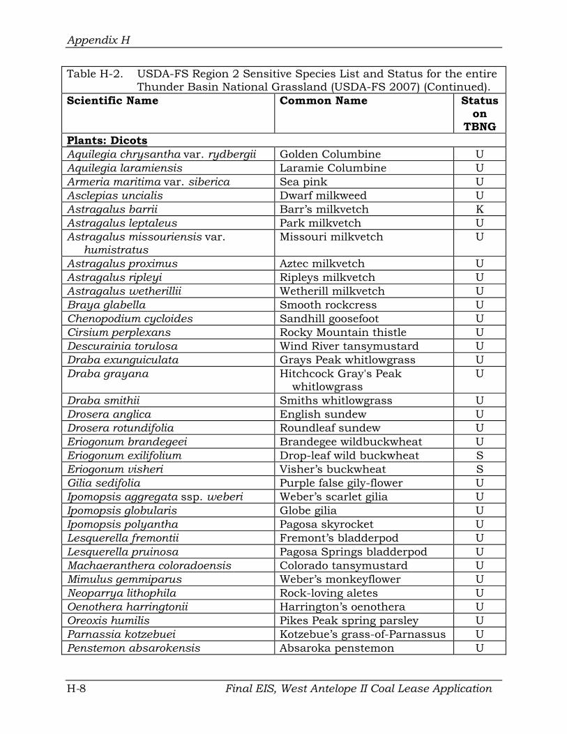
Appendix H
Table H-2. USDA-FS Region 2 Sensitive Species List and Status for the entire Thunder Basin National Grassland (USDA-FS 2007) (Continued).
Scientific Name Common Name Status on
TBNG Plants: Dicots Aquilegia chrysantha var. rydbergii Golden Columbine U Aquilegia laramiensis Laramie Columbine U Armeria maritima var. siberica Sea pink U Asclepias uncialis Dwarf milkweed U Astragalus barrii Barr’s milkvetch K Astragalus leptaleus Park milkvetch U Astragalus missouriensis var.
humistratus Missouri milkvetch U
Astragalus proximus Aztec milkvetch U Astragalus ripleyi Ripleys milkvetch U Astragalus wetherillii Wetherill milkvetch U Braya glabella Smooth rockcress U Chenopodium cycloides Sandhill goosefoot U Cirsium perplexans Rocky Mountain thistle U Descurainia torulosa Wind River tansymustard U Draba exunguiculata Grays Peak whitlowgrass U Draba grayana Hitchcock Gray's Peak
whitlowgrass U
Draba smithii Smiths whitlowgrass U Drosera anglica English sundew U Drosera rotundifolia Roundleaf sundew U Eriogonum brandegeei Brandegee wildbuckwheat U Eriogonum exilifolium Drop-leaf wild buckwheat S Eriogonum visheri Visher’s buckwheat S Gilia sedifolia Purple false gily-flower U Ipomopsis aggregata ssp. weberi Weber’s scarlet gilia U Ipomopsis globularis Globe gilia U Ipomopsis polyantha Pagosa skyrocket U Lesquerella fremontii Fremont’s bladderpod U Lesquerella pruinosa Pagosa Springs bladderpod U Machaeranthera coloradoensis Colorado tansymustard U Mimulus gemmiparus Weber’s monkeyflower U Neoparrya lithophila Rock-loving aletes U Oenothera harringtonii Harrington’s oenothera U Oreoxis humilis Pikes Peak spring parsley U Parnassia kotzebuei Kotzebue’s grass-of-Parnassus U Penstemon absarokensis Absaroka penstemon U
Final EIS, West Antelope II Coal Lease Application H-8

Appendix H
Table H-2. USDA-FS Region 2 Sensitive Species List and Status for the entire Thunder Basin National Grassland (USDA-FS 2007) (Continued).
Scientific Name Common Name Status on
TBNG Plants (Continued)
Plants: Dicots Penstemon caryi Cary beardtongue U Penstemon degeneri Degener’s penstemon U Penstemon harringtonii Harrington’s beardtongue S Phacelia scopulina var. submutica Debeque scorpionweed U Physaria didymocarpa var. lanata Woolly twinpod S Physaria pulvinata Cushion bladderpod U Potentilla rupincola Front Range cinquefoil U Primula egaliksensis Greenland primrose U Pyrrocoma carthamoides var.
subsquarrosa Absoroka goldenweed U
Pyrrocoma clementis var. villosa Tranquil goldenweed U Pyrrocoma integrifolia Many-stemmed goldenweed U Ranunculus karelinii Frosty buttercup U Rubus arcticus ssp. acaulis Arctic bramble U Salix arizonica Arizona willow U Salix barrattiana Barrat willow U Salix candida Sage willow U Salix myrtillifolia Myrtleleaf willow U Salix serissima Autumn willow U Sanguinaria canadensis Bloodroot U Shoshonea pulvinata Shoshonia U Thalictrum heliophilum Sun-loving meadowrue U Townsendia condensata var.
anomala Cushion townsenddaisy U
Utricularia minor Lesser bladderpod U Viburnum opulus var. americanum Highbush-cranberry S
Viola selkirkii Great-spurred violet U
Fish Nocomis biguttatus Hornyhead chub U Couesius plumbeus Lake chub U Gila pandora Rio Grande chub U Gila robusta Roundtail chub U Macrhybopsis gelida Sturgeon chub U Phoxinus neogaeus Finescale dace K Margariscus margarita Pearl dace U
Final EIS, West Antelope II Coal Lease Application H-9

Appendix H
Table H-2. USDA-FS Region 2 Sensitive Species List and Status for the entire Thunder Basin National Grassland (USDA-FS 2007) (Continued).
Scientific Name Common Name Status on TBNG
Fish (Continued) Phoxinus eos Northern redbelly dace U Hybognathus placitus Plains minnow K Catostomus discobulus Bluehead sucker U Catostomus latipinnis Flannelmouth sucker U Catostomus platyrynchus Mountain sucker U Catostomus plebeius Rio Grande sucker U
Invertebrates Somatochlora hudsonica Hudsonian emerald butterfly U Speyeria nokomis nokomis Great Basin silverspot
butterfly U
Hesperia ottoe Ottoe skipper butterfly U Speyeria idalia Regal fritillary S
Reptiles and Amphibians Rana pipiens Northern leopard frog K Storeria occipitomaculata pahasapae Black Hills redbelly snake S
Mammals Euderma maculatum Spotted bat K Corynorhinus townsendii Townsend’s big-eared bat K Myotis thysanodes Fringed myotis K Cynomys ludovicianus Black-tailed prairie dog K Vulpes velox Swift fox K
Birds Cygnus buccinator Trumpeter swan U Botaurus lentiginosus American bittern U Coccyzus americanus Yellow-billed cuckoo K Numenius americanus Long-billed curlew K Buteo regalis Ferruginous hawk K Accipiter gentilis Northern goshawk K Circus cyaneus Northern harrier K Athene cunicularia Burrowing owl K Asio flammeus Short-eared owl K Calcarius ornatus Chestnut-collared longspur K Calcarius mccownii McCown’s longspur K Centrocercus urophasianus Greater sage-grouse K
H-10 Final EIS, West Antelope II Coal Lease Application

Appendix H
Table H-2. USDA-F and Management Indicator Species List and Status for the entire Thunder Basin National Grasslands (USDA-FS 2007) (Continued).
Scientific Name Common Name Status on TBNG
Birds (Continued) Haliaeetus leucocephalus Bald eagle K Charadrius montanus Mountain plover K Lanius ludovicianus Loggerhead shrike K Spizella breweri Brewer’s sparrow K
Ammodramus savannarum Grasshopper sparrow K Amphispiza billneata Sage sparrow U Chlidonias niger Black tern K Melanerpes lewis Lewis’ Woodpecker K
Final EIS, West Antelope II Coal Lease Application H-11
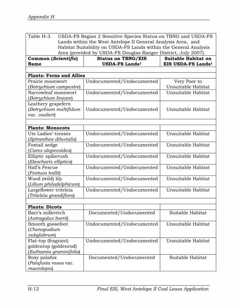
Appendix H
Table H-3. USDA-FS Region 2 Sensitive Species Status on TBNG and USDA-FS Lands within the West Antelope II General Analysis Area, and Habitat Suitability on USDA-FS Lands within the General Analysis Area (provided by USDA-FS Douglas Ranger District, July 2007).
Common (Scientific) Name
Status on TBNG/EIS USDA-FS Lands1
Suitable Habitat on EIS USDA-FS Lands1
Plants: Ferns and Allies Prairie moonwort (Botrychium campestre)
Undocumented/Undocumented Very Poor to Unsuitable Habitat
Narrowleaf moonwort (Botrychium lineare)
Undocumented/Undocumented Unsuitable Habitat
Leathery grapefern (Botrychium multifidum var. coulteri)
Undocumented/Undocumented Unsuitable Habitat
Plants: Monocots Ute Ladies’-tresses (Spiranthes diluvialis)
Undocumented/Undocumented Unsuitable Habitat
Foxtail sedge (Carex alopecoidea)
Undocumented/Undocumented Unsuitable Habitat
Elliptic spikerush (Eleocharis elliptica)
Undocumented/Undocumented Unsuitable Habitat
Hall’s Fescue (Festuca hallii)
Undocumented/Undocumented Unsuitable Habitat
Wood (wild) lily (Lilium philadelphicum)
Undocumented/Undocumented Unsuitable Habitat
Largeflower triteleia (Triteleia grandiflora)
Undocumented/Undocumented Unsuitable Habitat
Plants: Dicots Barr’s milkvetch (Astragalus barrii)
Documented/Undocumented Suitable Habitat
Smooth goosefoot (Chenopodium subglabrum)
Undocumented/Undocumented Unsuitable Habitat
Flat-top (fragrant) goldentop (goldenrod) (Euthamia graminifolia)
Undocumented/Undocumented Unsuitable Habitat
Rosy palafox (Palafoxia rosea var. macrolepis)
Documented/Undocumented Suitable Habitat
H-12 Final EIS, West Antelope II Coal Lease Application

Appendix H
Table H-3. USDA-FS Region 2 Sensitive Species Status on TBNG and USDA-FS Lands within the West Antelope II General Analysis Area, and Habitat Suitability on USDA-FS Lands within the General Analysis Area (provided by USDA-FS Douglas Ranger District, July 2007) (Continued).
Common (Scientific) Name
Status on TBNG/EIS USDA-FS Lands1
Suitable Habitat on EIS USDA-FS Lands1
Plants: Dicots (Continued) Lemonscent (crown-seed fetid-marigold) (Pectis angustifolia)
Documented/Undocumented Suitable Habitat
Nelson larchleaf penstemon (Penstemon laricifolius ssp. exifolius)
Undocumented/Undocumented Marginal Habitat
Woolly twinpod (Physaria didymocarpa var. lanata)
Undocumented/Undocumented Marginal Habitat
Visher’s buckwheat (Eriogonum visheri)
Tentatively Documented/Undocumented Unsuitable Habitat
Highbush-cranberry (Viburnum opulus var. americanum)
Undocumented/Undocumented Unsuitable Habitat
Amphibians Northern leopard frog (Rana pipiens)
Documented/No Observations Very Poor to Unsuitable Habitat
Fish No Fish Species are Listed for this Area*
Mammals Black-tailed prairie dog (Cynomys ludovicianus)
Documented/Documented Suitable Habitat
Swift fox (Vulpes velox) Documented/No Observations Suitable but Unoccupied Habitat
Birds Long-billed curlew (Numenius americanus) Documented/No Observations Marginal Habitat
Ferruginous hawk (Buteo regalis) Documented/Documented Suitable Habitat
Final EIS, West Antelope II Coal Lease Application H-13

Appendix H
Table H-3. USDA-FS Region 2 Sensitive Species Status on TBNG and USDA-FS Lands within the West Antelope II General Analysis Area, and Habitat Suitability on USDA-FS Lands within the General Analysis Area (provided by USDA-FS Douglas Ranger District, July 2007) (Continued).
Common (Scientific) Name
Status on TBNG/EIS USDA-FS Lands1
Suitable Habitat on EIS USDA-FS Lands1
Birds (Continued) Burrowing owl (Athene cunicularia) Documented/Documented Suitable Habitat
Chestnut-collared longspur (Calcarius ornatus)
Documented/Documented Suitable Habitat
Birds (Continued) McCown’s longspur (Calcarius mccownii) Documented/Documented Suitable Habitat
Greater sage-grouse (Centrocercus urophasianus)
Documented/No Observations Marginal Habitat
Bald eagle (Haliaeetus leucocephalus)
Documented/ No Observations Suitable Rangeland Foraging Habitat
Mountain Plover (Charadrius montanus) Documented/Documented Suitable Habitat
Loggerhead shrike (Lanius ludovicianus) Documented/No Observations Marginal Habitat
Brewer’s sparrow (Spizella breweri) Documented/No Observations Marginal Habitat 1 EIS USDA-FS Lands are USDA-FS administered lands within the West Antelope II LBA tract
general analysis area. * The USDA-FS lands included in this tract are not known nor expected to contain or provide
habitat for these species.
H-14 Final EIS, West Antelope II Coal Lease Application

Appendix H
USDA-FS SENSITIVE SPECIES HABITAT AND OCCURRENCES ON USDA-FS LANDS WITHIN THE WEST ANTELOPE II GENERAL ANALYSIS AREA
Site-specific data on the occurrence of USDA-FS Region 2 Sensitive Species on USDA-FS Lands within the West Antelope II general analysis area were obtained from the Wyoming Department of Environmental Quality/Land Quality Division (WDEQ/LQD) permit applications, annual and baseline reports for the Antelope Mine, the Rocky Mountain Herbarium, the Wyoming Natural Diversity Database, and the USDA-FS. Annual wildlife surveys have been conducted for the adjacent Antelope Mine since 1982. Those surveys included the mine permit area and a one- or two-mile surrounding perimeter (depending on the purpose of the surveys). Those extended survey perimeters for the annual wildlife monitoring program coincidentally encompassed all USDA-FS administered lands and adjacent lands within the LBA tract general analysis area. More details describing that overlap are provided in the Wildlife section, below. Several intensive vegetation baseline inventories have also been completed on each mine’s current permit area as well as the West Antelope II general analysis area.
DIRECT AND INDIRECT EFFECTS OF SENSITIVE SPECIES
The following discussion is an evaluation of the potential direct and indirect environmental effects on USDA-FS Region 2 Sensitive Species identified as inhabiting or potentially inhabiting USDA-FS lands within the West Antelope II general analysis area, as outlined in Table H-3.
PLANTS
Seasonal plant species surveys have been conducted on portions of the West Antelope II general analysis area during the various previous vegetation baseline inventories completed for the Antelope Coal Mine and North Antelope/Rochelle mine as well as for prior EIS documents. Additional seasonal plant species surveys were completed on the general analysis area during baseline inventories completed for the Antelope Mine in 2007.
There is no suitable habitat on USDA-FS lands within the general analysis area for 12 of the 18 plant species listed in Table H-3. All of the 16 plant species will be discussed here because potential habitat may be present on other portions of the general analysis area even if suitable habitat is not present on the USDA-FS lands.
1. Prairie Moonwort (Botrychium campestre) The prairie moonwort has not been documented on USDA-FS lands within the general analysis area or within the TBNG. This plant species is suspected of occurring on TBNG lands where suitable habitat is present. This species was only recorded in Wyoming in a semi-shady mixed deciduous and ponderosa pine forest on sandy soils in the Black Hills. Prairie moonworts are known to Final EIS, West Antelope II Coal Lease Application H-15

Appendix H
exist in a variety of other habitats such as those underlain by Pierre shale, the Laramie Formation, calcareous sedimentary rocks, calcareous soils underlain by limestone, sandy soils and loess prairie. These habitats are generally limited on the West Antelope II general analysis area, with only some areas dominated by sandy soils present.
Existing Conditions Prime habitats for the prairie moonwort are not present on the FS lands within the general analysis area. Sites with sandy soils are present on USDA-FS lands and other portions of the general analysis area but these areas are rather sparsely vegetated and do not provide habitat preferred by this plant species. Prairie moonworts have not been recorded on the general analysis area or adjacent areas.
Indirect and Direct Impacts If present on areas to be disturbed by mining, individuals of this species would be lost when topsoil is removed or during disturbances caused by other mining activities.
Determination of Effect and Rationale Implementation of the Proposed Action or Alternatives may impact individuals but is not likely to cause a trend to federal listing or loss of viability within the planning area. As indicated, the general analysis area does not provide suitable habitat for this plant species. The potential for loss of individuals or preferred habitats is very low.
2. Narrowleaf Moonwort (Botrychium lineare) The narrowleaf moonwort has not been documented on USDA-FS lands within the general analysis area or within the TBNG. This plant species is suspected of occurring on TBNG lands where suitable habitat is present. This species has an affinity for riparian areas and is associated with spruce/fir forests, lodgepole pine forests and forest meadows.
Existing Conditions Habitats for the narrowleaf moonwort are not present on the USDA-FS lands within the general analysis area. Suitable riparian habitats or forest habitats are not present on these USDA-FS lands within the general analysis area. Riparian sites associated with Antelope Creek, Spring Creek and Horse Creek are present on other portions of the general analysis area but these sites do not appear to provide optimum habitat for this species. The narrowleaf moonwort has not been recorded on the general analysis area or adjacent areas.
Indirect and Direct Impacts If present on areas to be disturbed by mining, individuals of this species would be lost when topsoil is removed or during disturbances caused by other mining activities.
Final EIS, West Antelope II Coal Lease Application H-16

Appendix H
Determination of Effect and Rationale Implementation of the Proposed Action or Alternatives may impact individuals but is not likely to cause a trend to federal listing or loss of viability within the planning area. As indicated, the general analysis area does not provide suitable habitat for this plant species. The potential loss of individuals or preferred habitats is very low.
3. Leathery Grapefern (Botrychium multifidum var. coulteri) The leathery grapefern has not been documented on USDA-FS lands within the general analysis area or within the TBNG. This plant species is suspected of occurring on TBNG lands where suitable habitat is present. This species generally has an affinity for meadows, wetlands, floodplains and other wet areas in open to forested habitats within forests.
Existing Conditions Habitats for the leathery grapefern are not present on the USDA-FS lands within the general analysis area. Suitable riparian habitats or forest habitats are not present on these USDA-FS lands within the general analysis area. Riparian sites associated with Antelope Creek, Spring Creek and Horse Creek are present on other portions of the general analysis area but these sites do not appear to provide optimum habitat for this species. The leathery grapefern has not been recorded on the general analysis area or adjacent areas.
Indirect and Direct Impacts If present on areas to be disturbed by mining, individuals of this species would be lost when topsoil is removed or during disturbances caused by other mining activities.
Determination of Effect and Rationale Implementation of the Proposed Action or Alternatives will have no impact on the leathery grapefern. As indicated, the general analysis area does not provide suitable habitat for this plant species so the potential loss of individuals or preferred habitats is not expected.
4. Ute ladies’-tresses (Spiranthes diluvialis) The Ute ladies’-tresses is a perennial forb plant species and is also listed as threatened by the USFWS. Please see Appendix I for a more detailed description of Ute ladies’-tresses.This species has not been documented on USDA-FS lands within the general analysis area or within the TBNG. This plant species is suspected of occurring on TBNG lands where suitable habitat is present. The Ute ladies’-tresses has an affinity for open meadows, wetlands, floodplains and other wet areas that are subirrigated well into July and August. Ute ladies’-tresses has been recorded at several locations about 25 miles west of the general analysis area on Sand Creek, Antelope Creek, and its tributaries. No occurrences have been recorded in Campbell County, nor in the West Antelope II general analysis area in Converse County.
Final EIS, West Antelope II Coal Lease Application H-17

Appendix H
Existing Conditions Ute ladies’-tresses habitat is not present on the USDA-FS lands within the general analysis area. On non-Forest Service lands in the general analysis area, riparian sites associated with Antelope Creek, Spring Creek, and Horse Creek are present. Portions of these riparian areas contain potential habitat for this species. Potential Ute ladies’-tresses habitat in the general analysis area was surveyed on August 16-17 of 2006; July 25-27, August 3-5, and August 16-19 of 2007; and August 4, 5, 18, and 19 of 2008. Surveys were also conducted on portions of these areas in 1997, 1998, 1999, and 2004. The Ute ladies’-tresses orchid was not found during any of these surveys. To date, no Ute ladies’-tresses occurrences have been recorded in Campbell County nor in the West Antelope II general analysis area in Converse County. The nearest known Ute ladies’-tresses population is located on an Antelope tributary approximately 20 miles upstream of the project area.
Indirect and Direct Impacts Disturbance and reclamation of streams by surface coal mining may alter stream morphology and hydrology. The large quantities of water produced from CBNG development and water discharge on the surface may also alter stream morphology and hydrology. Although individual plants of this species do not necessarily produce annual flowering stalks nor above-ground growth consistently from year to year, it is unlikely that Ute ladies’-tresses populations would have remained undetected during multiple surveys over multiple years, if they were present in the area.
Nonetheless, if undetected populations were present on Horse Creek or Spring Creek in the general analysis area, they would be lost due to surface disturbing activities. However, Antelope Creek would have a stipulated 100-foot no disturbance buffer zone on either side of its banks and that area would not be mined. If there were undetected Ute ladies’-tresses orchids in that locality, they would remain in place.
Determination of Effect and Rationale As previously described, multiple orchid surveys have been conducted over multiple years during the known time of flowering using USFWS accepted techniques. All surveys have resulted in negative findings.
Ute ladies’-tresses habitat is not present on the USDA-FS lands within the general analysis area. On non-Forest Service lands in the general analysis area, implementation of the Proposed Action or Alternatives may affect, but is not likely to adversely affect Ute ladies’-tresses. Potential habitat for this species is currently present on the tract along Antelope Creek, Horse Creek, and Spring Creek. If lands in the general analysis area are leased, Spring Creek and Horse Creek would be mined, but Antelope Creek would have a 100foot no-disturbance buffer zone on either side of its banks, as is presently stipulated in the WDEQ/LQD mine permit. Outside of these drainages, potential suitable habitat is rare in the study area. Surveys of existing suitable
Final EIS, West Antelope II Coal Lease Application H-18

Appendix H
habitat at the Antelope Mine and other mines in the area have not found Ute ladies’-tresses.
5. Foxtail Sedge (Carex alopecoidea) The foxtail sedge is a perennial plant species and has not been documented on USDA-FS lands within the general analysis area or within the TBNG. This plant species is suspected of occurring on TBNG lands where suitable habitat is present. The foxtail sedge generally has an affinity for wet meadows and willow-sedge communities along wet, shady creek bottoms and springs.
Existing Conditions Habitats for the foxtail sedge are not present on the USDA-FS lands within the general analysis area. Suitable wet meadows or willow-sedge communities are not present on these USDA-FS lands. Riparian sites associated with Antelope Creek, Spring Creek and Horse Creek are present on other portions of the general analysis area but these sites do not appear to provide optimum habitat for this species. The foxtail sedge has not been recorded on the general analysis area or adjacent areas.
Indirect and Direct Impacts If present on areas to be disturbed by mining, individuals of this species would be lost when topsoil is removed or during disturbances caused by other mining activities.
Determination of Effect and Rationale Implementation of the Proposed Action or Alternatives should have no impact on the foxtail sedge. As indicated, the general analysis area does not provide suitable habitat for this plant species. The potential for loss of individuals or preferred habitats is not expected.
6. Elliptic Spikerush (Eleocharis elliptica) The elliptic spikerush is a perennial and has not been documented on USDAFS lands within the general analysis area or within the TBNG. This plant species is suspected of occurring on TBNG lands where suitable habitat is present. The foxtail sedge generally has an affinity for wetland areas created by seeps or springs but may also be found in temporarily flooded areas.
Existing Conditions Habitats for the elliptic spikerush are not present on the USDA-FS lands within the general analysis area. Suitable wetland habitats are not present on these USDA-FS lands. Wetland sites associated with Antelope Creek, Spring Creek and Horse Creek are present on other portions of the general analysis area and these sites may provide marginal habitat for this species. The elliptic spikerush has not been recorded on the general analysis area or adjacent areas.
Final EIS, West Antelope II Coal Lease Application H-19

Appendix H
Indirect and Direct Impacts If present on areas to be disturbed by mining, individuals of this species would be lost when topsoil is removed or during disturbances caused by other mining activities. However, due to lack of abundant suitable habitat the impacts to this species overall would be minimal.
Determination of Effect and Rationale Implementation of the Proposed Action or Alternatives may impact individuals but is not likely to cause a trend to federal listing or loss of viability within the planning area. As indicated, the general analysis area does not provide abundant habitat for this plant species so the potential loss of individuals or preferred habitats is low.
7. Hall’s Fescue (Festuca hallii) The Hall’s fescue is a tufted perennial grass and has not been documented on USDA-FS lands within the general analysis area or within the TBNG. This plant species is suspected of occurring on TBNG lands where suitable habitat is present. This species generally has an affinity for montane meadows, slopes and edges of open coniferous woods and meadows above 6000 feet in Wyoming.
Existing Conditions Habitats for the Hall’s fescue are not present on the USDA-FS lands within the general analysis area. Suitable montane habitats above 6000 feet are not present on these USDA-FS lands within the general analysis area or within the rest of the general analysis area. The Hall’s fescue has not been recorded on the general analysis area or adjacent areas.
Indirect and Direct Impacts If present on areas to be disturbed by mining, individuals of this species would be lost when topsoil is removed or during disturbances caused by other mining activities.
Determination of Effect and Rationale Implementation of the Proposed Action or Alternatives should have no impact on the Hall’s fescue. As indicated, the general analysis area does not provide suitable habitat for this plant species. The potential loss of individuals or preferred habitats is not expected.
8. Wood Lily (Lilium philadelphicum) The wood lily is a perennial herb and has not been documented on USDA-FS lands within the general analysis area or within the TBNG. This plant species is suspected of occurring on TBNG lands where suitable habitat is present. This species generally has an affinity for woodland meadows and woodland grasslands.
Existing Conditions Habitats for the wood lily are not present on the USDA-FS lands within the
Final EIS, West Antelope II Coal Lease Application H-20

Appendix H
general analysis area. Suitable woodland meadow or grassland habitats are not present on these USDA-FS lands within the general analysis area or within the rest of the general analysis area. The wood lily has not been recorded on the general analysis area or adjacent areas.
Indirect and Direct Impacts If present on areas to be disturbed by mining, individuals of this species would be lost when topsoil is removed or during disturbances caused by other mining activities.
Determination of Effect and Rationale Implementation of the Proposed Action or Alternatives should have no impact on the wood lily. As indicated, the general analysis area does not provide suitable habitat for this plant species so the potential loss of individuals or preferred habitats is not expected.
9. Largeflower Triteleia (Triteleia grandiflora) The largeflower triteleia is a perennial herb and has not been documented on USDA-FS lands within the general analysis area or within the TBNG. This plant species is suspected of occurring on TBNG lands where suitable habitat is present. This species generally has an affinity for grassy areas in sagebrush at the edge of aspen and lodgepole pine forests and in pinon-juniper woodlands to pine forests and hills.
Existing Conditions Habitats for the largeflower triteleia are not present on the USDA-FS lands within the general analysis area. Suitable grassy areas in sagebrush at the edge of aspen and lodgepole pine forests and pinon-juniper woodlands or pine forests and hills are not present on these USDA-FS lands within the general analysis area or within the rest of the general analysis area. The largeflower triteleia has not been recorded on the general analysis area or adjacent areas.
Indirect and Direct Impacts If present on areas to be disturbed by mining, individuals of this species would be lost when topsoil is removed or during disturbances caused by other mining activities.
Determination of Effect and Rationale Implementation of the Proposed Action or Alternatives should have no impact on the largeflower triteleia. As indicated, the general analysis area does not provide suitable habitat for this plant species so the potential loss of individuals or preferred habitats is not expected.
10. Barr’s Milkvetch (Astragalus barrii) The Barr’s milkvetch is a matt-forming perennial forb that is known from numerous occurrences on the USDA-FS lands within the TBNG. As more surveys are completed, new occurrences are reported. The Barr’s milkvetch is Final EIS, West Antelope II Coal Lease Application H-21

Appendix H
found primarily on dry, sparsely-vegetated rocky prairie breaks, knolls, hillsides and ridges. Parent material is calcareous soft shale, siltstone or silty sandstone. Most populations appear to be stable, although populations may decline under drought.
Existing Conditions Astragalus barrii is a regional endemic plant of the plains in southwestern South Dakota, eastern Wyoming, southeastern Montana, and northwestern Nebraska. According to USDA-FS, this plant species is known to occur in six counties in Wyoming, and there are eleven known occurrences of A. barrii in the USDA-FS TBNG.
Suitable habitat for the Barr’s milkvetch is present on the USDA-FS lands within the general analysis area as well as other lands within the general analysis area. When surveyed, the Barr’s milkvetch plants were not in bloom, but populations were estimated to consist of approximately 500 to 1,000 individuals within the project area. Barr’s milkvetch populations and individuals were identified in several locations within the project area. Potential habitat and additional populations also occur in surrounding areas outside of the general analysis area. Barr’s milkvetch has been collected and positively identified approximately 0.75 miles south of the general analysis area in the SWSWSW1/4 of Section 21 T. 40 N., R. 71 W. based on specimens on file with the Rocky Mountain Herbarium in Laramie, Wyoming.
Indirect and Direct Impacts If lands within the West Antelope II general analysis area are leased and mined, potential habitat, individuals, and A. barrii populations would be lost due to surface disturbances caused by mining activities. These losses would most likely be permanent unless disturbed lands are reclaimed to habitats that would support this plant species.
Determination of Effect and Rationale Implementation of the Proposed Action or Alternatives may impact individuals but is not likely to cause a trend to federal listing because there are Astragalus barrii occurrences outside of the project area that will not be affected by the proposed action or alternatives.
11. Smooth Goosefoot (Chenopodium subglabrum) The smooth goosefoot is an annual forb and has not been documented on USDA-FS lands within the general analysis area or within the TBNG. This plant species is suspected of occurring on TBNG lands where suitable habitat is present. This species generally has an affinity for sand bars and sandy blowouts in riparian areas.
Existing Conditions Habitats for the smooth goosefoot are not present on the USDA-FS lands within the general analysis area. Riparian areas are not present on the USDA-FS
Final EIS, West Antelope II Coal Lease Application H-22

Appendix H
lands within the general analysis area. Riparian areas are present within portions of the rest of the general analysis area in association with Antelope Creek, Spring Creek and Horse Creek but these areas do not contain the required sand bar or sandy blowout habitats required for this plant species. The smooth goosefoot has not been recorded on the general analysis area or adjacent areas.
Indirect and Direct Impacts If present on areas to be disturbed by mining, individuals of this species would be lost when topsoil is removed or during disturbances caused by other mining activities.
Determination of Effect and Rationale Implementation of the Proposed Action or Alternatives should have no impact on the smooth goosefoot. As indicated, the general analysis area does not provide suitable habitat for this plant species so the potential loss of individuals or preferred habitats is not expected.
12. Flat-top Goldentop (Euthamia graminifolia) The flat-top goldentop is a rhizomatous perennial forb and has not been documented on USDA-FS lands within the general analysis area or within the TBNG. This plant species is suspected of occurring on TBNG lands where suitable habitat is present. In Wyoming this species generally has an affinity for stony sandbars and streambanks but may also be found on moist or drying sites along open streambanks or roadside ditches.
Existing Conditions Habitats for the flat-top goldentop are not present on the USDA-FS lands within the general analysis area. Wetland or streambank areas are not present on the USDA-FS lands within the general analysis area. Streambanks and wetland areas are present within portions of the rest of the general analysis area in association with Antelope Creek, Spring Creek and Horse Creek. These areas generally do not contain the typical habitats required for this plant species but marginal habitats are present. The flat-top goldentop has not been recorded on the general analysis area or adjacent areas.
Indirect and Direct Impacts If present on areas to be disturbed by mining, individuals of this species would be lost when topsoil is removed or during disturbances caused by other mining activities.
Determination of Effect and Rationale Implementation of the Proposed Action or Alternatives may impact individuals but is not likely to cause a trend to federal listing or loss of viability within the planning area. As indicated, the general analysis area does not provide suitable habitat for this plant species so the potential loss of individuals or preferred habitats is low. Final EIS, West Antelope II Coal Lease Application H-23

Appendix H
13. Rosy Palafox (Palafoxia rosea var. macrolepis) The rosy palafox is an annual forb plant species and has not been documented on USDA-FS lands within the general analysis area but has been recorded on other lands within the TBNG. This plant species is suspected of occurring on other TBNG lands where suitable habitat is present. In Wyoming this species generally has an affinity for sagebrush and mixed-grass prairie habitats on sandy soils.
Existing Conditions Habitats utilized by the rosy palafox are present on the USDA-FS lands within the general analysis area and on other lands within the remainder of the general analysis area. Sagebrush and mixed-grass prairie plant communities are present on sandy soils in the study area. However, the rosy palafox has not been recorded on these lands but is potentially present. This plant species has been documented southeast of the general analysis area.
Indirect and Direct Impacts If present on areas to be disturbed by mining, individuals of this species would be lost when topsoil is removed or during disturbances caused by other mining activities. However, due to the presence of abundant habitat outside of the general analysis area and the fact this plant is abundant in other areas, the impacts to this species overall would be minimal.
Determination of Effect and Rationale Implementation of the Proposed Action or Alternatives may impact individuals but is not likely to cause a trend to federal listing or loss of viability within the planning area. As indicated, the general analysis area does contain suitable habitat for this plant species but the rosy palafox has not been documented on the site. This species has been documented southeast of the general analysis area and abundant habitat is present on other sites outside of the general analysis area that will not be affected.
14. Lemonscent (Pectis angustifolia) The lemonscent is an annual forb plant species and has not been documented on USDA-FS lands within the general analysis area but has been recorded on other lands within the TBNG. This plant species is suspected of occurring on other TBNG lands where suitable habitat is present. In Wyoming this species generally has an affinity for gravel hills and scoria slopes. Lemonscent is also known to occur in low areas in sandy ravines and on sandbars.
Existing Conditions Habitats utilized by lemonscent are present on the USDA-FS lands within the general analysis area and on other lands within the remainder of the general analysis area. Gravel hills, slopes and sandy ravines are present in the study area. However, lemonscent has not been recorded on these lands but could potentially be present. This plant species has been documented south of the general analysis area.
Final EIS, West Antelope II Coal Lease Application H-24

Appendix H
Indirect and Direct Impacts If present on areas to be disturbed by mining, individuals of this species would be lost when topsoil is removed or during disturbances caused by other mining activities. However, due to the presence of abundant habitat outside of the general analysis area and the fact this plant is abundant in other areas, the impacts to this species overall would be minimal.
Determination of Effect and Rationale Implementation of the Proposed Action or Alternatives may impact individuals but is not likely to cause a trend to federal listing or loss of viability within the planning area. As indicated, the general analysis area does contain suitable habitat for this plant species but lemonscent palafox has not been documented on the site. This species has been documented south and east of the general analysis area and abundant habitat is present on other sites outside of the general analysis area that will not be affected.
15. Nelson Larchleaf Penstemon (Penstemon laricifolius spp. exifolius) The larchleaf penstemon is a perennial forb plant species and has not been documented on USDA-FS lands within the general analysis area or on other lands within the TBNG. This plant species is suspected of occurring on other TBNG lands where suitable habitat is present. In Wyoming this species generally has an affinity for dry, rocky, gravelly or sandy slopes, ridgetops and upland flats with shallow soils. Most populations in Wyoming are found at elevations above 6000 feet, but this species has been documented at lower elevations in the state.
Existing Conditions Habitats utilized by larchleaf penstemon are present on the USDA-FS lands within the general analysis area and on other lands within the remainder of the general analysis area. Gravel hills, rocky slopes and rough breaks are present in the study area. The larchleaf penstemon has not been recorded on these lands but has potential habitat. This plant species has not been documented near the general analysis area.
Indirect and Direct Impacts If present on areas to be disturbed by mining, individuals of this species would be lost when topsoil is removed or during disturbances caused by other mining activities. However, due to the presence of abundant habitat outside of the general analysis area and the fact this plant is abundant in other areas, the impacts to this species overall would be minimal.
Determination of Effect and Rationale Implementation of the Proposed Action or Alternatives may impact individuals but is not likely to cause a trend to federal listing or loss of viability within the planning area. As indicated, the general analysis area does contain suitable habitat for this plant species but the larchleaf penstemon has not been documented on the site. This species has been documented and is common in Final EIS, West Antelope II Coal Lease Application H-25

Appendix H
southern Wyoming and abundant habitat is present on other sites outside of the general analysis area that will not be affected.
16. Wooly Twinpod (Physaria didymocarpa var. lanata) The wooly twinpod is a perennial forb plant species and has not been documented on USDA-FS lands within the general analysis area or on other lands within the TBNG. This plant species is suspected of occurring on other TBNG lands where suitable habitat is present. In Wyoming this species generally has an affinity for dry redbed clay-shale slopes, limey-sandstone outcrops, roadcuts and other exposed rock-cliff substrates. Most populations in Wyoming have been documented in the foothills of the Big Horn Mountains.
Existing Conditions Habitats utilized by the wooly twinpod are present on the USDA-FS lands within the general analysis area and on other lands within the remainder of the general analysis area. Gravel hills, rocky slopes and rough breaks are present in the study area. Wooly twinpod has not been recorded on these lands but is potentially present. This plant species has not been documented near the general analysis area.
Indirect and Direct Impacts If present on areas to be disturbed by mining, individuals of this species would be lost when topsoil is removed or during disturbances caused by other mining activities. However, due to the presence of abundant habitat outside of the general analysis area and the fact this plant is abundant in other areas, the impacts to this species overall would be minimal.
Determination of Effect and Rationale Implementation of the Proposed Action or Alternatives may impact individuals but is not likely to cause a trend to federal listing or loss of viability within the planning area. As indicated, the general analysis area does contain suitable habitat for this plant species but the wooly twinpod has not been documented on the site. This species has been documented and is common in north-central Wyoming and abundant habitat is present on other sites outside of the general analysis area that will not be affected.
17. Visher’s buckwheat (Eriogonum visheri) The Visher’s buckwheat has not been documented on USDA-FS lands within the general analysis area but has been tentatively identified within the TBNG. This plant species is suspected of occurring on TBNG lands where suitable habitat is present. This species generally has an affinity for gullied ridges and eroded badland hills. These sites generally consist of barren shale and clay outcrops with at least 50% bare soil, high salt content and shrink/swell clay soils. Typical habitat includes badland islands in grasslands.
Existing Conditions Habitats for the Visher’s buckwheat are not present on the USDA-FS lands
Final EIS, West Antelope II Coal Lease Application H-26

Appendix H
within the general analysis area. Suitable gullied ridges, eroded sites or badland habitats are not present on these USDA-FS lands within the general analysis area. Suitable habitats may be found in other portions of the general analysis area but these sites do not appear to provide optimum habitat for this species. The Visher’s buckwheat has not been recorded on the general analysis area or adjacent areas.
Indirect and Direct Impacts If present on areas to be disturbed by mining, individuals of this species would be lost when topsoil is removed or during disturbances caused by other mining activities.
Determination of Effect and Rationale Implementation of the Proposed Action or Alternatives will have no impact on the Visher’s buckwheat As indicated, this species has not be documented on the site and the general analysis area does not provide optimum suitable habitat for this plant species so the potential loss of individuals or preferred habitats is not expected.
18. Highbush-cranberry (Viburnum opulus var. americanum) The highbush-cranberry has not been documented on USDA-FS lands within the general analysis area or within the TBNG. This plant is found within Crook County and is suspected of occurring on TBNG lands where suitable habitat is present. This species generally has an affinity for moist sites including wooded hillsides, thickets or low woodlands. The highbush-cranberry is found all across northern North America.
Existing Conditions Habitats for the highbush-cranberry are not present on the USDA-FS lands within the general analysis area. Suitable moist wooded habitats are not present on these USDA-FS lands within the general analysis area. Marginally suitable habitats may be found in limited amounts on other portions of the general analysis area but these sites do not appear to provide optimum habitat for this species. The highbush-cranberry has not been recorded within the general analysis area or adjacent areas.
Indirect and Direct Impacts If present on areas to be disturbed by mining, individuals of this species would be lost when topsoil is removed or during disturbances caused by other mining activities.
Determination of Effect and Rationale Implementation of the Proposed Action or Alternatives will have no impact on the highbush-cranberry. As indicated, this species has not been documented on the site and the general analysis area does not provide optimum suitable habitat for this plant species so the potential loss of individuals or preferred habitats is not expected. Final EIS, West Antelope II Coal Lease Application H-27

Appendix H
WILDLIFE
WDEQ/LQD guidelines and regulations specify different wildlife survey areas for different species and for different survey purposes (baseline studies or annual monitoring). In the wildlife discussions for the USDA-FS section of this document, the terms “one-half, one-, and two-mile perimeter wildlife survey area” refer to perimeters surrounding the existing Antelope Mine permit area. Surveys conducted during annual monitoring (for existing permitted areas) include the permit area and a one-half or one-mile perimeter around the permit area. The two-mile perimeter is used for big game counts in alternate annual monitoring years and for new wildlife baseline studies. The annual wildlife monitoring perimeters coincidentally also encompassed all USDA-FS lands within both the BLM study area (i.e., the tract as applied for and lands that BLM is considering adding to the tract) and the general analysis area (BLM study area plus a surrounding one-quarter-mile perimeter) for the West Antelope II LBA tract.
USDA-FS typically assesses impacts to resources on its managed lands and, when applicable, adjacent lands that could also be impacted by the proposed action. For wildlife, the USDA-FS is interested in knowing what resources and potential impacts occur within a one- or two-mile perimeter surrounding their lands, depending on the species. As illustrated in Figure H-1, the one-mile annual monitoring perimeter for the Antelope Mine overlapped all USDA-FS lands under analysis, all but the southwestern-most 0.5 mi2 of the one-mile perimeter around those federal lands, and all except the western- and southern-most 7.5 mi2 of the two-mile perimeter around the USDA-FS lands.
Baseline wildlife inventories in a two-mile perimeter survey area were conducted for the overall West Antelope II LBA tract beginning in 2006. Due to the proximity of USDA-FS lands to the LBA tract, that two-mile wildlife baseline perimeter also covered all perimeters around USDA-FS lands.
To summarize, all USDA-FS lands associated with this EIS analysis have been included in wildlife monitoring surveys for the adjacent Antelope Mine annually since 1982. Those surveys also included substantial portions of the one- and two-mile perimeters around those USDA-FS lands.
Regular surveys conducted in and near USDA-FS lands over the years included raptors, mountain plovers (Charadrius montanus), upland game birds, migratory bird species of management concern, lagomorphs, and big game. Supplemental specific surveys for bald eagles (Haliaeetus leucocephalus), herptiles, waterfowl, and other species were conducted periodically during baseline studies for the Antelope Mine. Efforts included a variety of approved survey methods, such as fixed-wing aerial, remote observation via spotting scopes and binoculars, pedestrian, nocturnal spotlighting, belt transects, point counts, and trapping. All incidental sightings of those species were also recorded during each site visit, including notes on species, number of
Final EIS, West Antelope II Coal Lease Application H-28

!
#
Appendix H
#*#*
!( !
! ! !
!
! !
!(
!
!(
!
!
!( !
!( !
!
!(
#*
!(
!(
"
"
!(
!( !(
!(
!(
!(
"
!(
!( "
!(!(
!
!( #!(
!(
!(
#
!
!
!
!
!
!
!
!
!
! !
!
!
!(
!
!
!
!(
!
County Rd. 37
Antelope Cr.
T. 40 N.
T. 41 N.
R. 71 W. R. 70 W.
B1
BO5
BO7
GE3f
GE3e
FH13b
GE5a
GE5b
BO2c BO2b
GE2g
BO2d
FH5f
FH3c
FH1l
FH5e
FH4b
FH5d
FH1k
GE1c
GE1b
GE1d
GE1e
BO3
BO4
FH1c
FH1d
FH1b
BO10
BO11
BO6
FH1h
FH1i
FH1f
GE3a
FH3a
GE3b GE3d FH5b
FH5c FH5a
FH4a
FH1gFH1j
RTH18
RTH1c
GHO9
GHO3a
RTH1b
GHO3b
GHO2b
GHO3c
RTH1a
GHO11b/RTH13d
RTH13a
RTH13c
RTH8
RTH6 GE3c/GHO2c
RTH13b/GHO11d
GE2b/GE5c/GHO11c
FH1a/RTH2a/GHO1a
GHO2a
BO2a
!(4 !(5
!(6
!(18
!(14
!(8
!(1
!(3
!(2
!(7
9 78
4 1235 6
11
30
15
24
14 13
25
2322
12
16
2628
27
18
10
21 19
17
34
20
29
33 3135 3632
8
5
32
3135 36
29
17
34
20
3332 32
!(59
£
0 5,000 10,000
GRAPHIC SCALE (FEET)
B.N
.S.F
. & U
. P. R
R
SPECIES CODES
B Unknown Buteo Species
BO Burrowing Owl
FH Ferruginous Hawk
GE Golden Eagle
GHO Great Horned Owl
RTH Red-Tailed Hawk
SH Swainson's Hawk
NEST TYPES
! Existing Raptor Nest
# Existing Platform Nest
" Nest Box
( Former Raptor Nest Site
* Former Platform Nest Site
LEGEND USDA-FS 240 acre Boundary
County Boundary
USDA-FS 240 acre Wildlife Two-Mile Survey Perimeter
Antelope Wildlife One-Mile Survey Perimeter (Through 2006)
Historical Mountain Plover Use Area (MPA): Inactive for 1 - 12 years during current monitoring program (1994-2007). As mapped in 1989 using 1982-1988 data. [Included infrequently used, unoccupied suitable, and unsuitable habitat when originally mapped.] Recent Mountain Plover Use Area: (MPA): Active at least one year during current monitoring program (1994-2007). As mapped in 1989 using 1982-1988 data. [Included infrequently used, unoccupied suitable, and unsuitable habitat when originally apped.] Area where Mountain Plovers were actually seen during current monitoring period (1994-2007). [Included infrequently used areas.]
Current acreage of prairie dog colonies in vicinity of Antelope Mine.
Prairie dog colonies created in 2002 and 2003 to mitigate loss of Mountain Plover habitat to mining.
Figure H-1. 2007 Biological Assessment / Biological Evaluation for USDA-FS Administered Lands within the West Antelope II Study Area.
Final EIS, West Antelope II Coal Lease Application H-29

Appendix H
individuals, sex/age (when possible), habitat, and location. Specific details regarding survey methods and results from annual monitoring and baseline inventories for the Antelope Mine, dating back to 1978, are provided in reports on file with the WDEQ-LQD and/or USDA-FS, and thus are not provided in this document.
The entire list of Region 2 Sensitive Species was reviewed and every vertebrate species was considered for full evaluation. However, only those species that might potentially be affected directly or indirectly by implementation of the Proposed Action or Alternatives on USDA-FS lands were selected for evaluation (Table H-3). For example, if a vertebrate species was known to occur on or near USDA-FS lands, or suitable but unoccupied habitat was present in that area and would be disturbed, then potential effects were evaluated. If suitable habitat was not present in the area, no further analysis was conducted.
Thirteen vertebrate species were identified that could potentially be affected by implementation of the Proposed Action or Alternatives. Many other sensitive vertebrates and one invertebrate that had been documented elsewhere on the TBNG were not evaluated further because of a lack of suitable habitat on or near USDA-FS lands, or because no such habitat would be physically disturbed or otherwise affected by implementation of the Proposed Action or Alternatives.
Brief discussions of the status, distribution, and local occurrence of each evaluated species and the potential direct and indirect impacts are presented in each of the following subsections. Cumulative impacts are discussed for all evaluated Region 2 Sensitive Species at the end of this section. Determinations of impact are included within each species’ subsection.
1. Northern Leopard Frog (Rana pipiens) Northern leopard frogs range from the Great Slave Lake and Hudson Bay, south to Kentucky and New Mexico (NatureServe 2007). This species is considered relatively common within Wyoming (Baxter and Stone 1980, Cerovski et al. 2004). Northern leopard frogs require shallow, permanent, or semi-permanent standing water with at least some emergent vegetation for breeding (Wagner 1997). Conversely, they use deeper lakes or ponds with well-oxygenated water that does not freeze to the bottom as overwintering habitat (Wagner 1997). Leopard frogs must have good quality water to successfully reproduce, as degraded or turbid water has the potential to negatively affect development of eggs and tadpoles. Overcrowding and changes in water temperature and pH (5.5 or lower) can increase the incidence of disease and mortality (NatureServe 2007) in this species. Adult frogs feed upon a variety of insects and other invertebrates, tadpoles, snakes, and fish (Cerovski et al. 2004), while tadpoles feed primarily upon small invertebrates, plant tissue, and organic debris. Adults also forage within aquatic and upland habitats, whereas tadpoles are restricted to aquatic habitats. Although their overall range remains essentially undiminished in size, many populations are declining.
Final EIS, West Antelope II Coal Lease Application H-30

Appendix H
Major factors affecting leopard frog populations are habitat loss in some portions of their range, habitat degradation, overexploitation, interactions with non-native species, climate change, disease, and other unknown causes (Wagner 1997).
Existing Conditions The northern leopard frog has been observed in northern Converse County, but has not officially been recognized as breeding there (Cerovski et al. 2004). Although formal anuran surveys were not required or conducted at the adjacent Antelope Mine, biologists have been on-site in all seasons over multiple decades and listened and watched for leopard frogs and other herptiles while conducting all other surveys throughout the area, including those on USDA-FS lands within the West Antelope II LBA tract and adjacent lands.
Habitat conditions for northern leopard frogs vary considerably between the overall BLM general analysis area for the West Antelope II LBA tract and the 240 acres of USDA-FS lands in the southeastern corner of that larger area. The BLM general analysis area includes portions of Antelope Creek and Spring Creek, which are intermittent streams that occasionally retain small pools of water during spring and early summer. The confluence of Antelope and Spring Creeks is located approximately 2.5 miles north of the USDA-FS lands analyzed for this EIS. As indicated in Table H-1, leopard frogs have been documented infrequently in the BLM general analysis area during baseline and annual monitoring surveys conducted since the late 1970s. Most of those records consisted of frog vocalizations along Antelope Creek in spring. Both Antelope Creek and Spring Creek are often dry by mid- to late summer; without flow to maintain open water, any pools persisting until winter freeze solid, thus limiting overwintering habitat for this species.
The 240 acres of USDA-FS lands within the general analysis area do not have any perennial or intermittent streams. Water sources on those lands are limited to ephemeral tributary draws that run very briefly (hours or 1-2 days) and only during heavy precipitation events such as rain storms and excessive snow melt. No emergent vegetation occurs in these draws, because no persistent standing water is present. Additionally, no reservoirs or other impoundments occur on these 240 acres. Therefore, none of the physical characteristics considered as optimum for the various life stages of this species are present on the 240 acres of USDA-FS lands in the southeastern corner of the West Antelope II general analysis area, and no leopard frogs or anuran egg masses have been documented on those lands during more than 25 years of annual monitoring efforts (Table H-3).
Direct and Indirect Effects Wetland and aquatic habitats for northern leopard frogs are considered very poor to unsuitable on USDA-FS lands (Table H-3), and only marginally and seasonally suitable elsewhere in the West Antelope II general analysis area, as Final EIS, West Antelope II Coal Lease Application H-31
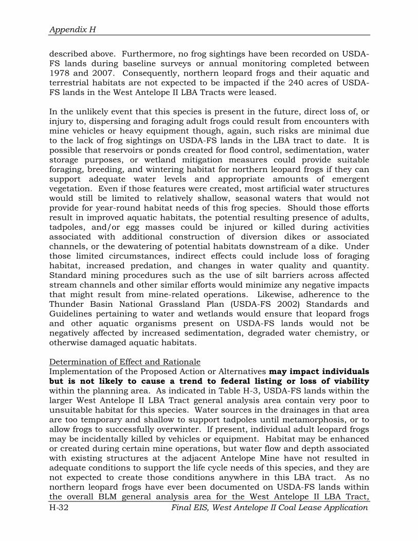
Appendix H
described above. Furthermore, no frog sightings have been recorded on USDAFS lands during baseline surveys or annual monitoring completed between 1978 and 2007. Consequently, northern leopard frogs and their aquatic and terrestrial habitats are not expected to be impacted if the 240 acres of USDAFS lands in the West Antelope II LBA Tracts were leased.
In the unlikely event that this species is present in the future, direct loss of, or injury to, dispersing and foraging adult frogs could result from encounters with mine vehicles or heavy equipment though, again, such risks are minimal due to the lack of frog sightings on USDA-FS lands in the LBA tract to date. It is possible that reservoirs or ponds created for flood control, sedimentation, water storage purposes, or wetland mitigation measures could provide suitable foraging, breeding, and wintering habitat for northern leopard frogs if they can support adequate water levels and appropriate amounts of emergent vegetation. Even if those features were created, most artificial water structures would still be limited to relatively shallow, seasonal waters that would not provide for year-round habitat needs of this frog species. Should those efforts result in improved aquatic habitats, the potential resulting presence of adults, tadpoles, and/or egg masses could be injured or killed during activities associated with additional construction of diversion dikes or associated channels, or the dewatering of potential habitats downstream of a dike. Under those limited circumstances, indirect effects could include loss of foraging habitat, increased predation, and changes in water quality and quantity. Standard mining procedures such as the use of silt barriers across affected stream channels and other similar efforts would minimize any negative impacts that might result from mine-related operations. Likewise, adherence to the Thunder Basin National Grassland Plan (USDA-FS 2002) Standards and Guidelines pertaining to water and wetlands would ensure that leopard frogs and other aquatic organisms present on USDA-FS lands would not be negatively affected by increased sedimentation, degraded water chemistry, or otherwise damaged aquatic habitats.
Determination of Effect and Rationale Implementation of the Proposed Action or Alternatives may impact individuals but is not likely to cause a trend to federal listing or loss of viability within the planning area. As indicated in Table H-3, USDA-FS lands within the larger West Antelope II LBA Tract general analysis area contain very poor to unsuitable habitat for this species. Water sources in the drainages in that area are too temporary and shallow to support tadpoles until metamorphosis, or to allow frogs to successfully overwinter. If present, individual adult leopard frogs may be incidentally killed by vehicles or equipment. Habitat may be enhanced or created during certain mine operations, but water flow and depth associated with existing structures at the adjacent Antelope Mine have not resulted in adequate conditions to support the life cycle needs of this species, and they are not expected to create those conditions anywhere in this LBA tract. As no northern leopard frogs have ever been documented on USDA-FS lands within the overall BLM general analysis area for the West Antelope II LBA Tract,
Final EIS, West Antelope II Coal Lease Application H-32

Appendix H
potential effects are expected to be negligible, if they occur at all.
2. Black-tailed Prairie Dog (Cynomys ludovicianus) The black-tailed prairie dog was removed from USFWS federal listing in 2004. The agency ruled that listing this species may be warranted, but was precluded by higher priority considerations.
Black-tailed prairie dogs historically ranged throughout the Great Plains in short-grass and mixed-grass prairies. This species is also a common resident in the short- and mid-grass habitats of eastern Wyoming (Cerovski et al. 2004). The TBNG, which includes approximately 240 acres in the extreme southeastern portion of the West Antelope II general analysis area, harbors one of the seven major colony complexes remaining in North America. Black-tailed prairie dogs are highly social, diurnal burrowing rodents that typically feed on grasses and forbs. Prairie dogs form colonies that are the main unit of a prairie dog population. This species has the ability to rapidly expand its distribution and population if not limited by pest control practices or disease, and will readily spread into recently disturbed areas. Many species such as the black-footed ferret (Mustela nigripes), mountain plover, burrowing owl (Athene cunicularia), and swift fox (Vulpes velox) are dependent on prairie dogs during a portion of their life cycle. Black-tailed prairie dog occupied range and abundance has declined dramatically, and continues to exhibit a slow decline (NatureServe 2007). Major factors contributing to the decline include disease (sylvatic plague), urbanization, habitat conversion, and control efforts.
Existing Conditions Sixteen prairie dog colonies (total of approximately 729 acres) are within the overall two-mile perimeter wildlife survey area for West Antelope II (Figure 316). Seven colonies were occupied during 2006, eight were unoccupied, and occupancy in one colony was unknown.
One of the 16 colonies straddles USDA-FS lands in T. 40 N., R. 71 W., Section 15 (Figure H-1), in the southeastern corner of the study area. The occupied colony has expanded in recent years, encompassing approximately 93 acres (13 percent of total) in 2006. The eastern-most 41 acres (44 percent) of that colony occurs directly on USDA-FS lands. The Section 15 colony currently meets the 80-acre minimum for black-footed ferret habitat (USFWS 1989). However, the entire coal mine region of the Powder River Basin of northeast Wyoming, including all USDA-FS and surrounding lands within the West Antelope II LBA general analysis area, is beyond the focus area for ferret reintroduction efforts on the TBNG and in the general region (refer to Management Area 3.63-USDAFS 2002, Grenier 2003). Additionally, some prairie dog colonies in that region are currently experiencing development associated with conventional oil and gas, CBNG, and coal (including open pits) resources. Year-round human activity and disturbance are already present in a few locations.
Final EIS, West Antelope II Coal Lease Application H-33

Appendix H
Direct and Indirect Effects The current mine plan for the Antelope Mine does not project any new surface disturbance in the Section 15 prairie dog colony through at least 2016. Nevertheless, because the entire colony (93 acres) falls within the USDA-FS general analysis area, that area may be affected by the proposed activities at some point in time. Such impacts could have immediate direct effects on prairie dogs if the occupied colony is buried beneath overburden piles, or subjected to scraping, flooding, or is otherwise impacted in a short timeframe that precludes dispersal prior to disturbance. As those activities are expected to occur incrementally across various portions of the general analysis area, individuals would be able to disperse and would likely inhabit undisturbed portions of the affected colony, or initiate one or more new colonies within the area. Dispersing individuals may be killed or injured by vehicles and heavy equipment during ongoing or future mine operations.
Portions of the Section 15 prairie dog colony and surrounding foraging habitat could be fragmented by small-scale linear disturbances associated with mining activities such as roads, power lines, fences, and pipelines. These disturbances will, however, occur within narrow corridors over relatively short distances, and would be completed within shorter timeframes. New linear disturbances might also create travel corridors that would facilitate movements of mammalian predators, possibly increasing predation risk to prairie dogs.
Existing and new above-ground power lines located within or near the colony would provide perch sites for predatory birds. Applying perch deterrents to those poles would minimize such impacts. Adjacent habitats into which the existing colony could potentially spread may be destroyed by the installation of roads, pipelines, and topsoil stripping prior to mining. However, minor surface disturbance in proximity to the colony would also provide recently upturned soils that could facilitate the expansion of the existing colony or the establishment of new ones, as prairie dogs will readily move into recently disturbed areas.
Post-mining reclamation could have similar potential benefits; prairie dogs have already demonstrated their ability to inhabit reclaimed lands at the Antelope Mine. Given the relative abundance of prairie dogs in the overall region and their tendency to disperse and expand their boundaries, the potential incremental loss of prairie dog acreage (13 percent of total) on and near USDA-FS lands will not likely have adverse consequences for the viability of the regional population. Disturbance and reclamation efforts will occur incrementally in varying locations throughout the permit area as mining progresses through the approved lease.
In 2008, at Antelope Mine’s request, the Wyoming Game and Fish Commission reviewed and amended their policy regarding the relocation of black-tailed prairie dogs for the creation of mountain plover habitat. The previous WGFD policy required that the mine obtain written permission of adjacent landowners
Final EIS, West Antelope II Coal Lease Application H-34

Appendix H
within a four mile radius of the release site before any black-tailed prairie dog relocation could occur. The 2008 approved amendment replaced the former rule and established that black-tailed prairie dog relocation could occur once the mine provided written notification to adjacent landowners within a four mile radius of the release site. One of Antelope Mine’s specific reclamation objectives is to restore black-tailed prairie dog communities that have had documented mountain plover nesting activity and have been impacted by mining.
All USDA-FS Standards and Guidelines applicable to black-tailed prairie dogs outlined in the TBNG Plan (USDA-FS 2002, page 1-20) would be implemented. To reduce risks and habitat loss for prairie dogs and other wildlife species closely associated with prairie dog colonies, new roads will be aligned outside colony boundaries where possible. If it is necessary to place a new road within a prairie dog colony, the amount of road in the colony will be minimized to the extent that soil, drainage, topographical and other physical factors will allow.
Determination of Effect and Rationale Implementation of the Proposed Action or Alternatives may impact individuals but is not likely to cause a trend to federal listing or loss of viability within the planning area. A portion (41 acres) of one black-tailed prairie dog colony (93 total acres) could be physically disturbed by the proposed activities on and immediately adjacent to USDA-FS lands. That colony represents 13 percent of the total acreage present in the entire West Antelope II LBA general analysis area. Direct injury or mortality may occur to individuals resulting from activities under the Proposed Action or Alternatives. Conversely, some surface disturbances associated with the proposed activities may create habitats favorable for colony expansion or initiation.
3. Swift Fox (Vulpes velox) The swift fox was removed from the USFWS federal listing process in 1995, after extensive field surveys demonstrated that the population was greater than expected. This species is considered to be common within the eastern Great Plains grasslands of Wyoming (Cerovski et al. 2004), though it typically occurs at very low densities. The exact status of the population is unknown but believed to be increasing, especially in the Northern Plains. Swift foxes are largely nocturnal and typically prefer flat to gently rolling, short- or mixed-grass prairies, generally lacking in shrubs or woody vegetation (Cotterill 1997). This species uses multiple den sites year-round for shelter, protection from predators, and rearing young. Burrows of other mammals such as badgers (Taxidea taxus), red foxes (Vulpes vulpes), and prairie dogs are often used or modified for those purposes. Small to mid-sized mammals constitute the bulk of their diet. Swift foxes have little fear of humans and may den in proximity to human disturbances (residences and busy roadways). This tolerance also makes them susceptible to trapping, vehicle collisions, and attacks by dogs. Major threats faced by the swift fox include habitat loss and degradation, interspecific competition with red fox and coyote (Canis latrans), and vehicle Final EIS, West Antelope II Coal Lease Application H-35

Appendix H
collisions.
Existing Conditions Swift fox have been observed in northern Converse County and southern Campbell County with more frequency in recent years, and are presumed to breed there. This species has also been documented within the overall TBNG. No specific surveys for swift fox were conducted for this analysis. However, such efforts were completed for other unrelated projects in 2002, approximately 7.0 miles to the north of the USDA-FS lands within the West Antelope II general analysis area. Since at least 1994, annual nocturnal surveys for other species have also been conducted on and near USDA-FS lands and elsewhere within the one-mile perimeter wildlife survey area for the adjacent Antelope Mine, with additional wildlife monitoring surveys occurring at neighboring mines in that region annually since the early 1980s.
Grasslands dominate both the overall BLM general analysis area for the West Antelope II LBA tract and the 240 acres of USDA-FS lands in the southeastern corner of that larger area. However, no swift foxes had been recorded in the combined area prior to 2005. In early October that year, biologists with Jones & Stokes (formerly Thunderbird Wildlife Consulting) saw two separate individuals (adult and juvenile) walking and hunting on a grassy hill within and near the northern portion of the overall West Antelope II general analysis area in T. 41 N., R. 71 W., NW¼ SW¼ Section 22 and NE¼ SW¼ Section 22, respectively. The foxes were observed during spotlighting surveys for lagomorphs (hares and rabbits) conducted for the annual wildlife monitoring program at the adjacent Antelope Mine. A pair of swift foxes was observed in the adjacent sections to the west and south of Section 22 during similar spotlight surveys conducted in both 2006 and 2007.
The relatively large blocks of grasslands interspersed with sparse sagebrush-grasslands on and near the 240 acres of USDA-FS lands in the West Antelope II general analysis area represent suitable swift fox habitat, especially where associated with more gentle topography. Burrows within the existing black-tailed prairie dog colony, and scattered badger or red fox burrows, could be used by swift foxes as den or shelter sites. Potential denning, shelter, and foraging habitats may be physically disturbed by the proposed activities. Despite these characteristics, no swift foxes have ever been recorded on the 240 acres of USDA-FS lands analyzed in the West Antelope II LBA tract EIS. All of the observations described for the larger BLM general analysis area were 3.0 miles or more to the north of those USDA-FS lands.
Few other swift fox sightings have been recorded elsewhere within the surrounding region during specific surveys or incidental to other searches at local mines over the last 26 years. Those efforts were conducted as part of annual wildlife monitoring by contract and USDA-FS biologists on private and federal lands in the area. Swift foxes were documented approximately 16.0 miles north-northwest of the West Antelope II EIS USDA-FS lands between
Final EIS, West Antelope II Coal Lease Application H-36

Appendix H
1995 and 1997. One sighting each was made in T. 43 N., R. 72 W., SE¼ Section 20 and T. 43 N. R. 71 W., SE¼ Section 23 and SW¼ Section 14 (USDAFS 2003) during that period. In March 2002, a single swift fox was observed in T. 42 N. R. 70.W., SE¼ Section 15 during spotlight trapping efforts at the North Antelope Rochelle Mine, approximately 11.0 miles northeast of the USDA-FS lands boundary. Reports from all of those studies are already on file with the Douglas Office of the USDA-FS, and with WDEQ-LQD.
Direct and Indirect Effects Suitable but unoccupied swift fox habitat is present on and near the 240 acres of USDA-FS lands considered in this analysis. Should this species be present on those lands in the future, direct loss of or injury to individuals foraging or denning within, or passing through that area could result from vehicle collisions or encounters with equipment associated with mine-related activities. Swift fox are relatively tolerant of human activities, but may avoid areas directly affected by mine operations as human presence and noise escalate with active mining. As the population size and residency status of the individuals in the area are largely unknown, some swift fox may remain within undisturbed habitats in the vicinity of mining encroachment.
The Proposed Action or Alternatives could disturb known and potential swift fox foraging, denning, or shelter habitat in the overall BLM general analysis area and the 240 acres of USDA-FS lands in the southeastern corner of the larger area, respectively. Those habitats could be removed, altered, or fragmented to varying degrees by one or more mine- or non-mine-related activities such as topsoil removal and a variety of linear disturbances (e.g., roads, fences, power lines, and pipelines). However, the latter disturbances will occur within narrow corridors over relatively short distances, and will typically be completed within a few days. Linear disturbances and habitat alterations could also provide convenient travel corridors and habitat for larger mammalian predators that could compete with swift foxes for prey species. The type, timing, location, and extent of habitat disturbance will vary throughout the general analysis area and on USDA-FS lands as mining operations progress. Reclamation of disturbed areas will occur incrementally as mining is completed in a given portion of the area, and will eventually provide additional foraging and potential denning habitat for the swift fox. Surface disturbing activities may result in a short-term, localized decrease in prey base (small rodents and voles), but due to their high reproductive potential and tendencies to re-establish and adapt to disturbed and reclaimed areas, prey numbers should increase quickly after the disturbance. Should swift fox be documented on or adjacent to the 240 acres of USDA-FS lands in the West Antelope II LBA tract, that agency would determine whether species-specific Standards and Guidelines outlined in the TBNG Plan (USDA-FS 2002, page 1-20) would apply.
Determination of Effect and Rationale Implementation of the Proposed Action or Alternatives may impact individuals Final EIS, West Antelope II Coal Lease Application H-37

Appendix H
but is not likely to cause a trend to federal listing or loss of viability within the planning area. The 240 acres of USDA-FS lands within the overall BLM general analysis area for the West Antelope II LBA tract are currently considered as suitable but unoccupied habitat for the swift fox (Table H-3). No fox sightings have been documented on those USDA-FS lands during specific and incidental surveys conducted over the last 27 years (1980-2007). Only seven sightings have been recorded within or near the overall West Antelope II general analysis area during that period (all since 2005), and all were at least 3.0 miles north of the USDA-FS lands in the southeastern corner of that larger area.
4. Long-billed Curlew (Numenius americanus) Long-billed curlews breed from interior British Columbia and southern Alberta through southern Manitoba, south to central California, and east to western North Dakota, central South Dakota, central Nebraska, western Kansas, northeastern New Mexico, and northern Texas (Dechant et al. 2003a). The long-billed curlew is a relatively uncommon summer resident of grasslands and sagebrush-grasslands in Wyoming (Cerovski et al. 2004). Curlews are ground nesters, and require large open expanses of grassland, with relatively low vegetation and few shrubs in which to nest (Hill 1998). The nest is typically a shallow scrape or depression, thinly lined with grass, weeds or cow dung, typically near water or moist areas.
Curlews use historically occupied sites each year, and some individual birds may reuse the same territories from year to year (Dechant et al. 2003a). Curlews primarily feed upon insects but also eat other invertebrates, small crustaceans, toads, and eggs and nestlings of other birds. This species forages in grasslands, wet meadows, prairie dog colonies, and occasionally along the margins of wetlands. Lakeshores and river valleys are often used during fall as migration staging areas (Hill 1998). Although some populations may be declining, overall population trends suggest long-billed curlew numbers are stable or increasing slightly. The major factor affecting curlew populations is habitat destruction and fragmentation.
Existing Conditions Long-billed curlews are uncommon summer residents within the TBNG. The area evaluated for this analysis, which includes 240 acres of USDA-FS lands and a surrounding ¼-mile perimeter, is dominated by potential habitat (expansive, open, level to gently rolling grasslands with short vegetation) for this species. However, few individuals have been observed in the region during annual wildlife monitoring in that area over the last two decades (Jones & Stokes data, currently on file with the USDA-FS and WDEQ-LQD). Most of those sightings occurred during spring months north of the USDA-FS lands, and were likely individual migrants or non-breeding adults. No significant wetlands (i.e. large lakes) or other conditions that might attract large numbers of curlews during migration exist within the area evaluated for this analysis.
Final EIS, West Antelope II Coal Lease Application H-38

Appendix H
No nesting occurrences have been documented in northern Converse County (Cerovski et al. 2004), including the USDA-FS general analysis area and adjacent lands. Potential nesting habitat is poor to marginal throughout the general analysis area, including on USDA-FS lands themselves. Foraging habitat is present within the existing prairie dog colony and areas of heavily grazed grasslands and sagebrush-grasslands on USDA-FS lands and elsewhere within the West Antelope II LBA tract general analysis area. CBNG development and conventional oil and gas production are increasing throughout the region, with active mining (including open pits) also occurring in the immediate vicinity. Potential, low quality long-billed curlew nesting and foraging habitats will be disturbed by the Proposed Action and Alternatives 1 and 2.
Direct and Indirect Effects Given the lack of sightings of, and limited potential for, long-billed curlews on and near USDA-FS lands over the last 13 years (1994-2006), the Proposed Action and Alternatives are unlikely to cause any direct injury or mortality to this species. If present, individuals or nests could be injured or destroyed by vehicles and equipment associated with ongoing and future mining activities. Individuals may also be displaced by human activities and noise associated with mining. Linear habitat disturbances (i.e., roads or fence lines) can provide convenient travel corridors for mammalian predators, thus increasing the predation risk to nests, nestlings, or adults that are present. Potential foraging and nesting habitats may be disturbed, removed, or fragmented by mining activities. The type, timing, location, and extent of habitat disturbance will vary throughout the general analysis area as operations progress. Reclamation of disturbed areas will occur incrementally as mining is completed in a given portion of the mine, and will eventually mitigate impacts to some degree. Antelope Mine’s reclamation plan would incorporate the replacement of jurisdictional wetland acreages existing prior to mining with at least equal types and numbers of wetland acreages. The creation of wetland habitats, especially where adjacent to grassland habitats, could provide additional (although limited) foraging areas for curlews.
As sightings have been infrequent over time, and long-billed curlew nests have not been documented within USDA-FS lands or other lands within or near the West Antelope II LBA tract general analysis area, species-specific Standards and Guidelines outlined in the Grassland Plan (USDA-FS 2002) would not apply.
Determination of Effect and Rationale Implementation of the Proposed Action or Alternatives may impact individuals but is not likely to cause a trend to federal listing or loss of viability within the planning area. As this species appears to be an infrequent visitor to the general analysis area, and good quality foraging and nesting habitat is not present within the area, impacts to this species are likely to be minimal. Loss, degradation, or fragmentation of potential foraging habitat and potential Final EIS, West Antelope II Coal Lease Application H-39

Appendix H
collisions with vehicles may occur. Reclamation of wetlands and grasslands may create limited foraging or nesting habitat.
5. Ferruginous Hawk (Buteo regalis) Ferruginous hawks breed throughout much of the western United States and portions of three Canadian provinces (Johnsgard 1990). This species nests throughout Wyoming (Cerovski et al. 2004) and occupies portions of the state during winter. Large expanses of grassland and shrubland, where livestock grazing (vs. cultivation) is the predominant land use, provide the most suitable habitat (Schmutz 1989, Johnsgard 1990). Most ferruginous hawks in the Powder River Basin nest on the ground (usually elevated sites, though some pairs nest in small trees). Typical nest sites include hilltops, rock outcrops, eroded creek banks, small trees, and even relatively level ground. The ferruginous hawk relies primarily on two mammalian families for the majority of its prey: Leporidae (rabbits and hares) and Sciuridae (ground squirrels and prairie dogs). Numerous nests can occur within the territory of a single pair, and ferruginous hawks often reuse nests for many years.
This species may be sensitive to human disturbance, especially during the nesting period (White and Thurow 1985). This sensitivity can be heightened in years of low prey abundance. Accurate information regarding the trend for the ferruginous hawk is limited and mixed. Although some populations may be declining (Bechard and Schmutz 1995), overall population trends suggest numbers are stable or increasing (NatureServe 2007). Major factors affecting ferruginous hawk populations include habitat destruction and fragmentation, and human disturbance.
Existing Conditions Ferruginous hawks have nested in the vicinity of the Antelope Mine during 23 of the last 25 years, and fledged young in 18 of those years. In the last five years, four to eight pairs nested within the two-mile perimeter wildlife survey area (which includes USDA-FS lands). A total of 64 ferruginous hawk nest sites in at least 18 different territories have been documented within that two-mile survey area over the last 25 years. Thirty-four nests in at least 10 territories were physically intact within the Antelope Mine two-mile perimeter wildlife survey area in 2006; 10 territories were active that year, with a total of eight young fledged. Nesting activity in 2005 and 2006 was greater than during the previous three years, likely in response to remarkably high lagomorph populations in both years.
Direct and Indirect Effects No ferruginous hawk nests are present on USDA-FS lands within the BLM study area. Five of the 64 total ferruginous hawk nest sites documented for the Antelope Mine through 2006 fall within one-quarter mile of USDA-FS lands (Figure H-1); these nest sites are either within the general analysis area (maximum potential for surface disturbance) for the West Antelope II LBA tract or within currently permitted areas. Four nests fall within one territory (FH5),
Final EIS, West Antelope II Coal Lease Application H-40

Appendix H
with the remaining nest in a different territory (FH1).
Four of the five sites nearest the USDA-FS lands had nest material present during 2006. However, all five meet USDA-FS criteria as “active” (occupied during at least one of the last seven years [2000-2006]). One of those five nest sites was used during 2006; birds incubated eggs but did not hatch young. All five locations could be physically destroyed by mining under the Proposed Action or Alternatives, though such disturbances are not projected to occur on or within on-quarter mile of the USDA-FS lands through at least 2016.
Both territories include alternate nest sites beyond USDA-FS lands that have been actively used in recent years. One territory (FH5) includes alternate nests that will not be disturbed physically or visually by future mining within the West Antelope II LBA tract. However, all alternate nest sites within the other territory would be impacted by future mine-related activities. Such disturbances could negatively impact the reproductive success of ferruginous hawks nesting in the area.
Over time, the Antelope Mine has avoided, where possible, or mitigated mining impacts on raptor nests through a variety of means. The mine has monitored nesting raptor populations, maintained and implemented current USFWS approved Raptor Mitigation Plans, adjusted operations to provide temporal and spatial buffers around raptor nests, and ensured that new power lines at the mine conform to current Avian Power Line Interaction Commission (APLIC) guidelines. Provided those practices are continued, direct impacts on both ferruginous hawks and active nest sites will be minimized. The most probable source of potential impact to ferruginous hawks would be an increase in injuries and fatalities of individuals foraging within the general analysis area due to vehicle collisions associated with ongoing or future mining and non-mining activities. The use of existing roads in the area, when possible, would help to minimize this risk.
The West Antelope II lease area would expand Antelope Mine and could potentially impact up to 6,309.18 total new acres during the life of the mine; approximately 240 acres (4%) are managed by the USDA-FS. Habitat loss, degradation, and fragmentation would result from a variety of large- and small-scale mining operations (e.g., topsoil stripping, drilling, reservoir construction, etc.). Potential nesting and foraging habitat might also be fragmented by linear disturbances such as the construction, maintenance, and removal of roads, fences, power lines, and pipelines. Those disturbances could also create new travel corridors to mammalian predators that reside in or pass through the area. However, such disturbances would occur within narrow corridors over relatively short distances, typically over a period of days. Additionally, those structures are often constructed immediately prior to the removal of similar features elsewhere in the area, often resulting in minimal or no net gain of new linear disturbances. All mine-related habitat disturbances would shift throughout the expanded permit area as operations progress. Reclamation of Final EIS, West Antelope II Coal Lease Application H-41

Appendix H
disturbed areas would occur incrementally as resource recovery is completed in a given portion of the mine, and would mitigate impacts to some degree. Surface disturbing activities could also result in a short-term, localized decrease in the prey base (lagomorphs and rodents) for ferruginous hawks. However, due to their high reproductive potential and tendencies to re-populate and adapt to disturbed and reclaimed areas, prey numbers should increase quickly after the disturbance.
USDA-FS Standards and Guidelines would be implemented and offer additional protections for active nests; they would apply only to activities outside of the lease. These factors should help ensure that the Proposed Action and Alternatives do not significantly degrade the quality of existing ferruginous hawk territories and nest sites. Standards and Guidelines specific to ferruginous hawks outlined in the TBNG Plan (USDA-FS 2002, page 1-20-21) are as follows:
73. To help prevent abandonment, reproductive failure or nest destruction, prohibit development of new facilities within 0.25 mile (or line of sight) of active ferruginous hawk nests. For the ferruginous hawk, a nest is no longer considered active if it is known to have been unoccupied for the last seven years. This does not apply to pipelines, fences and underground utilities.
74. To help reduce disturbances to nesting ferruginous hawks, prohibit the following activities within 0.5 mile (or line of sight) of active ferruginous hawk nests from 1 March through 31 July: construction (e.g., roads, water impoundments, oil and gas facilities), reclamation, gravel mining operations, drilling of water wells, and oil and gas drilling.
75. To help reduce disturbances to nesting ferruginous hawks, do not authorize the following activities within 0.5 mile (line of sight) of active ferruginous hawk nests from 1 March through 31 July: construction (e.g., pipelines, utilities, fencing), seismic exploration, and workover operations for maintenance of oil and gas wells.
Determination of Effect and Rationale Implementation of the Proposed Action or Alternatives may impact individuals but is not likely to cause a trend to federal listing or loss of viability within the planning area. Mine-related activities will not physically disturb any ferruginous hawk nest sites on USDA-FS lands themselves. However, such activities could impact up to five nests within the West Antelope II LBA tact general analysis area that abuts USDA-FS lands. Some individuals or pairs may experience disturbance, destruction, or fragmentation of nesting and foraging habitat. Increased disturbance to individuals due to human activity may also occur. However, several factors should minimize the potential mining-related impacts on this species, including the availability of alternate
Final EIS, West Antelope II Coal Lease Application H-42

Appendix H
nest sites located further away from pending disturbance in each affected territory, implementation of USFWS and USDA-FS approved mitigation measures, reclaiming habitats as soon as feasible, encouraging nesting within mine reclamation lands, and continued monitoring of this species to ensure that mitigation methods are applied when necessary.
6. Burrowing Owl (Athene cunicularia) Burrowing owls breed from southern Alberta to southwestern Saskatchewan, south through east-central Washington, central Oregon, and southern California, and east to eastern North Dakota, west-central Kansas, and Texas (Klute, et al. 2003, pg 7). The burrowing owl is a summer resident of open rangeland habitats throughout Wyoming (Cerovski et al. 2004). This species requires burrows of fossorial mammals, primarily badgers and prairie dogs, for nesting and roosting (Klute, et al. 2003, pg 12).
Most burrowing owl nests within the TBNG are located within prairie dog colonies (USDA-FS 2003). Burrowing owls typically reuse traditional nesting areas. Burrow mounds, shrubs, fence posts or boulders may be used as observation perches. This species is usually tolerant of human activity but is vulnerable to predation by pets (cats, dogs). Burrowing owls forage within a variety of habitats, including cropland, pasture, prairie dog colonies, fallow fields, and sparsely vegetated areas. This species is often active during daylight hours. Insects and small mammals (mice and voles) are the owls’ primary prey items. Burrowing owl populations have been declining throughout its range, primarily due to habitat loss.
Existing Conditions Burrowing owls are common summer residents within the TBNG (Cerovski et al. 2004). This species was first recorded nesting in the Antelope Mine two-mile perimeter wildlife survey area in 1991, and owls have nested in that general vicinity during 14 of the last 16 years. All known burrowing owl nest sites throughout the entire West Antelope II LBA tract were in prairie dog burrows, and are therefore considered intact. Four additional artificial nest boxes have been constructed in the two-mile perimeter wildlife survey area for mitigation purposes since 1994, but no owls have ever been observed at or near them.
One burrowing owl site (BO5) has been documented in the prairie dog colony on USDA-FS lands in T. 40 N., R. 71 W., Section 15 (Figure H-1). That site was discovered in 1996, and six young fledged that year. At least one adult was observed in the same colony in 1997 and again in 2006, but no active nests have been documented there since 1996. As the nest area has not been used for the last ten consecutive years, it is considered “inactive” by the USDA-FS definition for this species (unoccupied during the current or most recent nesting season). One of the four artificial nest sites (BO11) is located in reclaimed lands within one-quarter mile of the USDA-FS. No owls have ever used that nest box. Full details of all burrowing owl nest sites have been Final EIS, West Antelope II Coal Lease Application H-43

Appendix H
provided in the Annual Wildlife Report for the Antelope Mine each year, and are on file with both the USDA-FS Douglas, Wyoming Ranger District and WDEQLQD in Cheyenne, Wyoming.
Direct and Indirect Effects One natural burrowing owl nest site is present on USDA-FS lands and thus could be impacted by the leasing of the West Antelope II LBA tract. That nest site has not been active since 1996. Both USDA-FS Standards and Guidelines (USDS-FS 2002) and the Antelope Mine state mining permit stipulate that clearance surveys will be conducted and approved by the appropriate agencies before any colony is disturbed during the breeding season. That process will preclude most direct impacts to nesting burrowing owls in that area.
Because burrowing owls are active during daylight hours, the most probable source of direct impacts would be the death of, or injury to, individuals fleeing heavy equipment, or being killed or injured by equipment while feeding or moving through the mine area. Burrowing owls are generally tolerant of human activities, but increased presence and noise, especially during the nest initiation period, may displace individuals or inhibit nesting proximate to mine operations. Foraging could also be hindered within these areas, especially where mining activities occur near prairie dog colonies.
Mining could eventually disturb or eliminate all 93 acres of potential alternate nesting habitat (prairie dog colony) on USDA-FS lands or in the overlapping West Antelope II LBA tract general analysis area. However, that colony represents only 13% of the total acreage within the two-mile perimeter wildlife survey area for the Antelope Mine. Additionally, the tendency of prairie dogs to quickly colonize nearby areas when their colonies are disturbed would create new nesting habitat for burrowing owls. Overall, nesting and foraging habitats will be incrementally affected by a variety of large-and small-scale operations. The type, timing, location, and extent of habitat disturbance will vary throughout the general analysis area as mining operations progress, thus providing opportunities for burrowing owls to relocate to other suitable habitat within the immediate area.
Reclamation will proceed incrementally as areas are mined and activities move to new locations within the mine area. Both activities will create loose soil that should be attractive to dispersing prairie dogs (potential habitat source), at least in the short term. Reclamation of disturbed areas will occur incrementally as resources are extracted in a given portion of the mine, and will eventually mitigate habitat impacts to some degree. However, to date, burrowing owls have rarely been documented nesting within reclaimed habitats at surface mines in northeast Wyoming.
Linear disturbances such as the construction, maintenance, and removal of roads, fences, power lines, and pipelines could temporarily disturb nesting or foraging individuals. Such disturbances however, would occur within narrow
Final EIS, West Antelope II Coal Lease Application H-44

Appendix H
corridors over relatively short distances, typically over a period of days. Surface disturbing activities could also result in a short-term, localized decrease in the prey base (lagomorphs and rodents) for burrowing owls. However, due to their high reproductive potential and tendencies to re-populate and adapt to disturbed and reclaimed areas, prey numbers should increase quickly after the disturbance.
If nesting burrowing owls are documented on or near USDA-FS lands, USDAFS Standards and Guidelines applicable to this species would be implemented to offer additional protections beyond those outlined in the USFWS approved Raptor Mitigation Plan for the Antelope Mine. Annual monitoring of known burrowing owl nest sites within the one-mile perimeter wildlife survey area for the mine, including USDA-FS and adjacent lands, and other nearby colonies will continue through the life of the mine to document their histories of occupancy and production.
Determination of Effect and Rationale Implementation of the Proposed Action or Alternatives may impact individuals but is not likely to cause a trend to federal listing or loss of viability within the planning area. Disturbance, fragmentation, and alteration of foraging and potential nesting habitats will occur. One inactive natural nest site within 93 acres of known and potential nesting habitat (prairie dog colony) could be disturbed under the Proposed Action or Alternatives. However, most (87%) prairie dog acreage is located outside of the USDA-FS lands.
The Antelope Mine has avoided, where possible, and mitigated such impacts in the past through intensive monitoring of both populations and specific nest sites, implementation of USFWS approved mitigation measures, and adjusting operations to provide temporal and spatial buffers around raptor nests (including burrowing owl nests). Mining activities and noise may disturb individuals inhabiting the lease area, thus inhibiting potential nesting or foraging in proximity to lands with ongoing development. Potential collisions with vehicles might also occur, though none have been recorded in the area to date.
7. Chestnut-collared Longspur (Calcarius ornatus) The breeding range of the chestnut-collared longspur extends from southern Alberta to southern Manitoba, south to west-central Colorado, and east through North Dakota and South Dakota to western Minnesota (Dechant et al. 2003b). The chestnut-collared longspur is a common summer resident of the eastern plains of Wyoming (Cerovski et al. 2004). This species prefers native grasslands as breeding sites, inhabiting open prairie and avoiding excessively shrubby areas. Grasslands with dense litter accumulations are avoided (Dechant et al. 2003b). Scattered shrubs are often used as singing perches. Nests are typically placed in areas of sparse vegetation (less than 20-30 cm), but usually with a taller grass component than sites preferred by McCown’s longspurs. Nests are on the ground in depressions, often placed beside cattle Final EIS, West Antelope II Coal Lease Application H-45

Appendix H
dung pat, small shrub, or under a clump of grass (Hill and Gould 1997). Male fidelity to breeding areas has been observed. Chestnut-collared longspurs feed primarily on seeds (especially grasses), insects, and spiders. This species is generally tolerant of short-term intrusion at the nest site but may desert if disturbed during nest building or egg-laying (Hill and Gould 1997). High rates of predation on eggs and nestlings have been reported and pesticides have been shown to reduce hatching success. The chestnut-collared longspur breeding range has contracted and long-term data suggests population declines (Hill and Gould 1997). These declines have been attributed to loss of native prairie habitat, and conversion to cropland and urban development.
Existing Conditions Chestnut-collared longspurs are common summer residents within the TBNG. This species has often been documented on and near USDA-FS lands in the southeastern corner of the West Antelope II LBA BLM study area during annual monitoring surveys since at least 1994. Although the prairie dog colonies and grasslands in that area do not represent prime nesting habitat, these longspurs likely do breed and forage in the area. The height and composition of grasslands throughout much of the remainder of the USDA-FS lands and two-mile perimeter wildlife survey area for the Antelope Mine could also provide suitable habitat for this species, though few observations have been made in those areas over time.
Direct and Indirect Effects Fatalities or injury to individuals may occur due to collisions with vehicles or equipment associated with ongoing and future mining activities. If nests are present, nests and eggs may be crushed or destroyed, and young killed or injured by equipment operations in nesting areas during the breeding season. Increased human activity and noise could inhibit foraging or nesting within portions of USDA-FS lands, and will likely displace individuals during periods of intense activities. Over the life of the mine, potential nesting and foraging habitats in the general analysis area (including up to 93 acres of existing black-tailed prairie dog colony overlapping the USDA-FS lands) could be disturbed, destroyed, altered, or fragmented. Specifically, these habitats will be incrementally affected by a variety of large-and small-scale operations (e.g. topsoil stripping, drilling, reservoir or diversion channel construction, or the construction of facilities).
The type, timing, location, and extent of habitat disturbance will vary throughout the USDA-FS general analysis area as mining operations progress. Reclamation of disturbed areas will occur incrementally as resources are extracted in a given portion of the mine. Within one to two years, newly reclaimed areas may create good quality, short-duration nesting habitat for chestnut-collared longspurs. However, as these sites mature, they would become less suitable as nesting habitat for this species. Linear disturbances such as the construction, maintenance, and removal of roads, fences, power lines, pipelines, and diversion channels could provide convenient travel
Final EIS, West Antelope II Coal Lease Application H-46

Appendix H
corridors for mammalian predators, thus increasing the predation risk to nesting adults, eggs, and nestlings. Most linear disturbances would occur within narrow corridors over relatively short distances, typically over a period of days.
Determination of Effect and Rationale Implementation of the Proposed Action or Alternatives may impact individuals but is not likely to cause a trend to federal listing or loss of viability within the planning area. Some individuals or pairs may be displaced from portions of USDA-FS or adjacent lands and may experience disturbance, destruction, or fragmentation of nesting, foraging, or brood rearing habitat. The creation of linear corridors through nesting habitat may increase nest predation. Injury or mortality may occur to eggs, young, or adults resulting from mining operations and/or vehicle collisions within nesting habitat during the breeding season. However, mining disturbances would not likely limit the movement of individuals within the vicinity. This species has been documented regularly in the area despite ongoing mining activities nearby.
8. McCown’s Longspur (Calcarius mccownii) McCown’s longspurs breed from southern Alberta and southern Saskatchewan, south through Montana, eastern and central Wyoming, and north-central Colorado, and east to western Nebraska, north-central South Dakota, and southwestern North Dakota (Dechant et al. 2003c). This species is a common summer resident of the eastern plains and great basin-foothills grasslands, basin-prairie shrublands, and agricultural areas throughout most of Wyoming (Cerovski et al. 2004). Specifically, this species requires open habitats such as sparsely vegetated, low structured grasslands, and heavily grazed pastures containing a moderate bare ground component for nesting and foraging. Nest sites are typically a natural or shallow scraped depression on the ground placed in the open or beside vegetation such as bunch grasses, cacti, or shrubs. McCown’s longspurs feed on seeds of grasses and forbs, insects, and other arthropods. No strong data suggests breeding site fidelity although some individuals may return to the general nesting area in subsequent years.
Individuals vary in response to human intrusion at nest sites, but appear to be relatively more tolerant than most grassland songbird species. High rates of predation on eggs and nestlings occur especially where nests are associated with vegetative structure. Nestlings may also be directly poisoned where insecticides are sprayed in nest areas (With 1994). Populations are declining, especially within the northern portion of the range. Factors directly affecting the McCown’s longspur include the reduction of breeding habitat due to overgrazing, control of prairie fires, plowing, development, and excessive use of pesticides. Conversion of short-grass prairie to agriculture and urban development is the most important factor (With 1994).
Final EIS, West Antelope II Coal Lease Application H-47

Appendix H
Existing Conditions McCown’s longspurs are also common summer residents within the TBNG. This species has frequently been documented at Antelope and other nearby surface coal mines over the years, and is commonly seen during spring and summer in the prairie dog colony that straddles USDA-FS lands in the southeastern corner of the West Antelope II LBA tract (T. 40 N., R. 71 W., Section 15). Although no McCown’s longspur nests have been found in that area, it is highly likely that this species nests and forages on or immediately adjacent to USDA-FS lands. Singing and foraging males were regularly heard and observed within grassland habitats during annual wildlife monitoring surveys conducted since at least 1994. Short-grass prairie, prairie dog colonies, and very sparse sagebrush habitats within the area represent suitable nesting and foraging habitat for this species. These areas would be especially attractive to longspurs during periods of heavy grazing and drought, when grass height would be suppressed. The height and composition of vegetation throughout the remainder of the area is generally too tall and dense to provide suitable habitat for McCown’s longspurs.
Direct and Indirect Effects The direct and indirect effects to McCown’s longspurs would be the same as those described above for the chestnut-collared longspur.
Determination of Effect and Rationale Implementation of the Proposed Action or Alternatives may impact individuals but is not likely to cause a trend to federal listing or loss of viability within the planning area. Some individuals or pairs may be displaced from USDA-FS or adjacent lands and may experience disturbance, destruction, or fragmentation of nesting, foraging, or brood rearing habitat. The creation of linear corridors through nesting habitat may increase nest predation. Injury or mortality may occur to eggs, young, or adults resulting from mining operations and/or vehicle collisions within nesting habitat during the breeding season. However, mining disturbances would not likely limit the movement of individuals within the vicinity. This species has been documented regularly in the area despite ongoing mining activities nearby.
9. Greater sage-grouse (Centrocercus urophasianus) The Greater sage-grouse occurs year-round throughout non-forested regions of Wyoming (Cerovski et al. 2004). Sage-grouse rely on a variety of habitats within sagebrush dominated landscapes to reproduce and survive throughout the year. Early in the spring, grouse gather at breeding display sites called leks. Leks are usually in open areas (playas, ridge tops, sparse sagebrush, or burned areas) that are surrounded by dense sagebrush and escape cover. The surrounding area also typically represents nesting, loafing, and foraging habitat.
After being bred, hens typically scratch out a nest under sagebrush (Connelly et al. 1991) within three kilometers of the lek (Schroeder et al. 1999). Nests in
Final EIS, West Antelope II Coal Lease Application H-48

Appendix H
some portions of sage-grouse range are typically placed under sagebrush with average height of 36-79 cm (Schroeder et al. 1999). However, research conducted within the Southern Powder River Basin (Brown and Clayton 2004) indicated that, although shorter sagebrush was present at nest sites, grouse selected shrubs ranging from 55-61 cm in height under which to place nests. Re-nesting may occur if the nest is destroyed early during the laying or incubation period. Nest success is enhanced where both sagebrush and residual grass cover are taller and denser (Gregg et al. 1994). Sage-grouse exhibit high fidelity to seasonal ranges, and may return to the same area to nest in subsequent years.
For the first month after hatching, the young depend on relatively open sagebrush stands with an abundance of forbs and insects, especially ants and beetles (Drut et al. 1994, Schroeder et al. 1999). Late-season brood rearing habitats, such as wet meadows and bottomlands, are more mesic and support greater forb cover (Drut et al. 1994). Sage-grouse use a variety of habitats during fall, and the incidence of sagebrush in their diet increases as forbs become less available. During winter, grouse feed upon sagebrush leaves almost exclusively. Winter range is characterized by large expanses of dense, exposed sagebrush. Where snow accumulations are significant, gentle south-and west-facing slopes or windblown ridges are preferred.
Breeding populations of this species have declined by at least 17-47% throughout much of its range (Connelly et al. 2004). Within Wyoming, sage-grouse populations have generally declined over the past four decades. However, sage-grouse population estimates specifically pertaining to the TBNG suggest an overall increase in individuals since 1995. This same general trend was observed both statewide and within the Northeast Wyoming Sage-Grouse Local Working Group area.
The Northeast Wyoming Sage-grouse Local Working Group identified habitat fragmentation and degradation, disturbance and direct mortality as major influences affecting sage-grouse (NWSGWG 2006). The group identified oil and gas development, vegetation management, invasive plants, and weather as those factors with the most influence on the northeast Wyoming sage-grouse populations and those that may most effectively be addressed to provide the greatest benefit for sage-grouse conservation in northeast Wyoming (NWSGWG 2006).
Existing Conditions The Greater sage-grouse is a common year-round resident within much of the TBNG, but is rare in the vicinity of the West Antelope II LBA tract and the adjacent Antelope Mine. Potential sage-grouse habitat is limited throughout the entire West Antelope II LBA tract general analysis area. Grasslands are the dominant vegetation community within the entire two-mile perimeter wildlife survey area for the Antelope Mine (including USDA-FS lands), occupying 85% of that area. Final EIS, West Antelope II Coal Lease Application H-49

Appendix H
No large expanses of contiguous sagebrush are present within several miles of LBA tract. Sagebrush habitats that do occur are quite limited and of poor quality. Those shrublands are primarily limited to relatively small and somewhat sparse patches scattered across the northern half of the West Antelope II LBA tract, and some sparse shrubs sprinkled throughout the shortgrass prairie and prairie dog colonies in the southeastern portion of the area (the vicinity of USDA-FS lands). Additional small, fragmented stands of sparse sagebrush are present elsewhere in the two-mile perimeter wildlife survey area for the Antelope Mine, but most are overshadowed by short- and mid-grass communities, and are isolated from the larger contiguous sagebrush grasslands regularly inhabited by sage-grouse. Although some sagebrush habitat is present within the West Antelope II LBA tract general analysis area, little, if any, potential sage-grouse habitat would be disturbed by the Proposed Action and Alternatives.
Potential sage-grouse habitat is also limited within the USDA-FS lands and their two-mile perimeter of interest for that species. Grasslands are the dominant vegetation community in the region, with no large expanses of contiguous sagebrush occurring within several miles of that area. Sage stands that are present on or near USDA-FS lands are relatively short and sparse, with only marginal understory composition for adequate nesting habitat. Shrubs are not tall or dense enough to provide quality winter habitat in deep snows, and the lack of surface water in the ephemeral drainages in that area provides minimal suitable brood-rearing habitat. Overall, little, if any, potential sage-grouse habitat would be disturbed by the Proposed Action and Alternatives on or near USDA-FS lands.
Baseline (1978-1979, 1998, 2003) and annual monitoring studies (1982-2006) have repeatedly demonstrated that sage-grouse observations are rare within the Antelope Mine one- and two-mile perimeter wildlife survey areas. As described previously, annual monitoring surveys for sage-grouse leks conducted for the adjacent Antelope Mine encompassed the entire USDA-FS parcel and much of its surrounding perimeter every year since 1982. No leks were observed in that region during any survey year. Additionally, WGFD records (obtained from D. Thiele, Regional Biologist, WGFD, Buffalo, WY) and USDA-FS records have not documented any sage-grouse leks within the approximately 80.5 mi2 area that encompasses the two-mile perimeter wildlife survey area for the Antelope Mine. The nearest known sage-grouse lek is the Steckley Road Complex, approximately 3 miles away in T40N R70W, SE NW Section 29. Telemetry data collected on radio-collared grouse at the nearby North Antelope Rochelle Mine throughout the last six years (2001-2006) shows no sage-grouse locations within several miles of the West Antelope II LBA tract during that period (Brown and Clayton 2004, McKee 2006).
Isolated and sporadic observations of sage-grouse, both with and without broods, were made in the north-central portion of the West Antelope II LBA tract general analysis area in T. 41 N., R. 71 W., SE¼ Section 21 in the early
Final EIS, West Antelope II Coal Lease Application H-50

Appendix H
1980s. One grouse sighting occurred in a draw in T. 40 N., R. 71 W., SW¼ Section 21, approximately 1.5 miles southwest of the USDA-FS lands, in the early 1990s. In early July 2006, grouse droppings and feathers were seen in a sage draw approximately 1.75 miles southeast of the USDA-FS lands, in T. 40 N., R. 71 W., NW¼ Section 25. The prevalence of sign in that area indicated that multiple grouse had recently foraged in that drainage. Despite these regional records of sage-grouse, no grouse or their sign (droppings, feathers, etc.) were ever documented on USDA-FS lands themselves or the associated general analysis area for the West Antelope LBA tract, or within 1.5 miles of USDA-FS lands.
In addition to active mining, existing corridors associated with oil and gas (CBNG and conventional) developments, low use two track roads, all weather roads, fence lines, and overhead H-frame transmission and distribution power lines currently fragment portions of the two-mile perimeter wildlife survey area surrounding both USDA-FS lands and the adjacent Antelope Mine (Figure 316). Other land uses in the general vicinity include livestock grazing (both cattle and sheep), outfitted hunting and trapping, and limited recreation in the extreme southern portion of that two-mile perimeter. Oil and gas development is most prevalent in the northern portion of the two-mile perimeter wildlife survey area for the mine, while livestock grazing and prairie dog shooting are the primary disturbances occurring in the south. Active mining dominates the landscape to the northeast of the USDA-FS lands, while reclaimed lands occur to the east.
Direct and Indirect Effects More than 25 years of annual monitoring have fully documented that sage-grouse do not inhabit the USDA-FS lands in the southeastern portion of the West Antelope II LBA BLM study area or general analysis area. Given the absence of leks within three miles of that area, the paucity of grouse sightings in the general region over nearly three decades of monitoring, the lack of evidence (sign) of grouse use of USDA-FS lands and elsewhere in the BLM study area, as well as the minimal quantity and marginal quality of potential sage-grouse habitat present in the area, the direct and indirect effects of the Proposed Action and Alternatives are similar to those for the No Action Alternative.
Likewise, as no sage-grouse have ever been documented on or within 1.5 miles of USDA-FS lands analyzed in this EIS, all corresponding stipulations outlined in the TBNG Plan (USDA-FS 2002) would be waived. Should sage-grouse move into USDA-FS lands analyzed in this EIS in the future, agency Standards and Guidelines would offer appropriate protections for the species and its important habitat. However, under the current conditions and documented absence of this species, mining USDA-FS lands within the West Antelope II LBA tract would not adversely impact sage-grouse populations in the region, nor would it conflict with the current TBNG Plan or any future objectives to manage the area for this species. Final EIS, West Antelope II Coal Lease Application H-51

Appendix H
Determination of Effect and Rationale Implementation of the Proposed Action or Alternatives may impact individuals but is not likely to cause a trend to federal listing or loss of viability within the planning area. Nearly three decades of annual monitoring have documented that sage-grouse do not inhabit the USDA-FS lands analyzed for this EIS, or other lands within the West Antelope II LBA BLM study area and general analysis area. The nearest documented lek is approximately three miles away in T40N R70W, SE NW Section 29. The nearest known evidence of sage-grouse presence in the last 15 years was approximately 1.5 miles southwest of those USDA-FS lands. Consequently, anticipated mining-related disturbances will not affect any sage-grouse leks nor any identified and actively used seasonal sage-grouse habitats on or near USDA-FS lands analyzed for this EIS.
10. Bald eagle (Haliaeetus leucocephalus) Bald eagles occur throughout North America, from Alaska and Canada south to Florida, the Gulf Coast, and northern Mexico. The northwest coast of North America serves as the stronghold for this species, with approximately one-half of the population inhabiting Alaska.
The USFWS officially listed the bald eagle as an endangered species in 43 of the lower 48 states on July 4, 1976. The listing was due to a combination of several factors, including widespread habitat loss, negative effects of pesticide use on reproductive success, indiscriminant shooting, and others. The status of the bald eagle was downgraded to threatened throughout the lower 48 states in 1995. Bald eagle population trends began increasing throughout most of the species’ range in the early 1990’s, and it was proposed for de-listing in 1999.
On July 9, 2007, the Service published a Federal Register notice (72 FR 37346) announcing that the bald eagle (Haliaeetus leucocephalus) would be removed from the list of threatened and endangered species under the Endangered Species Act of 1973, as amended (16 U.S.C 1531 et seq.) on August 8, 2007. However, the protections provided to the bald eagle under the Bald and Golden Eagle Protection Act (BGEPA), 16 U.S.C. 668, and the Migratory Bird Treaty Act (MBTA), 16 U.S.C. 703, will remain in place. The bald eagle is now recognized as a BLM and USDA-FS Sensitive Species.
Bald eagles typically nest in large trees within a stand of mature, similarly sized trees either along or in proximity (within 0.7 mile) to rivers, lakes, or reservoirs that harbor adequate fish populations. Those areas tend to be remote and experience little disturbance (Johnsgard 1990). Typically, the nest is placed in the crown of a large cottonwood or pine, but if the topography allows, eagles will nest on cliff edges or escarpments. Open-canopied trees and snags provide required perches in nesting and foraging areas.
Final EIS, West Antelope II Coal Lease Application H-52

Appendix H
All verified bald eagle nests in northeastern Wyoming (BLM Buffalo Field Office GIS database) are situated in significant, mature cottonwood stands along larger creeks or rivers (i.e., Tongue River, Powder River, Clear Creek, and Little Thunder Creek). Nesting attempts are rare on the Thunder Basin National Grassland (Beske 1994, USDA-FS). Fish and waterfowl are the primary source of food for nesting bald eagles. Where available, large to mid-size carrion and large rodents (e.g., prairie dogs [Cynomys spp.]) can also be an important dietary component.
Bald eagles nest and winter throughout Wyoming, though typically are not locally abundant in the northeastern portion of the state. The species regularly migrates through and winters in Campbell County (Cerovski et al. 2004), and has often been documented during winter and early spring at nearby coal mines (Thunderbird-Jones and Stokes data, currently on file with the USFWS and WDEQ/LQD). Most eagles that migrate through or winter in Campbell County roost communally in stands of large ponderosa pine, along wooded cottonwood-riparian corridors, or in isolated stands of large trees. As water is scarce in that region, especially during winter, those birds likely forage widely for lagomorphs or carrion.
Existing Conditions Bald eagles are relatively common winter residents and migrants in the Powder River Basin, but only rarely nest in that region. The study area (including the one mile perimeter) includes only limited potential habitat for nesting or roosting activities in the form of a sparse riparian corridor along Antelope Creek and isolated trees or small (five trees or less) stands of cottonwoods along Antelope or Spring Creeks or their primary tributary draws. Those areas are already within the current approved permit area for the adjacent Antelope Mine, or are farther upstream and on the far side of a busy state highway from the study area. The corridor along Antelope Creek is within the buffer zone of non-disturbance, thus the trees along that drainage will not be physically disturbed.
In general, the study does not contain unique or sizeable, concentrated prey sources (e.g., fisheries, waterfowl wintering areas) that would be expected to attract bald eagles. Four black-tailed prairie dog (Cynomys ludovicianus) colonies lie within the LBA study area boundary: three occupied and one unoccupied colony which total 188 acres. Twelve additional colonies are present within two miles of the study area: 4 occupied, 7 unoccupied, and one unknown which total 541 acres. Sheep and lambs are present in the spring, when bald eagles have typically left the region, with winter flocks pastured there infrequently. The area does not support a large big game herd, though some groups do winter in the area.
Fixed-wing surveys for bald eagle winter roost sites were most recently completed in the study area during winter 2005-2006, with additional aerial and ground surveys in 2003. The latter surveys were conducted as part of the Final EIS, West Antelope II Coal Lease Application H-53

Appendix H
West Antelope baseline studies. The western portion of the LBA study area (including portions of both main creeks) was also included incidentally in surveys for another project during 2004, 2005, and winter 2006-2007.
Potential winter roost surveys have encompassed all or most potential habitat within the LBA study area annually from 2003 through early 2007. All winter roost surveys were conducted between one-half hour before and one hour after sunrise or between one hour before and one-half hour after sunset, per current BLM guidelines for survey timing and frequency. Biologists also watched for nesting bald eagles within the survey area while conducting surveys for other nesting raptors. No bald eagles, nests, roosts, or any other sign were observed during the 2006 survey flights. Survey flights previously completed in the study area also never recorded bald eagle roosts, nests, or potentially prime habitat. The only regular occurrence of bald eagles in the area was observed during early 2007, when a single adult was recorded perched in a lone cottonwood in a dry gulch north of Spring Creek and on the west (far) side of Wyoming Highway 59, approximately 1.5 miles west of the LBA study area boundary.
Direct and Indirect Effects Direct effects include the potential for injury or mortality to individual bald eagles foraging in the mine area. The increased human presence and noise associated with construction activities, if conducted while eagles are wintering within the area, could harass or displace individual eagles during that period. As large groups of eagles have not been documented in the general analysis area, impacts of the Proposed Action and Alternatives 1 and 2 would be limited to occasional foraging individuals rather than a large segment of the population. If necessary, the majority of direct effects could be mitigated if construction activities were conducted outside the winter and early spring months.
Indirect effects include additional disturbance and fragmentation of already limited winter foraging habitat within the geographic area. Indirect impacts could result from a variety of mining related operations including, but not limited to, topsoil stripping, overburden and coal removal, reclamation activities, reservoir and access road construction, increased noise and human presence, etc. Potential winter foraging habitat could be further fragmented by linear disturbances such as power lines (above ground and buried), fences, and pipelines. The latter disturbances would occur within narrow corridors over relatively short distances. The locations of operations would shift throughout the expanded permit area as mining occurred, with habitats disturbed and reclaimed incrementally. Conversely, the addition of fences and raptor-safe power poles could possibly benefit foraging bald eagles by providing additional perch sites. Due to the lack of potential nesting or roosting sites, and lack of concentrated sources of prey, both the direct and indirect effects of the Proposed Action and Alternatives 1 and 2 to bald eagles are expected to be minimal.
Final EIS, West Antelope II Coal Lease Application H-54
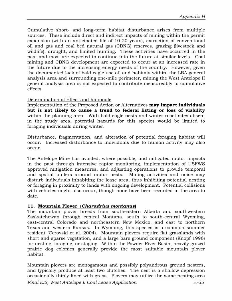
Appendix H
Cumulative short- and long-term habitat disturbance arises from multiple sources. These include direct and indirect impacts of mining within the permit expansion (with an anticipated life of 10-20 years), extraction of conventional oil and gas and coal bed natural gas (CBNG) reserves, grazing (livestock and wildlife), drought, and limited hunting. These activities have occurred in the past and most are expected to continue into the future at similar levels. Coal mining and CBNG development are expected to occur at an increased rate in the future due to the increasing energy needs of the country. However, given the documented lack of bald eagle use of, and habitats within, the LBA general analysis area and surrounding one-mile perimeter, mining the West Antelope II general analysis area is not expected to contribute measureably to cumulative effects.
Determination of Effect and Rationale Implementation of the Proposed Action or Alternatives may impact individuals but is not likely to cause a trend to federal listing or loss of viability within the planning area. With bald eagle nests and winter roost sites absent in the study area, potential hazards for this species would be limited to foraging individuals during winter.
Disturbance, fragmentation, and alteration of potential foraging habitat will occur. Increased disturbance to individuals due to human activity may also occur.
The Antelope Mine has avoided, where possible, and mitigated raptor impacts in the past through intensive raptor monitoring, implementation of USFWS approved mitigation measures, and adjusting operations to provide temporal and spatial buffers around raptor nests. Mining activities and noise may disturb individuals inhabiting the lease area, thus inhibiting potential nesting or foraging in proximity to lands with ongoing development. Potential collisions with vehicles might also occur, though none have been recorded in the area to date.
11. Mountain Plover (Charadrius montanus) The mountain plover breeds from southeastern Alberta and southwestern Saskatchewan through central Montana, south to south-central Wyoming, east-central Colorado and northeastern New Mexico, and east to northern Texas and western Kansas. In Wyoming, this species is a common summer resident (Cerovski et al. 2004). Mountain plovers require flat grasslands with short and sparse vegetation, and a large bare ground component (Knopf 1996) for nesting, foraging, or staging. Within the Powder River Basin, heavily grazed prairie dog colonies generally provide the most suitable mountain plover habitat.
Mountain plovers are monogamous and possibly polyandrous ground nesters, and typically produce at least two clutches. The nest is a shallow depression occasionally thinly lined with grass. Plovers may utilize the same nesting area Final EIS, West Antelope II Coal Lease Application H-55

Appendix H
in subsequent years (Dechant et al. 2003d). Adults and fledged chicks leave the breeding grounds by early August, and may stage within appropriate habitats before migrating. Plovers feed primarily upon insects. Beetles, grasshoppers, crickets, and ants are the most important prey items (Knopf 1996). This species is highly approachable and does not flee far. Mountain plover populations have historically declined and recent data suggests that this species is continuing to decline in numbers. Causes of population declines have been primarily attributed to regional changes in agricultural practices (Knopf 1996).
Existing Conditions Mountain plovers are summer residents within portions of the TBNG. Most observations of mountain plovers in northeast Wyoming have been associated with prairie dog colonies. Approximately 86 percent of recently (since 1993) occupied mountain plover habitat in that region occurred within prairie dog colonies (Byer 2001).
The history of this species at the Antelope Mine and surrounding area is well documented. Mountain plovers were first documented in the vicinity of the Antelope Mine and general analysis area during baseline studies in 1978 and 1979. Annual monitoring for this species began in 1982 and continued through 2006. Those surveys included much of the overall West Antelope II general analysis area, and the entire USDA-FS block and adjacent lands. Survey results have demonstrated that mountain plovers are regular spring migrants and/or summer residents in both areas.
Mountain plovers have undergone two intensive studies, as well as more than two decades of annual monitoring. Generally, two to five pairs of mountain plovers nest in the vicinity of the Antelope Mine each year. Over time, the number of observed broods in that area has fluctuated considerably, but young have fledged in 24 of the last 25 years. Generally more than 75 percent of mountain plover sightings recorded in the Antelope Mine monitoring area each year between 1994 and 2006 occurred within or adjacent to occupied black-tailed prairie dog colonies. The most regular sightings of mountain plovers in that region over the last 13 years have occurred in two occupied prairie dog colonies within the West Antelope II LBA tract general analysis area (T. 40 N., R. 71 W., Sections 8/9 and 15) and one remnant occupied colony in the Antelope permit area in T. 40 N., R. 71 W., Section 3 (Figure H-1). Since 1994, most of the documented nesting activity in the area has also occurred among those three prairie dog colonies. Further details regarding mountain plovers beyond the USDA-FS lands are provided in Chapter 3.
As previously described in the prairie dog subsection above, the eastern half of the Section 15 prairie dog colony encompasses approximately 41 acres of USDA-FS lands, while the entire colony (93 acres) is within the West Antelope II general analysis area. That prairie dog colony is associated with Mountain Plover Use Area (MPA) Numbers 3 (211 acres) and 4 (202 acres). The MPA
Final EIS, West Antelope II Coal Lease Application H-56

Appendix H
designation describes areas that were originally mapped as known or potential habitat in 1989, but that may or may not have been used by mountain plovers during previous or subsequent years. In addition to the prairie dog colony itself, USDA-FS lands overlap the northern portion of MPA Number 2 (225 acres).
Mountain plover use of USDA-FS lands within the West Antelope II general analysis area has also been well documented over the last 25 years. This species was observed in one or more of the three MPAs that overlap the USDAFS or adjacent lands. As for the TBNG in general, most plovers were documented in the Section 15 black-tailed prairie dog colony that overlaps USDA-FS lands. Nesting efforts during that period were confirmed in ten years, with most broods also observed in that colony. Natural factors such as weather conditions appear to be the primary influences affecting annual brood production in the area. Unfavorable weather conditions such as drought, temperature extremes, and excessive precipitation that occur in the spring or summer months can result in declines in nesting attempts and the number of young observed.
Direct and Indirect Effects The Proposed Action and Alternatives could potentially eliminate approximately 331 acres of habitat currently known or mapped as mountain plover use areas on or within one-quarter mile of USDA-FS lands within the West Antelope II LBA tract: 93 acres (28 percent) in the Section 15 prairie dog colony and 238 acres (72 percent) spread across portions of MPA Numbers 2-4 (Figure H-1). However, the greatest potential impact would occur in the prairie dog colony, as most observations and known mountain plover nesting have occurred in that portion of the area over time. Even sightings within that colony have been concentrated in its western half over time, beyond the USDA-FS lands themselves. Nevertheless, nests, adults, or young chicks present in those areas could be injured or killed if mining operations encroach during the nesting or early brood-rearing periods.
Both USDA-FS Standards and Guidelines and the Antelope Mine state mining permit stipulate that clearance surveys will be conducted and approved by the appropriate agencies before any colony is disturbed during the breeding season. That process will preclude most direct impacts to nesting mountain plovers on or immediately adjacent to USDA-FS lands within the BLM study area and West Antelope II general analysis area. The most probable source of potential effects would be an increase in the mortality of, or injury to, individuals foraging within or passing through the mine area due to collisions with mine-related equipment and vehicles. The use of existing roads in the area, when possible, would help minimize this risk. Increased activity and noise, especially during the nest initiation period, could inhibit nesting within proximity to mining activities.
Once active mining begins, a number of prairie dogs may escape their burrows Final EIS, West Antelope II Coal Lease Application H-57

Appendix H
prior to the advance of encroaching machinery, and may even create new burrows in freshly turned soils associated with disturbance and reclamation activities. Approximately 73 percent of MPA Number 2 falls outside of the general analysis area for the West Antelope II LBA tract itself, and thus represents suitable habitat not slated for physical disturbance during any phase of this potential leasing action. The extreme southwestern extent of MPA Number 3 also will not be disturbed by activities associated with that leasing action. In addition to these areas immediately adjacent to federal USDA-FS lands, ample suitable nesting and foraging habitat for mountain plovers has been documented throughout the general area to the north, west, and south. However, the effects of increased CBNG activity to the northwest on mountain plover presence and use in that area are not yet known.
Given the species’ willingness to return to areas disturbed by mining (as well as CBNG operation areas to the northwest), the long-term stability of the number of breeding pairs in the overall area, and the quantity of suitable but unoccupied habitat in the area, operations associated with the Antelope Mine have not adversely impacted mountain plovers. It appears that natural events and other unknown factors, particularly on wintering grounds, may be the primary forces affecting mountain plover numbers and use at and near the mine.
USDA-FS Standards and Guidelines for mountain plovers outlined in the TBNG Plan (USDA-FS 2002) would be implemented to minimize mine-related impacts to this species. To help maintain suitable nesting habitat for mountain plover, development of new facilities would be prohibited within 0.25 mile of known mountain plover nests or nesting areas. This would not apply to pipelines, fences and underground utilities. To reduce the risk of disturbances to nesting mountain plovers, surface use (e.g., drilling, testing, new construction, and workovers) would be prohibited from 15 March through 31 July within 0.25 mile of active nests. To help reduce risks to mountain plovers from traffic, vehicle speeds would be limited in occupied mountain plover habitat to 25 mph on resource roads and 35 mph on local roads. The USDA-FS may impose mitigation measures beyond the TBNG Plan Standards and Guidelines for mountain plovers on a project-by-project basis. These mitigation measures include intensive nest monitoring in areas of ongoing and continuous activities and contact with the appropriate agencies.
In 2008, at Antelope Mine’s request, the Wyoming Game and Fish Commission reviewed and amended their policy regarding the relocation of black-tailed prairie dogs for the creation of mountain plover habitat. The previous WGFD policy required that the mine obtain written permission of adjacent landowners within a four mile radius of the release site before any black-tailed prairie dog relocation could occur. The 2008 approved amendment replaced the former rule and established that black-tailed prairie dog relocation could occur once the mine provided written notification to adjacent landowners within a four mile radius of the release site. One of Antelope Mine’s specific reclamation
Final EIS, West Antelope II Coal Lease Application H-58

Appendix H
objectives is to restore black-tailed prairie dog communities that have had documented mountain plover nesting activity and have been impacted by mining.
In addition to these efforts, the Antelope Mine has worked cooperatively with the USFWS Ecological Services Office in Cheyenne to incorporate species-specific protective measures into its state mining permit, and to develop a USFWS approved species-specific monitoring and mitigation plan for mountain plovers. Those efforts include annual surveys, halting or delaying operations to accommodate nesting birds, planting of appropriate seed mixes in reclamation to restore habitats lost to mining, and re-creation of prairie dog colonies, the most commonly used habitat in the area. Through a successful translocation program implemented in 2002 and 2003, the mine has established a small, but growing, prairie dog colony in reclamation in an area historically used by mountain plovers. That colony is approximately 1.0 mile northeast of the USDA-FS general analysis area and 1.1 miles northeast of the Section 15 prairie dog colony, where plovers are known to periodically nest. The reclamation colony is monitored annually to determine habitat conditions and to watch for mountain plover use.
Determination of Effect and Rationale Implementation of the Proposed Action or Alternatives may impact individuals but is not likely to cause a trend to federal listing or loss of viability within the planning area. Degradation, destruction, and/or fragmentation of known and potential nesting, staging, and foraging habitat and potential collisions with vehicles and mining equipment may occur. Approximately 70% of this species’ most commonly used habitat (prairie dog colonies) within the two-mile perimeter wildlife survey area for the Antelope Mine, as well as many square miles of additional known and potential habitat, lie beyond the general analysis area boundary for the West Antelope II LBA tract, including USDA-FS lands. Approximately 215 acres (30% of total) of prairie dog colonies are within the general analysis area for the West Antelope II LBA tract, and are thus likely to be disturbed at some point in time, should this leasing action move forward; about 41 acres (6%) within one colony occur on USDA-FS lands, with the entire colony (93 acres, 13%) falling within the general analysis area. Although the areas that lie beyond the West Antelope II LBA tract general analysis area boundaries are, or may be, impacted by non-mine related operations, expanding surveys have demonstrated more mountain plovers in the general area than were previously known.
12. Loggerhead shrike (Lanius ludovicianus) Loggerhead shrikes breed from Washington, northern Alberta, central Saskatchewan, and southern Manitoba, south to California and Florida, and east to southwestern Minnesota, southern Wisconsin, southern Michigan, and Maryland. This species is a common summer resident throughout Wyoming (Cerovski et al. 2004). Shrikes prefer relatively open, heterogeneous habitats characterized by grasses and forbs of low stature interspersed with bare Final EIS, West Antelope II Coal Lease Application H-59

Appendix H
ground and shrubs or low trees with perches for hunting. This species will use a wide variety of trees and shrubs, particularly thick or thorny species, as nesting substrates and hunting perches (Prescott and Bjorge 1999).
Although some shrike nests are used in subsequent years, fidelity to a nest site is limited. This species forages over relatively open habitats, feeding primarily upon arthropods, amphibians, small to medium-sized reptiles, small mammals, and birds (Yosef 1996). Shrikes may also feed upon road kill and carrion. This species is generally tolerant of human activity near a nest, although they will abandon if disturbed during egg-laying or early in incubation. The loggerhead shrike is declining in both number and overall range. Declines have been attributed to habitat loss and conversion, urbanization, pesticide contamination, and loss of insect prey as a result of pesticide use (Yosef 1996).
Existing Conditions Loggerhead shrikes are common summer residents within the TBNG, though they are not often observed on or adjacent to USDA-FS lands. Shrikes have occasionally been seen in the one-mile perimeter wildlife survey area for the adjacent Antelope Mine (which includes all USDA-FS lands) over time. No actual shrike nests have been documented in that area, but the presence of recently fledged young in some years indicates that this species does nest in the general vicinity. Over time, most sightings occurred in the cottonwood-riparian corridor along Antelope Creek in T. 40 N., R. 71 W., W½ Section 5, approximately 2.5 miles north of the USDA-FS general analysis area. Shrikes have also been infrequently recorded perched on various fences or on overhead power lines in SE¼ SE¼ Section 16, just beyond the USDA-FS area. Shrike foraging habitat is present throughout the general analysis area, including USDA-FS lands. As indicated, existing utility and fence lines currently provide good quality hunting perches.
Direct and Indirect Effects Implementation of the Proposed Action or Alternatives could result in direct and indirect impacts to loggerhead shrikes, though such impacts would likely be uncommon. No known nest sites have been documented on or adjacent to USDA-FS lands or elsewhere in the annual monitoring survey area for the adjacent Antelope Mine. The riparian corridor within the 100-foot buffer on either side of Antelope Creek (potential nesting habitat) will be protected from physical disturbance, as required by the Antelope Mine state mining permit. The most probable direct impact would be the mortality of, or injury to, individuals foraging within or passing through the USDA-FS lands due to collisions with mine-related vehicles, or dispersal of foraging individuals due to active mining.
The relatively slow movement of mining equipment and the noise associated with the activity would decrease direct impacts associated with vehicle collisions. As loggerhead shrikes are not especially common in the West Antelope II general analysis area, indirect impacts would be limited despite the
Final EIS, West Antelope II Coal Lease Application H-60

Appendix H
fragmentation, degradation, or loss of habitat in the short and mid-term, and the notable reductions in prey populations that would accompany active mining.
Any birds that would be displaced would be forced to travel to other locations with acceptable habitat. This could result in stress to individual birds, as well as potential decreased nesting effort and success. Prey numbers reduced by mining would be expected to rebound following reclamation due to generally high reproductive potential and prey tendencies to re-establish and adapt to disturbed and reclaimed areas.
The locations of mine-related habitat disturbances and reclamation efforts would proceed incrementally throughout the expanded mining area as operations progressed. Additionally, this mining activity would not conflict with the current TBNG Plan, or any future objectives to manage the TBNG for this species. USDA-FS Standards and Guidelines would offer additional protections for any active nest sites that may be present in the area.
Determination of Effect and Rationale Implementation of the Proposed Action or Alternatives may impact individuals but is not likely to cause a trend to federal listing or loss of viability within the planning area. Such impacts would be minimized by the low frequency of regular sightings and known nesting attempts, as well as the relative paucity of suitable nesting habitat on or adjacent to the USDA-FS lands analyzed in this EIS and their surrounding region. Degradation, fragmentation, or loss of potential foraging habitat, reduction in prey populations, and potential collisions with vehicles may occur. Given the low number of birds recorded in the area, and the composition of the shrike’s prey base (insects, small mammals, etc.), impacts to shrikes would be minimal. USDA-FS Standards and Guidelines would apply for active nests during the breeding season. Additionally, mining the USDA-FS lands would not conflict with the current TBNG Plan, or any future objectives to manage the TBNG for loggerhead shrikes.
13. Brewer’s Sparrow (Spizella breweri) The breeding range of the Brewer’s sparrow extends from southwestern Yukon, southern Alberta, southwestern Saskatchewan, south (east of the Cascades and Sierras) to southern California, central Arizona, and northern New Mexico (Rotenberry et al. 1999). The Brewer’s sparrow is a common summer resident of the basin-prairie and mountain-foothills throughout Wyoming (Cerovski et al. 2004). Brewer’s sparrow is a sagebrush obligate species and where present is the most abundant species (Rotenberry et al. 1999).
This species is an uncommon cowbird (Molothrus ater) host and typically builds a small cup nest low in sagebrush shrubs. Brewer’s sparrows prefer to nest in medium-sized (19-35 in) live sagebrush within relatively dense (26-42% canopy cover) stands (Walker 2004). Grass height and density are important factors Final EIS, West Antelope II Coal Lease Application H-61

Appendix H
for nest concealment. Although tolerant of human visitation, this species may abandon a nest if disturbed during the construction process.
Brewer’s sparrows feed primarily on small insects and, to a lesser extent, seeds from grasses and forbs. Throughout areas where they have been surveyed, the species appears to have undergone and continues to undergo statistically significant declines (Rotenberry et al. 1999). Major threats to Brewer's sparrow populations are similar to those faced by other declining sagebrush-obligate species and include habitat conversion and fragmentation, invasion by nonnative plants, altered fire regimes, livestock overgrazing, conifer encroachment, energy development, and conversion to urban or residential housing (Walker 2004).
Existing Conditions Brewer’s sparrows are common summer residents within the TBNG and northern Converse County (Cerovski et al. 2004). Breeding bird survey data from annual monitoring and baseline studies conducted for the Antelope Mine, and incidental observations over time, have shown that the Brewer’s sparrow is a common but limited breeder in the area. This species has been recorded in the vicinity of the mine during each of the last 13 years (1994-2006). However, Brewer’s sparrows were most often seen in a relatively small stand of big sagebrush, their preferred habitat (Rotenberry et al. 1999), in the southeastern corner of the northern half of the West Antelope II LBA general analysis area just north of the county line in T. 41 N., R. 71 W., NW¼ Section 27 and NE¼ Section 28. Although nests have rarely been encountered, the presence and behavior (singing) of birds throughout spring and summer suggest that Brewer’s sparrows regularly nest in that area. Brewer’s sparrows were not documented during breeding bird surveys (which included USDA-FS lands) in 2006 due to elimination of the sagebrush stand described above as a result of landowner access restrictions.
The known Brewer’s sparrow habitat in Sections 27 and 28 is approximately 3.75 miles northwest of the USDA-FS lands. No Brewer’s sparrows have been recorded in that area over the last 25 years of annual monitoring, including breeding bird point counts conducted on those USDA-FS lands in 2006. As described for sage-grouse, above, the lack of a continuous stand of quality sagebrush in that area is a limiting factor for sage-obligates such as Brewer’s sparrows.
Direct and Indirect Effects Nesting and foraging habitat for Brewer’s sparrow is present in limited stands of sagebrush on and near USDA-FS lands within the BLM study area. The shrubs in that area are relatively short and somewhat sparse, and represent only marginal habitat for sage obligates such as this sparrow. Potential direct impacts to this species include the destruction of active nests during topsoil removal or other operations, mortalities resulting from collision with large equipment and other vehicles, natural predators, and displacement of
Final EIS, West Antelope II Coal Lease Application H-62

Appendix H
individuals from their core home range. As for other species, such impacts could be minimized by incremental disturbance and reclamation of disturbed areas.
The use of existing roads, when possible, could minimize additional impacts related to traffic hazards and use of new travel corridors by mammalian predators. Increased activity and noise, especially during the nest initiation period, could inhibit nesting proximate to mining activities. Foraging could also be hindered within these areas, especially where active mining occurs. Additional infrastructure and activity associated with the expansion of the mine, in combination with other ongoing disturbances (e.g., CBNG operations), could displace Brewer’s sparrows from any historical use areas that might occur in the area. Those birds could potentially move into other sagebrush stands in the general area, assuming they are not already occupied.
Limited habitat loss, degradation, and fragmentation will result from a variety of large- and small-scale mining operations (e.g., topsoil stripping, drilling, reservoir construction, etc.) on USDA-FS lands. In addition to their effects on the landscape, linear habitat disturbances (i.e., roads and power lines) can also provide convenient travel corridors for mammalian predators, thus increasing the predation risk to individuals in proximity to these structures.
Given that Brewer’s sparrows have not been documented on or near the USDSFS lands analyzed in this EIS, and the marginal quality of the sage stands present in that area, potential impacts to this species would be minimal. Reclamation of disturbed areas will occur incrementally as mining is completed in a given portion of the mine and will eventually mitigate impacts to some degree, though such efforts could take decades to benefit sagebrush obligates such as the Brewer’s sparrow. Impacts to sagebrush habitat on USDA-FS lands could be further mitigated off-site by efforts to preserve and enhance such habitat on adjacent and nearby private lands. Landowners in the region have formed an ecosystem-based land management group (Thunder Basin Grasslands Prairie Ecosystem Association) that has been working cooperatively with the USDA-FS Douglas Ranger District and USFWS to implement a research and management plan for sage-grouse on their private lands that could also address the needs of other sagebrush obligates, including the Brewer’s sparrow, within the TBNG. Standards and Guidelines for sagebrush habitats outlined in the TBNG Plan (USDA-FS 2002, pages 1-18; Appendix D) would be implemented as necessary, and could serve to sustain regional populations of this sparrow.
Determination of Effect and Rationale Implementation of the Proposed Action or Alternatives may impact individuals but is not likely to cause a trend to federal listing or loss of viability within the planning area.
Final EIS, West Antelope II Coal Lease Application H-63
Appendix H
Given the limited presence and marginal quality of sagebrush within the USDA-FS general analysis area, and the likelihood that Brewer’s sparrows would remain viable elsewhere within the TBNG for at least the short-term, the Proposed Action or Alternatives would not conflict with the current TBNG Plan (USDA-FS 2002) or future objectives to manage the area for this species. Application of appropriate USDA-FS Standards and Guidelines, successful reclamation efforts, and proper land management on adjoining lands could mitigate potential impacts, to some degree.
CUMULATIVE EFFECTS REGARDING SENSITIVE SPECIES
Cumulative effects are defined under the NEPA process as the incremental impacts of past, present, and reasonably foreseeable future actions conducted by any entity (federal, state, private, and others).
Cumulative short- and long-term disturbances to the species considered in this analysis arise from multiple sources that occur on federal and non-federal lands within the general analysis area for the West Antelope II LBA tract, including USDA-FS lands within that area and neighboring lands. Those sources include direct and indirect impacts of mining (with an anticipated life of at least 20 more years), extraction of conventional oil and gas and CBNG reserves, road development and relocation, construction and removal of power lines and pipelines, grazing (livestock and wildlife), drought, occupied residences, and hunting and trapping. Those activities have occurred in the vicinity of the USDA-FS general analysis area in the past and most are expected to continue at similar levels, at least for the near future.
Coal mining and CBNG development are expected to occur at an increased rate in the future. Other reasonable and foreseeable developments within the area could potentially include the construction of a coal-fired power plant and new rail lines for transporting coal. Both mining and oil and gas development activities have requirements for reclamation of disturbed areas as resources are depleted. However, those standards are dramatically different in both implementation and monitoring. As new areas of disturbance related to energy extraction activities are added, areas that have been mined out will be restored and reclaimed. Similarly, oil and gas well sites will be reclaimed once they are depleted and abandoned.
No critical habitat for any USDA-FS Sensitive Species has been delineated in the West Antelope II LBA tract general analysis area (including the USDA-FS lands). Any habitat losses that do occur will eventually be mitigated for most species by reclamation with native seed mixes which may improve habitat quality by reducing the presence of non-native plants (e.g., crested wheatgrass) within the area. Leasing lands within the West Antelope II general analysis area will not conflict with the current TBNG Plan, or any future objectives to manage USDA-FS lands and provide habitat for Sensitive Species. Because effects of disturbance on sensitive species inhabiting the same habitat types
Final EIS, West Antelope II Coal Lease Application H-64

Appendix H
would be the same, cumulative impacts are analyzed according to species’ main habitat associations.
Species Associated Primarily With Short Grasses or Prairie Dog Colonies
Five evaluated species are strongly associated with prairie dog colonies or other areas with short, sparse vegetation: the black-tailed prairie dog, mountain plover, burrowing owl, chestnut-collared longspur, and McCown’s longspur. Cumulative impacts to these habitats and associated species will largely result from activities that would decrease occupied black tailed prairie dog colonies within the area. As the prairie dog is the most common sensitive species in the area, it has the most potential to be affected by cumulative impacts from the Proposed Action and Alternatives. Specifically, individuals could be killed or injured by activities in or near prairie dog colonies, and habitat will be lost until reclamation takes place. Incremental habitat disturbance and freshly turned soil in stripped and reclaimed areas would allow escaping or dispersing animals to create new burrows, and thus maintain a presence in the area.
Burrowing owls and mountain plovers rely heavily on prairie dogs to provide and maintain suitable nesting habitat. Longspurs are also often found in prairie dog colonies in the overall general analysis area. Therefore, any activities that jeopardize prairie dogs will also affect those species to some degree. Although impacts would occur on approximately 215 acres of prairie dog colonies within or overlapping the boundaries of the West Antelope II LBA general analysis area (93 acres of which occur on or within one-quarter-mile of USDA-FS lands), the presence of approximately 514 acres of colonies beyond the overall general analysis area would minimize negative impacts to those three species. Despite their strong association with prairie dogs, species such as burrowing owls, mountain plovers, and longspurs can all utilize short-grass habitats other than prairie dog colonies. However, all of those avian species would benefit from the presence of undisturbed prairie dog colonies surrounding the West Antelope II LBA tract general analysis area, including USDA-FS lands, as well as other short-form vegetative communities.
Despite the presence of additional habitat outside the area, cumulative effects expected for these five species would include habitat destruction, alteration, and fragmentation. As indicated, some individuals may be killed or injured by vehicles or equipment, collisions with fences, and poisoning or shooting. Predation rates on some species may increase due to the creation of favorable habitats, perches, or travel corridors for avian or mammalian predators. Nests of avian species will likely be destroyed or compromised by human disturbances or activities, and individuals (especially avian species) will likely be displaced from existing territories. Such occurrences would increase competition for available adjacent territories. If those areas have already reached carrying capacity, the result would be intra-specific competition followed by nutritional stress, decreased fecundity, and/or mortality.
Final EIS, West Antelope II Coal Lease Application H-65

Appendix H
Mixed Sagebrush and/or Mid-grass Species
Mid-grass parcels interspersed with sagebrush occur, but are not especially common in the West Antelope II LBA tract general analysis study area, including USDA-FS lands. Mining the area will impact the habitats that are present. Evaluated species for mixed grassland habitats included the swift fox, long-billed curlew, and ferruginous hawk. Cumulative impacts to those species would be the similar to those described above. However, as all of these species have the capacity of utilizing a variety of habitats, including prairie dog colonies and short-grass areas, beyond the overall general analysis, the cumulative effects would be somewhat lessened.
Regarding the swift fox and ferruginous hawk, the fragmentation, alteration, or destruction of suitable habitats would also destroy denning and shelter sites or nest sites, respectively, and would potentially facilitate inter-specific competition for available prey bases. Both the swift fox and hawks using these habitats would also be negatively affected by activities that reduce prey availability. The impacts would be partially mitigated by the existing presence of alternate denning and nesting sites in the area that would not be disturbed by the Proposed Action or Alternatives. The greatest threat to mixed, mid-grass species would arise from the creation of habitat patches that are too small to attract individuals or sustain viable breeding pairs or populations.
Sagebrush Obligates
Species associated with sagebrush habitats that could occur in or near the West Antelope II LBA tract general analysis area and USDA-FS lands include the Greater sage-grouse and Brewer’s sparrow. However, more than 25 years of annual monitoring have demonstrated that the sagebrush stands within those areas and surrounding lands are insufficient in size and structure to support sage-grouse. Therefore, sage-grouse would not experience cumulative impacts due to mining within either the overall or USDA-FS general analysis area. Similarly, the relatively small and somewhat sparse shrub stands within the northern portion of the West Antelope II LBA tract general analysis area provide limited, marginal habitat for Brewer’s sparrows, and observations have been sparse in the area over time. No Brewer’s sparrows have been recorded on or near the USDA-FS lands during more than two decades of frequent spring and summer surveys.
Given the restricted occurrence of sagebrush habitat within the overall general analysis area (including USDA-FS lands) and immediate vicinity, cumulative impacts to sagebrush habitats and their associated species would be minimal. Impacts that do occur would likely be limited to the direct injury or mortality of individual Brewer’s sparrows, or their nests or young. Indirect impacts to Brewer’s sparrows could entail changes in their presence or distribution as the quantity and quality of existing sagebrush stands in the area are diminished
Final EIS, West Antelope II Coal Lease Application H-66
Appendix H
due to habitat fragmentation, alteration, degradation, and conversion of shrubland communities during ongoing and new mining operations.
Any displaced individuals would have to compete for the limited availability of adjacent territories, and if those areas have reached carrying capacity, intraspecific competition may result in nutritional stress, decrease in fecundity, or mortality to affected individuals. Sagebrush habitats lost to mining would be mitigated, as required. However, those efforts would not likely be able to keep pace with, or compensate for, the on-going loss or alteration of sagebrush habitat within the area, as sagebrush stands can take two or three decades to re-establish.
Tree or Wetland/Aquatic Species
Only one small (less than five) stand of trees and no wetland/aquatic habitats occur on and near USDA-FS lands, and such habitats are limited elsewhere in the overall West Antelope II LBA tract general analysis area. Species associated with treed or aquatic habitats that could occur in or near those areas include the loggerhead shrike and northern leopard frog, though the latter is less likely to be present. Cumulative effects to shrikes would be similar, but slightly greater than, those for non-raptor avian species within mixed mid-grass and shrub habitats. The increased intensity of effects would be due to the overall lack of trees (potential nest sites) within either general analysis area, and thus the limited alternate habitats as trees are lost to mining. Mitigating that impact is the fact that most trees in the general analysis area are within the 100-foot buffer zone along Antelope Creek, and thus will not be physically disturbed by future mining. However, that location is approximately 2.75 miles north of the USDA-FS lands. High intensity activity and noise along that corridor when mining is most proximate could deter shrikes from nesting in the area, at least until they acclimated to the disturbance. All trees destroyed by mining will be replaced during reclamation, but it will take decades for them to mature to their current stature.
Northern leopard frogs are not prevalent within either the West Antelope II LBA tract general analysis area or USDA-FS lands, and therefore have little potential to be affected by cumulative impacts from the Proposed Action and Alternatives. Wetland and aquatic habitats for northern leopard frogs are considered very poor to unsuitable on USDA-FS lands within the West Antelope II LBA tract general analysis area and no frog sightings have been recorded on USDA-FS lands within the general analysis area. If this species is present in the future, individuals could be killed or injured by activities in proximity to aquatic habitats. Dewatering or degradation of breeding habitats could kill eggs, tadpoles, or over-wintering adults, as well as increase predation rates on adults and eggs. Conversely, the creation and augmentation of aquatic habitats for sedimentation ponds and other purposes could maintain and possibly increase local northern leopard frog populations.
Final EIS, West Antelope II Coal Lease Application H-67

Appendix H
Overall, despite the death, injury, and displacement of some animals, the cumulative impacts associated with the Proposed Action and Alternatives are not expected to significantly reduce the size or viability of populations of any of the USDA-FS Region 2 Sensitive Species. Many of these species have not been documented within either the West Antelope II LBA or USDA-FS general analysis area over the last 25 years, have already been displaced from those areas, or have remained present despite the ongoing mine and non-mine activities in and near those areas.
TBNG PLAN COMPLIANCE
The Proposed Action and Alternatives are considered to be in compliance with Grassland-wide, Geographic Area, and Management Area Standards and Guidelines for wildlife (including regionally sensitive species, and Management Indicator Species) detailed in the Grassland Plan (USDA-FS 2002).
REQUIRED MITIGATION AND RECOMMENDED MONITORING
To help protect R2 Sensitive Species, the operator will notify the USDA-FS District Ranger, Douglas, Wyoming, if sensitive species nests or dens in addition to those identified in the Biological Evaluation are located during construction or operation of the project. Future surveys for any R2 Sensitive Species could be conducted in response to requests from the USDA-FS Douglas District Ranger. This would allow assessments of how, and if, implementation of the TBNG Plan is benefiting these species.
Mitigation measures designed to reduce impacts to wildlife that are required by the Surface Mining Control and Reclamation Act and state law include:
• Using raptor-safe power lines; • Designing fences to permit wildlife passage; • Creating artificial raptor nest sites; • Relocating raptor nests and taking other action to maintain active
nesting pairs; • Restoring pre-mining topography to the maximum extent possible; • Planting a diverse mixture of grasses, forbs, and shrubs in configurations
beneficial to wildlife; and • Building and maintaining sediment control ponds or other sediment
control devices during mining.
To further minimize negative impacts to faunal species of concern, the USFWS requires additional species-specific protective measures, as well as targeted monitoring and mitigation plans for certain Region 2 Sensitive Species.
Final EIS, West Antelope II Coal Lease Application H-68

Appendix H
USDA-FS MANAGEMENT INDICATOR SPECIES
SPECIES EVALUATED AND RATIONALE
A Management Indicator Species (MIS) is defined as a “plant or animal species or habitat components selected in a planning process used to monitor the effects of planned management activities on populations of wildlife and fish, including those that are socially or economically important” (USDA-FS 2002). MIS are selected to serve as barometers for species diversity and viability. These species are monitored over time to assess the effects of management activities on their populations and habitat, and the populations of other species with similar habitat needs. MIS for the TBNG are identified by Geographic Area. In accordance with the TBNG Plan (USDA-FS 2002), the Greater sage-grouse was selected as the management indicator species to be evaluated for this project (as defined for the Hilight Bill Geographic area).
For detailed sage-grouse habitat and population information, please see Section 3.10.5 in the EIS. This Biological Assessment and Biological Evaluation (BABE) document analyzes and discloses potential effects to wildlife if lands within the West Antelope II general analysis area are leased and mined. The USDA-FS Douglas Ranger District biologists have reviewed the EIS and BA/BE.
In addition to the information provided in this EIS analysis, USDA-FS also completed an evaluation of the Greater sage-grouse as a USDA-FS MIS. The complete MIS evaluation is available for public review at the USDA-FS Douglas Ranger District. The following is a brief summary of the findings of Forest Service’s MIS evaluation in regard to the Proposed Action and Alternatives 1 and 2:
• “According to WGFD records and USDA-FS records, the closest sage-grouse leks are approximately three miles away from the West Antelope II proposed lease area. Given the limited sightings of sage-grouse observations in the area, and the minimal quantity and marginal quality of potential sage-grouse habitat, implementation of the Proposed Action or either Alternative 1 or 2 is not likely to negatively impact any existing or potential sage-grouse leks, and will not impact prevalent sage-grouse habitats (expanses of sagebrush).”
• “. . . (The Proposed Action and Alternatives 1 and 2) are not expected to change the current trend of sage grouse habitat on Thunder Basin National Grassland.”
• “. . . (The Proposed Action and Alternatives 1 and 2) would be in compliance with the TBNG LRMP management direction for sage grouse as an MIS. At this time, the viability of sage grouse within Thunder Basin National Grassland is not a concern.”
Final EIS, West Antelope II Coal Lease Application H-69

Appendix H
REFERENCES AND LITERATURE CITED
Baxter, G.T. and M.D. Stone. 1980. Amphibians and reptiles of Wyoming. Wyoming Game and Fish Department, Lander, WY.
Bechard, M.J. and J.K. Schmutz. 1995. Ferruginous hawk (Buteo regalis). In The Birds of North America, No. 172 (A. Poole and F. Gill, Eds.) The Academy of Natural Sciences, Philadelphia, PA, and The American Ornithologists’ Union, Washington, D.C.
Brown, K.G. and K.M. Clayton. 2004. Ecology of the Greater sage-grouse (Centrocercus urophasianus) in the coal mining landscape of Wyoming’s Powder River Basin. Final Technical Report prepared by Thunderbird Wildlife Consulting, Gillette, Wyoming.
Byer, T. 2001. Biological assessment and biological evaluation report for Devon Energy Production Company. USDA-FS, Douglas Ranger District.
Cerovski, A.O., M. Grenier, B. Oakleaf, L. Van Fleet, and S. Patla. 2004. Atlas of Birds, Mammals, Amphibians, and Reptiles in Wyoming. Wyoming Game and Fish Department Nongame Program, Lander.
Connelly, J.W., W.L. Wakkinen, A.D. Apa, and K.P. Reese. 1991. Sage grouse use of nest sites in southeastern Idaho. J. Wildl. Manage. 55:521-524.
Connelly, J.W., S.T. Knick, M.A. Schroeder, and S.J. Stiver. 2004. Conservation Assessment of Greater Sage-grouse and Sagebrush Habitats. Western Association of Fish and Wildlife Agencies. Unpublished Report, Cheyenne, Wyoming.
Cotterill, S.E. 1997. Status of the swift fox (Vulpes velox) in Alberta. Alberta Environmental Protection, Wildlife Status Report No. 7, Edmonton, AB.
Dechant, J. A., M. L. Sondreal, D. H. Johnson, L. D. Igl, C. M. Goldade, P. A. Rabie, and B. R. Euliss. 2003a. Effects of management practices on grassland birds: Long-billed Curlew (Version 12DEC2003). Northern Prairie Wildlife Research Center, Jamestown, ND. Available from website on the Internet: <http://www.npwrc.usgs.gov/resource/literatr/grasbird/lbcu/lbcu.htm>.
Dechant, J. A., M. L. Sondreal, D. H. Johnson, L. D. Igl, C. M. Goldade, M. P. Nenneman, and B. R. Euliss. 2003b. Effects of management practices on grassland birds: Chestnut-collared Longspur (Version 28 MAY2004). Northern Prairie Wildlife Research Center, Jamestown, ND. Available from website on the Internet: <http://www.npwrc.usgs.gov/resource/literatr/grasbird/cclo/cclo.htm >.
Dechant, J. A., M. L. Sondreal, D. H. Johnson, L. D. Igl, C. M. Goldade, P. A. Final EIS, West Antelope II Coal Lease Application H-70

Appendix H
Rabie, and B. R. Euliss. 2003c. Effects of management practices on grassland birds: McCown's Longspur (Version 12 AUG2004). Northern Prairie Wildlife Research Center, Jamestown, ND. Available from website on the Internet: <http://www.npwrc.usgs.gov/resource/literatr/grasbird/mclo/mclo.htm>.
Dechant, J. A., M. L. Sondreal, D. H. Johnson, L. D. Igl, C. M. Goldade, M. P. Nenneman, and B. R. Euliss. 2003d. Effects of management practices on grassland birds: Mountain Plover (Version 12DEC2003). Northern Prairie Wildlife Research Center, Jamestown, ND. Available from website on the Internet: <http://www.npwrc.usgs.gov/resource/literatr/grasbird/mopl/mopl.htm>.
Drut, M.S., J.A. Crawford, and M.A. Gregg. 1994. Brood habitat use by sage grouse in Oregon. Great Basin Naturalist 54:170-176.
Gregg, M.A., J.A. Crawford, M.S. Drut, and A.K. DeLong. 1994. Vegetational cover and predation of sage grouse nests in Oregon. J. Wildl. Manage. 58:162166.
Grenier, Martin. 2003. An Evaluation of Black-footed Ferret Block Clearances in Wyoming: Completion Report. Wyoming Game and Fish Department. Lander, WY. 16pp.
Hill, D.P. 1998. Status of the long-billed curlew (Numenius americanus) in Alberta. Alberta Environmental Protection, Wildlife Status Report No. 16, Edmonton, AB.
Hill, D.P. and L.K. Gould. 1997. Chestnut-collared longspur (Calcarius ornatus). In The Birds of North America, No. 288 (A. Poole and F. Gill, Eds.) The Academy of Natural Sciences, Philadelphia, PA, and The American Ornithologists’ Union, Washington, D.C.
Johnsgard, P.A. 1990. Hawks, eagles, and falcons of North America. Smithsonian Institution Press, Washington, D.C.
Klute, D.S., L.W. Ayers, M.T. Green, W.H. Howe, S.L. Jones, J.A. Schaffer, S.R. Sheffield, and T.S. Zimmerman. 2003. Status Assessment and Conservation Plan for the Western Burrowing Owl in the United States. U.S. Department of Interior, Fish and Wildlife Service, Biological Technical Publication FWS/BTPR6001-2003, Washington.
Knopf, F.L. 1996. Mountain plover (Charadrius montanus). In The Birds of North America, No. 211 (A. Poole and F. Gill, Eds.) The Academy of Natural Sciences, Philadelphia, PA, and The American Ornithologists’ Union, Washington, D.C.
Final EIS, West Antelope II Coal Lease Application H-71

Appendix H
McKee, G. 2006. Nest Success and Survival of the Greater Sage-grouse (Centrocercus urophasianus) at the North Antelope Rochelle Surface Coal Mine in 2006. 2006 Summary Report.
NatureServe. 2007. NatureServe Explorer: An online encyclopedia of life [web application]. Version 4.0. NatureServe, Arlington, Virginia. Available from website on the Internet as of January 8, 2007: <http://www.natureserve.org/explorer>.
Northeast Wyoming Sage-grouse Working Group (NWSGWC), 2006, Northeast Wyoming Sage-grouse Conservation Plan. August 15. Available from website on the Internet as of 12/17/07: <http://gf.state.wy.us/wildlife/wildlife_management/sagegrouse/Northeast/N EConsvPlan.pdf>.
Prescott, D.R.C, and R.R. Bjorge. 1999. Status of the loggerhead shrike (Lanius ludovicianus) in Alberta. Alberta Environment, Wildlife Status Report No. 24, Edmonton, AB.
Rotenberry, J.T., M.A. Patten, and K.L. Preston. 1999. Brewer’s sparrow (Spizella breweri). In The Birds of North America, No. 390 (A. Poole and F. Gill, Eds.) The Academy of Natural Sciences, Philadelphia, PA, and The American Ornithologists’ Union, Washington, D.C.
Schmutz, J.K. 1989. Hawk occupancy of disturbed grasslands in relation to models of habitat selection. Condor 91:362-371.
Schroeder, M.A, J.R. Young, and C.E. Braun. 1999. Sage grouse (Centrocercus urophasianus). In The Birds of North America, No. 425 (A. Poole and F. Gill, Eds.) The Birds of North America, Inc., Philadelphia, PA.
U.S. Department of Agriculture Forest Service (USDA-FS). 2002. Updated Land and Resource Management Plan for the Thunder Basin National Grassland, Medicine Bow-Routt National Forest, Rocky Mountain Region. USDA Forest Service, Medicine Bow-Routt national Forest, Rocky Mountain Regional Office, Denver, Colorado.
U.S. Department of Agriculture Forest Service. 2003. Thunder Basin National Grassland Wildlife GIS Data and Map. Unpubl.
U.S. Department of Agriculture Forest Service. 2007. Species Conservation Project: Region 2 Regional Forester’s Sensitive Species – Rocky Mountain Region. Available from website on the Internet as of June 2007: <http://www.fs.fed.us/r2/projects/scp/sensitivespecies/index.shtml>
U.S. Department of Interior Fish and Wildlife Service (USFWS). 1989. Black-footed ferret survey guidelines for compliance with the endangered species act.
Final EIS, West Antelope II Coal Lease Application H-72

Appendix H
USFWS, Denver, Colorado, and Albuquerque, New Mexico. April 1989.
Wagner, G. 1997. Status of the northern leopard frog (Rana pipiens) in Alberta. Alberta Environmental Protection, Wildlife Status Report No. 9, Edmonton, AB.
Walker, B. 2004. Effects of management practices on grassland birds: Brewer's Sparrow. Northern Prairie Wildlife Research Center, Jamestown, ND. Jamestown, ND: Northern Prairie Wildlife Research Center Online. Available from website on the Internet: <http://www.npwrc.usgs.gov/resource/literatr/grasbird/brsp/brsp.htm (Version 12AUG2004)>.
White, C.M. and T.L. Thurow. 1985. Reproduction of ferruginous hawks exposed to controlled disturbance. The Condor 87:14-22.
With, K.A. 1994. McCown’s longspur (Calcarius mccownii). In The Birds of North America, No. 96 (A. Poole and F. Gill, Eds.) The Academy of Natural Sciences, Philadelphia, PA, and The American Ornithologists’ Union, Washington, D.C.
Yosef, R. 1996. Loggerhead shrike (Lanius ludovicianus). In The Birds of North America, No. 231 (A. Poole and F. Gill, Eds.) The Academy of Natural Sciences, Philadelphia, PA, and The American Ornithologists’ Union, Washington, D.C.
Final EIS, West Antelope II Coal Lease Application H-73

APPENDIX I
BIOLOGICAL ASSESSMENT FOR THE WEST ANTELOPE II
COAL LEASE APPLICATION EIS

TABLE OF CONTENTS
Appendix I
Page I-1.0 INTRODUCTION............................................................................... I-1 I-2.0 DESCRIPTION OF THE PROPOSED ACTION AND ALTERNATIVES... I-4
I-2.1 The Proposed Action ........................................................................I-4 I-2.2 Alternatives to the Proposed Action ..................................................I-6
I-2.2.1 Alternative 1...............................................................................I-6 I-2.2.2 Alternative 2 (BLM’s Preferred Alternative) ..................................I-7 I-2.2.3 Alternative 3............................................................................. I-10
I-3.0 CONSULTATION TO DATE ............................................................. I-10 I-4.0 SPECIES HABITAT AND OCCURRENCE AND EFFECTS OF THE
PROPOSED PROJECT.................................................................... I-11 I-4.1 Threatened Species ........................................................................ I-14
I-4.1.1 Ute ladies’-tresses orchid (Spiranthes diluvialis) ........................ I-14 I-4.2 Endangered Species....................................................................... I-18
I-4.2.1 Black-footed ferret (Mustela nigripes) ........................................ I-18 I-5.0 SUMMARY OF DETERMINATIONS ................................................. I-21 I-6.0 REGULATORY REQUIREMENTS AND MITIGATION........................ I-21 I-7.0 CUMULATIVE IMPACTS................................................................. I-23 I-8.0 CREDENTIALS OF SURVEY PERSONNEL ...................................... I-26 I-9.0 REFERENCES AND LITERATURE CITED ....................................... I-28
LIST OF TABLES
Table I-1. Effects Determination of Federal T&E Species in the West Antelope II General Analysis Area. ............................................ I-21
LIST OF FIGURES
Figure I-1. General Location Map with Federal Coal Leases and LBA Tracts ........................................................................................ I-2
Figure I-2. West Antelope II LBA Preferred Alternative Tract Configuration ............................................................................. I-3
Final EIS, West Antelope II Coal Lease Application I-i

Appendix I
I-1.0 INTRODUCTION
On April 6, 2005, Antelope Coal Company (ACC1) filed an application with the BLM to lease the federal coal reserves included in a maintenance coal tract under the regulations at 43 CFR 3425: Leasing on Application. Antelope Coal Company, a directly held subsidiary of Rio Tinto Energy America, operates the Antelope Mine in Campbell and Converse Counties, Wyoming. The environmental impacts of leasing the maintenance coal tract are being evaluated in the West Antelope II Coal Lease Application EIS. The tract, referred to as the West Antelope II LBA tract, and applicant mine are shown in Figures I-1 and I-2.
The purpose of this Biological Assessment is to provide information about the potential effects that leasing lands in the West Antelope II general analysis area would have on federally listed threatened or endangered species. T&E species are managed under the authority of the Endangered Species Act of 1973 (PL 93-205, as amended). The ESA requires federal agencies to ensure that all actions which they authorize, fund, or carry out are not likely to jeopardize the continued existence of any federally listed species or result in the destruction or adverse modification of their critical habitat. BLM does not authorize mining by issuing a lease for federal coal, but the impacts of mining the coal are considered at the leasing stage because it is a logical consequence of issuing a lease.
This Biological Assessment was prepared to disclose the possible effects to T&E species (plant and animal) that are known to be present or that may be present within the area influenced by the Proposed Action and the alternatives to the Proposed Action being evaluated by the BLM. It was prepared in accordance with Section 7 of the ESA.
Biological Assessment objectives are:
1. To comply with the requirements of the ESA that actions of federal agencies not jeopardize or adversely modify critical habitat of federally listed species.
2. To provide a process and standard by which to ensure that threatened or endangered species receive full consideration in the decision making process.
Refer to page xvi of the West Antelope II LBA EIS for a list of abbreviations and acronyms used in this document.
Final EIS, West Antelope II Coal Lease Application I-1
1

Appendix I
RENO JUNCTION
E To B
uffa
lo
38 M
iles
To Douglas 46 Miles
To Newcastle 29 Miles
E
E
North Maysdorf
North Porcupine
South Hilight Field
¥¦90
tu14
¥¦90¥¦90
tu16
ST59
ST50
ST450
ST116
ST59
ST59
tu16
ST387
Campbell County
John
son
Cou
nty
Converse County
Cro
ok C
ount
y
Weston County Niobrara County
WRIGHT
GILLETTE
Moorcroft Rozet
Cam
pbel
l Cou
nty
Cam
pbel
l Cou
nty
Wes
ton
Cou
nty
Powder River
Little Thunder
Coal Creek Mine
NARO South
Black Thunder Mine
Caballo Mine
West Jacobs Ranch
Rawhide Mine
North Jacobs Ranch
Thundercloud
Buckskin Mine
Horse Creek
West Hilight Field
West Antelope
South Porcupine
West Black Thunder
North Hilight Field
West Roundup
North Antelope / Rochelle Mine
Hay Creek II
Belle Ayr North
North Rochelle
Dry Fork Mine
Eagle Butte
North Antelope/ Rochelle
Eagle Butte West
West Coal Creek
Belle Ayr Mine
Caballo West
West Hay Creek
School Creek Mine
Maysdorf II
Jacobs Ranch
West Antelope II
Eagle Butte Mine
Antelope Mine
South Maysdorf
West Rocky Butte
NARO North
Belco I90 Exchange Lease
Cordero-Rojo Mine
Jacobs Ranch Mine
Wyodak Mine
LEGEND
Existing Leases (Prior to Decertification)
LBAs Issued
LBAs Pending
LBA Tract As Applied For (this EIS)
Urban Area
County Boundary
£0 10 20
GRAPHIC SCALE - MILES
Figure I-1. General Location Map with Federal Coal Leases and LBA Tracts.
Final EIS, West Antelope II Coal Lease Application I-2

Appendix I
Campbell County
Converse County
B.N.S.F.& U.P
RR
North Antelope / Rochelle Rail Line
Antel
ope
Roa
d
County Road 37
T. 40 N.
R. 72 W. R. 70 W.
T. 41 N.
T. 41 N.
R. 71 W.
T. 40 N.
R. 71 W.
R. 71 W. R. 71 W. R. 72 W. R. 70 W.
987
88 9
7 8
77
9
1 4 515 23
9
66
3 2 516 4 61
4
5
11
12
22
11
27
13
24
15
24
10
20
26
18
19
4
17
30
2021
29
23
15
14
29 28
24
14 13
16
12
23 22
30
12
1713
16
20
25
19
17 18
32
17
34
10
21
18
19
13
313231
12
33 35
18
36
2019
25
24
36
28
33
21
16
21
16
30252625 292729 2830 28
2
11
14
23
26
!(59
£0 8,000 16,000
GRAPHIC SCALE (FEET)
Figure I-2. West Antelope II LBA Preferred Alternative Tract Configuration.
LEGEND BLM's Preferred Alternative Tract Boundary
Existing Antelope Mine Federal Coal Leases
State Coal Lease
West Antelope II LBA Tract As Applied For
Additional Area Evaluated Under Alternatives 1 and 2
North Tract Under Alternative 2 (BLM's Preferred Alternative)
South Tract Under Alternative 2 (BLM's Preferred Alternative)
Final EIS, West Antelope II Coal Lease Application I-3

Appendix I
I-2.0 DESCRIPTION OF THE PROPOSED ACTION AND ALTERNATIVES
I-2.1 The Proposed Action
The West Antelope II LBA tract is located west of and immediately adjacent to the Antelope Mine. Under the Proposed Action, the tract would be offered for lease as applied for at a sealed-bid, competitive lease sale. The boundaries of the tract would be consistent with the tract configuration proposed by the applicant (Figure I-2). As applied for, the West Antelope II LBA tract consists of two non-contiguous blocks of federal coal. The Proposed Action assumes that AM would be the successful bidder on the tract, and that the tract would be mined as a maintenance lease for an existing mine.
The legal description of the proposed West Antelope II LBA tract coal lease lands as applied for by ACC under the Proposed Action is as follows:
T.41N., R.71W., 6th P.M., Campbell County, Wyoming Section 9: Lots 9 through 16: 330.68 acres Section 10: Lots 11 through 15: 203.00 acres Section 14: Lots 3 and 4: 82.64 acres Section 15: Lots 1 through 5, 12, and 13: 289.35 acres Section 20: Lots 14 through 16: 122.89 acres Section 21: Lots 1 through 16: 651.74 acres Section 22: Lots 2, 7, 8, and 14 through 16: 252.93 acres Section 27: Lots 6 through 11: 250.51 acres Section 28: Lots 1 through 8: 322.50 acres Section 29: Lots 1 through 3 and 6 through 8: 247.76 acres
T.40N., R.71W., 6th P.M., Converse County, Wyoming Section 5: Lot 18: Section 8: Lots 1 through 3, 6 through 11, and 14 through 16: 478.14 acres Section 9: Lots 2 through 16: 597.22 acres Section 10: Lots 5, 6, and 11 through 14: 238.99 acres
Total: 4,108.60 acres
The coal estate underlying this tract is owned by the federal government and administered by the BLM. The surface estate on this tract is privately owned.
The tract as applied for includes approximately 4,108.60 mineable acres. It is assumed that an area larger than the tract would have to be disturbed in order to recover all of the coal in the tract. The disturbances outside of the tract would be due to activities like overstripping, matching undisturbed topography, and construction of flood control and sediment control structures.
Under the Proposed Action for the West Antelope II LBA tract, if a decision is made to hold a competitive lease sale and if there is a successful bidder at that
Final EIS, West Antelope II Coal Lease Application I-4
Appendix I
sale, a lease would be issued for the federal coal tract as applied for. The tract offered for lease would be subject to standard and special lease stipulations developed for the Wyoming PRB. The stipulations that would be attached to a lease for the West Antelope II LBA tract are listed in Appendix D of the West Antelope II Coal Lease Application EIS. The following stipulation relating to T&E species is one of the special stipulations developed for the Wyoming PRB:
THREATENED, ENDANGERED, CANDIDATE, or OTHER SPECIAL STATUS PLANT and ANIMAL SPECIES – The lease area may now or hereafter contain plants, animals, or their habitats determined to be threatened or endangered under the Endangered Species Act of 1973, as amended, 16 U.S.C. 1531 et seq., or that have other special status. The Authorized Officer may recommend modifications to exploration and development proposals to further conservation and management objectives or to avoid activity that will contribute to a need to list such species or their habitat or to comply with any biological opinion issued by the Fish and Wildlife Service for the Proposed Action. The Authorized Officer will not approve any ground-disturbing activity that may affect any such species or critical habitat until it completes its obligations under applicable requirements of the Endangered Species Act. The Authorized Officer may require modifications to, or disapprove a proposed activity that is likely to result in jeopardy to the continued existence of a proposed or listed threatened or endangered species, or result in the destruction or adverse modification of designated or proposed critical habitat.
The lessee shall comply with instructions from the Authorized Officer of the surface managing agency (BLM, if the surface is private) for ground disturbing activities associated with coal exploration on federal coal leases prior to approval of a mining and reclamation permit or outside an approved mining and reclamation permit area. The lessee shall comply with instructions from the Authorized Officer of the Office of Surface Mining Reclamation and Enforcement, or his designated representative, for all ground disturbing activities taking place within an approved mining and reclamation permit area or associated with such a permit.
The coal mining unsuitability criteria listed in the federal coal management regulations (43 CFR 3461) have been applied to high to moderate coal development potential lands in the Wyoming PRB (see Section I-3.0 for further discussion). As indicated in Chapter 1, Section 1.5 and Appendix B of the West Antelope II Coal Lease Application EIS, some of the above described lands in the West Antelope II LBA tract are unsuitable for mining due to the presence of the BNSF & UP railroad ROW and ROWs for State and County roads. Although the coal would not be recovered from these lands, they are included in the tract to allow maximum recovery of all the mineable coal outside of the ROWs and associated buffer zones and to comply with the coal leasing regulations, which do not allow leasing of less than 10-acre aliquot parts. A stipulation stating that no mining activity may be conducted in the portion of the lease within the ROWs will be attached if a lease is issued for this tract.
Final EIS, West Antelope II Coal Lease Application I-5

Appendix I
Under the Proposed Action, it is assumed that the LBA tract would be developed as a maintenance lease to extend the life of the adjacent existing Antelope Mine. As a result, under the Proposed Action, the coal included in the tract would be mined by existing employees, using existing facilities and roads.
I-2.2 Alternatives to the Proposed Action
I-2.2.1 Alternative 1
Under Alternative 1 for the West Antelope II LBA tract, BLM would reconfigure the tract and hold one competitive coal sale for the lands included in the reconfigured tract and issue a lease to the successful bidder. The modified tract would be subject to standard and special lease stipulations developed for the PRB and for this tract if it is offered for sale. Alternative 1 for the West Antelope II LBA tract assumes that AM would be the successful bidder on the tract if a lease sale is held and that the federal coal would be mined as a maintenance lease for the existing Antelope Mine. Other assumptions are the same as for the Proposed Action.
As applied for, the West Antelope II LBA tract consists of two non-contiguous blocks of federal coal. In evaluating the West Antelope II coal lease application, BLM identified a study area which includes unleased federal coal adjacent to the northeastern, western, and southern edges of the tract as applied for. BLM is evaluating the potential that some or all of these lands could be added to the area to be offered for lease to provide for more efficient recovery of the federal coal, increase competitive interest in the West Antelope II LBA tract, and/or reduce the potential that some potentially mineable federal coal in this area would be bypassed if it is not included in the West Antelope II LBA tract.
Under Alternative 1, the BLM could add all or part of the following lands to the West Antelope II LBA tract as applied for:
T.41N., R.71W., 6th P.M., Campbell County, Wyoming Section 10: Lots 9, 10, and 16: 123.42 acres Section 11: Lots 13 and14: 85.03 acres Section 20: Lots 9 through 13: 204.29 acres Section 29: Lots 4 and 5: 81.71 acres
T.41N., R.71W., 6th P.M., Converse County, Wyoming Section 29: Lots 12 and 13: 81.09 acres Section 32: Lots 4, 5, 12, and 13: 162.36 acres
T.40N., R.71W., 6th P.M., Converse County, Wyoming Section 5: Lots 8, 9, 16, and 17: 119.54 acres Section 8: Lots 4, 5, 12, and13: 159.52 acres Section 14: Lot 13: 39.99 acres Section 15: Lots 2 through 7, and 10 through 16: 514.01 acres
Final EIS, West Antelope II Coal Lease Application I-6

Appendix I
Section 17: Lots 1 through 16: 629.62 acres
Total: 2,200.58 acres
The legal description of the Alternative 1 reconfiguration of the West Antelope II LBA tract is as follows:
T.41N., R.71W., 6th P.M., Campbell County, Wyoming Section 9: Lots 9 through 16: 330.68 acres Section 10: Lots 9 through 16: 326.42 acres Section 11: Lots 13 and14: 85.03 acres Section 14: Lots 3 and 4: 82.64 acres Section 15: Lots 1 through 5, 12, and 13: 289.35 acres Section 20: Lots 9 through 16: 327.18 acres Section 21: Lots 1 through 16: 651.74 acres Section 22: Lots 2, 7, 8, and 14 through 16: 252.93 acres Section 27: Lots 6 through 11: 250.51 acres Section 28: Lots 1 through 8: 322.50 acres Section 29: Lots 1 through 8: 329.47 acres
T.41N., R.71W., 6th P.M., Converse County, Wyoming Section 29: Lots 12 and 13: 81.09 acres Section 32: Lots 4, 5, 12, and 13: 162.36 acres
T.40N., R.71W., 6th P.M., Converse County, Wyoming
Section 5: Lots 8, 9, and 16 through 18: 159.79 acres Section 8: Lots 1 through 16: 637.66 acres Section 9: Lots 2 through 16: 597.22 acres Section 10: Lots 5, 6, and 11 through 14: 238.99 acres Section 14: Lot 13: 39.99 acres Section 15: Lots 2 through 7, and 10 through 16: 514.01 acres Section 17: Lots 1 through 16: 629.62 acres
Total: 6,309.18 acres
I-2.2.2 Alternative 2 (BLM’s Preferred Alternative)
Under Alternative 2 for the West Antelope II LBA tract, BLM is considering dividing the tract as applied for into two tracts and offering one or both of those tracts for sale. A separate, competitive sealed bid sale would be held for each tract that is offered for sale, and each tract would be subject to standard and special lease stipulations developed for the PRB and for that tract. Alternative 2, dividing the tract as reconfigured by BLM into two tracts and offering both for sale as separate competitive bids, is the BLM’s Preferred Alternative. If the tracts are offered for lease, Alternative 2 for the West Antelope II LBA tract assumes that AM would be the successful bidder and that the federal coal
Final EIS, West Antelope II Coal Lease Application I-7

Appendix I
would be mined to extend the life of the existing Antelope Mine. Other assumptions would be the same as for the West Antelope II LBA tract Proposed Action.
As discussed under Alternative 1, the West Antelope II LBA tract consists of two non-contiguous blocks of federal coal. Under Alternative 2, the West Antelope II North LBA Tract would consist of the northernmost block of coal and the West Antelope II South LBA Tract would consist of the southern block of coal. BLM is dividing the tract because the northern tract would potentially be of competitive interest to more than one mine. The division would be consistent with public comments that the BLM received regarding the tract, and would also be administratively efficient given that the two tracts would be in different counties.
As discussed under Alternative 1, BLM has identified a study area which includes unleased federal coal adjacent to the northeastern, western, and southern edges of the tract as applied for. BLM is evaluating the potential that adding some or all of these lands to the area offered for lease would provide for more efficient recovery of the federal coal, increase competitive interest in the West Antelope II LBA tract, and/or reduce the potential that some of the remaining unleased federal coal in this area would be bypassed in the future. Under Alternative 2, the BLM could add all, part, or none of the study area to the West Antelope II LBA tract application area.
The lands that BLM is considering including in the north tract are:
T.41N., R.71W., 6th P.M., Campbell County, Wyoming Section 9: Lots 9 through 16: 330.68 acres Section 10: Lots 9 through 16: 326.42 acres Section 11: Lots 13 and14: 85.03 acres Section 14: Lots 3 and 4: 82.64 acres Section 15: Lots 1 through 5, 12, and 13: 289.35 acres Section 20: Lots 9 through 16: 327.18 acres Section 21: Lots 1 through 16: 651.74 acres Section 22: Lots 2, 7, 8, and 14 through 16: 252.93 acres Section 27: Lots 6 through 11: 250.51 acres Section 28: Lots 1 through 8: 322.50 acres Section 29: Lots 1 through 8: 329.47 acres
Total: 3,248.45 acres
The lands that BLM is considering including in the south tract are:
T.41N., R.71W., 6th P.M., Converse County, Wyoming Section 29: Lots 12 and 13: 81.09 acres Section 32: Lots 4, 5, 12, and 13: 162.36 acres
Final EIS, West Antelope II Coal Lease Application I-8

Appendix I
T.40N., R.71W., 6th P.M., Converse County, Wyoming Section 5: Lots 8, 9, and 16 through 18: 159.79 acres Section 8: Lots 1 through 16: 637.66 acres Section 9: Lots 2 through 16: 597.22 acres Section 10: Lots 5, 6, and 11 through 14: 238.99 acres Section 14: Lot 13: 39.99 acres Section 15: Lots 2 through 7, and 10 through 16: 514.01 acres Section 17: Lots 1 through 16: 629.62 acres
Total: 3,060.73 acres
The south tract includes approximately 240 acres of Thunder Basin National Grassland (TBNG) administered by the U.S. Department of Agriculture–Forest Service (USDA-FS). TBNG lands include Section 14, Lot 13 and Section 15, Lots 2, 7, 10, 15, and 16.
BLM’s preferred tract configuration is to add approximately 125 acres to the northeast corner of the north tract, as applied for, and approximately 554 acres to southeast corner of the south tract, as applied for. BLM’s preferred alternative would be to divide the West Antelope II LBA, as originally applied for, into two separate tracts and to also add the following lands:
T.41N., R.71W., 6th P.M., Campbell County, Wyoming Section 10: Lots 10, and 16: 82.22 acres Section 11: Lot 14: 42.69 acres
T.40N., R.71W., 6th P.M., Converse County, Wyoming Section 14: Lot 13: 39.99 acres Section 15: Lots 2 through 7, and 10 through 16: 514.01 acres
Total: 678.91 acres
BLM’s preferred alternative includes holding separate competitive lease sales on the two divided tracts. The legal description of BLM’s preferred tract configuration for the West Antelope II LBA is as follows:
West Antelope II North Tract
T.41N., R.71W., 6th P.M., Campbell County, Wyoming Section 9: Lots 9 through 16: 330.68 acres Section 10: Lots 10 through 16: 285.22 acres Section 11: Lot 13: 42.34 acres Section 14: Lots 3 and 4: 82.64 acres Section 15: Lots 1 through 5, 12, and 13: 289.35 acres Section 20: Lots 14 through 16: 122.89 acres Section 21: Lots 1 through 16: 651.74 acres Section 22: Lots 2, 7, 8, and 14 through 16: 252.93 acres
Final EIS, West Antelope II Coal Lease Application I-9

Appendix I
Section 27: Lots 6 through 11: 250.51 acres Section 28: Lots 1 through 8: 322.50 acres Section 29: Lots 1 through 3 and 6 through 8: 247.76 acres
West Antelope II North Tract Total: 2,878.56 acres
West Antelope II South Tract
T.40N., R.71W., 6th P.M., Converse County, Wyoming
Section 5: Lot 18: 40.25 acres Section 8: Lots 1 through 3, 6 through 11, 14 through 16: 478.14 acres Section 9: Lots 2 through 16: 597.22 acres Section 10: Lots 5, 6, and 11 through 14: 238.99 acres Section 14: Lot 13: 39.99 acres Section 15: Lots 2 through 7, and 10 through 16: 514.01 acres
West Antelope II South Tract Total: 1,908.60 acres
West Antelope II North and South Tracts Total: 4,787.16 acres
I-2.2.3 Alternative 3
Under the West Antelope II LBA tract Alternative 3, the No Action Alternative, ACC’s application to lease the coal included in the West Antelope II LBA tract would be rejected, the tract would not be offered for competitive sale at this time, and the coal included in the tract would not be mined. This would not affect permitted mining activities and employment on the existing leases at Antelope Mine and would not preclude an application to lease the federal coal included in the West Antelope II LBA tract in the future. Portions of the surface of the West Antelope II LBA tract would be disturbed due to overstripping to allow coal to be removed from the adjacent existing leases.
I-3.0 CONSULTATION TO DATE
The locations of the existing Antelope Mine coal leases, the existing approved mine permit area, and the West Antelope II LBA tract are shown in Figure I-2.
The Antelope Mine and West Antelope II LBA tract are included in the area determined to be “acceptable for further consideration for leasing” as part of the coal screening process. The coal screening process is a four part process that includes application of the coal unsuitability criteria, which are defined in 43 CFR 3461.5. BLM has applied these coal screens to federal coal lands in Campbell County several times, starting in the early 1980s. Most recently, in 1993, BLM began the process of reapplying these screens to federal coal lands
Final EIS, West Antelope II Coal Lease Application I-10

Appendix I
in Campbell, Converse, and Sheridan Counties. The results of this analysis were included as Appendix D of the 2001 Approved Resource Management Plan for Public Lands Administered by the BLM Buffalo Field Office (BLM 2001a), which can be viewed on the Wyoming BLM website at http://www.wy.blm.gov in the NEPA documents section. Consultation with the USFWS occurred in conjunction with the unsuitability findings under Criterion 9 (Critical Habitat for Threatened or Endangered Plant and Animal Species), Criterion 11 (Bald or Golden Eagle Nests), Criterion 12 (Bald and Golden Eagle Roost and Concentration Areas), Criterion 13 (Falcon Nesting Site(s) and Buffer Zone(s)), and Criterion 14 (Habitat for Migratory Bird Species).
Appendix B of the West Antelope II Coal Lease Application EIS summarizes the unsuitability criteria, describes the general findings for the screening analyses discussed above, and presents a validation of these findings for the West Antelope II LBA general analysis area based on the current information.
The USFWS maintains a list of T&E and candidate species and designated critical habitat on their official website; the website includes those species found in Wyoming. USFWS updates the species list annually, or sooner if any listing changes occur. The species list on the USFWS website fulfills the obligation of the USFWS, under section 7(c) of the Endangered Species Act of 1973, to provide a list of T&E species upon request for federal actions and NEPA compliance.
According to USFWS information (USFWS 2008), two federally listed species could potentially occur in the West Antelope II general analysis area, the Ute ladies'-tresses orchid and the black-footed ferret. The effects upon these two species are described and analyzed in detail in this appendix. The USFWS list for Campbell and Converse Counties also included the following species: Blowout Penstemon (Endangered), Interior Least Tern (Endangered), Pallid Sturgeon (Endangered), Preble's Meadow Jumping Mouse (Threatened)and its Designated Critical Habitat, Western Prairie Fringed Orchid (Threatened), and the Whooping Crane (Endangered). However, habitat for these species is not present in the West Antelope II general analysis area. These species were considered, but because there is no habitat present in the general analysis area, they are not described in Appendix I. USFWS has reviewed the West Antelope II DEIS, including the Biological Assessment, and provided comment to the BLM on its content in a memorandum letter dated April 2, 2008 (see Appendix J).
I-4.0 SPECIES HABITAT AND OCCURRENCE AND EFFECTS OF THE PROPOSED PROJECT
The Antelope Mine initiated baseline investigations in 2006 expressly for the West Antelope II LBA tract. Due to its proximity to existing mines, the proposed lease area has also received extensive coverage during baseline and annual wildlife monitoring surveys for nearly 30 years. Both types of wildlife
Final EIS, West Antelope II Coal Lease Application I-11
Appendix I
surveys encompass a large perimeter around mine permit areas. Consequently, all but the northern third of the West Antelope II LBA tract has been included in multiple baseline studies and annual wildlife monitoring efforts associated with the Antelope Mine since the early 1980s. The wildlife monitoring was designed to meet the WDEQ/LQD, WGFD, and federal requirements for annual monitoring and reporting of wildlife activity on coal mining areas. Detailed procedures and site-specific requirements have been carried out as approved by WGFD and USFWS. The monitoring programs were conducted in accordance with Appendix B of WDEQ/LQD Coal Rules and Regulations.
The approved Antelope Mine Permit 525 Term T7 includes monitoring and mitigation measures for the Antelope Mine that are required by SMCRA and Wyoming State Law. If the West Antelope II LBA tract is acquired by AM, these monitoring and mitigation measures would be extended to cover operations on the LBA tract when the Antelope Mine’s mining permit is amended to include the tract. This amended permit would have to be approved before mining operations could take place on the tract. These monitoring and mitigation measures are considered to be part of the Proposed Action and the Alternatives 1 and 2 during the leasing process because they are regulatory requirements.
Background information on wildlife in the vicinity of the West Antelope II general analysis area was obtained from several sources, including the South Powder River Basin Coal FEIS (BLM 2003), records from the WGFD, BLM, USFWS, and USDA-FS, and personal contact with biologists from those four agencies. Site-specific data for the West Antelope II LBA general analysis area were obtained from several sources, including WDEQ/LQD mine permit applications and annual wildlife monitoring reports for the applicant and the neighboring North Antelope Rochelle coal mine, the FEIS for the West Antelope Coal Lease Application (BLM 2001b), the FEIS for the Horse Creek Coal Lease Application (BLM 2000), and the FEA for the Antelope Coal Lease Application (BLM 1995).
The West Antelope II LBA is dominated by rolling topography, with a few small areas of steeper and more heavily dissected terrain. The general analysis area is also characterized primarily by broken rolling hills and uplands, along with some prominent ridgelines and more level terrain along the terraces of Antelope and Spring Creeks. Surface mine lands, both active and reclaimed, dominate the landscape east and northeast of the southern portion of the tract. Elevations range from approximately 4,500 to 5,100 feet above sea level.
Predominant wildlife habitat types classified on the general analysis area correspond with the major plant communities defined during the vegetation baseline survey, and consist primarily (approximately 67 percent) of various upland grasslands. Included within those grasslands are black-tailed prairie dog (Cynomys ludovicianus) colonies, roughlands and coulees, and treated grazing lands (“treated grazing land” is defined in WDEQ/LQD Rules, Chapter
Final EIS, West Antelope II Coal Lease Application I-12

Appendix I
1, section 2 (xi)). Smaller proportions (less than 1 to approximately 17 percent) of other habitat types are also present, including big sagebrush, birdsfoot sagebrush, grassy bottomland, disturbed land, water, silver sagebrush lowland, and greasewood lowland. Mesic habitats include limited treed riparian corridors, and are restricted to narrow bands along primary drainages of Antelope Creek, Spring Creek, and Horse Creek as they pass through or adjacent to the general analysis area. Cheatgrass and crested wheatgrass have invaded some areas, and a growing network of road and well-pad disturbance areas occur in grasslands and sagebrush grasslands, especially in the north. A few oil tank batteries and increasing numbers of natural gas pipelines and facilities are also present, with pipeline disturbance corridors in varying degrees of activity and recovering vegetative cover. No designated critical, crucial, or unique habitats are present.
Antelope Creek and Spring Creek (a primary tributary of Antelope Creek) flow generally west to east across the narrow band of the West Antelope II LBA tract that connects the north and south blocks under the Action Alternatives. Horse Creek, another primary tributary of Antelope Creek, flows north to south through the northern-most extent of the LBA tract. All three drainages are classified as ephemeral streams in this area. Numerous named and unnamed ephemeral tributaries of these creeks also drain portions of the LBA tract.
Several stock reservoirs are scattered throughout those drainages, and all are constructed with earthen berms or dams. Those water bodies provide short-term habitat of variable quality for migrating waterfowl, shorebirds, and other aquatic species (birds, fish, herptiles) during spring but are less reliable, and often dry, during other seasons. Antelope’s approved WDEQ/LQD mine permit allows disturbance of Spring Creek and Horse Creek, but requires a buffer of 100 feet on either side of Antelope Creek. The channels of the two tributary creeks have been, or will likely be disturbed, whereas Antelope Creek will not.
Wetland inventories were based on USFWS NWI mapping, 2006-2007 vegetation mapping in the field, and wetland inventories completed for mine permit areas within or adjacent to the general analysis area. The wetland analysis area includes the West Antelope II tract as applied for, the lands added under Alternatives, and a ¼-mile disturbance buffer for lands not located within a currently approved mine permit area. Some wetland areas previously mapped by the USFWS NWI project have been recently altered somewhat due to CBNG-related water production within and upstream of the general analysis area. Within the entire wetland analysis area (9,520.8 total acres, of which 2,115.5 acres are within the current Antelope Mine permit area), a total of approximately 42.9 acres of wetlands and Other Waters of the U.S. have been identified. Of this 42.9 acres identified, approximately 31.7 acres are vegetated wetlands and the remaining 11.2 acres are pond or channel Other Waters of the U.S. The majority of the wetlands are associated with Antelope Creek, Horse Creek, and Spring Creek stream channels. The majority of the channel Other Waters of the U.S. are associated with the ephemeral
Final EIS, West Antelope II Coal Lease Application I-13

Appendix I
stream channels present on the area. Non-jurisdictional wetlands or other waters of the U.S. were included in the above acreages and were not identified separately in the study area because only the COE has the authorization to make such determinations.
A formal wetland delineation has been confirmed by the COE for the wetlands and other waters in the 2,116 acres of the wetland analysis area that lie within Antelope Coal Mine’s current permit area. Wetland inventories covering the remainder of the wetland analysis area have been conducted but have not yet been submitted to the COE for verification. This wetland inventory would be submitted to the COE for verification as part of the process of obtaining a surface coal mining permit. In Wyoming, once the delineation has been verified, it is made a part of the mine permit document. The reclamation plan is then revised to incorporate the replacement of at least equal types and numbers of jurisdictional wetland acreages.
Within the proposed lease area and adjacent study area, no designated critical, crucial, or unique habitats designated by USFWS for T&E species are present. The following discussion describes species’ habitat requirements and their occurrence in the area of the West Antelope II LBA tract and evaluates the potential environmental effects of the Proposed Action and Alternatives 1 and 2 on federally listed species.
I-4.1 Threatened Species
I-4.1.1 Ute ladies’-tresses orchid (Spiranthes diluvialis)
Ute ladies’-tresses, a member of the orchid family, was listed as threatened on January 17, 1992, due to a variety of factors, including habitat loss and modification, hydrological modifications of existing and potential habitat areas, and invasion of exotic plant species. At the time of listing, Ute ladies’-tresses was only known from Colorado, Utah, and extreme eastern Nevada. Ute ladies’-tresses orchids were discovered in Wyoming in 1993. It is currently known from western Nebraska, eastern Wyoming, north-central Colorado, northeastern and southern Utah, east-central and southeastern Idaho, southwestern Montana, and central Washington.
Biology and Habitat Requirements: Ute ladies’-tresses is a perennial, terrestrial orchid with erect, glandular-pubescent stems 12 to 50 cm tall arising from tuberous-thickened roots. Ute ladies’-tresses occurs primarily on moist, subirrigated or seasonally flooded soils bordering wetland meadows, springs, lakes, or perennial streams. The elevation range of known occurrences is 4,200 to 7,000 feet in alluvial substrates along riparian edges, gravel bars, old oxbows, and moist to wet meadows. Most populations are found on alluvial sand, coarse silt, or whitish loamy clay with a slightly basic pH. These soils are derived from Quaternary alluvial deposits or drab Eocene-
Final EIS, West Antelope II Coal Lease Application I-14

Appendix I
age sandstones and claystones (Fertig 2000). Ute ladies’-tresses is not found in heavy, tight clay soils, saline, or alkaline soils.
This orchid can be commonly associated with horsetail, milkweed, verbena, blue-eyed grass, reedgrass, goldenrod, bentgrass, and arrowgrass (USFWS 2005). Wyoming populations often occur in moist meadow communities dominated by redtop, common quackgrass, Baltic rush, foxtail barley, or switchgrass within a narrow vegetative band between emergent aquatic vegetation and dry upland prairie (Fertig 2000). Vegetative cover tends to range from 75-90 percent and is usually less than 45 cm tall (Fertig 2000). The orchid seems intolerant of shade. Plants usually occur as small scattered groups and occupy relatively small areas within the riparian system.
In Wyoming, this species typically blooms from early August to early September, with fruits produced from mid-August to September (Fertig 2000). Leaves persist during flowering (Moseley 1998). Flowers are white or ivory and are clustered into a spike at the top of the stem. No direct observations of pollination have been made in Wyoming. In their 1994 report, Sipes and Tepedino indicated that large, long-tongued bumblebees in the genus Bombus are the primary pollinators in Utah and Colorado (Fertig 2000). Smaller bees may also visit these flowers, but have the incorrect body shape or mass to properly accommodate the orchid’s large, sticky anther/pollen clusters (Fertig 2000).
This species reproduces basically by sexual reproduction and can produce as many as 7,300 tiny seeds per fruit (Fertig 2000). The plant requires mycorrhizal fungi to germinate and establish. Individual plants may not flower in consecutive years under adverse environmental conditions but will persist below ground with their mycorrhizal symbionts (Fertig 2000).
Flowers are needed for positive plant identification. The species can be reliably located only when it is flowering (Heidel 2001). Plants probably do not flower every year and may remain dormant below ground during drought years. In general, the species’ best flowering years seem to correspond with extreme heat during flowering. Preliminary review of climate data also indicates that growing seasons that start out as relatively cold and wet correspond with low flowering levels (Heidel 2001).
The orchid is well adapted to disturbances from stream movement and is tolerant of other disturbances such as grazing that are common to grassland riparian habitats (USFWS 1995). Populations are often dynamic and “move” within a watershed as disturbances create new habitat or succession eliminates old habitat (Fertig and Beauvais 1999). Ute ladies’-tresses colonize early successional riparian habitats such as point bars, sand bars, and low-lying gravelly, sandy, or cobbley edges, persisting in those areas where the hydrology provides continual dampness in the root zone through the growing season. The orchid has been known to establish in heavily disturbed sites,
Final EIS, West Antelope II Coal Lease Application I-15

Appendix I
such as revegetated gravel pits, heavily grazed riparian edges, and along well-traveled foot trails on old berms (USFWS 1995).
Existing Environment: Prior to 2005, four orchid populations had been documented within Wyoming, all discovered between 1993 and 1997 (Fertig and Beauvais 1999). Four additional sites were located in 2005 and one additional site was found in 2006 (Heidel 2007). The new locations were in the same drainages or tributaries as the original four populations. Drainages with documented orchid populations include Antelope Creek and tributaries in northern Converse County, Bear Creek in northern Laramie and southern Goshen Counties, Horse Creek in Laramie County, and Niobrara River in Niobrara County. No occurrences have been recorded in Campbell County or in the West Antelope II general analysis area in Converse County.
Areas of suitable habitat within the West Antelope II LBA tract and adjacent study area were surveyed by Intermountain Resources on August 16-17 of 2006; July 25-27, August 3-5, and August 16-19 of 2007; and August 4, 5, 18, and 19 of 2008. Surveys were also conducted on portions of these areas in 1997, 1998, 1999 and 2004. The Ute ladies’-tresses orchid was not found during any of these surveys.
Topographical and wetland delineation maps for the study area were reviewed to identify all potential drainages that may contain the orchid. Suitable habitat factors included less steep stream banks, light soil texture and well drained soils, close lateral or vertical distance to perennial water source during the flowering period, lack of plant competition, lack of general soil alkalinity/ salinity, and current or historical management practices that did not promote overgrazing and extensive use of riparian areas. Suitable habitat was traversed on foot during the time of actual flowering of the known population, and involved walking entire lengths of the drainages documenting locations of potential habitat and searching for this species.
Most of the suitable habitat within the West Antelope II LBA tract and adjacent study area is found along Antelope Creek, Horse Creek, and Spring Creek. These drainages, which flow generally from west to east through portions of the West Antelope II LBA tract, are classified as ephemeral streams in this area. Limited portions of these drainages may receive recharge from bank storage making them locally intermittent. In response to surface discharge of groundwater associated with CBNG development on or upstream of the West Antelope II LBA tract, which is a relatively recent phenomenon, streamflow occurrence is now more persistent and some drainage channels are seldom completely dry. Several unnamed and named ephemeral tributaries of these creeks also drain portions of the West Antelope II LBA tract. There are also several stock reservoirs on the tract. The stock reservoirs are present on these ephemeral drainages and all are constructed earthen berms or dams. These ponds generally contain water only in early spring, then dry up in summer.
Final EIS, West Antelope II Coal Lease Application I-16

Appendix I
There is a total of approximately 42.9 acres of wetlands and Other Waters of the U.S., including approximately 31.7 acres of vegetated wetlands and 11.2 acres of pond or channel Other Waters of the U.S. within the West Antelope II general analysis area.
No Ute ladies’-tresses orchids were found during the 1997, 1998, 2004, 2006, 2007, or 2008 surveys conducted in potential habitats on the West Antelope II general analysis area (Intermountain Resources 2007, 2008).
According to the USFWS 2005 Rangewide Status Review of Ute Ladies’-tresses (Fertig et al. 2005), the number of populations, geographic ranges, acreages, and estimated population sizes of this species has increased significantly since it was listed in 1992. Much of this can be attributed to increased survey and project clearance work over much of the western United States and heightened awareness of the plant due to its protected status. When the orchid was listed as threatened in 1992, it had an estimated population size of 6,000 individuals. In 2005, additional survey work estimated the number of plants to be over 83,300. USFWS determined that a petition to remove the orchid from federal protection under the Endangered Species Act provided substantial biological information which indicated that removal may be warranted. As of December, 2005, the Service is moving forward with the proposal to delist Ute ladies’tresses.
Effects of the Proposed Project: Mining the federal coal included in the West Antelope II general analysis area, if the tract is leased under the Proposed Action or Alternatives, may affect, but is not likely to adversely affect Ute ladies’-tresses. Potential habitat for this species is currently present on the tract along Antelope Creek, Horse Creek, and Spring Creek. If lands in the general analysis area are leased, Spring Creek and Horse Creek would be mined, but Antelope Creek would have a 100-foot no-disturbance buffer zone on either side of its banks, as is presently stipulated in the WDEQ/LQD mine permit. Outside of these drainages, potential suitable habitat is rare in the study area. Surveys of the existing suitable habitat at the Antelope Mine and other mines in this area have not found Ute ladies’-tresses.
The nearest known Ute ladies’-tresses population is located on an Antelope Creek tributary approximately 20 miles upstream of the project area. As described earlier, Antelope Mine has conducted multiple orchid surveys over multiple years during the known time of flowering using USFWS accepted techniques. All surveys have resulted in negative findings.
Although individual plants of this species do not necessarily produce annual flowering stalks nor above-ground growth consistently from year to year, it is unlikely that Ute ladies’-tresses populations would have remained undetected during multiple surveys over multiple years, if they were present in the area. Nonetheless, if undetected populations were present on Horse Creek or Spring Creek in the general analysis area, they would be lost due to surface disturbing
Final EIS, West Antelope II Coal Lease Application I-17

Appendix I
activities. However, Antelope Creek would have a stipulated 100-foot no disturbance buffer zone on either side of its banks and that area would not be mined. If there were undetected Ute ladies’-tresses orchids in that locality, they would remain in place.
Jurisdictional wetlands located in the West Antelope II LBA tract that are destroyed by mining operations would be replaced in accordance with the requirements of Section 404 of the Clean Water Act, as determined by the U.S. Army Corps of Engineers. The replaced wetlands may not duplicate the exact function and landscape features of the pre-mine wetlands. COE considers the type and function of each jurisdictional wetland that will be impacted and may require restoration of additional acres if the type and function of the restored wetlands will not completely replace the type and function of the original wetland. Replacement of non-jurisdictional and functional wetlands may be required by the surface land owner and/or WDEQ/LQD. WDEQ/LQD allows and sometimes requires mitigation of non-jurisdictional wetlands affected by mining, depending on the values associated with the wetland features. WDEQ/LQD also requires replacement of playas with hydrologic significance.
Cumulative Effects: Alterations of stream morphology and hydrology are believed to have extirpated Ute ladies’-tresses from most of its historical range (USFWS 2002). Disturbance and reclamation of streams by surface coal mining may alter stream morphology and hydrology. The large quantities of water produced from CBNG development and water discharge on the surface may also alter stream morphology and hydrology.
I-4.2 Endangered Species
I-4.2.1 Black-footed ferret (Mustela nigripes)
The black-footed ferret, a nocturnal mammal and an obligate associate of prairie dogs (Cynomys spp.), was listed as endangered in March, 1967. This species is thought to have historically inhabited a nearly contiguous matrix of prairie dog colonies spanning the short-grass prairies of the eastern and southern Rockies and the Great Plains of North America (Forrest et al. 1985). Since the early 1930s, numerous factors have led to substantial declines in prairie dog colonies in that region. Reductions in some states are estimated as high as 90% from formerly occupied colonies (Rose 1973, Tyler 1968).
Conversion of grasslands to agricultural landscapes, eradication of prairie dogs, and diseases such as the plague and canine distemper have resulted in severe reductions in prairie dog colonies across the west, colonies which provided food, shelter, and habitat for black-footed ferrets. This species of ferret is currently one of the most endangered mammals in North America and was thought to be extinct until a small population was discovered in Meeteetse, Wyoming in September, 1981. Since then, successful captive breeding and reintroduction programs have released black-footed ferrets back into the wild
Final EIS, West Antelope II Coal Lease Application I-18

Appendix I
in several western and Great Plains states including Wyoming, Montana, South Dakota, Colorado, Utah, and Arizona.
Biology and Habitat Requirements: Ferrets rely on prairie dogs to provide both shelter and food (Hillman and Clark 1980). Ferrets produce one litter per year, typically giving birth to four or five kits. The decline in ferret populations has been largely attributed to the reduction in the vast prairie dog colonies that historically existed in the western United States. Despite extensive ferret surveys over the past 20 plus years throughout Wyoming, the last known wild black-footed ferret population was discovered near Meeteetse in 1981 (Miller et al. 1996). Those surveys included numerous USFWS-approved clearances for coal mining and other development in the Powder River Basin of Wyoming, as well as USDA-FS surveys for ferrets on the TBNG. Reintroduction efforts involving captive bred individuals have successfully established one black-footed ferret population in the Shirley Basin area in south-central Wyoming. Currently, this is the only known black-footed ferret population within the state, though other populations are present elsewhere in the United States and Mexico.
Existing Environment: Few ferrets have historically been recorded in locations away from prairie dog colonies. The Antelope Mine and West Antelope II general analysis area are beyond the focus area for ferret reintroduction efforts on the nearby TBNG and elsewhere in the general region (USDA-FS 2002, Grenier 2003). While the EIS study area and its perimeter harbor some small prairie dog colonies, black-footed ferrets have never been documented at the mine, nor the surrounding region, during surveys conducted over the last 20 plus years by a variety of private, state, and federal entities. No black-footed ferret observations or scat have been documented in the general analysis area. On February 2, 2004, the USFWS declared that surveys for black-footed ferrets were no longer required in black-tailed prairie dog colonies throughout Wyoming (USFWS, 2004).
Currently, four black-tailed prairie dog colonies encompassing a total of approximately 188 acres overlap or are located within the West Antelope II general analysis area. Twelve additional colonies exist within 2.0 miles of the general analysis area. Seventy-five percent of the 16 colonies average 10 acres in size; four colonies exceed 25 acres. Three of the four colonies that intersect all or some portion of the general analysis area were occupied during 2006. Two of those four colonies meet the 80-acre minimum requirement for black-footed ferret habitat (USFWS 1989), but none of the colonies meet the 120-acre minimum threshold for supporting a breeding female ferret and her litter (Forrest et al. 1985).
In 2008, at Antelope Mine’s request, the Wyoming Game and Fish Commission reviewed and amended their policy regarding the relocation of black-tailed prairie dogs for the creation of mountain plover habitat. The previous WGFD policy required that the mine obtain written permission of adjacent landowners
Final EIS, West Antelope II Coal Lease Application I-19

Appendix I
within a four mile radius of the release site before any black-tailed prairie dog relocation could occur. The 2008 approved amendment replaced the former rule and established that black-tailed prairie dog relocation could occur once the mine provided written notification to adjacent landowners within a four mile radius of the release site. One of Antelope Mine’s specific reclamation objectives is to restore several black-tailed prairie dog communities that have had documented mountain plover nesting activity and have been impacted by mining.
In addition to these efforts, the Antelope Mine has worked cooperatively with the USFWS Ecological Services Office in Cheyenne to incorporate species-specific protective measures into its state mining permit. Through a successful translocation program implemented in 2002 and 2003, the mine has established a small prairie dog colony in reclamation in an area historically used by mountain plovers. That colony is approximately 1.0 mile northeast of the USDA-FS general analysis area and 1.1 miles northeast of the Section 15 prairie dog colony, where plovers are known to periodically nest. The reclamation colony is monitored annually.
Effects of the Proposed Project: Mining the federal coal included in the West Antelope II general analysis area, if the tract is leased under the Proposed Action or Alternatives, would have no effect on black-footed ferrets. Given the documented absence of black-footed ferrets in the region, including the general analysis area during specific surveys for this species, the small size of most colonies within the LBA and surrounding area, the block clearance issued by USFWS for black-tailed prairie dog colonies throughout the entire state, and the distance of the LBA area from future reintroduction sites, mining the West Antelope II general analysis area would not affect black-footed ferrets.
Mine activities include, but are not limited to, large-scale topsoil stripping, the intense presence of heavy machinery, extended human presence, loud noise and various linear disturbances such as roads, power lines and fences. Additionally, ongoing disturbance (grazing, oil and gas production, etc.) from sources unrelated to mining would likely continue, with some activities occurring within prairie dog colonies in the area. These activities would result in less habitat disturbance than surface mining, but physical disturbance would occur.
Based on more than 20 years of historic and recent survey efforts and other general analysis area data and information, it is unlikely that ferrets exist in the West Antelope II general analysis area.
Cumulative Effects:
As indicated, coal mining and natural gas development have occurred in the general analysis area for more than 20 years, with activities expected to increase in the immediate future. Leasing and mining lands in the West
Final EIS, West Antelope II Coal Lease Application I-20

1
Appendix I
Antelope II general analysis area would not contribute to cumulative adverse effects to black-footed ferrets within either the general analysis area or the region. No black-footed ferret populations exist within northeastern Wyoming or the TBNG. The USFWS issued a block clearance for this species in black-tailed prairie dog colonies throughout Wyoming. The general analysis area and surrounding perimeter are beyond the focus area for future ferret reintroduction efforts on the TBNG and in the general region (USDA-FS 2002, Grenier 2003). Furthermore, the proposed Action and Alternatives 1 and 2 would not conflict with any future objectives to manage the area for, or reintroduce black-footed ferrets into, the TBNG.
I-5.0 SUMMARY OF DETERMINATIONS
Table I-1 summarizes the determinations for federally listed T&E species in the West Antelope II general analysis area that may result from implementing the Proposed Action or Alternatives 1 and 2.
Table I-1. Effects Determination of Federal T&E Species in the West Antelope II General Analysis Area.
Status Species Common Name Potential Effects Threatened: Ute ladies’-tresses May affect1
Endangered: Black-footed ferret No effect
Not likely to adversely affect individuals or populations.
I-6.0 REGULATORY REQUIREMENTS AND MITIGATION
The issuance of a federal coal lease grants the lessee the exclusive rights to mine the coal, subject to the terms and conditions of the lease. Lease ownership is necessary for mining federal coal, but lease ownership does not authorize mining operations. Surface coal mining operations are regulated in accordance with the requirements of the Surface Mining Control and Reclamation Act of 1977 (SMCRA) and Wyoming State regulations. SMCRA gives the Office of Surface Mining Reclamation and Enforcement (OSM) primary responsibility to administer programs that regulate surface coal mining operations and the surface effects of underground coal mining operations.
Pursuant to Section 503 of SMCRA, the WDEQ developed, and in November, 1980 the Secretary of the Interior approved, a permanent program authorizing WDEQ to regulate surface coal mining operations and surface effects of underground mining on non-federal lands within the State of Wyoming. In January, 1987, pursuant to Section 523(c) of SMCRA, WDEQ entered into a cooperative agreement with the Secretary of the Interior authorizing WDEQ to regulate surface coal mining operations and surface effects of underground mining on federal lands within the state. In order to get approval of this
Final EIS, West Antelope II Coal Lease Application I-21

Appendix I
cooperative agreement, the state had to demonstrate that state laws and regulations are no less stringent than, meet the minimum requirements of, and include all applicable provisions of SMCRA.
If lands within the West Antelope II general analysis area are leased, it would be a maintenance lease for the existing Antelope Mine, which currently has both an approved Mineral Leasing Act of 1920 (MLA) mining plan and an approved State mining and reclamation permit. In the case of maintenance leases, such as the West Antelope II LBA tract, the existing MLA mining plan and State mining and reclamation plan must be amended to include the newly leased areas before they can be mined.
In order to amend the existing MLA mining plan and State mining and reclamation permit, the company would be required to submit a detailed permit application package to WDEQ before starting surface coal mining operations on the newly acquired leases. WDEQ/LQD would review the permit application package to insure the permit application complies with the permitting requirements and that the coal mining operation will meet the performance standards of the approved Wyoming program. If the permit application package does comply, WDEQ would issue the applicant an amended permit which would allow the permittee to extend coal mining operations onto the newly acquired leases.
Protection of fish, wildlife, and related environmental values is required under SMCRA regulations at 30 CFR 816.97, which state:
“No surface mining activity shall be conducted which is likely to jeopardize the continued existence of endangered or threatened species listed by the Secretary of which is likely to result in the destruction or adverse modification of designated critical habitats of such species in violation of the Endangered Species Act of 1973, as amended.”
In addition to requiring the operator to minimize disturbances and adverse impacts on fish, wildlife, and related environmental values, the regulations at 30 CFR 816.97 disallow any surface mining activity which is likely to jeopardize the continued existence of endangered or threatened species and require that the operator use the best technology currently available to: 1) minimize electrocution hazards to raptors; 2) locate and operate haul and access roads to avoid or minimize impacts on important fish and wildlife species; and 3) design fences, conveyors, and other potential barriers to permit passage of large mammals.
USFWS Section 7 consultation would be required prior to approval of the mining and reclamation plan modification. Additional measures to ensure compliance with the ESA and SMCRA can be developed when the detailed mining plan, which identifies the actual location of the disturbance areas, how and when they would be disturbed, and how they would be reclaimed, is developed and reviewed for approval. At the leasing stage, a detailed mining
Final EIS, West Antelope II Coal Lease Application I-22

Appendix I
and reclamation plan is not available for evaluation or development of appropriate mitigation measures specific to an actual proposal to mine.
The following is a partial list of measures related to federally protected species that are required as part of the mining and reclamation permits:
• avoiding bald eagle disturbance; • restoring bald eagle foraging areas disturbed by mining; • using raptor safe power lines; and • surveying for Ute ladies’-tresses if habitat is present.
I-7.0 CUMULATIVE IMPACTS
Existing habitat-disturbing activities in the PRB include surface coal mining; conventional oil, gas, and CBNG development; uranium mining; sand, gravel, and scoria mining; ranching; agriculture; road, railroad, and power plant construction and operation; recreational activities; and rural and urban housing development. Mining, construction, agricultural activities, and urban development tend to have more intense impacts on fairly localized areas, while ranching, recreational activities, and oil and gas development can be less intensive locally but tend to spread over larger areas. Oil and gas development and mining activities have requirements for reclamation of disturbed areas as resources are depleted. The net area of energy disturbance in the Wyoming PRB has been increasing. In the short term, this means a reduction in the available habitat for T&E plant and animal species. In the long term, habitat is being and will continue to be restored as reclamation proceeds.
BLM has recently completed a regional technical study of current and proposed or potential development activity in the PRB to help the agency evaluate the impacts of coal development in the PRB. The Powder River Basin Coal Review consisted of three tasks: Task 1 updated the BLM’s 1996 status check for coal development in the PRB, Task 2 developed a forecast of reasonably foreseeable development in the PRB through the year 2020, and Task 3 predicted cumulative impacts that would be expected to occur as a result of the projected development. The information about existing development in the following paragraphs is taken from the Powder River Basin Coal Review Task 2 report (BLM 2005) and BLM lease records. The project area for the coal review encompassed over eight million acres and included all of Campbell, Sheridan, and Johnson Counties and the northern portion of Converse County in northeastern Wyoming.
Oil and gas exploration and production have been ongoing in the PRB for more than 100 years. Conventional (non-CBNG) oil and gas fields are, for the most part, concentrated in the central and southern parts of the structural basin. Development of the CBNG resources from the coal beds is a more recent occurrence, with CBNG production in the Wyoming PRB starting in the late 1980s. As of 2003, an estimated 187,761 acres had been disturbed in the coal
Final EIS, West Antelope II Coal Lease Application I-23

Appendix I
review project area as a result of oil and gas development activities, but approximately 115,045 acres of that disturbance has been reclaimed. This includes conventional oil and gas and CBNG wells and associated facilities and major transportation pipelines.
BLM estimates that the existing federal coal leases in the Wyoming PRB include approximately 121,185 acres. The currently pending federal coal LBA tracts (including the West Antelope II LBA tract) include approximately 39,223 additional acres. The majority of the coal in the areas permitted for surface coal mining is federal, but some state and private leases are included within some of the existing mine permit areas. All of the current and proposed federal coal leases are concentrated near the outcrop of the Wyodak coal bed, which is located in eastern Campbell County and the extreme northeastern edge of Converse County.
As of 2003, the surface coal mining operations along the Wyodak outcrop had disturbed approximately 68,794 acres. Approximately 24,097 of those disturbed acres were occupied by “permanent” mine facilities, such as roads, buildings, coal handling facilities, etc., which are not available for reclamation until after coal mining operations end. Of the remaining 44,697 acres of disturbance available for reclamation, approximately 21,238 acres had been reclaimed.
The Powder River Basin Coal Review identified an estimated 4,891 additional acres of coal-related development disturbance (i.e., coal-fired power plants, railroads, and coal technology projects) as of 2003.
The estimated total development-related disturbance in the Wyoming PRB in 2003 was 264,704 acres. In addition to the coal and oil and gas development discussed above, this total includes other types of development disturbance, such as reservoirs and industrial fabrication firms, as well as public and private infrastructure, such as highways and roads, government buildings, and residential and commercial real estate development. It should be noted that some of these disturbances overlap one another. In such cases, the disturbance acreage is counted separately under each category, but is not counted twice in determining the total area of disturbance.
Cumulative effects would also occur to T&E plant and animal resources as a result of indirect impacts. One factor is the potential import and spread of noxious weeds around roads and facilities. Noxious weeds have the ability to displace native vegetation and hinder reclamation efforts. Control of noxious weeds is addressed in surface coal mining and reclamation plans. If weed mitigation and preventative procedures are applied to all construction and reclamation practices, the impact of noxious weeds on T&E plants and animals would be minimized.
Final EIS, West Antelope II Coal Lease Application I-24

Appendix I
In reclaimed areas, vegetation cover often differs from undisturbed areas. In the case of surface coal mines, re-established vegetation would be dominated by species mandated in the reclamation seed mixtures (to be approved by WDEQ). The majority of the species in the approved reclamation seed mixtures are native to the area; however, reclaimed areas may not serve ecosystem functions presently served by undisturbed vegetation communities and habitats. In the short-term in particular, species composition, shrub cover, and other environmental factors are likely to differ from pre-disturbance vegetation communities and habitats. Establishment of noxious weeds and alteration of vegetation in reclaimed areas has the potential to alter T&E plant and animal habitat composition and distribution.
Potential adverse effects to federally protected species that have occurred and would continue to occur as a result of existing and potential future activities in the PRB would include direct loss of habitat, indirect loss of habitat due to human and equipment disturbance, habitat fragmentation, displacement of bald eagle prey species and the resultant change in bald eagle foraging, and mortality caused by equipment activities, motor vehicle collisions, power line collisions, and power line electrocution.
The existing mines have developed mitigation procedures, as required by SMCRA (at 30 CFR 816.97) and Wyoming State regulations, to protect T&E species. These procedural requirements would be extended to include mining operations on the West Antelope II LBA tract, if it is leased as proposed, and after required detailed plans to mine the coal and reclaim the mined-out areas are developed and approved.
Final EIS, West Antelope II Coal Lease Application I-25

Appendix I
I-8.0 CREDENTIALS OF SURVEY PERSONNEL
Intermountain Resources of Laramie, Wyoming
Jim Orpet
Mr. Orpet has a Masters degree in Range Management and a Bachelors degree in Wildlife Management from the University of Wyoming with over 30 years of natural resource field survey and report preparation experience in the state of Wyoming. Mr. Orpet has completed well over 125 vegetation and T&E surveys in Wyoming and adjacent states. Surveys were completed for all types of resource development projects from detailed site specific seasonal field survey and data analysis to regional evaluations. Mr. Orpet was qualified in 1987 by the WDEQ/LQD to conduct T&E and other plant and animal surveys on Abandoned Mine Land (AML) projects in the state of Wyoming. Qualification was based on the review of Mr. Orpet’s experience by the WGFD and USFWS. Mr. Orpet has also completed well over 50 wetland inventories and 150 wildlife baseline studies.
Russel Tait
Mr. Tait has a Bachelors degree in Wildlife Management, with a minor in Range Management from the University of Wyoming with 17 years of natural resource field survey and reporting experience in the state of Wyoming. Mr. Tait has completed well over 80 vegetation and T&E surveys in Wyoming. Surveys were completed for all types of resource development projects from detailed site specific seasonal field survey and data analysis to regional evaluations. Mr. Tait has located, identified and documented specific T&E plant species in the field. Well over 90 wildlife field inventories have also been completed by Mr. Tait.
Thunderbird Wildlife Consulting of Gillette, Wyoming
Gwyn McKee
Ms. McKee obtained a Master of Science degree in Wildlife Ecology from the University of Missouri-Columbia. She has accumulated more than 19 years of professional experience, with the last twelve in Wyoming. Ms. McKee has skills that include planning and conducting surveys for a variety of terrestrial and aquatic species, summarizing data, and preparing technical reports for private, state, and federal agencies. Ms. McKee is considered qualified by all state and federal agencies to conduct T&E and other wildlife surveys within the region. Those qualifications include surveys for mountain plovers and their habitat, and certification by the USFWS to conduct black-footed ferret surveys.
Final EIS, West Antelope II Coal Lease Application I-26

Appendix I
Kort M. Clayton
Mr. Clayton earned a Master of Science degree in Biology from the University of Saskatchewan. He has been professionally involved with wildlife issues in the Northern Great Plains for over 12 years. Since 1998, Mr. Clayton has focused on wildlife inventories, clearances, impact analysis, mitigation, and applied research related to energy developments in the PRB of Wyoming and Montana. Those experiences include surveys for most vertebrate taxa in the region, sage-grouse research, raptor mitigation projects, and clearance surveys for several federally listed species.
Final EIS, West Antelope II Coal Lease Application I-27

Appendix I
I-9.0 REFERENCES AND LITERATURE CITED
Bureau of Land Management (BLM), 1995, Final Environmental Assessment for the Antelope Coal Lease Application, U.S. Department of the Interior, Bureau of Land Management, Casper District Office, Casper, Wyoming.
, 2000, Final Environmental Impact Statement for the Horse Creek Coal Lease Application (WYW141435), U.S. Department of the Interior, Bureau of Land Management, Casper District Office, Casper, Wyoming.
, 2001a, Approved Resource Management Plan (RMP) for Public Lands Administered by the Bureau of Land Management, Buffalo Field Office, Buffalo, Wyoming.
, 2001b, Final Environmental Impact Statement for the West Antelope Coal Lease Application (WYW151643), U.S. Department of the Interior, Bureau of Land Management, Casper District Office, Casper, Wyoming.
, 2003, Final South Powder River Basin Coal Environmental Impact Statement, December 2003, Casper Field Office, Casper, Wyoming.
, 2005, Task 2 Report for the Powder River Basin Coal Review, Past, Present, and Reasonably Foreseeable Development Activities. Prepared for BLM Casper Field Office, Casper, Wyoming, by ENSR Corporation, Fort Collins, Colorado, October 2005.
Fertig, W. 2000. Survey for Ute Ladies Tresses (Spiranthes diluvialis) Along the Sweetwater River in Pathfinder National Wildlife Refuge. Wyoming Natural Diversity Database, University of Wyoming, Laramie. 15 pp.
Fertig, W., and G. Beauvais, 1999, Wyoming Plant and Animal Species of Special Concern. Unpublished report. Wyoming Natural Diversity Database, Laramie, Wyoming.
Fertig, W., P. Black, and P. Wolken, 2005, Rangewide Status Review of Ute Ladies’-tresses (Spiranthes diluvialis). Prepared for U.S. Fish and Wildlife Service and Central Utah Water Conservation District, 93 pp.
Forrest, S. C., T. W. Clark, L. Richardson, and T. M. Campbell III, 1985, Black-footed Ferret Habitat: Some Management and Reintroduction Considerations, Wyoming BLM Wildlife Technical Bulletin #2, U.S. BLM, Cheyenne, Wyoming, 49 pp.
Grenier, M. 2003. An Evaluation of Black-footed Ferret Block Clearances in Wyoming: Completion Report, Wyoming Game and Fish Department, Lander, WY, 16pp.
Final EIS, West Antelope II Coal Lease Application I-28

Appendix I
Heidel, B. 2001. Monitoring Ute Ladies’-tresses (Spiranthes diluvialis), in Jefferson County, Montana, 1996-2000. Report to Bureau of Land Management. Montana Natural Heritage Program. Helena.
Heidel, B. 2007. Personal communication between Jim Orpet (Intermountain Resources, Laramie, Wyoming) and Bonnie Heidel, botanist (Wyoming Natural Diversity Database, University of Wyoming, Laramie).
Hillman, C.N. and T.W. Clark, 1980. Mustela nigripes, Mammalian Species No. 126.
Intermountain Resources (IR), 2007, Personal communication with Jim Orpet, January 2007, on year 2006 and other Ute ladies’-tresses orchid surveys conducted within analysis area.
Intermountain Resources (IR), 2008, Personal communication with Jim Orpet, August 2008, on year 2008 Ute ladies’-tresses orchid surveys conducted within analysis area.
Miller, B., R.P. Reading, and S. Forrest, 1996, Prairie night: Black-footed ferrets and the recovery of endangered species, Smithsonian Institution Press, Washington, D.C.
Moseley, R. 1998. Ute Ladies’-tresses (Spiranthes diluvialis) in Idaho: 1997 and 1998 Status Reports. Idaho Bureau of Land Management, Technical Bulletin No. 98-16. 23 pp.
Rose, B. J. 1973. History of prairie dogs in South Dakota. In: Black-footed Ferret-Prairie Dog Workshop Proceedings, Sep. 4-6, 1973. S. Dak. State Univ., Brookings, pp. 76-77.
Tyler, J. D. 1968. Distribution and vertebrate associates of the black-tailed prairie dog in Oklahoma. Ph.D. Dissert., Univ. of OK, Norman. 85 pp.
U.S. Department of Agriculture-Forest Service (USDA-FS), 2002, Supplemental Information Report disclosing changes to black-tailed prairie dog habitat within proposed management area 3.63 of the Thunder Basin National Grassland Plan resulting from the 2001 Sylvatic plague outbreak. January 14, 2002.
U.S. Fish and Wildlife Service (USFWS), 1989, Black Footed Ferret Survey Guidelines for Compliance with the Endangered Species Act, U.S. Fish and Wildlife Service, Denver, Colorado and Albuquerque, New Mexico.
, 1995, Ute ladies’-tresses draft recovery plan, U.S. Fish and Wildlife Service, Denver, Colorado, 46 pp.
Final EIS, West Antelope II Coal Lease Application I-29
Appendix I
, 2002, Biological and Conference Opinion for the Powder River Basin Oil and Gas Project, Campbell, Converse, Johnson, and Sheridan Counties, Wyoming, Cheyenne, Wyoming, 51 pp.
, 2004, File letter ES-1411/BFF/WY7746 issuing block clearance for black-footed ferrets in all black-tailed prairie dog colonies throughout Wyoming, and select white-tailed prairie dog colonies, Wyoming Field Office of the U.S. Fish and Wildlife Service, Cheyenne.
, 2005, Memorandum from Brian Kelly, Field Supervisor, USFWS Wyoming Field Office, Cheyenne, Wyoming, to James Murkin, BLM, Field Office Manager, Casper Field Office, Casper, Wyoming, dated February 15, 2005.
, 2008, Endangered, Threatened, and Candidate Species and Designated Critical Habitat for Wyoming Counties, February 2008, available from website on the Internet: <http://www.fws.gov/mountain-prairie/endspp/CountyLists/Wyoming.pdf>, accessed October 2008.
Final EIS, West Antelope II Coal Lease Application I-30
APPENDIX J
DRAFT EIS COMMENT LETTERS, RESPONSES, AND HEARING SUMMARY


........ 2 ~BAL HISTORIC PRESERVATION OFFICE.lKJ STANDING ROCK SIOUX TRIBE
Adinlnistrative Service Center . . North Standing Rock Avenue
Fort Yates, N.D. 58538· Tel: (701) 854-2120
. Fax: (701) 854-2138 February 20, 2008
Sarah Bucklin Bureau ofLand Management
. Casper Field Office 2987 Prospector Drive Casper, WY 82604
THPO file 08-07 . RE: Draft EIS for the West Antelope II ·Lease Application
Dear Ms. Bucklin:
%en will the uninventoried portions ofthe project receive a Class Inblven~ry?· This is]. .1 a vital part of the Section 106 process. A final EIS should not be issued until the Section 106 process is complete. .. .. .' . .
It is. virtually impossible to comment on specific sites because ofa lack ofinformation in the draft EIS. The EIS should contain a new table that provides more specific . information about each site than is provided in Table 3-14. For example~ there are many different kinds ofprehistoric sites, e.g. lithic scatter, stone circle, effigy &; c. These' 2 should be detailed in the additional table, including descriptions ofwhat kinds offeatures are present. The table should specify what evaluative testing has been done ~cluding the number and depth of test units. .
Can you supply us with the site fonns for all prehistoric sites? ). 3 In deterinining the NRHP eligibility ofsites, were Native American tribes consulted? A site that is. ineligible under the Secretary ofInterior standards might be considered eligible if the Tribes asses it as a TCP/sacred site. A TCPstudy should be completed. Actual TCP detenninations require an on-site visit by an elder but as a gener8J. rule th~ 4 Standing Rock Sioux Tribe considers sites with stone features to potentially be . TCPs/sacred sites. For your infonnation, attached are two documents that address stone crrcles. The fIrst summarizes D/Lakota use of tipis as burial lodges..Thesecond provides infonnation about D/Lakota use of stone circles for ceremonial purposes.
Are all of the listed sites goi~g to be destroyed by coal mining? Clearly there is a time }' table and plan for mine expan.sion. It should be possible to provide an infonned estimate 5 of which sites wiJJ be destroyed Please specify.' .

/ Sincerely, STANDING ROCK SIOUX TRIBE
Byron Olson Tribal Archaeologist
Attaclunents
'f

~G. Eathorne••• to Sarah Eucklin at Tue 3/25/2008 11:22 ~ 3/4
/ Casper Field Office, BLM A'.-IN: Sarah Bucklin 2987 Prospector Drive Ca.~per~ WY 82604
March 24, 2001
These are my comments on the Draft EIS for the West Antelope 11 Feder~ t,,<»aI Lease By .Application.
On page ES1~ paragraph 4,1 quote: .. BLM must prepare anEA or EIS to evaluate sitespecific and cwnulative environmental and socio-economic impacts oncasing and developing the federal coal in the application area. The impacts of mining the coal are considered in this ElS because it is a logical consequence of issuing a maintenance lease to an existing mine." . . I have experienced direct and cumulative impacts of this coal mine and others in the.
· . Powder River Basin for the last twenty-seven years. I hope that my comments·Will serve to lessen these impacts in the future. . . I Jjve~ and ranch, 24 miles south of the entrance to the Antelope Coal Mine near the Burlington Northem-Union Pacific Joint rail line. I. and my neighbors. have been treated to cow imes from this mine and others as they :falloff, or are blown oft; the rail cars as they pass b)'. Only B small amount comes offeach car, but at 30 loaded trains per day with an average ofat lCA8t 120 caTS each, withcach car loaded to about 120 lons,. that . odds up to 432,000 tons passing each day. Much ofthe fugitive coallonds on the railroad right orway, bUl some then washes into nearby streams and draws, causing water and land poll~ion. Much ofthc wind-hiown coal dust lands outside the righl-of-way,causing air and then land pollution. . The coal that lands aJong the track is B problem for the railroad, as well, according to a recent article in the Casper StarTribune, as it contaminates and weakens the ballast under the rallH. TIlls causc:s c:xpt:nsiva:= replact:rm:nl of the: ballast ancJ more expense to clean up
· the ballast windrow from the side ofthe track. It also accumulates along the side of the track, but mainly along the sides ofthe earthen fills. These fiUs were seeded to grow grass after the initial construction was fmished in about 1980. Occasionally, a train-caused fire will start in the grass. which then ignites the
· coal fiDes. In some arens, the coal fines are two feet deep. 'Jbe result is a smoldering flJ'e that can bum for days, Ironically, the railroad takes no responsibility for monitoring these fires should they escape the right-of-way. I, as a volunteer rural fireman, lutve bt:t:n lOld that they do not have the personnel to monitor these smoldering.cmbers. and that ill want my property protected, it is up to me to either put it out, or standby for the duration. Puning out smoldering coal embers is not an option, both from a practical, and 8 safety, r;tandpoinL
·There are scveral possible solutions that would end most ofthis problem. Either cover each car, as some gravel trucks are required to do, or spray a surfactant on the surface of the coal afler it is loaded on the rail car, and/or resuica the loading of the car to below the level ofthe top raiJ oCthe car.
3
. '.
1

~G. Eatborne •.• to Sarah Eucklin at Tue 3/25/200811:23 P.N 4/4
/ It is my understanding that the surfactant is currently being applied in some cases at the .
request of the customer- the power plant that pays for the cool os it is looded on the : . railcar. I have recently noticed that some trains emit very linle du~ as they go by OD a windy day. while others t:rnit a lot. I suspect that all railcars could be treated. but the question is who will pay for it. J suggest that the railroad be assessed a part of the cost, u it is a benefit to their track maintenance. . I ask you torernedy the situation for the coal leaving this mine by recognizins the cumulative environmental impact of this amount of cow and including in the termS ofthis penuit, the requirement to eliminate the fugitive cool dust. I also ask that in each future pennit application. for eve!)' mine in the Powder River .. Rasin. thanhis be a condition of the pennit. If these remedies are recognized as e1l'ective. there should be a way to mnndate this action immediately. prior to future permit. .. applications. r appreciate the ongoing effons by industry and the State in response 10 a complaintl made with. WY DEQ in Fe~ 2007, and I have seen some improvement in that fewer
.fmes arc being discharged, but there is still room for much improvement. Thank you for the opportunity to comment. .
~~jt. Frank G. Eathome.lr. 2661 HwyS9 Douglas. WY 82633
c: Conv~rsc Counl)' Commissioners Governor Dave Freudenthal WYDEQ·

4
it Lesley To Mike Karbs/CFOIWYIBLMlDOI@BLM, Sarah CollinslCFOlWY/BLM/DOI .BucklinlCFOIWY/BLMlDOI@BLM
cc031271200808:57 AM bee
Subject Fw: request to be on mailing list for West Antelope DEIS .
Lesley A. Collins Casper FIeld Office Public AffaIrs . Office: 307-261-7603
. -'- Forwarded by Lesley Collins/CFOlWY/BLM/DOI on 0312712008 08:56 AM --.;....
• marc/a and John nadolsld <[email protected]> .To [email protected] 0312712008 12:50 AM cc .
Subject request to be on mailing list for West Antelope DE'S
Hello Mike and Sarah,
Th~ United States ofAmerica needs a reliable source ofpower in order for us ~ maintain our growth.' (::oal is one of the most reliable and cheapest sources ofpower for us. PrOperly done, coal mining is a short-term land use, providing a source ofpower, jobs, and income while' preserving our lands and heritage. I strongly encourage the BLM to go forward with the sale of
. the West Antelope nFederal Coal Lease. .
Please·include me on the mailing list for information dealing with the DEIS for the West . Antelope proposal. Also, please let me know the date for accepting public comments. I look forward to hearing back from you. . . "
Yours truly,
John Nadolski, PE 3123 Frontier Drive Sugar Land, TX 77479
Be a better friend, newshound, and know-it-all with Yahoo! Mobile. Try it riow.
1

5 United States Department of the Interior
NATIONAL PARK SERVICE INTERMOUNTAIN REGION 12795 West Alameda Parkway
PO Box 25287 Denver, Colorado 80225-0287
DES-08/0004
Memorandum
March 31, 2008
To: Sarah Bucklin, Bureau of Land Management, Casper Field Office
From: Roxanne Runkel, National Park Service, Intermountain Region lsI
Subject: National Park Service comments on the Draft Environmental Impact Statement, West Antelope II Coal Lease Application (WYW 163340)
The National Park Service has reviewed this project in relation to any possible conflicts with the Land and Water Conservation Fund and the Urban Park and Recreation Recovery programs.
We have found L&WCF project 56-00796, Skateboard Park Improvements that may be impacted.
We recommend you consult directly with the officials who administer the L&WCF program in the State of Wyoming to determine any potential conflicts with section 6(t)(3) of the L&WCF Act (Public Law 88-578, as amended). This section states:
"No property acquired or developed with assistance under this section shall, without the approval of the Secretary [of the Interior], be converted to other than public outdoor recreation uses. The Secretary shall approve such conversion only if he finds it to be in accord with the ten existing comprehensive statewide outdoor recreation plan and only upon such conditions as he deems necessary to assure the substitution of other recreation properties of at least equal fair market value and of reasonably equivalent usefulness and location."
The administrator for the L&WCF program in Wyoming is Ms. Mary Moore Grants Coordinator, Wyoming Division of Parks and Recreation. Ms. Moore's phone number is 307-777-5598.
If you have any questions regarding the L&WCF projects that could be impacted, please contact Terree Klanecky, Outdoor Recreation Planner, in our Midwest Regional Office at 402.221.1556.
We appreciate the opportunity to comment. (fyou have any questions, please contact me at (303) 969-2377.
cc: Dale Morlock, NPS-WASO Ellen Singleton, NPS-WASO
1
1

6 United States Department of the Interior· .~:~
FISH AND Wll..DLIFE SERVICE
Ecological Services 5353 YfJlowstone Road, Suiie 308A
ChfYfnne, Wyoming 82009 .
In RepJyRtfer To: ES-614111W,(1lJ WY08FAOO68
Memorandum ..
To: Mike Karbs, Assistant Field Manager of Solids, Bureau ofLand Management, Casper Field Office, CaSper, Wyoming .
Attention: Sarah Bucklin, Environmental Protection Specialist
Frmn: ()M1~ Brian T~ Kelly, Field. Supervisor, U.S. Fish and Wildlife Service, WyQlIling Field .. .,?V Office, Cheyenne, Wyoming ~~ .. . ... .. '. .'
Subject: . . Scoping Comments for the Draft Environmental· Impact Statement for the West Antelope IT Coal Lease Application . ' .
. The U.S. Fish and Wildlife Service (Service) rec~ived the Bureau of Land Management;s (HLM) . Draft Environmental Impact Statement (DEIS) for the West Antelope IT Coal Lease Application
on February!!, 2008. This DEIS assesses the environmentalconsequences of the competitive' lease of an approximately 4,109 acres tract of Federal coal located adjacent to the Antelope Mille
. in Converse and Campbell counties, Wyoming. In response to your request for our review of the DEIS, the Service is providing the following comments.
General Comments
The Service feels that the DEIS is generally wen written and effectively addresses DLM . sensitive species, threatened, and endangered species and niigr.atory bird issues.
Specific Comments
Chapter 3. Page 89. Paragraph 2: It is stated that "FoJlowingreclamation, the LBA tract would be primarily a mixture ofupJand prairie grasslands with graminoidlforb dominated areas." Elsewhere in the DEIS the LBA tract has been described as encompassing black-tailed prairie 1 dog colonies (Appendix H, Page 31) that provide habitat for other BLM sensitive species including the mountain plover and burrowing owl. The Service looks forward to a discussion of potential management actions (0 restore prairie dog ecosystems in reclaimed areas..
Appendix I, Page IS, Paragraph J: In lhe first sentence of the paragraph it is stated that the ~ proposed action may affect, but is not likely to adversely affect Ute ladies tresses. However, in {
COpy

2 the last sentence of the paragraph it is stated that "If undetected populations·.m= pres~nt, they would be lost due to surface disturbing activities:' The Service advises BLM ~at if"undeteeted populations are lost due to surface dist~bing activities, those actions would ~DStitute' ail adverse effect to Uteladies'-tresses. .
In accordance with the Services 1996 fonnal consultation and resultant biol~gical opinion to the Office of Service Mining, coal mines in Wyoming need to develop species-specific protection . measures if adverse impacts to threatened and endangered species may be anticipated. Examples of protection measures may involve avoiding mine related activities in suitable h8bitats for the orchid or conducting surveys of all suitable habitat, and subsequently avoidinl areas where Ute ladies'-tresses have been observed.
.. . . Thank you for the opportunity to comment on the West Antelope U Coal Lease Application DElS. We look forward to receiving the fmal EIS and biological assessmenL Please feel free to contact our office at any time to discuss issues or concerns regarding this pioposecl'co811ease. If you have any questions regarding this letter, please contact Trish Sweanor at (307) 772.:.2374 . extensiOJi 239~ . . . ..' .
cc: WGFD, Lander, Non-Game Coordinator (B.O~eaf)
WGFD, Cheyenne, Statewide Habitat Protection Coordinator (V.Stelter) .
2 ; .....~.. ',.'
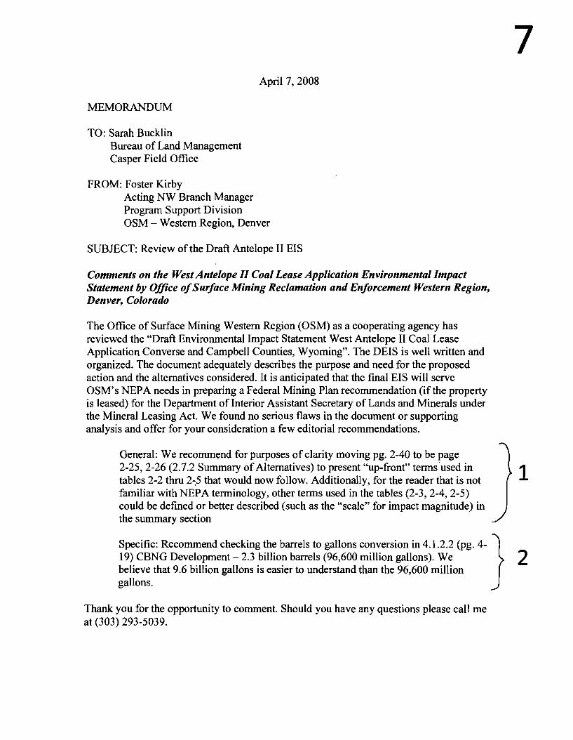
7 April 7, 2008
MEMORANDUM
TO: Sarah Bucklin Bureau of Land Management Casper Field Office
FROM: Foster Kirby Acting NW Branch Manager Program Support Division OSM - Western Region, Denver
SUBJECT: Review of the Draft Antelope II EIS
Comments on the West Antelope II Coal Lease Application Environmental Impact Statement by Office ofSurface Mining Reclamation and Enforcement Western Region, Denver, Colorado
The Office of Surface Mining Western Region (OSM) as a cooperating agency has reviewed the "Draft Environmental Impact Statement West Antelope II Coal Lease Application Converse and Campbell Counties, Wyoming". The DEIS is well written and organized. The document adequately describes the purpose and need for the proposed action and the alternatives considered. It is anticipated that the final EIS will serve OSM's NEPA needs in preparing a Federal Mining Plan recommendation (ifthe property is leased) for the Department of Interior Assistant Secretary of Lands and Minerals under the Mineral Leasing Act. We found no serious flaws in the document or supporting analysis and offer for your consideration a few editorial recommendations.
General: We recommend for purposes ofclarity moving pg. 2-40 to be page 2-25,2-26 (2.7.2 Summary of Alternatives) to present "up-front" tenns·used in 1tables 2-2 thru 2-,5 that would now follow. Additionally, for the reader that is not familiar with NEPA tenninology, other tenns used in the tables (2-3, 2-4, 2-5) could be defined or better described (such as the "scale" for impact magnitude) in the summary section
Specific: Recommend checking the barrels to gallons conversion in 4.1.2.2 (pg. 4- } 19) CBNG Development - 2.3 billion barrels (96,600 million gallons). We 2 believe that 9.6 billion gallons is easier to understand than the 96,600 million gallons.
Thank you for the opportunity to comment. Should you have any questions please call me at (303) 293-5039.

"Robert Ukeiley" To <[email protected]>
• <rukeifey@wildearthguardian
cc "'Leslie Glustrom'· <[email protected]> ~ 5.org> bcc04/08/2008 03:32 PM
Subject West Antelope II comments
Dear Ms. Bucklin:
Attached, please find WildEarth Guardians comments on the proposed West Antelope II coal lease . These comments are supported by the literature Leslie Glustrom submitted to you via e-mail on April 6
th
and 7th
•
If you have any difficulty opening the attached document or any questions, please do not hesitate to contact me.
Sincerely,
Robert Ukeiley, Director and Staff Attorney Climate and Energy Program WildEarth Guardians 720-563-9306
As ofJanuary 28, 2008 Forest Guardians, Sinapu, and the Sagebrush Sea Campaign have joined forces to become WildEarth Guardians. With offices in Boulder, Denver, Phoenix and Santa Fe, WildEarth Guardians protects and restores wildlife, wild places, and wild rivers in the American West.
~' ~
VI ant comments on DEISvtin.pdf

Note from BLM:
During the West Antelope II Draft EIS public comment period, Leslie Glustrom sent BLM nine
emails regarding global climate change and related topics. The emails are included in this
appendix as supplemental information to the WildEarth Guardians formal comment letter. They
have been considered in the EIS and have been incorporated into the EIS Administrative Record.
Ms. Glustrom's emails are located behind the WildEarth Guardians letter.

8 WILDEARTH GUARDIANS
VIA E-MAIL
April 8, 2008
Bureau of Land Management Casper Field Office Attn: Sarah Bucklin 2987 Prospector Dr. Casper, WY 82604 [email protected]
RE: Draft Environmental Impact Statement West Antelope II Coal Lease Application
Dear BLM,
Thank you for the opportunity to comment on the Draft Environmental Impact Statement for the West Antelope II Coal Lease Application (WYW 163340) issued in February 2008. These comments are being submitted on behalfofWildEarth Guardians, our approximately 4,500 members and Leslie Glustrom.
Before beginning we would like to thank Sarah Bucklin and the team of specialists that wrote the Draft EIS (DEIS). It was obviously a large undertaking and the writing and organization are generally clear and the information well presented. We also thank Sarah Bucklin for her prompt and helpful responses to our questions.
We appreciate your attention to the following comments on the DEIS for the West Antelope II Coal Lease Application:
1) Irretrievable Loss of Coal (e.g. pp 3-23, 3-174 and 4-29}-It does not appear that the OEIS has properly emphasized the irretrievable loss ofthese coal deposits. Fossil fuels are highly valuable forms of stored energy and carbon and once they are used, then they are irretrievably lost. By definition, the planet will not be making any more fossil fuels in a human time frame. If the coal is mined, then its carbon will be released and the coal will never be available again for use by future generations. There are some industrial processes (e.g. making steel) for which fossil fuel resources are uniquely suited. If the federal government leases the coal in this tract for burning in steam power plants to produce electricity (which we have many other ways ofproducing), then the coal will not be available in future years for processes for which there is no particularly good
Santa Fe • Denver • Phoenix • Boulder 1536 Wynkoop Street, Suite 300 • Denver, Colorado 80202
303-573-4898 • wildearthguardians.org
1

alternative. As discussed below, we don't have nearly as much economically accessible coal as has often been stated in the mainstream media.
2) Loss of Economically Accessible Coal (e..g. pp 3-8, 3-12, and 3-13) It does not appear that the DEIS has properly emphasized the increasing overburden associated with potential mine expansion into the West Antelope II lease analysis area. According to Table 3-2 (p. 3-8) the average overburden in the existing mine is 122 feet, while in the areas being considered for expansion, the overburden is approximately 260-280 feet, or more than a lOO% increase. As overburden increases, then the associated production costs are also likely to increase significantly. Not only do costs go up but environmental impacts also increase. For example, more fuel is required to move the overburden. This means more fuel consumption and more air emissions, including criteria pollutants like NOx, sax, co, PMlO, PM2.5 and more greenhouse gas emissions like N20 and CO2. If the coal in the West Antelope II area is mined, then the next expansion is likely to have an even greater increase in overburden-and an even greater production cost.
3) Need to Place the Coal Resources and Their Accessibility in a Broader Context: (e.g. Sections 3.3 and 4.2.2) It does not appear that the Draft EIS has placed the coal resources of the Powder River Basin in general and the West Antelope II area in a broader context. A review of the data in the Federal Assessment of Coal Resources from August 2007 (especially pages 25 and 33) shows that the amount of overburden in the Powder River Basin generally increases as you move from east to west and that approximately 70% of the coal in the Powder River Basin will not be surface accessible. The figures on pages 25 and 33 of the Federal Assessment should be reproduced in the Powder River Basin EISs so that this broader context can be easily seen.
4) Need to Emphasize Legal Requirement of the Clean Air Act to Prevent Future and Remedy Existing Visibility Impairment in Class I Areas (e.g. pp 3-45 to 3-50) It does not appear that the OEIS has adequately emphasized the visibility goal of the Clean Air Act to prevent future and remedy existing impainnent ofvisibility in Class I areas such as national parks and wilderness areas. It would be helpful to cite the exact provision of the Clean Air Act (including citations to both statutory and rule provisions). The Draft EIS seems to imply that maintaining existing visibility impainnents is adequate (e.g. Figure 3-10, page 3-48) instead of emphasizing the need to remedy existing visibility impainnents in Class I areas. In addition, as the planet wanns, increased drought in the interior of continents (see p. 3-168) is likely to increase particulate pollution, potentially degrading visibility even further. This should be discussed as a probable impact of mining the coal in the West Antelope II analysis area.
5) Need to Discuss Irretrievable Losses Related to Acidification of Lakes (e.g. p. 3-50 and 3-174) It does not appear that the OEIS has properly emphasized the irretrievable losses related to lake acidification. When lakes become acidified then the biota can be adversely affected both from the increased acidity and from secondary consequences such as elevated aluminum. Once a lake loses significant amounts of its life it is unlikely to recover in a reasonable amount of time.
2
3
4
5
2

6) Effects on Groundwater (e.g. p. 3-52 to 3-63 and 4-41 to 4-50) It appears that the DEIS should contain more data on both groundwater quantity and quality. There is a lot of text, but not much data organized into easy to read tables. As a result it is difficult to know what baseline data is available and what the expected consequences are. As just one example, the recharge data discussed on page 4-44 should be presented in much more detail in a table format with specific numbers for the level of the water and how it compares to pre-mining conditions. Similarly, the water quality data discussed on page 4-49 should be provided in a summarized form in a Table. Also, it would be very helpful if the text had subheadings to make it easier for the reader to follow the various issues. Finally, the discussion of irreversible and irretrievable commitment of resources on page 3-174 should discuss the effects on ground and surface water quantity and quality.
7) Need for Further Monitoring for Ute Ladies Tresses (e.g. Appendices H and I) It is well established that Ute Ladies Tresses are extremely difficult to survey for. According to the 2005 Rangewide Status Review of Ute Ladies' Tresses by Fertig and co-authors plants, can bloom over a period from early July to late October (p. 69, Fertig) and can go dormant for 1-4 years confounding survey efforts. (pp 61-62). According to the Draft EIS (e.g. Appendix I, pages 1-12 to 1-15), surveys were only conducted on two days in August of 2006 and over a one three week period in 2007. Before moving ahead with the Final EIS, there should be at least four years of surveys for the Ute Ladies' Tresses and in each year they should be done a couple of times a month from July to October.
8) Concerns About Sensitive Species: According to the Sensitive Species Evaluation in Appendix H (e.g. p. H-2), some of the goals of the sensitive species policy are to maintain vulnerable species habitat and to ensure sensitive species are considered in land management decisions. It would be very helpful to have a table of the Sensitive Species potentially inhabiting the general analysis area. (Appendix H, pages H-15 to H62) and include a summary of the habitat requirements, all surveys done for this species and/or its habitat, the dates of the survey, where the results can be found, and the conclusion of the surveys and this should be discussed in the body of the report and in the Executive Summary. There are several species of concern including, but not limited to, Northern Leopard Frogs, Black Tailed Prairie Dogs, Swift Foxes, Ferruginous Hawks, Burrowing Owls, Chestnut Collared Longspur, McCown's Longspur, Sage Grouse, Bald Eagles, Golden Eagles, Mountain Plovers, Loggerhead Shrikes, Brewer's Sparrow, and several of the plant species. The determinations that the coal leasing "may adversely impact individuals, but is not likely to result in loss of viability in the general analysis area, nor cause a trend toward federal listing," are suspect until the actual survey dates and locations are more carefully documented and the public has an opportunity to review the surveys and to analyze the basis for each conclusion. Also, there appear to be contradictions between conclusions reached on pages H-15 to H-62 and Table with respect to the Northern Leopard Frog and the Swift Fox. Also, it is not clear what the key for "Status on TBNG" is for Table H-2 and Figure H-l (p. H-28) appears to have a wealth of data that does not appear to be discussed elsewhere. For example, there appear to be numerous Golden Eagle nests in and around the Analysis Area that don't appear to
3
6
7
8

be discussed in the Draft EIS. This may have implications for other laws such as the Migratory Bird Treaty Act. For Figure H-l, it would be very helpful to provide a table of each of the sitings and other markings on the Figure and provide dates, field observations and other notes regarding the observations. Also, as discussed further below, all assumptions about revegetation and reclamation should be reconsidered in light of the questionable track record of the Powder River Basin Mines in reclamation. In turn, any claims about reclamation have to be modified by the probable drying of the interior of continents as the planet warms (e.g. see p. 3-166). This warming and drying is likely to make revegetation efforts significantly more difficult as the feedback processes of desertification begin to operate.
9) Greenhouse gas emissions: We appreciate the expanded discussion ofglobal warming and greenhouse gas emissions and the summary of the Intergovernmental Panel on Climate Change Fourth Assessment Report (p. 3-166 to 3-171) but it is essential that the Draft ElS be amended to address the following issues:
a) Once taken out of the ground it is essentially certain that the carbon in the coal will be oxidized and become CO2•
b) Scientific studies tell us that CO2 has an atmospheric lifetime of at least hundreds ofyears and a fraction stays for thousands of years.
c) The CO2 in the atmosphere will block heat leaving the planet leading to increased planetary warming which in turn will lead to increased CO2 releases (e.g. through melting of the permafrost and release from soils, vegetation and the oceans).
d) Numerous scientific studies are now making it clear that the already dire conclusions of the IPCC's Fourth Assessment Report were inadequate. This has been most apparent in the area of ice melt (e.g. Arctic ice, Greenland's glaciers and Antarctica's Ice Shelves), but it is likely that the accelerated impacts seen in these systems will also be reflected in an increasing number of systems as we move through the coming decades. This will have extremely severe consequences for all systems, both societal and environmental and these should be discussed in detail.
e) One of the many impacts of increasing CO2 levels in the atmosphere will be accelerated species loss-especially when combined with habitat losses and competition from exotic species. This also needs to be discussed in detail.
t) BLM needs to consider the cumulative impact of this action and other actions on climate change. These other actions include other BLM oil and gas lease sales such as the January 16,2008 lease sale by the New Mexico State Office of the BLM, as well as recent lease sales in other states such as Utah and Wyoming. These other actions also include BLM's revision of its plan for oil and gas extraction at the Pinedale Anticline in Wyoming and the actions covered in the Great Divide plan revision which is currently open for public comment. These other actions also include the issuance ofall Applications for Permits to Drill (APD) for oil and gas activities that are occurring now or are reasonably foreseeable.
Furthermore, the cumulative actions that BLM must consider in terms of greenhouse gas emissions are not limited to oil and gas activities. For example, coal fired power plants are the largest source of greenhouse gas emissions in the United States. BLM is currently considering the Toquop coal fired power plant. Emissions of
4
9

greenhouse gases from this plant, and any other coal fired power plant BLM is considering, must also be considered in the cumulative impacts analysis.
Livestock is also a major source of greenhouse gas emissions. See ~ Henning Steinfield, Livestocks Long Shadow: Environmental Issues and Options, (2006). Thus, BLM must consider its actions which involve livestock grazing in its cumulative impacts analysis of greenhouse gas emissions.
Coal mining is also a major source of greenhouse gases. These sources include the direct impacts of mining the coal and the indirect impacts of transporting, burning and disposing of the coal combustion waste. Therefore, BLM must consider its actions which involve coal mining in its cumulative impacts analysis of greenhouse gas emissions.
Until such time as BLM analyzes the cumulative impacts of greenhouse gas emissions from BLM's oil and gas, coal-fired power plant, livestock grazing, and coal mining activities, BLM cannot move forward with the leasing of this mine.
g) The statement on p. 3-170 about the No Action Alternative not resulting in a decrease of U.S. CO2 emissions because power plants would just use another source of coal should be eliminated. To begin with this speculation is inaccurate. Decreases in coal supply increase the cost of coal which results in less use of coal. We are witnesses this right now on a global scale. Not going forward with this mine would contribute to this situation of decreasing supply and increasing prices resulting in less reliance on coal and more reliance on other, cleaner, safer, methods of meeting our energy demands. Moreover, the nation's environrnentallaws (e.g. NEPA, MUSY, ESA, CAA, CWA etc.) require consideration of the cumulative impact of hundreds of individual decisions and prohibit engaging in a practice that attempts to avoid issues of cumulative impact. If "Two wrongs don't make a right," then certainly "a million wrongs don't make it right. .. " either. Each coal mine expansion will need to take these extremely serious issues into account and of course we have many perfectly fine ways to manage and meet our desire for electricity including efficiency, wind, solar (both concentrating solar thermal and photovoltaic) and geothermal.
h) Finally the discussion of CO2 emissions needs to have any discussion of possible CO2 "capture and storage" rewritten. At this point in time carbon "storage" (sometimes referred to as "sequestration") is only at the beginning stages of development and it should not be assumed that successful technical and legal strategies will exist for carbon "storage" during the time covered by the potential coal lease.
The Draft EIS needs to be amended to consider all of these matters and to reflect the explosion of scientific papers documenting these extremely serious concerns. We have submitted key scientific papers electronically, but the BLM should conduct a thorough literature survey of the scientific literature and include that in the Final EIS and the results should be prominently displayed and included in the Executive Summary.
10) Other Emissions from Coal Burning: The section on other "by-products" of coal burning needs to be greatly expanded to discuss all emissions from coal plants including S02, NOx, particulates, volatile organic compounds, CO, dioxin, radioactive materials and all of the heavy metals (including but not limited to mercury) as well as coal combustion waste. Matter can't be created or destroyed, so once the coal is taken out
5
10

of the ground, all of the elements that it contains will be released into the environment in a more mobile state than when they are in coal whether it is through air, water or solid waste emissions. The rate of release from coal in the ground is very slow compared to the rate of release from the burning of coal and all of this should be discussed in serious detail and the conclusions clearly stated and included in the Executive Summary for each of the emissions that will occur.
11) Reclamation: Throughout the Draft EIS the assumption is made that any mine expansion will be reclaimed and the landscape will be largely returned to its premine existence. Each and every one of these statements needs to be rewritten and there needs to be a thorough discussion of existing efforts at reclamation at mines throughout the Powder River Basin and at the Antelope Mine in particular. For each mine in the Powder River Basin there needs to be a presentation of:
a) Total number of acres disturbed b) Total number of acres at each stage of reclamation c) Results of the reclamation in terms of species impacts, soil, vegetation
and wetlands. d) Rate at which reclamation efforts are proceeding e) Projected date for full reclamation of the existing mine.
All discussions of impacts (present, future, cumulative and residual) need to be rewritten in light of the actual experience of the Powder River Basin mines with respect to reclamation. No assumptions should be made that reclamation will be completed until all reclamation efforts have been completed at existing mines. Moreover, any discussion of future reclamation efforts should include a discussion of the probable complications that will arise as the planet warms and the interior of continents dry out.
12) Explanation of Key Laws and Regulations: It would be very helpful to have the list of key federal authorities on page 1-10 expanded to include the title of the law, where it can be found and the key provisions that apply to the coal lease application. The goal of an Environmental Impact Statement is to help the general public understand how these decisions are being made and how they can get involved and most members of the public will not understand what the acronyms are or what the key provisions of the laws are. Then the EIS should explain how each of the key provisions of these laws either is or isn't being followed and this should be included in the Executive Summary. A similar effort should be undertaken with respect to all the key regulations governing coal leasing and mining.
13) Discussion of Alternatives: The Draft EIS should note that there are many alternatives to burning coal for producing electricity. These include:
a) Improved energy efficiency and other demand side management measures including solar thermal water heating b) Wind c) Photovoltaic Solar d) Solar Thermal Electric (also called Concentrating Solar Power) e) Geothermal
6
11
12
13

t) Biomass
Since we have many ways of making electricity but no way of either making new coal or effectively managing the "by products" resulting from the burning of the coal it is important to give thorough consideration to these alternatives before deciding to lease coal which will invariably lead to the production of all the various "by products."
14) Readability of the Draft EIS: While there were obvious efforts made to make the Draft EIS readable, the bulk of the document has the effect of making the information not very accessible. All key summary statements of effects should be clearly presented in the Executive Summary and for each chapter and subsection there should 14 also be a collection of the key conclusions so that the reader doesn't have to read hundreds of pages and keep extensive notes in order to understand what is being said. At each step of the way the key conclusions should be gathered into a central location and format that is easy to access and decipher.
In closing, we thank you for the hard work already done on this Draft EIS and we thank you in advance for the work that we have asked for in these comments. The decision to lease millions of tons of coal is a very serious decision indeed, and every effort must be made to ensure that all laws and regulations are fully complied with.
Sincerely,
Is Robert Ukeiley
Robert Ukeiley, Director and Staff Attorney Climate and Energy Program Wild Earth Guardians
7

"Leslie Glustrom" To <[email protected]> <[email protected]> ee 04/06/200812:47 PM
bee
Subject West Antelope II Comments-Part 1 Federal Assessment of Coal Resources
Hi Sarah---I expect some more formal comments to be submitted tomorrow, but I wanted to forward some supporting reports that I hope you'll consider on the West Antelope" Draft Environmentallmpaet Statement. Thanks for all your help and your hard work on the DEIS.
To begin with I'd like you to consider the Federal Coal Assessment. In particular, the diagrams on pages 25 and 33 are key and should be included in the Final EIS. The key thought is that increasing overburden means that coal that has less overburden is very valuable and we should be considering the need to leave this coal in the ground so future generations will have some relatively accessible coal to use for purposes that don't have good alternatives.
We have lots of way to make electricity, but the planet won't be making any more coal anytime soon and there are some purposes (e.g. making steel) for which it may be difficult to find other alternatives.
More e-mails to follow. Thanks. Leslie
Leslie Glustrom 4492 Burr Place Boulder, CO 80303
[email protected] 303-245-8637
Dt'.1"
Fed Report on Coal Resources Aug 2007.pd

..Leslie Glustrom" To <[email protected]> <[email protected]>
cc 04/06/200801:14 PM
bcc
Subject West Antelope Comments-Part 3 Carbon Dioxide Articles
Hi Sarah-Part 3 of the West Antelope II Comments.
Carbon Dioxide stays in the atmosphere for a really long time. The attached pdfs talk about approx 25% staying for over a thousand years.
-Archer Journal of Geophys Research 110, C09S05 (2005)
- Montenegro Geo Physical Research Letters 34, L19707 (2007)
These are important to consider when we take coal out of the ground. Once the carbon becomes oxidized and turns into C02 it will stay in the atmosphere essentially forever. Before we take coal out of the ground we have to give this the deepest of thought.
We have many ways of making electricity but once the C02 is in the atmosphere it will be there essentially forever heating up our planet and accelerating feed back cycles. This is critical to think about before we
. take the coal out of the ground.
More e-mails to follow.
Thanks. Leslie
.;r;:r.... .... . ' i "
,.~-~, '. ,'.~
1 ~.
...,. "
Leslie Glustrom 4492 Burr Place Boulder, CO 80303
[email protected] 303~245-8637
fa8
Archer Fate of Fossil Fuel CO2 in Geologic Time J Geophys Research 110. C09505 (2005).pd
~ Montenego long Term Fate of Anthropogenic Carbon Geo Phys Res letters 34.l19707 (2007).pd

"leslie Glustrom" To <[email protected]> <[email protected]>
cc 04/06/2008 01 :26 PM
bcc
Subject West Antelope II Comments Part 4-Caldeira on C02 Reductions
HI Sarah-The attached paper from Caldeira
Geo Phys Res Letters 35 L04705 (2008)
discusses the need to essentially reduce C02 emissions to zero to start stabilizing the climate of the planet. This is a paper we'll discuss in the more formal comments and which should be cited in the Final EIS.
Thanks. Leslie
Leslie Glustrom 4492 Burr Place Boulder, CO 80303
[email protected] 303-245-8637
~ Geo Phy Res Letters 35 L04705 2008 Caldeira on Need Near Zero Emissions' .pdf

RLeslie GlustromR To "[email protected]" <[email protected]>
•~~ <[email protected]> ee
04/07/200812:52 AM bee
Subjed West Antelope II Comments Part 4-Extinetion Risks from C02 Emissions and Climate Change
Hi Sarah--With respect to the West Antelope II Draft EIS, it needs to be strengthened with respect to the extinction risks associated with C02 accumulation and the warming of the planet.
There are three articles that should be included in the Final EIS. The discussion ofendangered species should not be restricted to the immediate area of the coal lease application, but rather to the full picture of the risks to species that will accompany the oxidation of the coal and the increase of C02 in the atmosphere.
The three articles are: 1) "Climate Warming and Disease Risks for Terrestrial and Marine Biota," Harvell et aI.,
Science 296, 2158 (2002) 2) "Climate Change, Human Impacts, and the Resilience of Coral Reefs," Hughes et. aI.,
Science 301,929 (2003) 3) "Extinction Risk from Climate Change," Thomas et aI., Nature 427, 145 (2004).
There are also many references contained in these articles. Leasing the coal in the West Antelope II will increase risks to many species including those identified as "threatened or endangered," and this must be thoroughly documented before moving ahead with the coal lease application.
More e-mails to follow.
Thanks. Leslie
Leslie Glustrom 303-245-8637 [email protected]
Dt..:!!!!!.~
Climate Change and Disease Risks Science 296,2158 (2002).pdf Climate Change Coral Reefs Science 301, 929 (2003).pdf
~ ~
Extinction Risks from O"mate Change Nature 427, 145 (2004). pdf

"Leslie Glustrom" To <[email protected]> <[email protected]>
cc 04/07/200807:16 AM
bcc
Subject West Antelope II Comments-Part 5-Climate Change and Species Loss-IPCC Working Group II
Hi Sarah-With respect to the West Antelope II Draft EIS, I really appreciate your summary of the results of Working Group I of the tpee. Thanks!
It is also important to discuss the relationship between climate change and species loss. This is addressed in the report of Working Group II to the IPee as well as in some of the scientific articles I sent you yesterday.
The Working Group II Summary for Policymakers is attached, but you should probably use the most recent version available from www.ipcc.ch as well as the numerous references included in the full Working Group II report.
When coal comes out of the ground it will be oxidized much faster than it would if it stayed in the ground and the resulting e02 will impact species all around the globe. This should be addressed in great detail in the Final EIS.
Sorry to create more work, but we must take these decisions to take coal out of the ground and oxidize it very, very seriously because the impacts on our planet will go on for thousands of years.
Thanks. Leslie
Leslie Glustrom 4492 Burr Place Boulder, CO 80303
[email protected] 303-245-8637
~ ..:!!!!!.
IPCC 4th Assessment Irnpacts and Adaptation.pdf

"Leslie Glustrom" To <[email protected]> <[email protected]>
ce 04/07/2008 07:32 AM
bce
Subject West Antelope II Comments-Part 6 Accelerated Ice Melt-IPCC AR4 Too Conservative
Hi Sarah-With respect to the West Antelope II Draft EIS I really appreciate the summary of the Intergovernmental Panel on Climate Change Assessment 4 Physical Basis report in the Draft EIS.Thanks.
As you probably know, it is now clear to the scientists that they underestimated the rate of loss of ice sheets in the IPCC Assessment 4. A few scientific articles (or their abstracts) are attached. These issues were generally not covered in the IPCC AR4. The articles are:
1) "Changes in the Velocity Structure of the Greenland Ice Sheet," Rignot and Kanagaratnam, Science 311,986 (2006)
2) "Abrupt Increase in the Permafrost Degradation in Arctic Alaska: Jorgensen et. al. Geo Phys Res Letters 33, L02503 (2006)
3) "Permafrost and the Global Carbon Budget, " Zimov et.a!. Science 312, 1612 (2006) 4) "Paleoclimatic Evidence for Future Ice-Sheet Instability and Rapid Sea-Level Rise: Overpeck
et al. Science 311, 1747 (2006) 5) "Missing feedbacks, asymmetric uncertainties, and the underestimation of future warming,"
Margaret Torn, Geophys Res Letters 33, L10703 (2006)
All of this should be discussed in the Final EIS. The dynamic melting processes that are beginning to occur are stunning the climate change scientists and I wish I was exaggerating when I say you can see, hear and feel the panic when these scientists speak about what is happening to the planet.
Before taking more coal out of the ground just to produce electricity when we have so many other good low- or non-carbon ways of producing the same electricity we need to carefully consider the impacts on the only planet we know of that supports life.
I'll send some of the data and articles from 2007 and 2008 when I next get a chance.
Thanks. Leslie
Leslie Glustrom 4492 Burr Place Boulder, CO 80303

"Leslie Glustrom" To <[email protected]> <[email protected]>
cc 04/081200804:32 PM
bee
Subject West Antelope" Comments-Part 7 2007 Ice Melt Data
Hi Sarah-With respect to the West Antelope II Draft EIS, the following articles (and any more recent ones that appear before the final is issued) should be summarized. The science on the dire consequences of the build up of C02 in the atmosphere is telling us that things are probably even worse than the IPCC stated in the Fourth Assessment Report. This must be considered before approving the coal lease application.
Here are the articles: 1) "Arctic Sea Ice Decline: Faster than Forecast: Geo Phys Res Letters 34, L09501 (2007)
2) "Greenland Surface Melt Trends 19730-2007: Evidence of a Large Increase in 2007 Geo Phys Res Letters 34, L22507 (2007)
3) A Younger, Thinner Arctic Ice Cover: Increased Potential for Rapid, Extensive Sea-Ice Loss," Gee Phys Res Letters 34, L 24501 (2007)
4) "Pushing the Scary Side of Global Warming," Science 316, 1412 (2007) 5) "Why is Climate Sensitivity So Unpredictable?" Science 318, 629 (2007) 6) "Climate Change and Trace Gases," Phil Trans Royal Society A 365,1925 (2007) 7) "Disappearing Arctic Lakes," Science 308, 1429 (2005)
Thanks. Leslie
Leslie Glustrom 4492 Burr Place Boulder, CO 80303
[email protected] 303-245-8637
Arctic Sea Ice Faster Than Modeled Geo Res Urs May 2007.pcf Hansen Trace Gases Phil Trans 2007.pcf
~' ~ .1_, Maslanick YOU"lgeI TIYIner Arctic Ice Geo Phys Res Letters 34, L24501 (2OO7).pcf PusOOg Scary Side Science 2007·06·08.pcf
Ia- ~-~. ~~ ~ ..::!!!!!.
Arctic Lakes Disappearing Science 308, 1429 (2007).pcf Cimate Sensitivity So Unpredictable Science 318, 629 (2007).pcf
~ -'"_
Mote GreerWld Mel 1973-2007 Geo Phys Res Letters 34, L22507 (2007).pcf

Wleslie GlustromW To <[email protected]>
•~ <[email protected]> cc
04/08/2008 04:54 PM bee
Subject West Antelope II Comments-Part 8- Risks to Species from C02 Accumulation Plus Carbon loss From Soils and Southwest Drying
Hi Sarah-With respect to the West Antelope 2 EIS, the C02 that will be formed once the coal is taken out of the ground poses very serious risks to species all around the planet and this should be carefully analyzed and considered before issuing the Final EIS.
I've attached a few articles to get you going. They all contain many references that should also be discussed in the FEIS along with any scientific articles that appear before the FEIS is issued. I've added a couple of more on related subjects including the drying of the interior west and the increasing loss of carbon from the soils-one of the feedback loops that appears to be beginning. I've also included a classic Jim Hansen paper from 2005 on the energy imbalance on the planet. It is key to a thorough discussion of the science.
The articles are: 1) "Past Peak Water,· SW Hydrology (2006) 2) "Carbon Losses From All Soils Across England and Wales from 1978-2003: Nature 437,245
(2005) 3) "Extinction Risk From Climate Change," Nature 427, 145 (2004) 4) "Climate Warming and Disease Risks for Terrestrial and Marine Biota,· Science 296, 2158
(2002) 5) "Earth's Energy Imbalance: Confirmation and Implications: Science 308, 1431 (2005) 6) "Coral Reefs Under Rapid Climate Change and Ocean Acidification: 318, 1737 (2007)
Clearly, the threat to species is much broader than just what will happen in the vicinity of the mines in the Powder River Basin. This must all be discussed and carefully considered before apprOVing a lease to take more coal out of the ground.
Thanks. Leslie
Leslie Glustrom 4492 Burr Place Boulder, CO 80303
[email protected] 303-245-8637
SW Hydrology Oct 2006 Past Peak Water Hoerling.pd Carbon Loss From English So~s NatUfe 437.245 (2005).pd

MLeslie GlustromM To <[email protected]> <[email protected]>
cc 04/081200805:12 PM
bcc
SUbject West Antelope II Comments-Part 9-Alternatives and National Transmission
Hi Sarah-We're almost done-at least for now....Phew!!
The last key is to build national transmission and ship electrons instead of shipping coal. I've attached a news article and a PPT about American Electric Power's vision as well as a Scientific American concept article on the idea of a national grid.
Presently our transmission system is like a system of two lane highways and what is being said is that we need to do for transmission what Eisenhower did for the highway system. While no one likes transmission (including me) it is a lot better than continuing on our present trajectory towards run away climate change.
It is just about making electrons flow and then shipping them long distances. We know how to do that, but we don't know how to MbuildM another planet. ..
All of this should be discussed under Alternatives in the Final EIS on the West Antelope II Final EIS.
Well-that's all for now...
I'm sorry to have just given you a huge pile of work-but we must stop blithely leasing coal just because that's what we've always done in the past We only have one planet-and it is absolutely irreplaceable.
Coal is easily replaced. The planet is not. It is that simple and "m afraid you will now be in the middle of that discussion.
Thanks in advance for all your work-both past and future!
Best Regards. Leslie
Leslie Glustrom 4492 Burr Place Boulder, CO 80303
[email protected] 303-245-8637
Utily Automation and Engineering AEP Vision on National Transmission Nov 2007.doc AEP and National Transmission Jan ~.pcf

9 N.t1ona.1l1c:.dquartua II~O 17rh Srr.:'rf. N.W. I WUllinRlOn. D.C. lco~6-460+ I 1I:1'.o1.,6Il'.'J¥lO I fall ,ol.6h.IHI _.dd'endenoOl'l
Bureau of Land Management Casper Field Office Attn: Sarah Bucklin 2987 Prospector Drive Casper, Wyoming 82604
April 8, 2008
Re: Comments on the West Antelope II LBA Coal Lease Application Draft Environmental Impact Statement
Dear Ms. Bucklin:
Thank you for the opportunity to comment on the West Antelope II Coal Lease Application and Draft Environmental Impact Statement ("DEIS"). These comments are submitted on behalf ofDefenders of Wildlife ("Defenders"), a non-profit public interest conservation organization with over 500,000 members nationally.
Defenders is dedicated to protecting imperiled species and their habitats by combining scientific research, public organizing, and administrative and legal advocacy. Defenders relies on the Endangered Species Act ("ESA"), and other federal conservation laws to protect endangered and threatened species, and imperiled species not currently benefiting from ESA protections. In addition to species-specific litigation, Defenders is a committed advocate for the protection of the nation's wildlife refuges, parks, forests and other public lands.
In February 2007, the Intergovernmental Panel on Climate Change ("IPCC") declared, "[w]arming of the climate system is unequivocal," and it is "very likely" that most of the warming since the middle of the 20th century is the result of human pollutants. Global warming is a global phenomenon with well-documented and serious local impacts. In addition to its other disruptive direct effects, coal leasing poses serious climate threats: the mining ofcoal will likely result in the generation of high quantities of greenhouse gas emissions, the predominant cause of global warming. With concerns about global warming, coal is paralyzing scary. The Bureau of Land Management ("BLM") was obligated to consider the impacts ofa coal lease sale in the DEIS.
The DEIS fails to consider global warming on many fronts. It fails to: (1) analyze the greenhouse gas emissions inevitably resulting from a lease sale; (2) analyze the observed and projected effects ofglobal warming on the welfare ofecosystems; (3) analyze alternatives to
Comments on the West Antelope II LBA Coal Lease Application 1 Draft Environmental Impact Statement

National lIc:adquartt••
lI~O 17rh Str"rr.I':"~·: I Wa~hinRton. D.C. ~.co~6-#~ I rd 101.•6lC'..'J-400 I f~x ?O,.•6111.. IHI
-·dd'endc:...·011
coal based energy in meeting energy needs; and (4) analyze the impacts of the lease sale on threatened and endangered species protected under the ESA, as well as imperiled species that have yet to be listed.
These comments address and analyze the effects of coal mining on greenhouse gas emissions and the deficiencies of the DEIS. Federal agencies in general, and the Bureau of Land Management ("BLM") in particular, are required to incorporate global warming and its impacts in their decision calculus under a number of mandates, including the National Environmental Policy Act of 1969,42 U.S.c. §§ 4331 et seq. (''NEPA''). In addition, the project fails to comply with the Endangered Species Act, 16 U.S.C. §§ 1531-1544. We believe that the DEIS must be revised and redistributed prior to approval as the DEIS is fatally flawed, violates NEPA and the ESA, and must be supplemented to integrate global warming in its analysis.
The DEIS Fails to Analyze Greenhouse Gas Emissions
The Bureau of Land Management ("BLM") failed to consider and analyze the greenhouse gas emissions that would result from the lease sale of the West Antelope II tract in the Powder River Basin ("PRB") in Wyoming. The BLM administers mineral resources owned by the federal government. It leases these resources for development under the Mineral Leasing Act, 30 U.S.C. § 221 et seq, and manages them according to resource management plans developed under the Federal Land and Policy and Management Act ("FLPMA"), 43 U.S.C. § 1701 et seq. BLM's failure to substantially consider the greenhouse gas and global warming considerations in the DEIS is arbitrary, capricious, otherwise not in accordance with law, and not supported by substantial evidence.
Congress enacted NEPA in 1970 with the following purpose: "To declare a national policy which will encourage productive and enjoyable harmony between man and his environment; to promote efforts which will prevent or eliminate damage to the environment and biosphere and stimulate the health and welfare of man; to enrich the understanding of the ecological systems and natural resources important to the Nation." 42 U.S.c. § 4321; Center for Biological Diversity (2006).
To accomplish these goals, all federal agencies must assess the environmental impacts of their proposals before taking any action on them. The preparation ofan Environmental Impact Statement ("EIS") lies at the heart ofNEPA (Center for Biological Diversity 2006). The purpose of the EIS is to ensure policies and goals ofNEPA are included in federal programs and actions. 40 C.F.R. § 1502.1. It also shall serve to inform both decision makers and the public about the alternatives and adverse impacts of the project. Id. See also Columbia Basin Protection Ass'n v. Schlesinger, 643 F.2d 585,592 (9th Cir. 1981)
Comments on the West Antelope II LBA Coal Lease Application 2 Draft Environmental Impact Statement

National lIud'luartua II~O l7fh Stl\'l't. KW. I Wul1inRton. D.C. ~co~6-#04- I tel 201..6/(1.•()¥10 I f.u loz.611?.IHt
www.delendelll·OII
("[T]he preparation of an EIS ensures that other officials, Congress, and the public can evaluate the environmental consequences independently.").
These objectives require that environmental information be disseminated "early enough so that it can serve practically as an important contribution to the decision-making and will not be used to rationalize or justify decisions already made." 40 C.F.R. § 1502.5; Center for Biological Diversity (2006). See also Marsh v. Oregon Natural Resources Council, 490 U. S. 360, 371 (1989) ('"the broad dissemination mandated by NEPA permits the public and other government agencies to react to the effects of a proposed action at a meaningful time"); Metcalfv. Daley, 214 F. 3d 1135, 1143-44 (9th Cir. 2000). Given the magnitude and irreversible effects global warming will have on our public resources, the BLM, as an Interior Department agency, faces an increasingly daunting challenge to preserve the public resources for which they are responsible.
Coal-ftred electric power plants are the nation's largest emitter of greenhouse gases, the leading culprit in global warming, yet the BLM failed to do more than a cursory analysis ofthe impacts on global warming that will occur as a result of this leasing decision. The Antelope Mine produced 33.9 million tons ofcoal in 2006, which represents about 7.8 percent of the coal produced in the Wyoming PRB in 2006, or about 1.1 percent of the estimated U.S. CO2 emissions in 2006. DElS, 3-169. The BLM, through the Antelope Coal Company ("ACC"), estimates that approximately 429.5 million tons ofcoal would be recoverable from the West Antelope II LBA tract. DElS, 2-5. ACC estimates that the life of the mine would be extended by about 12 additional years beyond 2018 at an average annual coal production rate ofapproximately 36 million tons. If the average annual production rate increases to 42 million tons, which is the maximum rate allowed by the current air quality permit, the life of the mine would be extended by ten additional years under the Proposed Action. DElS, 3-167,3-170.
Under the Proposed Action, the Antelope Mine anticipates producing the coal included in the West Antelope LBA tract at currently permitted levels using existing production and transportation facilities, which would extend CO2emissions related to burning coal from the Antelope Mine for up to 13 additional years beyond 2018. DEIS, 3170. The greenhouse gas emissions from this volume ofcoal production will contribute signiftcantly to greenhouse gas emissions.
Under the No Action Alternative, C02 emissions attributable to burning coal produced by the Antelope Mine would be extended at about this level for approximately eleven years, or until about 2018, while the mine recovers its remaining estimated 394.3 million tons ofcurrently leased coal reserves. DElS, 3-169, 3-170.
Comments on the West Antelope II LBA Coal Lease Application 3 Draft Environmental Impact Statement
1

NationaJ 1Ic:lldquarta.
IIl0 Inh Srr~rr. K\lt:. I Wnl1inRTon. D.C. ,col6-~Q.I. I I'd ,.l;l1.• 6l('_(J.JQo I fall 102.6l17..IHr www.dd'e.dc:n·ora
As discussed further below, the public and decision makers are entitled to know the true costs and impacts of all aspects of the coal lease, including its greenhouse gas emissions. Laying bare the true impacts and costs of the direct and cumulative greenhouse gas emissions from the coal lease program, and disclosing alternatives and mitigation measures, would very likely lead to increased energy conservation and use of renewable energy sources (see Center for Biological Diversity 2006).The BLM prevented this result by producing a DEIS that hid the true greenhouse gas emissions of its proposal. Instead, the BLM stated that it is "not possible to project the level of CO2 emissions that burning the coal in the West Antelope II LBA tract would produce due to the uncertainties about what emission limits will be in place at that time or where and how the coal in the West Antelope LBA tract would be used after it is mined." DEIS, 3-170. This position is contrary to the mandate ofNEPA to disclose the full environmental consequences of the West Antelope II lease. The BLM's failure to consider the greenhouse gas emissions of the coal resources taints every aspect of the OEIS and the decision making process. The BLM must prepare a revised DEIS that properly considers the greenhouse gas and global warming implications of the lease sale, prior to proceeding to the Final EIS. See, Center for Biological Diversity, 2006.
The DEIS Fails to Analyze the Observed and Projected Effects of Global Warming
Global warming represents the most significant and pervasive threat to the future of biodiversity worldwide, affecting both terrestrial and marine species. The periodic assessment reports issued by the United Nationals Intergovernmental Panel on Climate Change ("IPCC") serve as a useful barometer for the advancement of understanding surrounding global warming. The IPCC's mission is to comprehensively and objectively assess the scientific, technical and socioeconomic information relevant to human-induced climate change, its potential impacts, and options for adaptation and mitigation (IPCC Mandate). The IPCC Assessment reports authoritatively document the adverse environmental impacts of global warming at local, regional, national and global scales, and the primary role ofbuming fossil fuels, including energy derived from coal mining, in causing global warming. The technical reports underlying these periodic assessments are a synthesis of the existing scientific and technical literature compiled by the world's leading climate change experts, representing the collective wisdom of thousands of scientists from around the world, including hundreds ofacademic and government researchers within the U.S. The reports represent the "best available science" addressing climate change and its impacts on the natural world.
The evidence of the IPCC reports conclusively shows that greenhouse gases, including carbon dioxide ("C02"), endanger public health, welfare, and the environment. The IPCC's fourth assessment report, issued in February 2007, determined that the evidence of warming global temperatures is ''unequivocal'' and that observed changes in temperatures
Comments on the West Antelope II LBA Coal Lease Application 4 Draft Environmental Impact Statement

N••ionaJ lIudquartcla
lI~O 17fh Srl\:('r. N.W. I Wa~hinRton. D.C. !co~6-#0+ I rd "o1.• 6lC:O·.'J400 I fnll lOJ.•611'"IHF _.dJenck....06JI
since the mid-20th century have been "very likely" (>90% chance) caused by increases in anthropogenic greenhouse gas emissions. In addition, the largest growth in global greenhouse gas emissions between 1970 and 2004 has come from the energy supply sector (an increase of 145%).
Many of the public resources managed by the Department of the Interior are being harmed by global warming resulting from increased greenhouse gas emissions (see generally GAO, Climate Change). As stated by the U.S. Supreme Court last year, "[t]he harms associated with climate change are serious and well recognized." Massachusetts v. EPA, 127 S. Ct. 1438, 1455 (2007). These harms-already occurring throughout the planet-include ''the global retreat of mountain glaciers, reduction in snow-cover extent, the earlier spring melting of rivers and lakes, [and] the accelerated rate of sea levels during the 20th century relative to the past few thousand years." Id. (quoting National Research Council, Climate Change: An Analysis of Some Key Questions, at 16). The impacts from global warming on species and ecosystems are not too uncertain to predict.
For example, one of the most immediate general effects of climate change on terrestrial plants and wildlife are shifts in geographical ranges, catalyzed by changes in the normal patterns of temperatures and humidity that generally determine such ranges (Thuiller 2007). As a result ofwarming temperatures, significant range shifts averaging 6.1 kilometers per decade towards the poles and an advancement of spring events by 2.3 days per decade have already occurred (Parmesan & Yohe 2003). Because many ecosystems and species cannot make such "shifts," global warming presents risks ofwidespread extinctions (Thomas et al. 2004; Thuiller 2007).
In addition to general impacts, different regions throughout the world will be increasingly affected in ways specific to those locations.
The Arctic region has been the most obvious early indicator of the effects ofglobal warming on the planet. While the planet as a whole warmed approximately 1°F during the 20th century, some regions of the Arctic experienced warming of4-5°F since the 1950s alone, and the region continues to warm at rates approximately twice that in the rest ofthe world (ACIA 2004).1 Most notably, the melting ofArctic sea ice due to global warming has occurred much more rapidly and on a scale that scientists believed would not happen for another half century. At the end of summer in 2007, the volume ofArctic sea ice was half
I A phenomena known as the "Ice-Albedo feedback" is largely responsible for these disproportionate effects. Because the arctic ice has high albedo, meaning it reflects much more solar radiation than other sources, once that ice melts, the uncovered land and water absorbs more solar radiation, leading to a positive feedback loop and rising temperatures.
Comments on the West Antelope II LBA Coal Lease Application 5 Draft Environmental Impact Statement
2

NationaJ IIc:.dquartaa
,,~o Inh Sfl\'('f, K W. I W:nllinROOn, D.C. 'co~6-#00l- I I'd 1,01.,6lC7.1}4IJO I f~y 70I.6lh..IH! www,d.efeAckra.OI'JI
what it was only four years ago, nearly 23 percent below the previous record low. (Borenstein 2007).
The rapid melting of the Arctic ice has grave repercussions for the many Arctic species that rely wholly or partially on the ice for feeding, nesting, breeding, sheltering, and other essential behavioral functions. The melting of Arctic sea ice caused by glo bal warming directly threatens the polar bear, which is completely dependent on the ice for every aspect of its life cycle. Melting sea ice will shorten the time frame in which polar bears can hunt seals due to earlier ice break-up and later freeze-up dates, reduce availability of prey, increase distances bears need to swim because of melting ice, and increase bear-human conflicts as bears move into terrestrial and populated areas in search of food.
Additionally, the world's oceans, occupying 70 percent of the planet, are being profoundly affected by global warming, as primarily evidenced by warming temperatures and increasing acidification of the oceans (Rosenzweig 2007). Coral reefs have served as an early bellwether of these changes, and NMFS on May 9,2006 determined two species-the elkhorn (Acropora palmata) and staghorn (A. cervicornis) corals-to be threatened, the first coral species to be give protection under the ESA. 71 Fed. Reg. 26,852.
In addition to the precipitous declines in staghorn and elkhorn coral populations as a result of global-warming inducted bleaching, global warming also adversely affects coral species by increasing the acidification of ocean waters (Hoegh-Guldberg 2007). Ocean acidification is especially driven by CO2; as greater levels of CO2 enter the ocean, it reacts with seawater to produce carbonic acid, which ultimately reduces the amount of carbonate available to the reefs, leading to decreased calcification and increased erosion. In a recent study, a team of researchers presented three scenarios based on the business-asusual/alternative scenario approach, and found that even if CO2 emissions leveled at 380 ppm, coral reefs worldwide would still undergo fundamental changes (Hoegh-Guldberg 2007). If carbon dioxide levels rise to double that of preindustrial levels under a business-asusual approach, "[t]hese changes will reduce coral reef ecosystems to crumbling frameworks with few calcareous corals...Under these conditions, reefs will become rapidly eroding rubble banks" (Hoegh-Guldberg 2007).
Like the rapidly accumulating evidence addressing the negative effects of global warming on coral reef species and the polar bear, new scientific information demonstrates that global warming is increasingly having negative effects throughout the western United States. The west has warmed more than any other area in the country outside of Alaska, with projections of future warming varying from 3 to 7°F, to as much as 14°F in the Southwest (Leung and Qian 2005; Overpeck 2005). As new scientific information developed since 1996 convincingly demonstrates, global warming is already affecting the West by causing wetter
Comments on the West Antelope II LBA Coal Lease Application Draft Environmental Impact Statement
6

NatioaaJ IIl:adlluartu. II~O Inh SrI\'Cl". N.W. I WullinRton. D.C. ICO~(j-#o ... I rd '-(11..61C:>.'}4Qo I f~'A' lm..6Ib.IHr _.dd'e.dc:n·OfI
and warmer winters with reduced snowpacks and earlier springs with associated early-season melting of the already-reduced snowpack (Mote et al. 2005). In addition, many areas of the West are in the midst of the worst drought in hundreds ofyears, and researchers believe global warming could cause drought to become essentially permanent.
This combination of effects is already having real-world consequences for biological resources. For example, scientists identified high temperatures as one of the likely causes of a massive die-off ofpifion and ponderosa trees across 3.5 million acres of Arizona and New Mexico (Breshears et al. 2005). In addition, less snowpack and earlier snowmelt have been correlated with increasing numbers of large forest fires in the west, as earlier snowmelt acts to dry out forest fuels (Westerling 2006).
The effects ofglobal warming present heightened risks to species already imperiled by other causes, especially those with restricted ranges or highly specific ecological needs (Randall 2006). Climate change during the past 30 years has in fact already been implicated in one species-level extinction, and a potential mass extinction (an estimated 67 percent of 110 species) ofAtelopus, a genus ofamphibians endemic to the American tropics (Pounds et al. 1999; Pounds et al. 2006). If levels of greenhouse gases continue to rise unabated, newlydeveloped science indicates that extinction levels in the U.S. and worldwide would likely be catastrophic. As stated by James Hansen, senior scientist at Columbia University Earth Institute and Director of the NASA Goddard Institute for Space Studies:
In my opinion there is no significant doubt (probability >99%) that [] additional global warming of 2°C would push the Earth beyond the tipping point and cause dramatic climate impacts including eventual sea level rise of at least several meters, extermination of a substantial fraction of the animal and plant species on· the planet, and major climate disruptions. Much remains to be learned before we can define these effects in detail, but these consequences are no longer speculative climate model results.
(Hansen 2006).
Echoing this assessment, a team of 18 scientists recently estimated that 15-37 percent of terrestrial species within sample regions covering approximately 20 percent of the Earth's surface would be "committed to extinction" by 2050 if greenhouse gas emissions continue rising on current trajectories (Thomas et al. 2004). Ifthose percentages of loss are extrapolated to a planetary level, more than 1 million species could be driven extinct in the next fifty years (Thomas et al. 2004). Many ocean species will also suffer pronounced losses (Hunter 2007).
2 COht.
Comments on the West Antelope II LBA Coal Lease Application 7 Draft Environmental Impact Statement

Nationa.lllc:.dquartua
II~O l7rh Srr,·t'f.KW. I WaSllinRTOn. D.C. Ico~6-~0+ I ",,1'.o1..6Ih.')400 I fn"Jllm.•6ll1..JW
WWW·dJendc:,,·ora
The BLM is required under NEPA to analyze global warming impacts that result from its actions
In April 2007, the V.S. Supreme Court issued a decision that recognized the severity of the climate change crisis, and the V.S. Environmental Protection Agency's obligation to confront the problem. The Supreme Court held, in Massachusetts v. EPA, 127 S. Ct. 1438 (2007), that the "unambiguous" defmition of "air pollutants" includes carbon dioxide and other greenhouse gases. This case was initiated by a dozen states and numerous environmental organizations, and the Supreme Court's ruling is widely viewed as a landmark recognition of the global warming crisis by the judiciary. The Court noted that the "[t]he harms associated with climate change are serious and well recognized." Id. at 1455. The Court also acknowledged ''the enormity of the potential consequences associated with manmade climate change," and the contribution ofcarbon dioxide emissions to global warming. Id. at 1457-58. Given the Supreme Court's conclusion that, "[t]he harms associated with climate change are serious and well recognized," the federal government has a responsibility to take action to reduce it, even if such action may not completely reverse glo bal warming. Id. at 1458. BLM is not exempt from that responsibility.
Since 1990, 17 coal leases containing more than five billion tons of federal coal have been issued following competitive sealed-bid sales in the PRB. The West Antelope II LBA tract would be mined as part ofthe Antelope Mine. DEIS, 2-6. The Antelope Mine produced: 23.0 million tons ofcoal in 2000; 24.6 million tons of coal in 2001; 26.8 million tons ofcoal in 2002; 29.5 million tons ofcoal in 2003; 29.7 million tons ofcoal in 2004; 30.0 million tons ofcoal in 2005; and 33.9 million tons ofcoal in 2006. DEIS, 2-6. If the project moves forward as applied for, an estimated total of 823.8 million tons of coal would be recovered after January 1,2007, with an estimated 429.5 million tons coming from the LBA tract. DEIS, 2-6. This mined coal will inevitably be used in the coal-fired power plants.
Coal-frred power plant emissions include carbon dioxide (C02), which is the principal anthropomorphic greenhouse gas. CO2 emissions represent about 84 percent ofthe total U.S. greenhouse gas emissions. DEIS, 3-168. Ofthat 84 percent, estimated CO2 emissions from the electric power sector totaled 2,343.9 million metric tons, or about 39.5 percent of total V.S. energy-related CO2 emissions in 2006 (See Massachusetts, 127 S. Ct. at 1446 ("A well documented rise in global temperatures has coincided with a significant increase in the concentration ofcarbon dioxide in the atmosphere. Respected scientists believe the two trends are related ... It is therefore a species-the most important species~f a 'greenhouse gas."').
The concentration of CO2 in the Earth's atmosphere now exceeds 380 parts per million ("ppm"), more than 80 ppm greater than the maximum levels ofat least the last
Comments on the West Antelope II LBA Coal Lease Application Draft Environmental Impact Statement
8
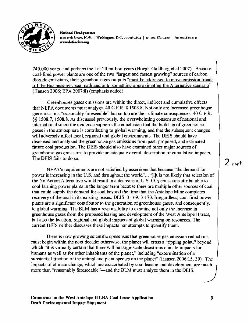
Nacionalllc:adquarrua
,,~o 17fh Srn:rr. KW. I \V'uhinRton. O.c. !co~6'-~0+ I I'd w1.• 611,.. '}4QO I f~'1 ,ol.6112.IHI _.defeRdc:n·OII
740,000 years, and perhaps the last 20 million years (Hoegh-Guldberg et aI2007). Because coal-fired power plants are one of the two "largest and fastest growing" sources ofcarbon dioxide emissions, their greenhouse gas outputs "must be addressed to move emission trends off the Business-as-Usual path and onto something approximating the Alternative scenario" (Hansen 2006; EPA 2007:8) (emphasis added).
Greenhouses gases emissions are within the direct, indirect and cumulative effects that NEPA documents must analyze. 40 C.F.R. § 1508.8. Not only are increased greenhouse gas emissions "reasonably foreseeable" but so too are their climate consequences. 40 C.F.R. §§ 1508.7, 1508.8. As discussed previously, the overwhelming consensus of national and international scientific evidence supports the conclusion that the build-up of greenhouse gases in the atmosphere is contributing to global warming, and that the subsequent changes will adversely affect local, regional and global environments. The OEIS should have disclosed and analyzed the greenhouse gas emissions from past, proposed, and estimated future coal production. The OEIS should also have examined other major sources of greenhouse gas emissions to provide an adequate overall description of cumulative impacts. The OEIS fails to do so.
NEPA's requirements are not satisfied by assertions that because '"the demand for power is increasing in the U. S. and throughout the world" ... "[i]t is not likely that selection of the No Action Alternative would result in a decrease of U.S. C02 emissions attributable to coal-burning power plants in the longer term because there are multiple other sources ofcoal that could supply the demand for coal beyond the time that the Antelope Mine completes recovery of the coal in its existing leases. OEIS, 3-169.3-170. Irregardless, coal-fired power plants are a significant contributor to the generation of greenhouse gases, and consequently, to global warming. The BLM has a responsibility to examine not only the increase in greenhouse gases from the proposed leasing and development of the West Antelope II tract, but also the location, regional and global impacts of global warming on resources. The current OEIS neither discusses these impacts nor attempts to quantify them.
There is now growing scientific consensus that greenhouse gas emission reductions must begin within the next decade; otherwise, the planet will cross a '"tipping point," beyond which "it is virtually certain that there will be large-scale disastrous climate impacts for humans as well as for other inhabitants of the planet," including "extermination ofa substantial fraction of the animal and plant species on the planet" (Hansen 2006: 15, 30). The impacts ofclimate change, which are exacerbated by coal leasing and development are much more than "reasonably foreseeable"-and the BLM must analyze them in the OEIS.
2 c.o~+.
Comments on the West Antelope II LBA Coal Lease Application 9 Draft Environmental Impact Statement

NaricmaJ IIIl:.dquarcua
II~O Inh Srr,"(,f. KW. I W~~hinRton. D.C. ~co~6·-#Q.J. I 11:1 '.o1.• 6lC?"J~OO I f~l: 10'.•6111.. 'HI www.dJenck...·OIJ
The DEIS Fails to Analyze the Alternatives to Coal Based Energy and the "No Action" Alternative
The DEIS correctly acknowledges that the demand for power is increasing in the U.S. and throughout the world. DEIS, 3-169. According to the North American Electric Reliability Council, peak demand for electricity in the U.S. is expected to double in the next 22 years. DEIS, 3-169 (citing Associated Press, 2007). There are methods ofgenerating electricity that result in fewer greenhouse gas emissions than burning coal, including natural gas, nuclear, hydroelectric, solar, wind, and geothermal resources. DEIS, 3-168. According to the IPCC, "there is high agreement and much evidence that all stabilization levels can be achieved by deployment ofa portfolio of technologies that are either currently available or expected to be commercialized in coming decades ...." DEIS, 3-168.
The existence ofa viable but unexamined alternative renders an EIS inadequate. An agency must look at every reasonable alternative. Alaska Wilderness Recreation & Tourism Ass'n v. Morrison 67 F.3d 723, 729 (9th Cir.1995)
NEPA mandates that federal agencies "study, develop, and describe appropriate alternatives to recommended courses ofaction in any proposal which involves unresolved conflicts concerning alternative uses ofavailable resources." 42 U.S.c. § 4332(2)(E). Yet the DEIS failed to consider alternative methods. NEPA "requires that alternatives ... be given full and meaningful consideration." Bob Marshall Alliance v. Hodel 852 F.2d 1223, 1229 (9th Cir. 1988). The BLM failed to meet NEPA's requirements.
After failing to analyze the greenhouse gas emissions th~t will result from the coal lease, the DEIS then compounds its error by failing to analyze a legitimate "No Action" alternative (Center for Biological Diversity 2006). In order to provide "a clear basis for choice among options by the decisionmaker and the public," an agency's EIS must consider the "no action" alternative. 40 C.F.R. § 1502.14; 40 C.F.R. § 1502. 14(d) (EIS shall "[i]nclude the alternative of no action"). According to the BLM, in this case, there can be no true "No Action" alternative for the West Antelope II coal lease, because continued coal consumption is essentially a forgone conclusion. According to the DEIS "[i]t is not likely that selection of the "No Action" alternative would result in a decrease of U.S. CO2
emissions attributable to coal-burning power plants in the longer term because there are multiple other sources ofcoal that could supply the demand for coal beyond the time that the Antelope Mine completes recovery of the coal in its existing leases." DEIS, 3-170.
Climate change scientists have shown that imminent action is necessary to stabilize and reverse the rapid climate change already occurring. Regardless of what actions are taken to reduce greenhouse gas emissions, some level of global warming is already "in the
Comments on the West Antelope II LOA Coal Lease Application 10 Draft Environmental Impact Statement
3

NaticmaJ IIcadqu&rQ:'"
IIJO lnh Srr"rr. KW. I \'\':nhinRton. D.C. IcoJ6-#Q.I. I I'd ,m..61l,.,IJ¥10 I f~ll lo,-.61J,.. IHI _.dJe.dc....OI'I
pipeline," because ofpast and current emissions. Scientists, however, have generally outlined two broad scenarios based on levels of future emissions: the "Business-as-Usual" scenario and the "Alternative" scenario. Under the alternative scenario, which would yield global warming of less than 1°C in the 21 st century, carbon dioxide emissions must moderately decline before 2050 and then have a subsequent steeper decline in order that atmospheric carbon dioxide peaks at 475 ppm in 2100 and declines slowly thereafter. Under the business-as-usual scenario, if emissions continue to rise 2 percent a year, the same rate of increase as the frrst five years of the 21st century, there will be at least 2°C of global warming by 2100. Ifwarming approaches these levels, the Earth will be a "different planet," and "it is virtually certain that there will be large-scale disastrous climate impacts for humans as well as for other inhabitants of the planet" (Hansen 2006).
The window of opportunity to implement the alternative scenario is exceedingly narrow. If carbon dioxide emissions continue to rise at 2 percent per year for another decade, ''the 35% increase [] (between 2000 and 2015) will make it implausible to achieve the Alternative scenario"). As the same time, ''the tripwire between keeping global warming less than 1°C, as opposed to having a warming that approaches the range 2-3°C, may depend upon a relatively small difference in human-made direct forcings" (Hansen 2006).
The BLM was required to compare all ofthe environmental impacts from producing and utilizing the anticipated coal resources to the environmental impacts of not using them and instead relying on alternative energy sources. This disclosure and comparison is designed to facilitate better decision making, and allow the public and decision makers to change harmful behavior (see Center for Biological Diversity 2006). It is highly probable that if the public and decision makers were informed of the true costs ofcoal production, that they would greatly reduce use of these fuels by increased energy conservation, increased use of renewably energy, and other measures. Id. By hiding the impact ofthe greenhouse gas emissions from the proposed coal production, the BLM has prevented this process from functioning and attempted to tum its assumption about the continuing use of fossil fuels into a self-fulfilling prophecy. Id. This violation cannot be countenanced in light of the severe environmental consequences ofcontinued fossil fuel use. Id.
The DEIS Fails to Analyze the Impacts of the Coal Lease on Threatened and Endangered Species
In both generalities and particulars, extensive new scientific information strongly demonstrates that global warming will adversely affect and jeopardize the continued existence of many threatened and endangered species.
Comments on the West Antelope II LBA Coal Lease Application 11 Draft Environmental Impact Statement
Natio.na.lllcadquar~,.
,,~o J7fh Srr"rr. 1'\. W. I Wul1inRton. D.C. 1.co~6-#0+ I rd ,.l;\1.•61t,..'}4(10 I foll' '01.6112. 'HI
_.dJeAdcn.OI)
Statutory Background
The ESA was enacted, in part, to provide a "means whereby the ecosystems upon which endangered species and threatened species depend may be conserved... [and] a program for the conservation of such endangered species and threatened species..." 16 U.S.C. § 1531 (b). The ESA "is the most comprehensive legislation for the preservation ofendangered species ever enacted by any nation." Tennessee Valley Authority v. Hill, 437 U.S. 153, 180 (1978). The Supreme Court's review of the ESA's "language, history, and structure" convinced the Court "beyond a doubt" that "Congress intended endangered species to be afforded the highest of priorities." Id. at 174. As the Court found, "the plain intent of Congress in enacting this statute was to halt and reverse the trend toward species extinction, whatever the cost." Id. at 184.
In order to fulfill the substantive purposes of the ESA, under section 7(a)(2) of the ESA, Congress prohibited federal agencies from authorizing, funding, or carrying out actions that would jeopardize the continued existence of threatened and endangered species, or that will destroy or adversely modify their designated critical habitat. 16 U.S.c. § 1536(a)(2) (Section 7 consultation); see also 50 C.F.R. § 402.02 (providing examples of agency "action").
This mandate is met through a statutorily-created consultation process, under which the action agency, in cooperation with the U.S. Fish and Wildlife Service ("FWS") (terrestrial species) or National Marine Fisheries Service ("NMFS") (marine and anadromous species), analyzes potential impacts of the action on listed species, based on the "best available science." Id. § 1536(b); 50 C.F.R. § 402.012(b). The action agency, in this case the BLM, must first assess the project's effects on listed species and if the agency determines that the action may affect listed species, must prepare a biological assessment to initiate the consultation process. FWS or NMFS is then responsible for preparing a biological opinion ("BO"), which must address whether the project will violate the ESA's prohibition against jeopardizing listed species or adversely modifying their critical habitat. If so, the agency may not proceed with any program, permit, or decision that would jeopardize a species' survival unless the BO specifies reasonable and prudent alternatives ("RPAs") that will avoid jeopardy and allow the agency to proceed with the action. 16 U.S.c. § 1536(b). See also Sierra Club v. Marsh, 816 F.2d 1376, 1384-86 (9th Cir. 1987) (enjoining highway construction because agency could not meet burden ofabsolute assurance that mitigation required to avoid jeopardy was possible).
Comments on the West Antelope II LBA Coal Lease Application 12 Draft Environmental Impact Statement
4

Naalona.lllc:adlluarraa II~O l7rh S(I"\;'("(. K'«.'. I Wa~hin~ton. D.C. '.co~6·-~0+ I rd '.f.l1.,611?.I}4QO I f~y 70I.6lJz.IHI
www.dJendeI'l·OIJ
The West Antelope II Coal Lease "Affects" ESA-Listed Species
The scientific community has made enormous strides in its understanding of the nature and scope ofanthropogenic global warming, as well as the enormous risks it poses to wildlife, birds, fish, and plants---especially those species that are already imperiled.
Numerous species will be affected by global warming. Species that are already imperiled by habitat destruction and fragmentation, pollution, over-harvesting and other factors will be especially prone to extinction as a result of global warming (Hannah et al. 2005:3-14). Therefore, the greenhouse gas emissions of the lease "may affect" such species, triggering the consultation requirement.
More pronounced global warming effects in the western U.S. pose particular risks to the region's many threatened and endangered species. For example, the "sky island" mountains of Arizona, so named because they contain "islands" of forested habitat rising above a "sea" ofdesert and grasslands, contain at least 28 threatened or endangered species listed under the ESA. Because many of the mountain ranges are isolated from one another, their forested expanses contain a high proportion of endemic wildlife with highly restricted ranges. The U.S. Forest Service, which administers most of the land within these ranges, recently concluded that rising temperatures associated with global warming had adverse impacts on the sky islands, stating that its plants and wildlife "have not evolved to tolerate these new conditions." (Egan 2007). For species that exist at the higher elevations of these ranges, there may be no opportunity to adapt; as temperatures rise, their habitat will simply disappear. As stated by one prominent scientist, "[a]s the climate warms, these species on top of the sky islands are literally getting pushed off into space." Or in the words ofanother researcher, "I honestly believe that we are standing at the edge ofa very, very large mass extinction, and top-of-mountain species are going to be the first to go" (Erickson 2005).
The highly imperiled Mt. Graham red squirrel, listed as endangered, vividly illustrates this risk. Endemic to a sky island range known as the Pinalefios, its population numbers have already been dramatically reduced through historic habitat loss. Beginning in 1996, the species' only forest habitat has been altered through a series of insect outbreaks driven by warmer and drier conditions caused by global warming (Koprowski et al. 2005). As noted by scientists studying the species, ''these impacts are expected to increase with current trends in global climate change" (Koprowski et al. 2005: 491; Ayres and Lombardero 2000). If those trends do continue, "[i]n a sense, the topmost community [of the Pinalefios] (the spruce-fir community [will] literally be[] burned up into the sky," causing the Mt. Graham red squirrel' to go extinct (WarshaIl2007).2
2 Global warming and, in particular, longer drought, is also predicted to negatively impact another squirrel species endemic to the eastern U.S., the Delmarva fox squirrel (Hilderbrand et at. 2007). Comments on the West Antelope II LBA Coal Lease Application Draft Environmental Impact Statement
13

Nadonai IIndqulIlteJ'a
II~O 17rh Srr,·rr. KW. I WuhinRTon, D.C. Ico~6-#0+ I rd '.m.,611?"'J~QO I f~'f lOl.61.12,IHI
WWW.dJendc:....OI]I
The adverse effects of global warming on listed species within the western U.S. are by no means limited to mountaintop species, however. For example, global warming has been identified as a driving factor in the extirpation of thirty of the eighty peninsular bighorn sheep populations in California, as researchers have correlated those extirpations with those places where the climate has been the warmest and driest (Epps et al. 2004). In addition, decreasing snowfall associated with global warming has been found to negatively affect the Canada lynx, through decreased prey availability and decreased competitive advantage over other carnivores (Carroll 2006).
BLM is Violating Section 7 the ESA
Section 7 of the ESA requires federal agencies to ensure that any "action" they authorize, fund, or carry out is not likely to "jeopardize the continued existence of any endangered [ ] or threatened species," or result in the destruction or adverse modification of critical habitats. 16 U.S.C. § 1536(a)(2). The applicable regulations direct agencies, in considering whether formal consultation is required, "to detennine whether any action may affect listed species or critical habitat." 50 C.F.R. § 402.14(a). A later portion of the same regulation confirms that agencies must consider the "effects of the action as a whole." Id. § 402.14(c). The "[e]ffects of the action" include the "direct and indirect effects of an action on the species or critical habitat," and "[i]ndirect effects are those that are caused by the proposed action and are later in time, but still are reasonably certain to occur." Id. § 402.02. Interrelated actions are those that are part of a larger action and depend on the larger action for their justification. Interdependent actions are those that have no independent utility apart from the action under consideration. Id.
Despite increasing recognition that global warming poses grave threats to both human society and the natural world, and the fact that the mining and burning ofcoal is one of the paramount contributors to such warming, the BLM continues to approve new coal leases, which will in turn feed new coal-fired power plants. Coal mining emissions, and their contribution to global warming and species endangerment, are thus an "effect" of the BLM coal leasing program triggering a duty to initiate formal consultation. The BLM and Services are currently in violation of section 7, as they have failed to commence formal consultation.
Under these regulations, federal agencies are required to consider the "total impact" of a proposed project on listed species when consulting under section 7. Riverside Irrigation Dist. v. Andews, 758 F.2d 508, 512 (lOth Cir. 1985); North Slope Borough v. Andrus, 642 F.2d 589, 608 (D.C. Cir. 1980) (agency must look at "all ramifications" of its action). By requiring federal action agencies to broadly assess the effects of their proposed actions, and to consider such effects in the context of independent, baseline harms already occurring to a
4 cont.
Comments on the West Antelope II LBA Coal Lease Application 14 Draft Environmental Impact Statement

NatioAaJ IIudquutna
II~O mh Srr.:rr. N.W. I Wul1inRton. D.C. ,co~6-#().f. I rd ,.o1.. 6lC:o.'}¥10 I fax:ool.6Ib.IH' _.defenck,.oOlJ
species, ESA regulations ensure that the section 7 consultation process is not conducted "in a vacuum," and that agencies will "not take action that will tip the species from a state of precarious survival into a state of likely extinction." Nat'l Wildlife Fed'n v. NMFS, 481 F. 3d 1224 (9th Cir. 2007). Coal-fIred power plants are properly considered both "interrelated" and "interdependent" actions to the BLM's coal leasing program, and the effect of these power plants on global warming and listed species must be assessed in the new consultation.
By defming "effects of an action" broadly, the ESA regulations do not distinguish between direct and indirect effects-both must be considered during consultation. Indeed, the centrality of indirect effects analysis to the consultation process is highlighted throughout the section 7 regulations. In addition to "effects of the action" encompassing both "direct and indirect effects," the regulatory defInition of "action" (actions include those "indirectly causing modifIcations to the land, water, or air"), "action area," ("all areas to be affected directly or indirectly by the Federal action and not merely the immediate area involved in the action") and "destruction or adverse modifIcation" of critical habitat ("a direct or indirect alteration that appreciably diminishes the value ofcritical habitat") all explicitly include indirect effects. 50 C.F.R. § 402.02 (emphasis added); see also Village of False Pass v. Clark, 733 F.2d 605, 611 (9th Cir. 1984) (consultation must insure that direct and indirect effects of agency action will not jeopardize listed species); Connor v. Burford, 848 F.2d 1441, 1452 (9th Cir. 1988) (section 7 requires preparation of biological opinion analyzing all phases of agency action).
In determining what constitutes an indirect effect, the regulations demand only that they be "reasonably certain to occur," 50 C.F.R. § 402.02, a standard that is consistent with normal tests of proximate causation and foreseeability. While "[p]roximate causation is not a concept susceptible ofprecise defmition ... It is easy enough [] to identify the extremes." Babbitt v. Sweet Home Chapter ofCmtys. for a Great Ore., 515 U.S. 687, 713 (0' Connor, J., concurring). As such, questions ofcausation "depend[] to a great extent on considerations of the fairness of imposing liability for remote consequences ... [A]t the least, [] proximate cause principles inject a foreseeability element into the statute." Id.
Under even the most rigid of formulations, the contribution ofcoal-buming power plants on global warming are reasonably foreseeable indirect effects of the BLM coal leasing program under ESA regulations. 3 The causal chain at issue is, in fact, short and unattenuated: the BLM permits the lease ofcoal, the Office of Surface Mining ("OSM") approves the mining ofcoal under its coal regulatory program, and the mined coal is then
3 As noted above, the actual process of coal mining, and the handling and transportation of the mined coal, both result in significant greenhouse gas emissions, particularly methane. Thus, global warming is also a direct effect of the OSM coal mining program.
Comments on the West Antelope II LBA Coal Lease Application Draft Environmental Impact Statement
15
NatioaaJ IIradquarcua ,,~o Inh Srr"rr. KW. I WuhinRron. D.C. !co~6-~o+ I rd un.61C,.'}4(lo I fn'f 'O,..6112.1Hl www.dJentkn.OlI
utilized at coal-fired generating stations that comprise the largest source ofCOz in the country. The greenhouse gas emissions and their contribution to global warming-which pose greater risks of mass extinctions that any other activity in human history-are consequently a reasonably foreseeable consequence of the BLM's action. c.r Friends ofthe Earth v. Watson, 2005 U.S. Dist. LEXIS 42335 (N.D. Cal. Aug. 23, 2005) (finding causation for standing purposes in action against agencies that provide loans, loan guarantees, and insurance to U.S. companies that invest in large international energy projects which contribute to global warming). It is equally clear that the mining and burning ofcoal within the U.S., by contributing to global warming, poses threats to listed species far beyond the regulation's de minimis "may affect" threshold. See 51 Fed. Reg. 19,926, 19,949 (June 3, 1986) (section 7 rulemaking in which FWS and NMFS interpreted the "may affect" threshold for initiation and reinitiation of consultation as a very low bar, finding that "any possible effect, whether beneficial, benign, adverse, or of an undetermined character, triggers the formal consultation requirement.") (emphasis added). Consequently, greenhouse gas emissions from coal-fired power plants, and their effect on global warming and listed species, are an indirect effect of the BLM's coal mining program compelling formal consultation.
In addition to the requirement to consider greenhouse gas emissions as an indirect effect ofthe coal program, the ESA regulations create an independent duty on the BLM to consider coal-fired power plant emissions as an interrelated and interdependent action. "The test for interrelatedness or interdependentness is 'but for' causation: but for the federal project, these activities would not occur." Sierra Club v. Marsh, 816 F. 2d 1376, 1387 (9th Cir. 1987) (quoting 51 Fed. Reg. 19,932 (1986)). Here, U.S. coal-fired power plants would not and could not operate without the domestic coal mining program possible through coal leases administered by the BLM. In recent years, approximately 90 percent of coal mined in the U.S. has been utilized at domestic power plants, while importation has always "represented a negligible share ofU.S. coal," and has not risen above 3.5 percent of domestic consumption for the past 35 years (EIA 2006: 17; EIA 2007:3). Because these coalfired power plants are interrelated to, and interrelated with the BLM coal leasing program, their effects on threatened and endangered species present an additional and independent basis compelling the BLM to initiate consultation.
Conclusion
Although the BLM does not authorize mining by issuing a lease for federal coal, it is a logical consequence of issuing a maintenance lease to an existing mine that coal will be mined. Although the use of the coal after it is mined is not determined at the time of leasing, almost all of the coal that is currently being mined in the Wyoming PRB is being used by coal-fired power plants to generate electricity. Therefore, and based on the aforementioned
Comments on the West Antelope II LBA Coal Lease Application 16 Draft Environmental Impact Statement

Natio-..lllll:adquartleJ'a
lI~O 17fh Srr,·rt. NoW. I Wul1inRton. D.C. '-co~6'-~0+ I td ,.o1.,61C7_9.JOO I fny,o,.•6Ih.. 1H1
WWW.defeedcOl.OJ'I
deficiencies, we believe the BLM must revise the DEIS and update it to include an accurate, current, and complete discussion of the impacts of greenhouse gas emissions from the lease sale, of the impacts ofglobal warming on the resources affected, and of impacts on listed species and non-listed species.
All references cited in the text are listed in the Literature Cited section below. We request that the BLM carefully review and consider these important references. A CD with the scientific studies will be provided at a later date and under a different cover. They are also part of the\administrative record for this rulemaking.
Thank you very much for your consideration of these comments. Please contact me at (202) 682-9400 or at the address on this letterhead if you have any questions or concerns.
Sincerely,
Erin Lieberman Legal Fellow
Comments on the West Antelope II LBA Coal Lease Application Draft Environmental Impact Statement
17

National lIc:adquartaa
II~O 17fh Sr",rr. ".W. I Wa~llinRtl)n. D.C. ,cm6-~0+ I cd 1.07.,6Ih.'}4Qo I f~lI' 101.61h,IHI
www.dJendera·GrI
Literature Cited
ACIA. Impacts ofa Warming Climate: Arctic Climate Impact Assessment. Cambridge University Press. (2004).
Ayres, M.P., Lombardero, M.l Assessing the consequences of global change for forest disturbance from herbivores and pathogens. Science ofthe Total Environment 262, 263-286.
Borenstein, S. Arctic sea ice gone in summer within five years? National Geographic News, Dec. 12,2007.
Breshears, D.O., Cobb, N.S., Rich, P.M., Allen, C.D., Balice, R.G., Romme, W.H., Kastens, lH., Floyd, M.L., Belnap, l, Anderson, ll, Myres, O.B., and Meyer C. W. Regional vegetation die-off in response to global-change-type-drought. Proceedings ofthe National Academy ofScience 102, 15144-15148.
Center for Biological Diversity, Comments on Proposed Outer Continental Shelf (OCS) Oil and Gas Drilling Program for 2007-2012 and Comments on Draft Environmental Impact Statement for the Proposed OCS Program for 2007-2012, 71 Fed. Reg. 50457-50463. Nov. 21,2006.
Egan, T. Heat Invades Cool Heights Over Arizona Desert. New York Times. Mar. 27, 2007.
EIA (Energy Information Administration, Office of Coal, Nuclear, Electric and Alternate Fuels, u.s. Department ofEnergy). Coal Production in the United States. (2006).
EIA. Quarterly Coal Report July-September 2007 (2007).
Erickson, J. Vital Signs: Taking the Pulse of Global Warming. Rocky Mountain News. Dec. 14,2005.
GAO, Climate Change: Agencies Should Develop Guidance for Addressing the Effects on Federal Land and Water Resources. Aug. 2007.
Hannah, L., Lovejoy, T.E. & Schneider, S.H. 2005. Biodiversity and climate change in context. In: Climate Change and Biodiversity (T.E. Lovejoy & L. Hannah, eds). Yale University Press: New Haven.
Comments on the West Antelope II LBA Coal Lease Application Draft Environmental Impact Statement
18

N.t1onaJ lIc:adquartua
II~O 17th Srr.:t'r. '"W. I Wa5l1inRton. D.C. ~co~6-4-60+ I I'd ,.o1.,61C,_IJ-lJ.lo I fax 10'..6111.. IH1 _.defenden·OII
Hansen, 1 E. Expert Declaration, Green Mountain Chrysler-Plymouth-Dodge-Jeep v. Torti, Consolidated Cases 2:05-CV-302, and 2:05-CV-304 (D. Vt. Aug 14,2006).
Hoegh-Guldberg, 0 et al. Coral reefs under rapid climate change and ocean acidification. Science 318, 1737-42 (2007).
Hunter, P. The impact of C02. The global rise in the levels of C02 is good for trees, bad for grasses and terrible for corals (2007).
IPCC. IPCC's Second Assessment, Climate Change 1995 (1995).
IPCC. Climate Change 2007: The Physical Science Basis. Contribution ofWorking Group I to the Fourth Assessment Report ofthe Intergovernmental Panel on Climate Change. Cambridge University Press (2007).
Koprowski, lL., Alanen, M.I., and Lynch, AM. Nowhere to run and nowhere to hide: Response ofendemic Mt. Graham red squirrels to catastrophic forest damage. Biological Conservation 126, 491-498 (2005).
Leung, L.R., and Y. Qian. Hydrological Response to Climate Variability, Climate Change, and Climate Extreme in the USA: Climate Model Evaluation and Projections, Proceedings of Symposium S6 held during the Seventh IAHS Scientific Assembly at Foz do Iguacu, Brazil, April 2005, IAHS Publ. 295, 37-44 (2005).
Overpeck, J.T. Climate Change: What's Aheadfor the Southwest. Presentation to New Mexico Climate Change Advisory Group, Santa Fe, New Mexico. July 27,2005.
Mote, P.W., Hamlet, AF., Clark, M.P., Lettenmaier, D.P. Declining mountain snowpack in western North America. Bulletin ofthe American Meteorological Society 86, 39-49 (2005).
Parmesan, C. & G. Yohe. A globally coherent fmgerprint of climate change impacts across natural systems. Nature 421, 37-42 (2007).
National Research Council, Climate Change: An Analysis ofSome Key Questions
Pounds, lA, Fogden, M.L.P. & Campbell, J.H. Biological response to climate change on a tropical mountain. Nature 398, 611-615 (1999).
Pounds, lA, Bustamante, M.R., Coloma, L.A, Consuegra, lA., Fogden, M.P.L., Foster, P.N., La Marca, E., Masters, K.L., Merino-Viteri, A, Puschendorf, R., Ron, S.R., SancheAzofeifa, G.A, Still, C.l, Young, RE. Widespread amphibian extinctions from epidemic
Comments on the West Antelope II LBA Coal Lease Application Draft Environmental Impact Statement
19

NalionaJ lIudquartllla
II~O J7rh Str"rr. K~:. I WuhinRton. D.C. ~co~6-~ I rd ,.0?..6tc?..'J.J(lO I f~1r 1m.•611,·.JHI _.defenckn.06JI
disease driven by global warming. Nature 439, 161-167 (2006).
Randall, lA Climate change, wildlife, and endangered species. (2006).
Rosenzweig, C., Casassa, G., Karoly, D.l, Imeson, A, Liu, C., Menzel, A, Rawlins, S., Root, T.L., Seguin, B., Tryjanowski, P. Assessment of observed changes and responses in natural and managed systems. Climate Change 2007: Impacts, Adaptation and Vulnerability. Contribution o/Working Group II to the Fourth Assessment Report o/the Intergovernmental Panel on Climate Change. Parry, M.L., Canziani, O.F., Palutikof, lP., van der Linden, P.l, Hanson, C.E., Eds., Cambridge University Press, Cambridge, UK, 79-131.
Sauders S. Warming in the West: Evidence o/Climate Disruption in Western Sates. The Rocky Mountain Climate Organization and Natural Resources Defense Council (2008).
Thomas, C.D. Extinction risk from climate change. Nature 427, 145-148 (2004).
Thuiller, W. Climate change and the ecologist. Nature 448, 550-552 (2007).
Warhsall, P. A bartered squirrel faces global warming, too. Restoring Connections: Newsletter of the Sky Island Alliance 10, 7 (2007).
Westerling, AL., Hidalgo, H.G., Cayan, D.R., and Swetnam, T.W. Warming and earlier spring increase western U.S. forest wildfIre activity. Science 313, 940-43 (2006).
Comments on the West Antelope II LBA Coal Lease Application Draft Environmental Impact Statement
20

10United States Department of the Interior
U. S. GEOLOGICAL SURVEY
Reston, VA 20192
In Reply Refer To: April 11, 2008 Mail Stop 423
Ms. Sarah Bucklin Bureau of Land Management Casper Field Office 2987 Prospector Drive Casper, WY 82604
Subject: Draft Environmental Impact Statement for the West Antelope II Coal Lease Application WYW163340, WY
Dear Ms. Bucklin:
As requested by your correspondence of January 11,2008, the U.S. Geological Survey (USGS) has reviewed the subject draft environmental impact statement (DEIS) and offers the following comments.
SPECIFIC COMMENTS
Section 3.3.2.1.1 Conventional Oil and Gas, page 3-14, first paragraph
This paragraph cites USGS Fact Sheet 2006-3135 as the source ofestimated means of undiscovered oil and conventional and continuous gas resources for the Powder River Basin.
The resource data provided in the DEIS are: • 639 million barrels of conventional and continuous oil, • 1.21 trillion cubic feet of conventional gas (Le. not including coal bed natural gas), and • 130.91 million barrels ofconventional and continuous natural gas liquids.
These data are somewhat inconsistent with the USGS data published in Fact Sheet 2006-3135, which is available on the Internet at: http://pubs.usgs.gov/fs/2006/3135/pdf/FS06-3135 508.pdf. Table 1 in the fact sheet lists resource values as follows:
• Total estimate ofmean undiscovered conventional and continuous oil resources = 638.96 million barrels ofoil
• Total estimate of mean undiscovered conventional and continuous gas resources = 16.63 trillion cubic feet of gas
• Total estimate ofmean undiscovered conventional gas (i.e. not including coal bed natural gas) resources = 1.16 trillion cubic feet
1

2
• Total estimate of mean undiscovered conventional and continuous natural gas liquids =
130.91 million barrels of natural gas liquids
The DElS reports USGS mean undiscovered estimates for conventional and continuous oil and natural gas liquids, but for natural gas only estimates of conventional resources are reported. It would help the reader to explain why continuous gas resources were excluded.
The basis of the estimate of 1.21 trillion cubic feet of conventional gas (i.e. not including coal bed natural gas) should be provided. From Table 1 in the USGS Fact Sheet, the total should be 1.13 trillion cubic feet of conventional gas.
Thank you for the opportunity to review and comment on the DElS. If you have any questions concerning our comments, please contact Frances Pierce, Geology Discipline, at (703) 648-6636 or at [email protected].
Sincerely,
/Signed/
James F. Devine Senior Advisor for Science Applications

Lesley To Sarah Bucklin/CFOIWY/BLM/DOI@BLM CollinslCFOlWY/BLM/DOI
cc 03/26/2008 11 :07 AM
bcc
Subject Fw: Attn Sarah Bucklin
Lesley A. Collins Casper Field Office Public Affairs Office: 307-261-7603
--- Forwarded by Lesley Collins/CFOlWY/BLM/DOI on 03/2612008 11 :07 AM ----
~ "Shannon Anderson" <sanderson@powderriverbas To <[email protected]>... I' in.org>
cc 03/25/2008 01 :32 PM..
SUbject Attn Sarah Bucklin
Hi Sarah,
Please find our comments on the West Antelope" DEIS attached. We greatly appreciate the opportunity to participate in the process. I also enjoyed attending the meeting last night -- the information was presented well and was very informative.
Kind regards, Shannon
Shannon Anderson Powder River Basin Resource Council 934 N. Main St., Sheridan, WY 82801 Office: 307-672-5809 Cell: 307-763-1816
~ [email protected] W. Antelope Coal Lease DEIS Comments.doc

11 .'~.~~ENCOURA"NG RESPONSIILE DEVELOPMENT TODAY - FOR TO~ORROW ~~~,..
~l1 (]07167HB09 POWDER RIVER BASIN'HN.IMINST. SHllillAN,wr IlBO! fAXU07167HBOO
INfoeJOWDll~lIASIN.OllG WWW.POWl)(~lIViIiASIN.ORG RNMQU, ClJUItdt
March 31, 2008
Bureau of Land Management, Casper Field Office Attn: Sarah Bucklin 2987 Prospector Drive Casper, WY 82604 casper [email protected]
RE: Draft EIS West Antelope II Coal Lease Application
Dear Ms. Bucklin:
Thank you for the opportunity to review the Draft Environmental Impact Statement (DEIS) and present our comments and concerns on the proposed West Antelope II Coal Lease Application.
The Powder River Basin Resource Council (PRBRC) has a long history of involvement working for responsible coal leasing and mining in the Powder River Basin. PRBRC was formed in 1973 by ranchers and concerned citizens of Wyoming to address the impacts of strip mining on rural people and communities. Today, we work for the preservation and enrichment of our agricultural heritage and rural lifestyle; the conservation of our unique land, mineral, water, and clean air resources, consistent with the responsible use of those resources to sustain the livelihood of present and future generations; and the education and empowerment ofour citizens to raise a coherent voice in the decisions that will impact their environment and lifestyle. Our members live, work, and travel throughout the Powder River Basin near the various coal mines of the area. We write these comments on their behalf.
1. Failure to Appropriately Demonstrate Project Need and Purpose
The DElS's one and a half page analysis ofproject need and purpose l is woefuliy inadequate. The BLM fails to explain why the mine is needed at this time, especially when it estimates that the existing mining tracts of the Antelope Mine will not be depleted for "approximately 11 years." According to the DEIS, the mine will produce an estimated 36-42 million tons of coal each year and will extend the life of the Antelope Mine by 10-12 years.2 However, the DEIS speaks only in general terms about how this coal "helps provide a stable supply ofpower" and does not appropriately demonstrate that this mine is specifically needed to provide coal to existing or projected coal-fired power plants. The DEIS lacks a discussion about existing coal
I DEIS at 1-8 to 1-9. 2 DEIS at 2-6.
1

1
reserves and whether those existing reserves (and projected reserves through the next 11 years) will be sufficient (or not sufficient) to meet existing and projected power needs.
Additionally, the DEIS fails to mention whether the coal mined through this new lease will be needed in the United States or will be exported internationally. Growth of coal-fired power plants in the United States has dramatically slowed because of concern over greenhouse gases and other pollution. At the same time, coal is in high demand across Asia and other parts of the world. According to the Washington Post, "In the United States, it is getting harder to license and borrow money to build new coal plants. But Peabodr Energy's chief executive Gregory H. Boyce says foreign demand will sustain mining output." The New York Times recently reported that coal exports are continuing to increase in light of this growing international demand.4 The public, and particularly citizens of Wyoming that will be heavily impacted by this development, have the right to know whether the true need for this project is domestic or international.
Without complete analysis of the project need, it is difficult for members of the public and consulting agencies to appropriately comment on the proposed alternatives and whether these alternatives could meet the project need. For instance, Alternative 5 (delaying the sale of the lease tract), which was not analyzed in detail, could potentially meet the project need and provide environmental and socio-economic benefits (such as potential increase in royalty revenue, increased chance for contemporaneous reclamation, and improved local and regional air quality). Likewise, Alternative 3 (no action) may be the most prudent choice at this time given the significant environmental and public health consequences of the other alternatives. However, given the lack of specific and detailed analysis in the DEIS about project need, it is almost impossible for a member of the public to exercise their judgment.
2. Adequate Protection of Public Health & Welfare
Coal mining in the Powder River Basin creates significant public health impacts. In particular, coal mining activities contribute to emissions of particulate matter. PMIO is small enough to "pass through the throat and nose and enter the lungs. Once inhaled, these particles can affect the heart and lungs and cause serious health effects."s According to the California Air Resources Board:
PMIO is among the most harmful of all air pollutants. When inhaled these particles evade the respiratory system's natural defenses and lodge deep in the lungs. Health problems begin as the body reacts to these foreign particles. PMIO can increase the number and severity of asthma attacks, cause or aggravate bronchitis and other lung diseases, and reduce the body's ability to fight infections.6
J Stephen Mufson and Blaine Harden, Coal Can't Fill World's Burning Appetite, WASHINGTON POST, March 20, 2008, Page AO l. available at http://www.washingtonpost.com/wpdyn/content/articleI2008/03/19/AR2008031903859.html?wpisrc=newsletter&sid=ST2008032000989. 4 Clifford Krauss, An Export in Solid Supply, NEW YORK TIMES, March 19, 2008, available at http://www.nytimes.com/2008/03/19/business/19coal.html?ex= 1206590400&en=7ab8547ececb3 f33&ei=5070&emc =etal. S U.S. Environmental Protection Agency, Particulate Matter, available at http://www.epa.gov/particles/. 6 California Environmental Protection Agency, Air Resources Board, PARTICULATE MATTER BROCHURE, available at http://www.arb.ca.govlhtmllbrochure/pmIO.htm.
2

As the DEIS notes, "In early 2007, nine exceedances [of the PMIO standard] were monitored at four mines.,,7 Clearly, particulate matter emissions are an ongoing problem in the Powder River Basin and notably in the Wright Area Subregion where the Antelope Mine is located.
Additionally, blasting activities lead to increased nitrogen oxides (NOx) exposure of nearby residents. Repeated exposure to one fonn of NOx, N02, "may exacerbate pre-existing respiratory conditions, or increase the incidence of respiratory infections."s Reactions between NOx and other compounds fonn ozone which is the main component of smog. The Environmental Protection Agency (EPA) is in the process of improving its ozone regulations in response to concerns about ozone's impacts on public health and the environment.9
Mining activities also create a number of socio-economic concerns that impact human health, including inadequate and unaffordable housing and an overall increased cost of living. 10
In light of these concerns, we believe BLM should conduct a Human Health Impact Assessment" related to the site-specific issues of this proposed coal lease and cumulative health issues of coal mining and related energy activity in the Powder River Basin. Requiring a Health Impact Assessment will allow BLM to fulfill its responsibility under NEPA to consider the effects on the "human environment." 42 U.S.C. § 4332(B), 40 C.P.R. § 1508.14. The protection of public health was one of the primary goals ofNEPA. During congressional hearings, Senator Hemy Jackson, one of the Act's primary authors, testified that one ofNEPA's main purposes is to stimulate the health of the nation. With this history in mind, the CEQ regulations specifically require that agencies consider "the degree to which the proposed action affects public health or safety." 40 c.P.R. § 1508.27(b).
We also urge BLM to add the Center for Disease Control and Prevention, Wyoming Department of Health and/or local public health departments as consulting agencies for this DEIS. As evidenced by the paucity of infonnation related to human health in the DEIS, the BLM and the current consulting agencies do not have the appropriate expertise or infonnation to fully and adequately analyze potential impacts to public health. At the very least, the DEIS needs to include and consider available public health data and research to allow BLM and mining companies to properly mitigate additional harms caused by this proposed coal lease. 12
7 DEIS at 3-28. 8 DEIS at 3-38. 9 See WY Department of Environmental Press Release, EPA Releases new National Ambient Air Quality Standards for Ozone, March 12,2008, available at http://deq.state.wy.us/out/downloads/EPA%200zone%20standard.pdf. 10 The DEIS cites that "The average selling price of homes in Converse County in 2005 ... was $147,560, nearly 29 ~ercent higher than the preceding year." DEIS at 3-160.
1 Intergovernmental institutions have adopted requirements for Health Impact Assessments. Even international corporations and trade groups such as the International Association of Oil and Gas Producers, have endorsed Health Impact Assessments as a way to protect the public, achieve the maximum benefit for local communities, and streamline permitting through proactively addressing communities' concerns. 12 The Wyoming Department of Health has information on environmental public health that could be incorporated into this DEIS. See http://www.health.wyo.gov/phsdlehl/index.html. Likewise, the Center for Disease Control and Prevention has resources and expertise that should be utilized in this DEIS. See http://www.cdc.gov/Environmental/.
3
2

3. Minimization of Global Warming Impacts
Although we appreciate the inclusion of climate change impacts in the DEIS,13 we believe the DEIS falls short in addressing all "reasonably foreseeable" environmental impacts of this proposed action. 40 C.F.R. §§ 1508.7, 1508.8. Greenhouse gas emissions are clearly within the direct, indirect and cumulative effects that NEPA documents must analyze. 14
An estimated 90 percent of coal that is mined in the United States is used for coal-fired power generation. Coal-fired power generation is one of the leading contributors to global warming and global climate change in the United States and internationally. Additionally, new projects, such as coal-to-liquids plants, threaten to dramatically increase carbon dioxide and other global warming pollution levels. Moreover, as mentioned above, more and more coal is being exported from the Powder_River Basin internationally to countries that do not have the same environmental protections that the U.S. has.
Completing a thorough analysis will help the BLM fulfill its legal obligation under NEPA to "recognize the worldwide and long-range character of environmental problems" and support international efforts to prevent "declines in the world environment." 42 U.S.C. § 4332 (F).
4. Proper Consideration of Cumulative Impacts
"A necessary component ofNEPA's 'hard look' is 'a sufficiently detailed catalogue of past, present, and future projects, and... adequate analysis about how these projects, and differences between the projects, are thought to have impacted the environment.",15 The Powder River Basin is already heavily impacted by coal and other industrial development, such as oil, gas, . uranium, and coalbed methane. The DEIS needs to greatly expand the cumulative impacts section and properly account for the interplay between all of this development and its continuing substantial impact on the people and places of Northeast Wyoming.
5. Site Specific & Cumulative Air Quality Impacts
Our members have expressed serious concern throughout the years regarding the degraded and poor air quality caused to nearby landowners from the dust and other emissions coming off mines in the Powder River Basin. We feel the DEIS does not properly analyze site specific and cumulative air quality impacts of industrial activity in the Powder River Basin.
In particular, we encourage BLM or other public land managers to condition approval of this lease on the inclusion of blasting restrictions similar to those of the Eagle Butte and Black Thunder Mines to mitigate the public health and environmental impacts ofNOx. Although the DEIS mentions these restrictions,16 the document does not disclose whether the restrictions
13 OEIS at 3-167 to 3-168. 14 See Mid States Coalition for Progress v. Surface Transp. Rd, 345 F.3d 520 (8 th Cir. 2003) (holding increased coal consumption and global warming emissions was reasonably foreseeable effect of railroad expansion to transport coal). IS Oregon Natural Resources Council Fund v. Goodman, 505 F.3d 884, 892 (9th Cir. 2007), quoting Lands Council v. Forester of Region One, 395 F.3d 10 19, 1027-28 (9th Cir. 2005). 16 OEIS at 3-42 to 3-43.
4
3
4

I
5
would apply to this new mine tract or whether the measures would m~rely be voluntary. We " encourage BLM and WDEQ to ensure that these restrictions will take place, or else they should not be considered as appropriate mitigation measures for NOx impacts.
The DEIS does not adequately analyze how local and regional climatic conditions contribute to air quality concerns. According to the Wyoming Climate Atlas of the University of Wyoming, "during the winter there are frequent periods when the wind reaches 30 to 40 mph with gusts of 50 or 60 mph.,,17 The Atlas states that Wyoming ranks first in the United States in annual average wind speed. 18 Winds of these speeds have the potential to blow particulate matter and other air pollution for great distances, impacting public health and visibility for hundreds of miles. Violations ofNational Ambient Air Quality Standards (NAAQS) have been recorded for the area surrounding the Antelope Mine and these violations are often attributed to high wind events. As mines get increasingly larger in geographic area, additional exposed land coupled with wind contributes to reduced air quality. We object to the use of the Natural Events Action Plan19 as a scapegoat for industry to avoid their legal duties to protect public health and the environment. Mitigation measures should be created to prevent exceedances in the first place not merely ameliorate them when they occur.
In addition to health consequences detailed above, PMIO causes substantial environmental impacts. Fine particulate matter is "the major cause of reduced visibility (haze) in parts of the United States, including many of our treasured national parks and wilderness areas.,,20 Since wind carries particles over long distances, the local and regional consequences of coal and other industrial activity become more severe in high wind areas. The settling of particulate matter carried by wind has numerous ecological impacts, including "making lakes and streams acidic; changing the nutrient balance in coastal waters and large river basins; depleting the nutrients in soil; damaging sensitive forests and farm crops; and affecting the diversity of ecosystems.,,21
As Campbell County's Natural Resource and Land Use Plan identifies, air quality "is of. .. significant value to the economic viability of Campbell County and the state of Wyoming.,,22 We urge the BLM and other public land managers to take that message to heart and do everything it can to protect the value of Wyoming's air resources.
6. Site Specific & Cumulative Impacts on Groundwater Quality & Quantity
It is common knowledge that water is a precious and scarce commodity in Wyoming. As much of Wyoming is classified as a desert because of limited rainfall, most residents and businesses depend on groundwater. Although water quality is a concern, impacts to water quantity are equally a concern of our members. While the DEIS briefly mentions "dewatering" that has
17 Jan Curtis and Kate Grimes, Wyoming Climate Atlas, University of Wyoming, Section Il.l, available at http://www.wrds.uwyo.edu/wrds/wsc/climateatJas/wind.htmJ. 18/d. 19 See DEIS at 3-35. 20 U.S. Environmental Protection Agency, Particulate Maller: Health and Environment, available at http://www.epa.gov/particJes/health.html. 21ld.
22 Campbell County Natural Resource and Land Use Plan, adopted August 21,2007, at 75, available at http://ccg.co.campbell.wy.us/Commissioners/Land%20Use%20PIan.pdf.
5

6 occurred "as a result of previous mining and CBNG development,,,Z3 the document fails to substantially and adequately analyze the site specific and cumulative impacts of industrial and other development in the area. Specifically, how many wells will be lost or impacted? Will the groundwater drawdown impact residential or livestock uses? If lost water rights are replaced from other sources,Z4 how will this activity impact regional aquifers? The OEIS should consider the overarching question of whether any drawdown is appropriate in an area where CBM development has already produced significant and irreversible impacts to regional aquifers. All of these questions must be answered prior to this lease. The DEIS also fails to discuss the growing demand for water in Gillette and other areas of the Powder River Basin, specifically as a result of growing populations from industrial development, and the issue of where this water supply will be met.
7. Site Specific & Cumulative Impacts on Surface Water Quality & Quantity
The DEIS notes that "no mining has been conducted on Antelope Creek nor on an adjacent buffer zone of 100 ft on either side of the creek."Z5 We ur~e the BLM to consider the impacts of the proposed revision to OSM's stream buffer zone rules. 6 If these rules are approved, will this buffer zone change? If so, what will be the impacts to water quantity and quality in the area? Moreover, if the current buffer remains, what steps will BLM and OSM take to ensure that the buffer is enforced?
We also encourage the BLM to comply with Section 404 of the Clean Water Act. Section 404 regulates the discharge of dredged and/or fill materials into waters of the United States, including materials caused by mining activities. Regulations for Section 404 establish a regulatory framework to avoid, minimize, and then mitigate impacts caused by the discharge of dredged or fill materials. According to the Fish and Wildlife Service, "The fundamental rationale of the [404] program is that no discharge of dredged or fill material should be pennitted if there is a practicable alternative that would be less damaginf to our aquatic resources or if significant degradation would occur to the nation's waters."z As the DEIS recognizes, wetlands serve a critical role in prairie ecosystems by "controlling flood waters, recharging groundwater, and filtering pollutants" and "the vegetation in [wetland] environments is highly productive and diverse, and provides habitat for many wildlife species."z8 There is no mention in the DEIS of the Section 404 framework; instead, the BLM takes for granted that through leasing this coal tract, "42.9 acres of wetland and other waters of the U.S. would be disturbed."z9 The DEIS must, at the very least, explain why impacts to these wetlands cannot be avoided or minimized.
There are very few streams or other surface water sources in the Powder River Basin, and the BLM and other public land managers need to appropriately protect these water resources.
23 DEIS at 3-59. 24 DEIS at 3-70. 2S DEIS at 3-67. 26 See Office of Surface Mining Press Release, August 24, 2007, at http://www.osmre.gov/news/082407.pdf. 27 U.S. Fish & Wildlife Serivce, Clean Water Act Section 404, at http://www.fws.govlhabitatconservation!cwa.htm. 28 DEIS at 3-76. 29 DEIS at 3-78.
6
7

8. Impacts on Wildlife Populations and Habitat
The BLM must fully analyze habitat depletion and how mining activities will impact threatened or sensitive species. BLM estimates that mining activities will destroy 42.9 acres of wetlands and will reduce habitat diversity and carrying capacity (even after reclamation).3o Additionally, mining activities will impact sagebrush and grassland habitats. Sagebrush habitat takes a long time to properly reclaim and as the DEIS acknowledges, "An overall reduction in [vegetation] species diversity, especially for the shrub component, would occur.,,3l We are concerned that the increasing loss of sagebrush habitat in the Powder River Basin may be contributing to population declines, particularly of sage grouse. Sage Grouse leks are known to historically occur in and near the proposed area. Given the likelihood of greater sage grouse being listed on the endangered species list, the DEIS needs to provide current information on the status of the leks and the sage grouse in the leasing area. Please provide a map showing the leks and known sage grouse populations in the area in the DEIS. Although the DEIS explains in detail likely impacts on sage grouse from mining activities, the document is silent on mandatory and voluntary mitigation measures that could be implemented to reduce the impact on this critical species, including protection for the leks and buffer areas. Moreover, mitigation measures for other key species should be included in the lease plan and documented in the DEIS.
Thank you for the opportunity to review and comment on the proposed West Antelope II coal lease application. Given the above concerns, we hope you will integrate our comments and expand the analysis of the DEIS. We urge you to amend the DEIS and re-circulate it for public comment. We look forward to participating in that process.
Sincerely,
Shannon Anderson Organizer, Powder River Basin Resource Council
30 The DEIS acknowledges that "Direct adverse impacts resulting from topographic moderation include a reduction in microhabitats for some wildlife species and a reduction in habitat diversity." DEIS at 3-7. 31 DEIS at 3-89.
7
8

12
II Lesley To Sarah BucklinlCFOIWYIBLM/POI@BLM ColllnslCFOIWY/BlM/DOI
cc 0312612008 11 :08 AM
bee
Subjed Fw: Ann Sarah Bucklin
Lesley A. Collins Casper Field Office Public Affairs . Office: 307-261-7603
_'_' Forwarded by Lesley CollinslCFOIWY/BLMIDOI on 0312612008 11:08 AM -.,.'
·Shannon Anderson<sanderson@powderrlverbU To <caspecwymall~blm.gov> In.orp ,
cc 0312612008 10:49 AM
Subject Ann Sarah Bucklin
" , . ',',. . " . , .. .. ~
. Please supplement our comments to the DEIS on the West Antelope-II coal lease tract with the following information just ..leased from West Virginia Unlvenity, avaliable at htJp:/lhealth.wvu.eduinewsrelea"llnm-detaiI,up'lID-J44. . .·..1 Thank you, , .'
Shannon Anderson . Powder River Basin Resource CouncD 934 N. Main St.. Sheridan. WY 82801 Office: 307-672-5809·Cell: 307-763-J,8J6
08-051 ' . For More Infonnatlon: '
Amy Johns, HSC NeWs service, (304) 293-7087 , ' johnsa@wyyh·com
'WVUstudy Jinks chronic illness to coa'l-mining pollution
MORGANTOWN, W.Va. - PoJJution from coal mining may have a negative impact on public health in mining communities, according to data analyzed in a West Virginia University research study.'
"Residents ofcoal-mining communities have long complained ofimpaired heaJth," Mj~hael Hendryx,

Ph.D., associate director of the WVU Institute for Health Policy Research In WVU's Community Medicine department, said. "This study substantiates their claims. Those residents ~ at an increased risk of developing chronic heart, lung and kidney diseases."
The study, "Relations between Health Indicators and Residential Proximity to Coal Mining in West Virginia," will appear in the April issue of the American Journal ofPublic Health.; .
Hendryx and co-author Melissa Ahem, Ph.D., ofWashington State University, used data nom a 2001 WVU Health Policy Research telephone survey ofmore than 16,400 West Virginians. That was correlated with data from the West Virginia Geological and Economic SUrvey~ which shows volume·ofcoal production from mining in each ofthe state's 55 counties. : .
.The goal was to detennine whether there is a relationship between coal production and forms of cardiovascular, lung and kidney disease in the state. ...
According to Hendryx, as coal production increases, so does the incidence ofchronic illneSs. Coal-processing chemicals, equipment powered by diesel engines, explosives, toxic impurities in coals, and even dust from uncovered coal trucks can cause enviromnental pollution that could have a negative affect on public health. . .
According to Hendryx, the data show that people in coal mining communitieS
_have a 70 percent increased risk for developing kidney disease.
- have a 64 percent increased risk for developing chronic obstructive pulmonary disease (COPD) such as emphysema.
- are 30 percent more likely to report high blood pressure (hypertension)•.
"We've considered that chronic iHness might be prevalent in these areas becaUse rural West Virginians have less access to health care, higher smoking rates and poorer ecOnomic conditions ". , Hendryx said. "We've adjusted our data to include those factors, and stilI found disease rates higher in coal-mining communities."
Hospitalization rates in these communities also were studied. Data show the risk ofhospitaIization ~b .
- COPO increases I percent for every 1,462 tons ofcoal.
_hypertension increases 1 percent for every 1,873 tons ofcoal.
"Total mortality rates are higher in coal-mining areas compared to other areas ofAppalachia md the nation," Hendryx said. "The incidence ofmortality has been consistently higher in·

coal-mining areas for as long as Centers for Disease Control rates are available, ba~k to 197~."
Total mortality data for West Virginia suggests there are 313 excess deaths every year from coal-mining pollution. .
. . More detailed reports documenting the increases ofmortality rates in.coal-~g communities will be published in' national journals this spring.
The researchers note that their study is an analysis ofexisting data, which limits the:overall depth of the findings. Their next steps are to directly measure air and water qualitY in coal-mining communities. '. . .
•"People in coal-mining communities need better access to healthcare, cleaner ail, cleaner Water, aDd . stricter enforcement of environmental standards," he said. "Our study helps open the door for further . explorations of community health and coal mining. We owe it to peoplein~osecoriununities to st8rt. protecting and repairing their health."
Fo~ more information on the WVU Department of Community Medicine,- visit www.hsc.wvu.edu/som/cmedl. .
-wvucw: 03-25-08
u.s. Environmental Protertion Agency Rating System for Draft Environmenta' lrnpact Statements
Definitions and FoJJow-Up Action*
Environmental Impact oftbe ActioD
LO - - La~k of Obje~dons: The Environmental Protection A£ency (EPA) review has not identified any potential environmental impacts requiring substantive chan£es to the proposal. The review may have disclosed opportunities for application of mitigation measures that could be accomplished with no more than minor changes to the proposal.
EC - - Environmen tal C on~erns: The EPA review has identified environmental impacts that should be avoided in order to fuJly protect the environment. Conective measures may require changes to the preferred alternative or application of mitigation measures that can reduce these impacts.
EO - - Environmental Objections: The EPA review has identified significant environmental impacts that should be avoided in order to provide adequate protection for the environment. Conective measures may require substantial changes to the preferred alternative or consideration of some other project alternative (including the IKHIction alternative or a new alternative). EPA inlends to work with the lead agency to reduce these impacts.
EU - - Environmentally Unsatisfactory': The EPA review has identified adverse environmental iJJ1l8cts that are of sufficient magnitude that they are unsatisfactory from the standpoint of public health or welfare or environmental quality. EPA intends to work with the lead a£ency to reduce these impacts. If the potential unsatisfactory impacts are not conected at the fmal EIS stage, this proposal wiJl be recommended for referral to the Council on . Environmental Quality (CEQ~.
Adequacv of the Impact StatemeDt
Category] - - Adequate: EPA believes thr draft EIS adequately sets forth the environmental i~act(s) of the preferred alternative and those of the alternatives reasonably available to the project or action. No further analysis of data collectlon is necessary, but the revirwer may suggest the addition ofclarifyins languase or information.
Cateeory 2 - - Jnsuffldent Information: The draft ElS does not contain sufficient infonnation for EPA to fully assess environmental impacts that should be avoided in order to fuJJy protect the environment, or the EPA reviewer has identified new reasonably available alternatives that are within the spectrum ofalternatives analyzed in the draft ElS, which could reduce the environmental impacts of the action. The identified additional information, data, analyses or discussion should be included in the final EIS.
Category 3 - - Jnadequate: EPA does not believe that the draft EIS adequately assesses potentiaJJy significant environmental impact! of the action, or the EPA reviewer has identified new, reasonably available alternatives that are outside of the specD1Jm of alternatives analyzed in the draft EIS, which should be analyzed in order to reduce the potentiaHy significant environmental impacts. EPA believes that the identified additional information, data, analyses, or discussions are of such a ma£nitude that they should have fun public review at a draft stage. EPA does not believe that the draft EIS is adequate for the purposes of the National Environmental Policy Act and or Section 309 review, and thus should be fonnaJ)y revised and made available for public comment in a supplemental or revised draft ElS. On the basis of the potential si!!nificant impacts involved, this proposal could be a candidate for referral to the CEQ.
• From EPA Manual 1640 Policy and PrQcedurrs for the' Re'virw ofFe'deral ActioDS Impacting the Environment. February, 1987.

13 UNITED STATES ENVIRONMENTAL PROTECTION AGENCY
REGION 8 1595 Wynkoop Street
DENVER, CO 80202-1129 Phone 800-227-8917
http://wYNJ.epa.gov/region08
Ref: EPR-N April 22, 2008
Sarah Bucklin Project Manager Bureau of Land Management Casper Field Office 2987 Prospector Drive Casper, WY 82604
Subject: Draft Environmental Impact Statement for West Antelope II Coal Lease Application [CEQ# 20080038]
Dear Ms. Bucklin:
The U.S. Environmental Protection Agency (EPA) has reviewed the Bureau of Land Management's (BLM) Draft Environmental Impact Statement (DEIS) for West Antelope II Coal Lease Application to assess the consequences of issuing a lease for a 4109-acre tract of federally-owned solid minerals making available 430 million tons of surface-minable coal in the Powder River Basin of Wyoming. Our review and comments are provided pursuant to Section 102(2)(C) of the National Environmental Policy Act (NEPA), 42 U.S.c. Section 4332(2)(c) and Section 309 of the Clean Air Act, 42 U.S.C. Section 7609.
Air quality continues to be EPA's main concern for the energy activities in the Powder River Basin (PRB). Large surface coal mines have the potential to become particulate emission sources in the PRB contributing to air quality degradation. Although the Wyoming Department ofEnvironmental Quality (WDEQ) has by statute, the authority and responsibility to require mitigation for air quality impacts, the FEIS should propose additional mitigation measures for air quality impacts that may go beyond BLM's jurisdiction for managing this solid mineral lease. (See CEQ Forty Questions: #19b). Recent air quality monitoring has shown exceedances of the PMIO (particulate matter less than 10 micrometers in diameter, commonly referred to as fugitive dust) air standard.
Air quality models also predict additional increases in PMIO emissions for this mining area, potentially causing exceedances of the air quality standards. Therefore, we are recommending that the FEIS analyze more effective dust control measures than the current BACT and BACM practices and develop additional mitigation to reduce fugitive dust from mining the lease tract and the cumulative effects of mining in the surrounding area.
EPA also has concerns about the impacts of nitrogen dioxide emissions from cast blasting shots and whether or not existing mitigation is sufficient. Voluntary blasting restrictions to control public exposure to NOx emissions may not be reasonable mitigation depending on the proximity of public exposure to the explosive fumes. The most successful control measure would be to eliminate cast blasting entirely as the Eagle Butte Mine has done.
EPA is also concerned about wildlife impacts to raptors, sage grouse and the longterm success of coal mine reclamation to replace destroyed wetlands in the basin.
Based on the procedures EPA uses to evaluate the potential effects of the examined alternatives and the adequacy of the information in the DEIS, the proposed action will be listed in the Federal Register in the category EC-2 (EC - Environmental Concerns, 2 - Adequate Information). This rating means that the review identified environmental impacts that should be avoided in order to fully protect the environment and the DEIS adequately sets forth the environmental impacts of the preferred alternative from information reasonably available on the project. Tiering your discussion of the cumulative environmental consequences from the information reported in the PRB Coal Review studies has been effective. For that reason, all the reports still in preparation from that series should be completed by the FEIS publication date.
Please see the following detailed comments for our specific environmental and informational concerns. We appreciate your interest in our comments. If you have any further questions, please contact James Hanley of my staff at (303) 312-6725.
Sincerely,
/s/
Larry Svoboda Director, NEPA Program

In our comments, EPA endeavored to provide new regulatory information that could alter your conclusion. Our review examined your analyses or assumptions for flaws that would undermine the preferred alternative. We tried to point out any technical errors that might mislead the concerned public reader of this document. Most importantly, we have issued most comments to request clarifications that will support your conclusions in the Final Environmental Impact Statement (FEIS).
Air Quality
PMIO Fugitive Dust
1. 4.2.3 (Tables 4-10 through 4-11). The tables disclose potential cumulative impacts that BLM modeled in the recent PRB Coal Review. Potential cumulative impacts exceeded significance thresholds in the case of the National Ambient Air Quality Standards (NAAQS) for particulate matter as PMIO and some of the increments under the Prevention of Significant Deterioration regulations. Air monitoring stations located near the West Antelope Mine have measured concentrations near the 24-hour PMlO NAAQS. In addition, several other PMIO stations in the Powder River Basin have also measured PM IO above the 24-hour standard. EPA is concerned that both monitoring data and modeling results suggest potentially significant project-specific and cumulative PMIO impacts caused by existing or future development. The PElS should also more fully evaluate mitigation for reducing PMIO through future actions tiering from this NEPA analysis such as additional stipulations or conditions of approval for the coal-mining plan of development.
2. Current Monitoring Data exceeds predictions of Wyoming DEQ Permit Model. The theory of PM10 control in the Wyoming PRB coal mines is: (1) Wyoming DEQ uses a conservative Fugitive Dust Model to determine coal production levels that will not exceed annual NAAQS at any monitor when required BACM (Best Available Control Methods) is used; and (2) monitoring data is used (in the absence of accurate short term models) to show that at actual production levels, 24-hour PMIO NAAQS exceedances do not occur (and confirm compliance with the Annual NAAQS).
When monitoring does not correspond to the predictive model, this indicates that the assumptions and input to the model need to be reassessed. This is particularly important when we have data documenting exceedances and the model predicts that the mines will comply with the standard. Unfortunately, monitoring data showing exceedances at nearby Black Thunder and North Rochelle mines since 2000 have shown the current air quality control approach to be flawed. Both annual and 24-hour PMIO exceedances have occurred. We have listed below some potential causes of the disparity between the air permit model and monitoring data:
a. The current DEQ Permit model under predicts mine emissions even with implemented BACM.
b. BACM, while required, was not in place when exceedances occurred. c. The background level is higher than that assumed.
1
2

d. New, unmodeled sources have been introduced near the monitors showing exceedances.
No matter which of these situations is the actual cause or a combination, either mine emissions or other emissions must be reduced before production at the 36 to 42 mmtpy will comply with PM10 standards.
3. 3.4.2.3 (Page 3-35), the Natural Event Action Plan (NEAP) for the mines in the PRB is referenced. The NEAP was developed with cooperation between the Wyoming Department of Environrnental Quality (WDEQ) and the PRB coal mines, including West Antelope. The EPA approved the NEAP in January 2007. On 22 May 2007, EPA finalized the Exceptional Event Rule (40CFR50 and 40CFR5l) which has many of the same features as the previous policies that preceded it and should be appropriately referenced in this section. The PMIO control strategies, including BACM, listed in the NEAP are applicable to the Exceptional Event Rule as Reasonable and Appropriate controls. The controls listed within the NEAP should be viewed as the minimum required. Additional mitigation ofPMlO should be introduced if PM10 exceedances occur at the Antelope mine.
4. 3.4.1.1 (Table 3-3) Assumed Background Air Pollutant Concentrations. This table '\ contains references to several air monitoring site data collected generally from 20022004. The Table units are presented as ug/m3, however, for some of the parameters it appears that ppb units may be shown instead. Please ensure units are correct. In addition, there are much more recent data available from 2006 and 2007 that should also be incorporated into the table.
a. The background concentration for N02 is listed for the Thunder Basin National Grassland Monitoring Site, which is located more than 20 miles north of Gillette. Please replace this location with the Antelope Site 3 N02 monitoring data located near the Antelope II Coal Lease, which would be more representative of true background conditions.
b. The background concentration for 03 is listed to be 70 ppb. The most recent data for the Thunder Basin National Grassland Monitoring Site is 0.069 ppm for a 3year average 4th max. Another WDEQ operated site located 15 miles SSW of Gillette measured 0.067 ppm for the 3-year average 4th max.
c. Data for S02 should be updated to more recently measured concentrations at the Wyodak Site 4 monitoring station in Campbell County, Wyoming.
d. It is unclear why data from Eagle Butte Mine was used for background PMIO in Table 3-3. There are numerous nearby PMIO monitoring sites in the southern PRB, including sites at the Antelope Mine, which are presented in Tables 3-4 and 3-5 of the DEIS. For NEPA purposes data presented as Background Data should be
2
3
4

data that represents base case ambient conditions near the proposed actionJ
5. 3.4.2.1 (Table 3-4) The table presents summary data from the Antelope mine PMl 0 monitoring sites. It is not clear why the 2nd maximum PMIO concentrations were presented. Typically, maximum PMIO 24-hour concentrations are presented. Please update the data to include 15t maximum concentrations. The Table should also include the 2006 and 2007 data.
a. Table 3-5 Summary ofPMIO for Wright Area Subregion should also include data from 2006 and 2007.
6. 4.2.3 (Page 4-33, 15t full paragraph) Current text indicates modeling shows that the projected mine activities at the Antelope Mine will be in compliance with the PMJO ambient air standards for the life ofmine. It is not clear to EPA that this conclusion has been demonstrated in the DEIS. 3.4.2.2.1 (Page 3-29, 2nd full paragraph) references modeling analysis conducted to ensure compliance with the annual PMIO standard. Very little infonnation is supplied in the DEIS on this project-specific analysis. A description of this modeling with assumptions and results should be made in the FEIS. A cumulative analysis was conducted for the DEIS as referenced from the PRB Coal Review analyses.
a. Page 4-35 references the Memorandum ofAgreement between the WDEQ and EPA (January 24, 1994). A condition of the agreement is to continue PM IO monitoring near the mine to ensure compliance with the 24-hour PMI0 NAAQS. BLM should ensure that the mine operator consult with the WDEQ on any monitoring site adjustments or additions due to the proposed expansion of the active mine area. Particular attention should be made to shifting monitors closer to the active mine areas and the placement ofair monitoring sites in order to detennine maximum impacts from the proposed action.
7. We recommend that the DEIS disclose that emissions from coal combustion have been identified as a significant source of atmospheric mercury. EPA's web site at http://www.epa.gov/mercwylreport.htm has several reports summarizing the environmental impacts ofmercury, primarily bioaccumulation in the aquatic food web. Concentrations ofmercury emitted as a result of combustion vary depending on the chemistry of coal deposits and the type ofair pollution controls. For purposes of the DEIS, we recommend including any existing infonnation on mercury emissions from power plants currently burning coal from the PRB mines.
Nitrogen Dioxide
8. 3.4.3.1.2 Mitigation for Nitrogen Dioxide Emissions. According to page 3-38, the Antelope Mine has already implemented voluntary measures to reduce N02 emissions. Because the measures are voluntary, ACC may choose not to implement the mitigation
3
5
6
7
8 measures. It should also be noted that the measures for the mines do not include a prohibition of blasting when conditions are unfavorable (large blast, wet conditions, weather inversions, little wind, wind direction towards residences/road, etc.) The existing mitigation merely requires notification and monitoring. We recommend that a condition of approval be added to the lease prohibiting blasting when conditions are unfavorable. The mines would then need to analyze the size of blasts in conjunction with weather conditions and potential public exposure, to prevent exceedances of the EPA and NIOSH recommended toxicity levels. The FEIS also needs to more fully describe the types and levels ofmitigation and how the mitigation will be implemented to reduce exposure to nitrogen dioxide. For example we understand that several of the mines have reduced the sizes of blasts, changed the composition of the material used for blasting, and/or changed the placements of blasting agents. Are these measures required or are they voluntary?
Cumulative Impacts
9. 4.2.3 Greenhouse Gas Emissions Impacts. EPA believes that BLM should include a discussion ofgreenhouse gases and climate change in the FEIS. Although there are currently no EPA regulatory standards directly limiting greenhouse gas emissions from burning Antelope Mine coal to produce power, there is enough information developed by the International Panel on Climate Change (IPCC) to inform a quantitative estimate of the GHG generated by the known coal-fired power plants burning this continuing supply of low sulfur compliance coal. I
10. We recommend that the impact sections for resources that are substantially impacted by cumulative impacts be reevaluated to determine how the impacts will overlap in time and for the resource as a whole. For example, does the timing of maximum impact from other activities (e.g., coalbed methane) coincide with the peak of impacts from coal mining? Are any resources impacted by coal mining approaching sustainability limits because of cumulative impact levels?
This broader cumulative impact analysis should also factor in the success of reclamation/mitigation plans for various resources. Mining reclamation works well for restoring some aspects of resources such as grazing livestock and wildlife, and visual aesthetics. Other resource values may take a long time to return to a full function or may not be restorable at all (e.g., wetlands, groundwater, and unique habitats).
Wetlands
Since the issuance of the April 2, 2007 Supreme Court opinion in Massachusetts. et al. v. EPA, 127 S.C!. 1438 (2007). EPA has been
developing a response to the remand as well as evaluating the broader ramifications of the decision throughout the Clean Air Act (CAA). On March 27, 2008, the Administrator announced that he has directed his staff to draft an Advanced Notice of Proposed Rulemaking (ANPR) to discuss and solicit public input on the specific effects of climate change and the interrelated issues raised by the possible regulation of greenhouse gas emissions under the CAA. Thus, this comment letter does not rellect, and should not be construed as rellecting, the type of judgment that might form the basis for a positive or negative finding under any provision of the CAA.
4
9
10
I

11. 3.7.3 Wetlands Mitigation. The wetlands mitigation plan needs to be amended to compensate for the long-term loss of wetlands values during and following mining. The mitigation ratios may need to be increased to compensate for the temporal loss of wetlands. Wetlands obviously cease to function during the 10 to 20 years of mining. However, wetlands fed by groundwater will not regain function until the ground water 11 table recovers. We recommend that additional mitigation be established to compensate for the long-term loss of wetland values. The mitigation plans for previous or current reclamation may provide good locations for increasing wetlands in the area. Alternatively, the mines may want to improve other wetlands damaged by over grazing, poorly constructed roads, or off-road vehicle damage.
Wildlife
12.4.2.8.4 Special Status Species. The analysis for wildlife impacts should be based on the habitat needs of the species of concern, rather than the specific boundaries of the mines and lease tracts. There also needs to be sufficient analysis to understand the impacts of the LBA decisions. For example, on page 4-71, the DEIS states that no sage grouse leks occur within five miles of the West Antelope II LBA tract. It is unclear if the absence of nesting areas is important to the decline in sage grouse population or if there are sufficient numbers of leks nearby to sustain the population. In addition, this information does not appear to be consistent with the cumulative impacts discussion in the last paragraph of 12 page H-67, which states that "Given the absence of grouse, and the limited quantity and marginal quality of potential grouse habitat in the area, USDA-FS Management Direction guidelines for Management Indicator Species (MIS) to not apply to this project." By looking at sage grouse habitat on a component-by-component basis and mainly on LBA and mining properties, the impacts of the LBA decisions are not apparent on the health and sustainability of the grouse population in this area. We note that a full biological assessment and evaluation document is being prepared for review in addition to the information in the EIS analysis.
5

WYOMING GAME AND FISH DEPARTMENT
5400 Bishop Blvd. Cheyenne, 'N'f 820015
Phone: (307) 777.A600 Fax (307) m~tl'O
Web sit.: httJ):JJgf.stI1e.wy.UI'
GOVEIINClR DA\EFREUD~
DlAeCTOlt . 14mutVClEVE~
.. COIIMlSllONEM .lERAY lW.LU - ...... eUFFOAO IQRK - VIOl PrMllIIIIl Cl.ARJ( ALLAN. FREIl LINDZrf
. RON LO\IEIIlCHICIC EOIotIGNERT .1lJ.~'.gVM
May 15,2008
WER 183.02 Bureau ofLand'Management Casper Field Office , Draft Environmental Impact Statement· . Antelope Coal CompanylWest Antelope Tract n Campbell and Converse Counties .
Sarah Bucklin Bureau ofLand ManSiement Casper Field Office 2981 Prospector Drive Casper, WY 82604
.. Dea Ms. Bucklin:
.The statfoftbc Wyoming Game and Fish Department has reviewed the Draft' Environmental Impact Statement for AnteJope Coal CompanylWcst Antelope TractU in Campbell and Converse Counties. We offer the following comments for your ~nsideratioD.
Terrestrial Consideration,;
,The Bureau ofLand Management (BLM). in conjunction with Rio Tinto Energy and Jones and Stokes wildlife consultant5,has already performed extensive biological survey wom . for this project. Potential impacts to big game as well as sensitive, threatened and endanacred ' 'species have been considered. Our standards regarding big game ranges, reclamation, and sensitive. threatened and endangered species are adequately integrated into the draft EIS. These include recommended fencing to allow movement of big game, installation·ofraptor~Proof stnJctures along new power lines. mapping ofraptor nests and prairie dog towns. and other standard wildlife swvcys. In addition, Rio Tinto Energy and Jones and Stokes .have and continue . to conduct extensive surveys to monitor wildlife species. At this time. we have no further comments regarding terrestrial wildlife that pertain to the West Antelope II Tract coal leaSe and associated draft ErS. We commend the BLM for their thorough and comprehensive work.on this m~g~~pl~ .
Aguatie CODsfdrntioDli
We have DO aquatic concerns pertaining to this project.
~CQtUtrvlng Wildl~ • Slrvll/6 P,opl,·
1

/' Ms. Sarah Bucklin . May 15, 2008
Page 2· WER 183.02 >
Thank you for the opponunity to conunent·
1lJJ4 f?'/10HN EMMERICH .
DEPUTY DIRECTOR
JE:VS:db .
cc: . USFWS

Responses to Comment Letter 1 W. Funk
Comment Response 1: Please review Chapters 3 and 4 in the EIS. They discuss in great detail the site-specific and cumulative environmental and socioeconomic consequences of the proposed coal lease.
Comment Response 2: We have added information in the EIS recognizing the broader mix of electric generation sources, including greater efficiency in energy utilization. We have included two studies that attempt to forecast the likely mix of generation sources, including the expected growth in “carbon neutral” methods such as nuclear, wind, solar, and newer renewable innovations such as river turbines and tidal power. The EPRI study assumes regulation of CO2
emissions to 1990 levels and predicts what that level of reduction would potentially do to the mix of electric generation technologies. Please see Section 4.2.13.1 in the FEIS.
Comment Response 3: CBNG is a valuable energy resource, and BLM policy encourages the development of this resource, where economically feasible, in advance of coal mining. The EIS acknowledges that a portion of the CBNG has been recovered by oil and gas operations that are economically recovering CBNG. Section 3.18.1 in the DEIS recognized the release of methane as a result of mining, although the rate of methane release at the Antelope Mine is lower than a typical surface mine as a result of the past and ongoing commercial recovery of methane by CBNG operations.
Comment Response 4: Coal from the PRB, and specifically from the Antelope Mine, is sold on a national coal market. Prices are variable and coal is generally sold on short term contracts or at spot prices that reflect demand and supply in that market. Additionally, coal companies are not able to stockpile coal at their mines. The market tends to result in coal being sold at prices as of the time of mining. Since royalties are based on a percentage of price at the time of sale, the U.S. is receiving a return that reflects the future prices of the coal.
Comment Response 5: The coal that could potentially be mined as a part of the West Antelope II lease by application is federally owned coal. All other non-coal mineral rights, whether they are federal, state, or private, are retained by the owners during the leasing process, including water rights. If the owner of a water right has had their water source interrupted, discontinued, or diminished due to coal mining, SMCRA and Wyoming state law require that the surface coal mine operator provide the owner of the affected water right with water of equivalent quantity and quality.
Comment Response 6: As you noted in your letter, reclamation is a long term effort. Lands that are disturbed to recover coal must be reclaimed following mining in accordance with the requirements of state and federal law. The Surface Mining Control and Reclamation Act of 1977 requires sufficient bonding to cover anticipated reclamation costs. When mining is permitted, the WDEQ-LQD sets the bond amount for reclamation of all disturbed lands and the operator posts an acceptable bonding instrument for this amount with the State of Wyoming. The reclamation bond is not released until a minimum of ten years have elapsed from the date of final seeding and the WDEQ-LQD has determined that all reclamation verifications have occurred.

Comment Response 7: Revenues to state, local, and federal governments are a part of the impact on the local economy. Socioeconomic impacts are disclosed as part of the NEPA analysis in Chapters 3 and 4. Impacts to the local communities include population change and how that change affects community services, facilities, and social setting.
Comment Response 8: The picture on the front cover of the West Antelope II EIS is an area that has been mined and reclaimed by Antelope Coal Company. Elk from the Rochelle Hills elk herd are regularly seen inhabiting and foraging at this mine reclamation area.
In 2004, Rio Tinto Energy America, owner and operator of Antelope Coal Company and Jacobs Ranch Mine, partnered with the Rocky Mountain Elk Foundation to create a conservation easement for wildlife on lands that were mined for coal and reclaimed in the Powder River Basin. In June, 2007, the formal agreement was finalized and the Rochelle Hills Conservation Easement was created. The easement ensures that the land will be preserved for wildlife use, indefinitely, and includes approximately 730 reclaimed acres of critical elk wintering habitat. The reclamation features high quality forage, diverse topography, and establishment of water sources that have created ideal conditions for the Rochelle Hills elk herd.
The Wyoming Game and Fish Department reviewed monitoring data on big game species in and around the mine sites in the Powder River Basin in 1999 and concluded that the monitoring indicated a lack of impacts to big game on existing mine sites. No severe mine-caused mortalities had occurred and no long-lasting impacts to big game had been noted on existing mine sites. After reclamation, reclaimed lands support the same uses as they did prior to mining.
Responses to Comment Letter 2 Tribal Historic Preservation Office
Standing Rock Sioux Tribe
Comment Response 1: The FEIS has been revised to include additional information regarding cultural resources in the West Antelope II general analysis area. As described in Section 3.12 of the final EIS, Class III inventories have been completed for the entire West Antelope II general analysis area. Site evaluations and assessment of potential effects and mitigation needs will be detailed in the Conditions of Approval accompanying the Record of Decision. The EIS process is bound by the National Environmental Policy Act. Additionally, the requirements of Section 106 of the National Historic Preservation Act will be completed prior to the authorization of any surface disturbing activities.
Comment Response 2: The EIS has been revised to include additional information regarding cultural resources in the West Antelope II general analysis area. Additional detailed information will be provided to the Tribal Historic Preservation Officer during the Section 106 consultation process.
Comment Response 3: According to BLM Manual 8120 and BLM Handbook H-8120-1, site forms are provided to parties that have a data sharing agreement in place. To coordinate a data sharing agreement with Wyoming BLM for this project, please contact Ranel Capron at the BLM Wyoming State Office at 307-775-6108.

Comment Response 4: Thank-you for providing additional information regarding the stone features that are important to the Standing Rock Sioux Tribe. BLM will strive to conduct consultation for archaeological sites containing stone features.
BLM conducts Native American Consultation with Native American tribes known to have tribal history in the Powder River Basin. BLM will conduct Native American Consultation before a Record of Decision is issued.
For a site to be considered a TCP, it must be in use today and for the last several generations. A professional archaeologist can apply the criteria of eligibility for archaeological sites under the National Register of Historic Places.
Comment Response 5: In Wyoming, the mitigation of cultural sites is the responsibility of the permitting agency that authorizes the mining activity. For coal mining in the Powder River Basin, the Wyoming Department of Environmental Quality and the U.S. Office of Surface Mining Reclamation and Enforcement are the primary permitting agencies. If an eligible site is threatened with destruction, the site will either be pulled from being leased or the site would be mitigated to create a “no adverse effect” or “no effect” situation. Mitigation of cultural sites will be completed prior to surface disturbance.
Response to Comment Letter 3 F. Eathorne, Jr.
Comment Response 1: Additional information regarding coal loss during transport has been added to the Final EIS. Please see Section 3.15.4.1. We have incorporated the information that you provided.
The Wyoming Department of Environmental Quality, with oversight from the U.S. Office of Surface Mining Reclamation and Enforcement, authorizes and issues permits to mine coal in Wyoming. BLM does not permit coal mining nor authorize any surface disturbance due to coal mining.
BLM contacted the National Coal Transportation Association (NCTA) on June 25, 2007 regarding your concern. According to NCTA’s Executive Director, NCTA is examining the issue.
Response to Comment Letter 4 J. Nadolski
Comment Response 1: The EIS presents BLM’s analysis of environmental impacts under the authority of NEPA and associated rules and guidelines. The analysis will be used to make a leasing decision.

Response to Comment Letter 5 U.S. National Park Service
Comment Response 1: The Land and Water Conservation Fund project 56-00796 listed in your comment letter, Skateboard Park Improvements, is located approximately 50 miles north of the EIS general analysis area. We anticipate no conflicts with the referenced L&WCF project if the federal coal being evaluated in the West Antelope II Coal EIS is leased.
Responses to Comment Letter 6 U.S. Fish and Wildlife Service
Comment Response 1: We have provided additional information in Appendix H and I of the Final EIS regarding black-tailed prairie dog community restoration.
Comment Response 2: The nearest known Ute ladies’-tresses (ULT) population is located 20 miles upstream of the project area. Antelope Mine has conducted multiple ULT surveys over multiple years during the known time of ULT flowering using USFWS accepted techniques. Each survey has resulted in negative findings.
Although individual plants of this species do not necessarily produce annual flowering stalks nor above-ground growth consistently from year to year, it is unlikely that Ute ladies’-tresses populations would have remained undetected during multiple surveys over multiple years, if it were present in the area.
We have provided additional information in Appendix I regarding ULT and will continue to coordinate with USFWS throughout the Section 7 consultation process.
Responses to Comment Letter 7 U.S. Office of Surface Mining Reclamation and Enforcement
Comment Response 1: The information provided in your comment letter has been considered in the preparation of the Final EIS.
Comment Response 2: The information provided in your comment letter has been considered in the preparation of the Final EIS.
Responses to Comment Letter 8 WildEarth Guardians
Comment Response 1: The coal mined from Antelope Mine and other PRB mines as a group has historically been purchased and used to generate electricity for the United States. The coal is sold on an open market where purchasers use this coal for uses suitable to their needs. The demand for PRB coal at this time is based on the coal’s suitability for use in existing power plants throughout the United States in order to meet electrical demand in compliance with regulations and at lowest cost. It is not likely that selection of the No Action Alternative (that is do not offer the tract for competitive leasing) would result in a decrease of coal production

because there are multiple other sources of coal that would supply the country’s demand for coal beyond the time that the Antelope Mine completes recovery of the coal in its existing leases. We have supplemented the discussion of alternative sources for electrical generation in Section 4.2.13.1 of the Final EIS.
Comment Response 2: The EIS recognizes the increasing strip ratio (ratio of coal to overburden) as mining would progress from current leases into the proposed new lease area. This is a general fact in reserve acquisition at surface mines. Mining generally starts in areas of lowest strip ratio and progresses to deeper areas as the margin of expected mining costs to revenues allows. The EIS discusses the additional impacts as strip ratio increases; particularly in terms of surface disturbance. The air quality modeling for permitting recognizes the specific emissions resulting from the mining based on the lessee’s mining proposal, should the lease be offered and sold.
Comment Response 3: The 2007 study that you referenced is the “Inventory of Assessed Federal Coal Resources and Restrictions to Their Development.” It was prepared jointly by the U.S. Departments of Energy, Interior, and Agriculture. BLM was a participant in this study. As you noted, the overburden thickness does increase generally as you move westward from where coal mining is occurring at the eastern outcrop of the Wyodak seam. Overburden thickness was modeled from data that was of various sources and reliability and at a broad scale. The figure on page 25 of that study is generally reliable, but not reliable at the fine-detail level used in mine planning. The figure on page 33 of that study is based in part on the assumption that coals at greater strip ratios than 10:1 were not minable by surface mining practices, and that any coals with lesser strip ratios could be surface mined. This assumption is very broad. The actual determination of whether surface mining operations are practical is a function of coal demand and expected market prices, as well as the costs of available mining technology at the time the mining method decision is made.
Comment Response 4: Section 169 of the Clean Air Act addresses visibility protection. On June 15, 2005, EPA issued final amendments to its July 1999 regional haze rule. These amendments apply to the provisions of the regional haze rule that require emission controls known as Best Available Retrofit Technology, or BART, for industrial facilities emitting air pollutants that reduce visibility. The nearest Class I PSD areas to the general analysis area for this LBA are Wind Cave National Park (about 100 miles east), and the Badlands Wilderness Area (about 150 miles east). There are also five Class II PSD areas 80-100 miles away from the LBA general analysis area; all others are at least 100 miles away. These are listed in the DEIS on page 3-46.
This EIS uses two tools to evaluate visibility impact. Regional modeling is used to estimate and disclose the change in the number of days that a change of 10 percent or more in extinction would occur by 2010, in relation to a baseline, also modeled, for 2002. On site monitoring at Class I areas is included to show actual measured changes in visibility over the period of record (1989-2004). While monitoring results show annual variability in visibility impairment at the two sites illustrated in the graphs on page 3-48, the trend is stable overall with some slight lessening of impairment in recent years.

Potential impacts of global warming and effects upon climate in the western U.S. have been studied by USGS. Geologic studies of past periods of global warmth and simulations of these past climates by numerical models suggest that the degree of warming can vary greatly across the globe and that precipitation and temperature regimes are affected differently in different regions. Given the complex nature of regional responses to global warming and the fact that natural climate variability is a complicating factor, better tools are needed to assess the impacts of a range of likely future climate variations on the western United States and elsewhere. Climate change will directly affect water availability and quality, agriculture, forestry, power production from dammed rivers, and the storage of toxic materials (“A Strategy for Assessing Potential Future Changes in Climate, Hydrology, and Vegetation in the Western United States”, USGS Circular 1153, 1998).
Comment Response 5: Please refer to Section 3.4.5.2 regarding acidification of lakes. To help reduce acid rain, EPA implemented a program to reduce releases of SO2 and other pollutants from coal-fired power plants. The first phase began in 1995 for SO2 and targeted the largest and highest emitting power plants. The second phase, started in 2000, set tighter restrictions on smaller coal-, gas-, and oil-fired plants. Scientists predict that the decrease in SO2 emissions required by the Acid Rain Program will significantly reduce acidification. Regulatory limits on emissions by coal-fired power plants have been and will continue to be enacted.
The USDA-Forest Service has been monitoring air quality in the Wind River Mountain Range in Wyoming since 1984 and is seeing a general trend of decreasing sulfates. In a 2002 analysis conducted by USGS, Appalachian and Illinois Basin coals supplying a Kentucky power plant were found to contain 2.5 to 3.5 percent sulfur. In the same study, Powder River Basin coal supplying an Indiana power plant was found to contain 0.23 to 0.47 percent sulfur. Based on this study, PRB coal contained approximately 8 times less sulfur than the coals being utilized from the Appalachian and Illinois Basins (“Characterization and Modes of Occurrence of Elements in Feed Coal and Fly Ash—An Integrated Approach”, USGS Fact Sheet-038-02, 2002).
Comment Response 6: The Water Resources analysis in the EIS was formulated based on data originating from several sources including the Gillette Area Ground Water Monitoring Organization (GAGMO) reports, which are a compilation of the information from the annual reports prepared by the coal mines, and the Cumulative Hydrologic Impact Analysis (CHIA) prepared by WDEQ-LQD. The annual reports and the CHIAs are available for the public to review at the WDEQ-LQD .
Comment Response 7: Federal agencies have a responsibility under Section 7 of the Endangered Species Act to conserve federally listed threatened and endangered species. BLM is partnered with USFWS to fulfill our Section 7 consultation obligations and responsibilities. BLM has provided Appendices H and I to USFWS and USDA-Forest Service for their review; the EIS has been revised based on written comments, discussions, and additional information that we have received.
Six ULT surveys were completed between 2006 and 2008 in the EIS general analysis area. ULT surveys were also conducted on portions of these areas in 1997, 1998, 1999, and 2004. These surveys were carried out according to ULT guidelines that were written and provided by

USFWS. The Service developed these guidelines in concert with biologists and ecologists that were knowledgeable about the species. The ULT determination of “may affect, not likely to adversely affect” is based on the results of multiple ULT surveys of potentially suitable habitat, during multiple years, during the known time of flowering, using USFWS accepted survey methods.
Comment Response 8: The information provided in your comment has been considered in the preparation of the Final EIS.
Table H-1 provides habitat types for BLM listed sensitive plant species. Table H-2 is a USDA-Forest Service regional species list that includes all Region 2 Forest Service sensitive species from Colorado, Kansas, Nebraska, South Dakota, and Wyoming. The Region 2 list was provided by Forest Service. Because Table H-2 is a regional list, many of the plant species are not applicable to the EIS area. Therefore, habitat types are not provided. The USDA-FS species that are more likely to have potential habitat in the general analysis area were also compiled by USDA-FS and are presented in Table H-3. Each of the plant species listed in Table H-3, their habitat types, and presence or absence in the area are discussed in the text following the table.
The Sensitive Species Evaluation in Appendix H of the EIS has been revised to clarify information pertaining to the northern leopard frog and the swift fox. The information presented in Table H-3 is specific to the 240 acres of USDA-Forest Service lands in the southeast corner of the EIS general analysis area. Swift fox have been documented in the past on some lands, but they have not been documented on the 240 acres of USDA-FS lands in the general analysis area. As described in Appendix H of the EIS, swift fox observations within the EIS general analysis area were located at least three miles north of the USDA-FS lands associated with the West Antelope II LBA tract. Suitable but unoccupied swift fox habitat is present on and near the 240 acres of USDA-FS lands considered in this analysis. Habitat conditions for northern leopard frogs vary considerably between the overall BLM general analysis area for the West Antelope II LBA tract and the 240 acres of USDA-FS lands in the southeastern corner of that larger area. As described in Appendix H of the EIS, none of the physical characteristics considered as optimum for the various life stages of the northern leopard frog are present on the 240 acres of USDA-FS lands in the southeastern corner of the West Antelope II general analysis area, and no leopard frogs or anuran egg masses have been documented on those lands during more than 25 years of annual monitoring efforts.
The wildlife analysis has been reviewed by professional wildlife biologists in the Wyoming Game and Fish Department, USFWS, USDA-Forest Service, and BLM. For detailed information on surveys, timing, and methods used, supporting data reports are on file with the BLM Casper Field Office. The public is welcome to review these reports. To review annual wildlife survey reports conducted at permitted mines, please contact the Wyoming Department of Environmental Quality/Land Quality Division.
Comment Response 9: We have updated the analysis of global climate change and greenhouse gas emissions. Please see Section 3.18.2 and Section 4.2.13.1 in the Final EIS. The EIS includes estimates of carbon dioxide that have resulted from use of the coal mined from the Wyoming PRB as well as the Antelope Mine. The EIS also estimates anthropogenic methane releases from

the local mines. The EIS recognizes the current uncertainty regarding the possible regulation of greenhouse gas emissions, and also includes available information regarding the current status of regulatory initiatives. The EIS also discloses the relationship of the proposed leasing action to coal supply. Impacts of historic global warming have been incorporated into the EIS, including sea level changes, differential temperature change, and changes to vegetation and habitat.
BLM and other federal agencies are required to assess and disclose the impacts of their proposed actions prior to making decisions. This EIS addresses the impacts of a proposed coal leasing action. If a federal action is required, the oil and gas and power plant actions that are listed must be the subject of the NEPA analysis by the appropriate agencies. As you noted, agricultural sources account for about 30 percent of anthropogenic methane emissions, in large part due to enteric fermentation in domestic animals.
Coal prices have recently increased in response to demand, and coal production has increased in response. As noted earlier, the domestic coal market is large and diverse, and has substantial capacity to adjust to market fluctuations. Coal production has increased through 2007, both domestically and internationally. The FEIS contains additional discussion of the forecasting used to identify future coal production rates, both at the Antelope Mine and on a cumulative basis for the PRB. This forecasting is dependent on market demand. A major factor in this market has been, and is predicted to be, nation-wide electric demand. While site specific and cumulative impacts are based on current forecasts, we recognize the uncertainty contained in these forecasts as a result of proposed policy and potential regulation of carbon-based fuels for electric generation.
As you point out, carbon capture and sequestration is not a commercially established process. The current processes for capture and sequestration are costly and energy intensive. However, analysis shows the potential for cost reductions of 30–45 percent for CO2 capture. Post-combustion, pre-combustion, and oxy-combustion capture systems being developed are expected to be capable of capturing more than 90 percent of flue gas CO2. The next step is to sequester (store) the CO2. The primary means for carbon storage are injecting CO2 into geologic formations or using terrestrial applications.
Geologic sequestration involves taking the CO2 that has been captured from power plants and other stationary sources and storing it in deep underground geologic formations in such a way that CO2 will remain permanently stored. Geologic formations such as oil and gas reservoirs, unmineable coal seams, and underground saline formations are potential options for storing CO2. Storage in basalt formations and organic rich shales is also being investigated.
Terrestrial sequestration involves the net removal of CO2 from the atmosphere by plants and microorganisms that use CO2 in their natural cycles. Terrestrial sequestration requires the development of technologies to quantify with a high degree of precision and reliability the amount of carbon stored in a given ecosystem. Program efforts in this area are focused on increasing carbon uptake on mined lands and evaluation of no-till agriculture, reforestation, rangeland improvement, wetlands recovery, and riparian restoration. (National Energy Technology Laboratory website, 2008)

Comment Response 10: We have expanded our analysis of Mercury, Coal Combustion Residues, and Other By-Products. Please see Section 4.2.13.2 in the Final EIS.
Comment Response 11: Lands that are disturbed to recover coal must be reclaimed following mining in accordance with the requirements of state and federal law. The Surface Mining Control and Reclamation Act of 1977 requires sufficient bonding to cover anticipated reclamation costs. When mining is permitted, the WDEQ-LQD sets the bond amount for reclamation of all disturbed lands and the operator posts an acceptable bonding instrument for this amount with the State of Wyoming. The reclamation bond is not released until a minimum of ten years have elapsed from the date of final seeding and the WDEQ-LQD has determined that all reclamation verifications have occurred.
Individual coal mine annual reports are available to the public at WDEQ-LQD offices which include specific reclamation information. The Office of Surface Mining also prepares reports describing reclamation activities in Wyoming.
Currently, the BLM is completing a regional technical study, the PRB Coal Review, to evaluate cumulative impacts of coal and other mineral development in the PRB. One of its tasks includes to define past and present coal development in the PRB and to develop a forecast of reasonably foreseeable development in the PRB through 2020. Tables 4-2 and 4-3 in the Final EIS address baseline and projected reclaimed and unreclaimed mining acres in the PRB. BLM is also completing work on developing a comprehensive database to use in tracking development activities in the PRB. The database will track cumulative actual reclaimed and unreclaimed acreages of coal mines.
Comment Response 12: For abbreviations and acronyms used in the EIS, please refer to the Abbreviation and Acronym section which follows the Table of Contents.
The West Antelope II proposed coal lease is being processed according to the regulatory authorities and responsibilities listed under Section 1.3 of the EIS. Regulations that govern the BLM's coal leasing program are found in Title 43, Groups 3000 and 3400 of the Code of Federal Regulations (CFR). This publication is available in law libraries and most large public libraries. The CFR is also available on-line from the Government Printing Office (www.access.gpo.gov). Additional information is also available at the BLM Federal Coal Leasing Program website at: http://www.blm.gov/wo/st/en/prog/energy/coal_and_non-energy/federal_coal_leasing.html
Comment Response 13: The EIS has been revised to address and recognize the broader mix of electric generation sources. We have included two studies that attempt to forecast the likely mix of generation sources, including the expected growth in “carbon neutral” methods such as nuclear, wind, solar, and newer renewable innovations such as river turbines and tidal power. The EPRI study assumes regulation of CO2 emissions to 1990 levels and predicts what that level of reduction would potentially do to the mix of electric generation technologies. Please see Section 4.2.13.1.
Comment Response 14: The EIS evaluates the environmental impacts of leasing federal coal. We evaluated the site-specific and cumulative impacts in the coal lease application area.

Because of the numerous resources involved, the analysis can sometimes be technical and complex. The Executive Summary, which follows the title page, provides a condensed synopsis of the impacts and effects.
Responses to Comment Letter 9 Defenders of Wildlife
Comment Response 1: We have revised the analysis of greenhouse gas emissions, global climate change, and coal-fired power plant related GHG emissions. Please see Section 3.18.2 and 4.2.13.1. The EIS includes estimates of carbon dioxide that have resulted from use of the coal mined from the Wyoming PRB as well as the Antelope Mine. The EIS also estimates anthropogenic methane releases from mining at these mines. The EIS recognizes the current uncertainty regarding the possible regulation of greenhouse gas emissions and includes available information about the status of regulatory initiatives. The DEIS also discloses the relationship of the proposed leasing action to coal supply.
Comment Response 2: The EIS has been revised to include impacts of historic global warming including sea level changes, differential temperature change and changes to vegetation and habitat. Please see Section 4.2.13.1.
Comment Response 3: The FEIS contains additional discussion of the forecasting used to identify future coal production rates, both at the Antelope Mine, as well as on a cumulative basis for the PRB. This forecasting is dependent on market demand. A major factor in the market has been, and is predicted to be, electric demand. While site-specific and cumulative impacts are based on current forecasts, we recognize the uncertainty contained in these forecasts as a result of proposed policy and potential regulation of carbon-based fuels for electric generation.
We have added information in the EIS recognizing the broader mix of electric generation sources. We have included two studies that attempt to forecast the likely mix of generation sources, including the expected growth in “carbon neutral” methods such as nuclear, wind, solar, and newer renewable innovations such as river turbines and tidal power. The EPRI study assumes regulation of CO2 emissions to 1990 levels and predicts what that level of reduction would potentially do to the mix of electric generation technologies. Please see Section 4.2.13.1.
Comment Response 4: The U.S. Fish and Wildlife Service (USFWS) is responsible for the administration of the Endangered Species Act. USFWS is the lead agency that manages threatened and endangered species and consults, through the Section 7 process, with other agencies in how proposed projects might impact and affect listed species. All federal agencies have a responsibility under Section 7 (a)(1) of the Endangered Species Act to conserve federally listed threatened and endangered species. BLM is partnered with USFWS in fulfilling our Section 7 consultation obligations and responsibilities. The West Antelope II Biological Assessment (Appendix I) has been prepared and provided to USFWS for their review. We continue to work with USFWS in order to address concerns and provide any additional information needs. The EIS has been revised based on comments and oral discussions with the USFWS. Section 7 consultation will be completed before a decision is made on the West Antelope II proposed coal lease.
It is the mandate and responsibility of USFWS to provide guidance to federal agencies in how to avoid adverse impacts to protected species and habitats. Comments that we received from USFWS on April 2, 2008 indicated that they felt the West Antelope II DEIS was well written and effectively addressed BLM sensitive species, threatened, and endangered species and migratory bird issues.
USFWS is currently monitoring trust resources to see how they are affected by changing climate. The USFWS Endangered Species Program is working to develop interim guidance regarding relevant aspects of ESA implementation involving climate change with a focus on how to evaluate and include the best available scientific information on climate change information in the decision making process. BLM will continue to coordinate and consult with USFWS on listed species and will work to ensure that our projects do not adversely affect nor jeopardize threatened and endangered species.
In Wyoming, the Wyoming Department of Environmental Quality with oversight from the Office of Surface Mining Reclamation and Enforcement authorizes and issues permits to mine coal. BLM does not have the authority to deny nor approve the burning of coal. To support the large electrical demand of U.S. consumers, coal is burned to generate electricity. However, BLM does not approve, permit, nor regulate combusted fossil fuel emissions. The Clean Air Act requires the EPA to regulate air pollutants, and they are required to develop regulations, rules, and standards for industries that emit one or more pollutants in significant quantities.
One of the contributors linked to global warming is greenhouse gas emissions. In 2007, the Supreme Court ruled that EPA has the authority to regulate greenhouse gas emissions under the Clean Air Act, but the court did not specifically order the EPA to set mandatory limits. In April of 2008, 18 states filed a legal petition in federal court to compel EPA to regulate greenhouse gas emissions from cars and trucks. Congress is also proceeding forward with proposals to limit U.S. emissions linked to global warming. It is very likely that regulatory limits will continue to be enacted in regard to greenhouse gas emissions. Coal-fired power plants would have to comply with any new EPA standards, rules, or regulations for emission controls. Regulatory limits on emissions by coal-fired power plants have been and will likely continue to be enacted by EPA. We have revised the analysis regarding global climate change and GHG emissions. Please see Section 3.18.2 and 4.2.13.1.
Response to Comment Letter 10 U.S. Geological Survey
Comment Response 1: The information provided in your comment letter has been incorporated in the Final EIS.
Responses to Comment Letter 11 Powder River Basin Resource Council
Comment Response 1: The purpose of the EIS is to assess and disclose the impacts of competitively offering for lease certain coal reserves applied for by the Antelope Coal Company. The EIS also analyzes alternatives to this leasing action and discloses those impacts prior to a
decision. As noted in Section 1.2, leasing is recognized as a prerequisite to mining but it is not the enabling action that will allow mining. In their application, Antelope Coal Company has identified their need for coal.
The rate at which remaining reserves at the Antelope Mine would be mined and sold is based on forecasting coal demand into the future. Coal production has increased through 2007 both domestically and internationally. The FEIS contains additional discussion of the forecasting used to identify future coal production rates, both at the Antelope Mine and on a cumulative basis for the PRB. This forecasting is dependent on market demand. A major factor in this market has been, and is predicted to be, electric demand. The EIS discusses the uncertainty in future forecasting you have noted as a result of the uncertainty of potential regulation of CO2 emissions resulting from carbon-based fuels being used to generate electric power.
As you point out, The United States is a net exporter of coal. Energy Information Administration information for 2001-2007 shows that both imports and exports have increased, with a net export of coal in 2007 of 23 million tons (2 percent of total domestic production). Ninety percent is exported to Canada and Europe. Most exports are of eastern coal which is higher in heat value, an advantage in export. The expectation (GLG News, 2008) is that PRB coal may be used to replace the eastern coal that is exported. Coal is sold in an open market which may include non- domestic buyers. However, the limited percentage of export and the heat value disadvantage of PRB coal for export would indicate that the likelihood of export is minimal.
Comment Response 2: Air pollution is controlled by state and federal air quality regulations and standards established under the federal Clean Air Act Amendments. State implementation plans are in place to ensure that proposed actions like coal mining comply with all associated air quality regulations and criteria. The Wyoming Ambient Air Quality Standards for the PM10
annual and the SOx annual and 24-hour levels are more stringent than the National Ambient Air Quality Standards and are enforced by the Wyoming Department of Environmental Quality (WDEQ).
As stated in Section 3.4.2.3 of the EIS, WDEQ/AQD has developed a Natural Events Action Plan for the coal mines of the Powder River Basin. The plan, based on EPA Natural Event Policy guidance, identifies potential control measures for protecting public health and minimizing exceedences of the PM10 NAAQS.
All mines are required to conduct long-term air quality modeling to show that their proposed operations are in compliance with the National and Wyoming Ambient Air Quality Standards. Please see Section 3.4.2.3 to review air quality mitigation measures that WDEQ/AQD implemented in order to prevent exceedences of the National and Wyoming Ambient Air Quality Standards by surface coal mines.
According to recorded data collected from air quality monitors in the field, Antelope Mine is in compliance with the current ambient air quality standards for PM2.5 and NO2. To date, there have been no reported events of public exposure to NO2 from blasting activities at the Antelope Mine. NO2 emissions have been monitored near the Antelope Mine since 2003. The maximum

annual NO2 concentration measured at the Antelope site was 9.4 ug/m3 in 2005, as compared to the NAAQS of 100 ug/m3.
The WDEQ/Air Quality Division coal mining permit process requires air quality modeling of the primary air pollutants PM10 and NO2. If the West Antelope II LBA is leased, it is not anticipated to cause any exceedences of state or annual federal air quality standards. If exceedences do occur, they will be documented and analyzed.
Please see Section 3.17.9.1 concerning human health impact assessments. BLM does not have jurisdiction in regard to conducting human health assessments. BLM has contacted the Wyoming Department of Health/Environmental Health Section and has invited them to review and provide comment on the West Antelope II EIS. BLM has also contacted the Center for Disease Control and Prevention but have not received a response.
Comment Response 3: We have updated the analysis of global climate change and greenhouse emissions. Please see Section 3.18.2 and 4.2.13.1. We have included estimates of carbon dioxide that have resulted from use of the coal mined from the Wyoming PRB as wells as the Antelope Mine. The FEIS also estimates anthropogenic methane releases from mining at these mines. The EIS recognizes the current uncertainty regarding the possible regulation of greenhouse gas emissions, and includes available information about the status of regulatory initiatives. The EIS also discloses the relationship of the proposed leasing action to coal supply. Impacts of historic global warming are disclosed in the EIS including sea level changes, differential temperature change, and changes to vegetation and habitat.
Comment Response 4: Please see Chapter 4: Cumulative Environmental Consequences. It analyzes in great detail the numerous cumulative impacts associated with past, present, and reasonably foreseeable development in the Powder River Basin.
Comment Response 5: The Final EIS has been revised to include additional information regarding coal dust. Please see Section 3.15.4.1.
The coal mines are required to conduct long-term air quality modeling to show that the proposed operations will comply with the National and Wyoming Ambient Air Quality Standards. The EIS identifies measures that are required by WDEQ-AQD and are in place to control particulate emissions at the Antelope Mine. If the West Antelope II LBA tract is leased, measures specific to mining operations on the tract will be determined during the permitting process. The measures listed in Section 3.4.2.3 are representative of the types of control measures that are required at Power River Basin mines.
Air emissions, including nitrogen dioxide emissions, are regulated and monitored. As discussed in Section 3.4.3 of the EIS, the Antelope Mine mining permit includes conditions regarding procedures that the mine must follow when conducting blasting operations. These procedures are designed to control and limit emissions of nitrogen dioxide and public exposure to nitrogen dioxide. Blasting by surface coal mines is conducted in accordance with Chapter 6 of the WDEQ Rules and Regulations. The specific control measures for blasting operations on the Antelope Mine would be developed during the permitting process when mining operations are

authorized by WDEQ and OSM. Please refer to Section 3.4.3.3 which identifies the measures that are used to reduce NO2 emissions during blasting.
Local and regional climatic conditions are addressed in Section 3.1.1 of the EIS. Additional information has been added to Section 3.4.1 regarding how local and regional climatic conditions can potentially contribute to air quality concerns.
Comment Response 6: If the owner of a water right has had their water source interrupted, discontinued, or diminished due to coal mining, SMCRA and Wyoming state law require that the surface coal mine operator provide the owner of the affected water right with water of equivalent quantity and quality.
For the analysis regarding the projected drawdown in the coal and overburden aquifers, please see Section 3.5.1.2.1. The EIS addresses the impacts to wells within the mine’s anticipated five-foot drawdown. Table 3-10 describes the water wells that may possibly be subject to drawdown if the West Antelope II tract is leased and mined. As described in the EIS, there are 13 wells that may be impacted if the West Antelope II tract is leased and mined. Most of these wells are low yield stock wells. The replacement of these wells in other aquifers would likely have little impact upon the other aquifers.
Please refer to Section 4.2.4 and its subsections for detailed analyses regarding cumulative impacts to groundwater, including CBNG development. Please see Sections 3.17.5.1 and 4.2.12.7 for analyses of water use and supply for the Cities of Douglas and Gillette and the surrounding area. The EIS describes how the City of Gillette intends to augment their water supply.
Comment Response 7: The proposed revision to OSM’s stream buffer zone rules would not modify the 100-foot buffer zone on either side of Antelope Creek. The enforcement of the buffer zone has been and would continue to be part of the WDEQ permit.
Please refer to Section 3.7 to review site-specific wetlands and restoration information. The U.S. Army Corps of Engineers (COE) requires mitigation of all impacted jurisdictional wetlands in accordance with Section 404 of the Clean Water Act. As the EIS stated, there would be no net loss of jurisdictional wetlands. They would be restored under the jurisdiction of the COE.
There are special required permitting procedures to assure that after mining, there will be no net loss of wetlands. If a lease is issued, a formal wetland inventory is completed and submitted to the COE for verification as part of the permitting process. COE reviews all surface coal mining and reclamation permits. They approve the plans for wetland restoration and the number of acres to be restored. The wetland mitigation plan approved by COE becomes part of the WDEQ mining permit. The WDEQ/LQD requires the restoration of some non-jurisdictional wetlands, depending on the values associated with the wetland. WDEQ requires restoration of playas if they have hydrologic significance. Reclaimed wetlands are monitored using the same procedures used to identify pre-mining jurisdictional wetlands.
The BLM does not authorize mining operations by issuing a lease and does not regulate mining operations after a lease is issued. As discussed in Section 1.3 of the EIS, WDEQ is authorized

by the Secretary of the Interior to regulate surface coal mining operations and surface effects of underground mining on federal and nonfederal lands within Wyoming.
Comment Response 8: As the EIS states, there would be no net loss of jurisdictional wetlands. Wetlands would be restored under the jurisdiction of the U.S. Army Corps of Engineers (COE). Please refer to the wetlands and restoration analysis in Section 3.7.
The EIS discusses Greater sage-grouse and other sensitive species in Appendix H. Among other important habitat components, sage-grouse require vast expanses of sagebrush-steppe communities with extensive mosaics of sagebrush of varying densities and heights. As stated in the EIS, there are no large expanses of contiguous sagebrush in the West Antelope II general analysis area. Wyoming big sagebrush uplands are found in about 14 percent of the general analysis area. Please see Section 3.9.2.1 for information regarding sagebrush and rangeland reclamation.
There are no known leks within the West Antelope II general analysis area. No leks are known to occur within three miles of the West Antelope II general analysis area. Annual monitoring studies from 1982-2006 have repeatedly documented that sage-grouse are rare in Antelope Mine’s wildlife survey areas. Requirements to protect sage-grouse during mining operations are addressed as part of the existing mining and reclamation plan for each individual mine, including Antelope Mine. An approved raptor mitigation plan is also in place for Antelope Mine. If the proposed tract is leased and then permitted for mining, the wildlife monitoring and mitigation plans would be amended, as required by WDEQ-LQD and USFWS, to include this newly leased tract.
In 2007, Wyoming Governor Dave Freudenthal commissioned a Statewide Sage-Grouse Implementation Team. On March 17, 2008, the team preliminarily identified and mapped recommended sage-grouse core breeding areas in Wyoming in an effort to better understand what types of habitat grouse prefer and what areas should be protected. The West Antelope II general analysis area is not located within any of the mapped core breeding areas.
On May 27, 2008, the BLM Buffalo Field Office preliminarily identified sage-grouse interim management areas within their field office to protect sage-grouse habitat. The West Antelope II general analysis area is not located within any of the BLM proposed interim management sage-grouse habitat areas.
The EIS analyzes and thoroughly describes how proposed activities will impact habitats and species. Like all proposed projects at BLM, we are partnered with USFWS to fulfill our Section 7 consultation obligations and responsibilities. USFWS has determined that our analysis effectively addresses wildlife issues. The Wyoming Game and Fish Department also assessed that the EIS adequately addresses potential impacts to species. The wildlife analysis has been reviewed by professional wildlife biologists at the Wyoming Game and Fish Department, USFWS, USDA-Forest Service, and BLM.

Response to Comment Letter 12 Email from Powder River Basin Resource Council
Comment Response 1: The information provided in your comment has been considered in the preparation of the final EIS.
Responses to Comment Letter 13 U.S. Environmental Protection Agency
Comment Response 1: As explained in Chapter 4, the cumulative air quality modeling conducted for the Powder River Basin Coal Review indicated a potential for cumulative impacts to exceed the National Ambient Air Quality Standards for PM10. However, the modeling does not project exceedences of any increments under the PSD regulations. As the EIS discusses, the modeling analysis does not separate PSD increment-consuming sources from those that do not consume increment. The PSD-increment comparison is provided for information purposes only and cannot be directly related to a regulatory interpretation of PSD increment consumption.
There have been no monitored exceedences of the Annual PM10 standard in the Wyoming PRB. However, as discussed in Section 3.4.2.1, monitoring sites at some of the surface coal mines have shown some numerical exceedences of the 24-hour PM10 standard since 2000. According to WDEQ/AQD, the circumstances associated with the monitored exceedences of the 24-hour PM10 standard in the Powder River Basin prior to 2007 provide adequate reason to conclude that high wind events and blowing dust had caused exceedences of the ambient air quality standards that otherwise would not have occurred.
In response to the measured exceedences of the 24-hour PM10 ambient air quality standards and in anticipation of conditions that would potentially lead to future exceedences, the WDEQ/AQD collaborated with the Wyoming Mining Association to develop a Natural Events Action Plan for the coal mines of the Powder River Basin. The plan was based on EPA Natural Event Policy guidance. A report describing the plan was submitted to EPA. Section 3.4.2.3 and Appendix F (F-3.1.1) in the EIS describe the plan, its proposed measures for implementation, and dust control measures considered to be Best Available Control Measures.
Exceedences of the 24-hour PM10 standard for Antelope Mine are discussed in Section 3.4.2.1. Site-specific air quality modeling indicates the projected mine activities at the Antelope Mine will be in compliance with the PM10 ambient air standards for the life of the mine at the permitted mining rate of 42 mmtpy.
Air quality mitigation measures related to surface coal mining are outside the jurisdiction of BLM. Under Chapter 6 Section 2 of the Wyoming Air Quality Standards and Regulations (WAQSR), coal mining is permitted by WDEQ/AQD, in addition to WDEQ/LQD and OSM. In order to be permitted, the mine must demonstrate that the proposed mining operations will comply with all applicable aspects of WAQSR. Air quality mitigation is also under the jurisdiction of the WDEQ/AQD. The mitigation measures that would be required to control air emissions would be developed at the time of permitting by WDEQ/AQD. Mitigation measures would be based on an analysis of a detailed site-specific mining and reclamation plan.
Comment Response 2: The model used by WDEQ is the Industrial Source Complex Long-Term (ISCLT) model, not FDM. This is an annual model that predicts compliance with the annual standard. ISCLT is used assuming that BACT, not BACM, is used. BACT measures are employed continuously while BACM are only employed during high wind events consistent with the NEAP requirements.
Air quality modeling indicates the projected mine activities at the Antelope Mine will be in compliance with the PM10 ambient air standards for the life of the mine at the permitted mining rate of 42 mmtpy.
There have been no exceedences of the Annual PM10 standard in the Wyoming PRB. However, as discussed in Section 3.4.2.1, monitoring sites at some of the surface coal mines have shown some numerical exceedences of the 24-hour PM10 standard since 2000. Exceedances of the 24-hour PM10 standard for Antelope Mine are discussed in Section 3.4.2.1. Site-specific air quality modeling indicates the projected mine activities at the Antelope Mine will be in compliance with the PM10 ambient air standards for the life of the mine at the permitted mining rate of 42 mmtpy.
Comment Response 3: We have incorporated the information that you provided regarding NEAP in Section 3.4.2.3. Air quality mitigation measures related to surface coal mining are outside the jurisdiction of BLM. Air quality mitigation is under the jurisdiction of the WDEQ. Antelope Mine is in compliance with the NEAP as approved by EPA.
Comment Response 4: We have incorporated the information that you provided; Table 3-3 has been revised.
Comment Response 5: Table 3-4 represents the Antelope monitoring stations as compared to the NAAQS. The PM10 NAAQS states that the 24-hour standard is not to be exceeded more than once per year on average over three years.” While Table 3-4 is actually more conservative than the standard, it is an accurate representation of monitoring data at the mine. Table 3-4 has been revised to include 2005-2007 monitoring data. Table 3-4a has also been added which represents the actual NAAQS comparison. Table 3-5 has been revised and updated as well.
Comment Response 6: We have revised the Final EIS to include the air quality modeling summary. Please see Appendix F. WDEQ requires all PRB mine operators to establish and operate a monitoring network acceptable to the agency. To ensure proper placement of monitors, WDEQ requires all mines to re-evaluate monitoring locations every five years as a condition of their state permit.
Comment Response 7: We have revised the Final EIS to include additional information regarding coal combustion and mercury emissions. Please see Section 4.2.13.2.
Comment Response 8: Blasting by surface coal mines is conducted in accordance with Chapter 6 of the WDEQ-LQD Coal Rules and Regulations. The specific control measures for blasting would be developed during the permitting process, when mining operations are authorized.

In January, 2008, Antelope Mine completed the voluntary installation of a 30 meter high weather monitoring station. The station measures temperature, relative humidity, wind speed, wind direction, solar radiation, vertical wind speeds, and barometric pressure. The Antelope Mine blasting operations have direct real time in-pit access to this weather data 24 hours a day.
Administrative controls are a component of the Antelope Mine operating procedures and outline that blasting operations will be delayed in the event unfavorable wind direction or dispersion conditions exist. At Antelope Mine, these controls are in place and are used daily in order to detect unfavorable weather conditions and cease blasting operations during those times.
The BLM does not authorize mining operations by issuing a lease and does not regulate mining operations after a lease is issued. As discussed in Section 1.3 of the EIS, WDEQ is authorized by the Secretary of the Interior to regulate surface coal mining operations on federal and non-federal lands within Wyoming.
Comment Response 9: We have expanded the analysis regarding climate change and greenhouse gas emissions. Please see Section 4.2.13.1 and 3.18.2. We have also added discussion of the court’s requirement in Massachusetts v. EPA for EPA to develop a response to a determination under the CAA.
Comment Response 10: BLM cannot predict the coal markets nor the peak of impact from coal mining. Coal markets drive the rate of coal production. The EIS analysis assumes increases in coal production based on existing approved mining and reclamation permits and proposed changes in those permits. Assumed levels of coalbed natural gas production are based on the Wyoming and Montana oil and gas EISs, which are the best available estimates of the levels of coalbed natural gas and conventional oil and gas development for the reasonably foreseeable future. Other projects are considered based on their likelihood of completion. BLM is in the process of developing a database to use in tracking development activities in the Powder River Basin. Once completed, we plan to update the database annually to track PRB development.
The purpose of the EIS is to disclose the potential impacts of a specific proposed federal action so that a decision maker can make an informed decision. That decision considers the potential impacts of a proposed project when combined with other reasonably foreseeable development in the area. The West Antelope II EIS cumulative impact analysis includes projects that BLM has identified as reasonably foreseeable.
As indicated in Chapter 4 of the EIS, the cumulative impact analysis for the West Antelope II LBA is based on the Powder River Basin Coal Review. This was a regional technical study which assessed cumulative impacts associated with past, present, and reasonably foreseeable development in the Powder River Basin. The study’s development projects included coal mine development, coal-related activities, and non-coal related activities. The development levels projected in the PRB Coal Review are based on projected coal demand and other energy demand. For more information on the reasonably foreseeable coal and energy development projections, please see the PRB Coal Review Task 2 report which is available on-line at: http://www.wy. blm.gov/minerals/coal/prb/prbdocs.htm.

Reclamation is a long term effort. Lands that are disturbed to recover coal must be reclaimed following mining in accordance with the requirements of state and federal law.
Comment Response 11: If the West Antelope II LBA tract is leased, restoration of jurisdictional wetlands is required and consultation with the U.S. Army Corps of Engineers (COE) would be completed during the permitting process. COE requires mitigation of all impacted jurisdictional wetlands in accordance with section 404 of the Clean Water Act. They approve the plans for wetland restoration and the number of acres to be restored. COE considers the type and function of each jurisdictional wetland that will be impacted and may require restoration of additional acres if the type and function of the restored wetlands will not completely replace the type and function of the original wetland. The wetland mitigation plan approved by COE then becomes part of the WDEQ-LQD mining permit. There are special required permitting procedures to assure that after mining, there would be no net loss of wetlands. WDEQ-LQD is the agency that permits mining operations and has authority to enforce mining regulations.
Comment Response 12: Additional information has been added to the FEIS regarding Greater sage-grouse. The EIS discusses Greater sage-grouse and other sensitive species in Appendix H. Among other important habitat components, sage-grouse require vast expanses of sagebrush-steppe communities with extensive mosaics of sagebrush of varying densities and heights. As stated in the EIS, there are no large expanses of contiguous sagebrush in the West Antelope II general analysis area. There are no known leks within the West Antelope II general analysis area. No leks are known to occur within three miles of the West Antelope II general analysis area. Annual monitoring studies from 1982-2006 have repeatedly documented that sage-grouse are rare in Antelope Mine’s wildlife survey areas. Requirements to protect sage-grouse during mining operations are addressed as part of the existing mining and reclamation plan for each individual mine, including Antelope Mine. Requirements are stipulated in the mining and reclamation plan amendments if the tract is leased, and before the tract is mined.
In 2007, Wyoming Governor Dave Freudenthal commissioned a Statewide Sage-Grouse Implementation Team. On March 17, 2008, the team preliminarily identified and mapped recommended sage-grouse core breeding areas in Wyoming in an effort to better understand what types of habitat grouse prefer and what areas should be protected. The West Antelope II general analysis area is not located within any of the mapped core breeding areas.
On May 27, 2008, the BLM Buffalo Field Office preliminarily identified sage-grouse interim management areas within their field office to protect sage-grouse habitat. The West Antelope II general analysis area is not located within any of the currently proposed BLM interim management sage-grouse habitat areas.
The EIS analyzes and describes how proposed activities will impact habitats and species. Like all proposed projects at BLM, we are partnered with USFWS to fulfill our Section 7 consultation obligations and responsibilities. USFWS has determined that our analysis effectively addresses wildlife issues. The Wyoming Game and Fish Department also assessed that the EIS adequately addresses potential impacts to species. The wildlife analysis has been reviewed by professional

wildlife biologists at the Wyoming Game and Fish Department, USFWS, USDA-Forest Service, and BLM.
Response to Comment Letter 14 Wyoming Game and Fish Department
Comment Response 1: We have incorporated the information that you provided into the Final EIS.

Summary of the West Antelope II Draft EIS Public Hearing
Four statements were given as testimony at the West Antelope II Draft EIS Public Hearing held on March 24, 2008, in Douglas, Wyoming. The complete transcript is available for public review at the BLM Casper Field Office.
Shannon Anderson, speaking on behalf of the Powder River Basin Resource Council, described a number of concerns that the group has in regard to coal mining. Ms. Anderson's testimony highlighted the formal comment letter submitted by the Powder River Basin Council. Please refer to letter #11 and #12 in this appendix.
Kyle Wendtland spoke on behalf of Antelope Mine. Mr. Wendtland presented an overview of the mine's history, operations, and described how the mine benefits the local community.
Frank Eathorne delivered testimony as a Converse County private landowner. Mr. Eathorne described local impacts that coal mining has had on his property, specifically coal dust and fire, and also submitted a formal comment letter describing these concerns with inquiry into potential surfactant use. Please see comment letter #3.
Mr. Jim Willox spoke as Chairman of the Converse County Board of Commissioners. Mr. Willox also described his concerns with coal dust from the trains and wildfire, and how this is a health and safety issue for the residents of Converse County. Mr. Willox stated, "... coal dust mitigation needs to happen, or we continue to threaten the well-being and health of those in the vicinity ... we urge you to make that a condition of the permit or of the sale."
The Converse County Board of Commissioners' testimony parallels concerns that were also described in comment letter #3. Please see BLM's response to comment letter #3 which addresses coal dust. BLM also revised the analysis in the Final EIS to incorporate these comments and testimony. Please see Section 3.15.4.1--Coal Loss During Transport.