file: CPT-OS Input parameters and ... qc1N,cs 1 10 Normalized friction ratio (%) ... CUq...
38
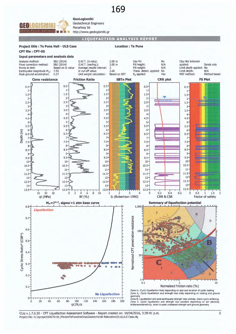
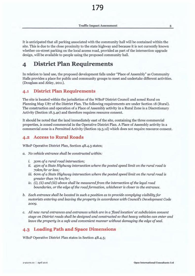
169 GeoLogismiki Geotechnical Eng ineers Merarhias 56 http:/ /www.geologismiki.gr LIQUEFACTION ANALYSIS REPORT Project title : Te Puna Hall - ULS Case CPT file: CPT-OS Input parameters and analysis data Analysis method: B&I (2014) G.W.T. (in-situ): Fines correction method: B&I (2014) G.W.T. (earthq.): Points to test: Based on Ic value Average results interval: Earthquake magnitude Mw: 7.50 Peak ground acceleration: 0.27 0.5 1.5 2 2.5 3 3.5 4 4.5 5 5.5 8.5 9 9.5 10 10.5 11 11.5 12 12.5 Cone resistance 13 13.5-'---,--.----,r---' 10 20 30 qt (MPa) 0.5 1 1.5 2 2.5 3 3.5 4 4.5 5 5.5 6 6.5 7 7.5 8 8.5 Ic cut-off value: Unit weight calculation: Friction Ratio 9.5 10 10.5 11 ... 12 12.5 13 13 .5 -t-h-.---,-,.,---.---.rl 0 2 4 6 8 10 Rf (%) Mw=7 1 ' 2 , sigma' =l atm base curve Location : Te Puna 2.00 m 2.00 m 3 2.60 Based on SBT SBTn Plot Use fill : No Fill height: N/ A Fill weight: N/ A Trans. detect. applied: No K, applied : Yes 0.5 1.5 2 2.5 3 3.5 4 4.5 5 5.5 6 6.5 7 7.5 8 8.5 9 9.5 10 10.5 11 11 .5 12 12.5 13 13.5 ,. l { CRRplot ... \ \ 1 2 3 4 0 0.2 0.4 CRR &CSR Ic (Robertson 1990) Clay like behavior applied : Limit depth applied: Limit depth: MSF method : Sands only No N/ A Method based FS Plot 0.6 0 0.5 1 1.5 2 Factor of safety o. 8+---L-.J.... __.___J, _ _,___---'-__,_..L__.l..,_.__--'------'--'----'--r'-- +- * 0:: V) * 0 :;::; ct1 0:: Vl Vl ...... V) u u > u Liquefaction 0.7 0.6 0.5 0.4 0.3 • • • • 0.2 0.1 No Liquefaction .. -rrr-/- 0 20 40 60 80 100 120 140 160 180 200 qc1N,cs 1 10 Normalized friction ratio (%) Zone A,: Cyclic liquefaction likely depending on size and duration of cycli c loading Zone A 2 : Cyclic liquefaction and strength loss likely depending on loading and ground geometry Zone B: Liquefaction and post-earthquake strength loss unlikel y, check cyclic softening Zone C: Cycli c liquefaction and strength loss possible depending on soil plasticity, bri ttleness/sensit ivi ty, strain to peak undrained strength and ground geometry CUq v.1.7.6.50- CPT Liquefaction Assessment Software- Report created on: 14/04/2016, 3:39:41 p.m. Project file: G:\5project\9A070.00_MindenTePunalnstlmp\Geotech\Hall Relocation\Cliq\ULS Case.clq 5
Transcript of file: CPT-OS Input parameters and ... qc1N,cs 1 10 Normalized friction ratio (%) ... CUq...
169GeoLogismiki Geotechnical Engineers
Merarhias 56
http :/ /www.geologismiki.gr
LIQUEFACTION ANALYSIS REPORT
Project title : Te Puna Hall - ULS Case
CPT file: CPT-OS
Input parameters and analysis data
Analysis method: B&I (2014) G.W.T. (in-situ): Fines correction method: B&I (2014) G.W.T. (earthq.): Points to test: Based on Ic value Average results interval: Earthquake magnitude Mw: 7.50 Peak ground acceleration: 0.27
0.5
1.5
2
2.5
3
3.5
4
4.5
5 5.5
8.5
9
9.5 10
10.5
11
11.5
12
12.5
Cone resistance
13
13.5-'---,--.----,r---' 10 20 30
qt (MPa)
0.5
1
1.5
2
2.5
3
3.5
4
4.5
5 5.5
6 6.5
7
7.5
8 8.5
Ic cut-off value: Unit weight calculation:
Friction Ratio
9-<~---
9.5
10
10.5
11
11.5~ ... --...:::~--12
12.5
13
13. 5 -t-h-.---,-,.,---.---.rl 0 2 4 6 8 10
Rf (%)
Mw=71' 2, sigma'=l atm base curve
Location : Te Puna
2.00 m 2.00 m 3 2.60 Based on SBT
SBTn Plot
Use fill : No Fill height: N/ A Fill weight: N/A Trans. detect. applied: No K, applied : Yes
0.5
1.5
2
2.5
3
3.5
4
4.5
5 5.5
6
6.5
7
7.5
8 8.5
9
9.5 10
10.5
11
11.5
12
12.5
13
13.5
,.
l {
CRRplot
...
\ \
1 2 3 4 0 0.2 0.4
CRR &CSR Ic (Robertson 1990)
Clay like behavior applied: Limit depth applied: Limit depth: MSF method :
Sands only No N/ A Method based
FS Plot
0.6 0 0.5 1 1.5 2
Factor of safety
o.8+---L-.J....__.___J, _ _,___---'-__,_..L__.l..,_.__--'------'--'----'--r'-- +-
* 0:: V)
~ * 0 :;::; ct1 0:: Vl Vl
~ ...... V)
u u > u
Liquefaction
0.7
0.6
0.5
0.4
0.3 • • • •
0.2
0.1
No Liquefaction 04-orrrroTTTTTT~rrroTTTTTT~rrrrrrTTTT .. -rrr-/-
0 20 40 60 80 100 120 140 160 180 200 qc1N,cs
1 10 Normalized friction ratio (%)
Zone A,: Cyclic liquefaction likely depending on size and duration of cyclic loading Zone A2: Cyclic liquefaction and strength loss likely depending on loading and ground geometry Zone B: Liquefaction and post-earthquake strength loss unlikely, check cyclic softening Zone C: Cyclic liquefaction and strength loss possible depending on soil plasticity, brittleness/sensitivity, strain to peak undrained strength and ground geometry
CUq v.1.7.6.50- CPT Liquefaction Assessment Software- Report created on: 14/04/2016, 3:39:41 p.m. Project file: G:\5project\9A070.00_MindenTePunalnstlmp\Geotech\Hall Relocation\Cliq\ULS Case.clq
5
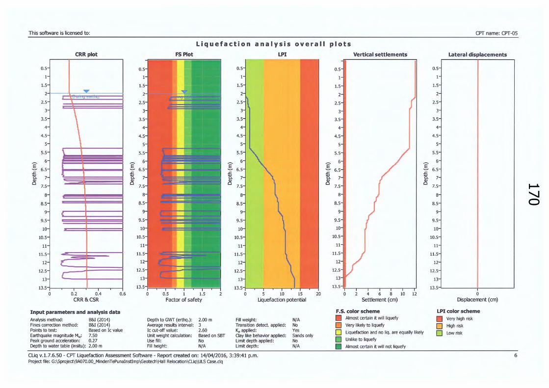
170This software is licensed to: CPT name: CPT-OS
Liquefaction analysis overall pl o ts
0.5
1
1.5
2
2.5
3
3.5
4
4.5
5
5.5
6
::§:: 6.5 £ a. ~
7
7.5
8
8.5
9
9.5
10
10.5
11
11.5
12
12.5
13
13.5 ' 0
CRR plot
.....
\ '
::§:: £ a. ~
(
{
[
0.2 0.4 0.6
FS Plot LPI
0.5
1
1.5
2
2.5
3
3.5
4
4.5
5.5
E' 6
~ 6.5 £ ....
7 a. ~
7.5
8
8.5
9
9.5
10
10.5
11
11.5
12
12.5
13
13.5 0 0.5 1 1.5 2 0 5 10 15
CRR &CSR Factor of safety Uquefaction potential
Input parameters and analysis data Analysis method : B&I (2014) Depth to GWT (erthq.): Fines correction method: B&I (2014) Average results interval: Points to test: Based on Ic value Ic cut-off value: Earthquake magnitude Mw: 7.50 Unit weight calculation : Peak ground acceleration: 0.27 Use fill: Depth to water table (insitu): 2.00 m Fill height:
2.00 m 3 2.60 Based on SBT No N/A
Fill weight: Transition detect. applied: K, applied: Clay like behavior applied: Limit depth applied: Limit depth:
Cliq v.1.7.6.50- CPT Liquefaction Assessment Software- Report created on: 14/04/2016, 3:39:41 p.m. Project file : G:\Sproject\9A070.00_MindenTePunalnstlmp\Geotech\Hall Relocation\Cliq\ULS Case.clq
N/A No Yes Sands only No N/A
20
Vertical settlements Lateral displacements
0.5 0.5
1 1
1.5 1.5
2 2
2.5 2.5
3 3
3.5 3.5
4 4
4.5 4.5
5
5.5 5.5
6
::§:: 6.5 E' 6
~ 6.5 £ .... a. ~
7
7.5
8
8.5
9
9.5
10
10.5
11
11.5
12
12.5
13
13.5
0 2 4 6 8 Settlement (em)
F.S. color scheme Almost certain it will liquefy
D Very likely to liquefy
£ a. ~
10 12
D Liquefaction and no liq. are equally likely
D Unlike to liquefy
Almost certain it will not liquefy
7
7.5
8
8.5
9
9.5
10
10.5
11
11 .5
12
12.5
13
13.5 0
Displacement (em)
LPI color scheme D Very high risk
D High risk
D Low risk
6

171New Te Puna Memorial Hall Notice of Requirement for Designation Western Bay of Plenty
District Council
Appendixs Map of Alternative
Sites Considered

172

173New Te Puna Memorial Hall Notice of Requirement for Designation Western Bay of Plenty
District Council
Appendix6 Traffic Impact
Assessment Report

174
OPUS
Te Puna Memorial Hall
Traffic lntpact Assessntent
175
OPUS
Te Puna Memorial Hall
Traffic I111pact Assess111ent
Prepared By Letitia Drake -Graduate Transportation Engineer
Reviewed By
Opus International Consultants Ltd Hamilton Office Opus House, Princes Street Private Bag 3057, Waikato Mail Centre, Hamilton 3240 New zealand
Telephone: +64 7 838 9344
I<Iisioft'er-Hanssoli_________________________________________________ Facsimile:
Approved for Release By
Transport Planner
J anine Fall well Principal Planner
© Opus International Consultants Ltd 2016
Date: Reference: Status:
28June2016 2-9A070.00 Final
I

176
Traffic Impact Assessment
Contents
1 Introduction ....................................................................................................... 1
2 Back~ound ........................................................................................................ 1
3 Proposed Development ...................................................................................... 2
4 District Plan Requirements ................................................................................ 3 4.1 District Plan Requirements ............................................................................................... 3 4· 2 Access to Rural Roads ....................................................................................................... 3 4.3 Loading Path and Space Dimensions ................................................................................ 3 4.4 On-site Manoeuvring ........................................................................... ............................. 4 4·5 On Site Parking Requirements .......................................................................................... 4
5 Traffic Assessment ............................................................................................. 4 5·1 Trip Generation ................................................................................................................. 4 5.2 Access ................................................................................................................................ 5 5·3 On Site Parking ....................................... .......................................................................... 5 5.4 Loading Zone ..................................................................................................................... 7 5.5 Pedestrians/Cyclists .......................................................................................................... 7
6 Conclusion and Recommendation ...................................................................... 7
2-9A070.00 I April 2016 Opus International Consultants Ltd
177
Traffic Impact Assessment
1 Introduction
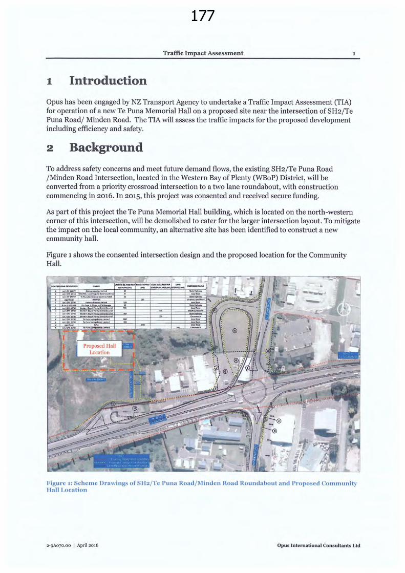
Opus has been engaged by NZ Transport Agency to undertake a Traffic Impact Assessment (TIA) for operation of a new Te Puna Memorial Hall on a proposed site near the intersection of SH2jTe Puna Road/ Minden Road. The TIA will assess the traffic impacts for the proposed development including efficiency and safety.
2 Background
To address safety concerns and meet future demand flows, the existing SH2/Te Puna Road /Minden Road Intersection, located in the Western Bay of Plenty (WBoP) District, will be converted from a priority crossroad intersection to a two lane roundabout, with construction commencing in 2016. In 2015, this project was consented and received secure funding.
1
As part of this project the Te Puna Memorial Hall building, which is located on the north-western corner of this intersection, will be demolished to cater for the larger intersection layout. To mitigate the impact on the local community, an alternative site has been identified to construct a new community hall.
Figure 1 shows the consented intersection design and the proposed location for the Community Hall.
Figure 1: Scheme Drawings ofSH2/Te Puna Road/Minden Road Roundabout and Proposed Community Hall Location
2-9A070.00 I April 2016 Opus International Consultants Ltd

178
Traffic Impact Assessment 2
There will be a local access road running parallel to SH2 to Te Puna Road which will provide access to the three existing commercial properties (4 square, real estate agency and BP petrol station). As shown in Figure 1, the existing accesses from SH2 to these properties have been rationalised and reduced to only one access, which is designed as a left in left out access. The access to these properties to and from Te Puna Road will be upgraded and continue to provide for all turning movements. There will be raised kerb between this new local road and SH2.
As the SH2/Minden Road/Te Puna Road intersection design has been consented, this TIA will assess the traffic impact of the proposed Te Puna Memorial Hall development only, on the basis that this intersection layout will be installed and associated safety works in place. A large scale scheme drawing of the SH2/Te Puna Road /Minden Road Intersection is provided in Appendix A.
Further information on the SH2/Minden Road/Te Puna Road intersection upgrade can be found in the Notice of Requirement for Alteration to Designation (May 2015).
3 Proposed Development
The proposed community hall location is a greenfield site northwest of the SH2/Te Puna Road/Minden Road Intersection. The site access will be located off the new local access road on the northern side of SH2. While this road may accommodate access to future activities on the greenfield site to the south of the proposed community hall location, for the purpose of this assessment, this road is assumed to only accommodate traffic associated with the hall and the three existing commercial properties.
The proposed gross floor area of the Te Puna Memorial Hall is s6sm 2 , however, the majority of this area is occupied by ancillary areas including stage, storage, kitchen, meeting rooms and toilets. The maximum capacity of the proposed hall is 120 people.
r_j " _;/
I /
l~-------------Figure 2: Te Puna Hall Floor Plan
2-9A070.00 I April 2016 Opus International Consultants Ltd
179
Traffic Impact Assessment
It is anticipated that all parking associated with the community hall will be contained within the site. This is due to the close proximity to the state highway and because it is not currently known whether on-street parking on the local access road, provided as part of the intersection upgrade design, will be available to people using the proposed community hall.
4 District Plan Requirements
3
In relation to land use, the proposed development falls under "Place of Assembly" as Community Halls provides a place for public and community groups to meet and undertake different activities. (Douglass and Abley, 2011).
4.1 District Plan Requirements
The site is located within the jurisdiction of the WBoP District Council and zoned Rural on Planning Map U87 ofthe District Plan. The following requirements are under Section 18 (Rural). The construction and operation of a Place of Assembly activity in a Rural Zone is a Discretionary Activity (Section 18.3-4e) and therefore requires resource consent.
It should be noted that the land immediately east of the site, containing the three commercial properties, is zoned commercial in the Operative District Plan. A Place of Assembly activity in a commercial zone is a Permitted Activity (Section 19.3.1d) which does not require resource consent.
4.2 Access to Rural Roads
WBoP Operative District Plan, Section 4B.4.3 states;
a. No vehicle entrance shall be constructed within:
z. 30m of a rural road intersection; ii. 45m of a State Highway intersection where the posted speed limit on the rural road is
70kmjhr or less; iii. 6om of a State Highway intersection where the posted speed limit on the rural road is
greater than 70 kmjhr; zv. (i), (ii) and (iii) above shall be measuredfrom the intersection of the legal road
boundaries, or the edge of the roadformation, whichever is closer to the entrance.
b. Each entrance shall be located in such a position as to provide complying visibility for motorists entering and leaving the property in accordance with Council's Development Code 2009.
c. All new rural entrances and entrances which are in a 'fixed location' at subdivision consent stage on District roads shall be designed and constructed so that heavy vehicles can enter and leave the property in a safe and convenient manner without damaging the edge of seal.
4·3 Loading Path and Space Dimensions
WBoP Operative District Plan states in Section 4B.4.5;
2-9A070.00 I April 2016 Opus International Consultants Ltd
180
Traffic Impact Assessment
Activities requiring loading facilities or servicing from heavy vehicles shall comply with the 90 percentile design two axled truck swept path and minimum loading space dimensions or a greater dimension of design where articulated vehicles or trucks and trailers are anticipated.
4·4 On-site Manoeuvring
WBoP Operative District Plan states in Section 4B-4.6;
4
All activities shall provide manoeuvring space onsite so that all vehicles can enter and exit without reversing on to or off the road. Such manoeuvring shall be able to be executed in no more than a three-point turn.
4·5 On Site Parking Requirements
District plans are generally liberal in their approach to off-street parking for places of assembly including churches and community halls. This is also the case for WBoP District Council that states in the Operative District Plan (Section 4B.4.7) that the car parking requirement is to provide one car parking space for every five people the facility is designed to cater for.
Based on the surveys in the NZ Trip Data Base (18 Church sites) the car parking demand varied from 1 car park per 5 people in attendance to 1 car park per 2 people in attendance.
5 Traffic Assessment
5.1 Trip Generation
5.1.1 Existing Local Road Trip Generation
Trip generation on the proposed local road prior to construction of the community hall, has been estimated from data obtained from the Transfund NZ Research Report 453 and Trips and Parking Database 2015. The estimated peak hour volumes on the local road is shown in Table 1 below.
Ta bl d akh e 1: Estimate pe ourve h" I IC e trips per h our on th I al e oc roa d( I di C exc u ng ommun1ty Ha Land use Vehicles per Hour (vph)
Small Convenience Store 43
Real Estate Agency 3
Petrol Station 101
Total 147
5.1.2 Community Hall Trip Generation
The existing Te Puna Memorial Hall has a number of regular activities scheduled with the participants being between 10 and so people.
ll)
2-9A070.00 I April 2016 Opus International Consultants Ltd
181
Traffic Impact Assessment 5
Similar to most community halls, the current Te Puna Hall is used as a venue for annual events such as Pony Club, rowing club prize giving, family celebrations and occasionally wedding parties. In addition, there are music concerts held about four times a year. These irregular events will attract a larger number of participants than the regular weekly activities. The number of events that are expected to reach full capacity of the hall (120 participants) is approximately 25 occasions each year.
Based on the District Plan principles outlined in Section 4.5 above and assuming a vehicle occupancy of two, it is estimated that the maximum number of vehicles travelling to the site during a large event is 6o vehicles.
Total Trip Generation
In summary, the total number of vehicles estimated on the proposed local road during the peak hour is 207. This assumes that the peak hour (147 vehicles) and a large event at the Community Hall (6o vehicles) coincide. This is considered to be the worst case scenario. However, this is considered unlikely as peak hour for vehicle movements to the adjacent commercial properties is considered to be late afternoon, whereas the largest events in the community hall occur on;
• Sunday evenings; up to 40 people, • Weekday mornings; up to so people, and • Irregular private functions (usually in the evenings); up to 120 people.
Regardless of whether the large event occurs at the same time as the peak period, the traffic volume on this local access road is considered very low.
Traffic Modelling
No traffic modelling of the entrance to the community hall has been undertaken as the traffic flows on the local road are considered to be very low and therefore no delays are expected.
5.2 Access
The vehicle entrance to the Community Hall will be off the local access road located adjacent SH2 and constructed as part of the intersection upgrade. This access road is designed as a left in left out intersection, approximately 200 metres west of the SH2jTe Puna Road/Minden Road intersection. The speed of vehicles on the local road and number of vehicles using it is expected to be low.
The entrance to the hall is located approximately som east of this left in/left out intersection. It is assumed that the entranceway will be 8m wide; however as part of any Designation conditions the entrance should be constructed to meet the District Council's requirements for new entrances.
5·3 On Site Parking
Based on the maximum hall capacity of 120 people, and the principles outlined in Section 4.5 above, the community hall needs to provide a minimum of 24 on-site car parks to comply with the District Plan requirements.
Based on the surveys in the NZ Trip Data Base, the car parking demand suggests providing 1 car park per 2 people in attendance. This equates to a maximum of 6o car parks when the hall is at full
2-gAO?O.OO I April 2016 Opus International Consultants Ltd

182
TraflficlnlpactAssessnlent 6
capacity. On a typical weekday, this number is estimated to reduce to a maximum of 25 vehicles. However, assuming that some participants will travel by other means to the community hall (i.e. motorbike, bicycle, walk etc.) the number of car parks required is considered to be less.
AS/NZS 2890.6:2009, Parking Facilities, Part 6: Off-street parking for people with disabilities states that parking facilities, whether public or private shall provide not less than two accessible car parking spaces for people with disabilities where the total number of car parking spaces provided are between 21-50. An additional disability car park shall be provided for every additional so car spaces.
Therefore, based on this information, a total of 6o car parks, including two accessible car parks, will be provided at the site. This is more than twice the number required by the District Plan; however, considering the low number of adjacent on-street car parks available the proposed number of car parks is considered appropriate for this site.
AS/NZS 2890.1:2004 specifies that a standard 90 degree angle car park to be 2.5m wide, 5-4m in length and an aisle dimension of s.Sm. AS/NZS289o.6:2009 states the dimensions for accessible parking are the same as a standard car park, as long as they are adjacent to a shared space of at least 1.1m.
A vehicle tracking exercise has been undertaken to ensure that both heavy vehicles and standard cars can safely manoeuvre within the site.
Figure 3 shows the design layout which is accordance with the dimensions and number of spaces detailed above.
/ /
/
Figure 3: Te Puna Memorial Hall Site Plan
2-9A070.00 I April 2016
I
: R PUNA H.t.U I I FUXIItJ>.IitE.Jl564tW I ... _,...e..,.,~ ........ --~
SITE PLAN 1:200 ~.,..,..,..J'tOy• .... •a-..-•c,_.
Opus Inte rnational Consultants Ltd

183
Traffic Impact Assessment
5·4 Loading Zone
No designated loading area will be provided on the site. Because service vehicles access the site before or after events when large amounts of general parking will be available, loading can be accommodated in general car parks.
5·5 Pedestrians/Cyclists
7
Pedestrian and cyclist movements have been provided for within the upgrade of the SH2jTe Puna Road/Minden Road and associated safety improvements. The upgrade includes construction of a pedestrian refuge island to the west of the roundabout, to allow pedestrians and cyclists to cross SH2 safely, and footpaths and cycleways as necessary. No additional pedestrian and cyclist facilities are required as part of the inclusion of the Community Hall.
The entranceway to the site is assumed to be 8 metres wide, and in conjunction with low traffic volumes and speeds at the site, is considered to be safe for pedestrians and cyclists accessing the site.
A cycle stand should be provided to encourage cyclist movements to the site.
6 Conclusion and Recommendation
This traffic impact assessment has assessed the proposed Te Puna Memorial Hall on a new greenfields site located to the west of the SH2jTe Puna Road/Minden Road intersection. The TIA has been undertaken on the basis that the SH2jTe Puna Road/Minden Road intersection upgrade will be installed as per the scheme drawing and associated safety works in place prior to construction of the Community Hall.
Based on the information presented, we consider that any negative effects on traffic due to the proposed community hall are less than minor.
In total, 6o car parks including two accessible car parks, will be provided within the site. This is more than twice the number required by the District Plan; however, considering the low number of adjacent on-street car parks available, the proposed number of car parks are considered appropriate for this site.
It is therefore recommended that the Notice of Requirement for this proposed development be supported from a traffic perspective.
2-9A070.00 I April 2016 Opus International Consultants Ltd

184
/ Opus International Consultants Ltd Opus House, Princes Street Private Bag 3057, Waikato Mail Centre, Hamilton 3240 New Zealand
t. +64 7 838 9344 1: +64 7 838 9324
www.opus.co.nz

185New Te Puna Memorial Hall Notice of Requirement for Designation Western Bay of Plenty
District Council
Appendix7 Noise Assessment Report
186
7 July 2016
Opus Consultants Ltd P 0 Box 646 Tquranga 3140
Attention: lanine Fallwell
Dear Janine
Re: Proposed Te Puna Memorial Hali-Te Puna Noise Assessment
As requested, we have carried out an assessment relating to noise from the proposed Te Puna Memorial Hall in Te Puna.
The proposal is to establish and operate a community hall on the subject site, which is to the north-west of the junction of State Highway 2 and Te Puna Road. The hall will replace the existing community hall located on the corner of these roads.
The new hall will be used for health and recreational classes, and other community uses such as group meetings and functions. The site will be accessed off a new local access road on the northern side of SH2 with parking areas on the southern and eastern sides of the new building.
1.0 Noise Performance Standards
The subject site is zoned 'Rural' in the Western Bay of Plenty District Council's Operative District Pian.
While District Plan rules do not generally apply to a designated site, we consider it is reasonable to use the noise limits for the rural zone as a guideline in this case. Our assessment of noise from the hall is therefore based on compliance with Rule 4C.1.3.2 of the operative Western Bay of Plenty District Plan. The noise rule specifies the following for activities within the rural zone:
Rule 4C.1.3.2 Noise Limits
(a) Noise limits for activities in Residential, Rural-Residential, Future Urban, Rural and Lifestyle Zones
(i) All activities located within these zones shall be so conducted as to ensure that noise from the site shall not exceed the following noise limits within the stated timeframes at any point within the notional boundary of any dwelling in a Rural, Lifestyle or Rural -Residential zone, or at any point within the boundary of any property within a Residential or Future Urban Zone (other than the site of the activity);
Design Acoustics Ltd PO Box 4540 Tauranga 3149
Phone 07 578 9016 Mobile 0274 173 700
tony@designacoustics. co . nz
187
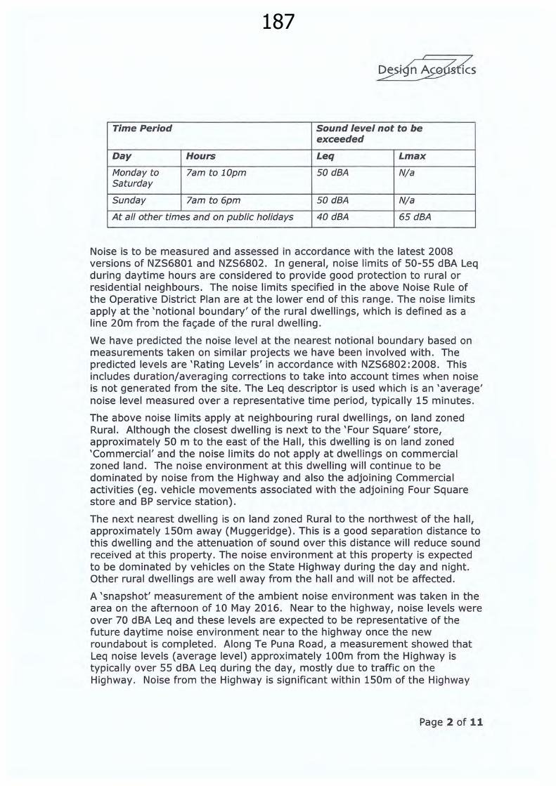
Time Period Sound level not to be exceeded
Day Hours Leq Lmax
Monday to lam to lOpm 50dBA N/a Saturday
Sunday lam to 6pm 50dBA N/a
At all other times and on public holidays 40 dBA 65dBA
Noise is to be measured and assessed in accordance with the latest 2008 versions of NZS6801 and NZS6802. In general, noise limits of 50-55 dBA Leq during daytime hours are considered to provide good protection to rural or residential neighbours. The noise limits specified in the above Noise Rule of the Operative District Plan are at the lower end of this range. The noise limits apply at the 'notional boundary' of the rural dwellings, which is defined as a line 20m from the fa<;ade of the rural dwelling.
We have predicted the noise level at the nearest notional boundary based on measurements taken on similar projects we have been involved with. The predicted levels are 'Rating Levels' in accordance with NZS6802:2008. This includes duration/averaging corrections to take into account times when noise is not generated from the site. The Leq descriptor is used which is an 'average' noise level measured over a representative time period, typically 15 minutes.
The above noise limits apply at neighbouring rural dwellings, on land zoned Rural. Although the closest dwelling is next to the 'Four Square' store, approximately 50 m to the east of the Hall, this dwelling is on land zoned 'Commercial' and the noise limits do not apply at dwellings on commercial zoned land. The noise environment at this dwelling will continue to be dominated by noise from the Highway and also the adjoining Commercial activities (eg. vehicle movements associated with the adjoining Four Square store and BP service station) .
The next nearest dwelling is on land zoned Rural to the northwest of the hall, approximately 150m away (Muggeridge) . This is a good separation distance to this dwelling and the attenuation of sound over this distance will reduce sound received at this property. The noise environment at this property is expected to be dominated by vehicles on the State Highway during the day and night. Other rural dwellings are well away from the hall and will not be affected .
A 'snapshot' measurement of the ambient noise environment was taken in the area on the afternoon of 10 May 2016. Near to the highway, noise levels were over 70 dBA Leq and these levels are expected to be representative of the future daytime noise environment near to the highway once the new roundabout is completed. Along Te Puna Road, a measurement showed that Leq noise levels (average level) approximately 100m from the Highway is typically over 55 dBA Leq during the day, mostly due to traffic on the Highway. Noise from the Highway is significant within 150m of the Highway
Page 2 of 11

188
and this will continue to be the situation in the future. In relation to this we note that:
• Construction of the Tauranga Eastern Link is proposed to commence in the near future.
• The State Highway 2/Te Puna Road intersection is proposed to be converted to a roundabout.
The traffic report prepared for the roundabout with/without the Tauranga Eastern Link completed shows that at the nearest rural dwelling the noise from the roundabout and highway will be approximately 50-53 dBA (Leq24hr). On this basis, the noise environment at this dwelling will continue to be dominated by noise from the roundabout/local road network.
We also note that the area in the vicinity of the proposed roundabout is busy and relatively noisy from commercial and other horticultural activities in the area. Commercial activities include the Four Square store and BP Service station on adjoining land to the east, and an ITM timber yard on Te Puna Road further to the east on Te Puna Road. The DMS packhouse/coolstore further north on Te Puna Road (zoned Post Harvest) will also produce noise especially during the peak harvesting season.
In our opinion, the rural zone noise limits of 50 dBA Leq during the day, and 40 dBA Leq/65 dBA Lmax during night time area reasonable in this noise environment, and will control noise for the neighbours in the vicinity of the subject site to a high degree.
2.0 Noise Assessment
The majority of activities at the new Hall will typically occur between 9am and 9.30pm on weekdays/weekends for a wide range of community uses. These include indoor health and other recreational activities such as fitness, bowls, yoga, dance, ante-natal, garden club, prize-givings and other community group meetings. The hall may also be used for church services, funerals, public meetings, training sessions, exhibitions or conferences.
These activities will occur inside the building during daytime and evenings, typically during the 'daytime' period when a 50 dBA Leq noise limit applies and there will be no issue in terms of compliance with this limit. After 6.00pm on Sundays, and all day on Public Holidays, stricter noise limits of 40 dBA Leq/65 dBA Lmax apply. Some of the above activities may occur during these times, however the above activities typically produce low-moderate levels of noise and will not cause the 'night time' noise limits to be exceeded.
The hall will also be used as a function venue for events which involve amplified music, and some of these activities may finish after lOpm when the stringent night time limits apply. These activities may include wedding receptions, family celebrations and concerts. Concerts are estimated to be held approximately four times per year and these may also finish after lOpm.
Page 3 of 11
189
These activities produce higher noise levels from amplified music, and may need to be managed to ensure compliance with the noise limits especially the stricter night time limits.
Noise from activities associated with the new Community Hall can be grouped as follows:
• Noise from vehicle movements in the car park areas next to the new building .
• Noise from activities inside the buildings eg. Amplified music.
• Noise from people outdoors or other activities eg in the courtyard on the northern side of the hall.
• Noise from any mechanical plant associated with the heating, ventilating and air conditioning of the building (HVAC).
• There will also be noise from construction of the facility .
2.1 Noise from Vehicle Movements
The car park areas are on the southern and eastern sides of the main building. The car park is accessed via a right-of-way and parking is provided for 60 vehicles.
Noise from vehicles on public roads is not required to comply with the District Plan rule, however, whilst on the site the noise generated by vehicles should comply. Cars are only slow-moving whilst in the carpark and driveway areas and do not generate significant noise.
The worst case situation is after a large event at the Hall which may finish after 10pm, when the stricter night time noise limits apply and when larger numbers of people/cars depart the site over a short period. However, during these times our calculations show that noise at the notional boundary of the nearest rural dwelling to the northwest will not exceed 30 dBA Leq and 60 dBA Lmax and will comply with the 40 dBA Leq/65 dBA Lmax noise limits.
At all other times, noise from vehicles associated with the typical day-today operation of the hall will be less than 25 dBA Leq and safely comply with the 50 dBA Leq daytime noise limit, and will not be an issue. Noise from vehicle movements will be masked by the higher noise levels from road traffic on the Highway for most of the day.
Page 4 of 11
190
2.2 Noise from Activities Inside the Building
The design of the Hall is still at an early stage, but it is expected to be constructed along the following lines :
• Timber framed walls with lightweight fibre cement sheet or similar cladding, batt insulation to the cavity and internal plasterboard lining .
• Windows will be glazed with single laminated glass, or dual thermal glazing.
• The roof will be longrun corrugated metal with ceiling insulation and a suspended plasterboard or acoustic tile ceiling.
Noise levels can be high during a larger event such as a concert or wedding reception, with amplified music, shouting/applause and PA system or DJ noise. Based on typical music levels of up to 85 dBA Leq our calculations show that:
• With windows and doors closed, there will be no issue and noise will comply with the daytime and night time noise limits at the nearest rural dwelling to the northwest.
• With windows/doors open, noise from indoors will comply with the 50 dBA Leq noise limit which applies during daytime. However, noise may not comply with the 40 dBA Leq noise limit which applies after lOpm (Monday to Saturday) or after 6pm on Sundays.
On this basis, we recommend that noise from any event which involves live or pre-recorded amplified music should be managed so that if these extend past lOpm Monday to Saturday (or after 6pm on Sundays/Public Holidays) then windows/doors to the hall shall be closed. The hall will be provided with a mechanical ventilation/air conditioning system, so that windows/doors can be kept closed.
This aspect will be looked at during final design stage since the hall is only at a preliminary stage of design and the building materials may change as the design progresses. However, our assessment shows that noise from the majority of activities inside the Hall will safely comply with the daytime and night time noise limits at the nearest rural dwelling. Noise from events which include amplified music can also comply with the stricter night time noise limits as long as doors/windows are closed .
Preparation of a noise management plan may be useful, in relation to the use of the Hall for events which involve amplified music. This Plan can contain matters affecting noise emissions such as:
• Control of noise levels inside the venue .
• Closing of windows/doors when music is played after lOpm (or after 6pm on Sundays/public holidays) when stricter night time noise limits apply .
• Music to finish no later than 12.00 midnight so that the majority of people have left the site prior to 12.30am.
Page 5 of 11
191
• Procedures for dealing with any complaints .
I /
D . / A / . _?SJ·gn _ _5-~StiCS
We have recommended preparation of a Noise Management Plan as a designation condition .
2.3 Noise from People and other Outdoor Activities
In general, noise from people talking outside will not be audible at any rural dwelling.
Noise from large groups of people talking outdoors, such as the courtyard area on the northern side of the building, will be less than 40 dBA Leq/50 dBA Lmax at the nearest rural dwelling to the north-west and this will comply with the daytime and night time noise limits.
Some daytime events can include an outdoor public address system for announcements eg gala day or similar. Family functions such as weddings or other celebrations can also include low levels of amplified music or ' three piece' group of musicians outside, as background music. These activities, carried out during daytime hours, are not expected to cause any problems with compliance with the daytime noise limit at the nearest rural dwelling and this can also be included in the Noise Management Plan we have recommended .
2.4 Noise from Mechanical Plant
In general, any mechanical plant associated with the heating, ventilation and air conditioning of the Hall will be small and will not be an issue:
• Roof mounted extract fans - as long as these are appropriately selected to not exceed 55 dBA at 3m distance they will not cause the noise limit to be exceeded at any rural dwelling.
• Small supply/extract fans serving toilets and ancillary areas - t hese will not be an issue.
• Split system air conditioners. These can be located on the southern or eastern sides of the building if required. These are similar to residential heat pump systems and the small outdoor units associated with these systems will produce low levels of noise and will not be an issue.
This can be checked during final design stage. Noise from these systems will be designed so that they comply with the night time limits at the nearest rural dwelling, and this will not be an issue.
Page 6 of 11

192
2.5 Noise from Construction
Noise from construction should comply with the relevant noise limits which are specified in Rule 4C.1.3.1 of the District Plan:
Construction Noise
Construction noise shall not exceed the noise limits in, and shall be measured and assessed in accordance with the requirements of NZS 6803: 1999 Acoustics -Construction Noise.
Due to the large separation distance, the requirements of Construction Noise standard is expected to be complied with at the nearest rural dwelling, with a large margin of safety. Compliance with the Construction Standard will also be achieved at the nearest buildings on the commercial zoned land to the east.
We recommend that compliance with the Construction Standard should be made a condition of the construction contract . Construction work should generally be carried out Monday to Saturday between 7.30am and 6pm, when the higher noise limits apply at dwellings (75 dBA Leq and 90 dBA Lmax, of the latest Standard). Once the building is enclosed, construction work carried out indoors associated with the internal fit-out will be inaudible/negligible for the neighbours.
3.0 Noise from State Highway - Reverse Sensitivity
As a 'place of assembly' constructed near to a Highway, NZTA normally requires that 'noise sensitive' activities are protected from road traffic noise and avoid a 'reverse sensitivity' effect.
While the District Plan is not specific in this regard, we recommend that the building shall be designed, located or treated so that the internal noise level within the main hall does not exceed 40 dB LAeq24hr with any ventilating windows open. This is consistent with NZTA requirements in the Tauranga District.
We note that the predicted noise levels at the Hall site, from road traffic on the roundabout, is 55-57 dBA Leq . With windows/doors on the northern side open for ventilation, sound levels indoors would be approximately 35-37 dBA Leq and comply with the internal noise limit. It is unlikely that the 'building envelope' of the Community Hall will need to be upgraded in order to comply with the internal noise limit.
Further, the Hall will also be mechanically ventilated/air conditioned so that, with all doors/windows closed, noise levels inside the hall will be less than 35 dBA so that compliance is unlikely to be an issue.
Page 7 of 11

193
4.0 Temporary Activities
We also note that the District Plan permits 'Temporary Activities' in any zone. This usually applies to large outdoor sporting or community/concert events which may be held in the District from time to time. Examples of this would be noise from a large regional or national sporting event or an outdoor community event such as a two-day exhibition, festival, gala day or an outdoor concert. We summarise the noise and duration requirements of Rule 4A.2.3.1(b) in relation to Temporary Activities:
Permitted Activities
(b) In any zone temporary activities which are held on a site which falls within the definition of places of assembly and which:
(i) Do not exceed three consecutive days in duration plus two additional days, one day for setting up prior to the event and one day to tidy up afterwards;
(ii) Do not occur more than six times in any calendar year, nor more than twice in any calendar month on the same site (provided that there shall be at least five full days between the tidy up of one event and the set up of the next event held on the same site);
(iii) Do not involve the open air use of motorised vehicles (other than those vehicles used for transport to and from the site) unless the prior written consent of all adjoining neighbours is obtained including any neighbours on the immediate opposite side of an adjoining road, except that motorsport events held on public roads and public reserves are exempt from this rule (they are addressed through separate legislation);
(iv) Do not exceed the following noise limits within the stated timeframes (as measured at any point within the notional boundary of any dwelling in a relevant zone);
Time Period Sound level not to be exceeded
Day Hours Leq Lmax
Monday to 9am to 10pm 70dBA 75dBA Saturday and public holidays
Sunday 10am to 6pm 70dBA 75dBA
At all other times 40 dBA 65dBA
Page 8 of 11

194
I /
D . / A / . es.t-g n C.GUSti CS ~
The intention of the temporary event rule is to permit large outdoor events to emit higher noise levels and this is reasonable with restrictions on duration and number of events per year. Although this kind of event is not envisaged, a larger community event could come into this category and we consider that the above restrictions/noise limits are reasonable and should apply to the Community Hal l.
5.0 Restriction on Night time Activities
It can be appropriate for night time activities to be restricted, to minimise disturbance to neighbours during the more 'noise sensitive' night time period.
This site is not in a ' pristine ' or quiet rural environment, remote from major arterial routes . However, noise from events which involve amplified music and/or finish after 10pm can have the potential to cause disturbance especially when road traffic flows are lower in the evening. On this basis, we recommend that functions which involve amplified music shall cease no later than 12.00 midnight, so that the majority of people are off the site by 12.30 am.
We further recommend that any function which involves amplified music and which finishes after 10pm, shall be restricted to no more than 25 events per year. The 4 concert events per year would be additional to this requirement .
6.0 Conclusions
We have carried out a noise assessment relating to the proposed Te Puna Memorial Hall.
Our assessment shows that compliance with the noise limits specified in the Operative District Plan will be achieved for the typical day-to-day operation of the community hall. However, management measures may be required in relation to the use of the Hall as a venue for functions which include amplified music, when the stricter night time noise limits apply. For example, windows/doors to the Hall may need to be kept closed. The Hall will be air cond itioned to provide a comfortable thermal environment during these times.
A further assessment should be carried out during final design stage and, at building consent stage, an acoustic certificate should be prepared showing the actual treatment which will be implemented. Preparation of a Noise Management Plan is also recommended to help manage noise emissions and ensure compliance with the noise limits for the Rural Zone.
Page 9 of 11

195
I /
D . / A /. _?5-l·g n _ 5-~StiCS
The following conditions, or similar wording, may be appropriate as designation Conditions in a Notice of Requirement for the Te Puna Memorial Hall development:
(i) All activities located on the subject site shall be so conducted as to ensure that noise from the site shall not exceed the following noise limits within the stated timeframes at any point within the notional boundary of any dwelling in a Rural, Lifestyle or Rural-Residential Zone, (other than the site of the activity);
Time Period Sound level not to be exceeded
Day Hours Leq Lmax
Monday to lam to 10pm SOdBA N/a Saturday
Sunday lam to 6pm 50 dBA N/a
At all other times and on public 40 dBA 65dBA holidays
(ii) Noise control treatment shall be carried out in general accordance with the recommendations set out in the report from Design Acoustics dated July 2016.
(iii) Sound levels shall be measured in accordance with the requirements of NZS 6801:2008 Measurement of Environmental Sound, and assessed in accordance with the requirements of NZS6802: 2008 Assessment of Environmental Sound. The noise shall be measured with a sound level meter complying with the International Standard IEC 651 (1979): Sound Level Meters, Type 1.
(iv) At building consent stage, an acoustic design certificate shall be prepared by a suitably qualified and experienced acoustic consultant, showing the noise mitigation and management measures that will be implemented, to ensure compliance with the requirements of Condition (xx) above as per Rule 4C.1.3.2 of the District Plan.
(iv) Prior to the first use of the building for functions (such as a wedding) or as a venue for concerts, with live or pre-recorded amplified music, a Noise Management Plan shall be prepared showing how the activity will be operated and managed, to comply with the relevant standards. Functions which finish after 1 Opm weekdays/Saturdays (or after 6pm on Sundays/Public Holidays) shall be limited to a maximum of 25 events per calendar year and Concerts to a maximum of 4 per calendar year.
(v) Construction noise shall not exceed the noise limits in, and shall be measured and assessed in accordance with the requirements of NZS 6803:1999 Acoustics- Construction Noise.
Page 10 of 11
196
I /
D . / A / . _3-S-J·g n _ 5·9:~.JBtr cs
(vi) Temporary activities held outdoors (such as a gala day or large outdoor event) shall comply with the requirements of Rule 4A.2 of the Operative District Plan.
In conclusion, with the above noise control treatment and management measures fully implemented, we consider that noise from the community hall will comply with the District Plan limits for the rural zone, and any noise effects will be negligible/less than minor for the neighbours.
We trust this information is satisfactory. Please do not hesitate to contact us if you have any questions.
Yours faithfully, Design Acoustics Ltd
a__Lj~
Tony Windner Director
Page 11 of 11

197New Te Puna Memorial Hall Notice of Requirement for Designation Western Bay of Plenty
District Council
Appendix8 Report on Potential Spray Drift
& Mitigation Measures
198
7 June 2016
Janine Fallwell Principal Planner Opus International Consultants Ltd Tauranga
By: email [email protected]
Dear Janine
Consents/ approvals under the Resource Management Act, for the proposed new Te Puna Memorial Hall
1.0 Introduction
The purpose of the report is to provide advice with respect to the following.
The potential for spray drift onto the proposed hall site from Mr and Mrs Muggeridge orchard activities, including aerial spraying, and/ or from any other rural properties in the immediate vicinity.
Whether, and to what extent, the proposed mitigation measures incorporated on the attached Site Plan 101 - E will be effective. The mitigation measures include
• locating the hall building and car park as far as possible to the east, with almost the entire development being beyond the 50m buffer zone (advised by the Mr and Mrs Muggeridge as being a generally accepted buffer distance for spraying)
• placing virtually the entire outdoor area (i.e. car park and courtyard) to the east of the 50m notification line, satisfying the 30m buffer identified (for without shelter) in the BOP Regional Council's "Guide to Applying Agrichemicals"
• providing a dense evergreen shelter belt along the western site boundary • possibly installing artificial shelter of suitable height and cloth density, on the
Te Puna side of the Muggeridge natural shelter
Whether any additional or alternative mitigation measures are necessary (e.g . artificial shelter) .
The ability of Mr and Mrs Muggeridge spraying activities to satisfy any relevant guidelines or Standards such as BoP Regional Council "Guide to Applying Agrichemicals"; Current BoP Regional Council Air Plan rules and including NZS 8409: 2004 Management of Agrichemicals, and "AvoGreen"; a programme of the Avocado Industry Council which has specifications which enable better pest and disease control decisions and by focusing on the market desire for safe and healthy fruit grown with minimal impact on the environment and the community.
To consider and address any other relevant information

199
I was not able to visit the site as Mr and Mrs Muggeridge preferred to not meet me.
I was able to discuss orchard spraying on the orchard with Mrs Muggeridge in a telephone conversation on 12 May 2016.
I was also able to discuss aerial spray application with Kelvin Amrein and Glenn Olliff, Oceania Helicopters with regard to spray operations they carry out on the Muggeridge avocados. Glenn Olliff and Oceania Helicopters have been at the forefront of research work in helicopter aerial spraying of avocados, in association with Plant Protection Chemistry New Zealand Ltd.
I visited the vicinity of the site on Friday 13 May 2016, by exploring the proposed hall site up to the boundary of Mr and Mrs Muggeridge property from pedestrian access through the property of SuperMac Holdings Ltd, located at 23 Te Puna Road.
I have considered the proposed site plan 101 - E prepared by Thorn Architecture, the OPUS/NZTA Scheme Plan for Land Requirement and Designation Plan and the OPUS plan defining the 200m and 300m boundaries from the edge of Mr and Mrs Muggeridge orchard and the Te Puna area immediately to the east of their property.
2.0 Potential for Spray Drift
New Zealand Standard NZS 8409 (2004) (English): Management of Agrichemicals [By Authority of New Zealand Environmental Protection Authority Management of Agrichemicals Code of Practice] (the Standard) defines drift as "the movement of airborne agrichemical as droplets, vapour or solid particles away from the target area."
Current formulations of agrichemicals are rarely sold as solids resulting in dust particles or vapour at application time.
Appendix G2 of the Standard further identifies that off-target movement of spray i.e. spray drift, occurs in two main ways: (a) Primary drift the movement of spray as droplets; and (b) Secondary drift- the movement of spray contaminated dust, soil or sand particles and movement of spray as a vapour (gaseous phase).
The potential for spray drift from horticultural spraying exists, by virtue of the fact that droplets are discharged within a range of droplet sizes, including spray output with droplets of low Volume Median Diameters (VMD). Such very small droplets will tend to not be immediately deposited on the target surfaces, but instead drift. The higher the proportion of spray output with droplets of low VMD, the more at risk such spray output will be to drift.
Fully enclosed spraying systems can reduce spray drift risk to almost zero.
Some off-target drift is unavoidable for agrichemical application by ground based air blast sprayers, air blast sprayers with volutes and helicopter sprayers.
200
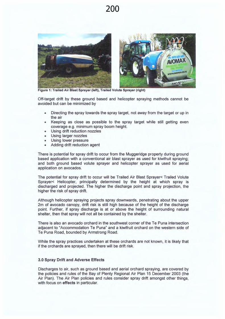
Off-target drift by these ground based and helicopter spraying methods cannot be avoided but can be minimized by
• Directing the spray towards the spray target, not away from the target or up in the air
• Keeping as close as possible to the spray target while still getting even coverage e.g . minimum spray boom height.
• Using drift reduction nozzles • Using larger nozzles • Using lower pressure • Adding drift reduction agent
There is potential for spray drift to occur from the Muggeridge property during ground based application with a conventional air blast sprayer as used for kiwifruit spraying; and both ground based volute sprayer and helicopter sprayer as used for aerial application on avocados.
The potential for spray drift to occur will be Trailed Air Blast Sprayer< Trailed Volute Sprayer< Helicopter, principally determined by the height at which spray is discharged and projected. The higher the discharge point and spray projection, the higher the risk of spray drift.
Although helicopter spraying projects spray downwards, penetrating about the upper 2m of avocado canopy, drift risk is still high because of the height of the discharge point. Further, if spray discharge is at or above the height of surrounding natural shelter, then that spray will not all be contained by the shelter.
There is also an avocado orchard in the southwest corner of the Te Puna intersection adjacent to "Accommodation Te Puna" and a kiwifruit orchard on the western side of Te Puna Road , bounded by Armstrong Road .
While the spray practices undertaken at these orchards are not known , it is likely that if the orchards are sprayed , then there will be drift risk.
3.0 Spray Drift and Adverse Effects
Discharges to air, such as ground based and aerial orchard spraying, are covered by the policies and rules of the Bay of Plenty Regional Air Plan 15 December 2003 (the Air Plan). The Air Plan policies and rules consider spray drift amongst other things, with focus on effects in particular.

201
In essence, Rules 12 and 13 of the Air Plan require that orchard spraying must not result in any harmful concentration of agrichemical beyond the boundary of the subject property or into water. Harmful concentration means a concentration of contaminants that causes or is likely to cause injury to the health of humans or animals, or adversely affect water, soil or plants.
The rules do not specify that there must be no spray drift.
The rules specify that applicators must hold the industry recognized GROWSAFE Certificate and must meet the requirements of NZS 8409: 1999 Code of Practice for the Management of Agrichemicals (the Standard). For aerial application the applicator must also hold a Pilot Chemical Rating (Civil Aviation Authority).
Rules 12c and 13c state "All persons discharging agrichemicals under this rule shall ensure that the agrichemical is used in a manner that complies with NZS 8409:1999 Code of Practice for the Management of Agrichemicals" (the Standard).
Rules 12 and 13 have very clear requirements for notification to neighbours in relation to spraying, with notification no earlier than 20 days and no later than 12 hours before the agrichemical use.
These rules must be complied with for spray operations such as for those horticultural properties in the vicinity of the current and proposed Te Puna Hall sites.
For aerial application notification, the owner/occupier or agent must notify the occupier of any adjoining properties within 200m of that agrichemical use. For ground based spraying, the owner/occupier or agent must notify the occupier of any adjoining properties within 50m of that agrichemical use. Note that the draft new BoP Regional Council Regional Air Plan 26 April 2016 has a proposed notification distance for aerial application of 300m.
These notification distances are just that, notification distances; not spray buffer zones intended to specify a minimum separation distance between point of spray application and off targets of spraying .
Mr and Mrs Muggeridge are required by the Air Plan rules to notify neighbours within 50m of the edge of the orchard for ground based spraying and 200m of the edge of the orchard for aerial spraying.
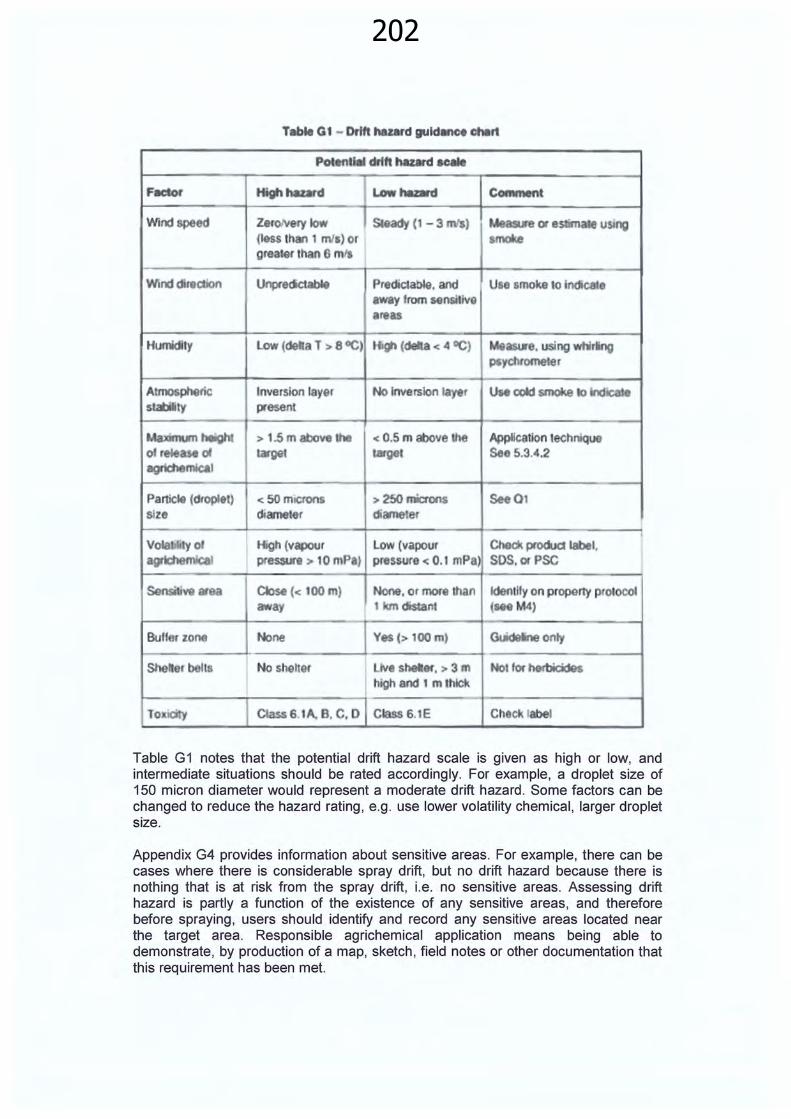
Appendix G of the Standard provides information about spray drift hazard and weather conditions and summarises the various factors affecting spray drift hazard in Table G1.
Aerial spraying of avocados is considered as having a high drift hazard because of the height at which spray is discharged; and because helicopter spraying typically concentrates the active ingredient applied in a lesser volume of water than would otherwise have been used for ground application .
202
F8dor
Windspe
Winddi n
Humidity
AtmosphQtic ' ty
MaJIII1Um height ofr d agric:tMtmb.1
Particle (dropltt) Slle
Table Gt- Drift hazard guld llnCI ctwrt
p chtft hazard "* Highhatatd Lowt.z:.d Convnent
Z8f01Very low using (Jess than 1 mta) or greater th Gmfl
U~clctable Predictab!e. and Use smoke 10 indlcat wway 1rom sensi1ive areas
low (detla T > 8 GC) H9' ( a< 4 OC) Me e. using whirling P~yd\rome er
tnversion layer present
> 1.5 m above target
< 50 miCfOr'l
d1ameter
Close(< 100m) away
No shelter
<0.5m above Application technlq targel See 5.3.4.2
> 250 "*'ons See01 diame er
Low (vapour Chock product label, pntssure < 0.1 mPa SOS. ot PSC
ldentUy on propony pr01oco1 (Me M4)
Guldeine only
Ch Ck label
Table G1 notes that the potential drift hazard scale is given as high or low, and intermediate situations should be rated accordingly. For example, a droplet size of 150 micron diameter would represent a moderate drift hazard. Some factors can be changed to reduce the hazard rating, e.g. use lower volatility chemical, larger droplet size.
Appendix G4 provides information about sensitive areas. For example, there can be cases where there is considerable spray drift, but no drift hazard because there is nothing that is at risk from the spray drift, i.e. no sensitive areas. Assessing drift hazard is partly a function of the existence of any sensitive areas, and therefore before spraying , users should identify and record any sensitive areas located near the target area. Responsible agrichemical application means being able to demonstrate, by production of a map, sketch, field notes or other documentation that this requirement has been met.

203
G 4 (c) gives the example of a sensitive area as "Public places and amenity areas where people congregate". The Te Puna Hall in its proposed location satisfies the definition of a sensitive area. The current Te Puna Hall carpark is just beyond the 200m notification distance for aerial application.
Another sensitive area included in section G4 of the Standard is public roads. State Highway 2 adjacent to the Muggeridge property is therefore a sensitive area.
Appendix G6 provides information about buffer zones and shelter belts, as these can be effective tools for reducing the hazard to a sensitive area.
Table G2 - Buffer zones
Application method Distance (metres)
With shelter Without shelter -Boom sprayer 2 10
Air blast sprayer 10 30
Aerial application 100 300
NOTE -These distances are subject to:
(a) The equipment used (boom, air blast, aircraft) being calibrated and operated correctly.
(b) All other appropriate strategies being observed to reduce sptay drift hazard (table G1).
(c) Shelter should be complete and without gaps at the base.
For aerial application, a sensitive area is considered a high hazard for drift if the sensitive area is close, that is less than 1OOm away and conversely, low hazard for drift, if the sensitive area is more than 1 km away.
No buffer zone is considered high hazard for drift and conversely, a buffer zone of >1OOm is considered low hazard for drift. Buffer zones are noted as being only one of many methods to manage and reduce drift hazard and the distances recommended are guidelines.
No shelter is considered a high hazard for drift and conversely, live shelter of greater than 3m height and 1m thick is considered a low hazard for drift.
Opus Notification and Buffer Zone Plan shows the footprint of the proposed Te Puna Hall site plan 101 E and the following distances.
• 10m - NZS 8409:2004 Managing Agrichemicals Code of Practice (No. HSNOCOP 3-1 09-04); Table G2 buffer zone for ground based spraying with shelter
• 30m - NZS 8409:2004 Managing Agrichemicals Code of Practice (No. HSNOCOP 3-1 09-04); Table G2 buffer zone for ground based spraying without shelter
• 50m - BoPRC Current Air Plan rule 13 d, notification distance for ground based spraying (no change in proposed new Air Plan rules)
• 1OOm - NZS 8409:2004 Managing Agrichemicals Code of Practice (No. HSNOCOP 3-1 09-04); Table G2 buffer zone for aerial application with shelter
• 200m - BoPRC Current Air Plan rule 12 d, notification distance for aerial spraying (proposed change in new Air Plan rules to 300m)
204
• 300m - NZS 8409:2004 Managing Agrichemicals Code of Practice (No. HSNOCOP 3-1 09-04); Table G2 buffer zone for aerial application without shelter
Refer Appendix 1: Notification and Buffer Zone Distances
The Muggeridge orchard has natural shelter present at the eastern edge of the avocado orchard.
For both ground spray and aerial spray applications to the Muggeridge avocados, the proposed Te Puna Hall site car park area falls within the 50m and 200m notification distances respectively.
For ground spray application to the Muggeridge kiwifruit on both sides of the avocado block, the proposed Te Puna Hall site car park area falls beyond the 50m notification distance.
For air blast ground spray application, such as to the avocados for most applications and kiwifruit for all applications at the Muggeridge and other adjacent properties, there are no sensitive areas currently or proposed to be within the 1Om buffer zone with shelter.
For aerial spray application to the avocados, two sensitive areas fall within the 1OOm buffer zone with shelter; all of the proposed Te Puna hall site and all of State Highway 2 adjacent to the Muggeridge property.
4.0 Spray Drift Adverse Effects Risk Management
4.1 Spray Notification
Mrs Muggeridge advised that aerial application is typically undertaken once or twice a year, at differing times, not necessarily in winter only. Application is in response to independent crop monitoring under Avogreen protocols for pests, which provides information to growers on when pest action thresholds are exceeded and intervention by spraying is warranted.
Mr and Mrs Muggeridge consider that it is not always possible to achieve good canopy coverage for effective pest control from ground based spraying, hence the decision to occasionally apply agrichemicals by helicopter spraying.
Although not specifically discussed, the implication is that good canopy coverage for effective pest and disease control can mostly be achieved by ground based spraying, since that is how most of the avocado pest and disease control spraying is done on the Muggeridge avocados.
There are many avocado growers who undertake the practice of occasional aerial spraying for pest control (for Thrips and Leaf Roller, for example). Avogreen monitoring is not undertaken in the tops of tall avocado trees, simply because it is not possible for crop monitoring staff to assess pest levels in those areas of the avocado canopy.
Notification steps currently undertaken by Mr and Mrs Muggeridge prior to aerial application on avocados include

205
• signage is placed at the property entrance adjacent to State Highway 2, in order to inform road users that spraying is to take place
• an advertisement is placed in the public notices (publication medium not confirmed)
• Mr or Mrs Muggeridge telephone neighbours to notify, typically the day before application is due
The owners of the Four Square and rental house to the north of the Four Square confirmed to me in interview that they receive a telephone call from Mrs Muggeridge advising when spraying is to be undertaken. They also confirm as advised by Mrs Muggeridge, that aerial application is done early in the morning (typically around 6am to ?am), which Mr and Mrs Muggeridge elect as a good time for aerial spraying because there are usually fewer people about at that time of day.
This proposed location for the hall would therefore require of Mr and Mrs Muggeridge that they provide spray notification to Te Puna Hall site users for all avocado aerial sprays and all avocado ground based sprays.
Notification for ground and aerial based sprays, including Site 101 E Te Puna Hall users, is an additional responsibility Mr and Mrs Muggeridge would be obliged to take on, as per the Air Plan.
This poses some challenges and requires goodwill on the part of the Hall Owners, Managers and Mr and Mrs Muggeridge to find sensible solutions. Mr and Mrs Muggeridge cannot be expected to notify every possible user of the Te Puna Hall, when they plan avocado spraying .
A possible workable scenario is for the Hall Owners to designate a Hall Manager to be the telephone, text or email contact for receipt of spray notifications from Mr and Mrs Muggeridge. That contact person, who presumably manages the booking schedule for the hall , will be aware of user groups, user group contact details and bookings. The contact person would then forward the notification to any users booked for the nominated date for application.
Hall users would need to understand and accept when they confirm bookings for the Te Puna Hall, that when avocado spraying may take place, their nominated user group contact will notify them when application is planned and potential users can make their own decisions accordingly.
In addition , the Hall Owners and Managers could establish an ongoing protocol that notifications are physically posted at the hall entries as soon as possible after notification, prior to application.
An alternative, practical but less flexible approach is to simply cancel bookings for user groups on the days when avocado applications are to be made.
Rule 13 (d) of the plan requires that Mr and Mrs Muggeridge notify the occupier of the site (Te Puna Hall). Rule 13 (c) requires that the Mr and Mrs Muggeridge ensure that agrichemicals are used in a manner that complies with the Standard.
The Standard , section 5.3.1 requires "Any person who is likely to be directly affected (Appendix M2.2) by the application of agrichemicals has a right to information about the operation. The owner or occupier of the property on which the spraying is to take place shall inform, at intervals of no more than once a year, any person who is likely

206
to be directly affected by the application , that a spray plan (see Appendix M4) has been prepared and is available on request. More or less frequent information may be provided where mutually acceptable arrangements have been agreed to, and recorded on the spray plan. " (Appendix M of the Standard covers normative information about notification).
Property owners such as the owners of the Te Puna Hall , may also wish to be notified under the Standard notification s.5.3.1 , as owners need to be informed on their own behalf as well as on behalf of those who use their property.
4.2 Other Risk Management Practices
Other reasons also support the decision to aerial spray early in the morning, which enable Mr and Mrs Muggeridge to manage drift risk and consequent harmful concentration of agrichemical beyond the boundary of the Muggeridge property including
• It is sufficiently light for helicopter operations, so the operator can clearly see in and around the target spraying environment, to be alerted to any unexpected hazards
• Wind speeds may be more constant than at later times in the day • Wind direction is often more predictably steady than at later times in the day • Relative humidity is higher than at later times of the day
These points underline that Mr and Mrs Muggeridge currently undertake aerial application of agrichemicals to their avocados, mindful of the need to achieve effective pest and disease control, while also adhering to both the notification rules of the Air Plan and the guideline buffer zone for aerial spraying adjacent to a sensitive area, State Highway 2, without causing harmful concentration of agrichemical beyond the property boundary.
Oceania Helicopters who undertake aerial spraying of the avocados at the Muggeridge property advise that they spray in the morning and finish no later than 7.30am at this site. The reason for this cut-off time for completing spraying is that they wish to avoid spraying when there are movements of school children on the way to school , from about that time of the day.
Oceania Helicopters undertake their own calibration procedures to ensure output rates, output pattern and droplet sizes produced enable them to achieve desired pest control outcomes while minimising spray drift. The company operating procedures are independently audited annually by AsureQuality, to meet GAP requirements. The output nozzles used for avocado spraying are Disc-core type hollow cone nozzles (D1 0 - 46) mounted on an 8m boom. Each nozzle produces a hollow cone spray pattern with droplet VMD of about 400 microns at operating pressure of about 60psi (413kPa). Droplets of this VMD are not prone to drift.
The time taken by Oceania Helicopters to apply spray to the block is about 4 minutes per application. Allowing for wind speeds of 1 km/hour, (i.e. relatively slow movement of any spray drift), exposure time for spray drift at the proposed Te Puna Hall would be about 6 minutes. Typical spray wind speeds are in the range of 0 - 6km/hour for ground based spraying and a lesser upper wind speed for aerial spraying.
A practical modification to mitigate spray drift risk from aerial spray application to Muggeridge avocados, may simply be to not permit the Te Puna Hall to be used for overnight purposes and not before 7.30am in the morning.