FIG. 2-1 Historic character buildings are …cms.cityoftacoma.org/Planning/North Downtown...
24
1 CITY OF TACOMA NORTH DOWNTOWN SUBAREA PLAN DRAFT FIG. 2-1 Historic character buildings are interspersed among more contemporary structures throughout the North Downtown Subarea.
Transcript of FIG. 2-1 Historic character buildings are …cms.cityoftacoma.org/Planning/North Downtown...

1 CITY OF TACOMA NORTH DOWNTOWN SUBAREA PLAN DRAFT
FIG. 2-1 Historic character buildings are interspersed among more contemporary structures throughout the North Downtown Subarea.

DRAFT NORTH DOWNTOWN SUBAREA PLAN CITY OF TACOMA 2
North Downtown Tacoma is an eclectic collection of mixed-use districts that ranges in character from downtown commercial center to multifamily neighborhood. The Subarea’s walkability and robust transit service provide easy access to a range of downtown destinations including healthcare facilities, parks, restaurants, art galleries and the downtown farmer’s market, as well as institutional amenities such as Tacoma’s public library, the YMCA, and Bates Technical College. The Subarea’s range of housing options and revitalized Theater District have attracted a broad arts community to the area. North Downtown’s rich cultural resources include two historic districts and a concentration of city landmarks that lend it a distinctive character and civic presence. Within the context of these numerous urban assets, there is also room for growth: vacant lots, surface parking, and underutilized commercial and office space all present opportunities to help North Downtown realize its full potential.
NORTH DOWNTOWNCONTEXT
02
THE NORTH DOWNTOWN SUBAREA
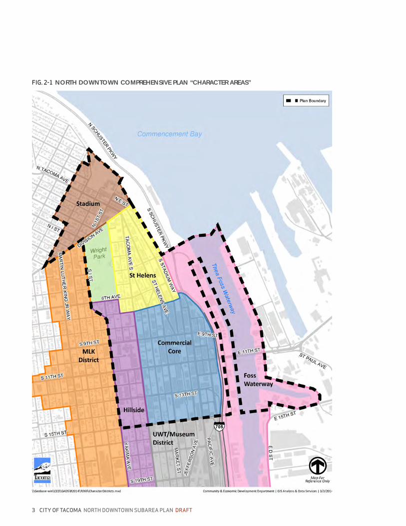
The North Downtown Subarea encompasses approximately 520 acres of urban commercial and mixed-use neighborhoods in the northern half of Tacoma’s downtown. The Subarea is bordered by the University of Washington - Tacoma and the Museum District to the south, the Hilltop mixed-used residential district to the west, the Old Town and Proctor districts to the north, and the Port of Tacoma to the east. The Subarea is comprised of four distinct character areas: the Downtown Core, the St. Helens neighborhood, the Stadium District, and the Foss Waterway.
The Downtown Core
The Downtown Core is the portion of downtown bounded by South 7th Street, Tacoma Avenue South, South 15th Street and the waterfront. With the highest intensity of urban uses in Tacoma, it functions as the center for governmental, cultural, business, financial activities. The area is the visual and commercial focal point for the city and offers a variety of day and nighttime activities for
locals and visitors, such as theater, art galleries, shopping, and dining. The principal retail corridors are located along Pacific Avenue and Broadway south of 7th Avenue. The City has completed numerous projects to improve the area’s walkability and the quality of the public realm.
The Downtown Core is home to the regional headquarters for many companies, and it is located just across the Foss Waterway from The Port of Tacoma, one of the largest container ports in North America. It is served by the I-705 spur, which provides easy access to the interstate freeway system via on- and off-ramps between South 13th and 15th Streets. Ample parking can be found throughout the Subarea in structured and surface lots, as well as on the street.
The Downtown Core is a hub for important local and regional transit connections. Tacoma LINK light rail, in operation since 2003, has helped draw residents to downtown, and a planned extension from downtown to the Stadium District and the Hilltop neighborhood will further expand the system’s access. The Commerce
3 CITY OF TACOMA NORTH DOWNTOWN SUBAREA PLAN DRAFT
FIG. 2-1 NORTH DOWNTOWN COMPREHENSIVE PLAN “CHARACTER AREAS”

DRAFT NORTH DOWNTOWN SUBAREA PLAN CITY OF TACOMA 4
Street Transit Center, located between South 9th and 11th Streets, is served by light rail and provides a point of connection for most bus routes traversing downtown Tacoma.
The downtown campus of Bates Technical College (BTC) is located on the west edge of the Downtown Core, bordered by South 11th and 13th Streets, South Altheimer Street and South Yakima Avenue. BTC has been providing vocational training in the Tacoma area for more than 75 years and has recently updated its facilities master plan. For more information on BTC, see the Economic Development Chapter.
St. Helens
The St. Helens neighborhood consists of the triangle of land bounded approximately by Division and Tacoma Avenues to the north and west, South 7th Street to the south, and Stadium Way to the east. Wright Park, a 27-acre open space amenity, is located directly to the west and is easily accessible from St. Helens.
This medium-density mixed-use neighborhood looks out over Thea Foss Waterway and provides a transition between the historic civic center of the Downtown Core and the more residential Stadium District on the bluff above. Although visible from most areas in St. Helens, the waterway is difficult to reach due to the steep, wooded slope between Stadium Way and Schuster Parkway and the BNSF railroad tracks that parallel the shoreline.
I-705, the short freeway spur connecting downtown Tacoma to I-5, terminates between 9th and 7th Avenues at the south end of the neighborhood, providing a transition from the interstate highway system to the city street grid.
With its successful retail core along St. Helens Avenue, the neighborhood is home to an array of businesses and multifamily residential buildings, both apartments and condos. Attractive infill redevelopment opportunities exist in St. Helens, and portions of Broadway and St. Helens Avenue have recently been upgraded under a Local Improvement District funded by adjacent property owners.
FIG. 2-1 A view of Old City Hall and the Theater District light rail station.
FIG. 2-1 Commerce Street serves as North Downtown’s transit hub, providing transit users with an opportunity to make connections between the bus and light rail systems.

5 CITY OF TACOMA NORTH DOWNTOWN SUBAREA PLAN DRAFT
FIG. 2-1 Wright Park’s 27 acres include public amenities such as a loop trail, an arboretum, lawn bowling courts, picnic and play areas, and an outdoor performance venue.
FIG. 2-1 The Stadium district is home to a variety of multifamily housing options, including condos as well as rental units.
FIG. 2-1 The locally-owned Stadium Thriftway, located on North 1st Street, has been operating as a full-service grocer in the Stadium District since 1985.
FIG. 2-1 The Triangle Townhomes, a 27-unit condo development in the St. Helens district, are one of the first Built Green projects in downtown Tacoma.
FIG. 2-1 Tacoma’s First Presbyterian Church, founded in 1873, has been at its current location since 1925. The Romanesque structure was designed by famous church architect Ralph Adams Cram.
FIG. 2-1 Bates Technical College’s downtown campus is located on two city blocks between South 11th and 13th Streets, on the west edge of the North Downtown subarea.

DRAFT NORTH DOWNTOWN SUBAREA PLAN CITY OF TACOMA 6
The Stadium District
The Stadium District is located just north of Tacoma’s downtown commercial core, adjacent to the North Slope and Hilltop neighborhoods to the west and north. The district is named after Stadium High School, an architectural and historic icon which has been operating within the Tacoma School District for more than 100 years.
Situated on a bluff overlooking Commencement Bay, the Stadium District is significantly higher in elevation than much of the Downtown Core area. The neighborhood is located adjacent to Wright Park and the Seymour Conservatory, which constitute a valuable open space amenity within a highly urbanized context.
The district is home to a mix of retail and service businesses including a grocery store, drug store, dry cleaners, bank, tailor, hair salons, coffee shops and eateries. Many businesses within the district are family-owned. The area around the intersection of North 1st Street and Tacoma Avenue serves as a commercial node and neighborhood center for the area’s large population of apartment-dwelling residents.
The Thea Foss Waterway
The Thea Foss Waterway, an inlet of Commencement Bay, has provided access to Tacoma’s deepwater port since the turn of the 20th century. Initially a thriving industrial center, the waterway languished midcentury and was largely abandoned by the 1980s. Due to many years of chemical and industrial pollution, it was designated as part of the Commencement Bay Superfund site in 1983. Remediation was completed in 2006.
Today, the west shore of the Foss Waterway is the site of many redevelopment projects, including new parks, residential and office space, and a waterfront esplanade. The east side of the Foss remains largely industrial in character and is home to fueling docks and marine services companies as well as the Center for Urban Waters, an environmental research center that opened in 2010. The LEED-platinum facility is a partnership between UW-T, City of Tacoma Environmental Services, and the Puget Sound Partnership.
FIG. 2-1 Stadium High School, a Tacoma icon, has been part of the Tacoma Public School system since 1906.
FIG. 2-1 North Downtown has little single family housing stock. What does exist can be found on the north and west edges of the Stadium District.
FIG. 2-1 The Center for Urban Waters research facility, located on the east bank of the Foss, opened after the completion of the Superfund site remediation.

7 CITY OF TACOMA NORTH DOWNTOWN SUBAREA PLAN DRAFT
1 inch = 1/4 mile
FIG. 2-1 NORTH DOWNTOWN TOPOGRAPHY, 10’ CONTOURS
LEGEND
North Downtown Subarea boundary

DRAFT NORTH DOWNTOWN SUBAREA PLAN CITY OF TACOMA 8
HISTORY
Plentiful fishing grounds and abundant natural resources on the tideflats of the Puyallup River delta led the Puyallup Tribe and other Coast Salish native peoples to call the Tacoma downtown area home for millennia. But in 1852, sweeping change began with Nicolas Delin’s sawmill, which was established near the south end of the Thea Foss Waterway.
The downtown area was originally known as “New Tacoma,” independent from the older settlement further north known as “Tacoma City.” Growth in downtown was catalyzed by the 1873 decision to place the terminus of the Northern Pacific Railroad’s transcontinental line on the shores of Commencement Bay. In late 1883, Tacoma City and New Tacoma merged to form the City of Tacoma. During the late 1800s, industrial, warehousing, and commercial brick and stone buildings appeared along a growing network of rail corridors. In 1888, two streetcar lines were constructed connecting the length of Pacific Avenue and Tacoma Avenue.
Dredging for the Thea Foss Waterway was completed by the Army Corps of Engineers in 1907. In 1911, the Northern Pacific Railroad erected a grand terminal called Union Station that replaced Northern Pacific’s prior stations and also served the Union Pacific and Milwaukee Road transcontinental rail lines. During the following decades, settlement patterns expanded away from the core areas served by the railroad, and the area’s economy grew and diversified beyond its initial focus on maritime trade and resource extraction.
The construction of I-5 and the Tacoma Mall contributed to the decline of Tacoma’s downtown during the 1960s through the 1980s. By the 1990s, a recovery had begun to take shape in downtown, fueled by ongoing major investments, including the renovation of the historic Pantages (1983) and Rialto theaters (1991), the Foss Waterway cleanup (2006), and the development of the Foss Esplanade (ongoing). Catalytic infrastructure improvements include the opening of Sound Transit LINK light rail (2003) and its subsequent expansion (ongoing) as well as the renovation of the historic Murray Morgan Bridge (2013).
FIG. 2-1 Old City Hall’s freestanding clock tower, which serves as a downtown landmark, was not part of the original 1893 structure - it was added nine years later, in 1904.
FIG. 2-1 Renovation work on the Murray Morgan Bridge was completed in time to celebrate its 100th anniversary in February of 2013. The bridge serves as an important link between downtown Tacoma and the Port of Tacoma.

9 CITY OF TACOMA NORTH DOWNTOWN SUBAREA PLAN DRAFT
FIG. 2-1 Pedestrian amenities, such as this urban park and water feature at corner of South 11th Street and Broadway, contribute to the quality of the downtown urban streetscape.
FIG. 2-1 A view from Broadway east toward structured and surface parking flanking Commerce Street.
FIG. 2-1 Parking garages and character structures flank the sidewalks along Pacific Avenue in the Downtown Core.
FIG. 2-1 The east bank of the Thea Foss Waterway is industrial in character, home to warehouses, docks and marine-related businesses.

DRAFT NORTH DOWNTOWN SUBAREA PLAN CITY OF TACOMA 10
BUILT ENVIRONMENT
Within the North Downtown Subarea, the mainly rectilinear street grid makes two significant shifts - one between the Downtown Core area and St. Helens in the vicinity of 6th and 7th Avenues, and another, more significant, shift between St. Helens and the Stadium District at Division Avenue. In the Downtown Core, most blocks are approximately 700 x 300 ft in size with a north-south orientation. They become irregular in shape and size as they negotiate the slope between downtown and the Stadium District and as the grid shifts to parallel the shoreline.
A range of building types are represented within the Subarea. The Downtown Core contains historic commercial and residential structures mixed with new mid- and high-rise office buildings. Surface and structured parking options are abundant.
The St. Helens neighborhood shares the Downtown Core’s dense urban character, but the majority of the buildings in this district are multifamily residential - apartments and condos. There are many commercial structures as well, but they are generally more modest in scale than those in the Downtown Core.
Further north, the built environment of the Stadium District illustrates the transition from a downtown urban context to a residential neighborhood environment, with smaller scale commercial buildings and a mix of apartment buildings and single family homes.
The North Downtown Subarea also includes the east bank of the Foss Waterway, which is home to an assortment of marine services companies, fuel docks, and warehouses as well as the Center for Urban Waters.
Several notable public spaces contribute to the pedestrian character of the subarea, including the Pacific Avenue streetscape, the 12th Street hillclimb that provides an east-west connection from Pacific Avenue to Broadway, and the Foss Esplanade along the waterfront. City-owned parks in the South Downtown Subarea include Wright Park, Firemen’s Park and Thea’s Park, which sits at the entrance to the Foss Waterway. Open space lands, urban parks and recreational facilities are managed by Metro Parks Tacoma.
FIG. 2-1 Neighborhood-scale commercial development at the intersection of N 1st Street & St. Helens Avenue.
FIG. 2-1 The Stadium District provides a range of housing options, from single-family houses to midrise apartments.
FIG. 2-1 A north-facing view along Tacoma Avenue South illustrates the range of mid- and high-rise housing in the St. Helens district.

11 CITY OF TACOMA NORTH DOWNTOWN SUBAREA PLAN DRAFT
TABLE 2-1 NORTH DOWNTOWN ECONOMIC, EMPLOYMENT, AND HOUSING DATA
Parameter North Downtown Tacoma Pierce
CountyKing
CountyWA
State USA
ECONOMICS (2013 data)
Median Household Income $20,529 $47,862 $57,869 $66,174 $57,244 $50,046
Per capita Income $23,952 $25,377 $27,466 $36,410 $29,733 $26,059
Poverty Rate n/a 16% 12% 12% 13% 15%
EMPLOYMENT
Unemployment Rate 13% 13% 12% 9% 11% 11%
Not in Labor Force n/a 37% 34% 30% 35% 36%
OCCUPATION
Management, business, science, and arts 41% 34% 32% 48% 39% 36%
Service 25% 22% 19% 15% 18% 18%
Sales and office 21% 25% 26% 22% 23% 25%
Natural resources, construction, maintenance 4% 8% 10% 6% 10% 9%
Production, transportation, material moving 9% 11% 12% 9% 11% 12%
HOUSING
Number of Units 4,523 85,786 325,375 851,261 2,885,677 131,704,730
Occupancy Rate 88% 92% 92% 93% 91% 89%
Renter Occupied 89% 46% 37% 41% 36% 35%
Owner Occupied 11% 54% 63% 59% 64% 65%
Median Home Value $262,795 $230,400 $252,000 $385,600 $271,800 $179,900
Median Gross Rent n/a $856 $964 $1,036 $908 $855
Percent Single-family Detached n/a 62% 66% 56% 64% 61%

DRAFT NORTH DOWNTOWN SUBAREA PLAN CITY OF TACOMA 12
TABLE 2-2 NORTH DOWNTOWN DEMOGRAPHIC AND HOUSEHOLD DATA
Parameter North Downtown Tacoma Pierce
CountyKing
County WA State USA
DEMOGRAPHICS
Population 7,550 198,397 795,225 1,931,249 6,724,540 308,745,538
Median Age 36.7 35.1 35.9 37.1 37.3 37.2
Percent Less than 18 years of Age 9% 23% 24% 21% 24% 24%
Percentage Age 65 or Older 13% 11% 11% 11% 12% 13%
Percent Male 55% 49% 50% 50% 50% 49%
Percent Female 45% 51% 50% 50% 50% 51%
POPULATION BY RACE
White 69% 65% 74% 69% 77% 72%
Black 15% 11% 7% 6% 4% 13%
American Indian 2% 2% 1% 1% 2% 1%
Asian 6% 8% 6% 15% 7% 5%
Pacific Islander 1% 1% 1% 1% 1% <1%
Two or more races 6% 8% 7% 5% 5% 3%
Other 1% 5% 4% 4% 5% 6%
Hispanic (any race) 8% 11% 9% 9% 11% 16%
Percent Foreign Born n/a 13% 9% 20% 13% 13%
Percent non-English Spoken at Home n/a 18% 14% 26% 18% 21%
EDUCATIONAL ATTAINMENT (AGE 25+)
High School Graduate (or higher) 82% 87% 90% 90% 90% 86%
Bachelor’s Degree (or higher) 25% 24% 23% 31% 31% 28%
Graduate/Professional Degree 9% 9% 8% 17% 11% 10%
HOUSEHOLDS
Number of Households 3,967 78,541 295,554 787,809 2,606,863 114,567,419
Average Household Size 1.57 2.44 2.59 2.41 2.51 2.58
Percent Householder Living Alone 69% 33% 25% 31% 27% 25%
Percent Households with Children 9% 31% 35% 29% 32% 33%
Percent Households in Group Quarters 17% 3% 2% 2% 2% 3%

13 CITY OF TACOMA NORTH DOWNTOWN SUBAREA PLAN DRAFT
DEMOGRAPHICS
General Population
Selected demographic data for the North Downtown Subarea and other geographies are shown in Tables 2-1 and 2-2. Characteristics of the Subarea that stand out from the City of Tacoma as a whole and from the greater region are summarized below:
Demographics
• Much lower percentage of children
• Slightly higher percentage of elderly
• Higher percentage of Blacks
• Male/female split that is somewhat skewed towards male
• Lower educational attainment
Households
• Very low average household size
• Very high percentage of single-person households
• Very low percentage of households with children
• Very high percentage of households in group quarters
• Very high percentage of renter-occupied units and very low percentage of owner-occupied units
Economics
• Low median household income and per capita income
• Relatively high proportion of management/business/science/arts and service occupations
• Relatively low proportion of natural resources/construction/maintenance occupations
Housing
• High percentage of renting versus ownership
Employment
Data on covered employment in various sectors in the North Downtown Subarea are given in Table 2-3. Covered employment refers to jobs “covered” under the state’s Unemployment Insurance program, and constitutes approximately 85-90% of total employment. The jobs-housing ratio is approximately 4, which is higher higher than typical urban areas, reflecting that North Downtown is a job center.
Covered employment in the North Downtown Subarea dropped by approximately 19 percent between 2000 and 2011. In comparison, covered employment within the entire City of Tacoma dropped from 99,810 in 2000, to 95,318 in 2011, corresponding to a much smaller decline of approximately 4.5 percent. These declines can be largely attributed to the Great Recession, though North Downtown was more vulnerable than the City on average. The manufacturing and FIRE (finance/insurance/real estate) sectors were particularly hard hit, each losing at least 50% of jobs.
Job sector percentages in North Downtown compared to other cities are shown in Table 2-4. Comparatively, North Downtown has a relatively low fraction of retail, manufacturing and wholesale/transportation/utilities jobs, and a relatively high fraction of government, finance, insurance, and real estate jobs.
Add information on largest/most significant employers in North Downtown, # jobs provided (State Farm ~1100 jobs, etc... - NEED INFORMATION).

DRAFT NORTH DOWNTOWN SUBAREA PLAN CITY OF TACOMA 14
TABLE 2-3 COVERED EMPLOYMENT IN THE NORTH DOWNTOWN SUBAREA
SECTOR
2000 2011
Jobs
Wor
kpla
ces
Jobs
Wor
kpla
ces
Const/Res 107 12 70 19
FIRE 2,868 104 1,432 98
Manufacturing 509 17 219 15
Retail 322 30 208 28
Services 7,842 358 7,365 444
WTU 161 14 106 19
Government 3,177 64 2,778 63
Education 877 9 600 3
Total 15,863 608 12,779 689
TABLE 2-4 COMPARISON OF COVERED EMPLOYMENT BY SECTOR PERCENTAGE
CITY (2011)
Cons
t/ R
es
FIRE
Man
ufac
turin
g
Reta
il
Serv
ice
WTU
Gov
ernm
ent
Educ
ation
North Downtown >1% 11% 2% 2% 57% 1% 22% 5%
Tacoma 3% 4% 6% 11% 51% 5% 13% 6%
Bremerton 3% 7% 6% 8% 52% 6% 10% 7%
Everett 2% 3% 42% 7% 29% 4% 9% 3%
Bellevue 3% 9% 4% 10% 59% 7% 3% 3%
Seattle 3% 7% 6% 8% 52% 6% 10% 7%

15 CITY OF TACOMA NORTH DOWNTOWN SUBAREA PLAN DRAFT
CONSISTENCY WITH EXISTING PLANS AND POLICY
The objectives and policies of the North Downtown Subarea Plan are well aligned with, and strongly supported by, an abundance of existing plans policies at the Federal, State, regional, and local levels. These plans and policies have been put in place to foster precisely the kind of outcome that is sought by the North Downtown Subarea Plan: a vibrant, walkable, mixed-use community that provides a robust range of housing, transportation, employment, and recreation choices; a community that is a welcoming home to people of all cultures, ages, and incomes. The following section discusses these plans and policies.
Washington State Growth Management Act
Adopted in 1990, the Growth Management Act (GMA) sets forth 13 goals, including the following six that are most directly aligned with the overall objectives of the North Downtown Subarea Plan:
• Encourage development in urban areas where adequate public facilities and services exist or can be provided in an efficient manner.
• Reduce the inappropriate conversion of undeveloped land into sprawling, low-density development.
• Encourage efficient multimodal transportation systems that are based on regional priorities and coordinated with County and City comprehensive plans.
• Promote economic opportunity… especially for unemployed and for disadvantaged persons, promote the retention and expansion of existing businesses and recruitment of new businesses… encourage growth in areas experiencing insufficient economic growth.
• Protect the environment and enhance the State’s high quality of life, including air and water quality.
The GMA requires municipalities to plan for accommodating growth, and grants counties, in consultation with cities, the authority to assign growth
allocations for population and employment. In general, the goals of the GMA will be most successfully achieved by maximizing the portion of growth that can be accommodated in urbanized areas with adequate infrastructure.
Assigned by the Pierce County Regional Council (within parameters set by the PSRC), the City of Tacoma’s allocations are 78,600 new residents and 64,200 new jobs between 2008 and 2030. The North Downtown Subarea Plan is intended to play a key role in helping the City plan for accommodating these allocations, as required by the GMA.
Within Tacoma, GMA goals would be best served by maximizing accommodation of the growth allocations within the downtown Regional Growth Center, where there is plentiful development capacity, a concentration of employment, and significant infrastructure, including a regional transit hub. A 2009 City of Tacoma study estimated that downtown Tacoma has the capacity to accommodate an additional 62,400 people and 42,200 jobs, which is a large portion of the growth allocations.
VISION 2040
VISION 2040 is the PSRC’s vision and strategy for accommodating the five million people and three million jobs expected to be present in the Puget Sound region by 2040, while promoting the “well-being of people and communities, economic vitality, and a healthy environment.” VISION 2040 is also the policy document that provides the rationale for assigning growth allocations to meet the requirements of the GMA, as noted above.
One of the six overarching goals of VISION 2040 is to “focus growth within already urbanized areas to create walkable, compact, and transit-oriented communities that maintain unique local character.” Even more pertinent to North Downtown Tacoma, VISION 2040 establishes the following policy: “Encourage efficient use of urban land by maximizing the development potential of existing urban lands, such as advancing development that achieves zoned density.”1
1 http://psrc.org/growth/vision2040

DRAFT NORTH DOWNTOWN SUBAREA PLAN CITY OF TACOMA 16
One of VISION 2040’s key strategies is to concentrate growth in urban centers, defined as “locations identified to take a greater proportion of future population and employment in order to curb sprawl.” Centers are characterized by “compact, pedestrian-oriented development, a mix of different office, commercial, civic, entertainment, and residential uses,” along with “improved accessibility and mobility for walking, biking, and transit.”
At the top of VISION 2040’s hierarchy of centers are the Regional Growth Centers, “envisioned as major focal points of higher density population and employment, served with efficient multimodal transportation infrastructure and services.” Downtown Tacoma is one of the 27 designated Regional Growth Centers, and the North Downtown Subarea comprises most of its northern half. The objectives of the North Downtown Subarea Plan are completely in sync with VISION 2040’s intention to target growth and leverage the potential of Regional Growth Centers.
Pierce County Countywide Planning Policies
In accordance with Washington State’s GMA, the Pierce County Regional Council maintains the Pierce County Countywide Planning Policies (PCCPP) to coordinate planning countywide. Updated in 2012, the PCCPPs include a wide range of policies that support the objectives of the North Downtown Subarea Plan, with the most relevant policies summarized below:2
Community and Urban Design
Each municipality in the County will develop high quality, compact communities that:
• Impart a sense of place
• Preserve local character
• Provide for mixed uses and choices in housing types
• Encourage walking, bicycling, and transit use
2 http://www.co.pierce.wa.us/pc/abtus/ourorg/pcrc/index.htm
Economic Development and Employment
The County, and each municipality in the County, will work to achieve a prospering and sustainable regional economy by supporting business and job creation, investing in all people, sustaining environmental quality, and creating great central places, diverse communities, and high quality of life by:
• Providing an adequate supply of housing with good access to employment centers
• Determining a reasonable “jobs/housing” balance and then coordinating land use and development policies to help achieve the designated balance of adequate affordable housing accessible to employment centers
• Providing opportunities and locations for incubator industries
• Marketing development opportunities
• Encouraging redevelopment of underutilized commercial areas
• Encouraging the location of economic development activities in areas served by public transit and adequate transportation facilities
• Reducing inefficient, sprawling development patterns
• Reducing transportation demand
• Promoting development in areas with existing available public facility capacity
• Encouraging joint public/private development as appropriate
• Concentrating a significant amount of economic growth in designated centers
• Promoting infill development to assist in maintaining a viable market for existing businesses
• Utilizing redevelopment or other public financing mechanisms, where appropriate, to maintain existing businesses
• Streamlining permit processing

17 CITY OF TACOMA NORTH DOWNTOWN SUBAREA PLAN DRAFT
Health and Well-Being
The County, and each municipality in the County, will be designed to promote physical, social, and mental well-being, so that all people can live healthier and more active lives, by:
• Designing communities to provide an improved environment for walking and bicycling
• Developing and implementing design guidelines to encourage construction of healthy buildings and facilities to promote healthy people
• Developing and implementing community plans and programs, such as community gardens and farmer’s markets, that provide support for agricultural, farmland, and aquatic uses that facilitate the production of fresh and minimally-processed healthy foods, and encourage community access to those resources
Natural Resources, Open Space, Protection of Environmentally Sensitive Lands and the Environment
Air Quality: Strengthening efforts to reduce pollutants from transportation activities by:
• Reducing vehicle miles traveled (VMT) and auto dependence
• Designing and prioritizing compact communities and neighborhood accessibility for goods and services
Climate Change:
• Direct development into urban areas and compact centers to prevent and reduce the urbanization of ecologically sensitive areas and natural resources
• Increase alternatives to driving alone
• Encourage private and public development of transit-oriented development throughout the country to reduce the need for personal vehicle use
Transportation Facilities and Strategies
The County, and each municipality in the County, shall address substandard LOS for existing facilities by:
• Using transportation demand management (TDM)
• Promoting nonmotorized travel
The County, and each municipality in the County, shall address compatibility between land use and transportation facilities by:
• Using land use regulations to increase the modal split between automobiles and other forms of travel
• Designating high densities in transit and transportation corridors and designated TOD sites
• Requiring pedestrian-oriented design
• Encouraging or requiring mixed use development and TOD
Overall Policies for Non-Industrial Centers
Design Features of Centers: The County and each jurisdiction that designates a center within its comprehensive plan shall encourage density and development to achieve targeted growth:
• [By] encouraging higher residential densities within centers
• [By] allowing for greater intensity of use within centers
• Designated centers are expected to receive a significant share of projected growth in conjunction with periodic disaggregation of countywide population allocations
Transportation, Parking and Circulation: Locate higher densities/intensities of use close to transit stops within centers and seek opportunities to:
• Create a core area to support transit and HOV use
• Establish incentives for developers to provide transit and TDM-supportive amenities

DRAFT NORTH DOWNTOWN SUBAREA PLAN CITY OF TACOMA 18
Implementation Strategies: Jurisdictions should consider incentives for development within centers such as:
• Streamlined permitting
• Financial incentives
• Density bonuses or transfer of development rights (TDR)
• Using SEPA Planned Action provisions to streamline environmental review by conducting environmental analysis during planning and providing permit applicants and the public with more certainty of how impacts will be addressed
Regional Growth Centers
Regional Growth Centers are targeted for employment and residential growth and provide excellent transportation service, including fast, convenient high capacity transit service, as well as investment in major public amenities. Regional Growth Centers shall plan to meet the following criteria:
• A minimum of 25 employees per gross acre of non-residential lands
• A minimum of 10 households per gross acre
• A minimum of 15,000 employees
• Planning recognizing the need to receive a significant share of the regional growth
Tacoma Comprehensive Plan
The Comprehensive Plan is Tacoma’s 20-year plan for physical growth, development and improvement. Its various Elements include a wide range of policies that are aligned with and support the objectives of the North Downtown Subarea Plan, the most relevant of which are summarized below:3
Growth Strategy and Development Concept Element
This Element articulates several relevant policy goals, including:
• “Growth will be directed toward compact mixed-use centers and in nodes along major transportation corridors including primary transit routes.”
• “Support of the high-capacity transit system, including light rail and commuter rail, will be a top priority of the City.”
• “Concentrating growth within mixed-use centers will… strengthen the existing development pattern, protect neighborhoods and the environment and create attractive urban living and working environments which encourage walking, cycling and public transit.”
Also defined are minimum densities appropriate for “High Intensity in Mixed-Use Centers” such as North Downtown:
“Minimum site densities should range from 25 to 80 dwelling units per net acre… Higher minimum densities are envisioned in other parts of the mixed-use centers depending on the established height limit.”
Generalized Land Use Element
In the Generalized Land Use Element, the Mixed-use Centers goal is spelled out as follows:
“To achieve concentrated centers of development with appropriate multimodal transportation facilities, services and linkages that promote a balanced
3 http://www.cityoftacoma.org/Page.aspx?hid=2241

19 CITY OF TACOMA NORTH DOWNTOWN SUBAREA PLAN DRAFT
pattern of growth and development, reduce sprawl, foster economies in the provision of public utilities and services, and yield energy savings.”
Also provided is the following description of Transit-Oriented Development (TOD) that describes desired outcomes for North Downtown, especially as LINK light rail is extended along Stadium Way and Division Avenue, as is currently proposed:
“Multi-family housing and mixed-use projects that support the public investment in fixed route transit service... TODs increase the density of people near transit, including residents, employees, visitors, and customers in a built environment that is pedestrian-friendly and connected to transit. Mixed-use buildings, projects, or areas with a mix of uses are active from early in the morning to late in the evening, making the environment safer for pedestrians and providing peak- and off-peak customers for transit service.”
Downtown Element
In 2008 the City of Tacoma adopted an updated Downtown Element that applies to the entirety of North Downtown. The Downtown Element has seven goals, the following four of which are most relevant to the vision and objectives of the North Downtown Subarea Plan & EIS:
• Resolve the questions of how to responsibly increase density while laying the groundwork for a long-term, high-quality city environment and maintaining Tacoma’s unique character.
• Coordinate land use, transportation and parking strategies through a comprehensive approach to downtown, including its adjacent neighborhoods.
• Build City capacity to create a walkable downtown through the application of best practices and “complete streets” policies.
• Encourage links between economic vitality and environmental quality through an awareness of the regional effects of growth management, land use and transportation decisions.
• Generate new partnerships to promote infill development and link land use policy with economic revitalization strategies.
The Downtown Element includes a range of policies that focus on several specific areas within North Downtown as noted below:
• Commercial Core: The Commercial Core is the employment center of downtown Tacoma and is highly accessible by both freeway and transit. Redevelopment efforts should focus on underdeveloped sites currently used for surface parking and provide a location for high-intensity development while maintaining a pedestrian-priority environment.
» Develop a parking strategy that utilizes Transportation Demand Measures to eliminate parking requirements.
» Create a streetscape master plan for Pacific Avenue to restore its function as Tacoma’s original main street.
» Create a Design Review program for the International Financial Services Area to promote livability standards in new development.
» Leverage public-private partnerships to develop connected, pedestrian-oriented open spaces.
» Provide regulatory relief to incentivize the development of constrained sites.
» Promote redevelopment of the “Courts” by allowing new configurations for development and optimizing the public right-of-way.
• St. Helens: A center of recent growth in downtown housing stock, the St. Helens corridor still presents many opportunities for redevelopment. New development should focus on sensitive infill strategies, the introduction of sustainability concepts, catalyst projects within the public rights-of-way and emphasizing neighborhood connections.
» Enhance walkability by implementing catalyst projects within the public right-of-way

DRAFT NORTH DOWNTOWN SUBAREA PLAN CITY OF TACOMA 20
» Consider adding additional height to help fund specific, strategic public benefits and to revitalize infill sites
» Organize on-street parking to maximize service to downtown while promoting an active street edge, prioritizing cyclist safety, and allowing for future transit service
» Consider the development of urban design guidelines for high-density residential environments
• Hillside: Well served by transit and in close proximity to the UWT and major employment centers, Hillside is an ideal location for midrise residential and mixed-use growth that provides an important transition to the intensity of downtown.
» Provide relief from adjacent density with a focus on ground-level open spaces and pocket parks
» Prioritize porosity and connections between major centers
» Develop the area around Yakima and 6th as a gateway to Wright Park
» Leverage existing Pierce County office structures to improve the mix of uses and amenities between 9th and 15th
Transportation Element
Key policies in this Element that align with the transportation vision for North Downtown include:
• T-LUT-9 Transit Oriented Development: Encourage and promote transit-oriented development (TOD) and provide incentives for development that includes specific TOD features.
• T-TSM-6 Level of Service Standards: Establish level of service standards that are consistent with regional and state standards for roadways that reflect arterial functional classifications and the differing development patterns, growth objectives, accessibility for vehicles, transit, pedestrian and bicycle use.
• T-MS-12 Complete Streets: Apply the Complete Streets guiding principles.
• T-ES-3 Congestion Management: Encourage the use of alternative modes, and thereby slow the increase in the use of single occupant vehicles and the increase of environmental degradation associated with their use.
As part of the Transportation Element, the City of Tacoma adopted the Mobility Master Plan in 2010, an implementation plan for improving “conditions for pedestrians and bicyclists citywide over the next fifteen years,” providing “recommendations for developing a nonmotorized network that reduces auto travel, increases the number of nonmotorized users of all ages and abilities…”4 The main goals of the plan are to:
• “Complete a safe and comfortable bicycling system that connects all parts of the city (north to south/east to west) and accommodates all types of cyclists by 2025.
• “Complete an accessible network of pedestrian supportive infrastructure, including sidewalks, curb ramps, accessible pedestrian signals and shared-use paths, in high-priority pedestrian areas.
• “Increase the nonmotorized mode split to 5% by 2015 and continue gains thereafter
• “Increase transit use by enhancing pedestrian access and bicycle support facilities through the development of bikeways and walkways that serve transit hubs.”
A particularly relevant policy of the Mobility Master Plan is to “Prioritize infrastructure improvements that connect residential areas to local retail, business, and community services, so residents can access more of the services they need close to home by walking, biking, and using assistive devices.” The corresponding Action is to “Prioritize funding and construction of non-motorized facilities in recognition of the livability, environmental and health benefits these forms of mobility provide,” with priority given to projects that:
4 http://www.cityoftacoma.org/Page.aspx?hid=12894

21 CITY OF TACOMA NORTH DOWNTOWN SUBAREA PLAN DRAFT
• “Provide the greatest connectivity to the greatest number of people or neighborhoods;
• “Provide connections to transit;
• “Connect major employers or employment areas to residential areas in order to increase commute trips by bike or walking;
• “Connect residential areas to local retail, business and community services so residents can access daily”
Regarding Level of Service, the Plan states, “The focus of arterial corridors in this transportation plan is on moving people as opposed to moving vehicles. As such, we are suggesting that a lower level of service (LOS E) be provided to vehicular traffic within the identified arterial corridors.”
In Summer 2013 the City initiated a process to create a Transportation Master Plan and an update of the Comprehensive Plan Transportation Element, with an anticipated completion date of Fall 2014. The purpose of this effort is to provide more detailed guidance about future mass transit and roadway improvements and connections, and more information about how each component will work together to provide a cohesive, efficient, and effective multimodal transportation system that meets the needs and goals of the community. The update will factor the land use changes described in this Subarea Plan, and will be tailored to support the Plan’s goals and policies. Specific tasks include Transportation Model and Level-of-Service updates, transit scenario planning, corridor analysis, and a roadway update. To provide guidance for the Transportation Element update, the City established a Transportation Commission in August 2013.
Thea Foss Waterway Design and Development Plan
The 2005 Thea Foss Waterway Design and Development Plan (Plan) is an element of the City’s Comprehensive Plan and the Shoreline Master Program (SMP). The policies of the Plan are implemented in Chapter 13.10.110 of the Tacoma Municipal Code: S-8 Shoreline District.
The intent of the S-8 regulations is “to improve the environmental quality of Thea Foss Waterway; provide continuous public access to the Waterway; encourage the reuse and redevelopment of the area for mixed-use pedestrian-oriented development, cultural facilities, marinas and related facilities, water-oriented commercial uses, maritime activities, water-oriented public parks and public facilities, residential development, and waterborne transportation; and to encourage existing industrial and terminal uses to continue their current operations and leases to industrial tenants.”
The policies of the Plan are also implemented in Chapter 9.10 of the Shoreline Master Program (SMP). The City of Tacoma recently updated the SMP, which was given final approval by the Department of Ecology in October of 2013.
Transfer of Development Rights
The Downtown Element of the Tacoma Comprehensive Plan establishes the following policies on Transfer of Development Rights (TDR):
• “The City should consider allowing ‘Density Transfers’ to raise the current existing maximum heights to provide redevelopment potential on non-historic infill sites.
• “The City should work with owners of selected assembled infill sites to promote participation in the TDR program.
• “The City should consider providing identified historic property owners grants and/or loans to complete seismic and other upgrades to their properties.”
In the Historic Preservation section of the Downtown Element, the following action is identified with respect to TDR for historic structures:
“Expand the existing Historic Preservation Program to provide recommendations for Transfer of

DRAFT NORTH DOWNTOWN SUBAREA PLAN CITY OF TACOMA 22
Development Rights (TDR) for historic structures. Identify designated sending (identified eligible properties) and receiving properties (infill) as a tool to fund the renovation and adaptive re-use of signature buildings.”
The St. Helens neighborhood is specifically identified as a desired location for a potential historic TDR program. The Downtown Element also suggests the revision of the historic “special features” bonus provision for additional height to make the TDR program for historic structures viable.
A TDR program was also a recommendation in the 2008 Tacoma Climate Action Plan (see below), because “TDR is a market-based way to conserve resource lands, control sprawl and encourage good development in our urban core where community infrastructure already exists.”
In August of 2012, the City of Tacoma published a report entitled Transfer of Development Rights Market Study. The purpose of the study was to assess “whether a TDR program for Tacoma can assist in achieving regional conservation priorities while, at the same time, providing local benefits in encouraging new development in some areas and conserving resources elsewhere in the City.” In 2012, the City established an new Land Use Code that implements a TDR program in downtown and in the City’s mixed-use centers.
This TDR program will help further the goals of the North Downtown Subarea Plan & EIS by providing a mechanism to preserve historic buildings or open space in habitat corridors. Under existing zoning and real estate market conditions in North Downtown, there is unlikely to be demand from developers to purchase additional development capacity through TDRs. However, establishment of a TDR program in the near term ensures that when the real estate market improves, TDR will be in place and ready to be applied to projects.
In March 2013, the City, in partnership with Pierce County, was awarded a Washington Department of Ecology Watershed Protection and Restoration
Grant of $44,500 to conduct a study of the Landscape Conservation and Local Infrastructure Program (LCLIP) as applied in downtown Tacoma. LCLIP is a regional-scale tool authorizing new financing for central Puget Sound cities to invest in infrastructure to support growth and redevelopment. The transfer of growth potential from county resource lands to Tacoma’s downtown will reduce storm water impacts to critical watershed health in the Puget Sound basin. The work plan includes stakeholder engagement, analysis, model refinement, and strategies for integration into the Land Use Code.
City of Tacoma Climate Action Plan
In 2006, the Tacoma City Council adopted a resolution calling for a reduction in greenhouse gas emissions in City operations and pursuing reductions in community emissions through cooperative programs and policies, including reusing older buildings, pursuing regional transfer of development rights and enhancing compact and walkable neighborhoods. In 2007, the City Council appointed the Green Ribbon Climate Action Task Force, which published the Tacoma Climate Action Plan in 2008. One of the five recommended strategies in this plan is “Enhancing Compact/Livable Neighborhoods,” which is also essentially the primary goal of the North Downtown Subarea Plan & EIS. The Climate Action Plan states:
“[The] City should implement smart growth principles – including compact, transit-oriented development within the City’s mixed-use centers – to promote mixed-use developments, affordable housing, green building, green site development, and bike- and pedestrian-friendly neighborhoods. Policies should increase mobility while decreasing dependence on private vehicles.”
This strategy to reduce Tacoma’s greenhouse gas emissions is completely aligned with the regional goals for smart growth that are fundamental to VISION 2040, as described above.

23 CITY OF TACOMA NORTH DOWNTOWN SUBAREA PLAN DRAFT
Washington State Policy on Greenhouse Gas Emissions
In 2008, the Washington State Legislature passed House Bill 2815, mandating reductions in vehicle miles traveled (VMT).5 Intended as a strategy to reduce greenhouse gas emissions from automobiles, the legislation sets targets of 18 percent reduction in per capita VMT by 2020, 35 percent by 2035, and 50 percent by 2050. Numerous studies have shown that households in walkable, transit-rich neighborhoods tend to drive less than comparable households located in more car-dependent environments.6 Focusing new household and employment growth in North Downtown will help the State to meet its VMT reduction goals.
Other Plans and Studies
The North Downtown Plan draws from and builds upon the following previous plans and studies:
Bates Technical College Master Plan
Bates Technical College updated its Facilities Master Plan in 2013. Building upon the 2003 Master Plan and the 2007 update, the 2013 document serves as a guide for the next stages of the college’s development and support the college’s mission “to inspire, challenge and educate.”
The objectives of the 2013 Master Plan include:
• Reinforce College and Campus Identity while maintaining Campus Diversity
• Create or Reinforce the Heart of Each Campus
• Accommodate 10 Year Growth Projections for Staff & Students
• Assess Impact on Budget
• Provide Suitable Space and Appropriate Relocation for Uses
• Provide Accessibility to All Users5 http://apps.leg.wa.gov/documents/billdocs/2007-08/Pdf/Bills/
Session%20Law%202008/2815-S2.SL.pdf
6 Transit-Oriented Communities: A Blueprint for Washington State,
Futurewise, 2009.
• Minimize Circulation Conflicts
• Support Energy Conservation
• Establish a Clear Front Door
• Improve Signage and Way finding
BIA Housing Services Study
In 2013, the downtown Business Improvement Area (BIA) initiated a study to support the development of an objective strategy for working with the City of Tacoma to balance market-rate and special needs housing and services within and adjacent to the BIA boundaries. The report analyzed the relative percentage of subsidized and special needs housing and the relative density of Mental Health and Chemical Dependency facilities within the BIA, and it summarized the City of Tacoma’s housing priorities as outlined in existing City policy and documents in order to inform the BIA’s recommendations.
Recommendations of the study include:
• Encourage a balance of market-rate and non-market rate housing thoughout the City’s neighborhoods without concentrating non-market rate housing and services in any one neighborhood
• Support the continued use of the City’s Historic Property Tax Exemption and Multifamily Tax Exemption programs for providing market-rate housing
• Support the efforts of affordable and low-income housing providers to provide safe, decent housing services for the homeless and disadvantaged
• Encourage BIA members to participate on the TRCA Board and to maintain open lines of communication
• Continue to support the Affordable Housing Policy Advisory Group’s recommendations to the Council, particularly the 2014 Comp Plan amendment
• Track the City’s Comp Plan annual amendment process, including affordable housing in 2014 and land capacity in 2015

DRAFT NORTH DOWNTOWN SUBAREA PLAN CITY OF TACOMA 24
• Track the City’s Enforcement log to identify buildings that are having a negative effect on neighborhoods in the BIA
• Review program activities of the City’s Mental Health and Chemical Dependency Program
Stadium Business District Parking Study
The City of Tacoma’s Public Works Department completed a parking study of the Stadium Business District in 2013 in order to assess existing parking conditions in the core Stadium Business District. The study included a parking inventory, an assessment of potential new parking spaces, and a parking occupancy count.
Key findings of the study include:
• Time restricted parking is not consistent or systematic
• On average, parking duration exceeds time restrictions
• There is a high level of resident and employee use of the on-street parking system
• Infrastructure improvements are underfunded
• Converting the limited available locations to angle parking may not be beneficial to the neighborhood
Consider adding more on South Downtown Subarea Plan and Hilltop Subarea Plan.
Others?