FHM-1 Surface Weather Observations and Reports
104
OFFICE OF THE FEDERAL COORDINATOR FOR METEOROLOGICAL SERVICES AND SUPPORTING RESEARCH U.S. DEPARTMENT OF COMMERCE/ National Oceanic and Atmospheric Administration FEDERAL METEOROLOGICAL HANDBOOK No. 1 Surface Weather Observations and Reports Surface Weather Observations and Reports FCM-H1-2005 Washington, D.C. September 2005
-
Upload
lee-mcdermot -
Category
Documents
-
view
214 -
download
1
description
Federal Meteorolgical Handbook 1 - Surface Weather Observations and Reports
Transcript of FHM-1 Surface Weather Observations and Reports
OFFICE OF THE FEDERAL COORDINATOR FOR
METEOROLOGICAL SERVICES AND SUPPORTING RESEARCH
U.S. DEPARTMENT OF COMMERCE/ National Oceanic and Atmospheric Administration
FEDERAL METEOROLOGICAL HANDBOOK No. 1
Surface WeatherObservationsand Reports
Surface WeatherObservationsand Reports
FCM-H1-2005
Washington, D.C.September 2005


FEDERAL COORDINATORFOR
METEOROLOGICAL SERVICES ANDSUPPORTING RESEARCH
8455 COLESVILLE ROAD, SUITE 1500SILVER SPRING, MARYLAND 20910
301-427-2002www.ofcm.gov
FEDERAL METEOROLOGICAL HANDBOOKNUMBER 1
SURFACE WEATHER OBSERVATIONS AND REPORTS
FCM-H1-2005Washington, D.C.September 2005

ii
CHANGE AND REVIEW LOG
Use this page to record changes, notices and reviews.
ChangeNumber
PageNumbers
DatePosted
Initials
1 (See Change Letter) Nov 5, 1998 BKT
2 (See Change Letter) Sep 1, 2005 Mary Cairns
3
4
5
6
7
8
9
10
Changes are indicated by a vertical line in the margin next to the change.
ReviewDate
Comments Initials
September 2005 Federal Meteorological Handbook No.1iii
TABLE OF CONTENTS Page RECORD OF CHANGES ii TABLE OF CONTENTS iii LIST OF TABLES ix CHAPTERS 1 INTRODUCTION1.1 Purpose . . . . . . . . . . . . . . . . . . . . . . . . . . . . . . . . . . . . . . . . . . . . . . . . . . . . . . . . . . . . . . . . . . 1-11.2 Applicability of Standards . . . . . . . . . . . . . . . . . . . . . . . . . . . . . . . . . . . . . . . . . . . . . . . . . . . 1-11.3 Relation to Other Handbooks and Manuals . . . . . . . . . . . . . . . . . . . . . . . . . . . . . . . . . . . . . . 1-11.4 Format of This Handbook . . . . . . . . . . . . . . . . . . . . . . . . . . . . . . . . . . . . . . . . . . . . . . . . . . . 1-11.5 Changes to The Handbook . . . . . . . . . . . . . . . . . . . . . . . . . . . . . . . . . . . . . . . . . . . . . . . . . . . 1-21.6 Agency Procedures and Procedural Changes . . . . . . . . . . . . . . . . . . . . . . . . . . . . . . . . . . . . 1-21.7 Reference Library . . . . . . . . . . . . . . . . . . . . . . . . . . . . . . . . . . . . . . . . . . . . . . . . . . . . . . . . . 1-21.8 Unforeseen Requirements . . . . . . . . . . . . . . . . . . . . . . . . . . . . . . . . . . . . . . . . . . . . . . . . . . . 1-31.9 Other Questions and Suggestions Regarding FMH-1 . . . . . . . . . . . . . . . . . . . . . . . . . . . . . . 1-3 2 SURFACE WEATHER OBSERVATION PROGRAM2.1 General . . . . . . . . . . . . . . . . . . . . . . . . . . . . . . . . . . . . . . . . . . . . . . . . . . . . . . . . . . . . . . . . . . 2-12.2 Scope . . . . . . . . . . . . . . . . . . . . . . . . . . . . . . . . . . . . . . . . . . . . . . . . . . . . . . . . . . . . . . . . . . . 2-12.3 Surface Weather Observation Program . . . . . . . . . . . . . . . . . . . . . . . . . . . . . . . . . . . . . . . . . 2-12.4 Aviation Weather Observing Locations . . . . . . . . . . . . . . . . . . . . . . . . . . . . . . . . . . . . . . . . . 2-12.5 Types of Reports . . . . . . . . . . . . . . . . . . . . . . . . . . . . . . . . . . . . . . . . . . . . . . . . . . . . . . . . . . 2-22.5.1 Aviation Routine Weather Report (METAR) . . . . . . . . . . . . . . . . . . . . . . . . . . . . . . . . . . . 2-22.5.2 Aviation Selected Special Weather Report (SPECI) . . . . . . . . . . . . . . . . . . . . . . . . . . . . . . 2-22.6 Observing Standards Applicable to All Stations . . . . . . . . . . . . . . . . . . . . . . . . . . . . . . . . . . 2-32.6.1 Use of Certified Observers . . . . . . . . . . . . . . . . . . . . . . . . . . . . . . . . . . . . . . . . . . . . . . . . . 2-32.6.2 Backup . . . . . . . . . . . . . . . . . . . . . . . . . . . . . . . . . . . . . . . . . . . . . . . . . . . . . . . . . . . . . . . . . 2-32.6.3 Rounding Figures . . . . . . . . . . . . . . . . . . . . . . . . . . . . . . . . . . . . . . . . . . . . . . . . . . . . . . . . 2-32.6.4 Time Used in Reports . . . . . . . . . . . . . . . . . . . . . . . . . . . . . . . . . . . . . . . . . . . . . . . . . . . . . 2-32.6.5 Sensor Siting Standards. . . . . . . . . . . . . . . . . . . . . . . . . . . . . . . . . . . . . . . . . . . . . . . . . . . . 2-42.6.6 Algorithms Used by Automated Stations. . . . . . . . . . . . . . . . . . . . . . . . . . . . . . . . . . . . . . . 2-42.7 Recency of Observed Elements . . . . . . . . . . . . . . . . . . . . . . . . . . . . . . . . . . . . . . . . . . . . . . . 2-42.7.1 Recency of Observed Elements at Automated Stations. . . . . . . . . . . . . . . . . . . . . . . . . . . . 2-42.7.2 Recency of Observed Elements at Manual Stations. . . . . . . . . . . . . . . . . . . . . . . . . . . . . . . 2-42.8 Dissemination . . . . . . . . . . . . . . . . . . . . . . . . . . . . . . . . . . . . . . . . . . . . . . . . . . . . . . . . . . . . . 2-52.8.1 Types of Dissemination . . . . . . . . . . . . . . . . . . . . . . . . . . . . . . . . . . . . . . . . . . . . . . . . . . . . 2-52.8.2 Dissemination Requirements . . . . . . . . . . . . . . . . . . . . . . . . . . . . . . . . . . . . . . . . . . . . . . . . 2-52.8.3 Dissemination Priority . . . . . . . . . . . . . . . . . . . . . . . . . . . . . . . . . . . . . . . . . . . . . . . . . . . . . 2-52.8.4 Corrections to Transmitted Data . . . . . . . . . . . . . . . . . . . . . . . . . . . . . . . . . . . . . . . . . . . . . 2-52.9 Report Filing Time . . . . . . . . . . . . . . . . . . . . . . . . . . . . . . . . . . . . . . . . . . . . . . . . . . . . . . . . . 2-52.10 Delayed Reports . . . . . . . . . . . . . . . . . . . . . . . . . . . . . . . . . . . . . . . . . . . . . . . . . . . . . . . . . . . 2-5 3 CERTIFICATION AND QUALITY CONTROL3.1 General . . . . . . . . . . . . . . . . . . . . . . . . . . . . . . . . . . . . . . . . . . . . . . . . . . . . . . . . . . . . . . . . . . 3-13.2 Scope . . . . . . . . . . . . . . . . . . . . . . . . . . . . . . . . . . . . . . . . . . . . . . . . . . . . . . . . . . . . . . . . . . . 3-1

Federal Meteorological Handbook No.1 September 2005iv
3.3 Certification Requirements . . . . . . . . . . . . . . . . . . . . . . . . . . . . . . . . . . . . . . . . . . . . . . . . . . 3-13.3.1 Certification of Observers . . . . . . . . . . . . . . . . . . . . . . . . . . . . . . . . . . . . . . . . . . . . . . . . . . 3-13.3.2 Certification of Stations . . . . . . . . . . . . . . . . . . . . . . . . . . . . . . . . . . . . . . . . . . . . . . . . . . . . 3-13.4 Quality Control . . . . . . . . . . . . . . . . . . . . . . . . . . . . . . . . . . . . . . . . . . . . . . . . . . . . . . . . . . . 3-23.4.1 Quality Control of Observing Programs . . . . . . . . . . . . . . . . . . . . . . . . . . . . . . . . . . . . . . . 3-23.4.2 Quality Control of Instruments and Sensors . . . . . . . . . . . . . . . . . . . . . . . . . . . . . . . . . . . . 3-23.4.3 Quality Control of Weather Reports . . . . . . . . . . . . . . . . . . . . . . . . . . . . . . . . . . . . . . . . . . 3-23.5 Quality Control Performed at Central Locations . . . . . . . . . . . . . . . . . . . . . . . . . . . . . . . . . . 3-33.6 Customer Feedback . . . . . . . . . . . . . . . . . . . . . . . . . . . . . . . . . . . . . . . . . . . . . . . . . . . . . . . . 3-3 4 OBSERVATIONAL RECORDS4.1 General . . . . . . . . . . . . . . . . . . . . . . . . . . . . . . . . . . . . . . . . . . . . . . . . . . . . . . . . . . . . . . . . . . 4-14.2 Scope . . . . . . . . . . . . . . . . . . . . . . . . . . . . . . . . . . . . . . . . . . . . . . . . . . . . . . . . . . . . . . . . . . . 4-14.3 Types of Records . . . . . . . . . . . . . . . . . . . . . . . . . . . . . . . . . . . . . . . . . . . . . . . . . . . . . . . . . . 4-14.3.1 Station Information File. . . . . . . . . . . . . . . . . . . . . . . . . . . . . . . . . . . . . . . . . . . . . . . . . . . . 4-14.3.2 Retention of Station Observational Records . . . . . . . . . . . . . . . . . . . . . . . . . . . . . . . . . . . . 4-24.3.3 Station System/Sensor/Configuration Records . . . . . . . . . . . . . . . . . . . . . . . . . . . . . . . . . . 4-2 5 WIND5.1 General . . . . . . . . . . . . . . . . . . . . . . . . . . . . . . . . . . . . . . . . . . . . . . . . . . . . . . . . . . . . . . . . . . 5-15.2 Scope . . . . . . . . . . . . . . . . . . . . . . . . . . . . . . . . . . . . . . . . . . . . . . . . . . . . . . . . . . . . . . . . . . . 5-15.3 Wind Parameters . . . . . . . . . . . . . . . . . . . . . . . . . . . . . . . . . . . . . . . . . . . . . . . . . . . . . . . . . . 5-15.4 Wind Observing Standards . . . . . . . . . . . . . . . . . . . . . . . . . . . . . . . . . . . . . . . . . . . . . . . . . . 5-15.4.1 Wind Direction . . . . . . . . . . . . . . . . . . . . . . . . . . . . . . . . . . . . . . . . . . . . . . . . . . . . . . . . . . 5-15.4.2 Variable Wind Direction. . . . . . . . . . . . . . . . . . . . . . . . . . . . . . . . . . . . . . . . . . . . . . . . . . . 5-15.4.3 Wind Speed. . . . . . . . . . . . . . . . . . . . . . . . . . . . . . . . . . . . . . . . . . . . . . . . . . . . . . . . . . . . . 5-15.4.4 Wind Gust. . . . . . . . . . . . . . . . . . . . . . . . . . . . . . . . . . . . . . . . . . . . . . . . . . . . . . . . . . . . . . . 5-15.4.5 Peak Wind Speed. . . . . . . . . . . . . . . . . . . . . . . . . . . . . . . . . . . . . . . . . . . . . . . . . . . . . . . . . 5-15.4.6 Wind Shifts. . . . . . . . . . . . . . . . . . . . . . . . . . . . . . . . . . . . . . . . . . . . . . . . . . . . . . . . . . . . . . 5-25.4.7 Wind Sensor Range, Accuracy, and Resolution. . . . . . . . . . . . . . . . . . . . . . . . . . . . . . . . . . 5-25.5 Wind Reporting Standards . . . . . . . . . . . . . . . . . . . . . . . . . . . . . . . . . . . . . . . . . . . . . . . . . . . 5-25.5.1 Units of Measure and Resolution for Wind. . . . . . . . . . . . . . . . . . . . . . . . . . . . . . . . . . . . . 5-25.5.2 Calm Winds . . . . . . . . . . . . . . . . . . . . . . . . . . . . . . . . . . . . . . . . . . . . . . . . . . . . . . . . . . . . . 5-25.5.3 Variable Wind Direction . . . . . . . . . . . . . . . . . . . . . . . . . . . . . . . . . . . . . . . . . . . . . . . . . . . 5-25.5.4 Wind Gust. . . . . . . . . . . . . . . . . . . . . . . . . . . . . . . . . . . . . . . . . . . . . . . . . . . . . . . . . . . . . . . 5-25.5.5 Peak Wind Data. . . . . . . . . . . . . . . . . . . . . . . . . . . . . . . . . . . . . . . . . . . . . . . . . . . . . . . . . . 5-25.5.6 Wind Shifts. . . . . . . . . . . . . . . . . . . . . . . . . . . . . . . . . . . . . . . . . . . . . . . . . . . . . . . . . . . . . . 5-25.6 Summary of Wind Observing and Reporting Standards . . . . . . . . . . . . . . . . . . . . . . . . . . . . 5-3 6 VISIBILITY6.1 General . . . . . . . . . . . . . . . . . . . . . . . . . . . . . . . . . . . . . . . . . . . . . . . . . . . . . . . . . . . . . . . . . . 6-16.2 Scope . . . . . . . . . . . . . . . . . . . . . . . . . . . . . . . . . . . . . . . . . . . . . . . . . . . . . . . . . . . . . . . . . . . 6-16.3 Visibility Parameters . . . . . . . . . . . . . . . . . . . . . . . . . . . . . . . . . . . . . . . . . . . . . . . . . . . . . . . 6-16.4 Visibility Observing Standards. . . . . . . . . . . . . . . . . . . . . . . . . . . . . . . . . . . . . . . . . . . . . . . . 6-16.4.1 Observing Sites . . . . . . . . . . . . . . . . . . . . . . . . . . . . . . . . . . . . . . . . . . . . . . . . . . . . . . . . . . 6-16.4.2 Manual Observing Aids . . . . . . . . . . . . . . . . . . . . . . . . . . . . . . . . . . . . . . . . . . . . . . . . . . . . . 6-16.4.3 Observer Adaptation to Ambient Light Conditions . . . . . . . . . . . . . . . . . . . . . . . . . . . . . . 6-26.4.4 Visibility . . . . . . . . . . . . . . . . . . . . . . . . . . . . . . . . . . . . . . . . . . . . . . . . . . . . . . . . . . . . . . . 6-26.4.5 Variable Prevailing Visibility . . . . . . . . . . . . . . . . . . . . . . . . . . . . . . . . . . . . . . . . . . . . . . . 6-26.4.6 Sector Visibility . . . . . . . . . . . . . . . . . . . . . . . . . . . . . . . . . . . . . . . . . . . . . . . . . . . . . . . . . . 6-2

September 2005 Federal Meteorological Handbook No.1v
6.5 Visibility Reporting Standards . . . . . . . . . . . . . . . . . . . . . . . . . . . . . . . . . . . . . . . . . . . . . . . . 6-26.5.1 Unit of Measure . . . . . . . . . . . . . . . . . . . . . . . . . . . . . . . . . . . . . . . . . . . . . . . . . . . . . . . . . . 6-26.5.2 Prevailing Visibility . . . . . . . . . . . . . . . . . . . . . . . . . . . . . . . . . . . . . . . . . . . . . . . . . . . . . . . 6-26.5.3 Variable Prevailing Visibility . . . . . . . . . . . . . . . . . . . . . . . . . . . . . . . . . . . . . . . . . . . . . . . 6-26.5.4 Tower Visibility . . . . . . . . . . . . . . . . . . . . . . . . . . . . . . . . . . . . . . . . . . . . . . . . . . . . . . . . . . 6-26.5.5 Surface Visibility . . . . . . . . . . . . . . . . . . . . . . . . . . . . . . . . . . . . . . . . . . . . . . . . . . . . . . . . . 6-26.5.6 Visibility At Second Location . . . . . . . . . . . . . . . . . . . . . . . . . . . . . . . . . . . . . . . . . . . . . . . 6-26.5.7 Sector Visibility . . . . . . . . . . . . . . . . . . . . . . . . . . . . . . . . . . . . . . . . . . . . . . . . . . . . . . . . . . 6-26.6 Summary of Visibility Observing and Reporting Standards . . . . . . . . . . . . . . . . . . . . . . . . . 6-3 7 RUNWAY VISUAL RANGE7.1 General . . . . . . . . . . . . . . . . . . . . . . . . . . . . . . . . . . . . . . . . . . . . . . . . . . . . . . . . . . . . . . . . . . 7-17.2 Scope . . . . . . . . . . . . . . . . . . . . . . . . . . . . . . . . . . . . . . . . . . . . . . . . . . . . . . . . . . . . . . . . . . . 7-17.3 Visual Range Parameters . . . . . . . . . . . . . . . . . . . . . . . . . . . . . . . . . . . . . . . . . . . . . . . . . . . . 7-17.4 Runway Visual Range Observing Standards . . . . . . . . . . . . . . . . . . . . . . . . . . . . . . . . . . . . . 7-17.4.1 Observing Positions . . . . . . . . . . . . . . . . . . . . . . . . . . . . . . . . . . . . . . . . . . . . . . . . . . . . . . . 7-17.4.2 Day-Night Observations for Transmissometers . . . . . . . . . . . . . . . . . . . . . . . . . . . . . . . . . 7-17.5 Runway Visual Range Reporting Standards . . . . . . . . . . . . . . . . . . . . . . . . . . . . . . . . . . . . . 7-17.5.1 Multiple Runway Visual Range Sensors . . . . . . . . . . . . . . . . . . . . . . . . . . . . . . . . . . . . . . . 7-17.5.2 Units of Measure . . . . . . . . . . . . . . . . . . . . . . . . . . . . . . . . . . . . . . . . . . . . . . . . . . . . . . . . . 7-17.5.3 Runway Visual Range Based on a Transmissometer . . . . . . . . . . . . . . . . . . . . . . . . . . . . . 7-17.6 Summary of Runway Visual Range Observing and Reporting Standards . . . . . . . . . . . . . . 7-2 8 PRESENT WEATHER8.1 General . . . . . . . . . . . . . . . . . . . . . . . . . . . . . . . . . . . . . . . . . . . . . . . . . . . . . . . . . . . . . . . . . . 8-18.2 Scope . . . . . . . . . . . . . . . . . . . . . . . . . . . . . . . . . . . . . . . . . . . . . . . . . . . . . . . . . . . . . . . . . . . 8-18.3 Present Weather Parameters . . . . . . . . . . . . . . . . . . . . . . . . . . . . . . . . . . . . . . . . . . . . . . . . . 8-18.3.1 Precipitation. . . . . . . . . . . . . . . . . . . . . . . . . . . . . . . . . . . . . . . . . . . . . . . . . . . . . . . . . . . . . 8-18.3.2 Obscurations . . . . . . . . . . . . . . . . . . . . . . . . . . . . . . . . . . . . . . . . . . . . . . . . . . . . . . . . . . . . 8-18.3.3 Other Weather Phenomena . . . . . . . . . . . . . . . . . . . . . . . . . . . . . . . . . . . . . . . . . . . . . . . . . 8-28.4 Present Weather Observing Standards . . . . . . . . . . . . . . . . . . . . . . . . . . . . . . . . . . . . . . . . . . 8-28.4.1 Qualifiers . . . . . . . . . . . . . . . . . . . . . . . . . . . . . . . . . . . . . . . . . . . . . . . . . . . . . . . . . . . . . . . 8-28.4.2 Weather Phenomena. . . . . . . . . . . . . . . . . . . . . . . . . . . . . . . . . . . . . . . . . . . . . . . . . . . . . . . 8-48.5 Present Weather Reporting Standards . . . . . . . . . . . . . . . . . . . . . . . . . . . . . . . . . . . . . . . . . . 8-48.5.1 Precipitation . . . . . . . . . . . . . . . . . . . . . . . . . . . . . . . . . . . . . . . . . . . . . . . . . . . . . . . . . . . . . 8-58.5.2 Obscuration . . . . . . . . . . . . . . . . . . . . . . . . . . . . . . . . . . . . . . . . . . . . . . . . . . . . . . . . . . . . . 8-68.5.3 Other Weather Phenomena . . . . . . . . . . . . . . . . . . . . . . . . . . . . . . . . . . . . . . . . . . . . . . . . . 8-78.5.4 Thunderstorm . . . . . . . . . . . . . . . . . . . . . . . . . . . . . . . . . . . . . . . . . . . . . . . . . . . . . . . . . . . 8-78.5.5 Beginning/Ending Times of Precipitation, Tornadic Activity, and Thunderstorms . . . . . . 8-78.5.6 Other Significant Weather Phenomena . . . . . . . . . . . . . . . . . . . . . . . . . . . . . . . . . . . . . . . . 8-88.6 Summary of Weather. . . . . . . . . . . . . . . . . . . . . . . . . . . . . . . . . . . . . . . . . . . . . . . . . . . . . . . 8-8 9 SKY CONDITION9.1 General . . . . . . . . . . . . . . . . . . . . . . . . . . . . . . . . . . . . . . . . . . . . . . . . . . . . . . . . . . . . . . . . . . 9-19.2 Scope . . . . . . . . . . . . . . . . . . . . . . . . . . . . . . . . . . . . . . . . . . . . . . . . . . . . . . . . . . . . . . . . . . . 9-19.3 Sky Condition Parameters . . . . . . . . . . . . . . . . . . . . . . . . . . . . . . . . . . . . . . . . . . . . . . . . . . . 9-19.4 Sky Condition Standards . . . . . . . . . . . . . . . . . . . . . . . . . . . . . . . . . . . . . . . . . . . . . . . . . . . . 9-19.4.1 Sky Condition Observing Standards . . . . . . . . . . . . . . . . . . . . . . . . . . . . . . . . . . . . . . . . . . 9-19.4.2 Sky Cover . . . . . . . . . . . . . . . . . . . . . . . . . . . . . . . . . . . . . . . . . . . . . . . . . . . . . . . . . . . . . . 9-29.4.3 Obscuration . . . . . . . . . . . . . . . . . . . . . . . . . . . . . . . . . . . . . . . . . . . . . . . . . . . . . . . . . . . . . 9-29.4.4 Vertical Visibility . . . . . . . . . . . . . . . . . . . . . . . . . . . . . . . . . . . . . . . . . . . . . . . . . . . . . . . . 9-2
Federal Meteorological Handbook No.1 September 2005vi
9.4.5 Ceiling . . . . . . . . . . . . . . . . . . . . . . . . . . . . . . . . . . . . . . . . . . . . . . . . . . . . . . . . . . . . . . . . . 9-29.4.6 Significant Clouds and Cloud Types . . . . . . . . . . . . . . . . . . . . . . . . . . . . . . . . . . . . . . . . . . 9-29.4.7 Height of Sky Cover . . . . . . . . . . . . . . . . . . . . . . . . . . . . . . . . . . . . . . . . . . . . . . . . . . . . . . 9-29.5 Sky Cover Reporting Standards . . . . . . . . . . . . . . . . . . . . . . . . . . . . . . . . . . . . . . . . . . . . . . . 9-39.5.1 Frequency for Sky Cover . . . . . . . . . . . . . . . . . . . . . . . . . . . . . . . . . . . . . . . . . . . . . . . . . . . 9-39.5.2 Layer Amount . . . . . . . . . . . . . . . . . . . . . . . . . . . . . . . . . . . . . . . . . . . . . . . . . . . . . . . . . . . 9-39.5.3 Units of Measure for Heights . . . . . . . . . . . . . . . . . . . . . . . . . . . . . . . . . . . . . . . . . . . . . . . 9-49.5.4 Reportable Values for Sky Cover Height . . . . . . . . . . . . . . . . . . . . . . . . . . . . . . . . . . . . . . 9-49.5.5 Layer Heights . . . . . . . . . . . . . . . . . . . . . . . . . . . . . . . . . . . . . . . . . . . . . . . . . . . . . . . . . . . 9-49.5.6 Obscuration . . . . . . . . . . . . . . . . . . . . . . . . . . . . . . . . . . . . . . . . . . . . . . . . . . . . . . . . . . . . . 9-49.5.7 Variable Ceiling . . . . . . . . . . . . . . . . . . . . . . . . . . . . . . . . . . . . . . . . . . . . . . . . . . . . . . . . . . 9-49.5.8 Ceiling Height at a Second Location . . . . . . . . . . . . . . . . . . . . . . . . . . . . . . . . . . . . . . . . . . 9-49.5.9 Variable Sky Condition . . . . . . . . . . . . . . . . . . . . . . . . . . . . . . . . . . . . . . . . . . . . . . . . . . . . 9-49.5.10 Significant Cloud Types . . . . . . . . . . . . . . . . . . . . . . . . . . . . . . . . . . . . . . . . . . . . . . . . . . . 9-49.6 Summary of Sky Condition Observing and Reporting . . . . . . . . . . . . . . . . . . . . . . . . . . . . . 9-5 10 TEMPERATURE AND DEW POINT10.1 General . . . . . . . . . . . . . . . . . . . . . . . . . . . . . . . . . . . . . . . . . . . . . . . . . . . . . . . . . . . . . . . . . 10-110.2 Scope . . . . . . . . . . . . . . . . . . . . . . . . . . . . . . . . . . . . . . . . . . . . . . . . . . . . . . . . . . . . . . . . . . 10-110.3 Temperature and Dew Point Parameters . . . . . . . . . . . . . . . . . . . . . . . . . . . . . . . . . . . . . . . 10-110.4 Temperature and Dew Point Observing Standards . . . . . . . . . . . . . . . . . . . . . . . . . . . . . . . 10-110.4.1 Temperature and Dew Point Sensor Range. . . . . . . . . . . . . . . . . . . . . . . . . . . . . . . . . . . . 10-110.4.2 Temperature. . . . . . . . . . . . . . . . . . . . . . . . . . . . . . . . . . . . . . . . . . . . . . . . . . . . . . . . . . . . 10-110.4.3 Dew Point . . . . . . . . . . . . . . . . . . . . . . . . . . . . . . . . . . . . . . . . . . . . . . . . . . . . . . . . . . . . . . 10-110.4.4 Maximum and Minimum Temperature. . . . . . . . . . . . . . . . . . . . . . . . . . . . . . . . . . . . . . . . 10-110.5 Temperature and Dew Point Reporting Standards . . . . . . . . . . . . . . . . . . . . . . . . . . . . . . . . 10-110.5.1 Resolution for Temperature and Dew Point. . . . . . . . . . . . . . . . . . . . . . . . . . . . . . . . . . . . 10-110.5.2 Maximum and Minimum Temperatures . . . . . . . . . . . . . . . . . . . . . . . . . . . . . . . . . . . . . . 10-210.5.3 Reporting Procedures . . . . . . . . . . . . . . . . . . . . . . . . . . . . . . . . . . . . . . . . . . . . . . . . . . . . . 10-210.6 Summary of Temperature and Dew Point Observing and Reporting Standards . . . . . . . . . 10-2 11 PRESSURE11.1 General . . . . . . . . . . . . . . . . . . . . . . . . . . . . . . . . . . . . . . . . . . . . . . . . . . . . . . . . . . . . . . . . . 11-111.2 Scope . . . . . . . . . . . . . . . . . . . . . . . . . . . . . . . . . . . . . . . . . . . . . . . . . . . . . . . . . . . . . . . . . . 11-111.3 Pressure Parameters . . . . . . . . . . . . . . . . . . . . . . . . . . . . . . . . . . . . . . . . . . . . . . . . . . . . . . . 11-111.4 Pressure Observing Standards . . . . . . . . . . . . . . . . . . . . . . . . . . . . . . . . . . . . . . . . . . . . . . . 11-111.4.1 Barometer Comparisons. . . . . . . . . . . . . . . . . . . . . . . . . . . . . . . . . . . . . . . . . . . . . . . . . . . 11-111.4.2 Atmospheric Pressure. . . . . . . . . . . . . . . . . . . . . . . . . . . . . . . . . . . . . . . . . . . . . . . . . . . . . 11-111.4.3 Station Pressure . . . . . . . . . . . . . . . . . . . . . . . . . . . . . . . . . . . . . . . . . . . . . . . . . . . . . . . . . 11-111.4.4 Sea-level Pressure . . . . . . . . . . . . . . . . . . . . . . . . . . . . . . . . . . . . . . . . . . . . . . . . . . . . . . . 11-111.4.5 Altimeter Setting . . . . . . . . . . . . . . . . . . . . . . . . . . . . . . . . . . . . . . . . . . . . . . . . . . . . . . . . 11-211.4.6 Pressure Change (Rising/Falling) . . . . . . . . . . . . . . . . . . . . . . . . . . . . . . . . . . . . . . . . . . . 11-211.4.7 Pressure Tendency . . . . . . . . . . . . . . . . . . . . . . . . . . . . . . . . . . . . . . . . . . . . . . . . . . . . . . . 11-211.5 Reporting Standards . . . . . . . . . . . . . . . . . . . . . . . . . . . . . . . . . . . . . . . . . . . . . . . . . . . . . . . 11-211.5.1 Rounding Pressure Values . . . . . . . . . . . . . . . . . . . . . . . . . . . . . . . . . . . . . . . . . . . . . . . . . 11-211.5.2 Units of Measure . . . . . . . . . . . . . . . . . . . . . . . . . . . . . . . . . . . . . . . . . . . . . . . . . . . . . . . . 11-211.5.3 Altimeter Setting . . . . . . . . . . . . . . . . . . . . . . . . . . . . . . . . . . . . . . . . . . . . . . . . . . . . . . . . 11-211.5.4 Sea-Level Pressure . . . . . . . . . . . . . . . . . . . . . . . . . . . . . . . . . . . . . . . . . . . . . . . . . . . . . . . 11-211.5.5 Remarks . . . . . . . . . . . . . . . . . . . . . . . . . . . . . . . . . . . . . . . . . . . . . . . . . . . . . . . . . . . . . . . 11-211.6 Summary of Pressure Observing and Reporting Standards . . . . . . . . . . . . . . . . . . . . . . . . . 11-3
September 2005 Federal Meteorological Handbook No.1vii
12 CODING12.1 General . . . . . . . . . . . . . . . . . . . . . . . . . . . . . . . . . . . . . . . . . . . . . . . . . . . . . . . . . . . . . . . . . 12-112.2 Scope . . . . . . . . . . . . . . . . . . . . . . . . . . . . . . . . . . . . . . . . . . . . . . . . . . . . . . . . . . . . . . . . . . 12-112.3 METAR/SPECI Code . . . . . . . . . . . . . . . . . . . . . . . . . . . . . . . . . . . . . . . . . . . . . . . . . . . . . 12-112.4 Format and Content of the METAR/SPECI . . . . . . . . . . . . . . . . . . . . . . . . . . . . . . . . . . . . 12-112.5 Coding Missing Data in METAR/SPECI . . . . . . . . . . . . . . . . . . . . . . . . . . . . . . . . . . . . . . 12-212.6 Coding the Body of the METAR/SPECI . . . . . . . . . . . . . . . . . . . . . . . . . . . . . . . . . . . . . . . 12-212.6.1 Type of Report (METAR and SPECI). . . . . . . . . . . . . . . . . . . . . . . . . . . . . . . . . . . . . . . . . . . 12-212.6.2 Station Identifier (CCCC) . . . . . . . . . . . . . . . . . . . . . . . . . . . . . . . . . . . . . . . . . . . . . . . . . . 12-212.6.3 Date and Time of Report (YYGGggZ) . . . . . . . . . . . . . . . . . . . . . . . . . . . . . . . . . . . . . . . . . 12-212.6.4 Report Modifier (AUTO or COR). . . . . . . . . . . . . . . . . . . . . . . . . . . . . . . . . . . . . . . . . . . . . . 12-212.6.5 Wind Group (dddff(f)Gfmfm(fm)KT_dndndnVdxdxdx) . . . . . . . . . . . . . . . . . . . . . . . . . . . . . . . . . . . 12-212.6.6 Visibility Group (VVVVVSM) . . . . . . . . . . . . . . . . . . . . . . . . . . . . . . . . . . . . . . . . . . . . . . . 12-312.6.7 Runway Visual Range Group (RDRDR/VRVRVRVRFT or RDRDR/VnVnVnVnVVxVxVxVxFT) . . . . . . 12-312.6.8 Present Weather Group (w'w'). . . . . . . . . . . . . . . . . . . . . . . . . . . . . . . . . . . . . . . . . . . . . . . 12-412.6.9 Sky Condition Group (NsNsNshshshs or VVhshshs or SKC/CLR) . . . . . . . . . . . . . . . . . . . . . . . . . . 12-612.6.10 Temperature/Dew Point Group (T'T'/T'dT'd) . . . . . . . . . . . . . . . . . . . . . . . . . . . . . . . . . . . . . 12-712.6.11 Altimeter (APHPHPHPH) . . . . . . . . . . . . . . . . . . . . . . . . . . . . . . . . . . . . . . . . . . . . . . . . . . . . . 12-812.7 Remarks (RMK) . . . . . . . . . . . . . . . . . . . . . . . . . . . . . . . . . . . . . . . . . . . . . . . . . . . . . . . . . . . 12-812.7.1 Automated, Manual, and Plain Language Remarks. . . . . . . . . . . . . . . . . . . . . . . . . . . . . . 12-9
a. Volcanic Eruptions [Plain Language] . . . . . . . . . . . . . . . . . . . . . . . . . . . . . . . . . . . . . . . . . . 12-9b. Funnel Cloud (Tornadic activity_B/E(hh)mm_LOC/DIR_(MOV)) . . . . . . . . . . . . . . . . . . . . . 12-9c. Type of Automated Station (AO1 or AO2) . . . . . . . . . . . . . . . . . . . . . . . . . . . . . . . . . . . . . . . 12-9d. Peak Wind (PK_WND_dddff(f)/(hh)mm) . . . . . . . . . . . . . . . . . . . . . . . . . . . . . . . . . . . . . . . 12-9e. Wind Shift (WSHFT_(hh)mm) . . . . . . . . . . . . . . . . . . . . . . . . . . . . . . . . . . . . . . . . . . . . . . . 12-9f. Tower or Surface Visibility (TWR_VIS_vvvvv or SFC_VIS_vvvvv) . . . . . . . . . . . . . . . . . . 12-10g. Variable Prevailing Visibility (VIS_vnvnvnvnvnVvxvxvxvxvx) . . . . . . . . . . . . . . . . . . . . . . . . . . 12-10h. Sector Visibility (VIS_[DIR]_vvvvv) [Plain Language] . . . . . . . . . . . . . . . . . . . . . . . . . . . . 12-10i. Visibility At Second Location (VIS_vvvvv_[LOC]) . . . . . . . . . . . . . . . . . . . . . . . . . . . . . . . 12-10j. Lightning (Frequency_LTG(type)_[LOC]) . . . . . . . . . . . . . . . . . . . . . . . . . . . . . . . . . . . . . 12-10k. Beginning and Ending of Precipitation (w'w'B(hh)mmE(hh)mm) . . . . . . . . . . . . . . . . . . . . . 12-11l. Beginning and Ending of Thunderstorms (TSB(hh)mmE(hh)mm) . . . . . . . . . . . . . . . . . . . . . 12-11m. Thunderstorm Location (TS_LOC_(MOV_DIR)) [Plain Language] . . . . . . . . . . . . . . . . . . . 12-11n. Hailstone Size (GR_[size]) [Plain Language] . . . . . . . . . . . . . . . . . . . . . . . . . . . . . . . . . . . . 12-11o. Virga (VIRGA_(DIR)) [Plain Language] . . . . . . . . . . . . . . . . . . . . . . . . . . . . . . . . . . . . . . . 12-12p. Variable Ceiling Height (CIG_hnhnhnVhxhxhx) . . . . . . . . . . . . . . . . . . . . . . . . . . . . . . . . . . . 12-12q. Obscuration (w'w'_[NsNsNs]hshshs) [Plain Language] . . . . . . . . . . . . . . . . . . . . . . . . . . . . . . 12-12r. Variable Sky Condition (NsNsNs(hshshs)_V_NsNsNs) [Plain Language] . . . . . . . . . . . . . . . . . . 12-12s. Significant Cloud Types [Plain Language] . . . . . . . . . . . . . . . . . . . . . . . . . . . . . . . . . . . . . . 12-12t. Ceiling Height at Second Location (CIG_hhh_[LOC]) . . . . . . . . . . . . . . . . . . . . . . . . . . . . . 12-13u. Pressure Rising or Falling Rapidly (PRESRR/PRESFR) . . . . . . . . . . . . . . . . . . . . . . . . . . . . 12-13v. Sea-Level Pressure (SLPppp) . . . . . . . . . . . . . . . . . . . . . . . . . . . . . . . . . . . . . . . . . . . . . . . 12-13w. Aircraft Mishap (ACFT_MSHP) [Plain Language] . . . . . . . . . . . . . . . . . . . . . . . . . . . . . . . . 12-13x. No SPECI Reports Taken (NOSPECI) [Plain Language] . . . . . . . . . . . . . . . . . . . . . . . . . . . 12-13y. Snow Increasing Rapidly (SNINCR_[inches-hour/inches on ground]) . . . . . . . . . . . . . . . . . . 12-13z. Other Significant Information [Plain Language] . . . . . . . . . . . . . . . . . . . . . . . . . . . . . . . . . . 12-13

Federal Meteorological Handbook No.1 September 2005viii
12.7.2 Additive and Automated Maintenance Data . . . . . . . . . . . . . . . . . . . . . . . . . . . . . . . . . . . 12-14a. Precipitation . . . . . . . . . . . . . . . . . . . . . . . . . . . . . . . . . . . . . . . . . . . . . . . . . . . . . . . . . . . 12-14b. Cloud Types (8/CLCMCH) . . . . . . . . . . . . . . . . . . . . . . . . . . . . . . . . . . . . . . . . . . . . . . . . . . 12-15c. Duration of Sunshine (98mmm) . . . . . . . . . . . . . . . . . . . . . . . . . . . . . . . . . . . . . . . . . . . . . 12-15d. Hourly Temperature and Dew Point (TsnT'T'T'snT'dT'dT'd) . . . . . . . . . . . . . . . . . . . . . . . . . . . 12-15e. 6-Hourly Maximum Temperature (1snTxTxTx) . . . . . . . . . . . . . . . . . . . . . . . . . . . . . . . . . . . 12-16f. 6-Hourly Minimum Temperature (2snTnTnTn) . . . . . . . . . . . . . . . . . . . . . . . . . . . . . . . . . . . . 12-16g. 24-Hour Maximum and Minimum Temperature (4snTxTxTxsnTnTnTn) . . . . . . . . . . . . . . . . . . . 12-16h. 3-Hourly Pressure Tendency (5appp) . . . . . . . . . . . . . . . . . . . . . . . . . . . . . . . . . . . . . . . . . . 12-16i. Sensor Status Indicators . . . . . . . . . . . . . . . . . . . . . . . . . . . . . . . . . . . . . . . . . . . . . . . . . . . 12-18j. Maintenance Indicator . . . . . . . . . . . . . . . . . . . . . . . . . . . . . . . . . . . . . . . . . . . . . . . . . . . . 12-19
Appendix A . . . . . . . . . . . . . . . . . . . . . . . . . . . . . . . . . . . . . . . . . . . . . . . . . . . . . . . . . . . . . . . . . . . . A-1 Appendix B . . . . . . . . . . . . . . . . . . . . . . . . . . . . . . . . . . . . . . . . . . . . . . . . . . . . . . . . . . . . . . . . . . . . B-1 Appendix C . . . . . . . . . . . . . . . . . . . . . . . . . . . . . . . . . . . . . . . . . . . . . . . . . . . . . . . . . . . . . . . . . . . . C-1 Appendix D . . . . . . . . . . . . . . . . . . . . . . . . . . . . . . . . . . . . . . . . . . . . . . . . . . . . . . . . . . . . . . . . . . . . D-1
September 2005 Federal Meteorological Handbook No.1ix
LIST OF TABLES Page Table 4-1. Content of Station Information File . . . . . . . . . . . . . . . . . . . . . . . . . . . . . . . . . . . . . . . 4-1Table 5-1. Estimating Wind Speed . . . . . . . . . . . . . . . . . . . . . . . . . . . . . . . . . . . . . . . . . . . . . . . . . 5-2Table 5-2. Summary of Wind Observing and Reporting Standards . . . . . . . . . . . . . . . . . . . . . . . . 5-3Table 6-1. Reportable Visibility Values . . . . . . . . . . . . . . . . . . . . . . . . . . . . . . . . . . . . . . . . . . . . . 6-3Table 6-2. Summary of Visibility Observing and Reporting Standards . . . . . . . . . . . . . . . . . . . . . 6-3Table 7-1. Summary of Runway Visual Range Observing and Reporting Standards . . . . . . . . . . 7-2Table 8-1. Intensity of Rain or Ice Pellets Based on Rate-of-Fall . . . . . . . . . . . . . . . . . . . . . . . . . 8-3Table 8-2. Estimating Intensity of Rain . . . . . . . . . . . . . . . . . . . . . . . . . . . . . . . . . . . . . . . . . . . . . 8-3Table 8-3. Estimating Intensity of Ice Pellets . . . . . . . . . . . . . . . . . . . . . . . . . . . . . . . . . . . . . . . . . 8-3Table 8-4. Intensity of Snow or Drizzle Based on Visibility . . . . . . . . . . . . . . . . . . . . . . . . . . . . . 8-3Table 8-5. Notations for Reporting Present Weather . . . . . . . . . . . . . . . . . . . . . . . . . . . . . . . . . . . 8-6Table 8-6. Summary of Present Weather Observing and Reporting Standards . . . . . . . . . . . . . . . 8-8Table 9-1. Criteria of Variable Ceiling . . . . . . . . . . . . . . . . . . . . . . . . . . . . . . . . . . . . . . . . . . . . . . 9-3Table 9-2. Reportable Contractions for Sky Cover . . . . . . . . . . . . . . . . . . . . . . . . . . . . . . . . . . . . 9-3Table 9-3. Priority of Reporting Layers . . . . . . . . . . . . . . . . . . . . . . . . . . . . . . . . . . . . . . . . . . . . . 9-4Table 9-4. Increments of Reportable Values of Sky Cover Heights . . . . . . . . . . . . . . . . . . . . . . . 9-4Table 9-5. Summary of Sky Condition Observing and Reporting Standards . . . . . . . . . . . . . . . . 9-5Table 10-1. Summary of Temperature and Dew Point Observing and Reporting Standards . . . 10-2Table 11-1. Units of Measure of Pressure Parameters . . . . . . . . . . . . . . . . . . . . . . . . . . . . . . . . 11-2Table 11-2. Summary of Pressure Reporting and Observing Standards . . . . . . . . . . . . . . . . . . . 11-3Table 12-1. Reportable Visibility Values . . . . . . . . . . . . . . . . . . . . . . . . . . . . . . . . . . . . . . . . . . 12-3Table 12-2. Notations for Reporting Present Weather . . . . . . . . . . . . . . . . . . . . . . . . . . . . . . . . 12-4Table 12-3. Contractions for Sky Cover . . . . . . . . . . . . . . . . . . . . . . . . . . . . . . . . . . . . . . . . . . . 12-7Table 12-4. Increments of Reportable Values of Sky Cover Height . . . . . . . . . . . . . . . . . . . . . . 12-7Table 12-5. Type and Frequency of Lightning . . . . . . . . . . . . . . . . . . . . . . . . . . . . . . . . . . . . . 12-11Table 12-6. Units of Measure for Precipitation . . . . . . . . . . . . . . . . . . . . . . . . . . . . . . . . . . . . . 12-14Table 12-7. Characteristics of Barometer Tendency . . . . . . . . . . . . . . . . . . . . . . . . . . . . . . . . . 12-17Table 12-8. 3-Hour Pressure Change . . . . . . . . . . . . . . . . . . . . . . . . . . . . . . . . . . . . . . . . . . . . . 12-18Table C-1. Accuracy of Runway Visual Range . . . . . . . . . . . . . . . . . . . . . . . . . . . . . . . . . . . . . . C-2Table C-2. Accuracy of Automated Visibility Sensor . . . . . . . . . . . . . . . . . . . . . . . . . . . . . . . . . C-2Table C-3. Units of Measure, Range, Accuracy and Resolution of Wind Parameters . . . . . . . . C-3Table C-4. Range and Accuracy of Sky Condition Parameters . . . . . . . . . . . . . . . . . . . . . . . . . . C-3Table C-5. Temperature and Dew Point Sensor Accuracy and Resolution (Co) . . . . . . . . . . . . . C-3Table C-6. Units of Measure, Range, Accuracy and Resolution of Pressure Parameters . . . . . . C-4Table D-1. RVR Transmittance Conversion Table for Tasker 400 and Equivalent Systems
with 250-Foot Baseline . . . . . . . . . . . . . . . . . . . . . . . . . . . . . . . . . . . . . . . . . . . . . . . D-2Table D-2. RVR Transmittance Conversion Table for Tasker 500 and Equivalent Systems
with 250-Foot Baseline . . . . . . . . . . . . . . . . . . . . . . . . . . . . . . . . . . . . . . . . . . . . . . . D-3


September 2005 Federal Meteorological Handbook No.11-1
CHAPTER 1 INTRODUCTION
1.1 Purpose Federal Meteorological Handbook No.1, Surface Weather Observations and Reports (FMH-1) defines theobserving, reporting, and coding standards for surface based meteorological reports. These standards areapplicable to all Federal agency programs. These standards do not inhibit agencies from doing more thanis specified. 1.2 Applicability of Standards Standards described in this Handbook are applicable only if a station has the capability to comply. Thephrase "at designated stations" refers to observing stations instructed by their responsible agency to performa specified task. These specified tasks shall be performed in accordance with the standards described in thisHandbook. This Handbook is applicable to stations taking the following types of observations: a. Automated - automated surface weather observing systems that prepare the meteorological reports
for transmission without a certified weather observer. b. Augmented - automated surface weather observing systems that prepare the meteorological reports
for transmission with certified weather observers signed-on to the system to add information to theobservation.
c. Manual - certified weather observers are responsible for the meteorological observations. 1.3 Relation to Other Handbooks and Manuals Individual agencies shall issue their own manuals defining their observing procedures which implement theFMH-1 standards. Such manuals shall complement, not change, the standards contained in FMH-1. Mostobserving standards described in this Handbook also apply to synoptic surface observations which havecoding and reporting procedures described in Federal Meteorological Handbook No.2, Surface SynopticCodes (FMH-2). FMH-1 is consistent with agreements and publications of the World MeteorologicalOrganization (WMO), the International Civil Aviation Organization (ICAO), specifically WMO No. 306 -Manual on Codes, and ICAO Annex 3 - Meteorological Services for International Air Navigation, and civilas well as military weather services. 1.4 Format of This Handbook Chapter 1 presents an introductory overview of surface weather observations. Chapter 2 discusses the surface weather observation program, types of observations, criteria for specials,general observing standards, and dissemination. Chapter 3 presents the certification and quality control standards. It discusses certification of observers andquality control performed on-site, and at remote locations. Chapter 4 defines the requirements for maintaining records of surface weather data. It discusses the typesof records, preparation and maintenance of the Station Information File, types of storage, and proceduresfor maintaining records of surface weather data.

Federal Meteorological Handbook No.1 September 20051-2
Chapters 5 through 11 focus on a specific element (e.g., Visibility is an element) and all the associatedparameters (e.g., Prevailing Visibility and Sector Visibility are visibility parameters) of that element thatappear in the weather report. The elements are: Wind (Chapter 5), Visibility (Chapter 6), Runway VisualRange (Chapter 7), Present Weather (Chapter 8), Sky Condition (Chapter 9), Temperature and Dew Point(Chapter 10), and Pressure (Chapter 11). Each chapter contains a similar format: a brief overview of thechapter, a section that describes parameters, and a section that defines further the observing and reportingstandards for the reports. Each chapter also contains a Summary Table that offers an abridged listing ofstandards described in the chapter. By design, these summary tables do not contain all of the details foundin the text. Therefore, these tables should only be used as an overview of the standards contained in thechapter. Chapter 12 defines the coding procedures for reports in the METAR/SPECI format. Appendix A is a Glossary. Appendix B is a list of Abbreviations and Acronyms. Appendix C lists Sensor Standards. Appendix D contains Runway Visual Range Tables. Throughout this Handbook, the following definitions apply:
a. "shall" indicates a standard is mandatory.b. "should" indicates a standard is recommended.c. "may" indicates a standard is optional.d. "will" indicates futurity; it is not a requirement to be applied to standards.
1.5 Changes to The Handbook Changes, additions, deletions, and corrections will be issued, as necessary. These changes shall be issuedonly by the Office of the Federal Coordinator for Meteorology (OFCM) after consultation and coordinationwith the Working Group for Atmospheric Observing Systems (WG/AOS). 1.6 Agency Procedures and Procedural Changes Agencies shall issue manuals and directives to provide more detailed instructions and training to theirpersonnel and users (see paragraph 1.3). Copies of these procedures shall be provided to the referencelibrary (see paragraph 1.7). Agencies may also issue changes to their procedures as follows: a. Routine procedural changes that are in conformance with FMH-1 may be issued by an agency at any
time without coordination with the WG/AOS. b. Procedural changes not in conformance with FMH-1 shall be coordinated with the WG/AOS when time
allows. However, when necessary to meet urgent requirements, procedural changes not inconformance with FMH-1 may be issued by an agency without coordination with the WG/AOS.Copies of changes shall be forwarded to the WG/AOS for coordination and appropriate action.
1.7 Reference Library The WG/AOS shall maintain a record and library of agency procedures, changes, and supplements issuedby all participating agencies. The WG/AOS shall establish a procedure for making these procedures,changes, and supplements available to users.
September 2005 Federal Meteorological Handbook No.11-3
1.8 Unforeseen Requirements No set of instructions can cover all possibilities in weather observing. Observers must use their ownjudgment, adhering as closely as possible to this Handbook and agency operating procedures, to describephenomena not adequately covered by specific instructions. If the observer believes Handbook proceduresrequire change or clarification, suggested changes should be sent through normal administrative channelsto the headquarters of the appropriate organization. 1.9 Other Questions and Suggestions Regarding FMH-1 Questions or suggestions about the content or organization of this Handbook should be directed to: Office of the Federal Coordinator for Meteorology
8455 Colesville Road, Suite 1500Silver Spring, MD 20910
Telephone: Commercial (301) 427-2002FAX (301) 427-2007DSN 851-1460

September 2005 Federal Meteorological Handbook No.12-1
CHAPTER 2 SURFACE WEATHER OBSERVATION PROGRAM
2.1 General Surface weather observations are fundamental to all meteorological services. Observations are the basicinformation upon which forecasts and warnings are made in support of a wide range of weather sensitiveactivities within the public and private sectors. 2.2 Scope This chapter briefly describes the Federal Government's surface weather observation program and outlinesthe observing program and procedures which apply to each of the agencies involved in surface weatherobserving. In addition, the chapter addresses the types of dissemination and the general requirements forverifying and making corrections to disseminated reports. 2.3 Surface Weather Observation Program The Departments of Commerce (DOC), Defense (DOD), and Transportation (DOT) have establishednetworks of stations that collectively provide the meteorological data used by the public and private sectors.As the Nation's primary civil meteorological agency, the DOC's National Weather Service (NWS) has theresponsibility for observing, analyzing and forecasting weather conditions. DOD organizational elementswithin the U. S. Air Force (Major Commands), Marine Corps, and Navy (Naval Meteorology andOceanography Command (NAVMETOCCOM)) take weather observations to support DOD operationsworldwide. In addition to taking observations, the DOT's Federal Aviation Administration (FAA), as theagency responsible for safe operation of aircraft and efficient use of the Nation's airspace system, has therole of establishing requirements for, and disseminating aviation weather data to airspace users. In addition to the observations taken by the above Federal agencies, observations are taken by commercialairline companies, private individuals, and local and state government agencies. These non-Federallocations are established and operated under the guidance of the NWS, in cooperation with the FAA. 2.4 Aviation Weather Observing Locations There shall not be more than one official observation for a specific location at any one time. Formeteorological observations, the observing location is defined as the point or points at which the variouselements of the observation are evaluated. At a large airport, the locations may be defined as follows: a. For clouds, surface visibility, and weather, the observing location may be at the touchdown area of the
primary runway. b. For tower visibility, the observing location shall be the Airport Traffic Control Tower (ATCT). c. For temperature, dew point, and wind, the observing location may be the center of the runway
complex. d. For the location, type, and frequency of lightning (see paragraph 12.7.1.j(2)), the observing location
may be the Airport Location Point (ALP) . Specific details on the siting of observing equipment can be found in the Station Information File (seeparagraph 4.3.1).
Federal Meteorological Handbook No.1 September 20052-2
Manual and augmented weather observations may also contain information on phenomena occurring at otherthan the station. In these cases, the point(s) where the phenomenon occurs is not considered to be anadditional observing location. 2.5 Types of Reports 2.5.1 Aviation Routine Weather Report (METAR) METAR is the primary observation code used in the United States to satisfy requirements for reportingsurface meteorological data. METAR contains a report of wind, visibility, runway visual range, presentweather, sky condition, temperature, dew point, and altimeter setting collectively referred to as "the bodyof the report". In addition, coded and/or plain language information which elaborates on data in the bodyof the report may be appended to the METAR. This significant information can be found in the sectionreferred to as "Remarks". The contents of the remarks will vary according to the type of weather station.At designated stations, the METAR may be abridged to include one or more of the above elements. 2.5.2 Aviation Selected Special Weather Report (SPECI) SPECI is an unscheduled report taken when any of the criteria given in paragraph 2.5.2.a have beenobserved. SPECI shall contain all data elements found in a METAR plus additional plain languageinformation which elaborates on data in the body of the report. All SPECIs shall be made as soon aspossible after the relevant criteria are observed. a. Criteria for SPECI (1) WIND SHIFT. Wind direction changes by 45 degrees or more in less than 15 minutes and the
wind speed is 10 knots or more throughout the wind shift. (2) VISIBILITY. Surface visibility as reported in the body of the report decreases to less than,
or if below, increases to equal or exceed: (a) 3 miles.
(b) 2 miles.(c) 1 mile.(d) The lowest standard instrument approach procedure minimum as published in the
National Ocean Service (NOS) U.S. Terminal Procedures. If none published, use1/2 mile.
(3) RUNWAY VISUAL RANGE (RVR). The highest value from the designated RVR runwaydecreases to less than, or if below, increases to equal or exceed 2,400 feet during the preceding10 minutes. U.S. military stations may not report a SPECI based on RVR.
(4) TORNADO, FUNNEL CLOUD, OR WATERSPOUT. (a) is observed.
(b) disappears from sight, or ends. (5) THUNDERSTORM. (a) begins (a SPECI is not required to report the beginning of a new thunderstorm if one is
currently reported).(b) ends.

September 2005 Federal Meteorological Handbook No.12-3
(6) PRECIPITATION. (a) hail begins or ends.
(b) freezing precipitation begins, ends, or changes intensity.(c) ice pellets begin, end, or change intensity.
(7) SQUALLS. When squalls occur. (8) CEILING. The ceiling (rounded off to reportable values) forms or dissipates below, decreases
to less than, or if below, increases to equal or exceed: (a) 3,000 feet.
(b) 1,500 feet.(c) 1,000 feet.(d) 500 feet.(e) The lowest standard instrument approach procedure minimum as published in the
National Ocean Service (NOS) U.S. Terminal Procedures. If none published, use200 feet.
(9) SKY CONDITION. A layer of clouds or obscurations aloft is present below 1,000 feet andno layer aloft was reported below 1,000 feet in the preceding METAR or SPECI.
(10) VOLCANIC ERUPTION. When an eruption is first noted. (11) AIRCRAFT MISHAP. Upon notification of an Aircraft Mishap unless there has been an
intervening observation. (12) MISCELLANEOUS. Any other meteorological situation designated by the responsible
agency, or which, in the opinion of the observer, is critical. b. The SPECI criteria are only applicable to stations that have the capability of evaluating the event.
For example, visually evaluated elements, such as a tornado, are not applicable to non-staffedautomated stations.
2.6 Observing Standards Applicable to All Stations2.6.1 Use of Certified Observers. All personnel performing an observation function shall be certifiedin accordance with paragraph 3.3.1. Certification may be limited in accordance with observerresponsibilities.2.6.2 Backup. Backup refers to a method, in accordance with agency procedures, for providingmeteorological reports, parts of reports, documentation, or communication of reports when the primarymethod is unavailable. 2.6.3 Rounding Figures. Except where otherwise designated in this Handbook, the rounding of numbersshall be accomplished as follows: If the fractional part of a positive number to be dropped is equal to orgreater than one-half, the preceding digit shall be increased by one. If the fractional part of a negativenumber to be dropped is greater than one-half, the preceding digit shall be decreased by one. In all othercases, the preceding digit shall remain unchanged. For example, 1.5 becomes 2, -1.5 becomes -1, 1.3becomes 1, and -2.6 becomes -3. 2.6.4 Time Used in Reports. With the exception of designated stations which shall transmit reports inaccordance with agency instructions, METAR shall be transmitted at fixed intervals with SPECI transmittedwhen any of the criteria in paragraph 2.5.2.a occurs or is noted. Each station's schedule for transmittingreports shall be included in the Station Information File (see paragraph 4.3.1).
Federal Meteorological Handbook No.1 September 20052-4
a. Accuracy of Time in Reports. A procedure shall be established to assure that the accuracy of thetiming device used to establish times in the observation program are within ±1 minute of the U.S.Naval Observatory time.
b. Scheduled Time of Report. The scheduled time of the METAR shall be the Coordinated UniversalTime (UTC) a METAR is required to be available for transmission.
c. Actual Date and Time of Observation. The actual date and time of METAR shall be the time thelast element of the observation was observed. The actual time of a SPECI shall be the time the criteriafor the SPECI was met or noted.
d. Time Disseminated in Observations. All times disseminated in observations shall reference the 24-hour UTC clock, e.g., 1:47 A.M. shall be referred to as 0147 and 1:47 P.M. as 1347. The times 0000and 2359 shall indicate the beginning and ending of the day, respectively.
e. Date and Time Entered in Observations. All dates and times entered in observations shall be withreference to the 24-hour clock. The times that are disseminated as part of the observation shall beentered in UTC. However, at the discretion of the responsible agency, those times used to otherwisedocument the observation or other related observational data may be either Local Standard Time (LST)or UTC. The time standard selected shall be clearly indicated on all records; if LST is used, thenumber of hours used to convert to UTC shall also be indicated.
2.6.5 Sensor Siting Standards. All installations of sensors shall be in accordance with the latest FederalStandard for Siting Meteorological Sensors at Airports published by the OFCM. Presently installed sensorsmay be operated at their present location. However, if they must be relocated, the Federal standards shallbe followed.2.6.6 Algorithms Used by Automated Stations. Automated stations shall use algorithms that conformwith the latest Federal Standard Algorithms for Automated Weather Observing Systems published by theOFCM. These algorithms do not apply to previously authorized systems, which may continue to operateuntil replaced or modified. 2.7 Recency of Observed Elements 2.7.1 Recency of Observed Elements at Automated Stations. Individual elements entered in anobservation shall, as closely as possible, reflect conditions existing at the actual time of observation. Forthose elements that the human observer evaluates using spatial averaging techniques (e.g., sky cover andvisibility), the automated station substitutes time averaging of sensor data. Therefore, in an automatedobservation, sky condition shall be an evaluation of sensor data gathered during the 30-minute period endingat the actual time of the observation. All other elements evaluated shall be based on sensor data that iswithin 10 minutes or less of the actual time of the observation. 2.7.2 Recency of Observed Elements at Manual Stations. Individual elements entered in an observationshall, as closely as possible, reflect conditions existing at the actual time of observation. Elements enteredshall have been observed within 15 minutes of the actual time of the observation. Gusts and squalls shallbe reported if observed within 10 minutes of the actual time of the observation. Observation of elementsshall be made as close to the scheduled time of the observation as possible to meet filing deadlines, but inno case shall these observations be started more than 15 minutes before the scheduled time.
September 2005 Federal Meteorological Handbook No.12-5
2.8 Dissemination For purposes of this Handbook, dissemination is the act of delivering a completed report to users. 2.8.1 Types of Dissemination. There are two general types of dissemination: a. Local -- The transmission or delivery of a weather report to individual or groups of users in the
service area of the weather station. b. Long-line -- The transmission of a weather report beyond the service area of the weather station. 2.8.2 Dissemination Requirements. All reports shall be given local dissemination. At designatedstations, reports shall be given long-line dissemination. When reports are corrected, the corrected reportsshall be given the same dissemination as the reports being corrected. 2.8.3 Dissemination Priority. If reports cannot be disseminated simultaneously, local and long-line, theyshould be disseminated first to the local airport traffic control users. Further dissemination priorities shallbe defined by the responsible agencies. 2.8.4 Corrections to Transmitted Data. Corrections shall be disseminated, as soon as possible,whenever an error is detected in a transmitted report. However, if the erroneous data has been supersededby a later report (with the same or more complete dissemination), it shall not be necessary to transmit thecorrected report. Corrections transmitted shall consist of the entire corrected report. The original date andtime of the report shall be used as the date and time in the corrected report. 2.9 Report Filing Time SPECIs shall be completed and transmitted, as soon as possible. Agencies shall establish filing deadlinesfor all METARs; the filing deadlines shall be no sooner than necessary to assure the availability of the reportat its scheduled time. METARs shall not be transmitted sooner than 10 minutes before their scheduled time. 2.10 Delayed Reports When transmission of an observation is delayed until time for the next regularly scheduled report, only thelatest report shall be transmitted. In the record of observations, the remark FIBI (Filed But Impractical toTransmit) shall be appended in parentheses to the report that was not transmitted to indicate the report wasnot transmitted. The remark FIBI shall not be included in any local dissemination of the report. When a SPECI is not transmitted long-line, the later SPECI shall be transmitted long-line only when theoverall change between the last transmitted report and the current report satisfies the criteria for a SPECI.If the SPECI is not transmitted long-line, the remark FIBI shall be appended to the report in the record ofobservations. The SPECI shall be disseminated locally. Reports of Volcanic Eruption shall be disseminated, by any means possible, regardless of the delay.


September 2005 Federal Meteorological Handbook No.13-1
CHAPTER 3 CERTIFICATION AND QUALITY CONTROL
3.1 General In order to ensure validity and reliability of the Federal Government's meteorological data, the use ofstandards, certification, and quality control must be an inherent program element. Without theseessential elements, the credibility of the Nation's climatological database would become suspect andinvoke mistrust. 3.2 Scope This chapter prescribes the general standards for certification of observers and quality control ofweather observations. It separately addresses the standards and procedures applicable to all stations.It also discusses the requirement for quality control at National Centers. 3.3 Certification Requirements 3.3.1 Certification of Observers. Agencies shall have an observer certification program, and onlyobservers certified through that program shall be authorized to take weather reports. The NWS shallhave the responsibility for certifying observers at all civil stations. The certification of the observer shall attest to the fact that in the view of the certifying agency theobserver has: a. Acceptable vision. The observer shall have distant vision of at least 20/30 (Snellen) in at least
one eye, corrected if necessary. b. Adequate Training. The level of training would be commensurate with the level of the weather
reporting function to be undertaken by the candidate. c. Demonstrated Ability to Take Required Weather Reports. This demonstrated ability would be
dependent on the level of the weather reporting function to be undertaken by the candidate. 3.3.2 Certification of Stations. All stations where weather reports are taken shall be approved by theresponsible agency. The procedures for the approval shall also be established by that agency. Theprocedures shall include verification that: a. the instruments to be used meet the minimum standards for accuracy, range, and resolution for
weather elements as prescribed in this document (Appendix C); b. the installation of the automated sensors satisfy the siting requirements prescribed in the Federal
Standard for Siting Meteorological Sensors at Airports; c. the algorithms used in automated sensors are in accordance with the algorithms prescribed in the
Federal Standard Algorithms for Automated Weather Observing Systems used for Aviation Purposes; d. the proposed maintenance program to support the operation of the station is acceptable to the
responsible agency; and e. all observers are certified at a level commensurate with their duties in accordance with this
Handbook.

Federal Meteorological Handbook No.1 September 20053-2
3.4 Quality Control 3.4.1 Quality Control of Observing Programs. Each agency shall establish a quality control programto ensure that their surface weather reporting stations utilize proper procedures. The primary objectiveof the quality control program shall be to ascertain that: a. the siting and exposure of instruments is the best practical, and are still within acceptable limits; b. instruments are in good order and have been compared to the standard sensors, as required; c. standard procedures are being used to generate weather reports at the station; d. the observation program at the station satisfies the requirements for weather reports at that
location; and e. any observers taking weather reports are certified. 3.4.2 Quality Control of Instruments and Sensors a. Comparison of Portable Transfer-Standard Sensors. Agencies shall establish a procedure to
routinely compare portable transfer-standard instruments and sensors, which are used duringstation inspections, to standards that ensure compliance with the accuracy requirements, as listedin Appendix C, of this Handbook.
b. Comparison of Instruments and Sensors. Agencies shall establish a procedure to periodicallycompare the instruments and sensors used at operational weather reporting stations to standardsthat ensure compliance with the accuracy requirements, as listed in Appendix C, of thisHandbook.
c. Calibration and Standardization of Sensors. Agencies shall establish procedures to calibrateand standardize sensors. Calibration and standardization should be performed at least annually,after installation, and after any major maintenance is performed on a sensor.
d. Routine Maintenance. Each agency shall establish a schedule of maintenance for equipment atstations. Unless relieved of the responsibility, observers at stations shall determine theoperational acceptability of meteorological equipment consistent with agency policy. In additionto having the responsibility for the operational status of meteorological equipment, the observershall also have the final authority for deciding the operational status of any meteorologicalequipment used in the weather reporting program.
3.4.3 Quality Control of Weather Reports. Each agency shall establish a near real-time qualitycontrol program for all stations. This program shall be used to quickly detect repetitious errors beingmade by observers at the station. The program may use station personnel or personnel at anotherlocation with access to the records and reports made at the station. a. Pre-Dissemination Quality Control. The quality control performed at surface weather reporting
stations prior to any dissemination of the weather report is the most important of all qualitycontrol operations. Once an erroneous report has been given to users, it is impossible to ensurethat corrections are received by that same group of users. Therefore, all operational weatherreporting stations shall have as high a level of pre-dissemination quality control procedures aspracticable. This check should consist of recalculating computed data, verifying the syntax ofthe recorded weather reports, and comparing the recorded weather report against the reportsrecorded on any local dissemination devices.
b. Post-Dissemination Quality Control. All surface weather reports shall be checked at the site forerrors after dissemination and prior to the next weather report. If possible, the disseminatedreport shall be compared with the original report to verify that no errors were generated duringthe dissemination process.

September 2005 Federal Meteorological Handbook No.13-3
3.5 Quality Control Performed at Central Locations Insofar as possible, all agencies should implement quality control checking at a central location on atimely basis. Agencies shall devise a method to provide feedback to the observer in the case of errorsdetected in manual weather reports. 3.6 Customer Feedback Agencies shall encourage customers to comment on the performance of their observing programs. Inthis context, customers are anyone utilizing the data from the programs. It is recommended that all public issuances of information on the observing systems include an addressof the office designated to process customer feedback.

September 2005 Federal Meteorological Handbook No.14-1
CHAPTER 4 OBSERVATIONAL RECORDS
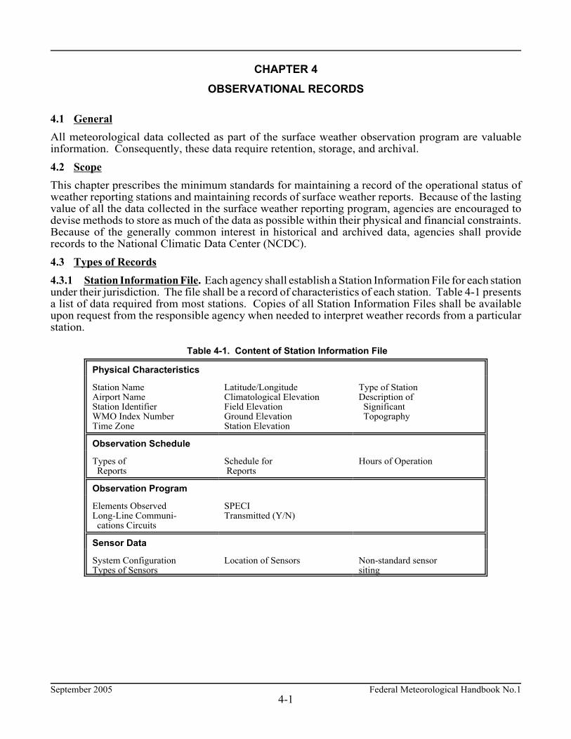
4.1 General All meteorological data collected as part of the surface weather observation program are valuableinformation. Consequently, these data require retention, storage, and archival. 4.2 Scope This chapter prescribes the minimum standards for maintaining a record of the operational status ofweather reporting stations and maintaining records of surface weather reports. Because of the lastingvalue of all the data collected in the surface weather reporting program, agencies are encouraged todevise methods to store as much of the data as possible within their physical and financial constraints.Because of the generally common interest in historical and archived data, agencies shall providerecords to the National Climatic Data Center (NCDC). 4.3 Types of Records 4.3.1 Station Information File. Each agency shall establish a Station Information File for each stationunder their jurisdiction. The file shall be a record of characteristics of each station. Table 4-1 presentsa list of data required from most stations. Copies of all Station Information Files shall be availableupon request from the responsible agency when needed to interpret weather records from a particularstation.
Table 4-1. Content of Station Information File
Physical Characteristics
Station NameAirport NameStation IdentifierWMO Index NumberTime Zone
Latitude/LongitudeClimatological ElevationField ElevationGround ElevationStation Elevation
Type of StationDescription of Significant Topography
Observation Schedule
Types of Reports
Schedule for Reports
Hours of Operation
Observation Program
Elements ObservedLong-Line Communi- cations Circuits
SPECITransmitted (Y/N)
Sensor Data
System ConfigurationTypes of Sensors
Location of Sensors Non-standard sensorsiting

Federal Meteorological Handbook No.1 September 20054-2
a. Maintenance of Station Information File. The Station Information File should be created on orbefore the date of station establishment to ensure the timely notification of the station's existence.The file shall be updated when any data in Table 4-1 or in the file changes, or the station closes,noting the date when each change is implemented. Corrections to erroneous station informationshall be noted as such, along with the historical extent of the error. Agencies shall establishprocedures to ensure the validity of their stations' Station Information Files. It is recommended thatthe content of the most recent file be reviewed as part of each station inspection.
b. Station Information File at NCDC. A copy of the Station Information File for each observinglocation shall be sent to the agency group representatives (NOAA, U.S. Navy, and U.S. AirForce) at the Federal Climate Complex, Asheville, North Carolina, and made available to theDOC/NOAA/NCDC. A copy of the file shall be sent when a station is established, when anydata listed in Table 4-1 or in the file changes or is corrected, and when a station closes. This fileshall become a part of that station's archived record.
4.3.2 Retention of Station Observational Records. Station observational records include regularlyobserved meteorological data from manual stations and automated systems. Each agency shall defineprocedures for retaining all observational records in accordance with agency data retention and archivalschedules under general METAR/SPECI guidelines: a. Short-term Storage. Storage of observational records for 4 or more days is required to assist in
sensor/system maintenance, and verification of sensor/system records in the event of an aircraftmishap.
b. Long-term Retention. Each agency shall establish procedures to provide long-term retention ofall observational records for 5 years to satisfy requirements for local studies and to supportlitigation.
c. Archive. The DOC/NOAA/NCDC is responsible for archiving observational records, asnecessary, to satisfy requirements to monitor the Nation's climate. Agencies shall includeprocedures to ensure the delivery of observational records to the agency group representatives(NOAA, U.S. Navy, and U.S. Air Force) at the Federal Climate Complex.
4.3.3 Station System/Sensor/Configuration Records. Each agency shall maintain information aboutchanges in the configuration of each station's systems/sensors, and in their operational status. Thisinformation may be collected as part of the Station Information File or the Station ObservationalRecords and, as such, maintained, retained, and archived as outlined in the preceding Sections.
September 2005 Federal Meteorological Handbook No.15-1
CHAPTER 5
WIND
5.1 General Wind shall be measured in terms of velocity, a vector that includes direction and speed. 5.2 Scope This chapter prescribes the standards for observing and reporting wind data. 5.3 Wind Parameters As used in this chapter, wind is the horizontal motion of the air past a given point and includes: a. Direction. The direction, in tens of degrees, from which the wind is blowing. b. Speed. The rate, in knots, at which the wind passes a given point. c. Gusts. The description of the variability of the wind speed. d. Peak wind speed. The maximum instantaneous wind speed measured. e. Wind Shift. A change in wind direction. 5.4 Wind Observing Standards Wind direction, speed, and gusts shall be determined at all stations. All other wind related parameters shallbe determined at designated stations. 5.4.1 Wind Direction. The wind direction shall be determined by averaging the direction over a 2-minuteperiod. When the wind direction sensor(s) is out of service, at designated stations, the direction may beestimated by observing the wind cone or tee, movement of twigs, leaves, smoke, etc., or by facing into thewind in an unsheltered area. 5.4.2 Variable Wind Direction. The wind direction may be considered variable if, during the 2-minuteevaluation period, the wind speed is 6 knots or less. Also, the wind direction shall be considered variableif, during the 2-minute evaluation period, it varies by 60 degrees or more when the average wind speed isgreater than 6 knots. 5.4.3 Wind Speed. The wind speed shall be determined by averaging the speed over a 2-minute period.At designated stations, Table 5-1 shall be used to estimate wind speeds when instruments are out of serviceor the wind speed is below the starting speed of the anemometer in use. 5.4.4 Wind Gust. The wind speed data for the most recent 10 minutes shall be examined to evaluate theoccurrence of gusts. Gusts are indicated by rapid fluctuations in wind speed with a variation of 10 knotsor more between peaks and lulls. The speed of a gust shall be the maximum instantaneous wind speed. 5.4.5 Peak Wind Speed. Peak wind data shall be determined with wind speed recorders. The peak windspeed shall be the maximum instantaneous speed measured since the last routine METAR.
Federal Meteorological Handbook No.1 September 20055-2
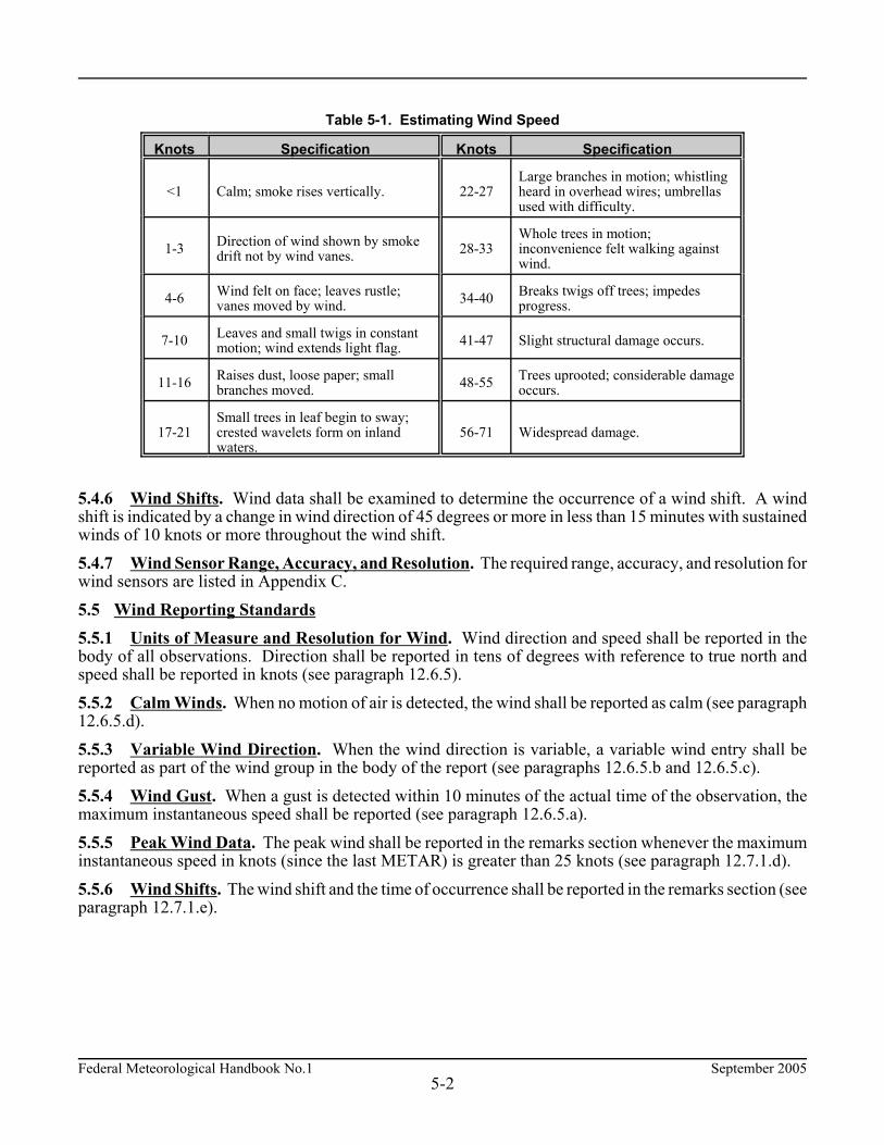
Table 5-1. Estimating Wind Speed
Knots Specification Knots Specification
<1 Calm; smoke rises vertically. 22-27Large branches in motion; whistlingheard in overhead wires; umbrellasused with difficulty.
1-3 Direction of wind shown by smokedrift not by wind vanes. 28-33
Whole trees in motion;inconvenience felt walking againstwind.
4-6 Wind felt on face; leaves rustle;vanes moved by wind. 34-40 Breaks twigs off trees; impedes
progress.
7-10 Leaves and small twigs in constantmotion; wind extends light flag. 41-47 Slight structural damage occurs.
11-16 Raises dust, loose paper; smallbranches moved. 48-55 Trees uprooted; considerable damage
occurs.
17-21Small trees in leaf begin to sway;crested wavelets form on inlandwaters.
56-71 Widespread damage.
5.4.6 Wind Shifts. Wind data shall be examined to determine the occurrence of a wind shift. A windshift is indicated by a change in wind direction of 45 degrees or more in less than 15 minutes with sustainedwinds of 10 knots or more throughout the wind shift. 5.4.7 Wind Sensor Range, Accuracy, and Resolution. The required range, accuracy, and resolution forwind sensors are listed in Appendix C. 5.5 Wind Reporting Standards 5.5.1 Units of Measure and Resolution for Wind. Wind direction and speed shall be reported in thebody of all observations. Direction shall be reported in tens of degrees with reference to true north andspeed shall be reported in knots (see paragraph 12.6.5). 5.5.2 Calm Winds. When no motion of air is detected, the wind shall be reported as calm (see paragraph12.6.5.d). 5.5.3 Variable Wind Direction. When the wind direction is variable, a variable wind entry shall bereported as part of the wind group in the body of the report (see paragraphs 12.6.5.b and 12.6.5.c). 5.5.4 Wind Gust. When a gust is detected within 10 minutes of the actual time of the observation, themaximum instantaneous speed shall be reported (see paragraph 12.6.5.a). 5.5.5 Peak Wind Data. The peak wind shall be reported in the remarks section whenever the maximuminstantaneous speed in knots (since the last METAR) is greater than 25 knots (see paragraph 12.7.1.d). 5.5.6 Wind Shifts. The wind shift and the time of occurrence shall be reported in the remarks section (seeparagraph 12.7.1.e).

September 2005 Federal Meteorological Handbook No.15-3
5.6 Summary of Wind Observing and Reporting Standards Table 5-2 summarizes the wind observing and reporting standards.
Table 5-2. Summary of Wind Observing and Reporting Standards
Parameter Observing and Reporting Standard
Wind direction 2-minute average in 10 degree increments with respect to true north isreported.
Wind speed 2-minute average speed in knots is reported.
Wind gust The maximum instantaneous speed in knots in the past 10 minutes isreported.
Peak wind The maximum instantaneous speed in knots (since the last scheduledreport) shall be reported whenever the speed is greater than 25 knots.
Wind shifts Wind shift and the time the shift occurred is reported.

September 2005 Federal Meteorological Handbook No.16-1
CHAPTER 6 VISIBILITY
6.1 General Visibility is a measure of the opacity of the atmosphere. An automated, instrumentally-derived visibilityvalue is a sensor value converted to an appropriate visibility value using standard algorithms and isconsidered to be representative of the visibility in the vicinity of the airport runway complex. Amanually-derived visibility value is obtained using the "prevailing visibility" concept. In this chapter, theterm "prevailing visibility" shall refer to both manual and instrument derived visibility values. 6.2 Scope This chapter describes the standards for observing and reporting visibility. 6.3 Visibility Parameters The visibility parameters are: a. Prevailing visibility. The visibility that is considered representative of visibility conditions at the
station; the greatest distance that can be seen throughout at least half the horizon circle, notnecessarily continuous.
b. Sector visibility. The visibility in a specified direction that represents at least a 45 degree arc of thehorizon circle.
c. Surface visibility. The prevailing visibility determined from the usual point of observation. d. Tower visibility. The prevailing visibility determined from the airport traffic control tower (ATCT)
at stations that also report surface visibility. 6.4 Visibility Observing Standards. Visibility may be manually determined at either the surface, thetower level, or both. If visibility observations are made from just one level, e.g., the airport traffic controltower, that level shall be considered the "usual point of observation" and that visibility shall be reportedas surface visibility. If visibility observations are made from both levels, the visibility at the tower levelmay be reported as tower visibility. Visibility may be automatically determined by sensors operating in accordance with the Federal StandardAlgorithms for Automated Weather Observing Systems Used for Aviation Purposes. This visibilityalgorithm calculates a mean visibility which is the sensor equivalent of prevailing visibility. The visibilitydata during the period of observation are examined to determine if variable visibility shall be reported. 6.4.1 Observing Sites. Where the observer's view of the horizon is obstructed, the observer shall moveto as many locations as necessary and practicable within the time allotted for the observation to view asmuch of the horizon as possible. In this respect, natural obstructions, such as trees, hills, etc., are notobstructions to the horizon. These natural obstructions define the horizon. For automated weather observing stations, the visibility sensor shall be located, in accordance with theFederal Standard for Siting Meteorological Sensors at Airports. 6.4.2 Manual Observing Aids. Agencies shall establish procedures to ensure that insofar as possible,dark or nearly dark objects viewed against the horizon sky shall be used during the day, and unfocusedlights of moderate intensity (about 25 candela) shall be used during the night as reference points formanually determining visibility. In addition, visibility sensors may be used to assist the observer in theevaluation.
Federal Meteorological Handbook No.1 September 20056-2
6.4.3 Observer Adaptation to Ambient Light Conditions. Agencies shall establish procedures toensure that observer's eyes shall be accustomed to the ambient lighting conditions before manual visibilityobservations are taken. 6.4.4 Visibility. Manually-derived visibility shall be evaluated as frequently as practicable. Allavailable visibility reference points shall be used. The greatest distances that can be seen in all directionsaround the horizon circle shall be determined. When the visibility is greater than the distance to thefarthest reference point, the greatest distance seen in each direction shall be estimated. This estimate shallbe based on the appearance of the most distant visible reference points. If they are visible with sharpoutlines and little blurring of color, the visibility is much greater than the distance to them. If they canbarely be seen and identified, the visibility is about the same as the distance to them. After visibilitieshave been determined around the entire horizon circle, they shall be resolved into a single value forreporting purposes. To do this, the greatest distance that can be seen throughout at least half the horizoncircle, not necessarily continuous shall be used; this is prevailing visibility. If the visibility is varyingrapidly during the time of the observation, the average of all observed values around the horizon circleshall be used for reporting purposes. 6.4.5 Variable Prevailing Visibility. If the prevailing visibility rapidly increases and decreases by 1/2statute mile or more, during the time of the observation, and the prevailing visibility is less than 3 miles,the visibility is considered to be variable. 6.4.6 Sector Visibility. When the manually-derived visibility is not uniform in all directions, thehorizon circle shall be divided into arcs that have uniform visibility and represent at least one eighth ofthe horizon circle (45 degrees). The visibility that is evaluated in each sector is sector visibility. 6.5 Visibility Reporting Standards 6.5.1 Unit of Measure. Visibility shall be reported in statute miles. 6.5.2 Prevailing Visibility. Prevailing visibility shall be reported in all weather observations. Thereportable values for visibility are listed in Table 6-1. If the actual visibility falls halfway between tworeportable values, the lower value shall be reported (see paragraph 12.6.6). 6.5.3 Variable Prevailing Visibility. Variable prevailing visibility shall be reported if the prevailingvisibility is less than 3 miles and rapidly increases or decreases by 1/2 statute mile or more during the timeof observation. The minimum and maximum visibility values observed shall be reported in remarkssection (see paragraph 12.7.1.g). 6.5.4 Tower Visibility. Tower visibility shall be reported, in accordance with agency procedures (seeparagraph 12.7.1.f). 6.5.5 Surface Visibility. Surface visibility shall be the prevailing visibility from the surface at manualstations or the visibility derived from sensors at automated stations (see paragraph 12.7.1.f). 6.5.6 Visibility At Second Location. When an automated station uses a meteorological discontinuityvisibility sensor, remarks shall be added to identify visibility at the second location which differ from thevisibility in the body of the report (see paragraph 12.7.1.i). 6.5.7 Sector Visibility. Sector visibility shall be reported in remarks when it differs from the prevailingvisibility by one or more reportable values and either the prevailing or sector visibility is less than 3 miles(see paragraph 12.7.1.h).

September 2005 Federal Meteorological Handbook No.16-3
Table 6-1. Reportable Visibility ValuesSource of Visibility Report
Automated Manual
M1/4 2 9a 0 5/8 1 5/8 4 12
1/4 2 1/2 10 1/16 3/4 1 3/4 5 13
1/2 3 1/8 7/8 1 7/8 6 14
3/4 4 3/16 1 2 7 15
1 5 1/4 1 1/8 2 1/4 8 20
1 1/4 6a 5/16 1 1/4 2 1/2 9 25
1 1/2 7 3/8 1 3/8 2 3/4 10 30
1 3/4 8a 1/2 1 1/2 3 11 35b
a. These values may not be reported by some automated stations.b. Further values in increments of 5 statute miles may be reported, i.e., 40, 45, 50, etc.
6.6 Summary of Visibility Observing and Reporting Standards Table 6-2 summarizes the applicability of visibility standards.
Table 6-2. Summary of Visibility Observing and Reporting Standards andProcedures
VisibilityType of Station
Automated Manual
Surface Represents 10-minutes of sensoroutputs.
Visual evaluation of visibility around the horizon.
Variable Reported when the prevailing visibility varies by 1/2 mile or more and thevisibility is less than 3 miles.
Tower Augmented. Reported at stations with anATCT.
Sector Not reported. Reported at all stations.


Federal Meteorological Handbook No.1 September 20057-1
CHAPTER 7 RUNWAY VISUAL RANGE
7.1 General The runway visual range (RVR) is an instrumentally derived value that represents the horizontal distancea pilot may see down the runway. 7.2 Scope This chapter describes the standards for observing and reporting RVR at designated stations. 7.3 Runway Visual Range (RVR) Parameter. The runway visual range is the maximum distance at which the runway, or the specified lights or markersdelineating it, can be seen from a position above a specified point on its center line. This value isnormally determined by visibility sensors located alongside and higher than the center line of the runway.RVR is calculated from visibility, ambient light level, and runway light intensity. 7.4 Runway Visual Range Observing Standards It is common practice to use a transmissometer or forward scatter meter as the RVR visibility sensor. Atransmissometer measures the transmittance of the atmosphere over a baseline distance while a forwardscatter meter measures the extinction coefficient of the atmosphere. RVR is then derived from equationsthat also account for ambient light (background luminance) and runway light intensity based on theexpected detection sensitivity of the pilot's eye. RVR Tables are contained in Appendix D. 7.4.1 Observing Positions. The location of the RVR visibility sensor should be within 500 feet of therunway centerline and within 1,000 feet of the designated runway threshold. 7.4.2 Day-Night Observations for Transmissometers. The day scale shall be used in the evening untillow intensity lights on or near the airport complex are clearly visible. The night scale shall be used in themorning until these lights begin to fade. Alternately, a day-night switch may be used to determine whichscale should be used. 7.5 Runway Visual Range Reporting Standards RVR shall be reported whenever the prevailing visibility is 1 statute mile or less and/or the RVR for thedesignated instrument runway is 6,000 feet or less. RVR shall be reported in the body of theMETAR/SPECI report (see paragraphs 12.6.7). 7.5.1 Multiple Runway Visual Range Sensors. At automated stations where it is applicable, RVRvalues for as many as four designated runways can be reported for long-line dissemination (seeparagraph 12.6.7). At manual stations, only RVR for the designated runway shall be reported. 7.5.2 Units of Measure. RVR is measured in increments of 100 feet up to 1,000 feet, increments of 200feet from 1,000 feet to 3,000 feet, and increments of 500 feet above 3,000 feet to 6,000 feet. 7.5.3 Runway Visual Range Based on a Transmissometer. Ten-minute extreme values (highest andlowest) of transmittance shall be reported. Manually reported RVR shall be based on light setting 5 foreither day or night time conditions, regardless of the light setting actually in use. One RVR value shallbe reported if the ten-minute high and low value are the same.

September 2005 Federal Meteorological Handbook No.17-2
7.6 Summary of Runway Visual Range Observing and Reporting Standards Table 7-1 summarizes the RVR observing and reporting standards.
Table 7-1. Summary of RVR Observing and ReportingStandards
RVR Observing and Reporting
Number of RVRs Up to 4a
RVR Light Setting 5 for transmissometer systems
When ReportedWhen visibility # 1 statute mile
AND/OR RVR # 6,000 feet
a. Manual observations shall contain only one RVR.
September 2005 Federal Meteorological Handbook No.18-1
CHAPTER 8 PRESENT WEATHER
8.1 General Present weather includes precipitation, obscurations, well-developed dust/sand whirls, squalls, tornadicactivity, sandstorms, and duststorms. Present weather may be evaluated instrumentally, manually, orthrough a combination of instrumental and manual methods. 8.2 Scope This chapter prescribes the standards for observing and reporting present weather. The types of presentweather reported vary according to the type of station defined by the responsible agency. 8.3 Present Weather Parameters 8.3.1 Precipitation. Precipitation is any of the forms of water particles, whether liquid or solid, that fallfrom the atmosphere and reach the ground. The types of precipitation are: a. Drizzle. Fairly uniform precipitation composed exclusively of fine drops with diameters of less than
0.02 inch (0.5 mm) very close together. Drizzle appears to float while following air currents,although unlike fog droplets, it falls to the ground.
b. Rain. Precipitation, either in the form of drops larger than 0.02 inch (0.5 mm), or smaller dropswhich, in contrast to drizzle, are widely separated.
c. Snow. Precipitation of snow crystals, mostly branched in the form of six-pointed stars. d. Snow Grains. Precipitation of very small, white, and opaque grains of ice. e. Ice Crystals (Diamond Dust). A fall of unbranched (snow crystals are branched) ice crystals in the
form of needles, columns, or plates. f. Ice Pellets. Precipitation of transparent or translucent pellets of ice, which are round or irregular,
rarely conical, and which have a diameter of 0.2 inch (5 mm), or less. There are two main types: (1) Hard grains of ice consisting of frozen raindrops, or largely melted and refrozen snowflakes. (2) Pellets of snow encased in a thin layer of ice which have formed from the freezing, either of
droplets intercepted by the pellets, or of water resulting from the partial melting of the pellets. g. Hail. Precipitation in the form of small balls or other pieces of ice falling separately or frozen together
in irregular lumps. h. Small Hail and/or Snow Pellets. Precipitation of white, opaque grains of ice. The grains are round
or sometimes conical. Diameters range from about 0.08 to 0.2 inch (2 to 5 mm). i. Unknown Precipitation. Precipitation type that is reported if the automated station detects the
occurrence of precipitation but the precipitation discriminator cannot recognize the type. 8.3.2 Obscurations. Any phenomenon in the atmosphere, other than precipitation, that reduces thehorizontal visibility. a. Mist. A visible aggregate of minute water particles suspended in the atmosphere that reduces
visibility to less than 7 statute miles but greater than or equal to 5/8 statute miles.
Federal Meteorological Handbook No.1 September 20058-2
b. Fog. A visible aggregate of minute water particles (droplets) which are based at the Earth's surfaceand reduces horizontal visibility to less than 5/8 statute mile and, unlike drizzle, it does not fall to theground.
c. Smoke. A suspension in the air of small particles produced by combustion. A transition to haze mayoccur when smoke particles have traveled great distances (25 to 100 miles or more) and when thelarger particles have settled out and the remaining particles have become widely scattered throughthe atmosphere.
d. Volcanic Ash. Fine particles of rock powder that originate from a volcano and that may remainsuspended in the atmosphere for long periods.
e. Widespread Dust. Fine particles of earth or other matter raised or suspended in the air by the windthat may have occurred at or far away from the station which may restrict horizontal visibility.
f. Sand. Sand particles raised by the wind to a height sufficient to reduce horizontal visibility. g. Haze. A suspension in the air of extremely small, dry particles invisible to the naked eye and
sufficiently numerous to give the air an opalescent appearance. h. Spray. An ensemble of water droplets torn by the wind from the surface of an extensive body of
water, generally from the crests of waves, and carried up a short distance into the air. 8.3.3 Other Weather Phenomena a. Well-developed Dust/Sand Whirl. An ensemble of particles of dust or sand, sometimes
accompanied by small litter, raised from the ground in the form of a whirling column of varyingheight with a small diameter and an approximately vertical axis.
b. Squall. A strong wind characterized by a sudden onset in which the wind speed increases at least16 knots and is sustained at 22 knots or more for at least one minute (see paragraph 12.6.8.e.(1)).
c. Funnel Cloud (Tornadic Activity) (1) Tornado. A violent, rotating column of air touching the ground. (2) Funnel Cloud. A violent, rotating column of air which does not touch the surface. (3) Waterspout. A violent, rotating column of air that forms over a body of water, and touches
the water surface. d. Sandstorm. Particles of sand carried aloft by a strong wind. The sand particles are mostly confined
to the lowest ten feet, and rarely rise more than fifty feet above the ground. e. Duststorm. A severe weather condition characterized by strong winds and dust-filled air over an
extensive area. 8.4 Present Weather Observing Standards 8.4.1 Qualifiers. Present weather qualifiers fall into two categories: intensity or proximity anddescriptors. Qualifiers may be used in various combinations to describe weather phenomena. a. Intensity/Proximity. The intensity qualifiers are: light, moderate, and heavy. The proximity
qualifier is vicinity.

September 2005 Federal Meteorological Handbook No.18-3
(1) Intensity of Precipitation. When more than one form of precipitation is occurring at a timeor precipitation is occurring with an obscuration, the intensities determined shall be no greaterthan that which would be determined if any forms were occurring alone.
The intensity of precipitation shall be identified as light, moderate, or heavy in accordance withone of the following:
(a) Intensity of Rain or Ice Pellets. The intensity of rain and ice pellets shall be based onthe criteria given in Table 8-1, Table 8-2, and Table 8-3.
Table 8-1. Intensity of Rain or Ice Pellets Based on Rate-of-Fall
Intensity Criteria
Light Up to 0.10 inch per hour; maximum 0.01 inch in 6 minutes.
Moderate 0.11 inch to 0.30 inch per hour; more than 0.01 inch to 0.03 inch in 6 minutes.
Heavy More than 0.30 inch per hour; more than 0.03 inch in 6 minutes.
Table 8-2. Estimating Intensity of Rain
Intensity Criteria
Light From scattered drops that, regardless of duration, do not completely wet an exposedsurface up to a condition where individual drops are easily seen.
Moderate Individual drops are not clearly identifiable; spray is observable just above pavementsand other hard surfaces.
Heavy Rain seemingly falls in sheets; individual drops are not identifiable; heavy spray toheight of several inches is observed over hard surfaces.
Table 8-3. Estimating Intensity of Ice Pellets
Intensity Criteria
Light Scattered pellets that do not completely cover an exposed surface regardless of duration.Visibility is not affected.
Moderate Slow accumulation on ground. Visibility reduced by ice pellets to less than 7 statutemiles.
Heavy Rapid accumulation on ground. Visibility reduced by ice pellets to less than 3 statutemiles.
(b) Intensity of Snow and Drizzle. The intensity of snow and drizzle shall be based on the
reported surface visibility in accordance with Table 8-4 when occurring alone.
Table 8-4. Intensity of Snow or Drizzle Based on Visibility
Intensity Criteria
Light Visibility > 1/2 mile.
Moderate Visibility > 1/4 mile but # 1/2 mile.
Heavy Visibility # 1/4 mile.

Federal Meteorological Handbook No.1 September 20058-4
(2) Proximity. Unless otherwise directed elsewhere in this Handbook, weather phenomenaoccurring beyond the point of observation (between 5 and 10 statute miles) shall be reported as(in the) vicinity.
b. Descriptors. Descriptors are qualifiers which further amplify weather phenomena and are used withcertain types of precipitation and obscurations. The descriptor qualifiers are: shallow, partial, patches,low drifting, blowing, shower(s), thunderstorm, and freezing.
(1) Shallow. The descriptor shallow shall only be used to further describe fog that has little verticalextent (less than 6 feet).
(2) Partial and Patches. The descriptors partial and patches shall only be used to further describefog that has little vertical extent (normally greater than or equal to 6 feet but less than 20 feet),and reduces horizontal visibility, but to a lesser extent vertically. The stars may often be seenby night and the sun by day.
(3) Low Drifting. When dust, sand, or snow is raised by the wind to less than 6 feet, "low drifting"shall be used to further describe the weather phenomenon.
(4) Blowing. When dust, sand, snow, and/or spray is raised by the wind to a height of 6 feet ormore, "blowing" shall be used to further describe the weather phenomenon.
(5) Shower(s). Precipitation characterized by the suddenness with which they start and stop, bythe rapid changes of intensity, and usually by rapid changes in the appearance of the sky.
(6) Thunderstorm. A local storm produced by a cumulonimbus cloud that is accompanied bylightning and/or thunder.
(7) Freezing. When fog is occurring and the temperature is below 0°C, "freezing" shall be usedto further describe the phenomena. When drizzle and/or rain freezes upon impact and forms aglaze on the ground or other exposed objects, "freezing" shall be used to further describe theprecipitation.
8.4.2 Weather Phenomena. Weather phenomena fall into three categories: precipitation, obscurations,and other phenomena. The three categories of weather phenomena shall be combined with the qualifierslisted in the preceding paragraphs, to identify present weather that is occurring. 8.5 Present Weather Reporting Standards Present weather is reported when it is occurring at, or in the vicinity of, the station and at the time ofobservation. Unless directed elsewhere in the Handbook, the location of weather phenomena shall bereported as: ¢ "occurring at the station" when within 5 statute miles of the point(s) of observation. ¢ "in the vicinity of the station" when between 5 and 10 statute miles of the point(s) of observation. ¢ "distant from the station" when beyond 10 statute miles of the point(s) of observation. With the exception of volcanic ash, low drifting dust, low drifting sand, low drifting snow, shallow fog,partial fog, and patches (of) fog, obscurations are reported only when the prevailing visibility is less than7 statute miles or considered operationally significant. Volcanic ash shall always be reported whenobserved.

September 2005 Federal Meteorological Handbook No.18-5
When more than one type of present weather are reported at the same time, present weather shall be reportedin the following order: ¢ Tornadic activity--Tornado, Funnel Cloud, or Waterspout.¢ Thunderstorm(s) with or without associated precipitation.¢ Present weather in order of decreasing dominance, i.e., the most dominant type is reported first.¢ Left-to-right in Table 8-5 (Columns 1 through 5).
The reporting notations given in Table 8-5 shall be used to report present weather. (For definitions ofpresent weather, refer to Appendix A - Glossary). 8.5.1 Precipitation. Precipitation shall be reported when occurring at the point of observation.Precipitation not occurring at the point of observation but within 10 statute miles shall be reported asshowers in the vicinity. a. Liquid Precipitation (1) Drizzle. (see paragraphs 12.6.8.a(1), 12.6.8.c(1), and 12.7.1.k). (2) Rain. (see paragraphs 12.6.8.a(1), 12.6.8.c(1), and 12.7.1.k). (3) Rainshower(s). (see paragraphs 12.6.8.a(1), 12.6.8.b(3), 12.6.8.c(1), and 12.7.1.k). b. Freezing Precipitation (1) Freezing Rain. (see paragraphs 12.6.8.a(1), 12.6.8.b(5), 12.6.8.c(1), 12.7.1.k). (2) Freezing Drizzle. (see paragraphs 12.6.8.a(1), 12.6.8.b(5), 12.6.8.c(1), and 12.7.1.k). c. Solid Precipitation (1) Snow. (see paragraphs 12.6.8.a(1), 12.6.8.c(1), 12.7.1.k). (2) Snowshower(s). (see paragraphs 12.6.8.a(1), 12.6.8.b(3), 12.6.8.c(1), and 12.7.1.k). (3) Blowing Snow. (see paragraphs 12.6.8.a(1), 12.6.8.b(2), and 12.6.8.c(1)). (4) Low Drifting Snow. (see paragraphs 12.6.8.a(1), 12.6.8.b(2), and 12.6.8.c(1)). (5) Snow Grains. (see paragraphs 12.6.8.a(1), 12.6.8.c(1), 12.7.1.k). (6) Ice Crystals. (see paragraphs 12.6.8.a(1), 12.6.8.c(1), and 12.7.1.k). (7) Ice Pellets. (see paragraphs 12.6.8.c(1) and 12.7.1.k). Ice Pellet shower(s). (see paragraphs 12.6.8.b(3), 12.6.8.c(1), and 12.7.1.k). (8) Hail. Hail shall be reported, at designated stations. (see paragraph 12.7.1.k and 12.7.1.n). Hail shower(s). (see paragraphs 12.6.8.b(3), 12.6.8.c(1), 12.7.1.k, and 12.7.1.n). (9) Small Hail and/or Snow Pellets. (see paragraphs 12.6.8.c(1)). Small Hail and/or Snow Pellets Shower(s). (see paragraphs 12.6.8.b(3), 12.6.8.c(1), and
12.7.1.n). d. Unknown Precipitation. Unknown precipitation shall only be reported by automated stations to
indicate precipitation of unknown type when the automated system cannot identify the precipitationwith any greater precision (see paragraph 12.6.8.c(2)).

Federal Meteorological Handbook No.1 September 20058-6
Table 8-5. Notations for Reporting Present Weather1
QUALIFIER WEATHER PHENOMENA
INTENSITY ORPROXIMITY
1
DESCRIPTOR
2
PRECIPITATION
3
OBSCURATION
4
OTHER
5
- Light
Moderate2
+ Heavy
VC In the Vicinity3
MI Shallow
PR Partial
BC Patches
DR Low Drifting
BL Blowing
SH Shower(s)
TS Thunderstorm
FZ Freezing
DZ Drizzle
RA Rain
SN Snow
SG Snow Grains
IC Ice Crystals
PL Ice Pellets
GR Hail
GS Small Hail and/or Snow Pellets
UP Unknown Precipitation
BR Mist
FG Fog
FU Smoke
VA Volcanic Ash
DU Widespread Dust
SA Sand
HZ Haze
PY Spray
PO Well- Developed Dust/Sand Whirls
SQ Squalls
FC Funnel Cloud Tornado Waterspout4
SS Sandstorm
DS Duststorm
1. The weather groups shall be constructed by considering columns 1 to 5 in the table above in sequence, i.e., intensity, followed by description, followed by weather phenomena, e.g., heavy rain shower(s) is coded as +SHRA2. To denote moderate intensity no entry or symbol is used.3. See paragraph 8.4.1.a.(2), 8.5, and 8.5.1 for vicinity definitions.4. Tornadoes and waterspouts shall be coded as +FC.
8.5.2 Obscuration. a. Mist. (see paragraph 12.6.8.d(1)). b. Fog. (see paragraphs 12.6.8.a(2) and 12.6.8.d(1)). (1) Shallow (Ground) Fog. (see paragraphs 12.6.8.b(1) and 12.6.8.d(1)). (2) Partial Fog. (see paragraphs 12.6.8.b(1) and 12.6.8.d(2)). (3) Patches (of) Fog. (see paragraphs 12.6.8.b(1) and 12.6.8.d(2)). (4) Freezing Fog. (see paragraph 12.6.8.b(5) and 12.6.8.d(1)). c. Smoke. (see paragraph 12.6.8.d(1)). d. Volcanic Ash. (see paragraph 12.6.8.d(1)). e. Widespread Dust. (see paragraph 12.6.8.d(1)). (1) Blowing Dust. (see paragraphs 12.6.8.a(1), 12.6.8.a(2), 12.6.8.b(2), and 12.6.8.d(1)). (2) Low Drifting Dust. (see paragraphs 12.6.8.b(2) and 12.6.8.d(1)).

September 2005 Federal Meteorological Handbook No.18-7
f. Sand. (see paragraph 12.6.8.d(1)). (1) Blowing Sand. (see paragraphs 12.6.8.a(1), 12.6.8.a(2), 12.6.8.b(2), and 12.6.8.d(1)). (2) Low Drifting Sand. (see paragraphs 12.6.8.b(2) and 12.6.8.d(1)). g. Haze. (see paragraph 12.6.8.d(1)). h. Blowing Spray. (see paragraphs 12.6.8.b(2) and 12.6.8.d(3)). 8.5.3 Other Weather Phenomena a. Well-Developed Dust/Sand Whirls. (see paragraphs 12.6.8.a(2) and 12.6.8.e(1)). b. Squalls. (see paragraph 12.6.8.e(1)). c. Tornado, Waterspout, or Funnel Cloud. (see paragraphs 12.6.8.a(1), 12.6.8.e(2), and 12.7.1.b). d. Sandstorm. (see paragraphs 12.6.8.a(1) and 12.6.8.e(1)). e. Duststorm. (see paragraphs (12.6.8.a(1) and 12.6.8.e(1)). 8.5.4 Thunderstorm. A thunderstorm occurring with or without accompanying precipitation shall bereported when observed to begin, to be in progress, or to end. In addition to reporting a thunderstorm inthe body of the METAR/SPECI, remarks may be added to report the time, location, and movement of thestorm (see paragraphs 8.5.5.c, 12.7.1.l, and 12.7.1.m). a. Beginning of Thunderstorm. The beginning of a thunderstorm shall be reported as the earliest
time: (1) thunder is heard; (2) lightning is observed at the station when the local noise level is sufficient to prevent hearing
thunder; or (3) lightning is detected by an automated sensor. b. Ending of Thunderstorm. The ending of a thunderstorm shall be reported as 15 minutes after
the last occurrence of any of the above criteria. 8.5.5 Beginning/Ending Times of Precipitation, Tornadic Activity, and Thunderstorms. a. Precipitation. At designated stations, the time precipitation begins or ends shall be reported to
the nearest minute. The beginning and ending times shall be reported in the next METAR afterthe event. Beginning and ending times for separate periods shall be reported only if theintervening time exceeds 15 minutes (see paragraph 12.7.1.k).
b. Tornadic Activity. At designated stations, the time tornadic activity begins or ends shall bereported to the nearest minute. The beginning and ending times shall be reported in a SPECI andthe next METAR after the event (see paragraphs 12.6.8.e(2) and 12.7.1.b).
c. Thunderstorm. At designated stations, the time thunderstorm(s) begins or ends shall be reportedto the nearest minute. The beginning and ending times shall be reported in a SPECI and the nextMETAR after the event. Beginning and ending times of separate thunderstorm(s) shall bereported only in a METAR if the intervening time exceeds 15 minutes (see paragraphs 12.6.8.a(1),12.7.1.l, and 12.7.1.m).
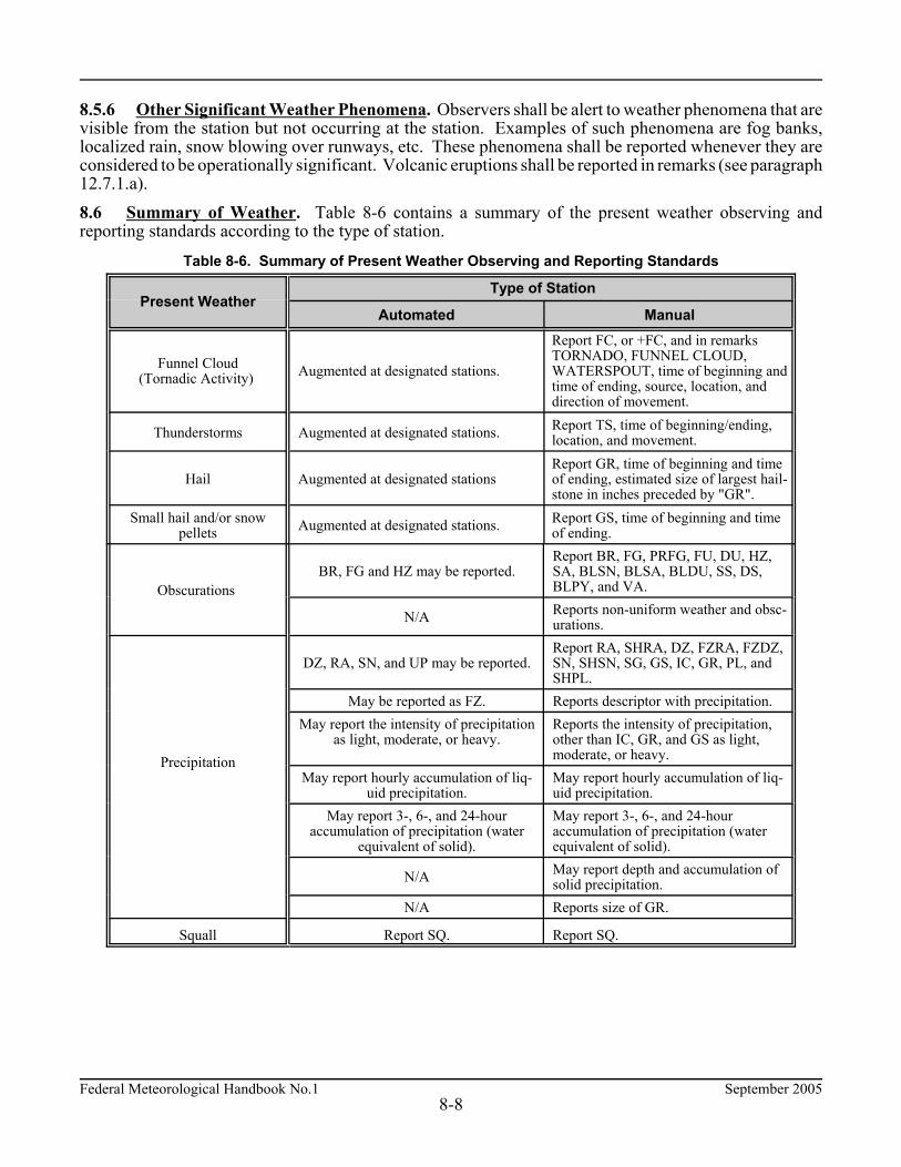
Federal Meteorological Handbook No.1 September 20058-8
8.5.6 Other Significant Weather Phenomena. Observers shall be alert to weather phenomena that arevisible from the station but not occurring at the station. Examples of such phenomena are fog banks,localized rain, snow blowing over runways, etc. These phenomena shall be reported whenever they areconsidered to be operationally significant. Volcanic eruptions shall be reported in remarks (see paragraph12.7.1.a). 8.6 Summary of Weather. Table 8-6 contains a summary of the present weather observing andreporting standards according to the type of station.
Table 8-6. Summary of Present Weather Observing and Reporting Standards
Present WeatherType of Station
Automated Manual
Funnel Cloud(Tornadic Activity) Augmented at designated stations.
Report FC, or +FC, and in remarksTORNADO, FUNNEL CLOUD,WATERSPOUT, time of beginning andtime of ending, source, location, anddirection of movement.
Thunderstorms Augmented at designated stations. Report TS, time of beginning/ending,location, and movement.
Hail Augmented at designated stationsReport GR, time of beginning and timeof ending, estimated size of largest hail-stone in inches preceded by "GR".
Small hail and/or snowpellets Augmented at designated stations. Report GS, time of beginning and time
of ending.
Obscurations BR, FG and HZ may be reported.
Report BR, FG, PRFG, FU, DU, HZ,SA, BLSN, BLSA, BLDU, SS, DS,BLPY, and VA.
N/A Reports non-uniform weather and obsc-urations.
Precipitation
DZ, RA, SN, and UP may be reported.Report RA, SHRA, DZ, FZRA, FZDZ,SN, SHSN, SG, GS, IC, GR, PL, andSHPL.
May be reported as FZ. Reports descriptor with precipitation.May report the intensity of precipitation
as light, moderate, or heavy.Reports the intensity of precipitation,other than IC, GR, and GS as light,moderate, or heavy.
May report hourly accumulation of liq-uid precipitation.
May report hourly accumulation of liq-uid precipitation.
May report 3-, 6-, and 24-houraccumulation of precipitation (water
equivalent of solid).
May report 3-, 6-, and 24-houraccumulation of precipitation (waterequivalent of solid).
N/A May report depth and accumulation ofsolid precipitation.
N/A Reports size of GR.
Squall Report SQ. Report SQ.
September 2005 Federal Meteorological Handbook No.19-1
CHAPTER 9 SKY CONDITION
9.1 General Sky condition is a description of the appearance of the sky. Sky condition may be evaluated eitherautomatically by instrument or manually with or without instruments. 9.2 Scope This chapter prescribes the standards for observing and reporting sky condition. 9.3 Sky Condition Parameters Sky condition parameters are: a. Sky cover. The amount of the celestial dome hidden by clouds and/or obscurations. b. Summation layer amount. A categorization of the amount of sky cover at and below each reported
layer. c. Layer height. The height of the bases of each reported layer of clouds and/or obscurations; or the
vertical visibility into an indefinite ceiling. d. Ceiling. The lowest layer aloft reported as broken or overcast; or the vertical visibility into an
indefinite ceiling. e. Type of clouds. The variety of clouds present. 9.4 Sky Condition Standards 9.4.1 Sky Condition Observing Standards. Sky condition shall be evaluated at all stations with thiscapability. Automated stations shall have the capability to evaluate sky condition from the surface to at least12,000 feet. Observers at manual stations shall evaluate all clouds and obscurations visible; the 12,000 footrestriction shall not apply. a. Layer Opacity. All cloud layers and obscurations shall be considered as opaque. b. Surface. The surface shall be the assigned field elevation of the station. At stations where the field
elevation has not been established, the surface shall be the ground elevation at the observation site. c. Sky Cover. Sky cover shall include any clouds or obscurations detected from the observing location. d. Stratification of Sky Cover. Sky cover shall be separated into layers with each layer containing
clouds and/or obscurations (i.e., smoke, haze, fog, etc.) with bases at about the same height. e. Evaluation of Interconnected Layers. Clouds formed by the horizontal extension of swelling
cumulus or cumulonimbus, that are attached to a parent cloud, shall be regarded as a separate layeronly if their bases appear horizontal and at a different level from the parent cloud. Otherwise, theentire cloud system shall be regarded as a single layer at a height corresponding to the base of theparent cloud.

Federal Meteorological Handbook No.1 September 20059-2
f. Sky Condition Range, Accuracy, and Resolution. The required range, accuracy, and resolutionfor sky condition is listed in Appendix C.
9.4.2 Sky Cover a. Clear Skies. When no clouds or obscurations are observed or detected from the point of
observation. b. Layer Amounts. The amount of sky cover for each layer shall be the eighths (or oktas) of sky cover
attributable to clouds or obscurations (i.e., smoke, haze, fog, etc.) in the layer being evaluated. c. Summation Layer Amount. The sky cover summation amount for any given layer is the sum of the
sky cover for the layer being evaluated plus the sky cover of all lower layers including obscurations.Portions of layers aloft detected through lower layers aloft shall not increase the summation amountof the higher layer. No layer can have a summation amount greater than 8/8ths.
d. Variable Amounts of Sky Cover. The sky cover shall be considered variable if it varies by one ormore reportable values (FEW, SCT, BKN, or OVC) during the period it is being evaluated.
9.4.3 Obscuration. The portion of sky (including higher clouds, the moon, or stars) hidden by weatherphenomena either surface-based or aloft. 9.4.4 Vertical Visibility. Vertical visibility shall be either: a. The distance that an observer can see vertically into an indefinite ceiling; b. The height corresponding to the top of a ceiling light projector beam; c. The height at which a ceiling balloon completely disappears during the presence of an indefinite
ceiling; or d. The height determined by the sensor algorithm at automated stations. 9.4.5 Ceiling. The ceiling shall be the lowest layer aloft reported as broken or overcast. If the sky istotally obscured, the vertical visibility shall be the ceiling. 9.4.6 Significant Clouds and Cloud Types. Cloud types shall be identified in accordance with the WMOInternational Cloud Atlas-Volumes I and II, the WMO Abridged International Cloud Atlas, or agencyobserving aids for cloud identification. Cumulonimbus, including cumulonimbus mammatus, toweringcumulus, altocumulus castellanus, standing lenticular, or rotor clouds are significant clouds. 9.4.7 Height of Sky Cover. A ceilometer, if available, or ceiling light, or known heights of unobscuredportions of abrupt, isolated objects within 1 1/2 statute miles of a runway shall be used to measure the heightof layers aloft. Otherwise, an alternative method shall be used to estimate the heights. The height may beestimated by using a ceiling balloon, pilot report, other agency guidelines, or observer experience. a. Indefinite Ceiling Height (Vertical Visibility). The height into an indefinite ceiling shall be the
vertical visibility measured in hundreds of feet. b. Height of Layers. The height of a layer shall be the height of the cloud bases or obscurations for the
layer being evaluated. Layers of clouds that are 50 feet or less above the surface shall be observedas layers with a height of zero. When the height of a ceiling layer increases and decreases rapidlyby the amounts given in Table 9-2, during the period of evaluation, it shall be considered variable andthe ascribed height shall be the average of all the varying values. At mountain stations, clouds belowthe level of the station may be observed.

September 2005 Federal Meteorological Handbook No.19-3
Table 9-1. Criteria for Variable Ceiling
Ceiling (feet) Variation (feet)
# 1,000 $200
>1,000 and #2,000 $400
>2,000 and <3,000 $500
9.5 Sky Cover Reporting Standards 9.5.1 Frequency for Sky Cover. Sky cover shall be included in all reports. 9.5.2 Layer Amount. The amount of sky cover reported for each layer shall be based on the summation layer amount for thatlayer. The amount shall be reported using the reportable contractions given in Table 9-2. Automated stations shall report no more than three layers. The selection of layers reported shall be madein accordance with Table 9-3. Manual stations shall report no more than six layers. If more than six layersare observed, then use Table 9-3 to determine which layers are to be reported. Additionally, all layers withassociated cumulonimbus or towering cumulus shall be identified by appending the contractions CB andTCU, respectively. Sky condition shall be reported in an ascending order up to the first overcast layer. Layers above12,000 feet are not reported by automated sky condition sensors. At mountain stations, if the cloud layeris below station level, the height of the layer shall be reported as ///. Table 9-2. Reportable Contractions for Sky Cover
Reportable Contraction Meaning Summation Amountof Layer
VV Vertical Visibility 8/8
SKC or CLR1 Clear 0
FEW2 Few 1/8 - 2/8
SCT Scattered 3/8 - 4/8
BKN Broken 5/8 - 7/8
OVC Overcast 8/8
1. The abbreviation CLR shall be used at automated stations when no layers at or below 12,000 feet arereported; the abbreviation SKC shall be used at manual stations when no layers are reported.2. Any layer amount less than 1/8 is reported as FEW.

Federal Meteorological Handbook No.1 September 20059-4
Table 9-3. Priority for Reporting Layers
Priority Layer Description
1 lowest few layer.
2 lowest broken layer.
3 overcast layer.
4 lowest scattered layer.
5 second lowest scattered layer.
6 second lowest broken layer.
7 highest broken layer.
8 highest scattered layer.
9.5.3 Units of Measure for Heights. Heights of sky cover shall be evaluated in feet above the surface. 9.5.4 Reportable Values for Sky Cover Height. The reportable values of sky cover height are hundredsof feet. The reportable value increments are given in Table 9-4.
Table 9-4. Increments of Reportable Values of Sky Cover Height
Range of Height Values (feet) Reportable Increment (feet)
#5,000 To nearest 100
>5,000 but #10,000 To nearest 500
>10,000 To nearest 1,000
9.5.5 Layer Heights. Heights of layers shall be reported in hundreds of feet, rounded to the nearestreportable increment. When a value falls halfway between two reportable increments, the lower value shallbe reported. When a cloud layer is 50 feet or less above the surface, the height shall be reported as 000 (seeparagraph 9.4.7.b). 9.5.6 Obscuration. When a portion of the celestial dome is obscured, the obscuration (amount of skycover hidden by the weather phenomena) shall be reported (see paragraph 9.4.3 and Table 9-1). Theobscuration shall also be reported as a remark (see paragraph 12.7.1.q). 9.5.7 Variable Ceiling. When the height of the ceiling layer is variable, and the ceiling layer is below3,000 feet, a remark shall be included in the report giving the range of variability (see paragraphs 9.4.7.band 12.7.1.p). 9.5.8 Ceiling Height at a Second Location. When automated stations use meteorological discontinuityceilometer(s), remarks shall be added to identify ceiling height conditions at the second location whichdiffer from the ceiling height in the body of the report (see paragraph 12.7.1.t). 9.5.9 Variable Sky Condition. Variable sky conditions shall be indicated in the remarks of the report(see paragraph 12.7.1.r). 9.5.10 Significant Cloud Types. Significant cloud types shall be indicated in the remarks of the report(see paragraph 12.7.1.s).

September 2005 Federal Meteorological Handbook No.19-5
9.6 Summary of Sky Condition Observing and Reporting Standards Table 9-5 summarizes the sky condition observing and reporting at each category of station.
Table 9-5. Summary of Sky Condition Observing and Reporting Standards
Parameter Reporting Standard
Sky Cover (General) Sky condition shall be included in all reports.
Height/Number of layers Report a maximum of three layers at automated stations; otherwise, amaximum of six layers at manual stations.
Variable sky condition Not evaluated at automated stations.
Variable ceiling height Evaluated at all stations.
Ceiling height at a secondlocation Evaluated at automated stations with multiple sensors.
Cloud Types Not evaluated at automated stations.

September 2005 Federal Meteorological Handbook No.110-1
CHAPTER 10 TEMPERATURE AND DEW POINT
10.1 General Temperature is a measure of hotness or coldness. On a daily basis, temperature is one of the mostwidely monitored and disseminated weather parameters obtained from the surface observation. 10.2 Scope This chapter prescribes the standards for observing and reporting temperature and dew point. Thechapter also defines maximum and minimum temperature and prescribes appropriate standards. 10.3 Temperature and Dew Point Parameters a. Temperature. The degree of hotness or coldness of the ambient air as measured by any suitable
instrument. b. Dew point. The temperature to which a given parcel of air must be cooled at constant pressure
and constant water-vapor content in order for saturation to occur. c. Maximum temperature. The highest temperature recorded/measured during a specified time
period. d. Minimum temperature. The lowest temperature recorded/measured during a specified time
period. 10.4 Temperature and Dew Point Observing Standards The method of obtaining temperature and dew point varies according to the system in use at the station. The data may be read directly from digital or analog readouts, or calculated from other measured values. 10.4.1 Temperature and Dew Point Sensor Range. The range for the temperature and dew pointsensors shall be determined by the responsible agency considering the local climatology (Appendix C). 10.4.2 Temperature. Temperature shall be determined to the nearest tenth of a degree Celsius at allstations. 10.4.3 Dew Point. At designated stations, dew point shall be determined to the nearest tenth of adegree Celsius with respect to water at all temperatures. 10.4.4 Maximum and Minimum Temperature. At designated stations, maximum and minimumtemperatures that occurred in the previous 6 hours shall be determined to the nearest tenth of a degreeCelsius for the 0000, 0600, 1200, and 1800 UTC observations. The maximum and minimumtemperatures for the previous 24 hours shall be determined to the nearest tenth of a degree Celsius forthe 0000 LST observation. 10.5 Temperature and Dew Point Reporting Standards 10.5.1 Resolution for Temperature and Dew Point. The reporting resolution for the temperatureand the dew point in the body of the report shall be whole degrees Celsius. The reporting resolution forthe temperature and dew point in the remarks section of the report shall be to the nearest tenth of adegree Celsius. Dew point shall be calculated with respect to water at all temperatures.
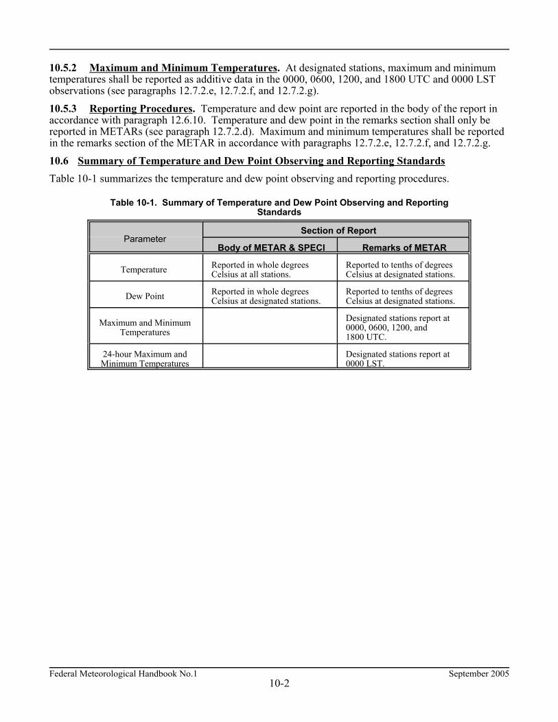
Federal Meteorological Handbook No.1 September 200510-2
10.5.2 Maximum and Minimum Temperatures. At designated stations, maximum and minimumtemperatures shall be reported as additive data in the 0000, 0600, 1200, and 1800 UTC and 0000 LSTobservations (see paragraphs 12.7.2.e, 12.7.2.f, and 12.7.2.g). 10.5.3 Reporting Procedures. Temperature and dew point are reported in the body of the report inaccordance with paragraph 12.6.10. Temperature and dew point in the remarks section shall only bereported in METARs (see paragraph 12.7.2.d). Maximum and minimum temperatures shall be reportedin the remarks section of the METAR in accordance with paragraphs 12.7.2.e, 12.7.2.f, and 12.7.2.g. 10.6 Summary of Temperature and Dew Point Observing and Reporting Standards Table 10-1 summarizes the temperature and dew point observing and reporting procedures.
Table 10-1. Summary of Temperature and Dew Point Observing and ReportingStandards
ParameterSection of Report
Body of METAR & SPECI Remarks of METAR
Temperature Reported in whole degrees Celsius at all stations.
Reported to tenths of degreesCelsius at designated stations.
Dew Point Reported in whole degreesCelsius at designated stations.
Reported to tenths of degreesCelsius at designated stations.
Maximum and MinimumTemperatures
Designated stations report at0000, 0600, 1200, and1800 UTC.
24-hour Maximum andMinimum Temperatures
Designated stations report at0000 LST.

September 2005 Federal Meteorological Handbook No.111-1
CHAPTER 11 PRESSURE
11.1 General Atmospheric pressure is the force exerted by the atmosphere at a given point. In this chapter, the term"barometric pressure" refers to the actual pressure sensor value. The sensor value may be an altimetersetting, station pressure, or simply a direct pressure value without applied corrections depending on the typeof sensor. 11.2 Scope This chapter prescribes the standards for observing and reporting atmospheric pressure data. 11.3 Pressure Parameters a. Station pressure. The atmospheric pressure at the designated station elevation. b. Altimeter setting. The pressure value to which an aircraft altimeter scale is set so that it will indicate
the altitude above mean sea level of an aircraft on the ground at the location for which the value wasdetermined.
c. Sea-level pressure. A pressure value obtained by the theoretical reduction of barometric pressureto sea level. Where the Earth's surface is above sea level, it is assumed that the atmosphere extendsto sea level below the station and that the properties of that hypothetical atmosphere are related toconditions observed at the station.
11.4 Pressure Observing Standards 11.4.1 Barometer Comparisons. Each agency shall establish an agency standard barometer traceableto the standard of the National Institute of Standards and Technology. Each agency shall also establish asystem of routine barometer comparisons to determine corrections required to keep the station's pressuresensors within the required accuracy (see Appendix C). 11.4.2 Atmospheric Pressure. The various pressure parameters shall be determined from the barometricpressure after appropriate corrections are applied. The method used shall depend on the type of sensor andthe available computational aids. These aids may be systems that result in a direct readout of the desiredparameter, pressure reduction calculators, or tables. Designated stations may use constants to convertmeasured pressure to the desired pressure parameter. 11.4.3 Station Pressure. Station pressure shall be determined by adjusting the corrected barometricpressure to compensate for the difference between the height of the barometer and the designated stationelevation. 11.4.4 Sea-Level Pressure. At designated stations, sea-level pressure shall be computed by adjustingthe station pressure to compensate for the difference between the station elevation and sea-level. Thisadjustment shall be based on the station elevation and the 12-hour mean temperature at the station. The 12-hour mean temperature shall be the average of the present ambient temperature and the ambient temperature12 hours ago. Stations within ± 50 feet of sea-level may be authorized by their agency to use a constant value to adjuststation pressure to sea-level pressure. Otherwise, stations shall use reduction ratios provided by theirresponsible agency to calculate sea-level pressure.

Federal Meteorological Handbook No.1 September 200511-2
11.4.5 Altimeter Setting. The altimeter setting shall be determined either directly from an altimetersetting indicator or computed from the station pressure by applying a correction for the difference betweenthe station elevation and field elevation in the standard atmosphere. Where this difference is 30 feet or less,agencies may authorize the use of a constant correction. 11.4.6 Pressure Change (Rising/Falling). At designated stations, the pressure calculated for each reportshall be examined to determine if a pressure change is occurring. If the pressure is rising or falling at a rateof at least 0.06 inch per hour and the pressure change totals 0.02 inch or more at the time of the observation,a pressure change remark shall be reported (see paragraph 12.7.1.u). 11.4.7 Pressure Tendency. Designated stations shall include pressure tendency data in each 3- and6-hourly report. The pressure tendency includes two parts: the characteristic (an indication of how thepressure has been changing over the past three hours) and the amount of the pressure change in the pastthree hours. The characteristic shall be based on the observed or recorded (barogram trace) changes inpressure over the past three hours. The amount of pressure change is the absolute value of the change instation pressure or altimeter setting in the past three hours converted to tenths of hectopascals. 11.5 Pressure Reporting Standards 11.5.1 Rounding Pressure Values. When computations of pressure values require that a number berounded to comply with standards on reportable values, the number shall be rounded down to the nextreportable value. For example, an altimeter reading of 29.248 inches becomes 29.24 and a station pressurereading of 29.249 inches becomes 29.245. 11.5.2 Units of Measure. Table 11-1 lists the units of measure for pressure parameters.
Table 11-1. Units of Measure of Pressure Parameters
Parameter Units of Measure
Altimeter Setting Inches of Mercury
Sea-Level Pressure Hectopascals
Station Pressure Inches of Mercury
11.5.3 Altimeter Setting. Altimeter setting shall be reported in all reports (see paragraph 12.6.11). 11.5.4 Sea-Level Pressure. At designated stations, sea-level pressure shall be included in the remarkssection of all METARs (see paragraph 12.7.1.v). 11.5.5 Remarks. At designated stations, the pressure change remarks (PRESRR or PRESFR) shall bereported if occurring at the time of observation (see paragraph 12.7.1.u). The pressure tendency group shallonly be included in 3- and 6-hourly reports (see paragraph 12.7.2.h).
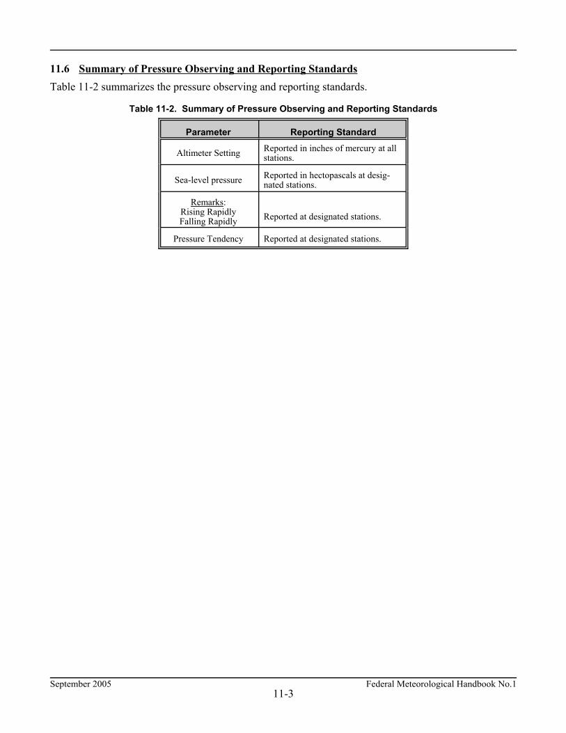
September 2005 Federal Meteorological Handbook No.111-3
11.6 Summary of Pressure Observing and Reporting Standards Table 11-2 summarizes the pressure observing and reporting standards.
Table 11-2. Summary of Pressure Observing and Reporting Standards
Parameter Reporting Standard
Altimeter Setting Reported in inches of mercury at allstations.
Sea-level pressure Reported in hectopascals at desig-nated stations.
Remarks:Rising RapidlyFalling Rapidly Reported at designated stations.
Pressure Tendency Reported at designated stations.


September 2005 Federal Meteorological Handbook No.112-1
CHAPTER 12 CODING
12.1 General The coding standards in this chapter conform to WMO Code Forms METAR FM 15-IX Ext. and SPECI FM16-IX Ext. and the United States Exceptions filed with the WMO. These exceptions reflect nationalobserving practices which differ from practices outlined in the WMO Manual on Codes No. 306.12.2 ScopeThis chapter contains the standards for coding a weather observation in either aviation routine weather report(METAR) and/or aviation selected special weather report (SPECI) format. 12.3 METAR/SPECI Code METAR or SPECI_CCCC_YYGGggZ_AUTO or COR_dddff(f)Gfmfm(fm)KT_dndndnVdxdxdx_
VVVVVSM_[RDRDR/VRVRVRVRFT or RDRDR/VNVNVNVNVVXVXVXVXFT]_w'w'_[NsNsNshshshs or VVhshshsor SKC/CLR]_T'T'/T'dT'd_APHPHPHPH _RMK_(Automated, Manual, Plain Language)_(Additive Data and Automated Maintenance Indicators)
METAR/SPECI has two major sections: the Body (consisting of a maximum of 11 groups) and the Remarks(consisting of 2 categories). Together, the body and remarks make up the complete METAR/SPECI. Ingeneral, the remarks are coded in the order depicted above and established in the remainder of this chapter. 12.4 Format and Content of the METAR/SPECI a. Body of report. (1) Type of Report - METAR/SPECI
(2) Station Identifier - CCCC(3) Date and Time of Report - YYGGggZ(4) Report Modifier - AUTO/COR(5) Wind - dddff(f)Gfmfm(fm)KT_dndndnVdxdxdx(6) Visibility - VVVVVSM(7) Runway Visual Range - RDRDR/VRVRVRVRFT or RDRDR/VNVNVNVNVVXVXVXVXFT(8) Present Weather - w'w'(9) Sky Condition - NsNsNshshshs or VVhshshs or SKC/CLR
(10) Temperature and Dew Point - T'T'/T'dT'd(11) Altimeter - APHPHPHPH
b. Remarks section of report--RMK
(1) Automated, Manual, and Plain Language(2) Additive and Maintenance Data
The underline character "_" indicates a required space between the groups. If a group is not reported, thepreceding space is also not reported. In addition to the format given, agencies shall provide for the inclusionof any special Beginning-of-Message, End-of-Message, or End-of-Transmission signals required by theircommunications system. The actual content of a METAR or SPECI depends on the observation program at the individual station. Atdesignated stations, the 0000, 0600, 1200, and 1800 Coordinated Universal Time (UTC) METAR's includeadditional data specified by the responsible agency and are known as 6-hourly reports. At designated stations,the 0300, 0900, 1500, and 2100 UTC METAR's are known as 3-hourly reports and also contain additionalinformation specified by the responsible agency.
Federal Meteorological Handbook No.1 September 200512-2
12.5 Coding Missing Data in METAR/SPECI When an element does not occur, or cannot be observed, the corresponding group and preceding space areomitted from that particular report. 12.6 Coding the Body of the METAR/SPECI 12.6.1 Type of Report (METAR and SPECI). The type, METAR or SPECI, shall be included in allreports. The type of report shall be separated from elements following it by a space. Whenever SPECIcriteria are met at the time of the routine METAR, the type of report shall be METAR. 12.6.2 Station Identifier (CCCC). The station identifier, CCCC, shall be included in all reports to identifythe station to which the coded report applies. The station identifier shall consist of four alphabetic-onlycharacters if the METAR/SPECI is transmitted long-line. The agency with operational control when thestation is first established shall be responsible for coordinating the location identifier with the FAA. A listof approved identifiers can be found in the FAA Manual 7350 Series, Location Identifiers. 12.6.3 Date and Time of Report (YYGGggZ). The date, YY, and time, GGgg, shall be included in allreports. The time shall be the actual time of the report or when the criteria for a SPECI is met or noted(see paragraph 2.6.4). If the report is a correction to a previously disseminated report, the time of thecorrected report shall be the same time used in the report being corrected. The date and time group alwaysends with a Z indicating Zulu time (or UTC). For example, METAR KDCA 210855Z would be the 0900scheduled report from station KDCA taken at 0855 UTC on the 21st of the month. 12.6.4 Report Modifier (AUTO or COR). The report modifier, AUTO, identifies the METAR/SPECI asa fully automated report with no human intervention or oversight. In the event of a corrected METAR orSPECI, the report modifier, COR, shall be substituted in place of AUTO. 12.6.5 Wind Group (dddff(f)Gfmfm(fm)KT_dndndnVdxdxdx). The standards for observing and reportingwind are described in Chapter 5. The wind direction, ddd, shall be coded in tens of degrees using three figures. Directions less than 100degrees shall be preceded with a "0". For example, a wind direction of 90° is coded as "090". The windspeed, ff(f), shall be coded in two or three digits immediately following the wind direction. The wind speedshall be coded, in whole knots, using the units and tens digits and, if required, the hundreds digit. Speeds ofless than 10 knots shall be coded using a leading zero. The wind group shall always end with KT to indicatethat wind speeds are reported in knots. For example, a wind speed of 8 knots shall be coded "08KT"; a windspeed of 112 knots shall be coded "112KT". a. Gust. Wind gusts shall be coded in the format, Gfmfm(fm) (see paragraphs 5.4.4 and 5.5.4). The
wind gust shall be coded in two or three digits immediately following the wind speed. The windgust shall be coded, in whole knots, using the units and tens digits and, if required, the hundredsdigit. For example, a wind from due west at 20 knots with gusts to 35 knots would be coded"27020G35KT".
b. Variable Wind Direction (Speeds 6 knots or less). Variable wind direction with wind speed6 knots or less may be coded as VRB in place of the ddd (see paragraphs 5.4.2 and 5.5.3). Forexample, if the wind is variable at three knots, it would be coded "VRB03KT".
c. Variable Wind Direction (Speeds greater than 6 knots). Variable wind direction with wind speedgreater than 6 knots shall be coded in the format, dndndnVdxdxdx. The variable wind direction groupshall immediately follow the wind group (see paragraphs 5.4.2 and 5.5.3). The directional variabilityshall be coded in a clockwise direction. For example, if the wind is variable from 180° to 240° at10 knots, it would be coded "21010KT 180V240".
d. Calm Wind. Calm wind shall be coded as "00000KT" (see paragraph 5.5.2).
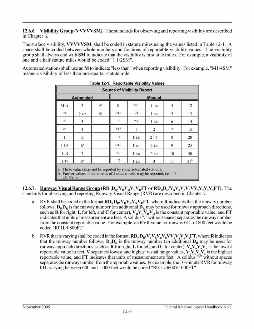
September 2005 Federal Meteorological Handbook No.112-3
12.6.6 Visibility Group (VVVVVSM). The standards for observing and reporting visibility are describedin Chapter 6. The surface visibility, VVVVVSM, shall be coded in statute miles using the values listed in Table 12-1. Aspace shall be coded between whole numbers and fractions of reportable visibility values. The visibilitygroup shall always end with SM to indicate that the visibility is in statute miles. For example, a visibility ofone and a half statute miles would be coded "1 1/2SM". Automated stations shall use an M to indicate "less than" when reporting visibility. For example, "M1/4SM"means a visibility of less than one-quarter statute mile.
Table 12-1. Reportable Visibility ValuesSource of Visibility Report
Automated Manual
M1/4 2 9a 0 5/8 1 5/8 4 12
1/4 2 1/2 10 1/16 3/4 1 3/4 5 13
1/2 3 1/8 7/8 1 7/8 6 14
3/4 4 3/16 1 2 7 15
1 5 1/4 1 1/8 2 1/4 8 20
1 1/4 6a 5/16 1 1/4 2 1/2 9 25
1 1/2 7 3/8 1 3/8 2 3/4 10 30
1 3/4 8a 1/2 1 1/2 3 11 35b
a. These values may not be reported by some automated stations.b. Further values in increments of 5 statute miles may be reported, i.e., 40, 45, 50, etc
12.6.7. Runway Visual Range Group (RDRDR/VRVRVRVRFT or RDRDR/VnVnVnVnVVxVxVxVxFT). Thestandards for observing and reporting Runway Visual Range (RVR) are described in Chapter 7. a. RVR shall be coded in the format RDRDR/VRVRVRVRFT, where R indicates that the runway number
follows, DRDR is the runway number (an additional DR may be used for runway approach directions,such as R for right, L for left, and C for center), VRVRVRVR is the constant reportable value, and FTindicates that units of measurement are feet. A solidus "/" without spaces separates the runway numberfrom the constant reportable value. For example, an RVR value for runway 01L of 800 feet would becoded "R01L/0800FT".
b. RVR that is varying shall be coded in the format, RDRDR/VnVnVnVnVVxVxVxVxFT, where R indicatesthat the runway number follows, DRDR is the runway number (an additional DR may be used forrunway approach directions, such as R for right, L for left, and C for center), VnVnVnVn is the lowestreportable value in feet, V separates lowest and highest visual range values, VxVxVxVx is the highestreportable value, and FT indicates that units of measurement are feet. A solidus "/" without spacesseparates the runway number from the reportable values. For example, the 10-minute RVR for runway01L varying between 600 and 1,000 feet would be coded "R01L/0600V1000FT".

Federal Meteorological Handbook No.1 September 200512-4
c. The values shall be based on light setting 5 at manual stations regardless of the light setting actuallyin use (see Appendix D). RVR values shall be coded in increments of 100 feet up to 1,000 feet,increments of 200 feet from 1,000 feet to 3,000 feet, and increments of 500 feet from 3,000 feet to6,000 feet. Manual RVR shall not be reported below 600 feet. For automated stations, RVR may bereported from up to four designated runways.
d. If the RVR is less than its lowest reportable value, the VRVRVRVR or VnVnVnVn groups shall bepreceded by M. If the RVR is greater than its highest reportable value, the VRVRVRVR or VxVxVxVxgroups shall be preceded by a P. For example, an RVR for runway 01L of less than 600 feet will becoded "R01L/M0600FT"; an RVR for runway 27 of greater than 6,000 feet will be coded"R27/P6000FT".
12.6.8 Present Weather Group (w'w'). The standards for observing and reporting present weather aredescribed in Chapter 8. The appropriate notations found in Table 12-2 shall be used to code present weather.
Table 12-2. Notations for Reporting Present Weather1
QUALIFIER WEATHER PHENOMENA
INTENSITY ORPROXIMITY
1
DESCRIPTOR
2
PRECIPITATION
3
OBSCURATION
4
OTHER
5
- Light
Moderate2
+ Heavy
VC In the Vicinity3
MI Shallow
PR Partial
BC Patches
DR Low Drifting
BL Blowing
SH Shower(s)
TS Thunderstorm
FZ Freezing
DZ Drizzle
RA Rain
SN Snow
SG Snow Grains
IC Ice Crystals
PL Ice Pellets
GR Hail
GS Small Hail and/or Snow Pellets
UP Unknown Precipitation
BR Mist
FG Fog
FU Smoke
VA Volcanic Ash
DU Widespread Dust
SA Sand
HZ Haze
PY Spray
PO Well- Developed Dust/Sand Whirls
SQ Squalls
FC Funnel Cloud Tornado Waterspout4
SS Sandstorm
DS Duststorm
1. The weather groups shall be constructed by considering columns 1 to 5 in the table above in sequence, i.e.,intensity, followed by description, followed by weather phenomena, e.g., heavy rain shower(s) is coded as +SHRA2. To denote moderate intensity no entry or symbol is used.3. See paragraph 8.4.1.a.(2), 8.5, and 8.5.1 for vicinity definitions.4. Tornadoes and waterspouts shall be coded as +FC.
September 2005 Federal Meteorological Handbook No.112-5
The following general rules apply when coding present weather for a METAR or SPECI: ¢ Weather occurring at the point of observation (at the station) or in the vicinity of the station shall
be coded in the body of the report; weather observed but not occurring at the point of observation(at the station) or in the vicinity of the station shall be coded in Remarks.
¢ With the exceptions of volcanic ash, low drifting dust, low drifting sand, low drifting snow, shallowfog, partial fog, and patches (of) fog, an obscuration shall be coded in the body of the report if thesurface visibility is less than 7 miles or considered operationally significant. Volcanic ash shallalways be coded when observed.
¢ Separate groups shall be used for each type of present weather. Each group shall be separated fromthe other by a space. METAR/SPECI shall contain no more than three present weather groups.
¢ The weather groups shall be constructed by considering columns 1 to 5 in Table 12-2 in sequence,i.e., intensity, followed by description, followed by weather phenomena, e.g., heavy rain shower(s)is coded as +SHRA.
a. Intensity or Proximity Qualifier. (1) Intensity shall be coded with precipitation types, except ice crystals (IC), hail (GR or GS),
and unknown precipitation (UP) including those associated with a thunderstorm (TS) andthose of a showery nature (SH). Tornadoes and waterspouts shall be coded as +FC. Nointensity shall be ascribed to the obscurations of blowing dust (BLDU), blowing sand(BLSA), and blowing snow (BLSN). Only moderate or heavy intensity shall be ascribed tosandstorm (SS) and duststorm (DS).
(2) The proximity qualifier for vicinity, VC, (weather phenomena observed in the vicinity of butnot at the point(s) of observation) shall be coded in combination with thunderstorm (TS), fog(FG), shower(s) (SH), well-developed dust/sand whirls (PO), blowing dust (BLDU),blowing sand (BLSA), blowing snow (BLSN), sandstorm (SS), and duststorm (DS).Intensity qualifiers shall not be coded with VC.
VCFG shall be coded to report any type of fog in the vicinity of the point(s) of observation. Precipitation not occurring at the point of observation but within 10 statute miles shall be
coded as showers in the vicinity (VCSH). b. Descriptor Qualifier. Only one descriptor shall be coded for each weather phenomena group, e.g.,
"-FZDZ". Mist (BR) shall not be coded with any descriptor. (1) The descriptors shallow (MI), partial (PR), and patches (BC) shall only be coded with FG,
e.g., "MIFG". (2) The descriptors low drifting (DR) and blowing (BL) shall only be coded with dust (DU),
sand (SA), and snow (SN), e.g., "BLSN" or "DRSN". DR shall be coded for DU, SA, or SNraised by the wind to less than six feet above the ground.
When blowing snow is observed with snow falling from clouds, both phenomena arereported, e.g., "SN BLSN". If there is blowing snow and the observer cannot determinewhether or not snow is also falling, then BLSN shall be reported. PY shall be coded onlywith blowing (BL).

Federal Meteorological Handbook No.1 September 200512-6
(3) The descriptor shower(s) (SH) shall be coded only with one or more of the precipitationtypes of rain (RA), snow (SN), ice pellets (PL), small hail (GS), or large hail (GR). The SHdescriptor indicates showery-type precipitation. When any type of precipitation is codedwith VC, the intensity and type of precipitation shall not be coded.
(4) The descriptor thunderstorm (TS) may be coded by itself, i.e., a thunderstorm withoutassociated precipitation, or it may be coded with the precipitation types of rain (RA),snow (SN), ice pellets (PL), small hail and/or snow pellets (GS), or hail (GR). For example,a thunderstorm with snow and small hail and/or snow pellets would be coded as "TSSNGS".TS shall not be coded with SH.
(5) The descriptor freezing (FZ) shall only be coded in combination with fog (FG),drizzle (DZ), or rain (RA), e.g., "FZRA". FZ shall not be coded with SH.
c. Precipitation. Up to three types of precipitation may be coded in a single present weather group.They shall be coded in order of decreasing dominance based on intensity.
(1) Drizzle shall be coded as DZ; rain shall be coded as RA; snow shall be coded as SN; snowgrains shall be coded as SG; ice crystals shall be coded as IC; ice pellets shall be coded asPL, hail shall be coded as GR, and small hail and/or snow pellets shall be coded as GS.
(2) At automated stations, precipitation of unknown type shall be coded as UP.d. Obscuration.
(1) Mist shall be coded as BR; fog shall be coded as FG; smoke shall be coded as FU; volcanicash shall be coded as VA; widespread dust shall be coded as DU; sand shall be coded as SA;and haze shall be coded as HZ.
(2) Shallow fog (MIFG), patches (of) fog (BCFG), and partial fog (PRFG) may be coded withprevailing visibility of 7 statute miles or greater.
(3) Spray (PY) shall be coded only as BLPY. e. Other Weather Phenomena (1) Well-developed dust/sand whirls shall be coded as PO; squalls shall be coded as SQ;
sandstorm shall be coded as SS; and duststorm shall be coded as DS. (2) Tornadoes and waterspouts shall be coded as +FC. Funnel clouds shall be coded as FC. 12.6.9 Sky Condition Group (NsNsNshshshs or VVhshshs or SKC/CLR). The standards for observing andreporting sky condition are described in Chapter 9. a. Sky condition shall be coded in the format, NsNsNshshshs, where NsNsNs is the amount of sky cover
and hshshs is the height of the layer. There shall be no space between the amount of sky cover andthe height of the layer. Sky condition shall be coded in an ascending order up to the first overcastlayer. At mountain stations, if the layer is below station level, the height of the layer shall becoded as ///.
b. Vertical visibility shall be coded in the format, VVhshshs, where VV identifies an indefinite ceilingand hshshs is the vertical visibility into the indefinite ceiling (see paragraphs 9.4.4, 9.4.7, and9.5.5). There shall be no space between the group identifier and the vertical visibility.

September 2005 Federal Meteorological Handbook No.112-7
c. Clear skies shall be coded in the format, SKC or CLR, where SKC is the abbreviation used bymanual stations to indicate no layers are present and CLR is the abbreviation used by automatedstations to indicate no layers are detected at or below 12,000 feet (see paragraph 9.5.4).
Each layer shall be separated from other layers by a space. The sky cover for each layer reported shall becoded by using the appropriate reportable contraction from Table 12-3. The report of clear skies (SKC orCLR) are complete layer reports within themselves. The abbreviations FEW, SCT, BKN, and OVC shallbe followed, without a space, by the height of the layer.
Table 12-3. Contractions for Sky Cover
Reportable Contraction Meaning Summation Amountof Layer
VV Vertical Visibility 8/8
SKC or CLR1 Clear 0
FEW2 Few 1/8 - 2/8
SCT Scattered 3/8 - 4/8
BKN Broken 5/8 - 7/8
OVC Overcast 8/8
1. The abbreviation CLR shall be used at automated stations when no layers at or below 12,000 feet arereported; the abbreviation SKC shall be used at manual stations when no layers are reported.2. Any layer amount less than 1/8 is reported as FEW.
The height of the base of each layer, hshshs, shall be coded in hundreds of feet above the surface using threedigits in accordance with Table 12-4.
Table 12-4. Increments of Reportable Values of Sky Cover Height
Range of Height Values (feet) Reportable Increment (feet)
#5,000 To nearest 100
>5,000 but #10,000 To nearest 500
>10,000 To nearest 1,000
At manual stations, cumulonimbus (CB) or towering cumulus (TCU) shall be appended to the associated layer.For example, a scattered layer of towering cumulus at 1,500 feet would be coded "SCT015TCU" and wouldbe followed by a space if there were additional higher layers to code. 12.6.10 Temperature/Dew Point Group (T'T'/T'dT'd). The standards for observing and reportingtemperature and dew point are given in Chapter 10. The temperature shall be separated from the dew point witha solidus "/". The temperature and dew point shall be coded as two digits rounded to the nearest whole degree Celsius (seeparagraph 2.6.3). For example, a temperature of 0.3°C would be coded as “00". Sub-zero temperatures and dewpoints shall be prefixed with an M. For example, a temperature of 4°C with a dew point of -2°C would becoded as "04/M02"; a temperature of -0.5°C would be coded as "M00".

Federal Meteorological Handbook No.1 September 200512-8
If the temperature is not available, the entire temperature/dew point group shall not be coded. If the dew pointis not available, the temperature shall be coded followed by a solidus "/" and no entry made for dew point. Forexample, a temperature of 1.5°C and a missing dew point would be coded as "02/". 12.6.11 Altimeter (APHPHPHPH). The standards for observing and reporting altimeter are described inChapter 11. The altimeter group always starts with an A (the international indicator for altimeter in inches of mercury). Thealtimeter shall be coded as a four digit group immediately following the A using the tens, units, tenths, andhundredths of inches of mercury. The decimal point is not coded. 12.7 Remarks (RMK) Remarks shall be included in all METAR and SPECI, if appropriate. Remarks shall be separated from the body of the report by a space and the contraction RMK. If there are noremarks, the contraction RMK is not required. METAR/SPECI remarks fall into 2 categories: (1) Automated, Manual, and Plain Language (see paragraph12.7.1), and (2) Additive and Maintenance Data (see paragraph 12.7.2). Remarks shall be made in accordance with the following: a. Where plain language is called for, authorized contractions, abbreviations, and symbols should be used
to conserve time and space. However, in no case should an essential remark, of which the observer isaware, be omitted for the lack of readily available contractions. In such cases, the only requirement isthat the remark be clear. For a detailed list of authorized contractions, see FAA Order 7340 Series,Contractions.
b. Time entries shall be made in minutes past the hour if the time reported occurs during the same hourthe observation is taken. Hours and minutes shall be used if the hour is different, or this Handbookprescribes the use of the hour and minutes.
c. Present weather coded in the body of the report as VC may be further described, i.e., direction from thestation, if known. Weather phenomena beyond 10 statute miles of the point(s) of observation shall becoded as distant (DSNT) followed by the direction from the station. For example, precipitation ofunknown intensity within 10 statute miles east of the station would be coded as "VCSH E"; lightning25 statute miles west of the station would be coded as "LTG DSNT W".
d. Distance remarks shall be statute miles except for automated lightning remarks which are in nauticalmiles.
e. Movement of clouds or weather, if known, shall be coded with respect to the direction toward whichthe phenomena is moving. For example, a thunderstorm moving toward the northeast would be codedas "TS MOV NE".
f. Directions shall use the eight points of the compass coded in a clockwise order. g. Insofar as possible, remarks shall be entered in the order they are presented in the following paragraphs.
September 2005 Federal Meteorological Handbook No.112-9
12.7.1 Automated, Manual, and Plain Language Remarks. These remarks generally elaborate onparameters reported in the body of the report. Automated and manual remarks may be generated either by anautomated or manual station. Plain language remarks are only provided from manual stations. a. Volcanic Eruptions (Plain Language). Volcanic eruptions shall be coded. The remark shall be plain language and contain the following, if known: (1) Name of volcano. (2) Latitude and longitude or the direction and the approximate distance from the station. (3) Date/Time (UTC) of the eruption. (4) Size description, approximate height, and direction of movement of the ash cloud. (5) Any other pertinent data about the eruption. For example, a remark on a volcanic eruption would look like the following: MT. AUGUSTINE VOLCANO 70 MILES SW ERUPTED 231505 LARGE ASH CLOUD
EXTENDING TO APRX 30000 FEET MOVING NE. Pre-eruption volcanic activity shall not be coded. Pre-eruption refers to unusual and/or increasing
volcanic activity which could presage a volcanic eruption. b. Funnel Cloud (Tornadic activity_B/E(hh)mm_LOC/DIR_(MOV)). At manual stations,
tornadoes, funnel clouds, or waterspouts shall be coded in the format, Tornadicactivity_B/E(hh)mm_LOC/DIR_(MOV), where TORNADO, FUNNEL CLOUD, orWATERSPOUT identifies the specific tornadic activity, B/E denotes the beginning and/or endingtime, (hh)mm is the time of occurrence (only the minutes are required if the hour can be inferred fromthe report time), LOC/DIR is the location and/or direction of the phenomena from the station, andMOV is the movement, if known (see paragraphs 8.3.3.c, 8.5.3.c, and 8.5.5.b). Tornadic activity shallbe coded as the first remark after the "RMK" entry. For example, "TORNADO B13 6 NE" wouldindicate that a tornado, which began at 13 minutes past the hour, was 6 statute miles northeast of thestation.
c. Type of Automated Station (AO1 or AO2). AO1 or AO2 shall be coded in all METAR/SPECIfrom automated stations. Automated stations without a precipitation discriminator shall be identifiedas AO1; automated station with a precipitation discriminator shall be identified as AO2.
d. Peak Wind (PK_WND_dddff(f)/(hh)mm). The peak wind shall be coded in the format, PK_WNDdddff(f)/(hh)mm of the next METAR, where PK_WND is the remark identifier, ddd is the directionof the peak wind, ff(f) is the peak wind speed since the last METAR, and (hh)mm is the time ofoccurrence (only the minutes are required if the hour can be inferred from the report time) (seeparagraphs 5.4.5 and 5.5.5). There shall be a space between the two elements of the remark identifierand the wind direction/speed group; a solidus "/" (without spaces) shall separate the winddirection/speed group and the time. For example, a peak wind of 45 knots from 280 degrees thatoccurred at 15 minutes past the hour would be coded "PK WND 28045/15".
e. Wind Shift (WSHFT_(hh)mm). A wind shift shall be coded in the format, WSHFT_(hh)mm,where WSHFT is the remark identifier and (hh)mm is the time the wind shift began (only theminutes are required if the hour can be inferred from the report time) (see paragraphs 5.4.6 and 5.5.6).The contraction FROPA may be entered following the time if it is reasonably certain that the windshift was the result of a frontal passage. There shall be a space between the remark identifier and thetime and, if applicable, between the time and the frontal passage contraction. For example, a remarkreporting a wind shift accompanied by a frontal passage that began at 30 minutes after the hour wouldbe coded as "WSHFT 30 FROPA".

Federal Meteorological Handbook No.1 September 200512-10
f. Tower or Surface Visibility (TWR_VIS_vvvvv or SFC_VIS_vvvvv). Tower visibility or surfacevisibility (see paragraphs 6.5.4 and 6.5.5) shall be coded in the formats, TWR_VIS_vvvvv orSFC_VIS_vvvvv, respectively, where vvvvv is the observed tower/surface visibility value. A spaceshall be coded between each of the remark elements. For example, the control tower visibility of 11/2 statute miles would be coded "TWR VIS 1 1/2".
g. Variable Prevailing Visibility (VIS_vnvnvnvnvnVvxvxvxvxvx). Variable prevailing visibility shall becoded in the format VIS_vnvnvnvnvnVvxvxvxvxvx, where VIS is the remark identifier, vnvnvnvnvn is thelowest visibility evaluated, V denotes variability between two values, and vxvxvxvxvx is the highestvisibility evaluated. There shall be one space following the remark identifier; no spaces between theletter V and the lowest/highest values. For example, a visibility that was varying between 1/2 and 2statute miles would be coded "VIS 1/2V2" (see paragraphs 6.4.5 and 6.5.3).
h. Sector Visibility (VIS_[DIR]_vvvvv) [Plain Language]. The sector visibility shall be coded in theformat, VIS_[DIR]_vvvvv, where VIS is the remark identifier, [DIR] defines the sector to 8 pointsof the compass, and vvvvv is the sector visibility in statute miles, using the appropriate set of valuesin Table 12-1 (see paragraphs 6.4.6 and 6.5.7). For example, a visibility of 2 1/2 statute miles in thenortheastern octant would be coded "VIS NE 2 1/2".
i. Visibility At Second Location (VIS_vvvvv_[LOC]). At designated automated stations, the visibilityat a second location shall be coded in the format VIS_vvvvv_[LOC], where VIS is the remarkidentifier, vvvvv is the measured visibility value, and [LOC] is the specific location of the visibilitysensor(s) at the station (see paragraph 6.5.6). This remark shall only be generated when the conditionis lower than that contained in the body of the report. For example, a visibility of 2 1/2 statute milesmeasured by a second sensor located at runway 11 would be coded "VIS 2 1/2 RWY11".
j. Lightning (Frequency_LTG(type)_[LOC]). (1) When lightning is observed at a manual station, the frequency, type of lightning, and location
shall be reported. The remark shall be coded in the format Frequency_LTG(type)_[LOC].The contractions for the type and frequency of lightning shall be based on Table 12-5. Thelocation and direction shall be coded in accordance with paragraph 12.7.c. For example,"OCNL LTGICCG OHD", “FRQ LTG VC", or "LTG DSNT W".
(2) When lightning is detected by an automated system: (a) Within 5 nautical miles of the Airport Location Point (ALP), it will be reported as TS in
the body of the report with no remark; (b) Between 5 and 10 nautical miles of the ALP, it will be reported as VCTS in the body of
the report with no remark; (c) Beyond 10 but less than 30 nautical miles of the ALP, it will be reported in remarks only
as LTG DSNT followed by the direction from the ALP.
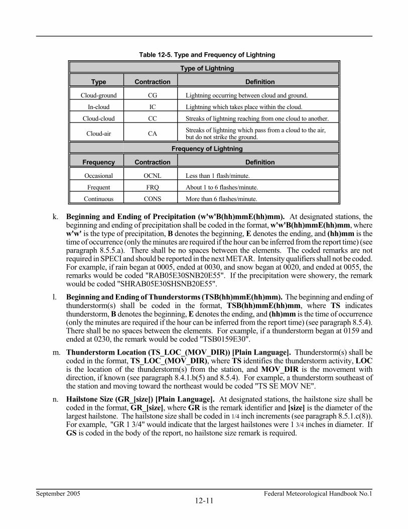
September 2005 Federal Meteorological Handbook No.112-11
Table 12-5. Type and Frequency of Lightning
Type of Lightning
Type Contraction Definition
Cloud-ground CG Lightning occurring between cloud and ground.
In-cloud IC Lightning which takes place within the cloud.
Cloud-cloud CC Streaks of lightning reaching from one cloud to another.
Cloud-air CA Streaks of lightning which pass from a cloud to the air,but do not strike the ground.
Frequency of Lightning
Frequency Contraction Definition
Occasional OCNL Less than 1 flash/minute.
Frequent FRQ About 1 to 6 flashes/minute.
Continuous CONS More than 6 flashes/minute.
k. Beginning and Ending of Precipitation (w'w'B(hh)mmE(hh)mm). At designated stations, thebeginning and ending of precipitation shall be coded in the format, w'w'B(hh)mmE(hh)mm, wherew'w' is the type of precipitation, B denotes the beginning, E denotes the ending, and (hh)mm is thetime of occurrence (only the minutes are required if the hour can be inferred from the report time) (seeparagraph 8.5.5.a). There shall be no spaces between the elements. The coded remarks are notrequired in SPECI and should be reported in the next METAR. Intensity qualifiers shall not be coded.For example, if rain began at 0005, ended at 0030, and snow began at 0020, and ended at 0055, theremarks would be coded "RAB05E30SNB20E55". If the precipitation were showery, the remarkwould be coded "SHRAB05E30SHSNB20E55".
l. Beginning and Ending of Thunderstorms (TSB(hh)mmE(hh)mm). The beginning and ending ofthunderstorm(s) shall be coded in the format, TSB(hh)mmE(hh)mm, where TS indicatesthunderstorm, B denotes the beginning, E denotes the ending, and (hh)mm is the time of occurrence(only the minutes are required if the hour can be inferred from the report time) (see paragraph 8.5.4).There shall be no spaces between the elements. For example, if a thunderstorm began at 0159 andended at 0230, the remark would be coded "TSB0159E30".
m. Thunderstorm Location (TS_LOC_(MOV_DIR)) [Plain Language]. Thunderstorm(s) shall becoded in the format, TS_LOC_(MOV_DIR), where TS identifies the thunderstorm activity, LOCis the location of the thunderstorm(s) from the station, and MOV_DIR is the movement withdirection, if known (see paragraph 8.4.1.b(5) and 8.5.4). For example, a thunderstorm southeast ofthe station and moving toward the northeast would be coded "TS SE MOV NE".
n. Hailstone Size (GR_[size]) [Plain Language]. At designated stations, the hailstone size shall becoded in the format, GR_[size], where GR is the remark identifier and [size] is the diameter of thelargest hailstone. The hailstone size shall be coded in 1/4 inch increments (see paragraph 8.5.1.c(8)).For example, "GR 1 3/4" would indicate that the largest hailstones were 1 3/4 inches in diameter. IfGS is coded in the body of the report, no hailstone size remark is required.

Federal Meteorological Handbook No.1 September 200512-12
o. Virga (VIRGA_(DIR)) [Plain Language]. Virga shall be coded in the format, VIRGA_(DIR),where VIRGA is the remark identifier and DIR is the direction from the station. The direction of thephenomena from the station is optional, e.g., "VIRGA" or "VIRGA SW".
p. Variable Ceiling Height (CIG_hnhnhnVhxhxhx). The variable ceiling height shall be coded in theformat, CIG_hnhnhnVhxhxhx, where CIG is the remark identifier, hnhnhn is the lowest ceiling heightevaluated, V denotes variability between two values, and hxhxhx is the highest ceiling height evaluated(see paragraph 9.5.7 and Table 9-1). There shall be one space following the remark identifier; nospaces between the letter V and the lowest/highest ceiling values. For example, "CIG 005V010"would indicate a ceiling that was varying between 500 and 1,000 feet.
q. Obscurations (w'w'_[NsNsNs]hshshs). [Plain Language] Obscurations (surface-based or aloft) shallbe coded in the format, w'w'_[NsNsNs]hshshs, where w'w' is the weather causing the obscuration atthe surface or aloft, NsNsNs is the applicable sky cover amount of the obscuration aloft (FEW, SCT,BKN, OVC) or at the surface (FEW, SCT, BKN), and hshshs is the applicable height (see paragraphs9.4.3 and 9.5.6). Surface-based obscurations shall have a height of “000". There shall be a spaceseparating the weather causing the obscuration and the sky cover amount; there shall be no spacebetween the sky cover amount and the height. For example, fog hiding 3-4 oktas of the sky wouldbe coded "FG SCT000"; a broken layer at 2,000 feet composed of smoke would be coded“FU BKN020".
r. Variable Sky Condition (NsNsNs(hshshs)_V_NsNsNs). [Plain Language] The variable sky conditionremark shall be coded in the format, NsNsNs(hshshs)_V_NsNsNs, where NsNsNs(hshshs) and NsNsNsidentifies the two operationally significant sky conditions and V denotes the variability between thetwo ranges (see paragraphs 9.4.2.d and 9.5.9). If there are several layers with the same sky conditionamount, the layer height (hshshs) of the variable layer shall be coded. For example, a cloud layer at1,400 feet that is varying between broken and overcast would be coded "BKN014 V OVC".
s. Significant Cloud Types [Plain Language]. The significant cloud type remark shall be coded in allreports in the following manner (see paragraphs 9.4.6 and 9.5.10):
(1) Cumulonimbus or Cumulonimbus Mammatus (CB or CBMAM_LOC_(MOV_DIR).Cumulonimbus or cumulonimbus mammatus, as appropriate, (for which no thunderstorm isbeing reported) shall be coded in the format, CB or CBMAM_LOC_(MOV_DIR), where CBor CBMAM is the cloud type, LOC is the direction from the station, and MOV_DIR is themovement with direction (if known). The cloud type, location, movement, and direction entriesshall be separated from each other with a space. For example, a CB up to 10 statute miles westof the station moving toward the east would be coded "CB W MOV E". If the CB was morethan 10 statute miles to the west, the remark would be coded "CB DSNT W".
(2) Towering cumulus (TCU_[DIR]). Towering cumulus clouds shall be coded in the format,TCU_[DIR], where TCU is the cloud type and DIR is the direction from the station. The cloudtype and direction entries shall be separated by a space. For example, a towering cumulus cloudup to 10 statute miles west of the station would be coded "TCU W".
(3) Altocumulus castellanus (ACC_[DIR]). Altocumulus castellanus shall be coded in the format,ACC_[DIR], where ACC is the cloud type and DIR is the direction from the station. The cloudtype and direction entries shall be separated by a space. For example, an altocumulus cloud 5to 10 statute miles northwest of the station would be coded "ACC NW".

September 2005 Federal Meteorological Handbook No.112-13
(4) Standing lenticular or Rotor clouds (CLD_[DIR]). Stratocumulus (SCSL), altocumulus(ACSL), or cirrocumulus (CCSL), or rotor clouds shall be coded in the format, CLD_[DIR],where CLD is the cloud type and DIR is the direction from the station. The cloud type anddirection entries shall be separated by a space. For example, altocumulus standing lenticularclouds observed southwest through west of the station would be coded "ACSL SWnW"; anapparent rotor cloud 5 to 10 statute miles northeast of the station would be coded "APRNTROTOR CLD NE"; and cirrocumulus clouds south of the station would be coded "CCSL S".
t. Ceiling Height at Second Location (CIG_hhh_[LOC]). At designated stations, the ceiling heightat a second location shall be coded in the format, CIG_hhh_[LOC], where CIG is the remarkidentifier, hhh is the measured height of the ceiling, and [LOC] is the specific location of theceilometer(s) at the station (see paragraph 9.5.8). This remark shall only be generated when theceiling is lower than that contained in the body of the report. For example, if the ceiling measured bya second sensor located at runway 11 is broken at 200 feet, the remark would be "CIG 002 RWY11".
u. Pressure Rising or Falling Rapidly (PRESRR/PRESFR). At designated stations, when thepressure is rising or falling rapidly at the time of observation (see paragraphs 11.4.6 and 11.5.5), theremark PRESRR (pressure rising rapidly) or PRESFR (pressure falling rapidly) shall be includedin the report.
v. Sea-Level Pressure (SLPppp). At designated stations, the sea-level pressure shall be coded in theformat SLPppp, where SLP is the remark identifier and ppp is the sea-level pressure in hectopascals(see paragraphs 11.4.4 and 11.5.4). For example, a sea-level pressure of 998.2 hectopascals wouldbe coded as "SLP982". For a METAR, if sea-level pressure is not available, it is coded as "SLPNO".
w. Aircraft Mishap (ACFT_MSHP) [Plain Language]. If a report is taken to document weatherconditions when notified of an aircraft mishap, the remark ACFT_MSHP shall be coded in the reportbut not transmitted. The act of non-transmission shall be indicated by enclosing the remark inparentheses in the record, i.e., "(ACFT MSHP)".
x. No SPECI Reports Taken (NOSPECI) [Plain Language]. At manual stations where SPECI's arenot taken, the remark NOSPECI shall be coded to indicate that no changes in weather conditions willbe reported until the next METAR.
y. Snow Increasing Rapidly (SNINCR_[inches-hour/inches on ground]). At designated stations, thesnow increasing rapidly remark shall be reported, in the next METAR, whenever the snow depthincreases by 1 inch or more in the past hour. The remark shall be coded in the format, SNINCR[inches-hour/inches on ground], where SNINCR is the remark indicator, inches-hour is the depthincrease in the past hour, and inches on ground is the total depth of snow on the ground at the timeof the report. The depth increase in the past hour and the total depth on the ground are separated fromeach other by a solidus "/". For example, a snow depth increase of 2 inches in the past hour with atotal depth on the ground of 10 inches would be coded "SNINCR 2/10".
z. Other Significant Information [Plain Language]. Agencies may add to a report other informationsignificant to their operations, such as information on fog dispersal operations, runway conditions,"FIRST" or "LAST" report from station, etc.

Federal Meteorological Handbook No.1 September 200512-14
12.7.2 Additive and Automated Maintenance Data. Additive data groups are only reported at designatedstations. The maintenance data groups are only reported from automated stations. a. Precipitation (1) Amount of Precipitation. The amount of liquid precipitation shall be coded as the depth of
precipitation that accumulates in an exposed vessel during the time period being evaluated. Theamount of freezing or frozen precipitation shall be the water equivalent of the solid precipitationaccumulated during the appropriate time period.
(2) Units of Measure for Precipitation. Precipitation measurements shall be in inches, tenths ofinches, or hundredths of inches depending on the precipitation being measured (see Table 12-6).
Table 12.6. Units of Measure for Precipitation
Type of Measurement Unit of Measure
Liquid Precipitation 0.01 inch
Water Equivalent of Solid Precipitation 0.01 inch
Solid Precipitation 0.1 inch
Snow Depth 1.0 inch
(3) Depth of Freezing or Frozen Precipitation. The depth of freezing and/or frozen precipitationshall be the actual vertical depth of the precipitation accumulated on a horizontal surface duringthe appropriate time period (see paragraphs 12.7.2.a(3)(b) and 12.7.2.a(3)(c). If snow falls,melts, and refreezes, the depth of ice formed shall be included in the measurement.
(a) Hourly Precipitation Amount (Prrrr). At designated automated stations, the hourlyprecipitation amount shall be coded in the format, Prrrr, where P is the group indicatorand rrrr is the water equivalent of all precipitation that has occurred since the lastMETAR (see paragraph 12.7.2.a(1)). The amount shall be coded in hundredths of an inch.For example, "P0009" would indicate 9/100 of an inch of precipitation fell in the pasthour; "P0000" would indicate that less than 1/100 of an inch of precipitation fell in thepast hour.
The group shall be omitted if no precipitation occurred since the last METAR. (b) 3- and 6-Hour Precipitation Amount (6RRRR). At designated stations, the 3- and
6-hourly precipitation group shall be coded in the format, 6RRRR, where 6 is the groupindicator and RRRR is the amount of precipitation. The amount of precipitation (waterequivalent) accumulated in the past 3 hours shall be reported in the 3-hourly report; theamount accumulated in the past 6 hours shall be reported in the 6-hourly report. Theamount of precipitation shall be coded in inches, using the tens, units, tenths andhundredths digits of the amount. When an indeterminable amount of precipitation hasoccurred during the period, RRRR shall be coded 6////. For example, 2.17 inches ofprecipitation would be coded "60217". A trace shall be coded "60000".
(c) 24-Hour Precipitation Amount (7R24R24R24R24). At designated stations, the 24-hourprecipitation amount shall be coded in the format, 7R24R24R24R24, where 7 is the groupindicator and R24R24R24R24 is the 24-hour precipitation amount. The 24-hour precipitationamount shall be included in the 1200 UTC (or other agency designated time) reportwhenever more than a trace of precipitation (water equivalent) has fallen in the preceding24 hours. The amount of precipitation shall be coded by using the tens, units, tenths, andhundredths of inches (water equivalent) for the 24-hour period. If more than a trace (waterequivalent) has occurred and the amount cannot be determined, the group shall be coded

September 2005 Federal Meteorological Handbook No.112-15
7////. For example, 1.25 inches of precipitation (water equivalent) in the past 24 hoursshall be coded "70125".
(d) Snow Depth on Ground (4/sss). At designated stations, the total snow depth on theground group shall be coded in the 0000, 0600, 1200, and 1800 UTC observationswhenever there is more than a trace of snow on the ground. The remark shall be codedin the format, 4/sss, where 4/ is the group indicator and sss is the snow depth in wholeinches using three digits. For example, a snow depth of 21 inches shall be coded as"4/021".
(e) Water Equivalent of Snow on Ground (933RRR). At designated stations, the waterequivalent of snow on the ground shall be coded each day, in the 1800 UTC report, if theaverage snow depth is 2 inches or more. The remark shall be coded in the format,933RRR, where 933 is the group indicator and RRR is the water equivalent of snow, i.e.,snow, snow pellets, snow grains, ice pellets, ice crystals, and hail, on the ground. Thewater equivalent shall be coded in tens, units, and tenths of inches, using three digits. Ifthe water equivalent of snow consists entirely of hail, the group shall not be coded. Awater equivalent of 3.6 inches of snow would be coded as "933036"; a water equivalentof 12.5 would be coded as "933125". This value is never estimated, ratios (e.g., 10 to 1)or temperature/snow water equivalent tables are not to be used to determine waterequivalency of snow for this group.
b. Cloud Types (8/CLCMCH). At designated stations, the group, 8/CLCMCH, shall be reported and codedin 3- and 6-hourly reports when clouds are observed. The predominant low cloud (CL), middle cloud(CM), and high cloud (CH), shall be identified in accordance with the WMO International Cloud Atlas,Volumes I and II, or the WMO Abridged International Cloud Atlas or agency observing aids for cloudidentification. A 0 shall be coded for the low, middle, or high cloud type if no cloud is present in thatclassification. A solidus "/" shall be coded for layers above an overcast. If no clouds are observeddue to clear skies, the cloud type group shall not be coded. For example, a report of "8/6//" wouldindicate an overcast layer of stratus clouds; a report of "8/903" would indicate cumulonimbus typelow clouds, no middle clouds, and dense cirrus high clouds.
c. Duration of Sunshine (98mmm). The duration of sunshine that occurred the previous calendar dayshall be coded in the 0800 UTC report. If the station is closed at 0800 UTC, the group shall be codedin the first 6-hourly METAR after the station opens. The duration of sunshine shall be coded in theformat, 98mmm, where 98 is the group indicator and mmm is the total minutes of sunshine. Theminutes of sunshine shall be coded by using the hundreds, tens, and units digits. For example, 96minutes of sunshine would be coded "98096". If no sunshine occurred, the group would be coded"98000".
d. Hourly Temperature and Dew Point (TsnT'T'T'snT'dT'dT'd). At designated stations, the hourlytemperature and dew point group shall be coded to the tenth of a degree Celsius in the format,TsnT'T'T'snT'dT'dT'd, where T is the group indicator, sn is the sign of the temperature, T'T'T' is thetemperature, and T'dT'dT'd is the dew point (see paragraphs 10.5.1 and 10.5.3). The sign of thetemperature and dew point shall be coded as 1 if the value is below 0°C and 0 if the value is 0°C orhigher. The temperature and dew point shall be reported in tens, units, and tenths of degrees Celsius.There shall be no spaces between the entries. For example, a temperature of 2.6°C and dew point of-1.5°C would be reported in the body of the report as "03/M01" and the TsnT'T'T'snT'dT'dT'd groupas "T00261015". If dew point is missing report the temperature; if the temperature is missing do notreport the temperature/dew point group.

Federal Meteorological Handbook No.1 September 200512-16
e. 6-Hourly Maximum Temperature (1snTxTxTx). At designated stations, the 6-hourly maximumtemperature group shall be coded in the format, 1snTxTxTx, where 1 is the group indicator, sn is thesign of the temperature, TxTxTx is the maximum temperature in tenths of degrees Celsius using threedigits (see paragraphs 10.4.4, 10.5.2, and 10.5.3). The sign of the maximum temperature shall becoded as 1 if the maximum temperature is below 0°C and 0 if the maximum temperature is 0°C orhigher. For example, a maximum temperature of n2.1°C would be coded "11021"; 14.2°C would becoded "10142".
f. 6-Hourly Minimum Temperature (2snTnTnTn). At designated stations, the 6-hourly minimumtemperature group shall be coded in the format, 2snTnTnTn, where 2 is the group indicator, sn is thesign of the temperature, and TnTnTn is the minimum temperature in tenths of degrees Celsius usingthree digits (see paragraphs 10.4.4, 10.5.2, and 10.5.3). The sign of the minimum temperature shallbe coded as 1 if the minimum temperature is below 0°C and 0 if the minimum temperature is 0°C orhigher. For example, a minimum temperature of n0.1°C would be coded "21001"; 1.2°C would becoded "20012".
g. 24-Hour Maximum and Minimum Temperature (4snTxTxTxsnTnTnTn). At designated stations,the 24-hour maximum temperature and the 24-hour minimum temperature shall be coded in theformat, 4snTxTxTxsnTnTnTn, where 4 is the group indicator, sn is the sign of the temperature, TxTxTxis the maximum 24-hour temperature, and TnTnTn is the 24-hour minimum temperature (seeparagraphs 10.4.4, 10.5.2, and 10.5.3). TxTxTx and TnTnTn shall be coded in tenths of degrees Celsiususing three digits. The sign of the maximum or minimum temperature shall be coded as 1 if it isbelow 0°C and 0 if it is 0°C or higher. For example, a 24-hour maximum temperature of 10.0°C anda 24-hour minimum temperature of n1.5°C would be coded "401001015"; a 24-hour maximumtemperature of 11.2°C and a 24-hour minimum temperature of 8.4°C would be coded as "401120084".
h. 3-Hourly Pressure Tendency (5appp). At designated stations, the 3-hourly pressure tendency groupshall be coded in the format, 5appp, where 5 is the group indicator, a is the character of pressurechange over the past 3 hours (see Table 12-7), and ppp is the amount of barometric change in tenthsof hectopascals (see Table 12-8). The amount of barometric change shall be coded using the tens,units, and tenths digits (see paragraphs 11.4.7 and 11.5.4). For example, a steady increase of 3.2hectopascals in the past three hours would be coded "52032".
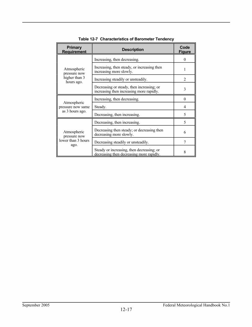
September 2005 Federal Meteorological Handbook No.112-17
Table 12-7 Characteristics of Barometer Tendency
PrimaryRequirement Description Code
Figure
Atmosphericpressure nowhigher than 3
hours ago.
Increasing, then decreasing. 0
Increasing, then steady, or increasing thenincreasing more slowly. 1
Increasing steadily or unsteadily. 2
Decreasing or steady, then increasing; orincreasing then increasing more rapidly. 3
Atmospheric pressure now same
as 3 hours ago.
Increasing, then decreasing. 0
Steady. 4
Decreasing, then increasing. 5
Atmospheric pressure now
lower than 3 hoursago.
Decreasing, then increasing. 5
Decreasing then steady; or decreasing thendecreasing more slowly. 6
Decreasing steadily or unsteadily. 7
Steady or increasing, then decreasing; ordecreasing then decreasing more rapidly. 8

Federal Meteorological Handbook No.1 September 200512-18
Table 12-8. 3-Hour Pressure ChangeAmount of Barometric Change (Rise or Fall) in the Past 3 Hours "ppp"
CodeFigure
Inches ofMercury
Hectopascals CodeFigure
Inches ofMercury
Hectopascals CodeFigure
Inches ofMercury
Hectopascals
000002003005007008010012014015017019020022024025027029030032034036037039041042044046047049051052054056058059061063064066
0.0000.0050.0100.0150.0200.0250.0300.0350.0400.0450.0500.0550.0600.0650.0700.0750.0800.0850.0900.0950.1000.1050.1100.1150.1200.1250.1300.1350.1400.1450.1500.1550.1600.1650.1700.1750.1800.1850.1900.195
0.00.20.30.50.70.81.01.21.41.51.71.92.02.22.42.52.72.93.03.23.43.63.73.94.14.24.44.64.74.95.15.25.45.65.85.96.16.36.46.6
068069071073075076078080081083085086088090091093095097098100102103105107108110112113115117119120122124125127129130132134
0.2000.2050.2100.2150.2200.2250.2300.2350.2400.2450.2500.2550.2600.2650.2700.2750.2800.2850.2900.2950.3000.3050.3100.3150.3200.3250.3300.3350.3400.3450.3500.3550.3600.3650.3700.3750.3800.3850.3900.395
6.86.97.17.37.57.67.88.08.18.38.58.68.89.09.19.39.59.79.810.010.210.310.510.710.811.011.211.311.511.711.912.012.212.412.512.712.913.013.213.4
135137139141142144146147149151152154156157159161163164166168169171173174176178179181183185186188190191193195196198200201
0.4000.4050.4100.4150.4200.4250.4300.4350.4400.4450.4500.4550.4600.4650.4700.4750.4800.4850.4900.4950.5000.5050.5100.5150.5200.5250.5300.5350.5400.5450.5500.5550.5600.5650.5700.5750.5800.5850.5900.595
13.513.713.914.114.214.414.614.714.915.115.215.415.615.715.916.116.316.416.616.816.917.117.317.417.617.817.918.118.318.518.618.819.019.119.319.519.619.820.020.1
i. Sensor Status Indicators. Sensor status indicators should be reported as indicated below: (1) if the Runway Visual Range should be reported but is missing, RVRNO shall be coded. (2) when automated stations are equipped with a present weather identifier and that sensor is
not operating, the remark PWINO shall be coded. (3) when automated stations are equipped with a tipping bucket rain gauge and that sensor is
not operating, PNO shall be coded. (4) when automated stations are equipped with a freezing rain sensor and that sensor is not
operating, the remark FZRANO shall be coded.

September 2005 Federal Meteorological Handbook No.112-19
(5) when automated stations are equipped with a lightning detection system and that sensor isnot operating, the remark TSNO shall be coded.
(6) when automated stations are equipped with a secondary visibility sensor and that sensor isnot operating, the remark VISNO_LOC shall be coded.
(7) when automated stations are equipped with a secondary ceiling height indicator and thatsensor is not operating, the remark CHINO_LOC shall be coded.
j. Maintenance Indicator. A maintenance indicator sign, $, shall be coded when an automatedsystem detects that maintenance is needed on the system.


1The terms and definitions presented in this glossary are in accordance with their usage in this Handbook.
September 2005 Federal Meteorological Handbook No.1
APPENDIX A
GLOSSARY1
Federal Meteorological Handbook No.1 September 2005A-2
3-hourly report. A METAR taken at 0300, 0900, 1500, or 2100 UTC. 6-hourly report. A METAR taken at 0000, 0600, 1200, or 1800 UTC. actual time of observation. For METARs, it is the time the last element of the report is observed orevaluated. For SPECIs, it is the time that the criteria for a SPECI was met or noted. additive data. A group of coded remarks that includes pressure tendency, amount of precipitation, andmaximum/minimum temperature during specified periods of time. aircraft mishap. An inclusive term to denote the occurrence of an aircraft accident or incident. Airport Location Point. ALP, the permanent airport reference point defined by the latitude andlongitude published in the Airport Facility Directory. algorithm. A set of rules implemented (usually in a computer) to process data and generate definedoutputs. altimeter setting. That pressure value to which an aircraft altimeter scale is set so that it will indicatethe altitude above mean sea-level of an aircraft on the ground at the location for which the value wasdetermined.archive. A permanent record of surface weather reports and related data used to establish aclimatological record for the United States. atmospheric pressure. The pressure exerted by the atmosphere at a given point (see altimeter setting,pressure, sea-level pressure, station pressure). augmented report. A meteorological report prepared by an automated surface weather observingsystem for transmission with certified observers signed on to the system to add information to thereport. automated report. A meteorological report prepared by an automated surface weather observingsystem for transmission, and with no certified weather observers signed on to the system. backup. An alternate method for providing a meteorological report, parts of reports or documentationof reports when the primary method is unavailable. barogram. An analog record of pressure produced by a barograph. barograph. A recording barometer. barometer. An instrument that measures atmospheric pressure. barometric pressure. The actual pressure value indicated by a pressure sensor. blowing. A descriptor used to amplify observed weather phenomena whenever the phenomena areraised to a height of 6 feet or more above the ground. blowing dust. Dust picked up locally from the surface of the earth and blown about in clouds orsheets, reducing the reported horizontal visibility to less than 7 statute miles. blowing sand. Sand particles picked up from the surface of the earth by the wind to moderate heightsabove the ground, reducing the reported horizontal visibility to less than 7 statute miles. blowing snow. Snow lifted from the surface of the earth by the wind to a height of 6 feet or moreabove the ground and blown about in such quantities that the reported horizontal visibility is reducedto less than 7 miles.

September 2005 Federal Meteorological Handbook No.1A-3
blowing spray. Water droplets torn by the wind from a body of water, generally from the crests ofwaves, and carried up into the air in such quantities that they reduce the reported horizontal visibilityto less than 7 statute miles. body of report. That portion of a METAR or SPECI beginning with the type of report and ending withthe altimeter setting. broken layer. A layer covering whose summation amount of sky cover is 5/8ths through 7/8ths. calm. A condition when no motion of the air is detected. candela. A unit of luminous intensity, equal to 1/60 of the luminous intensity of a square centimeter ofa black body heated to 1773.5 degrees Celsius. ceiling. The lowest layer aloft reported as broken or overcast; or the vertical visibility into an indefiniteceiling. ceiling light. A type of cloud-height indicator that uses a focused light to project vertically a narrowbeam of light onto a cloud base. ceilometer. A device used to evaluate the height of clouds or the vertical visibility into a surface-basedobscuration. certified observer. An individual approved by designated Federal agencies to take surface observationsused in aircraft operations. clear sky. The absence of sky cover. cloud. A visible aggregate of minute water droplets or ice particles in the atmosphere above the Earth'ssurface. cloud-air lightning (CA). Streaks of lightning which pass from a cloud to the air, but do not strike theground.cloud-cloud lightning (CC). Streaks of lightning reaching from one cloud to another. cloud-ground lightning (CG): Lightning occurring between cloud and ground. cloud height. The height of the base of a cloud or cloud layer above the surface of the earth. cloud layer. An array of clouds whose bases are at approximately the same level. cloud movement. The direction toward which a cloud is moving. cloud type. A cloud form which is identified according to the WMO International Cloud Atlas. contraction. A shortened form of a word, title, or phrase used for brevity. Coordinated Universal Time (UTC). The time in the zero degree meridian time zone. cumulus. A principal cloud type in the form of individual, detached elements which are generallydense and possess sharp non-fibrous outlines. cumulonimbus. An exceptionally dense and vertically developed cloud, occurring either isolated oras a line or wall of clouds with separated upper portions. These clouds appear as mountains or hugetowers, at least a part of the upper portions of which are usually smooth, fibrous, or striated, and almostflattened. designated RVR runway. A runway at civilian airports designated by the FAA for reporting RVR.

Federal Meteorological Handbook No.1 September 2005A-4
designated stations. Weather observing stations that have the capability and have been instructed bytheir responsible agency to perform a specified task that is not required by standards to be performedat all stations. dew point. The temperature to which a given parcel of air must be cooled at constant pressure andconstant water-vapor content in order for saturation to occur. diamond dust. See ice crystals. dissemination. The act of delivering a completed weather report to users. drizzle. Fairly uniform precipitation composed exclusively of fine drops (diameter less than 0.02 inchor 0.5 mm) very close together. Drizzle appears to float while following air current, although unlikefog droplets, it falls to the ground. duration of sunshine. The amount of time sunlight was detected at a given point. dust. (see widespread dust). duststorm. A severe weather condition characterized by strong winds and dust-filled air over anextensive area. element. One of the basic conditions of the atmosphere discussed in this FMH (wind, visibility, runwayvisual range, weather, obscurations, sky condition, temperature and dewpoint, and pressure). Seeparameter. few. A layer whose summation amount of sky cover is 1/8th through 2/8ths. field elevation. The elevation above sea level of the highest point on any of the runways of the airport. fog. A visible aggregate of minute water particles (droplets) which are based at the Earth's surface andreduce horizontal visibility to less than 5/8 statute mile and, unlike drizzle, it does not fall to the ground. freezing. A descriptor, FZ, used to describe drizzle and/or rain that freezes on contact with the groundor exposed objects, and used also to describe fog that is composed of minute ice crystals. freezing drizzle. Drizzle that freezes upon impact with the ground, or other exposed objects. freezing fog. A suspension of numerous minute ice crystals in the air, or water droplets at temperaturesbelow 0° Celsius, based at the Earth's surface, which reduces horizontal visibility. freezing precipitation. Any form of precipitation that freezes upon impact and forms a glaze on theground or exposed objects. freezing rain. Rain that freezes upon impact and forms a glaze on the ground or exposed objects. frozen precipitation. Any form of precipitation that reaches the ground in solid form (snow, small hailand/or snow pellets, snow grains, hail, ice pellets, and ice crystals). funnel cloud. A violent, rotating column of air which does not touch the surface, usually appendedto a cumulonimbus cloud. glaze. Ice formed by freezing precipitation covering the ground or exposed objects.

September 2005 Federal Meteorological Handbook No.1A-5
ground elevation. The official height of a weather station with reference to sea-level when a fieldelevation has not been established. It is the height of the ground at the base of the ceilometer. ground fog. See shallow fog. gust. Rapid fluctuations in wind speed with a variation of 10 knots or more between peaks and lulls. hail. Precipitation in the form of small balls or other pieces of ice falling separately or frozen togetherin irregular lumps. haze. A suspension in the air of extremely small, dry particles invisible to the naked eye andsufficiently numerous to give the air an opalescent appearance. hectopascal. A unit of measure of atmospheric pressure equal to 100 newtons per square meter. horizon. The actual lower boundary of the observed sky or the upper outline of terrestrial objects,including nearby natural obstructions. It is the distant line along which the earth, or the water surfaceat sea, and the sky appear to meet. ice crystals (diamond dust). A fall of non-branched (snow crystals are branched) ice crystals in theform of needles, columns, or plates. ice fog. See freezing fog. ice pellets. Precipitation of transparent or translucent pellets of ice, which are round or irregular, rarelyconical, and which have a diameter of 0.2 inch (5 mm), or less. There are two main types: a. Hard grains of ice consisting of frozen raindrops, or largely melted and refrozen snowflakes. b. Pellets of snow encased in a thin layer of ice which have formed from the freezing, either of
droplets intercepted by the pellets, or of water resulting from the partial melting of the pellets. in-cloud lightning (IC). Lightning which takes place within the cloud. indefinite ceiling. The ceiling classification applied when the reported ceiling value represents thevertical visibility upward into surface-based obscuration. intensity qualifier. Intensity qualifiers are used to describe whether a phenomena is light (-), moderate(no symbol used), or heavy (+). layer. An array of clouds and/or obscurations whose bases are at approximately the same level. layer amount. The amount of sky covered by clouds and/or obscurations at a given level above theEarth's surface. layer height. The height of the bases of each reported layer of clouds and/or obscuration; or the verticalvisibility into an indefinite ceiling. lightning. The luminous phenomenon accompanying a sudden electrical discharge (see cloud-airlightning, cloud-cloud lightning, cloud-ground lightning and in-cloud lightning). liquid precipitation. Any form of precipitation that does not fall as frozen precipitation and does notfreeze upon impact. local dissemination. The transmission or delivery of a weather report to individuals or groups of usersnear the observing location. Local Standard Time (LST): A time based on the geographic location of the station in one of thelegally established time zones of the globe.

Federal Meteorological Handbook No.1 September 2005A-6
long-line dissemination (also long-line transmission). The transmission of a weather report by acommunication media to a group of users on a regional or national scale. long-term retention. Retention of data for 5 years to satisfy requirements for local studies and tosupport litigation. low drifting. A descriptor, DR, used to describe snow, sand, or dust raised to a height of less than 6feet above the ground. low drifting dust. Dust that is raised by the wind to less than 6 feet above the ground; visibility is notreduced below 7 statute miles at eye level although objects below this level may be veiled or hiddenby the particles moving nearly horizontal to the ground. low drifting sand. Sand that is raised by the wind to less than 6 feet above the ground; visibility is notreduced below 7 statute miles at eye level although objects below this level may be veiled or hiddenby the particles moving nearly horizontal to the ground. low drifting snow. Snow that is raised by the wind to less than 6 feet above the ground; visibility is notreduced below 7 statute miles at eye level although objects below this level may be veiled or hiddenby the particles moving nearly horizontal to the ground. manual station. A station, with or without an automated surface weather observing system, where thecertified observers are totally responsible for all meteorological reports that are transmitted. maximum temperature. The highest temperature during a specified time period. may. A term used to indicate that a standard is optional. METAR/SPECI. An evaluation of select weather elements from a point or points on or near theground according to a set of procedures. It may include type of report, station identifier, date and timeof report, a report modifier, wind, visibility, runway visual range, weather and obstructions to vision,sky condition, temperature and dew point, altimeter setting, and Remarks. METAR/SPECI code. WMO code forms (FM 15-X Ext. METAR and FM 16-X Ext. SPECI)consisting of abbreviations, contractions, numbers, plain language, and symbols to provide a uniformmeans of disseminating surface weather reports. minimum temperature. The lowest temperature during a specified time period. mist. A visible aggregate of minute water droplets or ice crystals suspended in the atmosphere thatreduces visibility to less than 7 statute miles but greater than or equal to 5/8 statute mile. non-uniform sky condition. A localized sky condition which varies from that reported in the body ofthe report. non-uniform visibility. A localized visibility which varies from that reported in the body of the report. obscured sky. The condition when the entire sky is hidden by surface-based obscurations. obscurations. Any phenomenon in the atmosphere, other than precipitation, that reduces the horizontalvisibility in the atmosphere. observing location. The point or points from which an element is evaluated. observing station. The point or points from which the various elements of the report are evaluated. overcast. A layer whose summation amount of sky cover is 8/8ths.

September 2005 Federal Meteorological Handbook No.1A-7
parameter. A subset of the group of evaluations that constitute each element of an observation; e.g.,sky condition is an element, sky cover and ceiling are parameters. partial. A descriptor, PR, used only to report fog that covers part of the airport. partial fog. A substantial part of the station covered by fog while the remainder is clear of fog. patches. A descriptor, BC, used only to report fog that occurs in patches at the airport. patches (of) fog. Fog patches which randomly cover the station. peak wind speed. The maximum instantaneous wind speed since the last METAR that exceeded25 knots. precipitation. Any of the forms of water particles, whether liquid or solid, that fall from theatmosphere and reach the ground. precipitation discriminator. A sensor, or array of sensors, that differentiates between different typesof precipitation (liquid, freezing, frozen). precipitation intensity. An indication of the rate at which precipitation is falling at the time ofobservation. precipitation rate. The amount of water, liquid or solid, that reaches the ground in a specified periodof time. pressure. The force exerted by a column of air above the point of measurement. pressure change. The net difference between pressure readings at the beginning and ending of aspecified interval of time. pressure characteristic. The indication of how the pressure has been changing during a specifiedperiod of time, usually the 3-hour period preceding an observation; e.g., decreasing then increasing,pressure same or lower than 3 hours ago. pressure falling rapidly. A decrease in station pressure at a rate of 0.06 inch of mercury or more perhour which totals 0.02 inch or more. pressure reduction calculator. A device used to compute sea-level pressure, station pressure, altimetersetting, pressure altitude, etc. pressure rising rapidly. An increase in station pressure at a rate of 0.06 inch of mercury or more perhour which totals 0.02 inch or more. pressure tendency. The character and amount of atmospheric pressure change during a specifiedperiod of time, usually the 3-hour period preceding an observation. pressure unsteady. A pressure that fluctuates by 0.03 inch of mercury or more from the mean pressureduring the period of measurement. prevailing visibility. The visibility that is considered representative of conditions at the station; thegreatest distance that can be seen throughout at least half the horizon circle, not necessarily continuous. rain. Precipitation, either in the form of drops larger than 0.02 inch (0.5 mm), or smaller drops, whichin contrast to drizzle, are widely separated; for automated stations, precipitation that remains in theliquid state upon impact with the ground or other exposed objects. Remarks. Plain language or coded data added to the body of the METAR/SPECI to report significantinformation not provided for in the body of the report.
Federal Meteorological Handbook No.1 September 2005A-8
rotor cloud. A turbulent cloud formation found in the lee of some large mountain barriers. The air inthe cloud rotates around an axis parallel to the mountain range. Runway Visual Range (RVR). An instrumentally-derived value, based on standard calibrations, thatrepresents the horizontal distance a pilot may see down the runway from the approach end. sand. Loose particles of granular material. sandstorm. Particles of sand carried aloft by a strong wind. The sand particles are mostly confinedto the lowest ten feet, and rarely rise more than fifty feet above the ground. scattered. A layer whose summation amount of sky cover is 3/8ths through 4/8ths. scheduled time of report. The time a scheduled report is required to be available for transmission. sea-level pressure. The pressure value obtained by the theoretical reduction or increase of barometricpressure to sea-level. sector visibility. The visibility in a specified direction that represents at least a 45 degree arc of thehorizon circle. shall. A term used to indicate that a standard is mandatory. shallow. A descriptor, MI, used only to describe fog when the visibility at 6 feet above the ground is5/8ths statute mile or more and the apparent visibility in the fog layer is less than 5/8ths statute mile. shallow fog. Fog in which the visibility at 6 feet above ground level is 5/8ths statute mile or more andthe apparent visibility in the fog layer is less than 5/8ths statute mile. sheet ice. Ice formed by the freezing of liquid precipitation or the freezing of melted solid precipitation(see snow depth). short-term storage. Storage of data for 4 or more days to assist in sensor/system maintenance andverification of sensor/system records in the event of an aircraft mishap. should. A term used to indicate that a standard is recommended. shower(s). A descriptor, SH, used to qualify precipitation characterized by the suddenness with whichthey start and stop, by the rapid changes of intensity, and usually by rapid changes in the appearanceof the sky. significant clouds. Cumulonimbus, cumulonimbus mammatus, towering cumulus, altocumuluscastellanus, and standing lenticular or rotor clouds. sky condition. The state of the sky in terms of such parameters as sky cover, layers and associatedheights, ceiling, and cloud types. sky cover. The amount of the sky which is covered by clouds or obscurations in contact with thesurface. small hail. See snow pellets. smoke. A suspension in the air of small particles produced by combustion. A transition to haze mayoccur when smoke particles have traveled great distances (25 to 100 statute miles or more) and whenthe larger particles have settled out and the remaining particles have become widely scattered throughthe atmosphere. snow. Precipitation of snow crystals, mostly branched in the form of six-pointed stars; for automatedstations, any form of frozen precipitation other than hail.

September 2005 Federal Meteorological Handbook No.1A-9
snow depth. The vertical height of frozen precipitation on the ground. For this purpose, frozenprecipitation includes ice pellets, glaze, hail, any combination of these, and sheet ice formed directlyor indirectly from precipitation. snow grains. Precipitation of very small, white, opaque grains of ice. snow pellets. Precipitation of white, opaque grains of ice. The grains are round or sometimes conical.Diameters range from about 0.08 to 0.2 inch (2 to 5 mm). spray. An ensemble of water droplets torn by the wind from an extensive body of water, generallyfrom the crests of waves, and carried up into the air in such quantities that it reduces the horizontalvisibility. SPECI. A surface weather report taken to record a change in weather conditions that meets specifiedcriteria or is otherwise considered to be significant. squall. A strong wind characterized by a sudden onset in which the wind speed increases at least16 knots and is sustained at 22 knots or more for at least one minute. Standard Atmosphere. A hypothetical vertical distribution of the atmospheric temperature, pressure,and density, which by international agreement is considered to be representative of the atmosphere forpressure-altimeter calibrations and other purposes (29.92INS or 1013hPa). standing lenticular cloud. A, more or less, isolated cloud with sharp outlines that is generally in theform of a smooth lens or almond. These clouds often form on the lee side of and generally parallel tomountain ranges. Depending on their height above the surface, they may be reported as stratocumulusstanding lenticular cloud (SCSL); altocumulus standing lenticular cloud (ACSL); or cirrocumulusstanding lenticular cloud (CCSL). station elevation. The officially designated height above sea-level to which station pressure pertains.It is generally the same as field elevation at an airport station. station identifier. A four alphabetic character code group used to identify the observing location. Station Information File. A record that documents the site characteristics of an observing location andthe reporting program at the location. station pressure. The atmospheric pressure at the designated station elevation. summation layer amount. A categorization of the amount of sky cover at and below each reportedlayer. summation principle. This principle states that the sky cover at any level is equal to the summationof the sky cover of the lowest layer plus the additional sky cover provided at all successively higherlayers up to and including the layer in question. surface. The horizontal plane whose elevation above sea level equals the field elevation. At stationswhere the field elevation has not been established, the surface refers to the ground elevation at theobservation site. surface visibility. The prevailing visibility determined from the usual point of observation. synoptic surface weather observation. Surface weather observations evaluated in accordance withWMO regulations (perhaps modified by national practices). These observations are reported no morefrequently than every 3 hours.

Federal Meteorological Handbook No.1 September 2005A-10
temperature. A measure of the hotness or coldness of the ambient air as measured by a suitableinstrument. thunderstorm. A cumulonimbus cloud that is accompanied by lightning and thunder, or for automatedsystems, a storm detected by lightning detection systems. time of occurrence. A report of the time weather begins and ends. tornadic activity. The occurrence or disappearance of tornados, funnel clouds, or waterspouts. tornado. A violent, rotating column of air touching the ground; funnel cloud that touches the ground(see funnel cloud and waterspout). tower visibility. The prevailing visibility determined from the airport traffic control tower when thesurface visibility is determined from another location. towering cumulus. A descriptive term for a cloud with generally sharp outlines and with moderate togreat vertical development, characterized by its cauliflower or tower appearance. type of report. A code (METAR, SPECI) included in the weather report to indicate the content of theobservation, and to indicate whether certain reporting criteria have been met. type of station. A code figure (AO1, or AO2) for automated stations which is included in the remarkssection of the report to indicate the scope of the observation program at the station that generated thereport. unknown precipitation. Precipitation type that is reported if the automated station detects theoccurrence of precipitation but the precipitation discriminator cannot recognize the type. variable ceiling. A ceiling of less than 3,000 feet which rapidly increases or decreases in height byestablished criteria during the period of observation. variable layer amounts. A condition when the reportable amount of a layer varies by one or morereportable values during the period it is being evaluated (variable sky condition). variable prevailing visibility. A condition when the prevailing visibility is less than 3 statute miles andrapidly increases and decreases by 1/2 mile or more during the period of observation. variable wind direction. A condition when (1) the wind direction fluctuates by 60 degrees or moreduring the 2-minute evaluation period and the wind speed is greater than 6 knots; or (2) the directionis variable and the wind speed is 6 knots or less. vertical visibility. A subjective or instrumental evaluation of the vertical distance into a surface-basedobscuration that an observer would be able to see. vicinity. A proximity qualifier, VC, used to indicate weather phenomena observed between 5 and 10statute miles of the usual point of observation but not at the station. virga. Visible wisps or strands of precipitation falling from clouds that evaporate before reaching thesurface. visibility. The greatest horizontal distance at which selected objects can be seen and identified or itsequivalent derived from instrumental measurements. visibility reference points. Selected objects at known distances from the weather station that are usedto manually evaluate visibility.

September 2005 Federal Meteorological Handbook No.1A-11
volcanic ash. Fine particles of rock powder that originate from a volcano and that may remainsuspended in the atmosphere for long periods. volcanic eruption. An explosion caused by the intense heating of subterranean rock which expels lava,steam, ashes, etc., through vents in the earth's crust. water equivalent. The liquid content of solid precipitation that has accumulated on the ground (snowdepth). The accumulation may consist of snow, ice formed by freezing precipitation, freezing liquidprecipitation, or ice formed by the refreezing of melted snow. waterspout. A violent, rotating column of air that forms over a body of water, and touches the watersurface; tornado or funnel cloud that touches a body of water (see funnel cloud and tornado). well-developed dust/sand whirl. An ensemble of particles of dust or sand, sometimes accompanied bysmall litter, raised from the ground in the form of a whirling column of varying height with a smalldiameter and an approximately vertical axis. weather. A category of individual and combined atmospheric phenomena which must be drawn uponto describe the local atmospheric conditions at the time of observation. widespread dust. Fine particles of earth or other matter raised or suspended in the air by the wind thatmay have occurred at or far away from the station. will. A term used to indicate futurity; it is not a requirement to be applied to standards. wind. The horizontal motion of the air past a given point. wind character. The description of the variability of the wind speed in terms of gusts. wind direction. The true direction from which the wind is moving at a given location. wind gust. See "gust." wind shift. A change in the wind direction of 45 degrees or more in less than 15 minutes with sustainedwind speeds of 10 knots or more throughout the wind shift. wind speed. The rate at which air is moving horizontally past a given point. It may be a 2-minuteaverage speed (reported as wind speed) or an instantaneous speed (reported as a peak wind speed, orgust).


1The abbreviations, acronyms, contractions, and symbols included in this appendix are defined in accordance with their usagein this Handbook.
September 2005 Federal Meteorological Handbook No.1
APPENDIX B
LIST OF ABBREVIATIONS AND ACRONYMS1
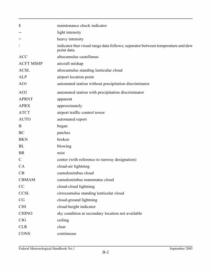
Federal Meteorological Handbook No.1 September 2005B-2
$ maintenance check indicator n light intensity + heavy intensity / indicator that visual range data follows; separator between temperature and dew
point data. ACC altocumulus castellanus ACFT MSHP aircraft mishap ACSL altocumulus standing lenticular cloud ALP airport location point AO1 automated station without precipitation discriminator
AO2 automated station with precipitation discriminator APRNT apparent APRX approximately ATCT airport traffic control tower AUTO automated report B began BC patches BKN broken BL blowing BR mist C center (with reference to runway designation) CA cloud-air lightning CB cumulonimbus cloud CBMAM cumulonimbus mammatus cloud CC cloud-cloud lightning CCSL cirrocumulus standing lenticular cloud CG cloud-ground lightning CHI cloud-height indicator CHINO sky condition at secondary location not available CIG ceiling CLR clear CONS continuous
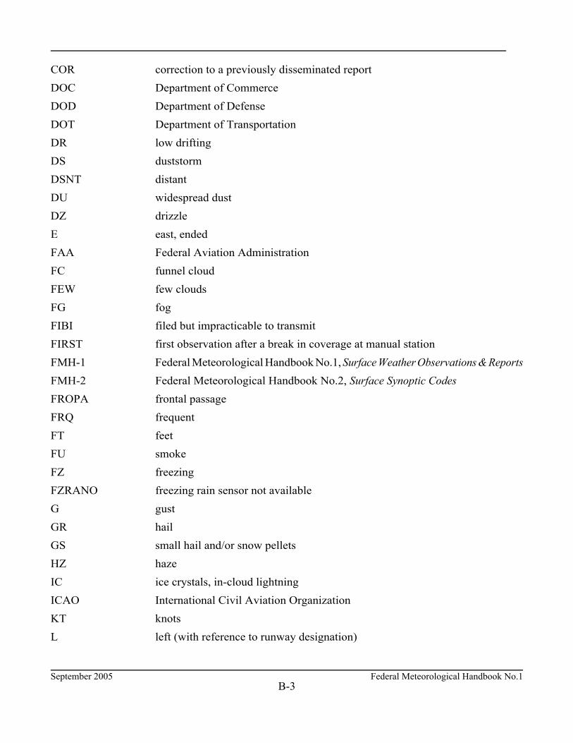
September 2005 Federal Meteorological Handbook No.1B-3
COR correction to a previously disseminated report DOC Department of Commerce DOD Department of Defense DOT Department of Transportation DR low drifting DS duststorm DSNT distant DU widespread dust DZ drizzle E east, ended FAA Federal Aviation Administration FC funnel cloud FEW few clouds FG fog FIBI filed but impracticable to transmit FIRST first observation after a break in coverage at manual station FMH-1 Federal Meteorological Handbook No.1, Surface Weather Observations & Reports FMH-2 Federal Meteorological Handbook No.2, Surface Synoptic Codes FROPA frontal passage FRQ frequent FT feet FU smoke FZ freezing FZRANO freezing rain sensor not available G gust GR hail GS small hail and/or snow pellets HZ haze IC ice crystals, in-cloud lightning ICAO International Civil Aviation Organization KT knots L left (with reference to runway designation)

Federal Meteorological Handbook No.1 September 2005B-4
LAST last observation before a break in coverage at a manual station LST Local Standard Time LTG lightning LWR lower M minus, less than METAR aviation routine weather report MI shallow MOV moved/moving/movement MT mountains N north N/A not applicable NCDC National Climatic Data Center NE northeast NOS National Ocean Service NOSPECI no SPECI reports are taken at the station NW northwest NWS National Weather Service OCNL occasional OFCM Office of the Federal Coordinator for Meteorology OVC overcast OHD overhead P greater than PL ice pellets PK WND peak wind PNO precipitation amount not available PO dust/sand whirls (dust devils) PR partial PRESFR pressure falling rapidly PRESRR pressure rising rapidly PWINO precipitation identifier sensor not available PY spray R right (with reference to runway designation)
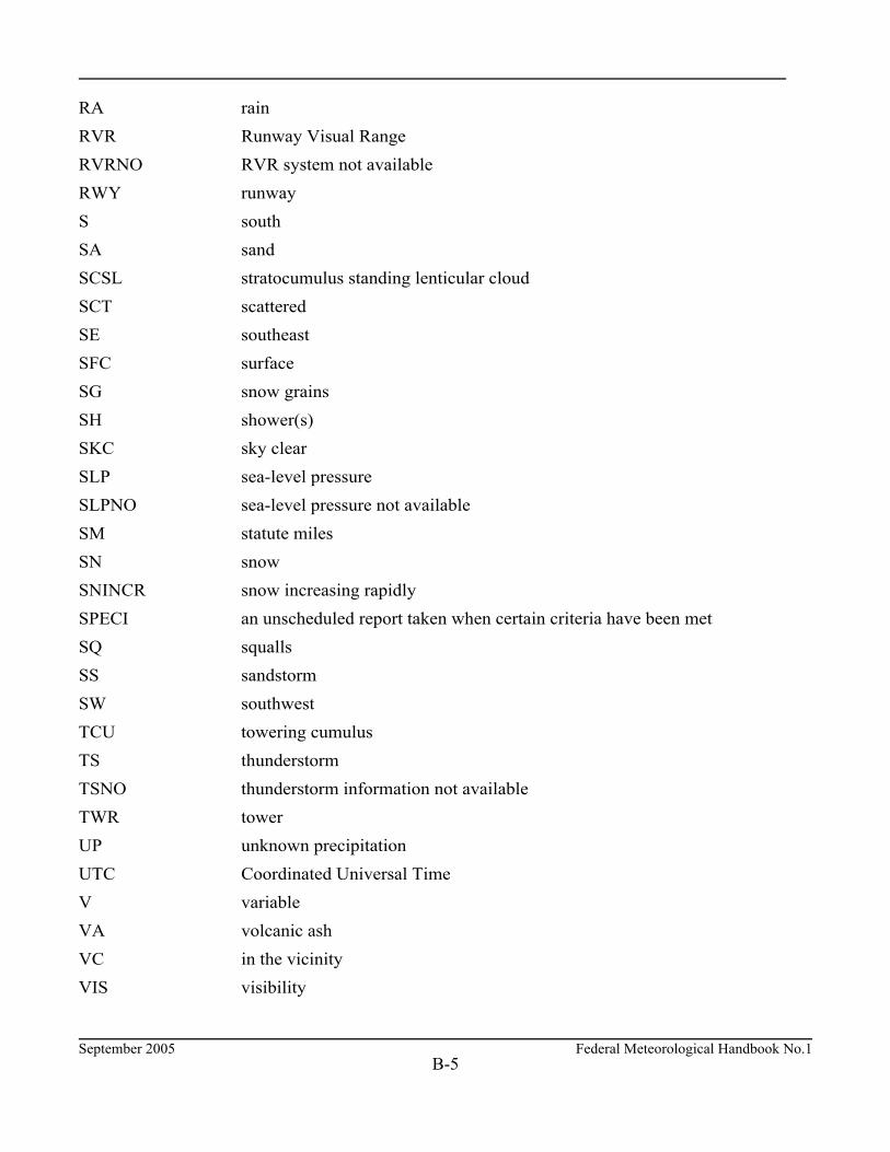
September 2005 Federal Meteorological Handbook No.1B-5
RA rain RVR Runway Visual Range RVRNO RVR system not available RWY runway S south SA sand SCSL stratocumulus standing lenticular cloud SCT scattered SE southeast SFC surface SG snow grains SH shower(s) SKC sky clear SLP sea-level pressure SLPNO sea-level pressure not available SM statute miles SN snow SNINCR snow increasing rapidly SPECI an unscheduled report taken when certain criteria have been met SQ squalls SS sandstorm SW southwest TCU towering cumulus TS thunderstorm TSNO thunderstorm information not available TWR tower UP unknown precipitation UTC Coordinated Universal Time V variable VA volcanic ash VC in the vicinity VIS visibility
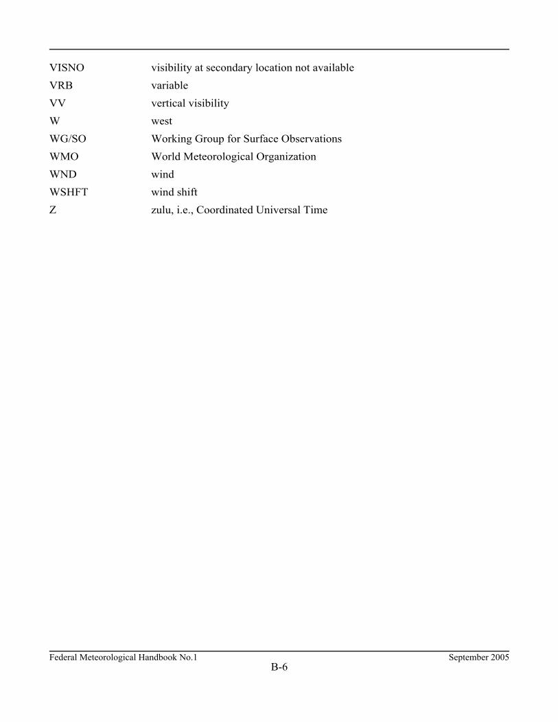
Federal Meteorological Handbook No.1 September 2005B-6
VISNO visibility at secondary location not available VRB variable VV vertical visibility W west WG/SO Working Group for Surface Observations WMO World Meteorological Organization WND wind WSHFT wind shift Z zulu, i.e., Coordinated Universal Time
September 2005 Federal Meteorological Handbook No.1
APPENDIX C
SENSOR STANDARDS

Federal Meteorological Handbook No.1 September 2005C-2
SENSOR STANDARDS
C.1 Runway Visual Range Standards. Table C-1 lists the required accuracy in feet for runway visualrange sensors.
Table C-1. Accuracy for Runway Visual
Range
Runway Visual Range InFeet Accuracy
<1,300 feet ±30 feet
1,300 through 2,600 feet ±80 feet
>2,600 feet ±10%
C.2 Visibility Sensor Standards. Table C-2 lists the accuracy for automated visibility sensors.
Table C-2. Accuracy of Automated Visibility Sensors
Visibility fromStandard
Visibility Sensor
Percentage of Data Within or Exceeding Given Range
At least 80%Within
No more than18% Exceed
No more than2% Exceed
0 through 1 1/4 ± 1/4 ± 1/2 ± 1
1 1/2 through 1 3/4 + 1/4, n 1/2 + 1/2, n 3/4 ± 1
2 through 2 1/2 ± 1/2 ± 1 ± 1
3 + 1/2, n 1 ± 1 ± 1
4 through 10 ± 1 RV* ± 2 RV* ± 2 RV*
*RV = Reportable value, all other values in miles.

September 2005 Federal Meteorological Handbook No.1C-3
C.3 Wind Sensor Standards. Table C-3 lists the units of measure, the range, the accuracy, and theresolution for pressure parameters.
Table C-3. Units of Measure, Range, Accuracy and Resolution of WindParameters
Parameter Units ofMeasure Range Accuracy Resolution
Direction Degrees 1° to360°
±5° when speed is $5knots 10°
Speed Knots 2 to 90knots
±1 knot up to 10 knots±10% above 10 knots 1 knot
C.4 Sky Condition Standards. Table C-4 lists the range and accuracy for sky condition parameters.
Table C-4. Range and Accuracy of Sky Condition Parameters
Parameter RangeAccuracy
Amounts Heights
Sky Condition 0 - 12,000 ft. (minimum) ±1 Reportable Value ±3 Reportable Values
C.5 Temperature and Dew Point Parameter Standards. Table C-5 lists the range, accuracy, andresolution in degrees Celsius for temperature and dew point parameters.
Table C-5. Temperature and Dew Point Sensor Accuracyand Resolution (Co)
Parameter Range Accuracy Resolution
Temperaturen62 to n50 n50 to +50+50 to +54
±1.1±0.6±1.1
0.10.10.1
Dew pointn34 to n24n24 to n01 n01 to +30
±2.2±1.7±1.1
0.10.10.1
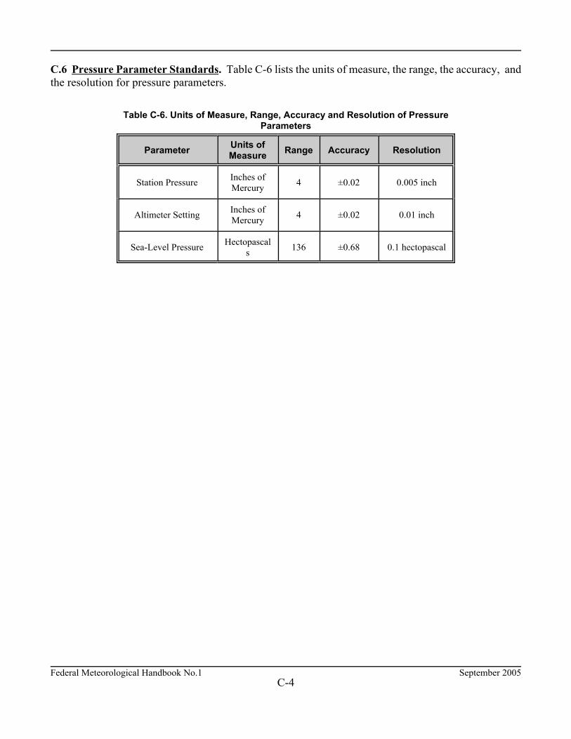
Federal Meteorological Handbook No.1 September 2005C-4
C.6 Pressure Parameter Standards. Table C-6 lists the units of measure, the range, the accuracy, andthe resolution for pressure parameters.
Table C-6. Units of Measure, Range, Accuracy and Resolution of PressureParameters
Parameter Units ofMeasure Range Accuracy Resolution
Station Pressure Inches ofMercury 4 ±0.02 0.005 inch
Altimeter Setting Inches ofMercury 4 ±0.02 0.01 inch
Sea-Level Pressure Hectopascals 136 ±0.68 0.1 hectopascal

September 2005 Federal Meteorological Handbook No.1
APPENDIX D
RUNWAY VISUAL RANGE TABLES

Federal Meteorological Handbook No.1 September 2005D-2
RUNWAY VISUAL RANGE TABLES
Table D-1. RVR Transmittance Conversion Table for Tasker 400 and Equivalent Systemswith 250-Foot Baseline -- Contrast Threshold 5.5 Percent
DAY NIGHT
RVR (Ft) LS 5 LS 5 RVR (Ft)
400----------------
600----------------
800----------------
1000----------------
1200----------------
1400----------------
1600----------------
1800----------------
2000----------------
2200----------------
2400----------------
2600----------------
2800----------------
3000----------------
3500----------------
4000----------------
4500----------------
5000----------------
5500----------------
6000----------------
.0299
.1038
.1974
.2905
.3746
.4479
.5107
.5644
.6104
.6499
.6840
.7136
.7395
.7774
.8194
.8431
.8584
.8710
.8815
.8905
.0013
.0113
.0351
.0707
.1134
.1590
.2048
.2492
.2913
.3307
.3674
.4014
.4328
.4820
.5415
.5906
.6317
.6662
.6957
.7209
400----------------
600----------------
800----------------
1000----------------
1200----------------
1400----------------
1600----------------
1800----------------
2000----------------
2200----------------
2400----------------
2600----------------
2800----------------
3000----------------
3500----------------
4000----------------
4500----------------
5000----------------
5500----------------
6000----------------
LS - Light Setting
Note: When a given value of RVR is being reported, the transmittance shallbe between the two adjacent values listed in the table.

September 2005 Federal Meteorological Handbook No.1D-3
Table D-2. RVR Transmittance Conversion Table for Tasker 500 and Equivalent Systemswith 250-Foot Baseline -- Contrast Threshold 5.0 Percent
DAY NIGHT
RVR (Ft) LS 5 LS 5 RVR (Ft)
500----------------
600----------------
700----------------
800----------------
1000----------------
1200----------------
1400----------------
1600----------------
1800----------------
2000----------------
2200----------------
2400----------------
2600----------------
2800----------------
3000----------------
3500----------------
4000----------------
4500----------------
5000----------------
5500----------------
6000----------------
.0449
.0823
.1264
.1974
.2905
.3746
.4479
.5107
.5644
.6104
.6499
.6840
.7136
.7395
.7774
.8190
.8384
.8541
.8671
.8779
.8871
.0027
.0075
.0159
.0351
.0707
.1134
.1590
.2048
.2492
.2913
.3307
.3674
.4014
.4328
.4820
.5415
.5906
.6317
.6662
.6957
.7209
500----------------
600----------------
700----------------
800----------------
1000----------------
1200----------------
1400----------------
1600----------------
1800----------------
2000----------------
2200----------------
2400----------------
2600----------------
2800----------------
3000----------------
3500----------------
4000----------------
4500----------------
5000----------------
5500----------------
6000---------------
LS - Light Setting.
* Nighttime readings on the recorder cannot be determined for less than700 feet. Report, if appropriate, M0700FT.
Note: When a given value of RVR is being reported, the transmittance shall bebetween the two adjacent values listed in the table.