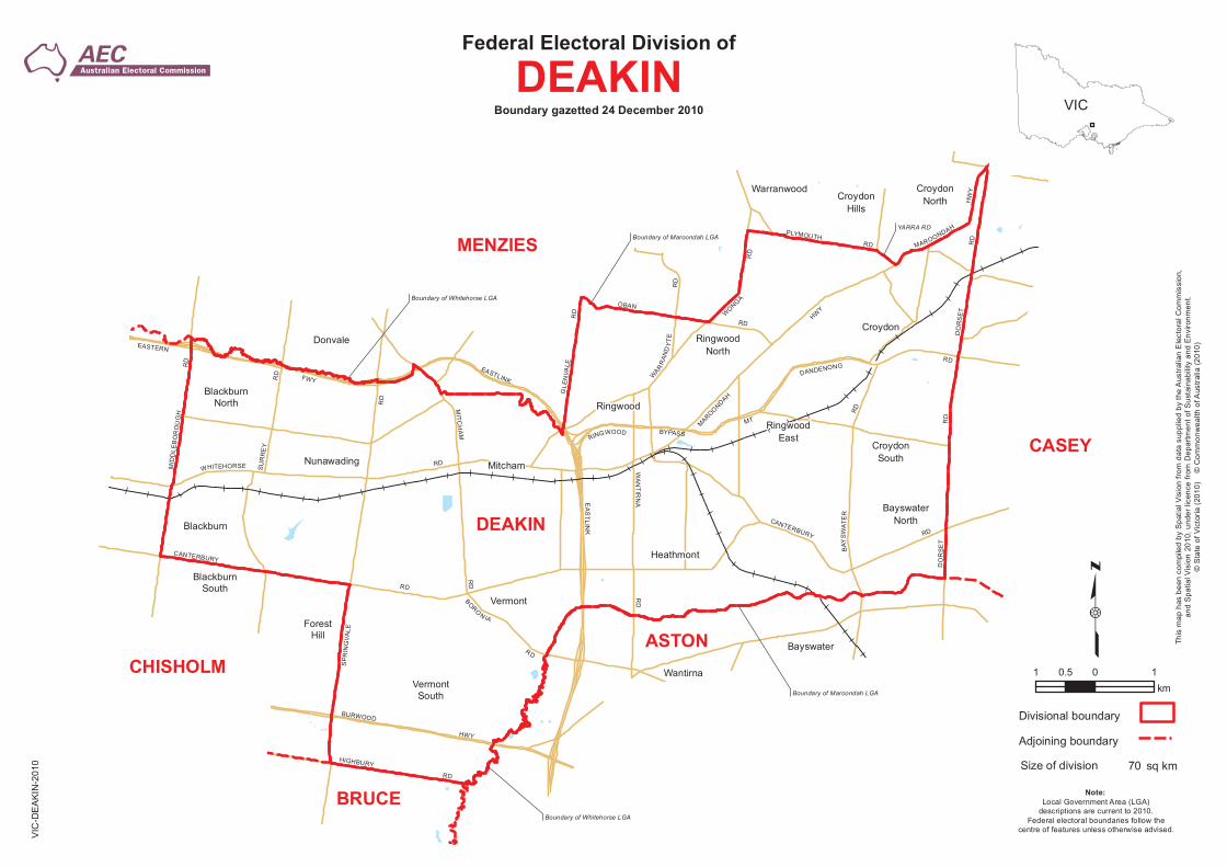
Federal Electoral Division of DEAKIN - Parliament of Australia · Title: Boundary map of the...
1
YARRA RD Boundary of Maroondah LGA Boundary of Whitehorse LGA Boundary of Whitehorse LGA Boundary of Maroondah LGA ASTON BRUCE CASEY CHISHOLM DEAKIN MENZIES Mitcham Bayswater Blackburn Blackburn North Blackburn South Croydon Hills Ringwood Croydon Croydon South Croydon North Nunawading Donvale Ringwood East Ringwood North Warranwood Bayswater North Forest Hill Heathmont Vermont Vermont South Wantirna SURREY RD CANTERBURY RD EASTLINK M I D DL E B OROUG H R D MAR OON DAH H W Y W H I T E H ORS E RD R I N G WO OD BYPA SS PL Y M OUTH RD M T D AN D EN O N G R D W A N T I R N A R D EAST ERN FW Y M I T C H A M R D B O R O N IA R D B A Y S W A T E R R D E A S T L I N K W A R R A N D Y T E R D S P R I N G V A L E R D HIGHBURY RD BURWOOD HWY O B AN RD W O N GA RD D O R S E T R D D O RSE T RD MA R OO N DA H H W Y G L E NV A L E R D CA N TERB UR Y RD VIC Federal Electoral Division of DEAKIN Boundary gazetted 24 December 2010 This map has been compiled by Spatial Vision from data supplied by the Australian Electoral Commission, and Spatial Vision 2010, under licence from Department of Sustainability and Environment. © State of Victoria (2010) © Commonwealth of Australia (2010) 1 0 1 0.5 km Note: Local Government Area (LGA) descriptions are current to 2010. Federal electoral boundaries follow the centre of features unless otherwise advised. 70 Divisional boundary Adjoining boundary Size of division sq km VIC-DEAKIN-2010
Transcript of Federal Electoral Division of DEAKIN - Parliament of Australia · Title: Boundary map of the...
YARRA RD
Boundary of Maroondah LGA
Boundary of Whitehorse LGA
Boundary of Whitehorse LGA
Boundary of Maroondah LGA
ASTON
BRUCE
CASEY
CHISHOLM
DEAKIN
MENZIES
Mitcham
Bayswater
Blackburn
Blackburn North
Blackburn South
Croydon Hills
Ringwood
Croydon
Croydon South
Croydon North
Nunawading
Donvale
Ringwood East
Ringwood North
Warranwood
Bayswater North
Forest Hill
Heathmont
Vermont
Vermont South
Wantirna
SUR
RE
Y
RD
CANTERBURY
RD
EASTLINK
MID
DLE
BO
RO
UG
H
RD
MAROONDAH
HWY
WHITEHORSE RD
RINGWOOD BYPASS
PLYMOUTH RD
MT
DANDENONG RD
WA
NT
IRN
AR
D
EASTERN
FWY
MIT C
HA
M
RD
BORO
N IA
R D
BAY
SW
ATE
R
RD
EA
ST
LINK
WAR
RA
ND
YT
E R
D
SP
RI N
GV
ALE
RD
HIGHBURY
RD
BURWOOD
HWY
OBAN
RD W
ONGA
RD
DO
RS
ET
RD
DO
RS
ET
RD
MAROONDAH
HW
Y
GLE
NVA
L E
RD
CANTERBURY RD
VIC
Federal Electoral Division of
DEAKIN Boundary gazetted 24 December 2010
This
map
has
bee
n co
mpi
led
by S
patia
l Vis
ion
from
dat
a su
pplie
d by
the
Aus
tralia
n E
lect
oral
Com
mis
sion
,an
d S
patia
l Vis
ion
2010
, und
er li
cenc
e fro
m D
epar
tmen
t of S
usta
inab
ility
and
Env
ironm
ent.
© S
tate
of V
icto
ria (
2010
) ©
Com
mon
wea
lth o
f Aus
tralia
(201
0)
1 0 10.5 km
Note: Local Government Area (LGA)
descriptions are current to 2010. Federal electoral boundaries follow the
centre of features unless otherwise advised.
70
Divisional boundary
Adjoining boundary
Size of division sq km
VIC
-DE
AK
IN-2
010