FARIDABAD DISTRICT HARYANA - Central Ground...
15
FARIDABAD DISTRICT HARYANA CENTRAL GROUND WATER BOARD Ministry of Water Resources Government of India North Western Region CHANDIGARH 2013
Transcript of FARIDABAD DISTRICT HARYANA - Central Ground...
FARIDABAD DISTRICT HARYANA CENTRAL GROUND WATER BOARD
Ministry of Water Resources
Government of India
North Western Region
CHANDIGARH
2013
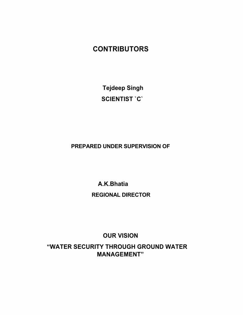
CONTRIBUTORS
Tejdeep Singh
SCIENTIST `C`
PREPARED UNDER SUPERVISION OF
A.K.Bhatia
REGIONAL DIRECTOR
OUR VISION
“WATER SECURITY THROUGH GROUND WATER
MANAGEMENT”
GROUND WATER INFORMATION BOOKLET
FARIDABAD DISTRICT, HARYANA
CONTENTS
FARIDABAD DISTRICT AT A GLANCE
1.0 INTRODUCTION
2.0 RAINFALL AND CLIMATE
3.0 GEOMORPHOLOGY AND SOILS
4.0 GROUND WATER SCENARIO
4.1 HYDROGEOLOGY
4.2 GROUND WATER RESOURCES
4.3 GROUND WATER QUALITY
4.4. STATUS OF GROUND WATER DEVELOPMENT
5.0 GROUND WATER MANAGEMENT STRATEGY
5.1 GROUND WATER DEVELOPMENT
5.2 WATER CONSERVATION & ARTIFICIAL RECHARGE
6.0 GROUND WATER RELATED ISSUES & PROBLEMS
7.0 RECOMMENDATIONS
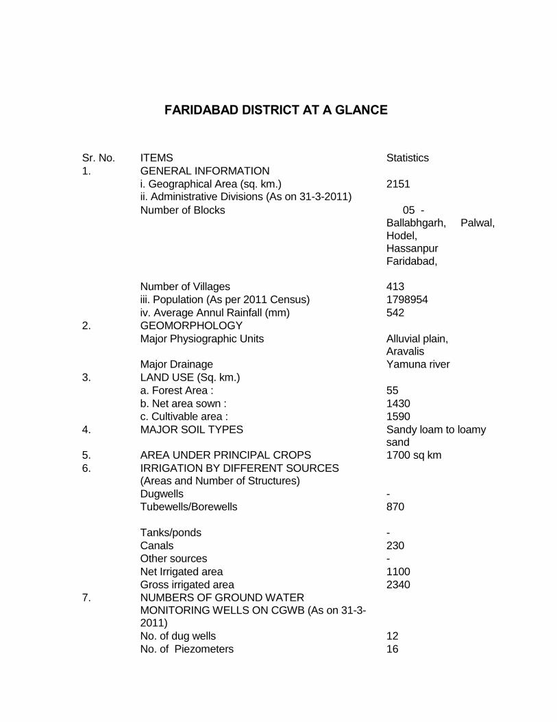
FARIDABAD DISTRICT AT A GLANCE
Sr. No. ITEMS Statistics
1. GENERAL INFORMATION
i. Geographical Area (sq. km.) 2151 ii. Administrative Divisions (As on 31-3-2011)
Number of Blocks 05 - Ballabhgarh, Palwal,
Hodel, Hassanpur Faridabad,
Number of Villages 413
iii. Population (As per 2011 Census) 1798954
iv. Average Annul Rainfall (mm) 542
2. GEOMORPHOLOGY
Major Physiographic Units Alluvial plain, Aravalis
Major Drainage Yamuna river
3. LAND USE (Sq. km.)
a. Forest Area : 55
b. Net area sown : 1430
c. Cultivable area : 1590
4. MAJOR SOIL TYPES Sandy loam to loamy sand
5. AREA UNDER PRINCIPAL CROPS 1700 sq km
6. IRRIGATION BY DIFFERENT SOURCES (Areas and Number of Structures)
Dugwells -
Tubewells/Borewells 870
Tanks/ponds -
Canals 230
Other sources -
Net Irrigated area 1100
Gross irrigated area 2340
7. NUMBERS OF GROUND WATER MONITORING WELLS ON CGWB (As on 31-3- 2011)
No. of dug wells 12
No. of Piezometers 16
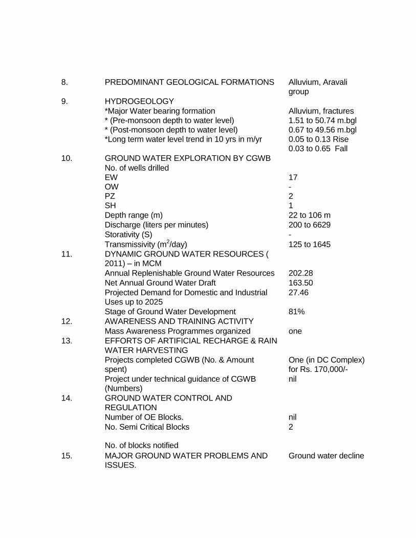
8. PREDOMINANT GEOLOGICAL FORMATIONS Alluvium, Aravali group
9. HYDROGEOLOGY
*Major Water bearing formation Alluvium, fractures * (Pre-monsoon depth to water level) 1.51 to 50.74 m.bgl * (Post-monsoon depth to water level) 0.67 to 49.56 m.bgl *Long term water level trend in 10 yrs in m/yr 0.05 to 0.13 Rise
0.03 to 0.65 Fall
10. GROUND WATER EXPLORATION BY CGWB
No. of wells drilled EW 17 OW - PZ 2 SH 1
Depth range (m) 22 to 106 m
Discharge (liters per minutes) 200 to 6629
Storativity (S) -
Transmissivity (m2/day) 125 to 1645
11. DYNAMIC GROUND WATER RESOURCES ( 2011) – in MCM
Annual Replenishable Ground Water Resources 202.28
Net Annual Ground Water Draft 163.50
Projected Demand for Domestic and Industrial 27.46 Uses up to 2025
Stage of Ground Water Development 81%
12. AWARENESS AND TRAINING ACTIVITY
Mass Awareness Programmes organized one
13. EFFORTS OF ARTIFICIAL RECHARGE & RAIN WATER HARVESTING
Projects completed CGWB (No. & Amount One (in DC Complex) spent) for Rs. 170,000/-
Project under technical guidance of CGWB nil (Numbers)
14. GROUND WATER CONTROL AND REGULATION
Number of OE Blocks. nil
No. Semi Critical Blocks 2
No. of blocks notified
15. MAJOR GROUND WATER PROBLEMS AND Ground water decline ISSUES.
GROUND WATER INFORMATION BOOKLET
FARIDABAD DISTRICT, HARYANA
1.0 INTRODUCTION
Faridabad district of Haryana located on south eastern part of Haryana state lies between 270 39’, 280 31’ north latitude and 760 40’ and 77’32’ east longitudes. In the north it is bordered by the Union Territory of Delhi in the east by Uttar Pradesh, in the North West by Mewat Gurgaon districts of Haryana and in the west. Total geographical area of the district is 2151 sq. km.
Faridabad district is divided into Two Blocks, namely, Faridabad, Ballabgarh. Faridabad town is the headquarter of the district.
The district is mainly drained by the rivers Yamuna, which is a perennial besides this a number of small streams originates from the hill ranges of the central parts of the district, which do not meet any major stream OR Rivers but disappears in the permeable deposits of alluvial plains after traversing some distance. The drainage of the area is dendritic sub parallel to sub-angular pattern.
Systematic hydrogeological surveys in the district was carried out by Geological Survey of India during 1956-61 Re-Appraisal Hydro Geological Surveys in the district were carried out by Central Ground Water Board, during 1975-77, 1981-82 and 1988-82 and
1988-89 detailed hydro geological and water balance studies were carried out under Ghaggar and Upper Yamuna Projects. Ground water exploration has been carried out in various phases and so far 5 exploratory wells, 15 slim holes and 15 piezometers have been
constructed in the district.
2.0 RAINFALL AND CLIMATE:
The climate of Faridabad district can be classified as tropical steppe, semiarid and hot which is mainly characterized by the extreme dryness of the Air except during monsoon months. During

three months of south west monsoon from last week of June to September, the moist air of oceanic penetrate into the district and causes high humidity, cloudiness and monsoon rainfall. The period from October to December constitutes post monsoon season. The cold weather season prevails from January to the beginning of March and followed by the hot weather or summer season which prevails up to the last week of June.
The normal annual rainfall in Faridabad district is about 542 mm spread over 27 days. The south west monsoon sets in the last week of June and withdraws towards the end of September and contributes about 85% of the annual rainfall. July and August are the wettest months 15% of the annual rainfall occurs during the nonmonsoon months in the wake of thunder storms and western disturbances.
Normal Annual Rainfall
Normal Monsoon Rainfall
Temperature
Mean Maximum :
Mean Minimum
Normal Rainydays
: 542 mm
: 460 mm
410 C (May & June)
: 800 C (January)
: 27
3.0 GEOMORPHOLOGY AND SOILS:
Soils of Faridabad district are classified as tropical and brown soils, existing in major parts of the district. In Hathin block the organic content of soils ranging from 0.41 to 0.75 percent which is of medium category. In rest of the area organic contents is 0.2 to 0.4 percent and falls in Low category.
The average conductivity of the soil is not more than 0.80 µmhos /cm and the average pH of the soil is between 6.5 and 8.7. The area comprises almost flat plains traversed by one ridge running N-S to NNE-SSW direction, divides the alluvium into two parts. The major river is Yamuna which is a perennial river.

4.0 GROUND WATER SCENARIO
4.1 Hydrogeology
Ground water occurs in alluvium and the underlying weathered/fractured quartzites. Alluvium comprises sands, silt, Kankar and gravel which form the principal ground water bearing horizon.
In Quartzite formation, occupying the north- western part of the district, ground water occurs in weathered and jointed fractured horizons. Weathering and fracturing has resulted in formation of semi-consolidated sand beds (BADARPUR SANDS) which form potential aquifer zones. This quartzite formation has not been explored for ground water occurrence.
In alluvium, granular zones are evenly distributed in entire thickness which is negligible near the quartzite outcrops to over 350 m in the eastern parts near Yamuna River.
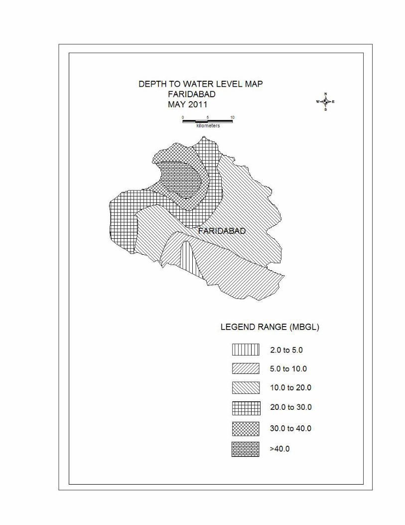
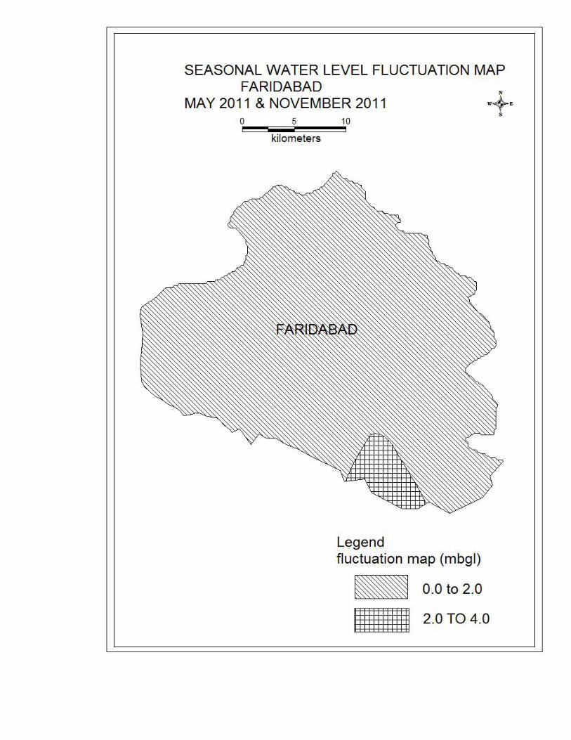
The ground water exploration in Faridabad district has been undertaken at 17 places. Out of these, 17 exploratory wells one slim hole and 2 piezometers were constructed in the district. In general, 6-14 granular zones mainly comprise fine sand, silt, clay and kankar. The discharge of successful exploratory wells varies between 200 and 6629 Ipm with draw down of 2.39-9.12m. To assess the aquifer parameters, aquifer performance tests were conducted. The Transmissivity values in the area vary between 125 and 1645m2/ day. The Depth to water level lies between 1.51 to 50.74 m.bgl during pre-monsoon and 0.67 to 49.56 m.bgl during post-monsoon period. Deeper water level, in the depth range of 10m to 15 m occurs in the southeastern parts of Ballabgarh and Faridabad blocks. Water level elevation range from 220 to 180 m amsl and the general groundwater flow is towards southeast and east. Isolated groundwater mounds and troughs in different parts of the district have been created because of heavy pumping in city area. In general water table has declined all over the district over the past decade. During 1983 to1993, a decline of water level from 1 to 6m, being more in southern blocks. Besides, drying of tube wells in the eastern parts of Faridabad and Ballabgarh block also proves significant decline of water table in recent past.

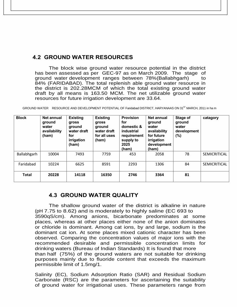
4.2 GROUND WATER RESOURCES
The block wise ground water resource potential in the district has been assessed as per GEC-97 as on March 2009. The stage of ground water development ranges between 78% (Ballabhgarh) to 84% (FARIDABAD). The total replenish able ground water resource in the district is 202.28MCM of which the total existing ground water draft by all means is 163.50 MCM. The net utilizable ground water resources for future irrigation development are 33.64.
GROUND WATER RESOURCE AND DEVELOPMENT POTENTIAL OF Faridabad DISTRICT, HARYANAAS ON 31ST
MARCH, 2011 in ha m
Block Net annual
ground water availability (ham)
Existing gross ground water draft for irrigation (ham)
Existing gross ground water draft for all uses (ham)
Provision for domestic & industrial requirement supply to 2025 (ham)
Net annual ground water availability for future irrigation development (ham)
Stage of ground water development (%)
catagory
Ballabhgarh 10004 7493 7759 453 2058 78 SEMICRITICAL
Faridabad 10224 6625 8591 2293 1306 84 SEMICRITICAL
Total 20228 14118 16350 2746 3364 81
4.3 GROUND WATER QUALITY
The shallow ground water of the district is alkaline in nature (pH 7.75 to 8.62) and is moderately to highly saline (EC 693 to 3590qS/cm). Among anions, bicarbonate predominates at some places, whereas at other places either none of the anion dominates or chloride is dominant. Among cat ions, by and large, sodium is the dominant cat ion. At some places mixed cationic character has been observed. Comparing the concentration values of major ions with the recommended desirable and permissible concentration limits for drinking waters (Bureau of Indian Standards) It is found that more than half (75%) of the ground waters are not suitable for drinking purposes mainly due to fluoride content that exceeds the maximum permissible limit of 1.5mg/1.
Salinity (EC), Sodium Adsorption Ratio (SAR) and Residual Sodium Carbonate (RSC) are the parameters for ascertaining the suitability of ground water for irrigational uses. These parameters range from
693 to 3590 micromhos/cm at 250 C, 2.19 to 15.79 and -14.52 to 13.97 milli equivalents respectively. Plot of USSL diagram used for the classification of irrigation waters indicated that ground water samples fall under class C2S1, C3S1, C3C2, C4S2, C4S2, C4S3 and C4S4. These waters are not suitable for customary irrigation as they may cause salinity and sodium hazards. It would be better if such waters are used for semi-salt tolerant to salt tolerant to salt tolerant crops along with appropriate amount of gypsum on well drained soils.
4.4 STATUS OF GROUND WATER DEVELOPMENT
The hydrogeological data generated through exploratory drilling has proved a vital information regarding identification of aquifer system, demarcation of their vertical and lateral extent, and delineation of potential aquifer characteristics. These studies also provide information on well design and drilling techniques. A well assembly of 203 mm dia, using about 20 m to 30 m long housing pipe and MS slot pipe with slots of 1.19 mm to 1.59 mm size would be ideal in the district area. “V” wires galvanized Screen having 0.50-1.5 mm slot can also be used as it can provide more open area conventional slotted pipes. Entrance velocity of water in the well has to be kept in mind while designing the well assembly.
Reverse /Direct circulation rig is suitable for carrying out the drilling in alluvial parts of district whereas percussion or Down the Hole Hammer (DTH) technique with Odex attachement are suitable for drilling in bouldery formation.
5.0 WATER CONSERVATION AND ARTIFICIAL RECHARGE
An experimental study for artificial recharge to ground water was taken up by NWR in the premises of D.C. office/ complex during the year 1999-2000. Mass awareness programme to raise awareness on water conservation and artificial recharge to ground water was organized by central ground water Board on 22nd
December 2001. A lecture on ground water condition in Faridabad area was delivered by Shri A.K. Bhatia, Sc ‘D’ of NWR, CGWB, Chandigarh. An exhibition depicting various facets of hydrogeology and Geophysics was also organized during mass awareness programme.
6.0. GROUND WATER RELATED ISSUES & PROBLEMS
There are certain areas in the district, which have recorded water level decline in recent past. Since ground water is the only source of irrigation in major part of the district, ground water aquifers are under great stress due to increased demand in irrigation and industrial sector.
Necessary remedial measures need to be taken up to arrest further declining of water levels in the areas and suitable methodology to be adopted to recharge the aquifers.
There are frequent cases of well failure of tube well reported from all over the district. The tube wells render max 4-5 years of
service and become defunct. Their discharge either has decreased or reported to have become silty. The shortening of life of the tube well is due to chemical action known as incrustation. Water tends to deposit mineral on the screen surface and in the pores of the formation, thus plugging the screen opening and the pores of the formation just out side the screen thereby decreasing discharge of the tube well. The pH of water in the area is more than 7.5 and is the reason of frequent failure of tube wells.
7.0 RECOMMENDATIONS
In order to arrest the declining trends of water levels in the block, the rooftop rainwater harvesting technology should be adopted and recharge structures may also be constructed in depression areas where water gets accumulated during rainy season. This will help in enhancing the recharge to ground water reservoir.
The crops consuming less quantity of water may be grown in place of crops requiring more water in the over-exploited block.
The construction of roof top rainwater harvesting structures should be made mandatory in building byelaws, which will help in checking the falling water level trend in the Faridabad town.
The abandoned dug wells may be cleaned and should be used for recharging the ground water by utilizing the surface monsoon runoff. The conjunctive use of poor quality groundwater and canal water by mixing in different ratio.
Cyclic use of canal water and poor quality groundwater. The water level monitoring network needs to be increased in the block.
Local populace to be educated regarding consequences of mining of ground water and need for effective and economic use.