FAPESP RESEARCH PROGRAMME ON GLOBAL CLIMATE … · FAPESP RESEARCH PROGRAMME ON GLOBAL CLIMATE...
49
FAPESP RESEARCH PROGRAMME ON GLOBAL CLIMATE CHANGE Land Use Change in Amazonia: Institutional Analysis and Modeling at multiple temporal and spatial scales Final Report – April, 2014 Project Period Covered: March 2010 to February 2014
Transcript of FAPESP RESEARCH PROGRAMME ON GLOBAL CLIMATE … · FAPESP RESEARCH PROGRAMME ON GLOBAL CLIMATE...

FAPESP RESEARCH PROGRAMME ON GLOBAL CLIMATE
CHANGE
Land Use Change in Amazonia: Institutional Analysis and
Modeling at multiple temporal and spatial scales
Final Report – April, 2014
Project Period Covered: March 2010 to February 2014

1 INTRODUCTION
This project aims to understand and model the causes that contribute to
deforestation in Amazonia. Biomass burning associated with deforestation is
responsible for most of Brazil’s greenhouse gas emissions. We argue that
land changes in Amazonia are brought about by social and institutional
arrangements. Understanding these social and institutional forces is critical
for evaluating and proposing deforestation control policies that also reduce
greenhouse gas emissions. Thus we propose to explore the following core
scientific question: What are the relations between changes in land use and
the evolution of institutional arrangements in Amazonia? These
arrangements include agreements or conventions set up between interest
groups, social movements, organizations, and state agencies. Negotiated at
different scales (from local to international), they influence the legal rules of
use of natural resources and territorial occupation. They also restrict law
enforcement. Since the 1960s, Amazonia has witnessed the buildup of
institutional arrangements often associated to competing ways of using
natural resources and to different economic goals. In our view, institutional
arrangements in Amazonia provide the key to the causes of land change in
the region in the last 40 years.
Many institutional arrangements that define land use in Amazonia
reflect the interests of private groups. These groups use social, political,
ideological, and legal means to control the region. Asserting control over the
land, ruling groups use their power to keep social inequality. For example,
credits granted by state agencies are often used to support political alliances
related to allied with private interests. Such a view explains how Amazonian
elites seize the land and expropriate the poor. From the 1970s to the 1990s,
efforts to control the area led to unexpected results, allowing deceit in the
rules of land use. However, recent institutional evolution in Amazonia is
increasingly motivated by rules that promote environmental conservation.
Since the 1990s, there are new legal limits on the use of natural resources,
which include community land rights. New protected areas have been
created. The Federal Government has increased law enforcement. New laws
also mandate formal representation of local populations in city councils and
regional development forums. This motivates an important question: how
do competing institutional arrangements for managing resources help to
promote or undermine good solutions to the problems of land use in
Amazonia?
The project is organized on four interrelated lines of research,
combining methods from different academic areas, including social analysis,
remote sensing, landscape ecology, and mathematical modeling:
• Axis 1: Identification and analysis of institutional arrangements that
influence land change, using social sciences and statistical methods.
• Axis 2: Measurement and mapping of land change, using novel
remote sensing and image processing methods.
• Axis 3: Detection and analysis of land occupation patterns and
trajectories. These patterns emerge from land changes related to the
institutional arrangements mentioned above.
• Axis 4: Construction of computational models and scenarios that
capture how social interactions and institutional arrangements act on
land change.
This report is organized as follows. Section 2 presents the main
findings of the project. Section 4 presents the research highlights. Section 5
summarizes the project and discusses future plans. The complete list of
scientific results is presented in the Annex.

2 Main findings of the project
(N.B. All of the papers cited have been produced as part of the project,
unless specifically stated).
This project has brought together researchers from different backgrounds
towards a common goal: understanding how land change happens in
Amazonia. Our approach to this problem is to try to indentify and recognize
the complexity of the decisions taken at an individual and local levels. In this
project, we have tried to understand how these local decisions are reflected
in the overall patterns and processes of change.
In the last two decades, there has been major scientific progress in the
methods for large-scale monitoring and mapping of land cover change in
Amazonia. Methodologies such as those used by INPE in its projects
PRODES, DETER and TERRACLASS have enabled the Brazilian government
to achieve a substantial reduction on deforestation. This emphasis on “top-
down” approaches to study change in Amazonia is also reflected in most
research works that try to explain the process of land change in Amazonia.
In most case, these studies take use of an econometric-based approach,
where data on land change extracted from remote sensing images is
correlated with data on land use selected from the Population and
Agricultural Census. We value the usefullness of this approach, but we also
recognize its limits. Thus, a large part of our effort in this project has been
dedicated to a dialogue with this established research tradition.
There is a considerable degree of intraregional variations in Amazonia
due to the local decision-making arrangements, as we had already
recognized in previous work leading up to the project1. Thus, a major part of
our efforts in the project have been devoted to understand how these local
actions and arrangements are reflected in the overall patterns of
deforestation. In this way, we have been able to combine the econometric
1 Ana Aguiar, Gilberto Câmara, and Maria Isabel Escada. 2007. "Spatial statistical analysis of land-use determinants in the Brazilian Amazon: exploring intra-regional heterogeneity." Ecological Modelling no. 209 (1-2):169–188.
“top-down” approach with a “bottom-up” that recognizes the importance of
the local arrangements.
In this light, we describe the main findings of the project below.
We showed that improvements on statistical analysis, such as better
methods for putting census data on cell spaces2 and spatio-temporal
inferences, can lead to improvements on our understanding of the relations
between land use and land cover3. Nevertheless, we also found out that
there are inherent limits to the predictive power of the “top-down”
econometric approach. The main problem is that projecting the correlations
found in econometric and statistical models to the future, assumes that
these relations will not change substantially. In one of our published papers3,
we showed that the correlation between variables associated to land use
and deforestation changed between 1997 and 2007, in some cases quite
substantially.
We also carried out ex-post evaluations of previous work by other
authors that tried to predict future scenarios of land change based on
econometric methods and found they have limited explanatory power4,5. We
found out that the previous land use modeling studies were not able to
plausibly capture the general trajectory of land cover change observed in the
Amazon during the last decade. We found out that regional policies
generated a greater demand for the regulation of the productive sectors,
which had a decisive effect for the immediate reduction of deforestation.
From our studies, we concluded that we need to represent Amazonian land
2 Giovana Espindola, Ana Aguiar, Pedro Andrade, 2012. “Combining Satellite Remote Sensing and Census Data for Regional Scale Analysis of Land Use Change in the Brazilian Amazon”. Revista Brasileira de Cartografia, 64(5). 3 Giovana Espindola, Ana Paula Aguiar, Edzer Pebesma, Gilberto Câmara, Leila Fonseca, 2012. “Agricultural land use dynamics in the Brazilian Amazon based on remote sensing and census data”. Applied Geography, 32(2):240-252. 4 Eloi Dalla-Nora, Ana Aguiar, David Lapola, Geert Woltjer, 2014. “Why have land use change models for the Amazon failed to capture the amount of deforestation over the last decade?”, Land Use Policy, 39, pp. 403–411. 5 Luiz Diniz, Merret Buurman, Pedro Andrade, Gilberto Camara, and Edzer Pebesma. "Measuring Allocation Errors in Land Change Models in Amazonia." Brazilian Symposium on Geoinformatics, 2013.
use processes as complex systems. The next generation of land use models
needs to capture both “top-down” driving forces such as government
policies and agrarian structure, but also represent “bottom-up” decision-
making by local actors.
As a contribution to the understanding of “bottom-up” processes, the
project researchers did a major effort to analyse and classify land change
patterns in Amazonia. This work enabled us to identify significant differences
in the occupation patterns, comparing different regions in Amazonia6 7.
Our research is supported by a theoretical concept of extensive urban
in Amazônia proposed by Monte-Mór8, in which the urban is seen as a
phenomenon that spans the territory, in a continuous, where a large set of
socio-spatial forms, beyond the cities and towns, is organized. Cities,
riparian communities, rural villages, settlement projects, protected areas,
indigenous lands and farms, are examples of types of land occupation that
are present in the Amazonian municipalities9.
In Amazonia, we have the indigenous peoples and the migrants that
moved to the region in the late 19th and early 20th Century. However, the
most important land changes in Amazonia results from the migrations that
took place after the 1970s. Often, these migrants came for urban or
periurban regions. Colonization was organized and sanctioned by the
government and based on creating a network of new towns or increasing
urban population of existing cities. Based on the hypothesis that the key to
understanding the land changes in Amazonia lies in the urban networks,
considering the diferent manners in which urban manifests on the territory, 6 Taise Pinheiro, Isabel Escada*. “Detection of forest degradation in Amazonia using celludar databases. XVI Brazilian Symposium on Remote Sensing (SBSR), Foz de Iguaçu, 2013. 7 André Gavlak, Isabel Escada*, Miguel Monteiro, “Dinamics of land use and land cover change in the Sustainable Forest District along BR-163 road. XV Brazilian Symposium on Remote Sensing, Curitiba, PA, 2011. 8 Roberto Monte-Mór. Urbanização Extensiva e Lógicas de Povoamento: Um Olhar Ambiental. In: SANTOS, M.; SOUZA, M. A. A. de.; SILVEIRA, M. L. (Ed.). Território, Globalização e Fragmentação. São Paulo: HUCITEC-ANPUR, 1994, p. 169-181. 9 Ana Cláudia Duarte Cardoso; José Júlio Ferreira Lima. Tipologias e padrões de ocupação urbana na Amazônia Oriental: para que e para quem? In: Cardoso, A. C. D. (Ed.). O Rural e o Urbano na Amazônia. Diferentes olhares e perspectivas. Belém-PA: EDUFPA, 2006, p.55-98.
and in the institutional and market connections, we carried out research on
urban settlements in the region10 11. We found out that the institutional
arrangements that shape the individual decisions are based on urban
settlements.
As part of our research, we found out that the current information on
land cover change in Amazonia provided by INPE (PRODES, DETER and
DEGRAD) although essential for monitoring deforestation, is insufficient to
enable us to model the complexity of the processes of land change in
Amazonia. For this reason, we invested in the techniques to improve
extraction of land change information from remote sensing images. These
techniques include improvements on methods for analising multisensor and
multitemporal imagery.
Our results in the project have studied the combination of optical and
radar data to map urban areas in Amazonia12. Our results point out that the
complex urban–rural landscape patterns in Amazonia cannot be effectively
well mapped by LANDSAT TM multispectral images with 30 m spatial
resolution. These urban-rural landscapes require image with 10 m spatial
resolution or better.
We also investigated the use of multitemporal data (especially long
term MODIS and AVHRR time-series) to detect land use transitions in the
agricultural areas in Amazonia1314. Our results indicate that time-series of
10 Silvana Amaral*, André Gavlak, Isabel Escada*, and Miguel Monteiro, “Using remote sensing and census tract data to improve representation of population spatial distribution: case studies in the Brazilian Amazon”, Population and Environment, 34:142-170, 2012. 11 Ana Paula Dal’Asta, Newton Brigatti, Silvana Amaral*, Isabel Escada* and Antonio Miguel Monteiro. “Identifying Spatial Units of Human Occupation in the Brazilian Amazon Using Landsat and CBERS Multi-Resolution Imagery”. Remote Sensing, 4: 68-87, 2012.
12 Dengsheng Lu, Guiying Li, Emilio Moran, Mateus Batistella, and Corina Freitas*, "Mapping impervious surfaces with the integrated use of Landsat Thematic Mapper and radar data: A case study in an urban–rural landscape in the Brazilian Amazon." ISPRS Journal of Photogrammetry and Remote Sensing 66(6): 798-808, 2011. 13 Damien Arvor, Margareth Meirelles, Vincent Dubreil, Agnès Bégué, and Yosio Shimabukuro*, “Analyzing the agricultural transition in Mato Grosso, Brazil, using satellite-derived indices”. Applied Geography, 32: 702-713, 2012.
MODIS, SPOT-VGT and PROBA satellite data can be useful to detect changes
in crop production in regions such as Mato Grosso, where the crop areas are
large enough to be detected by satellites with low spatial resolution and high
temporal resolution. We also looked into the role of forest fires in making the
Amazon forest more vunerable to deforestation15 16. We found out that forest
fires are playing an important role as precursors of later deforestation
actions.
The project also had a significant component on the development of
software for environmental modeling, which was necessary to support the
research of scenarios of future deforestation and on analysis and description
of the current landscapes in Amazonia. The main result of the project in this
area was the development of mature versions of TerraME, an innovative
toolkit for modeling nature-society interactions17. The TerraME software
supported innovative studies by the project researchers, such as agent-
based modeling of deforestation in São Felix do Xingu18 and the
development of INPE-EM, a detailed model for measuring emissions from
deforestation19.
14 Atzberger, C., A. R. Formaggio, Yosio Shimabukuro*, T. Udelhoven, M. Mattiuzzi, G. A. Sanchez, and E. Arai. "Obtaining crop-specific time profiles of NDVI: the use of unmixing approaches for serving the continuity between SPOT-VGT and PROBA-V time series." International Journal of Remote Sensing 35, no. 7 (2014): 2615-2638. 15 Luiz Aragão, and Yosio Shimabukuro*, "The incidence of fire in Amazonian forests with implications for REDD." Science 328(5983) 1275-1278, 2010. 16 Fletcher, I. N., L. E. O. C. Aragão, A. Lima, Y. Shimabukuro*, and P. Friedlingstein. "Fractal properties of forest fires in Amazonia as a basis for modelling pan-tropical burned area." Biogeosciences Discussions 10, no. 8, 2013. 17 Tiago Carneiro, Pedro Andrade*, Gilberto Câmara*, Miguel Monteiro, Rodrigo Reis Pereira, “An extensible toolbox for modelling nature-society interactions”. Enviromental Modelling and Software, 46: 104-117, 2013. 18 Sergio Costa, "Regional Scale Agent-Based Modelling of Land Change: Evolving Institutional Arrangements in Frontier Areas". PhD dissertation in Computer Science, INPE, 2012. Advisors: Gilberto Câmara* and Ana Paula Aguiar*. 19 Ana Paula Aguiar*, Jean Ometto, Carlos Nobre, David Lapola, Claudio Almeida, Ima Vieira, João Vianei Soares, Regina Alvalá, Sassan Saatchi, Dalton Valeriano. “Modeling the spatial and temporal heterogeneity of deforestation-driven carbon emissions: the INPE-EM framework applied to the Brazilian Amazon”. Global Change Biology, 18(11): 3346–3366, 2012.
A second software component of the project was the Geographic Data
Mining Analyst (GeoDMA)20. This has algorithms for segmentation, feature
extraction, feature selection, classification, landscape metrics and multi-
temporal methods for change detection and analysis. GeoDMA uses
decision-tree strategies adapted for spatial data mining. This software was
used in the analysis of the occupation patterns in Amazonia by the project
researchers.
3 Description of some of the project research results
In this section, we describe some of the project research results in more
detail. The following descriptions are intended to illustrate our approach to
the problem of modeling land use and land cover change in Amazonia.
3.1 The role of institutional arrangements in land change in Amazonia
One of the relevant results of the project was the development of an agent-
based model for describing land change in a large frontier area in Amazônia:
the São Felix do Xingu (SFX) region, an area of 100.000 km2 in the South-
East of the Pará state in Brazil, the place in Amazonia with the highest
deforestation rate in the 1990s and 2000s21. The model captures large-scale
land change during the 2000s and is used to build scenarios until 2020. The
study area is shown in Figure 1.
20 Thales Korting, Leila Fonseca*, Gilberto Câmara*, “GeoDMA - Geographic Data Mining Analyst”. Computers & Geosciences, 57: 133–145, 2013.
21 Sergio Costa, "Regional Scale Agent-Based Modelling of Land Change: Evolving Institutional Arrangements in Frontier Areas". PhD dissertation in Computer Science, INPE, 2012. Advisors: Gilberto Câmara* and Ana Paula Aguiar*.
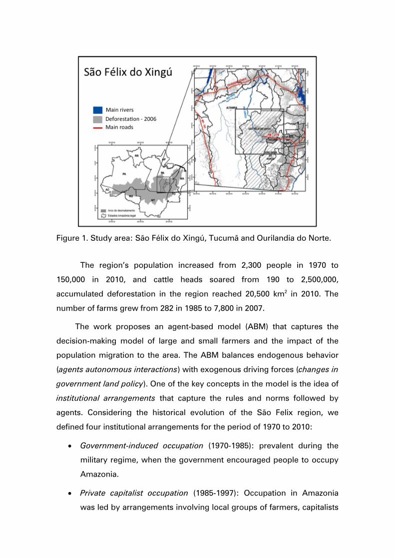
Figure 1. Study area: São Félix do Xingú, Tucumã and Ourilandia do Norte.
The region’s population increased from 2,300 people in 1970 to
150,000 in 2010, and cattle heads soared from 190 to 2,500,000,
accumulated deforestation in the region reached 20,500 km2 in 2010. The
number of farms grew from 282 in 1985 to 7,800 in 2007.
The work proposes an agent-based model (ABM) that captures the
decision-making model of large and small farmers and the impact of the
population migration to the area. The ABM balances endogenous behavior
(agents autonomous interactions) with exogenous driving forces (changes in
government land policy). One of the key concepts in the model is the idea of
institutional arrangements that capture the rules and norms followed by
agents. Considering the historical evolution of the São Felix region, we
defined four institutional arrangements for the period of 1970 to 2010:
• Government-induced occupation (1970-1985): prevalent during the
military regime, when the government encouraged people to occupy
Amazonia.
• Private capitalist occupation (1985-1997): Occupation in Amazonia
was led by arrangements involving local groups of farmers, capitalists

and politicians, with limited intervention from the Federal
Government.
• Beef marketing chain organization (1997-2005): Starting in 1996, there
was a renewal of public credits for cattle production that reinforced
the effects on land change.
• Deforestation control (2005-2010): From 2005 onwards, the Federal
Government set up a combined effort of improved satellite
monitoring, increased law enforcement, and creation of protected
The ABM for the São Felix do Xingu has the following components:
a) A support capacity submodel, that captures the capacity of the
land to support extensive cattle raising.
b) A frontier occupation submodel, that represents the way the
agents move from established areas to the frontier, grabbing new
land and causing deforestation.
c) A pasture creation submodel, that captures how farmers manage
their land for cattle raising.
d) A reforestation submodel, that represents the actions the farmers
take to restore forest land.
e) A land market submodel, that simulates buying and selling of
farms.
The authors ran a simulation, that starting from 1970, tried to
reproduce the different institutional arrangements from 1997 until 2010. The
results are shown in Figure 2, which compares the simulated deforestation
patterns to the actual patterns measured by the PRODES system. The model
was able to provide a reasonable account of the occupation process in São
Felix. The model shows how the land market, the moving frontier and the
institutional arrangements operate in shaping the evolution of deforestation
in São Felix.

Figure 2. Comparison of observed deforestation patters (top) with results from model simulation S3 for 2000, 2005 and 2010 (bottom).
3.2 Statistical Analysis of Driving forces of Deforestation in Amazonia
This work was carried out on the context of a PhD thesis by Giovana
Mira de Espindola, advised by Gilberto Câmara, Ana Paula Aguiar and Leila
Fonseca, three of the project’s leading investigators. The results of the thesis
have been published in the scientific literature22. The thesis used spatio-
temporal statistics to study determinant factors of land use change. We
broke up deforestation in 1997 and 2007 into the main agricultural uses –
pasture, temporary and permanent agriculture. To do this, we combined
deforestation maps from INPE with census information from IBGE. We took
the agricultural area for each city from the deforestation maps and the
proportion of land use from the census data.
22 Giovana Espindola, Ana Paula Aguiar, Edzer Pebesma, Gilberto Câmara, Leila Fonseca, 2012. “Agricultural land use dynamics in the Brazilian Amazon based on remote sensing and census data”. Applied Geography, 32(2):240-252.
2005
2000 2005
Observed deforestation patterns
Model results – Simulation 3
Special areas Deforestation
2000 2010
2010

The data included 30 explanatory variables grouped into four main
types: access to markets, public policy, agrarian structure, and environment.
As ‘access to markets’ variables, we took distance to roads, distance to
urban centers, distance to wood extraction distance to mineral deposits,
distance to external markets. The ‘public policy’ variables are number of
settled families, protected areas and indigenous lands. The ‘agrarian
structure’ data uses the proportion of small (< 200 ha), medium (200 to 1000
ha) and large (> 1000 ha) farms. The ‘environment’ data captures conditions
such as soil fertility and climate. Land use data is taken as dependent
(proportions of deforestation, pasture, temporary agriculture and permanent
agriculture).
The regression models for deforestation in 1997 and 2007 show some
important changes in the patterns of human occupation in the Brazilian
Amazon. They are summarized in Figure 2 showing the relative influence of
each factor, with 95% confidence intervals. The confidence intervals were
used to infer which determinant factors changed from 1996/1997 to
2006/2007.
In both models, distance to wood extraction, distance to rivers,
protected areas, fertility and humidity index did not change their influence
from 1997 and 2007. Connection to national markets and high fertility
changed little between these years. Distance to roads was more influential in
1997 than in 2007, suggesting that the influence of roads in deforestation
decreased. The number of settled families influences deforestation. This
influence increased in 2007, since the number of settlements increased
during the 2000s. Finally, indigenous lands were crucial in preventing
deforestation in areas of high population pressure.

Figure 3 – Standardized regression coefficients for deforestation in the roads and settlements model for 1997 and 2007 with 95% confidence intervals.
3.3 Evaluation of land use models: a critical analysis
In a recent paper published in the journal “Land Use Policy”23, we analysed
several models that have been proposed to explore future trajectories of
land use and cover change, particularly in the Amazon. We review and
analyze the general structure of the land use models that have most recently
been used to explore land use change in the Amazon, seeking to investigate
methodological factors that could explain the divergence between the
observed and projected rates, paying special attention to the land demand 23 Eloi Dalla-Nora, Ana Aguiar, David Lapola, Geert Woltjer, 2014. “Why have land use change models for the Amazon failed to capture the amount of deforestation over the last decade?”, Land Use Policy, 39, pp. 403–411.
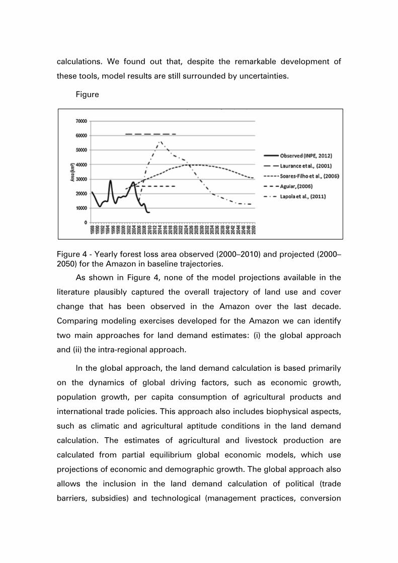
calculations. We found out that, despite the remarkable development of
these tools, model results are still surrounded by uncertainties.
Figure
Figure 4 - Yearly forest loss area observed (2000–2010) and projected (2000–2050) for the Amazon in baseline trajectories.
As shown in Figure 4, none of the model projections available in the
literature plausibly captured the overall trajectory of land use and cover
change that has been observed in the Amazon over the last decade.
Comparing modeling exercises developed for the Amazon we can identify
two main approaches for land demand estimates: (i) the global approach
and (ii) the intra-regional approach.
In the global approach, the land demand calculation is based primarily
on the dynamics of global driving factors, such as economic growth,
population growth, per capita consumption of agricultural products and
international trade policies. This approach also includes biophysical aspects,
such as climatic and agricultural aptitude conditions in the land demand
calculation. The estimates of agricultural and livestock production are
calculated from partial equilibrium global economic models, which use
projections of economic and demographic growth. The global approach also
allows the inclusion in the land demand calculation of political (trade
barriers, subsidies) and technological (management practices, conversion

efficiency) factors which are sometimes expressed only indirectly through
changes in prices or productivity.
In the intra-regional approach, land demand is calculated based on the
dynamics of local and regional factors, such as the distance to roads and
other infrastructure projects (existing and planned) and the presence of
constraints (primarily protected areas). In most cases, this approach also
includes in the land demand calculation a baseline factor that is related to
historical deforestation averages, over temporal horizons ranging from 5 to
25 years ago.
Thus, in the intra-regional approach the land demand calculation does
not directly include any form of international pressure or productivity
factors. The global approach, in turn, does not capture the dynamics and
magnitude of intra-regional drivers in the definition of future land demand
rates for the Amazon. These limitations prevent land use models from fully
representing the forces that shape the dynamics of the region. These
modeling exercises were also quite simplistic regarding the formulation of
their scenario since institutional changes (the social and governmental
reaction against high deforestations rates) were never considered.
Most land use models used in modeling exercises for the Amazon
present are two separate submodles for land demand and land allocation (in
the real world, they are interdependent). This division tries to capture the
difference between the proximate causes of deforestation and the
underlying driving factors. The proximate causes that are directly linked to
the land use and cover change pattern (soil fertility, topography,
infrastructure projects, etc.). The underlying driving factor are economic
(price of agricultural commodities, access to rural credit), institutional
(environmental policies, trade agreements) and technological (management
practices, conversion efficiency) factors.
However, in the case of Amazonia, institutional factors and public
policies play a key role. If Amazon deforestation was purely a result of price
movements and other economic factors, we would expect that the

slowdown in deforestation would be conjunctural and temporary, that is,
deforestation would fluctuate according to the economic cycle, which did
not actually occur. In this sense, regional policies adopted from 2004 have
played an important role in the maintenance of the deforestation slowdown
process. The effectiveness of regional policies generated a greater demand
by producers and civil society for the regulation of their activities, which
seems to have been decisive for the immediate reduction of deforestation
rates observed over the last decade in the Amazon. Finally, it also reinforces
the idea that Amazonian land cover change dynamics depend significantly
on the behavior of local and regional factors along with intentional markets,
which still need to be better understood and addressed in land use models.
The complex nature of the land use system in the Amazon indicates the
need to adopt an innovative modeling framework to represent the forces
that shape land use dynamics in this region. Sound land use models are
useful for representing plausible ways in which the future could unfold in the
context of scenario development, and explore the effects of changes in
certain factors. In this sense, the integra- tion of flexible economic models
and regional spatially explicit land use models is a possible way to increase
the internal consistency of the modeling exercises and ultimately enhance
their potential to represent future scenarios and support decision making.
3.4 Assessment of Performance of Land Change Models for Amazonia
In a companion work to the paper published in “Land Use Policy” and
discussed in the previous sections, we evaluation of the results of several
models of deforestation in the Brazilian Amazon in an ex-post analysis24.
We developed a goodness of fit metric that uses a multi-resolution
approach to account for the scale-dependency of spatial patterns. We
applied the proposed goodness of fit metric to evaluated two models that try
24 Luiz Veras, Merret Buurman, Pedro Andrade, Gilberto Camara*, and Edzer Pebesma. "Measuring Allocation Errors in Land Change Models in Amazonia." Brazilian Symposium on Geoinformatics, 2013.
to predict deforestation in the Brazilian Amazon: The SimAmazonia model,
developed by Soares-Filho et al., and the model developed by Laurance et
al25. We evaluated model projections for the year 2011, taking the PRODES
data provided by INPE (Brazilian National Space Research Institute) as the
reference for observed deforestation.
SimAmazonia projects the deforestation in Amazonia in 2050, based on
data from 2001. We estimated its results for 2011 using data provided by its
authors. For our assessment, we took the Business-as-usual scenario (BAU)
and the Governance scenario (GOV). The model by Laurance et al. projects
deforestation in the Brazilian Amazonia in 2020 based on the data for 2000. It
assumes a heavy impact of infrastructure projects that would lead to
deforestation in Amazonia of 28% (optimistic scenario) or 42% (non-
optimistic scenario) in 2020. The non-optimistic scenario assumes larger
degraded areas close to roads and rivers and more deforestation in
conservation areas.
We also used a neighborhood model as an example of the simplest
possible land change model for Amazonia. The model has a single
assumption: the potential for change in one year is the average
deforestation of the neighboring cells for the previous year.
The demand for deforestation in all models is the actual total
deforestation given by PRODES. The first two models originally projected
higher demand compared to the PRODES estimates. We reimplemented
such models in order to take into account the differences in the demand.
Figure 5 shows the goodness of fit plotted against sampling window size.
We see the differences between the model performances persist over many
resolutions. The goodness of fit values increase slowly with increasing
window size (note the logarithmic scale of the x axis).
25 Soares-Filho, B., et al., Modelling conservation in the Amazon basin. Nature, 2006. 440(7083): p. 520-523. Laurance, W., et al., The future of the Brazilian Amazon. Science, 2001. 291: p. 438-439.

The models allocate a lot of change in wrong regions. Both
SimAmazonia models have a similar performance. The Laurance scenarios
project most of the change in the wrong places. Even with sampling
windows of size of 32 by 32 cells (800 by 800km), the Laurance models have
a fit of only approximately 50%. The simple neighborhood model performs
almost as well as the SimAmazonia models and much better than the
Laurance models. Even the best model considered in our study allocates
only about 60% of the change correctly.
Figure 5: The goodness of fit of the different models plotted against sampling window size
(logarithmic scale). The largest window is 256 by 256 cells. As it covers the whole cell
space, which is 134 by 104 cells large, the goodness of fit is inevitably 100%.
We compare cell spaces of the deforestation as predicted by the
models with the PRODES dataset in Figure 6. Because of their over-reliance
on road infrastructure as the main factor for deforestation, the Laurance
models allocate much change in the wrong places and underestimate the
effectiveness of protected areas. SimAmazonia captures most of the change
close to existing deforested areas, but has a limited ability to predict how the
frontier expands. It misses most of the deforestation around the Cuiabá-
Santarém road (c) and predicted change close to Manaus (d), in Roraima (e)
and in the North of Pará (f) that did not happen.
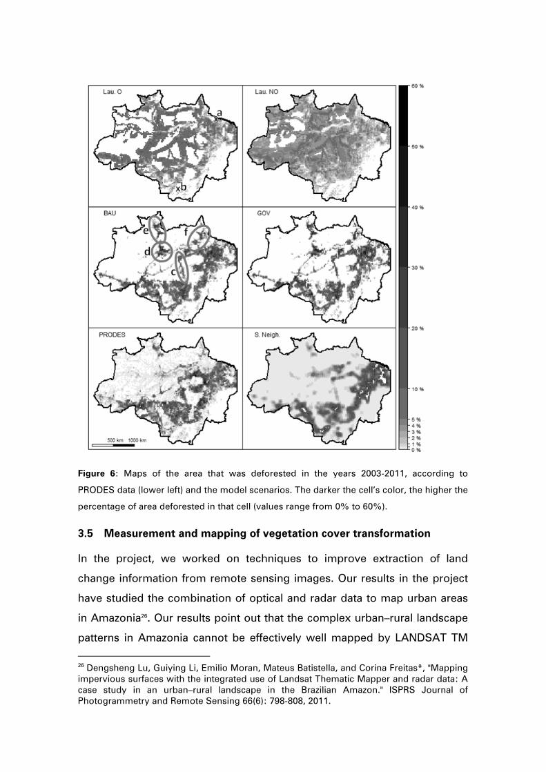
Figure 6: Maps of the area that was deforested in the years 2003-2011, according to
PRODES data (lower left) and the model scenarios. The darker the cell’s color, the higher the
percentage of area deforested in that cell (values range from 0% to 60%).
3.5 Measurement and mapping of vegetation cover transformation
In the project, we worked on techniques to improve extraction of land
change information from remote sensing images. Our results in the project
have studied the combination of optical and radar data to map urban areas
in Amazonia26. Our results point out that the complex urban–rural landscape
patterns in Amazonia cannot be effectively well mapped by LANDSAT TM
26 Dengsheng Lu, Guiying Li, Emilio Moran, Mateus Batistella, and Corina Freitas*, "Mapping impervious surfaces with the integrated use of Landsat Thematic Mapper and radar data: A case study in an urban–rural landscape in the Brazilian Amazon." ISPRS Journal of Photogrammetry and Remote Sensing 66(6): 798-808, 2011.
multispectral images with 30 m spatial resolution. These urban-rural
landscapes require image with 10 m spatial resolution or better.
Producing accurate image classification is a challenge, particularly in
moist tropical regions, due to the complex biophysical environment and
limitations of remote sensing data. In tropical regions, availability of optical
data is limited by cloud cover, and radar data is not sensitive to clouds..
Radar and optical data are complementary and integrating them improves
information extraction.
The paper compares parametric and non-parametric LUCC
classification algorithms for these three study areas. The spectral signatures
of remotely sensed data, for medium spatial resolution images, such as
Landsat, are still the most important features in land use/cover classification.
The authors conclude that parametric algorithms such as the maximum-
likelihood classifier are not appropriate for LUCC when optical and radar
images are combined. Advanced nonparametric classifiers, such as decision
tree, evidential reasoning, or the knowledge‐based approach, appear to be
the best choices.
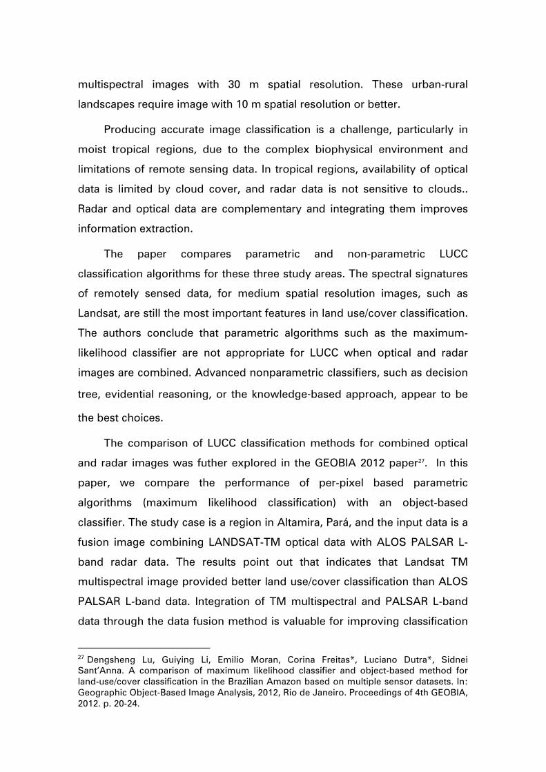
The comparison of LUCC classification methods for combined optical
and radar images was futher explored in the GEOBIA 2012 paper27. In this
paper, we compare the performance of per-pixel based parametric
algorithms (maximum likelihood classification) with an object-based
classifier. The study case is a region in Altamira, Pará, and the input data is a
fusion image combining LANDSAT-TM optical data with ALOS PALSAR L-
band radar data. The results point out that indicates that Landsat TM
multispectral image provided better land use/cover classification than ALOS
PALSAR L-band data. Integration of TM multispectral and PALSAR L-band
data through the data fusion method is valuable for improving classification
27 Dengsheng Lu, Guiying Li, Emilio Moran, Corina Freitas*, Luciano Dutra*, Sidnei Sant’Anna. A comparison of maximum likelihood classifier and object-based method for land-use/cover classification in the Brazilian Amazon based on multiple sensor datasets. In: Geographic Object-Based Image Analysis, 2012, Rio de Janeiro. Proceedings of 4th GEOBIA, 2012. p. 20-24.
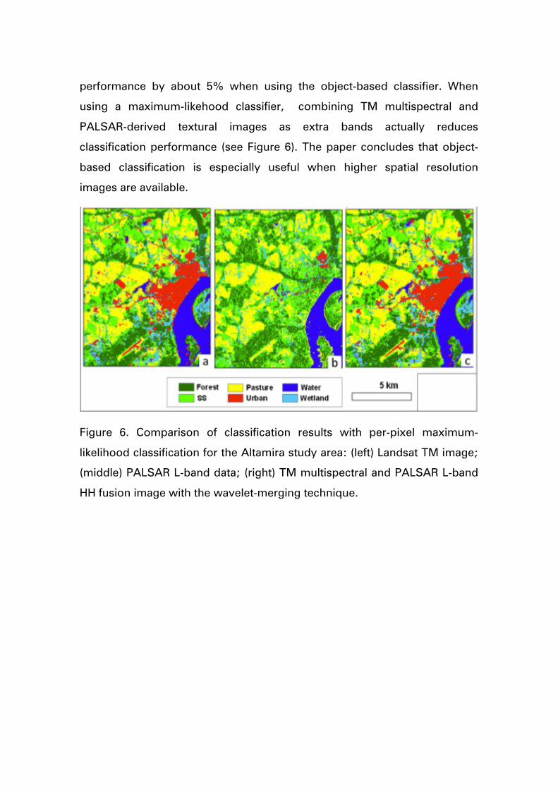
performance by about 5% when using the object-based classifier. When
using a maximum-likehood classifier, combining TM multispectral and
PALSAR-derived textural images as extra bands actually reduces
classification performance (see Figure 6). The paper concludes that object-
based classification is especially useful when higher spatial resolution
images are available.
Figure 6. Comparison of classification results with per-pixel maximum-
likelihood classification for the Altamira study area: (left) Landsat TM image;
(middle) PALSAR L-band data; (right) TM multispectral and PALSAR L-band
HH fusion image with the wavelet-merging technique.
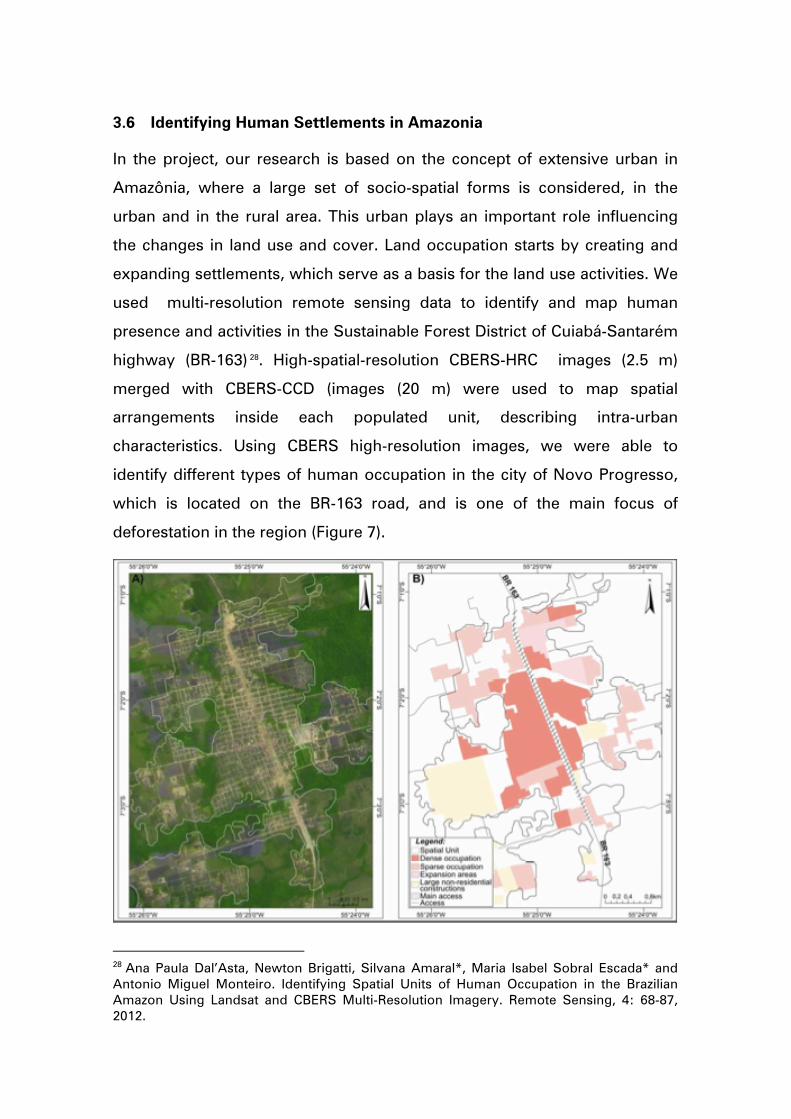
3.6 Identifying Human Settlements in Amazonia
In the project, our research is based on the concept of extensive urban in
Amazônia, where a large set of socio-spatial forms is considered, in the
urban and in the rural area. This urban plays an important role influencing
the changes in land use and cover. Land occupation starts by creating and
expanding settlements, which serve as a basis for the land use activities. We
used multi-resolution remote sensing data to identify and map human
presence and activities in the Sustainable Forest District of Cuiabá-Santarém
highway (BR-163) 28. High-spatial-resolution CBERS-HRC images (2.5 m)
merged with CBERS-CCD (images (20 m) were used to map spatial
arrangements inside each populated unit, describing intra-urban
characteristics. Using CBERS high-resolution images, we were able to
identify different types of human occupation in the city of Novo Progresso,
which is located on the BR-163 road, and is one of the main focus of
deforestation in the region (Figure 7).
28 Ana Paula Dal’Asta, Newton Brigatti, Silvana Amaral*, Maria Isabel Sobral Escada* and Antonio Miguel Monteiro. Identifying Spatial Units of Human Occupation in the Brazilian Amazon Using Landsat and CBERS Multi-Resolution Imagery. Remote Sensing, 4: 68-87, 2012.

Figure 7. Boundaries of the spatial units of human occupation obtained from Landsat TM for Novo Progresso over CBERS-CCD/HRC fused image (left) and spatial patterns mapping (right).
3.7 Relating rural and urban areas in Amazonia
One important concern we had in the project was to map the relationship
between urban patterns and rural land use. One of our studies was focused
on the evolution of the urban space and agricultural land in Santarém from
1990 to 201029. The work had two parts. First, we identified the types of
urban occupation in Santarém using remote sensing data. Then, we singled
out the types of agricultural land use close to the city. Results are shown in
Table 1 and Table 2.
Table 1. Types of urban occupation in Santarém
Padrão Tipologia Descrição
Dense occupation
> 80% of built space; pavements; vegetation < 15%; clear street definition.
Medium urban density
50 – 80% of built space; vegetation from 20 to 40% of area; clear street definition.
Low urban density
30 – 50% of built space; vegetation from 40 to 60% of area; clear street definition.
Urban Expansion
Less than 30% of built space; vegetation from 40% to 80% of area; much soil change.
Business and institutional
area Áreas with industries and large buildings.
Vegetation >80% of trees
Table 2. Types of agricultural land near Santarém.
29 Ana Paula D'Asta, Isabel Escada, Silvana Amaral, Miguel Monteiro. Evolução do arranjo espacial urbano e das terras agrícolas no entorno de Santarém (Pará) no período de 1990 a 2010: Uma análise integrada baseada em sensoriamento remoto e espaços celulares. In: XVI Brazilian Symposium on Remote Sensing (SBSR), Foz de Iguaçu, 2013.

Pattern Type Description Occupation pattern
Continuous Wetlands, urban areas , forest,
secondary vegetation. Non agricultural areas
Diffuse Small spot; Isolated occupation
Low to medium density
Shifting cultivation; small-scale
agriculture.
Linear Elongated areas, showing a direction
of occupation
Road-associated agriculture (new
settlements in early stages),
riverine population
Geometric
Regular geometric forms, with
medium to large size. Sparse forms,
with medium to small density.
Mechanized agriculture or large-
scale cattle raising, associated to
mid and large size farmers.
Continuous
Geometric
Regular geometric forms,
continuously spread with high
density.
Mechanized agriculture or large-
scale cattle raising, associated to
mid and large size farmers.
Mixed
areas
Irregular forms associated to
geometric forms; medium to high
density.
Mechanized agriculture or large-
scale cattle raising, combined
with small-scale production.
Based on this typology, we obtained two relevant results using the
GeoDMA software. First, we found out that there was a densification of the
urban occupation in Santarém. The expansion of the urban areas from 1991
to 2010 was less than 5 km2, while the population increased by almost
30,000 people. We also found out a marked land concentration. Figure 11
shows the patterns of agricultural land change near Santarém in 1990, 1999
and 2010. We can see an increase of large-scale agriculture associated to
soybean production and large-scale cattle raising. In this period, Santarém
became an important port for export soybean and meat, which is clearly
motivating a major agricultural expansion in the area.
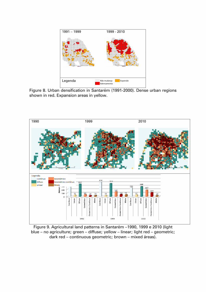
1991 – 1999 1999 - 2010
Legenda
Figure 8. Urban densification in Santarém (1991-2000). Dense urban regions shown in red. Expansion areas in yellow.
1990 1999 2010
Figure 9. Agricultural land patterns in Santarém –1990, 1999 e 2010 (light blue – no agriculture; green – diffuse; yellow – linear; light red – geometric;
dark red – continuous geometric; brown – mixed áreas).
Legenda:Nãomudança ExpansãoAdensamento
3.8 GeoDMA - Geographic Data Mining Analyst
GeoDMA (Geographical Data Mining Analyst) is a software for remote
sensing data mining. The main motivation of GeoDMA is that there is much
information available in remote sensing images which is not used by
traditional image processing statistical classifiers. In particular, information
on shape, patterns and spatio-temporal trends is not used. To use this
information, GeoDMA applies data mining techniques to remote sensing
imagery. The software associates landscape ecology metrics to land change
patterns. Then, it uses data mining algorithms to classify the patterns.
GeoDMA provides simulation methods to assess the accuracy of process
models as well as tools for spatio-temporal analysis, including a visualization
scheme for temporal profiles that helps users to describe patterns in cyclic
events.
GeoDMA implements image segmentation, extraction and selection of
image segment attributes, region-based classification and exploratory data
analysis tools. GeoDMA works as a plugin of the free GIS software
TerraView, developed by INPE and available at www.terralib.org. It uses the
geographical data handling and visualization structure provided by
TerraView. Both systems were developed using the open source TerraLib
library. We have used GeoDMA to describe land change patterns and
trajectories in Amazonia, as outlined in the previous sections. GeoDMA is
available at http://geodma.sourceforge.net/. The development of GeoDMA
has been supported by FAPESP thorugh the LUA project.
The project supported the GeoDMA software, which was the basis for a
PhD dissertation at INPE30 and a paper accepted at an important journal31. We
30 Thales Korting, “GeoDMA: a toolbox integrating data mining with object-based and multi-temporal analysis of satellite remotely sensed imagery”. PhD dissertation in Remote Sensing, INPE, 2012. Advisors: Leila Fonseca and Gilberto Camara. 31 Thales Korting, Leila Fonseca, Gilberto Câmara, “GeoDMA - Geographic Data Mining Analyst: a framework for GIScience”. Computers & Geosciences, 57: 133–145, 2013.
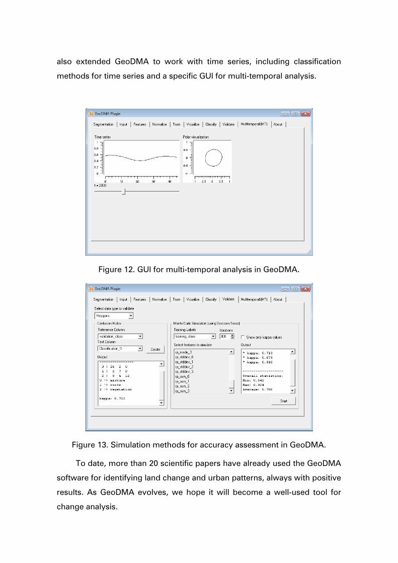
also extended GeoDMA to work with time series, including classification
methods for time series and a specific GUI for multi-temporal analysis.
Figure 12. GUI for multi-temporal analysis in GeoDMA.
Figure 13. Simulation methods for accuracy assessment in GeoDMA.
To date, more than 20 scientific papers have already used the GeoDMA
software for identifying land change and urban patterns, always with positive
results. As GeoDMA evolves, we hope it will become a well-used tool for
change analysis.
3.9 TerraME
Modeling interactions between social and natural systems is a hard task. It
involves collecting data, building up a conceptual approach, implementing,
calibrating, simulating, validating, and possibly repeating these steps again
and again. There are different conceptual approaches proposed in the
literature to tackle this problem. However, for complex problems it is better
to combine different approaches, giving rise to a need for flexible and
extensible frameworks for modeling nature-society interactions.
Given that most of the scientific problems we face in the LUA/IAM
project involve understanding and modeling human-nature interaction, the
project supported the development of TerraME. It is an open source toolbox
that supports multi-paradigm and multi-scale modeling of coupled human-
environmental systems. TerraME is a software for developing multiscale
spatially explicit models It enables models that combine agent-based,
cellular automata, system dynamics, and discrete event simulation
paradigms. TerraME has a GIS interface for managing real-world geospatial
data. The simulation language used by TerraME is an extension of Lua, a
high-level scripting language. TerraME extends Lua with data types and
functions for modeling and simulating human-enviroment systems32.
Development of TerraME started in 2006, as part of Tiago Carneiro’s
PhD at INPE. Pedro Andrade and Eva Moreira, as part of their PhDs, made
further advances. The LUA project supported major developments in
TerraME:
a) Release of TerraME versions 1.1, 1.2 and 1.3.
b) Full implementation of TerraME Observer, the visualization
component of the TerraME.
32 Tiago Carneiro, Pedro Andrade, Gilberto Câmara, Antônio Miguel Monteiro, Rodrigo Reis Pereira, “TerraME: an extensible toolbox for modelling nature-society interactions”. Enviromental Modelling and Software, 46: 104-117, 2013.

c) Significant improvements in agent-based modeling in TerraME,
following the experience of developing a model for deforestation in
Amazonia.
The visualization mechanism is structured according to the Observer
software design pattern. Graphical interfaces for scientific visualization are
called observers and present real-time changes in the internal state of any
TerraME object. In this context, each instance of a model component is
called subject. As Figures 1 illustrates, several observers can be linked to a
single subject, so that the evolving state of a subject can be analyzed
simultaneously in many ways. Changes in a subject are explicitly notified to
the observers in the model source code. This assures that only consistent
states will be rendered by the observers and gives complete control to the
modeler to decide in which changes he is interested in. When notified, each
observer updates itself requesting information about the internal state of its
subject. Then, the state is serialized and transferred to the observers to
render the graphical interface. The work was presented in a scientific paper33.
Figure 14. Visualization in TerraME is structured according to the Observer software design pattern.
33 Antonio Rodrigues, Tiago Carneiro, Pedro Andrade*. TerraME Observer: Extensible real-time visualizations of dynamic spatial models. In: GeoInfo 2012, Campos do Jordão, 2012.
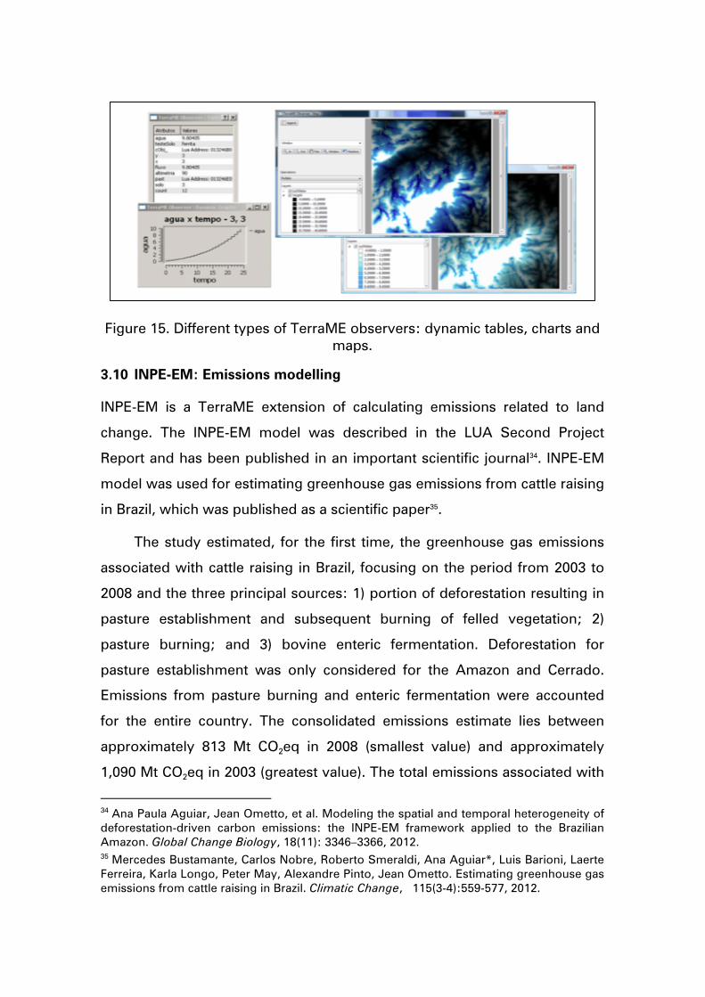
Figure 15. Different types of TerraME observers: dynamic tables, charts and maps.
3.10 INPE-EM: Emissions modelling
INPE-EM is a TerraME extension of calculating emissions related to land
change. The INPE-EM model was described in the LUA Second Project
Report and has been published in an important scientific journal34. INPE-EM
model was used for estimating greenhouse gas emissions from cattle raising
in Brazil, which was published as a scientific paper35.
The study estimated, for the first time, the greenhouse gas emissions
associated with cattle raising in Brazil, focusing on the period from 2003 to
2008 and the three principal sources: 1) portion of deforestation resulting in
pasture establishment and subsequent burning of felled vegetation; 2)
pasture burning; and 3) bovine enteric fermentation. Deforestation for
pasture establishment was only considered for the Amazon and Cerrado.
Emissions from pasture burning and enteric fermentation were accounted
for the entire country. The consolidated emissions estimate lies between
approximately 813 Mt CO2eq in 2008 (smallest value) and approximately
1,090 Mt CO2eq in 2003 (greatest value). The total emissions associated with
34 Ana Paula Aguiar, Jean Ometto, et al. Modeling the spatial and temporal heterogeneity of deforestation-driven carbon emissions: the INPE-EM framework applied to the Brazilian Amazon. Global Change Biology, 18(11): 3346–3366, 2012. 35 Mercedes Bustamante, Carlos Nobre, Roberto Smeraldi, Ana Aguiar*, Luis Barioni, Laerte Ferreira, Karla Longo, Peter May, Alexandre Pinto, Jean Ometto. Estimating greenhouse gas emissions from cattle raising in Brazil. Climatic Change, 115(3-4):559-577, 2012.

Amazon cattle ranching ranged from 499 to 775 Mt CO2eq, that of the
Cerrado from 229 to 231 Mt CO2eq, and that of the rest of the country
between 84 and 87 Mt CO2eq. The full set of emissions originating from
cattle raising is responsible for approximately half of all Brazilian emissions
(estimated to be approximately 1,055 Mt CO2eq in 2005), even without
considering cattle related sources not explicitly estimated in this study, such
as energy use for transport and refrigeration along the beef and derivatives
supply chain.
The paper identified some priority action areas to effectively address
these sources of emissions:
1. Mitigation potentials in the Brazilian cattle industry are significant
and do not imply cutting back on current production. Key
mitigation sources should include reduction of deforestation and
regeneration of secondary forest, reduction in enteric fermentation,
recuperation of degraded pasture and soils and elimination of fire
in pasture management.
2. Substantial investment in quality of pasture and related
technologies such as, among others, rotational grazing or
introduction of legume pasture, is essential to all forms of
mitigation.
3. Methane emissions by enteric fermentation can be reduced
significantly as a result of increased productivity, including genetic
improvement in the herd, use of supplemental rations and
provision of mineral salt, which allow for faster fattening and
higher survival rates resulting in a much shorter average lifespan in
relation to current standards of extensive ranching.
ANNEX 1
Full List of Scientific Results
In this section we present the full list the scientific results achieved in the
project. Project researchers involved in the thesis and papers are highlighted
by an asterisk (*).
PhD Dissertations
1 Eliana Pantaleao, “Análise de cenários para classificação de dados de
sensoriamento remoto usando otimização multiobjetivo e hierarquia de
classes.” (Classification of remote sensing images using multi-objective
optimization). PhD dissertation in Computer Science, INPE, 2012.
Advisor: Luciano Vieira Dutra*.
2 Sergio Costa, "Regional Scale Agent-Based Modelling of Land Change:
Evolving Institutional Arrangements in Frontier Areas". PhD dissertation
in Computer Science, INPE, 2012. Advisors: Gilberto Câmara* and Ana
Paula Aguiar*.
3 Carolina Pinho, “Análise de redes de localidades ribeirinhas amazônicas
no tecido urbano estendido” (The role of Amazonian settlements in the
urban network: a proposal based on network analysis). PhD
dissertation in Remote Sensing, INPE, 2012. Advisors: Leila Fonseca*
and Silvana Amaral*.
4 Giovana Mira de Espindola, “Spatiotemporal Trends of Land Use Change
in the Brazilian Amazon”. PhD dissertation in Remote Sensing, INPE,
2012. Advisors: Leila Fonseca* and Gilberto Camara*.
5 Thales Korting, “GeoDMA: a toolbox integrating data mining with object-
based and multi-temporal analysis of satellite remotely sensed imagery”.
PhD dissertation in Remote Sensing, INPE, 2012. Advisors: Leila
Fonseca* and Gilberto Câmara*.
6 Karine Reis Ferreira, "An Algebra for Spatiotemporal Data: From
Observations to Events". PhD dissertation in Computer Science, INPE,
2012. Advisors: Gilberto Camara* and Antônio Miguel Vieira Monteiro.
7 Gilberto Ribeiro de Queiroz, "CellDB: Uma Arquitetura de Acesso a
Dados para Modelagem Ambiental em Grande Escala Baseados em
Espaços Celulares" (CellDB: a data access architecture for large-scale
environmental modeling in cell spaces). PhD dissertation in Computer
Science, INPE, 2012. Advisors: Gilberto Camara* and Antônio Miguel
Vieira Monteiro.
8 Ramon Morais de Freitas, “Estudos de métodos computacionais para
visualização e caracterização do uso e cobertura da terra utilizando
imagens de sensoriamento remoto” (Computational methods for
visulisation and idenficaton of land use and land cover using remote
sensing images). PhD dissertation in Computer Science, INPE, 2012.
Advisor: Yosio Edemir Shimabukuro.
9 André de Lima, ”Influência da cobertura da terra na extensão e
configuração espacial de áreas queimadas em anos de seca extrema na
Amazônia Oriental” (Influence of land cover in the extension and spatial
configuration of burned areas in extreme drought years in Eastern
Amazonia). PhD dissertation in Remote Sensing, INPE, 2013. Advisor:
Yosio Shimabukuro*.
10 Fabrício Brito Silva, “Modelagem da Produtividade Primária Bruta na
Bacia Amazônica” (Modelling Gross Primary Productivity in Amazonia”) .
PhD dissertation in Remote Sensing, INPE, 2013. Advisor: Yosio
Shimabukuro*.
11 Marcus Saldanha, “Um segmentador multinível para imagens SAR
polarimétricas baseado na distribuição Wishart” (Multilevel
segmentation in SAR images). PhD dissertation in Computer Science,
INPE, 2013. Advisor: Corina da Costa Freitas*.
12 Rogerio Negri. “Maquina de Vetores de Suporte Adaptativa ao Contexto:
Formalização e Aplicações em Sensoriamento Remoto” (Adaptative
Support Vector Machine Algorithm). PhD dissertation in Computer
Science, INPE, 2013. Advisor: Luciano Vieira Dutra*.
13 Wagner Silva, Classificação de regiões de imagens utilizando testes de
hipótese baseados em distâncias estocásticas: aplicações a dados
polarimétricos (Region classifier using stochastic distances). PhD
dissertation in Remote Sensing, INPE, 2013. Advisor: Corina da Costa
Freitas*.
MSc Thesis
1 Saito, E. A; Caracterização de Trajetórias de Padrões de Ocupação
Humana na Amazônia Legal por meio de Mineração de Dados. MSc
thesis in Remote Sensing, INPE, 2010. Advisors: Leila Fonseca* and
Maria Isabel Sobral Escada*.
2 Ricardo Theophilo Folhes; Cenários de Mudanças no Uso e Cobertura da
Terra na Amazônia: uma abordagem participativa em um assentamento
agro-extrativista em Santarém. MSc thesis in Environmetal Science
UFPA, 2010. Advisors: Ana Paula Aguiar*.
3 Gavlak, A. A. Padrões de mudança de cobertura da terra e dinâmica
populacional no Distrito Florestal Sustentável da BR163: população,
espaço e ambiente. MSc thesis in Remote Sensing, INPE, 2011.
Advisors: Maria Isabel Sobral Escada* and Antônio Miguel Vieira
Monteiro.
4 Talita Oliveira Assis, “Modelagem de Processos de Mudanças de Uso da
Terra” (Modelling Processes of Land Use Change). MsC thesis in
Computer Science, INPE, 2012. Advisors: Gilberto Câmara* and Ana
Paula Aguiar*.
5 Luciana de Oliveira Pereira, “Avaliação de métodos de integração de
imagens ópticas e de radar para a classificação do uso e cobertura das
terra na região Amazônica” (Evaluation of methods for integrating radar
an optical images for classification of land use and land cover in
Amazonia). MsC thesis in Remote Sensing, INPE, 2012. Advisors: Corina
da Costa Freitas* and Sidnei Sant'Anna*.
6 Luiz Gustavo Veras, “Análise de erros de alocação de modelos de uso e
cobertura da terra na Amazonia”. Mestrado em Computação Aplicada,
INPE (co-orientação com). Início: Março 2010. Fim: Maio 2013. Advisors:
Gilberto Câmara* and Pedro Andrade-Neto*.
7 Merret Buurman, “Regionalisation of the Brazilian Amazon basin for
improved land change modelling”. Master of Science in Geoinformatics,
Institute for Geoinformatics, University of Münster, 2014. Advisors:
Gilberto Câmara* and Edzer Pebesma.
3.11 Journal papers (published or in press)
2010
1 Pedro Alves, Silvana Amaral*, Maria Isabel Sobral Escada*, Antôno
Miguel Vieira Monteiro, “Explorando as relações entre a dinâmica
demográfica, estrutura econômica e mudanças no uso e cobertura da
terra no sul do Pará: Lições para o distrito florestal sustentável da BR-
163”. Geografia (Rio Claro), 35(1):165-182, 2010.
2 Luke Parry, Brett Day, Silvana Amaral*, and Carlos A. Peres. "Drivers of
rural exodus from Amazonian headwaters." Population and Environment
32(2-3):137-176, 2010.
3 Luke Parry, Carlos A. Peres, Brett Day, and Silvana Amaral*. "Rural–
urban migration brings conservation threats and opportunities to
Amazonian watersheds." Conservation Letters 3(4): 251-259, 2010.
4 Luiz Aragão, and Yosio Shimabukuro*, "The incidence of fire in
Amazonian forests with implications for REDD." Science 328(5983) 1275-
1278, 2010.
5 Aboud-Neta, S. R. ; Freitas, C. C. ; Dutra, L. V., "Uso de imagens
ALOS/Palsar multipolarizadas para detecção de incremento de
desflorestamento na Amazonia, Revista Brasileira de Cartografia
(Online), p. 417, vol. 62, 2010.
2011
6 Guiying Li, Emilio Moran, Luciano Dutra*, and Mateus Batistella. "A
comparison of multisensor integration methods for land cover
classification in the Brazilian Amazon." GIScience & Remote Sensing
48(3):345-370, 2011.
7 Dengsheng Lu, Guiying Li, Emilio Moran, Mateus Batistella, and Corina
Freitas*, "Mapping impervious surfaces with the integrated use of
Landsat Thematic Mapper and radar data: A case study in an urban–rural
landscape in the Brazilian Amazon." ISPRS Journal of Photogrammetry
and Remote Sensing 66(6): 798-808, 2011.
8 Liana Anderson, Luiz Aragao, Yosio Shimabukuro*, Samuel Almeida,
and Alfredo Huete. "Fraction images for monitoring intra-annual
phenology of different vegetation physiognomies in Amazonia."
International Journal of Remote Sensing 32(2): 387-408, 2011.
9 Egídio Arai, Yosio Shimabukuro*, Gabriel Pereira, and Nandamudi
Vijaykumar. "A Multi-Resolution Multi-Temporal Technique for Detecting
and Mapping Deforestation in the Brazilian Amazon Rainforest." Remote
Sensing 3(9):1943-1956, 2011.
10 Eduardo Maeda, Gustavo Arcoverde, Petri Pellikka, and Yosio
Shimabukuro*. "Fire risk assessment in the Brazilian Amazon using
Modis imagery and change vector analysis." Applied Geography
31(1):76-84, 2011.
11 Ramón Freitas, Egidio Arai, Marcos Adami, Arley Ferreira, Fernando
Sato, Yosio Shimabukuro*, Reinaldo Rosa, Liana Anderson, and
Bernardo Rudorff. "Virtual laboratory of remote sensing time series:
visualization of MODIS EVI2 data set over South America." Journal of
Computational Interdisciplinary Sciences 2(1): 57-68, 2011.
12 Jean Ometto, Ana Paula Aguiar*, and Luiz Martinelli. "Amazon
deforestation in Brazil: effects, drivers and challenges." Carbon
Management 2(5):575-585, 2011.
13 Thales Seth Korting, Leila Maria Garcia Fonseca*, Gilberto Câmara*, A
Geographical Approach to Self-Organizing Maps Algorithm Applied to
Image Segmentation. Advances Concepts for Intelligent Vision Systems.
162-170. 2011.
2012
14 Silvana Amaral*, André Gavlak, Maria Isabel Sobral Escada*, and
Antônio Miguel Vieira Monteiro, “Using remote sensing and census tract
data to improve representation of population spatial distribution: case
studies in the Brazilian Amazon”, Population and Environment, 34:142-
170, 2012.
15 Ana Paula Dal’Asta, Newton Brigatti, Silvana Amaral*, Isabel Escada*
and Antonio Miguel Monteiro. “Identifying Spatial Units of Human
Occupation in the Brazilian Amazon Using Landsat and CBERS Multi-
Resolution Imagery”. Remote Sensing, 4: 68-87, 2012.
16 Dengsheng Lu, Mateus Batistella, Emilio Moran, Stephen Hetrik, Corina
Freitas*, Luciano Dutra*, Sidnei Sant’Anna*. “Land use/cover
classification in the Brazilian Amazon using satellite images”. Pesquisa
Agropecuária Brasileira, 47:1185-1208, 2012.
17 Guiying Li, Dengsheng Lu, Emilio Moran, Luciano Dutra*, Mateus
Batistella, “A comparative analysis of ALOS PALSAR L-band and
RADARSAT-2 C-band data for land-cover classification in a tropical moist
region”. ISPRS Journal of Photogrammetry and Remote Sensing, 70:26-
38, 2012.
18 Damien Arvor, Margareth Meirelles, Vincent Dubreil, Agnès Bégué, and
Yosio Shimabukuro*, “Analyzing the agricultural transition in Mato
Grosso, Brazil, using satellite-derived indices”. Applied Geography, 32:
702-713, 2012.
19 Ana Paula Aguiar*, Jean Ometto, Carlos Nobre, David Lapola, Claudio
Almeida, Ima Vieira, João Vianei Soares, Regina Alvalá, Sassan Saatchi,
Dalton Valeriano. “Modeling the spatial and temporal heterogeneity of
deforestation-driven carbon emissions: the INPE-EM framework applied
to the Brazilian Amazon”. Global Change Biology, 18(11): 3346–3366,
2012.
20 Mercedes Bustamante, Carlos Nobre, Roberto Smeraldi, Ana Aguiar*,
Luis Barioni, Laerte Ferreira, Karla Longo, Peter May, Alexandre Pinto,
Jean Ometto. “Estimating greenhouse gas emissions from cattle raising
in Brazil”. Climatic Change, 115(3-4):559-577, 2012.

21 Luciana Soler, Kasper Kok, Gilberto Câmara*, Tom Veldkamp, “Using
Fuzzy Cognitive Maps to describe current system dynamics and develop
land cover scenarios: a case study in the Brazilian Amazon”. Journal of
Land Use Science, 7(2): 149-175 , 2012.
22 Giovana Espindola, Ana Paula Aguiar*, Edzer Pebesma, Gilberto
Câmara*, Leila Fonseca*. “Agricultural land use dynamics in the Brazilian
Amazon based on remote sensing and census data”. Applied
Geography, 32(2):240-252, 2012.
23 Karine Reis Ferreira, Lúbia Vinhas, Antônio Miguel Monteiro, Gilberto
Câmara*, “Moving objects and spatial data sources”, Revista Brasileira
de Cartografia, 64(6): 797-806, 2012.
24 Carolina Pinho, Leila Fonseca*, Thales Korting, Claudia Almeida,
Hermann Kux. “Land-cover classification of intra-urban environment
using high-resolution images and object-based image analysis”.
International Journal of Remote Sensing, 33 (19), 5973–5995, 2012.
25 Theophilo Folhes, Ana Paula Aguiar*, Roberto Araújo Santos Jr*.
“Cenários participativos de mudanças no uso da terra na Amazônia: o
caso de Vila Brasil no projeto de assentamento agroextrativista do Lago
Grande (Participative scenarios of land change in Amazonia: the case of
Vila Brasil in the Lago Grande settlement)”. Campo-Território: Revista de
Geografia Agrária, 7(14): 1-34, 2012.
26 Giovana Espindola, Ana Paula Aguiar*, Pedro Andrade*, “Combining
Satellite Remote Sensing and Census Data for Regional Scale Analysis of
Land Use Change in the Brazilian Amazon”. Revista Brasileira de
Cartografia, 64(5), 2012.
2013
27 Wagner Silva, Corina Freitas, Sidnei Sant’Anna, Alejandro Frery.
“Classification of Segments in PolSAR Imagery by Minimum Stochastic
Distances Between Wishart Distributions”. Journal Of Selected Topics
In Applied Earth Observations And Remote Sensing, 6(3), June 2013.

28 Fletcher, I. N., L. E. O. C. Aragão, A. Lima, Y. Shimabukuro*, and P.
Friedlingstein. "Fractal properties of forest fires in Amazonia as a basis
for modelling pan-tropical burned area." Biogeosciences Discussions 10,
no. 8, 2013.
29 Fabrício Silva, Yosio Shimabukuro*, Luiz Aragao, Liana Anderson,
Gabriel Pereira, Franciele Cardozo, and Egídio Arai. "Large-scale
heterogeneity of Amazonian phenology revealed from 26-year long
AVHRR/NDVI time-series." Environmental Research Letters 8(2): 024011,
2013.
30 Kléber Trabaquini, Gustavo Silva, Gustavo Bayma, Antonio Formaggio,
Yosio Shimabukuro, Lênio Galvão, “Dynamics and distribution of
anthropic occupation In the cerrado of Mato Grosso in the period from
1990 to 2008”. Geografia (Rio Claro), 38: 209-224, 2013.
31 Silvana Amaral*,Ana Paula Dal’Asta, Newton Brigatti, Carolina Pinho,
Liliam Medeiros, Pedro Andrade, Taíse Pinheiro, Pedro Alves, Isabel
Escada*, Antônio Miguel Monteiro, “Comunidades ribeirinhas como
forma socioespacial de expressao urbana na Amazonia: uma tipologia
para a regiao do Baixo Tapajos (Para-Brasil)” (Riverin communities as
urban expressions in Amazonia: a classification for the region of the
Lower Tapajós, Pará”. REBEP Revista Brasileira de Estudos de
População, 30(2): 367-399, 2013.
32 Luciana Pereira, Corina Freitas*, Sidnei Sant’ Anna, Dengsheng Lu, and
Emilio F. Moran. "Optical and radar data integration for land use and land
cover mapping in the Brazilian Amazon." GIScience & Remote Sensing
50(3):301-321, 2013.
33 Thales Korting, Leila Fonseca*, Gilberto Câmara*, “GeoDMA -
Geographic Data Mining Analyst”. Computers & Geosciences, 57: 133–
145, 2013.
34 Tiago Carneiro, Pedro Andrade*, Gilberto Câmara*, Antônio Miguel
Monteiro, Rodrigo Reis Pereira, “An extensible toolbox for modelling
nature-society interactions”. Enviromental Modelling and Software, 46:
104-117, 2013.
2014
35 Karine Ferreira, Gilberto Câmara*, Antonio Miguel Monteiro, “An algebra
for spatiotemporal data: from observations to events”, Transactions in
GIS, 18(2):253-269, 2014.
36 David Lapola, Luiz Martinelli, Carlos Peres, Jean Ometto, Manuel
Ferreira, Carlos Nobre, Ana Aguiar*, Manuel Cardoso, Marcos Costa,
Carlos Joly, Christiane Leite, Paulo Moutinho, Gilvan Sampaio, Bernardo
Bernardo Strassburg, and Ima Vieira, et al. "Pervasive transition of the
Brazilian land-use system”. Nature Climate Change 4(1): 27-35, 2014.
37 Atzberger, C., A. R. Formaggio, Yosio Shimabukuro*, T. Udelhoven, M.
Mattiuzzi, G. A. Sanchez, and E. Arai. "Obtaining crop-specific time
profiles of NDVI: the use of unmixing approaches for serving the
continuity between SPOT-VGT and PROBA-V time series." International
Journal of Remote Sensing 35, no. 7 (2014): 2615-2638.
38 Eloi Dalla-Nora, Ana Aguiar*, David Lapola, Geert Woltjer, “Why have
land use change models for the Amazon failed to capture the amount of
deforestation over the last decade?”, Land Use Policy, 39, July 2014, pp.
403–411.
39 Jean Ometto, Ana Aguiar*, Talita Assis, Luciana Soler, Pedro Valle,
Graciela Tejada, David M. Lapola, and Patrick Meir. "Amazon forest
biomass density maps: tackling the uncertainty in carbon emission
estimates." Climatic Change, available online February 2014.
3.12 Book Chapters
1 Ima Vieira, Peter Toledo, Roberto Araújo Santos Junior*, Andrea Coelho,
Thomes Kasecker, Pedro Baiao. “Amazônia”. In: Fabio Scarano. (Org.).
Biomas Brasileiros - Retrato de um país plural (Brazilian biomes). 1ed.
Rio de Janeiro: Casa da Palavra, 2012, v. 1, p. 128-163.
2 Guiying Li, Dengsheng Lu, Emilio Moran, Mateus Batistella, Corina
Freitas, Luciano Dutra, Sidnei Sant’Anna. Land Use/Land Cover
Classification in the Brazilian Amazon with Different Sensor Data and
Classification Algorithms. In: Guangxing Wang; Qihao Weng.. (Org.).
Remote Sensing of Natural Resources. Oxford, UK, CRC Press, 2013, p.
111-126.
3 Liana Anderson, Luiz Aragão, Dalton Valeriano, Manuel Cardoso, Yosio
Shimabukuro*, André Lima. “Impactos de secas nas florestas
amazônicas” (Impacts of droughts in Amazon forests). In: Laura De
Borma, Carlos Nobre. (Org.). Secas na Amazônia: causas e
consequências (Droughts in Amazonia). São Paulo, Oficina de Textos. p.
147-164, 2013.
4 Dalton de Morrison Valeriano, Maria Isabel Sobral Escada*, Gilberto
Câmara*, Silvana Amaral*; Luis Eduardo Maurano, Camilo Daleles
Rennó, Cláudio Aparecido Almeida, Antônio Miguel Vieira
Monteiro, O monitoramento do desmatamento. In: Martine, George;
Ojima, Ricardo; Barbieri, Alisson; Carmo, Roberto do (Ed.). População e
Sustentabilidade na era das mudanças ambientais globais. ABEP:
[s.n.] 2012. ISBN 978-85-85543-25-9.
3.13 Papers presented in Scientific Congresses
1 Graziela Scofield, Luciano Dutra*, Corina Freitas*, Sidnei Sant’Anna,
Daniel Silva. Evaluation of Two Region Based Classifications in Tapajós
National Forest using the ALOS/PALSAR Polarimetric and Interferometric
Coherences. Em: IGARSS 2010 2010 IEEE International Geoscience and
Remote Sensing Symposium, p. 3426-3429, 2010.
2 Márcio Mello, Bernardo Rudorff, Marcos Adami, Rodrig Rizzi, Daniel
Alves Aguiar, Aníbal Gusso, and Leila Fonseca*. "A simplified Bayesian
Network to map soybean plantations." In Geoscience and Remote
Sensing Symposium (IGARSS), 2010 IEEE International, pp. 351-354.
IEEE, 2010.
3 Thales Korting, Leila Fonseca*, and Gilberto Câmara*. "Interpreting
images with GeoDMA." GEOBIA. Ghent, Belgium (2010).
4 Thales Korting, Luciano Dutra*, Guaraci Erthal, and Leila Fonseca*.
"Assessment of a modified version of the EM algorithm for remote
sensing data classification." In Progress in Pattern Recognition, Image
Analysis, Computer Vision, and Applications, pp. 476-483. Springer
Berlin Heidelberg, 2010.
5 Alexandre Ximenes and Silvana Amaral*. "Mapeamento das Ecorregiões
do Distrito Florestal Sustentável da BR-163 na Amazônia Brasileira com
uso de redes neurais." Anais XV Simpósio Brasileiro de Sensoriamento
Remoto-SBSR. Curitiba, PR (2011).
6 Newton Brigatti, Ana Paula Dal’Asta, Silvana Amaral*, Isabel Escada*,
André Gavlak, “Identificação de áreas edificadas e núcleos urbanos na
regiao Amazônica utilizando dados do sensor Landsat-TM5”, XV
Brazilian Symposium on Remote Sensing, Curitiba, PA, 2011.
7 Ana Paula Dal’Asta, Newton Brigatti, Silvana Amaral*, Isabel Sobral
Escada*, “Imagens de alta resolução espacial para a caracterizacao de
nucleos urbanizados do Distrito Florestal Sustentável da BR 163 – Pará –
Brasil” (High-resolution images to define urban settlements in the
Sustainable Forest District of BR-163). XV Brazilian Symposium on
Remote Sensing, Curitiba, PA, 2011.
8 André Gavlak, Isabel Escada*, Miguel Monteiro, “Dinâmica de padrões
de mudança de uso e cobertura da terra na região do Distrito Florestal
Sustentável da BR-163” (Dinamics of land use and land cover change in
the Sustainable Forest District along BR-163 road). XV Brazilian
Symposium on Remote Sensing, Curitiba, PA, 2011.
9 Luciana Pereira, Ricardo Negri, Sidnei Sant’Anna*, Luciano Dutra*,
Corina Freitas*, Guaraci Erthal, “Análise comparativa dos métodos de
classificação SVM e Maxver-ICM Polarimétrico em imagem de radar
ALOS PALSAR”. In: XV Simpósio Brasileiro de Sensoriamento Remoto,
2011, Curitiba. XV SBSR, 2011. p. 8223-8230.
10 Wagner Silva, Alejandro Frery, Corina Freitas(, Ricardo Negri, Sidnei
Sant’Anna*, “Classificador por regiões de imagens SAR com base em
distâncias estocásticas derivadas da densidade de probabilidade do par
de intensidades multi-look”. In: XV Simpósio Brasileiro de
Sensoriamento Remoto, 2011, Curitiba. XV SBSR, 2011. p. 8326-8333.

11 Wagner Silva, Luciana O. Pereira, Sidnei Sant'Anna, Corina C. Freitas,
Ricardo Guimarães, and Alejandro César Frery. "Land cover
discrimination at brazilian Amazon using region based classifier and
stochastic distance." In Geoscience and Remote Sensing Symposium
(IGARSS), 2011 IEEE International, pp. 2900-2903. IEEE, 2011.
12 Gustavo Silva, Antonio Formaggio, Yosio Shimabukuro*, Edson Sano,
Monitoramento e detecção de desmatamentos no bioma Cerrado mato-
grossense utilizando imagens de multisensores. Em: XV Brazilian
Symposium on Remote Sensing (Curitiba, Brazil), p. 2849-2855, 2011.
13 Luciane Sato, Yosio Shimabukuro*, Tatiana Kuplich. Uso da análise por
componentes principais na avaliação da mudança da cobertura florestal
da Floresta Nacional do Tapajós. Em: XV Brazilian Symposium on
Remote Sensing (Curitiba, Brazil), 2011, p. 6696-6702, 2011.
14 Luciene Sato, Flora Martins, Roberta Cantinho, Thales Korting, Leila
Fonseca*, Cláudio Almeida, and Dalton Valeriano. "Classificação de áreas
exploradas por sistema de corte seletivo na Amazônia." XV Brazilian
Symposium on Remote Sensing (Curitiba, Brazil), 2011: 6688-6695.
15 Joel Risso, Rodrigo Rizzi, Bernardo Rudorff, Yosio Shimabukuro*,
Marcos Adami, André Lima, and Jane Verona. "A soja eo
desflorestamento no Mato Grosso: safras 2001/02 a 2004/05." XV
Brazilian Symposium on Remote Sensing (Curitiba, Brazil), 2011.
16 André Lima, Yosio Shimabukuro*, Antônio Formaggio, Thiago Silva,
Marcos Adami, and Ramon Freitas. "Caracterização do padrão temporal
de regeneração florestal da Amazônia Oriental em áreas desmatadas no
ano de 2001." XV Brazilian Symposium on Remote Sensing (Curitiba,
Brazil) (2011): 6161-6168.
17 Maria Isabel Sobral Escada*, Luis Maurano, Camilo Rennó, Silvana
Amaral*, and Dalton Valeriano. "Avaliação de dados dos Sistemas de
Alerta da Amazônia: DETER e SAD." XV Brazilian Symposium on Remote
Sensing (Curitiba, Brazil) (2011): 2934-2943.
18 Roberto Araújo*, Potenciais de articulação entre o grande capital e a
pequena produção: uma reflexão a partir do campo sócioambiental
(Potentials for cooperation between big capital and the small producers).
VI Encontro Nacional da Associação Nacional de Pesquisa e Pós
Graduação em Ambiente e Sociedade (ANPPAS) Belém, 18 a 21 de
setembro de 2012.
19 Ana Paula Dal’Asta, Silvana Amaral*, Fernanda da Rocha Soares, Miguel
Monteiro, “Evolução recente da população urbana comparada à
evolução do desmatamento nos municípios do Distrito Florestal
Sustentável da BR-163 (PA)” (Recent evolution of urban population
compared to deforestation rates in municipalities of the Sustainable
Forest District of the BR-163 road”. XVIII National Meeting of Brazilian
Population Studies Association (ABEP), Águas de Lindóia, 2012.
20 Roberto Araújo*, Economia camponesa nas fronteiras do capitalism.
Seminário Dinâmica Agrária e Desenvolvimento Sustentável Belém,
UFPa/CAPES/Fundação Ford 30 de outubro a 01 de novembro de 2012.
21 Dengsheng Lu, Guiying Li, Emilio Moran, Corina Freitas*, Luciano
Dutra*, Sidnei Sant’Anna. A comparison of maximum likelihood
classifier and object-based method for land-use/cover classification in
the Brazilian Amazon based on multiple sensor datasets. In: Geographic
Object-Based Image Analysis, 2012, Rio de Janeiro. Proceedings of 4th
GEOBIA, 2012. p. 20-24.
22 Rogério Negri, Luciano Dutra*, Sidnei Sant'Anna*. Stochastic
Approaches of Minimum Distance Method for Region Based
Classification. 17th Iberoamerican Congress, CIARP 2012, Buenos Aires,
Argentina, September 3-6, 2012. Lecture Notes in Computer Science, v.
7441, p. 797-804, 2012.
23 Wagner Silva, Corina Freitas*, Sidnei Sant’Anna*, Alejandro Frery.
Polsar region classifier based on stochastic distances and hypothesis
tests. In: IEEE International Geoscience and Remote Sensing
Symposium (IGARSS), 2012.
24 Marcus Saldanha, Corina Freitas*, Sidnei Sant´Anna*. “Single channel
SAR image segmentation using Gamma distribution hipothesis test”. In:
IEEE International Geoscience and Remote Sensing Symposium
(IGARSS), 2012, Munique.
25 Sánchez, Gildardo Arango, Yosio Edemir Shimabukuro, and Dalton de
Morisson Valeriano. "Evaluation of multi-temporal ALOS/PALSAR for
monitoring the Brazilian Amazon rainforest." In IEEE International
Geoscience and Remote Sensing Symposium (IGARSS), 2012.
26 Ana Paula D'Asta, Silvana Amaral*, Flávia Soares, Antônio Miguel
Monteiro. Evolução recente da dinâmica populacional em comparação
à conversão florestal nos municípios do Distrito Florestal Sustentável da
BR-163, PA (Recent evolution of population dynamics in the
municipalities of the sustainable forest district of the BR-163 road). In:
XVIII - Encontro Nacional de Estudos Populacionais 2012, 2012, Águas
de Lindóia, SP.
27 Ana Paula D'Asta, Maria Isabel Sobral Escada*, Silvana Amaral*, Miguel
Monteiro. Evolução do arranjo espacial urbano e das terras agrícolas no
entorno de Santarém (Pará) no período de 1990 a 2010: Uma análise
integrada baseada em sensoriamento remoto e espaços celulares
(Evolution of the urban space and of the agriculture land in the city of
Santarém from 1990 to 2010). In: XVI Brazilian Symposium on Remote
Sensing (SBSR), Foz de Iguaçu, 2013.
28 Taise Pinheiro, Maria Isabel Sobral Escada*. “Detecção e Classificação
de padrões da Degradação Florestal na Amazônia por meio de banco de
dados cellular (Detection of forest degradation in Amazonia). XVI
Brazilian Symposium on Remote Sensing (SBSR), Foz de Iguaçu, 2013.
29 Maria Isabel Sobral Escada*, Luis Maurano, Jorge Silva. Dinâmica do
desmatamento na área de influência das usinas hidroelétricas do
complexo do rio Madeira (Deforestation dynamics in the areas close to
hydroelectric plants in the Madeira river). XVI Brazilian Symposium on
Remote Sensing (SBSR), Foz de Iguaçu, 2013.
30 Thales Korting, Leila Fonseca, Gilberto Camara*. Identifying features for
temporal analysis of vegetation indices. GEOBIA 2012 (Rio de Janeiro,
Brazil). May, 2012.
31 Alexandre Noma, Thales Korting, Leila Fonseca*, João Papa. Uma
comparação entre classificadores usando regiões e perfis EVI para
Agricultura (Comparision beween region-based and EVI time series
based classifiers for mapping agricultural land). XVI Brazilian Symposium
on Remote Sensing (SBSR), Foz de Iguaçu, 2013.
32 Antonio Rodrigues, Tiago Carneiro, Pedro Andrade*. TerraME Observer:
Extensible real-time visualizations of dynamic spatial models. In: GeoInfo
2012, Campos do Jordão, 2012.
33 Sergio Costa, Ana Paula Aguiar*, Gilberto Câmara*, Tiago Carneiro,
Evaldinolia Moreira. Agent placement for land change models in frontier
regions. XVI Brazilian Symposium on Remote Sensing (SBSR), Foz de
Iguaçu, 2013.
34 Luiz Veras, Pedro Andrade*, Gilberto Câmara*. Métrica de qualidade
espaço-temporal de modelos dinâmicos espaciais (Quality metrics for
land use models). In: XVI Brazilian Symposium on Remote Sensing
(SBSR), Foz de Iguaçu, 2013.
35 Ana Paula Dal’Asta, Silvana Amaral*, Antônio Miguel Monteiro, “O Rio e
as cidades: uma análise exploratória de dependências e alcances das
comunidades do Arapiuns (Pará-Brasil) e a formação do urbano na
Amazônia” (The river and the cities: an exploratory analysis of the
dependency of the communities of Arapiuns, Pará, Brazil”). II National
Meeting on Population, Space and Environment, São José dos Campos,
2013.
36 Thales Körting*, Emiliano Castejon, and Leila Fonseca*, "The Divide and
Segment Method for Parallel Image Segmentation." Advanced Concepts
for Intelligent Vision Systems. Springer International Publishing, 2013.
37 Luiz Veras, Merret Buurman, Pedro Andrade, Gilberto Câmara*, and
Edzer Pebesma. "Measuring Allocation Errors in Land Change Models in
Amazonia." Brazilian Symposium on Geoinformatics, 2013.
3.14 Technical Reports
1 Fernanda Soares. Identificação dos Núcleos Populacionais no
Município de Novo Progresso (Pará) utilizando Imagens de Média
Resolução Espacial (Identification of populational nucleus in Novo
Progresso using remote sensing images). Trabalho de Conclusão de
Curso de Graduação em Geografia - Universidade do Vale do Paraíba.
2012. (orientada por Silvana Amaral - INPE)
2 Silvana Amaral*, Newton Brigatti, Ana Paula Dal’Asta, Maria Isabel Isabel
Escada*, Fernanda da Rocha Soares. ”Tem fofoca na currutela”: Núcleos
urbanizados e uso da terra de Alta Floresta (MT) ao Crepurizão (PA) na
Transgarimpeira (Urban settlements and land use from Alta Floresta
(MT) to Crepurizão (PA) in the Transgarimpeira road). INPE technical
report TDI-02.10.17.29, 2012. Available on-line
http://urlib.net/8JMKD3MGP7W/3BBJ3K5
3 Ana Paula Dal’Asta, André Gavlak, Maria Isabel Sobral Escada*, Newton
Brigatti Silvana Amaral*, “Núcleos de ocupação humana e uso da terra
entre Santarém e Novo Progresso, ao longo da BR-163” (Urban
settlements and land use from Santarém to Novo Progresso, along the
BR-163 road). INPE technical report RPQ-03.29.14.21, 2012.
4 Maria Isabel Sobral Escada*; Ana Paula Dal´Asta, Fernanda da Rocha
Soares, Pedro Andrade*, Carolina Pinho, Lilian Medeiros, Vagner Luís
Camilotti, Vanessa da Costa Ferreira, Silvana Amaral*, “Infraestrutura,
serviços e conectividade das comunidades ribeirinhas do Arapiuns”, PA.
INPE technical report, 04.29.14.32-RPQ 2013. Available in:
<http://urlib.net/8JMKD3MGP7W/3E2NF9P>.
5 Ana Paula Dal’Asta, Anielli Rosane de Souza, Carolina Moutinho Duque
de Pinho, Fernanda da Rocha Soares, Genilson Fernando de Jesus
Rego, Juliana Mota de Siqueira, Maria Isabel Sobral Escada*, Newton
Brigatti, Silvana Amaral*, Vagner Luis Camilotti, Vinicius Etchebeur
Medeiros Dória, “As Comunidades de terra firme do Sudoesto do Pará:

População, infraestrutura, serviços, uso da terra e conectividades”. INPE
technical report. 2014
ANNEXES
Reports from Project Scholarship Students
Taise Pinheiro
Elói Nora
Nathan Vogt