Facies and architectural analysis of fluvial deposits of ... · PDF fileFacies and...
22
Facies and architectural analysis of fluvial deposits of the Nýřany Member and the Týnec Formation (Westphalian D – Barruelian) in the Kladno-Rakovník and Pilsen basins Stanislav Opluštil 1 – Karel Martínek 1 – Zuzana Tasáryová 2 1 Charles University Prague, Institute of Geology and Palaeontology, Albertov 6, 128 43 Praha 2, Czech Republic. E-mail: [email protected] 2 Academy of Sciences of the Czech Republic, Institute of Geophysics, Boční II/1401, 14131 Praha 4, Czech Republic. E-mail: [email protected] Abstract. The fluvial strata of the Nýřany Member (Westphalian D – Cantabrian) and of the lower part of the Týnec Formation (Cantabrian – Barruelian) have been the subjects of systematic sedimentological studies. Detailed analyses of the facies, paleocurrents, and sedimentary architecture were performed on the exposures. The cumulative stratigraphical thickness of the studied successions reaches about 100 m. Six sedimentary facies were distinguished: siltstone with plant material content (Fsm), fine-grained horizontal laminated sandstone (Sh), medium- to coarse-grained cross stratified sandstone (Sc), fine- to medium-grained massive conglomerate (Gm), fine- to medium-grained cross stratified conglomerate (Gcm), and coarse-grained cross stratified conglomerate (Gcc). Five architectural elements were identified: channels (CH), sand bed forms (SB), gravel bars and bed forms (GB), sediment gravity-flow deposits (SG), and downstream accretion macroforms (DA). All of these sediments represent braided river systems, though the type or behaviour of these systems differs at individual localities. Most of them were high energy, braided rivers of low sinuosity. Laterally migrating braided streams of low sinuosity, possibly forming braidplain fluvial environments, were distinguished at the Hostibejk Cliff deposits and in the lower part of the Pecínov quarry succession. Deposits indicative of vertically aggrading streams of higher sinuosity and lower energy fluvial environments were recognized in the Lobeč Cliff deposits and in the upper part of Pecínov quarry. Radčice Cliff is dominated by laterally migrating channels, though multi-storey channel fills also occur. Key words: Pennsylvanian, Pilsen and Kladno-Rakovník Basins, fluvial architecture, facies analysis, sedimentary processes Introduction The sedimentary infill of continental basins presents a re- cord of tectonic processes, erosion, and of climatic charac- ter. The interplay of varying subsidence rates and sediment supplies results in the development of different sedimen- tary environments, ranging from alluvial and fluvial to a variety of lacustrine settings. In most of these basins, flu- vial sediments form often a substantial part of the basin fill. Consequently, a number of case studies and review papers have appeared in the literature during the past few decades. These studies have been focused mainly on the analysis of facies and architecture of the fluvial strata of ancient and modern rivers, towards interpreting sedimentary processes and environments, and recognizing the main depositional factors (Bridge and Mackey 1993, Ramos and Sopena 1983, Sánchez-Moya et al. 1996, Smith 1990, Shanley and McCabe 1993, 1994, Capuzzo and Wetzel 2004). In conti- nental basins in which the sedimentary record was affected by eustatically driven base level changes, the application of sequence stratigraphy is very common (Martinsen et al. 1999, Hampson et al. 1999). Despite all the above-de- scribed trends, sedimentological studies on this topic are very rare for Late Paleozoic continental basins in the Bohemian Massif. These basins have received much atten- tion since the beginning of the nineteenth century when systematic coal-mining was started in most of them. Inten- sive borehole exploration after the Second World War fur- ther improved our knowledge of the basin-wide lithostrati- graphy and of local lithostratigraphic peculiarities. The current knowledge of the lithostratigraphic subdivision of the basin fill, the thickness of particular units, the biostrati- graphy, and coal reserves have been summarized in several papers, especially by Havlena and Pešek (1980), Pešek (1994, 1996) and Pešek et al. (2001). However, informa- tion on the facies and architecture of the fluvial strata, as well as the interpretation of sedimentary processes and the character of sedimentary environments, are either lacking or are discussed only generally for the central and western Bohemian basins. The study of a lacustrine and lacustrine-delta system of Stephanian B age (Skoček 1990) is an exception. The fluvial sediments that comprise most of the basin fill were studied mostly in terms of cyclic ana- lysis and basic facies description (Spudil et al. 1980, Spudil 1982, Bosák 1991, Pešek 1994). The present study was performed on outcrops of fluvial deposits of the Nýřany Member (Westphalian D – Cantabrian) in the Kladno-Ra- kovník Basin, and in the Týnec Formation (Cantabrian – Barruelian) of the Pilsen Basin. The sediments of these units provide one of the best opportunities for sedimentolo- gical study in central and western Bohemia. The goal of this study is to describe and interpret the sedimentary facies and their origins, and to examine their architectural ele- ments toward reaching a better understanding of the Ný- řany Member and Týnec Formation depositional environ- ments in the Kladno-Rakovník and Pilsen basins. Geological setting and stratigraphy The Late Paleozoic continental basins of the Czech Republic are situated on different terranes of the Bohemian Massif, 45 Bulletin of Geosciences, Vol. 80, No. 1, 45–66, 2005 © Czech Geological Survey, ISSN 1214-1119
Transcript of Facies and architectural analysis of fluvial deposits of ... · PDF fileFacies and...

Facies and architectural analysis of fluvial deposits of the Nýřany Member and the TýnecFormation (Westphalian D – Barruelian) in the Kladno-Rakovník and Pilsen basins
Stanislav Opluštil 1 – Karel Martínek 1 – Zuzana Tasáryová 2
1 Charles University Prague, Institute of Geology and Palaeontology, Albertov 6, 128 43 Praha 2, Czech Republic. E-mail: [email protected] Academy of Sciences of the Czech Republic, Institute of Geophysics, Boční II/1401, 14131 Praha 4, Czech Republic. E-mail: [email protected]
Abstract . The fluvial strata of the Nýřany Member (Westphalian D – Cantabrian) and of the lower part of the Týnec Formation (Cantabrian –Barruelian) have been the subjects of systematic sedimentological studies. Detailed analyses of the facies, paleocurrents, and sedimentary architecturewere performed on the exposures. The cumulative stratigraphical thickness of the studied successions reaches about 100 m. Six sedimentary facies weredistinguished: siltstone with plant material content (Fsm), fine-grained horizontal laminated sandstone (Sh), medium- to coarse-grained cross stratifiedsandstone (Sc), fine- to medium-grained massive conglomerate (Gm), fine- to medium-grained cross stratified conglomerate (Gcm), and coarse-grainedcross stratified conglomerate (Gcc). Five architectural elements were identified: channels (CH), sand bed forms (SB), gravel bars and bed forms (GB),sediment gravity-flow deposits (SG), and downstream accretion macroforms (DA).All of these sediments represent braided river systems, though the type or behaviour of these systems differs at individual localities. Most of them werehigh energy, braided rivers of low sinuosity. Laterally migrating braided streams of low sinuosity, possibly forming braidplain fluvial environments, weredistinguished at the Hostibejk Cliff deposits and in the lower part of the Pecínov quarry succession. Deposits indicative of vertically aggrading streams ofhigher sinuosity and lower energy fluvial environments were recognized in the Lobeč Cliff deposits and in the upper part of Pecínov quarry. Radčice Cliffis dominated by laterally migrating channels, though multi-storey channel fills also occur.
Key words: Pennsylvanian, Pilsen and Kladno-Rakovník Basins, fluvial architecture, facies analysis, sedimentary processes
Introduction
The sedimentary infill of continental basins presents a re-cord of tectonic processes, erosion, and of climatic charac-ter. The interplay of varying subsidence rates and sedimentsupplies results in the development of different sedimen-tary environments, ranging from alluvial and fluvial to avariety of lacustrine settings. In most of these basins, flu-vial sediments form often a substantial part of the basin fill.Consequently, a number of case studies and review papershave appeared in the literature during the past few decades.These studies have been focused mainly on the analysis offacies and architecture of the fluvial strata of ancient andmodern rivers, towards interpreting sedimentary processesand environments, and recognizing the main depositionalfactors (Bridge and Mackey 1993, Ramos and Sopena1983, Sánchez-Moya et al. 1996, Smith 1990, Shanley andMcCabe 1993, 1994, Capuzzo and Wetzel 2004). In conti-nental basins in which the sedimentary record was affectedby eustatically driven base level changes, the application ofsequence stratigraphy is very common (Martinsen etal. 1999, Hampson et al. 1999). Despite all the above-de-scribed trends, sedimentological studies on this topicare very rare for Late Paleozoic continental basins in theBohemian Massif. These basins have received much atten-tion since the beginning of the nineteenth century whensystematic coal-mining was started in most of them. Inten-sive borehole exploration after the Second World War fur-ther improved our knowledge of the basin-wide lithostrati-graphy and of local lithostratigraphic peculiarities. Thecurrent knowledge of the lithostratigraphic subdivision of
the basin fill, the thickness of particular units, the biostrati-graphy, and coal reserves have been summarized in severalpapers, especially by Havlena and Pešek (1980), Pešek(1994, 1996) and Pešek et al. (2001). However, informa-tion on the facies and architecture of the fluvial strata, aswell as the interpretation of sedimentary processes and thecharacter of sedimentary environments, are either lackingor are discussed only generally for the central and westernBohemian basins. The study of a lacustrine andlacustrine-delta system of Stephanian B age (Skoček 1990)is an exception. The fluvial sediments that comprise mostof the basin fill were studied mostly in terms of cyclic ana-lysis and basic facies description (Spudil et al. 1980, Spudil1982, Bosák 1991, Pešek 1994). The present study wasperformed on outcrops of fluvial deposits of the NýřanyMember (Westphalian D – Cantabrian) in the Kladno-Ra-kovník Basin, and in the Týnec Formation (Cantabrian –Barruelian) of the Pilsen Basin. The sediments of theseunits provide one of the best opportunities for sedimentolo-gical study in central and western Bohemia. The goal ofthis study is to describe and interpret the sedimentary faciesand their origins, and to examine their architectural ele-ments toward reaching a better understanding of the Ný-řany Member and Týnec Formation depositional environ-ments in the Kladno-Rakovník and Pilsen basins.
Geological setting and stratigraphy
The Late Paleozoic continental basins of the Czech Republicare situated on different terranes of the Bohemian Massif,
45
Bulletin of Geosciences, Vol. 80, No. 1, 45–66, 2005© Czech Geological Survey, ISSN 1214-1119

the tectonic histories of which are generally independent ofeach other. Based on the distinct stratigraphical ranges ofthese basins, they are divided into the following four regi-ons (Pešek 1994): 1. Central and Western Bohemian UpperPaleozoic basins, 2. Lusatian Upper Paleozoic basins,3. Krušné hory (Erzgebirge) Upper Paleozoic, and 4. gra-bens (Fig. 1A). These regions are further subdivided intoparticular basins whose borders are mostly formal, as theyusually represent only part of a larger depocenter.
The Pilsen and Kladno-Rakovník basins belong to theregion of Central and Western Bohemian Upper Paleozoicbasins. Their sedimentary history began around the Duck-mantian/Bolsovian boundary. Deposition, interrupted byseveral hiatuses, lasted at least until the end of the Carbon-iferous (Fig. 1B). The basin fill is divided into four litho-
stratigraphic formations based on the al-ternation of reddish coal-barren, andgreyish coal-bearing deposits (Weithofer1896, 1902, Havlena and Pešek 1980,Pešek 1994). The formations of grey sedi-ments are further subdivided into mem-bers (Fig. 1B).
Only a few papers describe the for-mation and tectonic evolution of thesebasins. Havlena (1982) characterizedthese basins as a simple asymmetricmega-graben formed on the Teplá-Bar-randian block, subsiding along theWSW-ENE striking faults (the CentralBohemian Fault in the south and theLitoměřice Fault in the north). This opin-ion is contrary to that of Pašek and Urban(1990), who emphasized the role of theNW-SE striking wrench faults related tothe oblique collision between Gondwanaand Baltica. Their conclusions are basedon an analysis of brittle structures andthe migration of depocenters of particu-lar lithostratigraphic units that indicatethree periods of tectonic evolution corre-sponding to the main sedimentary cyclesseparated by prominent basin-wide hia-tuses: 1. Lower Bolsovian (the RadniceMember), 2. Upper Westphalian D –Stephanian B (the Nýřany Member, theTýnec and Slaný Formations), 3. Step-hanian C – Autunian (the Líně Forma-tion).
The Nýřany Member and the TýnecFormation
The Nýřany Member consists of the up-per part of the Kladno (Lower Grey) For-mation, the oldest unit of sedimentary fillin the central and western Bohemian ba-sins. Its predominantly fluvial strata spanthe interval of the Upper Westphalian D
to Cantabrian. It is separated from the underlying RadniceMember by a basin-wide hiatus related to the Leonianphase of the Variscan Orogeny (Opluštil and Pešek 1998).This separation is marked not only by an unconformity, butalso by an apparent lithological contrast (Fig. 3a). Howe-ver, where sediments of the Radnice Member consist offluvial facies (Pešek 1994), the precise identification oferosional surfaces between these two units is problematicwithout paleontological evidence (especially in boreholesamples). The Nýřany Member is overlain by the Týnec(Lower Red) Formation of similar facies and structure, in-dicating the continuous deposition of both units. The boun-dary between them is marked by the prominent red colourof the fine-grained sediments and the absence of coal se-ams in the Týnec Formation. This boundary is interpreted
46
Figure 1. A – Late Paleozoic continental basins of the Czech Republic and their regional subdivision.B – Lithostratigraphic units in the basins of central and western Bohemia. The approximate strati-graphic position of the studied localities is indicated by arrows.C – Detailed map of the central and western Bohemian area, with the locations of the studied out-crops
Stanislav Opluštil – Karel Martínek – Zuzana Tasáryová

as a response to climatic change from hu-mid to drier conditions (Pešek 1994,Opluštil and Pešek 1998).
The thickness of the Nýřany Membervaries on a basin-wide scale from 0 tomore than 500 m in the central part of theKladno-Rakovník Basin. However, theaverage thickness of this unit in thePilsen Basin is 288 m, whereas in theKladno-Rakovník Basin it is 336 m(Pešek 1994). Northwestward and east-ward, the thickness decreases as sedi-ments of this unit wedge out toward theformer basin margin.
The Nýřany Member is characterizedby the presence of coarse-grained fluvialsediments, especially in the southern partof the Kladno-Rakovník Basin and mostparts of the Pilsen Basin, where mediumto coarse-grained arkoses with pebblyadmixture predominate. Conglomeratesare common at the base of the unit.Fine-grained floodplain, palustrine, oreven lacustrine facies are more commonin the N and NE parts of the Kladno-Ra-kovník Basin outside the study area.Coal seams are usually only several tensof centimetres thick, and thicknesses over 1 m are rare.Pešek (1994) distinguished three facies in the NýřanyMember: 1. fluvial facies, 2. phytogenic-volcanic facies,and 3. alluvial fan facies which represents facies associa-tions rather than individual facies. The fluvial facies con-sist of coarse- to medium-grained arkose with pebbly ad-mixtures, which predominates over fine-grained sandstoneand mudstone. The sediments are arranged into upwardfining cycles. The mudstones at the top are often rooted.Thin coal may be locally present at or near the top any cy-cle. The thicknesses of the cycles vary from less than 10 mto more than 25 m, being about 10 m on average. It is gen-erally higher along the basin margins, where the content offloodplain sediments is low. Phytogenic-volcanic faciesare characterized by the predominance of mudstones thatoften contain fossil roots, carbonaceous shale, and coalwith subordinate arkoses. This facies is developed mostlyin the central and NE part of the Kladno-Rakovník Basin.In the western part of the Pilsen Basin, coal seams up to3 m thick are present in the surroundings of the town ofNýřany. Alluvial fan facies were recognized by Pešek(1968, 1994) in the western part of the Pilsen Basin,where the so-called Komberk Horizon occurs. It is afan-like body, reaching up to 60 m in thickness, com-prised of reddish or mottled mudstones and subordinatearkoses located along the basin margin, which wedges outtoward the basin centre.
The Týnec Formation overlies the sediments of theNýřany Member. Its thickness in the Pilsen Basin variesbetween 92–132 m, with an average of 116 m, whereas inthe eastern part of the Kladno-Rakovník Basin it is between
94 and 245 m thick, with an average of 172 m. Theirlithological character generally resembles the sediments ofthe Nýřany Member. They are also arranged into cyclesdominated by basal, coarse-grained members. The mostapparent difference is the absence of any coal seams andred coloured mudstones, which are typical for the TýnecFormation. Moreover, in the Pilsen Basin, sediments of theTýnec Formation are generally coarser and richer in con-glomerates than the underlying Nýřany Member sediments(Pešek, pers. com.).
The paleogeography of the Nýřany Member and theTýnec Formation has been described by many authors, in-cluding Havlena and Pešek (1980), Holub et al. (1975),Pešek (1994), Pešek et al. (1998), and Opluštil and Pešek(1998). The sediments of this unit were deposited within alarge alluvial plain exceeding the size of the currently pre-served area of the basins in western and central Bohemia.The main sediment input came from the Central Bohe-mian Pluton located south of the basins (Pešek 1994). Lo-cal sources, however, surrounded nearly all the basin mar-gins.
Methods
The presently flat and densely vegetated surface of thestudy area provides only limited opportunities for studyingthe facies and architectural elements of the sedimentary re-cord of the Nýřany Member and the Týnec Formation. Out-crops of these sediments are located only along the south-ern margin of the Kladno-Rakovník Basin, and along the
47
Figure 2. Paleogeographic map of central and western Bohemia during the deposition of the NýřanyMember and the Týnec Formation in the Late Westphalian and Early Stephanian (based on Pešek etal. 1998). Note the position of studied localities and source areas.
Facies and architectural analysis of fluvial deposits of the Nýřany Member and the Týnec Formation in the Kladno-Rakovník and Pilsen basins

48
b
d
a
e
c
Figure 3. a – base of the Nýřany Member just above the contact with the underlying strata of the Radnice Member in the western quarry at Pecínov. Thecontact of both lithostratigraphic units is interpreted as a 6th order bounding surface (Miall 1996). The longer side of the photograph is about 7 m.b – water-escape structure in sediments of the Sc facies in the Hostibejk I Cliff. c – planar cross-bedding (Sc facies) in the Hostibejk II Cliff. The longerside of the photograph is about 2 m. d – planar cross-bedded conglomerates of the Gcm facies in the upper part of the Hostibejk II Cliff. Cross-bedding ismarked by tree trunks. The longer side of the photograph is 1 m. e – fining upward of grain size within the cross-bedded conglomerates (humpback duneof Miall, 1996) of the Gc facies, terminated by a reactivation surface followed by diagonally cross-bedded sandstone of the Sc facies. Pecínov quarry. Thelonger side of the photograph is about 1 m.
Figure 4. a – high erosional relief at the base of conglomeratic channels (CH), Gcm facies. Radčice near Plzeň. The longer side of the photograph is 5 m onoutcrop (oblique view). b – through-cross-bedding in Gcm facies. Pebble admixture in sandstone is present as scattered pebbles and residual lags at thebases of channels or reactivation surfaces. Note the high erosional relief at the base of the channel (top). Radčice near Plzeň. The longer side of the photo-graph is 4 m. c – through-cross-bedded sandstone of Sc facies. Lobeč near Kralupy nad Vltavou. The longer side of the photograph is 4 m. d – residualpebble lags at the bases of the channels can be seen, as well as the vertical stacking pattern of individual channels. Lobeč near Kralupy nad Vltavou. Thelonger side of the photograph is 12 m. e – example of small channel approximately perpendicular to outcrop strike. Hostibejk near Kralupy nad Vltavou.The longer side of the photograph is 10 m. f – cross-bedded conglomerates of Gcc facies at the bases of the channels (top). Hostibejk near Kralupy nad
Stanislav Opluštil – Karel Martínek – Zuzana Tasáryová
→
Sc
Gc
↓

49
b
c d
g
f
a
e
Vltavou. The longer side of the photograph is 4 m. g – diagonally bedded conglomerate of Gcm facies. Northern part of the Hostibejk Cliff nearKralupy. The longer side of the photograph is about 1 m.
Facies and architectural analysis of fluvial deposits of the Nýřany Member and the Týnec Formation in the Kladno-Rakovník and Pilsen basins
CH Gcm
↑↑
Gcc

50
Figu
re5.
Ove
rvie
wof
the
stud
ied
clif
fsat
the
Lob
ečan
dH
ostib
ejk
loca
litie
s.
Stanislav Opluštil – Karel Martínek – Zuzana Tasáryová
Fig
.4c
Fig
.4d
Fig
.4e
Fig
.4f
eastern margin of the Pilsen Basin. The most extensive andcontinuous outcrops of fluvial sediments occur at the loca-lities of Radčice (3 km NW of Pilsen), Pecínov (2 km southof Nové Strašecí and Lobeč), and Hostibejk (between Kra-lupy nad Vltavou and Nelahozeves). These exposures werestudied using the methods of facies, architectural, and pa-leocurrent analysis toward interpreting the sedimentaryprocesses and environment.
The main criteria used for defining the facies followthose of Miall (1978, 1996), which have been adopted bymany authors. These criteria principally concern grainsizes and sedimentary structures, the geometry of sedimen-tary bodies, and presence or absence of identifiable plantremains. The codes used for facies also agree with thoseused by Miall (1996).
Axes of cross beddings, flute casts, and tool marks wereused as the main paleocurrent indicators. In poorly exposedparts, the planar features and foreset dip directions of crossbeddings were also considered.
Our analysis of the sedimentary architecture generallyfollows the approach of Miall (1985, 1996), but out-crop-scale features are described more simply for clarity(see Bridge 1993). They were identified from studied out-crops and are indicated in photomosaics. These photo-mosaics were prepared as montages of partly overlappingphotographs taken from a distance of several tens of metresto avoid distortion. The facies and structural elements areindicated in the photomosaics. Widths and thicknesses ofthe architectural elements were measured on thephotomosaics, and ratios of these dimensions are given.The relation of the actual width of an object to that mea-sured on the photomosaic, which are in some cases obliqueto paleoflow, is discussed below.
Characteristics of the studied outcrops
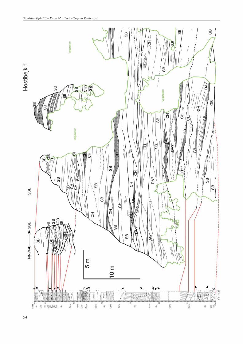
Kralupy nad VltavouTwo large sets of cliffs are located along the left bank of theVltava River (Moldau), between the towns of Kralupy nadVltavou and Nelahozeves. The strike of all the cliffs is ap-proximately to the north. The part located in Kralupy nadVltavou is called Hostibejk and consists of about three con-tinuous, partly vegetated cliffs, the heights of which varybetween 24 and 36 m. However, only two of them were ac-cessible for study (Fig. 5) during the field seasons of 2002and 2003. The main Hostibejk Cliff (Hostibejk I, Fig. 5) isabout 80 m long, whereas the length of Hostibejk Cliff II isonly about 20 m.
The Lobeč Cliff is situated further north, and is sepa-rated from the Hostibejk Cliffs by a tectonically boundedvalley about 150 m wide (Obrhel 1960). Lobeč Cliff is lo-cated between the northern margin of Kralupy nadVltavou and the southern margin of Nelahozeves. It ismore than 1 km long. However, only 150 m of its southernpart was suitable for photographic documentation, andwas studied in detail using the above-mentioned methods(Figs 5, 8).
The strata of the Hostibejk and Lobeč cliffs gently dip tothe north at an angle of up to 5°. The stratigraphically oldeststrata are exposed along the southern margin of HostibejkCliff I, whereas the stratigraphically youngest sedimentscrop out in the northern part of Lobeč Cliff near Nela-hozeves. The cumulative thickness of the studied part of thestratigraphic succession exposed in the Hostibejk Cliffs isestimated to be about 35 m, while that of Lobeč Cliff about45 m. However, when the non-studied part of the Lobeč ex-posure is included, its stratigraphic range is seen to be muchlarger, probably up to a few hundred metres.
The stratigraphic position of the exposed sections isbased on biostratigraphy, the lithological character of theexposed strata, and correlations made by using old miningdata. Coarse-grained, fluvial-dominated, floodplain-poorsediment successions exposed in the studied cliffs are typi-cal of the Nýřany Member and the Týnec Formation. Thisis consistent with biostratigraphical and old mining data.Historical exploration of the Upper Radnice Coal atČervená Hůrka Hill (Obrhel 1960, Šetlík 1968), now partof Kralupy nad Vltavou (called “Hůrka”) occurred severaltens of metres south of Hostibejk Cliff I. This data indicatesthat sediments exposed at the base of Hostibejk Cliff I formthe close overburden of the coal-bearing strata of theRadnice Member and, therefore, represent the lowermostpart of the Nýřany Member. Flora of the Westphalian Dcharacter collected by Obrhel (1960) at the top of the south-ern edge of Lobeč Cliff still refers to the position in thelower to middle part of the Nýřany Member succession.However, the presence of Sphenophyllum oblongifolium,the reliable Stephanian element, found by Šetlík (1968) in aroof mudstone of a thin coal seam in a northern part ofLobeč Cliff, approximately 500 m behind the area consid-ered here, clearly indicates a stratigraphic position in theupper part of the Nýřany Member. Thus, all the cliffs be-tween Kralupy nad Vltavou and Hostibejk expose fluvialsediments that range stratigraphically from the lower (bothHostibejk Cliffs) to the upper part of the Nýřany Member(behind the studied sector of the Lobeč Cliff), and possiblyup to the Týnec Formation.
PecínovThe Pecínov locality, about 2 km south of Nové Strašecí,consists of two quarries in which the company ČLUZ j.s.extracts refractory claystone of the Radnice Member(middle Westphalian). This claystone directly underliesthe Nýřany Member. Because of weathering and accessi-bility, only one of these quarries (the western one) wassubjected to detailed sedimentological study. Explorationactivity is less dynamic in this quarry, and the exposedwalls were studied in two successive field seasons in theyears 2002 and 2003. The western quarry is about 150 mlong and up to 45 m high at its central part. Sediments ofthe Nýřany Member comprise most of the succession, thethickness of which attains a maximum of 35 m. It is under-lain by sediments of the Radnice Member, separated by anerosional surface and overlain by Cretaceous strata. Theazimuth of wall is approximately 190°. Strata exposed in
51
Facies and architectural analysis of fluvial deposits of the Nýřany Member and the Týnec Formation in the Kladno-Rakovník and Pilsen basins

the western quarry gently dip to the NNE at an angle of 3to 5° (Fig. 10).
RadčiceThe Radčice locality, about 3 km NW of Plzeň (Pilsen), con-sists of a discontinuous series of outcrops about 1 km long,east of the village of Radčice, located along the left bank ofthe Mže River and a road cut. The strata dip gently to theENE. The stratigraphical position of the exposed strata ran-ges from the uppermost part of the Nýřany Member in thewestern part of the outcrops, to the lower part of the TýnecFormation in its eastern part. The boundary between theselithostratigraphic units is marked by several metres of con-glomerate at the base of the Týnec Formation. Because ofdiscontinuity and the presence of dense vegetation alongmost of the exposure, which prevented the taking of photo-graphs for the photomosaic, detailed sedimentological studywas performed only on the easternmost cliff, about 100 mlong and up to 12 m high. The cumulative thickness of theexposed succession in this part of the Radčice locality isabout 16 m, and stratigraphically represents sediments fromthe lower part of the Týnec Formation.
Sedimentary facies analysis
Six facies (Table 1) were recognized in the studied out-crops of the Nýřany Member (Hostibejk and Lobeč cliffs inthe Kralupy nad Vltavou, and the Pecínov quarries nearNové Strašecí) and the Týnec Formation (eastern part ofRadčice Cliff). Most of them are sandstone- to conglom-erate-dominated. Mudstone-dominated facies are lesscommon or even absent in individual outcrops.
Mudstone-dominated facies
Fsm: Laminated sandstone and mudstoneThis facies consists of interlaminations of mud, silt, and veryfine-grained sand. The thickness of particular sharp-basedbodies varies from 0.1 m (Hostibejk) to more than 1 m (Pe-cínov). They often rest on an erosional surface or onmedium- to coarse-grained sandstone. They pass upwardinto fine-grained, ripple bedded sandstone, or can be over-lain by medium- to coarse-grained sandstone. Laminationcan be prominent. Plant remains are locally present eitheras detritus or identifiable plant remains. Lobeč Cliff provi-
des the best example at the well known locality of the “Ný-řany flora” (Obrhel 1960). In the Pecínov quarry, only cor-daite leaves were found. Roots are infrequent but are occa-sionally observed at the Pecínov locality.
Interpretation: Sediments of this facies were depositedmostly from suspension, but also by low velocity unidirec-tional currents. They most probably represent an aban-doned channel fill, as indicated by the erosional surface atthe base or by the presence of medium- to coarse-grainedsandstone.
Sandstone-dominated facies
Sh: Horizontally stratified, fine-grained sandstoneFine-grained sandstone forms bodies that are up to 0.95 mthick, with sharp bases underlain by fine- and/orcoarse-grained gravel of facies Gp and Gt, and overlain bymedium-grained sandstone (facies Sp, St) and fine- and/orcoarse-grained gravel (Gp, Gt). The fine-grained sandstoneis well sorted with subrounded grains. Sedimentary struc-tures include flat lamination and current ripple lamination.The sandstone often contains plant remains and is rarely in-terbeded with siltstone.
Interpretation: Sandstone Sh was deposited from trac-tion by a low-energy, unidirectional current. Current ripplelamination, flat lamination, and silt interbeds indicatechanges in velocity and sediment load within the channel.
Sc: Cross-stratified sandstone(Figs 3c, 4c)Medium- to coarse-grained, cross-stratified, arkosic sand-stone dominates these sections of the outcrops. Their baseis sharp and erosional, with up to 0.4 m deep cuts into theunderlying deposits, though some channels in the RadčiceCliff have erosional relief up to 1.2 m. Pebble lag a fewcentimetres thick can be present at the base. These faciesare usually underlain by fine- or coarse-grained gravel, andare rarely underlain by fine-grained sandstone ormedium-grained gravel. Overlying deposits consist of fine-or coarse-grained sandstone. Sandstone Sc is well to mode-rately sorted with subrounded grains. In most cases thissandstone has a pebbly admixture (maximum pebble sizeobserved is 10 cm). Quartz pebbles are usually better roun-ded than quartzite, Proterozoic greywacke, and siltstonepebbles, which can even be angular. A feldspar content ofup to 30 to 40 % was observed locally. Coalified stems maybe present. Rare silt interbeds, silt intraclasts, and pebblesare present either as scattered deposits or as layers withinthe sandstone bed. The pebbles are usually between 0.5 and3 cm, with maximum size of 5 cm in diameter. Sedimen-tary structures include planar and trough-cross bedding.Current ripple bedding is very rare. Sedimentary structureshave been locally destroyed by soft sediment deformation,water escape structures, and bed slumping (Figure 2b).This sandstone can appear massive in places of strongerdiagenesis and weathering.
Interpretation: Sandstone Sc was deposited from trac-tion by a unidirectional current. Tabular and trough cross
52
Table 1. Facies recognized at individual localities
FaciesLocalities
Hostibejk Lobeč Pecínov Radčice
Fsm – + + –
Sh + + + –
Sc + + + +
Gcm + + + +
Gcc + + + +
Gm – + + –
Stanislav Opluštil – Karel Martínek – Zuzana Tasáryová

stratification record the migration of channel bed forms.High pebble contents indicate the high energy of thedepositional current. Pebble lag preserved on base of thesandstone suggests the cessation of a rolling gravel bedload, which could mean a fall in the initial energy of thedepositional current. This interpretation is further sup-ported by the fining upwards of several beds terminated lo-cally by current-ripple-bedded sandstone. Soft sedimentdeformation and slumping reflect channel bank instability.
Gravel-dominated facies
Gm: Massive conglomerateThis facies was observed only in the Lobeč and Pecínovsections. It consists of fine- to medium-grained conglome-rate. Pebbles are usually of size between 0.5 and 2 cm. Indi-vidual beds are up to 1.3 m thick, with sharp bases. This fa-cies is underlain by coarse-grained gravel and/orcoarse-grained sandstone. Overlying deposits are compri-sed of coarse-, medium-, and fine-grained gravel. Gm con-glomerates are poorly sorted, matrix supported, and con-tain subrounded pebbles. This facies appears massive, oc-casionally with preserved coarser pebble layers enclosedwithin finer beds, which marks changes in hydrodynamicconditions and the multi-phase nature of the deposition.The matrix of the conglomerate is mainly composed of mo-derately sorted, coarse-grained sandstone to fine-grainedconglomerate.
Interpretation: The absence of sedimentary structures,and the poor sorting and mixing of fine and coarse materialsuggest that conglomerate Gm was deposited by gravityflow, probably of a debris flow nature.
Gcm: Cross-stratified, matrix supported conglomerate(Figs 3d, 4b, g)These fine- to medium-grained, clast-supported conglome-rates are well to moderately sorted, with subrounded peb-bles. Coarse-grained conglomerates are less common butnot rare. The latter are well sorted, clast supported, and con-tain subrounded pebbles. Average pebble size is between 0.5and 4 cm, with a maximum of 20 cm. The conglomeratematrix is formed by medium- to coarse-grained sand and/orfine-grained gravel, occasionally with some amount of com-pressed plant material. Sandstone rip-up clasts derived fromunderlying strata rarely occur close to the conglomeratebase. Spheroidal limonitic nodules are common. The mostcommon sedimentary structures are trough and tabularcross-bedding with ordered imbricated fabric.Fining upwards into coarse-grained sandstone isobserved only occasionally.
The sediments of these facies formerosionally based bodies, with relief between 0.5and 1.2 m. The base is characterised by a pebblelag a few centimetres in thickness. These faciesalternate with cross-bedded sandstone facies.
Interpretation: The conglomerates of these fa-cies were deposited from traction by a unidirec-tional current. Trough and tabular cross-bedding
indicate high discharge and depositional energy, causing themigration of dunes and bars.
Gcc: Cross-stratified, clast supported conglomerate(Fig. 3e)This coarse-grained conglomerate is well sorted, clast sup-ported, and contains sub-rounded pebbles. Sedimentarystructures include trough and tabular cross bedding, withordered imbricated fabric. Fining upwards into coarse--grained sandstone was observed in one case. This con-glomerate’s matrix is composed of coarse-grained sandand/or fine-grained gravel, occasionally with some amountof plant fragments. Rip-up sandstone clasts derived fromunderlying sediments rarely occur at the base of the con-glomerate. Spheroidal limonitic nodules are common.
The conglomerate’s base is sharp and erosional, withup to 0.5 m deep cuts into the underlying deposits. This fa-cies is underlain by coarse-grained sandstone in mostcases, and rarely by fine-grained sandstone and/or fine-and medium-grained gravel. Overlying deposits consist ofcoarse-grained sandstone, fine- and medium-grainedgravel, and rarely of fine-grained sandstone.
Interpretation: The conglomerate Gcc was depositedfrom traction by a unidirectional current. The coarse grainsize reflects high discharge and higher energy of thedepositional current than the Gcm facies.
Analysis of the sedimentary architectural elements
Five architectural elements were recognized: channels,sand bed forms, gravel bar and bed forms, sedimentgravity-flow deposits, and downstream accretion macro-forms. Not all of these features were observed at each out-crop (Table 2). These elements, defined by their geometri-es and bounding surfaces (Miall 1996), form the basis forinterpreting depositional environments. Individual ele-ments represent different levels in terms of classification;for example, sand and gravel beds form channels, channelsform downstream accretion macroforms, while some gra-vel bars do not represent channel fill but are evaluated asinter-channel elements.
CH: Channels, CH(F): Abandoned channel fills
Channel deposits comprise lithofacies Sc, Gcm, and Gcc.Few abandoned channels in the Pecínov quarry are filled
53
Table 2. Architectural elements of individual localities
Architecturalelements
FaciesLocalities
Hostibejk Lobeč Pecínov Radčice
CHCH(F)
Sc, Gcm, Gcc,Fsm, Sh
++
++
++
+–
SB Sh, Sc + + + +
GB Gcm, Gcc + + + +
SG Gm – + + –
DA Sc, Gcc, Gcm + + + –
Facies and architectural analysis of fluvial deposits of the Nýřany Member and the Týnec Formation in the Kladno-Rakovník and Pilsen basins
54
Stanislav Opluštil – Karel Martínek – Zuzana Tasáryová
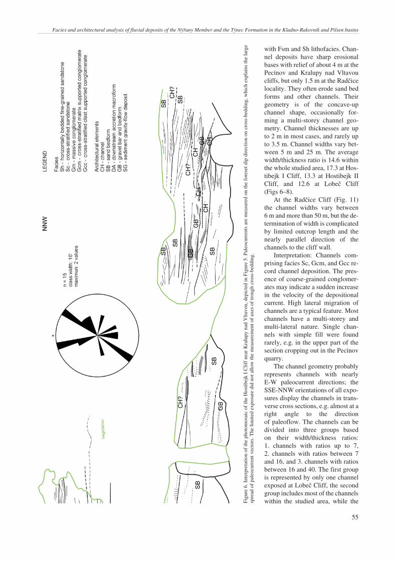
with Fsm and Sh lithofacies. Chan-nel deposits have sharp erosionalbases with relief of about 4 m at thePecínov and Kralupy nad Vltavoucliffs, but only 1.5 m at the Radčicelocality. They often erode sand bedforms and other channels. Theirgeometry is of the concave-upchannel shape, occasionally for-ming a multi-storey channel geo-metry. Channel thicknesses are upto 2 m in most cases, and rarely upto 3.5 m. Channel widths vary bet-ween 5 m and 25 m. The averagewidth/thickness ratio is 14.6 withinthe whole studied area, 17.3 at Hos-tibejk I Cliff, 13.3 at Hostibejk IICliff, and 12.6 at Lobeč Cliff(Figs 6–8).
At the Radčice Cliff (Fig. 11)the channel widths vary between6 m and more than 50 m, but the de-termination of width is complicatedby limited outcrop length and thenearly parallel direction of thechannels to the cliff wall.
Interpretation: Channels com-prising facies Sc, Gcm, and Gcc re-cord channel deposition. The pres-ence of coarse-grained conglomer-ates may indicate a sudden increasein the velocity of the depositionalcurrent. High lateral migration ofchannels are a typical feature. Mostchannels have a multi-storey andmulti-lateral nature. Single chan-nels with simple fill were foundrarely, e.g. in the upper part of thesection cropping out in the Pecínovquarry.
The channel geometry probablyrepresents channels with nearlyE-W paleocurrent directions; theSSE-NNW orientations of all expo-sures display the channels in trans-verse cross sections, e.g. almost at aright angle to the directionof paleoflow. The channels can bedivided into three groups basedon their width/thickness ratios:1. channels with ratios up to 7,2. channels with ratios between 7and 16, and 3. channels with ratiosbetween 16 and 40. The first groupis represented by only one channelexposed at Lobeč Cliff, the secondgroup includes most of the channelswithin the studied area, while the
55
Figu
re6.
Inte
rpre
tatio
nof
the
phot
omos
aic
ofth
eH
ostib
ejk
IC
liff
near
Kra
lupy
nad
Vlta
vou,
depi
cted
inFi
gure
5.Pa
leoc
urre
nts
are
mea
sure
don
the
fore
setd
ipdi
rect
ion
oncr
oss-
bedd
ing,
whi
chex
plai
nsth
ela
rge
spre
adof
pale
ocur
rent
vect
ors.
The
limite
dex
posu
redi
dno
tallo
wth
em
easu
rem
ento
fax
esof
trou
ghcr
oss-
bedd
ing.
Facies and architectural analysis of fluvial deposits of the Nýřany Member and the Týnec Formation in the Kladno-Rakovník and Pilsen basins

third group is represented by theHostibejk Cliff I channels. De-creasing width/thickness ratios fromthe Hostibejk to the Lobeč cliffs is afunction of exposure orientation. Thechannels at Hostibejk Cliff are ex-posed at angles closer to thepaleocurrent directions than are thoseat Lobeč Cliff, which are exposed al-most at a right angle to the paleo-current directions. Thus channels atHostibejk Cliff display higher widthsthan channels at Lobeč Cliff.
SB: Sand bars and bed forms
Sheet-like bodies of sand bed depo-sits comprise facies Sh and Sc. Theyhave sharp bases and are often erodedby channels. The erosional relief ofthe sand bed forms can be up to 2 m,though at Radčice Cliff it is only bet-ween 0.1 and 0.6 m. Sand bed formsare usually about 1.5 m thick, but oc-casionally reach the thicknesses up to3 m (at Hostibejk and Lobeč). Theirwidths vary between 20 m and 40 min most cases at the Kralupy nad Vl-tavou cliffs and Pecínov quarry, whe-reas at the Radčice locality it is onlybetween 10 m and 15 m in most ca-ses. The average width/thickness ra-tio is 19.3 within the studied area,21.8 at Hostibejk Cliff I, 21.2 at Hos-tibejk Cliff II, and 20 at Lobeč Cliff(Figs 6–8).
Interpretation: Sand bed forms re-cord intra-channel deposition. Theywere probably produced by migrat-ing dunes within the channel. This issupported by paleocurrent measure-ments, which show paleoflow direc-tions to the NNW, NE. Because ofthe SSE-NNW orientations of all ex-posures, where channel geometry isdisplayed close to the longitudinalcross section (subparallel to paleo-flow direction), the channel geome-try appears sheet-like. Sand bedforms were probably deposited bymigrating dunes within the channel.
GB: Gravel bars and bed forms
Gravel bar and bed deposits comprisefacies Gcc and Gcm. They have sharperosional bases and often erode sandbed forms and channels. Their geo-
56
Figu
re7.
Inte
rpre
tatio
nof
the
phot
omos
aic
ofth
eH
ostib
ejk
IIC
liff
near
Kra
lupy
nad
Vlta
vou.
For
the
phot
omos
aic
ofth
ecl
iff
see
Figu
re5.
Stanislav Opluštil – Karel Martínek – Zuzana Tasáryová

metry is lobate or sheet-like. The average width/thicknessratio of the gravel bar and bed forms is 30.6 within the stu-died area, 24.6 at Hostibejk Cliff I, 15 at Hostibejk Cliff II,and 47.7 at Lobeč Cliff (Figs 5–7). The thicknesses of thegravel bar and bed forms are up to 2 m in most cases, andrarely up to 4 m. Gravel bar and bed form widths are up to40 m at the Hostibejk Cliffs, but at Lobeč Cliff they reach135 m. The erosional relief of the gravel bar and bed formsvaries between 0.5 m and 4 m.
A flat based gravel bar was observed only at RadčiceCliff. This sheet-like body with a sharp flat base is overlainby sand bed forms and channels. The gravel bar’s thicknessvaries from 0.3 to 1.5 m. Its width is 15 m and erosional re-lief only 0.2 m.
Interpretation: Gravel bar and bed form deposits, com-prising facies Gcm and Gcc, record intra-channel deposi-tion. These gravel bar and bed form deposits can be dividedinto two groups based on their width/thickness ratios:1. with ratios up to 15, and 2. with ratios higher than 20.
Gravel bed forms with width/thickness ratios up to 15display an erosional relief between 1.5 to 4 m. They consistof fine- to coarse-grained conglomerates of the Gcm andGcc facies. Gravel bed forms record either migrating chan-nel bed loads when comprised of coarse-grained conglomer-ates (Gcm), or migrating channel bed forms when com-prised of facies Gcc. Gravel bed forms with width/thicknessratios higher than 20 record fluvial bar deposition when theyare comprised of coarse-grained conglomerate facies andhave erosional relief of 0.5 m, or the migration of large chan-nel bed forms when comprised of facies Gcc and Gcm.
If a gravel bed form a few centimetres thick is presentwithin the channel just above the erosional base, we cansuggest that gravel bar erosion and subsequent depositionwithin the channel occurred. This indicates a sudden in-crease in the velocity of the depositional current.
SG: Sediment gravity-flow deposits
Sediment gravity-flow deposits consist of matrix suppor-ted, massive gravels. They have sharp erosional bases andthe geometry of elongate lobes. They are underlain by gra-vel or sand bed forms, and they occur also within channeldeposits. These deposits occur rarely at Lobeč Cliff and inthe Pecínov quarry. Sediment gravity-flow deposit thick-nesses are up to 1 m in most cases. The widths of these sedi-ment gravity-flow deposit vary between 5 m and 7 m. Theaverage width/thickness ratio of sediment gravity-flow de-posits is up to 10 within the studied area, while their erosio-nal relief is 0.3 m.
Interpretation: Sediment gravity-flow deposits indicatenon-cohesive gravity-flow deposition. Their presencewithin the channel fills probably records channel bank in-stability and slumping.
DA: Downstream accretion macroforms
Downstream accretion macroforms comprise facies Sc,Gcc, and Gcm (sand and gravel bed form deposits). Their
geometry is sheet-like. Their average width/thickness ratiois of 13.8 within the studied area, 16.3 at Hostibejk Cliff I,and 8.6 at Hostibejk Cliff II (Figs 5–7). Downstream accre-tion macroforms were not recognized at Lobeč Cliff(Fig. 8). Downstream accretion macroform thicknesses areup to 4.5 m, and widths vary between 20 m and 40 m.
Interpretation: Downstream accretion macroforms re-cord channel deposition. Accretion surface interpretation isbased on knowledge of the paleocurrent direction. In caseswhere paleocurrent directions are sub parallel to the accre-tion surfaces, they are considered as downstream accretion.
Summary and interpretation of the studied outcrops
Kralupy nad Vltavou
In all, 37 paleocurrent measurements were taken from bothcliffs, 28 of which were measured at the Hostibejk Cliffs(Figs 6, 7), and 9 at Lobeč Cliff (Fig. 8). In most cases, theyrepresent measurements of cross bedding and laminae, andonly rarely of the true paleoflow indicators such as ridgesof current ripples, axes of trough cross bedding, and toolmarks. Paleocurrent indicators from the Hostibejk Cliffsshow two major trends: to the NNW and to the NE. Onlyminor components of paleoflow directions are to the S andto the SW. Measurements of Lobeč Cliff also display twodominating directions striking W and E. Measurements ta-ken from the Hostibejk Cliffs agree with the expected posi-tion of the source area to the south (Pešek 1994) and the di-rection of the main drainage approximately to the north.
Hostibejk CliffThe presence at Hostibejk Cliff of vertically stacked chan-nels forming multi-storey channel fill, downstream accre-tion, abundant occurrence of gravel bars, and an absence ofoverbank fine deposits (alluvial plain and/or floodplain de-posits), indicate that the depositional environment of theHostibejk Cliff could be interpreted as a fluvial streamcomplex of low sinuosity. This depositional environmentcould be described as a system of probably braided chan-nels, which cut and eroded themselves and accreted down-stream. Some channels are bounded by gravel bars. Highdynamics and current velocity are reflected in the grain si-zes of the deposits (coarse-grained sandstones and conglo-merates), in sedimentary structures (very rare preservationof current ripples, abundant cross stratification), and in thegeometry of the deposits (multi-storey channels, channelbed forms bounded by erosive surfaces, erosional relief ofdeposits up to 4 m). The absence of alluvial plain depositscould be explained either by their subsequent erosion bybraided channels, or that fine alluvial plain deposits did notoccur due to sudden the development and deposition ofthe complex braidplain. Plant and wood material in theHostibejk Cliff deposits undoubtedly originated in an allu-vial plain; and though the Hostibejk Cliff streams were ero-sive, we should see some relicts of alluvial plain depositsexposed there. Thus the interpretation is that a distant allu-
57
Facies and architectural analysis of fluvial deposits of the Nýřany Member and the Týnec Formation in the Kladno-Rakovník and Pilsen basins

58
Stanislav Opluštil – Karel Martínek – Zuzana Tasáryová
Figu
re8.
Phot
omos
aic
ofth
eL
obeč
Clif
fne
arK
ralu
pyna
dV
ltavo
u,an
dits
inte
rpre
tatio
n.

59
Facies and architectural analysis of fluvial deposits of the Nýřany Member and the Týnec Formation in the Kladno-Rakovník and Pilsen basins
Figu
re8,
cont
inue
d

vial plain existed, from which plant and wood material wastransported by braided streams, and which evolved into thebraidplain. It must be noted that this interpretation is influ-enced by the limited exposures in the Kralupy nad Vltavouarea.
The paleocurrent analysis shows a relatively lowspread of paleocurrent vectors, which is characteristic oflow sinuosity streams. The major paleoflow trends are tothe NNW and to the NE, with only minor directions to the Sand to the SW. Therefore, we propose that the main sedi-ment supply was from the SSE and SW generally towardthe N-NE.
Lobeč CliffLobeč Cliff (see Fig. 7) represents a different depositionalenvironment than that recorded in the Hostibejk Cliffs.Rare occurrences of gravel bars and the generally finergrain size of the deposits, especially in the upper part of Lo-beč Cliff, indicate that the depositional environment was acomplex of fluvial streams with higher sinuosity than thoseof the Hostibejk Cliffs. The depositional environmentcould be described as a complex of vertically aggradingchannels that partly cut into the underlying ones. The dyna-mics and velocity of the paleocurrents probably decreasedin time as indicated by the fining upwards in grain sizewithin the sequence (fine- and medium- to coarse-grainedsandstones), by sedimentary structures (current ripple andhorizontal lamination), and by the geometry of the deposits(erosional relief of deposits up to 2 m). However, the Lo-beč Cliff channels should not be interpreted as representinghigh sinuosity or meandering streams, as there is an ab-sence of lateral accretion macroforms (e.g., point bars),while coarse-gravel channels and rare gravel bars occuronly at the lower part of Lobeč Cliff.
In addition to a Carboniferous/Cretaceous uncon-formity recognized at the upper part of the outcrop, a sig-nificant intra-Carboniferous unconformity was recognizedalso near the bottom of the cliff. A succession of relativelythin, typically 1 to 2 m thick channels, bars, and bedformsoccurring above the unconformity, is described in detailabove. The underlying succession is poorly exposed, butbeds of crudely stratified fine-grained pebble conglomer-ates up to 4 m thick can be seen. The latter succession rep-resents very a different fluvial system not observed at theother localities.
Several subvertical faults were interpreted in the cen-tral part of Lobeč Cliff. A large southern fault zone showssignificant reduction of the upper Carboniferous succes-sion on the hangingwall between the unconformities. Thisseems to indicate predominant horizontal displacement,which is further supported by the occurrence of a smallernegative flower structure north of main fault zone (seeFig. 8).
Comparison of the fluvial stylesof the Hostibejk and Lobeč cliffsThe sedimentary record preserved at Lobeč Cliff is inter-preted as a product of deposition in streams of higher sinu-
osity and lower dynamics than at the Hostibejk Cliffs(Fig. 9). This is indicated by a higher spread of paleocurrentvectors, which is characteristic of high sinuosity streams,and by generally finer-grained nature of the fluvial sedi-ments.
The transition from a low sinuosity, highly dynamic,braided river system (Hostibejk Cliffs) to the higher sinu-osity and less dynamic braided system of the Lobeč Cliffmay be explained as a gradual change from one fluvialstyle to another. Deposits exposed at Hostibejk Cliff II dis-play a more distinct vertical stacking pattern than those ofthe lower part of Hostibejk Cliff I, where the architecture ofthe sedimentary record indicates the lateral migration ofchannels and the presence of multi-storey channels. Theoverlying Lobeč Cliff deposits, representing the finaldepositional environment of higher sinuosity and lower dy-namic streams flowing to the E, could record a gradualchange from the vertically stacked channels of HostibejkCliff II to the aggrading channels of Lobeč Cliff. Thus theKralupy nad Vltavou successions represent a gradual ces-sation of the initial high energy depositional conditions(Hostibejk Cliffs) to the final lower energy depositionalconditions (Lobeč Cliff). The change in paleocurrent direc-tions could be explained by the gradual change in dip of thebasin floor, which could be the primary cause of the grad-ual change of the depositional environments. A gradualchange in the dip of the basin floor could be related to grad-ual infilling of the basin with sediments or by changes intectonic activity.
An alternative explanation relates the existence of twodifferent sedimentary environments to a short-term hiatusbetween the deposition of sediments exposed in Hostibejkand Lobeč cliffs, which could be responsible for changes inthe tectonic settings and consequently for the re-configura-tion of local paleogeography/paleotopography. The possi-ble existence of such short-term hiatuses within the NýřanyMember has been mentioned by Wagner (1997), who stud-ied the floral succession within this unit. Additionally, sucha change in sedimentary environment can also be related tothe different stratigraphic positions of sediments exposedin cliffs that are separated by a fault-bounded valley(Obrhel 1960). Such a fault could be responsible for thejuxtaposing of stratigraphically higher parts of the NýřanyMember, exposed at Lobeč Cliff, against the basal part ofthis unit at the Hostibejk Cliffs.
Pecínov
The main sedimentological studies were carried out in thewestern quarry, where up to 35 m of the basal NýřanyMember strata are exposed in a wall about 150 m long. Theconglomerate-dominated basal sediments of the NýřanyMember are separated from the underlying Radnice Mem-ber by a hiatus marked by a prominent erosional surface(6th order sensu Miall 1996), with only minor relief ofabout 2 m over the distance of the whole quarry (Fig. 10).The exposed part of the Nýřany Member is dominated byconglomerate (Gcc, Gcm) and sandstone (Sc) lithofacies,
60
Stanislav Opluštil – Karel Martínek – Zuzana Tasáryová

with only a minor occurrence of mud-stone lithofacies. Conglomerate lithofa-cies predominate the lower part (approxi-mately the lower third) of the exposedsection. The remaining upper part is do-minated by sandstone lithofacies witherosional relics of mudstone and fine grai-ned sandstone (lithofacies Fsm and Sh).
The most common architectural ele-ments are channels, gravel bars, and sandbedforms. Down stream accretionmacroforms were rarely observed. Chan-nels are mostly filled by conglomerate orsandstone facies with planar or throughcross bedding. Pebble admixture is com-mon in the sandstones. Minor erosionalsurfaces are also frequent, indicating amulti-storey pattern of channel fill.Channels in the middle part of the sec-tion, bounded at the base by up to 4 m oferosional surface, are filled by mudstoneand fine grained sandstone lithofacies(Fsm, Sh). The bounding surfaces are ofseveral hierarchies. Except for the mostprominent discordances separating theNýřany Member from the Radnice Mem-ber at the base, and from the Cretaceoussediments at the top of the wall (ba-sin-wide surfaces of the 6th and 7th or-der, sensu Miall 1996), there are bound-ing surfaces of the 5th order within theNýřany Member which are generallytraceable over the whole exposure. Theyshow erosional relief between 1 and 2 mwhich locally reach up to 4 m. The dis-tance of adjacent surfaces is between 2 and 8 m, beingabout 5 m in average. They are interpreted as a base of ma-jor channels with multi-storey fill patterns, as indicated bythe presence of bounding surfaces of lower hierarchies.The generation of the main bounding surfaces of the 5th or-der is a response to base level changes.
Paleocurrent data were measurable only in the upper halfof the section, and are derived from cross-bedding and partlyfrom axes of through cross bedding. They indicate a NNEdirection for the main clastic transport. This trend is consis-tent with the assumed position of the main source area to thesouth, and the basin centre to the north (Pešek 1994).
As a whole, the succession exposed in the Pecínovquarry is characterized by a fining upward trend indicatingthe increasing thickness of the channel elements. Also thepresence of mudstone-dominated facies is typical for theupper part of the succession. This change in grain size andin stacking pattern is interpreted as a transition from ahighly dynamic, shallow gravel bed, braided, fluvial sys-tem to an apparently less dynamic, sandy, braided fluvialsystem. Paleocurrent data for the low sinuosity fluvial sys-tems in the Pecínov area indicate NNE directions for themain clastic transport.
Radčice
Our interpretation of the Týnec Formation fluvial system,exposed on the eastern part of Radčice, is based mainly onmeasured sections and photomontage of a 70 m long and12 m high rock cliff situated on the road to Radčice north ofPlzeň. Facies analysis reveals that this outcrop is domina-ted by the Sc and Gcm lithofacies. Cross bedding and erosi-onal bases are the most common features in sandstones ofthe Sc facies, and matrix supported conglomerates of theGm facies. Clast supported conglomerates of the Gcc fa-cies occur locally. Low angle cross bedding was also ob-served locally, ripples are absent (see Fig. 11).
This outcrop is dominated by channel architectural ele-ment CH, with higher erosional relief (up to 2 m). Channelfill is vertically stacked in a multi-storey pattern, but a lat-eral migration forming a multi-lateral pattern prevails inmost of the outcrop. Width/depth ratios range approxi-mately between 5 and 20. Finer grained sandy bedforms (ar-chitectural element SB) occur less frequently. They form thetop of the channel fill, and are often eroded by channels(CH). Low-angle, cross bedded gravel and sand bars of theGB architectural element occur rarely (see Fig. 11).
61
Figure 9. Depositional models of the Nýřany Member of the Hostibejk and Lobeč cliffs.
Facies and architectural analysis of fluvial deposits of the Nýřany Member and the Týnec Formation in the Kladno-Rakovník and Pilsen basins

Paleocurrent indicators show a low spread of vectors;the axes of trough cross bedding and foresets of planarcross bedding range between 55° and 180° , but are mostlybetween 120° and 180° (Fig. 11).
The features mentioned above lead to the interpretationof the Nýřany Member fluvial system in the Radčice area as
a high energy, higher gradient system with low sinuosity.The considerable lateral migration of channels indicates un-stable banks. No substantial changes in grain size were ob-served in vertical sections, though lateral variation in grainsize can be observed within individual channels, which ismostly a function of hydraulic factors. These features can be
62
Stanislav Opluštil – Karel Martínek – Zuzana Tasáryová

interpreted as a fluvial system with relatively high and uni-form discharge. The climatic setting was generally humid,though some minor climatic variations could occur (such asseasonal variations in rainfall). This interpretation is sup-ported by the occurrence of residual lags at the base of manyerosionally-based channels. This can be evidence of higherenergy/discharge during channel incision.
Discussion, conclusions and recommendations
Sedimentological studies of fluvial strata at the above-men-tioned localities indicate that the fluvial conditions of the
Nýřany Member and the Týnec Formation changed withtime. Generally, sediments exposed at all of the studied loca-lities are interpreted as a record of a braided fluvial system.However, differences in stacking patterns and variability ingrain size and the presence/absence of fine-grained faciesindicate the existence of different types of braided rivers.
The basal part of the Nýřany Member exposed atHostibejk Cliff I and the lower part of the Pecínov quarrywas interpreted as a high energy braided fluvial system withlow sinuosity channels. Here, the sediments are character-ized by increased conglomerate facies and the absence offine grained facies deposited from suspension. Paleocurrentdata show a typically narrow range of directions striking to
63
Figu
re10
.Pho
tom
osai
cof
the
wes
tern
Pecí
nov
quar
ryne
arN
ové
Stra
šecí
,and
itsin
terp
reta
tion.
Facies and architectural analysis of fluvial deposits of the Nýřany Member and the Týnec Formation in the Kladno-Rakovník and Pilsen basins

the north. This is consistent with the assumed location of themain source area to the south and the basin centre to thenorth (Fig. 9), as already stated by Havlena and Pešek(1980), Pešek (1994), and Pešek et al. (1998). This type ofbraided river deposition seems to have gradually passed up-ward into a less dynamic braided river system of higher sin-uosity, exposed at localities in Lobeč and probably also inthe upper part of the Pecínov quarry. It is marked by a gener-ally finer grain size of sediments, by the presence offine-grained facies (Fsm, Sh) interpreted as that fill of anabandoned channel or possibly as the preserved remains offloodplain sediments. This system is also characterized by awide range of paleocurrent data. Unfortunately, thepaleocurrent indicators in the Pecínov quarry are not asprominent as those from Lobeč Cliff. A high-energy, lowsinuosity, braided river system prone to lateral migrationwas also interpreted in the eastern part of the Radčice local-ity in the lower part of the Týnec Formation. Facies depos-ited from suspension or low velocity currents are absent inthe studied part of the succession. Paleocurrent data indicatea prevailing SE to S direction for the main clastic transport.
Thus, the Radčice fluvial system is partly similar to that ofHostibejk Cliff I and the lower part of the Pecínov quarry.The extent of the present study, however, does not allow usto decide whether these changes in the character of thebraided rivers were basin-wide or only local, or whether theywere related to local tectonic or paleogeographic conditions.Answering these questions will require further studies ofother localities, and their correlation to borehole samplesfrom the central parts of the basins.
The thickness of the studied succession, whichranges stratigraphically from the base of the NýřanyMember to the lower part of the Týnec Formation, is es-timated to be about 320–350 m, whereas the cumulativethickness of the stratigraphic succession exposed in thestudied cliffs is about 100 m (including the partial strati-graphic overlap of the Hostibejk and Pecínov sections).These localities represent the approximately 50 m thickbasal part of the Nýřany Member succession. The part ofLobeč Cliff studied here represents a further 40 to 45 mof stratigraphic interval of the Nýřany Member locatedbelow the middle part of the succession of this unit. Con-
64
Stanislav Opluštil – Karel Martínek – Zuzana Tasáryová
Figure 11. Photomosaic of the eastern part of the Radčice Cliff near Pilsen. Týnec Formation, Cantabrian-Barruelian.

cerning Radčice Cliff, only an approximately 20 m thicksuccession, located along its eastern and most continu-ous part of its outcrops, was studied. It comprises theyoungest strata that belong to the lower part of the TýnecFormation.
Future work, therefore, should focus on the detailedsedimentological study of the other outcrops, and the cor-relation of exposed strata to wireline log and core data de-rived from boreholes in the vicinity of studied localities.This will clarify the lateral relations of these deposits.Gamma ray field measurements should be undertaken inthe future toward correlating distant successions more pre-cisely. Such data could allow more thorough and rigorousclimatic/tectonic interpretations.
Acknowledgements . The authors thank Jiří Adamovičand Slavomír Nehyba for their patient and thorough reviews of themanuscript, which significantly improved the quality of the manuscript.We also greatly appreciate the financial support provided by the GrantAgency of the Charles University through the project225/2001/B-GEO/PrF.
References
Bosák P. (1991): Litofaciální korelace, sedimentologie a vývoj karbonumšenské oblasti. In: Žbánek J. (ed.) Závěrečná zpráva vyhledávacíhoprůzkumu Mělník-Benátky nad Jizerou 29 79 2204, surovina černéuhlí. Report, Czech geological survey – Geofond, Prague (in Czech).
Bridge J. S. (1993): Description and interpretation of fluvial deposits: acritical perspective. Sedimentology 40, 801–810.
Bridge J. S., Mackey S. D. (1993): A revised alluvial stratigraphy model.In: Marzo M., Puigdefábregas C. (eds) Alluvial Sedimentation. Spec.Publ. Int. Assoc. Sediment. 17, 319–336.
Capuzzo N., Wetzel A. (2004): Facies and basin architecture of the LateCarboniferous Salvan-Dorénaz continental basin (Western Alps,Switzerland/France). Sedimentology 51, 657–697.
Hampson G., Stollhofen, Flint, S. H. (1999): A sequence stratigraphicmodel for the Lower Coal measures (Upper Carboniferous) of the Ruhrdistrict, north-west Germany. Sedimentology 46, 6, 1199–1232.
Havlena V. (1982): Limnické pánve permokarbonu Českého masivu –geneze, třídění, vyplňování a zlomová tektonika. Sbor. IV. uhel. geol.konf. přírodověd. fak. (Praha), 37–44 (in Czech).
Havlena V., Pešek J. (1980): Stratigrafie, palaeogeografie a základnístrukturní členění limnického permokarbonu Čech a Moravy. Sbor.Příroda 34, 1–144 (in Czech).
Holub V., Skoček V., Tásler R. (1975): Palaeogeography of the LatePalaeozoic in the Bohemian Massif. Palaeogeogr., Palaeoclimat.,Palaeocol. 18, 313–332.
65
Figure 11, continued.
Facies and architectural analysis of fluvial deposits of the Nýřany Member and the Týnec Formation in the Kladno-Rakovník and Pilsen basins

Martinsen O. J., Ryseth A., Helland-Hansen W., Flesche H., TorkildsenG., Idil S. (1999): Stratigraphic base level and fluvial architecture:Ericson Sandstone (Campanian), Rock Springs Uplift, SW Wyo-ming, USA. Sedimentology 46, 2, 235–259.
Miall A. D. (1978): Fluvial sedimentology: a historical review. Can. Soc.Petrol. Geol. Mem. 5, 1–47.
Miall A. D. (1985): Architectural-element analysis: a new method of fa-cies analysis applied to fluvial deposits. Earth-Science Reviews 22,261–308.
Miall A. D. (1996): The Geology of Fluvial Deposits, Sedimentary facies,Basin Analysis, and Petroleum Geology. Springer-Verlag, Germany.
Obrhel J. (1960). Stratigrafie karbonu mezi Kralupy nad Vlt. a Nela-hozevsí. Věst. Ústř. Úst. geol., 35, 19–29. (in Czech)
Opluštil S., Pešek J. (1998): Stratigraphy, palaeoclimatology and palaeo-geography of the Late Palaeozoic continental deposits in the CzechRepublic. In: Crasquin-Soleau S., Izart A., Vaslet D., DeWever P.(eds) Peri-Tethys stratigraphic correlations 2, Geodiversitas 20, 4,597–620.
Pešek J. (1968): Geologická stavba a vývoj sedimentů plzeňskéčernouhelné pánve. Sbor. Příroda 2, 1–112 (in Czech).
Pešek J. (1994): Carboniferous of Central and Western Bohemia (CzechRepublic). Czech Geol. Survey, Prague.
Pešek J. (1996): Geologie pánví středočeské svrchnopalaeozoické oblasti.Čes. geol. úst. 1–95. Praha (in Czech).
Pešek J., Holub V., Jaroš J., Malý L., Martínek K., Prouza V., Spudil J.,Tásler R. (2001): Geologie a ložiska svrchnopalaeozoickýchlimnických pánví České republiky. Czech Geological Survey, Prague(in Czech).
Pešek J., Opluštil S., Kumpera O., Holub V., Skoček V. (1998):Palaeogeographic Atlas Late Palaeozoic and triassic Formations,Czech Republic. Czech Geol. Survey, Prague.
Pešek J., Urban M. (1990): The tectonic evolution of the Plzeň basin (Up-per Carboniferous, West Bohemia): a review and reinterpretation.Folia Mus. Rer. natur. Bohem. occident., Geol. 32.
Ramos A., Sopena A. (1983): Gravel bars in low-sinuosity streams (Perm-
ian and Triassic, central Spain). Spec. Publs. Int. Ass. Sediment. 6,301–312.
Sánchez-Moya Y., Sopena A., Ramos A. (1996): Infill architecture of anon-marine half-graben Triassic basin (central Spain). J. Sedim. Res.66, 6, 1122–1136.
Shanley K. W., McCabe P.J. (1993): Alluvial stratigraphy in a sequencestratigraphic framework: a case history from the Upper Cretaceous ofsouthern Utah, USA. In: Flint S. S., Bryant I. D. (eds) The geologicalmodelling of hydrocarbon reservoirs and outcrop analogues. Int.Assoc. Sedimentol. Spec. Publ. 15, 21–56.
Shanley K. W., McCabe P. J. (1994): Perspectives on the sequence stra-tigraphy of continental strata. Bull. Am. Assoc. Petrol. Geol. 78,544–568.
Skoček V. (1990): Stefanská jezernědeltová sekvence ve středních aseverovýchodních Čechách. Sbor. geol. Věd, Geol. 45, 91–122. (inCzech)
Smith A. (1990): The sedimentology and accretionary styles of an ancientgravel-bed stream: the Budleigh Salterton pebble beds (Lower Trias-sic), soutwest England. Sediment. Geol. 67, 199–219.
Spudil J. (1982): Strukturně geologická charakteristika ložiska Kačice.Sbor. IV. uhel. geol. konf. přírodověd. fak., 133–142, Praha (in Czech).
Spudil J., ed. (1980): Závěrečná zpráva úkolu Kačice. Report, Geofond,Praha (in Czech).
Šetlík J. (1968): Poznámky k fytopalaeontologii některých karbonskýchlokalit v okolí Kralup n. Vltavou a Veltrus. Zpr. geol. Výzk. v roce1966, 130–132 (in Czech).
Wagner R. H. (1997): Floral Palaeoecology of the Carboniferous/Perm-ian. In: E. Aguirre, J. Morales, D. Soria (eds) Registros fósiles ehistoria de la Tierra, Cursos de verano de el escorial, 1995, 143–172.
Weithofer K. A. (1896): Die geologischen Verhältnisse desBayer-Schachtes und benachbarten teiles der Pilsner Kohlenmulde.Österr. Z. Berg. u. Hüttenwes., Wien, 44, 317–321, 331–335,345–349, 355–357.
Weithofer K. A. (1902): Geologische Skizze des Kladno-RakonitzerKohlenbeckens. Verh. K.-Kön. geol. Reichsanst., Wien, 399–420.
66
Stanislav Opluštil – Karel Martínek – Zuzana Tasáryová