EXPLORATORY DRILLING PROGRAM OF THE U. S. … · geological survey circular 231 exploratory...
43
GEOLOGICAL SURVEY CIRCULAR 231 EXPLORATORY DRILLING PROGRAM OF THE U. S. GEOLOGICAL SURVEY FOR EVIDENCES OF ZINC-LEAD MINERALIZATION IN IOWA AND WISCONSIN, 1950-51
Transcript of EXPLORATORY DRILLING PROGRAM OF THE U. S. … · geological survey circular 231 exploratory...
GEOLOGICAL SURVEY CIRCULAR 231
EXPLORATORY DRILLING PROGRAM OF
THE U. S. GEOLOGICAL SURVEY
FOR EVIDENCES OF ZINC-LEAD
MINERALIZATION IN IOWA
AND WISCONSIN, 1950-51
UNITED STATES DEPARTMENT OF THE INTERIOR Douglas McKay, Secretary
GEOLOGICAL SURVEY W. E. Wrather, Director
GEOLOGICAL SURVEY CIRCULAR 231
EXPLORATORY DRILLING PROGRAM OF THE U. S. GEOLOGICAL SURVEY
FOR EVIDENCES OF ZINC-LEAD MINERALIZATION
IN IOWA AND WISCONSIN, 1950-51
By Alien F. Agnew, Arthur E. Flint, and John W. Allingham
Prepared in cooperation with the Wisconsin Geological and Natural History Survey
Washington, D. C., 1963Free on application to the Geological Survey, Washington 25, D. C.
EXPLORATORY DRILLING PROGRAM OF THE U. S. GEOLOGICAL SURVEY
FOR EVIDENCES OF ZINC-LEAD MINERALIZATION
IN IOWA AND WISCONSIN, 195051
By Alien F. Agnew, Arthur E. Flint, and John W. Allingham
CONTENTS
Page
Abstract..................................... 1Introduction.................................. 2
Purpose and scope of exploration.......... 2History and mineral production of district.. 2Previous geologic work .................. 2Acknowledgments........................ 2
General geology of the district................. 4The Tete des Morts area, Iowa ................ 4
Results of geologic mapping andexploratory drilling .................... 5
Stratigraphy ........;.............. 5Structure.......................... 5Evidence of mineralization .......... 7
Recommendations ....................... 7
Page
The Highland area, .Wisconsin................. 7Stratigraphy .......,..._............... 9
Upper Cambrian.................... 9Lower Ordovician ................. 9Middle Ordovician ................. 9
Results-of geologic mapping............... 9Evidences of mineralization......... 9Structure.......................... 10
Results of exploratory drilling............ 10Recommendations....................... 10
Literature cited.............................. 11Generalized logs of drill-hole explorations...... 12
Tete des Morts area..................... 12Highland area........................... 21
ILLUSTRATIONS
Page
Plate 1. Map of the Tete des Morts area showing location of holes drilled by theU. S. Geological Survey.............................................................. In pocket
Cross sections of holes drilled by the U. S. Geological Survey in the Tete des Morts area..... In pocketMap of Highland area showing location of holes drilled by the U. S. Geological Survey........ In pocketCross sections of holes drilled by the U. S. Geological Survey in the Highland area .......... In pocketIndex map showing location of the Wisconsin-Illinois-Iowa zinc-lead mineralized district .......... 3Map showing location of the Tete des Morts and Highland areas and the
Black Jack-Bautsch trend ................................................................. 3Stratigraphic column of the Tete des Morts area................................................ 6Stratigraphic column of the .Highland area..................................................... 8
2.3.4.
Figure 1.2.
3.4.
ABSTRACT
The Upper Mississippi Valley zinc-lead district covers 2, 500 square miles of Wisconsin, Illinois, and Iowa. It is one of the oldest mining districts in the United States, as lead mining by settlers began in 1788. Zinc has been mined since 1859, and the present production is more than ten times that of lead.
Rocks exposed in the district range from Early Ordovician to Middle Silurian in age, and, except for the St. Peter sandstone and the Maquoketa shale, consist mainly of dolomite. Structural compression has resulted in gentle folds and faults; principal trends are northwestward, northeastward, and eastward.
Galena (lead sulfide) has been mined principally from vertical joints in the upper, noncherty part of the Galena dolomite. On the other hand, sphalerite
(zinc sulfide) and a minor amount of smithsonite (zinc carbonate) are found as veins, breccia ore, and disseminations in the lower, cherty part of the Galena dolomite, in strata of the Decorah formation, and in the upper beds of the Platteville formation; these "lower-run" ore bodies are in inclined reverse faults (pitches) and associated bedding-plane faults (flats) that are localized along synclinal trends. Lead and zinc minerals are found in beds of the Prairie du Chien group where they are exposed along the northern edge of the district.
Since 1942 the U. S. Geological Survey has been studying the geology of the zinc-lead district and has been mapping the structure, stratigraphy, and the occurrences of ore bodies. The program here described was centered in two areas at the margin of the district. Twenty-five holes that totalled 7,466 feet were drilled in 1950-51. In the
Tete des Morts area, Iowa, the drilling showed lithology, structure, and evidences of mineralization that are favorable indications of the possible existence of pitch-type lower-run ore bodies; it showed a lateral extension of the potentially productive part of the district. In the Highland area, Wisconsin, lithology and evidences of mineralization found in strata of the Prairie du Chien group indicate that this unit might warrant further investigation as a potential source of ore at a lower stratigraphic position than that now being prospected in the main part of the zinc-lead district, farther south. Drilling in beds of the Prairie du Chien showed a vertical extension of the potentially productive part of the district.
INTRODUCTION
Purpose and scope of exploration
The exploratory drilling program of the U. S. Geological Survey in Iowa and Wisconsin in 1950 and 1951 was part of a continuing comprehensive geologic investigation of the zinc-lead district (figs. 1 and 2) that began in 1942. The principal purpose of the drilling was to provide geologic data related to the over-all objective of extending laterally, (geographically) and vertically (stratigraphically) the favorable indica tions of and known potentialities for zinc and lead ore (Agnew and Heyl, 1947, p. 228.)
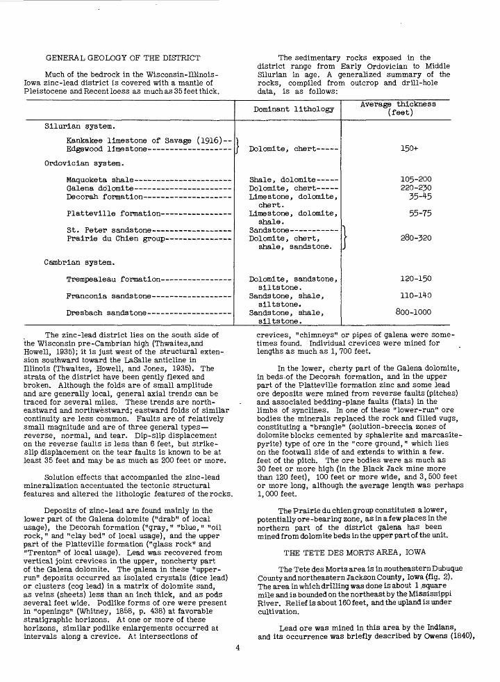
The southern limit of current activity in the Wisconsin-Illinois-Iowa mining district is the Black Jack-Bautsch fold, an ore trend (fig. 2) a few miles south of Galena, 111. Because the currently mined ore bodies are large and rich and were discovered during recent years as a result of new geological ideas re garding the occurrence of ore, it was proposed to explore an area in Iowa, just to the west of the Black Jack-Bautsch mines. Answers to several geologic questions were sought:
1. Is the lighology of the Tete des Morts area similar to that in the Black Jack-Bautsch trend 5 miles to the east?
2. Are structural features (Willman and Reynolds, 1947, pp. 14-15) similar?
3. Are products of mineralization similar?
Thus, the exploration in the Tete des Morts area was primarily an attempt to indicate a geographic, or lateral extension of the main ore-bearing zone of the zinc-lead district.
Lead and zinc minerals in the Lower Ordovician Prairie du Chien group have been found in several localities, particularly in the northern part of the mining district (Heyl, Lyons, and Agnew, 1951 ). In the Highland area, surface indications of lead miner alization in the Prairie du Chien group are particularly abundant, and a deep shaft had been sunk in this area to mine lead ore. Furthermore, lead was in short supply when the Geological Survey program was being planned. The drilling in the Highland area, therefore, was an attempt to obtain information regarding the (1) stratigraphic occurrence, (2) structural relations, and (3) mineralogic relations of lead in the Prairie du Chien group. It was an attempt to extend vertically the zinc-lead district the search for a stratigraph ically lower-producing zone.
Preliminary geologic studies in the Tete des Morts and Highland areas were made in the summer of 1950 in order to choose the most promising local ities for drilling. Five properties were selected, and 25 holes were drilled by cable-tool rigs between September 10, 1950, and May 25, 1951; the holes aggregated 7,466 feet of drilling.
History and mineral production of district
The zinc-lead district in Wisconsin, Illinois, and Iowa is one of the oldest mining areas in the United States. The lead mines in the Dubuque area were among the earliest worked by white men, be ginning in 1788 with Dubuque's Concession. The annual production of lead increased rapidly in the late 1820's and reached a maximum of about 27,000 tons of lead metal in the middle 1840 's, when the district contrib uted 85 to 90 percent of the lead produced in the United States. Lead mining in this district declined gradually until 1878, when the annual output was less than 5,000 tons.
Zinc production did not begin until 1859, as before that time no market existed. In 1859 zinc carbonate and in 1867 zinc sulfide were first mined, and by 1873 zinc sulfide had replaced' zinc carbonate as the district's major ore. By 1872 zinc production was about twice that of lead. The zinc-lead ratio increased only slightly until World War I when it suddenly became about 20 to 1 in 1917, and the peak of .zinc output from this district was more than 64,000 tons of zinc metal. By 1930 most of the large mining companies had left the district, and for the next 10 years zinc-lead production was generally low until the demands of World War II rejuvenated zinc- lead activity in 1941. Several large mining companies entered the district after 1944, and a large program of exploration and mining is now under way. Mines in the district produced about 1, 120,000 tons of zinc metal from 1859 to 1947 and about 815,000 tons of lead metal from 1800 to 1947.
Previous geologic work
The mining district was studied intermittently but rather thoroughly by government survey parties from 1836 until about 1916. From 1916 to the late 1920's the geologic investigations were carried out by company geologists. During the 1930's research by faculty and students of universities nearby kept geologic interest alive; however, except for the work of Behre (1939), these studies were directed toward specific phases of geology rather than general investi gations of the entire district.
Numerous publications resulted from the previous geologic work, but an adequate resume or bibliography is not within the scope of this brief report.
Acknowledgments
The Wisconsin Geological and Natural History Survey supplied part of the funds for the supervision of the drilling program.
C. W. Tandy, Jr., aided by surveying during the preliminary geologic investigations of the two areas.
IOWA
.J
V (ILLINOIS^MISSOURI \Cx \ I
\.<£_____50 IQOMILE^ J
IN DIANAB '
Indianapolis
SCALESt Loui
/WEST _^ "*-v .-* /VJRGINIAk
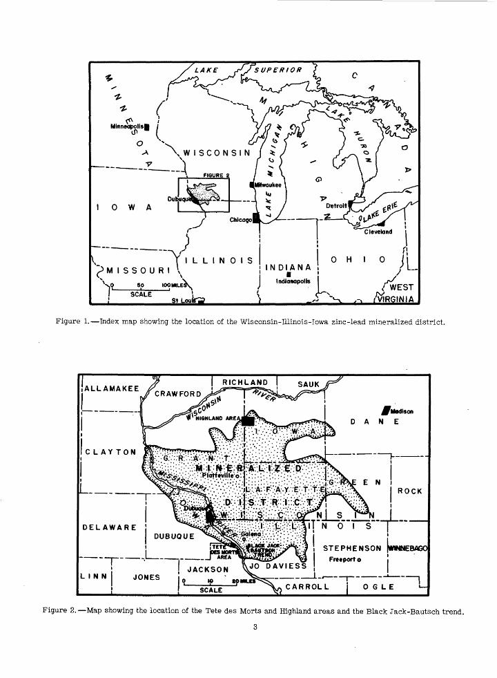
Figure 1. Index map showing the location of the Wisconsin-Illinois-Iowa zinc-lead mineralized district.
.Nl__s >2i I _T N 0* I S" \
i STEPHENSON (WINNEBAGCl
Frcepor t oJACKSON V° DAVIESS
CAR ROLL j OGLE
Figure 2. Map showing the location of the Tete des Morts and ffighland areas and the Black Jack-Bautsch trend.
3
GENERAL GEOLOGY OF THE DISTRICT
Much of the bedrock in the Wisconsin-IlMnois- lowa zinc-lead district is covered with a mantle of Pleistocene and Recent loess as much as 35 feet thick.
The sedimentary rocks exposed in the district range from Early Ordovician to Middle Silurian in age. A generalized summary of the rocks, compiled from outcrop and drill-hole data, is as follows:
Silurian system.
Kankakee limestone of Savage (1916) Edgewood limestone
Ordovician system.
Maquoketa shale
Prairie du Chien group
Cambrian system.
TYwo o"Ko r>Vi fin TirScfh OTI&
Dominant lithology
j Dolomite, chert -----
Shale, dolomite Dolomite, chert ----- Limestone, dolomite,
chert. Limestone, dolomite,
shale. Sandstone Dolomite, chert,
shale, sandstone.
Dolomite, sandstone, siltstone.
Sandstone, shale, siltstone.
Sandstone, shale, siltstone.
Average thickness (feet)
150-1-
105-200 220-230 35-^5
55-75
\ 280-320
120-150
110-140
800-1000
The zinc-lead district lies on the south side of the Wisconsin pre-Cambrian high (Thwaites,and Howell, 1935); it is just west of the structural exten sion southward toward the LaSalle anticline in Illinois (Thwaites, Howell, and Jones, 1935). The strata of the district have been gently flexed and broken. Although the folds are of small amplitude and are generally local, general axial trends can be traced for several miles. These trends are north eastward and northwestward; eastward folds of similar continuity are less common. Faults are of relatively small magnitude and are of three general types reverse, normal, and tear. Dip-slip displacement on the reverse faults is less than 6 feet, but strike- slip displacement on the tear faults is known to be at least 35 feet and may be as much as 200 feet or more.
Solution effects that accompanied the zinc-lead mineralization accentuated the tectonic structural features and altered the lithologic features of the rocks.
Deposits of zinc-lead are found mainly in the lower part of the Galena dolomite ("drab" of local usage), the Decorah formation ("gray, " "blue, " "oil rock," and "clay bed" of local usage), and the upper part of the Platteville formation ("glass rock" and "Trenton" of local usage). Lead was recovered from vertical joint crevices in the upper, noncherty part of the Galena dolomite. The galena in these "upper- run" deposits occurred as isolated crystals (dice lead) or clusters (cog lead) in a matrix of dolomite sand, as veins (sheets) less than an inch thick, and as pods several feet wide. Podlike forms of ore were present in "openings" (Whitney, 1858, p. 438) at favorable stratigraphic horizons. At one or more of these horizons, similar podlike enlargements occurred at intervals along a crevice. At intersections of
crevices, "chimneys" or pipes of galena were some times found. Individual crevices were mined for lengths as much as 1, 700 feet.
In the lower, cherty part of the Galena dolomite, in beds.of the Decorah formation, and in the upper part of the Platteville formation zinc and some lead ore deposits were mined from reverse faults (pitches) and associated bedding-plane faults (flats) in the limbs of synclines. In one of these "lower-run" ore bodies the minerals replaced the rock and filled vugs, constituting a "brangle" (solution-breccia zones of dolomite blocks cemented by sphalerite and marcasite- pyrite) type of ore in the "core ground," which lies on the footwall side of and extends to within a few. feet of the pitch. The ore bodies were as much as 30 feet or more high (in the Black Jack mine more than 120 feet), 100 feet or more wide, and 3, 500 feet or more long, although the average length was perhaps 1,000 feet.
The Prairie du chien group constitutes a lower, potentially ore -bearing zone, as in a few places in the northern part of the district galena has been mined from dolomite beds in the upper part of the unit.
THE TETE DES MORTS AREA, IOWA
The Tete des Morts area is in southeasternDubuque County and northeastern Jackson County, Iowa (fig. 2). The area in which drilling was done is about 1 .square mile and is bounded on the northeast by the Mississippi River. Relief is about 160 feet, and the upland is under cultivation.
Lead ore was mined in this area by the Indians, and its occurrence was briefly described by Owens (1840),
who stated that by 1839 at least 15,000 pounds of lead ore had been raised from H. H. Gher's diggings (pi. 1). The Tete des Morts diggings, however, have never been very productive and have long since been abandoned. Lead ore has been mined in recent years from shafts on Kohlenberg's land and from shafts a mile and a half southeast of Gordon's Ferry. Zinc minerals were reported in one of the shafts on the Kohlenberg farm.
Before the drilling, exploration, which will be described, a reconnaissance survey of the structural geology was made by Agnew and Flint along the Mississippi River bluff and back from the River, up the tributary valleys. Two synclines were found, one northeastward and the other northwestward in trend (pi. 1). Steep dips, a shattered zone in the rocks, and iron minerals indicative of a pitch zone were seen at the southeast end of the meander intheTetedesMorts River in sec. 3. Joint strikes were mapped, and the pattern showed general northwestward, northeastward, and eastward trends.
The lowest beds exposed in the Tete des Morts area are a few feet of cherty dolomite at the top of the lower, or cherty unit of the Galena dolomite. The upper, or noncherty beds of the Galena are seen along the bluffs of the Mississippi and Tete des Morts Rivers and provided most of the data fox1 mapping the geologic structure. The lower beds of the Maquoketa shale are exposed in the upper reaches of a few small ravines.
Shafts and smaller pits, remnants of lead diggings that are as much as 100 years old, were also located by reconnaissance geologic mapping. The lithology of material on the dump indicated that the productive zone was stratigraphically above the top of the cherty unit of the Galena dolomite. Iron minerals in the exposure of the pitch zone along the Tete des Morts River ranged in stratigraphic position from a few feet below the top of the cherty beds upward for about 75 feet.
Between September 10, 1950, and February 15, 1951, two properties in Iowa were drilled; the drilling totaled 13 holes and 4,036 feet. Cuttings were sacked for every 5 feet of drilling and were examined with a binocular microscope. (Summary logs are included on pp. 11-36.)
Results of geologic mapping and exploratory drilling
Stratigraphy. The St. Peter sandstone was penetrated in only one hole, Schenk 1, which cut through 18 feet of a quartz sandstone (fig. 3). A pyrite- cemented streak was found in the upper part of the unit; however, such streaks are common in the St. Peter in the upper Mississippi Valley district and have no known significance concerning the proximity of ore bodies.
The Platteville formation is 64 feet thick in Schenk hole 1,. the only hole penetrating the base of this formation. In this hole the lower part of the Platteville formation consists of light-brown dolomite (Pecatonica dolomite member), overlying thin green shale (Glenwood shale member). The McGregor
limestone member is a gray limestone in Schenk holes 1 to 3, which penetrated its entire thickness. The uppermost member of the Platteville, the Quimbys Mill member or "glass rock " of local usage, is limestone except in Kohlenberg hole 2, where part of the rock is dolomitic limestone.
A trace of pyrite in the "glass rock" unit in Schenk hole 7 is the only indication that the rocks of the Platteville formation were mineralized.
The Decorah formation, which averages 43 feet in thickness, consists of four units. The lowest, or Spechts Ferry shale member, is green shale; the middle, or Guttenberglimestone member, is brown limestone and shale, called "oil rock"; and the upper two, which constitute the Ion dolomite member, are gray and dark-gray limestone (dolomite in Schenk holes 4 through 9) and shale.
In the Tete des Morts area the Galena dolomite, 225 feet thick, is dolomite throughout, except on the Kohlenberg property where the lower 25 to 30 feet contain as much as 90 percent limestone and dolomitic limestone. The lack of limestone, in the Galena dolo mite on the Schenk property shows that the dolomite is due apparently to dolomitization associated with mineralization, for, if it were due to regional dolomitization, these beds on the Kohlenberg land would also have been dolomitized.
Several "openings" occur in the Galena dolomite in the Dubuque, Iowa, area 15 miles to the northwest and in the Galena, 111., area 5 miles northeast of the Tete des Morts area; the stratigraphic positions of these openings are shown in figure 3. Galena is the common mineral in the openings, but in the Dubuque area sphalerite and marcasite-pyrite are reported from openings that lie below the water table. The openings in the upper, noncherty unit of the Galena dolomite are commonly filled with clay and dolomite sand. However, the "upper flint" opening, the "lower flint" opening, and the mineralized zone (here named the lower Receptaculites opening) that lies 20 to 30 feet above the base of the Galena dolomite are commonly brangle zones. Even though it has great length, the opening type of deposit is relatively narrow, and prospecting for this type of ore zone by vertical drilling is likely to be disappointing.
No Maquoketa shale was penetrated in the holes drilled. In Schenk hole 5, however, phosphatic pebbles similar to the material of the depauperate zone occurring at the base of the Maquoketa shale were found below the surficial material; so the basal contact of the Maquoketa was probably within a few feet of the depth at which it was logged. Lithologic information for the Maquoketa (fig. 3) was derived mainly from the study of samples from a well drilled .about 2 miles to the south (W. H. Felderman, wiNEiSEi sec. 15, T. 87 N., R. 4E., Iowa).
A capping of loess as much as 35 feet thick is present on the uplands.
Structure. One of the major reasons for the selection of the Tete des Morts area was the occur rence of favorable structures.
w J?w 0>
(/>
z <
UPPER ORDOVICI
| MIDDLE ORDOVICIAN
Formation
MAQUOKETA
<
z
UJ
_I
<
e>
T~ < cc
PLATTEVILLEDECC
1ST PETER
Member
O1
=?o
c «=00,
a> «
i^0 3
055
o
ifs^§f^*^/$$*SouQ_1
\il/
S5 iO_«> C !-
o « "53!£ C * -- J = e--12 Lithology - =
*i~lliSNlsi
-= =
'^ ~ ~ ^r-- ̂ r s=~^
*̂£f /» «^» ^V,
S S X
XXX,X X - Xx nf x
r^Aj7^7
/ / XX / // x x"x«=>x -=>//" /^ ^«^ yfc
VSJv y
^5^/ V«/
-3yr^. ^^ ^^/"S^" =*
* * V TOX^g
'x /«=x£=.
^i:)s^/ /o X1/«= /«'>
<= /*"/'=>.
^^o/o x«=> xc<5>XO X<=» y*
X X" X
1 ',',',
; 1 1 1 |i1 1 ' i i i ii i iX X X >XXXXXX
i-ftfrMftUfr.
1S
JV^x: </>
=J3
O wP
-J3
O
I'l
.olJj£?
1w
a
Loess, brown
Shale, gray, soft, silty
Dolomite, brown, medium-granular, silty, gray-specked, argillaceous; shale, brown, dolomitic; depauperate phosphatic fauna at base
Dolomite, yellowish-buff, finely granular, medium-bedded; interbedded thin dolomitic buff shales; Llngula iowensis ,
FIRST OPENING
Dolomite, buff to grayish-brown, medium to coarsely granular, vuggy, mass
Dolomite, as above; Receptaculites oweni <
SECOND OPENING ^ Dolomite, as above Bentonite PIPE-CLAY OPENING
Dolomite, as above; bands of chert nodules ]
UPPER FLINT OPENING Dolomite, as above; less chertyLOWER FLINT OPENING
Dolomite, as above; cherty "]i
've
j-
»
Cj
>
LOWER RECEPTACULITES OPENING Q. Dolomite, as above; little chert *
Dolomite, as above; very cherty -Dolomite, as above; no chertDolomite and limestone, light-gray, medium-crystalline, gray+specked; fossitiferous greenish gray calcareous shale ^
3
Limestone, buff to brown, fine-groined, dense, calcareous, red-specked.; , shale, dark brown^Shofe, green, soft; limestone, greenish-gray fine-grained dense; phosphatic nodules^ ^Limestone, brownish, medium-granular., sugary; shale, dark-brown ^,
Limestone, gray, fine-to medium-crystalline, fossil If erous, argillaceous; trace gray shale
Dolomite, brown, medium-granular, black specks; phosphate nodules at base, sandy at base
\Shale, grayish-green; sand, quartz, subrounded. coarse, write cementSand, quartz, subrounded, fine to very coarse, poorly cemented
20-35
70+
45
25
15
35
20
15
30
20
Tcf10
ON
If)O
20
16
7 8
31
24
i y18+
inCM CM
to <*
<* <O
gb
Figure 3. Stratigraphic column of the Tete des Morts area, Dubuque and Jackson Counties, Iowa.
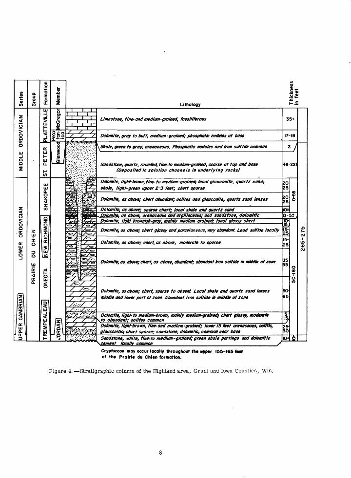
A structure contour map (pi. 1) of the top of the cherty unit of the Galena dolomite,prepared before drilling,showed two synclines that appeared to join near the center of the wi? of sec. 3. Drilling corrob orated the presence of both synclines. The northeast ward-trending syncline is thought to be the extension of the Galena-Shullsburg syncline and has much more relief than the narrower northwestward-trending one, which is like the Black Jack-Bautsch fold.
Evidence of mineralization
Indications of solution-thinning of the "oil rock" (middle part of Decorah formation) and the "glass rock" (upper part of Platteville formation) were seen in cuttings from one of the holeS( (Schenk 4), drilled near the pitch zone noted previously.
Although lines of lead shafts and "sucker holes" (diggings) were found, they are thought to be related to mining of the vertical or near-vertical "upper-run" (in the noncherty unit of the Galena dolomite) or crevice deposits and were not given any weight in the planning of the drilling because the purpose of this program was to explore the "lower-run" or pitch-and-flat type of ore body.
Holes 1 through 6 on the Schenk property (sec. 3) were spotted, on 125-foot centers, to cut across the southeastern projection of the pitch zone in the Tete des Morts River. They were drilled on the northeast limb of the northwestward-trending structure. Iron minerals were the only significant evidence of mineral ization in Schenk holes 1 through 6. Holes 2, 3, and 5 showed an estimated 3. 5 to 4. 7 percent iron for a thickness of 16 to 39 feet (pi. 2); all the holes except no. 4 had traces of zinc, and hole 3 had a trace of lead. The iron minerals were found at the stratigraphic ppsition of the upper and lower flint openings. As this position is in the upper part of the pitch-type ore bodies farther north and east, the occurrence of the iron is interpreted as a favorable indication of the possible existence of pitch-type lower-run ore bodies in the Tete des Morts area. Although no pitch-type fractures were found in the drilling, the existence of solution-thinning of the "oil rock" and "glass rock" with associated concentration of shaly material found in Schenk hole 4 is believed to justify further explora tion for lower-run zinc-lead deposits.
Holes 7 through 9 on the Schenk property were alined across the gently dipping southeast limb of the northeastward-trending syncline. In hole 7, iron dep osition similar to that in holes 2, 3, and 5 was discovered at the same stratigraphic position as in holes 1 through 6. In addition, a mineral identified as one of the manganese oxides was present at this position of the upper flint opening. This cross sec tion, holes 7 through 9, showed less promise than the one for holes 1-6.
The alinement of holes drilled on Kohlenberg's property crossed the northwestward-trending syncline. Hole 1 showed iron deposition estimated at 3 percent for 15 feet at the position of the lower Receptaculites opening, which is near the base of the Galena dolomite. Hole 2 showed traces of zinc, and hole 4 showed the manganese mineral, noted in Schenk hole 7, in the "gray" beds of the Decorah formation.
The significance of the manganese mineral is not known; however, the iron in Kohlenberg hole 1 is interpreted as a favorable indication of the possible existence of pitch-type lower-run ore bodies in the Tete des Morts area.
All holes drilled in the Tete des Morts area were completed to the desired depth at or near the base of the "glass rock" except Kohlenberg hole 1, which was bottomed in the "gray" beds of the Decorah. In the lower part of this hole, from 215 to its total depth of 244 feet, a joint with a strong flow of water caused such drilling and sampling difficulties that the hole was abandoned.
Recommendations
The exploratory work here described showed structure, lithology, and type and position of mineral ized zones that are interpreted as favorable indications of the possible existence of pitch-type lower-run ore bodies. The Tete des Morts and surrounding area thus constitute a potential extension of the mining district and further exploratory work is recommended.
Outcrop mapping is recommended as a means of locating geologic structures along the Mississippi River bluff, the Tete des Morts River, and other areas where exposures are numerous and structural control is good. Where such geologic data are not available, it is recommended that favorable structure be prospected for by means of drilling, .preferably using either a grid, or a series of cross sections across syncline trends.
Although the ore bodies are localized along structural trends, not all such trends bear ore bodies, and any one trend can have both ore-bearing and lean or blank areas. Thus, the structural picture must be used only as a guide in finding ore, not as a certain indication of ore.
Furthermore, it is recommended that any exploratory program, in this or similar new areas in the district, be planned to include an adequate number of drill holes. Recent experience by mining companies in the district has shown that limited drilling can give only insufficient information regarding any ore dis coveries and often it unjustly condemns an area.
THE HIGHLAND AREA, WISCONSIN
The Highland area (fig. 2) in west-central Iowa County and the adjoining part of Grant County, Wis., includes about 5 square miles. The village of Highland lies in the northeast corner of the area. Maximum topographic relief is approximately 300 feet. The uplands are under cultivation; the valley slopes and narrow stream flood plains are grasslands.
Zinc and lead ores in this area have been mined from Middle Ordovician rocks of the Platteville,Decorah, and Galena formations and lead ore has been taken from Lower Ordovician rocks of the Prairie du Chien group. The formations that contain these two ore- bearing zones are separated by the Middle Ordovician St. Peter sandstone (fig. 4). Because this part of the exploration by the Geological Survey was concerned with the lower ore zone, evidence of mineralization
u>9*w
»cn
z < o
MIDDLE ORDOV
z <
UPPER CAMBRIAN] LOWER ORDOVIC
a.3
2o
15O 0
UJor< or a.
Formation
PLATTEVILLE
cc
eUJa.
K
TREMPEALEAU] ONEOTA INEW RICHMONp| SHAKOPEE
Member
McGregor
§ss
uy
ii\ §-5
$s+-5 »1-2
Lithology l-~I Ii i i
1 I li i i
i i i/ / // / /
X<f&fXj.
pil9flyu2f="«£>>y*«aaxta
s!X~"V
^^<=>y6'<=./'«»y"*y
y/to y//es/ =*^==}*=>i>/fe?=V*=iCD ^/to/
.;.;;. Sr? " ^^ : : /
fbv*<sv3^«*>
£e*>-/«y«
X<=>//«=>yyfc> // >/<=>>
EV'cs= /«=>.c=,/<=,e^=t^vt^r c=>/«cir«=>xc/ X
/=/ // /<±>// / /-/ -/ s/ ;.*/ /
'^£?fe)&^ / / /^ / / yif:v>i*tV"-^*f-*'i^ ^iiiJv/iiii
Limestone, fine- and medium-groined, fossiliferous
Dolomite, gray to buff, medium -grained; phospnatic nodules at base
\Shale, green to gray, arenaceous. Phosphatic nodules and Iron sulfide common
Sandstone, quartz, rounded, fine-to medium-grained, coarse at top and base (Deposited In solution channels In underlying rocks)
Dolomite, light-brown, fine-to medium-grained; local giauconite, quartz sand; shale, light-green upper 2-3 feet; chert sparse
Dolomite, as above; chert abundant; oolites and giauconite, quartz sand lenses
Dolomite, as above; sparse chert; iocai shale and quartz sand
Dolomite, light brownish-gray, mainly medium -grained; focal glassy chert
Dolomite, as above; chert glassy and parcel an eous, wry abundant. Lead sulfide locally
Dolomite, as above; chert, as above, moderate to sparse
Dolomite, as above; chert, as above, abundant; abundant iron sulfide in middle of zone
Dolomite, as above; chert, sparse to absent. Local shale and quartz sand lenses middle and lower part of zone. Abundant iron sulfide in middle of zone
Dolomite, light- to medium-brown, mainly medium-grained} chert glossy, moderate \to abundant; oolites common
Dolomite, light-brown, fine- and medium-groined; lower 15 feet arenaceous, oolitic, gtauconltic; chert sparse; sandstone, dohmitic, common near baseSandstone, white, fine-to medium-grained; green shale partings and dotomitic
35+
17-18
*/
48-221
2O 25
20 25
lOto-
It15- 2515-
25
35-55
50-
65
5-, 5/
25- 3010+
IB 6
o <o
o m
&
in KCM
m(O CM
~~\cemenf locally common /
Cryptozoon may occur locally throughout the upper 155-165 <Mt of the Prairie du Chien formation.
Figure 4. Stratigraphic column of the Highland area, Grant and Iowa Counties, Wis.

in the Prairie du Chien rocks only is discussed. Most of the lead ore from this unit was mined from about 1850 to 1880, and no records of production are available. Areas of diggings (pi. 3) are relatively extensive, more so in the Highland vicinity than in other places where ore has been mined from the Prairie du Chien strata.
The Ohlerking mine, near the center of the WiSEisec. 31, T. 7N., R. IE., produced only lead ore. It was operated through a shaft about 180 feet deep, from which about 275 feet of drift was driven (Chamberlin, 1882, pp. 516-517). Although the amount of lead ore recovered is not known, this was the largest operation in the lower ore,zone.
A preliminary survey of the geology of the area, including the examination of the old mine dumps, was made by Flint before drilling was begun. A geologic and structural map (pi. 3) based on information gathered during this survey was used for determining the location of the drill holes. The topography was the only other important factor governing the exact location of the holes.
Stratigraphy
Upper Cambrian. The Upper Cambrian Trempealeau formation is not exposed in the area mapped in the vicinity of Highland but crops out 3 miles north. The upper Trempealeau strata are sandstone. They consist of white fine and medium subangular to subround quartz grains. Green shale partings separate the irregular thin sandstone beds.
Lower Ordovician. The Lower Ordovician Prairie du Chien group, which includes the mineralized zones explored by drilling, conformably overlies the Upper Cambrian Trempealeau formation and crops out in the northern half of the Wisconsin-Illinois-Iowa mining district in the more deeply dissected stream valleys. Where observed in the Highland area,this group is from 50 to 215 feet thick. Farther west a middle sandstone unit separates the dolomite strata of the group and permits its division into three forma tions. An attempt was made to extend this threefold division into the area covered by this report; however, because of incomplete knowledge of detailed Prairie du Chien stratigraphy throughout the mining district, it was not possible to identify positively the middle formation (fig. 4 and pi. 4), if it is present in the Highland area. From the base upward the three forma tions have been called the Oneota dolomite", New Richmond sandstone, and Shakopee .dolomite. Recent study by-Flint, however, has shown that these members are nor mappable units either in the High land area or generally in the Wisconsin-Illinois-Iowa zinc-lead district.
The Oneota dolomite is mainly a brown-gray medium-grained crystalline dolomite. Chert is common to abundant 30 to 40 feet above the base and in the upper half of the member. Oolitic textures appear near the base in both the chert and dolomite. Glauconite is common as a minor constituent of the rock. Algal (cryptozoon) structures occur locally throughout the formation, and near the base two algal zones are persistent. Lenses of quartz sandstone and arenaceous dolomites occur locally throughout the Oneota, but except in the lower 20 feet, approximately, the quartz
represents only a small percentage of the total rock. Banded chalcedony and drusy quartz line vugs in both the dolomite and chert. Shale is present locally throughout the Oneota but does not seem to occupy particular stratigraphic zones. Iron sulfide, mainly pyrite, is a common constituent of the rock.
In the Highland area the unit designated as New Richmond sandstone is an arenaceous shaly bed about 5 feet thick. In the one exposure where this bed is readily identified, a dolomitic sandstone layer about 1 foot thick, is present. The sand is medium to coarse in size and very similar to sand grains of the St. Peter sandstone, which is described below.
The Shakopee dolomite is more argillaceous and arenaceous than the Oneota. Algal structures are common. The beds are generally thin and irregular. Shaly and sandy strata are common; locally chert is very abundant, and much of it is oolitic.
Middle Ordovician. The Prairie du Chien group is overlain by the St. Peter sandstone. Where observed in the Highland area, this forma tion is from 48 to 221 feet thick. The sandstone is white to buff, mainly medium grained, but coarse at the top and near the base of the forma tion. The St. Peter is unmineralized except for local iron sulfide concentrations.
Above the St. Peter sandstone, the Platteville formation has the thin Glenwood shale member at its base; the Glenwood is overlain by the Pecatonica dolomite member, which is overlain by the McGregor limestone member, the highest stratigraphic unit penetrated by drilling.
A mantle of residual boulders, sand, clay, and soil, which is as much as 8 feet thick, covers the area.
Results of geologic mapping
Evidences of mineralization. Considerable float galena in many of the stream beds in the Ei sec. 3 Land the NWi sec. 32, T. 7 N., R. IE., and in the SWjNWi sec. 6, T, 6 N., R. 1 E. was found by field investigation of the area before drilling. Much of the galena was not broken up and appeared to be near its source. In a sharp ravine in the north west corner of sec. 32, T. 7 N., R. IE., galena was found in place, where it is associated with a brown-red clay. The dolomite beds are thin and irregular and are warped upward into a small dome, the top of which has been eroded away exposing the mineral.
In the quarry in the NW^NWi sec. 32 some galena was recovered as a byproduct in the quarrying activities. The lead mineral here occurs near and in a honeycombed chert layer 2 to 3 feet thick. Galena filling the voids in large free chert blocks may be seen near the entrance to the quarry. Abundant float galena occurs in the stream valley in the SW^SEl sec. 31, T. 7 N., R. IE., and a lesser amount is in the stream valley in the SWiNWi sec. 6, T. 6 N., R. IE. Two occurrences of galena seen in outcrops are in a zone 110 to 125 feet below the top of the St. Peter sandstone. A third occurrence also seen in an outcrop is in a zone 140 to 150 feet below the top of the St. Peter.
The pits and caved shafts of mines other than the Ohlerking mine appear to have been no deeper than 30 or 40 feet; in fact, most were very shallow and seem to have been dug to recover only residual galena concentrated at the bedrock surface.
Where galena is seen in outcrops,it is associated with thick chert layers and with solutional thinning of beds.
No zinc mineral was found in any of the exposures.
Structure. The upper surface of the St. Peter sandstone was chosen as the datum plane for structure contours because of the exceedingly irregular upper surface of the Prairie du Chien group. Much of this irregularity is primary and not a reflection of warping and flexing of the strata after deposition of the Prairie du Chien. However, the relief on the upper surface of the St. Peter sandstone is believed to represent adjustment to stresses applied to the strata, and these adjustments account for the fractures that localize mineralization.
As seen on the map of the Highland area (pi. 3), the basic structure is a southward-dipping homocline. Superposed on it are northeastward-trending minor corrugations that may be purely superficial because stream dissection has produced moderately steep- walled valleys, and the resulting mass movement of both surficial material and the sandstone bedrock may account for the minor warping. Furthermore, the trend of this minor structure locally tends to parallel the topography. Nevertheless, this structure was prospected because areas of float galena and old lead diggings seem to be located along its trend and because such gentle' structures localize mineral deposits in the upper ore zone in the main part of the mining district. Groups of drill holes alined normal to the trend of the corrugated structure were drilled at three places (pi. 3).
Results of exploratory drilling
Twelve exploratory holes were drilled between February 22 and May 17, 1951, five on the Steil property, Ni sec. 6, T. 6 N., R. IE., five on the Williams property, SEi sec. 31, T. 7 N. , R. IE., and two on the Wiest property, Si sec. 29, T. 7 N., R. IE. (pi. 3). Samples were taken of cuttings re covered from each 5 feet of drilling and were examined through a binocular microscope. (Summary logs are included on pp. 11-36.)
Three holes penetrated zones containing galena, samples of which assayed as high as 1. 2 percent lead, and traces of galena were found in samples from other holes (pi. 4 and summary logs, pp. 11-36). Zinc sulfide in present in the samples only as traces.
Iron sulfide is a common constituent of Prairie du Chien rocks, and significant amounts are present in samples from all the exploratory holes except Steil 3 which penetrated the very thick St. Peter sandstone and only 46 feet of dolomite beds of the Prairie du Chien group. Concentrations of iron sulfide occur in two general zones, one being 150 to 160 feet below the top of the St. Peter, the other 195 to 205 feet below that surface. Several samples were estimated to contain more than 10 percent iron sulfide, and
an estimate that iron sulfide comprised as much as 25 percent of one of the samples was corroborated by assay. The iron sulfide seems to increase slightly in amount from northwest to southeast in each property as is shown in the cross sections prepared from drill-hole data. This trend is significant because in the upper mineralized zone in the main part of the mining district the larger zinc deposits commonly have an iron sulfide halo that extends peripherally for some distance beyond the zinc ore.
At least two periods of chert emplacement are indicated. The earlier chert, which is similar to that common in the Prairie du Chien over a wide area, is glassy and is commonly gray or brown; the later chert is porcelaneous, white or cream, and is seen in the cuttings to have partly or completely Replaced the dolomite. In some of the exploratory holes the later chert seems to be associated with the iron deposits. Considerable drusy quartz and banded chalcedony occur locally in the dolomite and chert. Late dolomite is present in the vugs also. No obvious relation was noted between the late dolomite, the quartz, and the zones mineralized with iron sulfide, although one may exist.
The general knowledge of Prairie du Chien stratigraphy has been augmented by data from the drilling. Oolite zones and more poorly defined zones of abundant and sparse chert (pi. 4) were recognized in the study of the samples. Changes in lithology and rock textures were observed, and it was estab lished that the New Richmond sandstone cannot be distinguished with certainty in the Highland area. The drilling indicated that, as in the southern and central parts of the district, the lithology of the Prairie du Chien rocks varies laterally in short distances.
Recommendations
Continued district-wide study of Prairie du Chien stratigraphy is desirable. At present not enough data regarding these strata in and near the mining district are available to locate and describe persistent zones and stratigraphic markers. Stratigraphic factors affected emplacement of lead and zinc in the Galena- Decorah-Platteville ore zone, and probably the same is true of mineral zones in the Prairie du Chien. Thus a detailed knowledge of the stratigraphy of the mineral-bearing rocks is an important and necessary consideration for prospecting in this group.
Although some galena-bearing rock was penetrated in the area drilled, no conclusions about the presence or absence of zinc and lead ore in the, Prairie du Chien strata, generally, can be drawn from the limited drilling described in this report.
Future investigation of mineral deposition.in the Prairie du Chien in the Highland area should include:
1. Additional drill holes southeastwardalong the lines of the exploratory holes drilled in 1950-51. Such drilling may provide data on the increasing concen tration of iron sulfide in that direction and on the structural possibilities in these localities.
10
2. The cleaning out of the shaft and inspec tion of the old Ohlerking mine workings. The shaft reaches a depth at which it should penetrate the zones of iron deposition recorded in the drill holes on the Williams property. Examination of stopes and drifts in this mine should reveal structural and stratigraphic controls, and the manner of mineral emplacement. Such information can be obtained only partly by drilling.
LITERATURE CITED
Agnew, A. F., and Heyl, A. V., Jr., 1947, Recent developments in the Wisconsin-Illinois-Iowa lead- zinc district: Iowa Acad. Sci. Proc. 1946, vol. 53. p. 228.
Behre, C. H., Jr., 1939, Wisconsin-Illinois district, in Bastin, E. S., and others,, Contributions to a knowledge of the lead and zinc deposits of the Mississippi Valley region: Geol. Soc. America Special Paper 24, pp. 67-70.
Chamberlin, T. C., 1882, The ore deposits of south western Wisconsin: Wisconsin Geol. Survey, Geology of Wisconsin, vol. 4, pp. 516-517.
Heyl, A. V., Jr., Lyons, E. J., and Agnew, A. F., 1951, U. S. Geological Survey exploratory drilling in the Prairie du Chien group: U. S. Geol. Survey Circ. 131.
Owen, D. D., 1840, Report of a geological exploration of part of Iowa, Wisconsin, and Illinois, 1839: Cong. Doc. 26th Cong. 1st sess., H. Ex. Doc. 239, 161 pp.
Thwaites, F. T., and Howell, J. V., 1935, Topography of pre-Cambrian surface: Kansas Geol. Soc. 9th Ann. Field Conf., fig. 227.
Thwaites, F. T., Howell, J. V., and Jones, D. D., 1935, Structure of St. Peter sandstone: Kansas Geol. Soc. 9th Ann. Field Conf., fig. 230
Whitney, J. D., 1858, _in Hall, James, and Whitney, J. D., Report on the geological survey of the State of Iowa, vol. 1, pt. 1, Geology, pp. 438-440, [Albany, N. Y.]
Willman, H. B., and Reynolds, R. R., 1947, Geological structure of the zinc-lead district: Illinois State Geol. Survey Rept. Inc. 124, pp. 14-15.
11
GENERALIZED LOGS OF DRILL-HOLE EXPLORATIONS
Tete des Morts area, Jackson and Dubuque Counties, Iowa
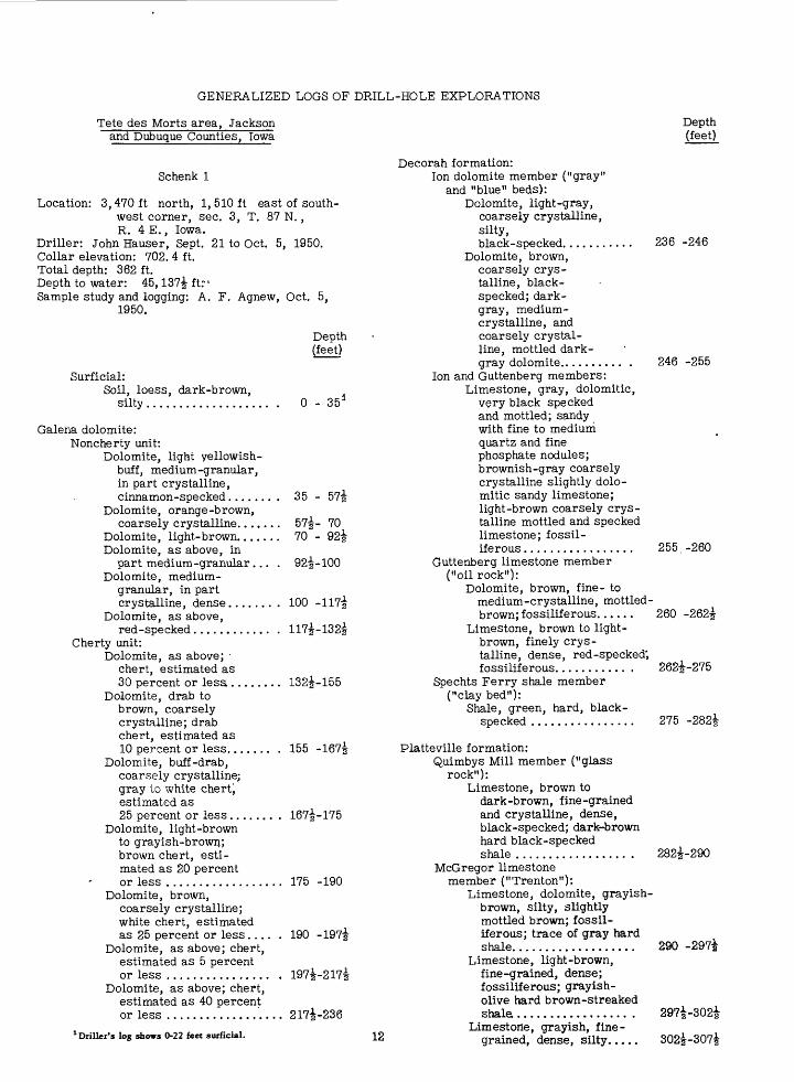
Schenk 1
Location: 3,470ft north, 1,510ft east of south west corner, sec. 3, T. 87 N., R. 4 E., Iowa.
Driller: John Hauser, Sept. 21 to Oct. 5, 1950.Collar elevation: 702. 4 ft.Total depth: 362 ft.Depth to water: 45,137| ft:- 1Sample study and logging: A. F. Agnew, Oct. 5,
1950.
Surficial:Soil, loess, dark-brown,
silty.................
Depth (feet)
0 - 35 3
Galena dolomite:Noncherty unit:
Dolomite, light yellowish- buff, medium-granular, in part crystalline, cinnamon-specked......
Dolomite, orange-brown, coarsely crystalline.....
Dolomite, light-brown.....Dolomite, as above, in
part medium-granular...Dolomite, medium -
granular, in part crystalline, dense......
Dolomite, as above,red-specked............
Cherty unit:Dolomite, as above;
chert, estimated as 30 percent or lesa ......
Dolomite, drab to brown, coarsely crystalline; drab chert, estimated as 10 percent or less.......
Dolomite, buff-drab, coarsely crystalline; gray to white chert) estimated as 25 percent or less ......
Dolomite, light-brown to grayish-brown; brown chert, esti mated as 20 percent or less ................
Dolomite, brown, coarsely crystalline; white chert, estimated as 25 percent or less
Dolomite, as above; chert, estimated as 5 percent or less ................
Dolomite, as above; chert, estimated as 40 percent or less ................
35 - 57i
57~- 70 70 2 - 92i
92^-100
100 -
132|-155
155 -167|
167|-175
175 -190
190 -197|
197i-217|
217|-236
1 Driller's log shows 0-22 feet surficial. 12
Depth (feet)
Decorah formation:Ion dolomite member ("gray"
and "blue" beds):Dolomite, light-gray,
coarsely crystalline, silty, black-specked........... 236 -246
Dolomite, brown, coarsely crys talline, black- specked; dark- gray, medium- crystalline, and coarsely crystal line, mottled dark- gray dolomite.......... . 246 -255
Ion and Guttenberg members:Limestone, gray, dolomitic,
very black specked and mottled; sandy with fine to medium quartz and fine phosphate nodules; brownish-gray coarsely crystalline slightly dolo mitic sandy limestone; light-brown coarsely crys talline mottled and specked limestone; fossil - iferous................. 255.-260
Guttenberg limestone member ("oil rock"):
Dolomite, brown, fine- to medium-crystalline, mottled- brown; fossiliferous...... 260 -262|
Limestone, brown to light- brown, finely crys talline, dense, red-specked; fossiliferous........... . 262^-275
Spechts Ferry shale member ("clay bed"):
Shale, green, hard, black- specked ................ 275 -282|
Platteville formation:Quimbys Mill member ("glass
rock"):Limestone, brown to
dark-brown, fine-grainedand crystalline, dense,black-specked; dark-brownhard black-speckedshale ................. . 282^-290
McGregor limestone member ("Trenton"):
Limestone, dolomite, grayish- brown, silty, slightly mottled brown; fossil iferous; trace of gray hard shale................... 290 -29?i
Limestone, light-brown, fine-grained, dense; fossiliferous; grayish- olive hard brown-streaked shale................... 297i-302|
Limestone, grayish, fine grained, dense, silty..... 302|-307|
Depth (feet)
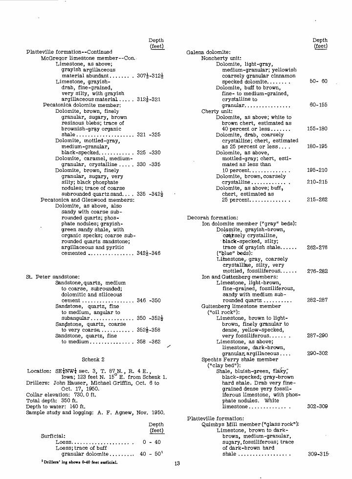
Platteville formation ContinuedMcGregor limestone member Con..
Limestone, as above; grayish argillaceous material abundant....... . 307i-312|
Limestone, grayish- drab, fine-grained, very silty, with grayish argillaceous material..... 312^-321
Pecatonica dolomite member:Dolomite, brown, finely
granular, sugary, brown resinous blebs; trace of brownish-gray organic shale.......'............. 321 -325
Dolomite, mottled-gray, medium-granular, black-specked........... . 325 -330
Dolomite, caramel, medium- granular, crystalline ..... 330 -335
Dolomite, brown, finely granular, sugary, very silty; black phosphate nodules; trace of coarse subrounded quartz sand... . 335 -342^
Pecatonica and Glenwood members:Dolomite, as above, also
sandy with coarse sub- rounded quartz; phos phate nodules; grayish- green sandy shale, with organic specks; coarse sub- rounded quartz sandstone; argillaceous and pyritic cemented ................ 342^-346
St. Peter sandstone:Sandstone, quartz, medium
to coarse, subrounded;dolomitic and siliceouscement .................. 346 -350
Sandstone, quartz, fineto medium, angular tosubangular............... 350 -352|
Sandstone, quartz, coarseto very coarse .......... . 352^-358
Sandstone, quartz, fineto medium.............. . 358 -362
Schenk 2
Location: SE^NWi sec. 3, T. 87 N., R. 4 E.,Iowa; 123 feet N. 15° E. from Schenk 1.
Drillers: John Hauser, Michael Griffin, Oct. 6 to Oct. 17, 1950.
Collar elevation: 730. 0 ft.Total depth: 350 ft.Depth to water: 140 ft.Sample study and logging: A. F. Agnew, Nov. 1950.
Depth (feet)
Surficial:Loess.................... . 0 - 40Loess; trace of buff
granular dolomite......... 40 - 50 l1 Drillers' log shows 0-40 feet surficial.
Depth (feet)
Galena dolomite:Noncherty unit:
Dolomite, light-gray,medium-granular; yellowishcoarsely granular cinnamonspecked dolomite....... . 50- 60
Dolomite, buff to brown,fine- to medium-grained,crystalline togranular................ 60-155
Cherty unit:Dolomite, as above; white to
brown chert, estimated as40 percent or less....... 155-180
Dolomite, drab, coarselycrystalline; chert, estimatedas 25 percent or less... . 180-195
Dolomite, as above,mottled-gray; chert, esti mated as less than10 percent............. . 195-210
Dolomite, brown, coarselycrystalline............ . 210-215
Dolomite, as above; buff,chert, estimated as25 percent............. . 215-262
Decorah formation:Ion dolomite member ("gray" beds):
Dolomite, grayish-brown,'coarsely crystalline,
black-specked, silty;trace of grayish shale...... 262-276
("felue" beds):Limestone,, gray, coarsely
crystalline, silty, very mottled, fossiliferous...... 276-282
Ion and Guttenberg-members: Limestone, light-brown,
fine-grained, fossiliferous, sandy with medium sub- rounded quartz .......... 282-287
Guttenberg limestone member ("oil rock"):
Limestone, brown to light- brown, finely granular to dense, yellow-specked, very fossiliferous...... . 287-290
Limestone, as above; limestone, dark-brown, granular, argillaceous.... 290-302
Spechts Ferry shale member ("clay bed"):
Shale, bluish-green, flaky,*" black-specked; gray-brown hard shale. Drab very fine grained dense very fossil iferous limestone, with phos phate nodules. White limestone............. . 302-309
Platteville formation:Quimbys Mill member ("glass rock11 ):
Limestone, brown to dark- brown, medium-granular, sugary, fossiliferous; trace of dark-brown hardshale 309-315-
13
Depth (feet)
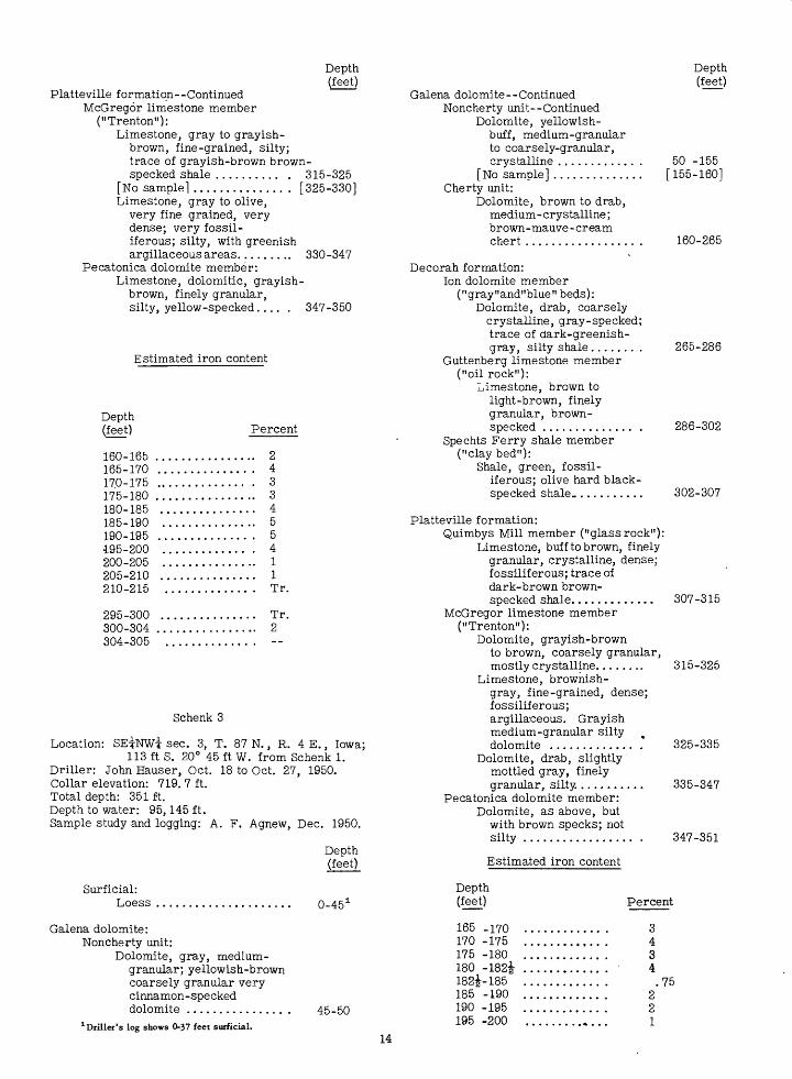
Platteville formation--Continued McGregor limestone member
("Trenton"):Limestone, gray to grayish-
brown, fine-grained, silty; trace of grayish-brown brown- specked shale .......... . 315-325
[No sample] .............. . [325-330]Limestone, gray to olive,
very fine grained, very dense; very fossil - iferous; silty, with greenish argillaceous areas......... 330-347
Pecatonica dolomite member:Limestone, dolomitic, grayish-
brown, finely granular, silty, yellow-specked.... . 347-350
Estimated iron content
Galena dolomite--ContinuedNoncherty unit--Continued
Dolomite, yellowish- buff, medium-granular to coarsely-granular, crystalline ...........
[No sample] ............Cherty unit:
Dolomite, brown to drab, medium - crystalline; brown-mauve -cream chert ................
Depth (feet)
50 -155 [155-160]
160-265
Depth (feet) Percent
160-165 ................ 2165-170 ............... 417.0-175 ............... 3175-180 ................ 3180-185 ............... 4185-190 ............... 5
Decorah formation:Ion dolomite member
("gray"and"blue" beds):Dolomite, drab, coarsely
crystalline, gray-specked; trace of dark-greenish- gray, silty shale ....... .
Guttenberg limestone member ("oil rock"):
Limestone, brown to light-brown, finely granular, brown- specked .............. .
Spechts Ferry shale member ("clay bed"):
Shale, green, fossil-iferous; olive hard black- specked shale............
265-286
286-302
302-307
190-195 195-200 200-205 205-210 210-215
5 4 1 1 Tr.
295-300 ............... Tr.300-304 ................ 2304-305 ..............
Schenk 3
Location: SEirNWi sec. 3, T. 87 N., R. 4 E., Iowa;113 ft S. 20° 45 ft W. from Schenk 1.
Driller: John Hauser, Oct. 18 to Oct. 27, 1950. Collar elevation: 719. 7 ft. Total depth: 351 ft. Depth to water: 95,145 ft. Sample study and logging: A. F. Agnew, Dec. 1950.
Depth (feet)
Platteville formation:Quimbys Mill member ("glass rock"):
Limestone, buff to brown, finely granular, crystalline, dense; fossiliferous; trace of dark-brown brown- specked shale............. 307-315
McGregor limestone member ("Trenton"):
Dolomite, grayish-brown to brown, coarsely granular, mostly crystalline........ 315-325
Limestone, brownish- gray, fine-grained, dense; fossilif erous; argillaceous. Grayish medium-granular silty % dolomite ............. . 325-335
Dolomite, drab, slightly mottled gray, finely granular, silty........... 335-347
Pecatonica dolomite member:Dolomite, as above, but
with brown specks; not silty ................. . 347-351
Estimated iron content
Surficial: Loess 0-45 1
Galena dolomite:Noncherty unit:
Dolomite, gray, medium- granular; yellowish-brown coarsely granular very cinnamon-specked dolomite ............... ,
1 Driller's log shows 0-37 feet surficial.
45-50
Depth (feet)
165 -170 170 -175 175 -180 180 -182i 182i-185 185 -190 190 -195 195 -200
Percent
3434.75
221
14
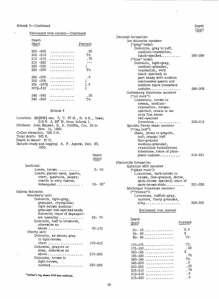
Schenk 3--Continued
Estimated iron content Continued
Depth (feet)
Depth (feet)
200 -205 205 -210 210 -215 215 -220 220 -225 225 -230
295 -300 300 -305 305 -307i 307i-310
340 -345 345 -350
Percent
.25 Tr. .75
1 Tr.
.5 11.5 1
.25 Tr.
Schenk 4
Location: SE|NWl sec. 3, T. 87 N., R. 4 E., Iowa;216 ft S. 22° W. from Schenk 1.
Drillers: John Hauser, R. E. Griffin, Oct. 28 toNov. 11, 1950.
Collar elevation: 726. 0 ft. Total depth: 335 ft. Depth to water: 97 ft. Sample study and logging: A. F. Agnew, Dec. 20,
1950.
Surficial:Loess, brown ............Loess; glacial sand, quartz,
chert, quartzite, jasper, coarse to very coarse, subangular.............. .
Galena dolomite:Noncherty'unit:
Dolomite, light-gray, granular, crystalline; light-brown medium - granular red-specked sandy dolomite; trace of depauper ate material ............ .
Dolomite, buff to brownish, otherwise as above .................. .
Cherty unit:Dolomite, as above; gray
to light-brown chert .....................
Dolomite, grayish or drab, otherwise as above ...................
Dolomite, brown to light-brown, mottled..................
1 Driller's log shows 0-50 feet surficial.
Depth (feet)
0- 35
35- 52 1
Decorah formation:Ion dolomite member
("gray" beds): Dolomite, gray to buff,
medium-crystalline, black-specked...........
("blue" beds): Dolomite, light-gray,
medium-granular, crystalline, very black specked; in part sandy with medium sub rounded quartz and medium black phosphate nodules.................
Guttenberg limestone member ("oil rock"):
Limestone, brown to cream, medium- crystalline, brown- specked; cream to tan very fine dense red-specked limestone ............. .
Spechts Ferry shale member ("clay bed"):
Shale, green to grayish, soft; orange-buff fine-grained medium-granular, crystalline fossiliferous limestone; trace of phos phate nodules............
285-298
298-306
306-315
312-321
Platteville formation:Quimbys Mill member
("glass rock"): Limestone, dark-brown to
brown, fine-grained, dense, dark-brown specked; trace ofdark-brown shale.......
McGregor limestone member ("Trenton"):
Limestone, buffish-gray, mottled, finely granular, silty...................
Estimated iron content
321-326
326-335
52- 70
70-170
170-215
215-235
235-285
Depth (feet)
50- 55 55- 60 60- 65
170-175175-180.180-185185-190190-195195-200200-205205-210210-215215-220
Percent
0.5 2Tr.
Tr. .25
2.75 Tr. .5 .25 .75 .5 .5
15
Schenk 4--Continued
Estimated iron content--Continued
Depth (feet)
Depth (feet)
220-225
305-315.315-320320-325
Percent
Tr.
Decorah formation--ContinuedSpechts Ferry shale member
("clay bed"):Shale, green; limestone,
brown, phosphate nodules; trace of light-gray bentonite............
Schenk 5
Location: SE|NWi sec. 3, T. 87 N. , R. 4 E. , Iowa;318 ft S. 21° W. from Schenk 1.
Drillers: John Hauser, R. E. Griffin, Nov. 14to Nov. 29, 1950.
Collar elevation: 731. 8 ft. Total depth: 340 ft. Depth to water: 145 ft. Sample study and logging: A. F. Agnew, Jan. 1951.
Platteville formation:Quimbys Mill member ("glass rock"):
Limestone, light- to dark-brown, finely granular, crystalline,dark-brown specked
323-330
330-340
Estimated iron content
[ No visible zinc except for a trace at the 65- to 70-foot -depth.]
Surficial:Loess, brown............. .Loess, as above; glacial sand,
estimated as much as 70 percent; gray till.......................
Till, as above; trace of sand, as above; depauperate pebbles, estimated as 25 per cent or less............. .
Galena dolomite:Noncherty unit:
Dolomite, brown to light- brown, finely granular to medium-granular, cinnamon- specked. .................
Cherty unit:Dolomite, light-brown to
grayish-brown, medium- crystalline; white to brown chert.................. .
Decorah formation:Ion dolomite member
("gray" and "blue" beds): Dolomite, brown-gray,
medium-crystalline, gray-specked; trace of greenish shale................... .
Ion and Guttenberg members: Limestone, dolomitic,
grayish-brown, medium- crystalline, gray-specked; sandy with medium sub- rounded quarts ....... '.. .
Guttenberg limestone member ("oil rock"):
Limestone, light-brown to tan, fine-grained, dense; fossiliferous; dark-brown argillaceous matter.......
Depth (feet)
0-35
35-50
50-58
58-180
180-287
Depth (feet)
50-55 55-60 60-65 65-70
770-75
125-130 130-135 135-140
185-190 190-195 195-200 200-205 205-210
280-285 285-290 290-295 295-300
315-320 320-325 325-330 330-335 335-340
Percent
Tr.
Tr.
Tr.
.25 545 Tr.
.5
.25Tr.
Tr. .25 .75 .25 Tr.
287-308
308-310
310-323
Schenk 6
Location: SEiNWi sec. 3, T. 87 N., R. 4 E., Iowa;252 ft N. 24* E. from Schenk 1.
Driller: John Hauser, Nov. 30 to Dec. 14, 1950. Collar elevation: 733. 7 ft. Total depth: 315 ft. Depth to water: 150 ft. Sample study and logging: A. F. Agnew, Dec. 1950.
Depth (feet)
1 Drillers' log shows 0-57 feet surficial.
16
Surficial:Loess, brown) trace of
depauperate pebbles at base.., 0-35
Depth (feet)
Schenk 6 Continued
Estimated iron content ContinuedGalena dolomite:
Noncherty unit:Dolomite, yellowish-
brown to brown, medium- granular, mostly crystalline .............
Cherty unit:Dolomite, grayish-drab to
buff, medium - crystalline to coarsely crystalline; brown to flesh-colored chert varying to cotton rock...................
35-155
Depth (feet)
190-195 195-200 200-205
155-264
Decorah formation:Ion dolomite member
("gray" beds): Dolomite, gray to buff,
medium-granular, gray- specked. ................. 264-277
("blue" beds):Limestone, dark-gray to
- brown, mottled; argillaceous; very fossiliferous; subrounded quartz sand and phosphate nodules......... 277-284
Guttenberg limestone-member ("oil rock"):
Limestone, light-brown, medium-crystalline, mottled; fossiliferous; silty. Light-brown to tan fine-grained dense argillaceous limestone; with brown specks.......
Spechts Ferry shale member ("clay bed"):
Shale, green to gray-green, very fossiliferous. White to light grayish-brown fine-grained limestone containing phosphate nod ules and fossils .........
210-215.. 215-220. 220-225. 225-230 . 230-235 .
265-270 . 270-275 275-280 , 280-285 285-290 , 290-295
300-305 305-310 310-315
Schenk 7
Percent
.75 Tr.
.25 Tr. .5
1 Tr.
Tr. .5 .25 Tr.
1 Tr.
.25 1 .5
284-300
Location: NEiSWi sec. 3, T. 87 N., R. 4 E., Iowa;1, 086 ft S. 32° 30 ft E. from Schenk 1.
Drillers: John Hauser, Gilbert Reiter, Dec. 21, 1950,to Jan. 5, 1951.
Collar elevation: 720.0 ft. Total depth: 312ft.' Depth to water: - - - Sample study and logging: A. F. Agnew, Jan. 16, 1951.
Depth (feet)
Surficial:Loess, brown
300-306
Platteville formation:Quimbys Mill member:
Limestone, gray-brown, fine-grained, dense; argillaceous; . trace of dark-brown shale ...............
Galena dolomite:Noncherty unit:
Dolomite, yellowish-buff, medium-granular, crystal line, cinnamon-specked...
Cherty unit:Dolomite, brownish-drab,
medium-crystalline; gray to brown chert...........
0- 25 1
25-150
150-258
306-315
Estimated iron content
[No visible zinc except for a trace at the 285- to 290-foot depth]
Depth (feet)
165-170 ... 170-175 ... 175-180 ... 180-185 .. 185-190 ....
Percent
0.25
.517
Decorah formation:Ion dolomite member ("gray" beds):
Dolomite, light-gray to brown, medium-crystalline, gray- specked; trace of green hard silty shale........;...... .
("blue" beds):Dolomite, calcareous, gray,
medium-crystalline, gray-specked; in part sandy; greenish argillaceous areas.................... .
1 Drillers' log shows 0-27 feet surficial.
258-273
273-280
Depth (feet)
Decorah formation ContinuedGuttenberglimestone member ("oilrock"):
Limestone, cream to brown, fossiliferous, brown-specked .......... . 280-295
Spechts Ferry shale member ("clay bed"):
Shale, green; bentonite;gray limestone ............ 295-301
Platteville formation:Quimbys Mill member
("glass rock"):,Limestone, brown to
cream, fine-grained, fossiliferous; brown argillaceous areas; trace of dark-brown shale ..................
McGregor limestone member ("Trenton"):
Limestone, light-gray, fine-grained, silty.......
Depth
301-311
311-312
Estimated iron and manganese content
Depth (feet)
Percent Iron Manganese
145-150 .................... Tr.150-155 .................... 0.5155-160 .................... 2 Tr.160-165 .................... 6 1165-170'.................... 7 1170-175 .................... 6 1175-180 .................... 5 .25180-185 .................... 4 Tr.185-190 .................... 3 Tr.190-195 .................... Tr.
Schenk 8
Location: SEiNWi sec. 3, T. 87 N., R. 4 E., Iowa;1, 240 ft S. 47° 45 ft E. from Schenk 1.
Drillers: John Hauser, Robert Dagenhardt, Jan. 10to Jan. 18, 1951.
Collar elevation: 718. 4 ft. Total depth: 301 ft. Depth to water: 125 ft. Sample study and logging: A. F. Agnew, Feb. 27, 1951.
Depth (feet)
Decorah formation:Ion dolomite member
("gray" beds):Dolomite, gray, medium-
granular, and buff, medium- crystalline, gray-specked; some greenish argillaceous matter..................... 250-260
("blue" beds):Limestone, gray, medium-crystal
line, very fossiliferous; in part sandy; greenish argillaceous and shaly material........... 260-270
Guttenberg' limestone member ("oil rock"):
Limestone, cream to buff, fine-grained, dense, fossil iferous; brown shale........ . 270-285
Spechts Ferry shale member ("clay bed"):
Shale, green, flaky, soft; very fossiliferous. Light- greenish fine-grained limestone containing phos phate nodules ............. . 285-290
Platteville formation:Quimbys Mill member
("glass rock"):Limestone, tan to dark-brown,
fine-grained, dense; brownish argillaceous areas. Dark- brown shale............... . 290-300
McGregor limestone member ("Trenton"):
Limestone, gray, finely granular, sugary........... . 300-301
Schenk 9
Location: SWiNEi sec. 3, T. 87 N., R. 4 E., Iowa;1, 634 ft S. 62° E. from Schenk 1.
Driller: Robert Dagenhardt, Jan. 20 to Jan. 31, 1951. Collar elevation: 720.4 ft. Total depth: 305 ft. Depth to water: 125 ft. Sample study and logging: A. F. Agnew, Feb. 27,
1951.
Depth (feet)
Surficial:Loess, brown.
Surficial:Loess, brown
Galena dolomite:Noncherty unit:
Dolomite, yellowish-brown, medium-granular, crystalline .............
Cherty unit:Dolomite, grayish-
brown; chert............
0- 25 1
25-140
140-250
Galena dolomite:Noncherty unit:
Dolomite, light- brown, medium- granulaE........
Cherty unit:Dolomite, grayish-
brown; grayish- brown chert...........
0- 38*
38-140
140-250
1 Drillers' tog shows 0>30 feet surficial. 1 Driller's log shows 0-35 feet surficial.
18
Depth (feet)
Decorah formation:Ion dolomite member
("gray" beds):Dolomite, light-gray to
grayish-brown, medium- crystalline, gray-specked; in part silty.............. . 250-265
("blue" beds):Limestone, gray, medium-granu
lar, crystalline, gray- specked; fossiliferous; in part sandy............... 265-272
Guttenberg limestone member (oil rock"):
Limestone, brown to buff, fine-grained, dense, mottled; fossiliferous; brown shale.............. . 272-287
Spechts Ferry shale member: Shale, green, very fossil
iferous; cream fine grained dense fossil iferous limestone, containing phosphate nodules ................. . 287-295
Platteville formation:Quimbys Mill member
("glass rock"):Limestone, brown to dark-
brown, fine-grained, dense; trace of dark-brown shale .....................
McGregor limestone member ("Trenton"):
Limestone, light-brownish gray, finely granular, sugary, slightly mottled ...................
295-301
301-305
Kohlenberg 1
Location: 4, 302 ft north, 504 ft west of southeastcorner, sec. 4, T. 87 N., R. 4 E.,Iowa.
Drillers: John Hauser, Gilbert Reiter, Dec. 6 toDec. 26, 1950.
Collar elevation: 732.0 ft. Total depth: 244ft. Depth to water: 215 ft. Sample study and logging: A. F-. Agnew, Jan. 16,
1951.
Surficial:Loess, brown;
glacial sand .
Depth (feet)
0- 16 1
Galena dolomite:Noncherty unit:
Dolomite, yellowish- brown, medium-granular; in part silty................ 16-60
Dolomite, as above; caramel dullchert(high-level gravel caved).. 60-105
1 Drillers' log shows 0-15 feet surficial.
Depth (feet)
Galena dolomite ContinuedNoncherty unit Continued
Dolomite, brown, mottled,granular,brown-specked ........ . 105-125
Cherty unit:Dolomite, as above;
caramel to brown topink chert; buff to creamfine- and medium-grainedlimestone; muchcalcite ................. 125-155
Dolomite, as above; grayisn-brown medium -crystallinevuggy dolomite; calcite,limonite; chert, as above...... 155-205
Dolomite, brown as above; dolo mite, calcareous, buff, calcite. 205-210
[No sample].............. [210-230]Dolomite, brown and
buff, as above ........ . 230-231
Decorah formation:Ion dolomite member
("gray" beds):Limestone, light-
brownish, medium- granular; in part gray- specked; much calcite; trace of olive-green black-specked silty shale ................
[No sample] ............[231-240] [240-244]
Drillers reported considerable difficulty in the lower part of the hole. At 214 feet a "pitchoff" (fracture that turned the bit away from vertical) was penetrated. The rock was hard drilling until 219 feet, where a second pitchoff was struck. From 219 to 225 feet, soft drilling was accompanied by sanding of the hole. At 225 feet the hole was reamed and casing was set to stop the sanding. From 225 to 230 feet drilling required 2 days (normal footage per,day is 30 to 40 feet). The hole was reamed to 230 feet and casing set at that depth. From 215 to 230 feet no cuttings were recovered because flow of water under ground washed them away in a fracture. Drilling proceeded in soft rock to 244 feet, where two bits and the bailer were stuck. After these were recovered, rocks and a fence post .thrown into the hole were carried away by the underground flow of water, as were the cuttings for the 240- to 244-foot interval. The hole was abandoned.
The cuttings from 230 to 240 feet indicate that the trouble was caused by an "opening" in a crevice zone and not by a slump joint.
Estimated iron content
Depth (feet)
180-185. 185-190 190-195
Percent
Tr.12
19
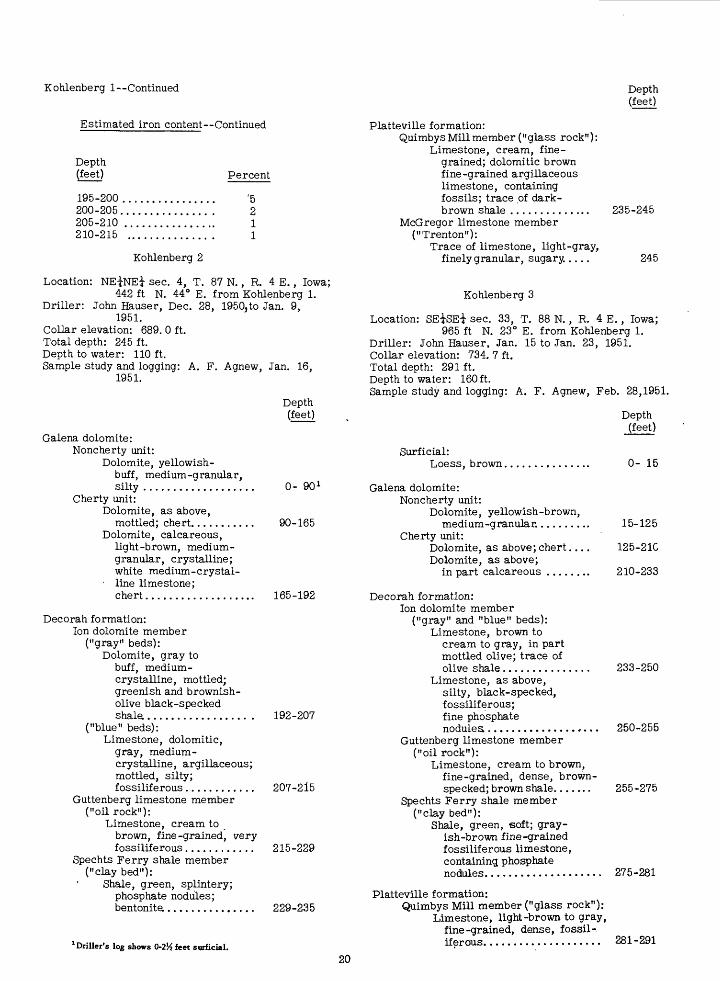
Kohlenberg I Continued
Estimated iron content Continued
Depth (feet)
Depth (feet)
195-200 200-205. 205-210 210-215
Kohlenberg 2
Percent
'5
2 1 1
Platteville formation:Quimbys Mill member ("glass rock"):
Limestone, cream, fine grained; dolomitic brown fine-grained argillaceous limestone, containing fossils; trace of dark- brown shale ..............
McGregor limestone member ("Trenton"):
Trace of limestone, light-gray, finely granular, sugary.....
235-245
245
Location: NE^NE-? sec. 4, T. 87 N., R. 4 E., Iowa;442 ft N. 44° E. from Kohlenberg 1.
Driller: John Hauser, Dec. 28, 1950,to Jan. 9,1951.
Collar elevation: 689. 0 ft. Total depth: 245 ft. Depth to water: 110 ft. Sample study and logging: A. F. Agnew, Jan. 16,
1951.
Galena dolomite:Noncherty unit:
Dolomite, yellowish- buff, medium-granular, silty .................
Cherty unit:Dolomite, as above,
mottled; chert.........Dolomite, calcareous,
light-brown, medium- granular, crystalline; white medium-crystal-
line limestone;chert.................
Depth (feet)
0- 90 1
90-165
165-192
Kohlenberg 3
Location: SEiSEi sec. 33, T. 88 N. , R. 4 E. , Iowa;965 ft N. 23° E. from Kohlenberg 1.
Driller: John Hauser, Jan. 15 to Jan. 23, 1951. Collar elevation: 734. 7 ft. Total depth: 291 ft. Depth to water: 160ft. Sample study and logging: A. F. Agnew, Feb. 28,1951.
Depth (feet)
Surficial:Loess, brown,
Galena dolomite:Noncherty unit:
Dolomite, yellowish-brown, medium-granular..........
Cherty unit:Dolomite, as above; chert....Dolomite, as above;
in part calcareous ........
0- 15
15-125
125-21C
210-233
Decorah formation:Ion dolomite member
("gray" beds):Dolomite, gray to
buff, medium- crystalline, mottled; greenish and brownish- olive black-specked shale.................. .
("blue" beds):Limestone, dolomitic,
gray, medium- crystalline, argillaceous; mottled, silty; fossiliferous............
Guttenberg limestone member ("oil rock"):
Limestone, cream to brown, fine-grained, very fossiliferous............
Spechts Ferry shale member ("clay bed"):
Shale, green, splintery; phosphate nodules; bentonite................
1 Driller's log shows 0-2% feet surficial.
192-207
207-215
215-229
229-235
Decorah formation:Ion dolomite member
("gray" and "blue" beds): Limestone, brown to
cream to gray, in part mottled olive; trace of olive shale............... 233-250
Limestone, as above, silty, black-specked, fossiliferous; fine phosphate nodules................... 250-255
Guttenberg limestone member ("oil rock"):
Limestone, cream to brown, fine-grained, dense, brown- specked; brown shale....... 255-275
Spechts Ferry shale member ("clay bed"):
Shale, green, soft; gray ish-brown fine-grained fossiliferous limestone, containing phosphate nodules.................... 275-281
Platteville formation:Quimbys Mill member ("glass rock"):
Limestone, light-brown to gray, fine-grained, dense, fossil-, iferous.................... 281-291
20
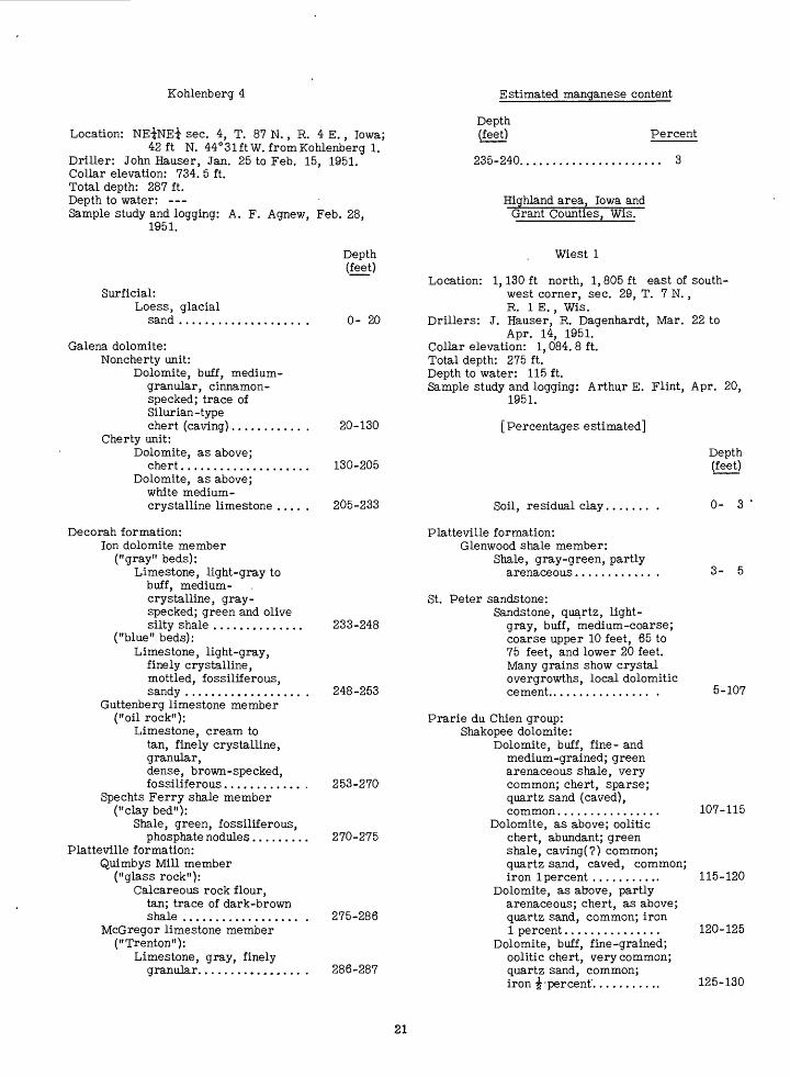
Kohlenberg 4 Estimated manganese content
Location: NEiNEi sec. 4, T. 87 N., R. 4 E., Iowa;42ft N. 44°31 ft W. from Kohlenberg 1.
Driller: John Hauser, Jan. 25 to Feb. 15, 1951. Collar elevation: 734. 5 ft. Total depth: 287 ft. Depth to water: Sample study and logging: A. F. Agnew, Feb. 28,
1951.
Depth (feet) Percent
235-240...................... 3
Highland area, Iowa and Grant Counties, Wis.
Surficial:Loess, glacial
sand .......
Depth (feet)
0- 20
Galena dolomite:Noncherty unit:
Dolomite, buff, medium- granular, cinnamon- specked; trace of Silurian-type chert (caving)...........
Cherty unit:Dolomite, as above;
chert...................Dolomite, as above;
white medium - crystalline limestone ....
Decorah formation:Ion dolomite member
("gray" beds):Limestone, light-gray to
buff, medium- crystalline, gray- specked; green and olive silty shale ..............
("blue" beds):Limestone, light-gray,
finely crystalline, mottled, fossiliferous, sandy ..................
Guttenberg limestone member ("oil rock"):
Limestone, cream to tan, finely crystalline, granular,dense, brown-specked, fossiliferous............
Spechts Ferry shale member ("clay bed"):
Shale, green, fossiliferous, phosphate nodules........
Platteville formation:Quimbys Mill member
("glass rock"):Calcareous rock flour,
tan; trace of dark-brown shale ..................
McGregor limestone member ("Trenton"):
Limestone, gray, finely granular................
Wiest 1
Location: 1,130 ft north, 1,805 ft east of south west corner, sec. 29, T. 7 N. , R. IE., Wis.
Drillers: J. Hauser, R. Dagenhardt, Mar. 22 to Apr. 14, 1951.
Collar elevation: 1, 084. 8 ft.Total depth: 275 ft.Depth to water: 115 ft.Sample study and logging: Arthur E. Flint, Apr. 20,
1951.
20-130
130-205
205-233
[Percentages estimated]
Soil, residual clay,
Platteville formation:Glenwood shale member:
Shale, gray-green, partly arenaceous............
Depth (feet)
0- 3
3- 5
233-248
248-253
253-270
270-275
275-286
286-287
St. Peter sandstone:Sandstone, quartz, light-
gray, buff, medium-coarse; coarse upper 10 feet, 65 to 75 feet, and lower 20 feet. Many grains show crystal overgrowths, local dolomitic cement................ .
Prarie du Chien group: Shakopee dolomite:
Dolomite, buff, fine- and medium-grained; green arenaceous shale, very common; chert, sparse; quartz sand (caved), common................
Dolomite, as above; oolitic chert, abundant; green shale, caving(?) common; quartz sand, caved, common; iron 1 percent ...........
Dolomite, as above, partly arenaceous; chert, as above; quartz sand, common; iron 1 percent...............
Dolomite, buff, fine-grained; oolitic chert, very common; quartz sand, common; iron -|'percent'...........
5-107
107-115
115-120
120-125
125-130
21
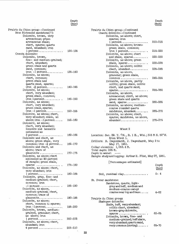
Depth (feet)
Prairie du Chien group--Continued New Richmond sandstone(?):
Dolomite, brown, veryarenaceous; greenarenaceous shale;chert, sparse; quartzsand, abundant; iron1 percent............... .
Oneota dolomite:Dolomite, brown,
fine- and medium-grained;chert, abundant;green shale and quartzsand, common;iron -1 percent...........
Dolomite, as above;chert, common;green shale andquartz sand, sparse;iron -7f percent...........
Dolomite, as above;chert, very abundant;green shale, common;iron 1 percent........... .
Dolomite, as above;chert, very abundant;green shale, sparse;iron -1 percent.......... .
Dolomite, as above; chert,very abundant; shale, asabove; iron -1 percent......
Dolomite, as above;chert, very abundant;limonite and hematiteestimated as3 percent............... .
Dolomite and chert, asabove; green shale, verycommon; iron -^ percent...
Dolomite and chert, asabove;trace ofglauconite .............. .
Dolomite, as above; chertestimated as 90 percentof sample; green shale,sparse ................ .
Dolomite, as above; chert,very abundant; iron1 percent.................
Dolomite, gray, fine- andmedium-grained; chert,common; iron-1 percent ............. .
Dolomite, as above,medium-grained; chert,common; trace ofglauconite................
Dolomite, as above;chert, common to sparse;iron -1 percent...........
Dolomite, brown, medium- grained, granular; chert,as above; ironI percent............... .
Dolomite, as above; chert,abundant; iron4 percent ................
130-135
135-140
140-145
145-150
150-155
155-160
160-165
165-170
170-175
175-180
180-185
185-190
190-195
195-200
200-205
205-210
Prairie du Chien group Continued Oneota dolomite Continued
Dolomite, as above; chert, sparse; iron 1 percent..................
Dolomite, as above; brown- green shale, common; iron 1 percent............ .
Dolomite, as above; chert and shale, sparse......... .
Dolomite, as above; green shale, sparse............ .
Dolomite, as above; oolitic chert, abundant............
Dolomite, as above, granular; green shale, common .................. .
Dolomite, as above, partly oolitic; green shale, oolitic chert, and quartz sand, sparse................... .
Dolomite, as above,arenaceous; chert, as above; green shale and quartz sand, sparse ..............
Dolomite, as above; medium- coarse rounded quartz sa'ndstone, abundant.........
Dolomite, as above; chert, sparse; sandstone, as above, abundant................. .
Depth (feet)
210-215
215-220
220-230
230-235
235-245
245-255
255-260
260-265
265-270
270-275
Wiest 2
Location:. Sec. 29. T. 7N., R. 1 E., Wis.; 315 ft S. 52°E.from Wiest 1.
Drillers: R. Dagenhardt, J. Dagenhardt, May 3 toMay 17, 1951.
Collar elevation: 1, 083. 4 ft. Total depth: 235 ft. Depth to water: Sample study and logging: Arthur E. Flint, May 27, 1951.
[Percentages estimated]
Soil, residual clay,
St. Peter sandstone:Sandstone, quartz, light-
gray and buff, medium and medium-coarse except coarse near top andbase..,
Depth (feet)
0- 4
4-62
Prairie du Chien group: Shakopee dolomite:
Shale, buff, very abundant; oolitic chert, abundant; brown- gray dolomite, sparse ..................
Dolomite, brown, fine- and medium-grained; buff shale, very abundant; quartz sahd, very common (caving)......
62-65
65-70
22
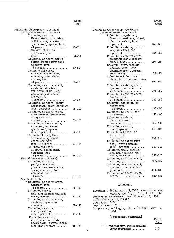
Depth (feet)
Depth (feet)
Prairie du Chien group Continued Shakopee dolomite Continued
Dolomite, as above,fine- and medium-grained; oolitic chert, abundant; quartz sand, sparse; iron-1 percent...............
Dolomite, chert, andquartz sand, asabove .................. .
Dolomite, as above; partlyoolitic chert; quartz sandas above; iron-1 percent ...............
Dolomite and chert, as above; quartz sand, common; green shale, sparse; iron-1 percent ...............
Dolomite, as above; chert,as above, abundant;red-brown shale, verycommon; quartz sand,sparse;iron1 percent................
Dolomite, as above, partlyarenaceous; chert, common;iron -1 percent............
Dolomite, as above; chert,very common; green shaleand quartz sand,sparse ................. .
Dolomite, nonarenaceous,and chert, as above;quartz sand, sparse;iron -1 percent'.......... .
Dolomite, brown, fine-and medium-grained;chert, common;iron +1 percent ..........
Dolomite and chert,as above; quartz sand,common; iron-1 percent ...............
New Richmond sandstone(?): Dolomite, as above,
partly arenaceous; green-brown arenaceous shale, common; chert, common; iron-1 percent.............. .
Oneota dolomite:* Dolomite, as above; chert,
abundant; iron-1 percent.............. .
Dolomite, brown,fine- and medium-grained; chert, common ...........
Dolomite, as above; chert, as above, sparse to common................ .
Dolomite, as above; chert, as above; iron -1 percent.......... .
Dolomite, as above; chert, abundant; red- brown shale, sparse to com mon; iron 3 percent ...... .
70-75
75-80
80-85
85-90
90-95
95-100
100-105
105-110
110-115
115-120
120-125
125-130
130-135
135-140
140-145
145-150
Prairie du Chien group Continued Oneota dolomite Continued
Dolomite, gray-brown, fine- and medium-grained; chert, abundant; iron5 percent.............. .
Dolomite, as above; chert, very abundant; iron6 percent............. .
Dolomite, as above; chert, abundant; iron 2 percent; trace of zinc ........... .
Dolomite, gray, medium- grained; chert, very abundant; iron 1.percent; trace of zinc............
Dolomite and chert, asabove; iron 1 percent; trace of zinc .................
Dolomite, as above; chert, sparse to common; iron
._ +1 percent............ .Dolomite, as above; chert,
sparse;, iron + 1 percent..............
Dolomite and chert, as above; iron-1 percent............ .
Dolomite, as above; iron-1 percent............. .
Dolomite, as above;chert, sparse tocommon.............. .
Dolomite, as above;chert, sparse.......... .
Dolomite and chert, asabove;iron1 percent...............
Dolomite, as above; grayshale, very common;iron -1 percent......... .
Dolomite, gray, medium- . grained, granular; grayshale, abundant..........
Dolomite, as above; chert,sparse................ .
Dolomite, as above; chert,sparse to common; iron\ percent ............. .
Dolomite, as above; chert,sparse................ .
150-155
155-160
160-165
165-170
170-175
175-180
180-185
185-190
190-195
195-200
200-205
205-210
210-215
215-220
220-225
225-230
230-235
Williams 1
Location: 1,455 ft north, 1, 700 ft west of southeast corner, sec. 31, T. 7 N., R. IE., Wis.
Driller: R. Dagenhardt, Feb. 22 to Mar. 5, 1951.Collar elevation: 1,116. 6 ft.Total depth: 330ft.Depth to water: 50 ft.Sample study and logging: Arthur'E. Flint, Mar. 10,
1951.
23
[Percentages estimated]
Soil, residual clay, weathered lime stone fragments.........
Depth (feet)
0-5
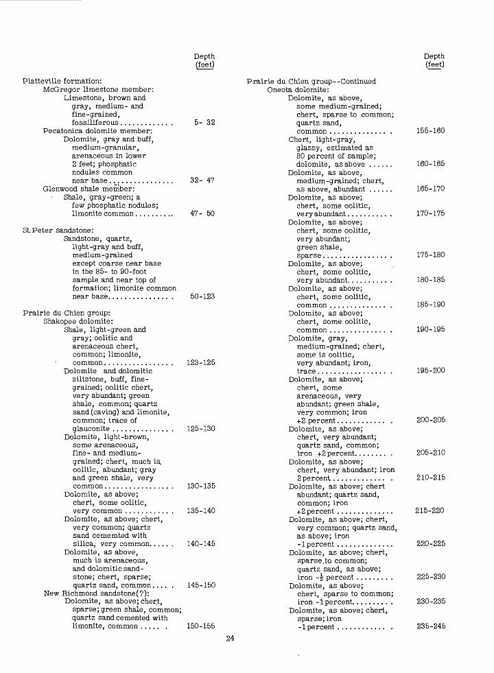
Depth (feet)
Depth (feet)
Platteville formation:McGregor limestone member:
Limestone, brown and gray, medium- and fine-grained, fossiliferous..........
Pecatonica dolomite member: Dolomite, gray and buff,
medium-granular, arenaceous in lower 2 feet; phosphatic nodules common near base.............
Glenwood shale member: Shale, gray-green; a
few phosphatic nodules; limonite common.......
5- 32
32- 47
47- 50
St Peter sandstone:Sandstone, quartz,
light-gray and buff, medium-grained except coarse near base in the 85- to 90-foot sample and near top of formation; limonite common near base............... .
Prairie du Chien group: Shakopee dolomite:
Shale, light-green and gray; oolitic and arenaceous chert, common; limonite, common................ .
Dolomite and dolomitic siltstone, buff, fine grained; oolitic chert, very abundant; green shale, common; quartz sand (caving) and limonite, common; trace of glauconite .............. .
Dolomite, light-brown, some arenaceous, fine- and medium- grained; chert, much is. oolitic, abundant; gray and green shale, very common................ .
Dolomite, as above; chert, some oolitic, very common ........... .
Dolomite, as above; chert, very common; quartz sand cememted with silica, very common......
Dolomite, as above, much is arenaceous, and dolomitic sand stone; chert, sparse; quartz sand, common.....
New Richmond sandstone(?):Dolomite, as above; chert,
sparse; green shale, common; quartz sand cemented with limonite, common ..... .
50-123
123-125
125-130
130-135
135-140
140-145
145-150
150-155
Prairie du Chien group--Continued Oneota dolomite:
Dolomite, as above,some medium-grained;chert, sparse to common;quartz sand,common .............. .
Chert, light-gray,glassy, estimated as80 percent of sample;dolomite, as above ......
Dolomite, as above,medium-grained; chert,as above, abundant ......
Dolomite, as above;chert, some oolitic,very abundant.......... .
Dolomite, as above;chert, some oolitic,very abundant;green shale,sparse................ .
Dolomite, as above;chert, some oolitic,very abundant.......... .
Dolomite, as above;chert, some oolitic,common .............. .
Dolomite, as above;chert, some oolitic,common .............. .
Dolomite, gray,medium-grained; chert,some is oolitic,very abundant; iron,trace................. .
Dolomite, as above;chert, somearenaceous, veryabundant; green shale,very common; iron+2 percent............ .
Dolomite, as above;chert, very abundant;quartz sand, common;iron +2 percent........ .
Dolomite, as above;chert, very abundant; iron2 percent............. .
Dolomite, as above; chertabundant; quartz sand,common; iron+2 percent ..............
Dolomite, as above; chert,very common; quartz sand,as above; iron-1 percent ..............
Dolomite, as above; chert,sparse,to common;quartz sand, as above;iron -j percent ........ .
Dolomite, as above;chert, sparse to common;iron -1 percent......... .
Dolomite, as above; chert,sparse;iron-1 percent ............ .
155-160
160-165
165-170
170-175
175-180
180-185
185-190
190-195
195-200
200-205
205-210
210-215
215-220
220-225
225-230
230-235
235-245
24
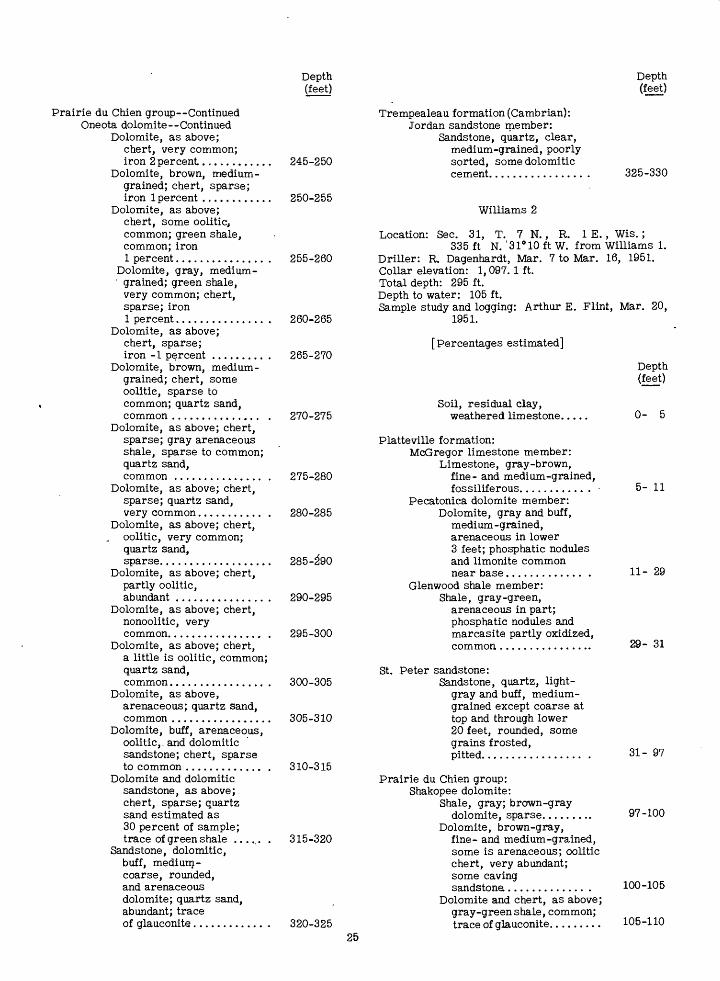
Prairie du Chien group Continued Oneota dolomite--Continued
Dolomite, as above; chert, very common; iron 2percent............
Dolomite, brown, medium- grained; chert, sparse; iron 1 percent ............
Dolomite, as above; chert, some oolitic, common; green shale, common; iron 1 percent............... .
Dolomite, gray, medium- grained; green shale,
very common; chert, sparse; iron 1 percent............... .
Dolomite, as above; chert, sparse; iron -1 percent ......... .
Dolomite, brown, medium- grained; chert, some oolitic, sparse to common; quartz sand, common ............... .
Dolomite, as above; chert, sparse; gray arenaceous shale, sparse to common; quartz sand, common ............... .
Dolomite, as above; chert, sparse; quartz sand, very common........... .
Dolomite, as above; chert, . oolitic, very common;
quartz sand, sparse...................
Dolomite, as above; chert, partly oolitic, abundant ............... .
Dolomite, as above; chert, nonoolitic, very common................ .
Dolomite, as above; chert, a little is oolitic, common; quartz sand, common................ .
Dolomite, as above,arenaceous; quartz sand, common .................
Dolomite, buff, arenaceous, oolitic,, and dolomitic sandstone; chert, sparse to common ............. .
Dolomite and dolomitic sandstone, as above;. chert, sparse; quartz sand estimated as 30 percent of sample; trace of green shale ...... .
Sandstone, dolomitic, buff, medium- coarse, rounded, and arenaceous dolomite; quartz sand, abundant; trace of glauconite............ .
Depth (feet)
245-250
250-255
255-260
260-265
265-270
270-275
275-280
280-285
285-290
290-295
295-300
300-305
305-310
310-315
315-320
Depth (feet)
Trempealeau formation (Cambrian): Jordan sandstone member:
Sandstone, quartz, clear, medium-grained, poorly sorted, some dolomitic cement................ 325-330
Williams 2
Location: Sec. 31, T. 7 N., R. 1 E., Wis.;335 ft N. '318 10 ft W. from Williams 1.
Driller: R. Dagenhardt, Mar. 7 to Mar. 16, 1951. Collar elevation: 1,097. 1 ft. Total depth: 295 ft. Depth to water: 105 ft. Sample study and logging: Arthur E. Flint, Mar. 20,
1951.
[Percentages estimated]
Soil, residual clay, weathered limestone.
Platteville formation:McGregor limestone member:
Limestone, gray-brown, fine- and medium-grained, fossiliferous........... .
Pecatonica dolomite member: Dolomite, gray and buff,
medium-grained, arenaceous in lower 3 feet; phosphatic nodules and limonite common near base............. .
Glenwood shale member: Shale, gray-green,
arenaceous in part; phosphatic nodules and marcasite partly oxidized, common,................
St. Peter sandstone:Sandstone, quartz, light-
gray and buff, medium- grained except coarse at top and through lower 20 feet, rounded, some grains frosted, pitted................. .
Depth (feet)
0- 5
5- 11
11- 29
29- 31
31- 97
320-32525
Prairie du Chien group: Shakopee dolomite:
Shale, gray; brown-graydolomite, sparse......... 97-100
Dolomite, brown-gray,fine- and medium-grained,some is arenaceous; ooliticchert, very abundant;some cavingsandstone............. . 100-105
Dolomite and chert, as above;gray-green shale, common;trace of glauconite......... 105-110
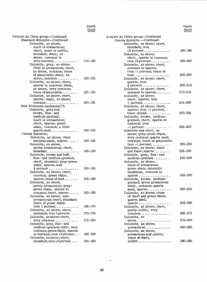
Prairie du Chien group Continued Shakopee dolomite Continued
Dolomite, as above, much is arenaceous; chert, some is oolitic, abundant; shale, as above, common to very common ..............
Dolomite, gray, as above, little is arenaceous; chert, as above, common; trace of glauconite; shale, as above,, common........... .
Dolomite, as above; chert, sparse to common; shale, as above, very common; trace of glauconite ........ .
Dolomite, as above; chert, sparse; shale, as above, common................. .
New Richmond sandstone(?):Dolomite, gray and
brown, fine- and medium-grained, much is arenaceous; chert, sparse; green shale, common; a little quartz sand............... .
Oneota dolomite;Dolomite, as above; chert
and gray shale, sparse..... .Dolomite, as above,
partly arenaceous; chert, abundant................. .
Dolomite, brown and buff, fine- and medium-grained; chert, abundant; gray-green shale, sparse; lead i percent ................ .
Dolomite, as above; chert, common; green shale, sparse; trace of lead....... .
Dolomite, as above,partly arenaceous; gray- green shale, sparse to common; chert, sparse......
Dolomite, as above, non- arenaceous; chert, abundant; trace of green shale; iron 1 percent..............
Dolomite, as above; chert, abundant; iron 1 percent.....
Dolomite, as above; chert, very common...............
Dolomite, gray, fine- and medium-grained; chert, very common; green shale, sparse to common; iron +3 percent...
Dolomite, as above; chert, abundant; iron+3 percent ....
Depth Depth (feet) (feet)
Prairie du Chien group Continued Oneota dolomite Continued
Dolomite, as above; chert, abundant; iron +2 percent ............... 190-195
Dolomite, as above:chert, sparse to common;
110-120 iron +2percent.......... . 195-200Dolomite, as above; chert,
common to sparse; iron -1 percent; trace of lead..................... 200-205
120-125 Dolomite, as above; chert,sparse; iron i percent............... . 205-210
Dolomite, as above; chert, 125-130 common to sparse........ 210-215
Dolomite, as above;chert, sparse; iron
130-135 1 percent.................. 215-220Dolomite, as above; chert,
sparse; iron -1 percent; trace of lead.............. 220-225
Dolomite, brown, medium- grained; chert, sparse to common; iron -1 percent ............. . 225-230
135-140 Dolomite and chert, asabove; gray-green shale, very common; quartz sand,
140-145 common; trace of glauconite;iron -1 percent.......... . 230-235
Dolomite, as above; chert 145-150 and shale;sparse........ . 235-240
Dolomite, gray, fine- andmedium-grained ........ . 240-245
Dolomite, as above;trace of arenaceous
150-155 green shale; dolomiticsandstone, common to sparse ................. . 245-250
155-160 Dolomite, brown, medium- grained; green arenaceous shale, common; quartz sand, sparse............ . 250-255
160-165 Dolomite, as above; traceof chert and green shale; quartz sand, sparse ................. . 255-265
165-170 Dolomite, as above; chert,partly oolitic, very
170-175 common............... . 265-275Dolomite, as
175-180 above.................. . 275-280Dolomite, as above,
arenaceous............... 280-290Dolomite, as above,
180-185 arenaceous and oolitic;trace of chert,
185-190 oolitic................... 290-295
26
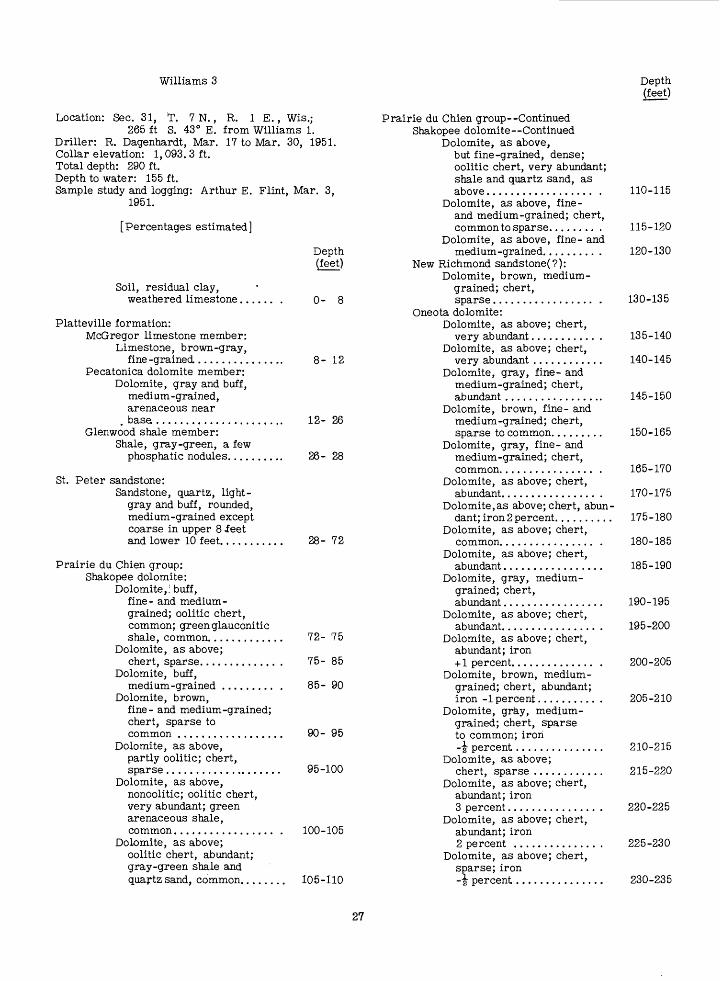
Williams 3
Location: Sec. 31, T. 7 N., R. IE., Wis.;265 ft S. 43° E. from Williams 1.
Driller: R. Dagenhardt, Mar. 17 to Mar. 30, 1951. Collar elevation: 1,093. 3 ft. Total depth: 290 ft. Depth to water: 155 ft. Sample study and logging: Arthur E. Flint, Mar. 3,
1951.
Depth (feet)
[Percentages estimated]
Soil, residual clay, weathered limestone,
Depth (feet)
0- 8
Platteville formation:McGregor limestone member:
Limestone, brown-gray, fine -grained ..........
Pecatonica dolomite member: Dolomite, gray and buff,
medium-grained, arenaceous near
. base .................Glenwood shale member:
Shale, gray-green, a few phosphatic nodules.....
12- 26
26- 28
St. Peter sandstone:Sandstone, quartz, light-
gray and buff, rounded, medium-grained except coarse in upper 8 feet and lower 10 feet....... 28- 72
Prairie du Chien group: Shakope'e dolomite:
Dolomite,; buff, fine- and medium- grained; oolitic chert, common; green glauconitic shale, common...........
Dolomite, as above;chert, sparse.............
Dolomite, buff,medium-grained .........
Dolomite, brown,fine- and medium-grained;chert, sparse tocommon ................
Dolomite, as above, partly oolitic; chert, sparse...................
Dolomite, as above,nonoolitic; oolitic chert, very abundant; green arenaceous shale, common.................
Dolomite, as above; oolitic chert, abundant; gray-green shale and quartz sand, common......
72- 75
75- 85
85- 90
90- 95
95-100
100-105
105-110
Prairie du Chien group Continued Shakopee dolomite Continued
Dolomite, as above,but fine-grained, dense; oolitic chert, very abundant; shale and quartz sand, as above.................. .
Dolomite, as above, fine- and medium-grained; chert, common to sparse........ .
Dolomite, as above, fine- and medium-grained......... .
New Richmond sandstone(?):Dolomite, brown, medium-
grained; chert, sparse................. .
Oneota dolomite:Dolomite, as above; chert,
very abundant........... .Dolomite, as above; chert,
very abundant ............Dolomite, gray, fine- and
medium-grained; chert, abundant .................
Dolomite, brown, fine- and medium-grained; chert, sparse to common.........
Dolomite, gray, fine- and medium-grained; chert, common................ .
Dolomite, as above; chert, abundant................ .
Dolomite,as above; chert, abun dant; iron 2 percent..........
Dolomite, as above; chert, common................ .
Dolomite, as above; chert, abundant.................
Dolomite, gray, medium- grained; chert, abundant.................
Dolomite, as above; chert, abundant................ .
Dolomite, as above; chert, abundant; iron + 1 percent.............. .
Dolomite, brown, medium- grained; chert, abundant; iron -1 percent.......... .
Dolomite, gray, medium- grained; chert, sparse to common; iron- § percent...............
Dolomite, as above;chert, sparse ............
Dolomite, as above; chert,abundant; iron3 percent............... .
Dolomite, as above; chert,abundant; iron2 percent .............. .
Dolomite, as above; chert,sparse; iron-i percent...............
110-115
115-120
120-130
130-135
135-140
140-145
145-150
150-165
165-170
170-175
175-180
180-185
185-190
190-195
195-200
200-205
205-210
210-215
215-220
220-225
225-230
230-235
27
Prairie du Chien ContinuedOneota dolomite Continued
Dolomite, gray, granular; chert, partly oolitic, sparse................
Dolomite, as above;trace of chert..........
Dolomite, brown, medium-grained, arenaceous; angular quartz sand, very abundant ..............
Dolomite, as above, nonarenaceous; quartz sand, as above, very abundant..........
Dolomite, as above;chert, abundant........
Dolomite, as above, partly oolitic; oolitic chert, abundant; quartz sand, sparse to common ..............
Dolomite, as above; partly oolitic chert, abundant; quartz sand, as above .........
Dolomite, as above, partly arenaceous and oolitic;chert and quartz sand, sparse ...............
Dolomite, as above, arenaceous and oolitic; oolitic chert, common; quartz sand, sparse; iron I percent..........
Dolomite, as above,arenaceous, glauconitic; chert and quartz sand, sparse.................
Depth (feet)
235-240
240-245
245-250
250-260
260-265
265-270
270-275
275-280
280-285
285-290
Depth (feet)
Williams 4
Location: Sec. 31, T. 7 N., R. 1 E., Wis.;525 ft S. 45°50 ft E. frpm Williams 1.
Driller: R. Dagenhardt, Apr. 6 to Apr. 17, 1951. Collar elevation: 1,080. 2 ft. Total depth: 280 ft. Depth to water: 145 ft. Sample study and logging: Arthur E. Flint, Apr. 20,
1951.
[Percentages estimated, except where assay values are indicated]
Soil, residual clay and chert........
Platteville formation:Glenwood shale member:
Shale, gray-green, oxidized in part to red .........
Depth (feet)
0- 8
8-1028
St. Peter sandstone:Sandstone, quartz, licrht-
gray and buff, rounded, many grains frosted, medium-grained except coarse in upper 10 feet and lower 8 feet, traces of white porcellaneous'chert in lower 30 feet (may be caved).....
Prairie du Chien group: Shakopee dolomite:
Shale, brown-buff;dolomite, buff,sparse................. .
Dolomite, brown,fine- and medium-grained;oolitic chert, sparse;quartz sand (caving)...... .
Dolomite, as above,partly arenaceous;chert, sparse;quartz sand, asabove ................... .
Dolomite, as above,fine- andmedium-grained ........ .
Dolomite, as above,partly oolitic; partlyoolitic chert,very common; brownshale, sparse.............
Dolomite, as above,nonoolitic; partlyoolitic chert,abundant............... .
Dolomite, as above,partly arenaceous;very oolitic chert,abundant; greenarenaceous shale,common................ .
Dolomite, as above,some very fine grained; partlyoolitic chert, abundant;quartz sand and greenshale, sparse tocommon ............... .
Dolomite, as above,partly arenaceous;quartz sand, sparse;trace of glauconite....... .
New Richmond sandstone(?): Dolomite, brown, partly
arenaceous, and dolomiticsandstone; green shale,sparse to common....... .
Oneota dolomite:Dolomite, brown, fine- and
medium-grained..........Dolomite, brown
and gray, medium -and fine -grained;chert, abundant......... .
Dolomite, as-above;chert, verycommon................ .
10- 56
56- 60
60- 65
65- 75
75- 80
80- 85
85- 90
90- 95
95-100
100-105
105-110
110-115
115-120
120-125

Prairie du Chien group--Continued Oneota dolomite--Continued
Dolomite, as above;chert, sparse; traceof lead .................
Dolomite, gray,medium-grained;chert, sparse.......... .
Dolomite, as above,fine- and medium-grained; glauconiticchert, abundant..........
Dolomite, brown,ve.i*y fine andmedi um - grained,partly arenaceous; chert,abundant.............. .
Dolomite, as above;chert, very abundant;iron 2 percent; leadif percent...............
Dolomite, as above;chert, very abundant;green shale, sparse;iron 2 percent;trace of lead............
Dolomite and chert, asabove; iron I percent;lead i percent...........
Dolomite, as above;chert, abundant; iron | percent; trace oflead.................. .
Dolomite and chert,as above; ironif percent...............
Dolomite, as above;chert, very common;iron f percent;trace of lead ............
Dolomite, gray, fine-and medium-grained;chert, sparse; traceof lead................ .
Dolomite, as above,medium-grained; chert,sparse..................
Dolomite, as above;chert, common tosparse; iron assayed12. 65 percent of sample;zinc assayedtrace................. .
Dolomite and chert,as above; iron8 percent ............. .
Dolomite and chert,as above; iron6 percent ............. .
Dolomite, as above;chert, sparse;iron 2 percent.......... .
Dolomite and chert,as above; iron1 percent............. .
Dolomite and chert,as above; iron 2 percent...
Depth (feet)
125-130
130-140
140-150
150-155
155-165
165-175
175-180
180-185
185-190
190-195
195-200
200-205
205-210
210-215
215-220
220-225
225-230
230-235
Depth (feet)
Prairie du Chien ContinuedOneota dolomite Continued
Dolomite, brown,medium-grained; chert,sparse;iron1 percent...............
Dolomite, asabove..................
Dolomite, as above; partly oolitic chert, very abundant...........
Dolomite, as above; chert and quartz sand, sparse to common ...............
Dolomite, as above; partly oolitic chert, common; quartz sand, sparse .................
Dolomite, as above; partly oolitic chert, common to sparse..................
Dolomite, brown, medium- grained, arenaceous, partly glauconitic; quartz sand common; trace of iron............
Dolomite, as above,arenaceous, and oolitic; partly oolitic chert, sparse; quartz sand, sparse.................
235-240
240-250
250-255
255-260
260-265
265-270
270-275
275-280
Williams 5
Location: Sec. 31, T. 7 N., R. IE., Wis.;860ft S. 46°45ftE. from Williams 1.
Driller: R. Dagenhardt, Apr. 18 to Apr. 28, 1951. Collar elevation: 1, 072. 2 ft. Total depth: 275 ft. Depth to water: 25 ft. Sample study and logging: Arthur E. Flint, Apr. 30,
1951.
[Percentages estimated]
Soil, alluvium, silt and fine quartz sand......
Depth (feet)
0- 5
St. Peter sandstone:Sandstone, quartz, light-
gray and buff, medium - grained exeept coarse in upper 5 feet, 35- to 50-foot sample, and lower 17 feet, rounded, some grains frosted, overgrowths on grains in upper 15 feet common............... 5-82
29
Depth (feet)
Depth (feet)
Prairie du Chien group: Shakopee dolomite:
Shale, green; oolitic chert, common; arenaceous fine- and medium- grained dolomite, sparse................ .
Dolomite, buff, fine- and medium-grained, arenaceous; oolitic chert, abundant; buff arenaceous shale, common; quartz sand (caving), common ..... .
Dolomite, brown, as above; oolitic chert, very common; quartz sand, sparse .......... .
Dolomite, as above; oolitic chert, sparse to common; green glauconitic shale, common; quartz sand, sparse .................
Dolomite, as above, partly arenaceous; chert and quartz sand, sparse; iron -1 percent..............
New Richmond sandstp,ne(?):Dolomite, as above;
green arenaceous shale, very common; quartz sand, sparse; iron +1 percent ..............
Oneota dolomite:Dolomite, as above;
chert, abundant; green shale, sparse; iron 1 percent...........
Dolomite, gray,nonarenaceous; chert, abundant; green shale, common; trace of lead ....................
Dolomite and chert, as above; shale, as above, sparse; trace of lead .................
Dolomite, as above; chert, sparse; quartz sand, sparse.......... .
Dolomite, as above, partly arenaceous; chert and shale, sparse .................
Dolomite, as above; chert, common to sparse; trace of lead ...................
Dolomite, gray, granular, medium- grained; green-brown shale, very common; chert, sparse; trace of glauconite; iron -^ percent.
82- 85
85- 90
90- 95
95-100
100-105
105-110
110-115
115-120
120-125
125-130
130-135
135-140
140-14530
Prairie du Chien group--Continued Oneota dolomite--Continued
Dolomite, brown, gray,fine- and medium -grained; chert,common ............... .
Dolomite, as above; chert,very abundant; greenshale, very common......
Dolomite, as above,partly medium-grained;chert, abundant; greenshale, common; iron2 percent............... .
Dolomite, as above;chert, very abundant; iron+ 1 percent.............. .
Dolomite, as above,medium-grained; chert,abundant; iron\ percent............... .
Dolomite and chert,as above ............... .
Dolomite, as above;chert, sparse........... .
Dolomite, gray, medium- grained; chert, sparse;iron4 percent.............
Dolomite, as above;iron 5 percent........... .
Dolomite, as above;iron 2 percent .......... .
Dolomite, gray-brown,medium-grained; iron+1 percent.............. .
Dolomite, gray, medium- grained; iron~\ percent...............
Dolomite, light-buff,medium-grained; whitedecomposed chert, sparse;iron \ percent........... .
Dolomite, brown-gray,medium-grained; chert,sparse ................. .
Dolomite, asabove.................. .
Dolomite, as above; ooliticchert, very common;green-brown arenaceousglauconitic shale, common;trace of glauconite....... .
Dolomite, brown, medium-grained, partly arenaceous;green glauconitic arenaceousshale, common...........
Dolomite, as above, arenaceousand oolitic; shale, as above,common; chert, sparse;iron -\ percent.......... .
Dolomite, as above, veryarenaceous and glauconitic;iron 2 percent.............
Dolomite, as above,arenaceous and oolitic;oolitic chert,sparse; iron-i percent ............. .
145-150
150-155
155-160
160-165
165-170
170-175
175-200
200-205
205-210
210-215
215-220
220-225
225-230
230-235
235-245
245-250
250-255
255-260
260-270
270-275
Steil 1
Location: 165 ft south, 1, 685 ft east of north west corner, sec. 6, T. 6 N., R. 1 E., Wis.
Driller: John Hauser, Feb. 22 to Mar. 1, 1951.Collar elevation: 1,119. 8 ft.Total depth: 350ft.Depth to water: 45 ft.Sample study and logging: Arthur E. Flint, Mar. 8,
1951.
Depth (feet)'
[Percentages estimated]
Depth (feet)
Soil, residual clay and weathered limestone (Quimbys Mill?) in lower 8 feet.................. 0-15
Platteville formation:McGregor limestone member:
Limestone, medium- gray, medium- grained 20 to 33 feet; otherwise fine- and very fine grained; fossiliferous .........
Pecatonica dolomite member: Dolomite, medium-
gray, weathers buff; quartz sand and phosphatic nodules at base...............
Glenwood shale member: Shale, gray-green,
arenaceous; limonite, phosphatic nodules, very common.........
15- 50
50- 61
61- 64St. Peter'sandstone:
Sandstone, quartz, light- gray, rounded, medium- fine except coarse in upper 10 feet and lower 15 feet................
Prairie du Chien group: Shakopee dolomite:
Shale, green, arenaceous 151 to 153 feet; gray- brown fine- and medium- grained dolomite; some arenaceous oolitic chert; glauconite, common._,....
Dolomite, as above, nonarenaceous; quartz sand (mostly caving), 15 percent of sample; trace of green shale................. .
Dolomite, as above, some arenaceous; oolitic chert, abundant........ .
Dolomite, as above; chert, a*s above, partly oolitic, abundant; sparse green shale and quartz sand (caving)...............
64-151
151-155
155-160
160-165
165-170
Prairie du Chien group--Continued Shakopee dolomite Continued
Dolomite, as above; chert, as above, some oolitic, common; quartz sand, sparse ........... .
New Richmond sandstone(?):Dolomite, buff and light
brownish-gray, fine- and very fine grained, partly arenacous; light-gray and light-yellow chert, much is oolitic, abundant; green shale, sparse; quartz sand, common ............... .
Oneota dolomite:Dolomite, buff, fine- and
medium-grained; partly oolitic chert, common; quartz sand, common (caving from New Richmond?); iron 1 percent.............
Dolomite, light -brown - gray, mainly fine-grained; chert, common.......... .
Chert, light-gray, 80 percent of sample; dolomite, as above.................. .
Dolomite, as above;chert, common.......... .
Dolomite, light brownish- gray, medium-grained; chert, abundant; quartz sand, sparse; iron 1 percent............... .
Dolomite, as above; chert, common; trace of glauconite .............. .
Dolomite, light brown- gray, fine- and medium- grained; chert, as above .................
Dolomite, light to medium brown-gray, medium- grained; chert, common; iron -1 percent......... .
Dolomite, as above;chert, abundant; quartz sand,common; iron1 percent................
Dolomite, as above; chert, as above, abundant; quartz sand, common; iron 3 percent.................
Dolomite and chert, as above; quartz sand and green shale, common; iron 3 percent.. ..........
Dolomite, as above; chert, abundant; quartz sand, common (part is caving); iron +1 percent.............. .
Dolomite, as above; chert,com- mon; quartz sand and green shale, sparse; iron -1percent.......... .
170-175
175-180
180-185
185-195
195-200
200-205
205-210
210-215
215-220
220-225
225-230
230-235
235-240
240-245
245-250
31

Depth (feet)
Depth (feet)
Prairie du Chien group Continued Oneota dolomite Continued
Dolomite, as above; chert, very common; yellow-buff shale and quartz sand (caving?), common; iron -1 percent ............ .
Dolomite, as above; chert, as above; quartz sand, as above;iron +2 percent..............
Dolomite, as above; chert, common; quartz sand, as above; iron +1 percent......... .
Dolomite, as above; chert and quartz sand, sparse to common; iron 1 percent ......... .
Dolomite, as above; chert and quartz sand,
, sparse ............... .Dolomite, as above;
green-gray shale, abundant;' trace of glauconite............. .
Dolomite, light- and medium -b rown, medium-grained; shale, as above, common .............. .
Dolomite, as above........Dolomite, as above;
chert, sparse.......... .Dolomite, as above;
chert, much is oolitic, very common............... .
Dolomite, as above; chert, very common............... .
Dolomite, as above; a little greenish-gray siltstone; chert, common ...............
Dolomite, as above; chert, sparse to common; quartz sand, very common ...........
Dolomite, as above, much is arenaceous and oolitic; oolitic chert, common; quartz sand, common; trace of glauconite............. .
Dolomite, as above, most is arenaceous and oolitic; arenaceous and oolitic chert, common; quartz sand, abundant; light-green shale, common .........
250-255
255-260
260-265
265-270
270-275
275-280
280-285 285-290
290-295
295-300
300-305
305-310
310-320
320-325
Prairie du Chien group Continued Oneota dolomite Continued
Dolomite, as above; chert, sparse; quartz sand, abundant; iron 3 percent ..........
Sandstone, quartz, fine to coarse-, poorly sorted; dolomite, arenaceous 20 percent of sample.,.............
330-335
335-337
Trempealeau formation:Jordan sandstone member:
Sandstone, quartz, fine to coarse, poorly sorted, in part dolomitic cemented............... 337-350
Steil 2
Location: Sec. 6, T. 6 N., R. IE., Wis., 245 ft N. 63°30 ft W. from Steil 1.
Driller: John Hauser, Mar. 3 to Mar. 16, 1951.Collar elevation: 1,113. 8 ft.Total depth: 325ft.Depth to water: 225 ft.Sample study and logging: Arthur E. .Flint, Mar. 18,
1951.
[Percentages estimated, except where assay values are indicated]
Soil, residual clay, decomposed buff limestone........... .
Platteville formation:McGregor limestone member:
Limestone, gray, weathers buff, fine- and medium- grained, fossiliferous,.....
Pecatonica dolomite member: Dolomite, medium-gray,
medium-grained, arenaceous near base ................... .
Glenwood shale member: Shale, grayish-green,
iron,common..............
Depth (feet)
0- 10
10- 37
37- 54
54- 56
St. Peter sandstone:Sandstone, quartz, rounded;
many grains frosted, pitted, medium-fine except coarse in upper 10 feet and medium- coarse in lower 12 feet .....
325-330
Prairie du Chien group: Shakopee dolomite:
Shale, light-buff; dolomite, buff, arenaceous; chert, sparse; limonite, common..
56-137
137-140
32

Depth (feet)
Depth (feet)
Prairie du Chien group Continued Shakopee dolomite Continued
Dolomite, brown-gray and buff, fine- and medium-grained; chert, much is oolitic, very common; quartz sand (caving), common.......
Dolomite, light-buff, some oolitic, very common; light-gray chert, much is oolitic, 70 percent of sample; glauconitic shale and quartz sand, sparse................
Dolomite, as above; partly oolitic chert, very common; traces of quartz sand and glauconite.............
Dolomite, as above,some arenaceous; chert, as above, very common; traces of quartz sand and green shale........
Dolomite, as above; chert, common; iron-1 percent; lead assayed 0. 45 percent...........
New Richmond sandstone(?):Dolomite, as above;
chert, common to sparse; shale and quartz sand, common; iron +1 percent; lead assayed 0. 6 percent............
Oneota dolomite:Dolomite, as above; some
chert; traces of glauconite; lead assayed 0. 5 percent.............
Dolomite as above; chert, as above; lead assayed (175 to 177|feet) 1. 25 percent; (177i-180 feet) 1. 20 percent...........
Dolomite, as above, medium-grained; chert, much is oolitic, very common; lead assayed (180 to 182| feet) 0. 5 percent; (182f to 185 feet) 0. 85 percent...........
Dolomite, as above; chert, common; lead 0. 25 percent......
Dolomite, as above; chert, common; iron-1 percent; trace of lead ..................
Dolomite, as above; chert, abundant.............. .
140-145
145-150
150-155
155-160
160-165
165-170
170-175
175-180
180-185
185-190
190-195
195-200
Prairie du Chien group Continued Oneota dolomite Continued
Dolomite, as above, a little is arenaceous; chert, sparse; trace of glauconite .............. .
Dolomite, light-brown, medium-grained; chert, abundant; iron 2 percent; trace of glauconite........
Dolomite, as above; chert, very abundant; iron 2 percent................
Dolomite, brown and medium-gray, medium- grained; chert very abundant; light-gray shale, common; iron 4-1 percent.............. .
Dolomite, as above; chert, common..................
Dolomite, gray, medium- grained; chert, common..................
Dolomite, as above; chert, sparse;trace of zinc ................... .
Dolomite, as above; chert, sparse; iron 4-1 percent.............. .
Dolomite, as above; trace of chert; iron1 percent................
Dolomite and chert,as above;trace ofiron ................... .
Dolomite and chert, as above;iron 4 percent.......... .
Dolomite and chert, asabove; iron 3 percent......
Dolomite, light-gray,granular; chert, sparse;iron 2 percent; trace ofzinc ................... .
Dolomite, brown-gray,medium-grained; chert,sparse;iron2 percent............... .
Dolomite, as above; chert, sparse; gray shale, sparse; iron 1 percent........... .
Dolomite, as above; chert, sparse; iron -1 percent; trace of zinc............. .
Dolomite, as above; chert, sparse; some gray- green shale............. .
Dolomite, brown,medium-grained......... .
Dolomite, as above........ .Dolomite, as above; but
partly oolitic and arena ceous; light-brown chert, common................ .
Dolomite, as above; chert, some is oolitic, common; quartz sand, 5 percent of sam ple; trace of glauconite ....
200-205
205-210
210-215
215-220
220-225
225-230
230-235
235-240
240-245
245-250
250-255
255-260
260-265
265-270
270-275
275-280
280-285
285-290 290-300
300-305
305-310
33
Depth (feet)
Depth (feet)
Prairie du Chien group--Continued Oneota dolomite--Continued
Dolomite, as above, much is oolitic, arenaceous, and glauconitic; oolitic and arenaceous chert, very common; quartz sand, 5 percent of sample ................
Dolomite, as above; chert, as above, common; quartz sand 10 percent of sample............... ,
Dolomite, brown,arenaceous; chert, as above (caving?), sparse; quartz sand 20 percent of sample..............
310-315
315-320
320-325
Note: Bottom of hole is at or very near the Cambrian-Ordovician boundary.
Steil 3
Location: Sec. 6, T. 6 N., R. 1 E., Wis.;210 ft S. 60° 33 ft E. from Steil 1.
Driller: John Hauser, Mar. 16 to Mar. 21, 1951. Collar elevation: 1,103. 7 ft. Total depth: 310ft. Depth to water: 200 ft. Sample study and logging: Arthur E. Flint, Mar. 25,
1951.
Prairie du Chien group: Oneota(?) dolomite:
Shale, light-gray and green; light-brown and gray chert, common; iron,common............ .
Dolomite, light-grayand light-brown, granular; light-brown and white chert, sparse to common; iron 4 percent............
Dolomite, as above;iron 3 percent.............
Dolomite, as above; chert, sparse; trace of glauconite. ............. .
Dolomite, as above; traces of chert and green shale............. .
Dolomite, as above; oolitic chert, common; glauconite, common in dolomite.................
Dolomite, light-brown, arenaceous, oolitic; traces of chert, green shale, and glauconite; quartz sand, sparse................. .
Dolomite, as above, but very arenaceous and glauconitic; oolitic chert, sparse; quartz sand, common; trace of green shale.......
264-266
266-270
270-275
275-280
280-290
290-295
295-305
305-310
[Percentages estimated]
Soil, residual clay and weathered limestone
Depth (feet)
0- 5
Platteville formation:McGregor limestone member:
Limestone, gray-brown, fine- and medium-grained, fossiliferous ........... 5-25
Pecatonica dolomite member: Dolomite, medium-gray,
weathered, buff, medium - grained................. 25- 42
Glenwood shale member: Shale, gray-green;
phosphatic nodules and iron, common........... 42- 43
St. Peter sandstone:Sandstone, light-gray
and buff, medium-grained,locally medium-coarse;gray-green shale, 150 to175 feet, abundant, andtraces in most samples;bright-red hematite occurswith much of shale; ironcommon in lowest3 feet................. . 43-264
Steil 4
Location: Sec. 6, T. 6 N., R. IE., Wis.;710 ft. S. '67° 30 ft E. from Steil 1.
Driller: R. Dagenhardt, Apr. 28 to May 4, 1951 Collar elevation: 1,073. 9 ft. Total depth: 230 ft. Depth to water: 155 ft. Sample study and logging: Arthur E. Flint, May 9,
1951.
[Percentages estimated]
Soil and residual clay.
Depth (feet)
0- 5
Platteville formation:Pecatonica dolomite member:
Dolomite, medium-gray, weathered, buff, medium -grained, some limonite mottling..............
Glenwood shale member: Shale, green;
traces of limonite and pyrite; a few quartz sand grains...............
5-18
18-2034
Depth (feet)
Depth (feet)
St. Peter sandstone:Sandstone, quartz,
light-gray, rounded, some frosting of grains, medium except coarse in upper 5+ feet, lower 7 to 8 feet and in sample 45 to 50 feet. ........... 20- 72
Prairie du Chien group: Shakopee dolomite:
Shale, light-buff and green; chert, brown, arenaceous; sandstone, quartz, common (caving?) .....
Dolomite, light-buff, fine-grained; light- gray oolitic chert, abundant; light-buff shale, common (caving); quartz sand (caving), common .............
Dolomite, as above, a little arenaceous; chert, sparse; traces of limonite and glaucoriite; quartz sand, sparse................
Dolomite, light-brown and buff, fine- and medium-grained; chert, sparse; limonite, glauconite, and quartz sand, as above...............
Dolomite, medium- gray-brown, fine- and medium-grained; chert, sparse..........
Dolomite, as above; light-gray oolitic chert, abundant; quartz sand, common ..............
Dolomite, as above, some arenaceous; chert, as above, some oolitic, abundant; green shale, common; a little quartz sand (partly caving).........
Dolomite, as above, some arenaceous; chert, as above, very common; shale, as above, common ..............
Dolomite, as above, some arenaceous; light-gray chert, much is oolitic, very common .........
72- 75
75- 80
80- 85
85-100
100-105
105-110
110-115
115-120
120-125
Prairie du Chien group Continued New Richmond sandstone(?):
Dolomite, as above,very arenaceous;shale, as above,common; quartz sand,10 percent ofsample................. ,
Oneota dolomite:Dolomite, light-buff
and light-brown,fine- and mediumgrained, a littlearenaceous; greenshale and quartzsard, sparse ............
Dolomite, as above,some medium-grained;traces of chert, shale,and quartzsand ....................
Dolomite, as above;chert, very abundant;trace ofiron....................
Dolomite, as above, fine-and medium-grained;chert as above, veryabundant; trace ofiron....................
Dolomite, as above;chert, as above, sparse;trace of iron............
Dolomite, light-gray,medium-grained; chert,as above, common; iron2 percent...............
Dolomite, as above;chert, very abundant;iron 7 percent..........
Dolomite, light-gray,very dense, fine-grained;chert, as above, common;iron 5 percent...........
Dolomite, brown, medium- grained; chert, abundant;iron 2 percent ...........
Dolomite, light- andmedium-gray, medium- grained; chert, as above,sparse; iron+ 1 percent..............
Dolomite, as above,medium-grained; chert,sparse; iron1 percent...............
Dolomite and chert,as above; iron+ 1 percent.............
Dolomite, as above;chert, sparse; ironi percent...............
Dolomite, as above;chert,sparse .................
125-130
130-135
135-140
140-145
145-150
150-160
160-165
165-170
170-175
175-180
180-185
185-190
190-200
200-205
205-210
35
Depth (feet)
Depth (feet)
Prairie du Chien group--Continued Oneota dolomite--Continued
Dolomite, gray-brown,medium-grained; chert,common;iron i percent.........
Dolomite, as above;chert, sparse tocommon; greenshale, sparse;quartz sand (caving?),common ..............
Dolomite, as above;chert, common........
Steil 5
210-220
220-225
225-230
Location: Sec. 6, T. 6 N., R. IE., Wis.;1,475 ft S. 74°32 ft E. from Steil 1.
Driller: R. Dagenhardt, May 4 to May 12, 1951. Collar elevation: 1, 070. 7 ft. Total depth: 235 ft. Depth to water: 135 ft. Sample study and logging: Arthur E. Flint, May 14,
1951.
[Percentages estimated]
Soil, residual clay, dolomite sand ...
Depth (feet)
0- 5
Platteville formation:Pecatonica dolomite member:
Dolomite, buff and gray, medium-grained, arenaceous at base .................
Glenwood shale member: Shale, gray-green;
phosphatic nodules, limonite and marcasite, common ..............
5- 24
24- 26
St. Peter sandstone:Sandstone, quartz,
light-gray and buff, medium except coarse near top and base............... 26-106
Prairie du Chien group: Shakopee dolomite:
Shale, green and light- buff; light-brown chert and light-brown dolomite, sparse .............
Dolomite, gray-brown-, fine- and medium- grained; quartz sand (caving), very common.............
106-110
110-115
Prairie du Chien group Continued Shakopee dolomite Continued
Dolomite, as above; brown oolitic chert, very abundant; trace of green shale....................
Dolomite, as above; chert, as above, partly oolitic, abundant; green shale, common; quartz sand, common .................
Dolomite, as above;chert, as above, common; quartz sand, common; iron -1 percent.......... .
New Richmond sandstone(?):Dolomite, as above, some
is arenaceous; dolomitic quartz sandstone, common; chert, as above, oolitic, abundant; quartz sand 30 percent of sample; iron +1 percent.............. .
Oneota dolomite:Dolomite, as above, a little
is arenaceous; chert, as above, a little is oolitic, common; brown and green shale, common; quartz sand 5 percent of sample; trace of glauconite.............. .
Dolomite, as above; chert, as above, common; traces of green shale and quartz sand................... .
Dolomite, as above; chert, sparse to common; shale and quartz sand, as above............... .
Dolomite, as above; chert, very abundant............
Dolomite, as above; chert, very abundant .......... .
Dolomite, as above, chert, sparse to common................ .
Dolomite, as above; chert, very abundant............... .
Dolomite, as above; chert, sparse to common................ .
Dolomite, brown, fine- and medium-grained; chert, abundant; iron 1 percent............... .
Dolomite, as above; chert, very abundant, iron + 1 percent.............. .
Dolomite, as above, medium- grained; chert, very abundant, iron 1 percent .............. .
115-120
120-125
125-130
130-135
135-140
140-145
145-150
150-155
155-160
160-165
165-170
170-175
175-180
180-185
185-190
36
Prairie da Chien ContinuedOneota dolomite Continued
Dolomite, as above; chert, very abundant; iron 1 percent.........
Dolomite, as above; fine- and medium- grained; chert, very abundant; iron 2 percent.............
Dolomite, as above, medium-grained; chert, sparse to common ..............
Dolomite, as above; chert, sparse; iron 1 percent .............
Dolomite, as abpve; chert, sparse; iron 9 percent .............
Depth (feet)
190-195
195-200
200-205
205-210
210-215
Depth (feet)
Prairie du Chien ContinuedOneota dolomite Continued
Dolomite, gray, medium- grained; chert, common;quartz sand 25 percentof sample; iron5'percent ...............
Dolomite, as above; cnert,sparse to common;quartz sand 25 percentof sample; iron4 percent...............
Dolomite, as above;chert, common;quartz sand 7 to8 percent of sample ;iron 2 percent ..........
Dolomite, as above;chert, sparse to common;iron 3 percent...........
215-220
220-225
225-230
230-235
37 IHT.-DOP. SET... WASH.. D.C.389J7
UNITED STATES DEPARTMENT OF THE INTERIOR GEOLOGICAL SURVEY
PREPARED IN COOPERATION WITH THE WISCONSIN GEOLOGICAL AND NATURAL HISTORY SURVEY CIRCULAR f»l PLATE 1
EXPLANATION
Om-* _i. /
Maquaketa shale
Og
Galena dolomite
Structure contour on top of chert, Galena dolomite Dashed where approximately located
Strike and dip of beds
Geologic contact, approximately locatedStrike and dip of joints
and strike of vertical joints
COUNTY COUNTY
Outcrop elevation at top of chert, Galena dolomite
Churn-drill hole Drilled by U. S. Geological Survey
e: number of hole 733.6: elevation at top of collar
57ft elevation at top of chert
*Q6O5 ,@732.O
6O7
H. H. GHER'S DIGGINGS
PROPERTY
GAYLOR PROPERTY
INDEX MAP SHOWING EXTENT OF PROPERTIES
MAP OF THE TETE DES MORTS AREA SHOWING THE LOCATION OF THE HOLESDRILLED BY THE U S. GEOLOGICAL SURVEY
DUBUQUE AND JACKSON COUNTIES, IOWA
Geology by Alien F Agnew and Arthur E.Flint, 1950
200 200 400 6OO F««t
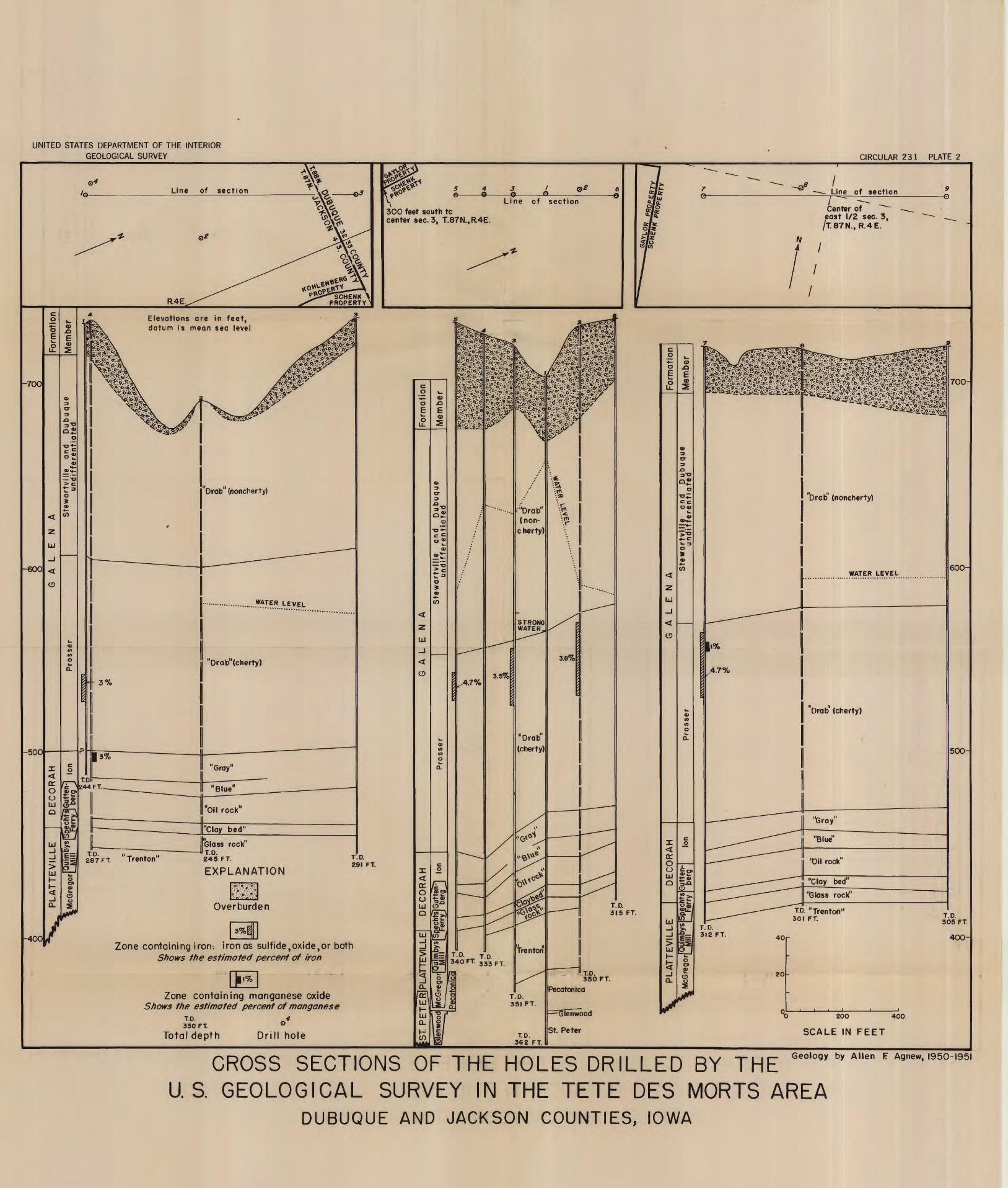
UNITED STATES DEPARTMENT OF THE INTERIOR GEOLOGICAL SURVEY CIRCULAR 231 PLATE 2
Center of east 1/2 sec. 3, T87N., R.4E.
300 feet south tocenter sec. 3, T.87N.,R.4E.
Elevations are in feet, datum is mean sea level
'"Drab"
(non-c herty)
Glass rock1T.D. 245 FT.
EXPLANATION"Clay bed1
rock"
Zone containing iron-, iron as sulfide,oxide,or both Shows the estimated percent of iron
Zone containing manganese oxide Shows the estimated percent of manganese
4 0 200 400
SCALE IN FEETTotal depth Drill hole
CROSS SECTIONS OF THE HOLES DRILLED BY THE U.S. GEOLOGICAL SURVEY IN THE TETE DES MORTS AREA
DUBUQUE AND JACKSON COUNTIES, IOWA

UNITED STATES DEPARTMENT OF THE INTERIOR GEOLOGICAL SURVEY
PREPARED IN COOPERATION WITH THE WISCONSIN GEOLOGICAL AND NATURAL HISTORY SURVEY
CIRCULAR 231 PLATE 3
EXPLANATION
Galena-Decorah and Platteville formation! undivided
Prairie du Chien groupZn..
MANNING DIGGINGS
OgdpGeologic contact
Dotted where concealed
INDEX MAP SHOWING EXTENT
OF PROPERTIES Outcrop elevation at top of St. Peter sandstone Elevation to the nearest foot
Churn-drill holeDrilled by the U. S Geological Survey
Shows elevation at top of St. Peter sandstone
Structure contour on top of St. Peter sandstone
HIGHLAN9O 90
Strike of vertical joints
Temporary bench mark and elevation Established by the U. S. Geological Survey
Mine shaft G: denotes shaft in Galena1 Decorah, and
Platteville formations Zn: denotes zinc; otherwise lead
Diggings Zn: denotes zinc; otherwise lead
// HORNSNOGGLE ft ..;. :..DIGGINGS
MAP OF HIGHLAND AREA SHOWING THE LOCATION OF THE HOLESDRILLED BY THE U. S. GEOLOGICAL SURVEY
GRANT AND IOWA COUNTIES, WISCONSIN
Geology by Arthur E. Flint, I960
1000 IOOO 2000 3000 Feet
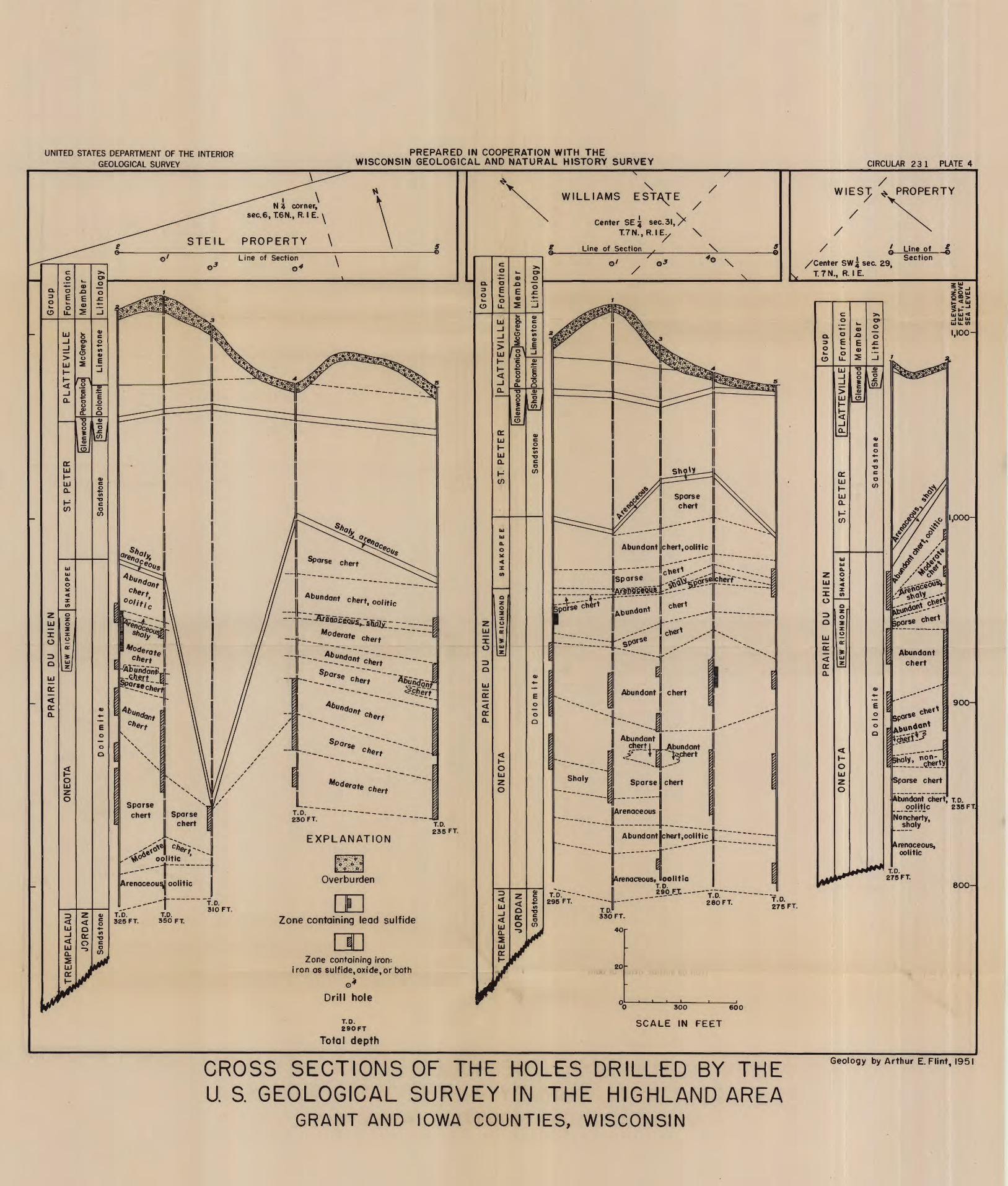
UNITED STATES DEPARTMENT OF THE INTERIOR GEOLOGICAL SURVEY
PREPARED IN COOPERATION WITH THE WISCONSIN GEOLOGICAL AND NATURAL HISTORY SURVEY CIRCULAR 231 PLATE 4
WIEST /
PROPERTYN 3 corner,
sec.6,T6N., R. I E. \
PROPERTY \
/Center SWsec. 29, T.7N., R. IE.
r~-4---"Abundant liehert,oolitic
chert, oolitic
Abundant chert
Sparse chert
Abundant chert, T.D. oolitic 235 FTSparse
chert II Sparse chert
Noncherty, shaly
230 FT.
EXPLANATION Abundant flchert,oolitic II Arenaceous,
oolitic
Arenaceous* Uoolitic T.D.29p_F_L_
T.D. T.D. 325 FT. 350 FT. Zone containing lead sulfide
Zone containing iron: iron as sulfide,oxide,or both
o 300 eoo
SCALE IN FEET
Total depth
CROSS SECTIONS OF THE HOLES DRILLED BY THE U. S GEOLOGICAL SURVEY IN THE HIGHLAND AREA
GRANT AND IOWA COUNTIES, WISCONSIN
Geology by Arthur E.Flint, 1951