EXHIBIT G California State Lands Commission Presurvey ... · Santa Cruz, CA 95060 Area: Goleta to...
57
EXHIBIT G California State Lands Commission Presurvey Notice Requirements for Permittees to Conduct Geophysical Survey Activities All parts of the Presurvey Notice must be adequately filled out and submitted to the CSLC staff a minimum of twenty-one (21) calendar days prior to the proposed survey date to ensure adequate review and approval time for CSLC staff. Note that one or more of the items may require the Permittee to plan well in advance in order to obtain the necessary documentation prior to the Notice due date (e.g., permits from other State or Federal entities).Please use the boxes below to verify that all the required documents are included in the Presurvey Notice. If "No" is checked for any item, please provide an explanation in the space provided. If additional space is needed, please attach separate pages. Please use the boxes below to verify that all the required documents are included in the Presurvey Notice. If "No" is checked for any item, please provide an explanation in the space provided. If additional space is needed, please attach separate pages. Yes No X □ Geophysical Survey Permit Exhibit F X □ Survey Location (including a full-sized navigation chart and GPS coordinates for each proposed track line and turning point) Explanation: ______________________________________________________ X □ Permit(s) or Authorization from other Federal or State agencies (if applicable) Explanation: X □ 21-Day Written Notice of Survey Operations to Statewide Geophysical Coordinator/ X □ U.S. Coast Guard Local Notice to Mariners/ X □ Harbormaster and Dive Shop Notifications Explanation: ______________________________________________________ X □ Marine Wildlife Contingency Plan Explanation: ______________________________________________________ X □ Oil Spill Contingency Plan Explanation: ______________________________________________________ X □ Verification of California Air Resources Board's Tier 2-Certified Engine Requirement Explanation: ______________________________________________________ X □ Verification of Equipment Service and/or Maintenance (must verify sound output) Explanation: ______________________________________________________ X □ Permit(s) or Authorization from California Department of Fish and Wildlife for surveys in or affecting Marine Protected Area(s) (if applicable). Explanation: .________________________________________________________________________________ NOTE: CSLC staff will also require verification that current biological information was obtained and transmitted as outlined in Section 5 of this permit.
-
Upload
vuongthuan -
Category
Documents
-
view
214 -
download
0
Transcript of EXHIBIT G California State Lands Commission Presurvey ... · Santa Cruz, CA 95060 Area: Goleta to...

EXHIBIT G
California State Lands Commission Presurvey Notice Requirements for Permittees to Conduct Geophysical Survey Activities
All parts of the Presurvey Notice must be adequately filled out and submitted to the CSLC staff a minimum of twenty-one (21) calendar days prior to the proposed survey date to ensure adequate review and approval time for CSLC staff. Note that one or more of the items may require the Permittee to plan well in advance in order to obtain the necessary documentation prior to the Notice due date (e.g., permits from other State or Federal entities).Please use the boxes below to verify that all the required documents are included in the Presurvey Notice. If "No" is checked for any item, please provide an explanation in the space provided. If additional space is needed, please attach separate pages.
Please use the boxes below to verify that all the required documents are included in the Presurvey Notice. If "No" is checked for any item, please provide an explanation in the space provided. If additional space is needed, please attach separate pages.
Yes No
X □ Geophysical Survey Permit Exhibit F
X □ Survey Location (including a full-sized navigation chart and GPS coordinates for each proposed track line and turning point)
Explanation: ______________________________________________________
X □ Permit(s) or Authorization from other Federal or State agencies (if applicable) Explanation:
X □ 21-Day Written Notice of Survey Operations to Statewide Geophysical Coordinator/
X □ U.S. Coast Guard Local Notice to Mariners/
X □ Harbormaster and Dive Shop Notifications Explanation: ______________________________________________________
X □ Marine Wildlife Contingency Plan
Explanation: ______________________________________________________
X □ Oil Spill Contingency Plan Explanation: ______________________________________________________ X □ Verification of California Air Resources Board's Tier 2-Certified Engine Requirement Explanation: ______________________________________________________ X □ Verification of Equipment Service and/or Maintenance (must verify sound output) Explanation: ______________________________________________________ X □ Permit(s) or Authorization from California Department of Fish and Wildlife for surveys in
or affecting Marine Protected Area(s) (if applicable). Explanation: .________________________________________________________________________________ NOTE: CSLC staff will also require verification that current biological information was obtained and
transmitted as outlined in Section 5 of this permit.


EXHIBIT F
PRESURVEY NOTIFICATION FORM
Applicant/Permittee's Mailing Address: Date: 4/25/2014
George Tate Jurisdiction: Federal ____ State ___ Both X
USGS Pacific Coastal and Marine Geology If State: Permit #PRC 8394 400 Natural Bridges Drive Region: II Santa Cruz, CA 95060 Area: Goleta to Pt. Sal, CA
GEOPHYSICAL SURVEY PERMIT
Check one: X New survey ___ Time extension of a previous survey
U.S.G.S. Pacific Coastal and Marine Geology (Applicant/Permittee) will conduct a geophysical survey offshore California in the survey area outlined on the accompanying navigation chart segment. If you foresee potential interference with commercial fishing or other activities, please contact the person(s) listed below:
FEDERAL WATERS (outside 3 nautical miles) 1) Applicant's representative: 2) Federal representative: (e.g., Bureau of Ocean Energy Management [BOEM] or National
Science Foundation [NSF]) NOTE: Any comments regarding potential conflicts in Federal waters must be received by the
Applicant's Representative and lead Federal agency within ten (10) days of the receipt of this notice.
STATE WATERS (Inside 3 nautical miles) 1) Permittee's representative: 2) CSLC representative: Richard Greenwood NOTE: Any comments regarding potential conflicts in State waters should be received as soon as possible by the Permittee's representative, no more than fifteen (15) days after the receipt of this notice.
1. Expected Date of Operation: July 17-August 2, 2014
2. Hours of Operation: 24 hours; 7AM to 7PM for sparker and magnetometer; 7PM to 7AM for magnetometer only
(passive) 3. Vessel Name: R/V Shearwater 4. Vessel Official Number: NOAA Hull# R6201, MMSI 366875280 5. Vessel Radio Call Sign: WDB2424 6. Vessel Captain's Name: Terence Shinn and Charles Lara
7. Vessel will monitor Radio Channel(s): 12,16 8. Vessel Navigation System: Differential GPS

9. Equipment to be used:
1. Edgetech Applied Acoustics CSP 700 Sparker a. Frequency (Hz, kHz): 800-850 Hz
b. Source level: (dB re 1 μPa at 1 meter (m) (rms): 202 dB RMS
c. Number of beams, across track beam width, and along track beam width: 1 beam, omnidirectional
d. Pulse rate and length: 250-750 milliseconds depending on depth; 350 μ seconds pulse length.
e. Rise time: 7 μ seconds
f. Estimated distances to the 190 dB, 180 dB, and 160 dB re 1 uPa (rms) isopleths, 190 dB: 3M ; 180 dB: 12M ; 160 dB: 130M *
g. Deployment depth: 1 m
h. Tow speed: 4.5 knots i. Approximate length of cable tow: 30 m.
*These estimates are based on the underwater sound propagation equation:
RSPL= SL-20log (R/Ro)-AR, where
RSPL=recieved sound potential level
SL= RMS source level re. 1 uPa (rms) based on manufacturer's specifications R= Distance Ro= Reference Distance (1 m)
A= sound absorption coefficient
2. Geometrics G-882 Cesium Vapor Marine Magnetometer (passive sensor) a. Frequency (Hz, kHz): 0
b. Source level: (dB re 1 μPa at 1 meter (m) (rms): 0
c. Number of beams, across track beam width, and along track beam width: None.
d. Pulse rate and length: None
e. Rise time: N/A
f. Estimated distances to the 190 dB, 180 dB, and 160 dB re 1 uPa (rms) isopleths, 190 dB: N/A ; 180 dB: N/A ; 160 dB: N/A
g. Deployment depth: 5-10m.
h. Tow speed: 8 knots
i. Approximate length of cable tow: 30-50 m.

Applicant's Representative: George Tate US Geological Survey 400 Natural Bridges Drive Santa Cruz, CA 95060 831-460-7484
California State Lands Representative: Richard B. Greenwood Statewide Geophysical Coordinator 200 Oceangate, 12th Floor Long Beach, CA 90802-4331 (562) 590-5201
BOEM Representative: Joan Barminski Chief, Office of Reservoir & Production 770 Paseo Camarillo Camarillo, CA 93010 (805) 389-7707
adsfkj

The survey area is bounded by the coordinates:
34.8902 -120.6418 34.7650 -120.6314 34.6999 -120.6052 34.5640 -120.6381 34.4470 -120.4556 34.4660 -120.1922 34.3981 -120.1885 34.3740 -120.4488 34.5110 -120.7196 34.6434 -120.7640 34.6640 -120.7174 34.8596 -120.7752
The track line coordinates are:
Line Number Start Line End Line North0001 34.8585 -120.7710 34.8862 -120.6483 North0002 34.8776 -120.6456 34.8500 -120.7683 North0003 34.8413 -120.7621 34.8701 -120.6345 North0004 34.8627 -120.6263 34.8336 -120.7574 North0005 34.8252 -120.7545 34.8543 -120.6230 North0006 34.8453 -120.6221 34.8169 -120.7498 North0007 34.8084 -120.7453 34.8353 -120.6245 North0008 34.8254 -120.6282 34.8001 -120.7418 North0009 34.7913 -120.7386 34.8166 -120.6254 North0010 34.8066 -120.6278 34.7828 -120.7351 North0011 34.7740 -120.7335 34.7972 -120.6303 North0012 34.7870 -120.6346 34.7648 -120.7338 North0013 34.7548 -120.7356 34.7766 -120.6393 North0014 34.7661 -120.6420 34.7453 -120.7346 North0015 34.7368 -120.7308 34.7557 -120.6473 North0016 34.7481 -120.6391 34.7285 -120.7273 North0017 34.7197 -120.7241 34.7386 -120.6391 North0018 34.7306 -120.6337 34.7115 -120.7200 North0019 34.7029 -120.7162 34.7242 -120.6203 North0020 34.7161 -120.6152 34.6942 -120.7136 North0021 34.6856 -120.7102 34.7076 -120.6111 North0022 34.6986 -120.6114 34.6762 -120.7117 North0023 34.6657 -120.7144 34.6884 -120.6138 North0024 34.6782 -120.6163 34.6455 -120.7600 North0025 34.6365 -120.7590 34.6678 -120.6206 North0026 34.6576 -120.6253 34.6276 -120.7592 North0027 34.6174 -120.7629 34.6474 -120.6296 North0028 34.6375 -120.6320 34.6083 -120.7610 North0029 34.5994 -120.7603 34.6268 -120.6379 North0030 34.6166 -120.6429 34.5911 -120.7571 North0031 34.5823 -120.7542 34.6048 -120.6531
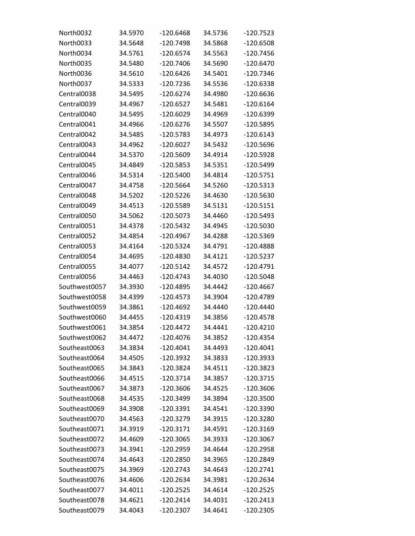
North0032 34.5970 -120.6468 34.5736 -120.7523 North0033 34.5648 -120.7498 34.5868 -120.6508 North0034 34.5761 -120.6574 34.5563 -120.7456 North0035 34.5480 -120.7406 34.5690 -120.6470 North0036 34.5610 -120.6426 34.5401 -120.7346 North0037 34.5333 -120.7236 34.5536 -120.6338 Central0038 34.5495 -120.6274 34.4980 -120.6636 Central0039 34.4967 -120.6527 34.5481 -120.6164 Central0040 34.5495 -120.6029 34.4969 -120.6399 Central0041 34.4966 -120.6276 34.5507 -120.5895 Central0042 34.5485 -120.5783 34.4973 -120.6143 Central0043 34.4962 -120.6027 34.5432 -120.5696 Central0044 34.5370 -120.5609 34.4914 -120.5928 Central0045 34.4849 -120.5853 34.5351 -120.5499 Central0046 34.5314 -120.5400 34.4814 -120.5751 Central0047 34.4758 -120.5664 34.5260 -120.5313 Central0048 34.5202 -120.5226 34.4630 -120.5630 Central0049 34.4513 -120.5589 34.5131 -120.5151 Central0050 34.5062 -120.5073 34.4460 -120.5493 Central0051 34.4378 -120.5432 34.4945 -120.5030 Central0052 34.4854 -120.4967 34.4288 -120.5369 Central0053 34.4164 -120.5324 34.4791 -120.4888 Central0054 34.4695 -120.4830 34.4121 -120.5237 Central0055 34.4077 -120.5142 34.4572 -120.4791 Central0056 34.4463 -120.4743 34.4030 -120.5048 Southwest0057 34.3930 -120.4895 34.4442 -120.4667 Southwest0058 34.4399 -120.4573 34.3904 -120.4789 Southwest0059 34.3861 -120.4692 34.4440 -120.4440 Southwest0060 34.4455 -120.4319 34.3856 -120.4578 Southwest0061 34.3854 -120.4472 34.4441 -120.4210 Southwest0062 34.4472 -120.4076 34.3852 -120.4354 Southeast0063 34.3834 -120.4041 34.4493 -120.4041 Southeast0064 34.4505 -120.3932 34.3833 -120.3933 Southeast0065 34.3843 -120.3824 34.4511 -120.3823 Southeast0066 34.4515 -120.3714 34.3857 -120.3715 Southeast0067 34.3873 -120.3606 34.4525 -120.3606 Southeast0068 34.4535 -120.3499 34.3894 -120.3500 Southeast0069 34.3908 -120.3391 34.4541 -120.3390 Southeast0070 34.4563 -120.3279 34.3915 -120.3280 Southeast0071 34.3919 -120.3171 34.4591 -120.3169 Southeast0072 34.4609 -120.3065 34.3933 -120.3067 Southeast0073 34.3941 -120.2959 34.4644 -120.2958 Southeast0074 34.4643 -120.2850 34.3965 -120.2849 Southeast0075 34.3969 -120.2743 34.4643 -120.2741 Southeast0076 34.4606 -120.2634 34.3981 -120.2634 Southeast0077 34.4011 -120.2525 34.4614 -120.2525 Southeast0078 34.4621 -120.2414 34.4031 -120.2413 Southeast0079 34.4043 -120.2307 34.4641 -120.2305

Southeast0080 34.4653 -120.2196 34.4059 -120.2198 Southeast0081 34.4075 -120.2089 34.4655 -120.2087 Southeast0082 34.4656 -120.1978 34.4082 -120.1980

Regional Area Map


US Geological Survey - Pacific Coastal and Marine Science Center Marine Wildlife Mitigation Plan - Gaviota to Point Sal, CA
1
Marine Wildlife Mitigation Plan California Seafloor Mapping Program Bathymetric Survey
Gaviota to Point Sal, CA.
(July 14 - August 2, 2014)
1.0 INTRODUCTION
This marine wildlife mitigation plan is prepared in compliance with the USGS Pacific Coastal and Marine Science Center's existing State Geophysical Permit PRC 8394. This plan is intended to provide guidance to USGS vessel operators and scientific field personnel collecting geophysical data for the Pacific Coastal and Marine Science Center (PCMSC) in Santa Cruz, CA to avoid significant impacts to marine wildlife that may occur during regular geophysical surveys.
1.1 Regulatory Basis
Species that are either currently in danger or soon likely to be in danger of extinction throughout all or a portion of its range are protected by the Endangered Species Act of 1973. The United States Fish and Wildlife Service (USFWS), and the National Oceanic and Atmospheric Administration (NOAA) National Marine Fisheries Service (NMFS) implement the Endangered Species Act. During the consultation with NMFS to issue a permit for the offshore geophysical survey, it was determined no incidental take permits are required to use the equipment identified in this document to conduct scientific data acquisition in federal waters offshore of the California coast.
1.2 Geophysical Survey Purpose and Objectives
The USGS Pacific Coastal and Marine Science Center (PCMSC) will collect geophysical data (high-resolution seismic-reflection, magnetometer) data, primarily in California's State Waters, along the mainland coast between Gaviota and Point Sal. The work is being conducted to support the large, collaborative partnership of the California Seafloor Mapping Program (CSMP; (http://walrus.wr.usgs.gov/mapping/csmp/). USGS CSMP work is partly funded by the California Ocean Protection Council, and collaborating State agencies have included the California Coastal Conservancy, California Geological Survey, and California Department of Fish and Wildlife. On the federal side, CSMP's partners include NOAA National Marine Fisheris Service, NOAA National Marine Sanctuaries, NOAA Office of Coast Surveys, National Park Service, and Bureau of Ocean Energy Management.
CSMP data and map products serve many purposes, providing critical data for informed
decision making and all facets of coastal and marine spatial planning. Examples of recent CSMP products include:
http://pubs.usgs.gov/sim/3281/ (Set of 11 maps and pamphlet for Offshore of Santa Barbara area; also see USGS SIMs 3225, 3254, and 3261) http://pubs.usgs.gov/ds/781/OffshoreSantaBarbara/data_catalog_offshoresantabarbara.

US Geological Survey - Pacific Coastal and Marine Science Center Marine Wildlife Mitigation Plan - Gaviota to Point Sal, CA
2
html (catalog of GIS layers) http://dev.axiomalaska.com/maps/search/usgs.html (groundtruthing imagery for all of California's State Waters) Data to be collected in this proposed survey will complete CSMP data collection in
central California. This baseline information will be specifically used to monitor change, characterize habitats, assess geologic hazards (sea-level rise, coastal erosion, earthquakes, tsunamis), and aid regional sediment management. The work and databases will also stimulate and enable new research and enhance public education and awareness.
This CSMP survey specifically addresses two broad areas: Climate Change and Habitat Characterization: This work establishes geophysical baselines for monitoring future change. For example, high-resolution, seismic reflection data provide data to map broad areas of the seafloor where sediment cover is exceedingly thin (< 1 m) and capable of being mobilized under different climatic conditions, leading to expansion or reduction of rocky habitat. Marine Zoning Monitoring: Information on geologic framework (including sediment distribution and thickness) and geologic hazards (such as potential earthquake and tsunami sources) is fundamental to all coastal and marine spatial planning activities.
PCMG will contact the NOAA Long Beach Office staff and local whale-watching operations to acquire information on the current composition and relative abundance of marine wildlife offshore as well as any pinniped haul out sites. Whale activity is moderate at the moment. Additionally, one day prior to survey activities, the NOAA Long Beach office, local whale watching operations will be contacted to get an update on marine wildlife sightings in the area. This information will be conveyed to the captain and crew prior to the survey.
The survey area will enter the Vandenberg and Point Conception State Marine Reserves and the Kashtayit State Marine Conservation Area. Permit applications for operations in these areas have been submitted to the California Department of Fish and Game.
A review of environmental responsibility of project operations will be conducted by the chief scientist in charge of the survey operations prior to commencing the first day of operations. When new personnel will be in the crew, this training will be repeated at least for those new to the crew. They will be made aware of their individual responsibility and will be shown how to be aware of possible environmental impacts and how to mitigate them during the geophysical survey operations. Information relating to seasonality, as an indication of the types of animals that might be in our survey area, at the time of survey work will also be presented to the crew. A copy of this document will be provided to the crew of our survey vessel.
All personnel will be expected to be consistently aware that they are to be alert to any presence of marine wildlife while they are performing their duties. There are a number of signs/indications of marine wildlife presence and each crew member will be responsible to maintain vigilance for those signs within the constraints of their project duties. Some of those indications are:

US Geological Survey - Pacific Coastal and Marine Science Center Marine Wildlife Mitigation Plan - Gaviota to Point Sal, CA
3
a. Sounds - such as splashing, vocalizations (by animals and birds), and blowing (breathing).
b. Visual indications - birds aggregating, changes in water character such as areas of rippled water, white water caused by splashing, changes in color or shape of the ocean surface,
1.3 Survey Schedule and Layout
The survey is scheduled to commence field activities on July 14 and is expected to conclude August 2, 2014. The survey will be conducted aboard the R/V Shearwater, departing out of Morro Bay harbor and will terminate no later than August 2 in Santa Barbara, CA. The regional map of the survey area is shown in Figure 2. This time period for the survey was chosen because historical wave height data shows that the significant wave height during July and August are most favorable for small vessel marine operations. The mean significant wave heights for July and August are 1.5m with mean peak heights of about 3m (Figure 1). While average mean Spring and Fall significant wave heights in this area are about 2-2,5 m, the peaks can range from 5-7.5m which is unsafe for sustained small vessel operations.
Figure 2. Historical significant wave heights at Point Conception.

US Geological Survey - Pacific Coastal and Marine Science Center Marine Wildlife Mitigation Plan - Gaviota to Point Sal, CA
4
Figure 2. Regional Map of Survey Area
US Geological Survey - Pacific Coastal and Marine Science Center Marine Wildlife Mitigation Plan - Gaviota to Point Sal, CA
5
2.0 Survey Equipment and Activities
The survey vessel will be the R/V Shearwater, a 62 foot long, aluminum-hulled catamaran owned and operated by NOAA Channel Islands National Marine Sanctuary (CINMS). High resolution sub bottom profile data will be collected using a chirp sub bottom profiler during daylight hours, and a towed marine magnetometer during night time hours.
The USGS is specifically requesting authorization to conduct night time passive magnetometer data collection operations. The USGS is also requesting that survey operations be extended from 10 hours to 12 hours because of the extended daylight hours at this time of year. Other operations of this type are generally conducted aboard the USGS R/V Park Snavely, a similar but smaller vessel with no overnight crew berthing capabilities. These operations are always exclusively day operations with the crew returning to port daily for lodging. For the operations described in this notice, the USGS has contracted with NOAA CINMS to conduct these operations aboard their vessel that can accommodate overnight crew berthing because the size of the study area precludes daily transits to and from the nearest harbors at Morro Bay and Santa Barbara. The extended summer daylight hours will allow active source operations to be conducted for 12 hours during full daylight. This extended daily operation will result in the reduction of the total length of survey operation by three sea days.
PCMG proposes to use the following equipment to collect the required data:
• Applied Acoustics CSP-700 Marine Sparker (active source)
• Geometrics G882 Marine Magnetometer (passive sensor)
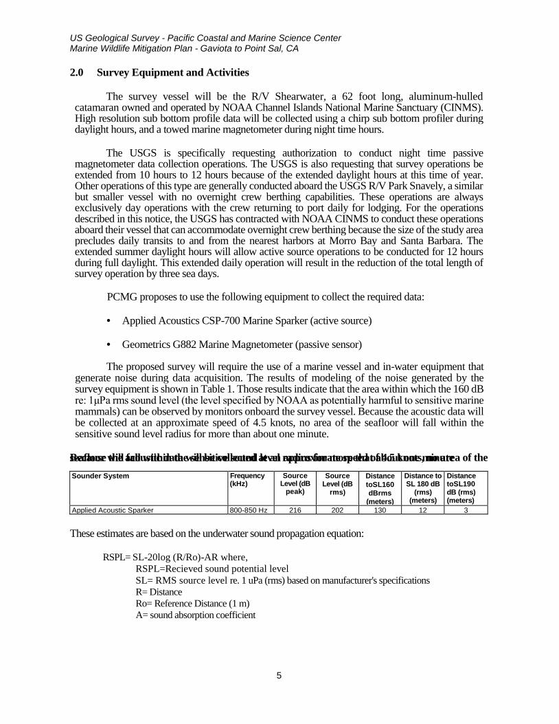
The proposed survey will require the use of a marine vessel and in-water equipment that generate noise during data acquisition. The results of modeling of the noise generated by the survey equipment is shown in Table 1. Those results indicate that the area within which the 160 dB re: 1μPa rms sound level (the level specified by NOAA as potentially harmful to sensitive marine mammals) can be observed by monitors onboard the survey vessel. Because the acoustic data will be collected at an approximate speed of 4.5 knots, no area of the seafloor will fall within the sensitive sound level radius for more than about one minute.
Because the acoustic data will be collected at an approximate speed of 4.5 knots, no area of the seafloor will fall within the sensitive sound level radius for more that about one minute
Sounder System Frequency (kHz)
Source Level (dB
peak)
Source Level (dB
rms)
Distance toSL160 dBrms
(meters)
Distance to SL 180 dB
(rms) (meters)
Distance toSL190 dB (rms) (meters)
Applied Acoustic Sparker 800-850 Hz 216 202 130 12 3
These estimates are based on the underwater sound propagation equation: RSPL= SL-20log (R/Ro)-AR where,
RSPL=Recieved sound potential level SL= RMS source level re. 1 uPa (rms) based on manufacturer's specifications R= Distance Ro= Reference Distance (1 m) A= sound absorption coefficient

US Geological Survey - Pacific Coastal and Marine Science Center Marine Wildlife Mitigation Plan - Gaviota to Point Sal, CA
6
3.0 Marine Wildlife
3.1 Marine Wildlife
The following discusses the marine wildlife that have been recorded within the project region, those taxa that are most likely to be within the project region during the survey, and methods that will be instituted by the vessel operator to reduce or eliminate potential impacts to marine wildlife during transit and survey operations. Assigned Marine Wildlife Observers (MWO), the vessel master and others in the vessel wheelhouse will watch for marine wildlife and will institute the aforementioned mitigations.
Table 2 provides information on the seasonal variations in the marine wildlife that are expected to be or have been reported within the Project area.
Table 2: Abundance Estimates for Marine Mammals and Reptiles of California Unless Otherwise Indicated
Common Name Scientific Name
Population Estimate Current Population Trend
REPTILES Cryptodira
Olive Ridley turtle Lepidochelys olivacea
1.39 million (Eastern Tropical Pacific)**
Increasing
Green turtle Chelonia mydas
3,319-3,479** (Eastern Pacific Stock)
Increasing
Loggerhead turtle Caretta caretta
1,000 (California)**
Decreasing
Leatherback turtle Dermochelys coriacea
178 (California)**
Decreasing
MAMMALS Mysticeti
California gray whale Eschrichtius robustus
18,017 (Eastern North Pacific Stock)
Fluctuating annually
Fin whale Balaenoptera physalus
2,624 (California/Oregon/Washington Stock)
Increasing off California
Humpback whale Megaptera novaeangliae
1,878 (California/Oregon/Washington Stock)
Increasing
Blue whale Balaenoptera musculus
2,046 (Eastern North Pacific Stock)
Unable to determine
Minke whale Balaenoptera acutorostrata
202 (California/Oregon/Washington Stock)
No long-term trends suggested
Northern right whale Eubalaena japonica
17 (based on photo-identification) (Eastern North Pacific Stock)
No long-term trends suggested
Sei whale Balaenoptera borealls
83 (Eastern North Pacific Stock)
No long-term trends suggested
Odontoceti Short-beaked common dolphin Delphinus delphis
343,990 (California/Oregon/Washington Stock)
Unable to determine
Long-beaked common dolphin Delphinus capensls
17,127 (California Stock)
Unable to determine
Dall's porpoise Phocoenoides dalli
32,106 (California/Oregon/Washington Stock)
Unable to determine
Harbor porpoise Phocoena phocoena
1,478 (Morro Bay Stock)
Increasing
Pacific white-sided dolphin Lagenorhynchus obllquldens
21,406 (California/Oregon/Washington Stock)
No long-term trends suggested
Risso's dolphin Grampus griseus
4,913 (California/Oregon/Washington Stock)
No long-term trends suggested

US Geological Survey - Pacific Coastal and Marine Science Center Marine Wildlife Mitigation Plan - Gaviota to Point Sal, CA
7
Short-finned pilot whale Globicephala macrorhynchus
465 (California/Oregon/Washington Stock)
No long-term trends suggested
Bottlenose dolphin Turslops truncates
684 (California/Oregon/Washington Offshore Stock)
No long-term trends suggested
290 (California Coastal Stock)
No long-term trends suggested
Northern right whale dolphin Llssopelphis borealis
6,019 (California/Oregon/Washington Stock)
No long-term trends suggested
Sperm whale Physeter macrocephalus
751 (California/Oregon/Washington Stock)
No long-term trends suggested
Killer whale Orcinus orca
85 (Eastern North Pacific Southern Resident
Stock)
Decreasing
162 (Eastern North Pacific Offshore Stock)
No long-term trends suggested
Pinnipedia California sea lion Zalophus californianus
141,842 (U.S. Stock)
Unable to determine; increasing in most recent three year period
Northern fur seal Callorhinus ursinus
5,395 (San Miguel Island Stock)
Increasing
Guadalupe fur seal Arctocephalus townsendi
3,028 (Mexico Stock) Undetermined in California
Increasing
Northern (Steller) sea lion Eumetopias jubatus
2,479 California Stock
Decreasing
Northern elephant seal Mirounga angustirostris
74,913 Increasing
Pacific harbor seal Phoca vitulina richardsi
31,600 Stable
Fissipedia Southern sea otter Enhydra lutris nereis
2,711* Unable to determine
Estimates provided by National Marine Fisheries Service (NOAA Fisheries 2011) *
Estimate provided by USGS (2010) ** Estimates provided by National Marine Fisheries Service (NMFS) (2004), Marquez, et al. (2002), Eguchi et ai. (2007), Benson et
al. (2007), and NMFS (2007). Estimates are based on number of current numbers of nesting females.
During the transit periods, there is a potential for encountering marine wildlife and therefore onboard monitoring will occur. Table 3 lists those species that are likely to occur in the survey area

USGS Pacific Coastal and Marine Geology Science Center California Seafloor Mapping Program (CSMP) - Monterey Bay Swath Mapping Survey
8
Table 3. Marine Wildlife Species and Most Likely Periods of Occurrence within the Survey Area
Family Common Name
Month of Occurrence <1) J F M A M J J A S O N D
REPTILES Cyptodira
Olive Ridley turtle (T) (2) Green turtle (T)(1),(2) Loggerhead turtle (T) (2) Leatherback turtle (E) (2)
MAMMALS Mysticeti
California gray whale Blue whale (E) Fin whale (E) Humpback whale (E) Minke whale Sei whale (E) Northern right whale (E)
Odontoceti Short-beaked common dolphin
Dall's porpoise Harbor porpoise
Long-beaked common dolphin Pacific white-sided dolphin Risso's dolphin Sperm whale Short-finned pilot whale Bottlenose dolphin Northern right whale dolphin Killer whale
Pinnipedia Northern fur seal (3) California sea lion Northern elephant seal (4) Pacific harbor seal Guadalupe fur seal (T) Steller sea lion
Fissipedia Southern sea otter (T) (5)
Relatively uniform distribution Not expected to occur Most likely to occur due to seasonal distribution
(E) Federally listed endangered species. (T) Federally listed threatened species. (1) Not Used (2) Rarely encountered, but may be present year-round. Greatest abundance during July through September. (3) Only a small percent occur over continental shelf (except near San Miguel rookery, May-November). (4) Common near land during winter breeding season and spring molting season. (5) Only nearshore (diving limit 100 feet). Sources: Bonnell and Dailey (1993), NOAA Fisheries (2011), NCCOS (2007)

USGS Pacific Coastal and Marine Geology Science Center California Seafloor Mapping Program (CSMP) - Monterey Bay Swath Mapping Survey
9
4.0 ONBOARD MITIGATIONS
4.1 Fishing Gear Clearance
In addition to submitting the required Notice to Mariners that will advise commercial fishers of pending on-water activities, prior to the start of each survey day, the vessel will traverse the proposed survey corridor for that day to note and record the presence of deployed fishing gear. No survey lines within 30 m (100 ft) of the observed fishing gear will be completed. The survey crew will not remove or relocate any fishing gear; removal or relocation will only be accomplished by the owner or by an authorized California Department of Fish and Game (CDFG) agent.
4.2 Survey Monitoring
At all times during survey activities, two to four marine wildlife monitors (MWOs) will be present on the vessel. The onboard MWO shall have the authority to stop operations if a mammal or turtle is observed is observed within the specified safety zone. The MWO will be present at the highest practical vantage point on the vessel and will use binoculars to observe the surrounding area. We will make contact with the NOAA Long Beach office and local whale watching organizations prior to commencement of operations to acquire information on the current composition and abundance of marine wildlife offshore and convey sighting data to the vessel crew and MWOs prior to departure. The certification of MWOs is provided in Appendix A.
The MWO will survey an area at least 200 m in all directions centered on the sound source (towed array behind the vessel) throughout the period of time that the survey equipment is operating. This 200 m visual range will encompass the130 m safe radius distance to the 160 dB noise level shown in Table 1.
If the monitor observes a marine mammal approaching the safety zone, the equipment will be shut down and will be re-started (ramped up) only when the MWO is assured that there is no longer the possibility of marine wildlife entering the safety zone.
The onboard monitors will have the authority to require that operations be stopped if a mammal or turtle is observed approaching the specified safety zone or appears to be negatively affected by the survey activities. The monitors will also have the authority to recommend continuation (or cessation) of operations during periods of limited visibility (i.e. fog) based on the observed abundance of marine wildlife. Periodic reevaluation of weather conditions and reassessment of the continuation/cessation recommendation will be completed by the onboard monitors.

USGS Pacific Coastal and Marine Geology Science Center California Seafloor Mapping Program (CSMP) - Monterey Bay Swath Mapping Survey
10
4.3 Mitigations During Transit and Survey
The research vessel will make three return transits during day-light hours from Santa Barbara to the survey area as laid out in Appendix B. During transits, there is a potential for encountering marine wildlife and onboard monitoring will be conducted by the MWOs, the vessel master and science crew. During transits the vessel will maintain a minimum distance of 100 m from observed animals. If the vessel master observes a marine mammal within the path of the transiting vessel, they will immediately slow the vessel and/or change course in order to avoid contact.
Cetaceans (whales) vary in their swimming patterns and duration of dives and therefore all shipboard personnel will be watchful as the vessel crosses the path of a whale or anytime whales are observed in the area.
If whales are observed during transits, the vessel master will institute the following measures:
• Maintain a minimum distance of 130 m from sighted whales; • Do not cross directly in front of or across the path of sighted whales; • When transit directions is parallel to whale path, maintain constant speed that is not greater than the whales speed, or alter transit direction away from whale path; • Do not position the vessel in such a manner to separate female whales from their
calves; • If a whale engages in evasive or defensive action, slow the vessel and move away
from the animal until the animal calms or moves out of the area. During survey operations, the vessel will maintain survey a speed of 4-5 knots and will
maintain a heading that coincides with survey track lines. If marine wildlife is observed within the vicinity of the vessel, the vessel master will take precautions to avoid proximity to marine wildlife (collision), ending and restarting the track line survey if necessary.
If a collision with marine wildlife occurs, the vessel master will document the conditions
under which the accident occurred, including the following:
• Location of the vessel when the collision occurred (latitude and longitude); • Date and time; • Speed and heading of the vessel; • Observed conditions (e.g., wind speed and direction, swell height, visibility in miles or
kilometers, and presence of rain or fog); • Species of marine wildlife contacted; and • Organization, vessel ID and name of master in charge of the vessel at time of
accident.
In accordance with NOAA requirements, after a collision, the vessel should stop, if safe to do so. The vessel may proceed after confirming that it will not further damage the animal by doing so. The vessel will then communicate by radio or telephone all details to the vessel's base of operations. The PCMSC Marine Operations Superintendent will contact the Stranding
USGS Pacific Coastal and Marine Geology Science Center California Seafloor Mapping Program (CSMP) - Monterey Bay Swath Mapping Survey
11
Coordinator, NMFS, Southwest Region, Long Beach, to obtain instructions. Alternatively, the vessel captain may contact the NMFS Stranding Coordinator directly using the marine operator to place the call or directly from an onboard telephone, if available to:
NOAA Southwest Regional Stranding Coordinator
National Marine Fisheries Service 501 West Ocean Blvd, Suite 4200
Long Beach, CA 90802-4213 562-980-4017
Contact: Sarah Wilkin Email: [email protected]
It is unlikely that the vessel will be asked to stand by until NOAA or CDFG personnel arrive, however this will be determined by the Stranding Coordinator. According to the MMPA, the vessel operator is not allowed to aid injured marine wildlife or recover the carcass unless requested to do so by the NOAA Stranding Coordinator.
Although NOAA has primary responsibility for marine mammals in both state and federal waters, the CDFG will also be advised that an incident has occurred in state waters affecting a protected species. Reports should be communicated to the federal and state agencies listed below:
Federal
Sarah Wilkin, Stranding Coordinator
Southwest Region National Marine Fisheries Service
Long Beach, California (562)980-4017
State Enforcement Dispatch Desk
California Department of Fish and Game
Long Beach, California (562)590-5132
State California State Lands Commission Mineral Resources Management
Division Long Beach, California
(562) 590-5071
4.4 Operational Measures
Operational measures to reduce impacts to marine mammals or turtles will include: 1) soft-start technique, 2) acoustic safety zone radii, 3) slow vessel speeds, 4) avoidance of pinniped haul out sites, and 4) limitations on equipment usage.
a) Soft Start
The soft-start technique will involve initiating the sparker at the lowest practical sound level, increasing the output in such a manner as to increase in steps not exceeding approximately 6 decibels per 5-minute period. During this time, MWOs will monitor the safety zone for marine mammal or turtle
USGS Pacific Coastal and Marine Geology Science Center California Seafloor Mapping Program (CSMP) - Monterey Bay Swath Mapping Survey
12
sightings.
b) Safety Zone Monitoring
The safety zone monitoring will follow the protocols outlined in Exhibit H of the Permit (PRC 8394), which sets a safety zone of 130 m for the sparker system and 80 m for the chirp sub-bottom profiler as specified in Table 1. In the event a pinniped haul out site is located within 300 m of the survey boundary, USGS will take the following measures:
• Not approach within 300 m of the haul-out site (consistent with NMFS guidelines); • Expedite survey activity in this area in order to minimize the potential for disturbance of
pinnipeds on land; • Have the MWM monitor pinniped activity onshore as the vessel approaches, observing and
reporting on the number of pinnipeds potentially disturbed
The vessel will continuously monitor the daily survey area to ascertain the presence, species and location of any marine wildlife is apparent in the intended survey area. The MWOs and onboard personnel will be watchful as the vessel crosses this path or anytime whales are observed in the area. The vessel operator shall observe the following guidelines:
• Make every effort to maintain distance from sighted marine mammals and other marine wildlife; • Do not cross directly in front of (perpendicular to) migrating whales or any other marine mammal
or turtle; • When paralleling marine mammals or turtles, the vessel will operate at a constant speed that is not
faster than that of the animals; • Care will be taken to ensure female whales are not separated from their calves; and, if a
whale engages in evasive or defensive action, the vessel will reduce speed or stop until the animal calms or moves out of the area.
c) Vessel Speed
Survey speeds for both sparker and magnetometer data acquisition will be approximately 5 knots for maximum sparker data accuracy and data quality, and 8 knots during nighttime magnetometer surveys.
d) Limitations on equipment usage
Limitations on the frequency, pulse length, and pulse rate will be implemented to reduce potential harmful noises. For the sub-bottom profiler, the highest frequency band possible will be used and the shortest possible pulse length and lowest pulse rate (pings per second) will be used. For the sparker, the system will be operated at the lowest power possible that provides sufficient signal for the optimal resolution and data quality.
4.5 Monitoring Reporting
A Post Survey Field Operations and Compliance Report will be submitted to CSLC staff as soon as possible but no more than 30 days after the completion of survey activities.

USGS Pacific Coastal and Marine Geology Science Center California Seafloor Mapping Program (CSMP) - Monterey Bay Swath Mapping Survey
13
USGS Pacific Coastal and Marine Geology Science Center California Seafloor Mapping Program (CSMP) - Monterey Bay Swath Mapping Survey
14
APPENDIX A: MARINE WILDLIFE OBSERVER CERTIFICATIONS Since 2006, the USGS Pacific Coastal and Marine Science Center has provided trained marine mammal observers in support of low power geophysical surveys in California State Waters and Federal Waters under NOAA National Marine Fisheries (NMFS) jurisdictions. These surveys have been conducted under permit authorizations from California State Lands Commission (CSLC) (Permit# PRC 8394) and various NMFS Incidental Harassment Authorizations (IHAs) and Letters of Concurrence. PCMSC has provided training for 136 of their staff research scientists and science and technical support staff as marine wildlife observers (MWO) to support our geophysical surveys and meet our marine mammal mitigation obligations under pursuant to our CSLC and NMFS permit requirements. The MWO training for our science and technical support staff is provided by Dr. James Harvey, a Professor of Marine Science at MLML and the Interim Director of MLML. Jim has taught courses on the biology and ecology of marine turtles, birds, and mammals for 22 years. Jim has also advised more than 70 graduate students as they obtained their M.S. degree, and has all of the instructional material (handouts, identification manuals, slides, video, etc.) for teaching this workshop. The training has been conducted during several 2 day workshop at Moss Landing Marine Laboratories on the identification of marine mammal species, including handouts, slides, and video. All species of marine mammals in the area of planned USGS activities were discussed, their status and trends, and identifying features that allow species identification, and possibly differentiation between sexes and age classes. The workshop participants were instructed in the “normal” behaviors of marine mammals using visual explanations, slides, and video. A typical data sheet was prepared and participants were instructed how they would complete the data form. The rationale for the need for trained observers and importance of the data was emphasized. This training concluded with an observational cruise aboard an MLML vessel on Monterey Bay to observe the marine mammals discussed in the course in their natural setting and receive identification tips and other information in a field setting similar to that which they would expect during science operations. PCMG Certified Marine Mammal Observers
Observer Name Staff Position Alicia Balliser-Gee Science Support Ginger Barth Research Scientist Jayne Bormann Science Support Daniel Brothers Research Scientist Katherine Coble Research Scientist Guy Cochrane Research Scientist Jamie Conrad Research Scientist Peter Dartnell Science Support Pete Dal Ferro Science Support - Vessel Master

USGS Pacific Coastal and Marine Geology Science Center California Seafloor Mapping Program (CSMP) - Monterey Bay Swath Mapping Survey
15
Theresa Fregoso Science Support Steven Hartwell Science Support Observer Name Staff Position Patrick Hart Research Scientist Sam Johnson Research Scientist Simon Klemperer Research Scientist Sean Paul LaSelle Science Support Tom Lorenson Science Support Brent Lunghino Science Support Tom Parsons Research Scientist Carol Reiss Science Support Ray Sliter Science Support Mike Torresan Science Support Peter Triezenberg Science Support Steve Watt Research Scientist Janet Watt Research Scientist Jenny White Science Support - Vessel Master Jeff Beeson Science Support
USGS Pacific Coastal and Marine Geology Science Center California Seafloor Mapping Program (CSMP) - Monterey Bay Swath Mapping Survey
16

USGS Pacific Coastal and Marine Geology Science Center California Seafloor Mapping Program (CSMP) - Monterey Bay Swath Mapping Survey
17
APPENDIX B: VESSEL OPERATIONS DAILY PLAN
Operational Plan for USGS Central California geophysical survey (7/18/14 to 8/1/14) Note: The schedule below anticipates optimal circumstances in which there are no significant equipment problems, no days in which weather (e.g., excessive wind or large swells, heavy fog) restricts operations; no delays attributable to closures offshore of Vandenberg Air Force Base (VAFB), etc. Any of the above can result in schedule adjustments. Day 1. July 18 daylight hours: Early AM departure from Santa Barbara Harbor. Transit to Gaviota. Collection of low-energy (500 j) minisparker seismic-reflection and marine-magnetometer data on N-S (perpendicular to shore) tracklines, from east to west. July 18-19 dark hours: Transit to Point Sal. Collection of marine-magnetometer data. Day 2. July 19 daylight hours: Collection of low-energy (500 j) minisparker seismic-reflection and marine-magnetometer data on NE-SW (perpendicular to shore) tracklines, from north to south, beginning at Point Sal and extending to offshore VAFB. July 19-20 dark hours: Collection of marine-magnetometer data. Day 3. July 20 daylight hours: Collection of low-energy (500 j) minisparker seismic-reflection and marine-magnetometer data on NE-SW (perpendicular to shore) tracklines, from north to south, offshore VAFB (south of Purisima Point). July 20-21 dark hours: Collection of marine-magnetometer data. Day 4. July 21 daylight hours: Collection of low-energy (500 j) minisparker seismic-reflection and marine-magnetometer data on NE-SW (perpendicular to shore) tracklines, from north to south, offshore VAFB. End between Purisima Point and Point Arguello. July 21-22 dark hours: Collection of marine-magnetometer data and transit to Point Conception. Day 5. July 22 daylight hours: AM collection of low-energy (500 j) minisparker seismic-reflection and marine-magnetometer data on N-S (perpendicular to shore) tracklines, from west to east. PM transit to Santa Barbara for re-fueling, etc. July 22-23 dark hours: Santa Barbara harbor. Day 6. July 23 daylight hours: Transit to area between Gaviota and Point Conception. Collection of low-energy (500 j) minisparker seismic-reflection and marine-magnetometer data on N-S (perpendicular to shore) tracklines, from east to west.

USGS Pacific Coastal and Marine Geology Science Center California Seafloor Mapping Program (CSMP) - Monterey Bay Swath Mapping Survey
18
July 23-24 dark hours: Collection of marine-magnetometer data and transit to area between Purisima Point and Point Arguello. Day 7. July 24 daylight hours: Collection of low-energy (500 j) minisparker seismic-reflection and marine-magnetometer data on NE-SW (perpendicular to shore) tracklines, from north to south. End offshore northern Point Arguello July 24-25 dark hours: Collection of marine-magnetometer data. Day 8. July 25 daylight hours: Collection of low-energy (500 j) minisparker seismic-reflection and marine-magnetometer data on NE-SW (perpendicular to shore) tracklines, from north to south. End offshore southern Point Arguello. July 25-26 dark hours: Collection of marine-magnetometer data. Day 9. July 26 daylight hours: Collection of low-energy (500 j) minisparker seismic-reflection and marine-magnetometer data on NE-SW (perpendicular to shore) tracklines, from north to south, between Point Arguello and Point Conception. July 26-27 dark hours: Collection of marine-magnetometer data and transit to area between Gaviota and Point Conception. Day 10. July 27 daylight hours: AM: collection of low-energy (500 j) minisparker seismic-reflection and marine-magnetometer data on N-S (perpendicular to shore) tracklines, from east to west. PM: Transit to Santa Barbara Harbor for refueling, etc. July 27-28 dark hours: Santa Barbara Harbor Day 11. July 28 daylight hours: Depart Santa Barbara Harbor. Transit to Point Conception. Collection of low-energy (500 j) minisparker seismic-reflection and marine-magnetometer data on NE-SW (perpendicular to shore) tracklines, from east to west. July 28-29 dark hours: Collection of marine-magnetometer data. Day 12. July 29 daylight hours: Collection of low-energy (500 j) minisparker seismic-reflection and marine-magnetometer data on NE-SW (perpendicular to shore) tracklines, from east to west, between Point Conception and Point Arguello. July 29-30 dark hours: Collection of marine-magnetometer data. Transit to Point Sal. Day 13. July 30 daylight hours: Collection of low-energy (500 j) minisparker seismic-reflection and marine-magnetometer data on shore-parallel trackline ("tie line"), about 3-4 km offshore, from Point Sal around Point Conception to Gaviota. July 30-31 dark hours: Collection of marine-magnetometer data.

USGS Pacific Coastal and Marine Geology Science Center California Seafloor Mapping Program (CSMP) - Monterey Bay Swath Mapping Survey
19
Day 14. July 31 daylight hours: Collection of low-energy (500 j) minisparker seismic-reflection and marine-magnetometer data, either completing unfinished work planned for Days 1-13, or working in federal waters. July 31-August 1 dark hours: Collection of marine-magnetometer data. Day 15. August 1 daylight hours: AM: Collection of low-energy (500 j) minisparker seismic-reflection and marine-magnetometer data, either completing unfinished work planned for Days 1-13 or working in federal waters. PM: Transit to Santa Barbara Harbor. De-mobilization.

USGS Pacific Coastal and Marine Geology Science Center California Seafloor Mapping Program (CSMP) - Monterey Bay Swath Mapping Survey
20

US Geological Survey - Pacific Coastal and Marine Science Center Oil Spill Contingency Plan - Gaviota to Point Sal, CA
1
U.S. GEOLOGICAL SURVEY
PACIFIC COASTAL AND MARINE SCIENCE CENTER
MANAGEMENT OF ACCIDENTAL DISCHARGE AND VESSEL INCIDENTS DURING OFFSHORE GEOPHYSICAL SURVEYS
1.0 INTRODUCTION
The survey operations will be conducted aboard the NOAA Research Vessel Shearwater, owned and operated by the Channel Islands National Marine Sanctuary in Santa Barbara, CA. Because of the vessel's size, it is anticipated that response to any operational spills will be quickly identified and response will be initiated quickly and efficiently by the vessel master and on board designated vessel crew. At the initiation of each project or project phase, a spill management review will be conducted by the vessel master who is in all cases the responsible authority. Oil spills in United States (U.S.) marine waters shall be reported immediately.
2.0 PETROLEUM BASED SPILL RESPONSE
The intent of this section is to identify measures to aid in the prevention of petroleum-based product spills, to provide spill response, containment, and reporting procedures, and to provide additional information that may be useful when dealing with a spill. 2.1 Prevention Prevention is the most effective way to avoid the safety hazards and environmental damage that oil spills present. Measures of prevention include:
□ Maintaining all machinery and equipment in good condition. Particular attention should be paid to all fuel system components (hoses, valves, filters, tanks, vents, etc.); hydraulic system components (pumps, hoses, seals, motors, rams, etc.); and equipment containing lubricating oils (main engine, generator engine, winch gear boxes, reduction gear). Inspections should be conducted in accordance with the departure checklist carried in these Orders.
□ Exercising care during fueling to avoid tank overflows. Given SHEARWATER'S large fuel capacity, "topping off the tanks should not be required for normal operations.
□ Inspecting and maintaining any scientific equipment containing petroleum-based products.
2.2 Containment In the event of a leak or spill, attempt to contain the spill using any of the following measures.

US Geological Survey - Pacific Coastal and Marine Science Center Oil Spill Contingency Plan - Gaviota to Point Sal, CA
2
□ Shut down all involved equipment if it is safe to do so (i.e. best practice may dictate that survey equipment be recovered and secured on-deck before attempting to address a hydraulic system leak/spill).
□ Isolate or interrupt the spill by cutting supply lines, where applicable. □ Contain the spill by placing physical and/or absorbent barriers "downstream" of the
spill. Sorbent pads, rags, towels, paper towels, or similar material may help to contain and/or clean up a minor spill. Spilled material that reaches the bilges should be left there and pumped at a shoreside facility, unless safety concerns dictate otherwise.
2.3 Recovery and Cleanup Spills on deck should be contained and cleaned up immediately to prevent migration into the water, and to remove related hazards, such as the potential for slipping. Enclosed spaces should be ventilated (where applicable) and Personal Protective Equipment (PPE) donned prior to initiating any clean-up actions. Any recovered product, including absorbent materials saturated with petroleum-based product should be retained in plastic bags or buckets for shoreside disposal. If clean-up requires the use of soap and water, retain all such liquids and their by-products for shoreside disposal. The use of detergents to disperse spilled product is strictly prohibited by federal law. Spilled material that enters the water may be contained or recovered using various materials onboard SHEARWATER, but the containment and recovery of any significant discharge will likely require professional assistance. Either way, contact the authorities immediately, as directed in the following section. 2.4 Oil Spill Containment Material Carried Aboard SHEARWATER
□ 1 or more bales of sorbent pads □ 1 large bag of rags
2.5 Petroleum Products Carried Aboard SHEARWATER Material Safety Data Sheets (MSDS) for each of the following petroleum-based products are carried in the Appendices of these Orders.
□ Low Sulfur Diesel Fuel, 1,200 gallon capacity. The fuel is carried in two 600-gallon tanks located aft of the port and starboard main engine spaces.
□ AW-46 Hydraulic Oil, 40 gallon capacity. Hydraulic oil is carried in one tank in the port main engine space, forward, and a second tank in the starboard main engine space, forward.
□ 15W40 Lube Oil, approximately 12 quarts. These spare quarts are stowed in the aft storage areas of both main engine spaces.
□ 30W Transmission Lube Oil, approximately 2 gallons. These spare gallons are stowed in the aft storage areas of both main engine spaces.

US Geological Survey - Pacific Coastal and Marine Science Center Oil Spill Contingency Plan - Gaviota to Point Sal, CA
3
3.0 Reporting Petroleum-based product spills that enter the water must be reported as soon as practicable, without compromising the crew's ability to contain the spill. The spill shall be reported to both the nearest US Coast Guard station and the CINMS shoreside point of contact. Reporting requirements may be satisfied using either VHF radio frequencies, cell phone, or satellite phone. Contact each of the following four entities to report the spill event.
□ US Coast Guard National Spill Response Center (800-424-8802).
□ West Coast Oil Spill Hotline (800-OILS-911).
□ California Department of Fish and Game (888-334-2258).
□ CINMS shoreside POC. The POC may then direct you to place follow-up call(s) to additional emergency response personnel. Refer to the last page of this section for a list of Enforcement/Emergency Response contact information, as needed.
The information reported should include:
□ Vessel name and call sign □ Vessel location □ Type of material spilled and estimated quantity □ Date and time when the spill occurred □ Actions taken to control or contain the spill □ Description of obvious impacts on local wildlife, if known □ Additional information requested by the response personnel handling your call □ Other information that may be of use (i.e. other involved vessels in the area)
Additionally, California Department of Fish and Game certified wildlife rescue/response organizations will be contacted about the spill. In the Southern California area, these include the following contacts:
Oiled Wildlife Care Network Animal Advocates 1-877-UCD-OWCN 323-651-1336
California Wildlife Center South Bay Wildlife Rehab 310-458-9453 310-378-9

US Geological Survey - Pacific Coastal and Marine Science Center Oil Spill Contingency Plan - Gaviota to Point Sal, CA
4


US Geological Survey - Pacific Coastal and Marine Geology Science Center (MM) AIR-1 Certification - Gaviota to Point Sal, CA
CALIFORNIA AIR RESOURCES BOARD TIER 2 ENGINE CERTIFICATION RESEARCH VESSEL SHEARWATER
MM-AIR-1: ENGINE TUNING, ENGINE CERTIFICATION, AND FUELS
The following information is provided as required for compliance with Mitigation Measure (MM) AIR-1: Engine Tuning, Engine Certification, and Engine Fuels. The Research Vessel Shearwater is a 62 ft. 2003 aluminum catamaran built for NOAA by All American Marine in Bellingham, WA and was delivered with two Detroit Diesel Series 60 diesel engines. These engines comply with IMO NOx limits and the comprehensive emission requirements (EU RCD and US EPA Tier 2, rating 5 Marine Leisure and rating 4 Marine Commercial).
The manufacturer's specifications for these engines is provided below.

DaimlerChrysler Off-Highway
Diesel Engines Series 60for Marine ApplicationsMaximum Continuous 1B354 - kW480 - mhp475 - bhp
Compliantwith MARPOL 73/78 (IMO)Annex VI NOx Limits
EPA Tier II
Typical applications
• Crew Boats
• Water Taxis
• Pilot Boats
• Ferry Boats
• Patrol Boats
Engine SpecificationsVersion In-line 6 cylinder
Displacement 14.0 liters (855 cu in)
Bore and Stroke 133 mm x 168 mm
(5.24 in. x 6.61 in.)
Description Turbocharged
and charge air cooled
Governor DDEC
Port Model 6062HK33/35
Starboard Model 6062HK32/34
Standard Power RatingAir Temp. 25˚C kW mhp bhp rpm
Sea Water Temp. 25˚C
Rated Power 354 480 475 2100
Rating Conditions SAE J 1228
Standard Boat Profile100% Power, 50% Time
85% Power, 25% Time
<15% Power, 25% Time
Series 60 is a trademark of Detroit Diesel Corporation. MTU is a registered trademark of MTU Motoren- und Turbinen-Union Friedrichshafen.4SA475ev 0310 As technical advancements continue, specifications will change. Photograph represents a typical marine engine. Printed in U.S.A.
For more information contact your MTU or DDC distributor. All Detroit Diesel distributors in NAFTA are authorized MTU distributors.www.mtu-online.com / www.detroitdiesel.com / [email protected]
Power output guaranteed within +2/-0% at SAE J1228 conditions:77∞F (25∞C) air inlet temperature29.31 in. Hg (99 kPa) dry barometer100∞F (38∞C) fuel inlet temperature.853 specific gravity at 60∞F (15∞C)
Performance shown includes:Air intake restriction: 10 in. H2O (2.5kPa)Exhaust back pressure: 15 in. H2O (3.7kPa)Fuel Density: 7.11 lb/gal
Standard EquipmentMMaaiinn EEnnggiinneess -- Water-cooled exhaust components; Aluminum flywheel housingsize SAE #1, “Workboat Blue” finish
FFuueell SSyysstteemm -- Electronic unit injection system; secondary fuel filter mounted onengine
EEnnggiinnee OOiill SSyysstteemm -- Dual filters mounted on engine
EEnnggiinnee CCoooolliinngg SSyysstteemm ((66006622HHKK3344//3355)) -- Titanium plate modular heat exchangersystem with integral fuel cooler; sea water cooled charge air cooler; gear drivenself-priming raw water pump with 2.5" inlet
EEnnggiinnee CCoooolliinngg SSyysstteemm ((66006622HHKK3322//3333)) -- Engine equipped for Keel coolingincluding expansion tank, separate circuit cooling pump, engine fuel cooler, andmarine gear oil cooler
AAiirr IInnlleett SSyysstteemm -- Air intake filter with silencer and closed breather system; 24Vemergency air shutdown
EElleeccttrriiccaall -- Starter: 24V, Alternator: 24V/100 amp, belt driven
EEnnggiinnee MMoouunnttiinngg -- Engine mounts with isolators or solid mount
MMaarriinnee GGeeaarr -- DDC shallow case electric shift marine gear; gear oil cooler in rawwater circuit
PPoorrtt//SSTTBBDD EEnnggiinnee CCoonnffiigguurraattiioonn -- For ease of service and maintenance
Optional EquipmentFFllyywwhheeeell HHoouussiinngg -- Cast iron
EEnnggiinnee LLuubbee SSyysstteemm -- Remote mount lube oil filters – single or double
EElleeccttrriiccaall -- 12V starter; 12V alternator/130 amp; 12V Amot air shutdown
AAcccceessssoorryy DDrriivveess -- SAE A (front gear train), Front crankshaft pulley for use with V-belts & interface for remote PTO
TTrraannssmmiissssiioonn -- Deep case, Down Angle
TTrraannssmmiissssiioonn OOppttiioonnss –– Trolling valve, companion flange and PTO
EExxhhaauusstt –– Raw water cooled stainless elbow (heat exchanger cooled only)
FFrroonntt PPTTOO –– Direct Drive Front PTO rated at either 350 or 525 ft. lbs.
MMaarriinnee SSoocciieettyy CCeerrttiiffiiccaattiioonn -- Available upon request
Rating Definition - Maximum ContinuousThe marine continuous-maximum rating applies to medium to high speedcommercial boats that operate at moderate to low load factors. Duration offull throttle operation is limited to 75% of total operating time.
Dimensional Information - Heat Exchanged
All dimensions are approximate. For complete dimensional information, referto installation drawing provided by your authorized Detroit DieselCorporation representative. Marine transmission shown represents standardoption marine gear.
Dry Weight w/ TD5114A Marine Gear: 4,240 lbs. (1923 kg)
Dimensional Information - Keel Cooled
Dry Weight w/o Marine Gear: 3,525 lbs. (1599kg)
41.05 in(1043 mm)
47.6 in(1210 mm)
60.90 in(1546 mm)
45.6 in(1160 mm)
84.0 in(2134 mm)
40.74 in(1035 mm)
BBHHPP FFuueell CCoonnssuummppttiioonn
US Geological Survey - Pacific Coastal and Marine Geology Science Center (MM) AIR-1 Certification - Gaviota to Point Sal, CA

US Geological Survey - Pacific Coastal and Marine Geology Science Center (MM) AIR-1 Certification - Gaviota to Point Sal, CA


ATTACHMENT I: Justification for Geophysical Survey Operations
Geophysical Survey Purpose and Objectives
The USGS Pacific Coastal and Marine Science Center (PCMSC) will collect geophysical data (high-resolution seismic-reflection, magnetometer) data, primarily in California's State Waters, along the mainland coast between Gaviota and Point Sal. The work is being conducted to support the large, collaborative partnership of the California Seafloor Mapping Program (CSMP; (http://walrus.wr.usgs.gov/mapping/csmp/). USGS CSMP work is partly funded by the California Ocean Protection Council, and collaborating State agencies have included the California Coastal Conservancy, California Geological Survey, and California Department of Fish and Wildlife. On the federal side, CSMP's partners include NOAA National Marine Fisheris Service, NOAA National Marine Sanctuaries, NOAA Office of Coast Surveys, National Park Service, and Bureau of Ocean Energy Management.
CSMP data and map products serve many purposes, providing critical data for informed decision making and all facets of coastal and marine spatial planning. Examples of recent CSMP products include:
http://pubs.usgs.gov/sim/3281/ (Set of 11 maps and pamphlet for Offshore of Santa Barbara area; also see USGS SIMs 3225, 3254, and 3261) http://pubs.usgs.gov/ds/781/OffshoreSantaBarbara/data_catalog_offshoresantabarbara.html (catalog of GIS layers) http://dev.axiomalaska.com/maps/search/usgs.html (groundtruthing imagery for all of California's State Waters)
Data to be collected in this proposed survey will complete CSMP data collection in central California. This baseline information will be specifically used to monitor change, characterize habitats, assess geologic hazards (sea-level rise, coastal erosion, earthquakes, tsunamis), and aid regional sediment management. The work and databases will also stimulate and enable new research and enhance public education and awareness.
This CSMP survey specifically addresses two broad areas:
Climate Change and Habitat Characterization: This work establishes geophysical baselines for monitoring future change. For example, high-resolution, seismic reflection data provide data to map broad areas of the seafloor where sediment cover is exceedingly thin (< 1 m) and capable of being mobilized under different climatic conditions, leading to expansion or reduction of rocky habitat.
Marine Zoning Monitoring: Information on geologic framework (including sediment distribution and thickness) and geologic hazards (such as potential earthquake and tsunami sources) is fundamental to all coastal and marine spatial planning activities.

Methods/Techniques
The survey vessel used for this work will be the R/V Shearwater, a 62 foot long, aluminum-hulled catamaran owned and operated by NOAA Channel Islands National Marine Sanctuary (CINMS). High resolution sub bottom profile data will be collected using a marine sparker sound source (active source) and a towed marine magnetometer (passive sensor). The proposed survey will require the use in-water of equipment that generates noise during data acquisition. The results of modeling of the noise generated by the survey equipment is shown in Table 1. Those results indicate that the area within which the 160 dB re:1μPa rms sound level (the level specified by NOAA as potentially harmful to sensitive marine mammals) can be observed by monitors onboard the survey vessel. This survey will a "no take" operations under NOAA Marine Mammal Protection Act (MMPA) guidelines in that trained, on-board, marine-mammal observers will be used to ensure that the source is shut down anytime a marine mammal is found to be entering the 160 dB safety radius (130 m for this source) and only started again using soft-start techniques once the animal is outside the safety radius.
Table 1. Distances to Received Pressure Levels from Geophysical Sound Source
Sounder System Frequency (kHz)
Source Level (dB)
peak)
Source Level (dB)
(rms)
Distance to SL 160 dB
(rms) (meters)
Distance to SL 180 dB
(rms) (meters)
Distance toSL190 dB
(rms) (meters)
Applied Acoustic Sparker 800-850 Hz 216 202 130 12 3
These estimates are based on the underwater sound propagation equation:
RSPL= SL-20log (R/Ro)-AR where,
RSPL=Recieved sound potential level SL= RMS source level re. 1 uPa (rms) based on manufacturer's specifications R= Distance Ro= Reference Distance (1 m) A= sound absorption coefficient
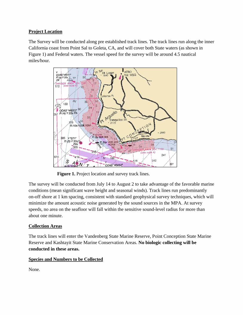
Project Location
The Survey will be conducted along pre established track lines. The track lines run along the inner California coast from Point Sal to Goleta, CA, and will cover both State waters (as shown in Figure 1) and Federal waters. The vessel speed for the survey will be around 4.5 nautical miles/hour.
Figure 1. Project location and survey track lines.
The survey will be conducted from July 14 to August 2 to take advantage of the favorable marine conditions (mean significant wave height and seasonal winds). Track lines run predominantly on-off shore at 1 km spacing, consistent with standard geophysical survey techniques, which will minimize the amount acoustic noise generated by the sound sources in the MPA. At survey speeds, no area on the seafloor will fall within the sensitive sound-level radius for more than about one minute.
Collection Areas
The track lines will enter the Vandenberg State Marine Reserve, Point Conception State Marine Reserve and Kashtayit State Marine Conservation Areas. No biologic collecting will be conducted in these areas.
Species and Numbers to be Collected
None.

Applicable State and Federal Permits
Marine operations in support of this project will be conducted under California State Lands Geophysical Survey Permit #PRC 8394. These geophysical survey operations will be conducted as "NO TAKE" operations under NOAA NMFS guidelines (observance of a 160dB safety zone for marine mammals) for the Marine Mammal Protection Act and do not require a NOAA NMFS permit.
PRE-SURVEY NOTIFICATIONS
1. NOAA - Marine Mammal Activity 2. Harbor Masters 3. SLC Geophysical Coordinator/Notice to Mariners 4. Dive Shops