Exhibit F Carmen-Smith Hydroelectric Project (FERC No ...
158
Exhibit F - Historic Properties Management Plan Eugene Water & Electric Board Carmen-Smith Hydroelectric Project FERC Project No. 2242 Exhibit F Carmen-Smith Hydroelectric Project (FERC No. 2242) November 2016 Amended and Restated Historic Properties Management Plan Redacted Version Submitted by: Eugene Water & Electric Board
Transcript of Exhibit F Carmen-Smith Hydroelectric Project (FERC No ...
Exhibit F - Historic Properties Management Plan Eugene Water & Electric Board Carmen-Smith Hydroelectric Project
FERC Project No. 2242
Exhibit F
Carmen-Smith Hydroelectric Project (FERC No. 2242)
November 2016 Amended and Restated Historic Properties Management Plan
Redacted Version
Submitted by:
Eugene Water & Electric Board

This page intentionally left blank.
Exhibit F - Historic Properties Management Plan Eugene Water & Electric Board Carmen-Smith Hydroelectric Project
FERC Project No. 2242
October 2016
i
FINAL DRAFT NOVEMBER 2016 AMENDED AND RESTATED
HISTORIC PROPERTIES MANAGEMENT PLAN FOR THE EUGENE WATER & ELECTRIC BOARD CARMEN-SMITH HYDROELECTRIC PROJECT, LANE AND LINN COUNTIES, OREGON (FERC No. 2242) Prepared for: Eugene Water & Electric Board Eugene, Oregon and Stillwater Sciences Arcata, California Prepared by: Albert C. Oetting and George Kramer Heritage Research Associates, Inc. Eugene, Oregon NOVEMBER 2016
Exhibit F - Historic Properties Management Plan Eugene Water & Electric Board Carmen-Smith Hydroelectric Project
FERC Project No. 2242
October 2016
ii
Suggested citation: Oetting, A. C., and G. Kramer. 2008. November 2016 amended and restated Historic properties management plan. Pre-final draft report. Prepared by Heritage Research Associates, Inc, Eugene, Oregon for Eugene Water & Electric Board, Eugene, Oregon and Stillwater Sciences, Arcata, California.
Exhibit F - Historic Properties Management Plan Eugene Water & Electric Board Carmen-Smith Hydroelectric Project
FERC Project No. 2242
October 2016
iii
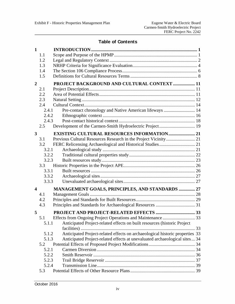
Exhibit F - Historic Properties Management Plan Eugene Water & Electric Board Carmen-Smith Hydroelectric Project
FERC Project No. 2242
October 2016
iv
Table of Contents
1 INTRODUCTION ............................................................................................ 1 1.1 Scope and Purpose of the HPMP ........................................................................ 1 1.2 Legal and Regulatory Context ............................................................................ 2 1.3 NRHP Criteria for Significance Evaluation ........................................................ 4 1.4 The Section 106 Compliance Process ................................................................. 6 1.5 Definitions for Cultural Resources Terms .......................................................... 8
2 PROJECT BACKGROUND AND CULTURAL CONTEXT ................... 11 2.1 Project Description ............................................................................................ 11 2.2 Area of Potential Effects ................................................................................... 11 2.3 Natural Setting .................................................................................................. 12 2.4 Cultural Context ................................................................................................ 14
2.4.1 Pre-contact chronology and Native American lifeways ........................... 14 2.4.2 Ethnographic context ................................................................................ 16 2.4.3 Post-contact historical context .................................................................. 18
2.5 Development of the Carmen-Smith Hydroelectric Project ............................... 19
3 EXISTING CULTURAL RESOURCES INFORMATION ....................... 21 3.1 Previous Cultural Resources Research in the Project Vicinity ......................... 21 3.2 FERC Relicensing Archaeological and Historical Studies ............................... 21
3.2.1 Archaeological study ................................................................................ 21 3.2.2 Traditional cultural properties study ......................................................... 22 3.2.3 Built resources study ................................................................................. 23
3.3 Historic Properties in the Project APE .............................................................. 26 3.3.1 Built resources .......................................................................................... 26 3.3.2 Archaeological sites .................................................................................. 27 3.3.3 Unevaluated archaeological sites .............................................................. 27
4 MANAGEMENT GOALS, PRINCIPLES, AND STANDARDS .............. 27 4.1 Management Goals ........................................................................................... 28 4.2 Principles and Standards for Built Resources ................................................... 29 4.3 Principles and Standards for Archaeological Resources .................................. 31
5 PROJECT AND PROJECT-RELATED EFFECTS .................................. 33 5.1 Effects from Ongoing Project Operations and Maintenance ............................ 33
5.1.1 Anticipated Project-related effects on built resources (historic Project facilities) ................................................................................................... 33
5.1.2 Anticipated Project-related effects on archaeological historic properties 33 5.1.3 Anticipated Project-related effects at unevaluated archaeological sites ... 34
5.2 Potential Effects of Proposed Project Modifications ........................................ 34 5.2.1 Carmen Diversion ..................................................................................... 34 5.2.2 Smith Reservoir ........................................................................................ 36 5.2.3 Trail Bridge Reservoir .............................................................................. 37 5.2.4 Transmission Line ..................................................................................... 39
5.3 Potential Effects of Other Resource Plans ........................................................ 39
Exhibit F - Historic Properties Management Plan Eugene Water & Electric Board Carmen-Smith Hydroelectric Project
FERC Project No. 2242
October 2016
v
5.4 Potential Effects of Project-Related Recreation ............................................... 39
6 TREATMENT MEASURES AND MANAGEMENT PROCEDURES .... 41 6.1 The Role of Communication and Consultation ................................................ 41 6.2 EWEB Management–Staffing and Training ..................................................... 41 6.3 Managing Built Resources (Historic Buildings and Structures) ....................... 42
6.3.1 Treatment measures for built resources .................................................... 43 6.3.2 Management review procedures for built resources ................................. 43
6.4 Managing Traditional Cultural Properties ........................................................ 44 6.5 Managing Archaeological Resources ............................................................... 45
6.5.1 Treatment measures for archaeological resources .................................... 45 6.5.2 Management review procedures for archaeological resources ................. 50
6.6 Unanticipated Discovery of Archaeological Resources ................................... 56 6.6.1 Archaeological resources found at location of Project-related activity .... 56 6.6.2 Archaeological resources found incidental to Project-related activity ..... 57
6.7 Looting and Vandalism Control ........................................................................ 57 6.8 Discovery of Human Graves or Remains ......................................................... 58 6.9 Discovery of Funerary Objects, Sacred Objects, or Objects of Cultural
Patrimony ......................................................................................................... 59 6.10 Emergencies ...................................................................................................... 60
7 OTHER PROGRAMS ................................................................................... 62 7.1 Resurvey of Project APE .................................................................................. 62 7.2 Project-wide Site Condition Monitoring Program ............................................ 62 7.3 Inventory and Assessment of McKenzie River and Bypassed Reaches ........... 63 7.4 Archaeological Site Evaluation Program .......................................................... 63 7.5 Employee Awareness Training Program .......................................................... 64 7.6 Agency Training Opportunities ........................................................................ 65 7.7 Public Information and Interpretation Program ................................................ 65 7.8 Culturally-Significant Plant Enhancement Program ......................................... 65
8 IMPLEMENTATION AND REVIEW OF THE HPMP ............................ 66 8.1 Adoption of the HPMP Through a Programmatic Agreement ......................... 66 8.2 Amendment Procedures .................................................................................... 66 8.3 Annual Report and Meeting on Historic Properties .......................................... 67 8.4 Periodic Review of the HPMP .......................................................................... 67 8.5 Dispute Resolution ............................................................................................ 67
9 REFERENCES CITED ................................................................................. 68
Exhibit F - Historic Properties Management Plan Eugene Water & Electric Board Carmen-Smith Hydroelectric Project
FERC Project No. 2242
October 2016
vi
List of Tables Table 1. Legal descriptions of Project APE locations. .................................................... 13 List of Figures Figure 1. Built resources facility map. ......................................................................................... 24 List of Appendices Appendix A: Manual for Built Resources
Exhibit F - Historic Properties Management Plan Eugene Water & Electric Board Carmen-Smith Hydroelectric Project
FERC Project No. 2242
October 2016
1
1 INTRODUCTION
The Eugene Water & Electric Board (EWEB) owns and operates the Carmen-Smith Hydroelectric Project (Project) under license No. 2242 from the Federal Energy Regulatory Commission (FERC). The existing license will expire on November 30, 2008, and EWEB has submitted an application for a new license. This Historic Properties Management Plan (HPMP) has been developed as a management tool to be implemented by EWEB for the identification, evaluation, protection and treatment of cultural resources associated with the Project Area of Potential Effects (APE) for the duration of the new license.
1.1 Scope and Purpose of the HPMP
The primary objectives of this HPMP are to: • provide responsible stewardship of the cultural resources in the Project APE for
continuing Project operation, including related transmission operation • comply with FERC requirements (18 CFR 4.51 and 16.8) for the identification,
evaluation, and treatment of historic properties potentially affected by the Project • comply with all applicable federal and state legal requirements pertaining to
historic properties, including Section 106 of the National Historic Preservation Act of 1966, as amended, 16 USC 470-470f, (NHPA)
• ensure appropriate interagency coordination of activities that have the potential to
affect historic properties in the Project APE • establish procedures for properly protecting and managing historic properties in
Project-related contexts, e.g., ongoing operations and maintenance, new activities, unexpected discoveries, and emergencies.
This HPMP has been developed to provide procedures for EWEB to implement in the planning of Project-related activities that have the potential to affect historic properties, both those currently known to exist and those that may be unexpectedly encountered in the future, as well as procedures for performing ongoing operation and maintenance activities, and for responding to emergencies. Studies conducted during the license application process demonstrate that the Project APE contains historic properties that merit consideration and protection under Section 106 of the NHPA (Oetting 2006a, 2006b). This HPMP briefly describes the resources identified in these studies and reviews their current status. In addition, this HPMP provides EWEB with a brief summary about the regulatory context for the identification, evaluation, protection and management of cultural resources of the Project’s APE. EWEB developed this HPMP
Exhibit F - Historic Properties Management Plan Eugene Water & Electric Board Carmen-Smith Hydroelectric Project
FERC Project No. 2242
October 2016
2
following guidelines issued by FERC (FERC 2002), by adapting cultural resources management procedures currently used by EWEB for the Leaburg-Walterville Hydroelectric Project (Oetting 2002), and by obtaining comments from agencies, Tribes and parties involved in the relicensing. Most of the Project’s APE is located on public lands administered by the United States Department of Agriculture Forest Service (USFS) in the Willamette National Forest (WNF), with some of the Project transmission line right-of-way (ROW) crossing privately-owned property. As the FERC licensee, EWEB shall be responsible for managing Project-related effects on historic properties within the Project APE, in consultation with FERC, the USFS, the Oregon State Historic Preservation Office (SHPO), federally-recognized Indian Tribes (including the following Tribal Nations: the Confederated Tribes of Warm Springs, the Confederated Tribes of Grand Ronde, and the Confederated Tribes of Siletz Indians) that choose to participate, and other parties that express a legitimate interest (including private landowners). The USFS has responsibilities for actions affecting historic properties, both Project- and non-Project-related, on National Forest System (NFS) land. Section 106 compliance for non-Project-related undertakings affecting historic properties in the Project APE will be overseen by the USFS, also in consultation with SHPO, Tribes, and other interested parties. Close cooperation among all parties will be essential to protect and manage these historic properties in the APE effectively.
1.2 Legal and Regulatory Context
The Project is a non-federal hydroelectric power system that operates under a federal license issued by FERC, pursuant to the Federal Power Act, as amended (FPA). Because FERC will issue a new license for the Project under federal law, the relicensing process and the resulting new license are considered a federal “undertaking” under Section 106 of the NHPA, and FERC, therefore, is subject to the requirements of the NHPA for federal historic preservation (USDI 1993a). With regard to Project cultural resources, one of the most important of these laws is the National Historic Preservation Act of 1966 (as amended) (NHPA) and the implementing regulations, Protection of Historic Properties (36 CFR Part 800, finalized in 1999). The NHPA makes explicit the nation’s interest in its historical and cultural foundations and establishes a federal regulatory system for recognizing and protecting significant historic properties. The NHPA created these programs and agencies: • National Register of Historic Places (NRHP): This register is the nationwide list
of properties determined to be significant in American history, architecture, archaeology, engineering, and culture. These historic properties are afforded specific legal consideration and protection. The National Park Service (NPS) evaluates properties for the NRHP using the criteria in 36 CFR 60.4.
Exhibit F - Historic Properties Management Plan Eugene Water & Electric Board Carmen-Smith Hydroelectric Project
FERC Project No. 2242
October 2016
3
• State Historic Preservation Officers and Program: State historic preservation programs, under the supervision of a state historic preservation officer, coordinate and review preservation activities in the state, including activities concerning the NRHP. In Oregon, the SHPO is part of the Oregon State Parks and Recreation Department, and the department Director is the designated State Historic Preservation Officer.
• Advisory Council on Historic Preservation (ACHP): The ACHP is the major
policy advisor to the federal government for historic preservation matters. The ACHP is responsible for reviewing and commenting on federal actions that may affect properties listed in or eligible for listing in the NRHP. The ACHP issued regulations in 36 CFR Part 800 implementing Section 106 of the NHPA.
Section 106 of the NHPA requires federal agencies to consider the effects an undertaking may have on historic properties included in or eligible for inclusion in the NRHP, and it requires that the ACHP be given a reasonable opportunity to comment on the undertaking. Section 106 requires that cultural resources in the area of the undertaking be identified and evaluated for NRHP eligibility, so that the agency will know which resources are the subject of protection. Compliance with Section 106 is the primary legal basis for the cultural resources studies EWEB conducted for relicensing of the Project and for the management requirements in this HPMP. Other federal laws make FERC responsible for considering Project effects on cultural resources. The National Environmental Policy Act of 1969 (NEPA) requires Federal agencies to
use all practicable means consistent with other essential considerations of national policy, to improve and coordinate Federal plans, functions, programs and resources to the end that the Nation may . . . 4) preserve important historic, cultural, and natural aspects of our national heritage.
42 USC 4331(b)(4). Basically, NEPA requires FERC to evaluate the environmental impacts that may result from the proposed issuance of a license for a hydroelectric project, including impacts to cultural resources. The Archeological and Historic Preservation Act of 1974, as amended (AHPA) requires that federal agencies provide for the preservation of historical and archeological data that “might otherwise be irreparably lost or destroyed as the result of . . . any alteration of the terrain caused as a result of any Federal construction project or federally licensed activity or program.” 16 USC 469. The preservation goals of these laws are generally met through compliance with Section 106 of the NHPA. Historic properties on federal land in the Project’s APE are subject to other federal laws:
Exhibit F - Historic Properties Management Plan Eugene Water & Electric Board Carmen-Smith Hydroelectric Project
FERC Project No. 2242
October 2016
4
• The American Indian Religious Freedom Act of 1978 (AIRFA) affirms that the United States will protect and preserve the inherent rights of American Indians to believe, express, and exercise traditional religions. These rights include physical access to sites, use and possession of sacred objects, and the freedom to worship using traditional ceremonies and rites.
• The Archaeological Resources Protection Act of 1979 (as amended) (ARPA)
protects archaeological resources that are over 100 years old on public federal and Native American lands (16 U.S.C. 470aa-mm; regulations 43 CFR Part 7). The ARPA established a permit system for excavation and other research at these archaeological sites, set qualifications for individuals conducting such work, and requires that recovered artifacts, samples, records, and other data be preserved (curated) by an approved institution. Excavation or other work without a permit at protected sites is illegal and subject to criminal and/or civil penalties as set forth in the Act. Within the Project APE, archaeological sites on USFS-administered lands are protected by ARPA and an ARPA permit, issued by USFS as a special use permit, is required to conduct any archaeological fieldwork.
• The Native American Graves Protection and Repatriation Act of 1990 (NAGPRA)
established policy and regulations (43 CFR Part 10) protecting Native American graves, human remains, funerary objects, sacred objects, and objects of cultural patrimony found on federal and Tribal lands. Knowingly disturbing such graves, remains, and objects without prior consultation under provisions of the NAGPRA is a felony under federal law and is subject to federal prosecution. This legislation applies to USFS-administered public lands in the Project APE.
Archaeological sites and, in particular, human burials on public and private land are protected under Oregon law. Oregon law requires the preservation and protection of “the cultural heritage” of Oregon “embodied in objects and sites that are of archaeological significance” (including NRHP-listed or eligible sites). ORS 358.910(2). No person may “excavate, injure, destroy, or alter an archaeological site or object or remove an archaeological object located on public or private lands in Oregon” unless the activity is authorized by a permit issued by the Oregon Parks and Recreation Department. ORS 358.920(1). Oregon law also protects Indian graves, and other sacred Indian objects in accordance with ORS 97.745.
1.3 NRHP Criteria for Significance Evaluation
A critical element in the federal laws requiring the consideration and protection of cultural resources is whether the resource is listed in or eligible for listing in the NRHP. This section introduces the principles and processes used in determining a cultural resource’s significance and evaluating its NRHP eligibility.
Exhibit F - Historic Properties Management Plan Eugene Water & Electric Board Carmen-Smith Hydroelectric Project
FERC Project No. 2242
October 2016
5
To be eligible for the NHRP, a cultural resource must meet the criteria in 36 CFR 60.4 (see also USDI n.d.) This regulation provides:
The quality of significance in American history, architecture, archeology, engineering, and culture is present in districts, sites, buildings, structures, and objects that possess integrity of location, design, setting, materials, workmanship, feeling, and association and
(a) that are associated with events that have made a significant contribution to the broad patterns of our history; or (b) that are associated with the lives of persons significant in our past; or (c) that embody the distinctive characteristics of a type, period, or method of construction, or that represent the work of a master, or that possess high artistic values, or that represent a significant and distinguishable entity whose components may lack individual distinction; or (d) that have yielded, or may be likely to yield, information important in prehistory or history
A historic property eligible for the NRHP must have a physical location (district, site, building, etc.), must be important within some context of our past (which may be our history, archaeology [prehistory], architecture, engineering, etc.), must possess sufficient integrity to be a good representative of that aspect of our past, and must be significant within one of four specific criteria (that the historic property has associative value with [a] specific events or patterns of history or with [b] important people, has [c] design or construction values important to our culture or technology, or has [d] information value). In addition to the regulation cited above, a historic property is generally required to be at least 50 years old, although allowance is made for a property of “exceptional importance” that is less than 50 years in age. Several categories of property are also normally excluded from NRHP consideration, absent special circumstances or location in a historic district. These categories include cemeteries, birthplaces, or graves of historical figures, religious properties, structures that have been moved, reconstructed historical buildings, and commemorative properties. In summary, the NRHP criteria allow for consideration of a wide diversity of properties, but require that the property be important within a defined historic context and be a good representative of that aspect of our past. An historical building, structure, and object (and districts comprised of these properties) are generally evaluated for significance under Criterion a, b, or c. Criterion d is usually applied to assess the significance of pre-contact (prehistoric) or historical archaeological sites. Once the evaluation criterion has been determined, the integrity of the property is assessed. Integrity is defined as “the ability of a property to convey its significance” (USDI n.d.), and seven interrelated standards (location, design, setting, materials, workmanship, feeling, and association) are used to judge integrity, with some being more crucial than others for specific evaluation criteria.
Exhibit F - Historic Properties Management Plan Eugene Water & Electric Board Carmen-Smith Hydroelectric Project
FERC Project No. 2242
October 2016
6
Archival and field research may be needed to assess whether a property meets these various criteria for NRHP eligibility. For an historical building or structure, research may involve documenting its association with events or people, comparing historical photos to document appearance, or detailed inspections to determine whether construction elements accurately convey the original design. For an archaeological site, the Oregon SHPO generally requires that subsurface excavations be conducted to assess fully the structure and information potential of the site. It is the responsibility of the State Historic Preservation Officer to identify and nominate eligible properties to the NRHP (36 CFR Part 60.6). Thus, any property thought to be eligible is reviewed by the SHPO staff and the Officer. Usually, an applicant prepares a Request for Determination of Eligibility for review by the SHPO. For an archaeological site, the Officer may review technical excavation reports to determine site eligibility. A property determined to be eligible for the NRHP is not automatically listed in the NRHP. Actual nomination to the NRHP requires a formal application and more detailed reviews and approvals by a State Review Board, the State Historic Preservation Officer, and the Keeper of the NRHP at the NPS. However, the same legal considerations and protections that apply to a listed property apply to an eligible property.
1.4 The Section 106 Compliance Process
Regulations that implement the historic preservation process mandated by Section 106 of the NHPA were developed and revised by the ACHP, and issued as “Protection of Historic Properties” (36 CFR Part 800) in 1999. The process is summarized below. • Initiate Section 106 Process: A federal undertaking (e.g., maintenance activity
within a federally licensed project) that may affect historic properties is identified. As defined below, historic properties are properties listed on the NRHP or eligible for listing on the NRHP. The undertaking entity (EWEB and FERC for this HPMP) should identify the appropriate SHPO and Tribes, as well as other potential consulting parties. If it is determined that the undertaking has no potential to affect historic properties (including unevaluated or undiscovered properties), there is no further obligation to Section 106.
• Identify Historic Properties: Historic properties within the undertaking’s APE
must be identified. This identification may come from previous investigations, or may require additional field or archival studies. The SHPO and other knowledgeable parties should be consulted in this identification process. Any NRHP-listed or eligible historic properties are considered, so identified but unevaluated properties should be evaluated for NRHP eligibility.
• If no historic properties are found to be present or affected, documentation of this is provided to SHPO and, barring any objection in a 30 day review period, the undertaking may proceed.
• If historic properties are present, assessment of possible adverse effects proceeds.
Exhibit F - Historic Properties Management Plan Eugene Water & Electric Board Carmen-Smith Hydroelectric Project
FERC Project No. 2242
October 2016
7
• Assess Adverse Effects: In consultation with SHPO and other interested parties, an
assessment of adverse effects on the identified historic properties is made, using the regulation’s criteria in 36 CFR Part 800.5.
• If the parties agree that there will be no adverse effect, the undertaking may proceed with any agreed upon conditions.
• If an adverse effect is found or the parties cannot agree about an effect, further consultation is initiated to identify ways to avoid, minimize, or mitigate the adverse effects.
• Resolve Adverse Effects: Measures to avoid, minimize, or mitigate adverse effects
to the historic properties are proposed and considered by the consulting parties. In cases where there may be substantial impacts to historic properties or other important issues, the ACHP may participate in consultation. This consultation process will usually result in a Memorandum of Agreement (MOA) that outlines the agreed upon measures for avoiding, minimizing, or mitigating the adverse effect. It should be noted that in some cases, the consulting parties may conclude that no measures are possible, and that the adverse effects must be accepted in the public interest.
• Implementation: After the MOA is executed, the undertaking may proceed under
the terms of the MOA. • Failure to Resolve Adverse Effects: If consultation proves unproductive, the
undertaking agency, the SHPO/Tribes, or ACHP may terminate consultation. If SHPO terminates consultation, the agency and the ACHP may conclude an MOA without SHPO involvement. If other parties terminate, the ACHP may or may not be required to provide further comments on the undertaking. The final decision on the undertaking will rest with the head of the federal agency requesting the undertaking (FERC, for this HPMP), who must take into account the ACHP’s comments, and document the decision. The responsibility for this decision cannot be delegated pursuant to Section 106.
• Tribal and Public Involvement: These regulations place a specific emphasis on
consultation with Indian Tribes. Consultation with a Tribe must respect tribal sovereignty and the formal government-to-government relationship between the federal government and Indian Tribes. These regulations also stress that public involvement is a key ingredient in successful Section 106 consultation. Views of the public should be solicited and considered throughout the process.
Through its “Notice of Application Tendered for Filing with the Commission” (FERC, December 12, 2006), FERC, under Part P, noticed the Parties, that FERC had initiated Section 106 consultation. That Notice and a subsequent notice on September 5, 2008,
Exhibit F - Historic Properties Management Plan Eugene Water & Electric Board Carmen-Smith Hydroelectric Project
FERC Project No. 2242
October 2016
8
delegated FERC's authority to EWEB to act on FERC’s behalf in carrying out the day-to-day Section 106 process for the relicensing of the Project.
1.5 Definitions for Cultural Resources Terms
This section defines some of the terms used in this HPMP. Some of the terms are broad, some describe certain types of resources, and some have specific legal meanings. The term cultural resources is a basic generic term that broadly applies to any physical manifestation of an individual or a society’s past interaction with other humans or the natural world. Thus, structures, buildings, archaeological sites, artifacts, and objects all can be classed as cultural resources. Within the context of the Project, the following types of cultural resources may be identified: • Built Resources: General term for any extant standing buildings, structures, and
objects. • Building: Standing construction that was created principally to shelter any form of
human activity (USDI n.d.).
• Structure: Standing construction made for functional purposes other than creating shelter, such as bridges, canals, and dams (USDI n.d.).
• Object: Constructions that are primarily artistic in nature or are relatively small in
scale and simply constructed (USDI n.d.). • Archaeological Resources: The material remnants of past human life or activities
in a physical context that can provide understanding of human behavior (USDI 1993b). These resources are usually found as artifacts (e.g., individual things like stone tools and debris, ceramic vessels, nails, or refuse) and features (e.g., fire hearths, remnants of walls, trash pits) that may co-occur at locations labeled archaeological sites. These resources may be more specifically identified as:
- Pre-contact (prehistoric) archaeological resources: Material remains of Native
American activities, with no physical evidence of contact with Europeans or Euro-Americans.
- Historical archaeological resources: Material remains with physical evidence
that post-dates the arrival of Europeans in the New World (USDI 1993b). • Traditional Cultural Property (TCP): A place related to traditional uses or
practices that are integral to the life of a community. A TCP is a location that is associated with “cultural practices or beliefs of a living community that (a) are rooted in that community’s history, and (b) are important in maintaining the continuing cultural identity of the community” (Parker and King 1990). It must
Exhibit F - Historic Properties Management Plan Eugene Water & Electric Board Carmen-Smith Hydroelectric Project
FERC Project No. 2242
October 2016
9
be a physical location that has a history of use or association lasting at least 50 years, and which retains that integrity of association and condition within the community. While special attention is usually given to identifying Native American properties, TCPs may be applicable to any ethnic or cultural group.
• Historical Building/Structure/Object: Standing constructions that are at least 50
years old, the minimum age normally considered for NRHP evaluation. • Site: The location of a significant event, a pre-contact or historical occupation or
activity, or a building or structure, whether standing or not, where the location itself possesses historical cultural or archaeological value regardless of the value of any existing building or structure (USDI n.d.).
• Archaeological site and archaeological isolated find: Under Oregon SHPO
policy, an archaeological site consists of at least 10 artifacts or at least one cultural feature found within a 10-m-diameter area or on a definable land form. An isolated find is a location containing fewer than 10 items.
• Property: Catch-all term used to describe any or all of the cultural resources types
described above. So, properties can be any pre-contact or historical district, site, building, structure, or object, individually or in any combination.
• Historic Property: Any pre-contact or historic district, site, building, structure, or
object included in, or eligible for inclusion in, the NRHP (36 CFR Part 800.16). This term is specifically used to identify and refer to NRHP-listed or NRHP-eligible properties, regardless of the age or cultural affiliation of the property.
• Effect: An alteration to the characteristics of a historic property qualifying it for
inclusion on or eligibility for the NRHP (36 CFR Part 800.16). • Adverse Effect: An alteration that deleteriously affects the characteristics of a
historic property qualifying it for inclusion on or eligibility for the NRHP. • Funerary Object: Item(s) reasonably believed to have been placed intentionally
with or near individual human remains at or after the time of death (43 CFR Part 10.2).
• Sacred Object: Ceremonial object(s) needed by traditional Native American
religious leaders for practice of traditional Native American religions by present-day adherents (43 CFR Part 10.2).
• Object of Cultural Patrimony: Object(s) of central importance to a group as a
whole, which cannot be owned or controlled by an individual, and which were
Exhibit F - Historic Properties Management Plan Eugene Water & Electric Board Carmen-Smith Hydroelectric Project
FERC Project No. 2242
October 2016
10
considered inalienable at the time the object was separated from the group (43 CFR Part 10.2).
The terms “historic” and “historical” can have several meanings when used in cultural resources terms. In terms such as historic property, historic preservation, or historical context, both words are used in a broad, generic sense, to embody the general past or general cultural heritage of the United States. However, when attached to terms such as historical building or historical archaeological resource, historical is being used to denote more specific time periods, as defined above (e.g., at least 50 years old, post-European arrival in North America, presence of European material items, etc.). The use of historic is limited to denoting NRHP-significant resources; thus, a historical building is a building at least 50 years old, while a historic building is a significant building at least 50 years old. Finally, these terms should not be used, or assumed, to imply a specific ethnic identification.
Exhibit F - Historic Properties Management Plan Eugene Water & Electric Board Carmen-Smith Hydroelectric Project
FERC Project No. 2242
October 2016
11
2 PROJECT BACKGROUND AND CULTURAL CONTEXT
This section supplies background information regarding Project operation and cultural contexts for this HPMP. The information on operations includes descriptions of the Project, the APE and the natural setting of the Project. The information on cultural context includes a brief review of regional archaeology, ethnography, and history. Finally, information is provided on the historical development of the Project. This background information is abstracted from the Project Final License Application Exhibit E (Stillwater Sciences 2006) and its supporting documents (Oetting 2006a).
2.1 Project Description
The Project is located in the Western Cascade Mountains on the McKenzie and Smith rivers in Linn and Lane counties, Oregon. The Project was completed in 1963 and includes three reservoirs, two powerhouses, and two transmission lines (EWEB 2003). The water of the McKenzie River is diverted at Carmen Diversion Reservoir through a tunnel in the ridge west of the river into a storage reservoir in the Smith River drainage. Water from Smith Reservoir then flows back through the ridge in a tunnel and penstock into the 110 MW Carmen Powerhouse, on the bank of the McKenzie River at the head of Trail Bridge Reservoir. Trail Bridge Reservoir serves to regulate the flow of the river, so that fluctuation in water usage at Carmen Powerhouse is contained through fluctuating reservoir levels, while providing a regulated outflow through Trail Bridge Dam that maintains natural river levels downstream. This outflow also passes through the 10.5 MW Trail Bridge Powerhouse at the base of the dam. A 115-kV Project transmission line roughly follows the river 19 miles downstream, delivering electricity to the Cougar Tap tie-in southwest of the community of McKenzie Bridge. There is also a 13.8-kV distribution line between the two powerhouses. The two lines are co-located on tall concrete towers for about one mile between the two powerhouses and the 115-kV line continues the remaining 18 miles on wooden or metal two- and three-pole towers.
2.2 Area of Potential Effects
The archaeological and built resources APE for the studies conducted for relicensing of the Project included all facilities and lands within the existing FERC Project boundary, as well as access roads, recreational facilities, and lands adjacent to and around reservoirs that are associated with the Project but are outside of the designated FERC boundary. The TCP study focused on this same APE but also included a more intensive review of the larger McKenzie River canyon in attempting to identify potential TCP locations.
Exhibit F - Historic Properties Management Plan Eugene Water & Electric Board Carmen-Smith Hydroelectric Project
FERC Project No. 2242
October 2016
12
Lands within the FERC Project boundary, as delineated on EWEB master Project maps, include the Project dams, the impounded reservoir pools and their perimeters, the two powerhouses, the Carmen-Smith Spawning Channel operated by EWEB just below Trail Bridge Dam, the 19-mile 115-kV Project transmission line from Carmen Powerhouse downstream to the Cougar Tap tie-in (which includes the short 13.8-kV line, co-located on the first mile of the Project line), and specific access and maintenance roads for these facilities. Certain facilities outside of the FERC boundary were identified by EWEB in consultation with the USFS and other relicensing stakeholders as being subject to Project effects. These facilities include Ice Cap Creek, Trail Bridge, and Lakes End campgrounds, along with several dispersed recreation areas in the general vicinity of the Project. The majority of the Project APE is located on federal public lands administered by the USFS, but segments of the Project transmission line cross private lands. The Project incorporates approximately 620 acres within the existing FERC boundary, including 561 acres on NFS land and 59 acres of private land (Stillwater Sciences 2006). Outside of the FERC boundary, but included in the APE, are an additional 35 acres of campgrounds and dispersed camp areas on NFS land. However, the surface areas of the Project reservoirs account for about 400 acres of the public land total. Thus, the archaeological and historical study APE covers about 255 acres–196 acres of NFS land and 59 acres of private property. Approximately 153 acres of the 255-acre total are within the ROW of the 115-kV Project transmission line. The private lands are all in the transmission line ROW. Project lands are located in portions of five townships (Table 1). FERC has requested (FERC 2007) that the bypassed reaches of the McKenzie and Smith rivers, and the McKenzie River from Trail Bridge Dam to Deer Creek also be included as part of the Project APE. The bypassed reach of the McKenzie River (the Carmen Bypass) extends from Carmen Diversion Dam downstream to the upper end of the Trail Bridge Reservoir pool. The Smith River bypassed reach extends from Smith Dam to Trail Bridge Reservoir. Deer Creek is a major tributary to the McKenzie River, joining the McKenzie approximately three river miles below Trail Bridge Dam. These areas are all on NFS land, and cover about 250 acres (incorporating a 30-m [100-ft] wide buffer zone on each riverbank). These elements of the APE were not included in the archaeological and historical studies completed for Project relicensing, and their composite acreage is in addition to the total acres discussed above. Inventory and assessment of cultural resources on these lands or other lands that may be added to the Project Boundary will occur as part of post-license implementation (addressed in Section 6.5.1.1 below).
2.3 Natural Setting
The upper McKenzie River flows through a deep V-shaped canyon along the geologic boundary between the older Western Cascade Mountains physiographic province and the younger High Cascades province (Orr et al. 1992). The High Cascades province includes
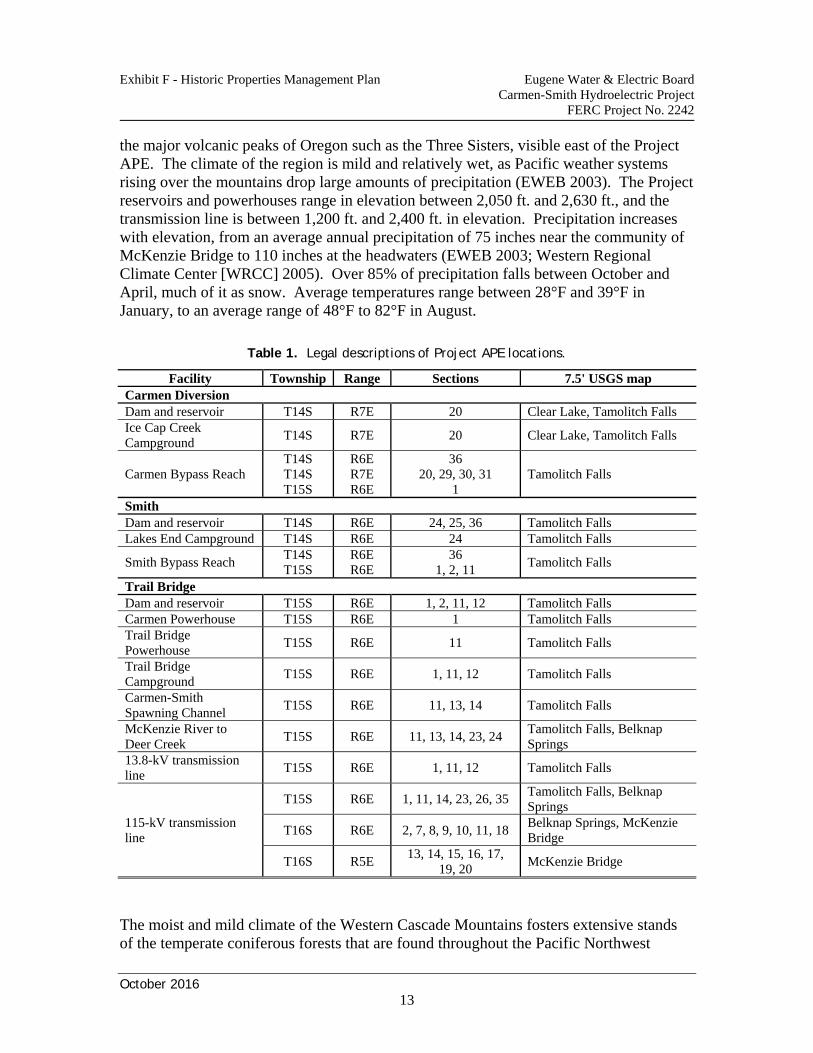
Exhibit F - Historic Properties Management Plan Eugene Water & Electric Board Carmen-Smith Hydroelectric Project
FERC Project No. 2242
October 2016
13
the major volcanic peaks of Oregon such as the Three Sisters, visible east of the Project APE. The climate of the region is mild and relatively wet, as Pacific weather systems rising over the mountains drop large amounts of precipitation (EWEB 2003). The Project reservoirs and powerhouses range in elevation between 2,050 ft. and 2,630 ft., and the transmission line is between 1,200 ft. and 2,400 ft. in elevation. Precipitation increases with elevation, from an average annual precipitation of 75 inches near the community of McKenzie Bridge to 110 inches at the headwaters (EWEB 2003; Western Regional Climate Center [WRCC] 2005). Over 85% of precipitation falls between October and April, much of it as snow. Average temperatures range between 28°F and 39°F in January, to an average range of 48°F to 82°F in August.
Table 1. Legal descriptions of Project APE locations.
Facility Township Range Sections 7.5' USGS map Carmen Diversion Dam and reservoir T14S R7E 20 Clear Lake, Tamolitch Falls Ice Cap Creek Campground
T14S R7E 20 Clear Lake, Tamolitch Falls
Carmen Bypass Reach T14S T14S T15S
R6E R7E R6E
36 20, 29, 30, 31
1 Tamolitch Falls
Smith Dam and reservoir T14S R6E 24, 25, 36 Tamolitch Falls Lakes End Campground T14S R6E 24 Tamolitch Falls
Smith Bypass Reach T14S T15S
R6E R6E
36 1, 2, 11
Tamolitch Falls
Trail Bridge Dam and reservoir T15S R6E 1, 2, 11, 12 Tamolitch Falls Carmen Powerhouse T15S R6E 1 Tamolitch Falls Trail Bridge Powerhouse
T15S R6E 11 Tamolitch Falls
Trail Bridge Campground
T15S R6E 1, 11, 12 Tamolitch Falls
Carmen-Smith Spawning Channel
T15S R6E 11, 13, 14 Tamolitch Falls
McKenzie River to Deer Creek
T15S R6E 11, 13, 14, 23, 24 Tamolitch Falls, Belknap Springs
13.8-kV transmission line
T15S R6E 1, 11, 12 Tamolitch Falls
115-kV transmission line
T15S R6E 1, 11, 14, 23, 26, 35 Tamolitch Falls, Belknap Springs
T16S R6E 2, 7, 8, 9, 10, 11, 18 Belknap Springs, McKenzie Bridge
T16S R5E 13, 14, 15, 16, 17,
19, 20 McKenzie Bridge
The moist and mild climate of the Western Cascade Mountains fosters extensive stands of the temperate coniferous forests that are found throughout the Pacific Northwest
Exhibit F - Historic Properties Management Plan Eugene Water & Electric Board Carmen-Smith Hydroelectric Project
FERC Project No. 2242
October 2016
14
(Franklin and Dyrness 1973). The Project facilities and transmission lines are in the western hemlock (Tsuga heterophylla) vegetation zone, dominated by Douglas-fir (Pseudotsuga menziesii), with western hemlock (Tsuga heterophylla) and western red cedar (Thuja plicata), some white fir (Abies concolor), and some deciduous trees along riparian corridors. Understory species include many shrubs and ferns, which often form a dense ground cover. Most animal species indigenous to the upper McKenzie River are still present, although population size and habits have changed due to modern human activities (Verts and Carraway 1998). Black-tailed deer (Odocoileus hemionus columbianus) is the most common large mammal in the region, with some elk (Cervus elaphus), black bear (Ursus americanus), cougar (Felis concolor), and many smaller mammals. The McKenzie River supports some anadromous fish along with many freshwater fish species (EWEB 2003), including spring Chinook salmon (Oncorhynchus tshawytscha), steelhead (O. mykiss), lamprey (Lampetra tridentata and L. richardsoni), bull trout (Salvelinus confluentus), rainbow trout (landlocked O. mykiss), cutthroat trout (O. clarki clarki), longnose and speckled dace (Rhinichthys spp.), and redside shiner (Richardsonius balteatus). Numerous resident and migratory birds also frequent the region.
2.4 Cultural Context
The Molala Indians inhabited the uplands of the Western Cascade Mountains when European and American trappers and explorers first entered western Oregon in the early nineteenth century. Archaeological sites and artifacts found in the Western Cascades provide evidence that the Molala and their predecessors have used this mountainous region for thousands of years prior to Euro-American contact. Ethnographic and archaeological studies have been limited in the mountains and valleys in the vicinity of the Project. While a number of sites and isolated artifacts have been found in this region, the local area has not figured significantly in the development of regional syntheses. A regional cultural background was prepared for the archaeological and historical section of the relicensing study (Oetting 2006a; Stillwater Sciences 2006) and that background is abstracted below. This regional review had to incorporate data from a wider area of the Western Cascades and the southern Willamette Valley, using overviews prepared by Baxter (1986), Beckham and Minor (1992), Minor and Toepel (1981), Minor (1987), Minor and Pecor (1977), O'Neill (1989), and Toepel and Beckham (1991). More complete discussions of regional ethnography and archaeology may be found in Oetting (2006a) and the sources mentioned above.
2.4.1 Pre-contact chronology and Native American lifeways
The regional cultural chronology and general models of settlement-subsistence for the pre-contact period developed for the relicensing studies are quite general, using relatively broad time periods and outlining only basic settlement-subsistence adaptations. This
Exhibit F - Historic Properties Management Plan Eugene Water & Electric Board Carmen-Smith Hydroelectric Project
FERC Project No. 2242
October 2016
15
chronology and most other regional overviews split this era into four general periods: Paleo-Indian, Early Archaic, Middle Archaic, and Late Archaic. Paleo-Indian (before 10, 000 BP): The presence of a Paleo-Indian period, dating prior to 10,000 years before present (BP), is based on the isolated occurrence of fluted points in the region. No sites dating to this period are known for the McKenzie River region, but fluted points have been found in the southern Willamette Valley and on the North Umpqua River. These specimens are thought to be equivalent in age with the well-dated 11,500 BP to 10,000 BP fluted-point hunting complexes in the Great Plains and Southwest, although the lifeways of these geographically disparate groups may have been quite different. Early Archaic (10,000-6,000 BP): This period is viewed as a time of adaptation to the developing Holocene environment. The leaf-shaped "Cascade" projectile point is diagnostic of this period, although this point type may have continued in less common use in later periods. These points were common in the early levels of Cascadia Cave in the South Santiam River drainage of the Western Cascades about 40 km (25 miles) northwest of the Project. The lowest levels of Cascadia Cave yielded radiocarbon ages of 6,000 to nearly 8,000 RCYBP (uncalibrated radiocarbon years before present). Several other sites in the mountains have cultural components present below ash from the eruption of Mt. Mazama (6,845 RCYBP). Buried hearths and rock oven features in the southern Willamette Valley have radiocarbon ages of 7,000 to 9,800 RCYBP.
Text deleted to remove confidential information. The cultural assemblages recovered in these early components suggest that a variety of plant and animal resources were exploited during this period. In some of the upland areas primary emphasis may have been on hunting, but charred camas bulbs were found in some of the early Willamette Valley ovens, indicating use of this important plant food during this period. An important fishery site on the North Umpqua River contained an Early Archaic component, which could suggest use of aquatic resources during this period, although no clear fishing equipment was recovered in this component. Middle Archaic (6,000-2,000 BP): Sites with Middle Archaic cultural components are found throughout western Oregon. The number of sites and their diverse settings suggest that populations were growing and that many resources were being used. Ground stone tools are more common in sites of this period, and the frequency of bowl mortars, hopper mortar bases, and pestles attests to the increased importance of plant resources to regional subsistence. Earth ovens with camas bulbs are common features during the Middle Archaic in the Willamette Valley. The presence of sites at several good fishing locations on the North Umpqua River again suggests fishing was an important subsistence pursuit. Leaf-shaped projectile points continue in use during this period, but the most common points are broad-necked stemmed and notched forms.
Exhibit F - Historic Properties Management Plan Eugene Water & Electric Board Carmen-Smith Hydroelectric Project
FERC Project No. 2242
October 2016
16
Several sites in the McKenzie River drainage have Middle Archaic assemblages, based on the presence of broad-necked, corner-notched and side-notched projectile points. They are found along the mainstem McKenzie River Valley as well as in a variety of upland settings, including forested ridge tops, meadow margins, and stream terraces.
Text deleted to remove confidential information. Middle Archaic artifact types and assemblages appear to persist into the Late Archaic time period in parts of southwestern Oregon, based on the association of these assemblages with relatively recent radiocarbon ages. These assemblages, termed the Glade Tradition (Connolly 1986), are interpreted to represent a very stable and conservative cultural tradition that persisted in parts of mountainous southwestern Oregon for a long period after these forms disappeared elsewhere in the Pacific Northwest. Continued research in the region will be necessary to evaluate the validity of the Glade Tradition concept and late persistence of Middle Archaic-like assemblages in the Western Cascade Mountains. Late Archaic (2,000 BP-Euro-American Contact): This final pre-contact period witnessed the continued development and refinement of regional cultural patterns. Populations, especially in the southern Willamette Valley, expanded considerably and inter-regional contacts increased. The settlement and subsistence practices characteristic of ethnographic groups became firmly established during this time. A broad range of resources was being exploited by this period. Vegetal resources were the primary foodstuffs, but hunting remained an important activity as did fishing. Small, narrow-necked projectile points dominate Late Archaic artifact assemblages, and these points appear to represent the introduction and use of the bow and arrow in the region. Late Archaic settlement patterns reflect those of the Middle Archaic in the Cascades uplands, with Late Archaic cultural components often overlying Middle Archaic components at the same sites. Late Archaic period sites are found across the southern Willamette Valley and in the neighboring foothills, suggesting a relatively large and/or mobile Late Archaic population. Shell ornaments and other artifacts at some of the floodplain sites suggest increasing trade and exchange with the Oregon coast and the Columbia River region. Relatively few sites with Late Archaic point types have been identified in the upper McKenzie River and Blue River area, but obsidian hydration studies at some sites reveal a distinct cluster of thin hydration rim measurements which have been interpreted to represent Late Archaic period occupations (Winthrop and Gray 1989). At some sites the Late Archaic age is suggested since Middle Archaic point types are associated with a second cluster of larger hydration rim measurements.
2.4.2 Ethnographic context
In the late eighteenth and early nineteenth centuries, when contacts between Native Americans and Euro-Americans were beginning to occur, the Molala Indians inhabited
Exhibit F - Historic Properties Management Plan Eugene Water & Electric Board Carmen-Smith Hydroelectric Project
FERC Project No. 2242
October 2016
17
the uplands of the Western Cascade Mountains. The Kalapuya Indians lived in the Willamette Valley and used the lower foothills of the mountains. Most contemporary maps depicting the general home territories of ethnographic groups place the Project APE in the region usually used by the Molala. The following brief sketch of Molala lifeways is derived from Toepel and Beckham (1981, 1991), Toepel (1987), and Zenk and Rigsby (1998). The Molala occupied a large, but poorly-defined, portion of the mountainous uplands of the western and high Cascades in Oregon. The population was sparse and, unfortunately, little reliable information is available on their lifeways. Molala is a language isolate within the Penutian phylum of languages, of which Kalapuya is also a member. Three subgroups have been recognized, the Northern Molala, who frequented the Molalla River and Mt. Hood region, the Southern Molala, in the Cascades of Douglas County west of Klamath Lake, and the Upper Santiam Molala, a little-known group that purportedly occupied the vicinity of the Santiam River and used the surrounding uplands of eastern Linn and Lane counties. The Molala probably followed an annual cycle of hunting and gathering similar to that of other Oregon Native Americans. Extended family groups generally wintered together, breaking into smaller family units in the summer to travel to varying resource areas. They focused their economic efforts on procuring resources available in upland environments, such as hunting game animals and harvesting berries, roots, and nuts such as huckleberries, serviceberries, camas, acorns, and hazelnuts. Hunting was a mainstay of the economy and probably included a wide variety of animals, although deer and elk were the most important species. Roots and berries, however, were important seasonal foci and may have brought larger groups together in favored harvesting areas. Molala families probably ascended and descended in elevation in the uplands as the seasons changed and different resources became available at differing altitudes. Winter villages, featuring semisubterranean earth lodges, were located in protected river valleys at lower elevations on the western side of the Cascades. The winter lodges were probably similar in style and construction to those of groups such as the Klamath and Tenino, but no examples have been documented. The extended family groups residing in winter camps were the primary social and political units among the Molala, as they were in neighboring societies. The Molala were on friendly terms with most of the surrounding groups. They traded with most of these groups, and intermarriage with members of neighboring tribes was not uncommon. By the 1840s, the ever-increasing numbers of Euro-Americans arriving in the Pacific Northwest heightened tensions with the region's native peoples, whose lifeways had already been severely affected by disease and the loss of traditional natural resources. Raiding and organized warfare occurred sporadically from the 1840s to 1860s, by which time most Oregon Native American groups had ceded their lands to the United States government through treaties and had been removed to reservations. The Northern and
Exhibit F - Historic Properties Management Plan Eugene Water & Electric Board Carmen-Smith Hydroelectric Project
FERC Project No. 2242
October 2016
18
Santiam bands of Molala, along with Willamette Valley Kalapuya bands, signed the Champoeg Treaty of 1851, which was not ratified by the United States Senate. In 1855, Joel Palmer, Superintendent of Indian Affairs for the Oregon Territory, negotiated a new treaty with these Kalapuya and Molala bands (Kappler 1904), signed in January 1855 as the Dayton Treaty. The McKenzie River watershed was included in the area encompassed by this treaty. A separate treaty with Southern Molala groups was negotiated and signed in December 1855. These bands ceded their lands to the United States for specified annuities and agreed to be removed to a reservation (Zenk and Rigsby 1998). Most Molala people were moved to the Grand Ronde Reservation on the west side of the Willamette Valley, with some also going to the Siletz and Warm Springs reservations. Some Southern Molalas made their way to the Klamath Reservation (Zenk and Rigsby 1998). The Dayton Treaty was ratified by the Senate in 1855, and the later Molala treaty was ratified in 1859 (Kappler 1904). Regular, ongoing residential and economic use of the upper McKenzie watershed by the Molala ended with the implementation of these treaties. However, individuals and families were permitted to leave the reservations for fishing and to obtain other resources, so some non-reservation areas continued to be visited. Molala and Wasco people from the Warm Springs Reservation reportedly conducted seasonal trips to the McKenzie watershed by horseback into the first half of the twentieth century (Sally Bird, Warm Springs Geo Visions Cultural Resources Manager, personal communication, 2007). Native Americans are among the many people that currently use the watershed, including the vicinity of the Project APE, for a variety of recreational and economic purposes.
2.4.3 Post-contact historical context
The Project APE and the general upper McKenzie River watershed were little affected by the Euro-American emigration to and colonization of Oregon until the 1860s, when the search for a viable transportation route across the Cascade Mountains led Felix Scott to develop a road from Eugene to central Oregon across McKenzie Pass. While this road enjoyed some success, the elevation of the pass and the annual closure by snow limited its usefulness. Military wagon roads using the Middle Fork Willamette and North Santiam rivers soon offered better routes across the Cascades. The road up the McKenzie River drainage, however, did encourage settlers to seek lands farther and farther up the river. An early proponent of the McKenzie road, John Templeton Craig, was living in the vicinity of modern McKenzie Bridge in the 1860s. The communities of Vida and Leaburg began in the 1870s, and a post office was opened in 1886 at Blue River, near mines where gold had been discovered in 1863. By the late nineteenth century, the rugged, forested upper McKenzie drainage was used for hunting, livestock grazing, and recreation, but was still too remote to be exploited by the emerging logging industry. To provide better oversight of public lands in the Western Cascade Mountains and to develop services for fire control, grazing rights,
Exhibit F - Historic Properties Management Plan Eugene Water & Electric Board Carmen-Smith Hydroelectric Project
FERC Project No. 2242
October 2016
19
recreation, and timber management, the Cascade Range Forest Reserve was created in 1893, bringing much of the forested Western Cascade Mountains under the control of the General Land Office. Administration of the forest reserves was reorganized in 1905 with the creation of the U.S. Forest Service within the U.S. Department of Agriculture (USDA). The Cascade Range Forest Reserve was divided into several national forests, with the upper McKenzie River area becoming part of WNF. The USFS took a more active role in regulating and managing forest resources, a role that continues today. The Great Depression of the 1930s had the effect of increasing development on national forest lands and in the upper McKenzie River region. Civilian Conservation Corps (CCC) camps were established in several places, including a camp near Belknap Springs at what is now the McKenzie River Ranger Station. Work projects included the construction of fire lookouts, roads, and recreation areas. By the mid-1930s, the CCC had built a road up the McKenzie River from Belknap to Clear Lake. This road was later extended to Santiam Pass and became part of Oregon State Highway 126. This network of primary roads became the backbone of the timber industry in the upper Western Cascades after World War II, as trucks were increasingly used to transport logs from the forest to the mill. EWEB has used McKenzie River water to generate electricity since 1911, when the Walterville development of the Leaburg-Walterville Hydroelectric Project in the lower McKenzie River valley was completed. The Leaburg development of this project was built in 1929-1931.
2.5 Development of the Carmen-Smith Hydroelectric Project
Rapid population growth in Oregon after WWII resulted in acute energy shortages to supply growing residential and industrial needs. In Western Oregon, these shortages were largely addressed by the construction of hydroelectric facilities that took advantage of the region’s extensive network of rivers and streams. EWEB began looking for new hydropower sites as early as 1947, when a project near Eugene was considered but rejected in favor of reconstruction of the Walterville plant (Stone 1986). Faced with nearly a 100% increase in electrical customers, identifying new sources of power remained a priority for EWEB. While some of the immediate needs were addressed by new or planned construction on the Columbia River by the Bonneville Power Administration (BPA) or within the Willamette River system by the U.S. Army Corps of Engineers, EWEB remained interested in developing its own power sources to augment power purchased elsewhere. In 1950, EWEB renewed efforts to identify power sites for increased generation, and these efforts soon focused on the upper McKenzie River, complementing the hydroelectric projects at Walterville and Leaburg. The Beaver Marsh Project was proposed as a 30-MW facility on the McKenzie River, to be followed by a second development at the Carmen-Smith Hydroelectric Project site. The State of Oregon and
Exhibit F - Historic Properties Management Plan Eugene Water & Electric Board Carmen-Smith Hydroelectric Project
FERC Project No. 2242
October 2016
20
the Federal Power Commission issued EWEB a license in January 1956 for the Beaver Marsh project, and EWEB readied a funding measure for the voters that would allow construction. However, Oregon’s Congressional delegation, led by senators Wayne Morse and Richard Neuberger, introduced legislation to revoke the Federal Power Commission’s license; considerable criticism of the project’s impact developed. Through a March 1956 election, EWEB requested approval for a revenue bond to fund the project. Opponents of the Beaver Marsh Project questioned the need for the project by suggesting that EWEB could adequately supply the area by increasing its purchase of BPA power. The opposition was based upon what today would be termed environmental concerns. The focal points were protection of the scenic and natural resources of the McKenzie River, the Sahalie and Koosah waterfalls, Clear Lake, and the wetlands at Beaver Marsh itself. Voter turnout for the March 1956 special election on Beaver Marsh exceeded expectations and overwhelmed most precincts, where long lines formed to cast ballots. Voters defeated the revenue bond funding measure by 55% to 45%. EWEB still needed to identify a new source of power to serve the growing number of customers. The result of additional studies concluded that the McKenzie River remained the logical location for development and that Beaver Marsh and/or the Carmen-Smith Project continued to be the best locations for developing hydroelectric energy. The Carmen-Smith Project site, located downstream from the Beaver Marsh site, quickly became the preferred site for a number of reasons. In September 1957, EWEB voted to pursue a feasibility study for the Carmen-Smith location while at the same time tabling a proposed revised study of the Beaver Marsh area. Despite some continued resistance, primarily from McKenzie Bridge area residents and statewide organizations, the Carmen-Smith Project was almost universally seen as a fairly “reasonable” compromise between recreation and the power needs of the region. Increasingly supportive comments for the Carmen-Smith location came from a wide group of stakeholders as the Project design became clear. This was especially true after EWEB publicly pledged to drop its license for the Beaver Marsh project should Carmen-Smith be approved. While several other groups continued in opposition, with some vowing complete opposition to development of any sort on the upper McKenzie River, the Carmen-Smith Project gained support from most review agencies. In March 1958, after having received formal support from the various state agencies involved, EWEB filed an application with the Federal Power Commission to build the Carmen-Smith Project on the upper McKenzie River. The last major hurdle, opposition from the Oregon State Game Commission, was cleared with EWEB’s agreement to build a salmon spawning bed. Soon after, the Oregon state engineer approved five applications related to the Project, and in January 1959 the Federal Power Commission granted EWEB a 50-year license for the Carmen-Smith Hydroelectric Project.
Exhibit F - Historic Properties Management Plan Eugene Water & Electric Board Carmen-Smith Hydroelectric Project
FERC Project No. 2242
October 2016
21
3 EXISTING CULTURAL RESOURCES INFORMATION
This section provides a summary of existing information on archaeological, traditional, and historical resources known for the Project APE and surrounding area of the upper McKenzie River watershed. This information includes non-Project-related studies conducted primarily by USFS, early Project-related cultural resources projects, and the archaeological and historical studies conducted for EWEB for the FERC relicensing of the Project.
3.1 Previous Cultural Resources Research in the Project Vicinity
Based on site and project records maintained at the Oregon SHPO and at the USFS McKenzie River Ranger Station, several cultural resources survey and testing projects have been conducted within or near the Project APE. Most had been conducted by USFS archaeologists in advance of activities such as timber sales, campground improvements, or road construction. Some of these included portions of the Project APE. In addition, two previous archaeological surveys of the Project transmission line ROW had been conducted for EWEB, prior to and also following a pole maintenance and replacement project (Toepel and Ricks 1995; Ricks 2001).
Text deleted to remove confidential information. Prior to the relicensing studies, none of the 19 pre-contact Native American sites or the Carmen Diversion historical site had been formally evaluated for eligibility to the NRHP. Limited subsurface archaeological testing had been conducted at four of the pre-contact sites, and all four were considered potentially eligible for the NRHP (Bergland 1993a, 1993b; Oetting 1996). The historic Clear Lake Road was evaluated and recommended as eligible (Bergland 1996).
3.2 FERC Relicensing Archaeological and Historical Studies
In-depth archaeological (Oetting 2006a, 2006b), TCP (Toepel et al. 2006), and built resources (Kramer 2005) inventories and significance evaluations were undertaken as part of the supporting studies (Exhibit E) for the License Application submitted to FERC by EWEB for relicensing of the Project (Stillwater Sciences 2006). These studies resulted in the first investigations of, and formal NRHP evaluations for, most of the resources in the Project APE (formal NRHP evaluations were not conducted for seven pre-contact archaeological sites on private land).
3.2.1 Archaeological study
The goal of the relicensing archaeological study was to locate and evaluate all archaeological resources in the Project APE (Oetting 2006a, 2006b). A pedestrian surface survey and subsurface discovery probe excavations were conducted to identify
Exhibit F - Historic Properties Management Plan Eugene Water & Electric Board Carmen-Smith Hydroelectric Project
FERC Project No. 2242
October 2016
22
archaeological sites and explore isolated artifacts. Subsurface discovery probes were included because of poor surface visibility in the forest vegetation covering much of the APE. Isolated finds were tested to determine if sufficient subsurface materials were present to designate the location a site. Site evaluation test excavations were undertaken to gather the basic information necessary to assess the NRHP eligibility of identified properties in the APE, and to provide data for developing this HPMP. Appropriate permits were obtained from the State of Oregon and the USFS for conducting the archaeological studies. The field inventory strategy included both surface survey and the excavation of subsurface site discovery probes in areas with high potentials for archaeological sites and a potential for Project effects. Site discovery probes in areas where archaeological sites were likely to be present were included because the dense forest vegetation in the APE severely limited surface ground visibility. Archaeological sites and isolated finds previously recorded in or near the APE were specifically revisited to determine their relationship with the APE through subsurface testing.
Text deleted to remove confidential information.
Beyond the identification of resources, a major goal of the relicensing archaeological study was to evaluate those resources for their eligibility for listing in the NRHP. This evaluation required subsurface archaeological test excavations to establish structure and integrity at sites that might contain subsurface cultural materials, or a surface inventory and evaluation of artifacts or features at sites where subsurface materials were unlikely to occur.
Text deleted to remove confidential information.
3.2.2 Traditional cultural properties study
The TCP study entailed a comprehensive review of existing literature to identify (1) traditional uses that may have taken place in the vicinity of the Project in the McKenzie River watershed, and (2) those communities that may have traditional ties to the Project APE. In conjunction with this review, EWEB initiated coordination and consultation with Indian Tribes having interests in the Project area. Tribes identified by the Oregon Commission on Indian Services (CIS) included the Confederated Tribes of the Grand Ronde Community of Oregon, the Confederated Tribes of Siletz Indians, and the Confederated Tribes of the Warm Springs Reservation of Oregon. Tribal members were included in the Social Sciences Technical Subgroup (SSTS) that was formed by EWEB to guide the archaeological and historical studies for the relicensing effort. The TCP study was conducted to comply with Section 106 of the NHPA, 36 CFR 800.4(a)(4). This regulation requires EWEB to gather information from any Tribe which may be of religious and cultural significance to them and may be eligible for the National Register.
Exhibit F - Historic Properties Management Plan Eugene Water & Electric Board Carmen-Smith Hydroelectric Project
FERC Project No. 2242
October 2016
23
The resulting review of ethnographic, ethnohistorical, and historical records (Toepel et al., 2006) did not result in the identification of any specific locations of potential TCPs within or near the Project APE. Rather, the background research has confirmed that the upper McKenzie River watershed is notable for its rugged topography, dense vegetation, and relative isolation. The area was undoubtedly used by the Molala and their neighbors for hunting, fishing, and gathering activities, but the lack of specific information pertaining to use of the area suggests that this part of the McKenzie drainage was peripheral to the primary use areas of Native American groups. The procedure EWEB shall use if EWEB identifies a potential TCP location is provided in Section 6.4 below.
3.2.3 Built resources study
All Project facilities and other built resources in the Study Area (Figure 1) were identified and recorded by a Historic Preservation Specialist (Kramer 2005). All built resources found to be greater than 50 years old were evaluated for NRHP eligibility. Structures becoming 50 years old during the first 10 years of the license renewal period were also identified.
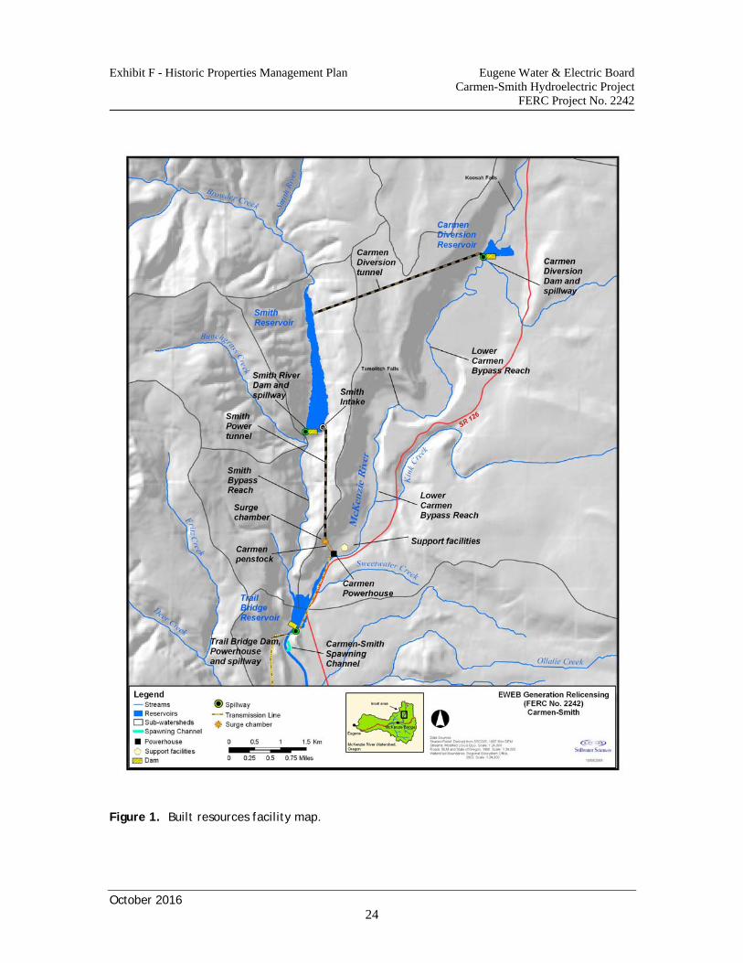
Exhibit F - Historic Properties Management Plan Eugene Water & Electric Board Carmen-Smith Hydroelectric Project
FERC Project No. 2242
October 2016
24
Figure 1. Built resources facility map.
Exhibit F - Historic Properties Management Plan Eugene Water & Electric Board Carmen-Smith Hydroelectric Project
FERC Project No. 2242
October 2016
25
Most of the built resources of the Project were developed as elements of the original construction period between September 1960 and September 1963. With few exceptions, all power generation and related linear features remain “as built” in all significant aspects. Exceptions were generally limited to roof and wall treatments to portions of the Carmen and Trail Bridge powerhouses, which included applied standing seam metal roofing and wall claddings. Several projecting canopies at Carmen Powerhouse were built of pressure-treated wood with metal sheet roofing. The most significant modifications to a generation-related element were the modifications made to the Carmen Powerhouse as a result of the 1964 flood. Windows overlooking the McKenzie River that had been destroyed by the flood were replaced with concrete walls. Modifications were also made to the surge chamber, to remove screening from the top to eliminate snow loading problems, and removal of the lower 6-m (20-ft) portion of the exterior ladder to improve safety and security. The largest alterations from the original construction period have been in the Carmen housing area. The three original (1960) construction dwellings were converted to Project staff housing after construction. These houses have had minor modifications over time, most visibly the uniform installation of green standing seam metal roofing (n.d., c1990s). A modular unit (House #4) was added to the housing area, and green metal-clad equipment barns and four-car garage were also added after the primary Project construction. While not specifically dated, these structures are compatible additions within the complex. Other changes included replacement of the original wood-frame communications shed atop the ridge between the McKenzie and Smith rivers with a concrete structure, leaving the original shed in place. The domestic water supply system pressure tank structure was entirely rebuilt using stacked pressure-treated lumber, abutting the original steel tank. A viewing platform at Beaver Marsh and an Americans with Disabilities Act (ADA) trail to the platform were both constructed in 1998. In 2001, the wooden back wall supports for the Carmen Diversion Bridge were replaced with concrete. The built resources study recommended that the Project be considered eligible for listing on the National Register of Historic Places under eligibility criterion “a” for association with the broad themes of Oregon history and under criterion “c” for the environmentally sensitive design of the Project, which minimized impacts to the surrounding landscape. The Project demonstrates significant association with the history of Eugene, Oregon, and the growth of the environmental movement in Oregon. The design of the Project included specific aspects intended to minimize visual impacts and retain the visual and aesthetic values of the McKenzie River region. The resources of the Project retain very high integrity to their original design and continue effectively to convey the associations for which they are significant. The Oregon SHPO has concurred with this recommendation.
Exhibit F - Historic Properties Management Plan Eugene Water & Electric Board Carmen-Smith Hydroelectric Project
FERC Project No. 2242
October 2016
26
3.3 Historic Properties in the Project APE
The studies reviewed above identified and evaluated a number of cultural resources. Five archaeological sites were evaluated as eligible to the NRHP, and the built resources comprising the Project as a whole were also found to be significant and eligible for inclusion in the NRHP. These eligible resources are specifically defined as historic properties by the NHPA (Section 301) and the Section 106 implementing regulations (36 CFR 800.16). No TCP locations were identified in or near the Project. Seven unevaluated archaeological sites remain potentially eligible resources until a formal evaluation is performed.
3.3.1 Built resources
The Project as a whole has been determined eligible for listing in the NRHP. The Project was designed to operate as a system comprised of multiple elements that depend upon each other for water flow, functionality, and, ultimately, power generation. Thus, the individual Project structures (e.g., dams, powerhouses, transmission line, etc.) and support facilities (e.g., Carmen complex, salmon spawning channel) that date from the original construction period (1960-1963) are considered contributing elements to the NRHP significance of the Project. The contributing Project elements include the following (listed from upstream to downstream): Carmen Diversion Reservoir Carmen Diversion Dam/Spillway Carmen Diversion Tunnel and Intake
Carmen recreation complex (including Ice Cap Creek Campground, trails, boat ramp, etc.)
Smith Reservoir Lakes End Campground Smith Dam Smith Power Tunnel and Intake Smith Power Tunnel Surge Chamber Carmen Powerhouse Penstocks Carmen Powerhouse Carmen Substation Carmen Powerhouse Storage Building/Tool Room
Carmen Housing Area and Support Structures (including Administration Office/ Garage, houses #1-3, Soils Lab Storage Building, Emergency Generator Shed, Water System Pump House, original Communication Relay Building)
Carmen-Cougar Transmission Line Carmen Powerhouse Bridge Trail Bridge Reservoir Trail Bridge Emergency Spillway Trail Bridge Powerhouse Trail Bridge Crane/Crane House
Exhibit F - Historic Properties Management Plan Eugene Water & Electric Board Carmen-Smith Hydroelectric Project
FERC Project No. 2242
October 2016
27
Trail Bridge-Carmen Distribution Line Trail Bridge Campground and Day Use Area Carmen-Smith Spawning Channel
3.3.2 Archaeological sites
Text deleted to remove confidential information.
3.3.3 Unevaluated archaeological sites
Text deleted to remove confidential information.
Exhibit F - Historic Properties Management Plan Eugene Water & Electric Board Carmen-Smith Hydroelectric Project
FERC Project No. 2242
October 2016
28
4 MANAGEMENT GOALS, PRINCIPLES, AND STANDARDS
EWEB is committed to the responsible stewardship of historic properties in the Project APE. EWEB shall endeavor to protect and preserve the integrity of NRHP-eligible properties that may be affected by the Project within the requirements of applicable regulations and the overarching context of continuing Project operation. EWEB shall effectively manage historic properties in the Project throughout the duration of any new FERC license following the tenets of the management goals, principles, and standards discussed in this section, and implemented through the management procedures detailed in Section 6. The USFS retains ultimate responsibility and authority for managing cultural resources (excluding Built Resources) on NFS lands. Any ground disturbing activities (other than routine activities excluded from Section 106 review as described in the Manual for Built Resources) taken by EWEB on NFS lands related to management and protection of cultural resources must be done in consultation with and subject to approval by the USFS consistent with Project Proposed License Article 24. On NFS lands, when conducting archeological investigations of any type related to this HPMP, EWEB shall employee a professional archaeologist who meets Secretary of Interior standards, described in 48 FR 44738-9, for professional archeologists.
4.1 Management Goals
EWEB’s goals for protecting and managing historic properties in the Project APE are to: • ensure continued safe and efficient normal operation of the Project while
effectively managing and maintaining the integrity of historic properties, • comply with and ensure consistency with Section 106 of the NHPA and other
federal, state, and local requirements and management plans pertaining to historic properties,
• avoid or mitigate Project-related impacts on NRHP-listed or NRHP-eligible historic properties, and on unevaluated properties,
• maintain confidentiality regarding the location of sensitive archaeological resources,
• provide stewardship through programs and procedures to identify historic properties, reduce vandalism, support educational opportunities, and encourage staff and public awareness in protecting cultural resources,
• coordinate and maintain compatibility with other resource management goals and plans to provide integrated stewardship of all sensitive resources, and,
• provide cost-effective measures for historic properties that balance with Project operations requirements and other resource programs
Exhibit F - Historic Properties Management Plan Eugene Water & Electric Board Carmen-Smith Hydroelectric Project
FERC Project No. 2242
October 2016
29
EWEB’s goals are to ensure continued safe operation of the Project, while fully complying with the regulations implementing Section 106 of the NHPA, by identifying and mitigating any adverse effects a Project-related activity may have on NRHP-listed and NRHP-eligible historic properties (as summarized in Section 1). EWEB shall plan Project-related activities in such a way as to avoid any effects to historic properties. If avoidance of adverse effects to the historic property is not reasonably possible, EWEB shall consider and implement actions to minimize or mitigate Project-related adverse effects on the historic property.
4.2 Principles and Standards for Built Resources
If avoidance of adverse effects to the built resources is not reasonably possible, EWEB shall consider and implement actions to minimize or mitigate Project-related adverse effects on the built resources. EWEB shall follow the principles, standards, and guidelines established in the Standards for the Treatment of Historic Properties in 36 CFR Part 68 for appropriately managing the historic buildings and structures in the Project APE. EWEB shall apply these standards to the repair, maintenance, alteration, addition or related new construction that affects built resources listed or eligible for listing in the NRHP and within the Project APE. These treatment standards may be summarized as (Weeks and Grimmer 1995): • Preservation: the application of measures to keep the existing form, integrity,
and materials of the historical resource. Stabilization and ongoing maintenance can contribute to preservation.
• Rehabilitation: making a property useful in a contemporary and efficient way
while preserving features that contribute to its significant cultural character. • Restoration: accurately recovering the form and details of a property and its
setting as it appeared at a particular period of time, by removing later work or replacing removed or missing earlier work.
• Reconstruction: the reproduction of the exact form and detail of a vanished
structure as it appeared at a particular time (this approach is least preferred and is not recommended unless needed for interpretive purposes).
Within the Project APE, EWEB shall use the preservation standard to guide maintenance and repair of existing built resources. EWEB shall use the rehabilitation standard for new construction or exterior modification required for improved Project operation. EWEB shall implement these standards in a reasonable manner, taking into account economic and technical feasibility, license requirements, and the goals in this HPMP. EWEB recognizes that change is inherent in maintaining and upgrading operating engineered facilities. EWEB shall work to maintain the historic integrity of the Project
Exhibit F - Historic Properties Management Plan Eugene Water & Electric Board Carmen-Smith Hydroelectric Project
FERC Project No. 2242
October 2016
30
while preserving the flexibility to upgrade equipment and structures as required by FERC, the new license, legal requirements, technological advances or operating requirements. EWEB shall use the following principles to guide its efforts: • Project-related actions will work to maintain and preserve the overall integrity of
the historic built resources comprising the Project. • A historic built resource will be used for its original Project purpose in its original
location, reflecting its function and character-defining features. • Historic character will be retained and preserved by reasonable means and
techniques. The removal of historic materials or alteration of features and spaces characterizing a resource will be avoided if reasonably possible, and mitigated if avoidance is not possible.
• Each built resource will be recognized as a physical record of its time, place, and
function. • Deteriorated architectural features will be repaired rather than replaced whenever
reasonably possible. When replacement is required, the new material will match the historical material in design, color, scale, and texture whenever reasonably possible. Replacement of key features will be documented by physical or pictorial evidence.
• Replacement of outmoded or deteriorated engineering equipment will avoid
unnecessary alteration or removal of character-defining elements if reasonably possible.
• Appropriate techniques will be used in surface cleaning and maintenance of
structures to avoid damage. • New additions, exterior alterations, and related new construction will be visually
distinct from the Project’s historic built resources yet, if reasonably possible, will remain compatible in size, scale, and material with the features that characterize these historic properties.
EWEB shall implement these principles and the four treatment standards through use of the Manual for Built Resources for the Project (Appendix A), which will guide normal and routine work. This manual provides maintenance guidelines and specific treatment recommendations for individual resources that are consistent with the Standards for the Treatment of Historic Properties in 36 CFR Part 68. For major undertakings, including but not limited to proposed demolition of identified historic properties, that are outside the Manual’s maintenance guidelines or that do not comply with the standards for rehabilitation, EWEB shall use the Section 106 compliance process as described above in
Exhibit F - Historic Properties Management Plan Eugene Water & Electric Board Carmen-Smith Hydroelectric Project
FERC Project No. 2242
October 2016
31
Section 1.4. EWEB shall use the results of any Section 106 compliance process to update and amend the Manual and this HPMP consistent with Section 8.4.
4.3 Principles and Standards for Archaeological Resources
To achieve the general goals stated above for archaeological resources, EWEB shall follow the ACHP principles and standards regarding the treatment of archaeological resources in Treatment of Archaeological Properties: A Handbook (ACHP 1980; see also ACHP 1999). The ACHP has revised the regulations governing the Section 106 process (36 CFR Part 800). EWEB shall base the management of pre-contact and historical archaeological resources on these general principles and standards (adapted from ACHP 1980): • Avoidance of NRHP-listed/eligible archaeological resources is the preferred
alternative. • If an NRHP-listed/eligible archaeological property can be reasonably preserved in
place, it should be. • If an eligible archaeological property is preserved in place, extensive excavation
of the property is seldom appropriate. • Treatment of an eligible archaeological resource will depend on its value for
research as balanced against other public values. • Treatment plans will be developed following this HPMP and in consultation with
the Oregon SHPO, USFS, other appropriate agencies, Tribes, and other interested parties.
• Data recovery is not a preferred treatment, but may be selected as a necessary treatment if adverse effects to the property cannot be reasonably avoided. If adverse effects cannot be reasonably avoided, the work will be conducted in an efficient manner to address identified research problems, will be based on firm background data and planning, and will contribute to the development of state and regional historic preservation plans.
The first priority in EWEB’s approach to archaeological site management shall be to maintain site integrity by working to avoid any impacts to the site. If full avoidance cannot be reasonably achieved, EWEB’s next priority shall be proactive site protection using a suite of treatment methods. These priorities reflect the current Section 106 implementing regulations (36 CFR Part 800), which encourage protection and non-disturbance over excavation and studies. EWEB shall retain and consult with professional archaeologists, as needed, to manage the archaeological historic properties in the Project APE successfully. Some archaeological sites within the Project APE will remain unevaluated for NRHP eligibility when this HPMP is implemented and will have to be evaluated prior to Project-related actions if the actions may affect them. EWEB may need to survey areas not previously examined for
Exhibit F - Historic Properties Management Plan Eugene Water & Electric Board Carmen-Smith Hydroelectric Project
FERC Project No. 2242
October 2016
32
archaeological resources if Project-related actions may affect the areas. EWEB may identify new archaeological sites during such surveys or as the result of inadvertent discoveries. Data recovery excavations may be needed for specific projects. EWEB shall obtain permits for conducting archaeological fieldwork as required. EWEB shall have all such work undertaken and supervised by professional archaeologists meeting the Professional Qualifications Standards in 36 CFR Part 61. EWEB shall have all research, field investigations, laboratory analyses, and report preparation conducted according to standard professional practice outlined in the NPS Standards and Guidelines issued at 48 Federal Register 44,716, September 29, 1983.
Exhibit F - Historic Properties Management Plan Eugene Water & Electric Board Carmen-Smith Hydroelectric Project
FERC Project No. 2242
October 2016
33
5 PROJECT AND PROJECT-RELATED EFFECTS
Ongoing Project operations and maintenance activities have the potential to affect historic properties. Likewise, Project modifications currently proposed for the new FERC license may affect known historic properties, and these proposed modifications will be subject to review under the procedures in this HPMP. This section identifies anticipated Project-related effects at known historic properties from ongoing Project operations and maintenance. This section also summarizes the currently proposed Project modifications and identifies the potential effects these modifications may have on known historic properties and the review processes in this HPMP that EWEB shall use.
5.1 Effects from Ongoing Project Operations and Maintenance
Day-to-day operation of the Project, routine maintenance of Project structures and support facilities, and other activities resulting from the presence of the Project, such as recreation, all have the potential to affect historic properties in the Project APE. These anticipated effects are discussed below by resource type.
5.1.1 Anticipated Project-related effects on built resources (historic Project facilities)
The Project as a whole has been determined eligible for listing in the NRHP; thus, the individual Project structures (e.g., dams, powerhouses, transmission line, etc.) and support facilities (e.g., Carmen complex, salmon spawning channel) that date from the original construction period are considered contributing elements to the significance of the Project. The integrity and character-defining features of these structures and facilities shall be protected and maintained. Anticipated effects for the Project’s built resources result primarily from routine operations and maintenance of individual facilities. Routine maintenance such as repainting or repairing the roof of a structure may affect the historic character-defining features of that structure. Similarly, replacing or updating operational equipment such as spillgates or generation equipment could affect the historic integrity of the Project. To address these anticipated Project effects, EWEB has developed the Manual for Built Resources (Appendix A) to provide appropriate guidelines and treatment measures EWEB shall use for most routine operations and maintenance activities.
5.1.2 Anticipated Project-related effects on archaeological historic properties
Text deleted to remove confidential information.
Exhibit F - Historic Properties Management Plan Eugene Water & Electric Board Carmen-Smith Hydroelectric Project
FERC Project No. 2242
October 2016
34
5.1.3 Anticipated Project-related effects at unevaluated archaeological sites
EWEB shall not conduct Project-related activities that have the potential for ground disturbance in or near any of these sites until evaluation test excavations have been conducted at the site to determine its eligibility for inclusion in the NRHP. EWEB may need to use special measures to ensure compliance with Section 106 if the property owner does not provide authorization to conduct the evaluation test excavations. EWEB shall use consultations with the Oregon SHPO and law enforcement agencies as necessary if such a situation arises while this HPMP is in effect.
5.2 Potential Effects of Proposed Project Modifications
The following Project modifications in this Section 5.2 are included in the Settlement Agreement. These modifications include changes to current Project operations and infrastructure modifications to enhance particular resources. EWEB shall use a qualified historic preservation specialist to review these proposed modifications and any future proposed actions that will result in changes to Project buildings and structures that may affect the NRHP character-defining elements of those historic built resources to minimize adverse effects and to amend the Manual for Built Resources as necessary. Most of the proposed modifications will not affect known archaeological historic properties, but many of the modifications will involve ground disturbance, which will necessitate EWEB conducting additional field studies (e.g., subsurface discovery probes) to examine specific Project areas more intensively for archaeological resources. Proposed Project modifications that are likely to affect historic properties are discussed below by location within the Project.
5.2.1 Carmen Diversion
Ice Cap Creek Campground Reconstruction: The campground is part of the Carmen Recreation Complex that was built during the original Project construction period, and is listed as a contributing resource to the NRHP-eligibility of the Project (see Section 3.3.1). Reconstruction of the campground is a proposed Project modification and has the potential to affect the character-defining elements of the original design adversely. If FERC includes the proposed reconstruction in the new license, EWEB shall design the reconstruction work to retain as much of the “rustic campground” feeling and appearance as reasonably possible. EWEB shall have a qualified historic preservation specialist review the reconstruction plans as they are developed. EWEB shall submit the resulting preferred option(s) for review by the Oregon SHPO and will be consistent with any applicable SHPO comments for the proposed work. The campground was surveyed for archaeological resources during the relicensing study, and no pre-contact or historical archaeological materials were found on the surface. No subsurface discovery testing was undertaken at that time. The planned reconstruction
Exhibit F - Historic Properties Management Plan Eugene Water & Electric Board Carmen-Smith Hydroelectric Project
FERC Project No. 2242
October 2016
35
will involve ground disturbance, and EWEB shall review the planned activites for impacts to historic properties under the procedures identified in Section 6.5 below. EWEB shall use subsurface discovery probe(s) in the campground prior to construction to determine if subsurface cultural materials are present. If an archaeological site is documented and cannot be reasonably avoided, EWEB shall conduct NRHP evaluation test excavation(s) as necessary. Carmen Diversion Dam Fish Ladder: Carmen Diversion Dam is an integral part of the water conveyance system of the Project and dates to the original construction period, so it is a contributing feature to the Project’s NRHP significance. If a fish ladder is built at the Carmen Diversion Dam, this fish ladder would be considered a proposed Project modification and has the potential to affect the downstream face of the dam and its historic character. If FERC includes the proposed fish ladder in the new license, EWEB shall design the fish ladder to complement the functional character-defining appearance of the dam if reasonably possible. To minimize visual impact on the Project, EWEB shall have a qualified historic preservation specialist review the fish ladder design and siting as plans are developed. EWEB shall submit the resulting preferred option(s) plan for review by the Oregon SHPO and will be consistent with any applicable SHPO comments for the proposed work. Project land in the vicinity of the Carmen Diversion dike, dam, and spillway was surveyed for archaeological resources during the relicensing study, and no pre-contact or historical archaeological materials were found on the surface. No subsurface discovery testing was undertaken at that time. Construction of the fish ladder will involve ground disturbance, and EWEB shall review the planned activities for impacts to historic properties under the procedures identified in Section 6.5 below. EWEB shall use subsurface discovery probe(s) in the footprint of the proposed fish ladder prior to construction to determine if subsurface cultural materials are present. If an archaeological site is documented and cannot be reasonably avoided, EWEB shall conduct NRHP evaluation test excavation(s) as necessary. Construction of Carmen Diversion Day Use Recreation Area: As noted above for Ice Cap Creek Campground, the Carmen Recreation Complex is listed as a contributing resource to the NRHP-eligibility of the Project. The construction of a day use recreation area along the shores of the reservoir is a proposed Project modification and will not directly affect existing recreation-related structures, but has the potential to affect the character-defining original appearance and experience of this recreation complex. If FERC includes the proposed day use recreation area in the new license, in the planning for the proposed recreation area, EWEB shall work to retain as much of the rustic and outdoors feeling and appearance of the existing recreation complex as reasonably possible. EWEB shall have a qualified historic preservation specialist review and comment on these plans as they are developed. EWEB shall submit the resulting preferred option(s) plan for review by the Oregon SHPO and will be consistent with any applicable SHPO comments for the proposed work if reasonably possible.
Exhibit F - Historic Properties Management Plan Eugene Water & Electric Board Carmen-Smith Hydroelectric Project
FERC Project No. 2242
October 2016
36
The Project land surrounding the reservoir was surveyed for archaeological resources during the relicensing study, and no pre-contact or historical archaeological materials were found on the surface. No subsurface discovery testing was undertaken at that time. The new day use recreation area will likely involve some ground disturbance, and EWEB shall review the planned activities for impacts to historic properties under the procedures identified in Section 6.5 below. EWEB shall use subsurface discovery probe(s) in the footprint of proposed structures (e.g., restrooms) prior to construction to determine if subsurface cultural materials are present. If an archaeological site is documented and cannot reasonably be avoided, EWEB shall conduct NRHP evaluation test excavation(s) as necessary.
5.2.2 Smith Reservoir
Text deleted to remove confidential information.
Construction of Smith Reservoir Day Use Recreation Area: The construction of a day use recreation area at Smith Reservoir is a proposed Project modification and will not affect any existing built resources that contribute to the NRHP significance of the Project. If FERC includes the new recreation area in the license, EWEB shall complement the existing built recreation resources of the Project in the design and appearance of any structures associated with this new recreation area. The general location of the proposed recreation area on the southeast side of Smith Reservoir was surveyed for archaeological resources during the relicensing study, and no pre-contact or historical archaeological materials were found on the surface. No subsurface discovery testing was undertaken at that time. The new day use recreation area will likely involve some ground disturbance, and EWEB shall review the planned activities for impacts to historic properties under the procedures identified in Section 6.5 below. EWEB shall use subsurface discovery probe(s) in the footprint of proposed structures (e.g., restrooms) prior to construction to determine if subsurface cultural materials are present. If an archaeological site is found and cannot reasonably be avoided, EWEB shall conduct NRHP evaluation test excavation(s) as necessary. Increasing In-Stream Flow Below Smith Dam: Increasing in-stream flow in Smith River below Smith Dam is a proposed Project modification and may involve modifications or additions to the existing spillway for Smith Dam. This dam, with its spillway, is an integral part of the Project and dates to the original construction period, so it is a contributing element to the NRHP significance of the Project. Modifications or additions to the spillway have the potential to affect the appearance and historic character of the concrete spillway adversely. If FERC includes increasing in-stream flow in the new license, EWEB shall design any proposed modifications or additions for increasing downstream in-stream flows to complement the functional character-defining appearance
Exhibit F - Historic Properties Management Plan Eugene Water & Electric Board Carmen-Smith Hydroelectric Project
FERC Project No. 2242
October 2016
37
of the dam and spillway if reasonably possible. EWEB shall have a qualified historic preservation specialist review the design of any modifications or additions as plans are developed. EWEB shall submit the resulting preferred option(s) plan for review by the Oregon SHPO and shall be consistent with any applicable SHPO comments for the proposed work. The Smith Dam access road and dispersed camp locations between this road and the river were surveyed for archaeological resources during the relicensing study. No pre-contact or historical archaeological materials were found. At present, conceptual plans for increasing downstream flows in Smith River focus on modifications or additions to the existing spillway and will not involve new ground disturbance. Likewise, the increased in-stream flows will not exceed normal Smith River flows and should not overtop the banks of the river. Therefore, it is unlikely that any archaeological resources will be affected, and no additional studies for these proposed modifications are anticipated at present.
5.2.3 Trail Bridge Reservoir
Trail Bridge Powerhouse Intake Fish Screen: Trail Bridge Dam and its powerhouse intake structure are integral parts of the Project operating system and date to the original construction period. The dam and intake are contributing features to the Project’s NRHP significance. The majority of the proposed fish screen will be underwater, but portions of the screen will be visible on the intake structure at and above the surface of the reservoir, and will have the potential to affect the straightforward functional and utilitarian appearance of the existing intake. If FERC includes the fish screen in the new license, EWEB shall design the fish screen to complement this functional character-defining appearance of the intake structure if reasonably possible. EWEB shall have a qualified historic preservation specialist review the fish screen final design to minimize visual impact on the historic character of the Project. EWEB shall submit the resulting preferred option(s) plan for review by the Oregon SHPO and shall be consistent with any applicable SHPO comments for the proposed work.
Text deleted to remove confidential information. Trail Bridge Dam Fish Ladder: Trail Bridge Dam is an integral part of the Project and dates to the original construction period, so it is a contributing feature to the Project’s NRHP significance. If the proposed fish ladder is placed on the face of the dam or passes through the dam, it will likely affect the functional and utilitarian appearance of the existing rock-filled dam. Present conceptual plans envision a separate fish ladder structure that will ascend the area west of the Trail Bridge powerhouse and pass around the end of the dam to access the west bank of the reservoir. If FERC includes the fish ladder in the new license, EWEB shall design it to complement the functional character-defining appearance of the dam and powerhouse. EWEB shall have a qualified historic
Exhibit F - Historic Properties Management Plan Eugene Water & Electric Board Carmen-Smith Hydroelectric Project
FERC Project No. 2242
October 2016
38
preservation specialist review the fish ladder final design to meet recommendations specified in the Manual for Built Resources in Attachment A of this HPMP. EWEB shall submit the preferred option(s) plan for review by the Oregon SHPO. Project land along the shore of the reservoir and in the vicinity of the Trail Bridge dam and powerhouse was surveyed for archaeological resources during the relicensing study, and no pre-contact or historical archaeological materials were found on the surface. No subsurface discovery testing in these areas was undertaken at that time. Construction of the fish ladder will involve ground disturbance, and EWEB shall review the planned activities for impacts to historic properties under the procedures identified in Section 6.5 below. EWEB shall use subsurface discovery probe(s) in the footprint of the proposed fish ladder prior to construction to determine if subsurface cultural materials are present. If an archaeological site is located and cannot reasonably be avoided, EWEB shall conduct NRHP evaluation test excavation(s) as necessary.
Text deleted to remove confidential information. Addition of a Water Bypass Valve to the Carmen Powerhouse: The Carmen powerhouse dates to the original construction period of the Project, and, other than several changes made following the 1964 flood, remains generally as it was constructed. The Carmen powerhouse is listed as a contributing element to the Project’s NRHP-eligibility (see Section 3.3.1 above). The construction of a water bypass valve and associated energy dissipation structure adjacent to the powerhouse will affect the historic character of the powerhouse. If FERC includes the valve and associated structure in the new license, EWEB shall design the proposed bypass valve and energy dissipation structure in consultation with a qualified historic preservation specialist to assure compatibility with the historic character of the Carmen Powerhouse and the overall Project in design, scale, siting, and use of materials if reasonably possible. EWEB shall submit the preferred option(s) plan for review by the Oregon SHPO. The Project land at and around the Carmen Powerhouse was surveyed for archaeological resources during the relicensing study, and no pre-contact or historical archaeological materials were found on the surface. Construction of the bypass valve and energy dissipation structure will involve ground disturbance, and EWEB shall review the planned activities for impacts to historic properties under the procedures identified in Section 6.5 below. EWEB shall use subsurface discovery probe(s) in the footprint of proposed structures prior to construction to determine if subsurface cultural materials are present. If an archaeological site is documented and cannot be reasonably avoided, EWEB shall conduct NRHP evaluation test excavation(s) as necessary.
Text deleted to remove confidential information.
Exhibit F - Historic Properties Management Plan Eugene Water & Electric Board Carmen-Smith Hydroelectric Project
FERC Project No. 2242
October 2016
39
5.2.4 Transmission Line
Text deleted to remove confidential information.
5.3 Potential Effects of Other Resource Plans
EWEB is developing many other resource management plans for use under the new Project FERC license. As EWEB develops these resource plans, EWEB shall identify and address conflicts with, and adverse effects to, historic properties. Many of the proposed Project modifications discussed above are elements of other resource plans. In addition, the Project-related activities’ review procedures in this HPMP will be referenced in other plans. Any proposed activities that are to be implemented prior to approval of the Project Settlement Agreement including this HPMP or FERC issuance of a new FERC license are still subject to review for effects to historic properties, as required by Section 106 of the NHPA. This compliance process is described in Section 1.4 above and is the basis for the review procedures in this HPMP. EWEB shall follow the Section 106 compliance process prior to implementation of this HPMP, so proposed Project-related activities that have a potential to affect historic properties adversely will be reviewed by the Oregon SHPO, in consultation with USFS, interested Tribes, and other knowledgeable parties. The Vegetation Management Plan is linked to cultural resources, in that it addresses management effects to plants that are culturally significant to Tribes. EWEB shall use the Vegetation Management Plan to incorporate and enhance these culturally significant traditional species into Project-related re-vegetation efforts. This Vegetation Management Plan shall include screening by EWEB of all vegetation or ground-disturbing activities, to avoid or minimize impacts to culturally significant species if reasonably possible. The plan shall also include re-vegetation efforts by EWEB, particularly in the Project transmission line ROW, that will remove weed species and establish mixed vegetation that will include appropriate and significant traditional native plant species. EWEB shall consult with the interested Tribes and USFS in the selection of appropriate native species. In cooperation with the USFS, EWEB shall provide opportunities to Tribal members and the interested public to assist in maintaining these native plants and in harvesting food and other products from these plants.
5.4 Potential Effects of Project-Related Recreation
Recreational opportunities are present in many parts of the Project APE, and they are an important part of the public services provided by the Project beyond power generation. However, Project-related recreation activities have the potential to affect historic properties in the APE adversely through inadvertent actions or from intentional looting and vandalism. Inadvertent actions such as camping on an archaeological historic
Exhibit F - Historic Properties Management Plan Eugene Water & Electric Board Carmen-Smith Hydroelectric Project
FERC Project No. 2242
October 2016
40
property could affect the integrity of the site through soil compaction and mixing disturbances, discarding of trash, or deposition of modern campfire charcoal. Driving a vehicle on a site, especially in wet conditions, may result in ground disturbance. Intentional looting or vandalism may include digging for artifacts in a site, theft of artifacts through collection, or defacement of historic Project buildings with graffiti (see Section 6.7). EWEB shall strive to prevent or minimize recreation-related adverse effects on the Project’s historic properties through a variety of programs. EWEB shall keep information regarding the location and contents of archaeological historic properties confidential, following current professional standards and the requirements of the laws, to reduce the risk of purposeful looting or vandalism (see Section 6.7 below). EWEB shall conduct periodic site condition monitoring of Project historic properties to determine if adverse effects (recreation-related or other types) are occurring and to document those effects (see Section 7.2 below). EWEB shall implement protection or mitigation measures as needed based on these observations. EWEB shall work to increase staff and public awareness of the value of cultural resources and the importance of protecting and preserving these resources (see Section 7.5 below for employee awareness training, and Section 5.2.3 above for public education opportunities at the proposed Carmen-Smith Visitor Center).
Text deleted to remove confidential information.
Exhibit F - Historic Properties Management Plan Eugene Water & Electric Board Carmen-Smith Hydroelectric Project
FERC Project No. 2242
October 2016
41
6 TREATMENT MEASURES AND MANAGEMENT PROCEDURES
Ongoing operation of the Project involves many tasks and activities, including scheduled and unscheduled maintenance, new construction, activities involving other resource areas (e.g., recreation, aquatics), and unexpected emergencies. Any of these activities constitutes an “undertaking” under Section 106 of the NHPA that may have the potential to affect historic properties. When historic properties may be affected by an activity (new or ongoing), EWEB shall review the activity and determine its effects to historic properties through the procedures delineated in this section. Under the new FERC license, EWEB shall be responsible for, and shall be the lead party for managing Project-related effects on historic properties within the Project APE, in consultation with FERC, the Oregon SHPO, the USFS, federally-recognized Indian Tribes that choose to participate, and other parties that express a legitimate interest (including private landowners) consistent with the implementing regulations for Section 106 (36 CFR 800.2). It is recognized that the USFS also has authority and responsibilities for actions, both Project- and non-Project-related, that affect the historic properties on NFS land in the Project APE.
6.1 The Role of Communication and Consultation
Effective management of all cultural resources in the Project APE, including NRHP-eligible historic properties, requires close cooperation and consultation between EWEB and the Oregon SHPO, the USFS, interested Indian Tribes, other agencies such as the FERC and the ACHP, and other interested parties or individuals that may be identified during the course of specific activities. EWEB communication and cooperation with the USFS will be important for properly managing the historic properties on NFS land that is within the Project APE, because EWEB and the USFS both have responsibilities for these properties. EWEB shall request input from and consultations with the SHPO, USFS, interested Tribes, and other concerned parties as necessary to identify and resolve satisfactorily adverse effects to historic properties. EWEB shall request review by specific agencies and Tribes when required for obtaining permits for archaeological investigations, and shall pursue more formal consultation as necessary. EWEB shall also conduct meetings with interested parties on a regular basis to report on Project cultural resources management activities, the state of Project historic properties, and to provide periodic review of this HPMP (see Section 8 below).
Text deleted to remove confidential information.
6.2 EWEB Management–Staffing and Training
As part of the ongoing program to manage cultural resources in the Project APE, EWEB shall designate an EWEB staff person to fulfill the role of Cultural Resources Liaison
Exhibit F - Historic Properties Management Plan Eugene Water & Electric Board Carmen-Smith Hydroelectric Project
FERC Project No. 2242
October 2016
42
(CR Liaison) and shall provide appropriate training for this person and any other essential supporting staff. EWEB through its CR Liaison shall: (1) be the contact person for anyone initiating Project-related activities that have the potential to affect cultural resources (any ground-disturbing Project-related activities or Project-related activities that may affect the appearance, fabric or setting of a built resource), (2) maintain records and maps of cultural resources sites and Project-related activities and other activities recorded in or near the Project APE, (3) contact the appropriate cultural resources consultant when Project-related activities that have the potential to affect cultural resources are proposed, (4) coordinate cultural resources training for staff and, if needed, subcontractors, (5) organize and participate in meetings and consultations required by this HPMP, (6) maintain relationships with interested parties (including the USFS, Oregon SHPO and interested Tribes), and (7) coordinate interpretive efforts. EWEB shall provide opportunities for the CR Liaison, and other selected personnel, to attend appropriate training sessions and conferences on cultural resources management and the Section 106 process, including cultural resource specialist training programs administered by USFS or other agencies. EWEB shall hire qualified cultural resources consultants (such as professional archaeologist, historic preservation consultant, or historian, referred to collectively as CR consultant), as required, to implement the management programs and procedures in this HPMP. These consultants shall (1) provide professional services to review Project-related activities forwarded by the EWEB CR Liaison, (2) perform fieldwork and analysis as needed to identify and evaluate cultural resources in the Project APE, (3) maintain records and maps of cultural resources sites and Project-related activities or other activities recorded in or near the Project APE, (4) periodically update cultural resources information by reviewing Oregon SHPO records, and (5) participate in cultural resources consultations as directed by EWEB. EWEB shall also provide directives and training for appropriate EWEB managers and field staff to inform and train them on the review procedures in this HPMP and their responsibilities for including historic properties’ review, identification, and management when developing or performing Project-related activities (see Section 7.5 below).
6.3 Managing Built Resources (Historic Buildings and Structures)
The Project as a whole is eligible to the NRHP, and individual structures and support facilities dating from the original construction period are considered contributing historic features (see Section 3.3.1 above). EWEB has developed a Manual for Built Resources for the Project (Appendix A), which EWEB shall use to guide normal and routine operations and maintenance work involving these contributing historic structures and facilities. This manual provides maintenance guidelines and specific treatment recommendations EWEB shall use for classes of resources (e.g., reservoir/water-related features, generation-related structures, etc.) as well as individual resources within the Project. The manual describes each class of properties, and of individual buildings and
Exhibit F - Historic Properties Management Plan Eugene Water & Electric Board Carmen-Smith Hydroelectric Project
FERC Project No. 2242
October 2016
43
structures and identifies the important character-defining aspects that define their historic character. The description includes a statement of the “current condition” of the property, which identifies changes that have occurred over time that support or detract from the character-defining aspects, and the goal for proper maintenance and management of the property.
6.3.1 Treatment measures for built resources
The Project’s Manual for Built Resources provides specific recommendations for maintenance, repair or replacement, and/or materials that are most appropriate for retaining the character-defining aspects of each property in compliance with this HPMP (e.g., paint color, siding types, roofing materials, etc.). The manual includes reference materials EWEB shall consider for Project-related activities such as specific recommended products, manufacturers, sources, and/or other details and specifications. The manual is intended to be a “working” document that EWEB shall revise over time as more efficient maintenance techniques are developed, product recommendations change, or new data on the history of the Project becomes available. The manual contains specific treatment information for many of the historic properties that constitute the Project.
6.3.2 Management review procedures for built resources
The procedures for reviewing the effect of proposed Project-related activities or ongoing maintenance on buildings and structures are founded on the principles described in Section 4.2 above and will follow the treatment/maintenance guidelines in the Project’s Manual for Built Resources if the manual covers the specific Project-related activities. If EWEB follows these guidelines, many of the normal ongoing maintenance activities undertaken at and on the identified contributing historic buildings and structures in the Project will be exempt from further review. The EWEB CR Liaison shall be responsible for contacting the CR consultant when a review of Project-related activities not covered in this HPMP and the manual is needed. In the very unlikely event that a historical built resource is identified that is not related to the Project, EWEB shall direct the CR consultant to document and evaluate the property for NRHP eligibility. The review process EWEB shall use for built resources (buildings/structures) is described below: • For any EWEB proposal for Project-related activities (new, or ongoing routines)
that will involve altering the appearance, fabric, or setting of a Project building or structure, EWEB shall notify its maintenance supervisor of the complex containing the building or structure
Exhibit F - Historic Properties Management Plan Eugene Water & Electric Board Carmen-Smith Hydroelectric Project
FERC Project No. 2242
October 2016
44
• EWEB through its maintenance supervisor shall consult the Manual for Built Resources in this HPMP to determine if the building/structure is a known contributing historic property and subject to restrictions
- if the building/structure is designated as a contributing historic feature in the manual, EWEB through its maintenance supervisor shall follow the guidelines for appropriate treatments provided in the manual. These appropriate treatments provide historically-compatible recommendations for most normal maintenance activities (e.g., painting, replacing windows, etc.)
- if the proposed activity is not covered, or the proposed activity is a substantial undertaking beyond the scope of the manual, EWEB through its maintenance supervisor shall contact the EWEB CR Liaison
• EWEB through its CR Liaison shall contact the CR consultant and direct the CR consultant to review the resource and the proposed activity, and,
• the CR consultant shall review the resource and the proposed activity, and determine if the Section 106 compliance process should be initiated and, if so, inform EWEB through its CR Liaison
- if the building/structure is designated a non contributing historic feature in the manual, EWEB may proceed with the activity - if the building/structure is not covered in the manual, EWEB cannot
proceed with the proposed activity and EWEB through its maintenance supervisor shall contact the EWEB CR Liaison
• EWEB through its CR Liaison shall contact the CR consultant and direct the CR consultant to take the actions described immediately below
• the CR consultant shall determine if the property has been evaluated for contributing or non-contributing status to the Project’s eligibility (or for NRHP eligibility if the property is not Project-related)
- if the building/structure has not been evaluated for NRHP eligibility, EWEB through its CR consultant shall have the building/structure evaluated and shall report the results to the CR Liaison
- if EWEB through its CR consultant determines the building/structure is a contributing historic feature, EWEB through its CR consultant shall report to the CR Liaison the appropriate section of the manual for compliance or that the Section 106 compliance process should be initiated if the building/structure is not covered in the manual
6.4 Managing Traditional Cultural Properties
No TCPs have been previously identified in the Project APE (see Section 3.2.2 above), and procedures for identifying, evaluating, and managing TCPs are still evolving in the Pacific Northwest. Identification and evaluation of a TCP will require involvement of the living community associated with the potential TCP. Most potential TCPs that might be
Exhibit F - Historic Properties Management Plan Eugene Water & Electric Board Carmen-Smith Hydroelectric Project
FERC Project No. 2242
October 2016
45
encountered in the Project APE will probably be associated with an Indian Tribe. If EWEB identifies a potential TCP in an area where a Project-related activity will take place in the Project APE, EWEB shall perform additional background research on the location, and, if the TCP appears to be Native American, shall consult with the Oregon Commission on Indian Services to determine which Tribes to contact for additional research, discussion, and consultation regarding the potential TCP. EWEB shall proceed with subsequent actions, which may include interviews with knowledgeable individuals and oral history studies, with the appropriate Tribe(s) or other identified communities.
6.5 Managing Archaeological Resources
The treatment of archaeological historic properties is dependent on both the nature of the anticipated effect and the structure of the archaeological site. While general treatment measures are available and are identified below, the application of a specific measure will be unique to each site. For example, the treatment measure of site protection may be undertaken, but the protective measures will depend on the type of effect and may vary from site to site. Likewise, mitigation through data recovery excavations may be a needed treatment in some cases, but the data recovery plan developed will be tailored to the specific site and the specific effects occurring or anticipated to occur. EWEB shall implement treatments that involve archaeological excavation and analysis by a qualified archaeologist to comply with state and federal regulations.
6.5.1 Treatment measures for archaeological resources
For the proper management of archaeological historic properties EWEB shall use efforts to identify archaeological sites and to evaluate their eligibility for inclusion in the NRHP. Where no previous archaeological investigations have been conducted, EWEB shall use measures such as a survey to identify resources and evaluation test excavations, as well as specific treatment measures for any identified NRHP-eligible historic properties. The following measures are general treatment measures for archaeological resources that EWEB may use for specific Project-related activities.
6.5.1.1 Surface/subsurface survey to identify archaeological resources
Archival research, background studies, and field inventory EWEB conducted for the FERC license application identified numerous archaeological resources in the Project APE. The identification of these resources is the essential first step in their management, and management of these known resources comprises much of this HPMP. However, EWEB recognizes that additional, unknown resources may still exist in the Project APE and that many of the identified resources have not been evaluated for NRHP eligibility. In addition, future activities may provide opportunities for EWEB to examine portions of the APE not previously accessible (e.g., reservoir drawdowns that expose land usually inundated), or may require that EWEB revise the Project APE to incorporate areas not previously investigated.
Exhibit F - Historic Properties Management Plan Eugene Water & Electric Board Carmen-Smith Hydroelectric Project
FERC Project No. 2242
October 2016
46
As new Project-related activities are proposed, or changes to the Project Boundary occur, EWEB shall sponsor new archival and field studies as necessary to identify cultural resources. EWEB shall follow the protections and procedures in this HPMP for any new unevaluated cultural resources that may be found in the APE, as a result of changes to the Project APE, from new surveys in the APE, or from inadvertent discoveries. EWEB shall also conduct new studies if management review procedures identify deficiencies in the existing data that impair or prohibit the conduct of new or ongoing routine Project-related activities. These Project-related activities might involve changes in the existing Project APE so that new lands must be examined, or they may involve more intensive examinations of specific areas than the initial cultural resources inventory required. EWEB shall document and record with the Oregon SHPO all archaeological sites identified through these studies.
6.5.1.2 NRHP evaluation of archaeological resources
Seven of the archaeological sites presently recorded in the Project APE (and located on private land) have not been evaluated for NRHP eligibility. Similarly, eight isolated finds of pre-contact artifacts have not been tested to determine whether they are part of larger archaeological sites. These known archaeological resources and resources that may be discovered in the future will be evaluated for NRHP eligibility prior to any Project-related activity that may affect the resource. EWEB shall evaluate some of the existing sites under the Site Evaluation Program discussed in Section 7.4 below. Otherwise, EWEB shall not evaluate these resources until a Project-related activity that may affect them is proposed. EWEB shall afford unevaluated properties the same considerations and protections as NRHP-listed or eligible historic properties until they are evaluated. EWEB shall re-examine all archaeological isolated finds (locales where fewer than 10 artifacts have been identified) through additional surface inspection and subsurface discovery probing to affirm that the location is not part of a larger archaeological site. If the isolated find contains an artifact that might be considered a sacred or funerary object, or an object of cultural patrimony, EWEB shall leave the artifact in place and shall contact and consult with the appropriate Tribes (see Section 6.9 below). Such consultation may conclude that the find location be recommended NRHP-eligible. The Oregon SHPO currently requires that subsurface test excavations be conducted at pre-contact archaeological sites to assess NRHP eligibility most effectively. Test excavations must be sufficient to establish site size (horizontal and vertical), structure, integrity, and content, with special attention given to obtaining information pertaining to site age(s) and function(s). EWEB shall develop a work plan appropriate to the site prior to evaluation tests. EWEB shall apply for and obtain a state excavation permit for sites on private, state, or municipal lands, as required by state law (ORS 390.235). On NFS land, EWEB shall apply for and obtain a special use permit to comply with ARPA. EWEB shall conduct all investigations according to standard professional practice as
Exhibit F - Historic Properties Management Plan Eugene Water & Electric Board Carmen-Smith Hydroelectric Project
FERC Project No. 2242
October 2016
47
outlined in the NPS Standards and Guidelines issued at 48 Federal Register 44,716, September 29, 1983. EWEB shall have all work supervised by professional archaeologists meeting the Professional Qualifications Standards in 36 CFR Part 61.
6.5.1.3 Avoidance of anticipated Project effects
EWEB’s preferred treatment in dealing with potential adverse effects to historic properties is to avoid these effects by ensuring that proposed Project-eligible activities and ongoing operation and maintenance activities avoid NRHP-listed or eligible archaeological resources. This avoidance can be best done through good communication within EWEB’s staff organization, so that Project-related activities can be planned or redesigned early in the process to avoid sites. EWEB shall review existing Project operations that affect cultural resources and, if possible, move or modify them to avoid these sites. The process and procedures for how EWEB shall accomplish this communication is described in Section 6.5.2 below.
6.5.1.4 Preservation in place through site protection
In general, if an NRHP-listed or eligible archaeological historic property cannot reasonably be avoided but can be preserved in place by protecting the site from Project-related adverse effects, EWEB shall follow this alternative. Protecting a site in place conserves the significant cultural and scientific values of the site for the future, and may be more cost-effective than full data recovery mitigation measures. A variety of protection treatments are acceptable for EWEB to use, including: • Restrict access to site areas • Design Project-related activities around cultural properties by locating them
within protected open spaces. • Restrict the types of vehicles that can be used or the kinds of operations that can
be conducted on sites. • Limit Project-related activities to certain seasons of the year. • Use fencing, earthen berms, and other devices to protect properties from nearby
Project-related activities. • Route construction activities and other Project-related activities effects away from
sites by careful design of access routes and drainage channels. • Cover affected areas of the property with geotextile cloth, clean sterile fill, or
other protective coverings, while limiting immediate and long-term disturbances caused by the covering (soil disturbance and compaction, chemical changes, etc.). Provisions should be made to ensure future access to the covered areas. This alternative may require some level of data recovery to document resources present beneath the covering.
• Stabilize the erosion of cutbanks and slopes with protective covers (e.g. rip-rap), vegetation, and/or engineered modifications to slope angles. If the stabilization requires some ground disturbance or covering, some limited data recovery to obtain data from these areas will be necessary.
Exhibit F - Historic Properties Management Plan Eugene Water & Electric Board Carmen-Smith Hydroelectric Project
FERC Project No. 2242
October 2016
48
• Design structures over properties to minimize subsurface disturbance. This approach would also probably require some limited data recovery.
6.5.1.5 Activity-specific Project-related archaeological monitoring
EWEB shall use on-site monitoring by a professional archaeologist in a variety of situations. EWEB may employ archaeological monitoring to determine if site protection treatment measures are adequate, or if measures to avoid a historic property fully are working. EWEB may also use monitoring in circumstances where there is concern that Project-related activities occurring near, but not within, identified archaeological resources may still affect those resources adversely, or where Project-related activities not expected to affect archaeological resources are occurring within a historic property. The intensity of monitoring may vary from periodic inspection of a particular location or activity to the continuous on-site presence of an archaeologist during the activity. EWEB through its CR Liaison and CR consultant shall determine the need for archaeological monitoring of a particular Project-related activity, in consultation as necessary with the Oregon SHPO, USFS, and interested Tribes. EWEB shall provide an annual monitoring schedule for Project-related activities for the annual meeting provided in Section 8.3.
6.5.1.6 Mitigation of adverse effects through data recovery
If NRHP-listed or eligible archaeological properties cannot reasonably be avoided by or protected from ongoing or planned Project-related activities, EWEB may have to mitigate adverse effects through data recovery excavations and investigations to recover a substantial sample of the scientific data contained in the site. EWEB shall conduct data recovery only if the preferred alternatives of site avoidance or protection cannot be fully implemented. An EWEB data recovery plan shall include a research design that identifies research questions to be examined, sampling strategy, field methods, anticipated laboratory analyses, report preparation, curation, budget, and key personnel (ACHP 1980). EWEB shall prepare the data recovery plan in consultation with and approval by the USFS when data recovery efforts are undertaken on NFS lands. This policy is consistent with the Section 106 process (36 CFR Part 800), which encourages protection and non-disturbance over excavation and studies. Data recovery is an extensive and, ultimately, destructive treatment for archaeological resources. However, if other options cannot protect a site or the information it contains from damage or destruction, the most appropriate treatment for resolving adverse effects may be the recovery of significant information from the threatened portions of the sites–even though data recovery through controlled excavation is, by definition, a destructive process. The ACHP has acknowledged this fact and has issued guidance for determining when data recovery “is the most appropriate preservation outcome” (ACHP 1999). The ACHP “Recommended Approach for Consultation on Recovery of Significant Information from Archaeological Sites” (ACHP 1999) addresses several issues, summarized here. The primary significance and value of the affected archaeological site
Exhibit F - Historic Properties Management Plan Eugene Water & Electric Board Carmen-Smith Hydroelectric Project
FERC Project No. 2242
October 2016
49
should be for the information on prehistory or history it is likely to yield (criterion d of 36 CFR 60.4, as discussed above); but it should not be valuable for permanent in situ public display or interpretation. The site should not have long term preservation values, such as traditional cultural, religious, or other special significance to Indian Tribes or other ethnic groups or communities, and EWEB should make sure there are no unresolved issues concerning data recovery with these parties. The site should not be likely to contain human remains or objects that may be covered under the Native American Graves Protection and Repatriation Act (25 U.S.C. 3001 to 3013, 43 CFR Part 10). EWEB shall prepare a complete data recovery plan for the affected site that is consistent with existing federal guidelines for treatment of historic properties, for professional qualifications of archeologists and for final report standards. EWEB shall consult with appropriate stakeholders as necessary. EWEB shall implement the data recovery plan with adequate funds and time. EWEB shall apply for and obtain appropriate permits (see Section 6.5.2.6 below). EWEB shall keep reviewing and consulting parties informed about the progress of this implementation. EWEB shall report the results of this research. EWEB may also incorporate the terms and conditions of the recommended approach into a Memorandum of Agreement (MOA) or Programmatic Agreement (PA). EWEB shall follow this guidance if reasonably possible. Because data recovery can be costly and time-consuming, as well as destructive, EWEB shall consider carefully decisions regarding this treatment. EWEB shall develop proposed data recovery excavation programs in consultation with the Oregon SHPO, USFS (if on NFS land), other state or federal agencies as needed, appropriate Tribes, and other interested parties. EWEB may stage such excavations over a multi-year period, to enable results of preceding years to be used in guiding subsequent investigations and to assess level of data redundancy. If a Project-related activity will damage only a portion of a site or if protection measures to preserve a site in place will disturb part of the site, then EWEB may limit data recovery excavations to obtaining a representative sample of the cultural materials, contexts, and features in that portion of the site. Full data recovery involving large-scale excavation may be appropriate if much or all of an NRHP-listed or eligible archaeological property will be damaged or destroyed. Regardless of the extent of excavation, EWEB shall plan and execute all data recovery activities. EWEB data recovery shall be designed to contribute to the development of state and regional historic preservation plans if reasonably possible. In making a decision to undertake data recovery at a site, EWEB shall weigh the research value of the site against other public or cultural values (e.g. tribal cultural values encouraging non-disturbance, or effects of excavation on terrestrial faunal and botanical resource plans). EWEB shall conduct the work in the most efficient and cost-effective manner consistent with the desired research results. EWEB shall have all research and fieldwork undertaken for the
Exhibit F - Historic Properties Management Plan Eugene Water & Electric Board Carmen-Smith Hydroelectric Project
FERC Project No. 2242
October 2016
50
data recovery undergo professional analyses and be reported. EWEB shall encourage public participation, if appropriate.
6.5.1.7 Curation
EWEB shall provide for the proper curation as required by 36 CFR 79, at approved facilities, of pre-contact or historical archaeological materials and data recovered in the Project APE. Such collections would most likely be the result of evaluation test excavations or data recovery excavations. EWEB shall submit for curation collections from pre-contact sites to the State Museum of Anthropology, housed at the Museum of Natural and Cultural History, University of Oregon, Eugene. EWEB shall submit for curation historical archaeological collections to the Department of Anthropology, Oregon State University in Corvallis.
6.5.1.8 Confidentiality of archaeological site information
EWEB shall consider archaeological site information and locations sensitive data and not readily available to the general public. Site record forms and technical reports held in repositories such as the Oregon SHPO are conditionally exempt from public records requests (such as requests through the Freedom of Information Act), and can be withheld from individuals who do not have professional or legal reasons for needing these data. To the extent allowed by law, EWEB shall follow this same principle. To the extent allowed by law, EWEB shall make information on site locations and contents available only on a "need to know" basis. EWEB shall exercise discretion and judgment in providing site information as required in 36 CFR 296.
6.5.2 Management review procedures for archaeological resources
The procedures for reviewing the effect of proposed Project-related activities or ongoing maintenance on archaeological historic properties in the Project APE are founded on the principles described in Section 4.3 above and will rely in large part on the general treatment guidelines discussed above. As a basic guiding principle, EWEB through its professional CR consultant shall review any activity in the Project APE involving disturbance of previously undisturbed ground (including covering of the surface). EWEB shall follow this principle for ongoing operations and maintenance activities as well as for newly proposed activities. In many cases, this archaeological management review will be short and will not involve additional archaeological field studies. Most ongoing operations and maintenance activities that do not involve new ground disturbance will be exempt from this review (see Section 6.5.2.3 below). However, to comply with federal and state regulations protecting significant historic properties and unevaluated resources, a brief review is necessary.
Exhibit F - Historic Properties Management Plan Eugene Water & Electric Board Carmen-Smith Hydroelectric Project
FERC Project No. 2242
October 2016
51
EWEB shall inform employees who have authority to authorize fieldwork that involves new ground disturbing activity in the Project APE (for new Project-related activities or for operation and maintenance) that such ground disturbing Project-related activities or operation and maintenance must be reviewed and approved before commencement of the project. EWEB shall make those employees aware (through training or other awareness education methods; See Section 7.5 of this HPMP) that this archaeological review should be conducted as early in the proposed project timeline as possible because the review may conclude that additional field studies, site evaluation tests, SHPO consultations/permits, and/or Tribal consultations are required prior to approval/modification/rejection of the Project-related activities or operation and maintenance. EWEB through its CR Liaison shall contact the CR consultant when an archaeological resources review is needed. EWEB through its CR consultant shall maintain records and maps of archaeological sites recorded in or near the Project APE as well as previous cultural resources investigations conducted in or near the APE, and shall periodically update this information by reviewing Oregon SHPO records. EWEB shall establish with its CR consultant a turnaround timeframe in which basic archaeological reviews shall be accomplished and the results provided to EWEB through its CR Liaison.
6.5.2.1 Basic archaeological review procedures
EWEB shall use the following basic archaeological resources review process: • Any EWEB staff person proposing a Project-related activity (new or ongoing
routines) that will involve disturbance of previously undisturbed ground shall notify the EWEB CR Liaison, and obtain archaeological review approval before the Project-related activity commences.
• EWEB through its CR Liaison shall notify the CR consultant of the proposed/planned Project-related activity and provide a description and map location of the proposed activity
• EWEB through its CR consultant shall review existing survey/site data: - If no NRHP-listed, NRHP-eligible, or unevaluated properties are present and
the area has been surveyed for archaeological resources–the Project-related activity may proceed without further review.
- If no NRHP-listed, NRHP-eligible, or unevaluated properties are present and the area has been surveyed, but the project-related activity involves substantial new ground disturbance–the activity may proceed, but on-site archaeological monitoring of ground disturbing activities will be used as necessary.
- If NRHP-listed, NRHP-eligible, or unevaluated properties are present–additional studies/consultations will be required and the proposed Project-
Exhibit F - Historic Properties Management Plan Eugene Water & Electric Board Carmen-Smith Hydroelectric Project
FERC Project No. 2242
October 2016
52
related activities may have to be reviewed/modified to avoid, protect, or mitigate damage to the archaeological property (see Sections 6.5.2.5 and 6.5.2.6 below).
- If the area has not been surveyed or existing data are inadequate to provide an informed assessment–additional field studies may be required (see Section 6.5.2.4 below).
• EWEB through its CR consultant shall report the results of review to the CR Liaison within the agreed timeframe and recommend additional actions, if necessary
6.5.2.2 Project-related activities that require review
All EWEB proposed new Project-related activities in the Project APE are subject to this review. EWEB shall also subject any ongoing operation and maintenance activities in the Project APE that are routine, but where some new ground disturbance or covering of natural surface will occur, to this basic archaeological review. In most instances, where the activity will not affect a known (recorded) site, EWEB shall limit the review to an immediate review of existing map data maintained by the CR consultant. It is likely that EWEB can accomplish this review by a phone call, fax, or e-mail. Examples of new Project-related activities and ongoing operation and maintenance activities for which EWEB shall perform a review include: • new road, building, or structure construction • road maintenance that includes new ground disturbance on existing roads (e.g.,
widening, blading, graveling, etc.) • transmission line maintenance or repair where new holes, bracing anchors, or
tower bases are needed, where existing holes may have to be enlarged, or where vehicles may damage the ground surface (e.g., in wet/muddy conditions)
• vegetation control actions that disturb the ground such as scraping to clear vegetation, stump removal, use of vehicles off existing roads, and use of vehicles in wet or muddy conditions
• activities, operations, or events that cause erosion, and actions to control/repair erosion
• other activities that disturb areas of natural ground
6.5.2.3 Project-related activities exempt from review
Some ongoing Project operations and maintenance activities do not involve any ground disturbance or affect only areas that have already been disturbed in the past. Most, if not all, of these activities do not require specific review by EWEB for archaeological resources and will be considered exempt from such a review. Ongoing operations and maintenance activities that are exempt from review by EWEB include:
Exhibit F - Historic Properties Management Plan Eugene Water & Electric Board Carmen-Smith Hydroelectric Project
FERC Project No. 2242
October 2016
53
• ongoing normal operation of the existing power plants, transmission lines, and associated facilities
• routine road maintenance that does not involve widening, blading, graveling, or other ground disturbance outside of the existing road and shoulder surfaces
• routine tunnel maintenance where no new natural ground surface is disturbed or covered
• routine transmission line maintenance where no ground disturbance or new road construction is necessary
• replacement of poles into existing holes when ground surface is dry or frozen • routine brush clearing and vegetation control actions not requiring ground
disturbance • routine fence maintenance, in-place repair/replacement, or other modifications
within existing disturbed soil matrix • routine maintenance of recreational facilities when no new ground disturbance
occurs
6.5.2.4 Procedures for Project-related activities that require archaeological survey/resurvey
Over the term of a new FERC license, new lands may be added to the Project APE or the SHPO may change standards for systematic archaeological surface survey and/or subsurface site discovery probing. For particular Project-related activities, a more intensive survey of specific potential impact areas may be necessary. Any survey EWEB conducts will search for all cultural evidence, including TCPs and historical built resources in addition to archaeological sites and artifacts. EWEB shall conduct all investigations according to standard professional practice and shall comply with all Oregon SHPO standards in effect when EWEB undertakes the investigations. All archaeological investigations on NFS lands shall be conducted in consultation with the USFS. EWEB shall apply for and obtain appropriate permits. EWEB shall document all sites and isolated finds discovered on the appropriate SHPO forms and record them at the Oregon SHPO. EWEB shall provide copies of these forms to the USFS for properties on NFS land. EWEB shall follow the directives of landowners or the land-managing entity (e.g., the USFS for NFS land) regarding surface artifact collection policies. In the absence of such directives, EWEB shall follow a no-collection policy for surface artifacts found during survey. However, EWEB shall collect, properly document and submit for curation all artifacts recovered from subsurface discovery probes. EWEB shall follow these procedures: • EWEB through its CR consultant shall report to the CR Liaison that proposed
Project-related activity area has not been previously surveyed, or that resurvey is recommended
Exhibit F - Historic Properties Management Plan Eugene Water & Electric Board Carmen-Smith Hydroelectric Project
FERC Project No. 2242
October 2016
54
• EWEB through its CR Liaison shall provide the information to EWEB staff proposing Project-related activities to revise activity time lines and funding to include cultural resources investigation
• EWEB shall conduct an archaeological surface/subsurface survey. If on USFS NFS land, EWEB shall apply for and obtain a special use permit.
- if EWEB discovers no archaeological sites (or TCPs, or built resources) , EWEB may proceed with the Project-related activity , with provision regarding inadvertent discovery (see Section 6.6 below)
- if EWEB identifies an archaeological site, TCP, or built resource , EWEB through its CR Liaison, CR consultant, and EWEB staff proposing the Project-related activity shall consult to determine if the activity can be modified reasonably to avoid the site area • if the site can be reasonably avoided, EWEB may proceed with the
Project-related activities, with monitoring or other oversight by EWEB through its CR Liaison
• if the site cannot be avoided, EWEB shall evaluate the site to determine NRHP eligibility. See section 6.5.2.5 below, for activities that may affect known archaeological resources.
6.5.2.5 Procedures for Project-related activities that may affect unevaluated archaeological sites
Text deleted to remove confidential information.
EWEB shall treat these sites as NRHP-eligible until EWEB performs an NRHP evaluation. EWEB shall follow these same protections and procedures for any new unevaluated archaeological sites that may be found in the APE, as a result of changes to the Project APE, from new surveys in the APE, or from inadvertent discoveries. EWEB shall follow these procedures and engage in these consultations: • EWEB through its CR consultant shall report to CR Liaison that a proposed
Project-related activity may affect a known archaeological site • EWEB’s CR consultant, CR Liaison, and EWEB staff proposing the Project-
related activity shall consult with one another to determine if the activity can be redesigned or otherwise modified to avoid the site area or if provisions to protect site area can be implemented
- if so, EWEB may proceed with the Project-related activity , with monitoring or other oversight by EWEB through its CR consultant
- if not, EWEB shall evaluate the affected site to determine NRHP eligibility. This evaluation will include a subsurface test excavation at the site. If on USFS-administered public land, EWEB shall apply for and obtain a special use permit. If on private land, EWEB shall apply for and obtain a state
Exhibit F - Historic Properties Management Plan Eugene Water & Electric Board Carmen-Smith Hydroelectric Project
FERC Project No. 2242
October 2016
55
archaeological permit from the SHPO (a permit application normally requires at least 30 days for review and comment)
• if the evaluation finds the site is not NRHP-eligible and the SHPO concurs (and the USFS concurs if on NFS land) with this assessment, EWEB may proceed with the activity without oversight by EWEB through its CR consultant
• if the evaluation finds the site is NRHP-eligible and SHPO concurs (and USFS concurs if on USFS-administered public land),EWEB shall conduct additional studies and engage in consultation under the Section 106 compliance process
6.5.2.6 Procedures for Project-related activities that may affect NRHP-eligible archaeological sites
Text deleted to remove confidential information.
If EWEB determines from a basic archaeological review that a proposed Project-related activity may affect one or more of these sites (or a newly discovered and evaluated site), EWEB shall use a different level of procedures, reviews, and approvals to comply with federal and state regulations. All archaeological investigations on NFS lands shall be conducted in consultation with the USFS. EWEB shall conduct SHPO and Tribal review and consultation for the Section 106 compliance process and shall apply for and obtain necessary excavation permits. EWEB shall follow these procedures and engage in these consultations: • EWEB’s CR consultant, CR Liaison, and EWEB staff proposing the Project-
related activity shall consult with one another to determine if the activity can be modified to avoid or protect the site area. If on USFS-administered land, EWEB shall consult with, and obtain the approval of, the USFS
- if the activity can be modified to protect or avoid the site area, EWEB may proceed with the Project-related activity, with monitoring or other oversight by EWEB through its CR consultant. EWEB shall develop a Memorandum of Agreement (MOA) detailing avoidance/protection measures as necessary
- if the activity cannot be modified to protect or avoid the site area, EWEB shall develop mitigation measures (e.g., data recovery) in consultation with the SHPO, USFS (if on USFS-administered public land), Tribes requesting involvement, and other interested parties (landowner if on private property). EWEB shall develop an MOA detailing agreed-upon mitigation measures for signature, if requested by a consulting party. EWEB shall then proceed with mitigation. (EWEB shall apply for and obtain any required state archaeological permit or USFS special use permit).
• At completion of data recovery or other mitigation measures, EWEB shall determine if all of the requirements of the MOA have been fulfilled and that no
Exhibit F - Historic Properties Management Plan Eugene Water & Electric Board Carmen-Smith Hydroelectric Project
FERC Project No. 2242
October 2016
56
new conditions at the site have emerged (e.g. discovery of new site deposits, burial, etc.)
- if the MOA requirements have been fulfilled and no new site conditions have emerged, EWEB may proceed with the Project-related activity
- if new site conditions have emerged, EWEB shall perform new evaluations and consultations as needed to determine the necessity of the activity as compared to additional mitigative measures
6.6 Unanticipated Discovery of Archaeological Resources
Maintenance and operations crews working in the field are the employees most likely to encounter archaeological resources accidentally, either by observing an artifact, feature, or site during the course of a field trip, or by unexpectedly exposing an artifact, feature, or site at a work site. EWEB’s review process makes accidental work site exposure unlikely, but it remains a possibility. It is also possible that a private individual may report a find in the Project APE to EWEB personnel working in the field. EWEB shall follow these procedures if an archaeological resource is inadvertently found:
6.6.1 Archaeological resources found at location of Project-related activity
Archaeological artifact/feature/site found during course of routine field activity that disturbs location of the resource (generally for something found during ground-disturbing activities): • EWEB through its staff shall halt the disturbing activity at the location of the find • EWEB through its staff shall report the find and location to the EWEB
supervisor/CR Liaison as soon as reasonably possible • EWEB through its staff shall restrict access to the find location until management
decisions regarding treatment can be made • EWEB through its staff shall leave artifacts or other materials associated with the
find in place (EWEB through its staff shall not collect artifacts or other materials unless there is an imminent concern for loss of the artifacts or other material).
• EWEB’s CR Liaison shall contact the CR consultant • EWEB through its CR consultant shall advise the CR Liaison or EWEB staff
contact if the activity can resume or if professional inspection of the location is needed prior to resumption of activity - if the find is on NFS lands, EWEB’s CR Liaison shall contact the USFS
archaeologist. - inspection of the find location may include both surface and subsurface
examination - if assessed as an isolated artifact, EWEB through its CR consultant shall
conduct additional inspection of find locale (surface and subsurface) to determine if locale is an archaeological site
Exhibit F - Historic Properties Management Plan Eugene Water & Electric Board Carmen-Smith Hydroelectric Project
FERC Project No. 2242
October 2016
57
- if the find is determined to be a site, EWEB shall implement the normal review/compliance process if the Project-related activity is to proceed (see Section 6.5 above).
- if the find is assessed as or suspected to be a funerary object, sacred object or object of cultural patrimony, EWEB shall implement the appropriate consultation process (see Section 6.9 below)
6.6.2 Archaeological resources found incidental to Project-related activity
Archaeological artifact/feature/site found during the course of routine field activity, but discovery is incidental to activity and is not disturbed by activity (generally for something found away from area of ground disturbing field activity or found during course of non-ground disturbing activity): • EWEB through its staff shall report the find to the EWEB supervisor/CR Liaison
at the soonest convenient time. EWEB may continue non-disturbing field activities at the location
- EWEB through its staff shall record the location of the find, but leave the find in place and undisturbed (EWEB through its staff shall not collect artifacts or other materials unless there is an imminent concern for loss of the artifacts or other material)
• EWEB’s CR Liaison shall contact the CR consultant • EWEB through its CR consultant shall advise the CR Liaison on whether the find
should be further documented or investigated - if the find is on NFS lands, EWEB’s CR Liaison shall contact the USFS
archaeologist. - if the find is assessed as or suspected to be a funerary object, sacred object
or object of cultural patrimony, EWEB shall implement the appropriate consultation process (see Section 6.9 below)
6.7 Looting and Vandalism Control
Looting and vandalism are difficult problems facing cultural resources management. Looting is the illegal, unscientific removal of archaeological resources (Hutt et al. 1992), and vandalism is the intentional or unintentional defacement (damage or destruction) of a resource. Cultural resources may be vandalized as deliberate acts, such as shooting out historical window panes, or as a result of carelessness causing a loss of the historic value of the resource. Looting and vandalism are illegal, and EWEB shall consider the locations where these activities have occurred crime scenes. EWEB shall work to prevent looting and vandalism, and shall coordinate and cooperate with the USFS and other agencies in anti-vandalism programs. As described above, EWEB shall keep information concerning the location and contents of Project area archaeological resources confidential and release such information on a "need to know" basis only. EWEB shall periodically conduct monitoring to assess conditions and may
Exhibit F - Historic Properties Management Plan Eugene Water & Electric Board Carmen-Smith Hydroelectric Project
FERC Project No. 2242
October 2016
58
implement anti-vandalism measures (access restriction, fencing, landscaping, or other means that protect a resource without altering its historic character) based on these observations. EWEB shall educate staff and the public regarding the serious implications of vandalism, and shall train appropriate staff to recognize evidence of vandalism and the correct procedures to follow upon discovery of vandalism. Finally, EWEB shall pursue appropriate legal remedies and shall cooperate with all law enforcement agencies. EWEB maintenance and operation crews working in the field may encounter evidence of looting or vandalism at archaeological sites or built resources. In such an event, EWEB shall follow these procedures: • Report evidence of the disturbance to the EWEB supervisor/CR Liaison as soon
as reasonably possible • Treat the location as a crime scene, avoid damaging or disturbing any physical
evidence that may be present at or near the site • If the location is on USFS-administered public land, EWEB through its CR
Liaison shall contact the USFS archaeologist, who shall notify USFS law enforcement officials
• If the location is on private land, EWEB through its CR Liaison shall contact the landowner, SHPO, and Oregon State Police
• EWEB through its employees reporting the disturbance and CR Liaison shall assist law enforcement officials as requested in investigating the incident and assessing damages
6.8 Discovery of Human Graves or Remains
Although unlikely, activities conducted in the Project APE might inadvertently uncover human burials and other human remains (e.g., bones, teeth, etc.). Native American graves and burials, including funerary objects, are specifically protected by state law (ORS 97.740-97.760) and federal law (NAGPRA, 43 CFR Part 10). The following procedures conform to these laws and to the Oregon Tribes/Oregon SHPO protocols established in government-to-government consultations (Treatment of Native American Human Remains n.d.). If a human burial or other remains suspected to be human are discovered, EWEB shall follow these procedures: • Halt any work underway in the area • Report the find and location to the EWEB supervisor and CR Liaison as quickly
as reasonably possible - secure unearthed specimens or other artifacts in a safe place at or near the find
location until they can be inspected and assessed by specialists–specimens/artifacts still in the ground should NOT be removed or otherwise disturbed. They should be covered and protected in place.
Exhibit F - Historic Properties Management Plan Eugene Water & Electric Board Carmen-Smith Hydroelectric Project
FERC Project No. 2242
October 2016
59
- avoid disturbing or damaging any physical evidence that may be present at or near the find location, because law enforcement officer(s) may determine this area to be a crime scene
- restrict access to the find location until management decisions regarding treatment can be made
• EWEB through its CR Liaison and CR consultant, shall locate and retain a qualified physical anthropologist to establish whether the encountered remains are definitely human
• If the find is on USFS-managed federal land, EWEB through its CR Liaison shall contact the USFS archaeologist
- The USFS archaeologist shall contact USFS law enforcement - EWEB through its CR Liaison shall contact the Oregon SHPO, state legislative
Commission on Indian Services (CIS), and appropriate Tribes (as directed by the CIS)
• If the find is on private land, EWEB through its CR Liaison shall contact the Oregon State Police, Oregon SHPO, CIS, appropriate Tribes, and USFS
• Law enforcement authorities shall determine if the find location may be a crime scene
- if the location is determined to be a crime scene, law enforcement authorities may restrict the find location and direct subsequent actions
- If the location is not a crime scene, EWEB shall assess the probable cultural affiliation and disposition/re-interment of the remains in consultation with the SHPO, the appropriate Tribes, and the CIS. EWEB shall bear any costs, as per ORS 97.745.
• As directed by EWEB, the CR consultant and physical anthropologist shall be available for additional investigation of remains and the find location
6.9 Discovery of Funerary Objects, Sacred Objects, or Objects of Cultural Patrimony
Funerary objects, sacred objects and objects of cultural patrimony (defined in Section 1.5 above) are specifically protected by the same state and federal laws that protect Native American human burials and remains. However, if found in the absence of human remains, these objects are more difficult to identify properly, and their discovery does not require notification of law enforcement agencies. Ornaments such as stone, shell, or glass beads, large well-finished obsidian biface knives, and artifacts covered with red ochre are perhaps the most common types of artifacts encountered that may be funerary or sacred objects, but less obvious artifacts may also be considered for these categories, and some Tribes feel that placement of these or other formed tools in particular settings imbue these objects with a sacred nature. EWEB shall work with Tribes in attempting to identify, safeguard, and repatriate funerary objects, sacred objects, and objects of cultural patrimony. EWEB through its CR Liaison and CR consultant shall consult with Tribes to establish which Tribes wish to
Exhibit F - Historic Properties Management Plan Eugene Water & Electric Board Carmen-Smith Hydroelectric Project
FERC Project No. 2242
October 2016
60
be contacted and consulted when isolated formed tools that might prove to be one of these objects are encountered in the field. EWEB through its CR Liaison shall develop protocols with the Tribes for preliminary artifact identification and for contacting appropriate Tribal personnel. EWEB shall follow the following procedures when an isolated artifact that has been shaped into a tool, ornament, or other shaped form is discovered as described in Section 6.6 above: • Restrict access to the find location until management decisions regarding
treatment can be made • Leave all artifacts or other materials associated with the find in place at the find
location until all consultations are concluded • Halt any activities being conducted in the immediate vicinity of the find • EWEB through its CR consultant shall conduct inspection of the find location to
determine the likelihood that the artifact fits the definition of a funerary, sacred, or cultural patrimony object and to assess whether the artifact is part of a larger archaeological site
• EWEB through its CR Liaison and/or CR consultant shall contact appropriate Tribal personnel, the SHPO, and the USFS to describe the find and find location
• EWEB through its CR Liaison and/or CR consultant shall consult as necessary with Tribal personnel and other interested parties, including any necessary visits to the find location
- if assessed as a funerary object, sacred object, or object of cultural patrimony, EWEB shall implement appropriate disposition of the artifact(s) and find location as determined through the consultation process
- if assessed as an isolated artifact, EWEB through its CR consultant shall conduct additional inspection of the find location (surface and subsurface) to determine if the location is an archaeological site
- if the find is determined to a be a site, EWEB shall implement the normal review/compliance process if the Project-related activity is to proceed (see Section 6.5 above).
6.10 Emergencies
When unpredictable events occur, emergency actions may be needed to save lives, protect property, and/or to keep the Project operating to produce needed electrical power. Events that may require immediate, emergency responses may include fires, natural disasters, extreme weather conditions, or large-scale facility malfunctions. During such emergencies, EWEB staff may not be able to follow fully the historic properties management procedures described in this HPMP. During the course of responding to an emergency situation, EWEB personnel shall:
Exhibit F - Historic Properties Management Plan Eugene Water & Electric Board Carmen-Smith Hydroelectric Project
FERC Project No. 2242
October 2016
61
• endeavor to minimize disturbance and damage to any historic properties or other cultural resources that are known to them
• minimize disturbance to surrounding areas and land surfaces as much as reasonably possible
Following immediate resolution of the emergency condition:
• EWEB managers or other emergency coordinators shall report all locations where emergency activities occurred to CR Liaison
• EWEB’s CR Liaison shall contact the CR consultant • EWEB through its CR consultant shall advise the CR Liaison if professional
inspection of emergency activity locations is needed - if the find is on NFS lands, EWEB’s CR Liaison shall contact the USFS
archaeologist. - if needed, EWEB shall conduct a surface inspection of the locations and may
also undertake subsurface testing in consultation and with approval by USFS when on NFS lands.
- if cultural resources are identified, EWEB shall perform additional investigations to assess the NR eligibility of the find and the extent of damage to the resource
• EWEB through its CR consultant and CR Liaison shall consult with the SHPO concerning circumstances surrounding the find. Based on any applicable SHPO comments, EWEB shall perform additional consultations and investigations under the Section 106 compliance process as necessary in consultation and with approval by USFS when on NFS lands.
Exhibit F - Historic Properties Management Plan Eugene Water & Electric Board Carmen-Smith Hydroelectric Project
FERC Project No. 2242
October 2016
62
7 OTHER PROGRAMS
7.1 Resurvey of Project APE
As part of EWEB’s ongoing stewardship and management of Project cultural resources, EWEB shall conduct a complete resurvey of the Project APE at 20-year intervals for the duration of a new FERC license. The resurvey will cover the Project APE that is in effect at the time of the survey. EWEB shall use these surveys to assess the adequacy of previous inventory surveys and to incorporate advances in survey methodology. EWEB shall conduct each future resurvey using the survey methodologies and technologies that are considered standard by the Oregon SHPO and USFS at the time of the survey. Similarly, EWEB’s artifact collection protocols shall conform to the standards and requirements of the SHPO and the landowners or land-managing entity at the time of the survey.
7.2 Project-wide Site Condition Monitoring Program
EWEB shall initiate and maintain a program to monitor the condition of all NRHP-eligible archaeological sites and unevaluated archaeological sites in the Project APE. EWEB shall coordinate this monitoring program with the USFS for sites on USFS-administered public lands. EWEB shall conduct site monitoring on a regular basis to document and assess site condition and integrity. Monitoring will minimally entail a field visit to the site and completion of a monitoring form that includes a description of the site when visited, photographs documenting site condition, and a summary assessment of any observed surface artifacts and features. EWEB shall use these records to compare site conditions during future visits and form baseline documentation to assess effects of recreation, vandalism, and other activities that may affect the site. EWEB shall use available USFS monitoring forms and protocols. EWEB through its CR Liaison shall maintain monitoring reports and provide these reports to the Oregon SHPO, USFS, and interested Tribes. EWEB shall examine all NRHP-eligible archaeological sites and all unevaluated sites (with landowner permission) through a site monitoring visit each year for the first three years after a new license is issued. If site conditions are stable through these visits, EWEB may reduce monitoring frequency to a visit every other year. If EWEB notes or suspects looting or vandalism activities, EWEB through its monitoring archaeologists shall follow the reporting procedures in Section 6.7.1 above. Similarly, if unexpected adverse effects from a Project-related activity are occurring, EWEB through its monitoring archaeologists shall contact the CR Liaison as soon as reasonably possible to halt the activity.
Exhibit F - Historic Properties Management Plan Eugene Water & Electric Board Carmen-Smith Hydroelectric Project
FERC Project No. 2242
October 2016
63
EWEB shall revisit all archaeological sites, including sites that were determined not eligible for the NRHP, once within the first five years of a new license and then subsequently re-visit the sites every ten years. If EWEB identifies new artifacts or features at these sites, EWEB shall perform a re-evaluation of the involved site as necessary.
7.3 Inventory and Assessment of McKenzie River and Bypassed Reaches
The bypassed reaches of the McKenzie (Carmen Bypass) and Smith Rivers, and the McKenzie River from Trail Bridge Dam to Deer Creek were added to the Project APE subsequent to the completion of the relicensing archaeological and historical studies. EWEB has not inventoried these areas for cultural resources. EWEB shall implement a program to inventory the riverbanks of these reaches for cultural resources within one year after FERC issues a new license. The inventory will consist of a surface survey and subsurface site discovery probing, following the procedures in Section 6.5.2.4 above. For the survey, EWEB shall search for all cultural evidence, including TCPs and built resources, in addition to archaeological materials. The survey area will include a 30-m-wide corridor extending inland from the riverbank on each side of the river. EWEB shall evaluate for NRHP eligibility all archaeological, TCP, and built resources sites identified during the inventory within five years following completion of the inventory. If a Project-related activity is proposed that may affect one of these properties before it is otherwise evaluated, EWEB shall evaluate the property in advance of the proposed activity. EWEB shall afford any unevaluated properties identified during the inventory the same considerations and protections as eligible NRHP historic properties until EWEB evaluates the properties. EWEB shall provide the WNF archaeologist the opportunity to review the draft and final site and inventory reports before submitting them to SHPO. Once completed and reviewed, two copies of final SHPO reports for newly recorded sites on national forest land and two copies of the inventory reports shall be provided to the Forest archaeologist. Following the initial inventory of these areas, EWEB shall add the bypassed reaches and McKenzie River from Trail Bridge Dam to Deer Creek to the resurvey inventory of the Project APE (see Section 7.1 above).
7.4 Archaeological Site Evaluation Program
Text deleted to remove confidential information.
Exhibit F - Historic Properties Management Plan Eugene Water & Electric Board Carmen-Smith Hydroelectric Project
FERC Project No. 2242
October 2016
64
EWEB shall implement a program to evaluate these properties in the first five years of a new FERC license. If EWEB proposes a Project-related activity that may affect one of these sites or isolated finds, EWEB shall evaluate the property in advance of the proposed activity. EWEB shall afford these unevaluated properties the same considerations and protections as NRHP eligible historic properties until EWEB evaluates the properties. EWEB has obtained landowner permission to evaluate four of the sites, and these four sites will be evaluated within two years after FERC issues a new license. EWEB shall also work to obtain landowner permission for examining the remaining sites and isolated finds, with a goal of one site and three isolated finds evaluated per year in the third through fifth years of a new FERC license. However, EWEB can conduct no evaluation without landowner permission. If a landowner denies permission for an evaluation, the resource will remain unevaluated until development of a Project-related activity that may impact the resource requires a resolution of the lack of landowner permission for an evaluation.
7.5 Employee Awareness Training Program
Within one year after FERC issues a new license, EWEB shall develop and implement an annual employee education and awareness training program. At a minimum, this program will provide information on use of this HPMP, including the social value of cultural resources, the legal protections and requirements underlying historic properties management, management and preservation measures discussed in this HPMP, and project review procedures required by this HPMP. Training topics will also include identification and protection of cultural resources, the maintenance, repair, and preservation of historic structures, the identification and use of proper materials for maintenance and repairs, procedures for conducting particular actions, and coordination with agencies such as the Oregon SHPO and USFS. EWEB shall provide employees with a handbook, or equivalent, summarizing training content. The training program shall be developed for EWEB employees directly involved in day-to-day operations and maintenance of the Project, including program managers and supervisors and maintenance field crews. EWEB may tailor training sessions for different employee groups. Supervisory personnel need to be aware of and understand the Project-related activities review procedures and timelines required under this HPMP, while field crews may benefit more from training to identify cultural resources, because they are most likely to encounter these resources in the field. For particular Project-related activities, EWEB may provide this training program for subcontractor employees as well.
Exhibit F - Historic Properties Management Plan Eugene Water & Electric Board Carmen-Smith Hydroelectric Project
FERC Project No. 2242
October 2016
65
7.6 Agency Training Opportunities
EWEB shall also provide for the periodic training of local law enforcement officers and agencies (e.g., Oregon State Police, Lane County Sheriff Department) to enhance their knowledge and understanding of state and federal laws (including ARPA) protecting historic properties, human burials, and other cultural resources. EWEB may sponsor such training sessions, or may provide grants to local agencies for officers to attend existing training programs. EWEB shall coordinate with the USFS and interested Tribes prior to providing or providing for this training.
7.7 Public Information and Interpretation Program
The Recreation and Aesthetics Management Plan contains an Interpretation and Education Program (See RAMP, Section 4.21) that includes a proposed Carmen-Smith Visitor Center to be constructed at Trail Bridge Campground. As described in Section 5.2 above, this visitor center will contain interpretive displays to educate visitors about the McKenzie River region and the Project, including the archaeology and history of the region. In addition, displays or brochures may be developed through this information and interpretation program to educate the public about the value of cultural resources and the need to protect these sensitive resources. EWEB shall consult with the USFS, interested Tribes, archaeologists, and historic preservation specialists in the development of these interpretive displays and other educational materials.
7.8 Culturally-Significant Plant Enhancement Program
The culturally-significant plant enhancement program is part of the Vegetation Management Plan. As described in Section 5.3 above, through this program EWEB shall work to incorporate and enhance native plant species that are culturally significant to Native Americans into Project-related re-vegetation projects. EWEB shall consult with interested Tribes and the USFS in the selection of appropriate native species and planting sites. In cooperation with interested Tribes and the USFS, EWEB shall provide opportunities to Tribal members and interested members of the public to assist in maintaining these native plants and in harvesting food and other products from these plants.
Exhibit F - Historic Properties Management Plan Eugene Water & Electric Board Carmen-Smith Hydroelectric Project
FERC Project No. 2242
October 2016
66
8 IMPLEMENTATION AND REVIEW OF THE HPMP
Effective management of historic properties is an ongoing process that may change as operational changes to the Project occur, new resources are identified, unforeseen issues arise, and cultural values evolve. This section provides adoption and amendment procedures for this HPMP that may be necessary to administer and maintain historic properties management throughout the term of a new FERC license.
8.1 Adoption of the HPMP Through a Programmatic Agreement
This HPMP will be adopted and implemented by execution of a Programmatic Agreement (PA). As part of this process, this HPMP will be reviewed by the Oregon SHPO, FERC, USFS, interested Tribes, and other parties, as recommended, through consultation with these agencies and parties. EWEB shall revise this HPMP based on this review, and additional consultation with these parties may be needed to finalize this HPMP. Once this HPMP is finalized, the consulting parties shall sign a PA. This PA will formally recognize that the goals, standards, and procedures in this HPMP are the proper and approved methods for managing historic properties and other cultural resources in the Project APE. Future actions may also require an individual PA or MOA. These actions might include approval of a data recovery excavation at an archaeological site (as outlined in Section 6.5.2.6 above), or approval for specific modifications to a historic building, or be the result of consultation where one of the parties requests consensus through a PA or MOA. EWEB shall develop and obtain approval for these documents through consultation as the need arises.
8.2 Amendment Procedures
Many factors may introduce unanticipated conditions that have the potential to affect cultural resources. As cultural resources management needs and protocols may change with changing cultural values and uses of the Project APE, this HPMP may require modification and amendment. Any of the PA signatory parties may suggest the need for an amendment to this HPMP at any time. The rationale for an amendment and its contents should be submitted in writing to all signatory parties, and consultations should be conducted as needed. An amendment will not be incorporated into this HPMP until all signatory parties have reached agreement on the amendment. New parties with a stake in Project area cultural resources may emerge in the future and ask to be part of consultations. Such interested parties should be included and consulted. Changes or amendments to this HPMP requested by these parties should be regarded in the same way as amendments proposed by the signatory parties.
Exhibit F - Historic Properties Management Plan Eugene Water & Electric Board Carmen-Smith Hydroelectric Project
FERC Project No. 2242
October 2016
67
8.3 Annual Report and Meeting on Historic Properties
EWEB through its CR Liaison and CR consultant shall prepare a yearly summary report on all activities that potentially affected historic properties in the Project, and any avoidance or mitigation measures employed during the year. EWEB shall schedule, sponsor and conduct an annual meeting to review and discuss this report and any activities involving cultural resources. Other topics related to cultural resources that EWEB could include and discuss at the annual meeting are consultations undertaken during the period, reports of looting or vandalism and measures taken to deal with these occurrences, activities planned in the upcoming year, and any concerns or recommendations regarding the effectiveness of this HPMP. EWEB shall provide the signatory parties to the PA and other interested parties with the annual report and invite them to the annual meeting.
8.4 Periodic Review of the HPMP
In addition to providing amendment procedures for modifying this HPMP, EWEB shall undertake periodic review of this HPMP to reassess this HPMP’s goals and procedures, evaluate the ongoing history of implementation, and determine if modifications or refinements to the document are necessary. EWEB shall undertake this review in the fifth year after this HPMP goes into effect and every 10 years after this first review. EWEB’s review shall focus on the degree of success in protecting Project APE cultural resources and success in minimizing and properly mitigating adverse effects to historic properties. EWEB staff shall consult with and provide a review opportunity to all signatory parties to the PA and other identified interested parties. EWEB shall prepare a formal report of the review, with consulting party comments. Amendments proposed as a result of this review will be considered and adopted through the process described above.
8.5 Dispute Resolution
Situations may arise where dispute over a particular Project-related activity cannot be settled by consultation. If an established resolution process is legally required for the disputed issue, that process will be followed. For example, if the dispute arises over dealing with adverse effects during the Section 106 compliance process, the process described in Section 1, “Section 106 Compliance Process” will be followed (36 CFR Part 800.7). For disputes over issuing a state archaeological excavation permit, the dispute procedure provided in the administrative rules implementing the permit process will be used. Disputes over actions required by the FERC license and any disputes for which a specific process is not legally required will be resolved through the dispute resolution process in Section 7 of the Settlement Agreement (Appendix B). If the dispute cannot be resolved through a legally required process or a process specified in this Section 8.5, EWEB shall request the ACHP to mediate the dispute.
Exhibit F - Historic Properties Management Plan Eugene Water & Electric Board Carmen-Smith Hydroelectric Project
FERC Project No. 2242
October 2016
68
9 REFERENCES CITED
Advisory Council on Historic Preservation (ACHP) 1980 Treatment of Archeological Properties: A Handbook. Advisory Council on Historic
Preservation, U.S. Government Printing Office. 1999 Section 106 User’s Guide, Archeology Guidance, Recommended Approach for Consultation on
Recovery of Significant Information from Archaeological Sites (64 FR 27085-27087). Advisory Council on Historic Preservation, http://www.achp.gov/archguide.html accessed May 2007.
Baxter, Paul W. 1986 Archaic Upland Adaptations in the Central Oregon Cascades. Unpublished Ph.D. dissertation,
Department of Anthropology, University of Oregon. Beckham, Stephen Dow, and Rick Minor 1992 Cultural Resource Overview of the Umpqua National Forest, Southwestern Oregon. Report by
Heritage Research Associates, Inc. to USDA Umpqua National Forest, Roseburg. Heritage Research Associates Report No. 125.
Bergland, Eric O. 1993a Phase I Test Evaluation, 35-LA-1072 (The Fox Site, Dist. #07-353), McKenzie Ranger District,
Willamette National Forest. Available at McKenzie River Ranger Station, McKenzie Bridge, OR.
1993b Phase I Test Evaluation, HR# 07-360 (The Mill 4 Site), McKenzie Ranger District, Willamette
National Forest. Available at McKenzie River Ranger Station, McKenzie Bridge, OR. 1994 Phase I Testing and Lithic Analysis of Collections for the Lookout Boatramp Site (35-LA-1020).
Submitted to USDA Forest Service. Available at McKenzie River Ranger Station, McKenzie Bridge, OR.
1996 Determination of Eligibility of the Clear Lake Road (HR# 18-07-421h), McKenzie Ranger
District, McKenzie Bridge, Oregon. Available at McKenzie River Ranger Station, McKenzie Bridge, OR.
Connolly, Thomas J. 1986 Cultural Stability and Change in the Prehistory of Southwest Oregon and Northern California.
Unpublished Ph.D. dissertation, Department of Anthropology, University of Oregon. Eugene Water and Electric Board (EWEB) 2003 Initial Consultation Package for Relicensing the Carmen-Smith Hydroelectric Project (FERC
Project No. 2242). Final report. Prepared by Stillwater Sciences, Arcata, CA for EWEB, Eugene. Copies available at EWEB, 500 East 4th Ave., Eugene, OR.
Federal Energy Regulatory Commission (FERC)
2002 Guidelines for the Development of Historic Properties Management Plans for FERC Hydroelectric Projects. Advisory Council on Historic Preservation and the Federal Energy Regulatory Commission, http://www.achp.gov/ferc-hpmp.pdf accessed May 2007.
Exhibit F - Historic Properties Management Plan Eugene Water & Electric Board Carmen-Smith Hydroelectric Project
FERC Project No. 2242
October 2016
69
2007 Federal Energy Regulatory Commission (FERC) Additional Information Request Letter to Eugene Water & Electric Board (EWEB), October 30, 2007. Copies available at EWEB, 500 East 4th Ave., Eugene, OR.
Flint, Sandra, and Elena Nilsson 1993 Cultural Resources Inventory of Lands at Cougar Reservoir, Lane County, Oregon. Mountain
Anthropological Research. Submitted to Portland District, U. S. Army Corps of Engineers, Portland.
Franklin, Jerry F., and C. T. Dyrness
1973 Natural Vegetation of Oregon and Washington. USDA Forest Service General Technical Paper PNW-8. Portland, OR.
Hutt, Sherry, Elwood W. Jones, and Martin E. McAllister
1992 Archeological Resource Protection. The Preservation Press, National Trust for Historic Preservation, Washington, D.C.
Kappler, Charles J. 1904 Indian Affairs: Laws and Treaties. Volume II (Treaties, 1778-1883).
http://digital.library.okstate.edu/kappler/Vol2/toc.htm accessed September 2007. Kramer, George 2005 Oregon Inventory of Historic Properties Section 106 Documentation Form for the Eugene Water
& Electric Board Carmen-Smith Hydroelectric Project (FERC #2242). Prepared by Heritage Research Associates, Inc. for Eugene Water & Electric Board, Eugene, OR and Stillwater Sciences, Arcata, CA.
Linderman, Carol 1989 Cultural Resource Site Report for 07-309h (Ice Cap Creek Culvert). Available at McKenzie
River Ranger Station, McKenzie Bridge, OR. Minor, Rick 1987 Prehistoric Background. In Cultural Resource Overview of the Willamette National Forest: A
10-Year Update, by Rick Minor, with Paul W. Baxter, Stephen D. Beckham, and Kathryn A. Toepel, pp. 32-60. Heritage Research Associates Report No. 60. Submitted to USDA Forest Service, Willamette National Forest, Eugene.
Minor, Rick, and Audrey F. Pecor 1977 Cultural Resource Overview of the Willamette National Forest, Western Oregon. University of
Oregon Anthropological Papers No. 12. Minor, Rick, and Kathryn A. Toepel 1981 Archaeological Overview. In Prehistory and History of BLM Lands in West-Central Oregon: A
Cultural Resource Overview, by Stephen D. Beckham, Rick Minor, and Kathryn A. Toepel, pp.117-183. University of Oregon Anthropological Papers 25.
Oetting, Albert C. 1994 Archaeological Testing and Evaluation at Sites in Blue River and Cougar Reservoirs, Lane
County, Oregon. Report by Heritage Research Associates, Inc. to Army Corps of Engineers, Portland District. Heritage Research Associates Report No. 172.
Exhibit F - Historic Properties Management Plan Eugene Water & Electric Board Carmen-Smith Hydroelectric Project
FERC Project No. 2242
October 2016
70
1996 Archaeological Data Collection at 35LA586 and 35LA1144 for Proposed Pole Replacement Activities, EWEB Cougar Tap Project, Lane County, Oregon. Report to Eugene Water and Electric Board, Eugene.
2002 Cultural Resources Management Plan for the Leaburg-Walterville Hydroelectric Project (FERC
No. 2496). Report by Heritage Research Associates, Inc. to Eugene Water & Electric Board, Eugene, OR.
2006a Archaeological Investigations for the Eugene Water & Electric Board Carmen-Smith
Hydroelectric Project, Lane and Linn Counties, Oregon (FERC No. 2242). Report by Heritage Research Associates, Inc. to Eugene Water & Electric Board, Eugene, OR and Stillwater Sciences, Arcata, CA. Heritage Research Associates Report No. 290.
2006b Archaeological Site Investigation Reports for the Eugene Water & Electric Board Carmen-Smith
Hydroelectric Project, Lane and Linn Counties, Oregon (FERC No. 2242). Report by Heritage Research Associates, Inc. to Eugene Water & Electric Board, Eugene, OR and Stillwater Sciences, Arcata, CA. Heritage Research Associates Report No. 294.
O'Neill, Brian L. 1989 Archaeological Investigations at the Narrows and Martin Creek Sites, Douglas County, Oregon.
USDI Bureau of Land Management, Portland, Oregon. Cultural Resources Series No. 4. Orr, Elizabeth L., William N. Orr, and Ewart M. Baldwin 1992 Geology of Oregon. Fourth Edition. Kendall Hunt Publishing Company, Dubuque, IA. Parker, Patricia L., and Thomas F. King 1990 Guidelines for Evaluating and Documenting Traditional Cultural Properties. National Register
Bulletin No. 38. U.S. Department of the Interior, National Park Service, Interagency Resources Division.
Ricks, Julie A. 2001 Post-Disturbance Archaeological Survey for the Cougar Tap Project, Eugene Water and Electric
Board, Lane and Linn Counties, Oregon. Report by Heritage Research Associates, Inc. to Eugene Water and Electric Board, Eugene. Heritage Research Associates Report No. 248.
Stillwater Sciences 2006 Carmen-Smith Hydroelectric Project (FERC No. 2242) Final License Application Exhibit E
Environmental Report. Prepared by Stillwater Sciences, Arcata, CA, for Eugene Water & Electric Board, Eugene, OR, http://www.eweb.org/news/carmensmith/final_application/Exhibits/ Exhibit_E.pdf accessed May 2007.
Stone, Norman F. 1986 Bountiful McKenzie, The Story of the Eugene Water and Electric Board. Parkstone Company,
Eugene. Toepel. Kathryn A. 1987 Ethnographic Background. In Cultural Resource Overview of the Willamette National Forest: A
10-Year Update, by Rick Minor, pp.7-31. Heritage Research Associates Report No. 60. Report to Willamette National Forest, Eugene, Oregon.
Toepel, Kathryn A., and Stephen D. Beckham
Exhibit F - Historic Properties Management Plan Eugene Water & Electric Board Carmen-Smith Hydroelectric Project
FERC Project No. 2242
October 2016
71
1981 Ethnographic Overview. In Prehistory and History of BLM Lands in West-Central Oregon: A Cultural Resource Overview, by Stephen D. Beckham, Rick Minor, and Kathryn A. Toepel, pp.41-114. University of Oregon Anthropological Papers 25.
1991 Cultural Resource Investigations for the Eugene Water and Electric Board Relicensing Project,
Lane County. Heritage Research Associates Report No. 102. Submitted to Eugene Water and Electric Board, Eugene.
Toepel, Kathryn A., Albert C. Oetting, and Stephen D. Beckham 2006 Literature Review for the Identification of Traditional Cultural Properties, for the Eugene Water
& Electric Board Carmen-Smith Hydroelectric Project, Lane and Linn Counties, Oregon. Report by Heritage Research Associates, Inc. to Eugene Water & Electric Board, Eugene, OR and Stillwater Sciences, Arcata, CA.
Toepel, Kathryn A., and Julie A. Ricks 1995 Cultural Resource Survey for the Eugene Water and Electric Board Cougar Tap Project, Lane
and Linn Counties, Oregon. Report by Heritage Research Associates, Inc. to Eugene Water and Electric Board, Eugene. Heritage Research Associates Report No. 175.
Treatment of Native American Human Remains n.d. Treatment of Native American Human Remains Discovered Inadvertently or Through Criminal
Investigations on Private and Public, State-Owned Lands in Oregon. Protocol established in government-to-government consultations between Oregon State agencies and the the Cultural Resources departments of the Oregon Tribes. Available at the Oregon SHPO and through the Oregon Tribes, Cultural Resources departments.
U. S. Department of the Interior (USDI) 1993a Federal Historic Preservation Laws. U.S. Department of the Interior, National Park Service,
Cultural Resources Programs. 1993b Guidelines for Evaluating and Registering Historical Archaeological Sites and Districts.
National Register Bulletin 36, U.S. Department of the Interior, National Park Service, Interagency Resources Division.
n.d. How to Apply the National Register Criteria for Evaluation. National Register Bulletin 15,
USDI, National Park Service, Interagency Resources Division. Verts, B. J., and Leslie N. Carraway 1998 Land Mammals of Oregon. University of California Press, Berkeley. Weeks, Kay D., and Anne E. Grimmer 1995 The Secretary of the Interior’s Standards for the Treatment of Historic Properties, with
Guidelines for Preserving, Rehabilitating, Restoring, and Reconstructing Historic Buildings. U.S. Department of the Interior, National Park Service, Heritage Preservation Services, Washington, D.C.
Western Regional Climate Center (WRCC) 2005 Period of Record Monthly Climate Summaries. http://www.wrcc.sage.dri.edu/summary/
climsmor.html (accessed August 2005). Winthrop, Kathryn R., and Dennis J. Gray 1989 Testing and Evaluation of Two Sites on the Blue River Ranger District: 35LA325 and 35LA857.
Winthrop Associates. Submitted to USDA Forest Service, Willamette National Forest, Eugene.
Exhibit F - Historic Properties Management Plan Eugene Water & Electric Board Carmen-Smith Hydroelectric Project
FERC Project No. 2242
October 2016
2
Zenk, Henry B., and Bruce Rigsby 1998 Molala. In Handbook of North American Indians, Volume 12: Plateau, edited by Deward E.
Walker, pp. 439-445. Smithsonian Institution, Washington, D.C.
Appendix A
Manual for Built Resources
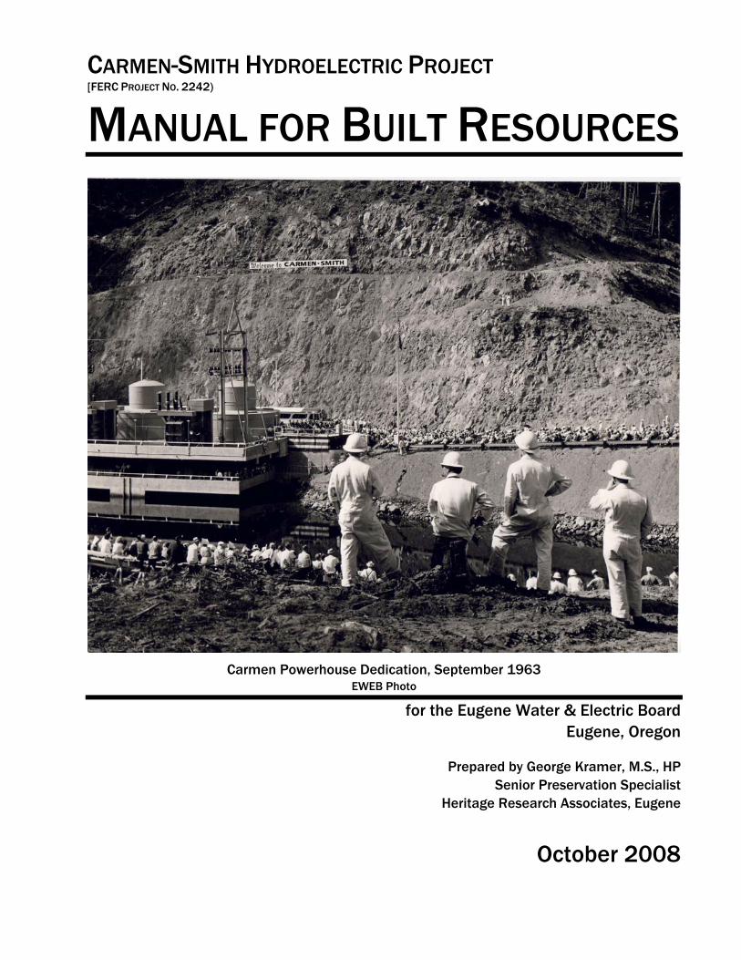
CARMEN-SMITH HYDROELECTRIC PROJECT [FERC PROJECT NO. 2242)
MANUAL FOR BUILT RESOURCES
Carmen Powerhouse Dedication, September 1963 EWEB Photo
for the Eugene Water & Electric Board Eugene, Oregon
Prepared by George Kramer, M.S., HP Senior Preservation Specialist
Heritage Research Associates, Eugene
October 2008
MANUAL FOR BUILT RESOURCES
FOR EUGENE WATER & ELECTRIC BOARD
CARMEN-SMITH HYDROELECTRIC PROJECT FERC NO. 2242
Final Version
Prepared by
George Kramer, M.S. Sr. Preservation Specialist
Heritage Research Associates, Inc.
1997 Garden Ave. Eugene, Oregon 97403
October 2008
CARMEN-SMITH HYDROELECTRIC PROJECT HISTORIC RESOURCES MANAGEMENT & MAINTENANCE GUIDELINES
Page 3
TABLE OF CONTENTS
1.0 INTRODUCTION ..................................................................... 5 1.1 PROJECT OVERVIEW: .......................................................................................................................... 6 1.2 APPLICABILITY ..................................................................................................................................... 6 1.3 GUIDELINES FORMAT .......................................................................................................................... 7 1.4 THE TREATMENT OF HISTORIC RESOURCES ..................................................................................... 9 1.5 THE MANAGEMENT AND MAINTENANCE OF HISTORIC RESOURCES: ............................................ 16 1.6 HISTORIC SIGNIFICANCE: .................................................................................................................. 18
2.0 GENERAL WORK ................................................................. 20 2.1. GENERAL WORK: CHARACTER DEFINITION: ................................................................................. 21 2.2. GENERAL WORK: WATER FEATURES: ........................................................................................... 23 2.3 GENERAL WORK: CORRIDORS ......................................................................................................... 25 2.4 GENERAL WORK: BRIDGES .............................................................................................................. 27
3.0 GENERATION AND RELATED STRUCTURES .......................... 29 3.1. DAMS, SPILLWAYS & TAILRACES .................................................................................................... 31 3.2. INTAKES & IN-WATER STRUCTURES ................................................................................................ 33 3.3. WATER CONVEYANCE; ABOVE GROUND ........................................................................................ 34 3.4. POWERHOUSES .................................................................................................................................. 35 3.5. POWERHOUSE SUPPORT ................................................................................................................... 37 3.6. FISH RELATED ................................................................................................................................... 39 3.7. TRANSMISSION TOWERS ................................................................................................................... 41
4.0 SUPPORT AND RESIDENTIAL STRUCTURES ........................... 43 4.1 SITE DESIGN ....................................................................................................................................... 45 4.2 SIDING ................................................................................................................................................. 47 4.3 OPENINGS ............................................................................................................................................ 49 4.4 ROOFS ................................................................................................................................................. 51 4.5 DECORATIVE FEATURES/TRIM ......................................................................................................... 53 4.6 CONCRETE .......................................................................................................................................... 55 4.7 NON-RESIDENTIAL BUILDINGS (INNER RING) ................................................................................. 57 4.8 NON-RESIDENTIAL BUILDINGS (OUTER RING) ................................................................................ 58 4.9 SCATTERED MINOR STRUCTURES ..................................................................................................... 60
CARMEN-SMITH HYDROELECTRIC PROJECT HISTORIC RESOURCES MANAGEMENT & MAINTENANCE GUIDELINES
Page 4
5.0 RECREATION RELATED ........................................................ 61 5.1 SITE DESIGN ....................................................................................................................................... 63 5.2 EDGE DEFINITION .............................................................................................................................. 64 5.3 CAMPISTE AMENITIES ....................................................................................................................... 65 5.4 BUILDINGS .......................................................................................................................................... 66 5.5 INTERPRETATION & INFORMATIONAL SIGNAGE ............................................................................. 67
BIBLIOGRAPHY .......................................................................... 69
Appendix A: SHPO Letter of Concurrence
Appendix B: Project Description and List of Built Resources
CARMEN-SMITH HYDROELECTRIC PROJECT HISTORIC RESOURCES MANAGEMENT & MAINTENANCE GUIDELINES
Section 1: Introduction Page 5
Section 1
Introduction
CARMEN-SMITH HYDROELECTRIC PROJECT HISTORIC RESOURCES MANAGEMENT & MAINTENANCE GUIDELINES
Section 1: Introduction Page 6
1.1 Project Overview
The following maintenance and management guidelines for built resources at the Carmen-Smith Hydroelectric Project are a component of a Historic Resource Management Plan [HRMP] commissioned by the Eugene Water & Electric Board [EWEB]. Like the HRMP, this document was prepared in connection with the relicensing process for Federal Energy Regulatory Commission [FERC] license No. 2242. The historic significance of the Carmen-Smith Project was evaluated in 2005 and the project was Determined Eligible for listing on the National Register of Historic Places in January 2006 (See Appendix A)
1.2 Applicability These maintenance and management guidelines apply specifically to the built aspects of the
Carmen-Smith Hydroelectric Project that are considered “contributing” to the historic significance of the facility as defined by the Section 106 request for Determination of Eligibility form approved by the Oregon State Historic Preservation Office in January 2006. Essentially, contributing built elements at Carmen-Smith are those that were constructed prior to 1963 and retain integrity to their original design and character. “Built” as used here applies to constructed physical features standing within the natural landscape as well as manipulated or altered natural areas related to the project such as reservoirs.
This document also provides guidance for any new work that may have visual or other impact
on the overall character of the site, such as the siting of new construction in proximity to historic contributing resources. Issues related to vegetation and landscape issues, beyond the scope of this manual, are covered through EWEB’s Vegetation Management Plan (VMP) for the Carmen-Smith Project and the Recreation and Aesthetics Management Plan (RAMP). Specific issues associated with the water conveyance, generation, support, recreation and fish management features are documented in major sections, by type.
As required by the HRMP, any proposed undertaking that is not detailed in these guidelines
should be reviewed according to the process outlined in the HRMP. Review of all undertakings should occur during the planning phase so as to allow every opportunity to minimize any effect on the historic character of the Project to the greatest extent feasible.
CARMEN-SMITH HYDROELECTRIC PROJECT HISTORIC RESOURCES MANAGEMENT & MAINTENANCE GUIDELINES
Section 1: Introduction Page 7
1.3 Guidelines Format The basic format for the management and maintenance guidelines is derived
from a combination of standard formats developed by the National Park Service [NPS] and provided by the State Historic Preservation Office [SHPO], augmented by information supplied by the Advisory Council on Historic Preservation [ACHP]. In order to make the document as straightforward as possible, much of the individual issue discussion follows the basic outline of the NPS-developed ‘‘Historic Structures Report’’ [HSR], a format devised to document existing conditions and repair strategies for individual built historic resources. The key element of the HSR is an organizational framework that covers specific issues in a logical order, providing practical guidance for resource management and maintenance personnel. The use of a consistent organizational system for each of the varying building types will enable quick reference and easy access to information on an ‘‘as-needed’’ basis. The basic organization of these guidelines contains five sections, based upon the specific character of the built resources of the Carmen-Smith Hydroelectric Project.
1. Introduction: This section, providing an overview of the guidelines document.
2. General Work: Concerning intrinsic site- and landscape-based issues such as roads, building placement, reservoir edge features, vegetation and similar issues, exclusive of typical construction-related, building-specific, issues. Given that the significance of the Carmen-Smith project is through its association to an early attempt at establishing an environmentally-sensitive character, as described in the Section 106 Documentation (Request for a Determination of Eligibility), this section provides guidance for new construction and system modifications that will best continue, and respect, that original character.
3. Generation and Industrial-Related Structures: Concerning resources related to the actual generation of electricity and the industrial support structures associated with that function. This section includes all built water-management features such as the dams, spillways, intakes, headgates, transmission lines, and other similar elements built of concrete and steel.
4. Residential and Support Structures: Concerning housing, offices and storage facilities, communications facilities and similar smaller buildings related to the housing and personnel and support functions associated with the project facilities. These buildings, generally wood frame but including concrete and other materials, are of simple architectural design and are significant only through their relationship to the operation of the project.
5. Recreation Related Facilities: Concerning those resources related to the recreation and camping associated with the project. These resources include minor built elements as well as the landscape/site character of campgrounds and related facilities.
At most of the major sections (i.e. Section 3, ‘‘Generation and Industrial
Related Structures’’) a general statement identifies the basic issues associated with that resource group. Next, individual ‘Items’ (i.e. 3.1, 3.2, etc.) cover specific features of the resources within the group, each focused on a particular aspect of the type of built resource under discussion. These Items are generally ordered from larger scale (site) to more specific issues (roofs, or openings). For ease of use, all Items are divided into consistent
CARMEN-SMITH HYDROELECTRIC PROJECT HISTORIC RESOURCES MANAGEMENT & MAINTENANCE GUIDELINES
Section 1: Introduction Page 8
sections, with most illustrated with examples to better inform the reader. Item divisions are as follows:
A. Basic Description: A simple narrative explanation of the feature.
B. Historic Character-Defining Aspects: Identifying the aspects of the feature that define its historic character.
C. Alterations or Modifications Present: A statement of ‘‘current condition,’’ including changes over time that either support or detract from the character-defining aspects.
D. Goal: The objective for all maintenance and management activities concerning this particular feature.
E. Approach: A general statement defining the basic approach to meet the goal.
While copies of the management and maintenance guidelines may be bound and distributed whole as needed, the master copy is intended to be a loose-leaf document that allows easy update and, more importantly, ready copying and distribution. Individual resource or feature-related sheets are intended as ‘‘stand-alone’’ documents that can be easily used by field maintenance staff on an issue-by-issue basis. As specific solutions or materials are adopted to address particular Item goals, the guidelines should include that information (paint color, vendor sourcing, installation notes, etc.) so as to maintain consistency and inform similar work in the future. As new repair technologies or historically appropriate replacement products become available, individual elements of the guidelines should be updated and modified when needed, following the consultation and review process outline in the HRMP.
These guidelines, though an integral element of the HRMP, are intended as a
true ‘‘working’’ document, and not as a static report that remains shelf bound after its initial review and acceptance. As a part of a regular review process, project facilities that may achieve significance subsequent to the adoption of these guidelines should be included in the guidelines following an amendment process.
CARMEN-SMITH HYDROELECTRIC PROJECT HISTORIC RESOURCES MANAGEMENT & MAINTENANCE GUIDELINES
Section 1: Introduction Page 9
1.4 The Treatment of Historic Resources By definition, designated historic resources associated with the Carmen-
Smith Hydroelectric Project, located within the boundary of EWEB’s FERC-licensed activities, will be treated subject to different management and maintenance standards than non-historic resources.1 The National Park Service has developed four levels of the Secretary of the Interior’s Standards for the Treatment of Historic Properties. These are 1) Preserving, 2) Rehabilitating, 3) Restoring and 4) Reconstructing (Weeks and Grimmer, 1995).
All SHPO or NPS review of activities concerning designated historic
resources will find that a proposed activity either ‘‘meets the Standards’’ or does not. As established by the HRMP, EWEB will use the Secretary’s Standards as the primary basis for its management and maintenance of historic resources at Carmen-Smith. Of the four ‘‘Treatments,’’ presented within the Secretary of the Interior’s Standards for the Treatment of Historic Properties, the Standard for Preservation historic properties is the most appropriate guide for EWEB’s management of the Project.
In reference to the preservation of historic resources, the basic tenant of
‘‘do no harm’’ holds true, with the expectation that buildings and structures should be treated in a manner that retains their historic character and, when repair is required, does as little as possible to alter that historic character as is feasible. The basic ‘‘Four Step Approach’’ to the management of historic resources will be:
1. IT IS BETTER TO MAINTAIN THAN TO REPAIR Except for normal on-going maintenance issues or modifications required by changing uses, a well-maintained building is both less expensive to operate in the long run and more likely to retain its historic character. The costs of deferred maintenance, causing larger and more expensive problems to rectify, also includes the unnecessary loss of historic materials through deterioration.
2. DAMAGED ELEMENTS SHOULD BE REPAIRED RATHER THAN REPLACED When a historic element is damaged, repair and retention is given priority over wholesale replacement of the feature so as to retain original material as possible.
3. WHERE REPAIR IS NOT FEASIBLE, IN-KIND REPLACEMENTS THAT MATCH THE ORIGINAL IN ALL VISUAL CHARACTERISTICS WILL BE USED Where historic materials are determined to be beyond salvage, or when changing uses require new work, new materials will be as visually and physically compatible with historic materials. IN-KIND replacement materials are those that replicate the original element in scale, design, material, and all other visual characteristics to the greatest degree possible.
1 A list of the designated resources, as detailed in the Determination of Eligibility, is included as Appendix B to this document.
CARMEN-SMITH HYDROELECTRIC PROJECT HISTORIC RESOURCES MANAGEMENT & MAINTENANCE GUIDELINES
Section 1: Introduction Page 10
4. BE CONSERVATIVE Historic character is difficult to define. The existing quantity and quality of original materials at the site are fixed and irreplaceable. No changes that include removal of historic material will be undertaken unless determined unavoidable and necessary for continued operation. Prior to any project, all alternatives should be fairly considered. Strategies that allow for the retention of historic material, even when more costly or time-consuming, should be given preference if they accomplish the same final result in operation.
THE STANDARDS FOR PRESERVATION
The majority of built resources identified at the Carmen-Smith Hydroelectric Project remain largely ‘‘as built’’ (i.e. substantially unaltered or modified from the original design). As a result, most elements of Carmen-Smith retain essential integrity and a high degree of original materials, meaning that the Secretary’s Standards for Preservation will serve as EWEB’s primary guide for on-going maintenance and normal repair.
Normal repair work, including modest system upgrades, changes required by new code issues such as ADA, energy or seismic retrofit, and similar issues as detailed in the following Guidelines will comply with the following Standards for Preservation (Weeks & Grimmer, 1995:21)
CARMEN-SMITH HYDROELECTRIC PROJECT HISTORIC RESOURCES MANAGEMENT & MAINTENANCE GUIDELINES
Section 1: Introduction Page 11
STANDARDS FOR PRESERVATION
Preservation is defined as the act or process of applying measures necessary to sustain the existing form, integrity, and materials of an historic property. Work, including preliminary measures to protect and stabilize the property, generally focuses upon the ongoing maintenance and repair of historic materials and features rather than extensive replacement and new construction. New exterior additions are not within the scope of this treatment; however, the limited and sensitive upgrading of mechanical, electrical, and plumbing systems and other code-required work to make properties functional is appropriate within a preservation project [NPS Website].
1. A property will be used as it was historically, or be given a new use that maximizes the retention of distinctive materials, features, spaces, and spatial relationships. Where a treatment and use have not been identified, a property will be protected and, if necessary, stabilized until additional work may be undertaken.
2. The historic character of a property will be retained and preserved. The replacement of intact or repairable historic materials or alteration of features, spaces, and spatial relationships that characterize a property will be avoided.
3. Each property will be recognized as a physical record of its time, place, and use. Work needed to stabilize, consolidate, and conserve existing historic materials and features will be physically and visually compatible, identifiable upon close inspection, and properly documented for future research.
4. Changes to a property that have acquired historic significance in their own right will be retained and preserved.
5. Distinctive materials, features, finishes, and construction techniques or examples of craftsmanship that characterize a property will be preserved.
6. The existing condition of historic features will be evaluated to determine the appropriate level of intervention needed. Where the severity of deterioration requires repair or limited replacement of a distinctive feature, the new material will match the old in composition, design, color, and texture.
7. Chemical or physical treatments, if appropriate, will be undertaken using the gentlest means possible. Treatments that cause damage to historic materials will not be used.
8. Archeological resources will be protected and preserved in place. If such resources must be disturbed, mitigation measures will be undertaken.
Source: National Park Service,
1995:18
CARMEN-SMITH HYDROELECTRIC PROJECT HISTORIC RESOURCES MANAGEMENT & MAINTENANCE GUIDELINES
Section 1: Introduction Page 12
THE STANDARDS FOR REHABILITATION
The Standards for Rehabilitation serve as the primary guide for additions to existing buildings, new construction, or any proposed changes that are not appropriately governed by the preservation standard.
Rehabilitation is defined as the act or process of making possible a compatible use for a property through repair, alterations, and additions while preserving those portions or features which convey its historical, cultural, or architectural values [NPS Website].
1. A property will be used as it was historically or be given a new use that requires
minimal change to its distinctive materials, features, spaces, and spatial relationships.
2. The historic character of a property will be retained and preserved. The removal of distinctive materials or alteration of features, spaces, and spatial relationships that characterize a property will be avoided.
3. Each property will be recognized as a physical record of its time, place, and use. Changes that create a false sense of historical development, such as adding conjectural features or elements from other historic properties, will not be undertaken.
4. Changes to a property that have acquired historic significance in their own right will be retained and preserved.
5. Distinctive materials, features, finishes, and construction techniques or examples of craftsmanship that characterize a property will be preserved.
6. Deteriorated historic features will be repaired rather than replaced. Where the severity of deterioration requires replacement of a distinctive feature, the new feature will match the old in design, color, texture, and, where possible, materials. Replacement of missing features will be substantiated by documentary and physical evidence.
7. Chemical or physical treatments, if appropriate, will be undertaken using the gentlest means possible. Treatments that cause damage to historic materials will not be used.
8. Archeological resources will be protected and preserved in place. If such resources must be disturbed, mitigation measures will be undertaken.
9. New additions, exterior alterations, or related new construction will not destroy historic materials, features, and spatial relationships that characterize the property. The new work shall be differentiated from the old and will be compatible with the historic materials, features, size, scale and proportion, and massing to protect the integrity of the property and its environment.
CARMEN-SMITH HYDROELECTRIC PROJECT HISTORIC RESOURCES MANAGEMENT & MAINTENANCE GUIDELINES
Section 1: Introduction Page 13
10. New additions and adjacent or related new construction will be undertaken in a such a manner that, if removed in the future, the essential form and integrity of the historic property and its environment would be unimpaired.
Source: National Park Service, 1995:62
CARMEN-SMITH HYDROELECTRIC PROJECT HISTORIC RESOURCES MANAGEMENT & MAINTENANCE GUIDELINES
Section 1: Introduction Page 14
1.4.4 CULTURAL LANDSCAPE DEFINITIONS
Given its specific historic significance that results from EWEB’s efforts to integrate the project into the surrounding natural environment, the management of the general setting and character of the Carmen-Smith Hydroelectric Project falls within the basic approaches defined by the National Park Service for the Treatment of Cultural Landscapes. A cultural landscape, as defined by the Park Service, is:
Cultural Landscape: A geographic area (including both cultural and natural resources and the wildlife or domestic animals therein), associated with a historic event, activity, or person exhibiting other cultural or aesthetic values. There are four general types of cultural landscapes, not mutually exclusive: historic sites, historic designed landscapes, historic vernacular landscapes, and ethnographic landscapes.….(NPS, 1996:4)
The following definitions related to identification and management of
cultural landscapes help guide their management.
Character-defining feature - a prominent or distinctive aspect, quality, or characteristic of a cultural landscape that contributes significantly to its physical character. Land use patterns, vegetation, furnishings, decorative details and materials may be such features.
Component landscape - A discrete portion of the landscape which can be further subdivided into individual features. The landscape unit may contribute to the significance of a National Register property, such as a farmstead in a rural historic district. In some cases, the landscape unit may be individually eligible for the National Register of Historic Places, such as a rose garden in a large urban park.
Cultural landscape - a geographic area (including both cultural and natural resources and the wildlife or domestic animals therein), associated with a historic event, activity, or person or exhibiting other cultural or aesthetic values. There are four general types of cultural landscapes, not mutually exclusive: historic sites, historic designed landscapes, historic vernacular landscapes, and ethnographic landscapes.
Ethnographic landscape - a landscape containing a variety of natural and cultural resources that associated people define as heritage resources. Examples are contemporary settlements, sacred religious sites, and massive geological structures. Small plant communities, animals, subsistence and ceremonial grounds are often components.
Feature - The smallest element(s) of a landscape that contributes to the significance and that can be the subject of a treatment intervention. Examples include a woodlot, hedge, lawn, specimen plant, allee, house, meadow or open field, fence, wall, earthwork, pond or pool, bollard, orchard, or agricultural terrace.
CARMEN-SMITH HYDROELECTRIC PROJECT HISTORIC RESOURCES MANAGEMENT & MAINTENANCE GUIDELINES
Section 1: Introduction Page 15
Historic character - the sum of all visual aspects, features, materials, and spaces associated with a cultural landscape’s history, i.e. the original configuration together with losses and later changes. These qualities are often referred to as character-defining.
Historic designed landscape - a landscape that was consciously designed or laid out by a landscape architect, master gardener, architect, engineer, or horticulturist according to design principles, or an amateur gardener working in a recognized style or tradition. The landscape may be associated with a significant person, trend, or event in landscape architecture; or illustrate an important development in the theory and practice of landscape architecture. Aesthetic values play a significant role in designed landscapes. Examples include parks, campuses, and estates.
Historic vernacular landscape - a landscape that evolved through use by the people whose activities or occupancy shaped it. Through social or cultural attitudes of an individual, a family, or a community, the landscape reflects the physical, biological, and cultural character of everyday lives. Function plays a significant role in vernacular landscapes. This can be a farm complex or a district of historic farmsteads along a river valley. Examples include rural historic districts and agricultural landscapes.
Historic site - a landscape significant for its association with a historic event, activity or person. Examples include battlefields and presidential homes and properties.
Integrity - the authenticity of a property’s historic identity, evinced by the survival of physical characteristics that existed during the property’s historic or prehistoric period. The seven qualities of integrity as defined by the National Register Program are location, setting, feeling, association, design, workmanship, and materials.
Significance - the meaning or value ascribed to a cultural landscape based on the National Register criteria for evaluation. It normally stems from a combination of association and integrity.
Treatment - work carried out to achieve a particular historic preservation goal.2
Viewing Carmen-Smith, as a whole, as a cultural landscape, allows us to
future define various elements of the project, in general treated as ‘‘built resources’’ within this document as also being something of component landscapes (such as the reservoirs and transmission corridors) or ‘‘features,’’ such as the individual dams or the individual transmission towers. It is considered key in maintaining the historic character of Carmen-Smith to understand that the components and the features gain significance through their relationship and compatibility to each other. How project features interface with the surrounding, non-project, landscape requires a delicate balancing act that respects the original design and relationships established by EWEB during the original construction period.
2 From NPS 1996:4-5, Guidelines for the Treatment of Cultural Landscapes. See also http://www.nps.gov/history/HPS/hli/landscape_guidelines/terminology.htm
CARMEN-SMITH HYDROELECTRIC PROJECT HISTORIC RESOURCES MANAGEMENT & MAINTENANCE GUIDELINES
Section 1: Introduction Page 16
1.5 The Management and Maintenance of Historic Resources The normal maintenance process includes regularly scheduled maintenance and
cyclical activities as well as periodic upgrade to maintain operations at an appropriate functional level. Each of these normal maintenance activities is subject to the Standards for Preservation.
Regular maintenance includes activities such as landscape maintenance (tree
trimming, etc.), as well less-than-monthly maintenance such as repairing winter damage, undergrowth removal, road grading, repainting minor trim, gutter repair, and similar work. In this context, maintenance by definition implies the ‘‘conservation’’ of existing elements by extending their useful life and responding to minor damage promptly and sensitively. An on-going maintenance program, grounded in a respect for the historic character of the resources, is the single most important factor in maintaining the significant historic character of the Carmen-Smith Hydroelectric Project. Prompt and appropriate repair of normal wear and tear, such as the removal of leaves, dirt or other debris before it creates major problems, both maintains the existing resource and, through familiarity, allows EWEB maintenance personnel a regular opportunity to inspect and monitor buildings and provide an ‘‘early-warning’’ system for issues that require attention. A regular maintenance program, with appropriate oversight to assure compliance, should be established by EWEB.
Over time, larger maintenance-related upgrades will also occur as the
historic resources at Carmen-Smith remain functional components of EWEB’s normal operation. Such upgrades might include roof replacement for support structures, repainting structures and facilities, installation of additional security fencing or monitoring devices, as well as interpretative or directional signage associated with project operations or recreational areas. All such activities, though not ‘‘regular’’ maintenance, are also subject to the Standards for Preservation and as a result should be planned and undertaken in ways that ‘‘…sustain the existing form, integrity, and materials…’’ of the historic property.
Specific guidance on various technical preservation issues is available on
a wide range of topics via the ‘‘Preservation Briefs’’ series, published by the National Park Service. An index of this series, along with web-based copies of most of the issues, is available on line at http://www2.cr.nps.gov/tps/briefs/presbhom.htm.
CARMEN-SMITH HYDROELECTRIC PROJECT HISTORIC RESOURCES MANAGEMENT & MAINTENANCE GUIDELINES
Section 1: Introduction Page 17
1.5.1 ADDITIONS TO HISTORIC RESOURCES
Since the original development of the Carmen-Smith Hydroelectric Project, changes in operation, technology, and society at large, have resulted in minor modifications to original elements, particularly in the area of the support structures and communications facilities. Existing support, generation and water-conveyance elements may be subject to future expansion as the result of efforts to increase generation capacity, to improve fish passage, or simply to create more storage or office space on the site. All such additions to existing historic resources are subject to the Standards for Rehabilitation.
1.5.2 NEW CONSTRUCTION WITHIN THE HISTORIC AREA
Over the life of both the FERC License and the HRMP, there will almost certainly be situations in which EWEB will require entirely new construction within the Project in order to address improved operation, fish passage, or additional support or recreational-related needs. Such new construction, subject to the pertinent elements of Section 2 General Work, are ultimately subject to the Standards for Rehabilitation so as to maintain the overall significant character of the Carmen-Smith project. Any new construction should be designed for compatibility with original resources while avoiding imitative design. It is understood and acknowledged that it is neither practical, nor desirable for new construction to duplicate the character of historic resources.
1.5.3 HISTORIC RESOURCE REMOVAL OR DEMOLITION
The removal or demolition of any historic resource, whether as a result of changes in operation, natural disaster, compliance with another agency required mandate, or other company interests, is specifically EXCLUDED from these Management and Maintenance Guidelines. Such an activity, by definition an ‘‘Adverse Effect,’’ will require the standard Section 106 consultation and mitigation process described in Section 4 of the HPMP.
CARMEN-SMITH HYDROELECTRIC PROJECT HISTORIC RESOURCES MANAGEMENT & MAINTENANCE GUIDELINES
Section 1: Introduction Page 18
1.6 Historic Significance In order to provide a basic foundation for the following management and
maintenance guidelines it is important to understand the specific aspects of the Carmen-Smith Hydroelectric Project that resulted in its having been Determined Eligible for listing on the National Register of Historic Places in 2006.
Unlike other historically designated hydroelectric projects, including
EWEB’s own Leaburg- Walterville Hydroelectric Project, Carmen-Smith represents an entirely different, yet clearly significant, period in the history of hydropower design and development in the Pacific Northwest. Planned and designed during the late 1950s and not completed until 1963, Carmen-Smith’s significance relates not directly to its architecture or design, as a typical Criterion C designation would, but rather to Criterion A, for its association with broad themes in our history. As summarized in the Request for Determination of eligibility,
The Carmen-Smith Hydroelectric Project demonstrates significant association with the history of Eugene, Oregon and the growth of the environmental movement in Oregon….the design of Carmen-Smith includes specific aspects intended to minimize visual impacts and retain the visual and aesthetic values of the McKenzie River region….(EWEB, 2005:15).
Although the design and
visual character of the project is important in relating its original appearance, distinct from typical built resource significance, much of Carmen-Smith’s historic character resides not so much in the way that it looks, as would be the case for a finely detailed powerhouse such as
EWEB’s Leaburg Powerhouse, but instead in the way that it doesn’t. Carmen-Smith’s design was intended to be unobtrusive, to be as near ‘‘invisible’’ as a large scale hydroelectric project could be, in order to preserve the natural character of the McKenzie River drainage (See Section 2.0 for specific guidance on individual types of the various industrial, generation-related, resources). This built character, or its design intent to blend, presents unusual challenges for maintenance and management that involve the visual inter-relationship between the project elements and the surrounding landscapes to a higher degree than is typical of earlier, pre-WWII era, hydroelectric projects.
Within this significant context, management and maintenance approaches at
Carmen-Smith have what might be termed both internal compatibility, meaning compatible design that mirrors the original design character of the project’s built elements, and external compatibility, meaning how the built elements of the project inter-relate visually with the surrounding landscape. Managing change and modification at the project, therefore, needs to balance historic integrity (meaning consistency with the original design) and historic intent (meaning the historic Carmen-Smith goal of compatibility with its environment) in a manner that is complex, delicate, and to some extent, unique. Balancing those two aspects of compatibility is a key factor in determining appropriate management practices that allow Carmen-Smith to retain integrity to its historic character and to respect the associations that make it significant.
Carmen-Smith’s historic character resides not so much in the way that it looks,… but instead in the way that it doesn’t. Carmen-Smith’s design was intended to be unobtrusive, to be as near ‘‘invisible’’ as a l l h d l i
CARMEN-SMITH HYDROELECTRIC PROJECT HISTORIC RESOURCES MANAGEMENT & MAINTENANCE GUIDELINES
Section 1: Introduction Page 19
The formal request for Determination of Eligibility for the Carmen-Smith
Hydroelectric Project identified 39 individual ‘‘built’’ elements at the Project, the majority of which were built prior to 1963 and so are considered ‘‘contributing’’ elements to its historic significance. Larger issues related to the character of the landscape and the inter-relationship between built resources and their surroundings were not specifically identified as contributing, as they are not ‘‘built’’ in the normal sense. However, implicit in the Criterion A designation of Carmen-Smith, which was determined historically significant for relationship to the growth of the environmental movement in Oregon and EWEB’s then cutting-edge efforts to integrate the project in the landscape while minimizing visual effects, is the recognition that the way the project relates to its surroundings remains a key character-defining feature of the project. Retaining that relationship and the visual integration between built project elements and the landscape, therefore, are considered primary to assuring project integrity and a continued ability to relate its significant association.
CARMEN-SMITH HYDROELECTRIC PROJECT HISTORIC RESOURCES MANAGEMENT & MAINTENANCE GUIDELINES
Section 2: General Work Page 20
Section 2
General Work
(non-building specific)
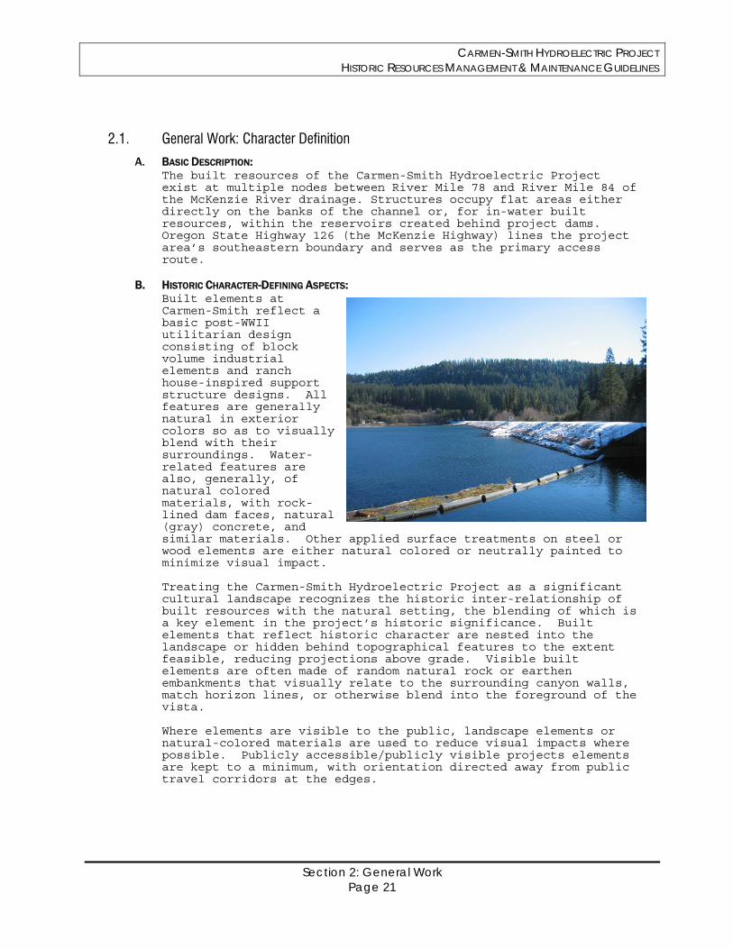
CARMEN-SMITH HYDROELECTRIC PROJECT HISTORIC RESOURCES MANAGEMENT & MAINTENANCE GUIDELINES
Section 2: General Work Page 21
2.1. General Work: Character Definition
A. BASIC DESCRIPTION: The built resources of the Carmen-Smith Hydroelectric Project exist at multiple nodes between River Mile 78 and River Mile 84 of the McKenzie River drainage. Structures occupy flat areas either directly on the banks of the channel or, for in-water built resources, within the reservoirs created behind project dams. Oregon State Highway 126 (the McKenzie Highway) lines the project area’s southeastern boundary and serves as the primary access route.
B. HISTORIC CHARACTER-DEFINING ASPECTS: Built elements at Carmen-Smith reflect a basic post-WWII utilitarian design consisting of block volume industrial elements and ranch house-inspired support structure designs. All features are generally natural in exterior colors so as to visually blend with their surroundings. Water-related features are also, generally, of natural colored materials, with rock-lined dam faces, natural (gray) concrete, and similar materials. Other applied surface treatments on steel or wood elements are either natural colored or neutrally painted to minimize visual impact. Treating the Carmen-Smith Hydroelectric Project as a significant cultural landscape recognizes the historic inter-relationship of built resources with the natural setting, the blending of which is a key element in the project’s historic significance. Built elements that reflect historic character are nested into the landscape or hidden behind topographical features to the extent feasible, reducing projections above grade. Visible built elements are often made of random natural rock or earthen embankments that visually relate to the surrounding canyon walls, match horizon lines, or otherwise blend into the foreground of the vista. Where elements are visible to the public, landscape elements or natural-colored materials are used to reduce visual impacts where possible. Publicly accessible/publicly visible projects elements are kept to a minimum, with orientation directed away from public travel corridors at the edges.
CARMEN-SMITH HYDROELECTRIC PROJECT HISTORIC RESOURCES MANAGEMENT & MAINTENANCE GUIDELINES
Section 2: General Work Page 22
C. ALTERATIONS OR MODIFICATIONS PRESENT: Taken as a whole, very little modification to the general character of the original elements at Carmen-Smith has occurred. Minor modifications do not seriously affect the overall compatibility of the project.
D. GOAL: Maintain and retain the general and specific historic character of the Carmen-Smith Hydroelectric Project in a manner that respects its historic association while allowing for its continued efficient operation.
E. APPROACH: Any proposed modification to existing structures or landscape elements at Carmen-Smith should be undertaken in a manner that minimizes change or the introduction of new elements that impact or alter the existing character. Approaches that continue or add to existing elements are preferred over the creation of entirely new elements whenever possible. In addition to materials and construction, the spatial relationships between elements, including mass and scale, should be carefully considered to retain the existing character to the greatest extent feasible. In order to maintain existing character and relationships, project designs that, in addition to materials and design, can take advantage of topography to reduce visual intrusion and minimize any disruption to the existing character are preferred. For example, projects should be located in low spots to reduce visibility from public viewpoints and sited behind natural features (or existing built features) to retain existing visual relationships from an external viewpoint. Where modifications are required by Project operations or other goals, new work should utilize natural colored, utilitarian materials and treatments that minimize visual intrusion consistent with the original project character. To the greatest extent feasible, new work should be located with respect to existing ‘‘nodes’’ of built resources, respecting the clustered approach to visible built resources within the project boundaries. Construction of entirely new, isolated, structures should only occur when project functionality demands that they be physically separate from existing project facilities. Care in matching existing character through color and materials is considered essential to maintaining the historic character of Carmen-Smith. This can largely be accomplished through the consistent use of traditional industrial materials including concrete and painted steel in neutral colors. Information regarding original treatments located during maintenance or future work may be generalized to guide work on similar features located throughout the project. The introduction of ‘‘designed’’ or ‘‘stylized’’ elements, particularly at the generation-related areas, is not appropriate or consistent with the original character. The introduction of new colors, especially non-neutral or bright colors that create contrast with the surrounding landscape, should be avoided to the greatest extent possible.
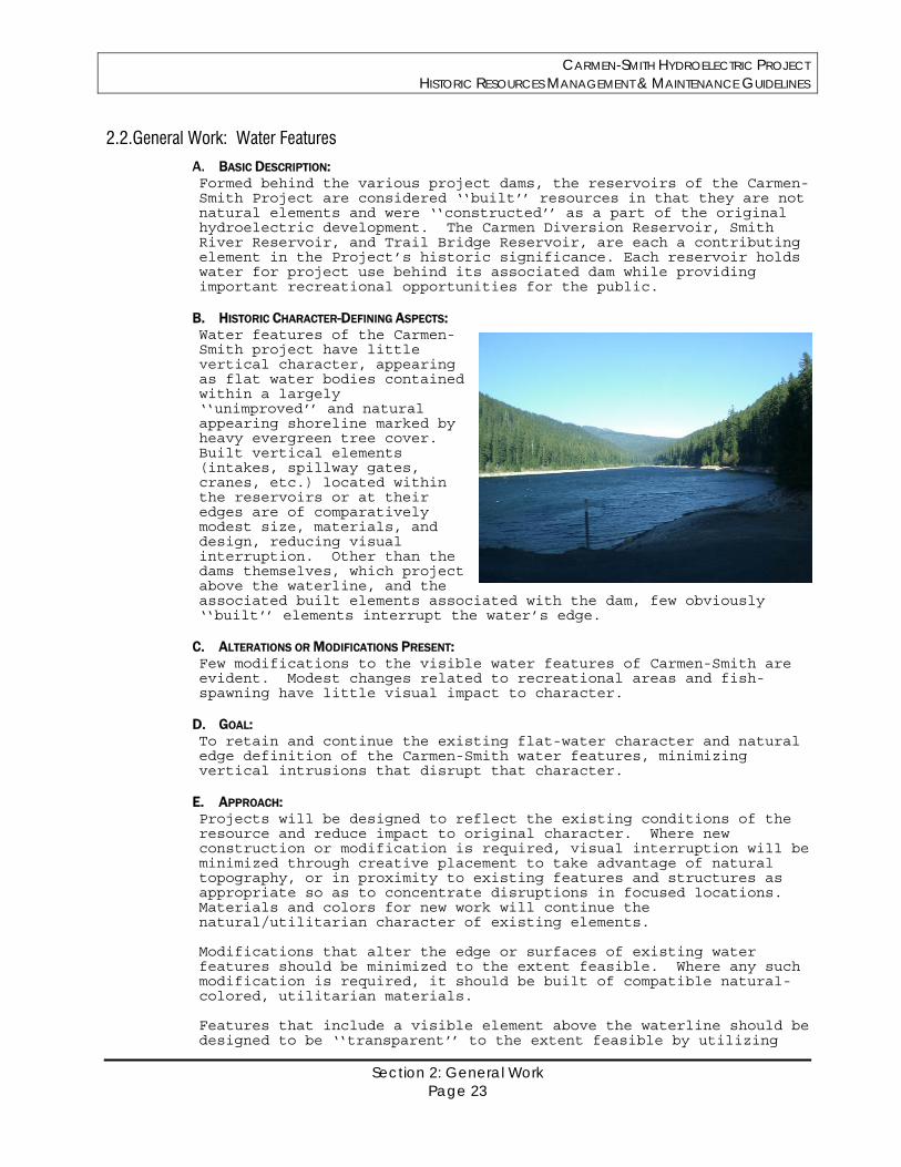
CARMEN-SMITH HYDROELECTRIC PROJECT HISTORIC RESOURCES MANAGEMENT & MAINTENANCE GUIDELINES
Section 2: General Work Page 23
2.2.General Work: Water Features
A. BASIC DESCRIPTION: Formed behind the various project dams, the reservoirs of the Carmen-Smith Project are considered ‘‘built’’ resources in that they are not natural elements and were ‘‘constructed’’ as a part of the original hydroelectric development. The Carmen Diversion Reservoir, Smith River Reservoir, and Trail Bridge Reservoir, are each a contributing element in the Project’s historic significance. Each reservoir holds water for project use behind its associated dam while providing important recreational opportunities for the public.
B. HISTORIC CHARACTER-DEFINING ASPECTS: Water features of the Carmen-Smith project have little vertical character, appearing as flat water bodies contained within a largely ‘‘unimproved’’ and natural appearing shoreline marked by heavy evergreen tree cover. Built vertical elements (intakes, spillway gates, cranes, etc.) located within the reservoirs or at their edges are of comparatively modest size, materials, and design, reducing visual interruption. Other than the dams themselves, which project above the waterline, and the associated built elements associated with the dam, few obviously ‘‘built’’ elements interrupt the water’s edge.
C. ALTERATIONS OR MODIFICATIONS PRESENT: Few modifications to the visible water features of Carmen-Smith are evident. Modest changes related to recreational areas and fish-spawning have little visual impact to character.
D. GOAL: To retain and continue the existing flat-water character and natural edge definition of the Carmen-Smith water features, minimizing vertical intrusions that disrupt that character.
E. APPROACH: Projects will be designed to reflect the existing conditions of the resource and reduce impact to original character. Where new construction or modification is required, visual interruption will be minimized through creative placement to take advantage of natural topography, or in proximity to existing features and structures as appropriate so as to concentrate disruptions in focused locations. Materials and colors for new work will continue the natural/utilitarian character of existing elements. Modifications that alter the edge or surfaces of existing water features should be minimized to the extent feasible. Where any such modification is required, it should be built of compatible natural-colored, utilitarian materials. Features that include a visible element above the waterline should be designed to be ‘‘transparent’’ to the extent feasible by utilizing
CARMEN-SMITH HYDROELECTRIC PROJECT HISTORIC RESOURCES MANAGEMENT & MAINTENANCE GUIDELINES
Section 2: General Work Page 24
narrow profile supporting members, light colors, and surface treatments that reduce visual impact. Placement near, or expansion of, existing vertical elements is preferred and recommended over the introduction of new, discrete, elements. Where other project requirements necessitate new and isolated construction, efforts will be made to place them with respect to existing elements or to take advantage of existing natural formations that will serve to mask the change. Where no flexibility for placement exists, new work shall be undertaken using natural toned, utilitarian materials in as ‘‘transparent’’ or minimally intrusive fashion as possible. New features constructed above the waterline, at the edges of reservoirs, will be sited to take advantage of natural topography and public views so as to reduce visual impact, particularly from the public right of way. New construction that expands an existing feature should generally continue the existing character or strive to otherwise minimize visual impact. Development of new, differentiated, elements in isolation is discouraged. Where unavoidable, use of placement, materials and natural colors will reduce visual impact. To the extent feasible, new elements should be designed to visually recede from any proximate historic element in the same general area of view.
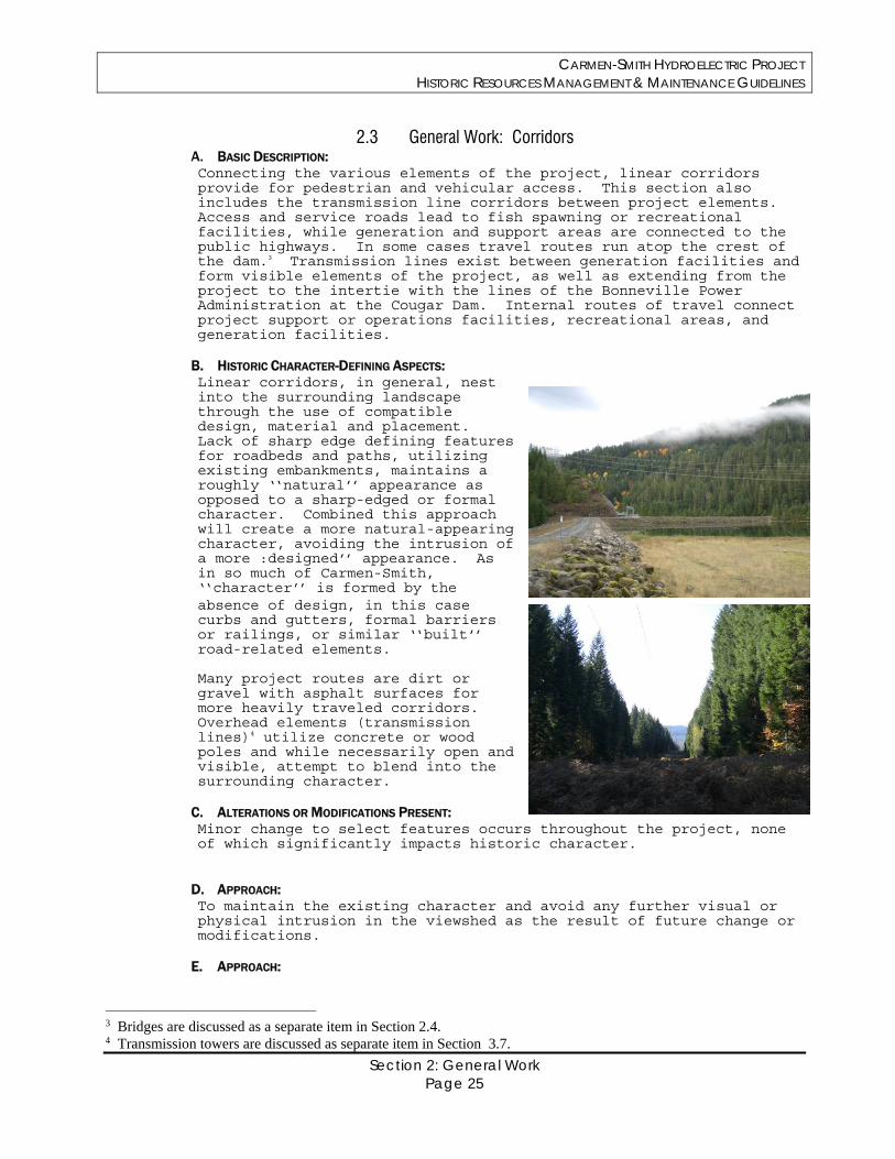
CARMEN-SMITH HYDROELECTRIC PROJECT HISTORIC RESOURCES MANAGEMENT & MAINTENANCE GUIDELINES
Section 2: General Work Page 25
2.3 General Work: Corridors A. BASIC DESCRIPTION: Connecting the various elements of the project, linear corridors provide for pedestrian and vehicular access. This section also includes the transmission line corridors between project elements. Access and service roads lead to fish spawning or recreational facilities, while generation and support areas are connected to the public highways. In some cases travel routes run atop the crest of the dam.3 Transmission lines exist between generation facilities and form visible elements of the project, as well as extending from the project to the intertie with the lines of the Bonneville Power Administration at the Cougar Dam. Internal routes of travel connect project support or operations facilities, recreational areas, and generation facilities.
B. HISTORIC CHARACTER-DEFINING ASPECTS: Linear corridors, in general, nest into the surrounding landscape through the use of compatible design, material and placement. Lack of sharp edge defining features for roadbeds and paths, utilizing existing embankments, maintains a roughly ‘‘natural’’ appearance as opposed to a sharp-edged or formal character. Combined this approach will create a more natural-appearing character, avoiding the intrusion of a more :designed’’ appearance. As in so much of Carmen-Smith, ‘‘character’’ is formed by the absence of design, in this case curbs and gutters, formal barriers or railings, or similar ‘‘built’’ road-related elements. Many project routes are dirt or gravel with asphalt surfaces for more heavily traveled corridors. Overhead elements (transmission lines)4 utilize concrete or wood poles and while necessarily open and visible, attempt to blend into the surrounding character.
C. ALTERATIONS OR MODIFICATIONS PRESENT: Minor change to select features occurs throughout the project, none of which significantly impacts historic character.
D. APPROACH: To maintain the existing character and avoid any further visual or physical intrusion in the viewshed as the result of future change or modifications.
E. APPROACH:
3 Bridges are discussed as a separate item in Section 2.4. 4 Transmission towers are discussed as separate item in Section 3.7.
CARMEN-SMITH HYDROELECTRIC PROJECT HISTORIC RESOURCES MANAGEMENT & MAINTENANCE GUIDELINES
Section 2: General Work Page 26
Maintain existing linear corridors, expanding those where required, rather than developing new or additional corridors. To the greatest extent feasible, travel corridors should be of minimal character, dirt or gravel surfaced. Where feasible, clearing width and surface type should be matched to existing. Where required by traffic volume or environmental constraints simple asphalt surfaces without edge definition are recommended. Where drainage must be provided, the use of rolled gutters or isolated drains or sumps are strongly recommended over continuous curbs, gutters, or any other form of linear hard-edge, design. New or expanded corridors should be designed to minimize impact to adjacent topography, vegetation and natural features to the extent possible. Transmission and communication corridors should be maintained as is, subject to required maintenance and brush removal. The installation of bird deterrents to power lines increase visibility by design and is accordingly counter to the historic character. Where such modifications are required, EWEB will rely on deterrents utilizing motion (spinning, etc.) in muted, industrial colors to the greatest degree possible while still meeting other project objectives.
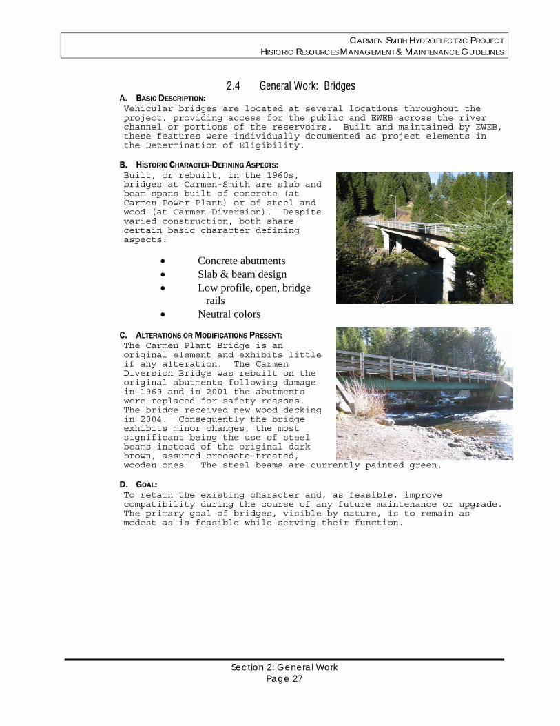
CARMEN-SMITH HYDROELECTRIC PROJECT HISTORIC RESOURCES MANAGEMENT & MAINTENANCE GUIDELINES
Section 2: General Work Page 27
2.4 General Work: Bridges A. BASIC DESCRIPTION: Vehicular bridges are located at several locations throughout the project, providing access for the public and EWEB across the river channel or portions of the reservoirs. Built and maintained by EWEB, these features were individually documented as project elements in the Determination of Eligibility.
B. HISTORIC CHARACTER-DEFINING ASPECTS: Built, or rebuilt, in the 1960s, bridges at Carmen-Smith are slab and beam spans built of concrete (at Carmen Power Plant) or of steel and wood (at Carmen Diversion). Despite varied construction, both share certain basic character defining aspects:
Concrete abutments Slab & beam design Low profile, open, bridge
rails Neutral colors
C. ALTERATIONS OR MODIFICATIONS PRESENT: The Carmen Plant Bridge is an original element and exhibits little if any alteration. The Carmen Diversion Bridge was rebuilt on the original abutments following damage in 1969 and in 2001 the abutments were replaced for safety reasons. The bridge received new wood decking in 2004. Consequently the bridge exhibits minor changes, the most significant being the use of steel beams instead of the original dark brown, assumed creosote-treated, wooden ones. The steel beams are currently painted green.
D. GOAL: To retain the existing character and, as feasible, improve compatibility during the course of any future maintenance or upgrade. The primary goal of bridges, visible by nature, is to remain as modest as is feasible while serving their function.
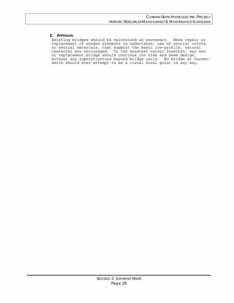
CARMEN-SMITH HYDROELECTRIC PROJECT HISTORIC RESOURCES MANAGEMENT & MAINTENANCE GUIDELINES
Section 2: General Work Page 28
E. APPROACH: Existing bridges should be maintained as necessary. When repair or replacement of wooden elements is undertaken, use of neutral colors, or neutral materials, that support the basic low-profile, natural character are encouraged. To the greatest extent feasible, any new or replacement bridge should continue the slab and beam design, without any superstructure beyond bridge rails. No bridge at Carmen-Smith should ever attempt to be a visual focal point in any way.
CARMEN-SMITH HYDROELECTRIC PROJECT HISTORIC RESOURCES MANAGEMENT & MAINTENANCE GUIDELINES
Section 3: Generation & Related Structures Page 29
Section 3
Generation and Related Structures
CARMEN-SMITH HYDROELECTRIC PROJECT HISTORIC RESOURCES MANAGEMENT & MAINTENANCE GUIDELINES
Section 3: Generation & Related Structures Page 30
General Statement: As noted earlier, the built structures of Carmen-Smith gain significance as compatible elements within a cultural landscape that blends the construction of a hydroelectric generation facility with the natural character of the McKenzie River drainage. The built elements of the Carmen-Smith Hydroelectric Project are, therefore, largely significant for reasons other than their own inherent design qualities except to the degree that those qualities respect the surrounding landscape. This is particularly true for the project’s generation related resources, many of which are largely below ground, purposely obscured from view, or designed to be of inconspicuous visual character. Built in the early 1960s of common, utilitarian, materials and forms, the historic character of most of the generation-related facilities at Carmen-Smith is modest, relying upon poured-in-place concrete, concrete block, steel, and other simple utilitarian, industrial, materials. The outdoor powerhouses, dams, spillways, water-intake structures and associated features of the project all follow a functional approach to design that presents very little in the way of ‘‘style.’’ There is little if any ornamental aspect to them beyond inherent function, and nothing in this Manual is intended to imply that these resources should, in general, be improved or modified to become something visually different than what they already are. Instead, the over-riding goal is to provide guidance as to how these structures can continue to convey their historic character and maintain their significant association with the project’s historic development. Continuing the use of simple, utilitarian materials, for any modifications, improvements, or additions that are mandated by changes in operation or technology remains the single best approach to maintaining their original character under the Standard for Preservation. Specific guidance on the various generation-related and industrial resource types at Carmen-Smith is the focus of this section. NOTE: Two basic approaches to minimizing visual intrusion of a built element into the surrounding landscape are important treatment options at Carmen-Smith. These are:
Masking, being the effort to design inserted structures so as to ‘‘look’’ like the surrounding landscape
Disassembly, reducing the scale of individual structural elements to create a larger whole, taking advantage of multiple scales to reduce overall visual impact.
To some extent these two approaches can be combined, which in large extent characterizes the original Carmen-Smith approach. However care should be exercised when masking a feature begins to approach imitation of natural elements5 As utilized at Carmen-Smith, small, discrete or attached elements of features are simply detailed and, over time, visually integrate into the landscape through mature vegetation, moss growth, and general weathering to a natural appearing surface.
5 The most common example of this approach is the occasional effort in other settings to treat telecommunication towers as “trees” by the addition of fake foliage or faux bark.
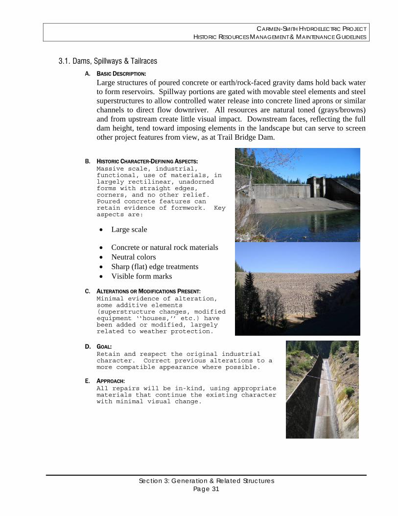
CARMEN-SMITH HYDROELECTRIC PROJECT HISTORIC RESOURCES MANAGEMENT & MAINTENANCE GUIDELINES
Section 3: Generation & Related Structures Page 31
3.1. Dams, Spillways & Tailraces
A. BASIC DESCRIPTION:
Large structures of poured concrete or earth/rock-faced gravity dams hold back water to form reservoirs. Spillway portions are gated with movable steel elements and steel superstructures to allow controlled water release into concrete lined aprons or similar channels to direct flow downriver. All resources are natural toned (grays/browns) and from upstream create little visual impact. Downstream faces, reflecting the full dam height, tend toward imposing elements in the landscape but can serve to screen other project features from view, as at Trail Bridge Dam.
B. HISTORIC CHARACTER-DEFINING ASPECTS: Massive scale, industrial, functional, use of materials, in largely rectilinear, unadorned forms with straight edges, corners, and no other relief. Poured concrete features can retain evidence of formwork. Key aspects are:
Large scale
Concrete or natural rock materials Neutral colors Sharp (flat) edge treatments Visible form marks
C. ALTERATIONS OR MODIFICATIONS PRESENT: Minimal evidence of alteration, some additive elements (superstructure changes, modified equipment ‘‘houses,’’ etc.) have been added or modified, largely related to weather protection.
D. GOAL: Retain and respect the original industrial character. Correct previous alterations to a more compatible appearance where possible.
E. APPROACH: All repairs will be in-kind, using appropriate materials that continue the existing character with minimal visual change.
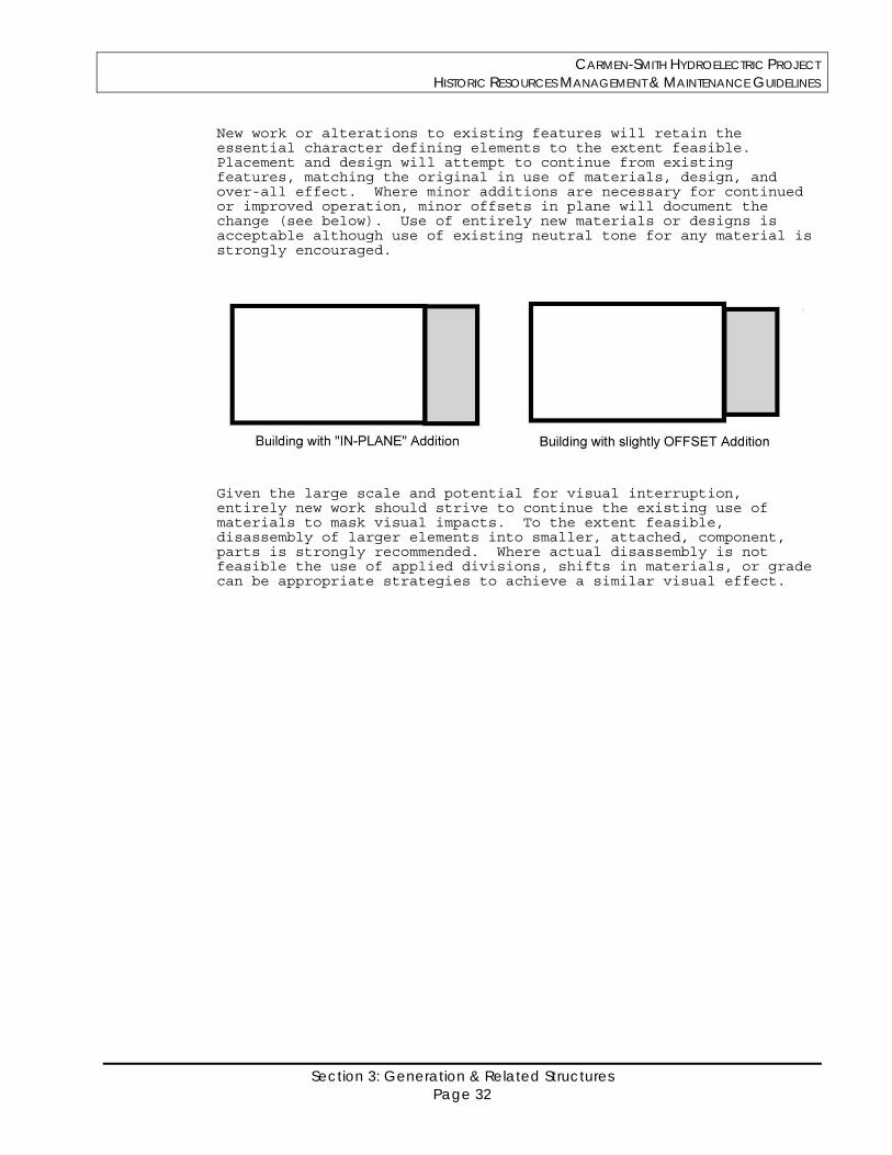
CARMEN-SMITH HYDROELECTRIC PROJECT HISTORIC RESOURCES MANAGEMENT & MAINTENANCE GUIDELINES
Section 3: Generation & Related Structures Page 32
New work or alterations to existing features will retain the essential character defining elements to the extent feasible. Placement and design will attempt to continue from existing features, matching the original in use of materials, design, and over-all effect. Where minor additions are necessary for continued or improved operation, minor offsets in plane will document the change (see below). Use of entirely new materials or designs is acceptable although use of existing neutral tone for any material is strongly encouraged.
Given the large scale and potential for visual interruption, entirely new work should strive to continue the existing use of materials to mask visual impacts. To the extent feasible, disassembly of larger elements into smaller, attached, component, parts is strongly recommended. Where actual disassembly is not feasible the use of applied divisions, shifts in materials, or grade can be appropriate strategies to achieve a similar visual effect.
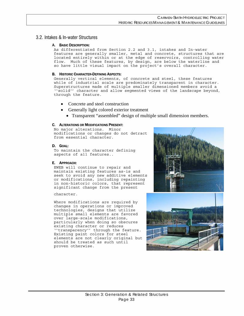
CARMEN-SMITH HYDROELECTRIC PROJECT HISTORIC RESOURCES MANAGEMENT & MAINTENANCE GUIDELINES
Section 3: Generation & Related Structures Page 33
3.2. Intakes & In-water Structures
A. BASIC DESCRIPTION: As differentiated from Section 2.2 and 3.1, intakes and In-water features are generally smaller, metal and concrete, structures that are located entirely within or at the edge of reservoirs, controlling water flow. Much of these features, by design, are below the waterline and so have little visual impact on the project’s overall character.
B. HISTORIC CHARACTER-DEFINING ASPECTS: Generally vertical elements, of concrete and steel, these features while of industrial scale are predominately transparent in character. Superstructures made of multiple smaller dimensioned members avoid a ‘‘solid’’ character and allow segmented views of the landscape beyond, through the feature.
Concrete and steel construction Generally light colored exterior treatment
Transparent “assembled” design of multiple small dimension members.
C. ALTERATIONS OR MODIFICATIONS PRESENT: No major alterations. Minor modifications or changes do not detract from essential character.
D. GOAL: To maintain the character defining aspects of all features..
E. APPROACH: EWEB will continue to repair and maintain existing features as-is and seek to avoid any new additive elements or modifications, including repainting in non-historic colors, that represent significant change from the present
character. Where modifications are required by changes in operations or improved technologies, designs that utilize multiple small elements are favored over large-scale modifications, particularly when doing so obscures existing character or reduces ‘‘transparency’’ through the feature. Existing paint colors for steel elements are not clearly original but should be treated as such until proven otherwise.
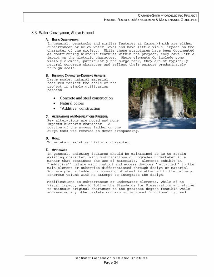
CARMEN-SMITH HYDROELECTRIC PROJECT HISTORIC RESOURCES MANAGEMENT & MAINTENANCE GUIDELINES
Section 3: Generation & Related Structures Page 34
3.3. Water Conveyance; Above Ground
A. BASIC DESCRIPTION: In general, penstocks and similar features at Carmen-Smith are either subterranean or below water level and have little visual impact on the character of the project. While these structures have been documented as contributing historic features within the project, they have little impact on the historic character. Where elements do include some visible element, particularly the surge tank, they are of typically neutral concrete character and reflect their purpose predominately through scale.
B. HISTORIC CHARACTER-DEFINING ASPECTS: Large scale, natural material, features reflect the scale of the project in simple utilitarian fashion.
Concrete and steel construction Natural colors “Additive” construction
C. ALTERATIONS OR MODIFICATIONS PRESENT: Few alterations are noted and none impacts historic character. A portion of the access ladder on the surge tank was removed to deter trespassing.
D. GOAL: To maintain existing historic character.
E. APPROACH: In general, existing features should be maintained so as to retain existing character, with modifications or upgrades undertaken in a manner that continues the use of materials. Elements exhibit an ‘‘additive’’ nature with control and access devices ‘‘attached’’ to the main element or otherwise differentiated through design or material. For example, a ladder to crossing of steel is attached to the primary concrete volume with no attempt to integrate the design. Modifications to subterranean or underwater elements, while of no visual impact, should follow the Standards for Preservation and strive to maintain original character to the greatest degree feasible while addressing any other safety concern or improved functionality need.
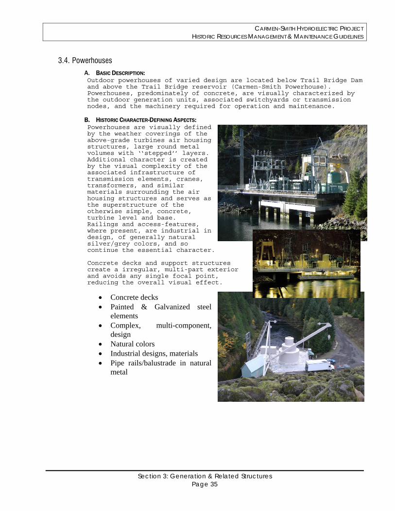
CARMEN-SMITH HYDROELECTRIC PROJECT HISTORIC RESOURCES MANAGEMENT & MAINTENANCE GUIDELINES
Section 3: Generation & Related Structures Page 35
3.4. Powerhouses
A. BASIC DESCRIPTION: Outdoor powerhouses of varied design are located below Trail Bridge Dam and above the Trail Bridge reservoir (Carmen-Smith Powerhouse). Powerhouses, predominately of concrete, are visually characterized by the outdoor generation units, associated switchyards or transmission nodes, and the machinery required for operation and maintenance.
B. HISTORIC CHARACTER-DEFINING ASPECTS: Powerhouses are visually defined by the weather coverings of the above-grade turbines air housing structures, large round metal volumes with ‘‘stepped’’ layers. Additional character is created by the visual complexity of the associated infrastructure of transmission elements, cranes, transformers, and similar materials surrounding the air housing structures and serves as the superstructure of the otherwise simple, concrete, turbine level and base. Railings and access-features, where present, are industrial in design, of generally natural silver/grey colors, and so continue the essential character. Concrete decks and support structures create a irregular, multi-part exterior and avoids any single focal point, reducing the overall visual effect.
Concrete decks Painted & Galvanized steel
elements Complex, multi-component,
design Natural colors Industrial designs, materials Pipe rails/balustrade in natural
metal
CARMEN-SMITH HYDROELECTRIC PROJECT HISTORIC RESOURCES MANAGEMENT & MAINTENANCE GUIDELINES
Section 3: Generation & Related Structures Page 36
C. ALTERATIONS OR MODIFICATIONS PRESENT: Turbine air housing structures have been repainted, varying from the presumed original sand, to green and more recently, back to tan. Other minor changes to electrical and support equipment do not seriously alter character. Porch coverings of pressure-treated wood have been added to access areas at the Carmen-Smith Powerhouse. Lower portions of the Carmen Powerhouse concrete base have been modified with infill panels.
D. GOAL: To retain industrial, multi-element, character using original materials and color values, so as to reducing additional visual impact
E. APPROACH: All new or maintenance work at the powerhouse locations should respect the original character through the appropriate use of natural, industrial materials and colors. The multi-component nature of the feature easily allows the insertion of new elements, including expanded switchyard/transmission facilities, additional or replaced transformers, and other changes or modifications to generation, transmission or support-related elements, without any serious impact to historic character provided color, scale, and essential physical layout are continued. Replacement in-kind, when required by other project needs, does not inherently reduce integrity provided historic character is retained. SOME visual differentiation between project elements (for example, retaining the mixture of sand-colored and natural galvanized/grey elements) is considered more appropriate than any uniform coloration as the latter approach will natural tend to amalgamate the various elements of the powerhouse into a single visual entity. Where such a single-toned approach is required, the use of a narrow range of shades within that tone (as in various shades of a basic sand/tan) can help to reduce the visual mass of the assembly. Prior to any future repainting proposal, EWEB will contact simple on-site paint analysis using non-damaging (crater-test) techniques to provide additional data on original and subsequent paint treatments of major elements including air housing structures, crane superstructure and other built elements.
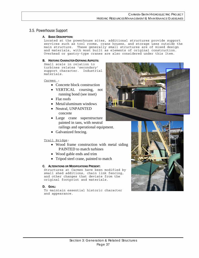
CARMEN-SMITH HYDROELECTRIC PROJECT HISTORIC RESOURCES MANAGEMENT & MAINTENANCE GUIDELINES
Section 3: Generation & Related Structures Page 37
3.5. Powerhouse Support
A. BASIC DESCRIPTION: Located at the powerhouse sites, additional structures provide support services such as tool rooms, crane houses, and storage uses outside the main structure. These generally small structures are of mixed design and materials, with most built as elements of original construction. Overhead or gantry-type cranes are also considered under this Item.
B. HISTORIC CHARACTER-DEFINING ASPECTS: Small scale in relation to turbines relates ‘secondary’ support character. Industrial materials. Carmen :
Concrete block construction VERTICAL coursing, not
running bond (see inset) Flat roofs Metal/aluminum windows Neutral, UNPAINTED
concrete Large crane superstructure
painted in tans, with neutral railings and operational equipment.
Galvanized fencing. Trail Bridge:
Wood frame construction with metal siding PAINTED to match turbines
Wood gable ends and trim Tripod steel crane, painted to match
C. ALTERATIONS OR MODIFICATIONS PRESENT: Structures at Carmen have been modified by small shed additions, chain link fencing, and other changes that deviate from the original footprint and materials.
D. GOAL: To maintain essential historic character and appearance.
CARMEN-SMITH HYDROELECTRIC PROJECT HISTORIC RESOURCES MANAGEMENT & MAINTENANCE GUIDELINES
Section 3: Generation & Related Structures Page 38
E. APPROACH: Maintenance work at either powerhouse location should continue the defined original character thorough use of materials, color and design. Existing non-compatible modifications should, as possible, be replaced with more compatible designs or painted in matching tones to better integrate with the original elements. New work (entirely new construction) should match basic character without being imitative, as in matching roof design (flat or gable) but of slightly different heights. Additions to existing structures should, as per the Secretary of the Interior’s Standards, be slightly offset or alternately dimensioned to document the change (see graphic at Item 3.1). NOTE: The complex nature of the powerhouse centers, with multiple individual elements related to the function and operation of the project, are considered highly forgiving of change. Gaining historic character through their ‘‘compound’’ appearance and built of modest, industrial materials, in simple and direct fashion, new construction, modification, and necessary repair or change will rarely result in an adverse impact on these sites provided the materials, scale, and historic character of the original elements are respected and the historic features are retained as visually dominant elements in the overall character.
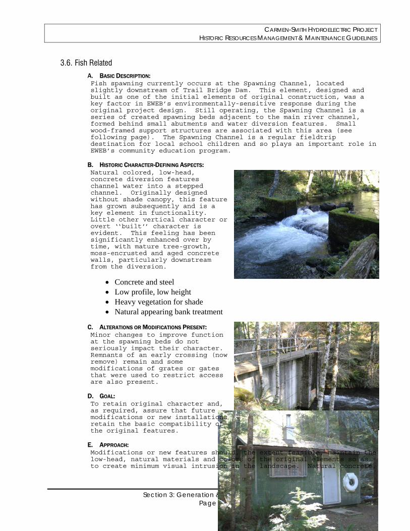
CARMEN-SMITH HYDROELECTRIC PROJECT HISTORIC RESOURCES MANAGEMENT & MAINTENANCE GUIDELINES
Section 3: Generation & Related Structures Page 39
3.6. Fish Related
A. BASIC DESCRIPTION: Fish spawning currently occurs at the Spawning Channel, located slightly downstream of Trail Bridge Dam. This element, designed and built as one of the initial elements of original construction, was a key factor in EWEB’s environmentally-sensitive response during the original project design. Still operating, the Spawning Channel is a series of created spawning beds adjacent to the main river channel, formed behind small abutments and water diversion features. Small wood-framed support structures are associated with this area (see following page). The Spawning Channel is a regular fieldtrip destination for local school children and so plays an important role in EWEB’s community education program.
B. HISTORIC CHARACTER-DEFINING ASPECTS: Natural colored, low-head, concrete diversion features channel water into a stepped channel. Originally designed without shade canopy, this feature has grown subsequently and is a key element in functionality. Little other vertical character or overt ‘‘built’’ character is evident. This feeling has been significantly enhanced over by time, with mature tree-growth, moss-encrusted and aged concrete walls, particularly downstream from the diversion.
Concrete and steel Low profile, low height Heavy vegetation for shade Natural appearing bank treatment
C. ALTERATIONS OR MODIFICATIONS PRESENT: Minor changes to improve function at the spawning beds do not seriously impact their character. Remnants of an early crossing (now remove) remain and some modifications of grates or gates that were used to restrict access are also present.
D. GOAL: To retain original character and, as required, assure that future modifications or new installations retain the basic compatibility of the original features.
E. APPROACH: Modifications or new features should, the extent feasible, maintain the low-head, natural materials and colors of the original elements so as to create minimum visual intrusion in the landscape. Natural concrete,
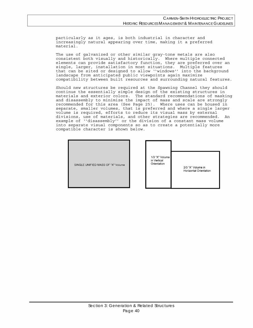
CARMEN-SMITH HYDROELECTRIC PROJECT HISTORIC RESOURCES MANAGEMENT & MAINTENANCE GUIDELINES
Section 3: Generation & Related Structures Page 40
particularly as it ages, is both industrial in character and increasingly natural appearing over time, making it a preferred material. The use of galvanized or other similar gray-tone metals are also consistent both visually and historically. Where multiple connected elements can provide satisfactory function, they are preferred over an single, larger, installation in most situations. Multiple features that can be sited or designed to allow ‘‘windows’’ into the background landscape from anticipated public viewpoints again maximize compatibility between built resources and surrounding natural features. Should new structures be required at the Spawning Channel they should continue the essentially simple design of the existing structures in materials and exterior colors. The standard recommendations of masking and disassembly to minimize the impact of mass and scale are strongly recommended for this area (See Page 25). Where uses can be housed in separate, smaller volumes, that is preferred and where a single larger volume is required, efforts to reduce its visual mass by external divisions, use of materials, and other strategies are recommended. An example of ‘‘disassembly’’ or the division of a constant mass volume into separate visual components so as to create a potentially more compatible character is shown below.
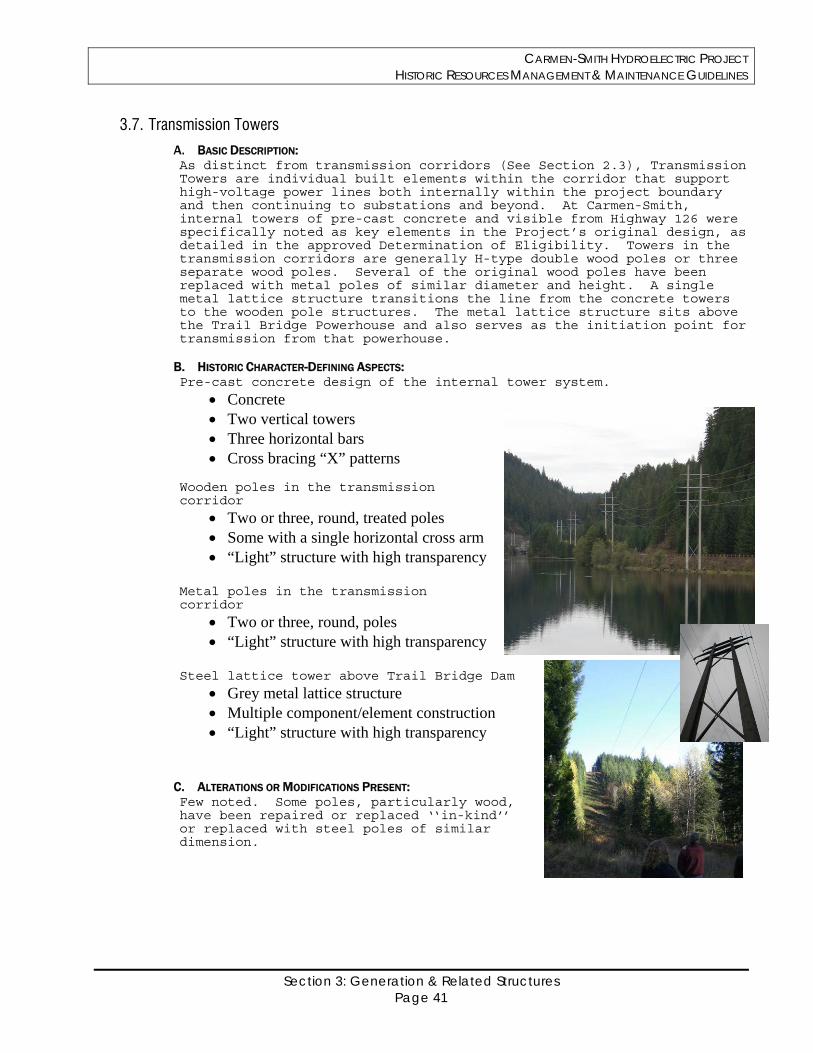
CARMEN-SMITH HYDROELECTRIC PROJECT HISTORIC RESOURCES MANAGEMENT & MAINTENANCE GUIDELINES
Section 3: Generation & Related Structures Page 41
3.7. Transmission Towers
A. BASIC DESCRIPTION: As distinct from transmission corridors (See Section 2.3), Transmission Towers are individual built elements within the corridor that support high-voltage power lines both internally within the project boundary and then continuing to substations and beyond. At Carmen-Smith, internal towers of pre-cast concrete and visible from Highway 126 were specifically noted as key elements in the Project’s original design, as detailed in the approved Determination of Eligibility. Towers in the transmission corridors are generally H-type double wood poles or three separate wood poles. Several of the original wood poles have been replaced with metal poles of similar diameter and height. A single metal lattice structure transitions the line from the concrete towers to the wooden pole structures. The metal lattice structure sits above the Trail Bridge Powerhouse and also serves as the initiation point for transmission from that powerhouse.
B. HISTORIC CHARACTER-DEFINING ASPECTS: Pre-cast concrete design of the internal tower system.
Concrete Two vertical towers Three horizontal bars Cross bracing “X” patterns
Wooden poles in the transmission corridor
Two or three, round, treated poles Some with a single horizontal cross arm “Light” structure with high transparency
Metal poles in the transmission corridor
Two or three, round, poles “Light” structure with high transparency
Steel lattice tower above Trail Bridge Dam
Grey metal lattice structure Multiple component/element construction “Light” structure with high transparency
C. ALTERATIONS OR MODIFICATIONS PRESENT: Few noted. Some poles, particularly wood, have been repaired or replaced ‘‘in-kind’’ or replaced with steel poles of similar dimension.
CARMEN-SMITH HYDROELECTRIC PROJECT HISTORIC RESOURCES MANAGEMENT & MAINTENANCE GUIDELINES
Section 3: Generation & Related Structures Page 42
D. GOAL: To maintain the existing character through retention of original poles or compatible replacements if required.
E. APPROACH: Pre-cast concrete towers should be retained. When damaged or requiring modification, poles they should only be replaced ‘‘in-kind’’ with identical work. Modifications to these towers should replicate the existing in ALL visual features to the greatest extent feasible. Modifications or replacements to the wooden pole system that characterize the transmission corridor may include minor modifications but should retain the basic round wood, two or three pole, design.
CARMEN-SMITH HYDROELECTRIC PROJECT HISTORIC RESOURCES MANAGEMENT & MAINTENANCE GUIDELINES
Section 4: Support and Residential Structures Page 43
Section 4
Support and Residential Structures
CARMEN-SMITH HYDROELECTRIC PROJECT HISTORIC RESOURCES MANAGEMENT & MAINTENANCE GUIDELINES
Section 4: Support and Residential Structures Page 44
General Statement: As noted earlier, the built structures of Carmen-Smith, in general, gain significance as compatible elements within a cultural landscape that blends the construction of a hydroelectric generation facility with the natural character of the McKenzie River drainage. The built elements, therefore, are significant for reasons other than their own inherent design qualities except for the way that those qualities reflect the historic intent to respect the surrounding landscape. The Carmen Housing Area, located just upriver from the Carmen Powerhouse, provides support facilities and housing related to project operations. This area consists of fifteen (15) individually identified built resources, the majority of which date from the original construction period. By virtue of its function, visual density, and location in proximity to Oregon Highway 126, the Carmen Housing Area is among the more publicly visible ‘built’ elements of the Carmen-Smith Hydroelectric Project. While residential structures at the Carmen Housing Area include a partial daylight basement, the basic character of all the area’s structures appears a single story, with the low-pitched gables and surface treatments typically referred to as ‘‘Ranch’’ house. This style, while not elaborately detailed, creates a strong homogenous appearance that unifies the Housing Area and ties support buildings and residential buildings into a single common theme. Maintaining a cohesive approach in design, through common materials and colors is more important in maintaining the area’s character than is the individual materials or colors that are chosen for the separate elements.
In no situation is appropriate to treat the individual structures at the Carmen Housing Area individually ---- differentiating dwellings or support buildings through the use of varied paint tones or roof treatments to create ‘‘variety’’ adversely affects the compound character and is not appropriate.
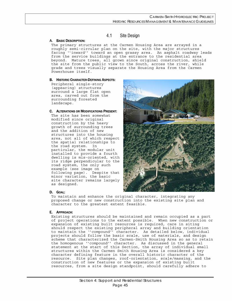
CARMEN-SMITH HYDROELECTRIC PROJECT HISTORIC RESOURCES MANAGEMENT & MAINTENANCE GUIDELINES
Section 4: Support and Residential Structures Page 45
4.1 Site Design A. BASIC DESCRIPTION: The primary structures at the Carmen Housing Area are arrayed in a roughly semi-circular plan on the site, with the major structures facing ‘‘inward’’ toward an open grassy area. An asphalt roadway leads from the service buildings at the entrance to the residential area beyond. Mature trees, all grown since original construction, shield the site from the public view to the South, across the river, while grade and trees visually separate the Housing Area from the Carmen Powerhouse itself.
B. HISTORIC CHARACTER-DEFINING ASPECTS: Peripheral single-story (appearing) structures surround a large flat open area, carved out from the surrounding forested landscape.
C. ALTERATIONS OR MODIFICATIONS PRESENT: The site has been somewhat modified since original construction by the heavy growth of surrounding trees and the addition of new structures into the housing area, not all of which respect the spatial relationships to the road system. In particular, the modular unit installed to provide a fourth dwelling is mis-oriented, with its ridge perpendicular to the road system, the only such example (see image on following page). Despite that minor variation, the basic site character remains largely as designed.
D. GOAL: To maintain and enhance the original character, integrating any proposed change or new construction into the existing site plan and character to the greatest extent feasible.
E. APPROACH: Existing structures should be maintained and remain occupied as a part of project operations to the extent possible. When new construction or expansion of existing built resources is required, care in siting should respect the existing peripheral array and building orientation to maintain the ‘‘compound’’ character. As detailed below, individual projects should follow the basic scale, use of materials, and design scheme that characterized the Carmen-Smith Housing Area so as to retain the homogenous ‘‘compound’’ character. As discussed in the general statement at the start of this Section, the array of individual small structures within the Carmen Smith Housing Area is considered a key character defining feature in the overall historic character of the resource. Site plan changes, roof-orientation, scale/massing, and the construction of new features or the expansion of existing built resources, from a site design standpoint, should carefully adhere to
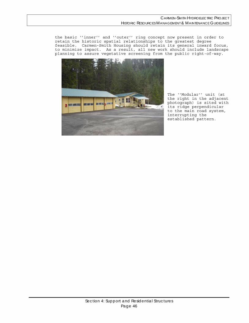
CARMEN-SMITH HYDROELECTRIC PROJECT HISTORIC RESOURCES MANAGEMENT & MAINTENANCE GUIDELINES
Section 4: Support and Residential Structures Page 46
the basic ‘‘inner’’ and ‘‘outer’’ ring concept now present in order to retain the historic spatial relationships to the greatest degree feasible. Carmen-Smith Housing should retain its general inward focus, to minimize impact. As a result, all new work should include landscape planning to assure vegetative screening from the public right-of-way.
The ‘‘Modular’’ unit (at the right in the adjacent photograph) is sited with its ridge perpendicular to the main road system, interrupting the established pattern.
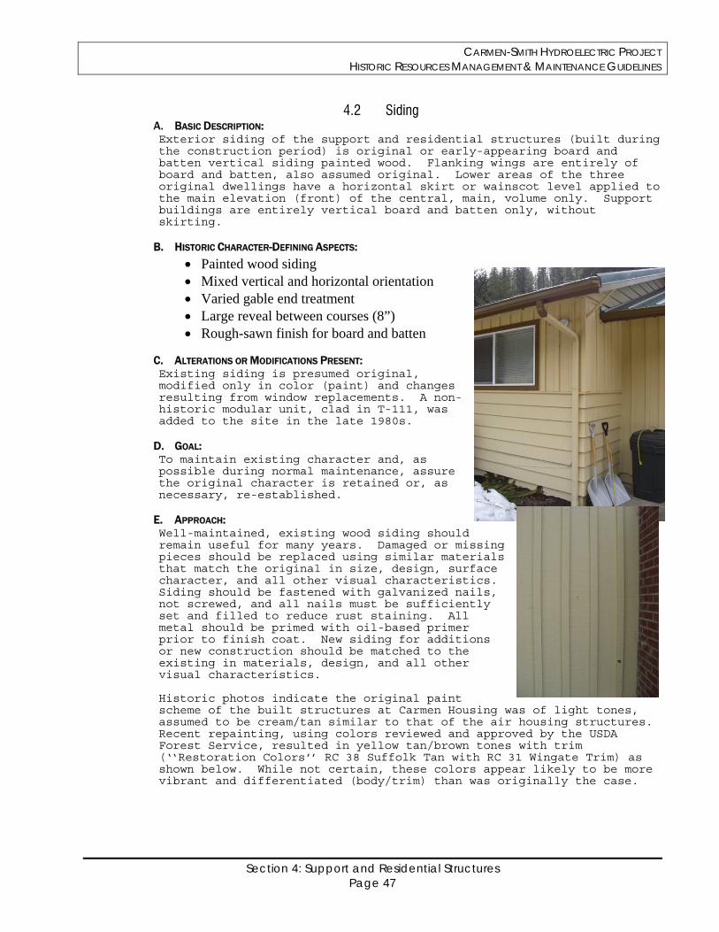
CARMEN-SMITH HYDROELECTRIC PROJECT HISTORIC RESOURCES MANAGEMENT & MAINTENANCE GUIDELINES
Section 4: Support and Residential Structures Page 47
4.2 Siding A. BASIC DESCRIPTION: Exterior siding of the support and residential structures (built during the construction period) is original or early-appearing board and batten vertical siding painted wood. Flanking wings are entirely of board and batten, also assumed original. Lower areas of the three original dwellings have a horizontal skirt or wainscot level applied to the main elevation (front) of the central, main, volume only. Support buildings are entirely vertical board and batten only, without skirting.
B. HISTORIC CHARACTER-DEFINING ASPECTS:
Painted wood siding Mixed vertical and horizontal orientation Varied gable end treatment Large reveal between courses (8”) Rough-sawn finish for board and batten
C. ALTERATIONS OR MODIFICATIONS PRESENT: Existing siding is presumed original, modified only in color (paint) and changes resulting from window replacements. A non-historic modular unit, clad in T-111, was added to the site in the late 1980s.
D. GOAL: To maintain existing character and, as possible during normal maintenance, assure the original character is retained or, as necessary, re-established.
E. APPROACH: Well-maintained, existing wood siding should remain useful for many years. Damaged or missing pieces should be replaced using similar materials that match the original in size, design, surface character, and all other visual characteristics. Siding should be fastened with galvanized nails, not screwed, and all nails must be sufficiently set and filled to reduce rust staining. All metal should be primed with oil-based primer prior to finish coat. New siding for additions or new construction should be matched to the existing in materials, design, and all other visual characteristics. Historic photos indicate the original paint scheme of the built structures at Carmen Housing was of light tones, assumed to be cream/tan similar to that of the air housing structures. Recent repainting, using colors reviewed and approved by the USDA Forest Service, resulted in yellow tan/brown tones with trim (‘‘Restoration Colors’’ RC 38 Suffolk Tan with RC 31 Wingate Trim) as shown below. While not certain, these colors appear likely to be more vibrant and differentiated (body/trim) than was originally the case.
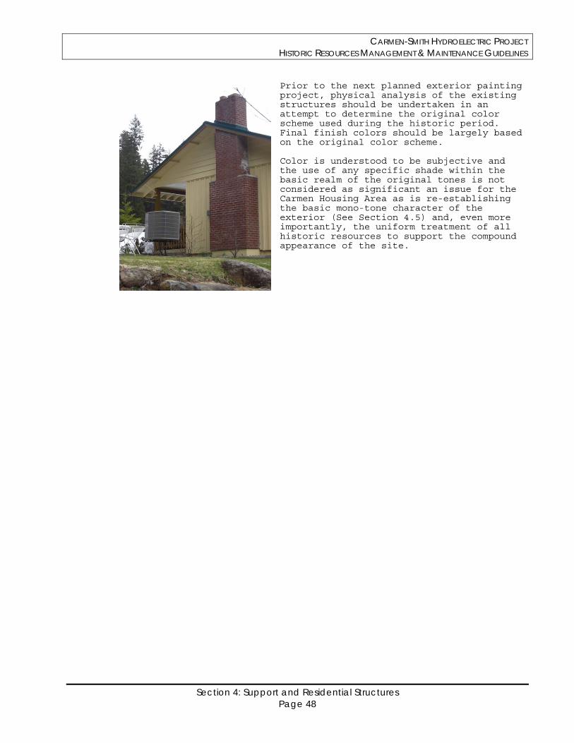
CARMEN-SMITH HYDROELECTRIC PROJECT HISTORIC RESOURCES MANAGEMENT & MAINTENANCE GUIDELINES
Section 4: Support and Residential Structures Page 48
Prior to the next planned exterior painting project, physical analysis of the existing structures should be undertaken in an attempt to determine the original color scheme used during the historic period. Final finish colors should be largely based on the original color scheme.
Color is understood to be subjective and the use of any specific shade within the basic realm of the original tones is not considered as significant an issue for the Carmen Housing Area as is re-establishing the basic mono-tone character of the exterior (See Section 4.5) and, even more importantly, the uniform treatment of all historic resources to support the compound appearance of the site.
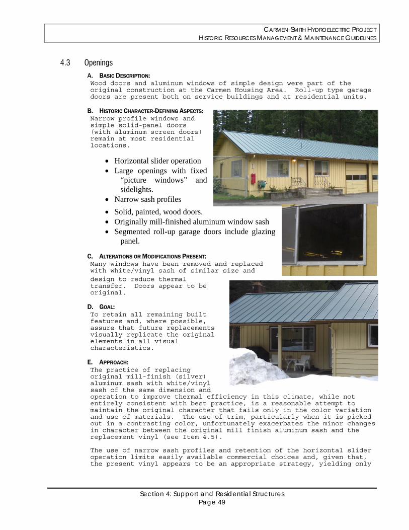
CARMEN-SMITH HYDROELECTRIC PROJECT HISTORIC RESOURCES MANAGEMENT & MAINTENANCE GUIDELINES
Section 4: Support and Residential Structures Page 49
4.3 Openings
A. BASIC DESCRIPTION: Wood doors and aluminum windows of simple design were part of the original construction at the Carmen Housing Area. Roll-up type garage doors are present both on service buildings and at residential units.
B. HISTORIC CHARACTER-DEFINING ASPECTS: Narrow profile windows and simple solid-panel doors (with aluminum screen doors) remain at most residential locations.
Horizontal slider operation Large openings with fixed
“picture windows” and sidelights.
Narrow sash profiles
Solid, painted, wood doors. Originally mill-finished aluminum window sash Segmented roll-up garage doors include glazing
panel.
C. ALTERATIONS OR MODIFICATIONS PRESENT: Many windows have been removed and replaced with white/vinyl sash of similar size and design to reduce thermal transfer. Doors appear to be original.
D. GOAL: To retain all remaining built features and, where possible, assure that future replacements visually replicate the original elements in all visual characteristics.
E. APPROACH: The practice of replacing original mill-finish (silver) aluminum sash with white/vinyl sash of the same dimension and operation to improve thermal efficiency in this climate, while not entirely consistent with best practice, is a reasonable attempt to maintain the original character that fails only in the color variation and use of materials. The use of trim, particularly when it is picked out in a contrasting color, unfortunately exacerbates the minor changes in character between the original mill finish aluminum sash and the replacement vinyl (see Item 4.5). The use of narrow sash profiles and retention of the horizontal slider operation limits easily available commercial choices and, given that, the present vinyl appears to be an appropriate strategy, yielding only
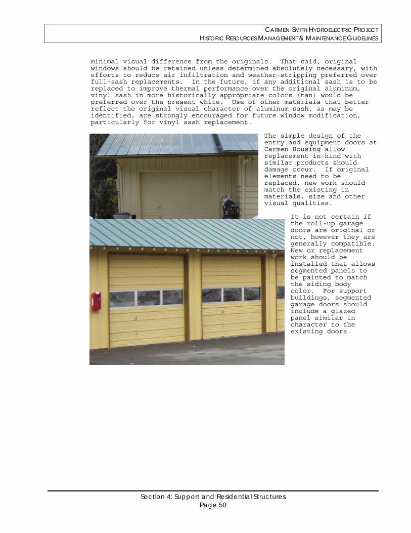
CARMEN-SMITH HYDROELECTRIC PROJECT HISTORIC RESOURCES MANAGEMENT & MAINTENANCE GUIDELINES
Section 4: Support and Residential Structures Page 50
minimal visual difference from the originals. That said, original windows should be retained unless determined absolutely necessary, with efforts to reduce air infiltration and weather-stripping preferred over full-sash replacements. In the future, if any additional sash is to be replaced to improve thermal performance over the original aluminum, vinyl sash in more historically appropriate colors (tan) would be preferred over the present white. Use of other materials that better reflect the original visual character of aluminum sash, as may be identified, are strongly encouraged for future window modification, particularly for vinyl sash replacement.
The simple design of the entry and equipment doors at Carmen Housing allow replacement in-kind with similar products should damage occur. If original elements need to be replaced, new work should match the existing in materials, size and other visual qualities.
It is not certain if the roll-up garage doors are original or not, however they are generally compatible. New or replacement work should be installed that allows segmented panels to be painted to match the siding body color. For support buildings, segmented garage doors should include a glazed panel similar in character to the existing doors.
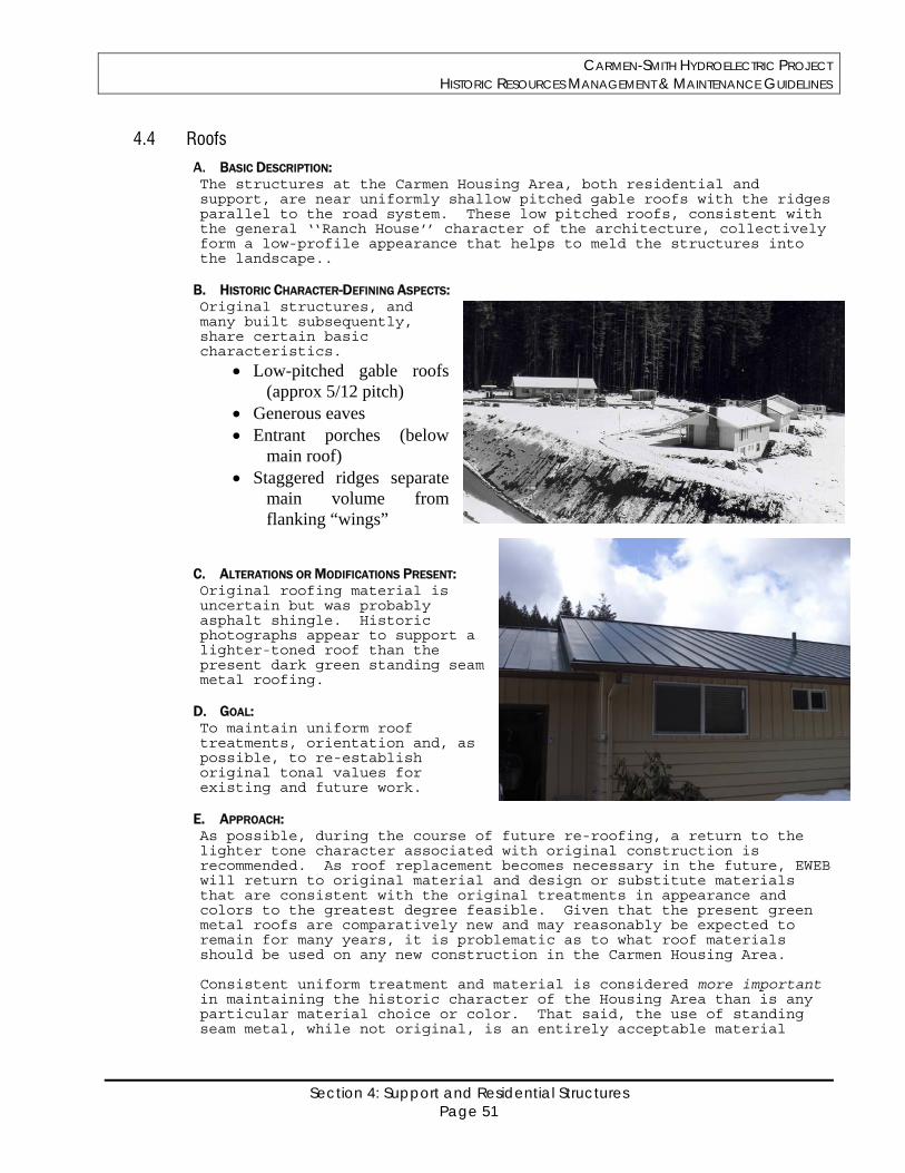
CARMEN-SMITH HYDROELECTRIC PROJECT HISTORIC RESOURCES MANAGEMENT & MAINTENANCE GUIDELINES
Section 4: Support and Residential Structures Page 51
4.4 Roofs
A. BASIC DESCRIPTION: The structures at the Carmen Housing Area, both residential and support, are near uniformly shallow pitched gable roofs with the ridges parallel to the road system. These low pitched roofs, consistent with the general ‘‘Ranch House’’ character of the architecture, collectively form a low-profile appearance that helps to meld the structures into the landscape..
B. HISTORIC CHARACTER-DEFINING ASPECTS: Original structures, and many built subsequently, share certain basic characteristics.
Low-pitched gable roofs (approx 5/12 pitch)
Generous eaves Entrant porches (below
main roof) Staggered ridges separate
main volume from flanking “wings”
C. ALTERATIONS OR MODIFICATIONS PRESENT: Original roofing material is uncertain but was probably asphalt shingle. Historic photographs appear to support a lighter-toned roof than the present dark green standing seam metal roofing.
D. GOAL: To maintain uniform roof treatments, orientation and, as possible, to re-establish original tonal values for existing and future work.
E. APPROACH: As possible, during the course of future re-roofing, a return to the lighter tone character associated with original construction is recommended. As roof replacement becomes necessary in the future, EWEB will return to original material and design or substitute materials that are consistent with the original treatments in appearance and colors to the greatest degree feasible. Given that the present green metal roofs are comparatively new and may reasonably be expected to remain for many years, it is problematic as to what roof materials should be used on any new construction in the Carmen Housing Area. Consistent uniform treatment and material is considered more important in maintaining the historic character of the Housing Area than is any particular material choice or color. That said, the use of standing seam metal, while not original, is an entirely acceptable material
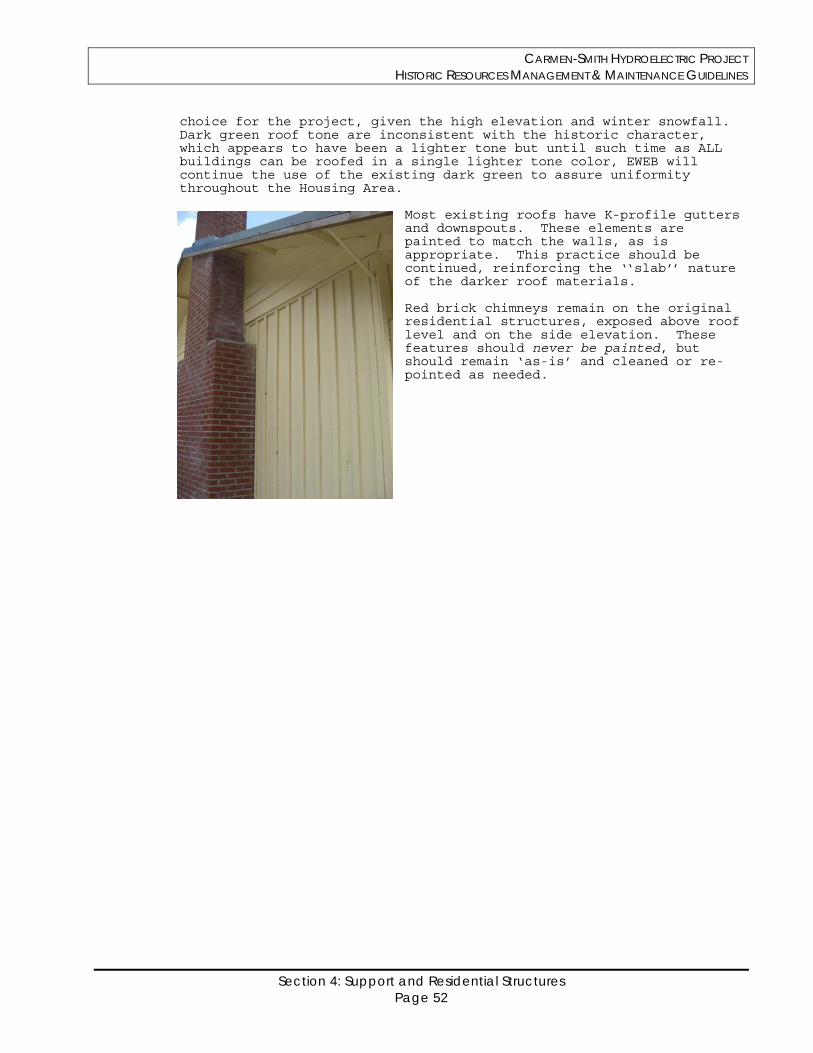
CARMEN-SMITH HYDROELECTRIC PROJECT HISTORIC RESOURCES MANAGEMENT & MAINTENANCE GUIDELINES
Section 4: Support and Residential Structures Page 52
choice for the project, given the high elevation and winter snowfall. Dark green roof tone are inconsistent with the historic character, which appears to have been a lighter tone but until such time as ALL buildings can be roofed in a single lighter tone color, EWEB will continue the use of the existing dark green to assure uniformity throughout the Housing Area.
Most existing roofs have K-profile gutters and downspouts. These elements are painted to match the walls, as is appropriate. This practice should be continued, reinforcing the ‘‘slab’’ nature of the darker roof materials.
Red brick chimneys remain on the original residential structures, exposed above roof level and on the side elevation. These features should never be painted, but should remain ‘as-is’ and cleaned or re-pointed as needed.
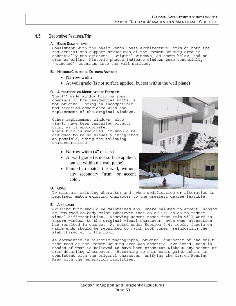
CARMEN-SMITH HYDROELECTRIC PROJECT HISTORIC RESOURCES MANAGEMENT & MAINTENANCE GUIDELINES
Section 4: Support and Residential Structures Page 53
4.5 Decorative Features/Trim
A. BASIC DESCRIPTION: Consistent with the basic Ranch House architecture, trim on both the residential and support structures of the Carmen Housing Area is essentially non-existent. Original windows, as shown below, had no trim or sills. Historic photos indicate windows were essentially ‘‘punched’’ openings into the wall surface.
B. HISTORIC CHARACTER-DEFINING ASPECTS:
Narrow width At wall grade (is not surface applied, but set within the wall plane)
C. ALTERATIONS OR MODIFICATIONS PRESENT: The 4’’ wide window trim on some openings of the residential units is not original, being an incompatible modification associated with the replacement of the original windows. Other replacement windows, also vinyl, have been installed without trim, as is appropriate. Where trim is required, it should be designed to be as visually integrated as possible, using the following characteristics:
Narrow width (4” or less) At wall grade (is not surface applied,
but set within the wall plane) Painted to match the wall, without
any secondary “trim” or accent color.
D. GOAL: To maintain existing character and, when modification or alteration is required, match existing character to the greatest degree feasible.
E. APPROACH: Existing trim should be maintained and, where painted to accent, should be returned to body color (whatever that color is) so as to reduce visual differentiation. Removing accent tones from trim will work to return windows to the original visual character, even when alteration has resulted in change. As noted under Section 4.4, roofs, fascia on gable ends should be repainted to match roof tones, reinforcing the slab character of the roof. As documented in historic photographs, original character of the built resources at the Carmen Housing Area was essential two-toned, both in shades of what is believed to have been cream/tan without any accent or trim detailing whatsoever. Returning to this basic paint scheme is consistent with the original character, unifying the Carmen Housing Area with the generation facilities.
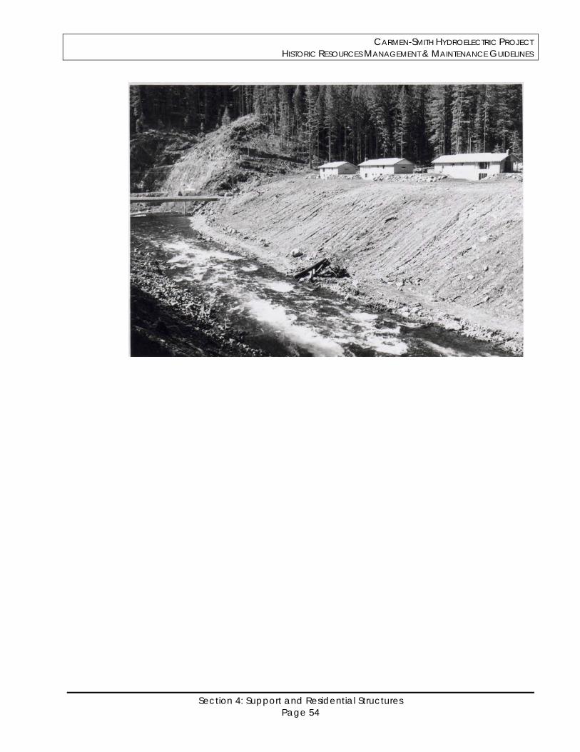
CARMEN-SMITH HYDROELECTRIC PROJECT HISTORIC RESOURCES MANAGEMENT & MAINTENANCE GUIDELINES
Section 4: Support and Residential Structures Page 54
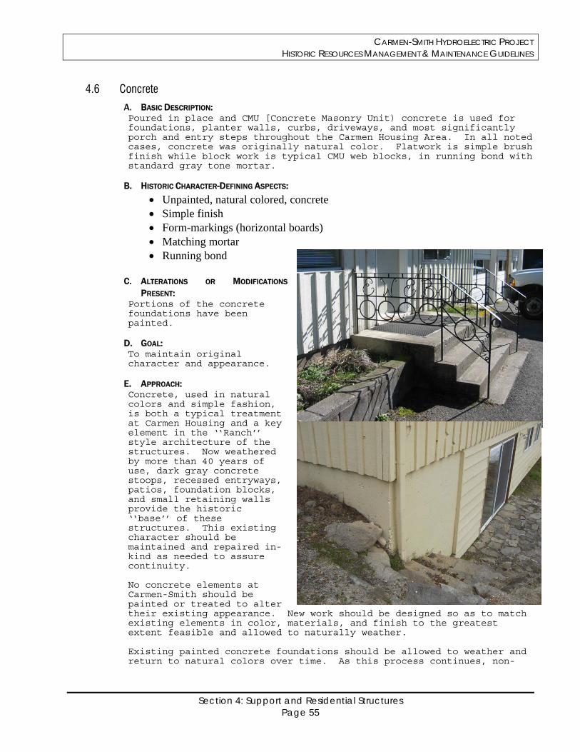
CARMEN-SMITH HYDROELECTRIC PROJECT HISTORIC RESOURCES MANAGEMENT & MAINTENANCE GUIDELINES
Section 4: Support and Residential Structures Page 55
4.6 Concrete
A. BASIC DESCRIPTION: Poured in place and CMU [Concrete Masonry Unit) concrete is used for foundations, planter walls, curbs, driveways, and most significantly porch and entry steps throughout the Carmen Housing Area. In all noted cases, concrete was originally natural color. Flatwork is simple brush finish while block work is typical CMU web blocks, in running bond with standard gray tone mortar.
B. HISTORIC CHARACTER-DEFINING ASPECTS:
Unpainted, natural colored, concrete Simple finish Form-markings (horizontal boards) Matching mortar Running bond
C. ALTERATIONS OR MODIFICATIONS
PRESENT: Portions of the concrete foundations have been painted.
D. GOAL: To maintain original character and appearance.
E. APPROACH: Concrete, used in natural colors and simple fashion, is both a typical treatment at Carmen Housing and a key element in the ‘‘Ranch’’ style architecture of the structures. Now weathered by more than 40 years of use, dark gray concrete stoops, recessed entryways, patios, foundation blocks, and small retaining walls provide the historic ‘‘base’’ of these structures. This existing character should be maintained and repaired in-kind as needed to assure continuity. No concrete elements at Carmen-Smith should be painted or treated to alter their existing appearance. New work should be designed so as to match existing elements in color, materials, and finish to the greatest extent feasible and allowed to naturally weather. Existing painted concrete foundations should be allowed to weather and return to natural colors over time. As this process continues, non-
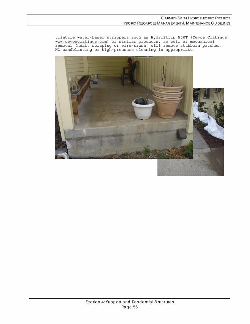
CARMEN-SMITH HYDROELECTRIC PROJECT HISTORIC RESOURCES MANAGEMENT & MAINTENANCE GUIDELINES
Section 4: Support and Residential Structures Page 56
volatile water-based strippers such as HydroStrip 500T (Devoe Coatings, www.devoecoatings.com) or similar products, as well as mechanical removal (heat, scraping or wire-brush) will remove stubborn patches. NO sandblasting or high-pressure cleaning is appropriate.
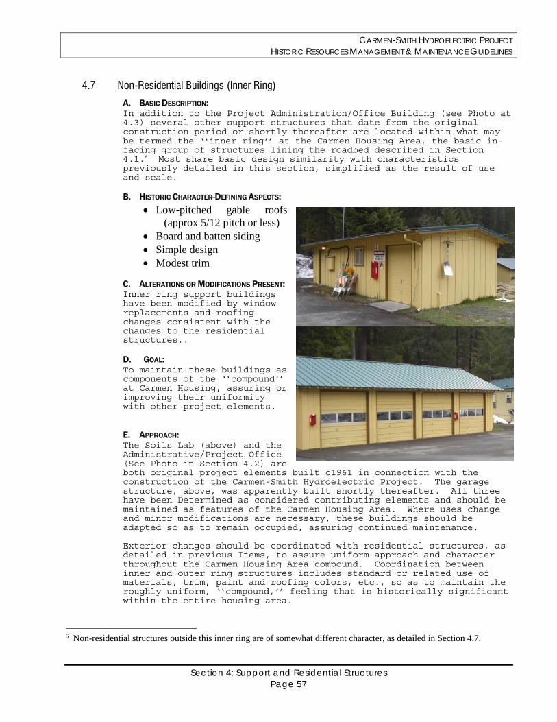
CARMEN-SMITH HYDROELECTRIC PROJECT HISTORIC RESOURCES MANAGEMENT & MAINTENANCE GUIDELINES
Section 4: Support and Residential Structures Page 57
4.7 Non-Residential Buildings (Inner Ring)
A. BASIC DESCRIPTION: In addition to the Project Administration/Office Building (see Photo at 4.3) several other support structures that date from the original construction period or shortly thereafter are located within what may be termed the ‘‘inner ring’’ at the Carmen Housing Area, the basic in-facing group of structures lining the roadbed described in Section 4.1.6 Most share basic design similarity with characteristics previously detailed in this section, simplified as the result of use and scale. B. HISTORIC CHARACTER-DEFINING ASPECTS:
Low-pitched gable roofs (approx 5/12 pitch or less)
Board and batten siding Simple design Modest trim
C. ALTERATIONS OR MODIFICATIONS PRESENT: Inner ring support buildings have been modified by window replacements and roofing changes consistent with the changes to the residential structures.. D. GOAL: To maintain these buildings as components of the ‘‘compound’’ at Carmen Housing, assuring or improving their uniformity with other project elements. E. APPROACH: The Soils Lab (above) and the Administrative/Project Office (See Photo in Section 4.2) are both original project elements built c1961 in connection with the construction of the Carmen-Smith Hydroelectric Project. The garage structure, above, was apparently built shortly thereafter. All three have been Determined as considered contributing elements and should be maintained as features of the Carmen Housing Area. Where uses change and minor modifications are necessary, these buildings should be adapted so as to remain occupied, assuring continued maintenance. Exterior changes should be coordinated with residential structures, as detailed in previous Items, to assure uniform approach and character throughout the Carmen Housing Area compound. Coordination between inner and outer ring structures includes standard or related use of materials, trim, paint and roofing colors, etc., so as to maintain the roughly uniform, ‘‘compound,’’ feeling that is historically significant within the entire housing area.
6 Non-residential structures outside this inner ring are of somewhat different character, as detailed in Section 4.7.
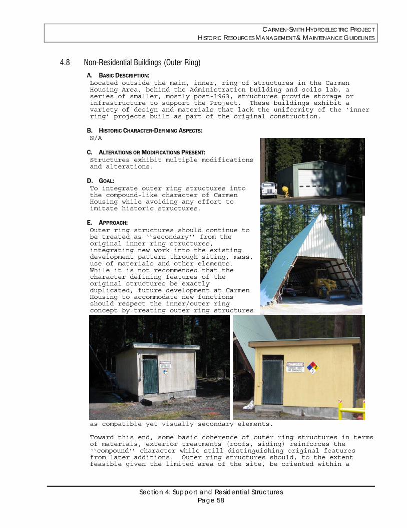
CARMEN-SMITH HYDROELECTRIC PROJECT HISTORIC RESOURCES MANAGEMENT & MAINTENANCE GUIDELINES
Section 4: Support and Residential Structures Page 58
4.8 Non-Residential Buildings (Outer Ring)
A. BASIC DESCRIPTION: Located outside the main, inner, ring of structures in the Carmen Housing Area, behind the Administration building and soils lab, a series of smaller, mostly post-1963, structures provide storage or infrastructure to support the Project. These buildings exhibit a variety of design and materials that lack the uniformity of the ‘inner ring’ projects built as part of the original construction.
B. HISTORIC CHARACTER-DEFINING ASPECTS: N/A
C. ALTERATIONS OR MODIFICATIONS PRESENT: Structures exhibit multiple modifications and alterations.
D. GOAL: To integrate outer ring structures into the compound-like character of Carmen Housing while avoiding any effort to imitate historic structures.
E. APPROACH: Outer ring structures should continue to be treated as ‘‘secondary’’ from the original inner ring structures, integrating new work into the existing development pattern through siting, mass, use of materials and other elements. While it is not recommended that the character defining features of the original structures be exactly duplicated, future development at Carmen Housing to accommodate new functions should respect the inner/outer ring concept by treating outer ring structures
as compatible yet visually secondary elements. Toward this end, some basic coherence of outer ring structures in terms of materials, exterior treatments (roofs, siding) reinforces the ‘‘compound’’ character while still distinguishing original features from later additions. Outer ring structures should, to the extent feasible given the limited area of the site, be oriented within a
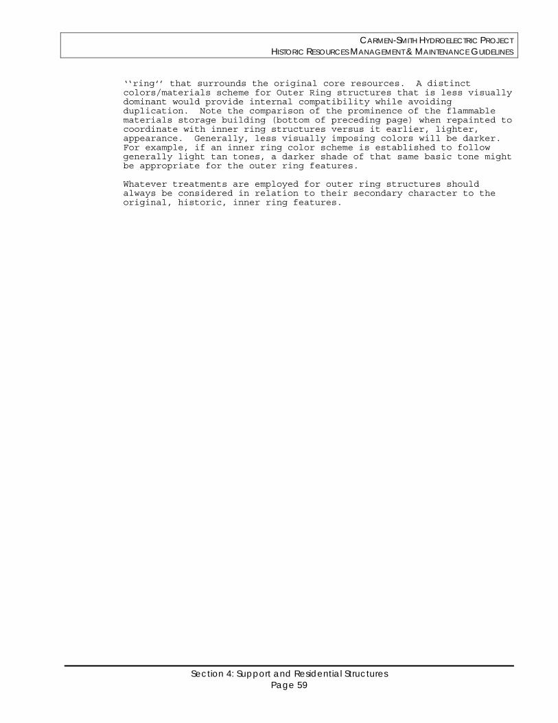
CARMEN-SMITH HYDROELECTRIC PROJECT HISTORIC RESOURCES MANAGEMENT & MAINTENANCE GUIDELINES
Section 4: Support and Residential Structures Page 59
‘‘ring’’ that surrounds the original core resources. A distinct colors/materials scheme for Outer Ring structures that is less visually dominant would provide internal compatibility while avoiding duplication. Note the comparison of the prominence of the flammable materials storage building (bottom of preceding page) when repainted to coordinate with inner ring structures versus it earlier, lighter, appearance. Generally, less visually imposing colors will be darker. For example, if an inner ring color scheme is established to follow generally light tan tones, a darker shade of that same basic tone might be appropriate for the outer ring features. Whatever treatments are employed for outer ring structures should always be considered in relation to their secondary character to the original, historic, inner ring features.
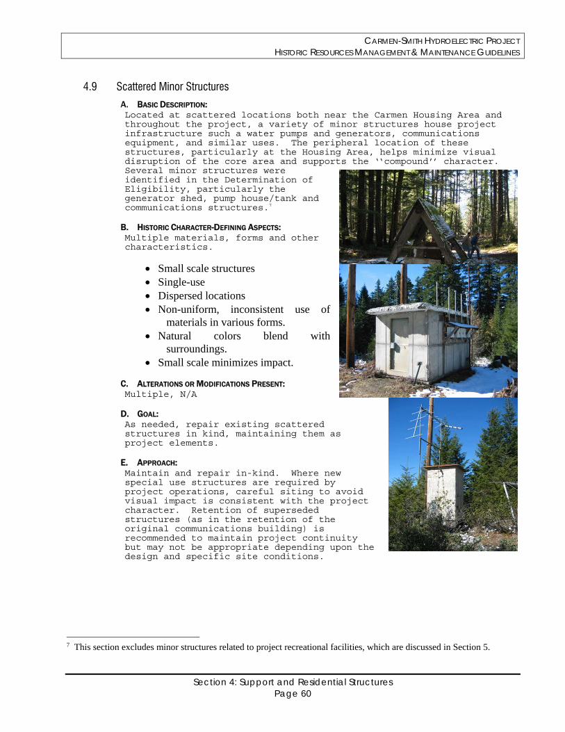
CARMEN-SMITH HYDROELECTRIC PROJECT HISTORIC RESOURCES MANAGEMENT & MAINTENANCE GUIDELINES
Section 4: Support and Residential Structures Page 60
4.9 Scattered Minor Structures
A. BASIC DESCRIPTION: Located at scattered locations both near the Carmen Housing Area and throughout the project, a variety of minor structures house project infrastructure such a water pumps and generators, communications equipment, and similar uses. The peripheral location of these structures, particularly at the Housing Area, helps minimize visual disruption of the core area and supports the ‘‘compound’’ character. Several minor structures were identified in the Determination of Eligibility, particularly the generator shed, pump house/tank and communications structures.7
B. HISTORIC CHARACTER-DEFINING ASPECTS: Multiple materials, forms and other characteristics.
Small scale structures Single-use Dispersed locations Non-uniform, inconsistent use of
materials in various forms. Natural colors blend with
surroundings. Small scale minimizes impact.
C. ALTERATIONS OR MODIFICATIONS PRESENT: Multiple, N/A
D. GOAL: As needed, repair existing scattered structures in kind, maintaining them as project elements.
E. APPROACH: Maintain and repair in-kind. Where new special use structures are required by project operations, careful siting to avoid visual impact is consistent with the project character. Retention of superseded structures (as in the retention of the original communications building) is recommended to maintain project continuity but may not be appropriate depending upon the design and specific site conditions.
7 This section excludes minor structures related to project recreational facilities, which are discussed in Section 5.
CARMEN-SMITH HYDROELECTRIC PROJECT HISTORIC RESOURCES MANAGEMENT & MAINTENANCE GUIDELINES
Section 5: Recreation Related Page 61
Section 5
Recreation Related
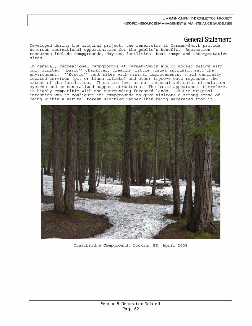
CARMEN-SMITH HYDROELECTRIC PROJECT HISTORIC RESOURCES MANAGEMENT & MAINTENANCE GUIDELINES
Section 5: Recreation Related Page 62
General Statement: Developed during the original project, the reservoirs at Carmen-Smith provide numerous recreational opportunities for the public’s benefit. Recreation resources include campgrounds, day-use facilities, boat ramps and interpretative sites. In general, recreational campgrounds at Carmen-Smith are of modest design with only limited ‘‘built’’ character, creating little visual intrusion into the environment. ‘‘Rustic’’ tent sites with minimal improvements, small centrally located services (pit or flush toilets) and other improvements represent the extent of the facilities. There are few, or no, internal vehicular circulation systems and no centralized support structures. The basic appearance, therefore, is highly compatible with the surrounding forested lands. EWEB’s original intention was to configure the campgrounds to give visitors a strong sense of being within a natural forest stetting rather than being separated from it.
Trailbridge Campground, Looking SE, April 2008
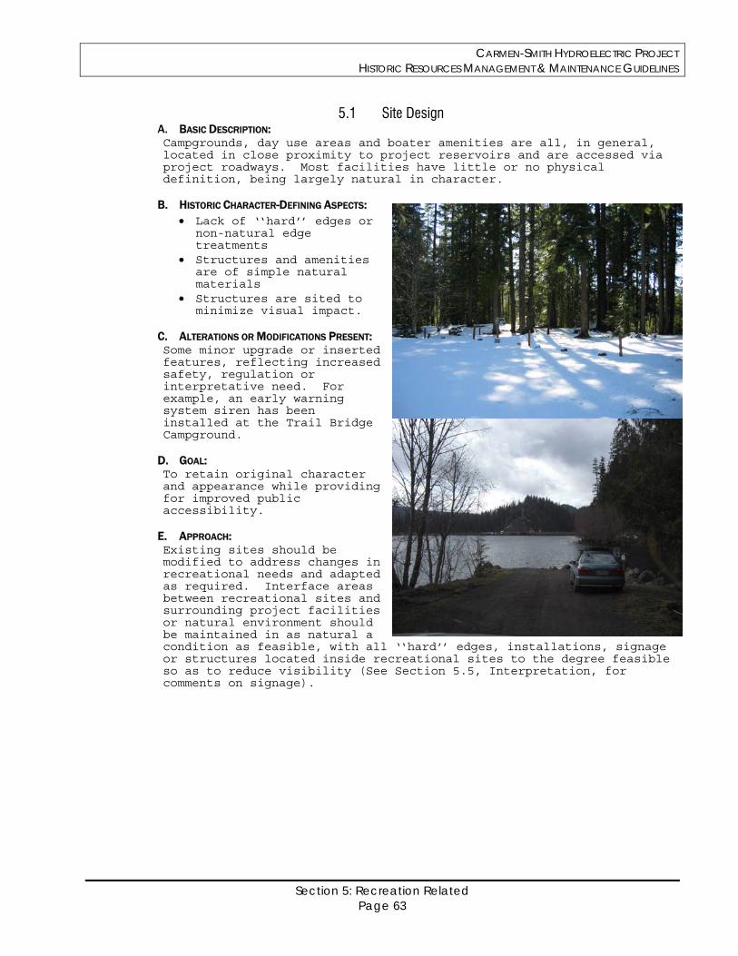
CARMEN-SMITH HYDROELECTRIC PROJECT HISTORIC RESOURCES MANAGEMENT & MAINTENANCE GUIDELINES
Section 5: Recreation Related Page 63
5.1 Site Design A. BASIC DESCRIPTION: Campgrounds, day use areas and boater amenities are all, in general, located in close proximity to project reservoirs and are accessed via project roadways. Most facilities have little or no physical definition, being largely natural in character.
B. HISTORIC CHARACTER-DEFINING ASPECTS: Lack of ‘‘hard’’ edges or
non-natural edge treatments
Structures and amenities are of simple natural materials
Structures are sited to minimize visual impact.
C. ALTERATIONS OR MODIFICATIONS PRESENT: Some minor upgrade or inserted features, reflecting increased safety, regulation or interpretative need. For example, an early warning system siren has been installed at the Trail Bridge Campground.
D. GOAL: To retain original character and appearance while providing for improved public accessibility.
E. APPROACH: Existing sites should be modified to address changes in recreational needs and adapted as required. Interface areas between recreational sites and surrounding project facilities or natural environment should be maintained in as natural a condition as feasible, with all ‘‘hard’’ edges, installations, signage or structures located inside recreational sites to the degree feasible so as to reduce visibility (See Section 5.5, Interpretation, for comments on signage).
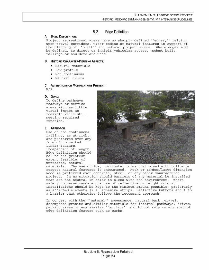
CARMEN-SMITH HYDROELECTRIC PROJECT HISTORIC RESOURCES MANAGEMENT & MAINTENANCE GUIDELINES
Section 5: Recreation Related Page 64
5.2 Edge Definition A. BASIC DESCRIPTION: Project recreational areas have no sharply defined ‘‘edges,’’ relying upon travel corridors, water-bodies or natural features in support of the blending of ‘‘built’’ and natural project areas. Where edges must be defined, to direct or inhibit vehicular access, modest built railings or boulders are used.
B. HISTORIC CHARACTER-DEFINING ASPECTS: Natural materials Low profile Non-continuous Neutral colors
C. ALTERATIONS OR MODIFICATIONS PRESENT: N/A.
D. GOAL: To define pathways, roadways or service areas with as little visual impact as feasible while still meeting required function.
E. APPROACH: Use of non-continuous railings, as at right, are preferred over any form of connected linear feature, independent of length. Edge definition should be, to the greatest extent feasible, of untreated, natural, materials. The use of low, horizontal forms that blend with follow or respect natural features is encouraged. Rock or timber/large dimension wood is preferred over concrete, steel, or any other manufactured project. In no situation should barriers of any material be installed that are not neutral in color to blend with the environment. Where safety concerns mandate the use of reflective or bright colors, installations should be kept to the minimum amount possible, preferably as attached elements (i.e. adhesive strips, reflective buttons etc.) to a barrier that otherwise follows the recommend approach. In concert with the ‘‘natural’’ appearance, natural bark, gravel, decomposed granite and similar materials for internal pathways, drives, parking areas or any similar ‘‘surface’’ should not rely on any sort of edge definition feature such as curbs.
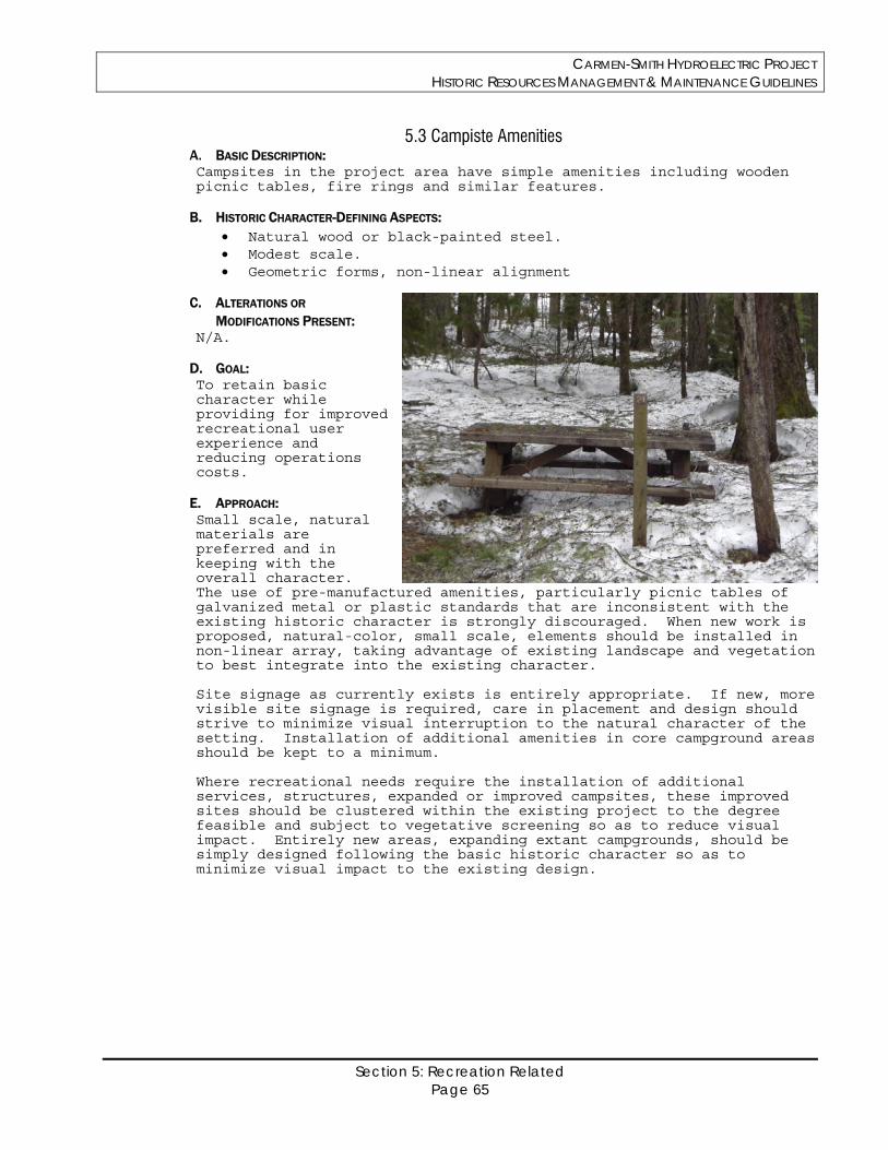
CARMEN-SMITH HYDROELECTRIC PROJECT HISTORIC RESOURCES MANAGEMENT & MAINTENANCE GUIDELINES
Section 5: Recreation Related Page 65
5.3 Campiste Amenities A. BASIC DESCRIPTION: Campsites in the project area have simple amenities including wooden picnic tables, fire rings and similar features.
B. HISTORIC CHARACTER-DEFINING ASPECTS: Natural wood or black-painted steel. Modest scale. Geometric forms, non-linear alignment
C. ALTERATIONS OR
MODIFICATIONS PRESENT: N/A.
D. GOAL: To retain basic character while providing for improved recreational user experience and reducing operations costs.
E. APPROACH: Small scale, natural materials are preferred and in keeping with the overall character. The use of pre-manufactured amenities, particularly picnic tables of galvanized metal or plastic standards that are inconsistent with the existing historic character is strongly discouraged. When new work is proposed, natural-color, small scale, elements should be installed in non-linear array, taking advantage of existing landscape and vegetation to best integrate into the existing character. Site signage as currently exists is entirely appropriate. If new, more visible site signage is required, care in placement and design should strive to minimize visual interruption to the natural character of the setting. Installation of additional amenities in core campground areas should be kept to a minimum. Where recreational needs require the installation of additional services, structures, expanded or improved campsites, these improved sites should be clustered within the existing project to the degree feasible and subject to vegetative screening so as to reduce visual impact. Entirely new areas, expanding extant campgrounds, should be simply designed following the basic historic character so as to minimize visual impact to the existing design.
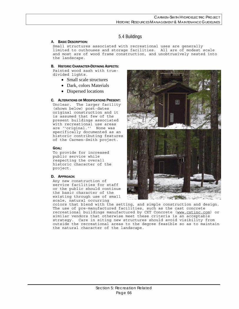
CARMEN-SMITH HYDROELECTRIC PROJECT HISTORIC RESOURCES MANAGEMENT & MAINTENANCE GUIDELINES
Section 5: Recreation Related Page 66
5.4 Buildings A. BASIC DESCRIPTION: Small structures associated with recreational uses are generally limited to outhouses and storage facilities. All are of modest scale and most are of wood frame construction, and unobtrusively nested into the landscape.
B. HISTORIC CHARACTER-DEFINING ASPECTS: Painted wood sash with true-divided lights.
Small scale structures Dark, colors Materials Dispersed locations
C. ALTERATIONS OR MODIFICATIONS PRESENT: Unclear. The larger facility (shown below) post-dates original construction and it is assumed that few of the present buildings associated with recreational use areas are ‘‘original.’’ None was specifically documented as an historic contributing features of the Carmen-Smith project. GOAL: To provide for increased public service while respecting the overall historic character of the project.
D. APPROACH: Any new construction of service facilities for staff or the public should continue the basic character of the existing through use of small scale, natural occurring colors that blend with the setting, and simple construction and design. The use of pre-manufactured facilities, such as the cast concrete recreational buildings manufactured by CXT Concrete (www.cxtinc.com) or similar vendors that otherwise meet these criteria is an acceptable strategy. Care in siting new structures should avoid visibility from outside the recreational areas to the degree feasible so as to maintain the natural character of the landscape.
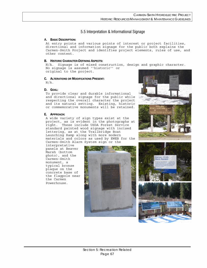
CARMEN-SMITH HYDROELECTRIC PROJECT HISTORIC RESOURCES MANAGEMENT & MAINTENANCE GUIDELINES
Section 5: Recreation Related Page 67
5.5 Interpretation & Informational Signage
A. BASIC DESCRIPTION: At entry points and various points of interest or project facilities, directional and information signage for the public both explains the Carmen-Smith Project and identifies project elements, rules of use, and other content.
B. HISTORIC CHARACTER-DEFINING ASPECTS: N/A. Signage is of mixed construction, design and graphic character. No signage is assumed ‘‘historic’’ or original to the project.
C. ALTERATIONS OR MODIFICATIONS PRESENT: N/A.
D. GOAL: To provide clear and durable informational and directional signage for the public while respecting the overall character the project and its natural setting. Existing, historic or commemorative monuments will be retained.
E. APPROACH: A wide variety of sign types exist at the project, as is evident in the photographs at right. These include USDA Forest Service standard painted wood signage with incised lettering, as at the Trailbridge Boat Launching Ramp along with more modern materials and colors as used by EWEB for the Carmen-Smith Alarm System sign or the interpretative panels at Beaver Marsh (bottom photo), and the Carmen-Smith monument, a typical bronze plaque on the concrete base of the flagpole near the Carmen Powerhouse.
CARMEN-SMITH HYDROELECTRIC PROJECT HISTORIC RESOURCES MANAGEMENT & MAINTENANCE GUIDELINES
Section 5: Recreation Related Page 68
In general, particularly in recreation sites, large wooden support members are recommended as more natural than steel. Where steel is required by function or for durability, black or neutral colors (powder-coat or paint) are recommended to reduce visual impact. Sign placement should be considered in terms of visual impact, in coordination with the recommendations of EWEB’s Recreation and Aesthetics Management Plan. While directional signage requires a vertical orientation, interpretative signage is recommended for low-height angled view, as at Beaver Marsh, to both reduce visual impact and support pedestrian use. Any future installation of informational or commemorative signage should follow the established precedents in terms of design and materials where possible and will be coordinated with existing standards for Scenic Byway design and other programs as appropriate. Forest Service signs located within the project will be consistent with the FS Sign Handbook. Maintaining the concept of disassembly, referred to in Section 3, the use of multiple, smaller scale, panels is strongly preferred over a single large panel for any interpretive display. Durable, colorfast, materials that allow the integration of photographs or graphics such as enamel-coated metal signage manufactured by KVO Industries Inc (www.kvoindustries.com) or other similar vendors. Many other weatherproof and durable signage products are available. In all cases, the use of high contrast, non-natural, colors except where required by safety concerns, is not recommended as appropriate.

CARMEN-SMITH HYDROELECTRIC PROJECT HISTORIC RESOURCES MANAGEMENT & MAINTENANCE GUIDELINES
Bibliography Page 69
Bibliography
CARMEN-SMITH HYDROELECTRIC PROJECT HISTORIC RESOURCES MANAGEMENT & MAINTENANCE GUIDELINES
Bibliography Page 70
The following selected publications provide source materials for the Management Plan or
offer specific information on particular aspects of historic preservation technology that may be of use for planning future work at Carmen-Smith.
EWEB. Eugene Water and Electric Board/Carmen-Smith Hydroelectric Project, Section 106
Documentation Form, August 2005 (SHPO Concurrence, 3-January-2006). Gayle, Margot & David Look, John White. Metals in America’s Historic Buildings. Washington DC:
US Department of the Interior, National Park Service/Heritage Preservation Services, 1980. Grimmer, Anne E. Keeping It Clean: Removing Exterior Dirt, Paint, Stains and Graffiti from Historic
Masonry Buildings. Washington DC: US Department of the Interior, National Park Service/Heritage Preservation Services, 1988.
Prentice, Helaine Kaplan & Blair Prentice. Rehab Right. Oakland, CA: City of Oakland/Ten Speed
Press , 1978,1888. National Park Service, Technical Preservation Division. Respectful
Rehabilitation. Washington, DC: The Preservation Press, 1982. National Park Service, Cultural Resource Stewardship & Partnerships/Historic
Landscape Initiative. Guidelines for the Treatment of Cultural Landscapes, Washington DC: US Department of the Interior, National Park Service/Heritage Preservation Services, 1996
New York Landmarks Conservancy. Repairing Old and Historic Windows: A Manual for
Architects and Homeowners. New York: John Wiley & Sons, Inc., 1992. Toepel, Kathryn Anne and Beckham, Stephen Dow. Cultural Resource Investigations
of the Eugene Water and Electric Board Relicensing Project, Lane County, Oregon. Heritage Research Associates Report No. 102, March 1991.
Weaver, Martin E., with F. G. Matero. Conserving Buildings: A Manual of
Techniques and Materials. New York, New York: Preservation Press/John Wiley & Sons, Revised Ed., 1997
Weeks, Kay D. and Anne E. Grimmer. The Secretary of the Interior’s Standards for the Treatment of Historic Properties, with Guidelines for Preserving, Rehabilitating, Restoring and Reconstructing Historic Buildings. Washington DC: US Department of the Interior, National Park Service/Heritage Preservation Services, 1995.
CARMEN-SMITH HYDROELECTRIC PROJECT HISTORIC RESOURCES MANAGEMENT & MAINTENANCE GUIDELINES
Appendix A Page 71
Appendix A
SHPO Letter of Concurrence January 3, 2006
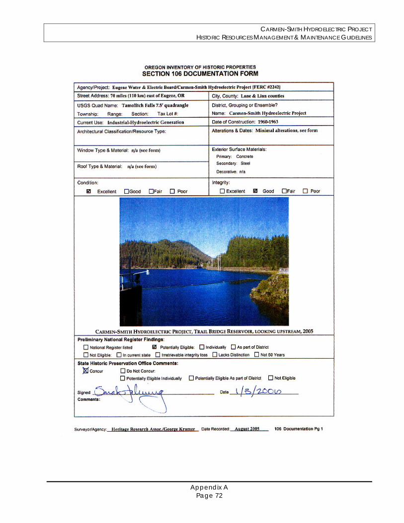
CARMEN-SMITH HYDROELECTRIC PROJECT HISTORIC RESOURCES MANAGEMENT & MAINTENANCE GUIDELINES
Appendix A Page 72
CARMEN-SMITH HYDROELECTRIC PROJECT HISTORIC RESOURCES MANAGEMENT & MAINTENANCE GUIDELINES
Appendix B Page 73
Appendix B
Project Description and List of Built Resources (from Determination of Eligibility Request, August 2005)
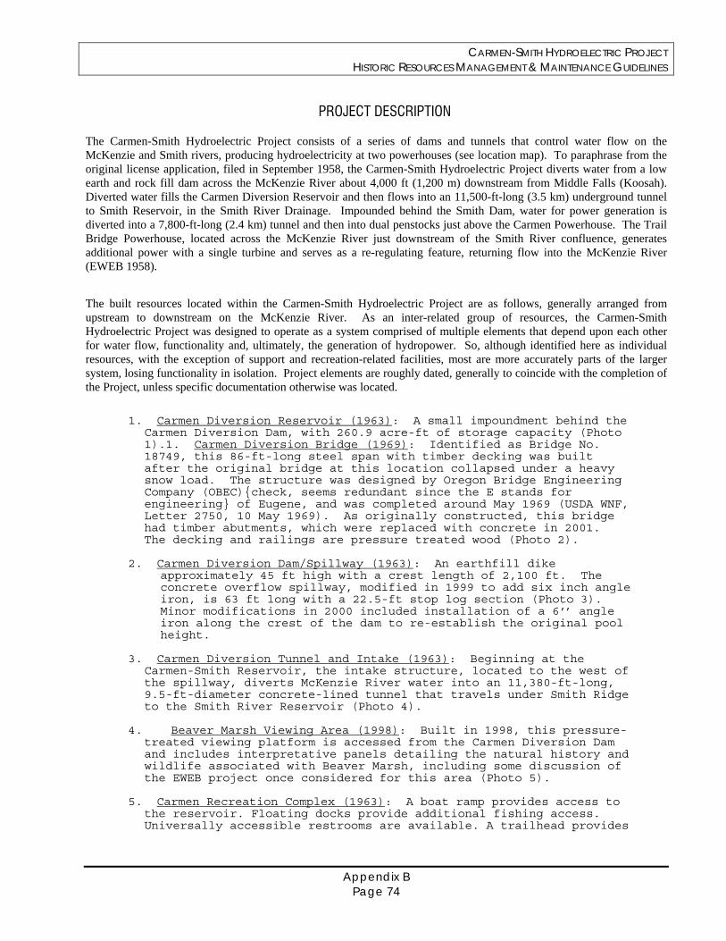
CARMEN-SMITH HYDROELECTRIC PROJECT HISTORIC RESOURCES MANAGEMENT & MAINTENANCE GUIDELINES
Appendix B Page 74
PROJECT DESCRIPTION
The Carmen-Smith Hydroelectric Project consists of a series of dams and tunnels that control water flow on the McKenzie and Smith rivers, producing hydroelectricity at two powerhouses (see location map). To paraphrase from the original license application, filed in September 1958, the Carmen-Smith Hydroelectric Project diverts water from a low earth and rock fill dam across the McKenzie River about 4,000 ft (1,200 m) downstream from Middle Falls (Koosah). Diverted water fills the Carmen Diversion Reservoir and then flows into an 11,500-ft-long (3.5 km) underground tunnel to Smith Reservoir, in the Smith River Drainage. Impounded behind the Smith Dam, water for power generation is diverted into a 7,800-ft-long (2.4 km) tunnel and then into dual penstocks just above the Carmen Powerhouse. The Trail Bridge Powerhouse, located across the McKenzie River just downstream of the Smith River confluence, generates additional power with a single turbine and serves as a re-regulating feature, returning flow into the McKenzie River (EWEB 1958).
The built resources located within the Carmen-Smith Hydroelectric Project are as follows, generally arranged from upstream to downstream on the McKenzie River. As an inter-related group of resources, the Carmen-Smith Hydroelectric Project was designed to operate as a system comprised of multiple elements that depend upon each other for water flow, functionality and, ultimately, the generation of hydropower. So, although identified here as individual resources, with the exception of support and recreation-related facilities, most are more accurately parts of the larger system, losing functionality in isolation. Project elements are roughly dated, generally to coincide with the completion of the Project, unless specific documentation otherwise was located.
1. Carmen Diversion Reservoir (1963): A small impoundment behind the
Carmen Diversion Dam, with 260.9 acre-ft of storage capacity (Photo 1).1. Carmen Diversion Bridge (1969): Identified as Bridge No. 18749, this 86-ft-long steel span with timber decking was built after the original bridge at this location collapsed under a heavy snow load. The structure was designed by Oregon Bridge Engineering Company (OBEC){check, seems redundant since the E stands for engineering} of Eugene, and was completed around May 1969 (USDA WNF, Letter 2750, 10 May 1969). As originally constructed, this bridge had timber abutments, which were replaced with concrete in 2001. The decking and railings are pressure treated wood (Photo 2).
2. Carmen Diversion Dam/Spillway (1963): An earthfill dike
approximately 45 ft high with a crest length of 2,100 ft. The concrete overflow spillway, modified in 1999 to add six inch angle iron, is 63 ft long with a 22.5-ft stop log section (Photo 3). Minor modifications in 2000 included installation of a 6’’ angle iron along the crest of the dam to re-establish the original pool height.
3. Carmen Diversion Tunnel and Intake (1963): Beginning at the
Carmen-Smith Reservoir, the intake structure, located to the west of the spillway, diverts McKenzie River water into an 11,380-ft-long, 9.5-ft-diameter concrete-lined tunnel that travels under Smith Ridge to the Smith River Reservoir (Photo 4).
4. Beaver Marsh Viewing Area (1998): Built in 1998, this pressure-
treated viewing platform is accessed from the Carmen Diversion Dam and includes interpretative panels detailing the natural history and wildlife associated with Beaver Marsh, including some discussion of the EWEB project once considered for this area (Photo 5).
5. Carmen Recreation Complex (1963): A boat ramp provides access to
the reservoir. Floating docks provide additional fishing access. Universally accessible restrooms are available. A trailhead provides
CARMEN-SMITH HYDROELECTRIC PROJECT HISTORIC RESOURCES MANAGEMENT & MAINTENANCE GUIDELINES
Appendix B Page 75
access to the McKenzie River National Recreation Trail, a waterfalls loop trail and a trail to Ice Camp Creek Campground, which provides 22 campsites. Several small structures such as restrooms and storage buildings are located in the campground area (Photo 6). The campground is operated by a concessionaire under contract to the USDA Forest Service, and EWEB contributes funds to assist with the upkeep of the campground.
6. Smith Reservoir (1963): Created behind the Smith Dam, this
reservoir serves as the forebay to the Carmen Powerhouse and provides total storage of approximately 15,000 acre-ft (Photo 7).
7. Smith Dam (1963): Located on the Smith River, this dam is a
zoned earth/rock type approximately 250 ft high with a crest length of 1,100 ft. A gated ogee spillway section is located on the west end (Photo 8). The crest height was increased 3.5 ft in 1974 and crest elevation was reestablished in 2001 with the addition of crushed rock and rip-rap.
8. Smith Power Tunnel and Intake (1963): Beginning behind a concrete
intake structure located just upstream of the Smith Dam, the Smith power tunnel is 7,325 ft long and 13.8 ft in diameter. Two 8.5 ft by 17.5 ft vertical gates control flow at the intake (Photo 9).
9. Lakes End Campground (1963): Located at the upstream end of the
Smith Reservoir, this USDA Forest Service-managed campground is only accessible by boat and offers 17 tent-only campsites. Boat ramps, restrooms, picnic tables and fire rings are provided.
10. Smith Power Tunnel Surge Chamber (1963): A surge chamber is
located at the south end of the Smith power tunnel. The surge chamber is 270 ft tall, with a 50-ft section rising above ground. Diameter is 31 ft below grade and 42 ft above ground, all of steel construction (Photo 10).
11. Carmen Powerhouse Penstocks (1963): Beginning at the surge
chamber, the 12-ft-diameter steel-lined penstock has a total length of 1,160 ft. The penstock bifurcates, or splits, into two 8-ft-diameter penstocks approximately 80 ft from the Carmen Powerhouse, providing flow to its two turbines.
12. Carmen Powerhouse (1963): Located on the west bank of the
McKenzie River, the Carmen Powerhouse houses two 55-MW Francis-type turbines rewound in 1983 to peak generating capacity of 110 MW. The outdoor turbine air housings are located above ground on the power plant deck. A dedicatory concrete monument with a case bronze plaque regarding the Carmen-Smith Hydroelectric Project and integrated aluminum flagpole is located on the upstream side of the powerhouse pad (Photos 11 and 12).
13. Carmen Substation (1963): Located on the roof of the
powerhouse, the Carmen Substation includes 50- and 60- MVA oil-filled electrical transformers (Photo 13), as well as an emergency generator, four potential transformers, and a gas-filled circuit breaker.
14. Carmen Powerhouse Storage Building/Tool Room (1963): A small
service structure located west of the powerhouse, the storage
CARMEN-SMITH HYDROELECTRIC PROJECT HISTORIC RESOURCES MANAGEMENT & MAINTENANCE GUIDELINES
Appendix B Page 76
building tool room is a flat-roofed building built from textured concrete masonry units (Photo 14).
15. Carmen Housing Area and Support Structures (Photos 15-31)
A group of residential support structures is located upstream of the Carmen Powerhouse. Several other minor structures in this general area, providing infrastructure, are included under this heading for convenience.
A. Carmen Administration Office/Garage (1960) (Photos 15-16) B. House #1 (1960) (Photos 17-18) C. House #2 (1960) (Photo 19) D. House #3 (1960) (Photo 20) E. House #4 (modular home, c1975) (Photo 21)
F. Oil Storage Building (n.d.) (Photo 22) G: Equipment Garage Building (c1980) (Photo 23)
H. Equipment A-Frame (n.d.) (Photo 24) I. Soils Lab Storage Building (1960) (Photo 25) J. 4-Car Garage (c1975) (Photo 26) K. Emergency Generator Shed (c1960) (Photo 27) L. Water Tank Building (1960, rebuilt 2002) (Photo 28) M. Water System Pump House (below housing area, c1960) (Photo
29) N. Current Communication Building (concrete, c1985) (Photo
30) O. Original Communication Relay Building (wood, 1963) (Photo
31) 16. Carmen-Cougar Transmission Line (1963): A 19-mile-long 115-kV
transmission line using pre-cast concrete, metal and wooden towers runs from the Carmen Substation to the Cougar Switchyard, near Cougar Dam. From there, power is wheeled to Eugene on the Bonneville Power Administration’s Cougar-Eugene transmission line. The agreement to share this transmission line was a major aspect of the original Carmen-Smith development and was seen as a mechanism to limit visual impacts of power generation in the upper McKenzie River area (Photo 32).
17. Carmen Powerhouse Bridge (1960): This pre-stressed concrete
structure spans the McKenzie River and provides access to the Carmen Powerhouse, housing complex, and Project-related recreation facilities. It was designed by CH2M and built by H. Strong Construction and Engineering of Eugene at a total cost of $98K{Why does this component have details of cost, design engineers & construction contractors, when others don’t?}
. Required for access to the site, it is among the oldest of the project’s elements, having been completed by October 1960 (Photo 33).
18. Trail Bridge Reservoir (1963): Located downstream of the Smith River/McKenzie River confluence, the Trail Bridge Reservoir serves a re-regulation function in the Carmen-Smith Hydroelectric Project. Storage capacity of the reservoir is approximately 2,263 acre-ft (Photo 34).
19.1. Trail Bridge Dam/Spillway (1963): A zoned earth/rock type
structure, 90 ft high and 700 ft long. A gated 30-ft-wide concrete spillway section is located at the eastern end (Photo 35).
20.2. Trail Bridge Emergency Spillway (1963, modified 2003): An
earth/rock structure that extends on for approximately 750’ south of the Trail Bridge Dam, this feature was part of original construction in 1963 and was referred to as the ‘‘Saddle Dike.’’
CARMEN-SMITH HYDROELECTRIC PROJECT HISTORIC RESOURCES MANAGEMENT & MAINTENANCE GUIDELINES
Appendix B Page 77
In 2003 a 300’ section in the middle of the dike was lowered approximately 10’ to allow additional overflow as required during a PMF (Probable Maximum Flood) event. The dike is now referred to as the ‘‘Trail Bridge Dam Emergency Spillway.’’
20.Trail Bridge Powerhouse (1963): Located on the right abutment,
immediately below Trail Bridge Dam, the Trail Bridge Powerhouse has one 10.5-MW Kaplin turbine. The inlet to the powerhouse’s penstock is located 60 ft below the reservoir surface approximately 200 ft upstream from the dam (Photo 36).
21. Trail Bridge Crane/Crane House (1963): This small metal-clad,
wood-framed structure houses the cable and operator controls for an outdoor crane located on the deck of the powerhouse, adjacent to the generator air housing (Photos 36 and 37).
22. Trail Bridge-Carmen Distribution Line (1963): A 1-mile-long 13.8
kV distribution line connects the Trail Bridge Powerhouse to the Carmen Substation, and runs concurrently (on the same towers) with the Carmen-Cougar Transmission line (Photos 34 and 38)
23. Trail Bridge Campground and Day Use Area (1963): Managed by the
USDA Forest Service with partial funding from EWEB, with 26 campsites. The campground also includes picnic areas, restrooms, a boat ramp, and a universally-accessible fishing pathway (Photo 39).
24. Carmen-Smith Spawning Channel (1961): This constructed spawning
facility consists of a series of pools and riffles located off of the main river channel (Photo 40). The spawning channel has a gated headworks with a trash rack, a holding pool, and a concrete entrance channel. The entrance is located adjacent to and downstream of a velocity barrier that spans the main channel of the river. The velocity barrier prevents most fish from swimming upstream towards the Trail Bridge Powerhouse and directs fish into the spawning channel. A small wooden structure located adjacent to the channel is used by staff for storing equipment and supplies (Photo 41).