
Executive Summary - NC
22
A1 Chowan - Executive Summary 1 2/18/2021 Executive Summary Chowan River Basin Plan Basinwide planning is a watershed-based approach to identify areas across the state where water resource concerns should be addressed. The planning process identifies areas that need additional protection, restoration, or preservation to ensure waters of the state are meeting their designated use. The 2021 Chowan River Basin Water Resources Plan is a reflection of this planning process and serves as a summary document for this river basin. Basinwide water quality management plans are required under General Statute 143-215.8B and are approved by the Environmental Management Commission (EMC) every 10 years (Session Law 2012-200). Updates are provided throughout the 10-year period to address changes in water resources and modeling methodology, to report changes to wastewater permits, and to share advances in scientific knowledge. While these plans are prepared by the North Carolina Department of Environmental Quality’s (NCDEQ’s) Division of Water Resources (DWR), their implementation and the protection of water resources entail the coordinated efforts of many agencies, local governments, and stakeholder groups in the state. These plans are not a rule; however, “Any water quality standard or classification and any requirement or limitation of general applicability that implements a basinwide water quality management plan is a rule and must be adopted as provided in Article 2A of Chapter 150B of the General Statutes (G.S. 143-215.8B[e]).”. The Chowan River basin begins in the foothills of Virginia (VA). The VA headwater streams include the Blackwater, Nottoway and Meherrin rivers. These three rivers converge to form the Chowan River near the Virginia-North Carolina state line. The North Carolina (NC) portion of the basin is located in the Middle Atlantic Coastal Plain and Southeastern Plains ecoregions with the Roanoke River basin to the west and south and the Pasquotank River basin to the east. The river flows south-southeast and drains to the Albemarle Sound where it eventually flows into the Atlantic Ocean. The nearest connection to the Atlantic Ocean, however, is through Oregon Inlet, which is beyond the Croatan and Roanoke sounds. Consequently, the mixing of water in the Chowan River is typically driven by meteorological, wind, and storm tides rather than astronomical tides. Nearly 1,300 square miles of land are included in the NC portion of the basin, but approximately 75% of the drainage area (3,600 square miles) lies in VA. Thirty- six percent of land use in the NC portion of the basin is identified as forest. An additional 29 percent is identified as agriculture with wetlands comprising just over 20 percent of the remaining land cover. All or portions of Bertie, Chowan, Gates, Herford and Northampton counties are located in the NC portion of the basin. Sixteen municipalities are also in the basin including Ahoskie, Cofield, Gatesville, Murfreesboro, Seaboard, and Winton. Population has remained relatively constant with some areas seeing a decline in population. Based on the 2010 census, an estimated 95,000 people live in the NC portion of the basin. Major tributaries to the Chowan River in NC include Potecasi Creek, Wiccacon River, and Meherrin River. The Chowan River is an attractive area for recreational and commercial fishing with fish species that include striped bass, Atlantic sturgeon, American shad, hickory shad and alewife and blueback herring,
Transcript of Executive Summary - NC
A1
Chowan - Executive Summary 1 2/18/2021
Executive Summary Chowan River Basin Plan
Basinwide planning is a watershed-based approach to identify areas across the state where water
resource concerns should be addressed. The planning process identifies areas that need additional
protection, restoration, or preservation to ensure waters of the state are meeting their designated use.
The 2021 Chowan River Basin Water Resources Plan is a reflection of this planning process and serves as
a summary document for this river basin.
Basinwide water quality management plans are required under General Statute 143-215.8B and are
approved by the Environmental Management Commission (EMC) every 10 years (Session Law 2012-200).
Updates are provided throughout the 10-year period to address changes in water resources and modeling
methodology, to report changes to wastewater permits, and to share advances in scientific knowledge.
While these plans are prepared by the North Carolina Department of Environmental Quality’s (NCDEQ’s)
Division of Water Resources (DWR), their implementation and the protection of water resources entail
the coordinated efforts of many agencies, local governments, and stakeholder groups in the state. These
plans are not a rule; however,
“Any water quality standard or classification and any requirement or limitation of
general applicability that implements a basinwide water quality management plan is
a rule and must be adopted as provided in Article 2A of Chapter 150B of the General
Statutes (G.S. 143-215.8B[e]).”.
The Chowan River basin begins in the foothills of Virginia (VA). The VA headwater streams include the
Blackwater, Nottoway and Meherrin rivers. These three rivers converge to form the Chowan River near
the Virginia-North Carolina state line. The North Carolina (NC) portion of the basin is located in the Middle
Atlantic Coastal Plain and Southeastern Plains ecoregions with the Roanoke River basin to the west and
south and the Pasquotank River basin to the east. The river flows south-southeast and drains to the
Albemarle Sound where it eventually flows into the Atlantic Ocean. The nearest connection to the Atlantic
Ocean, however, is through Oregon Inlet, which is beyond the Croatan and Roanoke sounds.
Consequently, the mixing of water in the Chowan River is typically driven by meteorological, wind, and
storm tides rather than astronomical tides. Nearly 1,300 square miles of land are included in the NC
portion of the basin, but approximately 75% of the drainage area (3,600 square miles) lies in VA. Thirty-
six percent of land use in the NC portion of the basin is identified as forest. An additional 29 percent is
identified as agriculture with wetlands comprising just over 20 percent of the remaining land cover. All or
portions of Bertie, Chowan, Gates, Herford and Northampton counties are located in the NC portion of
the basin. Sixteen municipalities are also in the basin including Ahoskie, Cofield, Gatesville, Murfreesboro,
Seaboard, and Winton. Population has remained relatively constant with some areas seeing a decline in
population. Based on the 2010 census, an estimated 95,000 people live in the NC portion of the basin.
Major tributaries to the Chowan River in NC include Potecasi Creek, Wiccacon River, and Meherrin River.
The Chowan River is an attractive area for recreational and commercial fishing with fish species that
include striped bass, Atlantic sturgeon, American shad, hickory shad and alewife and blueback herring,
A2
Chowan - Executive Summary 2 2/18/2021
collectively known as “river herring”. Areas for boating and kayaking can be found throughout the basin
including Bennett’s Millpond, Edenton Town Harbor, and publicly accessible wetlands, like the Chowan
Swamp Game Land and Merchants Millpond State Park. The natural areas of the Chowan River basin
include: Chowan Swamp/Bennetts Creek/Catherine Creek Swamps, Colerain/Cow Island Swamp and
Slopes, Rocky Hock Swamp Forest, Chinkapin Creek Hardwood Forest, Wiccacon River Bluffs and Swamp,
Meherrin River/Banks Creek Natural Area, and Chowan River/Bartonsville Natural Area (map). The
Chowan River basin contains 909 stream miles throughout two 8-digit hydrologic unit codes (HUC). Most
of the watersheds are made up of low-gradient swamp streams which can support a variety of habitats
(terrestrial and aquatic) and biodiversity.
The 2021 Chowan River Basin Water Resources Plan is the fourth document to be developed for the
Chowan River basin by DWR. The plan includes eight chapters covering water quality and quantity issues
in the basin. Because a hydrologic (or water supply) model has not been developed for the basin, local
water use information reported by the public water supply (PWS) systems through their local water supply
plans (LWSP) and information reported to the state’s Water Withdrawal and Transfer Registration
(WWATR) program were used to provide an overview of water use in the basin. Agricultural water use
information was obtained from the 2018 Agricultural Water Use Survey published by the North Carolina
Department of Agriculture & Consumer Services (NCDA&CS).
The 2021 Chowan River Basin Water Resources Plan includes the following information:
Chapter 1: Overview
Provides basic information about land use and population, nonpoint source pollution (agriculture,
forestry, stormwater) and basin characteristics (aquatic habitats, wetland functions, etc.).
Chapter 2: Monitoring Data and Water Quality
Reviews how chemical, physical, and biological parameters are used to assess water quality in North
Carolina and overall results for the Chowan River basin.
Chapter 3, 4, and 5: Watershed Chapters and Nutrient Sensitive Waters Summary
Provides detailed information at the watershed scale. Individual stream assessments, special studies,
information related to water use, and specific projects in the watershed are included.
Chapter 6: Water Quality Initiatives and Funding
Explores various options for protecting water resources and includes information as it relates to local
initiatives, watershed planning and funding opportunities.
Chapter 7: Permitted and Registered Activities in the Chowan River Basin
Contains general information about existing programs which protect water resources. Examples include
National Pollutant Discharge Elimination System (NPDES) and non-discharge wastewater management,
stormwater programs, public water supply systems, and animal feeding operations.
Chapter 8: Water Use and Availability in the Chowan River Basin
Provides a summary of water use in the basin. Information related to water use was obtained from LWSPs,
the WWATR database, and the Ground Water Management Branch (GWMB). Information related to
agricultural water use was obtained from the Agricultural Water Use Survey published by NCDA&CS.
A3
Chowan - Executive Summary 3 2/18/2021
Story Map
The plan also includes interactive components. Using online tools available through ESRI, a Story Map was
developed specifically for the Chowan River basin. The interactive components provide a better view of
where monitoring locations, permits, and where streams are located in the basin. Only a few locational
maps are included in this basin plan.
Water Quality Monitoring
This report covers biological monitoring data and water quality data collected between 2005 and 2019. A
summary of the freshwater miles that were assessed and found to be impaired are in Table 1. It does not
include all waterbodies in the basin. Most of the water quality standards are being met at the ambient
monitoring stations sampled within the Chowan River basin. As of 2018, there are 31 freshwater miles
that are impaired in this river basin (Table 2).
Table 1 Summary of Use Support in the Chowan River Basin
Total Freshwater Miles Assessed Freshwater Miles Impaired Freshwater Miles
909 306 (33.7%) 31 (10.0%)
Table 2 The 2018 Impaired Waters (303(d)) List in the Chowan River Basin and the Cause for the Impairment.
Stream Name AU # Classification Subbasin # Stream Miles
Parameter of Interest
Reason for Rating
Wiccacon River (Hoggard Swamp)
25-14 C;NSW 03010203 23 Benthos Fair
Cricket Swamp 25-24-2 C;NSW 03010203 8 Low pH
(6) >10 % & >90 % confidence
Biological Sampling The Water Sciences Section (WSS) Biological Assessment Branch (BAB) collects information on benthic
macroinvertebrate community, stream habitats, fish communities, and fish tissue data for DWR. A total
of 12 benthic macroinvertebrate communities sites were sampled during the 2010 cycle and nine sites
were sampled during the 2015 cycle. Most of the sites sampled rated Moderate bioclassification with only
one site receiving Not Rated in 2015. Chinkapin Swamp (DB3) was the only site that declined in
bioclassification rating and the Chowan River (DB14) declined based on provisional bioclassification
criterion. This provision criterion is for unwadeable stream which require sampling by boat similar to the
stations in the Chowan River. Overall trends for the basin indicate water quality is meeting criteria for
benthic macroinvertebrates. Several additional sites were also sampled as part of special studies (Table
3).
Fish Communities use the North Carolina Index of Biological Integrity (NCIBI) which incorporates
information about species richness and composition, trophic composition, fish abundance, and fish
condition. The NCIBI summarizes the effects of all classes of factors influencing aquatic faunal
communities such as water quality, energy source, habitat quality, flow regime, and biotic interactions.
The Index is undergoing revisions for the Upper Coastal Plain (Chowan, Neuse, Pasquotank, Roanoke, Tar,
A4
Chowan - Executive Summary 4 2/18/2021
and White Oak River basins), as such the fish community sites in the Chowan River basin have not been
sampled since 2000.
Table 3 Biological Monitoring Cycles and Special Studies in the Chowan River basin
Ambient Sampling The WSS Ecosystems Branch (EB) coordinates the Ambient Monitoring System (AMS) and Random
Ambient Monitoring System (RAMS) which collects water quality data to measure chemical and physical
parameters (Figure 1, Table 4). Nine AMS stations were monitored for dissolved oxygen, pH, specific
conductivity, turbidity, nutrients, and fecal coliform bacteria between 2005 and 2019. These stations are
used to obtain long-term local trends in water quality.
Three RAMS stations were sampled between 2009 and 2014 (Figure 1, Table 4). This program creates new
temporary monitoring stations that measure a wider range of parameters than AMS stations in order to
obtain a broader understanding of water quality throughout the entire state. Every RAMS station is
scheduled to be visited once per month for the duration of the two years of monitoring totaling 24
sampling events.
Table 4 DWR Ambient and Random Ambient Monitoring Stations in the Chowan River Basin, 2005 - 2019
Station ID Station Location Active Date County State Stream
Classification
Ambient Monitoring Stations
D0000050 NOTTOWAY RIVER AT US 258 NEAR
RIVERDALE VA 1/1981-Present SOUTHAMPTON VA II Estuarine
D0001800 BLACKWATER RIVER .5 MI UPS
MOUTH NEAR WYANOKE 1/1981-Present GATES VA B NSW
D0010000 CHOWAN RIVER NEAR RIDDICKSVILLE 3/1974-Present HERTFORD NC B NSW
D4150000 POTECASI CREEK AT NC 11 NEAR
UNION 1/1981-10/2019 HERTFORD NC C NSW
D4151000 POTECASI CREEK NEAR SR1108 10/2019-Present HERTFORD NC C NSW
D5000000
MEHERRIN RIVER AT SECONDARY
ROAD 1175 PARKERS FERRY NEAR
COMO
1/1974-Present HERTFORD NC B NSW
Monitoring Cycle Number Dates Benthic Samples
Collected
4 September 2005 – August 2010 12
5 September 2010 – August 2015 9
Special Study (county) Dates Benthic Samples
Collected
Ivy Creek (Northampton) March 14, 2011 1
Unnamed Tributary Corduroy Swamp
(Northampton) March 14, 2011 1
Cricket Swamp (Bertie) March 6, 2012 1
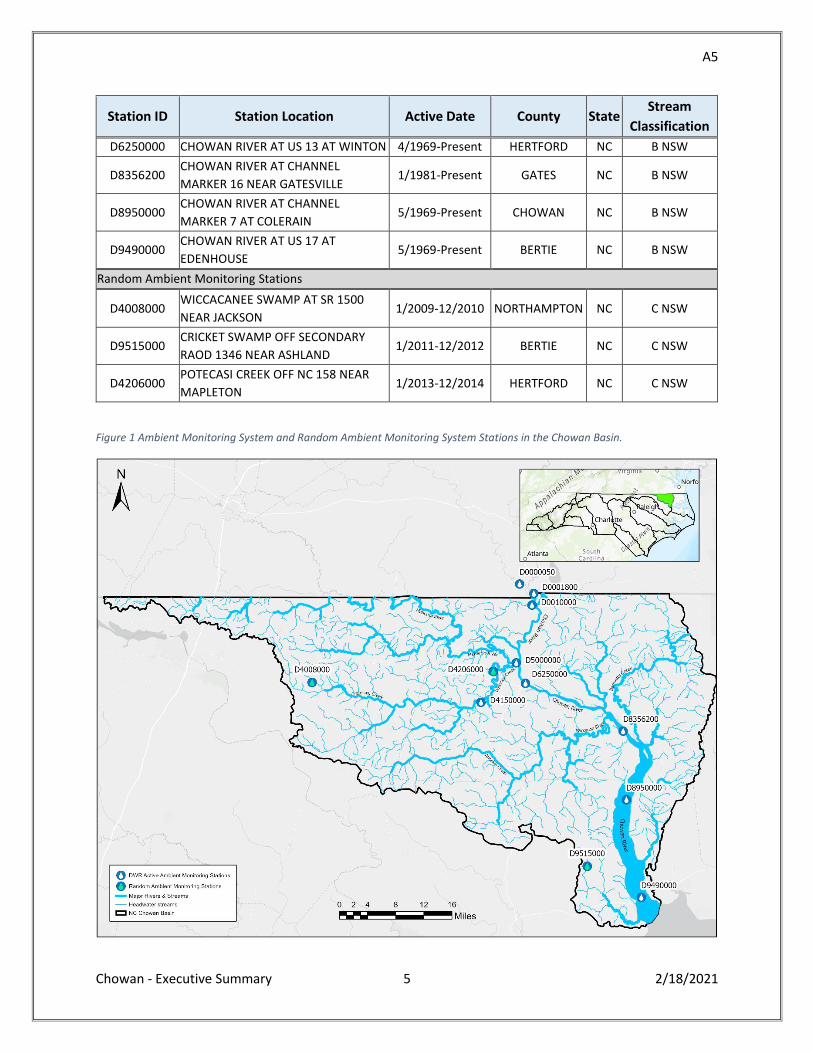
A5
Chowan - Executive Summary 5 2/18/2021
Station ID Station Location Active Date County State Stream
Classification
D6250000 CHOWAN RIVER AT US 13 AT WINTON 4/1969-Present HERTFORD NC B NSW
D8356200 CHOWAN RIVER AT CHANNEL
MARKER 16 NEAR GATESVILLE 1/1981-Present GATES NC B NSW
D8950000 CHOWAN RIVER AT CHANNEL
MARKER 7 AT COLERAIN 5/1969-Present CHOWAN NC B NSW
D9490000 CHOWAN RIVER AT US 17 AT
EDENHOUSE 5/1969-Present BERTIE NC B NSW
Random Ambient Monitoring Stations
D4008000 WICCACANEE SWAMP AT SR 1500
NEAR JACKSON 1/2009-12/2010 NORTHAMPTON NC C NSW
D9515000 CRICKET SWAMP OFF SECONDARY
RAOD 1346 NEAR ASHLAND 1/2011-12/2012 BERTIE NC C NSW
D4206000 POTECASI CREEK OFF NC 158 NEAR
MAPLETON 1/2013-12/2014 HERTFORD NC C NSW
Figure 1 Ambient Monitoring System and Random Ambient Monitoring System Stations in the Chowan Basin.
A6
Chowan - Executive Summary 6 2/18/2021
Lakes Assessment
The WSS Intensive Survey Branch (ISB) tests and reports on the water quality of lakes and reservoirs.
Merchants Millpond was sampled May-September 2010 and again in May and August 2015. It is a shallow
lake with a maximum depth of five feet and has characteristics of swamp waters. This lake has consistently
exhibited elevated biological productivity since it was first monitored by DWR in 1981.
Algae and Aquatic Plants The WSS Algae and Aquatic Plants Assessment Program provides two types of evaluations: episodic and
routine. Samples for episodic evaluations are collected in response to specific events such as fish kills,
algal blooms, and nuisance aquatic plant and algal growth. Routine evaluations are targeted studies of
specific waterbodies of interest and are generally performed in cooperation with other DWR programs.
Routine evaluations are conducted to assess changes in algal assemblages over time and are often focused
on estuarine systems where there are known issues of nutrient enrichment and have had frequent algal
blooms or fish kills. This program also maintains the NC DWR Algal Bloom Map which displays locations
analyzed by DWR for algal bloom activity.
Watersheds in the Chowan River Basin
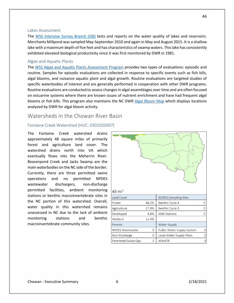
Fontaine Creek Watershed (HUC: 0301020407)
The Fontaine Creek watershed drains
approximately 48 square miles of primarily
forest and agriculture land cover. The
watershed drains north into VA which
eventually flows into the Meherrin River.
Beaverpond Creek and Jacks Swamp are the
main waterbodies on the NC side of the border.
Currently, there are three permitted swine
operations and no permitted NPDES
wastewater dischargers, non-discharge
permitted facilities, ambient monitoring
stations or benthic macroinvertebrate sites in
the NC portion of this watershed. Overall,
water quality in this watershed remains
unassessed in NC due to the lack of ambient
monitoring stations and benthic
macroinvertebrate community sites.
A7
Chowan - Executive Summary 7 2/18/2021
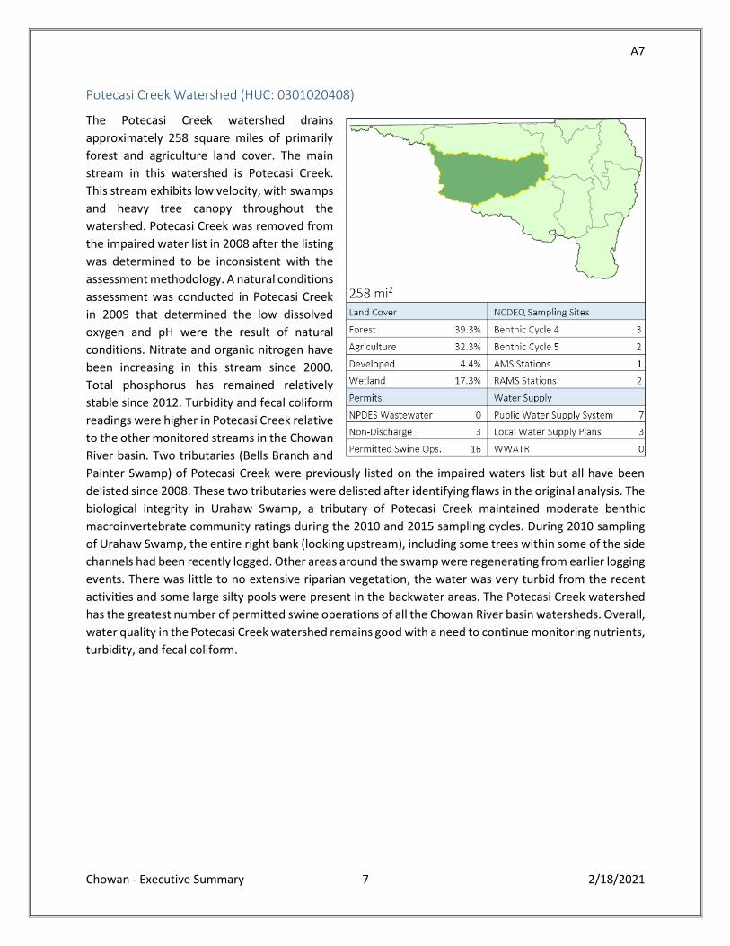
Potecasi Creek Watershed (HUC: 0301020408)
The Potecasi Creek watershed drains
approximately 258 square miles of primarily
forest and agriculture land cover. The main
stream in this watershed is Potecasi Creek.
This stream exhibits low velocity, with swamps
and heavy tree canopy throughout the
watershed. Potecasi Creek was removed from
the impaired water list in 2008 after the listing
was determined to be inconsistent with the
assessment methodology. A natural conditions
assessment was conducted in Potecasi Creek
in 2009 that determined the low dissolved
oxygen and pH were the result of natural
conditions. Nitrate and organic nitrogen have
been increasing in this stream since 2000.
Total phosphorus has remained relatively
stable since 2012. Turbidity and fecal coliform
readings were higher in Potecasi Creek relative
to the other monitored streams in the Chowan
River basin. Two tributaries (Bells Branch and
Painter Swamp) of Potecasi Creek were previously listed on the impaired waters list but all have been
delisted since 2008. These two tributaries were delisted after identifying flaws in the original analysis. The
biological integrity in Urahaw Swamp, a tributary of Potecasi Creek maintained moderate benthic
macroinvertebrate community ratings during the 2010 and 2015 sampling cycles. During 2010 sampling
of Urahaw Swamp, the entire right bank (looking upstream), including some trees within some of the side
channels had been recently logged. Other areas around the swamp were regenerating from earlier logging
events. There was little to no extensive riparian vegetation, the water was very turbid from the recent
activities and some large silty pools were present in the backwater areas. The Potecasi Creek watershed
has the greatest number of permitted swine operations of all the Chowan River basin watersheds. Overall,
water quality in the Potecasi Creek watershed remains good with a need to continue monitoring nutrients,
turbidity, and fecal coliform.
A8
Chowan - Executive Summary 8 2/18/2021
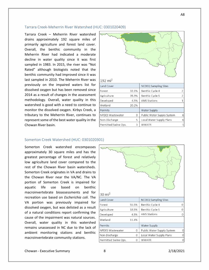
Tarrara Creek-Meherrin River Watershed (HUC: 0301020409)
Tarrara Creek – Meherrin River watershed
drains approximately 192 square miles of
primarily agriculture and forest land cover.
Overall, the benthic community in the
Meherrin River had indicated a moderate
decline in water quality since it was first
sampled in 1983. In 2015, the river was “Not
Rated” although biologists noted that the
benthic community had improved since it was
last sampled in 2010. The Meherrin River was
previously on the impaired waters list for
dissolved oxygen but has been removed since
2014 as a result of changes in the assessment
methodology. Overall, water quality in this
watershed is good with a need to continue to
monitor the dissolved oxygen. Kirbys Creek, a
tributary to the Meherrin River, continues to
represent some of the best water quality in the
Chowan River basin.
Somerton Creek Watershed (HUC: 0301020301)
Somerton Creek watershed encompasses
approximately 30 square miles and has the
greatest percentage of forest and relatively
low agriculture land cover compared to the
rest of the Chowan River basin watersheds.
Somerton Creek originates in VA and drains to
the Chowan River near the VA/NC. The VA
portion of Somerton Creek is impaired for
aquatic life use based on benthic
macroinvertebrate bioassessments and for
recreation use based on Escherichia coli. The
VA portion was previously impaired for
dissolved oxygen, but was delisted as a result
of a natural conditions report confirming the
cause of the impairment was natural sources.
Overall, water quality in this watershed
remains unassessed in NC due to the lack of
ambient monitoring stations and benthic
macroinvertebrate community stations.
A9
Chowan - Executive Summary 9 2/18/2021
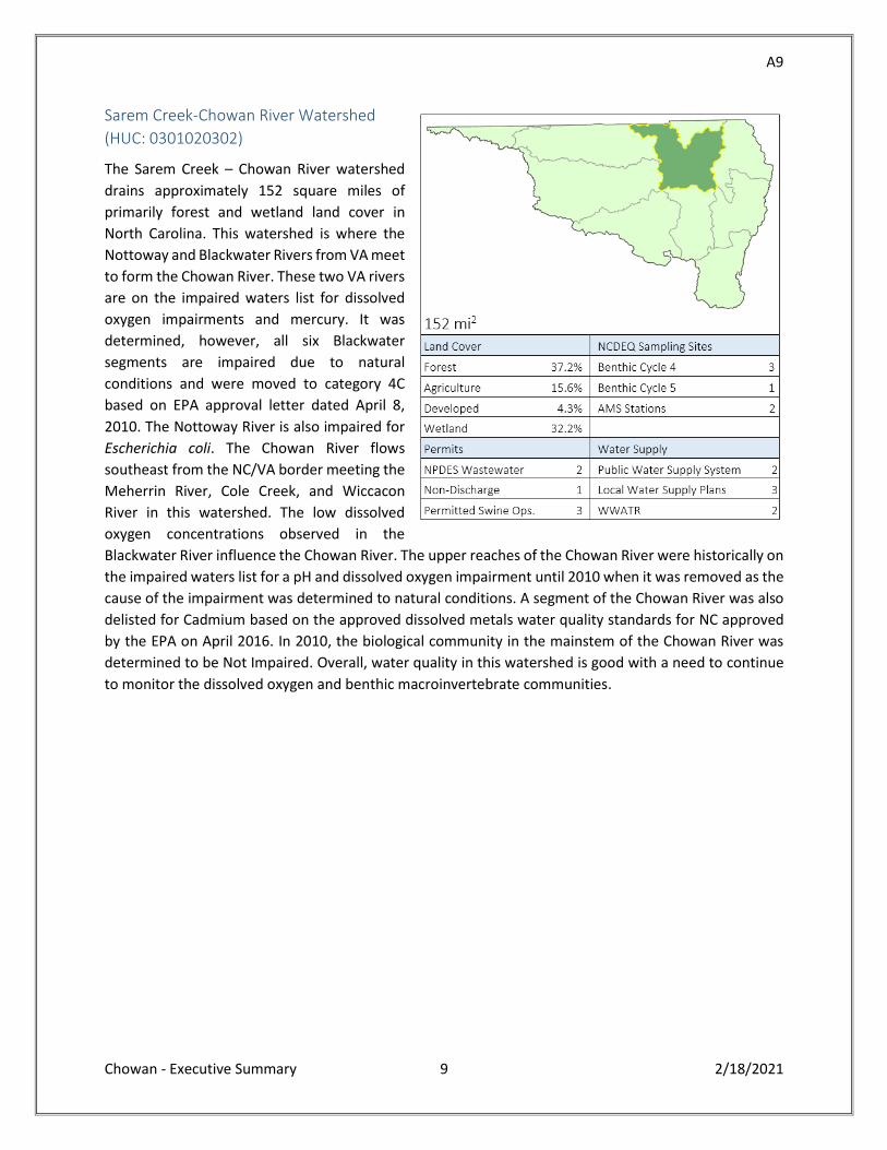
Sarem Creek-Chowan River Watershed
(HUC: 0301020302)
The Sarem Creek – Chowan River watershed
drains approximately 152 square miles of
primarily forest and wetland land cover in
North Carolina. This watershed is where the
Nottoway and Blackwater Rivers from VA meet
to form the Chowan River. These two VA rivers
are on the impaired waters list for dissolved
oxygen impairments and mercury. It was
determined, however, all six Blackwater
segments are impaired due to natural
conditions and were moved to category 4C
based on EPA approval letter dated April 8,
2010. The Nottoway River is also impaired for
Escherichia coli. The Chowan River flows
southeast from the NC/VA border meeting the
Meherrin River, Cole Creek, and Wiccacon
River in this watershed. The low dissolved
oxygen concentrations observed in the
Blackwater River influence the Chowan River. The upper reaches of the Chowan River were historically on
the impaired waters list for a pH and dissolved oxygen impairment until 2010 when it was removed as the
cause of the impairment was determined to natural conditions. A segment of the Chowan River was also
delisted for Cadmium based on the approved dissolved metals water quality standards for NC approved
by the EPA on April 2016. In 2010, the biological community in the mainstem of the Chowan River was
determined to be Not Impaired. Overall, water quality in this watershed is good with a need to continue
to monitor the dissolved oxygen and benthic macroinvertebrate communities.
A10
Chowan - Executive Summary 10 2/18/2021
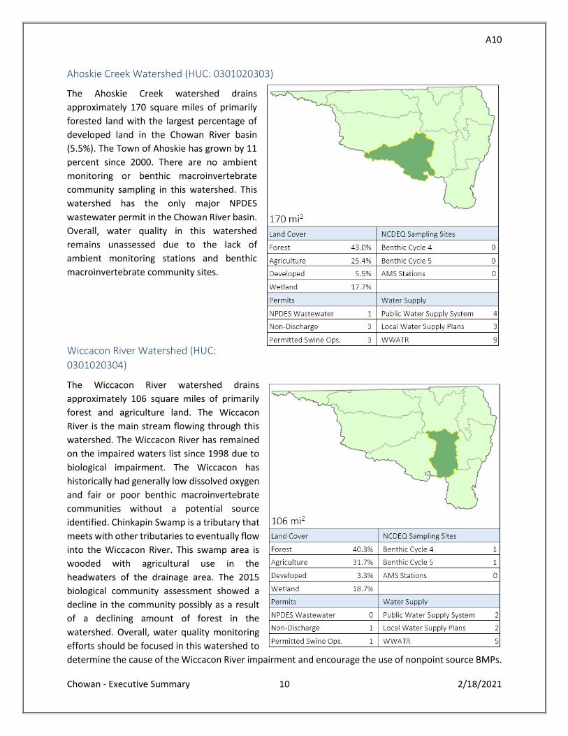
Ahoskie Creek Watershed (HUC: 0301020303)
The Ahoskie Creek watershed drains
approximately 170 square miles of primarily
forested land with the largest percentage of
developed land in the Chowan River basin
(5.5%). The Town of Ahoskie has grown by 11
percent since 2000. There are no ambient
monitoring or benthic macroinvertebrate
community sampling in this watershed. This
watershed has the only major NPDES
wastewater permit in the Chowan River basin.
Overall, water quality in this watershed
remains unassessed due to the lack of
ambient monitoring stations and benthic
macroinvertebrate community sites.
Wiccacon River Watershed (HUC:
0301020304)
The Wiccacon River watershed drains
approximately 106 square miles of primarily
forest and agriculture land. The Wiccacon
River is the main stream flowing through this
watershed. The Wiccacon River has remained
on the impaired waters list since 1998 due to
biological impairment. The Wiccacon has
historically had generally low dissolved oxygen
and fair or poor benthic macroinvertebrate
communities without a potential source
identified. Chinkapin Swamp is a tributary that
meets with other tributaries to eventually flow
into the Wiccacon River. This swamp area is
wooded with agricultural use in the
headwaters of the drainage area. The 2015
biological community assessment showed a
decline in the community possibly as a result
of a declining amount of forest in the
watershed. Overall, water quality monitoring
efforts should be focused in this watershed to
determine the cause of the Wiccacon River impairment and encourage the use of nonpoint source BMPs.
A11
Chowan - Executive Summary 11 2/18/2021
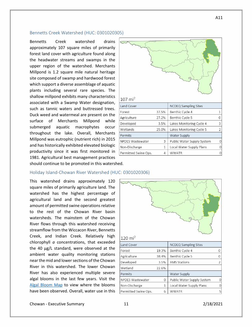
Bennetts Creek Watershed (HUC: 0301020305)
Bennetts Creek watershed drains
approximately 107 square miles of primarily
forest land cover with agriculture found along
the headwater streams and swamps in the
upper region of the watershed. Merchants
Millpond is 1.2 square mile natural heritage
site composed of swamp and hardwood forest
which support a diverse assemblage of aquatic
plants including several rare species. The
shallow millpond exhibits many characteristics
associated with a Swamp Water designation,
such as tannic waters and buttressed trees.
Duck weed and watermeal are present on the
surface of Merchants Millpond while
submerged aquatic macrophytes occur
throughout the lake. Overall, Merchants
Millpond was eutrophic (nutrient rich) in 2015
and has historically exhibited elevated biologic
productivity since it was first monitored in
1981. Agricultural best management practices
should continue to be promoted in this watershed.
Holiday Island-Chowan River Watershed (HUC: 0301020306)
This watershed drains approximately 120
square miles of primarily agriculture land. The
watershed has the highest percentage of
agricultural land and the second greatest
amount of permitted swine operations relative
to the rest of the Chowan River basin
watersheds. The mainstem of the Chowan
River flows through this watershed receiving
streamflow from the Wiccacon River, Bennetts
Creek, and Indian Creek. Relatively high
chlorophyll a concentrations, that exceeded
the 40 µg/L standard, were observed at the
ambient water quality monitoring stations
near the mid and lower sections of the Chowan
River in this watershed. The lower Chowan
River has also experienced multiple severe
algal blooms in the last few years. Visit the
Algal Bloom Map to view where the blooms
have been observed. Overall, water use in this
A12
Chowan - Executive Summary 12 2/18/2021
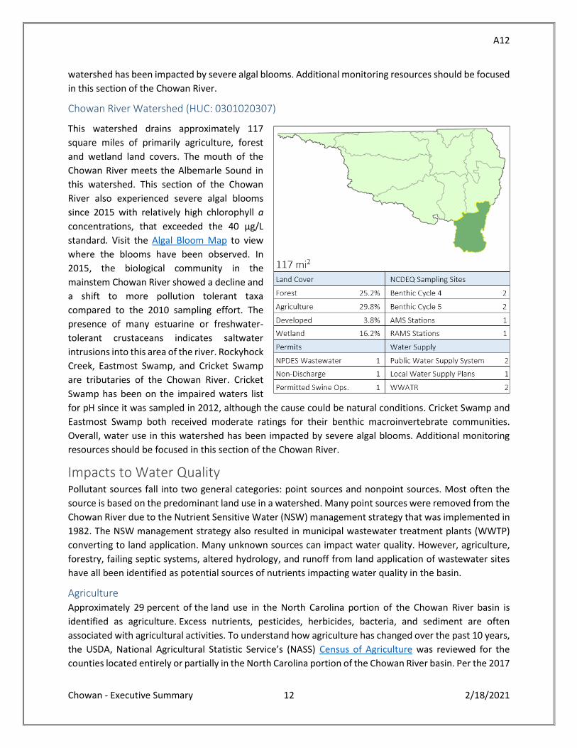
watershed has been impacted by severe algal blooms. Additional monitoring resources should be focused
in this section of the Chowan River.
Chowan River Watershed (HUC: 0301020307)
This watershed drains approximately 117
square miles of primarily agriculture, forest
and wetland land covers. The mouth of the
Chowan River meets the Albemarle Sound in
this watershed. This section of the Chowan
River also experienced severe algal blooms
since 2015 with relatively high chlorophyll a
concentrations, that exceeded the 40 µg/L
standard. Visit the Algal Bloom Map to view
where the blooms have been observed. In
2015, the biological community in the
mainstem Chowan River showed a decline and
a shift to more pollution tolerant taxa
compared to the 2010 sampling effort. The
presence of many estuarine or freshwater-
tolerant crustaceans indicates saltwater
intrusions into this area of the river. Rockyhock
Creek, Eastmost Swamp, and Cricket Swamp
are tributaries of the Chowan River. Cricket
Swamp has been on the impaired waters list
for pH since it was sampled in 2012, although the cause could be natural conditions. Cricket Swamp and
Eastmost Swamp both received moderate ratings for their benthic macroinvertebrate communities.
Overall, water use in this watershed has been impacted by severe algal blooms. Additional monitoring
resources should be focused in this section of the Chowan River.
Impacts to Water Quality Pollutant sources fall into two general categories: point sources and nonpoint sources. Most often the
source is based on the predominant land use in a watershed. Many point sources were removed from the
Chowan River due to the Nutrient Sensitive Water (NSW) management strategy that was implemented in
1982. The NSW management strategy also resulted in municipal wastewater treatment plants (WWTP)
converting to land application. Many unknown sources can impact water quality. However, agriculture,
forestry, failing septic systems, altered hydrology, and runoff from land application of wastewater sites
have all been identified as potential sources of nutrients impacting water quality in the basin.
Agriculture Approximately 29 percent of the land use in the North Carolina portion of the Chowan River basin is
identified as agriculture. Excess nutrients, pesticides, herbicides, bacteria, and sediment are often
associated with agricultural activities. To understand how agriculture has changed over the past 10 years,
the USDA, National Agricultural Statistic Service’s (NASS) Census of Agriculture was reviewed for the
counties located entirely or partially in the North Carolina portion of the Chowan River basin. Per the 2017
A13
Chowan - Executive Summary 13 2/18/2021
Census of Agriculture, a total of 959 farm operations are operating on a total of 510,698 acres (798 mi2)
in Bertie, Chowan, Gates, Hertford, and Northampton counties. This is a decrease from what was reported
in the 2007 Census of Agriculture when 1,153 total farms were operating on a total of 532,071 acres (831
mi2). The total number of acres identified as cropland has increased from approximately 355,000 acres in
2007 to just over 372,000 acres in 2017 while pastureland and woodland has declined. Livestock inventory
numbers have also changed over the last 10 years with the number of cattle and hogs decreasing while
poultry inventory and number of poultry farm operations increased (USDA, 2017).
As of May 2020, there were 40 permitted swine operations in the Chowan River basin. Animal operations
are defined under General Statute as feedlots that have more than 250 swine, 100 confined cattle, 75
horses, 1,000 sheep, or 30,000 confined poultry with a liquid waste management system. Most poultry
operations in North Carolina, however, use a dry waste management system. Poultry operations with a
dry waste management system are referred to as dry litter poultry operations. Dry litter poultry
operations are deemed permitted and are not required to register or obtain a permit from DWR.
For permitted animal operations, a Certified Animal Waste Management Plan (CAWMP) is incorporated
into the permit issued by DWR. Changes to the CAWMP are kept on the farm and reviewed annually by
DWR during inspections. Records related to nutrient management for deemed permitted animal
operations are kept on the farm as well but are not submitted to or reviewed by DWR. To better
understand where potential sources may be impacting water quality in the Chowan River basin,
information about the location of deemed permitted animal operations and where manure is being land
applied could help DWR adapt the basinwide stream monitoring program and identify new water quality
monitoring stations. Stream monitoring data has historically been a valuable piece of information in
understanding and addressing nutrient-related impacts to water quality including recreational use,
ecological integrity, commercial use, and quality of life for citizens living in the basin. DEQ will continue
to work collaboratively with federal, state and local agencies as well as local stakeholders in the basin to
identify information sharing opportunities to target water quality monitoring and BMP implementation
throughout the basin.
Between July 2010 and June 2020, more than $1.2 million of state cost share funds has been spent in the
basin on both agriculture and urban BMPs to protect water quality. Several practices have also been
installed using funds available through programs managed by the USDA Natural Resource Conservation
Service (NRCS). Soil and water technicians along with the Albemarle Resource Conservation and
Development Council, Inc. (ARCD) are continually working with agricultural operations to identify areas to
implement nutrient and sediment reducing BMPs as well as identifying how best to redesign drainage
from agricultural fields to reduce the amount and speed at which stormwater runoff enters a waterbody.
BMPs that target nutrient reduction and sediment removal should continue to be prioritized and
implemented throughout the basin.
Forestry Nearly 36 percent of the land use in the Chowan River basin in NC is identified as forested. Forests often
play a significant role in protecting water quality by absorbing and filtering precipitation, anchoring soil,
intercepting particulate matter, and reducing instream water temperatures.
Special attention is needed to ensure that water quality is protected while timber is being harvested in
the basin. Inappropriate management practices can impact water quality by altering instream habitat and
A14
Chowan - Executive Summary 14 2/18/2021
increasing sediment load. These impacts can also alter the interface of the aquatic and terrestrial
ecosystem and change watershed functions. Without appropriate best management practices in place
during and after harvests, sediment entering a waterbody can have a negative impact on water quality.
Sediment can stem from exposed cuts for skid trails, slopes with bare soil, and improperly constructed
stream crossings, forest roads, and log decks. As a result, the majority of regulations and erosion control
recommendations pertaining to forestry focus on preventing debris and sediment from entering
waterbodies. Properly planned and executed forest management plans facilitate the sustainable harvest
of forest products while protecting water quality.
Between July 2007 and June 2020, the North Carolina Forest Service (NCFS) inspected 1,743 timber
harvesting operations on 110,516 acres. Thirty-three were found to be out of compliance with the Forest
Practice Guidelines (FPG). The most common violations were related to streamside management zones
(SMZ), debris entering streams, stream crossings, or rehabilitation of the project area. Because
landowners are not required to notify NCFS of timber harvesting or related forestry activities, the numbers
reported may not be a full representation of the timber harvests in the basin.
There has been growing concern in recent years over forest management and its influence on algal blooms
in the Chowan River basin. In August 2016, NCFS personnel conducted an aerial assessment via aircraft
along the Chowan River to see if algal blooms were emanating from timber harvests. At that time, the
NCFS found no visible algal growth originating from past timber harvests of varying ages. NCFS met with
stakeholders in the basin, including the Soil and Water Conservation Districts (SWCD) and the Albemarle
Resource Conservation and Development Council, Inc. (ARCD), to discuss riparian buffer incentives for
landowners wanting to harvest timber adjacent to known nutrient-sensitive waters. Working
collaboratively with landowners, state and federal agencies, and researchers, NCFS continues to explore
how forest management may influence water quality in the Albemarle region.
Non-Discharge Wastewater Treatment Systems Due to the nutrient sensitivity of the waters in the Chowan River basin and the strict effluent limits on
discharges, non-discharge wastewater treatment systems are more common than municipal surface
wastewater dischargers. This transition occurred in the 1980’s to help prevent eutrophication in the
nutrient sensitive waters of the Chowan River basin. In many groundwater monitoring wells around the
non-discharge wastewater treatment system, nitrate and ammonia concentrations are below the 15A
NCAC 02L and Interim Maximum Allowable Concentrations for groundwater of 10 mg/L and 1.5 mg/L,
respectively. Although groundwater concentrations below many of these facilities adhere to groundwater
standards, a few facilities have observed concentrations above these standards in groundwater around
the facilities. Investigations indicate the elevated nutrient concentrations are the result of surrounding
land use. All of the facilities in the Chowan River basin have the potential to cause impacts to surface or
groundwater. Although potential may exist for groundwater and surface water impacts to occur from non-
discharge operations, there are few facilities where routine run-off occurs from the spray fields, no routine
cases of nutrient over-application occurring based on monitoring data, nor widespread groundwater
impacts attributable to wastewater management operations.
A15
Chowan - Executive Summary 15 2/18/2021
Parameters of Concern in the Chowan River Basin Algal Blooms and Nutrients
The Chowan River was the first coastal river in NC recognized to experience problems with nutrient
enrichment or eutrophication in 1972 and 1978. Nutrient enrichment resulting from excess nitrogen and
phosphorous in waterbodies can cause algal blooms that deplete oxygen, kill fish, and create taste and
odor problems in drinking water. The Chowan NSW Water Quality Management Plan nutrient reduction
goals of 20 percent for nitrogen and 35 percent for phosphorus were documented in the 1990's, but since
2000 the Chowan river and tributaries have seen a steady increase in organic nitrogen levels. Additional
research and analytical tools are needed to better understand the source of increasing organic nitrogen
and how to properly manage this load.
Over the last several years a resurgence of algal bloom and potentially harmful algal bloom (pHAB) activity
has occurred in the Chowan River. There is a need to better understand the different nutrient
contributions in the VA and NC watersheds which form the Chowan River which flows into the Albemarle
Sound. One of the goals of this assessment is to better understand the changes that have occurred over
time and if there is a specific turning point or shift in environmental conditions which have resulted in the
Chowan River becoming increasingly susceptible to the development of algal blooms and/or pHABs.
Reviewing the changes in nutrient concentrations and loading is just the first step in understanding
possible changes in the watershed. This report will present the nitrogen species [nitrate, ammonia, and
organic nitrogen], total phosphorus, and chlorophyll a data over time throughout the Chowan River basin
in an effort to communicate the changes in the instream nutrient concentrations and loads relating those
changes to the management strategy, land use and other watershed implementation efforts that have
taken place since the early 1980’s. Nutrient levels were analyzed at nine ambient stations throughout the
basin. Increasing instream concentration levels of organic nitrogen were observed at all nine sites, with
the highest amounts found in the Potecasi River. Total phosphorus instream concentration levels were
only found to be increasing at one site in the Potecasi River. The source of the increased nutrients has not
been identified.
Low pH
The standard for pH in freshwater is 6 su and 9 su. One river, Cricket Swamp, has water quality with a pH
less than this standard. This was determined by monitoring at a RAMS station D9515000 between 2011-
2012. Cricket Swamp drains to Salmon Creek then flow to the Chowan River near the Albemarle Sound.
The source of the low pH has not been determined but could be the result of natural conditions. The
natural conditions contributing to the low pH could be reactions with acid soils and drainage of swamp-
like water.
Dioxins
Dioxins have been identified as an impairment for the Albemarle Sound to the mouths of the Chowan and
Roanoke rivers. Dioxins are the byproducts of industrial processes and are formed during the chlorine
bleaching process at pulp and paper mills. The current dioxins advisory was issued by the Department of
Health and Human Services (DHHS) in 2001. The advisory is for the consumption of catfish and carp in the
Albemarle Sound from Bull Bay to Harvey Point; West to the mouth of the Roanoke River and to the mouth
of the Chowan River to the U.S. Highway 17 Bridge (Perquimans, Chowan, Bertie, Washington, and Tyrrell
counties). Women of childbearing age and children should not eat any catfish or carp from this area until
further notice. All other persons should eat no more than one meal per month of catfish and carp from
A16
Chowan - Executive Summary 16 2/18/2021
this area. For more information on this advisory please visit the DHHS website
https://epi.dph.ncdhhs.gov/oee/fish/advisories.html.
Mercury
In 1997 a statewide fish consumption advisory was issued due to mercury levels found throughout the
state. Mercury levels in fish have been found at unsafe levels especially in larger fish due to
bioaccumulation. The major source of the mercury has been determined to be atmospheric deposition.
For more information on this advisory please visit the DHHS website
https://epi.dph.ncdhhs.gov/oee/fish/advisories.html.
Recommendations Balancing economic growth with water resources protection is challenging. Point source impacts on
surface waters can be measured and addressed through voluntary and regulatory actions, but the
cumulative effects of nonpoint source pollution are diffuse. Nonpoint source pollution is the primary
threat to water quality and habitat degradation in the Chowan River basin. While streams impacted by
nonpoint source pollution can be identified through the basin planning process, actions to address the
issues are needed at the local level. Recommendations below are categorized by sector and include
agencies, stakeholders, and other entities as potential participants needed to participate in the
recommendation. Recommendations in bold type are ones that have been identified as priorities by the
Basin Planning Branch.
A17
Chowan - Executive Summary 17 2/18/2021
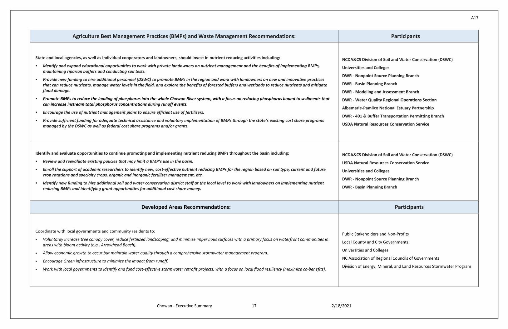
Agriculture Best Management Practices (BMPs) and Waste Management Recommendations: Participants
State and local agencies, as well as individual cooperators and landowners, should invest in nutrient reducing activities including:
Identify and expand educational opportunities to work with private landowners on nutrient management and the benefits of implementing BMPs, maintaining riparian buffers and conducting soil tests.
Provide new funding to hire additional personnel (DSWC) to promote BMPs in the region and work with landowners on new and innovative practices that can reduce nutrients, manage water levels in the field, and explore the benefits of forested buffers and wetlands to reduce nutrients and mitigate flood damage.
Promote BMPs to reduce the loading of phosphorus into the whole Chowan River system, with a focus on reducing phosphorus bound to sediments that can increase instream total phosphorus concentrations during runoff events.
Encourage the use of nutrient management plans to ensure efficient use of fertilizers.
Provide sufficient funding for adequate technical assistance and voluntary implementation of BMPs through the state’s existing cost share programs managed by the DSWC as well as federal cost share programs and/or grants.
NCDA&CS Division of Soil and Water Conservation (DSWC)
Universities and Colleges
DWR - Nonpoint Source Planning Branch
DWR - Basin Planning Branch
DWR - Modeling and Assessment Branch
DWR - Water Quality Regional Operations Section
Albemarle-Pamlico National Estuary Partnership
DWR - 401 & Buffer Transportation Permitting Branch
USDA Natural Resources Conservation Service
Identify and evaluate opportunities to continue promoting and implementing nutrient reducing BMPs throughout the basin including:
Review and reevaluate existing policies that may limit a BMP’s use in the basin.
Enroll the support of academic researchers to identify new, cost-effective nutrient reducing BMPs for the region based on soil type, current and future crop rotations and specialty crops, organic and inorganic fertilizer management, etc.
Identify new funding to hire additional soil and water conservation district staff at the local level to work with landowners on implementing nutrient reducing BMPs and identifying grant opportunities for additional cost share money.
NCDA&CS Division of Soil and Water Conservation (DSWC)
USDA Natural Resources Conservation Service
Universities and Colleges
DWR - Nonpoint Source Planning Branch
DWR - Basin Planning Branch
Developed Areas Recommendations: Participants
Coordinate with local governments and community residents to:
Voluntarily increase tree canopy cover, reduce fertilized landscaping, and minimize impervious surfaces with a primary focus on waterfront communities in areas with bloom activity (e.g., Arrowhead Beach).
Allow economic growth to occur but maintain water quality through a comprehensive stormwater management program.
Encourage Green infrastructure to minimize the impact from runoff.
Work with local governments to identify and fund cost-effective stormwater retrofit projects, with a focus on local flood resiliency (maximize co-benefits).
Public Stakeholders and Non-Profits
Local County and City Governments
Universities and Colleges
NC Association of Regional Councils of Governments
Division of Energy, Mineral, and Land Resources Stormwater Program
A18
Chowan - Executive Summary 18 2/18/2021
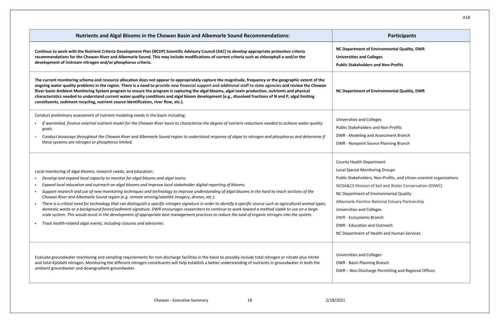
Nutrients and Algal Blooms in the Chowan Basin and Albemarle Sound Recommendations: Participants
Continue to work with the Nutrient Criteria Development Plan (NCDP) Scientific Advisory Council (SAC) to develop appropriate protective criteria recommendations for the Chowan River and Albemarle Sound. This may include modifications of current criteria such as chlorophyll a and/or the development of instream nitrogen and/or phosphorus criteria.
NC Department of Environmental Quality, DWR
Universities and Colleges
Public Stakeholders and Non-Profits
The current monitoring schema and resource allocation does not appear to appropriately capture the magnitude, frequency or the geographic extent of the ongoing water quality problems in the region. There is a need to provide new financial support and additional staff to state agencies and review the Chowan River basin Ambient Monitoring System program to ensure the program is capturing the algal blooms, algal toxin production, nutrients and physical characteristics needed to understand current water quality conditions and algal bloom development (e.g., dissolved fractions of N and P, algal limiting constituents, sediment recycling, nutrient source identification, river flow, etc.).
NC Department of Environmental Quality, DWR
Conduct preliminary assessment of nutrient modeling needs in the basin including:
If warranted, finance external nutrient model for the Chowan River basin to characterize the degree of nutrient reductions needed to achieve water quality goals.
Conduct bioassays throughout the Chowan River and Albemarle Sound region to understand response of algae to nitrogen and phosphorus and determine if these systems are nitrogen or phosphorus limited.
Universities and Colleges
Public Stakeholders and Non-Profits
DWR - Modeling and Assessment Branch
DWR - Nonpoint Source Planning Branch
Local monitoring of algal blooms, research needs, and education:
Develop and expand local capacity to monitor for algal blooms and algal toxins.
Expand local education and outreach on algal blooms and improve local stakeholder digital reporting of blooms.
Support research and use of new monitoring techniques and technology to improve understanding of algal blooms in the hard to reach sections of the Chowan River and Albemarle Sound region (e.g. remote sensing/satellite imagery, drones, etc.).
There is a critical need for technology that can distinguish a specific nitrogen signature in order to identify a specific source such as agricultural animal types, domestic waste or a background forest/sediment signature. DWR encourages researchers to continue to work toward a method viable to use on a large-scale system. This would assist in the development of appropriate best management practices to reduce the load of organic nitrogen into the system.
Track health-related algal events, including closures and advisories.
County Health Department
Local Special Monitoring Groups
Public Stakeholders, Non-Profits, and citizen scientist organizations
NCDA&CS Division of Soil and Water Conservation (DSWC)
NC Department of Environmental Quality
Albemarle-Pamlico National Estuary Partnership
Universities and Colleges
DWR - Ecosystems Branch
DWR - Education and Outreach
NC Department of Health and Human Services
Evaluate groundwater monitoring and sampling requirements for non-discharge facilities in the basin to possibly include total nitrogen or nitrate plus nitrite and total Kjeldahl nitrogen. Monitoring the different nitrogen constituents will help establish a better understanding of nutrients in groundwater in both the ambient groundwater and downgradient groundwater.
Universities and Colleges
DWR - Basin Planning Branch
DWR – Non-Discharge Permitting and Regional Offices
A19
Chowan - Executive Summary 19 2/18/2021
Potential Pollution Sources in the Chowan Basin and Albemarle Sound Recommendations: Participants
Understanding all potential pollution sources in the basin is critical to addressing impacts to water quality (i.e. increasing organic nitrogen, resurgence of harmful algal blooms). Potential sources of pollution include agriculture, biosolids, forestry, point sources, septic systems, stormwater, and groundwater.
Characterize the location, age, and types of septic systems within the Chowan River basin and consider financial incentives and financial assistance to address failing septic systems.1
Work with local and county governments to identify areas impacted by stormwater runoff and how best to address stormwater issues.2
Continue to support and expand the monitoring of groundwater through the Ground Water Management Branch. Consideration should be given to locate
wells in strategic locations in proximity to surface waterbodies. Such locations may provide a method to improve predictive modeling efforts related to
groundwater discharges to surface waters and could provide for more accurate assessment of surface water impairments resulting from groundwater
discharges enabling the state to make sound permitting judgments and recommendations to better protect ground and surface water quality.3
To better understand where potential sources may be impacting water quality in the Chowan River basin, information about the location of deemed
permitted animal operations and where manure is being land applied could help DWR adapt the basinwide stream monitoring program and identify new
water quality monitoring stations. Stream monitoring data has historically been a valuable piece of information in understanding and addressing nutrient-
related impacts to water quality including recreational use, ecological integrity, commercial use, and quality of life for citizens living in the basin. To do this,
DEQ will continue to work collaboratively with federal, state, and local agencies as well as stakeholders in the basin to identify information sharing
opportunities to target water quality monitoring and BMP implementation throughout the basin.4
Establish better communication between Virginia DEQ, North Carolina DEQ, and the Albemarle-Pamlico National Estuary Partnership to better understand
changes that have occurred over time and steps that each state has taken and can continue to take to control nutrients, ensure proportionate nutrient-
reduction measures are in place, and improve water quality flowing to the Albemarle Sound. Conversations should include how to improve, manage, and
share water quality data across the basin and how to capture BMP benefits (agriculture, stormwater, etc.). This information could then be used to model
nutrient loads throughout the entire basin.5
Research examining silvicultural practices in forested swamps is needed to better understand the relationship among forestry-related operations and water
quality parameters within the basin. Continued monitoring could help identify nonpoint sources of nutrients entering the basin.6
NC Department of Health and Human Services1
County Health Departments1
NC Association of Regional Councils of Governments2
Division of Energy, Mineral, and Land Resources Stormwater Program2
Public Stakeholders and Non-Profits1,2,4,5
Universities and Colleges1,2,5,6
Local and County Governments2,5
DWR - Ground Water Management Branch3
DWR - Water Quality Regional Operations Section3
DWR - Non-Discharge Branch3
NC Department of Environmental Quality3,4,5,6
DWR - Animal Feeding Operations Branch3,4
NCDA&CS Division of Soil and Water Conservation (DSWC)3,4
USDA Natural Resources Conservation Service4
County Soil and Water Conservation Districts (SWCD)4
North Carolina Farm Bureau (NCFB)4
DWR - Basin Planning Branch5
Albemarle-Pamlico National Estuary Partnership5
Virginia Department of Environmental Quality5
NCDA&CS NC Forest Service (NCFS)6
Streamflow Research Recommendations: Participants
Investigate possible temporal relationships between stream flow and chlorophyll a concentrations. Understanding the correlation between stream flow and chlorophyll a concentrations could assist local agencies with forecasting the intensity of algal bloom that may occur.
DWR - Modeling and Assessment Branch
DWR - Basin Planning Branch
Universities and Colleges
Public Stakeholders and Non-Profits
Identify new and innovative modeling approaches for coastal watersheds to adequately replicate the interactions of surface and groundwater withdrawals, modified land use and drainage patterns, adequate flow for the protection of aquatic habitats, changes in weather patterns, and stage-flow relationships. Data gaps in stream flow and the tidal influence in coastal waters complicates efforts to model stream flow.
DWR - Modeling and Assessment Branch
DWR - Ground Water Management Branch
DWR - Water Supply Planning Branch
Wildlife Resources Commission
Universities and Colleges
Public Stakeholders and Non-Profits
A20
Chowan - Executive Summary 20 2/18/2021
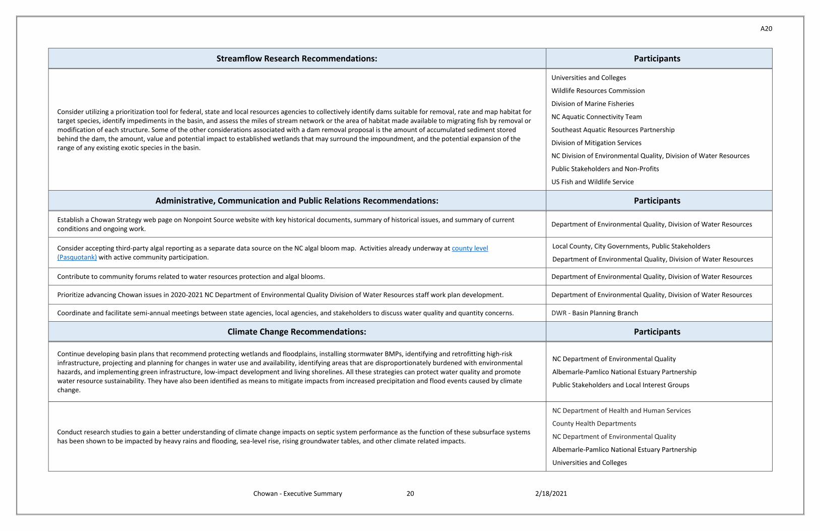
Streamflow Research Recommendations: Participants
Consider utilizing a prioritization tool for federal, state and local resources agencies to collectively identify dams suitable for removal, rate and map habitat for target species, identify impediments in the basin, and assess the miles of stream network or the area of habitat made available to migrating fish by removal or modification of each structure. Some of the other considerations associated with a dam removal proposal is the amount of accumulated sediment stored behind the dam, the amount, value and potential impact to established wetlands that may surround the impoundment, and the potential expansion of the range of any existing exotic species in the basin.
Universities and Colleges
Wildlife Resources Commission
Division of Marine Fisheries
NC Aquatic Connectivity Team
Southeast Aquatic Resources Partnership
Division of Mitigation Services
NC Division of Environmental Quality, Division of Water Resources
Public Stakeholders and Non-Profits
US Fish and Wildlife Service
Administrative, Communication and Public Relations Recommendations: Participants
Establish a Chowan Strategy web page on Nonpoint Source website with key historical documents, summary of historical issues, and summary of current conditions and ongoing work.
Department of Environmental Quality, Division of Water Resources
Consider accepting third-party algal reporting as a separate data source on the NC algal bloom map. Activities already underway at county level (Pasquotank) with active community participation.
Local County, City Governments, Public Stakeholders
Department of Environmental Quality, Division of Water Resources
Contribute to community forums related to water resources protection and algal blooms. Department of Environmental Quality, Division of Water Resources
Prioritize advancing Chowan issues in 2020-2021 NC Department of Environmental Quality Division of Water Resources staff work plan development. Department of Environmental Quality, Division of Water Resources
Coordinate and facilitate semi-annual meetings between state agencies, local agencies, and stakeholders to discuss water quality and quantity concerns. DWR - Basin Planning Branch
Climate Change Recommendations: Participants
Continue developing basin plans that recommend protecting wetlands and floodplains, installing stormwater BMPs, identifying and retrofitting high-risk infrastructure, projecting and planning for changes in water use and availability, identifying areas that are disproportionately burdened with environmental hazards, and implementing green infrastructure, low-impact development and living shorelines. All these strategies can protect water quality and promote water resource sustainability. They have also been identified as means to mitigate impacts from increased precipitation and flood events caused by climate change.
NC Department of Environmental Quality
Albemarle-Pamlico National Estuary Partnership
Public Stakeholders and Local Interest Groups
Conduct research studies to gain a better understanding of climate change impacts on septic system performance as the function of these subsurface systems has been shown to be impacted by heavy rains and flooding, sea-level rise, rising groundwater tables, and other climate related impacts.
NC Department of Health and Human Services
County Health Departments
NC Department of Environmental Quality
Albemarle-Pamlico National Estuary Partnership
Universities and Colleges
A21
Chowan - Executive Summary 21 2/18/2021
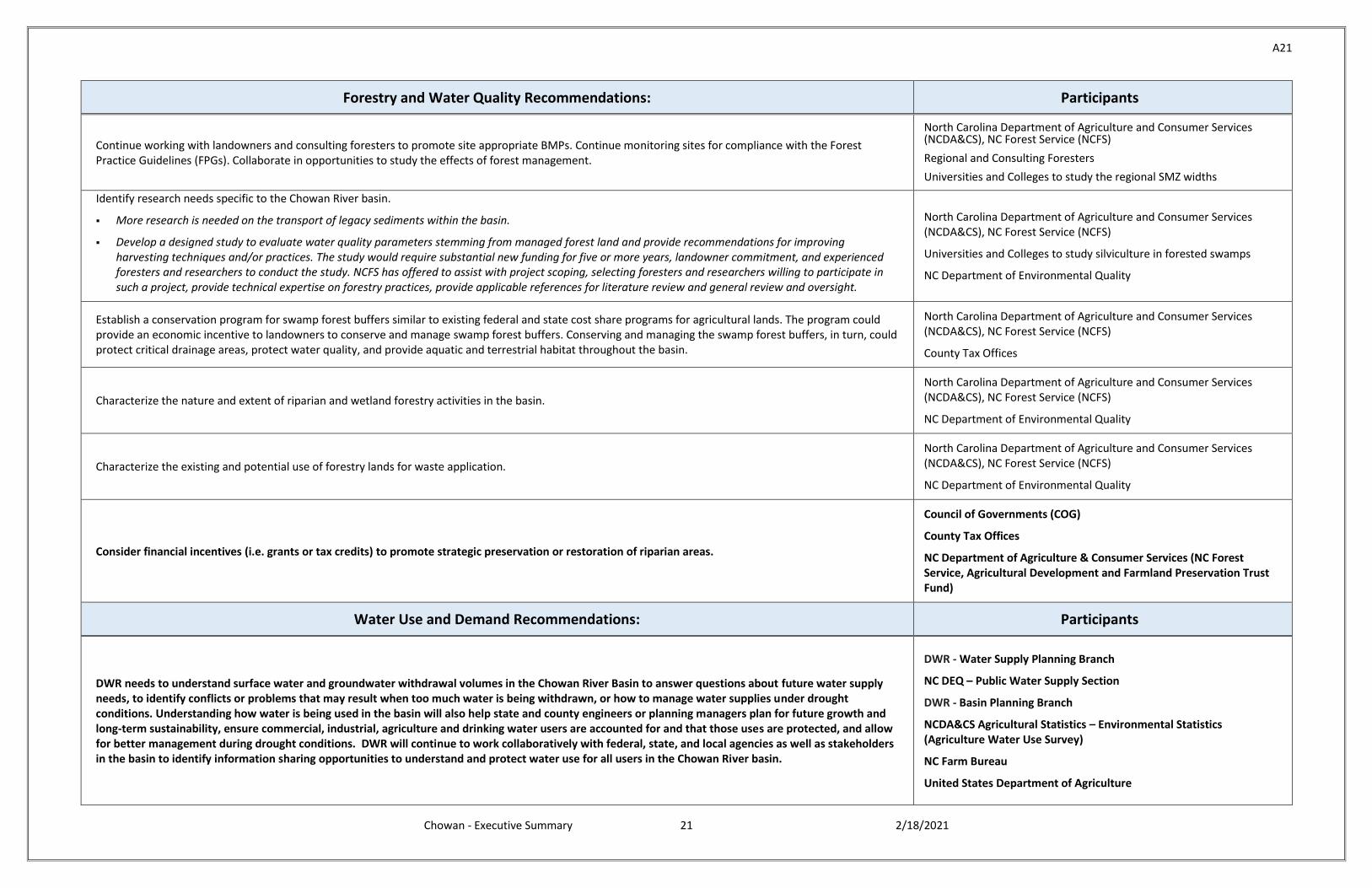
Forestry and Water Quality Recommendations: Participants
Continue working with landowners and consulting foresters to promote site appropriate BMPs. Continue monitoring sites for compliance with the Forest Practice Guidelines (FPGs). Collaborate in opportunities to study the effects of forest management.
North Carolina Department of Agriculture and Consumer Services (NCDA&CS), NC Forest Service (NCFS)
Regional and Consulting Foresters
Universities and Colleges to study the regional SMZ widths
Identify research needs specific to the Chowan River basin.
More research is needed on the transport of legacy sediments within the basin.
Develop a designed study to evaluate water quality parameters stemming from managed forest land and provide recommendations for improving harvesting techniques and/or practices. The study would require substantial new funding for five or more years, landowner commitment, and experienced foresters and researchers to conduct the study. NCFS has offered to assist with project scoping, selecting foresters and researchers willing to participate in such a project, provide technical expertise on forestry practices, provide applicable references for literature review and general review and oversight.
North Carolina Department of Agriculture and Consumer Services (NCDA&CS), NC Forest Service (NCFS)
Universities and Colleges to study silviculture in forested swamps
NC Department of Environmental Quality
Establish a conservation program for swamp forest buffers similar to existing federal and state cost share programs for agricultural lands. The program could provide an economic incentive to landowners to conserve and manage swamp forest buffers. Conserving and managing the swamp forest buffers, in turn, could protect critical drainage areas, protect water quality, and provide aquatic and terrestrial habitat throughout the basin.
North Carolina Department of Agriculture and Consumer Services (NCDA&CS), NC Forest Service (NCFS)
County Tax Offices
Characterize the nature and extent of riparian and wetland forestry activities in the basin.
North Carolina Department of Agriculture and Consumer Services (NCDA&CS), NC Forest Service (NCFS)
NC Department of Environmental Quality
Characterize the existing and potential use of forestry lands for waste application.
North Carolina Department of Agriculture and Consumer Services (NCDA&CS), NC Forest Service (NCFS)
NC Department of Environmental Quality
Consider financial incentives (i.e. grants or tax credits) to promote strategic preservation or restoration of riparian areas.
Council of Governments (COG)
County Tax Offices
NC Department of Agriculture & Consumer Services (NC Forest Service, Agricultural Development and Farmland Preservation Trust Fund)
Water Use and Demand Recommendations: Participants
DWR needs to understand surface water and groundwater withdrawal volumes in the Chowan River Basin to answer questions about future water supply needs, to identify conflicts or problems that may result when too much water is being withdrawn, or how to manage water supplies under drought conditions. Understanding how water is being used in the basin will also help state and county engineers or planning managers plan for future growth and long-term sustainability, ensure commercial, industrial, agriculture and drinking water users are accounted for and that those uses are protected, and allow for better management during drought conditions. DWR will continue to work collaboratively with federal, state, and local agencies as well as stakeholders in the basin to identify information sharing opportunities to understand and protect water use for all users in the Chowan River basin.
DWR - Water Supply Planning Branch
NC DEQ – Public Water Supply Section
DWR - Basin Planning Branch
NCDA&CS Agricultural Statistics – Environmental Statistics (Agriculture Water Use Survey)
NC Farm Bureau
United States Department of Agriculture
A22
Chowan - Executive Summary 22 2/18/2021
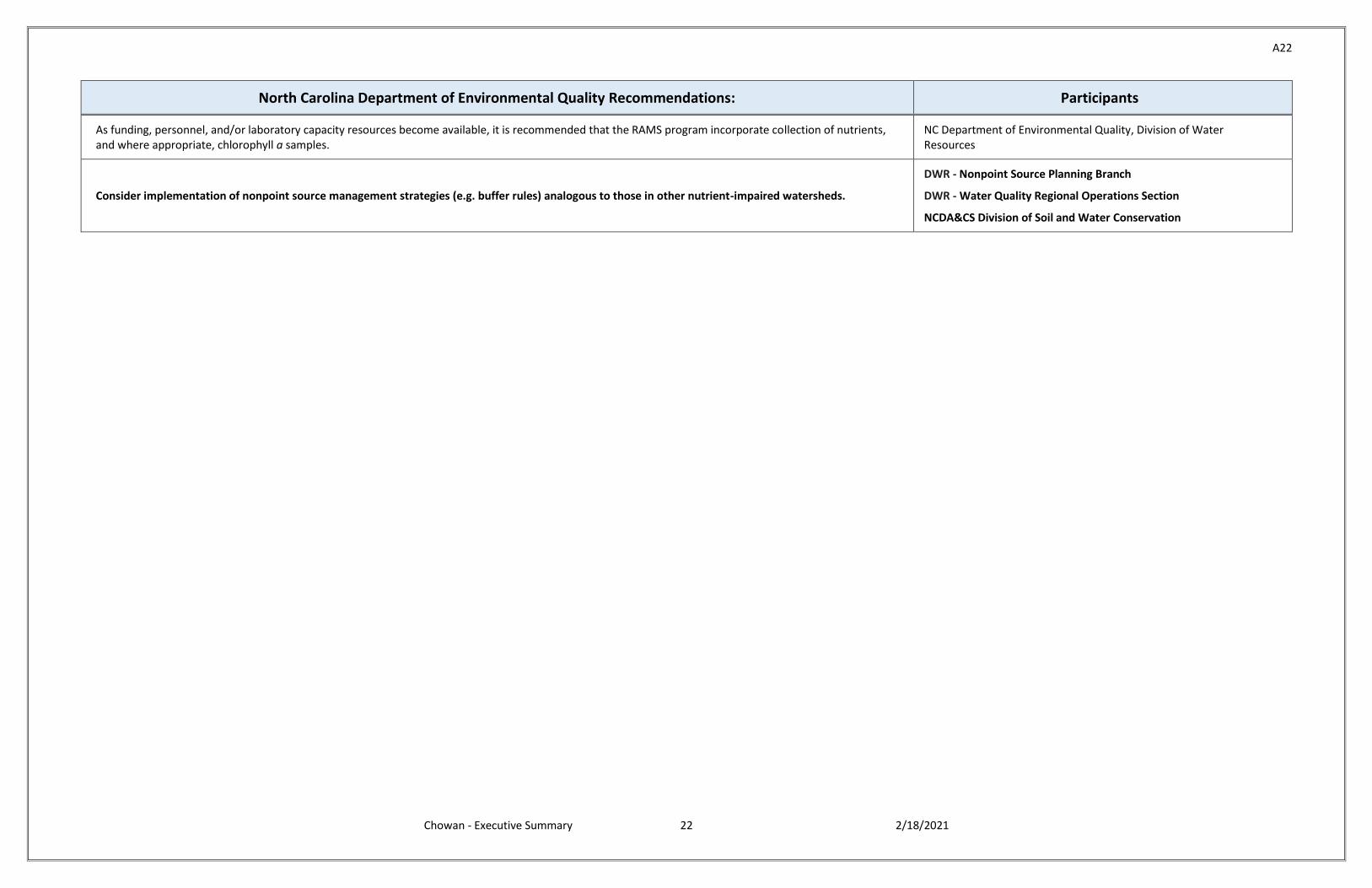
North Carolina Department of Environmental Quality Recommendations: Participants
As funding, personnel, and/or laboratory capacity resources become available, it is recommended that the RAMS program incorporate collection of nutrients, and where appropriate, chlorophyll a samples.
NC Department of Environmental Quality, Division of Water Resources
Consider implementation of nonpoint source management strategies (e.g. buffer rules) analogous to those in other nutrient-impaired watersheds.
DWR - Nonpoint Source Planning Branch
DWR - Water Quality Regional Operations Section
NCDA&CS Division of Soil and Water Conservation


![Food security and nutrition: building a global narrative ... · EXECUTIVE SUMMARY EXECUTIVE SUMMARY EXECUTIVE SUMMARY EXECUTIVE SUMMAR Y [ 2 ] This document contains the Summary and](https://static.fdocuments.net/doc/165x107/5ff5433612d22125fb06e6b5/food-security-and-nutrition-building-a-global-narrative-executive-summary-executive.jpg)
