EXCAVATIONS AT ZIYARET TEPE, DIYARBAKIR ... XXXVII, 2011 EXCAVATIONS AT ZIYARET TEPE, DIYARBAKIR...
48
ANATOLICA XXXVII, 2011 EXCAVATIONS AT ZIYARET TEPE, DIYARBAKIR PROVINCE, TURKEY, 2009-2010 SEASONS Timothy Matney, Tina Greenfield, Britt Hartenberger, Chelsea Jalbrzikowski, Kemalettin Köro lu, John MacGinnis, Anke Marsh, Martin Willis Monroe, Melissa Rosenzweig, Kristina Sauer, and Dirk Wicke Abstract This article presents the results of the 2009 and 2010 excavation and geophysical survey seasons at Ziyaret Tepe, the Late Assyrian city of Tushhan, in southeastern Turkey, as well as the preliminary results of post-excavation analyses. Particular attention is given to the continuing excavation of a palace on the citadel, a large public administrative building, and a city gate in the lower town, and to the completion of a full-coverage magnetic gradiometry survey across the lower town. Geophysical survey recovered the location of three substantial buildings in the southeastern corner of the lower town; these will be investigated further in future seasons. Specialist reports on the zooarchaeological and paleobotanical reports add significant detail to our understanding of the architecture and excavated archaeological contexts and help to identify room function within the Assyrian buildings. Important epigraphic finds from the palace and lower town excavations are briefly treated, and chipped stone and phytolith analyses are also discussed. Finally, a brief summary is provided describing our conservation activities in conjunction with the regional Diyarbakır Archaeological Museum in preparing an important collection of ivory and bronze artifacts from the palace for long-term storage and display. The 2009 and 2010 seasons were a joint undertaking with a collaborative partnership between the Universities of Akron (US), Cambridge (UK), Mainz (Germany), and Marmara (Turkey). INTRODUCTION The 13 th and 14 th seasons of archaeological fieldwork at Ziyaret Tepe, the Assyrian city of Tushhan, located in the Diyarbakır province of southeastern Turkey were conducted from July to September 2009 and from March to September 2010. Dr. Timothy Matney (University of Akron, US) served as the overall scientific director. Dr. John MacGinnis (Cambridge University, UK) directed excavations in the lower town. Dr. Dirk Wicke (University of Mainz, Germany) directed excavations on the citadel mound. Prof. Dr. Kemalettin Köro lu (Marmara University) served as our senior Turkish archaeologist. Previous reports in this journal (Matney 1998; Matney and Somers 1999; Matney and Bauer 2000; Matney et al. 2002; 2003; Matney and Rainville 2005; Matney et al. 2007; 2009) have established a basic description of the site’s topography and its historical significance; these background items will not be repeated here. The focus of this article is the results of excavations during 2009 and 2010 across several parts of the site, geophysical surveys conducted in the lower town in 2009, and specialist reports that form an important on-going record of our investigation into this important Assyrian urban center. All long-term archaeological projects generate significant numbers of interesting auxiliary projects and research questions; the Ziyaret Tepe expedition is no exception to
Transcript of EXCAVATIONS AT ZIYARET TEPE, DIYARBAKIR ... XXXVII, 2011 EXCAVATIONS AT ZIYARET TEPE, DIYARBAKIR...
ANATOLICA XXXVII, 2011
EXCAVATIONS AT ZIYARET TEPE, DIYARBAKIR PROVINCE, TURKEY, 2009-2010 SEASONS
Timothy Matney, Tina Greenfield, Britt Hartenberger, Chelsea Jalbrzikowski,Kemalettin Köro lu, John MacGinnis, Anke Marsh, Martin Willis Monroe,
Melissa Rosenzweig, Kristina Sauer, and Dirk Wicke
Abstract
This article presents the results of the 2009 and 2010 excavation and geophysical survey seasons at Ziyaret Tepe, the Late Assyrian city of Tushhan, in southeastern Turkey, as well as the preliminary results of post-excavation analyses. Particular attention is given to the continuing excavation of a palace on the citadel, a large public administrative building, and a city gate in the lower town, and to the completion of a full-coverage magnetic gradiometry survey across the lower town. Geophysical survey recovered the location of three substantial buildings in the southeastern corner of the lower town; these will be investigated further in future seasons. Specialist reports on the zooarchaeological and paleobotanical reports add significant detail to our understanding of the architecture and excavated archaeological contexts and help to identify room function within the Assyrian buildings. Important epigraphic finds from the palace and lower town excavations are briefly treated, and chipped stone and phytolith analyses are also discussed. Finally, a brief summary is provided describing our conservation activities in conjunction with the regional Diyarbakır Archaeological Museum in preparing an important collection of ivory and bronze artifacts from the palace for long-term storage and display. The 2009 and 2010 seasons were a joint undertaking with a collaborative partnership between the Universities of Akron (US), Cambridge (UK), Mainz (Germany), and Marmara (Turkey).
INTRODUCTION
The 13th and 14th seasons of archaeological fieldwork at Ziyaret Tepe, the Assyrian city of Tushhan, located in the Diyarbakır province of southeastern Turkey were conducted from July to September 2009 and from March to September 2010. Dr. Timothy Matney (University of Akron, US) served as the overall scientific director. Dr. John MacGinnis (Cambridge University, UK) directed excavations in the lower town. Dr. Dirk Wicke (University of Mainz, Germany) directed excavations on the citadel mound. Prof. Dr. Kemalettin Köro lu (Marmara University) served as our senior Turkish archaeologist. Previous reports in this journal (Matney 1998; Matney and Somers 1999; Matney and Bauer 2000; Matney et al. 2002; 2003; Matney and Rainville 2005; Matney et al. 2007; 2009) have established a basic description of the site’s topography and its historical significance; these background items will not be repeated here. The focus of this article is the results of excavations during 2009 and 2010 across several parts of the site, geophysical surveys conducted in the lower town in 2009, and specialist reports that form an important on-going record of our investigation into this important Assyrian urban center.
All long-term archaeological projects generate significant numbers of interesting auxiliary projects and research questions; the Ziyaret Tepe expedition is no exception to

68 TIMOTHY MATNEY ET AL.
this general rule. Broadly, our project goals were established in the late 1990s and remain the same: (1) to study city planning and urban functioning at a major Assyrian city; (2) to document the entire occupational sequence at Ziyaret Tepe and within the Upper Tigris River valley; (3) to explore the relationship between the Assyrian and indigenous Anatolian populations; and (4) to study the impact of urbanization on the regional Late Bronze and Iron Age ecology and environment. Our specific field objectives for the 2009 and 2010 seasons were comparatively modest. First, we continued excavation in the Bronze Palace (Operation A/N) on the citadel mound during both seasons in order to expose more of the plan of the palace to the west of the main courtyard, including a reception/throne room, which contained a number of important in situ finds (see Fig. 1 for location of operations). Second, we completed the long-term excavations of the southern city gate (Operation Q), and of a large mudbrick public structure previously described as part of an administrative complex attached to a Temple of Ishtar in the southern lower town (Operation G/R). Third, we completed a shallow subsurface magnetic gradiometry plan of the entire lower town, providing us with additional details on the general layout of the late Assyrian city. Fourth, we completed the preliminary analysis of the Late Assyrian ceramic corpus from Ziyaret Tepe and began preparation of a final ceramic typology for publication. This report will focus on the first three of these specific objectives.
Our special thanks for making the 2009 and 2010 seasons successful are extended to our Turkish colleagues: Nevin Soyukaya, the director of the regional DiyarbakırMuseum and her immediate predecessor Necdet Inal, Melek Çanga who was able to join us for a second time at Ziyaret Tepe during the 2009 season as government temsilci from the General Directorate in Ankara, and Mahmut Altuncan from the Konya Ere li Museum and Murat Ak from the sparta Yalva Museum who served as our representatives during the 2010 season. Their patience, hard work, and dedication to archaeology were of tremendous importance to the project. Funding for these seasons was generously provided by: the National Endowment for the Humanities (Grant No. RZ-50721-07), Deutsche Forschungsgemeinschaft (DFG), Johannes Gutenberg-Universität Mainz, Römisch Germanisches Zentralmuseum, the McDonald Institute of Cambridge University, the British Institute for the Study of Iraq, a number of private donations paid through the Ziyaret Tepe Archaeological Trust (UK), and the University of Akron. We would also like to thank Dr. Joy McCorriston of Ohio State University for giving our team access to her laboratories to conduct the paleobotanical analyses summarized in this report. Finally, and most importantly, we would like to acknowledge the immense energy, good-will, and professionalism of the Ziyaret Tepe field staff whose long hours of work under difficult field conditions are presented in this brief report. A conservation project, lasting from August 2 to September 24, 2010 was also undertaken by Wicke and reported below. We give our sincere thanks to the project conservators for that project: Melanie Clifton-Harvey, Tara Hornung, Lourdes Mesa Garcia, Friederike Moll-Dau, and Christine Puza. Finally, we would like to thank the staff of the Diyarbakır Archaeological Museum, and especially their principal conservator, Aysel Aksüt, for their generous support.

ANATOLICA XXXVII, 2011 69
EXCAVATIONS IN OPERATION A/N: THE “BRONZE PALACE” (D. Wicke)
The work in the 13th and 14th campaigns tied in with that of previous seasons (Wicke in Matney et al. 2008: 38-49). As noted above, the main objective for the 2009 and 2010 excavation in Op A/N was to further complete the plan of the monumental Late Assyrian building that we have dubbed the ‘Bronze Palace’. In particular, since only part of the reception/throne room (Room 7) had been uncovered in the 2007-2008 campaigns, grid squares N980 E1160 and N980 E1170, in which the remainder of the room lay, were the main targets of excavation. Additionally, an old excavation trench further to the west was reopened and extended in grid square N990 E1150 in order to answer specific questions regarding previous results. Our excavation limits in Operation A/N were pushed north to the edge of grid square N1010 E1180, until the Late Assyrian occupational layers were found at the eroded surface of the modern tell. Also, a deep sounding in grid square N1000 E1170 was started in 2009 in a limited area of 3m by 3m. This sounding was then enlarged to 3m by 10m in 2010, in order to investigate the earlier levels in this area. The five major occupational levels, labeled N0 to N4, identified in previous reports were confirmed (Wicke in Matney et al. 2009: 38-44), and are now augmented by a sixth pre-Late Assyrian level, labeled N5, discovered at the bottom of the sounding.
Levels N1, N2, and N3: The later occupation
On the basis of the on-going excavations, our earlier ground plans of the Medieval occupation in Operation A/N at Ziyaret Tepe can now be clarified to a large extent, indicating a clear functional division of space between the southwestern and northeastern parts of the excavated area. The plan of House 1, a simple, single-roomed structure, was completed in the 2010 season. A door-socket, ZT 35138, found at the north end of wall N-472 indicates the location of a door on this side of the room, orientated towards the west. Wall N-472, though thin (ca. 30cm) and constructed of large-size pebbles with few sandy mudbricks, is preserved in parts up to three courses in height (Wicke in Matney et al. 2009, 39-40 Fig. 2a). An outdoor surface consisting of hard clay, small pebbles, and sherds, N-435, could be followed for almost 40m2 across grid square N980 E1160. This surface slopes towards the northwest, and is truncated in the southeast by the plow zone; several stone-lined pits, probably for the storage of grain, are associated with this surface (Fig. 2).
To the southwest, a large quantity of animal bones was discovered in rather shallow pits and more were scattered generally across the area. The bones, mainly sheep/goat and cattle with an unusual percentage of mandibles, show cutting and butchering marks to a large extent. In this Medieval deposit, there were 15 mandibles in total: 10 from sheep/goat, 2 cattle, 2 cattle/horse, and one deer. The lack of pig bones in this deposit is unusual as pig bones are otherwise frequent in the Medieval layers.
In contrast to this, the northern part of the excavated area, in particular grid square N990 E1150, is densely spotted with tannurs, or bread ovens. This may suggest a processing of cereals in this part of the settlement and common cooking activities. These remains, discovered almost immediately beneath the surface, can be tentatively attributed to the occupation level N1, probably dating to the Ottoman period.
70 TIMOTHY MATNEY ET AL.
A noteworthy small-find from occupational level N1 is ZT 35049, a whistle in shape of a bird found in pit N-459 (Fig. 3). The bird’s cranium is marked with a small dip, probably indicating a crest, indicating a gallinaceous bird. The elongated tail is worked as the mouthpiece with a vertical slot. The round body is pierced laterally by two holes and two holes are also present instead of eyes, allowing one to play different tunes on the whistle. Field tests proved that the whistle is still functional. A close parallel to ZT 35049 is a whistle in shape of a cock from Girnavaz, currently on permanent display in the Mardin Museum.
After the removal of occupational level N1, four large pits were unearthed, constructed with a mudbrick-lining and broadening towards the bottom into a bell shape. These produced a large number of green-glazed sherds, thus indicating a Late Medieval date (phase N2). No architecture was found in connection to these pits. A detailed analysis of the paleobotanical remains from one of the phase N2 pits (N-255) is presented below by Rosenzweig and provides interesting insight into agricultural and consumption practices at medieval Ziyaret Tepe.
Stratified below phase N2, a drainage channel, N-496, excavated in grid square N980 E1160, constructed of baked bricks and stones, is cut by the pits of level N1 and N2 and therefore predates them. However, a level N3 date for the channel can only tentatively be assumed, since no pottery was securely associated with it. The channel seems to be connected to a stone foundation or stone door-sill further west, but the remains are too scant to allow further identification of features.
Level N4: The Late Assyrian occupation
The building collapse filling throne room 7 in grid square N980 E1170 was completely cleared during the 2009 season, down to the level of the burnt floor belonging to an earlier Late Assyrian phase (see Fig. 4). During the 2009 season, we discovered a two-columned cuneiform tablet, ZT 32327 (ZTT 30) in situ on this floor, along the centre of the western wall (see MacGinnis below). As usual for the citadel mound of Ziyaret Tepe, the Assyrian occupation is heavily disturbed by later pits; one of them may be responsible for the lack of further cuneiform tablets. A second door socket to the eastern entrance into Room 7 from the courtyard was also found in situ, confirming the suspected location of the doorway. The southern wall to Room 7 was detected in the southern section of the trench, giving the complete dimensions for the room of 15.0m by 5.5m (82.5m2). Grid square N980 E1160 was opened in order to investigate the area west of the throne room, where – by comparison to standard Assyrian architecture – an antechamber or a courtyard might to be expected (Manuelli 2009). This area, designated Room 10, turned out to be very much disturbed by later pits, despite our initial hopes for a better preservation of Assyrian deposits here. However, a scatter of badly-preserved mudbricks was found towards the west, representing some kind of paving or courtyard surface. These features appear to belong to the later Late Assyrian occupational level. Contrary to initial expectations, there does not seem to be an antechamber to Room 7 in the building phase, but rather a courtyard area requiring further investigation.
ANATOLICA XXXVII, 2011 71
An important and somewhat enigmatic find was pit N-519, whose stratigraphic relationship to the Late Assyrian architecture is unclear. Pit N-519 is a large feature filled with ash and human bones, and burnt in parts. At least four individuals (two adults and two infants) were distinguished. One individual is an adult male, fairly well-preserved, with distinct wear marks on his teeth. The second adult, also a male, is preserved in its lower body parts only, that is pelvis and parts of the thighs. The remains of two children were found further to the southwest beneath a heap of collapsed mudbrick and other debris. Their preservation is rather poor; all bones are burnt and very brittle. The human bones await detailed analysis in the 2011 season. The skeletons were partly covered with decayed mudbricks, which suggests a date contemporary with the final destruction of the Assyrian building. Yet, at the same time, the pit seems to be cut into the Assyrian floor. Although the bodies appear to be articulated, it is clearly not a burial. An almost complete pot full of grain was found underneath one skeleton; the carbonized grains were extensively sampled, and will hopefully provide some good archaeobotanical evidence and radiocarbon dates for this feature.
In the northernmost grid square in Operation A/N, N1010 E1180, Assyrian mudbricks could be very easily identified immediately beneath the surface, and our plan of the northern side of the building was amended correspondingly (Fig. 4). These walls seem to belong to the lower Assyrian level. Rooms 3 and 4 are clearly discernible by their grey mudbrick floors which contrast the adjoining walls. Room 3 was paved with baked bricks and had two entrances: one to the south and one to the northwest. In Room 4, the grey mudbrick floor had largely disappeared, thus the foundation bricks were visible. The foundation layer consisted of mudbricks of different colours which were laid with a heavy use of mortar, and, in places, an irregular patterns, as is visible in the south-facing section of grid square N1000 E1170 (Fig. 5). The northern walls to Rooms 3 and 4 were clearly indicated by a row of half-bricks, although this area was disturbed by pits and its plan is not entirely clear. Room 4, nevertheless, seems to be the largest room in this suite, representing its main reception room. One further row of rooms, including Room 12, to the north formed the edge of the Bronze Palace in this direction.
Level N5: The pre-Late Assyrian occupation
In 2009-2010, a long section was cut running east-west across the top three meters of grid square N1000 E1170 (see Fig. 5). This sounding provided important insights into the building history of the palace; in particular the northern section very clearly illustrates the different construction phases. A deep sounding was placed in the northwest corner of grid square N1000 E1170, where Room 9 had been much disturbed by later pits. Our deep sounding cuts into the Assyrian foundation platform (Fig. 5D), at least in the western half of the trench. Immediately underneath the Assyrian platform, we encountered a thin layer of pebbles, leveling a thick packing of large sherds and small stones. Some of these sherds appear to be handmade; others resemble standard Middle Assyrian pottery types. A detailed study of this pottery remains to be done in the future season. This packing overlies a layer of larger pebbles, which appear to be a general foundation layer to prevent moisture from rising up into the brickwork (Fig. 5C). Until recently it was not
72 TIMOTHY MATNEY ET AL.
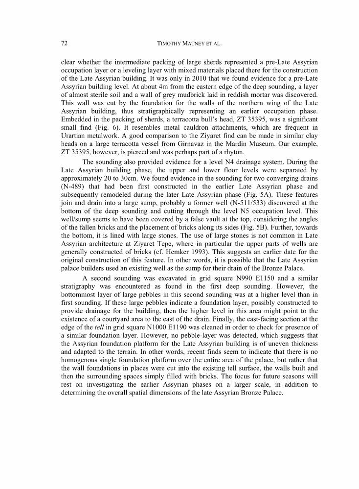
clear whether the intermediate packing of large sherds represented a pre-Late Assyrian occupation layer or a leveling layer with mixed materials placed there for the construction of the Late Assyrian building. It was only in 2010 that we found evidence for a pre-Late Assyrian building level. At about 4m from the eastern edge of the deep sounding, a layer of almost sterile soil and a wall of grey mudbrick laid in reddish mortar was discovered. This wall was cut by the foundation for the walls of the northern wing of the Late Assyrian building, thus stratigraphically representing an earlier occupation phase. Embedded in the packing of sherds, a terracotta bull’s head, ZT 35395, was a significant small find (Fig. 6). It resembles metal cauldron attachments, which are frequent in Urartian metalwork. A good comparison to the Ziyaret find can be made in similar clay heads on a large terracotta vessel from Girnavaz in the Mardin Museum. Our example, ZT 35395, however, is pierced and was perhaps part of a rhyton.
The sounding also provided evidence for a level N4 drainage system. During the Late Assyrian building phase, the upper and lower floor levels were separated by approximately 20 to 30cm. We found evidence in the sounding for two converging drains (N-489) that had been first constructed in the earlier Late Assyrian phase and subsequently remodeled during the later Late Assyrian phase (Fig. 5A). These features join and drain into a large sump, probably a former well (N-511/533) discovered at the bottom of the deep sounding and cutting through the level N5 occupation level. This well/sump seems to have been covered by a false vault at the top, considering the angles of the fallen bricks and the placement of bricks along its sides (Fig. 5B). Further, towards the bottom, it is lined with large stones. The use of large stones is not common in Late Assyrian architecture at Ziyaret Tepe, where in particular the upper parts of wells are generally constructed of bricks (cf. Hemker 1993). This suggests an earlier date for the original construction of this feature. In other words, it is possible that the Late Assyrian palace builders used an existing well as the sump for their drain of the Bronze Palace.
A second sounding was excavated in grid square N990 E1150 and a similar stratigraphy was encountered as found in the first deep sounding. However, the bottommost layer of large pebbles in this second sounding was at a higher level than in first sounding. If these large pebbles indicate a foundation layer, possibly constructed to provide drainage for the building, then the higher level in this area might point to the existence of a courtyard area to the east of the drain. Finally, the east-facing section at the edge of the tell in grid square N1000 E1190 was cleaned in order to check for presence of a similar foundation layer. However, no pebble-layer was detected, which suggests that the Assyrian foundation platform for the Late Assyrian building is of uneven thickness and adapted to the terrain. In other words, recent finds seem to indicate that there is no homogenous single foundation platform over the entire area of the palace, but rather that the wall foundations in places were cut into the existing tell surface, the walls built and then the surrounding spaces simply filled with bricks. The focus for future seasons will rest on investigating the earlier Assyrian phases on a larger scale, in addition to determining the overall spatial dimensions of the late Assyrian Bronze Palace.
ANATOLICA XXXVII, 2011 73
CUNEIFORM TABLET ZTT30 (J. MacGinnis)
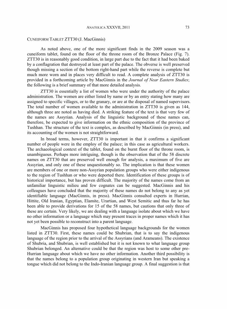
As noted above, one of the more significant finds in the 2009 season was a cuneiform tablet, found on the floor of the throne room of the Bronze Palace (Fig. 7). ZTT30 is in reasonably good condition, in large part due to the fact that it had been baked by a conflagration that destroyed at least part of the palace. The obverse is well preserved though missing a section of the bottom right-hand part while the reverse is complete but much more worn and in places very difficult to read. A complete analysis of ZTT30 is provided in a forthcoming article by MacGinnis in the Journal of Near Eastern Studies;the following is a brief summary of that more detailed analysis.
ZTT30 is essentially a list of women who were under the authority of the palace administration. The women are either listed by name or by an entry stating how many are assigned to specific villages, or to the granary, or are at the disposal of named supervisors. The total number of women available to the administration in ZTT30 is given as 144, although three are noted as having died. A striking feature of the text is that very few of the names are Assyrian. Analysis of the linguistic background of these names can, therefore, be expected to give information on the ethnic composition of the province of Tushhan. The structure of the text is complex, as described by MacGinnis (in press), and its accounting of the women is not straightforward.
In broad terms, however, ZTT30 is important in that it confirms a significant number of people were in the employ of the palace; in this case as agricultural workers. The archaeological context of the tablet, found on the burnt floor of the throne room, is unambiguous. Perhaps more intriguing, though is the observation that of the 58 discrete names on ZTT30 that are preserved well enough for analysis, a maximum of five are Assyrian, and only one of these unquestionably so. The implication is that these women are members of one or more non-Assyrian population groups who were either indigenous to the region of Tushhan or who were deported there. Identification of these groups is of historical importance, but has proven difficult. The majority of the names come from an unfamiliar linguistic milieu and few cognates can be suggested. MacGinnis and his colleagues have concluded that the majority of these names do not belong to any as yet identifiable language (MacGinnis, in press). MacGinnis consulted experts in Hurrian, Hittite, Old Iranian, Egyptian, Elamite, Urartian, and West Semitic and thus far he has been able to provide derivations for 15 of the 58 names, but cautions that only three of these are certain. Very likely, we are dealing with a language isolate about which we have no other information or a language which may present traces in proper names which it has not yet been possible to reconstruct into a parent language.
MacGinnis has proposed four hypothetical language backgrounds for the women listed in ZTT30. First, these names could be Shubrian, that is to say the indigenous language of the region prior to the arrival of the Assyrians (and Arameans). The existence of Shubria, and Shubrian, is well established but it is not known to what language group Shubrian belonged. An alternative could be that the region was host to some other pre-Hurrian language about which we have no other information. Another third possibility is that the names belong to a population group originating in western Iran but speaking a tongue which did not belong to the Indo-Iranian language group. A final suggestion is that
74 TIMOTHY MATNEY ET AL.
the language could belong to a new wave of population influx, such as the Mushki or Phrygians who were moving into eastern Anatolia around this time. It seems likely that whatever their linguistic affiliation, these women are either the descendants of the indigenous population of the Upper Tigris region, prisoners of war, or deportees.
ZOOARCHAEOLOGICAL REMAINS FROM THE BRONZE PALACE (T. Greenfield)
This section presents preliminary results of the analysis of the zooarchaeological remains recovered from specific rooms within the Bronze Palace. Traditionally, room function has been reconstructed on the basis of architectural and artefactual remains. Spatial analysis of the zooarchaeological remains provides an important opportunity to further investigate specific activities within a secure Late Assyrian palatial context. Based on the analysis of faunal samples from primary contexts within each room, it is possible in some cases to greatly improve upon our understanding of the activities that took place within the Bronze Palace. As expected, some rooms lack any evidence for animal food preparation, consumption, or disposal, while fine-grained zooarchaeological analysis clearly indicates the presence of such activities in other rooms. As described above (see also Matney et al. 2002: 53-58; Matney et al. 2003: 186-187; Matney et al. 2009: 41-49), the Bronze Palace is a monumental building designed in a style typical of Late Assyrian structures found in the heartland of Assyria. Intensive recovery of animal bones from Operation A/N was undertaken during the 2000-2002 and 2007-2010 seasons. While substantial Medieval remains were also recovered in this area (see Matney et al. 2009: 49-51 for a zooarchaeological analysis), this report focuses solely on the Late Assyrian deposits recovered from within the Bronze Palace.
Based on traditional methods of analysis, several rooms in the Palace were assigned functions by the excavator. For instance, Room 5 and its adjoining alcove (Room 1) were recognized as the courtyard of the Palace, Room 6 was defined as a hallway adjacent to the courtyard, and Room 7 (inclusive of sub-rooms 7a and 7b) was identified as the reception/throne room. Other rooms had more ambiguous associations and, consequently, functions were more difficult to assign. For example, no specific function could be assigned to Rooms 2, 3, and 4. The faunal remains found within each of these rooms are discussed below in detail with the objective of identifying activity areas within the palace complex.
General overview of the Late Assyrian fauna from Operation A/N
The Late Assyrian faunal sample size from Operation A/N is large (n=4486) but this number is significantly reduced (n=1173) when unidentifiable species are taken out of the analysis, and further reduced, (n=648) when a contextual analysis of rooms within the palace is carried out. This occurs for several reasons: (1) only specimens identifiable to a relatively specific taxon were used; (2) only specimens from clearly-defined contexts within a recognized room were used; and (3) only secure primary contexts were considered. While significantly reduced in size, the frequency of remains in the remaining sample still allows for a robust assessment of animal usage across the Bronze Palace.

ANATOLICA XXXVII, 2011 75
While many rooms have been uncovered, only the remains from Rooms 1-7 have been fully processed and are included in this preliminary report. Room 5 has the majority of remains (n = 491) followed in frequency by Rooms 1, 2, 3, and 4. Rooms 6 and 7 do not contain any faunal material, an important absence noted in the analysis.
Domestic species dominate the overall Late Assyrian assemblage, representing 97.5% of bones that were identifiable to a specific taxon (n=1173). The highest frequency of domestic species is from caprines (Ovis aries and Capra hircus with a combined total of 62% of the total assemblage), followed by Bos taurus at 24%, and Sus scrofa dom. at 14%). There is a very small frequency of Aves specimens (n=21), including both domestic (chicken/Gallus gallus) and wild bird specimens. Room 5 has the largest number of bird specimens (n=11), four of which were identified (3 domestic and 1 wild), followed by Room 1 (n=6) and Room 4 (n=4), all of which are identified as Aves sp..
Wild species are few in number (n=29), representing a small percentage of the overall animal bone assemblage identifiable by taxon (2.3%). Cervids dominate the wild assemblage, but represent only 1% of all remains identifiable to a specific taxon: Cervuselaphus (red deer; 0.7%) and Capreolus capreolus (roe deer; 0.3 %). While there is a wide range of wild species found within the Bronze Palace, they have a negligible presence on the overall assemblage (see Matney et al 2009: Fig. 9 for taxa/species charts). Fish are nearly absent from this period (<0.5%), which is somewhat surprising considering the site’s proximity to the Tigris River. All primary contexts were sieved, either fully or in a controlled sample. Therefore, recovery inefficiency cannot account for the extreme paucity of fish remains.
Evidence of butchering practices has been systematically studied for the zooarchaeological remains from the Bronze Palace. There are 39 specimens with butchered elements from Rooms 2, 3, 4, and 5 when we include our generic mammal size categories, i.e., specimens not identifiable to a specific species (see Fig. 8). General butchering activities include both skinning and disarticulation of animals. A total of 18 specimens are chopped, 20 are sliced, and only one specimen is both chopped and sliced. Chopped bones are usually an indication that the animal was disarticulated (chopped into smaller pieces for cooking, sharing etc), while slices often indicate skinning and de-fleshing of the animal. This does not mean to imply that some species are only butchered one way, but rather gives an indication of how the specific animals are being processed for consumption. In terms of identifiable species, there are a total of 25 specimens with evidence of butchering marks (see Fig. 9) with an uneven distribution of taxon by rooms, as discussed below.
Body section representation is defined as grouping specific portions of the animal’s body (i.e. thorax, distal limb, proximal, and cranial) to determine a selective preference for one part of the body over the other. An analysis of element representation for the Late Assyrian assemblage does not suggest any clear preference for specific choice cuts of meats among domesticates, particularly among Bos, Ovis, Capra, and Sus.This is surprising considering the palatial location of the remains where the selection of the choice cuts of meat would be expected to be of the highest quality. Wild species were not included in the analysis due to small sample size (n=2). There appears to be equal
76 TIMOTHY MATNEY ET AL.
representation of both cranial and proximal limb elements across all major domestic species. Caprines dominate distal limb representation, while the thorax is almost equally represented by Ovis/Capra, Sus scrofa dom. followed by Bos taurus. Of course, the presence of butchered elements found in those rooms does not necessarily mean that butchering activities took place in those rooms (except perhaps for Room 5, where the number of butchered specimens is very high). Rather, this shows that butchering probably took place either within the Bronze Palace or in its immediate vicinity because of the equal representation of all body parts. The paucity of butchering marks might imply careful use of meat and efficient use of butchering technology by specialized butchers.
Spatial analysis of zooarchaeological remains
This section provides a room-by-room discussion of the animal remains found within the Bronze Palace (Fig. 10). It is followed by an overall summary of suggested room function within the building.
Room 7. Room 7 appears to have been initially designed as a two room suite comprising a throne room for receptions (7a) and a smaller single room (7b), probably a bathroom for its paving in bitumen. (or the like) It was enlarged into a single room in its later use-phase. The primary architectural feature that helped to determine room function was the presence of tram lines for a moveable hearth. As detailed elsewhere, numerous associated elite artefacts were uncovered in the room. Surprisingly, faunal remains were not found in any secure context from this room. While a few stray specimens have been recovered from a secondary context (wall and ceiling collapse), they were not from a reliable use-related context and were, therefore, omitted from this analysis. One would expect that feasting occurred in this room, leaving evidence of food consumption. Conversely, if this room did have such activities occur, it would presumably have been kept very clean and all refuse disposed of elsewhere. (Oates and Oates 2001; J. Oates, pers. comm. 2010).
Room 6. The function of room 6 appears to be that of a hallway or passage from the eastern courtyard (Room 5) to an inner room towards the west (Room 9). Once again, faunal remains were not recovered from this room. Some specimens were found in the collapsed mudbrick of the walls, but were part of the wall construction and therefore not associated with activities within the room. The lack of faunal remains for this room is entirely plausible if the true function of this room is purely for a hallway or passage between the courtyard and the inner rooms.
Room 5. The courtyard, Room 5, is by far the largest room identified thus far excavated in the Bronze Palace, and consequently the largest sample of fauna from the palace came from this room (57% of all specimens). Domestic mammals (n= 463) make up 96% of the sample from the room. Bovids dominate the domestic category with a combined total of (n=359 or 82%) of the entire domestic sample. Within this category, Caprines present the highest frequencies (n=259; 62%), which include Capra hircus, Ovis aries, followed by Bos taurus (n=100; 20%). There is also a significant presence of equids (n=16) with Equus caballus dominating (n=11) and Equus asinus at a lower frequency (n=2). Canis familiaris is also present (n=6). A total of four Aves specimens were recovered from the courtyard: three specimens of Gallus gallus dom. (0.62%) and
ANATOLICA XXXVII, 2011 77
one Anas platyrhynchos (wild duck, possibly a Mallard; 0.21%). It is uncommon to find specimens of domestic chicken within this temporal and geographical context. These data tentatively suggest that the earliest evidence of domestic chicken in this area occurred during the Late Assyrian period. Reptiles (Testudines sp.; turtle) represent 0.41% of the entire assemblage (n=2). There is a higher frequency of wild taxa in this room in comparison to any other room in the palace (n=13, just under 3%). Cervids dominate (n=10), including Cervus elaphus (n=6) and Capreolus (n=4). Given the size of the courtyard (roughly 375m2 are preserved), the variety of species represented is impressive.
A total of 33 butchered specimens (n=17 chopped and n=16 sliced) were recovered from Courtyard 5. This number was slightly reduced to 25 when only specimens with definite species identification were used. Relative to the total number of the butchered bones (n=39) in the Bronze Palace, 85% were from this room. All medium-sized domestic mammals (Ovis aries, Capra hircus and Sus scrofa dom.) and large-sized domestic and wild mammals (Bos taurus, Equus asinus, Equus caballus, Cervus elaphus) have evidence of butchering; either chops, slices, or both (Fig. 8). It is possible to hypothesize that both skinning and disarticulation activities took place within the courtyard, due to the high numbers of butchered elements relative to other rooms in the palace. Furthermore, 75% of all bone tools found in the Bronze Palace was recovered in Courtyard 5.
During the 2000-2002 campaign, three cremation burials (A-242, A-252, and A-805) were uncovered within Courtyard 5, containing a mixture of large quantities of bronze artefacts, various elite items including ivories, human, and animal bones (Matney et al. 2003). In subsequent seasons, two additional cremation burials (N-070, N-212) were uncovered. Only the faunal material from the first set of burials (A-242, A-252, and A-805) is fully analyzed and presented here; further analysis of the fauna from the second set of burials (N-070 and N-212) is required before final publication. That said, it is important to note that only sixteen animal specimens from N-070, and two specimens from N-212 were recovered, which are relatively low frequencies compared to the numbers recovered from the first set of cremation burials.
A total of 295 faunal remains were recovered from the three “A” cremations, i.e., A-242, A-252, and A-805. All the fauna were calcined as a result of their close proximity to intense fire/heat. The specimens exhibit a range of colours ranging from a greenish white (close proximity to bronze objects), to reddish/brownish white, to pure white. Several of the specimens were warped from proximity to the flames/fire. Only domestic mammals were present in the cremation deposits. Taxonomically indeterminate medium-sized mammals have the highest frequency, followed by Ovis/Capra, indeterminate large mammals, Sus scrofa dom., Bos taurus, Ovis aries, Capra hircus, and Aves sp.(wild?) in descending order. Results from the individual cremations are discussed below:
A-242. Not surprisingly, this sample (n=199) is dominated by unidentified medium mammals (92%). Given the small fragment size and poor preservation, further identification is challenging. Of the identifiable specimens, bovids are clearly the most frequent: Ovis/Capra (3%) followed by, Bos taurus (2%). Aves sp., and Ovis aries each are represented by two specimens (1%). Capra hircus and Sus scrofa dom. each have one specimen. There is one specimen assigned to the general large mammal category. The two

78 TIMOTHY MATNEY ET AL.
specimens identified to belong to the Aves sp. are the only two present in any of the cremations. Further analysis will help determine its domestic or wild status as well as species. A252. The sample size for this cremation is relatively small (n=4). Two specimens are identified as Ovis/Capra, while Bos taurus and Sus scrofa dom. are each represented by a single specimen. A-805. The second highest frequency of remains (n=92) were from this cremation. Unidentified mammals, both medium (70%) and large sized mammals (10%), make up 80% of the assemblage from this cremation (n=73). Ovis/Capra has 6 specimens (7%), followed by Sus scrofa dom. with 5 specimens (5%). Ovis aries (n=4), Bos taurus (n=2), and Capra hircus (n=1) each have less than 1% representation.
Room 4. Architectural or artefactual evidence did not help to determine the function of this room. While the faunal sample is small (n=10), the pattern of data is unique here. For example, domesticates represent only 60% of the sample (Ovis/Capraand Sus scrofa dom.; each have 30%); this is a very low percentage compared to the other rooms. Conversely, Aves taxa are represented by an extraordinarily high frequency of remains. In this room, they represent the second highest group of remains (40%). This is a much larger than usual frequency of bird remains to be found within such a small room. Surprisingly, there are neither Bos taurus nor any equid remains in the room. This is in direct contrast to the data from every other room in the Palace where domesticates make up the majority of the sample, with bovids usually as the dominant taxa; none of these specimens is wild. It is possible that some of the Aves sp. elements are from wild species, however, more detailed analysis is necessary. There is no evidence of any butchering activities taking place in this room. However, Room 4 has the highest bone density per square meter of any room, as well as the highest level of bone fragmentation of any room in the Bronze Palace. The lack of butchering evidence for the bird specimens is perhaps understandable given their small size, but one wonders why the caprine and Sus elements also have no evidence of butchering when clearly they are butchered in the other rooms.
One possible theory to explain the high presence of birds and low presence of butchering is that the room had a special function (e.g., divinations) where butchering activities were not necessary. According to Collins (2002: 238), sheep are the favourite domestic animal and birds among the favourite wild animals for use by diviners. It is interesting to speculate that the extremely high level of fragmentation of remains found in this room may be a result of divination activities, rather than food preparation and consumption. Although it is mostly speculative to suggest that Room 4 might be a room for divination using birds, further investigation is certainly warranted.
Room 3. There are no distinguishing architectural features present in this room, although its location suggests a probable corridor. The sample size is moderately large (n=46). Caprines dominate the sample (n=24; 52%, inclusive of Ovis/Capra, Ovis aries,Capra hircus), followed by Bos taurus (n=15; 33 %) and Sus scrofa dom. (n=6; 13%). The one wild taxon that is present is Lepus sp. (2 %). Unidentified mammal categories (small, medium, and large) were more common in this room (n=37). There is evidence of butchering – slicing – on only one specimen of Sus scrofa dom.
Room 2. A total of 30 specimens were associated with this room, which has been tentatively assigned a function as a bathroom, given the presence of bitumen-lined baked

ANATOLICA XXXVII, 2011 79
bricks on the floor and the presence of a limestone slab used as a doorsill. Domestics make up 100% of this sample, dominated by Bovids: Ovis/Capra (n=16; 53%), Bos taurus (n=7; 23%), Ovis aries (n=3; 10%), followed by Capra hircus with only 1 specimen (3%). Both Sus scrofa dom. (n= 2) and Canis familiaris (n=1) have less than 10% frequencies. There was no evidence of equids, Aves, or wild specimens. Only two specimens show signs of butchering: one specimen of Bos Taurus was chopped and one of Ovis aries was sliced.
Room 1. Room 1 is an alcove located directly northeast of Courtyard 5 (see Fig. 4). With a total of 71 specimens (65 identified to a species), domestics make up 100% of the sample. The most commonly represented species are caprines (n= c. 62%), including Ovis/Capra (n=36), Ovis aries (n=5), Capra hircus, (n=4). This is followed by Bos taurus(n=13; 20%). Sus scrofa dom. and Aves sp. are equally represented (n=6; 9% each). Equus caballus (n=1; 2%) has the lowest frequency in the sample. Interestingly, wild specimens are not present in this room. This room has the second highest quantity of butchered bones found within the palace (8%), which is not surprising given the proximity (and openness) to the courtyard. Of the butchered elements, one element was chopped and sliced (the only found so far, within the palace), and two elements were sliced.
Room 10. This room, probably another open courtyard to the west of the throne room, has revealed a scatter of grayish and poorly preserved mudbricks which may represent some kind of paving. A large ashy pit (N-519) was discovered here containing at least four human individuals, as described above. Preliminary results from the animal bones recovered from Room 10 are as follows. The total sample recovered from this locus is 163 specimens. Medium mammal (n=100) and large mammal (n=20) have the highest frequency of remains (73%). Identification of remains to a specific species was difficult due to preservation issues; several of the remains were burnt black. Caprines dominate the domestic mammals; Ovis/Capra (n=18), Capra hircus (n=4), followed by Ovis aries (n=1) with a combined total of (n=24), followed by domestic Sus scrofa (n=8), while Bos taurushas a similar frequency to Capra hircus (n=4). Two other domestic species have only one element each (Equus asinus, and Equus caballus) and represent just over 1% of the entire sample. Wild mammals have a low frequency (n=3). Capreolus capreolus has two specimens and Capra ibex has only one specimen.
Zooarchaeological conclusions
Only recently has archaeological research shifted to the investigation of provincial capitals of the Assyrian Empire in order to elucidate spatial patterns of behaviour within
This report presents preliminary results of the faunal remains from specific rooms of the Bronze Palace in order to document specific room use within the overall layout of a provincial palace and to outline butchering practices within the palace which can eventually help determine provisioning activities, issues of hierarchy and status, with a specific focus on elite food practices. The butchering pattern for Room 5 indicates that the courtyard (and possibly associated Room 1) was a place for meat processing for two reasons. First, there was equal representation of body parts present. Second, evidence of
higher-order administrative centers (Joannès 2000; Matthews 2003; Weiss et al. 1993).
80 TIMOTHY MATNEY ET AL.
both chopping and slicing occurs in this space or its very near proximity; it appears to be a place for food preparation. Rooms 2, 3, and 4 do not have any direct function assigned to them, but the data are very different from each other and from the rest of the rooms. Room 4 may have been associated with ritual divination practices. This suggests that rooms within the Bronze Palace served very specialized functions, and as a result present unique distributions of zooarchaeological remains.
ARCHAEOBOTANICAL REMAINS IN THE BRONZE PALACE (M. Rosenzweig)
Although flotation samples have been systematically collected at Ziyaret Tepe since 2000, full archaeobotanical analysis of these sediment samples has only recently begun. A collection of over 1700 archaeobotanical samples have been retrieved from a variety of contexts, including domestic floors, hearths, pits, burials, and the contents of vessels. This collection spans the occupational lifetime of the site, from the Early Bronze Age to the Ottoman Period (ca. 3000 BC-AD 1800). Analysis of this rich collection will allow for investigations into changes in local agriculture over time and space, providing a much-needed record of environmental land-use in the region.
This preliminary report concentrates upon the findings from one sample, ZT 29732. This sample is derived from a Medieval pit (N-255) in Operation A/N and is dated to occupational phase N2 (see above). While the findings from one sample will hardly provide definitive information for the entire Medieval occupation at Ziyaret Tepe, given the richness of botanical remains from N-255, the following preliminary report offers some insights into the scope of medieval agriculture at the site, to be improved upon by future analysis.
Sampling protocols and analytical methods
Sediment sampling protocols were established by Matney and Lynn Rainville of Sweetbriar College at the onset of excavation at Ziyaret Tepe. In most cases, entire loci, or a representative sample of 50% or 25% of the whole were taken, with a minimum of 10 liters of primary suprafloor (ca. 5cm strata above the floor) and floor contexts sampled for flotation. When distinct deposits of charred remains were discovered, they were hand-picked, creating samples for qualitative analysis. In the field, Suphi Kaya, a local Turkish laborer, was trained to process all of the flotation samples using a Siraf-style flotation machine (Pearsall 2000: 44), employing 1mm and 355 m mesh sieves to catch the carbonized plant remains. Kaya has steadfastly handled the entirety of the flotation samples, with the exception of those collected in the 2009 field season, which were processed by Rosenzweig and Jennifer Walborn of Western Florida University.
The Ziyaret Tepe archaeobotanical collection now resides in the Paleoecology Laboratory at the University of Chicago. However, this particular sample was analyzed at the Archaeobotany Laboratory at Ohio State University (OSU). Here, sorting was conducted using a Leitz stereoscopic zoom microscope with a maximum magnification of 100x. Samples were size graded in 2mm, 1mm, and 500μm sieves. Material less than
ANATOLICA XXXVII, 2011 81
500μm was not analyzed. Within each size grade, the sample was divided into fractions using a riffle-sorter, in each case down to a fraction that would allow for complete sorting in one sitting. Fractions were then sorted until no new taxa were discovered. This method was designed to ensure consistent randomness of sampling within the sample itself, and to provide the most efficient means of documenting the diversity of taxa present (van der Veen and Fieller 1982). Any taxa missed through the riffle-sort method would presumably be too rare to be of environmental or economic importance for overall interpretations. Identifications of the N-255 material were made using the OSU Archaeobotany comparative collection and a number of seed reference manuals, including Martin and Barkley (1961), Musil (1963), and Nesbitt (2006).
The charred archaeobotanical remains from N-255 were highly degraded. Intact and well-preserved specimens were rare. The remains in this pit appear to have sustained intense firing, as attested by the presence of significant amounts of vitrified material. Of the 1268 (non-wood) botanical items extracted, only 690 were identifiable (54%), in many instances only to genus level.
ZT 29732 (N-255) archaeobotanical remains
N-255 is a shallow pit approximately 40cm deep and 1.9m in diameter. It is located in grid square N990 E1170 and is one of over thirty Medieval pits that have been found in Level N2. Although N-255 has no associated architectural features, it is within the vicinity of Medieval House 1, which lay to the south, see above. Excavators removed 10 liters of soil from a gray ash lens found at the bottom of the pit as sample ZT 29732. Judging from its location and contents, pit N-255 appears to have been used for refuse disposal. Numerous fragments of iron studs, a very common small find at Ziyaret Tepe, were recovered from the pit, along with shards of glass, an iron blade, pieces of pottery, and animal bone. Likewise, a range of archaeobotanical remains were found in N-255, most likely representing the accumulation of domestic debris swept into the pit during its use-life. As a deposit of household rubbish generated by a variety of domestic processes, the botanical remains from N-255 offer a preliminary record of diverse agricultural resources and practices during the Medieval period at Ziyaret Tepe.
To begin with, 243 cereal grains were recovered from N-255. Due to poor preservation, only 91 of these were identifiable, as Triticum sp., Triticum durum/aestivum,and Hordeum sp. (see Fig. 11). Wheat (Triticum sp.) was most common, and although many grains could not be identified to species, from the presence of eleven T.durum/aestivum grains, 32 free-threshing rachis, and only two wheat glume remains, it may be inferred that free-threshing wheat was the predominate crop processed. Within this sample as well, the data suggests that T. durum was the cereal of choice, given the accumulation of T. durum rachis and an absence of similarly distinguishable T. aestivumrachis. T. durum has a low salt tolerance, but performs well in regions with mild, wet winters and warm, dry summers (van Zeist 2003: 10) and would have provided the Medieval villagers of Ziyaret Tepe with grain suitable for bulgur (Charles 1984: 26). While T. durum, and free-threshing cereals in general, are often irrigated, pit N-255 did not contain any segetal or hydrophilic (water-loving) taxa, with the exception of a few
82 TIMOTHY MATNEY ET AL.
reeds, that would be indicative of irrigation. Based upon one sample, though, this lack of archaeobotanical evidence for irrigation should not be weighed too heavily.
Other cultigens recovered from N-255 include various legumes and Hordeum sp. (barley). Of the legumes, Lathyrus sativus (grass pea) was preserved in the greatest abundance, followed by Cicer arientium (chickpea) and one Pisum type specimen (field pea). There is a conspicuous absence of Lens culinaris (lentil), which has been historically reported as an important legume in this region (Miller 1991; Yakar 2000: 447). Barley may have been used to supplement the wheat supply for human consumption, provide fodder for animals, or both.
The N-255 remains do not represent a deposit of “clean” grain or food storage. Rather, they probably provide a record of botanical material generated by crop processing. The cereal culm accumulated in N-255 could have been captured when the crop was harvested low on the stalk, and dispersed as domestic debris when sieved (Hillman 1985: 2). Yakar (2000: 178-179) has observed rural farming families in Turkey sieving wheat on their rooftops, making the by-products of wheat processing a regular component of domestic refuse. Sieving and hand-sorting may also account for the presence of cereal rachis and agricultural weeds in pit N-255, which includes species of Aegilops, Lolium,Galium and Brassica (Martin and Barkley 1961). The cereal grains recovered are, in general, rather small and could be “tail grains” lost in the sieving process, or simply the refuse from accidental charring. The Triticum sp. grains average 4.49mm in length, the Triticum durum/aestivum 4.72mm, and the Hordeum sp. 5.85mm.
Weed seeds and chaff can also enter the archeobotanical record through the burning of dung fuel cakes. However, there was a significant lack of dung in pit N-255, while wood charcoal made up 49% of the overall weight (57.7g) of the flotation sample. From the identifiable seeds, the non-cultigen to cultigen ratio is 2:1. The number of non-cultigens calculated includes all the “indeterminate seeds,” while the cultigens include all the “large, indeterminate legumes” and “nutshell” (see Fig. 11). This ratio is much higher than those obtained by experimentation with dung fuel burning (Miller and Smart 1984). Therefore, it is proposed here that the remains of N-255 come primarily from the wood firing of botanical products for human use. However, given that N-255 is a refuse context, the deposit is surely the accumulation of botanical material from a variety of practices and sources, including dung cake fires (McCorriston 1995). Indeed, there are several taxa in the N-255 sample found in the steppe and associated with grazing. These include Astragalus sp., Trigonella astroites, Onosma sp., Centaurea sp., Rumex sp., and Verbascum sp. (Miller and Smart 1984: 17; Zohary 1973: 181). The cereal culm mentioned above, as a by-product of crop processing, could have also entered the archaeobotanical record if straw was used as an additional fuel for fires.
Archaeobotanical conclusions
The findings from pit N-255 provide the basis for several hypotheses regarding Medieval agriculture at Ziyaret Tepe. The main crops of this small village appear to have been durum wheat and barley, with the addition of chickpea, grass pea, and field pea. While dung fuel was most likely used, wood fuel was also available and used on-site. Weeds
ANATOLICA XXXVII, 2011 83
associated with cultivated fields are present, but no botanical evidence for irrigation was recovered. Steppic taxa are also present in the N-255 sample, presumably by way of animal consumption and therefore indicative of pastoral practices during this period.
EXCAVATIONS IN OPERATION G/R (J. MacGinnis)
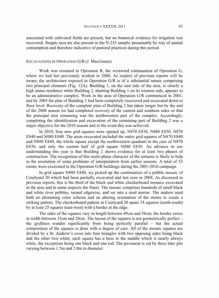
Work was resumed in Operation R, the westward continuation of Operation G, where we had last previously worked in 2008. As readers of previous reports will be aware, the architecture exposed in Operation G/R is of a substantial nature comprising two principal elements (Fig. 12A). Building 1, on the east side of the area, is clearly a high status residence while Building 2, abutting Building 1 on its western side, appears to be an administrative complex. Work in the area of Operation G/R commenced in 2001, and by 2003 the plan of Building 1 had been completely recovered and excavated down to floor level. Recovery of the complete plan of Building 2 has taken longer but by the end of the 2008 season we had completed recovery of the eastern and southern sides so that the principal area remaining was the northwestern part of the complex. Accordingly, completing the identification and excavation of the remaining part of Building 2 was a major objective for the 2010 season and in the event this was achieved.
In 2010, four new grid squares were opened up, N870 E830, N880 E830, N870 E840 and N880 E840. The areas excavated included the entire grid squares of N870 E840 and N880 E840, the whole square except the northwestern quadrant in the case of N870 E830, and only the eastern half of grid square N880 E830. An advance in our understanding this year is that Building 2 shows evidence for at least two phases of construction. The recognition of this multi-phase character of the remains is likely to help in the resolution of some problems of interpretation from earlier seasons. A total of 53 rooms were excavated in the Operation G/R buildings during the 2001-2010 campaign.
In grid square N880 E840, we picked up the continuation of a pebble mosaic of Courtyard 20 which had been partially excavated and last seen in 2004. As discussed in previous reports, this is the third of the black and white checkerboard mosaics excavated in the area and in some respects the finest. The mosaic comprises hundreds of small black and white river pebbles, turned edgewise, and set into a mud mortar. The makers used both an alternating color scheme and an altering orientation of the stones to create a striking pattern. The checkerboard pattern in Courtyard 20 spans 14 squares (north-south) by at least 25 squares (east-west) with a border at the edge.
The sides of the squares vary in length between 49cm and 58cm; the border varies in width between 15cm and 20cm. The layout of the squares is not geometrically perfect – the gridlines wander significantly from being perfectly parallel – but the actual composition of the squares is done with a degree of care. All of the mosaic squares are divided by a St. Andrew’s cross into four triangles with two opposing sides being black and the other two white; each square has a boss in the middle which is nearly always white, the exceptions being one black and one red. The pavement is cut by three later pits varying between 1.5m and 2.0m in diameter.
84 TIMOTHY MATNEY ET AL.
Near the southwestern corner of the pavement is a drain, R-301, marked by a 30cm square baked brick pierced by a hole 10 cm in diameter. This drain clearly connected with a main channel running under the wall bounding the western side of the courtyard: this was evident from the fact that leading out west from the drain brick was a patch measuring approximately 130cm by 60cm where the pavement had been dug up and the stones then put back in a jumble rather than with any attempt to reproduce the original design. This patch led directly towards the main drain R-301 and betrayed where the pavement had been dug up to clear or repair the drain. Furthermore, immediately to the west of this patch, was an open V-shaped configuration of bricks (38 x 38 cm) which must represent an even later repair of the drain: the fact that it was apparently left open at the top rather than roofed and underground represents a departure from the original standard of installation. The elevation of the pavement as a whole varies dramatically, from 550.43m at its highest point on the north to 550.10m at the lowest in the south.
Just east of the drain is a rectangular area, R-298, measuring 95cm by 240cm and composed of much larger stones measuring between 10cm by 15cm up to 40cm by 56cm. R-298 was either cut into the pavement or built as part of the original design. Unlike such features in earlier seasons (e.g., G-627 in the pavement of Courtyard 2 and features G-341, G-342, and G-343 in the pavement of Courtyard 11), in the case of R-298 in Courtyard 20, the feature carefully slots into the existing grid pattern (occupying what would have been an area 2 by 5 of the checkerboard squares). Both this fact and the fact that R-298 is significantly larger than the features in Courtyards 2 and 11 suggest that it may not have been a grave as is posited for those other features, but may rather have served some functional purpose in the use of the courtyard; there are no grounds for further speculation. On the west of the courtyard was a bathroom, Room 53, measuring 5.0m by 4.3m paved with baked bricks and demonstrating plentiful traces of bitumen. Lastly, on the north side of the pavement, near the eastern baulk, we picked up the remaining part of a baked brick threshold initially discovered in the 2003 season, completing our plan of that feature.
Upper phase of Building 2
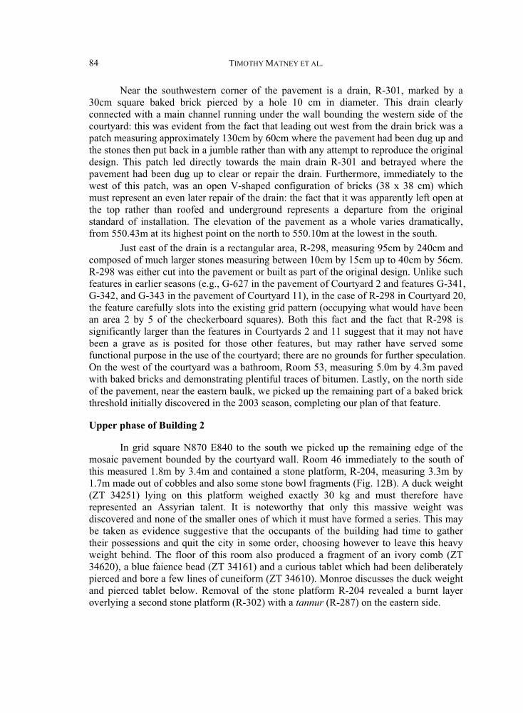
In grid square N870 E840 to the south we picked up the remaining edge of the mosaic pavement bounded by the courtyard wall. Room 46 immediately to the south of this measured 1.8m by 3.4m and contained a stone platform, R-204, measuring 3.3m by 1.7m made out of cobbles and also some stone bowl fragments (Fig. 12B). A duck weight (ZT 34251) lying on this platform weighed exactly 30 kg and must therefore have represented an Assyrian talent. It is noteworthy that only this massive weight was discovered and none of the smaller ones of which it must have formed a series. This may
their possessions and quit the city in some order, choosing however to leave this heavy weight behind. The floor of this room also produced a fragment of an ivory comb (ZT 34620), a blue faience bead (ZT 34161) and a curious tablet which had been deliberately pierced and bore a few lines of cuneiform (ZT 34610). Monroe discusses the duck weight and pierced tablet below. Removal of the stone platform R-204 revealed a burnt layer overlying a second stone platform (R-302) with a tannur (R-287) on the eastern side.
be taken as evidence suggestive that the occupants of the building had time to gather
ANATOLICA XXXVII, 2011 85
South of Room 46, two additional rooms were found, Rooms 47 and 48. Although no threshold connecting these rooms was immediately detectable, closer inspection revealed a section where the red brickwork was interrupted by an area of grey bricks two bricks wide: we take this to be an indication of an original threshold which had been blocked, presumably in preparation for the later phase.
Finds in the fill in these trenches included a seal with a star motif (ZT 34184), an amulet with a star motif (ZT 34189), a sherd of glazed pottery (ZT 34289), and a number of tokens (ZT 34323, ZT 34377, ZT 34566, ZT 34580, ZT 34602), see below.
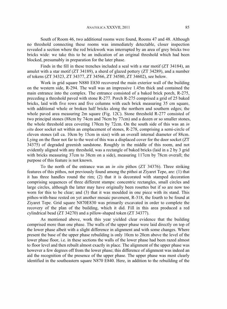
on the western side, R-294. The wall was an impressive 1.45m thick and contained the main entrance into the complex. The entrance consisted of a baked brick porch, R-275, preceding a threshold paved with stone R-277. Porch R-275 comprised a grid of 25 baked bricks, laid with five rows and five columns with each brick measuring 35 cm square, with additional whole or broken half bricks along the northern and southern edges; the whole paved area measuring 2m square (Fig. 12C). Stone threshold R-277 consisted of two principal stones (88cm by 74cm and 76cm by 77cm) and a dozen or so smaller stones, the whole threshold area covering 170cm by 72cm. On the south side of this was an insitu door socket set within an emplacement of stones, R-278, comprising a semi-circle of eleven stones (all ca. 10cm by 15cm in size) with an overall internal diameter of 88cm. Lying on the floor not far to the west of this was a displaced cover for the door socket (ZT 34375) of degraded greenish sandstone. Roughly in the middle of this room, and not evidently aligned with any threshold, was a rectangle of baked bricks (laid in a 2 by 3 grid with bricks measuring 37cm to 38cm on a side), measuring 117cm by 78cm overall; the purpose of this feature is not known.
To the north of the entrance was an in situ pithos (ZT 34376). Three striking features of this pithos, not previously found among the pithoi at Ziyaret Tepe, are: (1) that it has three handles round the rim; (2) that it is decorated with stamped decoration comprising sequences of three different stamps: concentric rectangles, small circles and large circles, although the latter may have originally been rosettes but if so are now too worn for this to be clear; and (3) that it was moulded in one piece with its stand. This pithos-with-base rested on yet another mosaic pavement, R-318, the fourth to be found at Ziyaret Tepe. Grid square N870E830 was primarily excavated in order to complete the recovery of the plan of the building, which it did. Fill in this area produced a red cylindrical bead (ZT 34270) and a pillow-shaped token (ZT 34377).
As mentioned above, work this year yielded clear evidence that the building comprised more than one phase. The walls of the upper phase were laid directly on top of the lower phase albeit with a slight difference in alignment and with some changes. Where present the base of the upper phase rebuilding is only 10cm to 20cm above the level of the lower phase floor, i.e. in these sections the walls of the lower phase had been razed almost to floor level and then rebuilt almost exactly in place. The alignment of the upper phase was however a few degrees off from the lower phase; this difference of alignment was indeed an aid the recognition of the presence of the upper phase. The upper phase was most clearly identified in the southeastern square N870 E840. Here, in addition to the rebuilding of the
Work in grid square N880 E830 recovered the main exterior wall of the building
86 TIMOTHY MATNEY ET AL.
original lower phase walls there were places where earlier entrances had been blocked and places where new walls had been inserted across earlier undivided spaces.
The upper phase was also detected in grid square N880 E840. In the northwestern part of N880 E840, an area dense with potsherds, stones, pieces of slag, and bones – perhaps a dump – was removed to come down onto a floor level (R-223) on which rested an almost complete jar (ZT 34384) and white limestone door socket (ZT 34383). Wall lines were also traced above the mosaic pavement but the associated floor levels could not be properly delineated; a tannur (R-193) in the area above the pavement must also have belonged to this phase.
Interpretation of Building 2
Based on the texts found in Rooms 9 and 10, the presence of hundreds of tokens and numerous pithoi, it has long been thought that the Operation R building was an administrative/storeroom complex. The evidence of the texts suggests that there was an association with the goddess Ishtar (Parpola 2008: 21-25). Accordingly, the current interpretation is that the Operation R complex was a storeroom complex associated with the temple of Ishtar: this interpretation is only strengthened by the discovery of loom weights as there was a close association between weavers and the temple establishments of Ishtar. The discovery of the one-talent duck-weight, which will have been used for weighing textiles, metals, and bitumen, is also consistent with the proposed administrative function. The likelihood would appear to be that Ishtar was the principal deity of the city, though it is noteworthy that the temple itself has not yet been discovered.
SELECTED SMALL FINDS FROM OPERATION G/R (W. Monroe)
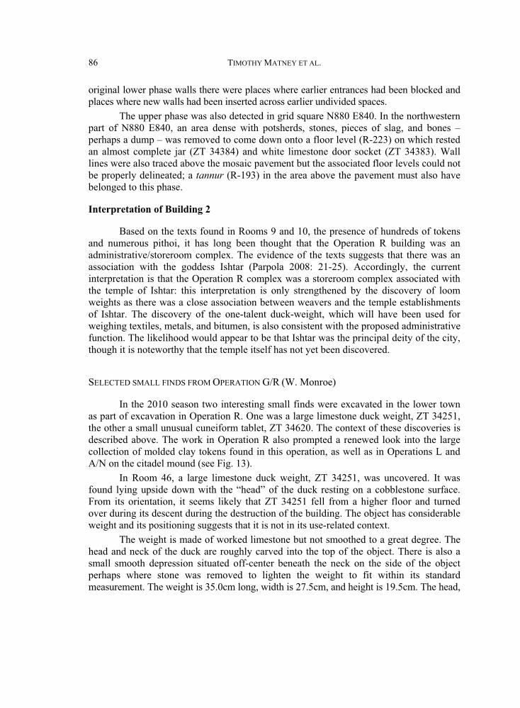
In the 2010 season two interesting small finds were excavated in the lower town as part of excavation in Operation R. One was a large limestone duck weight, ZT 34251, the other a small unusual cuneiform tablet, ZT 34620. The context of these discoveries is described above. The work in Operation R also prompted a renewed look into the large collection of molded clay tokens found in this operation, as well as in Operations L and A/N on the citadel mound (see Fig. 13).
In Room 46, a large limestone duck weight, ZT 34251, was uncovered. It was found lying upside down with the “head” of the duck resting on a cobblestone surface. From its orientation, it seems likely that ZT 34251 fell from a higher floor and turned over during its descent during the destruction of the building. The object has considerable weight and its positioning suggests that it is not in its use-related context.
The weight is made of worked limestone but not smoothed to a great degree. The head and neck of the duck are roughly carved into the top of the object. There is also a small smooth depression situated off-center beneath the neck on the side of the object perhaps where stone was removed to lighten the weight to fit within its standard measurement. The weight is 35.0cm long, width is 27.5cm, and height is 19.5cm. The head,
ANATOLICA XXXVII, 2011 87
including the neck, is approximately 18cm long and 9cm wide. It weighs approximately 30kg which places it firmly in the category of a one talent weight (= 60 minas).
Duck weights are fairly common in all categories of ancient Near Eastern weights, occupying sizes from the multi-talent down to the half mina. However, the duck and lion shapes are, for the most part, the typical forms given to weights in excess of a half talent (Powel 1971: 249-273). Often duck weights are inscribed with short lines of text indicating their weight and, in some cases, a royal inscription or owner. Duck weight ZT 34251 was uninscribed.
A second small find of particular interest from Operation R was a small inscribed clay tablet, ZT 34620, of an unusual shape and character found in Room 24. It was found among the ash from a broken tannur near a possible entrance to the white and black pebble mosaic Courtyard 20 to the north. This locus was rich in small finds and also included a fragment of an incised and decorated bone comb. The tablet itself is 5.8cm long, 3.4cm wide, 1.7cm thick and weighs 37g. It is inscribed with one single line of cuneiform in Neo-Assyrian ductus which reads:
mPAB-AŠ 1-lim “Ah˘h˘u-iddina, one thousand”
The inscription is relatively simple and clear. The tails of the horizontal wedges are extended significantly to take up space on the obverse of the tablet. The reverse is uninscribed and undecorated.
This noted, it is the physicality of the tablet which is most intriguing. The tablet is inscribed perpendicular to the orientation to be expected, i.e., landscape rather than portrait style. The inscription is roughly centered and is not positioned so as to accommodate any other lines of text. Directly beneath the line of text is a large hole the runs directly through the tablet, the hole is roughly ovoid in nature with dimensions of 1.9cm by 1.6cm. The interior wall of the hole is slightly concave, in that the entrance and exits on the tablet surface are of a smaller diameter than the interior. The interior surface of the hole is also quite rough, in contrast with the smooth exterior surface of the tablet, although no particular marks, textile or otherwise, can be discerned from the interior.
On the obverse of the tablet, the hole is surrounded by an incised decoration. The hole is bordered by a incised line a short distance from the hole and in between are incised lines running from the border to the edge of the hole (26 lines are preserved). This motif is interrupted by a break in the tablet along the bottom edge extending into the hole. However, in the break a large piece of a quartz pebble is visible, indicating that the material from which this tablet was made of was not typical well-levigated clean tablet clay. The tablet is also covered with tiny hair-line cracks indicating accidental firing most likely during the destruction of the building.
Interpretation of the tablet is hampered by its unique nature. The inscription seems to indicate some sort of ownership or tagging, however, the item type being signified by “one thousand” is not preserved. The significance of the hole perhaps indicates that the tablet itself was formed around an object or around a textile, such as a bag, containing objects which were lost during the fire which baked the tablet. The decoration around the hole, as well as the inscription, and its absence on the reverse certainly suggests a
88 TIMOTHY MATNEY ET AL.
particular orientation and location of the objects being signified as essentially “behind” the tablet. Perhaps this tablet formed the seal on the end of a rope or bag that contained 1000 objects or items with an equivalent to a value of 1000.
Finally, throughout the excavation of both the citadel mound and lower town at Ziyaret Tepe, significant numbers of small clay tokens have been found in mostly Late Assyrian contexts. These tokens fit roughly into a typology of eight types, all generally smaller than 30mm. They were probably used for counting, not as game pieces, as the Ziyaret Tepe tokens bear no distinguishing marks that would be expected if used for gaming or as dice. Any information on their symbolic meaning within a counting system is entirely unclear.
The eight types established at Ziyaret Tepe are as follows (see Fig. 13). Pillowtokens are flat tokens generally around 4mm thick. They are usually squarish, often with their corners formed into points giving them a pillow-like shape. Their sides are between 13mm and 15mm long. Bent-tip tokens are conical in shape but the tip of the token has been folded at a 90-degree angle forming a bent tip. They are generally 8mm to 12mm long with a base diameter of 16mm to 22mm. Spherical tokens are spherical in shape with a diameter ranging from 7mm to 10mm. Cylindrical tokens have straight sides and are cylindrical in shape; they have a length of 12mm to 15mm and a diameter of 8mm to 10mm. Cuboid tokens are in the form of a hexahedron, like a six-sided die, they measure 10mm to 13mm on a side. Disk tokens are flattened round disks with a diameter of 8mm to 13mm with a thickness between 3mm and 4mm. Conical tokens are straight versions of bent-tip tokens. They have a length of 15mm to 20mm and a base diameter of 8mm to 10mm. Pyramid tokens are shaped like a three-sided pyramid; they have four faces of equal size, three sides and one base. They measure 9mm to 13mm on a side. There are certain transformative processes that can modify tokens of one type into another. Spherical tokens often can become squashed between the fingers and turn into disk tokens. In fact many disk tokens have been found with finger prints still preserved on the obverse and reverse betraying the act of creating the token itself. Likewise conical tokens can easily become bent-tip tokens.
In most of our reports, we refer to the excavations in the southern lower town as Operation G/R, since the two operations are contiguous. However, as noted above, Operation G is the eastern side of the excavation area, while Operation R is the western side. This rough spatial distinction appears important with regards to the tokens. In particular, Operation R has produced by far the largest quantity of tokens excavated, while Operation G has the second largest count of excavated tokens at Ziyaret Tepe. What is interesting to note is that although 105 pyramid tokens were found in Operation R, none were found in any of the nearby loci in Operation G. This suggests that the tokens represent a specific item or good, rather than a quantity or number. Whatever the item is that is represented by the pyramid tokens, it appears to have been limited in distribution to the western building of Operation G/R. Generally bent-tip, spherical, cylindrical, and conical tokens have the broadest range across the entire site. The distribution of tokens illustrates the importance of accounting or administrative activities which took place in the buildings of Operation G/R as this area accounts for 86% of the tokens excavated across the site.
ANATOLICA XXXVII, 2011 89
EXCAVATIONS IN OPERATION Q: “KHABUR GATE” (K. Sauer and J. MacGinnis)
Operation Q, the site of a major gate on the southern city wall, had initially been located by both magnetic gradiometry and electrical resistivity surveys, the images of which showed a chambered gate with projections and a street running north-south leading up to the gate (Matney & Somers 1999: 210-211; Matney & Rainville 2005: 40-42). Earlier excavations had confirmed the geophysical maps in broad terms (Matney et al. 2009: 61-63; Fig. 22). The objective of the 2010 excavations in Operation Q was to gain insights into the occupational and architectural history of the gate complex during its centuries-long use-life.
The earlier excavations conducted in Operation Q in 2007 and 2008 revealed the outlines of city gate’s construction and of the street leading in between the two projecting buttresses flanking the gate (Fig. 14). Furthermore, by the end of the 2008 season at least three major phases of construction and occupation could be identified within the gate complex, which appeared to correspond well with the sequence that emerged from a section cut through the street between the buttresses (Matney et al. 2009: 61). The most intact deposit of in situ material, including features such as a narrow partitioning wall, Q-107 and hearth, Q-154, was identified in the eastern chamber (Matney et al. 2009: 61). In the western chamber, three post-Assyrian graves were revealed, each neatly dug along the inner walls of the chamber and containing a single burial (Matney et al. 2009: 63-64).
In 2010, excavation in Operation Q was resumed, through which a significantly more detailed picture of the occupational and architectural history of the gate has been reconstructed. The interior areas of the gate’s chambers were excavated down to foundation level, demonstrating that there were in fact four, rather than three, main phases of construction, each marked by a considerable raising of the main street level. Furthermore, excavation of the stratigraphic section cut perpendicular across the street was also resumed and taken down to natural. Here, too, four major phases of construction could be observed, correlating with the sequence in the interior of the gate, and thus demonstrating that the gate was in use for a long period of time and periodically refurbished.
Foundation Level and Phase I Gate
The foundation of the chamber construction could be traced in sections across the eastern and the western ends of the chambers. It consisted of a solid mud packing averaging 40cm thick. On top of this, a layer of pebbles was laid, followed by a second, thinner layer of mud, and then a foundation sub-floor packing 20cm thick consisting of pebbles mixed with sand and mud. In the northeastern corner of the eastern chamber a drain cutting the solid mud foundation was observed. It was covered with large stones and lined with sherds as well as pebbles in its upper part, whereas the lower part was lined with mud only. The initial layout of the street, at least in the gate itself, consisted of a surface built of large stones (roughly 10cm to 30cm in diameter), which was then covered with four alternating layers of pebble-sand packing and thin grayish, trampled mud layers. The width of the initial street was 5m. Judging from the outer section, this surface of large stones with packing on top continues on into the road in between the buttresses.
90 TIMOTHY MATNEY ET AL.
The layout of the chamber in the foundation level, with an average length of nearly 12m in its E-W extension, was slightly trapezoidal, being 2.75m broad at the center but only 2.2m broad at the eastern and western ends. Furthermore, the western chamber, measuring 3.2m in breadth, was nearly one meter shorter than the eastern one. At least two floor surfaces could be associated with the Phase I gate chamber, the first one being a pebble floor, the second a plastered surface: the latter had been burnt in the eastern chamber and in parts in the western chamber too, where two iron arrowheads (ZT 27638 and ZT 27640) were found.
Phase II Gate
Major changes occurred in the second phase of construction. First of all, the layout of the gate was now made properly rectangular, measuring 8.00m by 2.75m which means that while the trapezoidal aspect of Phase I had been corrected, the overall depth of the chambers was notably reduced. Furthermore, the position of the gate shifted 0.30m north, with the Phase II southern wall covering the Phase I southern wall. The most significant change however occurred in the general layout of the street and the gate chamber, with the passage between the buttresses being narrowed by the addition of a 1.40m broad wall which was cut through the pebble floor of the Phase I street, reaching the gate’s foundation level. The effect of this was to bring the dimensions of the two chambers into line with equal lengths and breadths. There was one floor surface associated with Phase 2, consisting of a bright mud plaster in both chambers.
Phase III Gate
In Phase III, the gate again underwent major changes, especially concerning the layout of the chambers. It was broadened in its E-W extension, now measuring 9.0m across. At the same time the gate was enlarged in its N-S extension, and now measured 4.0m across. The whole area was raised 0.5m on average by a mudbrick platform consisting of three courses of sun-dried mudbricks covered with a mud surface in which pebbles were then set. In the passage, two large slabs cut from white-grey limestone with conglomerate on the lower surfaces were installed as a threshold. On the northern edges of the limestone slabs, there are clear signs of wear from wheeled traffic with an axial span of 2.0m; there is however, no sign of track marks on the main surface of the stones. On their southern sides, these two slabs are bordered by a row of smaller stones behind which the pebble packing of the street continues.
The western chamber of this phase had already been excavated in the 2008 season, exposing the most intact depositions of in situ material encountered up to that date (Matney et al. 2009: 61-62; Fig. 22). The following remarks, thus, only apply to the material excavated in the eastern chamber in 2010. In this eastern gate chamber, a total of six distinct plastered floor surfaces were recognized. These overlay the mudbrick platform and all show traces of decayed reed matting. The mudbrick platform itself also showed evidence of use in the form of three fireplaces in the northern half, together with a considerable quantity of scattered animal bones.
ANATOLICA XXXVII, 2011 91
The first floor surface was traced by its plaster only, but there were no features and finds associated. The southern third of the chamber was covered with a pebble floor, a scheme that was traced in the upper surfaces as well. The second floor surface was also covered with plaster in the north and pebbles in the south. In the southwestern corner two baked bricks were set to form a simple threshold into the chamber. The chamber’s western edge was blocked by a low wall or bench that could be traced until the uppermost floor surface. The third floor surface was associated with a fireplace in the northwestern corner and a bench had been built up against the chamber’s northern wall. In its southwestern corner, near the entrance to the chamber, were found two in situ vessels: one was a palace ware beaker, ZT 27489, the other was a Mittani-style “pig pot” rhyton, ZT 27490 (cf. Postgate et al. 1998: 75, pl. 99). The fourth floor surface was associated with numerous features, including a hearth laid out with two baked bricks in the northwestern corner. In the middle of the chamber was a pot installation lined with stones and brick fragments cut into the underlying floor surfaces. Slightly west of this pot installation, the heavy burning of the floor plaster indicated that the area had evidently been used as a fireplace. The fifth surface was characterised by the construction of an L-shaped partitioning wall set over the location of the former pot installation. On the pebble floor, a circular stone missile, ZT 27443, was found. Furthermore the baked brick hearth associated with the previous floor was still in use (Fig. 15). The sixth and final surface was still associated with the benches, the brick-hearth and the partitioning wall, but with the difference that at this level the southern part of the chamber was now also covered by a plastered surface, on top of which the sherds of a large storage jar, ZT 27388, and a pot stand, ZT 27371, were found.
Phase IV Gate
Whereas there is much evidence for the use of the gate chamber in Phase III, no floor surface could be associated with Phase IV. Only the wall alignments and the layout of the street could be traced. In its final phase the gate’s interior was again narrowed, by approximately 0.40m in the E-W extension and 0.20m in the N-S extension, thus retaining its rectangular shape. The street level was also raised again, with the Phase III stone slabs being covered with a leveling fill of red clay with a pebble surface on top.
As regards evidence for the actual doors of the main city gate, two large door socket stones were found, both belonging to the southern threshold. The western socket, consisting of a large rectangular block of whitish limestone, was associated with Phase III whereas the eastern socket, associated with Phase II, was almost square in shape and made of basalt. No socket was found associated with the Phase I construction: on the eastern side of this phase it is possible that it is still in situ under the Phase II socket, although probably more likely that this socket is itself reused from the earlier phase; on the western side, the presence of a pit indicates that the socket had been dug out and reused (presumably for both Phases II and III). On the northern threshold of the gate, there was no sign of door sockets either in situ or dug out and it must be concluded that this inner threshold did not have a door. Curiously, in Phase II a single layer of mudbricks was laid on top of the Phase I street in the north, which might point to some kind of
92 TIMOTHY MATNEY ET AL.
foundation for a threshold construction that has not been preserved. Finally, the purpose of the limestone block set into middle of the gate’s northern threshold in Phase III remains obscure.
Operation Q Burials
In 2010, three burials were uncovered within the eastern gate chamber: Q-169, Q-226, and Q-237. Q-169 was dug into the first floor surface of the Phase II chamber along its eastern wall and cutting both the Phase III mudbrick platform as well as the underlying Phase III wall. This burial was very badly preserved: the few surviving fragments of the skeleton indicated that the head was at the south and the feet at the north and there were no associated grave goods. Q-226 is a pot burial cut into the leveling fill below the mudbrick platform of Phase II and sealed by the Phase III southern wall. It contained the skeleton of a child, sex unknown, lying in E-W orientation, with the head in the east, measuring 1.01m in length and 0.32m in breadth. The individual was placed in a large jar, lying crouched on his back with flexed legs. The skeleton was poorly preserved, but it was possible to recover parts of the cranium, some of the longer bones, the spine and ribs, as well as both patellae, and some teeth. The body was associated with three vessels, a small round spouted juglet, ZT 27552, possibly glazed, laying next to the head; a light blue palace ware dish, ZT 27553, lying upside down and covering the individual’s right hand; and a small flask, ZT 27576, placed below the left knee. Curiously, the left leg was placed outside the pot, being separated from the rest of the body by the pot’s body. Two beads were found in the chest region, a lamella faience bead, ZT 27577, and a tubular faience bead, ZT 27597, both light blue to light turquoise in colour.
Q-237 was a simple inhumation sealed by the Phase II eastern wall and cutting the Phase I southern wall. The northern part of this grave was also sealed by the Phase III mudbrick platform and the underlying floor surface, whereas its southern part is, in places, disturbed by grave Q-169. The grave contained the inhumation of a middle-aged individual, probably male, lying stretched out on his back in N-S orientation with the head in the north, measuring 1.84m in length and 0.20m to 0.49m in breadth. The skeleton was in poor condition, the legs being cracked and, in parts, missing. The cranium was recovered almost completely as were the shoulders, the pelvis and the hands, whereas the spine and ribs were poorly preserved. Interestingly, scattered over the skeleton were found the bones of sheep, cow and pig. The deceased was provided with a jar, ZT 27613, placed left of his head with a plate, ZT 27614, leaning against it. The arms of the skeleton were flexed with the hands placed in the region of the heart. The right hand was placed in a small phiale (see Fig. 16). Also associated with the burial was a cylinder seal, ZT 27619, described below.
Assyro-Urartian seal ZT 27619 (K. Sauer)
As noted above, cylinder seal ZT 27619 was found in Grave Q-237, lying at the hip of the deceased (Fig. 17). The seal is made of a dark black stone, probably serpentine, with bronze caps still intact. The cylinder seal is Late Assyrian in both context and style,
ANATOLICA XXXVII, 2011 93
pointing towards a late 8th century date BC. The cylinder seal shows a rigidly symmetrical, common Late Assyrian ritual scene (cf. Herbordt 1992: 79) of worshippers flanking a sacred tree executed in a rather linear and schematic way, and perhaps ZT 27619 should be considered an example of the Assyrian linear style seals (cf. Herbordt 1992: 81 “Kerbschnittstil”; Collon 2001: 2; Porada 1948; Moortgat 1940), though the design shows some foreign elements which suggest a local production.
The ritual scene, which is derived from Middle Assyrian glyptic, (cf. Matthews 1990: 90) is very common in Late Assyrian art, especially on the reliefs of Ashurnasirpal II, and also is a common motif on linear style seals (cf. Herbordt 1992: Tab. 1). The linear style, which was formerly believed to be dated mostly to the 9th and early 8th centuries BC, as Herbordt (1992: 2, 83; cf. also Reade 1995: 180) points out, is also found on later seals, as shown by the findings from Khorsabad (cf. Loud 1938). The carving of our seal clearly belongs to the group of the linear style, and shows distinctive features which suggest to us a late 8th century BC date, or to be even more precise, to the time of Sargon II.
The scene on the seal shows two worshippers in long dresses arranged antithetically around a very schematic sacred tree with a winged disc above. Behind the worshippers is a stack of symbols, a crescent above a star and a rhombus. At both ends, the region below the bronze caps the seal is decorated with a ladder motif. Both of the worshippers are grasping a streamer coming down from the winged disc which has an arch-like appendage above. This gesture is usually reserved for the king (cf. Mayer-Opificius n.d.: 110, 114, 315; cf. the seal of Mushezib-Ninurta from Sherif-Khan, Collon 1987: 341), but on ZT 27619 the worshippers do not show any royal attributes, even though it is impossible to judge from the sketchy depiction of the figures, whose dressings are only indicated by irregularly placed horizontal lines whether or not they are wearing a royal or even ceremonial dress.
Nevertheless, it is the depiction of the worshippers and of the sacred tree, which both indicate to a late 8th century BC date. First, the manner in which the hair of the worshipper is depicted – line-like and with a sharp edge on the shoulders – definitely points to the late 8th century (cf. Mayer-Opificius n.d.: 347, figs. 760, 768) as does the sacred tree which in a wider sense belongs to Collon’s (2001: 83) group of the “arch-and-net-type” trees. In our case, the tree is standing on a small mountain and the trunk and its leaves are not connected, but divided by an arch, a way of depiction which appears in Sargonid times (cf. Mayer-Opificius n.d.: 292 passim, 325, Figs. 737, 831, 833).
Even though the seal clearly belongs to the Assyrian sphere, there are some iconographical details which do suggest foreign influences in the motifs, e.g. the irregular pointed star, a feature which is also found on the so-called “Provincial-Assyrian-Style” seals from Hasanlu (cf. Marcus 1996) and also the way the winged disc is depicted in profile, which is a feature common in Urartian art (cf. Collon 1987: 86). Importantly, the proportions of the figures seem rather compressed, whereas the proportions on Assyrian seals are more balanced. Interestingly, as Herbordt (1992) mentions, the group of the ritual scene-seals, are more or less restricted to use by officials. Since our seal was found in a grave in the city gate, it is possible that the grave belonged to a high ranking military officer concerned with duties here.
94 TIMOTHY MATNEY ET AL.
In addition to the excavations in Operation G/R, a small sounding was excavated in outside the southern gates, several hundred meters south of the site’s boundaries (Operation S). This area had been indicated by locals to have produced ancient ceramics during annual agricultural activities. Operation S produced no ancient remains, and was abandoned after one week’s worth of excavation by a small crew.
GEOPHYSICAL SURVEY (T. Matney and C. Jalbrzikowski)
In 2009, we completed a subsurface geophysical magnetic gradiometry map of the lower town at Ziyaret Tepe (Fig. 18) after five discontinuous seasons of work (1998, 1999, 2002, 2003, 2009; see Matney and Somers 1999; Matney and Bauer 2000; Matney et al. 2003: 198-200: Figs. 16, 17; Matney and Donkin 2006). In the 2009 season we collected 133 grids of data covering 5.32 hectares using a handheld GeoScan FM-256 fluxgate gradiometer. Each grid was 20m by 20m in extent and data was collected at 16 samples/meter with 1m transects. This provided 6400 datapoints per grid square, a higher density than we were able to achieve in previous surveys due to a recent equipmentation upgrade and we collected a total of over 850000 individual datapoints. The data were processed using standard geophysical processing methods using the proprietary software application GeoPlot 3.0. A detailed report on the overall geophysical survey project at Ziyaret Tepe is forthcoming; some preliminary comments are made here. During the 2009 field season, the agricultural fields had not yet been burned of wheat stubble left over after the summer harvest, a common practice in the Diyarbakır province which usually starts in July and is complete by late August. The northern part of the dataset collected in 2009 was done with the stubble still in the fields; while the southern dataset was collected after our workers had cleared the remaining survey area of stubble by burning. There is a minor shift in the quality of the data due to these field conditions.
The most important discovery made during the 2009 geophysical survey came from the southeastern corner of the site (see Fig. 18 for location). Fig. 19 shows the location of a number of features found in an area of the southeastern corner of the site. The linear features marked A and B on Fig. 19 are modern; tracks caused by vehicles and plough scars respectively. The long linear feature C is the city wall, a segment of which was excavated just north of the current survey area as Operation D in 2000. Three large rectilinear anomalies, marked D, E, and F on Fig. 19, are areas of magnetic disturbance consistent with what we have discovered elsewhere at Ziyaret Tepe to be mudbrick walls. Typically, the mudbrick walls are surrounded by decayed mudbrick collapse, providing a very subtle contrast in the magnetic record. Without ground-truthing it is impossible to plan these structures precisely, or to establish their date and function. However, given their size we interpret these to be substantial elite residential dwellings or possibly administrative buildings.
SPECIALIST REPORTS
Post-excavation specialist reports form a vital part of all collaborative archaeology projects. This section provides updates to several on-going analyses of materials (chipped
ANATOLICA XXXVII, 2011 95
stone, phytoliths, and object conservation) representing a small portion of the wide-ranging scientific analyses currently underway on Ziyaret Tepe materials. Britt Hartenberger has served as the project’s lithic specialist since 2004, working on both chipped and ground stone artifacts from all periods. Anke Marsh has recently joined our team to undertake an analysis of phytolith samples taken in previous seasons. Wicke, as noted above, directed a team of object conservators at the Diyarbakır Archaeological Museum in the autumn of 2010 to continue long-term cleaning and recording of an important collection of bronze, iron, ivory and other artifacts found in series of cremation burials in Operation A/N, noted above, as well as from a hoard of artifacts found hidden beneath a baked brick paving in the Bronze Palace (see also Matney and Rainville 2005: 46-47). Their brief reports follow.
Chipped stone (B. Hartenberger)
The chipped stone assemblage at Ziyaret Tepe represents a range of contexts from the Early Bronze Age to Ottoman periods. A total of 4637 pieces has been analyzed to date. Of the raw materials used for chipped stone production, flint is used for the majority (85%) of pieces, quartz for 10%, obsidian for 3%, and other materials for the remainder (2%). A few flakes of greenstone (n=22), a dark green stone typically used for ground stone vessels, have also been found and are mostly Late Assyrian in date. The general characteristics of the raw materials, debitage, and tools, and their use over time will be discussed below.
The greatest proportions of chipped stone artifacts derive from the Early Bronze Age (“EBA”; n=361), Late Bronze Age (“LBA”; n=428), and Late Assyrian periods (n=817). Raw material usage does not vary considerably between these periods, especially within the Bronze Age, when flint represents 92% of the EBA and 89% of the LBA assemblage. By the Late Assyrian period, however, quartz plays a slightly greater role and makes up 15% of the chipped stone, while flint represents only 81%. In all periods, obsidian represents only about 3%.
Debitage comprises the majority of the assemblages from these three periods, and includes flakes, cores, and cortical flakes. Retouched and/or glossed pieces identified as tools make up 7% (see Fig. 20; CTEs are core trimming elements such as flanks or core tablets). The LBA chipped stone is very similar, with a slightly higher tool percentage of 11%. Proportions of lithic types from the Late Assyrian levels are skewed because so many lithics from this period (69%) derive from flotation or soil samples. When the Late Assyrian lithics not gathered from flotation samples are examined separately (n=252), their flake (62%), core/cortical flake (14%), and tool frequencies (9%) are similar to those of the Bronze Age.
Flotation and sieving of the Late Assyrian contexts collected a much greater number of chips (small flakes < 1cm in maximum length) relative to other periods. While the lithics collected during standard excavation include a wide variety of technological types and large pieces such as cores and chunks of flint, the soil samples catch greater numbers of chips but fewer larger pieces which were presumably collected previously by hand. When chips and flakes are combined, they represent 87% of the Late Assyrian
96 TIMOTHY MATNEY ET AL.
lithics, with cores and cortical flakes adding in 5% as additional debitage, and tools comprising only 3%. The flotation/soil samples are predominantly from primary contexts such as floors and suprafloors in domestic areas in Operations G/R and L. High numbers of chips and flakes in these contexts suggest that lithic production and use is still common in the Iron Age, even in the precinct of a temple administrative complex (Operation G/R). Future research will address whether the quantity of lithics by volume in primary context decreases over time from the Bronze Age into the Iron Age at the site.
Retouched tools found at Ziyaret are largely ad hoc, with a few of the standard types also found in the earlier Bronze Age levels. Glossed blades and retouched blades are found in Early and Late Bronze Age contexts, including a few Canaanean blades, but overall the tools rely on flakes for blanks (65-83% of tools). Tools from Iron Age contexts are non-formal types such as retouched flakes, notched flakes, and side scrapers, predominantly on flakes (82%). Overall, the Iron Age assemblage contains more debitage and a less formal set of retouched tools than the Bronze Age (see Fig. 20).
Phytolith analysis of pit N-519 and Room 10: preliminary results (A. Marsh)
Phytoliths (literally, ‘plant rocks’) are made up of silica and are formed within the epidermis of plants. Plants take up soluble silica from soil water, which is then deposited in the epidermal cells; the silica takes up the shape of these cells, making them diagnostic (Piperno 2006). In areas of high evapotranspiration rates, such as the Near East, more phytoliths are produced, particularly multi cells (silica skeletons), which can be identified to genus and sometimes species level (Piperno 2005; Rosen 1992). In general, phytolith analysis can be most beneficial in archaeological investigations when combined with other datasets such as zooarchaeological, paleobotanical, and microdebris samples. It is particularly useful in addressing questions of agricultural strategies such as storage, processing, and crop choice, and changing climate/environmental sequences. Phytolith assemblages can be compared both spatially and temporally to elucidate differing activity areas and changing practices.
Methodologically, abundances of single (short) cells and multi cells are counted and analysed. Rondels (single cells) can indicate the presence of pooid grasses (i.e., cereals) while bilobes can indicate the presence of panicoids. Multi cells can be identified, giving information on plant usage. Single and multi cell morphotypes are characteristic of different plant parts (husk, stem) and their presence could indicate different activities. For instance, stems could indicate fodder or bedding; husks could indicate storage/processing (Rosen 1992; Tsartsidou et al 2007). Climate and environmental change may also be reflected in single and multi cell assemblages, through the presence and changes in terms of ratios of C3 versus C4 plants (Twiss 1992), or the changing ratios between barley and wheat, although, of course, cultural choice may also play a significant role in such shifts.
Three phytolith samples were taken from Operation A/N, tentatively dated to the Late Assyrian period for analysis. Two of the samples are from pit N-519, see above, and a third from the fill (building collapse) from the same area (Room 10). The samples were processed following the protocol in Rosen (2005). The slides were analysed using a Nikon transmitted light microscope. At least 400 single cells, and 100 multi cells were
ANATOLICA XXXVII, 2011 97
counted on each slide; these counts were then calculated to obtain the number of individual morphotypes per gram. These figures (number of phytoliths per gram) were then graphed to see if there were any interesting trends. In particular, we looked at comparisons of total number of multi and single cells, numbers of dicots (woody shrubs and trees), numbers of wetland plants, and stems versus husks (including covariance). It should be noted that this is only a preliminary study, an indicator of the potential of phytolith analysis at this site, and due to the small sample size, only tentative hypotheses rather than strong trends can be indicated.
The two pit samples were broadly similar; the fill sample was slightly different. First impressions indicated that the fill sample contained more multi cells, however, this is negated by the overall counts, which are similar to the two samples from the pit. This impression comes from the fact that many of the multi cells were much larger in this sample – most of the pit multi cells were small. One major difference was the presence of phragmites: in the pit samples, there were no phragmites, however, in the fill sample, there were quite a few large multi cells. The phragmites could be from roofing material or bedding/ baskets. There was also abundant evidence for cereals (rondel short cells and multi cells). The multi cells are mostly husks, indicating storage and/or processing. The near absence of cereal straw might indicate that animal fodder/bedding was not stored in the vicinity. Sedges are consistent throughout the three samples and indicate (together with the phragmites) that there was standing water nearby – these wetland plants were probably gathered from the marshy edges of the Tigris River, or a nearby lake, and were possibly used for baskets, matting and/or roofing. There was also evidence of woody shrubs and trees in the form of both single and multi cell polyhedrons, a few jigsaws (leaves) and tracheids. This could indicate the use of these woody materials for fuel and/or building materials.
The pit contents included ash, burnt debris and human skeletons, mudbrick and other debris, see above. However, there were very few charred phytoliths, indicating that most of the plant material present in the pit either blew in accidently or was dumped in, unburnt, and so should be seen as mostly separate from the ash and other burnt items. All together, the phytolith evidence seems to indicate that the pit contents are mostly rubbish, dumped intentionally, or building collapse. The phytoliths can shed no direct light on the presence of the skeletons. Broadly, phytoliths from N-519 and Room 10 indicate the presence of trees nearby, as well as waterlogged areas. A more systematically sampling regime for phytoliths is planned for future seasons with the goal of further elucidating different behaviours (for instance, agricultural strategies) and plant usage, both temporally and spatially at Ziyaret Tepe.
Diyarbakir Museum Conservation Project, 2010 (D. Wicke)
During the 2007 and 2008 excavations in the Bronze Palace, a large number of bronze, ivory, and stone objects were discovered in two cremation burials (N-070 and N-212) as well as in a hoard hidden beneath a baked brick paving in the Bronze Palace, N-234 (Matney et al. 2002: 55-56; Schmidt and Reimann in Matney and Rainville 2005: 46-47; Wicke in Matney et al. 2009: 47-49). The bronze and ivory objects were initially in a
98 TIMOTHY MATNEY ET AL.
very poor state of preservation due to the intense heat of the cremation processes. These artifacts, thus, required more elaborate conservation than normal, which could not be fully procured in our field laboratory during the excavation seasons. Therefore, a separate conservation project was designed in order to focus on these objects, scheduled to take place in August and September 2010 at the regional Diyarbakır Archaeological Museum.
The objects under consideration are stored in the Museum’s Etüdlük (study) collection. The first corpus treated in 2010 comprised 80 ivory artifacts, principally from cremation burial 5 discovered in 2008 (N-212 + N-249) of which 61 were treated. Our initial task was to sort the large number of ivory fragments. These ivory fragments were joined when appropriate and fully documented by description and drawings. Finally, the objects were housed in new, specially-designed boxes for long-term storage. In particular the various objects, recorded during excavation by a collective number, ZT 29636, had to be separated according to design and function. After treatment, we were able to single out 48 ivory inlays from the mass of small fragments. This collection comprises mainly rosettes and ornamental strips, which might have decorated furniture or small wooden caskets. Most interesting are two fragmentary strips displaying seated musicians, playing flute and drum, ZT 29636/47 and ZT 29636/48. Somewhat unique to Assyrian ivory-carving is a small pyxis with a handle in shape of a bird’s head, ZT 29615 (Fig. 21) comparable only to a stone bowl with a similar handle from Ashur, royal tomb I (Haller 1954, 173 Pl. 41a-c), a a stone dish from Nineveh (Searight et al. 2008: No. 518, Fig. 49: 518), a blue frit bowl from Ziwiye (Seipel 2002: 181 Cat. No. 107), and a stone dish from Zincirli (Andrae 1943: Pl. 14n).
Subsequently, 144 bronze finds from cremation burial 5 were sorted, many of them joined to form single items. In total 21 bronze items, mainly vessels, were treated and restored as fully as possible. The bronze objects recovered from Cremation 5 contain various vessels: there is, for example, one large bowl set on a conical stand, ZT 29212, which is preserved to a large extent but much distorted due to firing. Close observations gave evidence for mineralized textile remains mainly on the outside along the foot, as if the vessel was wrapped in cloth. A small ovoid vessel, ZT 29572, with tall neck and fluted outside decoration can be reconstructed in drawings and matches beakers found at Nimrud (ND 7845; Oates and Oates 2001: 244, Fig. 155). Vessel ZT 29560 could be reassembled from more than 40 pieces and turned out to be a cylindrical beaker with rolled-rim. More solid artifacts include a bronze ladle with inset funnel, ZT 29573, and a bronze bowl, ZT 31184, to which it was attached. A bowl with single swing-handle, ZT 31184, bears separately made rim decorations, as well as an engraved central rosette.
The bronze-hoard N-234 was discovered in the immediate vicinity to the cremation burials and comprises more the 20 individual bronze items as well as four iron objects (Wicke in Matney et al. 2009: 47-49). Due to a lack of time in the fall season, it was decided to focus conservation on four objects: a flat base bowl with central rosette decoration, ZT 31046/1 + ZT 31047, a bronze juglet with a solid, decorated handle (ZT 31034-bis), and two heavy fragments of a cylindrical box with a massive triangular round lid (ZT 29522a and ZT 31046/2). The objects were cleaned, joined as far as possible,

ANATOLICA XXXVII, 2011 99
coated, and put into proper storage. Juglet ZT 31034-bis resembles juglet ZT 7279 from cremation burial 2 (A-252; cf. Matney and Rainville 2005: Fig. 17).
It was rarely possible to assemble the fragments into complete objects, which is partly due to the intense heat to which they were exposed upon cremation, and partly the artifacts seem to have been offered as burial goods already in a broken condition. Nevertheless, the conservation project allowed us to clarify the nature of most items, many of which had previously been identified simply as “bronze fragments.” In general, the assemblage of grave goods across all five cremation burials appears to be rather similar. Finds from hoard N-234 resemble items from the graves to a large extent, suggesting, that the hoard was deposited in association with or at the same time as the cremation burials. This hypothesis, of course, needs further study.
OVERALL CONCLUSIONS (T. Matney)
The 2009 and 2010 field seasons at Ziyaret Tepe/Tushhan were successful in forwarding our research towards the long-term goals noted above. In particular, we were able to complete our excavations in two major areas of the lower town: Operation G/R and Operation Q. Likewise, we have significantly refined our understanding of the layout and stratigraphy of the Bronze Palace. Especially important is the discovery of the underlying Middle Assyrian building in the deep sounding. The completion of the magnetic gradiometry map for the lower town, coupled with the excavations, allows us to directly address one of our long-term research interests, namely the city plan of Late Assyrian Tushhan (Fig. 22).
Our city plan can now be augmented by the discovery of the three large structures in the southeastern corner of the lower city. Although the function of these buildings will not be clear until we are able to ground truth our gradiometry plans in 2011, their presence fills in a significant gap in our knowledge about the layout of the city. Our suggestion that these were possibly elite residences would be significant since, in general, it appears that spatial separation of elite and commoner housing is not part of the general Mesopotamian building tradition (e.g., Stone 1987; Stone and Zimansky 2004). It may turn out that these structures serve some administrative function, but their plan and location within the lower town do not inform us about this possibility. At present, our research suggests that the acropolis held the palace and other large buildings, function uncertain, while the lower town held both domestic residences and administrative buildings. The large residential building in Operation G/R (eastern building) contrasts with the more modest remains expected in the southern lower town. The extent and construction of the city’s fortifications are now well understood through our three excavations there (Operations D, K, and Q), although the possibility and plan of a defensive moat, shown in the plan, is still largely conjectural. Excavations are planned in both 2011 and 2012 to continue our exploration of these areas and will add importantly to our understanding of how the Assyrians planned their frontier urban centers.
100 TIMOTHY MATNEY ET AL.
WORKS CITED
Andrae, W., 1943 – Die Kleinfunde von Sendschirli. Ausgrabungen in Sendschirli V. Berlin: Reimer. Charles, M.P., 1984 – Introductory Remarks on the Cereals. Bulletin on Sumerian Agriculture 1: 17-31. Collins, B.J., 2002 – Animals in Hittite Literature. In: B.J. Collins (ed.), History of the Animal World in the
Ancient Near East, Vol. 64. Boston, Brill. 237-250. Collon, D., 1987 – First Impressions. Cylinder Seals in the Ancient Near East. London, British Museum Press. Collon, D., 2001 – Catalogue of Western Asiatic Seals in the British Museum. Cylinder Seals V: Neo-
Assyrian and Neo-Babylonian Periods. London, Trustees of the British Museum. Haller, A., 1954 – Die Gräber und Grüfte von Assur. Wissenschaftliche Veröffentlichungen der Deutschen
Orient-Gesellschaft 65. Berlin. Hausleiter, A., 1999 – Chronologische und typologische Untersuchungen zur neuassyrischen Keramik im
Kerngebiet Assyriens. Unpublished PhD dissertation, University of Munich.Heinrich, E., 1984 – Die Paläste im Alten Mesopotamien. Denkmäler Antiker Architektur 15. Berlin. Hemker, C., 1993 – Altorientalische Kanalisation Untersuchungen zu Be- und Entwässerungsanlagen im
Mesopotamisch-Syrisch-Anatolischen Raum. Teil 1. Abhandlungen der Deutschen Orient-Gesellschaft 22. Münster.
Herbordt, S., 1992 – Neuassyrische Glyptik des 8.-7. Jh. v.Chr. unter besonderer Berücksichtigung der Siegelungen auf Tafeln und Tonverschlüssen. Helsinki, Neo-Assyrian Text Corpus Project.
Hillman, G.C., 1985 – Traditional Husbandry and Processing of Archaic Cereals in Recent Times: Part II, The Free-Threshing Cereals. Bulletin on Sumerian Agriculture 2: 1-31.
Loud, G., 1938 – Khorsabad II. The Citadel and the Town. Chicago: Oriental Institute Publications. MacGinnis, J., in press – A Neo-Assyrian Tablet from the Governor’s Palace in Tushan. To appear in
Journal of Near Eastern Studies.Manuelli, F., 2009 – Assyria and the Provinces. Survival of local features and imposition of new patterns in
the peripheral regions of the Empire. Mesopotamia 49: 61-112. Marcus, M., 1996 – Emblems of Identity and Prestige. The Seals and Sealings from Hasanlu, Iran.
Philadelphia: University Museum Press. Martin, A.C., and W.D. Barkley, 1961 – Seed Identification Manual. Berkeley: University of California Press. Matney, T., 1998 – Preliminary Report on the First Season of Work at Ziyaret Tepe in the Diyarbakir
Province. Anatolica 24: 7-30. Matney, T., and L. Somers, 1999 – The Second Season of Work at Ziyaret Tepe in the Diyarbakir Province:
Preliminary Report. Anatolica 25: 203-219. Matney, T., and A. Bauer, 2000 – The Third Season of Archaeological Survey at Ziyaret Tepe, Diyarbakir
Province, Turkey, 1999. Anatolica 26: 119-128. Matney, T., and A. Donkin, 2006 – Mapping the Past: An Archaeogeophysical Case Study from
Southeastern Turkey. Near Eastern Archaeology 69(1): 12-26. Matney, T., M. Roaf, J. MacGinnis and H. McDonald, 2002 – Archaeological Excavations at Ziyaret Tepe,
2000 and 2001. Anatolica 28: 47-89. Matney, T., J. MacGinnis, H. McDonald, K. Nicoll, L. Rainville, M. Roaf, M.L. Smith and D. Stein, 2003 –
Archaeological Investigations at Ziyaret Tepe, 2002. Anatolica 29: 175-221. Matney, T., and L. Rainville (eds.), 2005 – Archaeological Investigations at Ziyaret Tepe, 2003-2004.
Anatolica 31: 19-68. Matney, T., L. Rainville, K. Köro lu, A. Keskin, T. Vorderstrasse, N. Fındık and A. Donkin, 2007 – Report
on Excavations at Ziyaret Tepe, 2006 Season. Anatolica 33: 23-74.
Joannès, F., 2000 – The Age of Empires: Mesopotamia in the First Millennium. Edinburgh University Press.
ANATOLICA XXXVII, 2011 101
Matney, T., T. Greenfield, B. Hartenberger, A. Keskin, K. Köro lu, J. MacGinnis, W. Monroe, L. Rainville, M. Shepperson, T. Vorderstrasse and D. Wicke, 2009 – Excavations at Ziyaret Tepe 2007-2008. Anatolica 35: 37-84.
Matthews, D.M., 1990 – Principles of Composition in Near eastern Glyptic of the later 2nd Millennium B.C. Fribourg/Göttingen, Universitätsverlag.
Matthews, R., 2003 – The Archaeology of Mesopotamia; Theories and Approaches. London, Routledge.Mayer-Opificius, R., n.d. – Assyrische Glyptik des 14. – 8. Jh. v. Chr. Unpublished dissertation, University
of Münster. McCorriston, J., 1995 – Preliminary Archaeobotanical Analysis in the Middle Habur Valley, Syria and
Studies of Socioeconomic Change in the Early Third Millennium BC. Canadian Society for Mesopotamian Studies Bulletin 29: 33-46.
Miller, N.F., 1991 – The Near East. In: W. van Zeist, K. Wasylikowa and K.E. Behre (eds.), Progress in Old World Palaeoethnobotany. Balkema, Rotterdam, 133-160.
Miller, N.F,. and T.L. Smart, 1984 – Intentional Burning of Dung as Fuel: A Mechanism for the Incorporation of Charred Seeds into the Archaeological Record. Journal of Ethnobiology 4(1): 15-28.
Moortgat, A., 1940 – Vorderasiatische Rollsiegel. Ein Beitrag zur Geschichte der Steinschneidekunst. Berlin, Mann.
Musil, A.F., 1963 – Identification of Crop and Weed Seeds. Washington, D.C., U.S. Dept. of Agriculture. Nesbitt, M., 2006 – Identification Guide for Near Eastern Seeds. University College London. Oates, J., and D. Oates, 2001 – Nimrud. An Assyrian Imperial City Revealed. London, British School of
Archaeology in Iraq. Pearsall, D., 2000 – Paleoethnobotany. A Handbook of Procedures. San Diego, Academic Press. Piperno, D. E., 2005 – Phytoliths. A comprehensive guide for archaeologists and palaeoecologists. New
York, AltaMira Press. Porada, E., 1948 – Corpus of Ancient Near eastern Seals in American Collections. I: The Pierpont Morgan
Library. Washington, Pantheon Books. Postgate, C., D. Oates, and J. Oates, 1998 – The Excavations at Tell al-Rimah: The Pottery. Archaeological
Reports from Iraq 4. London, Aris and Phillips. Powel, M.A., Jr., 1971 – Sumerian Numeration and Metrology. Unpublished PhD dissertation, University
of Minnesota. Rosen, A.M., 1992 – Preliminary identification of silica skeletons from Near Eastern archaeological sites:
an anatomical approach. In: G. Rapp, Jr. and S.C. Mulholland (eds.), Phytolith systematics: emerging issues. New York and London, Plenum Press, 129-147.
Rosen, A.M., 2005 – Phytolith indicators of plant and land use at Catalhoyuk. In: Hodder, I. (ed.), Inhabiting Catalhoyuk: reports from the 1995-99 seasons. Cambridge and London, McDonald Institute for Archaeological Research and British Institute of Archaeology at Ankara, 203-212.
Searight, A., J. Reade, and I. Finkel, 2008 – Assyrian Stone Vessels and Related Material in the British Museum. Oxford, Oxbow.
Seipel, W. (ed.), 2002 – 7000 Jahre persische Kunst. Ausstellungskatalog Bonn / Wien. Bonn, Kunst- und Ausstellungshalle der Bundesrepublik Deutschland.
Stone, E., 1987 – Nippur Neighborhoods. Oriental Institute of the University of Chicago. Stone, E., and P. Zimansky, 2004 – The Anatomy of a Mesopotamian City: Survey and Soundings at
Mashkan-shapir. Winona Lake, Eisenbrauns. Tsartsidou, G., S. Lev-Yadun, R.-M. Albert, A.M. Rosen, N. Efstratiou and S. Weiner, 2007 – The
phytolith archaeological record: strengths and weaknesses evaluated based on a quantitative modern reference collection from Greece. Journal of Archaeological Science 34: 1262-1275.
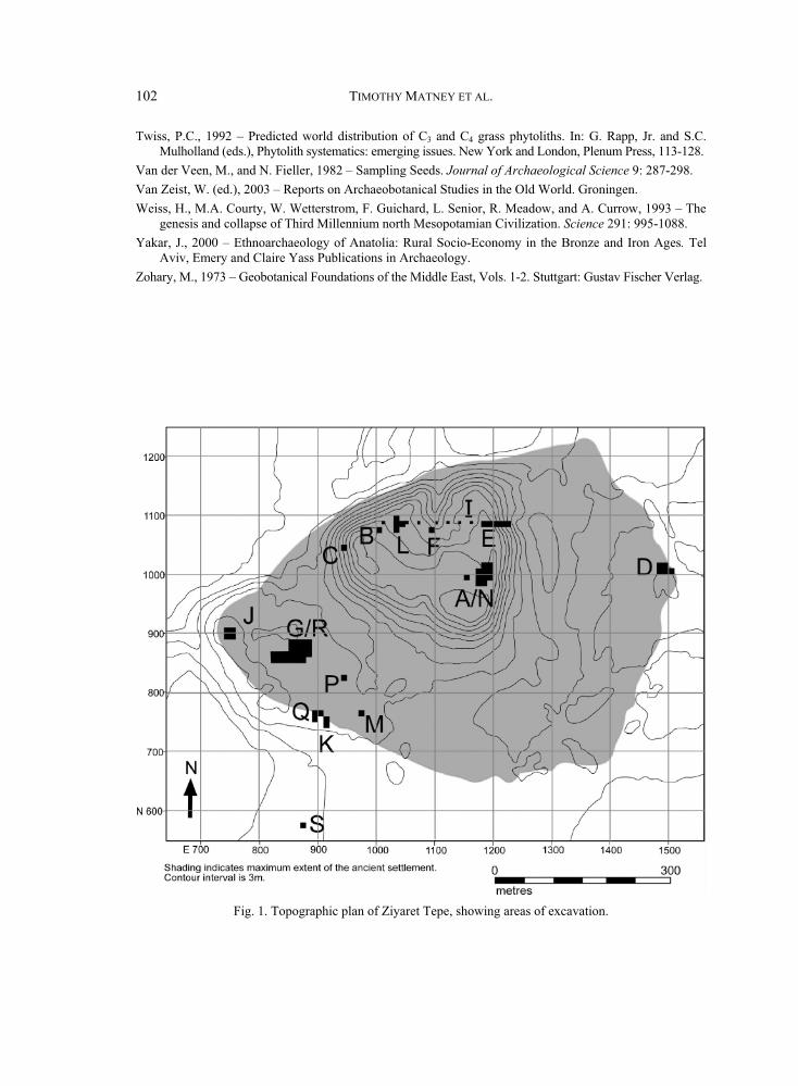
102 TIMOTHY MATNEY ET AL.
Twiss, P.C., 1992 – Predicted world distribution of C3 and C4 grass phytoliths. In: G. Rapp, Jr. and S.C. Mulholland (eds.), Phytolith systematics: emerging issues. New York and London, Plenum Press, 113-128.
Van der Veen, M., and N. Fieller, 1982 – Sampling Seeds. Journal of Archaeological Science 9: 287-298. Van Zeist, W. (ed.), 2003 – Reports on Archaeobotanical Studies in the Old World. Groningen. Weiss, H., M.A. Courty, W. We erstrom, F. Guichard, L. Senior, R. Meadow, and A. Currow, 1993 – The
genesis and collapse of Third Millennium north Mesopotamian Civilization. Science 291: 995-1088. Yakar, J., 2000 – Ethnoarchaeology of Anatolia: Rural Socio-Economy in the Bronze and Iron Ages. Tel
Aviv, Emery and Claire Yass Publications in Archaeology. Zohary, M., 1973 – Geobotanical Foundations of the Middle East, Vols. 1-2. Stuttgart: Gustav Fischer Verlag.
Fig. 1. Topographic plan of Ziyaret Tepe, showing areas of excavation.
tt

ANATOLICA XXXVII, 2011 103
Fig. 2. Photograph of typical Late Medieval surfaces in Operation A/N. Note the stone-lined pit in center of grid square N980 E1160 and the proximity of these remains to the modern surface.
Fig. 3. Drawing of terracotta bird-shaped whistle ZT 35049 (N-459).
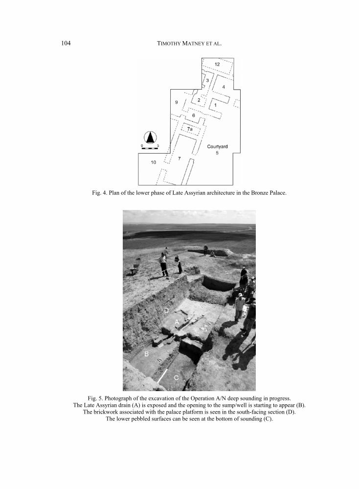
104 TIMOTHY MATNEY ET AL.
Fig. 4. Plan of the lower phase of Late Assyrian architecture in the Bronze Palace.
Fig. 5. Photograph of the excavation of the Operation A/N deep sounding in progress. The Late Assyrian drain (A) is exposed and the opening to the sump/well is starting to appear (B).
The brickwork associated with the palace platform is seen in the south-facing section (D). The lower pebbled surfaces can be seen at the bottom of sounding (C).

ANATOLICA XXXVII, 2011 105
Fig. 6. Drawing of terracotta bull’s head ZT 35395 (N-514)
Fig. 7. Photograph of cuneiform tablet ZTT 30.
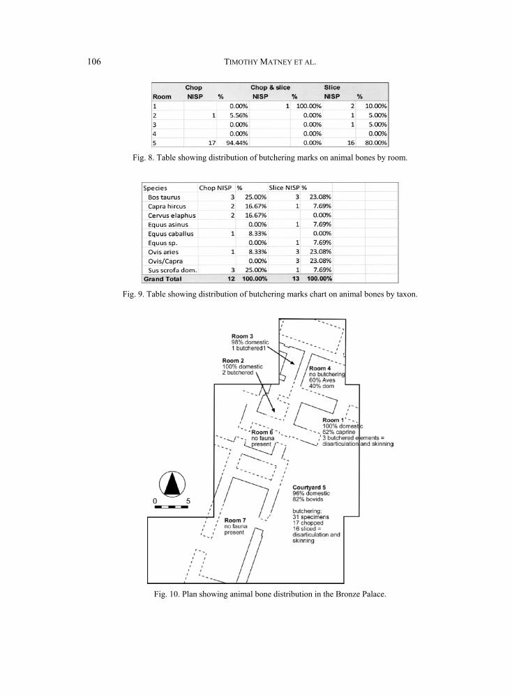
106 TIMOTHY MATNEY ET AL.
Fig. 8. Table showing distribution of butchering marks on animal bones by room.
Fig. 9. Table showing distribution of butchering marks chart on animal bones by taxon.
Fig. 10. Plan showing animal bone distribution in the Bronze Palace.
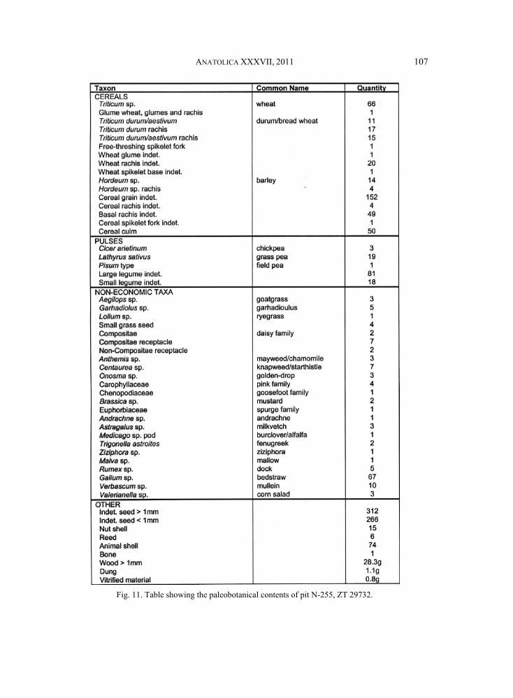
ANATOLICA XXXVII, 2011 107
Fig. 11. Table showing the paleobotanical contents of pit N-255, ZT 29732.
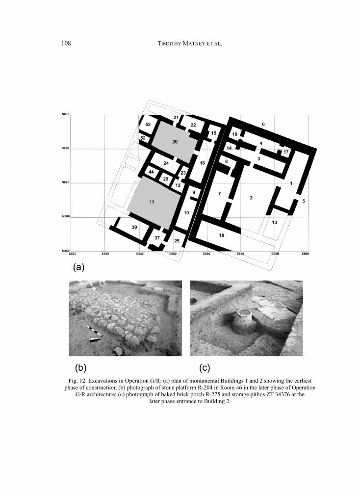
108 TIMOTHY MATNEY ET AL.
Fig. 12. Excavations in Operation G/R: (a) plan of monumental Buildings 1 and 2 showing the earliest phase of construction; (b) photograph of stone platform R-204 in Room 46 in the later phase of Operation
G/R architecture; (c) photograph of baked brick porch R-275 and storage pithos ZT 34376 at the later phase entrance to Building 2.
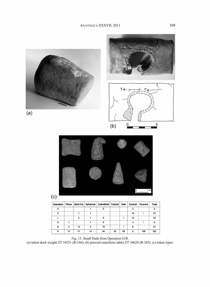
ANATOLICA XXXVII, 2011 109
Fig. 13. Small finds from Operation G/R. (a) talent duck weight ZT 34251 (R-166); (b) pierced cuneiform tablet ZT 34620 (R-285); (c) token types.
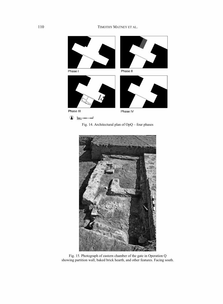
110 TIMOTHY MATNEY ET AL.
Fig. 14. Architectural plan of OpQ – four phases
Fig. 15. Photograph of eastern chamber of the gate in Operation Q showing partition wall, baked brick hearth, and other features. Facing south.
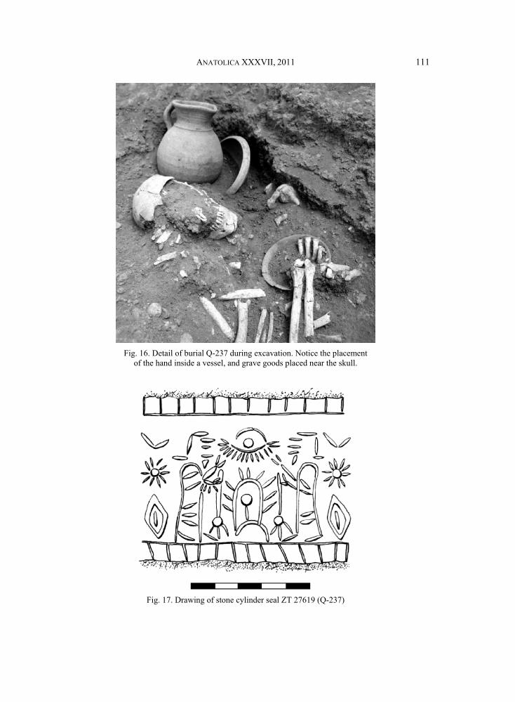
ANATOLICA XXXVII, 2011 111
Fig. 16. Detail of burial Q-237 during excavation. Notice the placement of the hand inside a vessel, and grave goods placed near the skull.
Fig. 17. Drawing of stone cylinder seal ZT 27619 (Q-237)
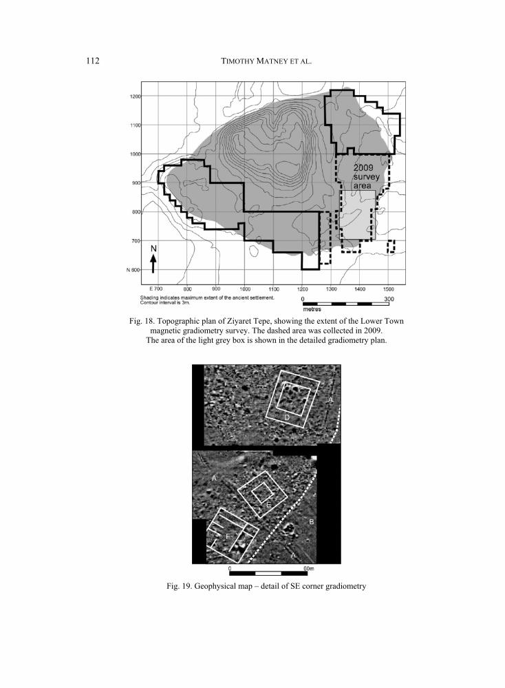
112 TIMOTHY MATNEY ET AL.
Fig. 18. Topographic plan of Ziyaret Tepe, showing the extent of the Lower Town magnetic gradiometry survey. The dashed area was collected in 2009.
The area of the light grey box is shown in the detailed gradiometry plan.
Fig. 19. Geophysical map – detail of SE corner gradiometry
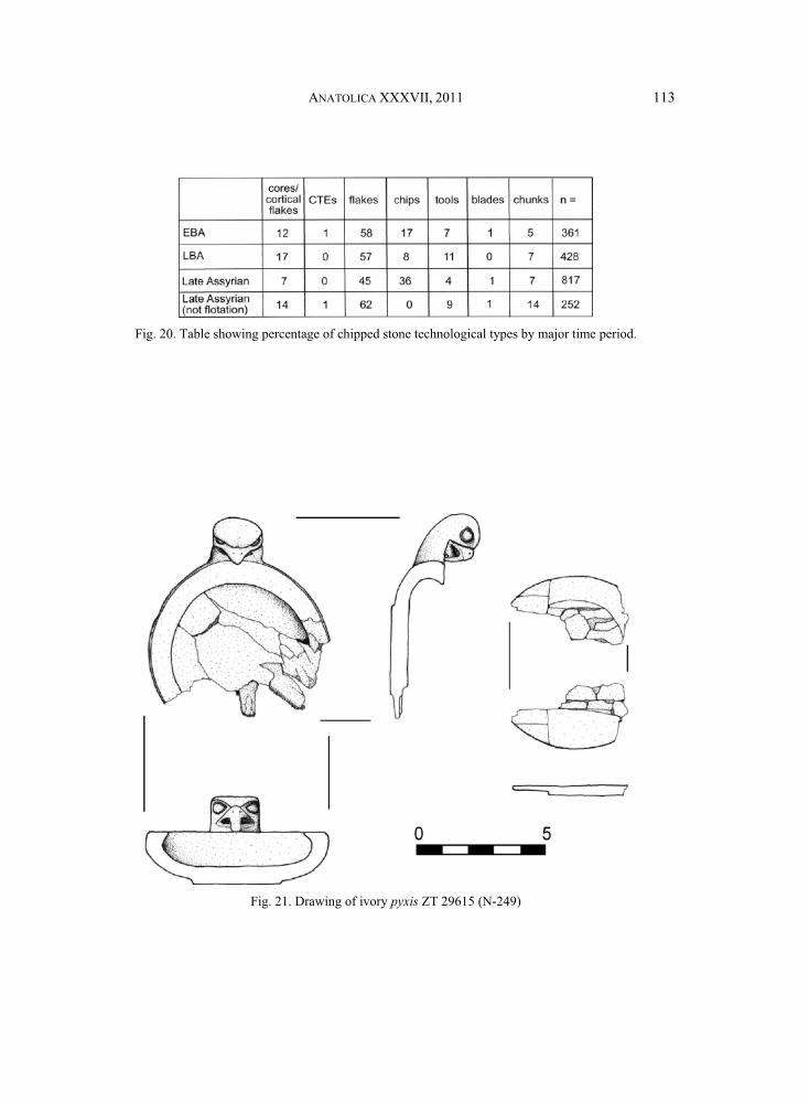
ANATOLICA XXXVII, 2011 113
Fig. 20. Table showing percentage of chipped stone technological types by major time period.
Fig. 21. Drawing of ivory pyxis ZT 29615 (N-249)
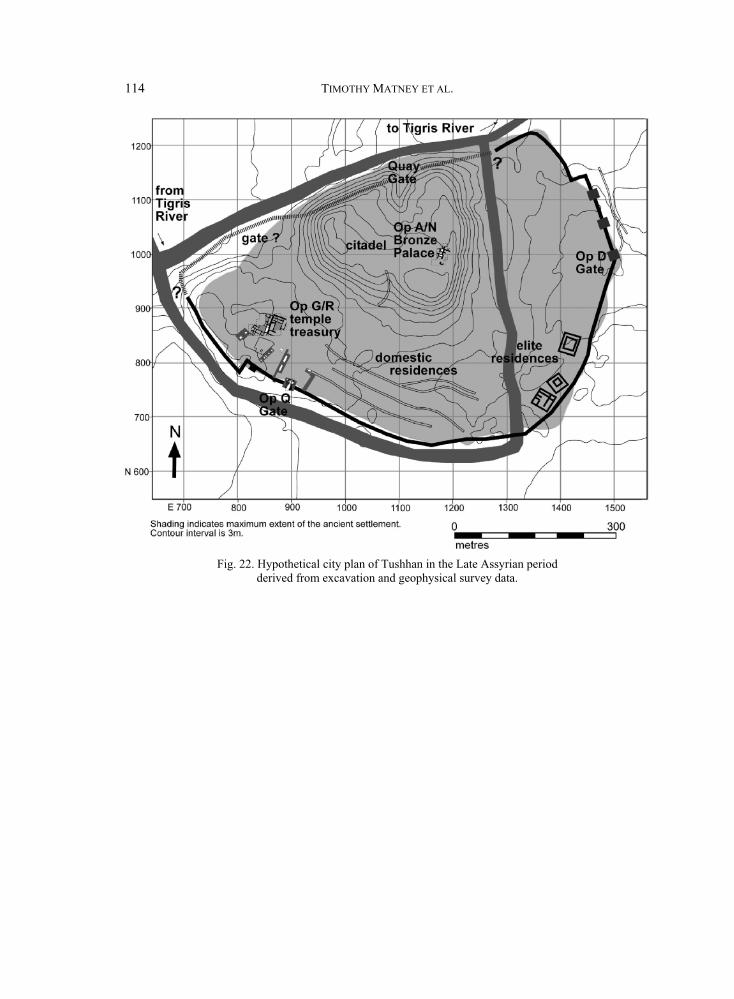
114 TIMOTHY MATNEY ET AL.
Fig. 22. Hypothetical city plan of Tushhan in the Late Assyrian period derived from excavation and geophysical survey data.