Examiner - GA Consulting S.r.l. · i ubjec h nite tate U.S xpor dministratio egulation ......
2
Examiner software revolutionizes the processing and analysis of three- dimensional ground penetrating radar (GPR) data. Examiner provides an intuitive and user friendly environment for visualization, analysis, and reporting. It integrates global positioning system (GPS) coordinates, maps, imagery and external annotations. Its unique functionality allows quick processing and navigating of large data sets. Additionally, the tool enables the user to generate output data for final reporting. These capabilities enable Examiner to dramatically reduce the time required to process 3D GPR data. Figure 1: Examiner dataflow. PROCESSING & VISUALIZATION Examiner seamlessly handles and displays projects with multiple large GPR data files. A three-slice view allows easy navigation within the data volumes for detailed analysis. Users are offered a full resolution presentation to pan, zoom, and deep dive the data with real-time rendering. The data is displayed and traversed for an initial review giving the user the opportunity to quickly identify subsurface areas for further investigations. EXAMINER HIGHLIGHTS › Optimized for large 3D GPR datasets › Results quickly available for field analysis › Geo-referenced maps and imagery › Virtual Trench option and 3D interface tracing › Adaptative Interference Suppression › Export to various formats, including DXF and KMZ 3D-RADAR EXAMINER™ Examiner ™ 3D GPR DATA PROCESSING AND ANALYSIS SOFTWARE WWW.3D-RADAR.COM Raw GPR Data GPS Coordinates Maps Aerial Photos User-supplied Annotations GPR Data Processing GPR Data Optimization Annotations & Virtual Trenching Interface Tracing Feature Identification Data Collection Processing Optimization Analysis and Reporting Output User-defined Outputs .dxf (AutoCAD) .kmz (Google Earth) .txt (Annotations) .xls, .avi 3 rd Party SW Tools Road Doctor GPR Slice, ReflexW Matlab Standalone Reports
Transcript of Examiner - GA Consulting S.r.l. · i ubjec h nite tate U.S xpor dministratio egulation ......
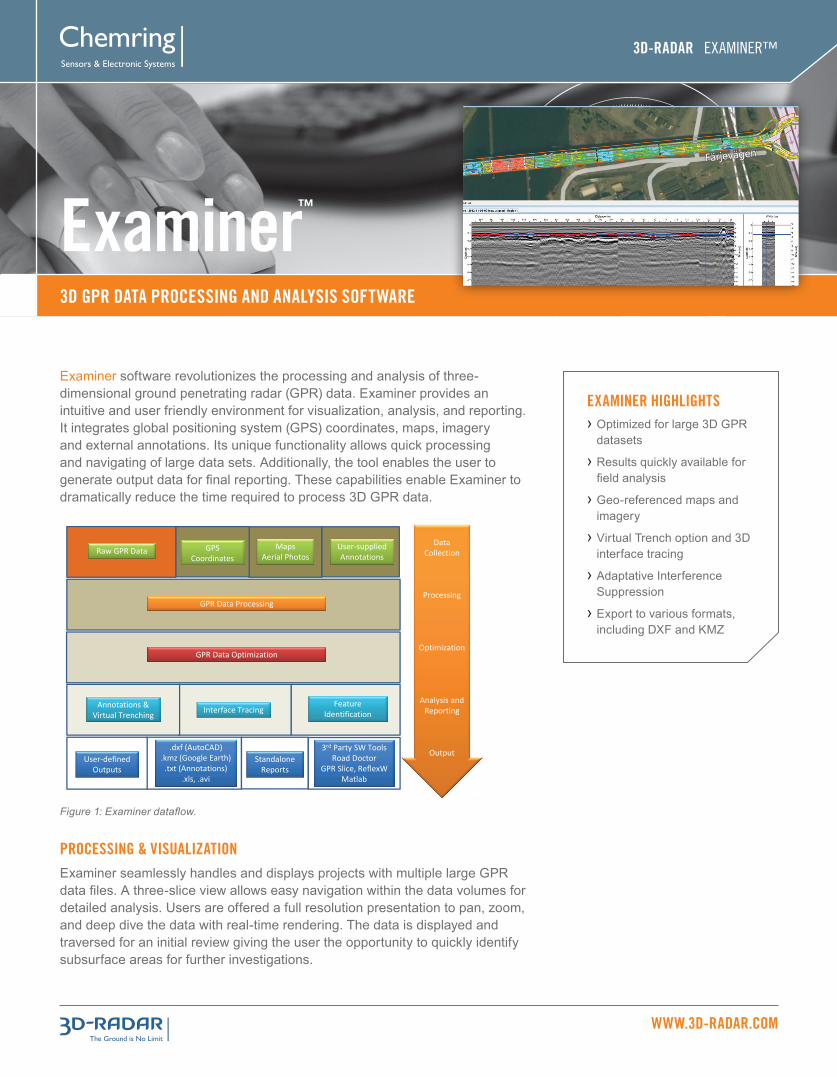
Examiner software revolutionizes the processing and analysis of three-dimensional ground penetrating radar (GPR) data. Examiner provides an intuitive and user friendly environment for visualization, analysis, and reporting. It integrates global positioning system (GPS) coordinates, maps, imagery and external annotations. Its unique functionality allows quick processing and navigating of large data sets. Additionally, the tool enables the user to generate output data for final reporting. These capabilities enable Examiner to dramatically reduce the time required to process 3D GPR data.
Figure 1: Examiner dataflow.
PROCESSING & VISUALIZATIONExaminer seamlessly handles and displays projects with multiple large GPR data files. A three-slice view allows easy navigation within the data volumes for detailed analysis. Users are offered a full resolution presentation to pan, zoom, and deep dive the data with real-time rendering. The data is displayed and traversed for an initial review giving the user the opportunity to quickly identify subsurface areas for further investigations.
EXAMINER HIGHLIGHTS › Optimized for large 3D GPR datasets
› Results quickly available for field analysis
› Geo-referenced maps and imagery
› Virtual Trench option and 3D interface tracing
› Adaptative Interference Suppression
› Export to various formats, including DXF and KMZ
3D-RADAR EXAMINER™
Examiner™
3D GPR DATA PROCESSING AND ANALYSIS SOFTWARE
WWW.3D-RADAR.COM
Raw GPR Data GPS Coordinates
MapsAerial Photos
User-suppliedAnnotations
GPR Data Processing
GPR Data Optimization
Annotations & Virtual Trenching Interface Tracing
Feature Identification
DataCollection
Processing
Optimization
Analysis and Reporting
OutputUser-defined
Outputs
.dxf (AutoCAD).kmz (Google Earth).txt (Annotations)
.xls, .avi
3rd Party SW ToolsRoad Doctor
GPR Slice, ReflexWMatlab
Standalone Reports

3D-RADAR EXAMINER™ WWW.3D-RADAR.COM
Examiner™ is a trademark of 3D-RADAR, AS, a subsidiary of Chemring North America’s Sensors and Electronic Systems’ Division. This product is subject to the United States (U.S.) Export Administration Regulations (EAR), Parts 730-774). The safe, transfer, transportation or shipment of this product to foreign person, inside or outside of the U.S., is prohibited or restricted without proper authorization or license.
© Copyright 2015. 3D-RADAR AS. All rights reserved. 01/15/2015
3D-RADARKlæbuveien 196 B7037 TrondheimNorway
Brynsveien 130667 OsloNorway
Tel: +47 7289 [email protected]
3D-RADAR23031 Ladbrook DriveSterling, VirginiaUSA
Tel: +1 (703) [email protected]
3D ANNOTATIONS AND VIRTUAL TRENCHExaminer showcases a powerful and user-friendly tool to draw three-dimensional points and multi-segment annotations. When using the “Virtual Trench” option, the user can display vertical slices of data across multiple swaths following annotation lines.
MAP OVERLAYS Examiner features a map view showing geo-referenced depth slices. The near reality display makes it easier to interpret features across the data. Data geo-referencing is based on advanced GPS filtering to ensure the best possible accuracy. Examiner provides global map imagery through the integrated map service, OpenStreetMap. Geo-referenced images can be imported from aerial, satellite, photos or maps in almost any projection, placing the GPR data quickly and accurately in the surrounding environment.
Figure 2: 3D GPR data from a 100 m x 100 m archaeological site.
Figure 3: Processed image from Figure 1 exported to Google Earth.
INTERFACE TRACINGExaminer offers an advanced analysis tool for automatic interface/layer tracing. With a single click, it is possible to follow and trace an interface for kilometers using an automatic 3D tracing algorithm. The end result is visualization on screen as depth profiles and color coded maps.
EXPORT & EXTENSIBILITYExaminer imagery can be directly copied and pasted into other applications for easy reporting or saved in the most commonly used image formats. It is also possible to generate a video to dynamically display how the data varies along a user selectable depth range. 3D processed data can be exported to a fully documented format which can then be imported into end-user developed software as well as leading third party analysis and reporting tools. Annotations, radar imagery and interfaces can be exported with rendered GPS data to various formats that are compatible with popular software such as AutoCAD (DXF) and Google Earth (KMZ). Traced interfaces can also be saved as point clouds in comma separated value files, or summarized in a comprehensive report with detailed statistics.
SYSTEM
Operating System
CPU
Memory
Disk capacity*
REQUIREMENTS
Windows 7 or 8
64-bit, Intel Core i7 recommended
8GB or greater
250 GB or more
SPECIFICATIONS
PART NUMBER
3DR-EX-PRO-101
DESCRIPTION
Examiner – Professional version, Single user
ORDERING INFORMATION
*Disk drives must be formatted with a file system capable of storing large files (e.g. NTFS, not FAT/FAT 32). A Solid State Drive (SSD) will enhance performance, but is not required.
3D-RADAR RELATED PRODUCTS › DX Antenna Array Series
› DXG Antenna Array Series
› GeoScope™ Mk IV 3D GPR