Evidence of regional subsidence and associated interior ... · Evidence of regional subsidence and...
23
Evidence of regional subsidence and associated interior wetland loss induced by hydrocarbon production, Gulf Coast region, USA Robert A. Morton U.S. Geological Survey Center for Coastal and Watershed Studies, St. Petersburg, FL 33701 USA Tel.: 727-803-8747 x3080 Fax: 727-803-2032 E-mail: [email protected] http://coastal.er.usgs.gov/gc-subsidence/ Julie C. Bernier ETI Professionals, Inc., St. Petersburg, FL 33701 USA John A. Barras U.S. Geological Survey National Wetlands Research Center Coastal Restoration Field Station Baton Rouge, LA 70894 USA
Transcript of Evidence of regional subsidence and associated interior ... · Evidence of regional subsidence and...
Evidence of regional subsidence and associated interior wetland loss induced by hydrocarbon production, Gulf Coast region, USA
Robert A. Morton
U.S. Geological Survey
Center for Coastal and Watershed Studies, St. Petersburg, FL 33701 USA Tel.: 727-803-8747 x3080
Fax: 727-803-2032
E-mail: [email protected]
http://coastal.er.usgs.gov/gc-subsidence/
Julie C. Bernier
ETI Professionals, Inc., St. Petersburg, FL 33701 USA
John A. Barras
U.S. Geological Survey
National Wetlands Research Center Coastal Restoration Field Station
Baton Rouge, LA 70894 USA

Abstract Analysis of remote images, elevation surveys, stratigraphic cross-sections, and hydrocarbon production
data demonstrates that extensive areas of wetland loss in the northern Gulf Coast region of the United States were
associated with large-volume fluid production from mature petroleum fields. Interior wetland losses at many sites in
coastal Louisiana and Texas are attributed largely to accelerated land subsidence and fault reactivation induced by
decreased reservoir pressures as a result of rapid or prolonged extraction of gas, oil, and associated brines. Evidence
that moderately-deep hydrocarbon production has induced land-surface subsidence and reactivated faults that
intersect the surface include: (1) close temporal and spatial correlation of fluid production with surficial changes
including rapid subsidence of wetland sediments near producing fields, (2) measurable offsets of shallow strata
across the zones of wetland loss, (3) large reductions in subsurface pressures where subsidence rates are high, (4)
coincidence of orientation and direction of displacement between surface fault traces and faults that bound the
reservoirs, and (5) accelerated subsidence rates near producing fields compared to subsidence rates in surrounding
areas or compared to geological rates of subsidence. Based on historical trends, subsidence rates in the Gulf Coast
region near producing fields most likely will decrease in the future because most petroleum fields are nearly
depleted. Alternatively, continued extraction of conventional energy resources as well as potential production of
alternative energy resources (geopressured-geothermal fluids) in the Gulf Coast region could increase subsidence
and land losses and also contribute to inundation of areas of higher elevation.
Keywords wetland loss, subsidence, coastal change, Gulf Coast region
Introduction Wetland losses in the northern Gulf Coast region of the United States are so extensive they
represent critical concerns to government environmental agencies and natural resource managers
(Boesch and others 1994). Each year, millions of dollars are spent in coastal Louisiana alone to
restore wetlands and to maintain the natural ecosystems that are vital to the Nation’s economy
(Finkl and Khalil 2005). Coastal wetland losses associated with subsidence can be manifested in
two distinctly different ways (Williams and others 1994). The primary and most extensive losses
are caused by sinking of the land surface and subsequent permanent flooding that expands
marine and intra-coastal water bodies at the expense of wetland resources. A secondary response
is accelerated wetland erosion attributed to lower elevations and thus greater inland penetration
of storm waves and overwash. Reduced elevations of coastal wetlands and storm-protection
levees increase depths and durations of floods and also increase ecological damage caused by
storms. A recent well-documented example of subsidence-aggravated damage was extensive
wetland destruction and the flooding of New Orleans, Louisiana as a result of Hurricane Katrina
in 2005.
1

Some areas of wetland loss in the Gulf Coast region coincide with some of the Nation’s largest
oil and gas fields. However, wetland loss, subsidence, and faulting induced by oil and gas
production generally have been discounted because much of the wetland loss occurs in coastal
Louisiana where many other factors can contribute to wetland change (Boesch and others 1994;
Williams and others 1994) and because the complex processes, environmental diversity, and
human alterations of the Mississippi delta tend to obscure the links between hydrocarbon
production and wetland loss. Beyond these general observations, relatively little is known about
the magnitudes and rates of wetland loss near oil and gas fields and their relationship to
production histories, fluid compositions, subsurface geology, and near-surface conditions prior to
hydrocarbon production.
Land subsidence caused by hydrocarbon production has been documented in many producing
basins of the world (Poland and Davis 1972; Van Hasselt 1992; Chilingarian and others 1995;
Nagel 2001; Chilingar and Endres 2005). Despite the widespread recognition of this
phenomenon, the potential for subsidence as a result of moderate to deep hydrocarbon
production generally has been disregarded in the Gulf Coast region, or remains controversial,
because prior studies have produced conflicting results. For example, some prior studies in
coastal Louisiana and Texas concluded that production-induced subsidence was minor compared
with natural coastal plain subsidence (Boesch and others 1994; Gagliano and others 2003; Dokka
2005), or compared to subsidence induced by shallow groundwater withdrawal (Holzer and
Bluntzer 1984). Ratzlaff (1982) analyzed regional releveling surveys along the Texas coastal
plain and concluded that subsidence was caused mostly by groundwater withdrawal with some
contribution from hydrocarbon production. However, Holzer and Bluntzer (1984) examined
releveling surveys that were over or close to producing fields and concluded that subsidence
induced by oil and gas production was minor compared to regional subsidence of the coastal
plain of Texas. Martin and Serdengecti (1984) and Suhayda (1987) came to similar conclusions
for coastal Louisiana after using a one-dimensional numerical model to estimate potential
magnitudes of subsidence around selected oil and gas fields. These prior studies in coastal
Louisiana and Texas drew important scientific conclusions about causes of historical subsidence
without examining local subsurface data specifically related to petroleum extraction, or
2
incorporating more appropriate estimates of parameters, such as declines in reservoir pressure,
that are used to run the numerical models.
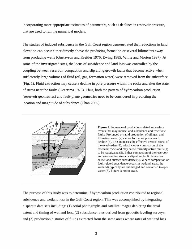
The studies of induced subsidence in the Gulf Coast region demonstrated that reductions in land
elevation can occur either directly above the producing formation or several kilometers away
from producing wells (Gustavson and Kreitler 1976; Ewing 1985; White and Morton 1997). At
some of the investigated sites, the locus of subsidence and land loss was controlled by the
coupling between reservoir compaction and slip along growth faults that become active when
sufficiently large volumes of fluid (oil, gas, formation water) were removed from the subsurface
(Fig. 1). Fluid extraction may cause a decline in pore pressure within the rocks and alter the state
of stress near the faults (Geertsma 1973). Thus, both the pattern of hydrocarbon production
(reservoir geometries) and fault-plane geometries need to be considered in predicting the
location and magnitude of subsidence (Chan 2005).
Figure 1. Sequence of production-related subsurface events that may induce land subsidence and reactivate faults. Prolonged or rapid production of oil, gas, and formation water (2) causes formation pressures to decline (3). This increases the effective vertical stress of the overburden (4), which causes compaction of the reservoir rocks and may cause formerly active faults (1) to be reactivated (5). Either compaction of the reservoir and surrounding strata or slip along fault planes can cause land-surface subsidence (6). Where compaction or fault-related subsidence occurs in wetland areas, the wetlands typically are submerged and converted to open water (7). Figure is not to scale.
The purpose of this study was to determine if hydrocarbon production contributed to regional
subsidence and wetland loss in the Gulf Coast region. This was accomplished by integrating
disparate data sets including: (1) aerial photographs and satellite images depicting the areal
extent and timing of wetland loss, (2) subsidence rates derived from geodetic leveling surveys,
and (3) production histories of fluids extracted from the same areas where rates of wetland loss
3

and subsidence also were available. Areas of investigation were limited to the southeastern
coastal plain of Texas and the Mississippi delta plain where groundwater extraction is negligible,
wetlands are extensive, and wetland losses occurred within the broad expanses of formerly
continuous marshes. By focusing on interior wetland losses, those associated with shoreline
erosion are eliminated or minimized. Understanding the influence of hydrocarbon production on
subsidence and wetland changes is important for predicting future wetland conditions and for
planning environmental activities such as coastal restoration projects.
Criteria for recognizing induced subsidence and fault reactivation
Temporal and spatial coincidence of wetland loss and hydrocarbon production
Wetland losses or fault reactivation typically are attributed to induced subsidence when the area
and timing of wetland losses and fault movement coincide with advanced stages of hydrocarbon
production. Production-induced subsidence in the Gulf Coast region was first reported in the mid
1920s at the Goose Creek field near Houston, Texas (Pratt and Johnson 1926). Subsidence at
Goose Creek of about 1 m was enough to convert an upland to open water. Subsequent studies
linking subsidence and hydrocarbon production in the coastal plain of southeast Texas were also
limited to individual fields (Ewing 1985; Sharp and Hill 1995) or focused on only a few fields
(White and Morton 1997; Morton and others 2001).
Field-based investigations of wetland losses in the Mississippi delta focused initially on direct
surficial effects of resource extraction such as excavation of drilling sites and associated access
channels (Scaife and others 1983) and indirect effects such as alterations of marsh
hydrodynamics (frequency and duration of inundation), alterations in water circulation patterns,
and changes in water quality (Boesch and others 1994; Williams and others 1994). Other studies
explained wetland losses in terms of biogeochemistry and plant physiology that included
saltwater intrusion, water logging, and sulfide concentration in the roots (DeLaune and Pezeshki
1994; Mendelssohn and McKee 1988). These investigations, which actually identified symptoms
of subsidence and permanent inundation, did not consider subsurface geological processes that
4

would cause subsidence. Only recently have there been analyses of subsurface data (volumes and
rates of fluid production, reservoir structure, magnitudes and rates of pressure reduction) that
would provide a direct basis for testing the hypothesis that hydrocarbon production has
contributed significantly to regional subsidence and interior wetland loss in the Gulf Coast
region (Morton and others 2001, 2005; Chan 2005).
Figure 2. Map of south Louisiana showing data sets near and along Louisiana Highway 1 between Raceland and Leeville, including locations of benchmarks along Louisiana Highway 1 (green circles), oil and gas fields, wetland losses, and cores from the Madison Bay study area (red squares). Fault projection from Kuecher and others (2001); wetland losses from Morton and others (2005); outlines of producing fields modified from Morton and Purcell (2001).
Patterns of subsidence, which led to wetland replacement by open water similar to those in
Texas, also were documented in south Louisiana as part of a series of sub-regional studies of
subsidence and wetland loss in the Mississippi delta plain. Those studies analyzed wetland loss
5

and fluid production histories for more than 50 oil and gas fields (Morton and others 2002; 2005)
with unpublished analyses of more than 200 fields as corroborating evidence. The opening of
Madison Bay, Louisiana, near the Lapeyrouse Field, provides an example of the relative timing
and typical surficial changes that occurred throughout the delta plain where wetland loss was
most rapid and most extensive between 1969 and 1974 (Figs. 2 and 3). As shown in Figure 4,
there was a hiatus of about 25 years between the onset of production and the first visible
evidence of surface disturbance and wetland loss.
Figure 3. Locations of sediment cores and stratigraphic cross sections from the Madison Bay area superimposed on pre- and post-subsidence aerial photographs taken in (a) 1969, (b) 1974, and (c) 2004. (d) 1956-2004 wetland loss at Madison Bay and the surrounding area superimposed on the 2004 image. The photos show that wetlands above the field were healthy and continuous in 1969, but deteriorated and had converted mostly to open water by 1974. The rapid changes likely were caused by induced subsidence and fault reactivation resulting from hydrocarbon production. Modified from Morton and others (2005).
6

Figure 4. Cumulative hydrocarbon production in the Lapeyrouse and Bay Baptiste Fields, Louisiana from 1944 to 2002. Compare production history with changes in wetlands observed in air photos at nearby Madison Bay (Fig. 3). Production data from the Louisiana Department of Natural Resources and the PI/Dwights PLUS database (IHS Energy 2003). Wetlands began rapidly disappearing after the field began rapidly producing large volumes of hydrocarbons in the 1960s. Wetland loss generally slowed when hydrocarbon production rates declined. Wetland loss also was rapid in the late 1980s and early 1990s following a peak period of formation water production. Modified from Morton and others (2005).
Figure 5. Composite histories of fluid production from oil-and-gas fields and wetland loss in south Louisiana. Production data from the Louisiana Department of Natural Resources and the PI/Dwights PLUS database (IHS Energy 2003). Wetland loss values were determined by Britsch and Dunbar (1993) and John Barras (unpublished data). These historical data, integrated across the delta plain, show close temporal and spatial correlations between rates of wetland loss and rates of fluid production. From Morton and others (2005).
Temporal and spatial correlations between wetland loss and hydrocarbon production also can be
tested at a sub-regional scale by comparing the combined annual rates of fluid extraction for
fields in the Mississippi delta plain with average annual rates of wetland loss for the same area
(Fig. 5). Rates of wetland loss in the 1990s and early 2000s were slower than when the wetlands
collapsed between the 1960s and 1980s. The deceleration in rates of wetland loss, which
corresponds with the rapid decline in hydrocarbon production, could signal a reduction in the
underlying rates of subsidence.
7

Shallow stratigraphic offsets
Correlation of shallow stratigraphic markers in adjacent sediment cores provides a basis for
determining the relative magnitudes of subsidence and subsequent erosion of the wetland surface
(Fig. 6). The former marsh sediments preserved beneath open water have subsided more than the
adjacent subaerial marsh sediments, but the entire area including the subaerial marsh has
subsided some unknown amount. Thus, subsidence estimates away from benchmark control are
minimums because there are no measurements of the total amount of historical subsidence
compared to some standard vertical datum. In Figure 6, the correlated beds have been displaced
downward between 50 and 65 cm compared to the adjacent marsh surface. Preservation of most
of the delta plain marsh beneath about a meter of water and the timing of the greatest wetland
loss (1969-1974) demonstrate that subsidence was rapid. The imagery analysis and core pairs
taken near the land/water interface show that erosion is only a minor process converting interior
wetlands to open water, and subsidence is largely responsible for the conversion. At most of the
open water sites that formerly were continuous emergent marsh, surveyed water depths were
greater than the thickness of the delta plain marsh. This physical relationship is clear evidence
that wetland loss resulted from subsidence because it is impossible to erode to those depths and
still preserve some of the marsh deposits. Erosion of the former marsh sediments at most
Madison Bay core sites ranges from 6 to 37 cm and averages about 20 cm (Fig. 6). Overall, the
stratigraphic correlations indicate that subsidence is responsible for about two thirds of the
differences between marsh elevations and water depths, whereas erosion is responsible for the
other third. Therefore, subsidence has been twice as important as erosion in altering the
landscape at Madison Bay. In other parts of the Mississippi delta plain where interior wetland
loss was greatest, magnitudes of subsidence, timing of wetland loss, and correlation of those
processes with hydrocarbon production were similar to those conditions recorded at Madison
Bay (Morton and others 2005).
Substantial declines in reservoir pressures
When oil, gas, and associated formation water are extracted from the subsurface, the natural
pressures and pressure gradients in the formation are reduced (Poland and Davis 1972; Mes
1990; Chilingarian and others 1995). If large volumes of fluids are produced faster than the rate
8

of recharge, then the decreases in formation pressure at depth (Fig. 7) increase vertical effective
stresses around the reservoir (Fig. 1). The increased overburden stresses cause reservoir
compaction, which can be transmitted through the overburden to the surface as subsidence
(Geertsma 1973).
Figure 6. Stratigraphic correlations for marsh and open water core pairs MB07-MB01 (a), MB08-MB02 (b), MB09-MB03 (c), and MB10-MB06 (d) illustrate the magnitude of subsidence and wetland erosion (in cm) at the Madison Bay wetland-loss hotspot. The upper stratigraphic unit represents the peat and organic mud facies, whereas the lower unit includes the clastic sand and mud facies. Locations shown in Fig. 3. Modified from Morton and others (2003).
Kreitler and others (1990) reported large-magnitude, widespread depressurization beneath the
Texas coastal plain in the 1.2 to 2.4 km depth range as a result of production of hydrocarbons
and associated brines. Pressure gradients calculated by Kreitler and others (1990) from bottom-
hole pressure measurements in thousands of wells were substantially below expected normal
hydrostatic pressure gradients within the depths of fluid production. The wide distribution of
sub-hydrostatic pressures indicated that depressurization was regional and not just around the
large fields.
9
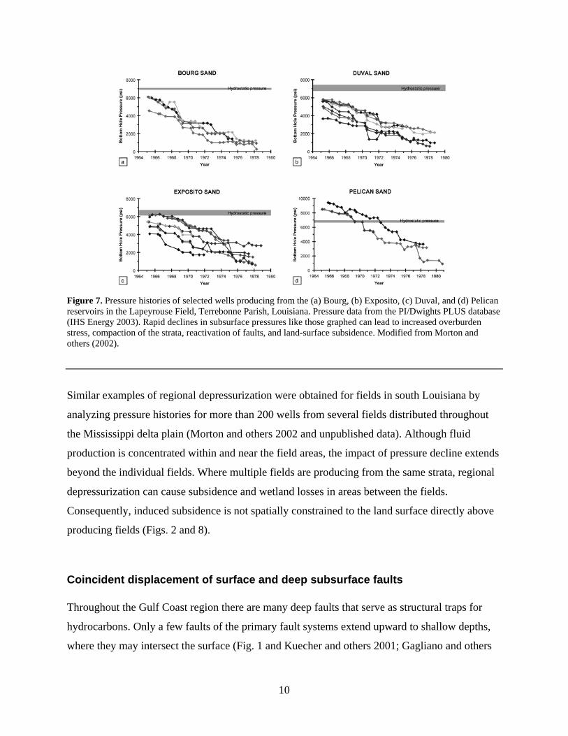
Figure 7. Pressure histories of selected wells producing from the (a) Bourg, (b) Exposito, (c) Duval, and (d) Pelican reservoirs in the Lapeyrouse Field, Terrebonne Parish, Louisiana. Pressure data from the PI/Dwights PLUS database (IHS Energy 2003). Rapid declines in subsurface pressures like those graphed can lead to increased overburden stress, compaction of the strata, reactivation of faults, and land-surface subsidence. Modified from Morton and others (2002).
Similar examples of regional depressurization were obtained for fields in south Louisiana by
analyzing pressure histories for more than 200 wells from several fields distributed throughout
the Mississippi delta plain (Morton and others 2002 and unpublished data). Although fluid
production is concentrated within and near the field areas, the impact of pressure decline extends
beyond the individual fields. Where multiple fields are producing from the same strata, regional
depressurization can cause subsidence and wetland losses in areas between the fields.
Consequently, induced subsidence is not spatially constrained to the land surface directly above
producing fields (Figs. 2 and 8).
Coincident displacement of surface and deep subsurface faults
Throughout the Gulf Coast region there are many deep faults that serve as structural traps for
hydrocarbons. Only a few faults of the primary fault systems extend upward to shallow depths,
where they may intersect the surface (Fig. 1 and Kuecher and others 2001; Gagliano and others
10

2003). If the pressure drop in the producing formation is sufficiently large, then the subsurface
state of stress is altered and faults that are near the threshold of failure may be reactivated and
begin to move (Chan 2005).
Figure 8. (a) Subsurface structure at Caplen Field, Texas including fault traces at the depth of hydrocarbon production. Comparing projected fault traces at the surface with an aerial photograph (b) of the same area shows that recent subsidence along the faults was responsible for wetland loss. Contours in meters below sea level.
Ewing (1985), White and Tremblay (1995), and Morton and others (2001) showed how near-
surface faults were reactivated around a few producing fields in Texas following a rapid
acceleration in rates of hydrocarbon production. Comparison of aerial photographs to structure
contour maps of the deep producing reservoirs show that the surface fault traces have the same
orientation and sense of displacement as much deeper faults that are part of the structural trap for
hydrocarbons (Fig. 8). However, the surface fault traces did not become apparent until
production had lasted several decades and the rate of production accelerated (White and Morton,
1997; Morton and others 2001). Similar results are obtained for the Mississippi delta plain when
histories of fault expression (Kuecher and others 2001; Gagliano and others 2003) are compared
to the production histories for nearby oil and gas fields. When the fault is active, the land area on
the downthrown side of the fault subsides near the fault plane (Fig. 9). Depending on the depth
11

and angle of the fault, the induced subsidence and associated wetland loss may occur several
kilometers away from the producing wells (Fig. 8) rather than directly above the producing
reservoirs.
Figure 9. (a) Location of benchmarks and (b) releveling profile along State Highway 87 that crosses a reactivated deep subsurface fault near Caplen, Texas. Compare with figure 8. Releveling profile from White and Morton (1997).
Accelerated subsidence rates
Subsidence rates for the Gulf Coast region estimated for Pleistocene and Holocene sediments
provide a basis for comparing subsidence rates between geological and historical time scales.
This comparison can be used to determine if historical subsidence rates are comparable to or
greater than those expected from natural processes operating in the sedimentary basin. Paine
(1993) used radiocarbon ages and elevations of Pleistocene strata and global sea-level data to
estimate average geological (105 yr) subsidence rates of 0.02 to 0.05 mm/yr for the central Texas
coastal plain. Similarly, Penland and others (1988), Roberts and others (1994), and Kulp (2000)
all used radiocarbon ages and depths of peat deposits to estimate subsidence rates in the
Mississippi delta for the past few thousand years. Analyses of Penland and others (1988) yielded
subsidence rates that ranged from 1 to 5 mm/yr and averaged 2 mm/yr; those of Roberts and
12

others (1994) yielded rates that ranged from 3 to 5 mm/yr and averaged 4 mm/yr. The most
extensive database of radiocarbon dates for the Mississippi delta (Kulp 2000) yielded subsidence
rates that ranged from 0.1 to 8 mm/yr and averaged about 1 mm/yr.
As expected, regional geological subsidence rates are higher in the Louisiana coastal plain
because Holocene sediments are relatively thick compared to the Texas coastal plain where
Holocene sediments are thin. From a theoretical viewpoint, subsidence rates of geologically
young deposits should be high initially as pore water is expelled from the sediments and the
sediments compact. Following the initial rapid compaction, subsidence rates should decline
exponentially. This principle was illustrated for Holocene Mississippi delta sediments by Kulp
(2000) who plotted calculated subsidence rates for the past 6 ky. The plot showed that the trend
of subsidence rates decayed exponentially with time to about 2 mm/yr after about 2 ky.
Historical subsidence rates are calculated from elevation changes at benchmarks, which are
periodically resurveyed by the National Geodetic Survey. Some releveling surveys in the Gulf
Coast region are located along roads that cross the structural grain of the Texas coastal plain
(Holzer and Bluntzer 1984; Paine 1993) and the Mississippi delta plain (Shinkle and Dokka
2004), and they also pass through or near producing fields (Figs. 2, 9, and 10). Comparing data
from first-order leveling surveys provides a basis for determining magnitudes and rates of
subsidence for the intervening period. Analysis of leveling data from surveys in 1965, 1982, and
1993 along Louisiana Highway 1 between Raceland and Leeville (Fig. 10) shows that (1)
subsidence rates were substantially higher near producing fields and faults than between the
fields, and (2) subsidence rates accelerated between the first and second periods of measurement.
In this sub-region subsidence rates between 1965 and 1982 ranged from 1.6 to 12.0 mm/yr and
averaged about 7.6 mm/yr, whereas between 1982 and 1993 they ranged from 8.2 to 18.9 mm/yr
and averaged about 12.1 mm/yr.
Another way of detecting induced subsidence around producing fields is by comparing observed
recent rates of subsidence with rates established for natural subsidence in the same region. For
example, Morton and others (2001) estimated a minimum short-term subsidence rate for the Port
Neches field in Texas during the period of maximum production. The estimated subsidence rate
13

of 30 mm/yr is three orders of magnitude higher than the geological subsidence rates for the
coastal plain estimated by Paine (1993). Accelerated rates of subsidence in south Louisiana can
also be demonstrated by comparing geological and historical rates. The average historical
subsidence rate in the Mississippi delta of 12 mm/yr (Shinkle and Dokka 2004) is roughly an
order of magnitude higher than average geological rates of subsidence reported by Penland and
others (1988) and Kulp (2000).
Figure 10. Plots of historical subsidence rates along Bayou Lafourche calculated by the National Geodetic Survey from releveling of benchmarks (Shinkle and Dokka 2004). Benchmark locations shown in Fig. 2. The plots show a close spatial correlation between highest subsidence rates, hydrocarbon-producing fields (delineated in gray), and the projected intersection of the Golden Meadow fault zone. They also show that subsidence rates accelerated between 1965-1982 and 1982-1993. Modified from Morton and others (2005).
Higher than expected historical subsidence rates in coastal Louisiana and Texas are occurring
over older (Tertiary and Quaternary) deposits that should have already compacted. In fact, the
geotechnical properties of Pleistocene and older deposits beneath the coastal plains and
continental shelf of Texas and Louisiana show that they are overcompacted for their burial
depths because of repeated subaerial exposure during lowstands in sea level (Fisk and
McClelland 1959; Bernard and others 1962). Because historical subsidence rates are
substantially higher than geological subsidence rates in coastal Texas and Louisiana, and because
historical subsidence rates in the Mississippi delta plain accelerated (Fig. 9), there must be
another geophysical explanation for these trends that are inconsistent with those predicted by
compaction theory alone.
14

Subsidence prediction
Numerical models used to predict subsidence caused by subsurface fluid withdrawal commonly
are inaccurate (Van Hasselt 1992; Rhett 1998) and they tend to underestimate observed induced
subsidence (Nagel 2001; Chan 2005). This is because the subsurface processes are still poorly
understood and the fluid-production models typically focus only on depletion and pressure
reduction in the primary reservoirs of a single field. Therefore, numerical models are not
considered applicable for estimating future reductions in land elevation in the Gulf Coast region.
In the absence of a reliable numerical model, qualitative and semi-quantitative predictions can be
made on the basis of subsidence measurements at benchmarks without regard for the underlying
mechanisms. Subsidence magnitudes and trends derived from tide-gauge measurements are less
reliable than elevation surveys because water-level records contain decadal trends (Hicks 1968;
Douglas and others 2001) that reflect external forces not related to land-elevation changes.
Predicting subsidence rates for the Gulf Coast region currently is limited to inferences based on
historical data, because rates since 1993 are not available and NOAA GPS Continuously
Operating Recording Stations (CORS) throughout the region have not been gathering data long
enough to determine extant local rates. Two approaches to subsidence prediction are possible
using the historical (pre-1993) data. One is a quantitative temporal analysis of subsidence rates to
determine the average rates and trend for a sub-region that are then projected into the future
(Shinkle and Dokka 2004) without consideration of the underlying processes. Another method of
qualitatively predicting future subsidence trends is by analogy using a case study of induced
subsidence where the geological conditions and driving forces are similar to those in the area of
interest. A well-known example in the Gulf Coast region is the Houston-Galveston area in Texas
where subsidence and fault reactivation were induced by industrial and municipal groundwater
withdrawal (Galloway and others 1999). Induced subsidence was so severe around Houston that
in 1975 the Texas legislature established a subsidence district and regulatory policies to
discourage groundwater pumping and to encourage conversion to surface-water supplies.
Extensometer measurements around Houston (Kasmarek and others 1997), obtained as part of
the subsidence-management program, show that where rates of groundwater withdrawal were
greatly reduced, subsidence either slowed dramatically or stopped (Fig. 11, Pasadena to Texas
15

City), but where high rates of groundwater withdrawal continued, subsidence also continued at
high rates (Fig. 11, Addicks). This example of induced subsidence is applicable to the subsidence
issues in south Louisiana because the Gulf Coast Basin framework geology and subsurface
processes are similar, and long-term, large-volume fluid production histories are well established
in both sub-regions.
Figure 11. Land surface subsidence trends in the Houston-Galveston area related to groundwater withdrawal. From Kasmarek and others (1997).
The Houston-Galveston subsidence data demonstrate that when the human activities inducing
subsidence slow or stop, then subsidence rates decelerate or return to the very slow background
rates (few mm/yr) that are caused by natural geological processes within the sedimentary basin.
Given the geological similarities between coastal Louisiana and coastal Texas, significant
reductions in subsidence rates are expected in the Mississippi delta because the rates of
subsurface-fluid withdrawal that are largely responsible for the rapid induced subsidence have
markedly declined (Fig. 5). This prediction is based on the assumption that hydrocarbon
production will continue to decline rather than increase, as might occur if large, deep-gas fields
are discovered.
16
Discussion
Whether the high rates of historical subsidence and associated interior wetland loss in the Gulf
Coast region are natural or induced by fluid production is still controversial. Gagliano and others
(2003) concluded that historical subsidence and wetland losses in south Louisiana were caused
naturally by sediment loading, salt evacuation, and gravity gliding. All of these processes are
known to be responsible for the overall tectonic regime of the Gulf Coast Basin, but Gagliano
and others (2003) presented no evidence to substantiate their claim that the recent timing (post-
1960s) and accelerated rates of subsidence in the Mississippi delta were attributable to natural
salt migration and fault reactivation. They also did not consider that (1) major decreases in
formation pore pressure, such as those reported by Morton and others (2002) around
hydrocarbon producing fields in south Louisiana, have the same effect as sediment loading
(increased vertical effective stress), or that (2) changes in subsurface stress induced by fluid
withdrawal are capable of accelerating movement of potentially active faults (Chan 2005).
Gagliano and others (2003) also argued that the 1964 Alaskan earthquake was largely
responsible for the timing of fault reactivation in south Louisiana, again without presenting any
scientific evidence of transitory changes in subsurface stress that would support their
speculation. The 1964 Alaskan earthquake was not felt in Louisiana, although seiches were
generated in water bodies by the passing surface wave (Stevenson and McCulloh 2001). Perhaps
more important is the fact that the massive interior wetland losses in the delta plain were mostly
initiated more than 5 years after the 1964 Alaskan earthquake (Fig. 3 and Morton and others
2005).
Historical subsidence rates are substantially higher than geological subsidence rates in the Gulf
Coast region (Paine 1993; Morton and others 2002, 2005). One explanation for this observation
is that natural faulting and subsidence were extremely active in the 1970s and 1980s at the same
time when surficial processes were being monitored and the monitoring methods were able to
measure the vertical movement. Another explanation is that subsidence and/or fault activation
have been accelerated by subsurface resource extraction. More than 150 quadrillion ft3 of natural
gas and nearly 20 trillion barrels of oil have been produced from the coastal fields of Texas and
Louisiana since the 1920s (Morton and Purcell 2001). At least an additional 20 trillion barrels of
17

formation water have also been produced as a common practice to prolong hydrocarbon recovery
in mature fields. Historical records indicate that in most fields, substantially more formation
water is produced than oil (Figs. 4 and 5).
The question of natural or induced causes applied to subsidence also can be applied to the issue
of fault reactivation. What natural processes would cause so many faults across the coastal plain
of Texas and the Mississippi delta plain to reach the threshold of failure at the same instant in
geological time? A reasonable explanation is that fault reactivation was accelerated by the large
volumes of produced fluids, the consequent reductions in subsurface pressure gradients, and
attendant changes in stress fields around the faults. Detailed radiocarbon dating of shallow
subsurface peats in the Mississippi delta plain (Morton and others 2005) does not show prior
evidence for abrupt, regional submergence and burial of the wetlands like what is occurring
today. Instead, the chronology of peat formation and submergence was related to delta-lobe
switching (Penland and others 1988; Morton and others 2005).
Conclusions
Production induced subsidence, fault movement, and wetland loss are indicated if the following
situations co-occur: (1) large wetland areas become open water at the same time and in the same
places as hydrocarbons are produced, (2) wetland sediments near producing fields subside
rapidly beginning a few years to a decade after production rates accelerate, (3) the cumulative
volumes of fluids produced cause large, rapid declines in subsurface pressures, (4) surface faults
reactivated after initial production have the same orientation and direction of displacement as
subsurface faults near the producing reservoirs, and (5) subsidence rates measured near the fields
during production are substantially higher compared to those in surrounding areas or compared
to geological rates of subsidence. Each condition by itself does not directly link wetland loss,
subsidence, and hydrocarbon production, but together they are compelling evidence of causality.
If historically high subsidence rates in the Gulf Coast region were largely induced by fluid
production, then future rates of subsidence likely will follow a similar pattern. If current
production trends continue, then significant reductions in local subsidence rates are expected
18
because the rates of subsurface-fluid withdrawal largely responsible for the rapid induced
subsidence have markedly declined. Moreover, fault movement likely has already relieved the
stress differential created by subsurface pressure reductions, and the state of stress has returned
to near-equilibrium conditions. If this is true, then continued subsidence related to fault
reactivation would not be expected because the subsurface perturbations caused by peak fluid
production have passed. Alternatively, if deep gas is discovered in the Gulf Coast region and
extraction of conventional energy resources continues, or if there is large-scale, long-term
production of geopressured-geothermal fluids (Lombard 1985), then subsidence and land losses
would likely increase unless reservoir-management techniques are implemented to control the
induced subsidence.
There is a need for (1) assessing cumulative subsidence since production began in coastal areas,
(2) evaluating environmental impacts of secondary hydrocarbon recovery methods, and (3)
developing engineering technologies that would minimize future subsidence. These objectives
can be achieved by investigating the areal extent and rates of subsidence around producing
fields, correlating rates of subsidence and land losses with reservoir parameters (cumulative
production, fluid composition, pressure histories), examining the influence of geologic
framework and structural style on subsidence, exploring rock deformation theories for
explanations of subsidence and recurrent fault movement, and developing predictive
environmental impact models that can be applied to other coastal regions where high volume
fluid production is anticipated.
Acknowledgements We thank Noreen Buster and Ginger Tiling for assistance in compiling some of the data and
Russell Peterson and Betsy Boynton for assistance in preparing the illustrations. We also thank Tip Meckel and Jim
Flocks for their critical reviews that improved the content and clarity of the paper.
19

References
Bernard HA, LeBlanc RJ, Major CF (1962) Recent and Pleistocene geology of southeast Texas. In: Geology of the
Gulf Coast and central Texas and guidebook of excursions. Houston Geol Soc. pp. 175-224
Boesch DF, Josselyn MN, Mehta AJ, Morris JT, Nuttle WK, Simenstad CA, Swift DJP (1994) Scientific assessment
of coastal wetland loss restoration and management in Louisiana. J Coastal Res Spec Issue 20
Britsch LD, Dunbar JB (1993) Land-loss rates Louisiana coastal plain. J Coastal Res 9:324-338
Chan AWK (2005) Production-induced reservoir compaction, permeability loss and land surface subsidence.
Unpub. Ph.D. dissertation, Stanford University, Stanford. 176 pp
Chilingar GV, Endres B (2005) Environmental hazards posed by the Los Angeles Basin urban oilfields: an historical
perspective of lessons learned. Environ Geol 47:302-317
Chilingarian GV, Donaldson EC, Yen TF (1995) Subsidence due to fluid withdrawal. Developments in Petroleum
Science 41, Amsterdam Elsevier Science
DeLaune RD, Pezeshki SR (1994) The influence of subsidence and saltwater intrusion on coastal marsh stability:
Louisiana Gulf coast, USA. J Coastal Res Spec Issue 12, pp. 77-89
Dokka, RK (2005) The effects of active normal faulting on the modern-day subsidence of southern Louisiana.
Abstracts with Programs Geological Society of America 37, p.12
Douglas BC, Kearney MS, Leatherman SP (2001) Sea level rise; history and consequences. International
Geophysics Series 75
Ewing TE (1985) Subsidence and surface faulting in the Houston-Galveston area, Texas related to deep fluid
withdrawal. In: Dorfman MH, Morton RA (eds.) Geopressured geothermal energy, Proceedings of the Sixth U. S.
Gulf Coast Geopressured Geothermal Energy Conference. Pergamon Press, New York pp 289-298
Finkl CW, Khalil SM (2005) Saving America’s wetlands: Strategies for restoration of Louisiana’s coastal wetlands
and barrier islands. J Coastal Res Spec Issue 44
Fisk HN, McClelland B (1959) Geology of continental shelf off Louisiana: Its influence on offshore foundation
design. Bull Geol Soc Am 70:1369-1394
Gagliano SM, Kemp EB, Wicker K, Wiltenmuth K, Sabate RW (2003) Neo-tectonic framework of southeast
Louisiana and applications to coastal restoration. Trans Gulf Coast Assoc Geol Socs 53:262-272
Galloway D, Jones D, Ingerbritsen SE (1999) Land subsidence in the United States. U. S. Geological Survey
Circular 1182
Geertsma J (1973) Land subsidence above compacting oil and gas reservoirs. J Petroleum Tech 25:734-744
Gustavson TC, Kreitler CW (1976) Geothermal resources of the Texas Gulf Coast-environmental concerns arising
from the production and disposal of geothermal water. Univ. of Texas at Austin, Bureau of Economic Geology
Geological Circular 76-7
Hicks SD (1968) Long-period variations in secular sea level trends. Shore and Beach 36:32-36
Holzer TL, Bluntzer RL (1984) Land subsidence near oil and gas fields, Houston, Texas. Ground Water 22:450-459
20
IHS Energy Group (2003) PI/Dwights Plus U.S. Production Data on CD. Available from IHS Energy Group, 15
Iverness Way East, D205, Englewood, CO 80112
Kasmarek M, Coplin LS, Santos HX (1997) Water-level altitudes 1997, water-level changes 1977-1997, and 1996-
1997, and compaction 1973-1996 in the Chicot and Evangeline aquifers, Houston-Galveston region, Texas. U. S.
Geological Survey Open-file Report 97-181
Kreitler CW, Akhter MS, Donnelly, ACA (1990) Hydrogeologic hydrochemical characterization of Texas Frio
Formation used for deep-well injection of chemical wastes. Environ Geol Water Sci 16:107-120
Kuecher GJ, Roberts HH, Thompson MD, Matthews I (2001) Evidence for active growth faulting in the Terrebonne
delta plain, south Louisiana: Implications for wetland loss and the vertical migration of petroleum. Environ
Geosci 8:77-94
Kulp MA (2000) Holocene stratigraphy, history, and subsidence; Mississippi River delta region, north-central Gulf
of Mexico. Unpub. Ph.D. dissertation Univ Kentucky, Lexington, 336 pp
Lombard, DB (1985) Geopressured geothermal brines - A resource for the future. In: Dorfman MH, Morton RA
(eds.) Geopressured geothermal energy, Proceedings of the Sixth U. S. Gulf Coast Geopressured Geothermal
Energy Conference. Pergamon Press, New York, pp 3-7
Martin JC, Serdengecti S (1984) Subsidence over oil and gas fields. In: Holzer TL (ed.) Reviews in Engineering
Geology VI pp 23-34
Mendelssohn IS, McKee KL (1988) Spartina alterniflora die-back in Louisiana: Time-course investigation of soil
waterlogging effects. J Ecol 76:509-521
Mes MJ (1990) Ekofisk reservoir pressure drops and seabed subsidence. Proc. 22nd Offshore Tech Conf pp 373-387
Morton RA, Purcell NA (2001) Wetland subsidence, fault reactivation, and hydrocarbon production in the U.S. Gulf
Coast region. U.S. Geological Survey Fact Sheet FS-091-01
Morton RA, Purcell NA, Peterson RL (2001) Field evidence of subsidence and faulting induced by hydrocarbon
production in coastal southeast Texas. Trans Gulf Coast Assoc Geol Socs 51:239-248
Morton RA, Buster NA, Krohn MD (2002) Subsurface controls on historical subsidence rates and associated
wetland loss in southcentral Louisiana. Trans Gulf Coast Assoc Geol Socs 52:767-778
Morton RA, Tiling G, Ferina NF (2003) Primary causes of wetland loss at Madison Bay, Terrebonne Parish,
Louisiana. U.S. Geological Survey Open-file Report 03-60
Morton RA, Bernier JC, Barras JA, Ferina, NF (2005) Rapid subsidence and historical wetland loss in the south-
central Mississippi delta plain: Likely causes and future implications. U. S. Geological Survey Open-file Report
2005-1216 (http://pubs.usgs.gov/of/2005/1216/)
Nagel NB (2001) Compaction and subsidence issues within the petroleum industry: From Wilmington to Ekofisk
and beyond. Phys. Chem. Earth 26:3-14
Paine JG (1993) Subsidence of the Texas coast: inferences from historical and late Pleistocene sea levels.
Tectonophysics 222:445-458
Penland S, Ramsey KE, McBride RA, Mestayer JT, Westphal KA (1988) Relative sea-level rise and delta-plain
development in the Terrebonne Parish region. Louisiana Geological Survey Coastal Geology Tech Rept 4
21
Poland JF, Davis GH (1972) Land subsidence due to withdrawal of fluids. In: Man and his physical environment,
Readings in environmental geology. Burgess Publ. Co., pp 77-90
Pratt WE, Johnson DW (1926) Local subsidence of the Goose Creek oil field. J Geol 34:577-590
Ratzlaff KW (1982) Land-surface subsidence in the Texas coastal region. Texas Dept of Water Resources Rept 272
Rhett DW (1998) Ekofisk revisited: A new model of Ekofisk reservoir geomechanical behavior. SPE/ISRM Eurock
'98 1:367-375
Roberts HH, Bailey A, Kuecher GJ (1994) Subsidence in the Mississippi River delta – Important influences of
valley filling by cyclic deposition, primary consolidation phenomena, and early diagenesis. Trans Gulf Coast
Assoc Geol Socs 44:619-629
Scaife WW, Turner RE, Costanza R (1983) Coastal Louisiana recent land loss and canal impacts. Environ Mgmt
7:433-442
Sharp JM Jr, Hill DW (1995) Land subsidence along the northeastern Texas Gulf Coast: Effects of deep
hydrocarbon production. Environ Geol 25:181-191
Shinkle KD, Dokka RK (2004) Rates of vertical displacement at benchmarks in the lower Mississippi Valley and the
northern Gulf Coast. National Oceanic and Atmospheric Administration Tech Rept 50
Stevenson DA, McCulloh RP (2001) Earthquakes in Louisiana. Louisiana Geological Survey Public Information
Series 7
Suhayda JN (1987) Subsidence and sea level In: Turner RE, Cahoon DR (eds), Causes of Wetland Loss in the
Coastal Central Gulf of Mexico, v. II Technical Narrative, Minerals Management Service OCS Study MMS87-
0120, pp 187-202
Van Hasselt JP (1992) Reservoir compaction and surface subsidence resulting from oil and gas production. Geol en
Mijnbouw 71:107-118
White WA, Morton RA (1997) Wetland losses related to fault movement and hydrocarbon production, southeastern
Texas coast. J Coastal Res 13:1305-1320
White WA, Tremblay TA (1995) Submergence of wetlands as a result of human-induced subsidence and faulting
along the upper Texas Gulf coast. J Coastal Res 11:788-807
Williams SJ, Penland S, Roberts HH (1994) Processes affecting coastal wetland loss in the Louisiana deltaic plain.
Am Soc Civil Eng Coastal Zone ’93 pp 211-219
22

![Study of land subsidence around the city of Shirazscientiairanica.sharif.edu/article_2167_b3bb54f3fcf13e2c...tectonic subsidence, and etc. [2]. Land subsidence, as a serious crisis,](https://static.fdocuments.net/doc/165x107/5f81603bf7f7323e190f6f7c/study-of-land-subsidence-around-the-city-of-s-tectonic-subsidence-and-etc.jpg)