EVALUATION OF THE CONVENTIONAL SURVEYING EQUIPMENT … · Regarding this, surveying techniques are...
11
1 EVALUATION OF THE CONVENTIONAL SURVEYING EQUIPMENT APPLIED TO DEFORMATION ANALYSIS OF HERITAGE BUILDINGS. A CASE STUDY: THE BELL TOWER OF SANTA MARÍA LA BLANCA CHURCH IN AGONCILLO (LA RIOJA, SPAIN) José Manuel VALLE MELÓN, Álvaro RODRÍGUEZ MIRANDA and Pablo PÉREZ VIDIELLA Laboratorio de Documentación Geométrica del Patrimonio Universidad del País Vasco-Euskal Herriko Unibertsitatea, Spain Abstract: A typical feature of heritage buildings is their fragility that is displayed by means of several pathologies such as wall sloping or cracks. Although there are some model projects on monitoring, they are usually enclosed in big restoration works, the budgets of which are ample enough to accommodate the cost. Except for these cases, most of the churches, palaces or castles which makes up our vast heritage, have to share the limited funds assigned to their maintenance where the geodetic analysis are just a luxury it cannot afford. In this paper, a case study carried out at Santa María la Blanca church (Agoncillo, Spain), which shows significant deformations, is reported. For two years, a number of field campaigns are being observed exclusively with conventional surveying equipment and benchmarks. Of course, we do not intend to perform a thorough monitoring but to answer the questions whether the building is stable and the scale of the possible movements. In order to accomplish this aim, the three-dimensional movements will be studied from their horizontal representation and we will only use angular observations that are the most easily controllable. The main goal is to define a low-cost method useful as a tool for preliminary diagnosis and to permit optimising the cases in which we resort to detailed geodetic studies or consolidation works. 1. INTRODUCTION In this paper a methodology based on conventional surveying techniques is presented, this methodology is principally aimed to the preliminary monitoring of deformations and structural pathologies in historic buildings. The origin of this text resides in the necessities and, above all, the constraints of the monitoring study that our laboratory is carrying out in Santa María la Blanca church in Agoncillo (La Rioja). One of the main problems that the huge patrimonial wealth existing in Europe has to face is the limited budget intended to its preservation, hence, one of the main interests for the different administrations in charge of its maintenance will be the ability to count on suitable tools allowing them to decide how to assign these funds. Without a doubt, structural damages, which, in several cases, can cause the complete wreckage of historical buildings, are one of the most funds demanding problems. Regarding this, surveying techniques are of great utility
Transcript of EVALUATION OF THE CONVENTIONAL SURVEYING EQUIPMENT … · Regarding this, surveying techniques are...
1
EVALUATION OF THE CONVENTIONAL SURVEYING EQUIPMENT APPLIED TO DEFORMATION ANALYSIS OF HERITAGE
BUILDINGS. A CASE STUDY: THE BELL TOWER OF SANTA MA RÍA LA BLANCA CHURCH IN AGONCILLO (LA RIOJA, SPAIN)
José Manuel VALLE MELÓN, Álvaro RODRÍGUEZ MIRANDA and Pablo PÉREZ VIDIELLA
Laboratorio de Documentación Geométrica del Patrimonio Universidad del País Vasco-Euskal Herriko Unibertsitatea, Spain
Abstract: A typical feature of heritage buildings is their fragility that is displayed by means of several pathologies such as wall sloping or cracks. Although there are some model projects on monitoring, they are usually enclosed in big restoration works, the budgets of which are ample enough to accommodate the cost. Except for these cases, most of the churches, palaces or castles which makes up our vast heritage, have to share the limited funds assigned to their maintenance where the geodetic analysis are just a luxury it cannot afford. In this paper, a case study carried out at Santa María la Blanca church (Agoncillo, Spain), which shows significant deformations, is reported. For two years, a number of field campaigns are being observed exclusively with conventional surveying equipment and benchmarks. Of course, we do not intend to perform a thorough monitoring but to answer the questions whether the building is stable and the scale of the possible movements. In order to accomplish this aim, the three-dimensional movements will be studied from their horizontal representation and we will only use angular observations that are the most easily controllable. The main goal is to define a low-cost method useful as a tool for preliminary diagnosis and to permit optimising the cases in which we resort to detailed geodetic studies or consolidation works.
1. INTRODUCTION
In this paper a methodology based on conventional surveying techniques is presented, this methodology is principally aimed to the preliminary monitoring of deformations and structural pathologies in historic buildings. The origin of this text resides in the necessities and, above all, the constraints of the monitoring study that our laboratory is carrying out in Santa María la Blanca church in Agoncillo (La Rioja).
One of the main problems that the huge patrimonial wealth existing in Europe has to face is the limited budget intended to its preservation, hence, one of the main interests for the different administrations in charge of its maintenance will be the ability to count on suitable tools allowing them to decide how to assign these funds. Without a doubt, structural damages, which, in several cases, can cause the complete wreckage of historical buildings, are one of the most funds demanding problems. Regarding this, surveying techniques are of great utility

2
since they permit determining the displacements at a set of points distributed all over the building and supply useful keys to know their dynamic with enough accuracy and rapidity for preliminary evaluations.
In any case, geometric measurements by themselves do not suffice to describe completely the evolution of the building, for this purpose, simulations of the structural behaviour are usually performed, which, besides the geometry, requires the characterization of the materials and their state of conservation, the latter can be obtained by means of a variety of analysis such as extraction of physical samples, measures of the electrical resistivity, ground-penetrating radar, etc ((Binda et al, 2000), (Modena et al, 2002), ...).
A way to check, to some extend, whether the simulation model performs correctly the real building consists of verifying that it can generate the currently visible pathologies (cracks, bending, etc) (Bermadeschi et al, 2004) which insists on the importance of its geometric depiction; although we must consider that all pathologies might not be caused for the same source, therefore, not all of them will be explained by the simulation model.
These detailed studies might require great economic investments, only available in emblematic projects and leaving aside most of patrimonial buildings, especially those located in rural areas with few population (San José et al, 2007). As a result, it is necessary to lay down some strategies allowing us to control this unkempt heritage -which agrees with one of the research lines of the ISPRS1: the search and development of low-cost methodologies- and supply adequate information to adopt the decision of doing further research, more intensive control studies, essays, emergency works or keep the prevention without doing anything else.
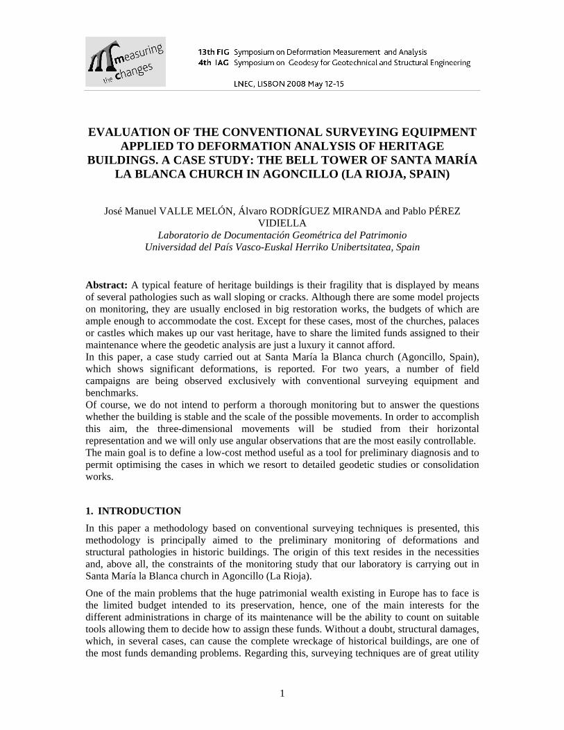
The church of Santa María la Blanca, is a single nave building built in ashlar masonry whose main construction belongs to the 16th century according to the existing documentation, the west façade would be erected at the beginning of the 17th century, the side chapels were added during the 18th century and the bell tower, which is the main subject of this study, started to be built in 1794 (Moya Valgañón, 1975). This source does not mention any of the currently visible pathologies: the west façade (in which the door is embedded) presents many cracks of considerable size and the tower that joints it on the north appears noticeably detached with a leaning of about 2 degrees; in spite of this, consulted neighbours say that they have always known the tower in that way; however, they disagree whether they have noticed an increase in the number or size of the cracks and the leaning of the tower.
1 The development of new low-cost methods is an emerging research line in heritage documentation, as it can be seen in the International Society for Photogrammetry and Remote Sensing Commission V Close-Range Sensing: Analysis and Applications, in which, within the Work Group V/2 – CULTURAL HERITAGE DOCUMENTATION there is, as a working line: “Development of low-cost and rapid techniques in documentation and monitoring of the cultural heritage”. (http://www.isprs.org/technical_commissions/wgtc_5.html#wg5/2)
3
Figure 1 - Santa María la Blanca’s church and its leaning bell tower
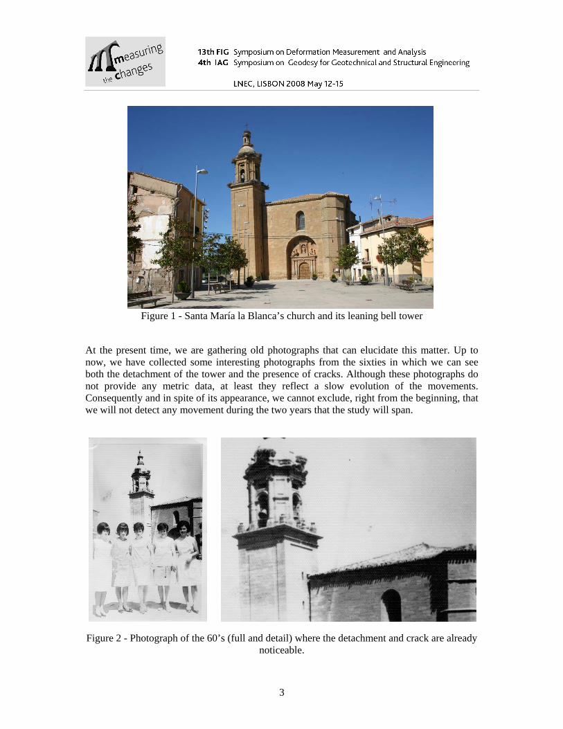
At the present time, we are gathering old photographs that can elucidate this matter. Up to now, we have collected some interesting photographs from the sixties in which we can see both the detachment of the tower and the presence of cracks. Although these photographs do not provide any metric data, at least they reflect a slow evolution of the movements. Consequently and in spite of its appearance, we cannot exclude, right from the beginning, that we will not detect any movement during the two years that the study will span.
Figure 2 - Photograph of the 60’s (full and detail) where the detachment and crack are already noticeable.

4
2. PLAN OF THE STUDY
Buildings are dynamic structures subjected to series of cyclic movements; therefore, the aim cannot consist only of detecting movements but in being able to recognize them as regular or anomalous in these natural time periods (Taliercio and Binda, 2007). On the other hand, the existence of pathologies in historical buildings does not always involve risk of imminent collapse, since a priori, it is unknown whether the visible pathologies (in our case, the cracks and the leaning of the tower) correspond to old processes already stabilised or they are caused by strengths that are currently acting on the building and thus they are in continuous advancement (Carpinteri et al, 2004). In order to illustrate these ideas, the following images (Azkarate et al, 2001) show the temporal behaviour of two cracks controlled by extensometers, we can appreciate that the movement is composed of a group of cyclic effects with different periods (daily: day-night, seasonal: summer-winter, etc). In the chart on the left we can see that these movements come back completely, which might made us think about a possible stability, on the contrary, the chart on the right shows a tendency besides the cyclic behaviour.
Figure 3 - Example of temporal behaviour of two cracks in Santa María Cathedral (Vitoria) (Azkarate et al, 2001)
These kinds of movements, the tendencies, are interesting to detect because they are what determines the instability of the building. Cyclic movements can be considered within the natural dynamic of the structure; however, it is most interesting to know their amplitude with the aim of being able to discriminate between them and the anomalous movements. Handbooks and official rules provide tables with values of deformation due to changes in temperature and moisture conditions for different materials; however, it is not easy to have at our disposal reliable data for cyclic effects since they are very dependent on the constructive characteristics of the building as well as to their location; consequently, it will be necessary to plan the observation campaigns in a suitable way. We will come back to this point later.
First of all, we need to determine what we are going to measure and where (which points). Respecting the points, nowadays, we will point out two alternatives: face to the traditional one consisting of making comparisons between discrete sets of points measured at different epochs, it can mentioned a new one, powered by the massive acquisition systems (like the 3D laser scanners) which register large amounts of points, in this case, the comparisons between epochs are not usually made directly with the points but the surfaces generated from them

5
(Sternberg, 2006). After analysing both alternatives and taking into account the proposed methodological objectives, we have chosen to work only with a set of strategically placed points, since this adapts better to the available surveying equipment, more wide spread, cheaper and the data of which can be used immediately after the acquisition without specific software. In order to simplify as much as possible the observation process and later calculations, we decided to use angular observation exclusively as these observables are easier to control and to limit the calculation to the XY plane, that is to say, the displacements are not measured in 3D but in their horizontal representation.
As for the targets placed on the buildings, it is advisable (and sometimes compulsory) that the nails or screws are inserted only in the joints between ashlars, without piercing them or glued by means of a high resistance adhesive which does not degrade the stone.
Several doubts arose when determining the most suitable sort of target for the observation, in the end, we decided to use two alternatives and analyse which one behaves better: the first one is a set of plates of stainless steel (100 x 70 mm) with its number carved and an adhesive stick with all the information about the project, the observation point is a hole of 1 mm diameter in the middle. During the campaign, these targets permit an easy location and identification, nevertheless, the central point does not always have a clear definition. On the other hand, we have embedded stainless steel nails of 5 mm diameter with a cross engraved on their head; these nails were placed near the plates. Generally, pointing at the nail is more accurate than pointing at the plate; nonetheless, they would be rather difficult to locate without the plates. Anyhow, before we can state which kind of target is more appropriate we have to see how time will affect them.
Figure 4 - Plate with information about the project and nail (bottom right).
Targets are distributed all over the tower on four levels (ground, 8 meters, 15 meters and 25 meters on the belfry), the west and north façades of the church (three levels) and on the nearest buildings for external reference. The total of points is rather high, about 50, owing to the double set of targets. In the following image we can see their placement on the west façade and tower.

6
Figure 5 - Placement of the targets, red circles indicate the position of some of them.
It is worth mentioning that on the lower places, within people’s reach, we have only placed nails because the plates can be easily damaged; however, we decided to include two “fake” plates at approximately 1.5 meters above the ground whose aim is to inform the neighbours about the project and search their implication.
The construction of pillars was not an option, neither for the budget nor for the nuisances that they would cause to the neighbours, we must bear in mind that the square is a public space that, among other uses, is the place of a weekly market (on Fridays, which prevents observing this day). Therefore, we resort to set up the total station (in this project, we are using a Leica TCR1205 R3002) over a combination of tripod and tribrach like a kind of forced centering equipment. We complete the group of observation placing three additional tripods with tribach and prism. A second group of four tripods is necessary to cover all targets; however, if both groups can be observed on the same day, it is possible to share a point, as it is shows in the following image:

7
Figure 6 - Plan sketch of the layout of the targets and stations.
Although we have measured distances between stations, we have not included them in the preliminary adjustments because we could not take suitable atmospheric data for their precise correction; nevertheless, they were used to obtain the approximate coordinates of the stations.
Each target is observed from three different references, following the well-know sequence DPreference-DPtarget-RPtarget-RPreference (DP: direct position, RP: reverse position). The configuration was designed so that each target is observed from at least three stations.
Targets on the church
Targets on adjacent buildings
Stations

8
Figure 7: Set up of the surveying field work
In order to track the annual cycle, the field campaigns are planed every three months for two years; they fit the moments when the amplitude is supposed to be highest (July and January) and two intermediate campaigns (April and October). With all these epochs we intend to determine whether the magnitude is appreciable or it lays below our discrimination limit, taking into account that the a priori root mean square error for the accuracy of each coordinate by surveying techniques is about 2 mm.
As the field work is rather laborious and takes most of the day (between 8 and 16 hours depending on the number of targets considered, which represents 1 or 2 whole days), the daily effect of the displacements is integrated in the accuracy of the established coordinates for each epoch since measures taken during the morning and in the evening are computed together.
3. ACCOMPLISHED EPOCHS
Three epochs has been observed to date: July 2007, October 2007 and January 2008, so only preliminary computations are available. Up to now, we have focused on checking the accuracy of the coordinates that can be computed rather than try to detect possible displacements.
The coordinates of a single epoch can be calculated with root mean square errors of about 2 mm, which fits with the expected values according to the bibliography.
During the second ant third campaigns, we made some analysis oriented towards refining the observation procedure: how to speed it up without loss of accuracy, which points are superfluous, whether it is worth adding a fourth reference for each target, if there is any gain after shifting the position of the tripods and so on. As a result of these tests, we have developed a simplified scheme with only half of the targets, the most meaningful ones, but enough to study the seasonal behaviour. The complete set of targets will be observed only in the campaigns of July.

9
From July 2008 onwards we will go on to contrast coordinates and draw conclusions about whether we can determine both the seasonal cycle and any tendencies.
4. MID-TERM WORK
The main objective of this two years’ preliminary study is to determine whether we can detect annual variations and tendencies with conventional surveying equipment. With regard to the former, we are going to investigate if there are any differences between the summer and winter’s campaigns which are recovered when we contrast two epoch of the same season, we do not know what the magnitude of this displacements might be but, taken into account the accuracy of our measures, if they are not, at least, about one centimetre, this effect will lay below our limit of discrimination. As this cycle repeats itself yearly a two-year period is enough to clarify this question and the fact of extending it will not provide more relevant data.
On the contrary, the span of the study might not be as long as necessary to detect any tendency, therefore, the data had to be conserved for their future use, which requires that they are conveniently documented by means of detailed reports, collections of photographs and lists of observations, all these adapted to standards and with their corresponding metadata so that, in several years’ time, anyone will be able to obtain new measures of the building and contrast them with the stored ones.
Although we are more than a year left until finishing observations and it is too early to decide what actions the results will suggest to the techniques in charge of its maintenance, we can foresee three possibilities:
1. In case a tendency was detected, they would probably prolong the monitoring, either by observing additional epochs or with new studies permitting a more detailed knowledge of the problem.
2. If no definitive tendency appeared, we might proceed in a different way depending on whether any seasonal cycle had been detected or not:
2.1.- In the absence of seasonal variations, we might proceed to adjust all epochs together in order to obtain a set of coordinates for the period 2007-2009 which would keep as a reference for their contrast with further studies. 2.2.- If, finally, a seasonal variation was detected, separate adjustments could be made for each season.
5. CONCLUSIONS
We describe a monitoring project in a historic building by means of conventional surveying equipment and methods herein. We point out some special features such as the lack of funding, their location in public spaces or the fact that a close relationship between the inhabitants of the place and the building itself exists. All these constraints could prevent the development of a study following the regular procedures like the monumentation of reference points or the use of specific equipment and targets.
As we are not dealing with ideal conditions, we have to shorten the scope of the monitoring and to concentrate it in a few specific items we can control easily. Even though a limited study will not provide a full knowledge of the dynamic of the building, it will still supply

10
enough information for the technicians in charge of its maintenance to draw some useful conclusions.
The accuracy that the conventional surveying methods can achieve, about 2 mm (RMSE), seems adequate for this type of projects bearing in mind that even if these structures are not undergoing decimetric deformations like the ones described by (Radulescu G., 2006) for very tall metallic stacks, they are subjected to a great number of factors which make submillimetric accuracy unattainable (for instance, the oscillation induced by a bell swinging can reach an amplitude of half a millimeter ((Ivorra and Pallarés, 2006), (Pieraccini et al, 2007))).
Finally, we want to remark the necessary implication of the town in the project, these studies should not be perceived as a nuisance or an alarm, for that reason, we think that initiatives such as the placement lure-targets to be examined and touched, the request of old photographs and further information about the happenings of the building or periodic reports of the obtained outputs to the population must be also encouraged.
Acknowledgments
We would like to thank the council of Agoncillo and the Consejería de Cultura of the government of La Rioja for the financial support and the neighbours of the town for the assistance provided during the development of the work and for the photographs given. We also appreciate the kindness of the Fundación Catedral de Santa María de Vitoria for handing over the images in figure 1. References
Azkarate, A.; Cámara, L.; Lasagabaster, J.I.; Latorre, P. (2001). Cateral de Santa María Vitoria-Gasteiz, Plan Director de Restauración. Vitoria (Spain): Diputación Foral de Álava y Fundación Catedral Santa María de Vitoria.
Bernardeschi K.; Padovani C.; Pasquinelli G. (2004). Numerical modelling of the structural behaviour of Buti’s bell tower. Journal of Cultural Heritage 371-378. Elsevier.
Binda, L.; Saisi A.; Tiraboschi C. (2000). Investigations procedures for the diagnosis of historic masonries. Construction and Building Materials 14 199-233. Elsevier.
Carpinteri A.; Invernizzi S.; Laciogna G. (2005). In situ damage assessment and nonlinear modelling of a historical masonry tower. Engineering Structures 27 387-395. Elsevier.
Ivorra S.; Pallarés F.J. (2006). Dynamic investigations on a masonry bell tower. Engineering Structures 28 660-667. Elsevier.
Modena C.; Valluzzi N.R.; Tongini Folli R.; Binda L. (2002). Design choices and intervention techniques for repairing and strengthening of the Monza cathedral bell-tower. Construction and Building Materials 16 385-395. Elsevier.
Moya Valgañon, J.G. (1975). Inventario artístico de Logroño y su provincia, tomo I (Abalos- Cellorigo). Madrid: Ministerio de Educación y Ciencia, Dirección General del Patrimonio Artístico y Cultural. pp. 19-20.

11
Pieraccini M.; Parrini F.; Dei D.; Fratini M.; Atzeni C.; Spinelli P. (2007). Dynamic characterization of a bell tower by interferometric sensor. NDT&E International 390-396. Elsevier.
Radulesky G.M.T. (2006). Monitoring the behaviour of very tall structures under the actino of non-uniform sunlight. The case of a 350 m high chimneystack from Baia Mare, Romania. 3rd IAG / 12th FIG Symposium, Baden (Germany), May 22-24.
San José J.I.; Fernández Martín J.J.; Pérez Moneo J.D.; Finat J.; Martínez Rubio J. (2007). Evaluation of structural damages from 3D laser scans. XXI International CIPA Symposium, 01-06 October, Athens (Greece).
Sternberg H. (2006). Deformation measurements at historical buildings with the help of three-dimensional recording methods and two-dimensional surface evaluations. 3rd IAG / 12th FIG Symposium, Baden (Germany), May 22-24.
Taliercio A.; Binda L. (2007). The basílica of San Vitale in Ravenna: investigation on the current structural faults and their mid-term evolution. Journal of Cultural Heritage 8 99-118. Elsevier.
Corresponding author contacts José Manuel VALLE MELÓN ([email protected])
Álvaro RODRÍGUEZ MIRANDA ([email protected]) Laboratorio de Documentación Geométrica del Patrimonio (http://www.ldpg.es) Universidad del País Vasco-Euskal Herriko Unibertsitatea Spain