EVALUATION OF RAINFALL UNOFF RELATIONSHIPS · PDF filecollect pollution like heavy metals,...
4
Project Members: Drew Beckwith Christy Ciarametaro Maya Dehner Mike Rossiter Joanne Siew Project Advisor: John Melack EVALUATION OF RAINFALL-RUNOFF RELATIONSHIPS TO DEVELOP STORMWATER REDUCTION STRATEGIES IN SOUTH COAST WATERSHEDS ON THE WEB AT HTTP://WWW.BREN.UCSB.EDU SPRING 2007 GROUP PROJECT BRIEF Motivation The impact of impervious surfaces on stormwater runoff and water quality has been studied by many scientists. Impervious surfaces inhibit the natural infiltration of rainwater into the ground, which leads to more stormwater runoff and higher stormwater peak flows. Streets, parking lots, and other transportation-related structures comprise the bulk of impervious surfaces within a watershed and, as such, collect pollution like heavy metals, grease, and oils. Runoff generated by early-season rains can mobilize and transport these pollutants and other contaminants, like harmful bacteria, to streams. These pollutants impact the health of receiving streams as well as the coastal waters into which these streams flow. The traditional method of managing stormwater has been to remove runoff as quickly as possible from the area through large pipes and concrete channels. An alternative to this strategy, known as low-impact development, establishes economic and land-use planning policies aimed at reducing stormwater runoff in combination with stormwater best management practices (BMPs) that treat stormwater on site. Goals Using a rainfall-runoff model, extensive literature review, and personal interviews, this project addresses the following questions for two Santa Barbara watersheds: Watershed Background The Mission Creek and Atascadero watersheds are located in the south-east portion of Santa Barbara County. Both watersheds begin in the mountainous headwaters of the Santa Ynez, pass through the developed, sloping coastal plain and drain into the Pacific Ocean. These watersheds are characterized by a Mediterranean climate with mild moist winters and moderately warm, generally rainless summers. “Flashy” winter rainstorms, which are usually of an intermittent and intense nature, provide most of the flow in the drainage network. El Niño/Southern Oscillation events significantly influence precipitation in the watersheds, causing large variations in annual precipitation ranging from less than 180mm/yr (~7”) to more than 1100mm/yr (~43”) (LTER 2006). The human population and its related impervious areas, dominate the mid- and lower-watersheds (Figure 1). Figure 1. Land use within Mission Creek and Atascadero watersheds. Black areas contain high levels of impervious surfaces. Modeling Two previously-calibrated HEC-HMS models (Beighley et al. 2003) were used to predict runoff characteristics under a variety of climatic conditions and impervious coverage reduction scenarios (Figure 2). The principle intention of this modeling exercise was to test whether changes in impervious surface coverage across the mid- and lower-Mission and Atascadero watersheds significantly alter runoff from those watersheds. The HEC-HMS modeling framework was specifically chosen because of its ability to accurately represent the flashy nature of 1. How does reducing imperviousness affect watershed runoff? 2. What types of materials should be used to replace impervious areas? 3. How can water agencies and other institutions encourage the use of these replacements?
Transcript of EVALUATION OF RAINFALL UNOFF RELATIONSHIPS · PDF filecollect pollution like heavy metals,...
Project Members:
Drew Beckwith
Christy Ciarametaro
Maya Dehner
Mike Rossiter
Joanne Siew
Project Advisor:
John Melack
EVALUATION OF RAINFALL-RUNOFF RELATIONSHIPS TO DEVELOP
STORMWATER REDUCTION STRATEGIES IN SOUTH COAST WATERSHEDS
ON THE WEB AT HTTP://WWW.BREN.UCSB.EDU SPRING 2007
GROUP PROJECT BRIEF
Motivation The impact of impervious surfaces on stormwater runoff and water quality has been studied by many scientists. Impervious surfaces inhibit the natural infiltration of rainwater into the ground, which leads to more stormwater runoff and higher stormwater peak flows. Streets, parking lots, and other transportation-related structures comprise the bulk of impervious surfaces within a watershed and, as such, collect pollution like heavy metals, grease, and oils. Runoff generated by early-season rains can mobilize and transport these pollutants and other contaminants, like harmful bacteria, to streams. These pollutants impact the health of receiving streams as well as the coastal waters into which these streams flow. The traditional method of managing stormwater has been to remove runoff as quickly as possible from the area through large pipes and concrete channels. An alternative to this strategy, known as low-impact development, establishes economic and land-use planning policies aimed at reducing stormwater runoff in combination with stormwater best management practices (BMPs) that treat stormwater on site. Goals Using a rainfall-runoff model, extensive literature review, and personal interviews, this project addresses the following questions for two Santa Barbara watersheds:
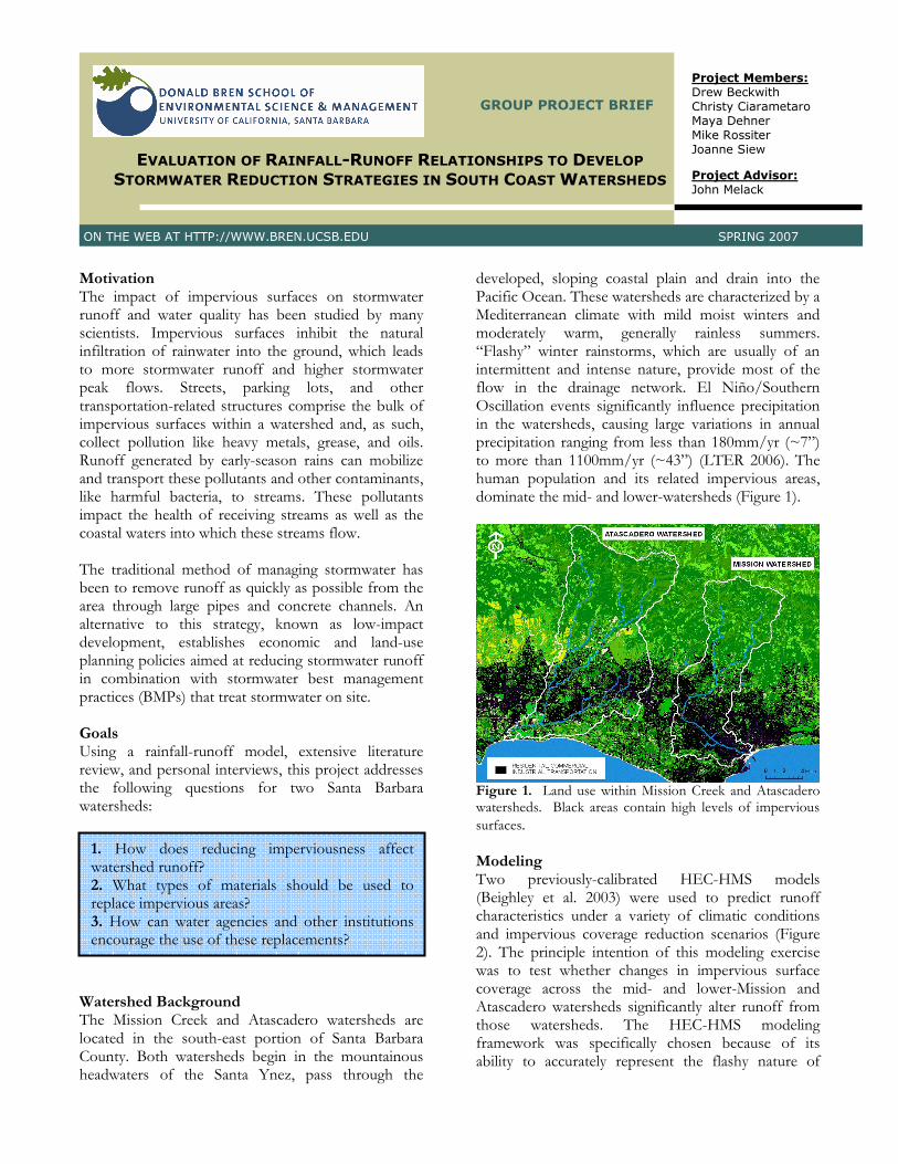
Watershed Background The Mission Creek and Atascadero watersheds are located in the south-east portion of Santa Barbara County. Both watersheds begin in the mountainous headwaters of the Santa Ynez, pass through the
developed, sloping coastal plain and drain into the Pacific Ocean. These watersheds are characterized by a Mediterranean climate with mild moist winters and moderately warm, generally rainless summers. “Flashy” winter rainstorms, which are usually of an intermittent and intense nature, provide most of the flow in the drainage network. El Niño/Southern Oscillation events significantly influence precipitation in the watersheds, causing large variations in annual precipitation ranging from less than 180mm/yr (~7”) to more than 1100mm/yr (~43”) (LTER 2006). The human population and its related impervious areas, dominate the mid- and lower-watersheds (Figure 1).
Figure 1. Land use within Mission Creek and Atascadero watersheds. Black areas contain high levels of impervious
surfaces. Modeling Two previously-calibrated HEC-HMS models (Beighley et al. 2003) were used to predict runoff characteristics under a variety of climatic conditions and impervious coverage reduction scenarios (Figure 2). The principle intention of this modeling exercise was to test whether changes in impervious surface coverage across the mid- and lower-Mission and Atascadero watersheds significantly alter runoff from those watersheds. The HEC-HMS modeling framework was specifically chosen because of its ability to accurately represent the flashy nature of
1. How does reducing imperviousness affect watershed runoff? 2. What types of materials should be used to replace impervious areas? 3. How can water agencies and other institutions encourage the use of these replacements?
GROUP PROJECT BRIEF SPRING 2007
2
Santa Barbara area meteorological conditions. Unlike many other hydrologic models intended to be run with a daily or hourly precipitation time step, HEC-HMS can run on a 15-minute time step.
Figure 2. Runoff was modeled under a variety of scenarios by selecting one condition from each row.
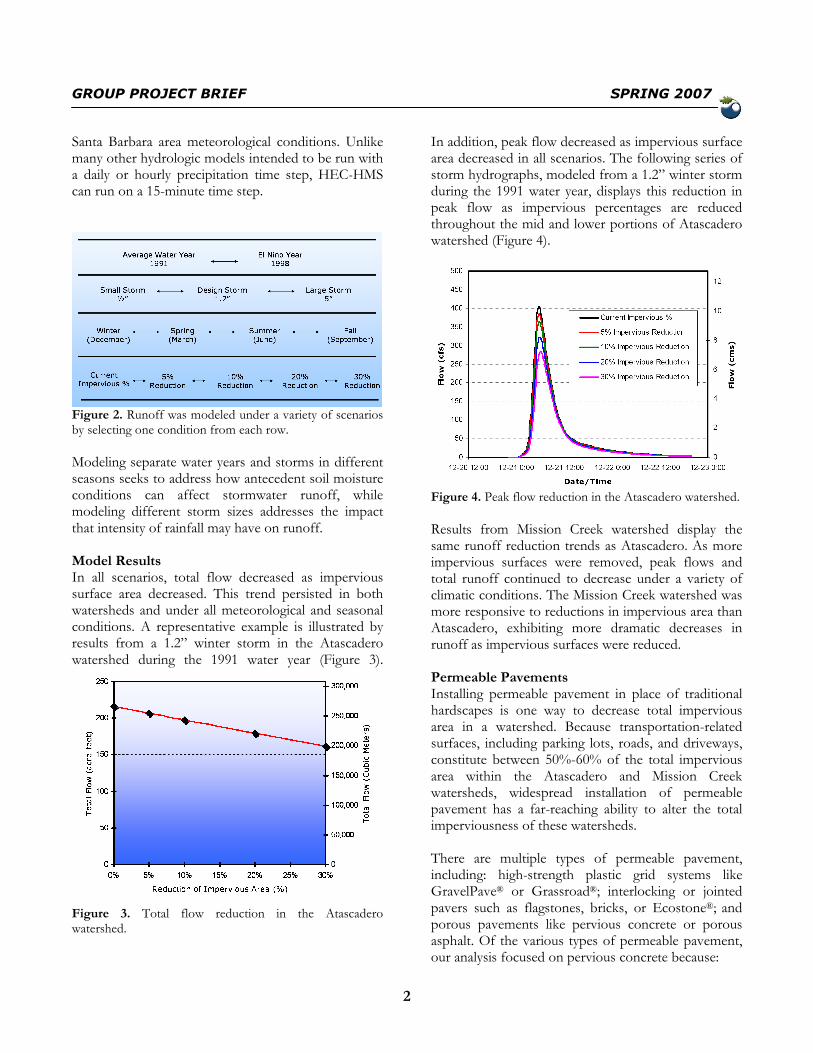
Modeling separate water years and storms in different seasons seeks to address how antecedent soil moisture conditions can affect stormwater runoff, while modeling different storm sizes addresses the impact that intensity of rainfall may have on runoff. Model Results In all scenarios, total flow decreased as impervious surface area decreased. This trend persisted in both watersheds and under all meteorological and seasonal conditions. A representative example is illustrated by results from a 1.2” winter storm in the Atascadero watershed during the 1991 water year (Figure 3).
Figure 3. Total flow reduction in the Atascadero watershed.
In addition, peak flow decreased as impervious surface area decreased in all scenarios. The following series of storm hydrographs, modeled from a 1.2” winter storm during the 1991 water year, displays this reduction in peak flow as impervious percentages are reduced throughout the mid and lower portions of Atascadero watershed (Figure 4).
Figure 4. Peak flow reduction in the Atascadero watershed.
Results from Mission Creek watershed display the same runoff reduction trends as Atascadero. As more impervious surfaces were removed, peak flows and total runoff continued to decrease under a variety of climatic conditions. The Mission Creek watershed was more responsive to reductions in impervious area than Atascadero, exhibiting more dramatic decreases in runoff as impervious surfaces were reduced. Permeable Pavements Installing permeable pavement in place of traditional hardscapes is one way to decrease total impervious area in a watershed. Because transportation-related surfaces, including parking lots, roads, and driveways, constitute between 50%-60% of the total impervious area within the Atascadero and Mission Creek watersheds, widespread installation of permeable pavement has a far-reaching ability to alter the total imperviousness of these watersheds. There are multiple types of permeable pavement, including: high-strength plastic grid systems like GravelPave® or Grassroad®; interlocking or jointed pavers such as flagstones, bricks, or Ecostone®; and porous pavements like pervious concrete or porous asphalt. Of the various types of permeable pavement, our analysis focused on pervious concrete because:

GROUP PROJECT BRIEF SPRING 2007
3
• pervious concrete is strong, durable, and well-suited to replace transportation-related surfaces
• the pollutant reduction capabilities of porous concrete have been studied in the peer-reviewed literature
• there is local interest for installing pervious concrete in the Santa Barbara area
• there are local contractors who have experience installing pervious concrete
Figure 4. Pervious concrete, “When it rains, it drains.”
Areas covered by permeable pavement produce almost no runoff. Multiple studies suggest that on average, only 3% of total rainfall runs off permeable pavement surfaces (upwards of 90% of rainfall runs off asphalt). The remainder either infiltrates into the ground or is temporarily stored within the pavement and then evaporates. Pervious concrete has the unique ability to reduce stormwater pollution. Stormwater pollutants, such as those in Table 1, can be reduced by 95% or more after passing through pervious concrete (Dierkes et al. 1999). These pollutants become physically trapped within the pavement or are degraded by microbes living within the pavement structure. Pathogens are the leading cause of water quality impairments for the South Coast region, however no existing research suggests that permeable pavement can reduce bacterial pollution.
Table 1. Some stormwater pollutants and their likely source.
Pollutant Potential Source
Lead and Zinc Tire wear, lubricating oil and grease, bearing wear
Copper and Chromium
Metal plating, wear of engine parts, brake lining wear
Manganese Moving engine parts, auto exhaust Hydrocarbons Spills and leaks of motor lubricants Pervious concrete has many other benefits in addition to its volume and pollutant reduction capabilities. It is exceptional at reducing “1st flush” stormwater pollution, promotes groundwater recharge, can be used to gain LEED credits, reduces the urban heat-island effect, is safer for driving and for people with disabilities, and is potentially cheaper than traditional stormwater management strategies. Before permeable pavement is installed at a particular location, some issues need to be addressed. Two main concerns include pavement clogging and the ability of the underlying soil to infiltrate stormwater. Clogging can easily be alleviated through regular maintenance, but some soil conditions within the two watersheds, like those in downtown Santa Barbara, may preclude the use of permeable pavement. This is the exception, however. Policy Recommendations Significant efforts have been made by the City and County of Santa Barbara to require the use of structural and non-structural BMPs to reduce the incidence of stormwater runoff in new developments. Most of the existing policies are aimed at developers and commercial property owners and are regulatory in nature. In order to address stormwater runoff pollution problems more effectively at a watershed scale, a wider spectrum of the community, such as private homeowners, should be included. A stormwater management credit program provides monetary incentives for developers, builders, and private property owners to implement runoff reduction strategies during the pre- and post-construction phases. These credit programs are used in multiple municipalities throughout the US and have many attributes that could easily be transferred to the Santa Barbara area.
GROUP PROJECT BRIEF SPRING 2007
4
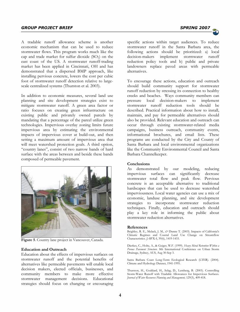
A tradable runoff allowance scheme is another economic mechanism that can be used to reduce stormwater flows. This program works much like the cap and trade market for sulfur dioxide (SO2) on the east coast of the US. A stormwater runoff-trading market has been applied in Cincinnati, OH and has demonstrated that a dispersed BMP approach, like installing pervious concrete, lowers the cost per cubic foot of stormwater runoff detection relative to large-scale centralized systems (Thurston et al. 2003). In addition to economic measures, several land use planning and site development strategies exist to mitigate stormwater runoff. A green area factor or ratio focuses on creating green infrastructure on existing public and privately owned parcels by mandating that a percentage of the parcel utilize green technologies. Impervious overlay zoning limits future impervious area by estimating the environmental impacts of impervious cover at build-out, and then setting a maximum amount of impervious area that will meet watershed protection goals. A third option, “country lanes”, consist of two narrow bands of hard surface with the areas between and beside these bands composed of permeable pavement.
Figure 5. Country lane project in Vancouver, Canada.
Education and Outreach Education about the effects of impervious surfaces on stormwater runoff and the potential benefits of alternatives like permeable pavements will enable local decision makers, elected officials, businesses, and community members to make more effective stormwater management decisions. Educational strategies should focus on changing or encouraging
specific actions within target audiences. To reduce stormwater runoff in the Santa Barbara area, the following actions should be prioritized: a) local decision-makers implement stormwater runoff reduction policy tools and b) public and private landowners replace paved areas with permeable alternatives. To encourage these actions, education and outreach should build community support for stormwater runoff reduction by stressing its connection to healthy creeks and beaches. Ways community members can pressure local decision-makers to implement stormwater runoff reduction tools should be described. Practical information about how to install, maintain, and pay for permeable alternatives should also be provided. Relevant education and outreach can occur through existing stormwater-related media campaigns, business outreach, community events, informational brochures, and email lists. These programs are conducted by the City and County of Santa Barbara and local environmental organizations like the Community Environmental Council and Santa Barbara Channelkeeper. Conclusions As demonstrated by our modeling, reducing impervious surfaces can significantly decrease stormwater total flow and peak flow. Pervious concrete is an acceptable alternative to traditional hardscapes that can be used to decrease watershed imperviousness. Local water agencies can use a mix of economic, landuse planning, and site development strategies to incorporate stormwater reduction techniques. Finally, education and outreach should play a key role in informing the public about stormwater reduction alternatives. References Beighley, R. E., Melack, J. M., & Dunne T. (2003). Impacts of California's Climatic Regimes and Coastal Land Use Change on Streamflow Characteristics. JAWRA, 39(6), 1419-1433. Dierkes, C., Holte, A., & Geiger, W.F. (1999). Heavy Metal Retention Within a Porous Pavement Structure. 8th International Conference on Urban Storm Drainage, Sydney, AUS, Aug 30-Sep 3. Santa Barbara Coast Long-Term Ecological Research (LTER). (2004). Climate and Hydrology Dataset, 1941-1995. Thurston, H., Goddard, H., Szlag, D., Lemberg, B. (2003). Controlling Storm-Water Runoff with Tradable Allowances for Impervious Surfaces. Journal of Water Resources Planning and Management, 129(5), 409-418.