
Evaluation of radiance data assimilation impact on Rapid Refresh forecast skill for retrospective...
31
Evaluation of radiance data assimilation impact on Rapid Refresh forecast skill for retrospective and real-time experiments Haidao Lin Steve Weygandt Stan Benjamin Ming Hu Curtis Alexander Patrick Hofmann Assimilation and Modeling Branch Global Systems Division NOAA Earth System Research Lab Boulder, CO Cooperative Institute for Research in the Atmosphere Colorado State University http:// rapidrefresh.noaa.gov
-
Upload
ralf-powell -
Category
Documents
-
view
227 -
download
0
Transcript of Evaluation of radiance data assimilation impact on Rapid Refresh forecast skill for retrospective...

Evaluation of radiance data assimilation impact on Rapid Refresh
forecast skill for retrospective and real-time experiments
Haidao LinSteve WeygandtStan Benjamin
Ming HuCurtis AlexanderPatrick Hofmann
Assimilation and Modeling Branch
Global Systems DivisionNOAA Earth System Research
LabBoulder, CO
Cooperative Institute for Research in the Atmosphere
Colorado State University
http://rapidrefresh.noaa.gov

Presentation Outline
1. Background on Rapid Refresh (RAP) system
2. Data introduction and selected channels
3. Retrospective experiments AIRS data impact Other radiance data impact
(AMSU-A, HIRS, and MHS)
4. Real-time radiance data impact in RAP
(with hybrid EnKF assimilation)
5. Real-time RAP radiance data availability issues
6. Summary and future work

– Advanced community codes (ARW model, GSI analysis)– Key features for short-range “situational awareness”
application (cloud analysis, radar DFI assimilation) RAP guidance for aviation, severe
weather, energy applications
Background on Rapid RefreshNOAA/NCEP’s hourly updated model
RAP version 1 -- NCEP since Spring 2012
RAP version 2 -- Planned NCEP Late 2013– DA enhancements (Hybrid –
EnKF using global ensemble)
– Model enhancements(MYNN PBL, 9-layer LSM)
Improved mesoscale guidance, GSD version parent for HRRR
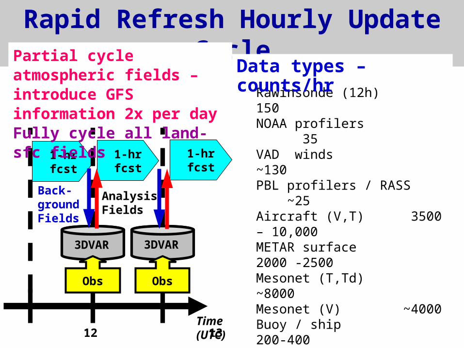
Rapid Refresh Hourly Update Cycle
1-hrfcst
1-hrfcst
1-hrfcst
11 12 13Time (UTC)
AnalysisFields
3DVAR
Obs
3DVAR
Obs
Back-groundFields
Rawinsonde (12h) 150NOAA profilers 35VAD winds ~130PBL profilers / RASS ~25
Aircraft (V,T) 3500 – 10,000METAR surface 2000 -2500Mesonet (T,Td) ~8000Mesonet (V) ~4000Buoy / ship 200-400GOES cloud winds 4000-8000METAR cloud/vis/wx ~1800
GOES cloud-top P,T 10 km res.Satellite radiances (AMSUA, HIRS, MHS)Radar reflectivity 1 km res.
Data types – counts/hr
Partial cycle atmospheric fields – introduce GFS information 2x per dayFully cycle all land-sfc fields

- Hourly cycling of land surface model fields - 6-hour spin-up cycle for hydrometeors, surface fields
RAP Hourly cycling throughout the day
RAP spin-upcycle
GFSmodel
RAP spin-upcycle
GFSmodel
00z 03z 06z 09z 12z 15z 18z 21z 00z
Observationassimilation
Observationassimilation
Rapid Refresh Partial Cycling

RAP Radiance impact Testing
RETROSPECTIVE REAL-TIME
Model WRF-ARW v3.2 WRF-ARW v3.4
Analysis GSI 3DVAR GSI hybrid EnKF
(80 member global)
Cycle 3-h, NO part. cycle 1-h with part. cycle
Satellite Ideal (no latency) Actual latencyCoverage
Expts Control (conv. obs) Control (conv. obs)
CNTL+ AIRS only CNTL + all 4 sat. CNTL+AMSUA only
CNTL+HIRS onlyCNTL+MHS onlyCNTL+all 4 sat.

Radiance Data• AIRS (Focused work)
– High vertical resolution– Temperature and moisture information – Not yet operationally used in RAP,
used experimentally in GSD real-time run
• AMSU-A (Operationally used in RAP)– Temperature information
• HIRS (Operationally used in RAP)– Temperature information– Moisture information (channels 10-12)
• MHS (Operationally used in RAP)– Moisture information

Radiance Channels Selected for RAP• AIRS (remove high peaking channels)
– Aqua: 68 channels selected from 120 GDAS channel set
• AMSU-A (remove high peaking and surface channels) – metop-a: channels 4-6, 8-10– noaa_n15: channels 4-10– noaa_n18: channels 4-8, 10– noaa_n19: channels 4-7, 9-10
• HIRS (remove high peaking and ozone channels)– noaa_n19: channels 4-8, 10-15– metop-a: channels: 4-8, 10-15
• MHS– noaa_n18: channels 1-5;– noaa_n19: channels 1-5; (not available for retro run on 2010)– metop-a: channels 1-5;

Retrospective Experiments
AIRS impact
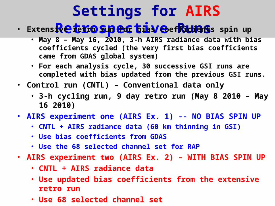
Settings for AIRS Retrospective Runs • Extensive retro run for bias coefficients spin up
• May 8 – May 16, 2010, 3-h AIRS radiance data with bias coefficients cycled (the very first bias coefficients came from GDAS global system)
• For each analysis cycle, 30 successive GSI runs are completed with bias updated from the previous GSI runs.
• Control run (CNTL) – Conventional data only• 3-h cycling run, 9 day retro run (May 8 2010 – May 16 2010)
• AIRS experiment one (AIRS Ex. 1) -- NO BIAS SPIN UP• CNTL + AIRS radiance data (60 km thinning in GSI)
• Use bias coefficients from GDAS
• Use the 68 selected channel set for RAP
• AIRS experiment two (AIRS Ex. 2) – WITH BIAS SPIN UP• CNTL + AIRS radiance data• Use updated bias coefficients from the extensive retro run• Use 68 selected channel set

AIRS Bias Correction Assessment
After BC
Before BC
channel 252 (CO2 channel ~672h Pa
Channel 1382 (water vapor channel ~866 hPa
With BCSpin-up
Without BCSpin-up

Number of Observations Used
Water vaporCarbon dioxideSurface
o Without BC spin-up * With BC spin-up
Better BC more obs used improved BC

AIRS Forecast Impact (against raob, 100-1000 hPa)
Normalize Errors
EN = (CNTL – EXP)
CNTL
Temperature
Relative Humidity
Wind9-day retro
average
Control run: conventional data only
AIRS Ex. 2(w/ BC spin-up)
AIRS Ex. 1(w/o BC spin-up)
+1%
-1%
0%

Retrospective Experiments
AMSU-A impactMHS impactHIRS impact
All impact (AIRS + AMSU-A + MHS + HIRS)

Settings for other Radiance Retrospective Runs
• Extensive retro run for bias coefficients spin up• Control run (CNTL) – conventional data only
• 3-h cycling run, 9 day retro run
(May 8 2010 – May 16 2010)• AMSU-A experiment – WITH BIAS SPIN UP
• CNTL + AMSU-A radiance data• MHS experiment – WITH BIAS SPIN UP
• CNTL + MHS radiance data • HIRS experiment – WITH BIAS SPIN UP
• CNTL + HIRS radiance data

AMSU-A Forecast Impact
Control run: conventional data only
9-day retro average
Forecast verification against raob. for 100-1000-hPa layer over a national domain
AMSU-A data from NOAA_15, 18, 19 and METOP-A
Temperature Relative Humidity
Wind
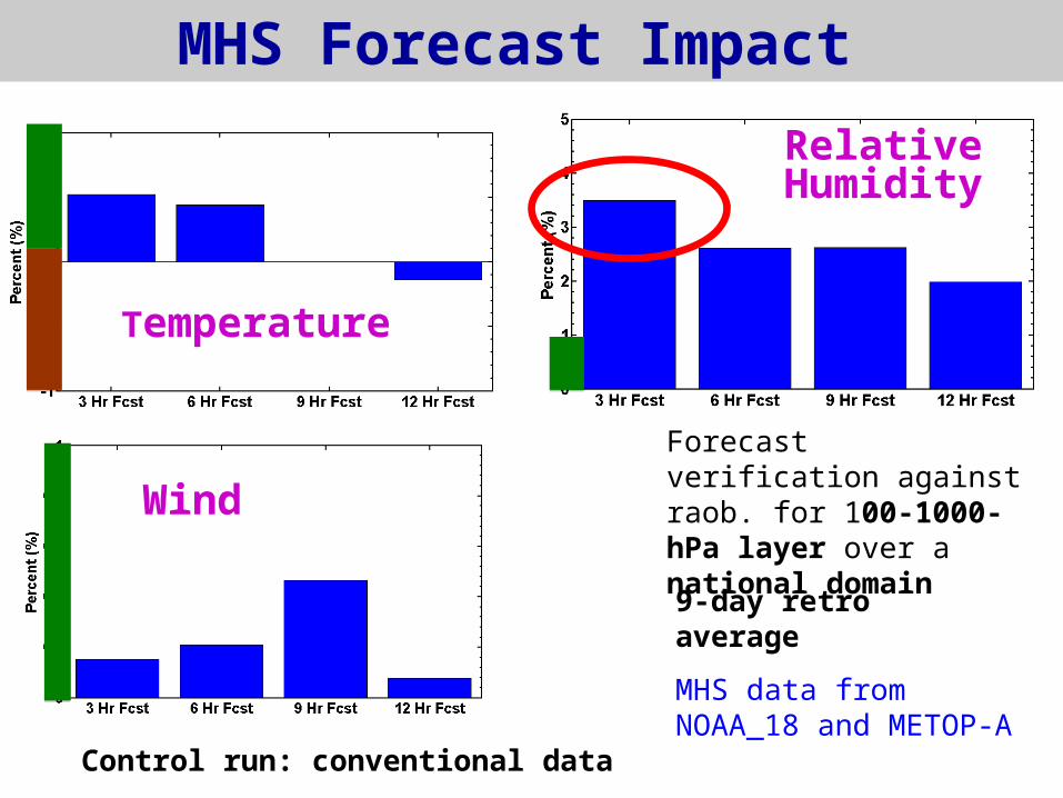
MHS Forecast Impact
Control run: conventional data
9-day retro average
Forecast verification against raob. for 100-1000-hPa layer over a national domain
Temperature
Relative Humidity
Wind
MHS data from NOAA_18 and METOP-A

HIRS Forecast Impact
control run: conventional data
Forecast verification against raob. for 100-1000-hPa layer over a national domain
9-day retro average
HIRS4 data from NOAA_19 and METOP-A
Temperature
Relative Humidity
Wind

Comparison of Radiance Impact
Control run: conventional data
Forecast verification against raob. for 100-1000-hPa layer over a national domain
9-day retro average
TemperatureRelative Humidity
Wind
AIRS
AMSU-A
HIRS
MHS
All

24-h (2 X 12h) Precipitation VerificationCSI by precip threshold(avg. over eight 24h periods)
AIRS
CNTL (conventional data )
MHS
HIRS
AMSU-ASlight improvement
for heavy precipitation thresholds from
radiance data
MHS data have largest positive impact for heavy precipitation prediction
Real-time Experiments
All impact (AIRS + AMSU-A + MHS + HIRS)

Real-Time RAP Runs
• Real-time RAP hybrid systems on Zeus: • 1-h cycling with partial cycle• real-time data
• Time period: May 29 – June 4 2013• RAP dev_sat_1: Control run (CNTL)
• conventional data only• RAP dev_sat_2: radiance experiment run
• conventional data + radiance data
(AIRS, MHS, HIRS, AMSU-A)
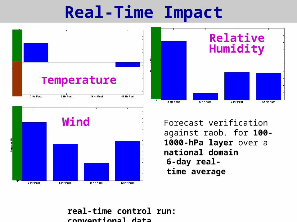
Real-Time Impact
real-time control run: conventional data
Temperature
Relative Humidity
Wind Forecast verification against raob. for 100-1000-hPa layer over a national domain
6-day real-time average

Data Availability Issues
Estimating fraction of data used
Initial examination of Regional ATOVSRetransmission Services (RARS) data

Estimating fraction of data used
short data cutoff times combined with long data availability latency times leads to minimal satellite data availability
W = Data Window Time
L = Data Latency Time
C = Data Cutoff Time
W = 180 minL = 60 minC = 30 min
(W/2 - L + C)/W
= 33% obsused
after cutoffdata
latencycutoff time
Diagram and equationfollowing Steve Lord
Samplecase
data window initial time03z02z 04z 05z 06z
dataavailable
0130z 0230z 0330z 0430z Obs time
Fraction of data used given by:

Real-Time Data Availability -- RARS
AMSU-A channel 3 from NOAA_18
Real-Time RAP
IDEAL -- No latency/cutoff
RARS feed (not used in real-time yet)
18Z May 29, 2013
Assuming +/- 1.5 h time window

AMSU-A RARS Data Coverage
12Z 13Z 14Z 15Z 16Z 17Z
18Z 19Z 20Z 21Z 22Z 23Z
RAP used +/- 1.5 hour data window
RARS +/- 1.5 hour data window
RAP used +/- 1.5 hour data window
RARS +/- 1.5 hour data window
May 29, 2013, NOAA_19
1741

Summary Retrospective runs
AIRS Focused-- Positive impact for short-range skill after BC spin-up;
improved BC result in more data assimilated
Overall (AIRS, AMSU-A, MHS, HIRS)-- Temperature: Positive impact for AIRS (largest) and MHS;
negative impact from HIRS data-- Moisture: Positive impact from all; max for MHS (3.5% for
3-h fcst); descending order: MHS, AIRS, AMSU-A, HIRS, -- Wind: Positive impact from AMSU-A, AIRS; the largest
impact from AMSU-A (more than 2.5% at 12-h forecast)-- Precipitation: Small positive impact at high threshold
for MHS
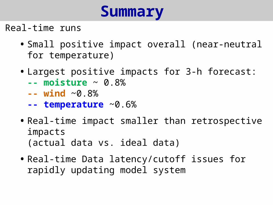
Summary Real-time runs
• Small positive impact overall (near-neutral for temperature)
• Largest positive impacts for 3-h forecast:-- moisture ~ 0.8%-- wind ~0.8%-- temperature ~0.6%
• Real-time impact smaller than retrospective impacts(actual data vs. ideal data)
• Real-time Data latency/cutoff issues for rapidly updating model system
Future Work• Investigate negative/neutral impacts for AMSU-A/HIRS data
• Model top problem -- Increase RAP model top and model levels (for experiment
purpose) -- Blending GFS fields
• Real-time data latency problem-- Use RARS feed-- Partial cycle (more waiting time)
• Retro tests with new RAP hybrid system
• Tropical cyclone prediction using RAP
• New data/instruments-- METOP-B, CrIS/ATMS
• Continue retro/real-time RAP radiance assimilation testing, implement enhancements into operational RAP.


