Evaluating the Archaeological Potential of Urban Soil
7
357 This study is the result of discussions between archaeologists at the Laboratoire Archéologie et Territoires in Tours and geotechnicians from the Centre for the Development of Applied Geosciences in Bordeaux about the need to develop appropriate methods for investigating the subsoil which would meet the requirements of both research and heritage management policies (Breysse et al. 2002; Galinié et al. 2003; Laurent 2007). In every historic town, several metres of deposits separate the current top-of-subsoil layer from the geological layers. Whether this deposit is defined as archaeological or anthropological, it covers the former urban space, and its depth, stratification and state of preservation vary from place to place within a single town. It is therefore necessary to be able to assess as precisely as possible the archaeological potential of the volume of urban soil on different scales: the site, the block and the town. 1. Background The aim of this study is to answer questions about the history of towns in north-western Europe by assessing the informative potential of the subsoil. The study was based on several aspects: a) the origins of the town and how topographical elements have influenced the urban landscape; b) the transformation phases of the town marked by periods of expansion and contraction; c) the relationships between society and urban space. These phenomena have a direct influence on the distribution of socio-spatial components (Di Méo 1991; Galinié 2000) determining the stratigraphic accumulation and preservation of the subsoil: the longer and denser the land use, the deeper, more heterogeneous and disturbed is the urban soil. This is an essential point of this research work which involves reconstructing these components through the characteristics of the urban soil. It was decided to take a multi-disciplinary approach to study these characteristics. This approach was primarily archaeological but included a geotechnical stance in order to provide a different view of the heterogeneous nature of the archaeo- logical deposit. To investigate this heterogeneity, a Evaluating the Archaeological Potential of Urban Soil Amélie LAURENT Laboratoire Archéologie et Territoires, UMR6173 CITERES, Université de Tours [email protected] Abstract Information about the extent and thickness of the archaeological soil of a city is crucial for assessing scientific knowledge, for evaluating the intensity and use of the soil and for defining research strategies. Moreover, it is important to develop assessment methods which are suitable for current heritage policy, aiming at both scientific and financial profitability. This paper presents the results of a doctoral study. The aim of the thesis was to answer historical questions about cities by assessing the informative potential of data available to archaeologists. It involved looking at the characteristics of the urban soil to understand how human activities have shaped the urban space and socio-spatial elements. More specifically, the analysis focused on assessing the thickness of the urban soil and its division into distinct functional layers in the city of Tours and sites of comparison. Bringing together the perspectives of archaeologists and geotechnicians made it possible to develop stratification production models (maps charting the thickness of the archaeological deposit) and methods to model the heterogeneity of the deposit. Results reveal that a theoretical 100m² grid is sufficient to understand variations in the thickness of the deposit. Vertically, the scale of analysis needed to distinguish the so-called “homogeneous” zones is roughly 10–25cm. At the site level, an archaeological-mechanical referential frame was established for sites in Tours and Lyons. The study shows that the PANDA penetrometer can improve the characterization of the archaeological deposit. In the medium term, these advances can be furthered by developing a common referential frame for a group of sites. Keywords urban archaeology, potential archaeological soil, spatial analyst, geotechnics, geostatistics Proceedings of the 36 th CAA Conference, Budapest, 2–6 April 2008
Transcript of Evaluating the Archaeological Potential of Urban Soil

357
This study is the result of discussions between archaeologists at the Laboratoire Archéologie et Territoires in Tours and geotechnicians from the Centre for the Development of Applied Geosciences in Bordeaux about the need to develop appropriate methods for investigating the subsoil which would meet the requirements of both research and heritage management policies (Breysse et al. 2002; Galinié et al. 2003; Laurent 2007).
In every historic town, several metres of deposits separate the current topofsubsoil layer from the geological layers. Whether this deposit is defined as archaeological or anthropological, it covers the former urban space, and its depth, stratification and state of preservation vary from place to place within a single town. It is therefore necessary to be able to assess as precisely as possible the archaeological potential of the volume of urban soil on different scales: the site, the block and the town.
1. Background
The aim of this study is to answer questions about the history of towns in northwestern Europe by
assessing the informative potential of the subsoil. The study was based on several aspects:a) the origins of the town and how topographical
elements have influenced the urban land scape;b) the transformation phases of the town marked by
periods of expansion and contraction;c) the relationships between society and urban
space.
These phenomena have a direct influence on the distribution of socio-spatial components (Di Méo 1991; Galinié 2000) determining the stratigraphic accumulation and preservation of the subsoil: the longer and denser the land use, the deeper, more heterogeneous and disturbed is the urban soil. This is an essential point of this research work which involves reconstructing these components through the characteristics of the urban soil.
It was decided to take a multi-disciplinary approach to study these characteristics. This approach was primarily archaeological but included a geotechnical stance in order to provide a different view of the heterogeneous nature of the archaeological deposit. To investigate this heterogeneity, a
Evaluating the Archaeological Potential of Urban Soil
Amélie lAureNt
Laboratoire Archéologie et Territoires, UMR6173 CITERES, Université de [email protected]
AbstractInformation about the extent and thickness of the archaeological soil of a city is crucial for assessing scientific knowledge,
for evaluating the intensity and use of the soil and for defining research strategies. Moreover, it is important to develop
assessment methods which are suitable for current heritage policy, aiming at both scientific and financial profitability.
This paper presents the results of a doctoral study. The aim of the thesis was to answer historical questions about cities by
assessing the informative potential of data available to archaeologists. It involved looking at the characteristics of the urban
soil to understand how human activities have shaped the urban space and socio-spatial elements. More specifically, the
analysis focused on assessing the thickness of the urban soil and its division into distinct functional layers in the city of Tours
and sites of comparison.
Bringing together the perspectives of archaeologists and geotechnicians made it possible to develop stratification production
models (maps charting the thickness of the archaeological deposit) and methods to model the heterogeneity of the deposit.
Results reveal that a theoretical 100m² grid is sufficient to understand variations in the thickness of the deposit. Vertically,
the scale of analysis needed to distinguish the so-called “homogeneous” zones is roughly 10–25cm.
At the site level, an archaeological-mechanical referential frame was established for sites in Tours and Lyons. The study
shows that the PANDA penetrometer can improve the characterization of the archaeological deposit. In the medium term,
these advances can be furthered by developing a common referential frame for a group of sites.
Keywordsurban archaeology, potential archaeological soil, spatial analyst, geotechnics, geostatistics
Proceedings of the 36th CAA Conference, Budapest, 2–6 April 2008

358
Amélie lAurent
functional typology of human activities was drawn up in collaboration with M. Fondrillon (Tours University) who works on the composition of layers (Fondrillon 2007). The study looked particularly at three criteria for describing layers: the compactness of archaeological layers, their thickness, and their internal variability.
We know that urban reconstruction and the development of townplanning operations after the Second World War caused massive destruction of the urban soil, with the loss of information for understanding town history. Assessment of the urban environment in some European towns began with the development of archaeology, and particularly the awareness of the phenomenon of the “erosion of history” (Heighway 1972).
Since the 1980s, with strengthened legislation, the results of European experiences have revealed the difficulty of reconciling scientific research and heritage management. There has been a vast accumulation of data with the development of conservation archaeology, but a lack of consultation between all those involved in urban projects, with the result that everything is now seen in terms of cost per square metre, rather than of research strategies. Consequently, the assessment phase of the archaeological potential has become a crucial discussion point, requiring the adaptation of specific methods and techniques during archaeological investigations.
This research takes the four objectives followed by the assessment practices at national and individual levels:1) to measure the thickness of the archaeological
deposit as precisely as possible,2) to identify the transformations of the former
urban space,3) to make hypotheses regarding the uses of space
in as much detail as possible,4) to make an inventory of disturbances to the
subsoil.
The assessment consists of defining the real archaeological potential of a town from the ideal potential and the massive destructions of the archaeological deposit.
This paper presents the methodology developed around theses objectives on the site level and the city level.
2. Methods and study site
To meet the assessment objectives, and to compensate for the small number of studies on the subject, an analysis grid of available and relevant observations for understanding the development of urban space was created. For this purpose, archaeological data were combined with geological, geophysical and geotechnical information at the level of the former urbanized space. To study the characteristics of the archaeological deposit, it was thus decided
Fig. 1. The computer-assisted dynamic automatic digital penetrometer device (PANDA) and a penetrogram.

359
Evaluating the Archaeological Potential of Urban Soil
to continue using the ultralight dynamic cone penetrometer PANDA, which has the advantage of being nondestructive, easy to manipulate, cheap and usable on all sites (Fig. 1). The principle is to measure the point resistance Qd in MPa (MegaPascal) when hammering in a 50-cm-long steel rod.
The study focused on use of the informative potential of these data to identify and characterize the archaeological deposit, and also to create a spatial model of the town based on the intensity of human occupation. It involved georeferencing the observation points which provide information about the thickness of the deposit and, where possible, about how it was divided up according to human activities. The main problem was how a specific piece of information could be generalized to the level of the town.
The specificity of the paper is thus that the analyses are based on three aspects:1) the interaction between the information acquired
by transect at the town and site levels,2) consideration of topographical constraints in
analyzing the urban soil,3) 3D modelling of its volume.
The site chosen to apply these methods was the city of Tours (France). It was deemed to be representative of the urban phenomenon observed in Europe due to its development from ancient times to the present day. It was also chosen for practical reasons. A corpus of comparison was created in other places, notably Lyon (France), in order to contrast the archaeological and geotechnical observations at the site level and to compare the PANDA results with geophysical analyses.
The former urbanized space of the city of Tours can be demarcated by its successive states, and does not correspond to the current historical centre. It was determined by adding and removing densely occupied zones of the town, from its earliest days to the 19th century. In general, the spatial variations are so numerous and complex that its shape has no historical value. On the other hand, it demarcates a perimeter of archaeological sensitivity with a high density of soil archives.
3. Assessment of the results at the site level
The study of the informative potential at the site level was mainly carried out at Saint Julien in Tours,
together with the comparison sites. After making an inventory of all the relevant data for the site assessment, three analyses were carried out.
First of all, the PANDA boreholes were carried out on the selected sites to meet the two initial objectives: distinguishing between the archaeo-logical deposit and natural levels, and the internal characterization of this deposit. In absolute terms, the goal was to differentiate the archaeological and natural formations directly on a penetrogram. This required the creation of a referential frame linking the archaeological and geotechnical data.
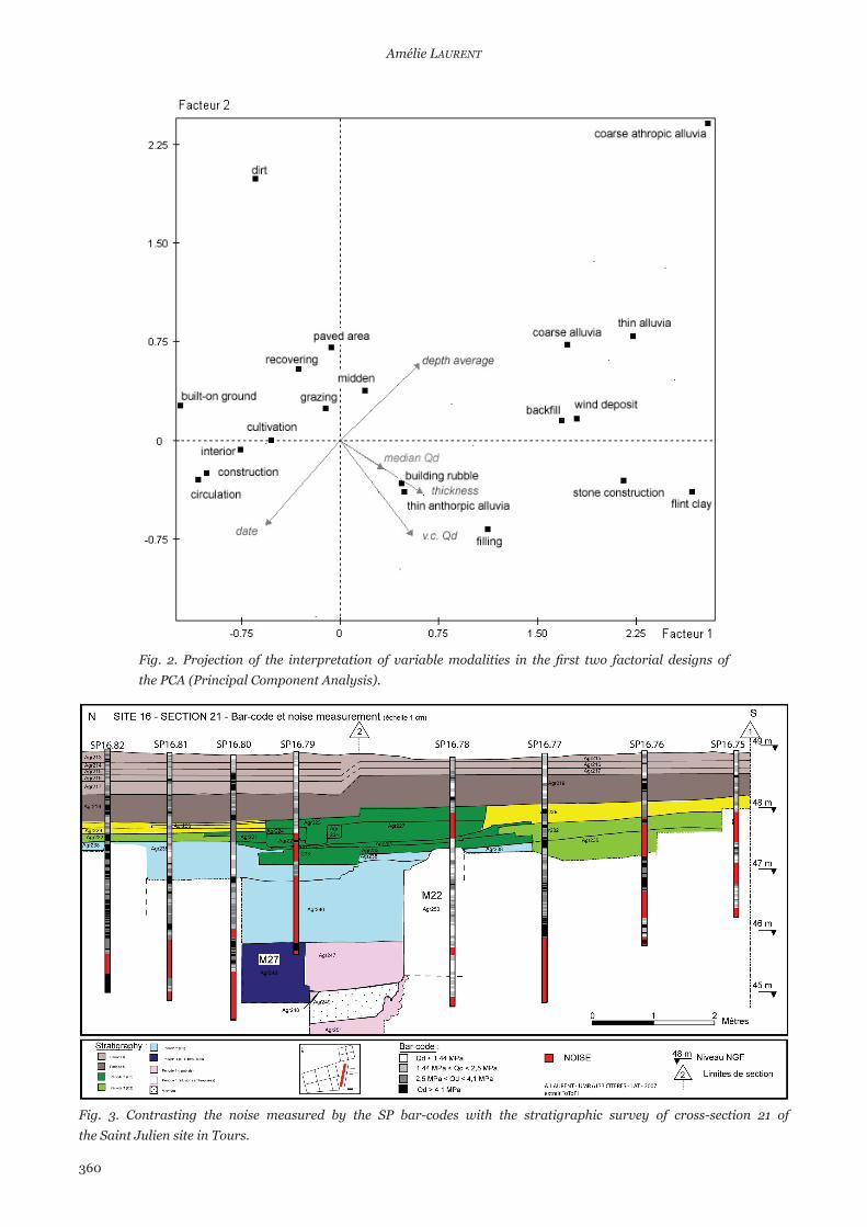
An intermediary unit was used: the contextual unit defined by its lithology, a functional inter-pretation, dating, thickness, geographical coordin-ates and mechanical properties such as resistance and internal variability. Using statistical methods (conditional probabilities and then factorial analysis), it was possible to group human activities on the basis of certain discriminant criteria. However, there is no uniqueness of mechanical properties for archaeological functions.
The methodology was tested first at the local level and then globally. The results show regional specificities which can be explained by the presence of specific components, but in general, the results for a number of characteristics are similar from one town to another (Fig. 2):a) stone constructions can be detected by their strong
resistance value, usually making it impossible to hammer in the penetrometer;
b) built-on ground, not very thick and with low resistance;
c) building rubble has high values and is fairly heterogeneous;
d) the exterior levels have low to high resistance values, but are fairly homogeneous.
This referential frame also has satisfactory results in terms of distinguishing between archaeological deposits and natural levels. It would be useful to carry out other tests in towns with the same geomorphological context and also in towns built directly on the rock substratum.
The ultimate goal of the archaeologicalmechanical referential frame is to characterize the Contextual Units (CUs) with no specified function from significant criteria. By combining the mechanical properties and vertical localization, it is possible to suggest functional interpretation possibilities. To characterize an unknown CU, it would then be
360
Amélie lAurent
Fig. 2. Projection of the interpretation of variable modalities in the first two factorial designs of the PCA (Principal Component Analysis).
Fig. 3. Contrasting the noise measured by the SP bar-codes with the stratigraphic survey of cross-section 21 of the Saint Julien site in Tours.

361
Evaluating the Archaeological Potential of Urban Soil
necessary to measure its proximity to the classes defined in the factorial analysis.
After that, an attempt was made to model the archaeological deposit from the penetrometric data. This involved constructing a barcode image from resistance classes and on a scale determined by analyzing the spatial variability of the measurements in the vertical dimension (variogram). After carrying out various signal analyses, the results show that the measures correlate at a thickness of between 5 and 10cm. The superposition of the bar-codes and cross-section readings show that the 5cm analytical scale is difficult to apply due to the heterogeneity of the levels.
Another approach was developed from the work of the geotechnicians to detect “noise zones” on the signal (Houy 2005). A noise is a random, fluctuating signal connected either to friction of the rod disturbing the measure or to some specific human activity. It is calculated from the concept of entropy (measure of the proportion which is disturbed or disordered) (Denis and Cremoux 2000).
The noise zones are represented on the barcodes (Fig. 3). This shows that the noise is characteristic of ungraded sandy rubble. On the other hand, for gardens, the noise corresponds to stony elements.
4. Assessment of the results for the city of Tours
From the data set used to assess the informative potential at the level of the city of Tours (site and planimetric data), the intensity of human occupation can be modelled. The study area was divided into nine zones, and an index of occupation intensity was estimated for 500-year periods. The total index map shows that human occupation is concentrated in the central part of the city.
As a next step, these indices were compared with the average thickness calculated from archaeological logs. In concrete terms, the correlation between the index of intensity and thickness defines the laws of urban soil production for the 500-year periods. The thickness for each zone can be estimated from these laws. In this way, a stratification production model was developed.
Furthermore, by interrelating archaeological, planimetric, geotechnical and geological sources it was possible to build up a database to study the thickness of the archaeological deposit and the top of the natural level. To complement these observation
points, penetrometer boreholes were taken in Tours on a 100-metre grid. First of all, the hundred or so penetrometer boreholes were studied blind in order to identify the heterogeneous nature of the urban soil. To model this heterogeneity, homogeneous units on the penetrograms were detected by means of statistical tools. These units are called Mechanical Units (MUs).
Four tests were developed around a central issue, namely the choice of analysis scale. On a decimetric or centimetric scale, homogeneities can be observed which must be related to archaeological formations. The results show that these signal analyses must be examined in greater depth on a scale approaching 20 to 25cm. A further issue was to define the indicative parameters and a statistical method suitable for the objective detection of homogeneous zones. The last two tests focused on the concept of entropy. The results indicate that the way forward for future work is the automatic detection of MUs by analyzing this concept.
In this way, the final data base, composed of 145 observation points, was used to produce a map showing the estimated depth of the archaeological deposit together with the top of the natural level. The interpolation method used for the study is Kriging, which involves two stages:
a) Studying the spatial structuring of the data from variogram analysis. This determines the maximum correlation distance between the data.
b) The interpolation itself, consisting in estimating the values between and at the measured points. The cross-validation of the measured and estimated points indicates the quality of the chosen model.
For the thickness of the archaeological deposit, the correlation distance between the measurement points is estimated at approximately 300 metres. For a general study of the city, this result is reasonable. On the other hand, at the local level, it needs to be treated with caution because the interpolation does not take into account the effects of the socio-spatial components. For example, the presence of a surrounding wall constitutes a significant break in the soil production. Ideally, an interpolation should be carried out within each town wall. This was not possible because of the insufficient number of points. In any event, it can be assumed that the theoretical 100metre grid is relevant for reconstructing the

362
Amélie lAurent
thickness of the deposit and to explain the variations on a smaller scale. The estimation map shows that the archaeological deposit is thicker within the 14thcentury town boundaries (Fig. 4). These results are generally similar to those of the models presented above.
Finally, a map of the archaeological potential of the city of Tours can be produced by superposing the map of the thicknesses and destructions of the sub-soil. This can provide new knowledge about the town.
To conclude, the study meets the objectives of a complete archaeological assessment of a town through the characteristics of the urban soil. By combining archaeological and geotechnical approaches it was possible to understand how the archaeological deposit was formed and its heterogeneity.
We have seen that the choice of assessment techniques is essential in terms of financial and scientific efficiency. We have shown that the PANDA penetrometer can meet this compromise thanks to its technical assets and use for identifying and characterizing the archaeological deposit.
Moreover, experiences of combining the penetrometer with a geoendoscope have shown the relevance of repeating and developing this experiment on other urban sites.
Finally, this study focused on investigating the vertical dimension of urban soil. It has opened the way for further work:a) defining more precisely the horizontal socio-
spatial components, which would allow the town to be divided up into smaller parts;
b) refining the stratification production model;c) the possibility of carrying out paleo-DEM at time
t by increasing the observation points.
Bibliography
Breysse, Denis, Halidou Niandou, Xavier Rodier, Henri Galinié and Amélie Laurent (2002). Le pénétromètre et l’hétérogénéité des sols archéologiques urbains. Revue Française de Géotechnique 100, 43–58.
Denis, Alain and Francis Crémoux (2000). Structural analysis of a signal from entropy toolapplication to tunnel boring data. In: Robert E. Melchers and Mark G. Stewart (eds.) Applications of Statistics and Probability. Proceedings of the ICASP 8 Conference. Sydney, New South, Australia 12-15 December 1999. Rotterdam: Balkema, 401–405.
Di Méo, Guy (1991). L’Homme, l’Espace, la Société. Paris: Anthropos.
Fondrillon, Mélanie (2007). La formation du sol urbain : étude archéologique des terres noires
Fig. 4. Map showing the estimated thickness of the archaeological deposit in Tours.

363
Evaluating the Archaeological Potential of Urban Soil
du haut Moyen Age (4e–12e siècle). Mémoire de thèse d’Histoire spécialité Archéologie. Université de Tours.
Galinié, Henri (2000). Ville, espace urbain et archéologie. Tours: Université François Rabelais.
Galinié, Henri, Amélie Laurent, Xavier Rodier, Denys Breysse, Laurent Houy, Halidou Niandou and Pierre Breul (2003). Utilisation du pénétromètre dynamique de type PANDA en milieu urbain pour l’évaluation et la caractérisation du dépôt archéologique. Revue d’Archéométrie 27, 15–26.
Heighway, Carolyn (ed.) (1972). The erosion of history. Archaeology and Planning in Towns. A study of historic towns affected by modern development in England, Wales and Scotland. Londres: S.I., CBA.
Houy, Laurent (2005). Variabilité des sols et risques liés à l’interaction sol-ouvrage. Mémoire de thèse de mécanique des sols. Université de Bordeaux I.
Laurent, Amélie (2007). Evaluation du potentiel archéologique du sol en milieu urbain. Mémoire de thèse d’Histoire spécialité Archéologie, 4 volumes (http://tel.archives-ouvertes.fr). Université de Tours.