Eurocopterl / Garmin Meeting 2/Garmin...Communication and Navigation GNS 400W/500W GPS/Nav/Comm...
42
February 1, 2012 Garmin Confidential
Transcript of Eurocopterl / Garmin Meeting 2/Garmin...Communication and Navigation GNS 400W/500W GPS/Nav/Comm...

February 1, 2012
Garmin Confidential


Innovation
To change or renew

Technology
Product or Service designed to assist the Human Being to better interpret
and/or interact with their environment

Situational awareness involves being aware of what is happening in the
vicinity to understand how information, events, and one's own actions will
impact goals and objectives, both immediately and in the near future.
Lacking or inadequate situational awareness has been identified as one of
the primary factors in accidents attributed to human error.
Thus, situational awareness is especially important in work domains
where the information flow can be quite high and poor decisions may lead
to serious consequences
Having complete, accurate and up-to-the-minute SA is essential where
technological and situational complexity on the human decision-maker are
a concern.
Situational awareness has been recognized as a critical, yet often elusive,
foundation for successful decision-making across a broad range of
complex and dynamic systems
Situational Awareness (SA)

Where are we today?

Helicopter Solutions

Helicopter Solutions
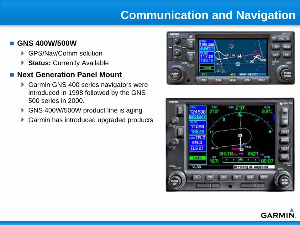
Communication and Navigation
GNS 400W/500W
GPS/Nav/Comm solution
Status: Currently Available
Next Generation Panel Mount
Garmin GNS 400 series navigators were
introduced in 1998 followed by the GNS
500 series in 2000.
GNS 400W/500W product line is aging
Garmin has introduced upgraded products

Communication and Navigation

Form Factor & Display
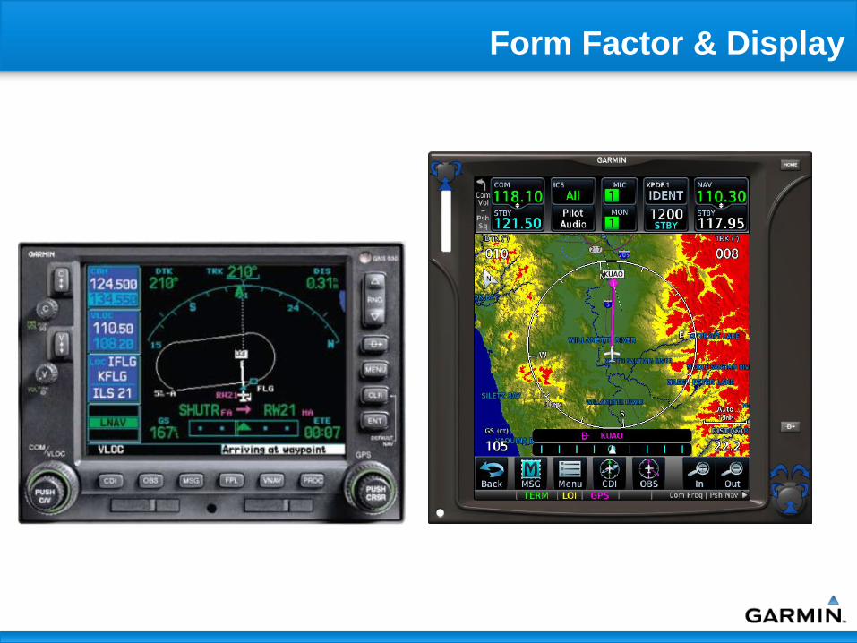
Form Factor & Display

• Virtual buttons (touchscreen)
Large graphical buttons – define function
Easy keyboard entry as optional input platform
•‘HOME’ BUTTON
•‘DIRECT TO’ BUTTON
•DUAL CONCENTRIC
KNOB
•VOLUME
KNOB
•TOUCH
SCREEN
• Dedicated Function Knobs
• Push buttons: “Home” & “Direct To”
• Knobs: Dual concentric & rotary volume
Form Factor & Display

Design Philosophy
• Consistency Among Garmin Product Line
G3000 G5000 (Evolution IFD based upon core G1000)
GTN (replacing GNS 400W/500W Series)

Com/Nav tuning
Com/Nav volume
Direct To entry
Home key and
default nav
Functionality not requiring touchscreen

G1000H

G500(H) Avionics Display System

Displays
GDU 620 and 620R (G500H)
Combines PFD and MFD in single 10”
wide bezel
Two 6.5” diagonal flat-panel LCDs
RGB backlighting supports Class A or
B NVIS compatibility
620H puts PFD on the right side to
support right-side PIC helicopter
applications
Status: Currently available;

G500(H) Capabilities
Primary flight data
Attitude
Air data
HSI – Heading and course guidance
Multi function display
Color moving maps
Chart display
Airport data
Hazard avoidance
Terrain awareness
– Synthetic Vision
• Terrain, traffic, airports
– HTAWS
XM satellite datalink weather
Traffic detection and display
Airborne weather radar
Communication via GNS
400W/500W or GTN 650/750 and
GTX XPDR
VHF com
Mode S Extended Squitter
Transponder
Navigation via GNS 400W/500W
or GTN 650/750
WAAS enabled GPS
VHF nav/loc/GS
FMS functionality
– Most ARINC leg types
– Arrivals, Departures, Approaches
– Single Point VNAV

G500H for Helicopters
Simple user interface
Form factor – helicopter instrument panels and consoles are small –PFD and
MFD functionality fit within allowed space
The new standard for VFR helicopters
Purposefully integrated with Garmin GNS navigators
Helicopter functionality
moving maps - detailed
synthetic vision
radar altimeter
video display
satellite datalink
traffic display
NVIS/NVG – Class B compatible
Retrofittable
Capabilities Added Via Software
TAWS - Class A, Class B, HTAWS
Chartview
FliteCharts
SafeTaxi
Autopilot Coupled ARINC 424 Leg Types
Airways
CMC/Diagnostics
Trend and Exceedance Monitoring and Storage
Crew Alerting System
Synoptics
Synthetic Vision
Performance Calculations

GTS 8XX TAS / TCAS 1
The GTS 8XX Traffic Advisory System (TAS) and Traffic Collision Avoidance System (TCAS I) use active interrogations of Mode S (GTS 820 and GTS 850 only) and Mode C transponders to provide traffic awareness and advisories to the pilot, independent of the air traffic control system.
The system also uses passive surveillance by means of an Automatic Dependent Surveillance – Broadcast (ADS-B) receiver which is enabled when installed with a 1090 MHz ADS-B transmit class of equipment, or other complementary ADS-B link transmit class of equipment (such as UAT).
Necessary Components Product Description Applicable
TSOs
Power/ Active
Interrogation Range
GTS Processor
Unit
Power Amp/Low-
Noise Amp
Top Antenna Bottom Antenna
GTS 800 TAS C147
C166a
40 W / 12 nm GTS 800 None 1 x GA 58 Optional
1 x GA 58 or omni
GTS 820 TAS C147
C166a
250 W / 40 nm
GTS 820 1 x GPA 65 1 x GA 58 Optional
1 x GA 58 or omni
GTS 850 TCAS I C118
C166a
250 W / 40 nm GTS 850 1 x GPA 65 1 x GA 58 Optional
1 x GA 58 or omni
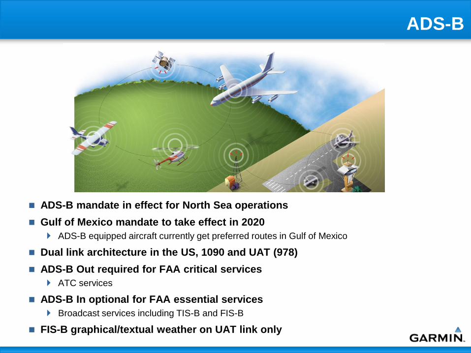
ADS-B
ADS-B mandate in effect for North Sea operations
Gulf of Mexico mandate to take effect in 2020
ADS-B equipped aircraft currently get preferred routes in Gulf of Mexico
Dual link architecture in the US, 1090 and UAT (978)
ADS-B Out required for FAA critical services
ATC services
ADS-B In optional for FAA essential services
Broadcast services including TIS-B and FIS-B
FIS-B graphical/textual weather on UAT link only

ADS-B Summary
Garmin has approved ADS-B
products in use everyday in AK,
ERAU, UND, China
Customers value the capabilities of
ADS-B equipment and improved
traffic awareness
FAA is making a substantial
investment on the NextGen ATC
System
Garmin offers a broad range of
ADS-B devices with interfaces to
panel mount GPS units, MFD’s,
portable products, and integrated
avionics suites

Datalink (Iridium/WiFi) Overview
WiFi & Data Storage - GDL 59
Flight parameter recorder
High speed data link between the aircraft systems and ground computers using 802.11g (“Wi-Fi”) while the aircraft is on the ground
Supports transmission of logged data reports including engine trend and exceedance data and CAS messages (HUMS)
Planned future features
– Automatic flight plan uploading and downloading
– Automatic database updates
Status: Currently Available
Iridium - GSR 56
Airborne low speed data link and voice communication capability
Utilizes Iridium satellite network
Satellite Phone
– Fully integrated with G3000/G1000/G500H
– GMA provides cockpit audio interface (via TEL button)
– Dialing interface provided via MFD
– “Incoming Call” message prioritized with other aural messages
Status: Currently Available

XM Weather and Radio
GDL 69A
XM satellite radio and digital datalink weather
receiver (U.S and Canada only)
Status: Currently Available
XM Radio Remote Controller
Features
– GDL 69A receiver provides XM radio and datalink
weather
– XM Radio entertainment control on MFD or using
remote control (GRC 10)
– Wireless link
GRC 10
– Allows passengers to control entertainment functions
– Selection of channel, music category, presets, and
volume
GRT 10
– RS-232 connection to GDL 69A
Status: Currently Available
GRC 10 GRT 10

User Interface and Software Features
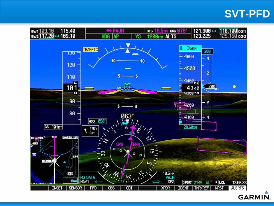
SVT-PFD

SVT – Obstacles

Enhanced Vision System/Video Support
Display Units support 2 sources of
external video input which may be used
for EVS or cameras
Displayed on MFD AUX page
Adjustable Contrast
Adjustable Brightness
Video 1 / 2 source selection
Digital zoom
Future plans include fusion of synthetic
vision and enhanced vision

ChartView
Jeppesen Data
Airport Diagrams
Approach Charts
Departure Procedures
Arrival Procedures
Most charts geo-referenced
so aircraft symbol can be
shown
Many different views available
and charts are easily zoomed
and panned

SafeTaxi
Detailed airport diagrams for over 800 airports in U.S. from NACO data Leverages Garmin’s in-house cartography
resources
Seamlessly integrated into main MFD navigation map and PFD inset map SafeTaxi adds data to the existing basemap
No need for a separate airport diagram chart
Requires no pilot action to display
Information automatically appears at appropriate ‘map range’ setting
Geo-referenced data with selectable attributes including: All current runways and taxiways
Public services (terminals, fire dept, post office, etc.)
FBOs, hangars, customs and more
Easy Updates Database updates available at
www.garmin.com
Available every 56 days
Status: Currently Available

HTAWS
Delivering TSO-C151b Class B and Class A
TAWS in G1000 and GNS 5XXW products
Developed HTAWS for use in helicopter
applications
Certified in accordance with TSO-C194
Available in GNS 430W/530W
Status: Currently Available
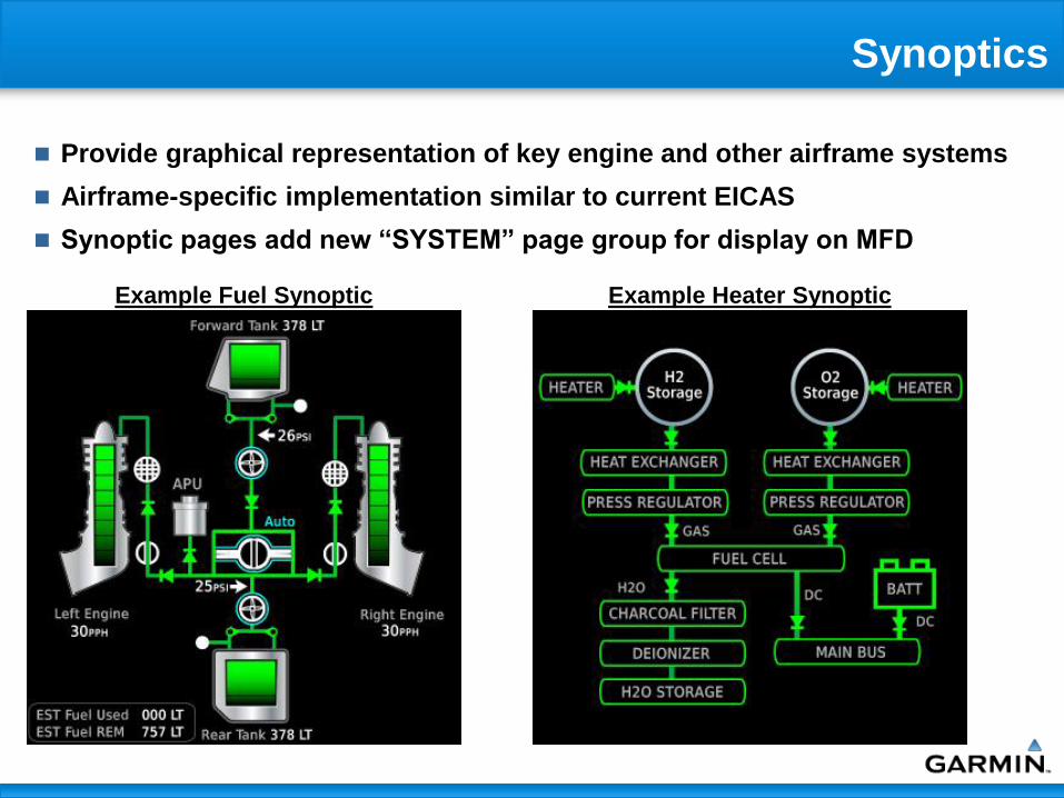
Synoptics
Provide graphical representation of key engine and other airframe systems
Airframe-specific implementation similar to current EICAS
Synoptic pages add new “SYSTEM” page group for display on MFD
Example Fuel Synoptic Example Heater Synoptic

Central Maintenance/HUMS Function
Data Logging The data logging system has access to any data available to the GDUs within the avionics system
(HSDB, discretes, analog, ARINC 429, etc.)
Fault report or basic data can be stored in the GDU, GDL 59, or both – Each GDU provides 1 MB of non-volatile memory for logged data storage
– The GDL 59 provides 2 GB of non-volatile memory for logged data storage
Within the GDL 59, logged data is organized into reports that can be automatically or manually transmitted via Wi-Fi or Iridium (requires GSR 56)
Trend Log 2/4/2009 16:02:29
# Date Time KIAS OAT(C) ALT(FT) FF(GPH) Ng(%RPM) Np(RPM) Torque(LB-FT) ITT (C) Vacuum (in-HG) OT (C) OP (PSI)
1 5/3/2009 16:23:45 155.51 NaN 10039.37 19.0204 80 1500 1327.60986 200 5.315397999 100 203.05284
2 5/3/2009 16:44:44 155.51 NaN 10039.37 19.0204 98 1700 885.0732398 500 5.315397999 70 101.52642
3 5/3/2009 18:23:11 155.51 NaN 10039.37 19.0204 98 1700 885.0732398 500 5.315397999 70 101.52642
4 5/3/2009 18:33:39 155.51 NaN 10039.37 19.0204 98 1700 885.0732398 500 5.315397999 70 101.52642
5 5/3/2009 19:18:30 155.51 NaN 10039.37 19.0204 98 1700 885.0732398 500 5.315397999 70 101.52642
6 5/3/2009 19:27:35 155.51 NaN 10039.37 19.0204 98 1700 885.0732398 500 5.315397999 70 101.52642
7 5/3/2009 19:41:43 155.51 NaN 10039.37 19.0204 98 1700 958.8293431 550 5.315397999 0 116.0302
8 5/3/2009 20:13:26 155.51 NaN 10039.37 0 80 1500 1106.34155 200 5.610697888 80 116.0302
Exceedances 2/4/2009 16:02:48
# Date Time Type Peak Duration
1 5/3/2009 16:24:27 ITT(C) 1200 0:02:38
2 5/3/2009 16:24:27 OIL PRESS HIGH(PSI) 203.0528 0:02:26
3 5/3/2009 16:24:27 OIL TEMP HIGH(C) 100 0:02:10
4 5/3/2009 16:24:31 Torque(LB-FT) 1401.366 0:01:30
5 5/3/2009 16:25:11 NP(RPM) 2100 0:01:08
6 5/3/2009 16:25:28 NG(%RPM) 103 0:00:27
7 5/3/2009 16:27:53 NP(RPM) 2100 0:01:55
8 5/3/2009 16:28:01 ITT(C) 800 0:01:39
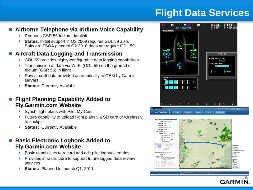
Flight Data Services
Airborne Telephone via Iridium Voice Capability Requires GSR 56 Iridium datalink
Status: Initial support in Q3 2009 requires GDL 59 also. Software TSOA planned Q2 2010 does not require GDL 59
Aircraft Data Logging and Transmission GDL 59 provides highly-configurable data logging capabilities
Transmission of data via Wi-Fi (GDL 59) on the ground or Iridium (GSR 56) in flight
Raw aircraft data provided automatically to OEM by Garmin servers
Status: Currently Available
Flight Planning Capability Added to Fly.Garmin.com Website Synch flight plans with Pilot My-Cast
Future capability to upload flight plans via SD card or wirelessly to cockpit
Status: Currently Available
Basic Electronic Logbook Added to Fly.Garmin.com Website Basic capabilities to record and edit pilot logbook entries
Provides infrastructure to support future logged data review services
Status: Planned to launch Q1, 2011
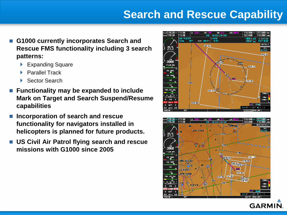
Search and Rescue Capability
G1000 currently incorporates Search and
Rescue FMS functionality including 3 search
patterns:
Expanding Square
Parallel Track
Sector Search
Functionality may be expanded to include
Mark on Target and Search Suspend/Resume
capabilities
Incorporation of search and rescue
functionality for navigators installed in
helicopters is planned for future products.
US Civil Air Patrol flying search and rescue
missions with G1000 since 2005

Helicopter Support Experience
Retrofit installs of various avionics on all
makes and models of helicopters
Programs of note
USCG MH-68
USA AH-64D
DoD DemVal (H-60, H-1)
Kansas City ENG and KCPD ADS-B safety
program
Royal Australian Army OH-58 upgrade

Helicopter Projects
G1000H and G500H LRU Vibration Qualification
AHRS/Magnetometer Helicopter Specific Development
ADC Helicopter Development
G500H STC
Bell 206/407
EC 130 (In cooperation with Air Methods)
AS 350 (In cooperation with Air Methods)
Helicopter Product, Feature, and Function Development
Cessna Citation Mustang
Cessna 400 & 350

GRS 77 AHRS / GMU 44 Magnetometer
Cessna Citation Mustang
Cessna 400 & 350
Garmin recently completed
testing of the GRS 77 AHRS and
GMU 44 magnetometer in the
helicopter flight environment
Flown with software modified for
helicopter flight characteristics
Results:
– Good performance in primary mode
during all maneuvers and in-air re-
alignments
– Good heading/pitch/roll performance
in reversion-no-GPS mode
– Good pitch/roll performance in
reversion-no-mag mode and
reversion-no-mag-no-air model
An AHRS “free gyro mode” to
support operations for limited
duration in the presence of
magnetic anomalies

Night Vision
Future Garmin display products
intended for use in helicopters will
address the need for NVG
compatibility in accordance with
SAE AS 5452 and MIL-L-85762
Class B
Garmin is pursuing NVG
compatibility:
G1000H – Support third party mod
G500H – RGB color palette change via
software in display
NVG compliant backlight for pilot
viewable bezels and knobs

LRU Environmental Qualification
Garmin has conducted vibration testing on LRUs for G1000 and G500H
systems
Testing conducted based on DO-160F Category U, Curve G vibration levels
– Tested the following LRUs:
• Display units (GDU)
• Integrated avionics unit (GIA)
• AHRS (GRS)
• Magnetometer (GMU)
• Air data computer (GDC)
• Audio panel (GMA)
• Transponder (GTX)
• Engine and airframe interface unit (GEA)
• XM weather and datalink unit (GDL)
• TAS (GTS)
Design modifications required for noted susceptibilities
– Air data computer and AHRS designs have been finalized and TSOA
– All LRUs currently TSO approved for helicopter vibration